determination of land boundaries briefing session
TRANSCRIPT

11
研究研究《《土地業權條例土地業權條例》》修訂建議聯合小組委員會修訂建議聯合小組委員會
JOINT SUBCOMMITTEE ON AMENDMENTS TO JOINT SUBCOMMITTEE ON AMENDMENTS TO THE LAND TITLES ORDINANCETHE LAND TITLES ORDINANCE
釐定土地界線簡介會釐定土地界線簡介會
Determination of Land Boundaries Determination of Land Boundaries Briefing SessionBriefing Session
Survey and Mapping OfficeLands Department
20092009--1010--0707
CB(1)45/09-10(01)
22
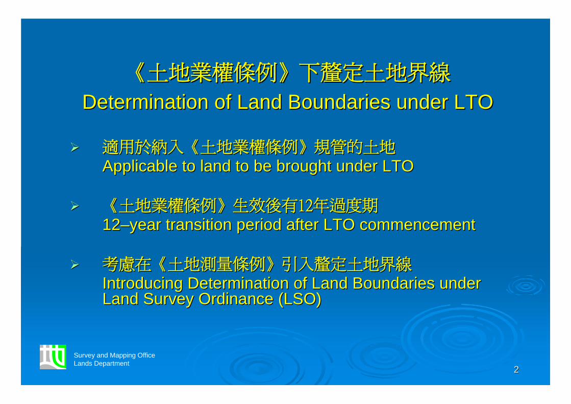
《《土地業權條例土地業權條例》》下釐定土地界線下釐定土地界線
Determination of Land Boundaries under LTODetermination of Land Boundaries under LTO
適用於納入適用於納入《《土地業權條例土地業權條例》》規管的土地規管的土地Applicable to land to be brought under LTOApplicable to land to be brought under LTO
《《土地業權條例土地業權條例》》生效後有生效後有1212年過度期年過度期1212––year transition period after LTO commencementyear transition period after LTO commencement
考慮在考慮在《《土地測量條例土地測量條例》》引入釐定土地界線引入釐定土地界線Introducing Determination of Land Boundaries under Introducing Determination of Land Boundaries under Land Survey Ordinance (LSO)Land Survey Ordinance (LSO)
Survey and Mapping OfficeLands Department

33
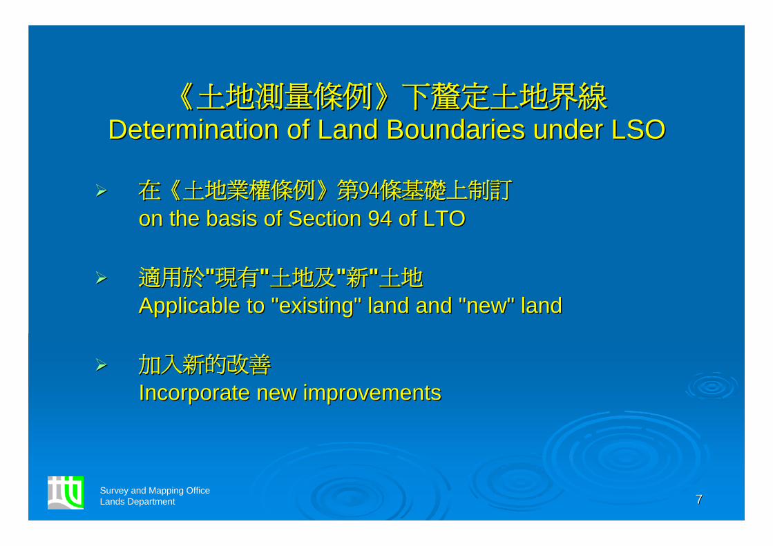
《《土地測量條例土地測量條例》》引入釐定土地界線引入釐定土地界線Determination of Land Boundaries under LSODetermination of Land Boundaries under LSO
適用於受適用於受《《土地註冊條例土地註冊條例》》規管的規管的""現有現有""土地土地
Applicable to Applicable to ""existing" land governed by Land existing" land governed by Land Registration Ordinance (LRO)Registration Ordinance (LRO)
及納入及納入《《土地業權條例土地業權條例》》規管的規管的""新新""土地土地
and "new" land brought under LTOand "new" land brought under LTO
改善釐定土地界線改善釐定土地界線
Improvement to Determination of Land BoundariesImprovement to Determination of Land Boundaries
Survey and Mapping OfficeLands Department

44
《《土地測量條例土地測量條例》》
Land Survey OrdinanceLand Survey Ordinance旨在規定:旨在規定:To provide for:To provide for:
認可土地測量師的註冊及紀律事宜認可土地測量師的註冊及紀律事宜Registration and disciplineRegistration and discipline of Authorized Land of Authorized Land Surveyors (ALS)Surveyors (ALS)
土地界線測量的水準土地界線測量的水準Control of standardsControl of standards of land boundary surveysof land boundary surveys
查核為土地分割而製備的土地界線圖及測量記錄圖查核為土地分割而製備的土地界線圖及測量記錄圖Checking ofChecking of Land Boundary Plans (LBP) and Survey Land Boundary Plans (LBP) and Survey Record Plans (SRP)Record Plans (SRP) for subdivision of landfor subdivision of land
Survey and Mapping OfficeLands Department

55
為土地分割而製備的土地界線圖為土地分割而製備的土地界線圖
Land Boundary Plan for Subdivision of LandLand Boundary Plan for Subdivision of Land
Survey and Mapping OfficeLands Department

66
為土地分割而製備的測量記錄圖為土地分割而製備的測量記錄圖
Survey Record Plan for Subdivision of LandSurvey Record Plan for Subdivision of Land
Survey and Mapping OfficeLands Department
77
《《土地測量條例土地測量條例》》下釐定土地界線下釐定土地界線Determination of Land Boundaries under LSODetermination of Land Boundaries under LSO
在在《《土地業權條例土地業權條例》》第第9494條基礎上制訂條基礎上制訂
on the basis of Section 94 of LTOon the basis of Section 94 of LTO
適用於適用於""現有現有""土地及土地及""新新""土地土地
Applicable to Applicable to ""existingexisting"" land and land and ""newnew"" landland
加入新的改善加入新的改善
Incorporate new improvementsIncorporate new improvements
Survey and Mapping OfficeLands Department

88
改善釐定土地界線改善釐定土地界線
Improvement toImprovement toDetermination of Land BoundariesDetermination of Land Boundaries
容許對土地界線圖作出細微修改容許對土地界線圖作出細微修改
Allowed to make minor changes to land boundary Allowed to make minor changes to land boundary plan plan
因資料不足而無須作出土地界線釐定因資料不足而無須作出土地界線釐定
ExemptedExempted from making a land boundary from making a land boundary determination due to lack of informationdetermination due to lack of information
Survey and Mapping OfficeLands Department

99
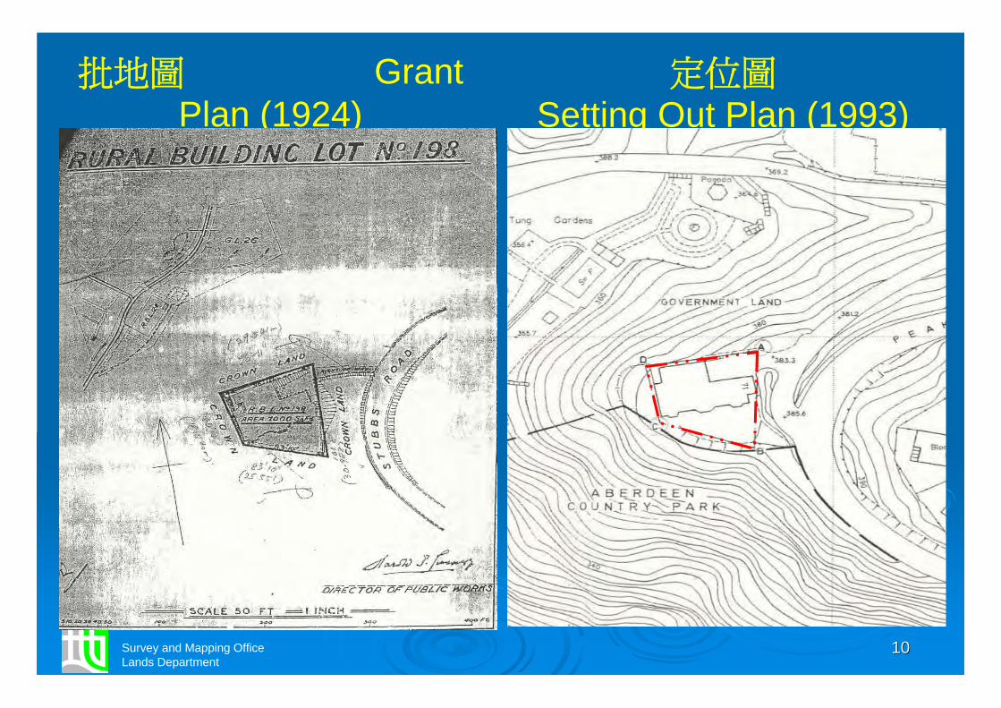
細微修改土地界線細微修改土地界線
Minor Changes to Land BoundariesMinor Changes to Land Boundaries
測量技術、設備有所改良測量技術、設備有所改良
Improved survey technology and equipment Improved survey technology and equipment
關乎一個地段的確實界線關乎一個地段的確實界線
Concerned with ascertaining the exact boundaries Concerned with ascertaining the exact boundaries of a lotof a lot
Survey and Mapping OfficeLands Department
1010Survey and Mapping OfficeLands Department
批地圖 Grant Plan (1924)
定位圖Setting Out Plan (1993)

1111
細微修改的接受準則細微修改的接受準則
Acceptance Criteria for Minor Changes Acceptance Criteria for Minor Changes
將會載列在將會載列在《《土地測量條例土地測量條例》》的實務守則的實務守則To be set out in the Code of Practice issued under LSOTo be set out in the Code of Practice issued under LSO
與香港測量學會磋商制定與香港測量學會磋商制定To be worked out in consultation with Hong Kong To be worked out in consultation with Hong Kong Institute of SurveyorsInstitute of Surveyors
Survey and Mapping OfficeLands Department

1212Survey and Mapping OfficeLands Department
丈量約份地圖 DD Sheet (1905)

1313Survey and Mapping OfficeLands Department
舊測量圖 Old Survey Sheet (1960)

1414Survey and Mapping OfficeLands Department
航空照片 Aerial Photo (1963)

1515Survey and Mapping OfficeLands Department
地段索引圖 Lot Index Plan (2006)

1616
資料不足的情況資料不足的情況
Cases of Insufficient InformationCases of Insufficient Information
沒有註冊圖的舊批屋宇地段沒有註冊圖的舊批屋宇地段
Old Schedule House LotsOld Schedule House Lots without Registered Planswithout Registered Plans
失圖據地段失圖據地段
Missing LotMissing Lot
批租文件遺失、損壞或難以辨認批租文件遺失、損壞或難以辨認
Missing, damaged or illegible lease documentMissing, damaged or illegible lease document
Survey and Mapping OfficeLands Department

1717
舊批屋宇地段舊批屋宇地段
Old Schedule House LotsOld Schedule House Lots
屬於集體官契下批出的屋地屬於集體官契下批出的屋地(1:3960 (1:3960 丈量約份地圖丈量約份地圖))Building lots granted under Block Government Lease Building lots granted under Block Government Lease (1:3960 DD Sheets)(1:3960 DD Sheets)
沒有附圖顯示每一地段的位置沒有附圖顯示每一地段的位置
No plan attached to the BGL to show the location of No plan attached to the BGL to show the location of each loteach lot
Survey and Mapping OfficeLands Department

1818
集體官契的丈量約份地圖集體官契的丈量約份地圖
DD Sheet registered with BGLDD Sheet registered with BGL
Survey and Mapping OfficeLands Department

1919
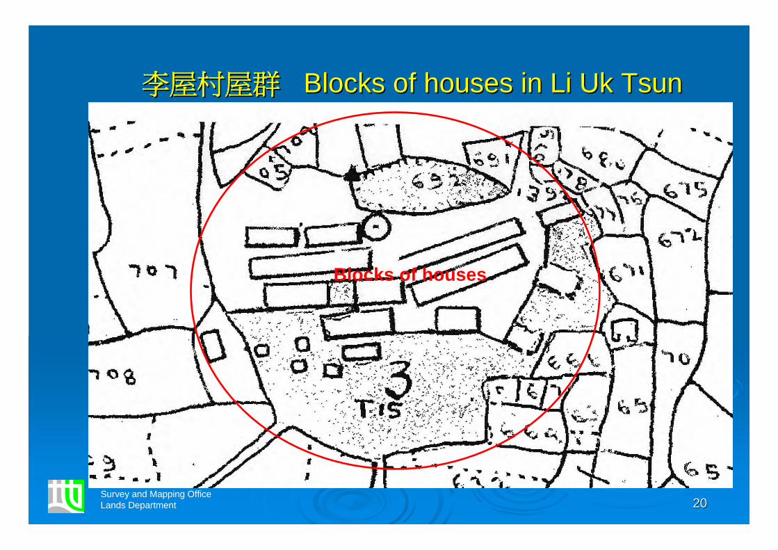
丈量約份地圖顯示的鄉村丈量約份地圖顯示的鄉村
Villages shown on DD SheetVillages shown on DD Sheet
Survey and Mapping OfficeLands Department
2020
李屋村屋群李屋村屋群 Blocks of houses in Li Blocks of houses in Li UkUk TsunTsun
Survey and Mapping OfficeLands Department
Blocks of houses

2121
失圖據地段失圖據地段Missing LotMissing Lot
持續繳交地租持續繳交地租
Paying Government rent continuouslyPaying Government rent continuously
政府找不到地段的位置和地界的記錄政府找不到地段的位置和地界的記錄
A search of Government records fails to establish its A search of Government records fails to establish its position and boundariesposition and boundaries
地政處指引提供處理失圖據地段程序地政處指引提供處理失圖據地段程序
Lands Administration Office (LAO) Instruction on Lands Administration Office (LAO) Instruction on Procedures for Establishing Missing LotsProcedures for Establishing Missing Lots
Survey and Mapping OfficeLands Department

2222
批租文件遺失、損壞或難以辨認批租文件遺失、損壞或難以辨認
Missing, damaged or illegible Missing, damaged or illegible lease documentlease document
根據地政處指引處理根據地政處指引處理
To be handled according to LAO InstructionTo be handled according to LAO Instruction
Survey and Mapping OfficeLands Department

2323
改善土地界線圖註冊改善土地界線圖註冊
Improvement to Registration of LBPImprovement to Registration of LBP 地界細微修改過的土地界線圖可以註冊地界細微修改過的土地界線圖可以註冊
LBP with minor changes to boundaries can be registeredLBP with minor changes to boundaries can be registered
新註冊的土地界線圖可以取代舊圖新註冊的土地界線圖可以取代舊圖New LBP supersedes any previously registered plansNew LBP supersedes any previously registered plans
未能註冊的新土地界線圖可以存放在土地測量監督處以備公眾未能註冊的新土地界線圖可以存放在土地測量監督處以備公眾查閱查閱Unregistered new LBP can be deposited in Land Survey Unregistered new LBP can be deposited in Land Survey Authority for public inspectionAuthority for public inspection
先完成核實土地界線圖,後註冊有關的土地分割文書先完成核實土地界線圖,後註冊有關的土地分割文書Completion of checking LBP before relevant instrument Completion of checking LBP before relevant instrument effecting a division of land is registeredeffecting a division of land is registered
Survey and Mapping OfficeLands Department
2424
改善土地界線記錄存放改善土地界線記錄存放
Improvement to Deposit of Improvement to Deposit of Land Boundary RecordLand Boundary Record
土地界線記錄包括「就界定土地界線所作的報告」土地界線記錄包括「就界定土地界線所作的報告」"Report in relation to a land boundary definition" be "Report in relation to a land boundary definition" be included as Land Boundary Recordincluded as Land Boundary Record
任何人士可查閱土地界線記錄任何人士可查閱土地界線記錄Any person can inspect Land Boundary RecordAny person can inspect Land Boundary Record
Survey and Mapping OfficeLands Department

2525
澄清土地界線測量權責澄清土地界線測量權責
Clarification on Power and Liability Clarification on Power and Liability in Land Boundary Surveyin Land Boundary Survey
批准公職人員進入毗連地段測量批准公職人員進入毗連地段測量Authorize public officers to enter adjoining lots to Authorize public officers to enter adjoining lots to conduct surveysconduct surveys
政府政府//公職人員無須承擔法律責任公職人員無須承擔法律責任No liability shall rest upon Government or any public No liability shall rest upon Government or any public officerofficer
Survey and Mapping OfficeLands Department

2626
地籍測量諮詢委員會地籍測量諮詢委員會
Cadastral Survey Consultative CommitteeCadastral Survey Consultative Committee
Members of CSCC include representatives from:Members of CSCC include representatives from:
Survey and Mapping OfficeLands Department
•• HKIEHKIE•• HKISHKIS•• HKIAHKIA•• Law SocietyLaw Society•• HKIPHKIP
•• HYKHYK•• PolyUPolyU•• ACEHKACEHK•• HKICMHKICM•• REDAREDA
•• DEVBDEVB•• LRLR•• LAOLAO•• PlanDPlanD•• BDBD

2727
諮詢過程及結果諮詢過程及結果
Process and Result of ConsultationProcess and Result of Consultation
發出諮詢文件發出諮詢文件Information paperInformation paper issued (Sept 2007)issued (Sept 2007)
成立工作小組討論成立工作小組討論Formation of Working Group for detailed discussions Formation of Working Group for detailed discussions (Oct (Oct –– Nov 2007)Nov 2007)
對建議沒有反對對建議沒有反對No objection against the proposal receivedNo objection against the proposal received
沒有爭議性意見沒有爭議性意見No controversial view raisedNo controversial view raised
總結提議及回應總結提議及回應Summary of Feedback and Response (Feb 2008)Summary of Feedback and Response (Feb 2008)
Survey and Mapping OfficeLands Department

2828
謝謝謝謝Thank youThank you
Survey and Mapping OfficeLands Department