description of the baseline inventory
TRANSCRIPT

Volunteers' Guide to Stewardship Agreements, Appendices - 35
APPENDIX A:
Description of The BASELINE INVENTORY
��������������������� ��� ���� ������
While establishing a baseline inventory is not the responsibility of a stewardship monitor, it is very important that monitors understand what a base line inventory is, how and why it is created, and its importance in monitoring Stewardship Agreements. What is a baseline inventory? At a minimum, a baseline inventory should provide a snapshot (in words and pictures) of the present health of the property’s ecosystems at the time the Stewardship Agreement is signed. The baseline inventory is used by the conservation organization in consultation with the landowner to design the Stewardship Agreement. Why is a baseline inventory done?
�������������� ���������������
���� ������ �������������������
���� ������������ ��������������� �
����������������� ��� ������������������
���������������� ��� ����������������
��� ���������������� ��� ����
����� �������� �������
Sora rail Photo copyright Johnathan Grant
�
It is usually prepared in the form of a detailed written report with accompanying surveys, photos and map documentation. Altogether this information indicates the health of the property’s ecosystem at the time the Stewardship Agreement is signed. Monitoring will reveal trends and changes in the property’s ecosystem health. To detect change, there must be a benchmark against which to measure change. A baseline inventory provides that benchmark. A baseline inventory must be carried out by the conservation organization before any monitoring can be done. When is a baseline inventory carried out?
36 - Volunteers' Guide to Stewardship Agreements Appendices
Although each situation differs, ideally a baseline inventory begins as an initial survey and report (or site description) of what is present on the land at the time the property is being considered for protection. Once the decision is made to protect the property, additional information is collected to assist in preparing the Stewardship Agreement. If the Stewardship Agreement is one that can be registered against title to the land, the inventory can be registered with the agreement at the Land Title Office along with accompanying maps. Baseline information must be collected when the ecological features central to the Stewardship Agreement can best be observed and recorded. Often this requires site descriptions at different times of the year to record seasonal changes. Where is a baseline inventory done? Sometimes a detailed inventory is only done for the ecologically sensitive aspects of a property and in other cases it is done property wide. The value of a property wide inventory is that property can be viewed as part of a larger ecosystem. For similar reasons it is a good idea to gather additional information about the surrounding area to establish the uniqueness of the property or to evaluate any potential threats to it. Who does a baseline inventory? A conservation organization is responsible for preparing a baseline inventory and accompanying maps for each property to be protected and monitored. It is important that volunteer monitors review the inventory with the involved conservation organization prior to undertaking a monitoring visit. The Appendix following is one sample of Baseline Inventory Forms. Another format is being field tested with several conservation organizations in the Land trust field, available for viewing at www. bc.natureconservancy.ca. We will likely offer this additional Baseline Inventory & Protocol form to users of this manual in the fall of 2001. The baseline inventory is updated periodically either by professional or trained lay volunteers undertaking stewardship monitoring on behalf of the involved conservation organization. It may also be updated during on-site visits conducted in the course of related responsibilities such as forest, wildlife or ecosystem assessments by professionals such as biologists, foresters and landscape planners, or authorized seasonal bird counts by a local naturalist club.

Volunteers' Guide to Stewardship Agreements, Appendices - 37
Monitors should explore with the involved conservation organization the possibility of joining in such on-site visits. �
�� ���� ����������������������� ����� ������������
����������� ���� ���� ���� � �� ���� ���� ������ �����
����������������� ���
�
How often is the baseline inventory done? Although a detailed baseline inventory is usually done when the property is initially protected, a complete inventory may require more than one visit over a period of time. Also, if additional information comes to light regarding, for instance, the presence of a species or habitat not previously identified, then further observations may be necessary to supplement the original inventory. Some conservation organizations undertake a comprehensive update of a baseline inventory every five years.
How is a baseline inventory done? A baseline inventory is usually undertaken by paid or unpaid professionals, or by others with extensive botanical or ecological knowledge working with the conservation organization to document the present health of the property. Sometimes aerial photos are used to document historical changes to the property and surrounding areas. A dated photo record is compiled with directional arrows on a map to indicate the direction from which each photo was taken. Video-taping with observations on the sound track and a date stamp also provides a good record. A photographic record, using either a conventional or digital camera, is frequently included in the written inventory report. It is a good idea to record the procedure and show the route on a map so the next monitoring visit can use the same route and procedure. Usually a baseline inventory includes a map which delineates the property boundaries and the boundaries for each zone, such as riparian, forest, agriculture, area enhancement, or building/residential zones. Such a map provides a useful visual link and orientation between the terms of the Stewardship Agreement, the accompanying baseline inventory for each zone and what the monitor will experience while conducting an on-site monitoring visit. In some cases these maps are registered in the Land Title Office as part of the Stewardship Agreement.
Calypso Orchid photo Johnathan Grant

38 - Volunteers' Guide to Stewardship Agreements Appendices
������ ����������� ��� ���� ������
A baseline inventory will include some or all of the following components:
��legal description; ��location of land; ��size of land; ��landowner name, address, e-mail, phone and fax numbers; ��conservation organization name, e-mail, phone and fax numbers, and contact(s); ��date the Stewardship Agreement was established; ��description of right of access to the land; ��features of the landscape; ��other natural features including flora and fauna; ��ecological values of the land; ��activities and land uses; ��status of development on the land; ��identification of disturbances; ��potential impacts or problems resulting from disturbances; ��conservation goals; ��other comments and considerations; and ��documents attached or available, such as maps or photos.
While the legal description, location, size, and accessibility will be recorded for all properties, what is inventoried and documented will vary depending on the conservation objectives stated in the Stewardship Agreement. The inclusion of a detailed botanical inventory or detailed ecosystem mapping in a Stewardship Agreement is ideal. In the case of larger properties, it may only be feasible to record and include significant features and ecosystems contained within the property. Preparation of a baseline inventory should include a search for additional information such as historical photos and information collected from previous surveys or maps. For example, it is worthwhile to make note of information such as whether the area is included in an annual bird count. Other biological components that might be documented for other purposes may include important terrestrial and aquatic features, flora and fauna including endangered or threatened species, or habitats. The local chapter of The Federation of B.C. Naturalists is an important source of this kind of information

Volunteers' Guide to Stewardship Agreements, Appendices - 39
APPENDIX B:
BASELINE INVENTORY AND DETERMINATION OF LANDOWNER CONSERVATION GOALS
Date: ______________________________ Time: Weather:___________________________________________________________________ 1. Landowner Contact Information Landowner’s Last Name: Landowner’s First Name: Property Address: City: Province: Postal Code: Phone: Fax: E-mail: 2. Property Information Legal Description (district, lot numbers): Location (latitude, longitude): Surface Area (ha.): Maximum Elevation (m): Minimum Elevation (m): Property Access: Directions for Access to Property: Area Name: Ecoprovince:__________________ EcoRegion:_________________EcoSection:_________ Maps: Air Photo Numbers: Other Photo Numbers & Locations: Zoning _____________________ Land use Designation______________________ Surrounding Land Use_____________________ Regional District_______________________ 3. On-Site Inventory Completed By Name: Address: City: Province: Postal Code: Phone: Fax: E-mail:

40 - Volunteers' Guide to Stewardship Agreements Appendices
4. Site Descriptions & Ecosystems present: a) Site Description:
%age BIOME Circle the Ecosystem Type if present (italics only) Forest Upland Coniferous Broadleaf Mixed
Riparian Fringe Floodplain Sub-alpine Parkland
Woodland Coniferous Broadleaf Mixed Grassland Shrub-
steppe Grass-steppe
Coastal
Shrubland
Notes:
Wetland Shrub Swamp
Treed Swamp
Freshwater Marsh
Estuarine Marsh
Treed Bog
Peat Bog
Shrub Fen
Sedge Fen
Transitional Wetland
Shrub-carr Wet Meadow
Saline Meadow
Alpine Meadow
Forb Graminoid Mountain-Heather
Sub-alpine Meadow
Forb Graminoid Mountain-Heather
Shallow Open Water
Floating Aquatics
No Floating Aquatics
Notes:
Pond Stream Cliff Spit Lake Beach Talus River Rocky
Outcrop Dune
b) Other Ecological or Heritage Values (bufffers, corridor, archeological, scenic...) 5. Land Uses If land is currently being used for any of the following purposes, please describe. Recreational: Hiking Hunting Snowmobiling Berry Picking Fishing Cross-country skiing Bird-Watching Four-Wheel Driving Other: Picnicking ATVing (atv) Camping Trail Riding (Horse)

Volunteers' Guide to Stewardship Agreements, Appendices - 41
Scientific/Educational (research, nature study, etc.): Habitat/Ecosystem management or Preservation: (planting, bird houses, etc.):
Residential (permanent residences, mobile homes, etc.):
Agricultural (orchard, vineyard, garden, horse/cattle pasture, etc.): Forestry: (reforestation, harvesting, etc.):
Commercial (sales to the public, etc.): Industrial (mining, etc.): Historical (previous known uses of the land, including archeological evidence): 6. Human-made Features Describe size, type and condition of: 1) Buildings/Structures 2) Trails 3) Wells 4) Power Lines 5) Pipelines

42 - Volunteers' Guide to Stewardship Agreements Appendices
6) Other 7. Disturbances (See Appendix E for Disturbance legend sample) Location on Map and Description: Check off if present with No. reference to map. Vegetation/Animals: Soil Removal: Vandalism: Trails/Roads/Cleared Lines: Natural: Tree Cutting Sand Garbage All Ter. Vehicles Landslide Bark Stripping Gravel Signs Roads Flooding Collecting Plants Peat Cut Fences Hiking Trails Erosion Trapping Animals Equestrian Trails Fire Fire Cutlines/Seismic Poaching Fencelines Other: Pipelines/Wellsite Powerlines Other Dist. (describe below)
Notes: 8. Wildlife and Wildlife Habitat Evidence of Wildlife: Wildlife Trees/Snags Animal Tracks (AT) Animal Scat Squirrel Caches Types of Animal Tracks: Types of Scat: Bird’s Nests Feathers Burrows Browsed Vegetation Other:
Wildlife observed on property
Volunteers' Guide to Stewardship Agreements, Appendices - 43
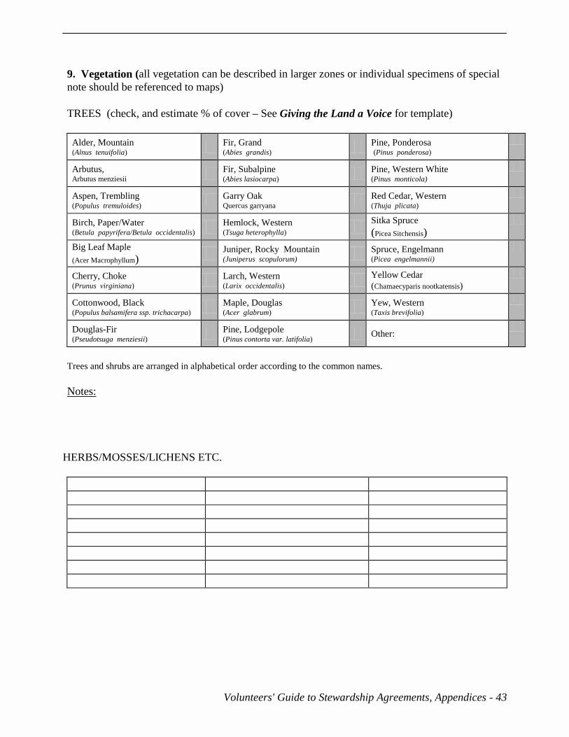
9. Vegetation (all vegetation can be described in larger zones or individual specimens of special note should be referenced to maps) TREES (check, and estimate % of cover – See Giving the Land a Voice for template)
Alder, Mountain (Alnus tenuifolia) Fir, Grand
(Abies grandis) Pine, Ponderosa (Pinus ponderosa)
Arbutus, Arbutus menziesii
Fir, Subalpine (Abies lasiocarpa) Pine, Western White
(Pinus monticola)
Aspen, Trembling (Populus tremuloides) Garry Oak
Quercus garryana Red Cedar, Western
(Thuja plicata)
Birch, Paper/Water (Betula papyrifera/Betula occidentalis) Hemlock, Western
(Tsuga heterophylla) Sitka Spruce (Picea Sitchensis)
Big Leaf Maple (Acer Macrophyllum) Juniper, Rocky Mountain
(Juniperus scopulorum) Spruce, Engelmann (Picea engelmannii)
Cherry, Choke (Prunus virginiana) Larch, Western
(Larix occidentalis) Yellow Cedar (Chamaecyparis nootkatensis)
Cottonwood, Black (Populus balsamifera ssp. trichacarpa) Maple, Douglas
(Acer glabrum) Yew, Western (Taxis brevifolia)
Douglas-Fir (Pseudotsuga menziesii) Pine, Lodgepole
(Pinus contorta var. latifolia) Other:
Trees and shrubs are arranged in alphabetical order according to the common names. Notes:
HERBS/MOSSES/LICHENS ETC.

44 - Volunteers' Guide to Stewardship Agreements Appendices
SHRUBS
Antelope-Bush (Purshia tridentata)
Hazelnut, Beaked Corylus cornuta) Sagebrush, Big (Artemisia tridentata)
Alder, Sitka (Alnus crispa ssp. sinuata)
Honeysuckle, Orange (Lonicera ciliosa)
Saskatoon (Amelanchier alnifolia)
Azalea, False Menziesia ferruginea
Honeysuckle, Utah (Lonicera utahensis)
Snowberry, Common (Symphoricarpos albus)
Birch, Scrub (Betula glandulosa)
Huckleberry, Black (Vaccinium membranaceum)
Sumack, Smooth (Rhus glabra)
Blueberry, Dwarf (Vaccinium myrtilloides)
Huckleberry, Red (Vaccinium parvifolium)
Snowberry, Creeping (Gaultheria hispidula)
Blueberry, Oval-Leaved (Vaccinium ovalifolium)
Juniper, Common (Juniperus communis)
Snowbrush (Ceanothus velutinus)
Blueberry, Velvet-Leaved (Vaccinium myrtilloides)
Kinnikinnick (Arctostaphylos uva-ursi)
Soopolallie (Shepherdia canadensis)
Bog-Laurel, Western (Kalmia microphylla ssp. microphylla)
Maple, Douglas (Acer giabrum)
Spirea, Birch-Leaved (Spiraea betulifolia)
Bramble, Five-Leaved (Rubus pedatus)
Mistletoe, Western Dwarf (Arceuthobium americanum)
Spirea, Pink (Spiraea douglasii ssp. menziesii)
Cascara (Ramnus purshana)
Mock-Orange (Philidelphus lewisii)
Spirea, Pyramid (Spiraea pyramidata)
Ceanothus, Redstem (Ceanothus sanguineus)
Mountain-Ash, Western (Sorbus scopulina)
Spray, Ocean (Holodiscus discolor)
Cinquefoil, Shrubby (Potentilla fruticos)
Mountain-Ash, Sitka (Sorbus sitchensis)
Tea, Labrador (Ledum groenlandicum)
Cranberry, Bog (Oxycoccus oxycoccus)
Mountain-Heather, Pink (Phyllodoce empetriformis)
Tea, Trapper's (Ledum glandolusum)
Cranberry, High-Bush (Viburnum edule)
Mountain-Heather, White (Cassiope mertensiana)
Tea-Berry, Western (Gaultheria ovatifolia)
Crowberry (Empetrum nigrum)
Nagoonberry, Dwarf (Rubus arcticus, R. acaulis)
Thimbleberry (Rubus parviflorus)
Current, Northern Black (Ribes hudsonianum)
Ninbark, Mallow (Physocarpus malvaceus)
Twinberry, Black (Lonicera involucrata)
Currant, Skunk (Ribes glandulosum)
Oregon -Grape, Tall (Mahonia aquifolium )
Twinflower (Linnaea borealis)
Currant, Squaw (Ribes cereum)
Penstemon, Shrubby (Penstemon fruticosus)
Willow, Arctic (Salix arctica)
Currant, Sticky (Ribes viscosissimum)
Poison-Ivy (Rhus radicans)
Willow, Barclay’s (Salix barclayi)
Devil’s Club (Oplopanax horridus)
Prince’s Pine (Chimaphila umbellata)
Willow, Bebb’s (Salix bebbiana)
Dogwood, Red-Osier (Cornus stolonifera, C. sericea)
Raspberry, Red (Rubus idaeus, R. strigosus)
Willow, Pacific (Salix lucida ssp. lasiandra)
Elderberry, Blue (Sambusus caerulea)
Raspberry, Trailing (Rubus pubescens)
Willow, Sitka (Salix sitchensis)
Elderberry, Red (Sambucus racemosassp. pubens var. leucocarpa)
Rhododendron,White-Flowered (Rhododendron albiflorum)
Willow, Scouler’s (Salix scouleriana)
Falsebox (Pachistima myrsinites) Rose, Baldhip (Rosa gymnocarpa)
Willow, Short-Fruited (Salix brachycarpa ssp. brachycarpa)
Gooseberry, Black (Ribes lacustre) Rose, Nootka (Rosa Nutkana)
Willow, Tea-Leaved (Salix planifolia ssp. planifolia)
Grouseberry (Vaccinium scoparium) Rose, Prairie (Rosa woodsii)
Other:
Hawthorn, Black (Crataegus douglasii)
Rose, Prickly (Rosa acicularis)

Volunteers' Guide to Stewardship Agreements, Appendices - 45
10. Red and Blue Listed Species/ Ecosystems Plants: Animals: Communities:
Notes:
11. Notes on Neighbouring Properties:

46 - Volunteers' Guide to Stewardship Agreements Appendices
CONSERVATION GOALS 12. Protected Area Plan This plan refers to fragile ecosystems that should have little or no human intervention and are delineated on the Property Zones Map. Special Features:
13. Water Management Plan This Plan refers to all water related areas delineated on the Property Zones Map such as wetlands, lake foreshore, bogs, river and creek banks usually protected by a fifteen meter zone. Special Features:

Volunteers' Guide to Stewardship Agreements, Appendices - 47
14. Forest Management Plan
This plan refers to all forested, wooded or treed areas as delineated on the accompanying Property Zones Map. Special Features: 15. Agriculture Management Plan This Plan refers to all farm related areas such as fields, paddocks, orchards, garden areas, green houses, growing areas and related activities as delineated on the accompanying Property Zones Map and includes all Agricultural Land Reserve (ALR) lands. Special Features:
48 - Volunteers' Guide to Stewardship Agreements Appendices
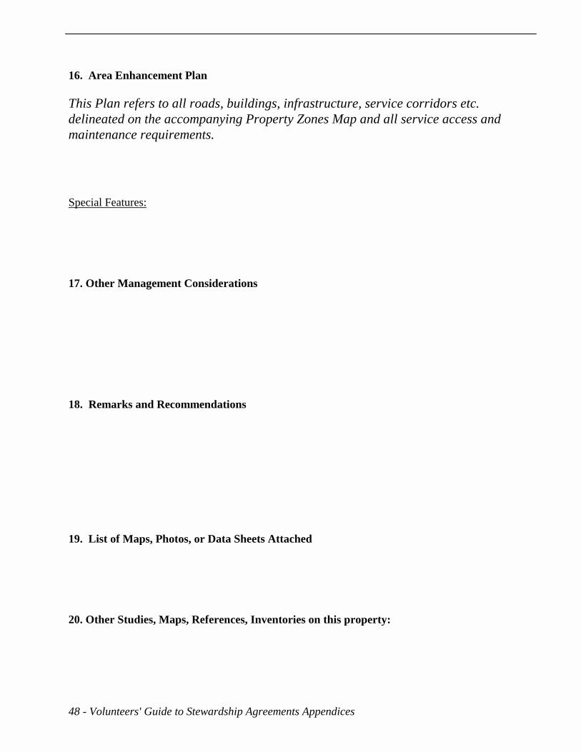
16. Area Enhancement Plan This Plan refers to all roads, buildings, infrastructure, service corridors etc. delineated on the accompanying Property Zones Map and all service access and maintenance requirements. Special Features:
17. Other Management Considerations 18. Remarks and Recommendations 19. List of Maps, Photos, or Data Sheets Attached
20. Other Studies, Maps, References, Inventories on this property:

Volunteers' Guide to Stewardship Agreements, Appendices - 49
Aquatic/Riparian Features and Hydrology of Property Project Name:__________________________ _Date:_______________________Weather:______________ General description:________________________________________________________________________________
Site # Station # Upstream Bearing: Class: Bankfull Width/Wetland Area: Bankfull Depth: Stream Gradient: Wetted Width: Wetted Depth:
Bank Slope (upstream) L: R: Flow Characteristics: Instream Vegetation: Riparian Vegetation: Modifications: Fish & Wildlife use: Temp: DO : ph: Turbidity: Coliform: Nitrogen: Phos: BOD:
Notes: Reference Site No. and Station No. on Map Clearly mark all sample bottles sent to the lab for analysis with the date of sampling, the site sampled, the parameter to be analyzed, and the station number from which the sample was collected. Remember that coliform samples must be shipped overnight to the lab for analysis within 24 hours of sample collection. They must be kept in coolers, and protected from exposure to light. Please instruct the lab to return the lab analysis results to the Land Trust, Conservancy or Stewardship Group who has directed that the study be completed.