delivering a better railway for a better britain route ... · srs g.01 - king’s cross -...
TRANSCRIPT

Delivering a better railway for a better Britain Route Specifications 2018 London North Eastern and East Midlands
Network Rail – Route Specifications: London North Eastern and East Midlands 02April 2018
Route G: East Coast Main Line and North East Route H: North Cross-Pennine Route I: East Midlands
London North Eastern and East Midlands
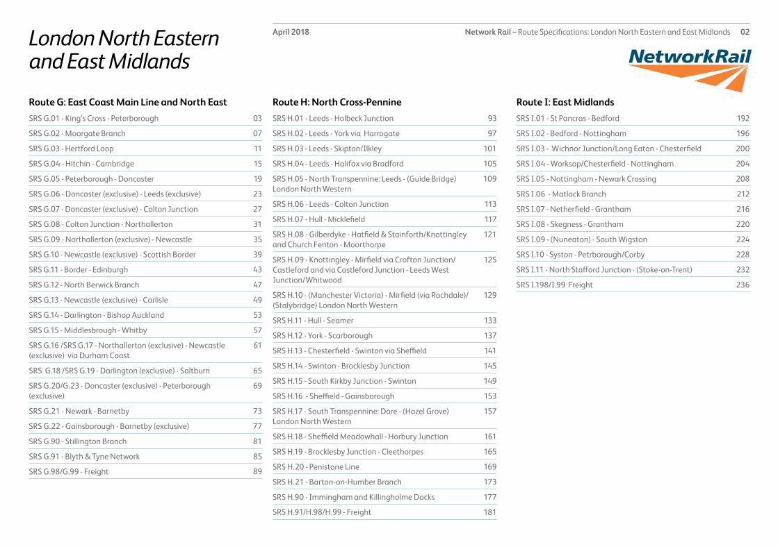
SRS G.01 - King’s Cross - Peterborough 03
SRS G.02 - Moorgate Branch 07
SRS G.03 - Hertford Loop 11
SRS G.04 - Hitchin - Cambridge 15
SRS G.05 - Peterborough - Doncaster 19
SRS G.06 - Doncaster (exclusive) - Leeds (exclusive) 23
SRS G.07 - Doncaster (exclusive) - Colton Junction 27
SRS G.08 - Colton Junction - Northallerton 31
SRS G.09 - Northallerton (exclusive) - Newcastle 35
SRS G.10 - Newcastle (exclusive) - Scottish Border 39
SRS G.11 - Border - Edinburgh 43
SRS G.12 - North Berwick Branch 47
SRS G.13 - Newcastle (exclusive) - Carlisle 49
SRS G.14 - Darlington - Bishop Auckland 53
SRS G.15 - Middlesbrough - Whitby 57
SRS G.16 /SRS G.17 - Northallerton (exclusive) - Newcastle (exclusive) via Durham Coast
61
SRS G.18 /SRS G.19 - Darlington (exclusive) - Saltburn 65
SRS G.20/G.23 - Doncaster (exclusive) - Peterborough (exclusive)
69
SRS G.21 - Newark - Barnetby 73
SRS G.22 - Gainsborough - Barnetby (exclusive) 77
SRS G.90 - Stillington Branch 81
SRS G.91 - Blyth & Tyne Network 85
SRS G.98/G.99 - Freight 89
SRS H.01 - Leeds - Holbeck Junction 93
SRS H.02 - Leeds - York via Harrogate 97
SRS H.03 - Leeds - Skipton/Ilkley 101
SRS H.04 - Leeds - Halifax via Bradford 105
SRS H.05 - North Transpennine: Leeds - (Guide Bridge) London North Western
109
SRS H.06 - Leeds - Colton Junction 113
SRS H.07 - Hull - Micklefield 117
SRS H.08 - Gilberdyke - Hatfield & Stainforth/Knottingley and Church Fenton - Moorthorpe
121
SRS H.09 - Knottingley - Mirfield via Crofton Junction/Castleford and via Castleford Junction - Leeds West Junction/Whitwood
125
SRS H.10 - (Manchester Victoria) - Mirfield (via Rochdale)/(Stalybridge) London North Western
129
SRS H.11 - Hull - Seamer 133
SRS H.12 - York - Scarborough 137
SRS H.13 - Chesterfield - Swinton via Sheffield 141
SRS H.14 - Swinton - Brocklesby Junction 145
SRS H.15 - South Kirkby Junction - Swinton 149
SRS H.16 - Sheffield - Gainsborough 153
SRS H.17 - South Transpennine: Dore - (Hazel Grove) London North Western
157
SRS H.18 - Sheffield Meadowhall - Horbury Junction 161
SRS H.19 - Brocklesby Junction - Cleethorpes 165
SRS H.20 - Penistone Line 169
SRS H.21 - Barton-on-Humber Branch 173
SRS H.90 - Immingham and Killingholme Docks 177
SRS H.91/H.98/H.99 - Freight 181
SRS I.01 - St Pancras - Bedford 192
SRS I.02 - Bedford - Nottingham 196
SRS I.03 - Wichnor Junction/Long Eaton - Chesterfield 200
SRS I.04 - Worksop/Chesterfield - Nottingham 204
SRS I.05 - Nottingham - Newark Crossing 208
SRS I.06 - Matlock Branch 212
SRS I.07 - Netherfield - Grantham 216
SRS I.08 - Skegness - Grantham 220
SRS I.09 - (Nuneaton) - South Wigston 224
SRS I.10 - Syston - Petrborough/Corby 228
SRS I.11 - North Stafford Junction - (Stoke-on-Trent) 232
SRS I.198/I.99 Freight 236

Network Rail – Route Specifications: London North Eastern and East Midlands 03April 2018SRS G01–King’s Cross - Peterborough
Route specification descriptionThis Strategic Route Section (SRS) forms the south end of the East Coast Main Line (ECML) and extends for 76¼ miles from London King’s Cross station to Peterborough. It comprises four tracks for most of its length, but widens to six tracks between Finsbury Park and Alexandra Palace, narrows to two tracks over the Welwyn Viaduct and through two tunnels north of Welwyn North station. It narrows to three and then two tracks between Huntingdon and Fletton Junction. It is electrified (with 25kV Overhead Line Electrification) along its whole length. It intersects with other routes at a number of locations, most notably with the North London Line at Copenhagen Junction and Harringay Junction, the Moorgate branch at Finsbury Park South Junction, the Hertford loop at Wood Green North Junction and Langley Junction, and the Hitchin – Cambridge line at Hitchin Cambridge Junction. The route carries suburban services from King’s Cross and Moorgate to various destinations in Hertfordshire, Bedfordshire, Cambridgeshire and Norfolk, and long distance high speed (LDHS) services from King’s Cross to destinations in Yorkshire, the North East and Scotland.
In terms of passenger numbers, the most significant stations are King’s Cross, Finsbury Park, Stevenage, Peterborough, Hitchin and Welwyn Garden City. King’s Cross is a major London terminal that forms a gateway to the many destinations to the North and North East. The station has 12 platforms, of which nine can accommodate both LDHS trains and suburban services, with a further three shorter platforms accommodating suburban trains only. There is also the facility to interchange to the Circle, Hammersmith & City, Metropolitan, Northern, Piccadilly and Victoria lines of the London Underground as well as with LDHS and interurban services at the adjacent St Pancras International station. The main Victorian train shed at King’s Cross is a listed building and has been considerably refurbished and enhanced, including the creation of a new entrance/concourse area and improved interchange facilities.
Finsbury Park station has seven platforms, serving trains originating from Moorgate via the Northern City line as well as suburban services from King’s Cross, whilst also allowing interchange to the Piccadilly and Victoria lines of London Underground which have their own four sub-surface platforms. Stevenage has four platforms,
and accommodates outer suburban services from King’s Cross to Peterborough, Cambridge and King’s Lynn, along with some LDHS trains, and some inner suburban services from the Hertford Loop (G.03). Peterborough has seven platforms. As well as marking the northernmost limit of outer suburban services, and providing a stop for many of the LDHS trains, Peterborough also accommodates regular east-west services (namely Birmingham to Cambridge/Stansted Airport services, and Liverpool to Norwich services) and less frequent local trains to Lincolnshire via Spalding and to Ipswich via Ely and Bury St Edmunds. Welwyn Garden City is the busiest of 11 stations serving regional services only and has four through platforms, whilst Hitchin is the busiest of seven stations which have two through platforms. Hatfield has three through platforms, whilst Huntingdon has two through platforms and a south-facing turnback platform. Recently completed platform extension work has ensured all appropriate locations are ready for the Thameslink outer suburban service planned to operate with twelve carriages.
There are numerous operational, maintenance and freight facilities along the route, of which the most significant include the sidings at Ferme Park (between Harringay and Hornsey), Hornsey Train Servicing Centre, the LDHS maintenance depot at Bounds Green, carriage sidings at Welwyn Garden City, a plant maintenance depot and engineers’ sidings at Hitchin and Nene carriage sidings, just south of Peterborough station. There are freight private sidings at Stevenage (Langley Junction) and Biggleswade together with various other sidings at Welwyn Garden City, St. Neots, Huntingdon and Connington, most of which are either lightly used or unused at the present time. There is a connection to the heritage Nene Valley Railway at Fletton Junction. This SRS is characterised by its large number of tunnels, at Gasworks, Copenhagen, Wood Green, Barnet, Hadley Wood South, Hadley Wood North, Potters Bar, Welwyn South and Welwyn North. Their existence forms a significant factor influencing any proposal for changes in station location or track layout.
Geographic Map

Network Rail – Route Specifications: London North Eastern and East Midlands 04April 2018SRS G01–King’s Cross - Peterborough
Table 1.0
Information Current 2019 2043 Notes
Line of route description
LN101: King’s Cross to Peterborough
Section start King’s Cross Station
Section end Peterborough Station
Route availability RA9 RA9 RA9
Gauge W10/W12 W10/W12 (except for W8 between Wood Green Junction and Langley Junction)
W10/W12 (except for W8 between Wood Green Junction and Langley Junction)
Signals TCB TCB ERTMS
SpeedSee Sectional Appendix for detailed speed profiles
Fast lines: Predominantly 125 mphSlow lines: Predominantly 75 mph
Fast lines: Predominantly 125 mphSlow lines: Predominantly 75 mph, with 100mph on some sections
Incremental linespeed improvements where possible in line with infrastructure characteristics and capability of rolling stock
Electrification 25kV AC OHL 25kV AC OHL 25kV AC OHL
Passenger train service levels (trains per hour / day)Table 2.0
Current 2019 2043 Notes
Typical journey time King’s Cross to PeterboroughLDHS: 47 minutesSuburban: 1 hour 18 minutes
Reduce journey time to lowest possible in line with linespeed improvements and changes in rolling stockIntroduction of IEP coupled with implementation of infrastructure interventions can be expected to provide some improvement
Reduce journey time to lowest possible in line with linespeed improvements and changes in rolling stock.
All future service specifications to be shaped by Market and Route Studies as part of the Long Term Planning Process.
No. of trains per hour LDHS2 tph (3 peak) King’s Cross to Newcastle/Scotland1 tph King’s Cross to Newark/York2 tph (3 peak) King’s Cross to Leeds1 tph King’s Cross to Lincoln or Hull or Sunderland or Bradford Interchange
Suburban4 tph (7 peak) King’s Cross to Royston/Cambridge/King’s Lynn2 tph (6 peak) King’s Cross to Peterborough3 tph (4 peak) Moorgate to Welwyn Garden City2 tph (7 peak) Moorgate to Gordon Hill/Hertford North1 tph (2 peak) Moorgate to Stevenage/Letchworth via Hertford North
Possible changes to service frequency in line with industry aspirations and market requirements.
Possible changes to service frequency in line with industry aspirations and market requirements.
Route capability overview

Network Rail – Route Specifications: London North Eastern and East Midlands 05April 2018SRS G01–King’s Cross - Peterborough
Table 3.0
Current 2019 2043 Notes
Route section
Trains in one direction (as per WTT)
20 tpd For further information please see the Freight Market Study .
* Figures are for freight trains in one direction only.
Table 4.0
Type Current No. of level crossings 2019 No. of level crossings 2043 No. of level crossings
Supervised: 6As determined by Level Crossing policyAutomatic: 0
User: 13
Freight Trains (trains per day)
Level crossings on route

Network Rail – Route Specifications: London North Eastern and East Midlands 06April 2018SRS G01–King’s Cross - Peterborough
Proposed Infrastructure Investment
Table 5.0
Project Project Description ELR Implementation Date
Output change Status
King’s Cross Station Remodelling
Remodelling of Kings Cross throat on the back of renewal of S&C and ERTMS
ECM1 2020 Potential improved performance, platfom lengthening, maintenance and journey time improvement
In design
Huntingdon to Woodwalton 4-tracking
4-tracking of existing 3-track section ECM1 CP6 Improved capacity In design
Peterborough Down Slow Upgrade of turnout at Fletton junction and Down Slow between Fletton Junction and Peterborough
ECM1 CP5 Improved capacity in the Peterborough area
In delivery
IEP Develoment/enabling works (OLE)
Infrastructure works to accommodate operation of IEP rolling stock
ECM1 CP5 Increased capacitiy In delivery
IEP Development/enabling works (Gauging)
Infrastructure works to accommodate operation of IEP rolling stock
ECM1 CP5 Increased capacity In delivery
IEP Development/enabling works (Platform Extensions)
Infrastructure works to accommodate operation of IEP rolling stock
ECM1 CP5 Increased capacity In delivery
ECML Inner Suburban Stevenage Turnback
New turnback facility at Stevenage ECM1 CP6 Saving of operational cost for franchisee In design
EC Power Supply Upgrade Phase 1 (Wood Green & Bawtry)
Major improvements to power supply to OLE
ECM1 CP5 Ability to accommodate increased ECML traffic
In design

Network Rail – Route Specifications: London North Eastern and East Midlands 07April 2018SRS G.02 - Moorgate Branch
Route specification descriptionThe Moorgate branch (also known as the Northern City Line) extends for 3½ miles from Moorgate station to Finsbury Park South Junction, where it joins the East Coast Main Line (SRS G.01). It carries frequent inner suburban commuter services from Monday to Friday. It is electrified with third rail DC from Moorgate to Drayton Park, and with 25kV OHL from Drayton Park to Finsbury Park.
It is double track along its whole length, and contains five stations (including Moorgate), all of which have two platforms serving the Moorgate Branch. There are eight platforms in total at Highbury & Islington station, facilitating both an easy interchange with the London Underground Victoria Line, and interchange with London Overground services operating on the North London Line (SRS E.03). Moorgate station has a total of ten platforms (of which the two formerly serving Thameslink are disused), serving the Circle, Hammersmith & City, Metropolitan, and Northern Lines of London Underground (LUL), as well as the two on the Moorgate branch. It is a key entry point to the City of London.
The other three stations on the branch (Old Street, Essex Road and Drayton Park) all have two through platforms each, all of which serve only the Moorgate Branch.
The platforms at Moorgate, Old Street, Essex Road and Highbury & Islington are all of sub-surface ‘tube’ type, although the line is of larger loading gauge than LUL ‘tube’ lines allowing operation by Class 313 EMUs which are the only rolling stock type used on the line. Due to the single line tunnel configuration of the line and its frequent service, the signalling incorporates a train stop system as traditionally used by LUL, but rarely used on Network Rail routes.
Geographic Map

Network Rail – Route Specifications: London North Eastern and East Midlands 08April 2018SRS G02–Moorgate - Finsbury Park Branch
Table 1.0
Information Current 2019 2043 Notes
Line of route description
LN105: Moorgate to Finsbury Park Junction
Section start Moorgate Station
Section end Finsbury Park Junction
Route availability 9 9 9
Gauge W6 W6 W6
Signals TCB TCB ERTMS
SpeedSee Sectional Appendix for detailed speed profiles
Predominantly 30mph Predominantly 30mph Incremental linespeed improvements where possible in line with infrastructure characteristics and capability of rolling stock
Electrification DC 3rd rail from Moorgate to Drayton Park; AC OHL from Drayton Park to Finsbury Park Junction
DC 3rd rail from Moorgate to Drayton Park; AC OHL from Drayton Park to Finsbury Park Junction
25kV AC OHL
Passenger train service levels (trains per hour / day)Table 2.0
Current 2019 2043 Notes
Typical journey time Moorgate to Finsbury Park (11½ minutes Down; 13 minutes Up)
Reduce journey time to lowest possible in line with linespeed improvements and changes in rolling stock
Reduce journey time to lowest possible in line with linespeed improvements and changes in rolling stock.
All future service specifications to be shaped by Market and Route Studies as part of the Long Term Planning Process.
No. of trains per hour Monday to Friday3 tph (4 peak) Moorgate to Welwyn Garden City2 tph (7 peak) Moorgate to Hertford North line1 tph (2 peak) Moorgate to Stevenage/LetchworthWeekends2 tph Moorgate to Welwyn Garden City1 tph Moorgate to Hertford North1 tph Moorgate to Stevenage via Hertford North
Possible changes to service frequency in line with industry aspirations and market requirements.
Possible changes to service frequency in line with industry aspirations and market requirements.
Route capability overview

Network Rail – Route Specifications: London North Eastern and East Midlands 09April 2018SRS G02–Moorgate - Finsbury Park Branch
Table 3.0
Current 2019 2043 Notes
Trains in one direction (as per WTT)
0 For further information please see the Freight Market Study..
* Figures are for freight trains in one direction only on an average weekday.
Table 4.0
Type Current No. of level crossings 2019 No. of level crossings 2043 No. of level crossings
Supervised:There are no level crossings in this route section.Automatic:
User:
Freight Trains (trains per day)
Level crossings on route

Network Rail – Route Specifications: London North Eastern and East Midlands 10April 2018SRS G02–Moorgate-Finsbury Park Branch
Table 5.0
Project Project Description ELR Implementation Date
Output change Status
There are no proposed infrastructure investment projects in CP5.
Proposed Infrastructure Investment

Network Rail – Route Specifications: London North Eastern and East Midlands 11April 2018SRS G03–Hertford Loop
Route specification descriptionThe Hertford Loop extends for 23 miles from Wood Green North Junction to Langley Junction (near Stevenage), thereby forming a loop off the southern section of the East Coast Main Line (SRS G.01), to which it is joined at both ends. It is double track and electrified (with 25kV OHL) along its whole length although the section between Hertford North and Langley Junction is effectively single track for periods to allow the other track to be used as an ERTMS test bed. The route has 11 stations, of which the most significant (in terms of passenger numbers) are Palmers Green, Winchmore Hill, Hertford North, Enfield Chase and Gordon Hill. It is served by frequent inner suburban services, which run to King’s Cross in the early morning, late evening, and at weekends, and to Moorgate for most of the day Monday to Friday. The northerly limits of Hertford loop services are generally Gordon Hill, Hertford North or Letchworth at which suitable turnback facilities exist. Gordon Hill and Hertford North stations each have three platforms, both being equipped with a south-facing turnback platform in addition to the Up and Down through platforms. The other nine stations (Bowes Park, Palmers Green, Winchmore Hill, Grange Park, Enfield Chase, Crews Hill, Cuffley, Bayford and Watton-at-Stone) are all served by two through platforms. There are electrified carriage sidings at Hertford North.
The line operates through a largely built up area as far as Gordon Hill with a more rural environment further north in which the largest community is at Hertford. It passes for some distance through a Conservation area immediately north of Hertford North station.
In addition to providing a key suburban link for parts of north London and Hertfordshire, the Hertford loop also has an important role as a diversionary route for services normally routed via Welwyn Garden City at times when the ECML is unavailable due to planned maintenance work or incident. It is also the main route for through freight trains between Wood Green and Langley Junction. As such, it forms a critical element of the total rail operation in the London – Stevenage corridor.
Geographic Map

Network Rail – Route Specifications: London North Eastern and East Midlands 12April 2018SRS G03–Hertford Loop
Table 1.0
Information Current 2019 2043 Notes
Line of route description
LN120: Wood Green Junction to Langley Junction
Section start Wood Green Junction
Section end Langley Junction
Route availability 9 9 9
Gauge W9 W12 W12
Signals TCB TCB ERTMS
SpeedSee Sectional Appendix for detailed speed profiles
Predominantly 75 mph Predominantly 75 mph Incremental linespeed improvements where possible in line with infrastructure characteristics and capability of rolling stock
Electrification 25kV AC OHL 25kV AC OHL 25kV AC OHL
Passenger train service levels (trains per hour / day)Table 2.0
Current 2019 2043 Notes
Typical journey time Bowes Park to Stevenage39 minutes
Reduce journey time to lowest possible in line with linespeed improvements and changes in rolling stock
Reduce journey time to lowest possible in line with linespeed improvements and changes in rolling stock.
All future service specifications to be shaped by Market and Route Studies as part of the Long Term Planning Process.
No. of trains per hour Monday to Friday2 tph (7 peak) Moorgate to Hertford North1 tph (2 peak) Moorgate to Stevenage/LetchworthWeekends1 tph King’s Cross to Hertford North1 tph King’s Cross to Stevenage
Possible changes to service frequency in line with industry aspirations and market requirements.
Possible changes to service frequency in line with industry aspirations and market requirements.
Route capability overview

Network Rail – Route Specifications: London North Eastern and East Midlands 13April 2018SRS G03–Hertford Loop
Table 3.0
Current 2019 2043 Notes
Trains in one direction (as per WTT)
15 For further information please see the Freight Market Study.
* Figures are for freight trains in one direction only on an average weekday.
Table 4.0
Type Current No. of level crossings 2019 No. of level crossings 2043 No. of level crossings
Supervised: 0As determined by Level Crossing policyAutomatic: 0
User: 1
Freight Trains (trains per day)
Level crossings on route
Network Rail – Route Specifications: London North Eastern and East Midlands 14April 2018SRS G03–Hertford Loop
Table 5.0
Project Project Description ELR Implementation Date
Output change Status
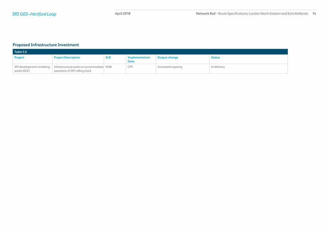
IEP development/ enabling works (OLE)
Infrastructure works to accommodate operation of IEP rolling stock
HDB CP5 Increased capacity In delivery
Proposed Infrastructure Investment
Network Rail – Route Specifications: London North Eastern and East Midlands 15April 2018SRS G.04 - Hitchin - Cambridge
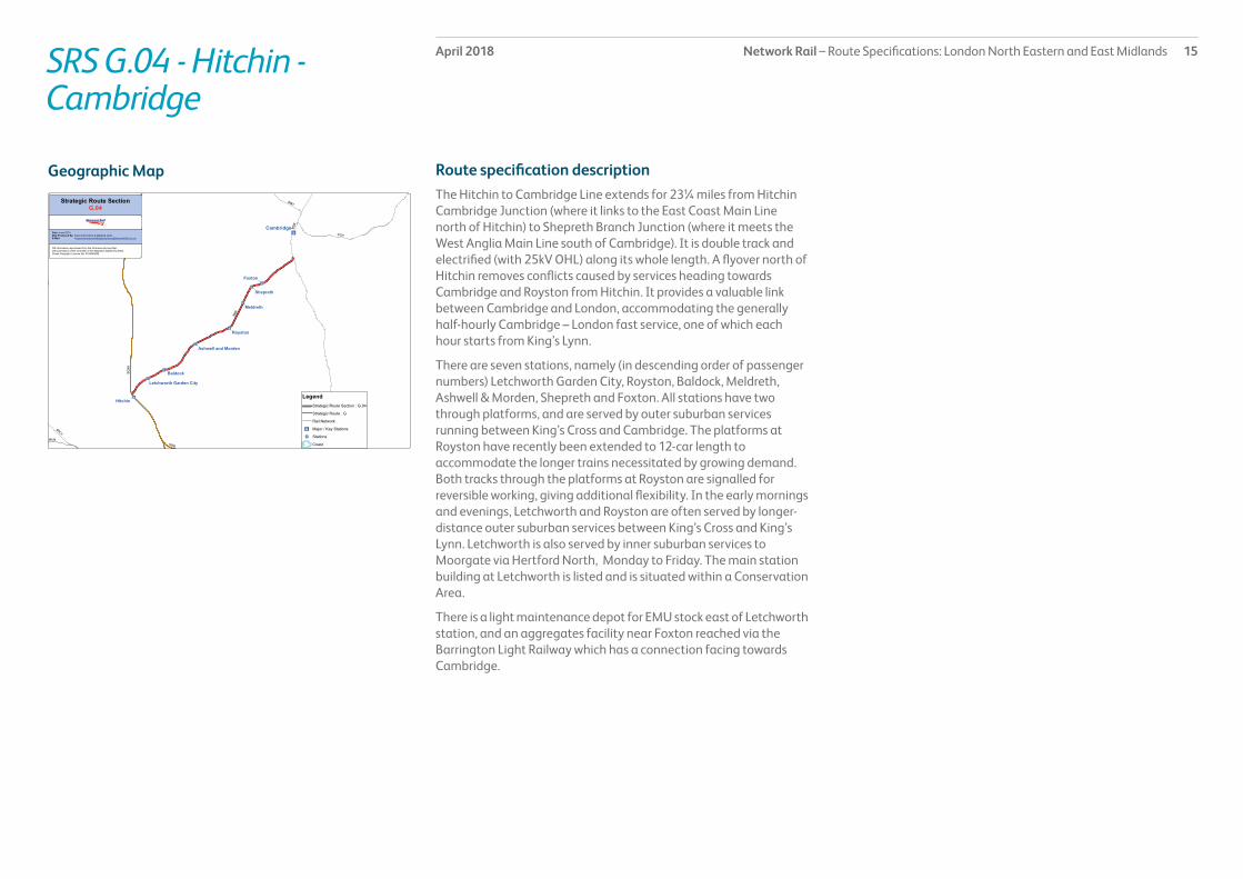
Route specification descriptionThe Hitchin to Cambridge Line extends for 23¼ miles from Hitchin Cambridge Junction (where it links to the East Coast Main Line north of Hitchin) to Shepreth Branch Junction (where it meets the West Anglia Main Line south of Cambridge). It is double track and electrified (with 25kV OHL) along its whole length. A flyover north of Hitchin removes conflicts caused by services heading towards Cambridge and Royston from Hitchin. It provides a valuable link between Cambridge and London, accommodating the generally half-hourly Cambridge – London fast service, one of which each hour starts from King’s Lynn.
There are seven stations, namely (in descending order of passenger numbers) Letchworth Garden City, Royston, Baldock, Meldreth, Ashwell & Morden, Shepreth and Foxton. All stations have two through platforms, and are served by outer suburban services running between King’s Cross and Cambridge. The platforms at Royston have recently been extended to 12-car length to accommodate the longer trains necessitated by growing demand. Both tracks through the platforms at Royston are signalled for reversible working, giving additional flexibility. In the early mornings and evenings, Letchworth and Royston are often served by longer-distance outer suburban services between King’s Cross and King’s Lynn. Letchworth is also served by inner suburban services to Moorgate via Hertford North, Monday to Friday. The main station building at Letchworth is listed and is situated within a Conservation Area.
There is a light maintenance depot for EMU stock east of Letchworth station, and an aggregates facility near Foxton reached via the Barrington Light Railway which has a connection facing towards Cambridge.
Geographic Map

Network Rail – Route Specifications: London North Eastern and East Midlands 16April 2018SRS G.04 - Hitchin - Cambridge
Table 1.0
Information Current 2019 2043 Notes
Line of route description
LN125: Hitchin Cambridge Junction to Shepreth Branch JunctionLN126: Hitchin North Junction to Hitchin East Junction
Section start Hitchin Cambridge Junction
Section end Shepreth Branch Junction
Route availability 9 9 9
Gauge W8 W12 W12
Signals TCB TCB ERTMS
SpeedSee Sectional Appendix for detailed speed profiles
Predominantly 90 mph Predominantly 90 mph Raise linespeed to highest possible in line with infrastructure characteristics and capability of rolling stock
Electrification 25kV AC OHL 25kV AC OHL 25kV AC OHL
Passenger train service levels (trains per hour / day)Table 2.0
Current 2019 2043 Notes
Typical journey time Hitchin to Cambridge40 minutes
Reduce journey time to lowest possible in line with linespeed improvements and changes in rolling stock
Reduce journey time to lowest possible in line with linespeed improvements and changes in rolling stock.
All future service specifications to be shaped by Market and Route Studies as part of the Long Term Planning Process.
No. of trains per hour 4 tph (7 peak) King’s Cross to Royston/Cambridge/King’s Lynn1 tph (2 peak) Moorgate to Letchworth (weekdays)
Possible changes to service frequency in line with industry aspirations and market requirements.
Possible changes to service frequency in line with industry aspirations and market requirements.
Route capability overview

Network Rail – Route Specifications: London North Eastern and East Midlands 17April 2018SRS G.04 - Hitchin - Cambridge
Table 3.0
Current 2019 2043 Notes
Trains in one direction (as per WTT)
3 tpd For further information please see the Freight Market Study.
* Figures are for freight trains in one direction only on an average weekday.
Table 4.0
Type Current No. of level crossings 2019 No. of level crossings 2043 No. of level crossings
Supervised: 0As determined by Level Crossing policy.Automatic: 1
User: 8
Freight Trains (trains per day)
Level crossings on route

Network Rail – Route Specifications: London North Eastern and East Midlands 18April 2018SRS G.04 - Hitchin - Cambridge
Table 5.0
Project Project Description ELR Implementation Date
Output change Status
IEP development/enabling works (IEP ECML OLE)
Infrastructure works to accommodate operation of IEP rolling stock
SBR CP5 Increased capacity In delivery
IEP development/enabling works (IEP ECML Gauging)
Infrastructure works to accommodate operation of IEP rolling stock
SBR CP5 Increased capacity In delivery
Proposed Infrastructure Investment

Network Rail – Route Specifications: London North Eastern and East Midlands 19April 2018SRS G.05 - Peterborough - Doncaster
Route specification descriptionThis SRS forms one of the central sections of the East Coast Main Line, and runs for 79½ miles from Peterborough to Doncaster. It comprises five tracks from Peterborough to Helpston Junction, four tracks from Helpston Junction to Stoke Tunnel, and predominantly two tracks from Grantham to the southern approaches to Doncaster. It is electrified (with 25kV OHL) along its whole length. It intersects with the GN/GE Joint Line (from Peterborough to Doncaster via Lincoln) at Werrington Junction, the Peterborough to Leicester line at Helpston Junction, the Nottingham to Skegness line at Grantham, the Nottingham to Lincoln line at Newark, the Sheffield to Lincoln line at Retford, and numerous freight and passenger lines near Doncaster. The only passenger services which use the route along its entire length are long distance high speed (LDHS) trains from London King’s Cross to Yorkshire, the North East, and Scotland. Birmingham to Cambridge/Stansted services use the route between Peterborough and Helpston Junction, Liverpool to Norwich services run between Peterborough and Grantham, and local services (from Peterborough to Spalding/Lincoln and Doncaster) use the route between Werrington Junction and between Hitchin East Junction and Doncaster.
There are five stations on this section, namely (in descending order of passenger numbers) Peterborough, Doncaster, Grantham, Newark North Gate and Retford. As well as marking the northernmost limit of outer suburban services from the southern end of the route, and providing a stop for many LDHS trains, Peterborough also accommodates two regular east-west services (Birmingham to Cambridge/Stansted services, and Liverpool to Norwich services) and less frequent local trains to Lincolnshire via Spalding and to Ipswich via Bury St Edmunds.
Doncaster has four through platforms, two north-facing bay platforms on the Down side, a newly -completed north-facing bay platform on the Up side and two south-facing bay platforms, one each on the Up and Down sides. As well as LDHS services, it accommodates services between Manchester Airport and Cleethorpes, and numerous local services.
Grantham has three through platforms and one north-facing bay platform. It accommodates LDHS services, plus Liverpool to Norwich and Nottingham to Skegness services.
Newark North Gate has three through platforms. It serves LDHS trains, plus some local services.
Retford has two through platforms on the East Coast Main Line, and two through platforms on the Sheffield to Lincoln line. It is served by LDHS services from King’s Cross, plus Sheffield to Lincoln local services.
There are numerous operational, maintenance and freight facilities along the route, of which the most significant include five sets of sidings accessed from the north side of Peterborough station (Crescent, Crescent Wharf, Westwood, Spital and New England), Peterborough North Depot, Peterborough Electrification Depot, a concrete plant at Tallington, a small number of freight sidings at Grantham and Newark, and a large complex of freight facilities at Doncaster Railport (including Doncaster Royal Mail Terminal, several sets of sidings, and DB Schenker’s maintenance depot). A new Intercity Express (IEP) depot has been built at Peterborough.
Geographic Map

Network Rail – Route Specifications: London North Eastern and East Midlands 20April 2018SRS G.05 - Peterborough - Doncaster
Table 1.0
Information Current 2019 2043 Notes
Line of route description
LN101: Peterborough to Doncaster
Section start Peterborough Station
Section end Doncaster Station
Route availability 9 9 9
Gauge W10 W12 W12
Signals TCB TCB ERTMS
SpeedSee Sectional Appendix for detailed speed profiles
Fast lines: Predominantly 125 mphSlow lines (to Stoke Tunnel): Predominantly 80 mph
Fast lines: Predominantly 125 mph
Slow lines (to Stoke Tunnel): Predominantly 80 mph
Incremental linespeed improvements where possible in line with infrastructure characteristics and capability of rolling stock
Electrification 25kV AC OHL 25kV AC OHL 25kV AC OHL
Passenger train service levels (trains per hour / day)Table 2.0
Current 2019 2043 Notes
Typical journey time Peterborough to Doncaster53 minutes
Reduce journey time to lowest possible in line with linespeed improvements and changes in rolling stock
Reduce journey time to lowest possible in line with linespeed improvements and changes in rolling stock.
All future service specifications to be shaped by Market and Route Studies as part of the Long Term Planning Process.
No. of trains per hour LDHS2 tph (3 peak) King’s Cross to Newcastle/Scotland1 tph King’s Cross to Newark/York2 tph (3 peak) King’s Cross to Leeds1 tph King’s Cross to Lincoln or Hull or Sunderland or Bradford Interchange
Other1 tph Norwich to Liverpool1 tph Peterborough to Spalding/Lincoln
Possible changes to service frequency in line with industry aspirations and market requirements
Possible changes to service frequency in line with industry aspirations and market requirements.
Route capability overview

Network Rail – Route Specifications: London North Eastern and East Midlands 21April 2018SRS G.05 - Peterborough - Doncaster
Table 3.0
Current 2019 2043 Notes
Trains in one direction (as per WTT)
13 For further information please see the Freight Market Study.
* Figures are for freight trains in one direction only on an average weekday.
Table 4.0
Type Current No. of level crossings 2019 No. of level crossings 2043 No. of level crossings
Supervised: 27As determined by Level Crossing policy.Automatic: 0
User: 24
Freight Trains (trains per day)
Level crossings on route

Network Rail – Route Specifications: London North Eastern and East Midlands 22April 2018SRS G.05 - Peterborough - Doncaster
Table 5.0
Project Project Description ELR Implementation Date
Output change Status
Werrington Grade Separation (Werrington Junction)
Alterations to junction layout ECM1, WEB, PMJ
CP6 Increased capacity for both passenger and freight services through Peterborough
In design
Doncaster Station Area Enhancement
New turnback facility (platform 0) on upside; bi-directional signalling on Up East Slow; make carriage sidings on up side into a running line
ECM1 CP5 Increase flexibility and capacity in the Doncaster area
Complete
EC Power Supply Upgrade Phase 1 (Wood Green & Bawtry)
Major improvements to power supply to OLE
ECM1 CP5 Ability to accommodate increased ECML traffic
In delivery
IEP development/enabling works (IEP ECML Gauging)
Infrastructure works to accommodate operation of IEP rolling stock
ECM1 CP5 Increased capacity In delivery
IEP development/enabling works (IEP ECML OLE)
Infrastructure works to accommodate operation of IEP rolling stock
ECM1 CP5 Increased capacity In delivery
IEP development/enabling works (IEP ECML Platform Extensions)
Infrastructure works to accommodate operation of IEP rolling stock
ECM1 CP5 Increased capacity In delivery
Proposed Infrastructure Investment
Network Rail – Route Specifications: London North Eastern and East Midlands 23April 2018SRS G.06 - Doncaster (exclusive) – Leeds (exclusive)
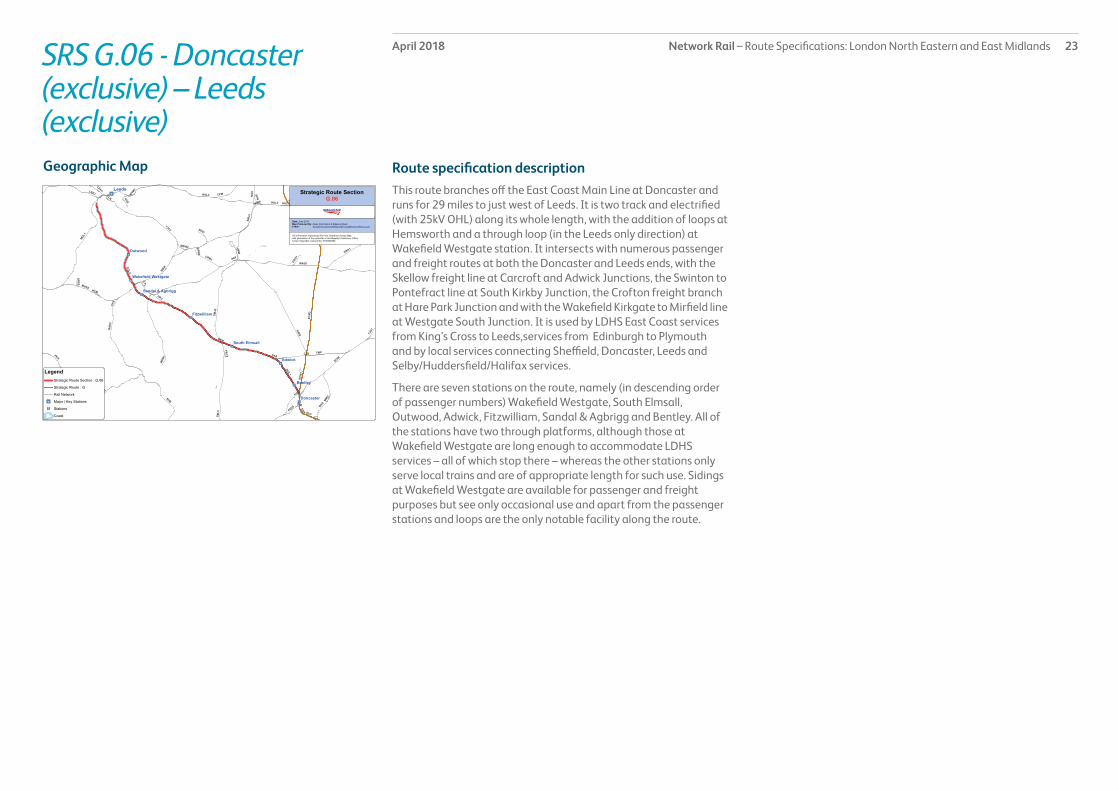
Route specification descriptionThis route branches off the East Coast Main Line at Doncaster and runs for 29 miles to just west of Leeds. It is two track and electrified (with 25kV OHL) along its whole length, with the addition of loops at Hemsworth and a through loop (in the Leeds only direction) at Wakefield Westgate station. It intersects with numerous passenger and freight routes at both the Doncaster and Leeds ends, with the Skellow freight line at Carcroft and Adwick Junctions, the Swinton to Pontefract line at South Kirkby Junction, the Crofton freight branch at Hare Park Junction and with the Wakefield Kirkgate to Mirfield line at Westgate South Junction. It is used by LDHS East Coast services from King’s Cross to Leeds,services from Edinburgh to Plymouth and by local services connecting Sheffield, Doncaster, Leeds and Selby/Huddersfield/Halifax services.
There are seven stations on the route, namely (in descending order of passenger numbers) Wakefield Westgate, South Elmsall, Outwood, Adwick, Fitzwilliam, Sandal & Agbrigg and Bentley. All of the stations have two through platforms, although those at Wakefield Westgate are long enough to accommodate LDHS services – all of which stop there – whereas the other stations only serve local trains and are of appropriate length for such use. Sidings at Wakefield Westgate are available for passenger and freight purposes but see only occasional use and apart from the passenger stations and loops are the only notable facility along the route.
Geographic Map

Network Rail – Route Specifications: London North Eastern and East Midlands 24April 2018SRS G.06 - Doncaster (exclusive) – Leeds (exclusive)
Table 1.0
Information Current 2019 2043 Notes
Line of route description
LN836: Doncaster to Holbeck West Junction
Section start Doncaster Station
Section end Holbeck West Junction
Route availability 9 9 9
Gauge W9 W9/W10 from Doncaster to Hare Park Junction, W9 thereafter
W9/W10 from Doncaster to Hare Park Junction, W9 thereafter
Signals TCB TCB ERTMS
SpeedSee Sectional Appendix for detailed speed profiles
Predominantly 100mph south of Sandal & Agbrigg, 75mph thereafter
Predominantly 100mph south of Sandal & Agbrigg, 75mph thereafter
Incremental linespeed improvements where possible in line with infrastructure characteristics and capability of rolling stock
Electrification 25kV AC OHL 25kV AC OHL 25kV AC OHL
Passenger train service levels (trains per hour / day)Table 2.0
Current 2019 2043 Notes
Typical journey time Doncaster to LeedsLDHS: 38 minutesLocal: 48 minutes
Reduce journey time to lowest possible in line with linespeed improvements and changes in rolling stock
Reduce journey time to lowest possible in line with linespeed improvements and changes in rolling stock.
All future service specifications to be shaped by Market and Route Studies as part of the Long Term Planning Process.
No. of trains per hour LDHS2 tph (3 peak) King’s Cross to Leeds1 tph Plymouth to Edinburgh
Local1 tph (2 peak) Doncaster to Leeds1 tph Sheffield to Leeds1 tph Sheffield to Adwick
LDHS1 tph Plymouth to EdinburghPossible changes to service frequency in line with industry aspirations
Local1 tph (2 peak) Doncaster to Leeds1 tph Sheffield to Leeds via Moorthorpe1 tph Nottingham to Bradford via Leeds1 tph Knottingley to Leeds1 tph Lincoln/Sheffield-Doncaster-Adwick
Possible changes to service frequency in line with industry aspirations and market requirements.
All future service specifications to be shaped by Market and Route Studies as part of the Long Term Planning Process.
Route capability overview

Network Rail – Route Specifications: London North Eastern and East Midlands 25April 2018SRS G.06 - Doncaster (exclusive) – Leeds (exclusive)
Table 3.0
Current 2019 2043 Notes
Trains in one direction (as per WTT)
26 For further information please see the Freight Market Study.
* Figures are for freight trains in one direction only on an average weekday.
Table 4.0
Type Current No. of level crossings 2019 No. of level crossings 2043 No. of level crossings
Supervised: 2As determined by Level Crossing policy.Automatic: 0
User: 5
Freight Trains (trains per day)
Level crossings on route

Network Rail – Route Specifications: London North Eastern and East Midlands 26April 2018SRS G.06 - Doncaster (exclusive) – Leeds (exclusive)
Table 5.0
Project Project Description ELR Implementation Date
Output change Status
Yorkshire train lengthening Lengthen platforms at various stations
DOL1/2, LEN2. ECM5
CP5 Increased passenger capacity In design
Freight Gauge Enhancements: Doncaster to Stourton Junction
Provision of W10/W11/W12 Various CP5 Capacity to carry deep sea containers on standard deck height wagons
In delivery
IEP development/enabling works (IEP ECML OLE)
Infrastructure works to accommodate operation of IEP rolling stock
DOL1/2 CP5 Increased capacity In delivery
IEP development/enabling works (IEP ECML Gauging)
Infrastructure works to accommodate operation of IEP rolling stock
DOL1/2 CP5 Increased capacity In delivery
IEP development/enabling works (IEP ECML Platform Extensions)
Infrastructure works to accommodate operation of IEP rolling stock
DOL1/2 CP5 Increased capacity In delivery
Proposed Infrastructure Investment

Network Rail – Route Specifications: London North Eastern and East Midlands 27April 2018SRS G.07 - Doncaster (exclusive) - Colton Junction
Route specification descriptionThis section comprises part of the East Coast Main Line, and runs for 27 miles from Doncaster to Colton Junction (which is 5½ miles south of York). It is two track and electrified (with 25kV OHL) along its whole length. It intersects with numerous passenger and freight lines at Doncaster, with the Askern Branch at Shaftholme Junction, with the Skellow freight line at Joan Croft Junction, with a branch to Selby at Templehirst Junction, with the Hull to Leeds line at Hambleton Junctions, and with the York to Leeds line at Colton Junction.
Passenger trains frequently using this route are Reading to Newcastle services, and LDHS services from King’s Cross to Yorkshire, the North East, and Scotland. A small number of local services use parts of the route to travel from Selby to either Doncaster or York. There are no stations on this section. There is a freight private siding at Heck which sees regular traffic. A down passenger loop is provided at Arksey, a short distance north of Doncaster.
This route is used by intermodal trains between Felixstowe and Selby.
Geographic Map

Network Rail – Route Specifications: London North Eastern and East Midlands 28April 2018SRS G.07 - Doncaster (exclusive) - Colton Junction
Table 1.0
Information Current 2019 2043 Notes
Line of route description
LN101: Doncaster to Shaftholme JunctionLN600: Shaftholme Junction to Colton Junction
Section start Doncaster Station
Section end Colton Junction
Route availability 9 (Doncaster to Templehirst Junction); 10 (Templehirst Junction to Colton Junction)
9 (Doncaster to Templehirst Junction); 10 (Templehirst Junction to Colton Junction)
9 (Doncaster to Templehirst Junction); 10 (Templehirst Junction to Colton Junction)
Gauge W10 W10 W10
Signals TCB TCB ERTMS
SpeedSee Sectional Appendix for detailed speed profiles
Predominantly 125 mph Predominantly 125 mph Incremental linespeed improvements where possible in line with infrastructure characteristics and capability of rolling stock
Electrification 25kV AC OHL 25kV AC OHL 25kV AC OHL
Passenger train service levels (trains per hour / day)Table 2.0
Current 2019 2043 Notes
Typical journey time Doncaster to York24 minutes
Reduce journey time to lowest possible in line with linespeed improvements and changes in rolling stock
Reduce journey time to lowest possible in line with linespeed improvements and changes in rolling stock.
All future service specifications to be shaped by Market and Route Studies as part of the Long Term Planning Process.
No. of trains per hour LDHS2 tph (3 peak) King’s Cross to Newcastle/Scotland1 tph King’s Cross to York/Sunderland1 tph Reading to Newcastle8 tpd King’s Cross to HullLocal1 tpd Selby to Doncaster
Possible changes to service frequency in line with industry aspirations and market requirements.
Possible changes to service frequency in line with industry aspirations and market requirements.
Route capability overview

Network Rail – Route Specifications: London North Eastern and East Midlands 29April 2018SRS G.07 - Doncaster (exclusive) - Colton Junction
Table 3.0
Current 2019 2043 Notes
Trains in one direction (as per WTT)
30 For further information please see the Freight Market Study.
* Figures are for freight trains in one direction only on an average weekday.
Table 4.0
Type Current No. of level crossings 2019 No. of level crossings 2043 No. of level crossings
Supervised: 11As determined by Level Crossing policy.Automatic: 0
User: 11
Freight Trains (trains per day)
Level crossings on route

Network Rail – Route Specifications: London North Eastern and East Midlands 30April 2018SRS G.07 - Doncaster (exclusive) - Colton Junction
Table 5.0
Project Project Description ELR Implementation Date
Output change Status
IEP development/enabling works (IEP ECML Gauging)
Infrastructure works to accommodate operation of IEP rolling stock
ECM1 CP5 Increased capacity In delivery
IEP development/enabling works (IEP ECML OLE)
Infrastructure works to accommodate operation of IEP rolling stock
ECM1 CP5 Increased capacity In delivery
Proposed Infrastructure Investment

Network Rail – Route Specifications: London North Eastern and East Midlands 31April 2018SRS G.08 – Colton Junction - Northallerton
Route specification descriptionThis section comprises part of the East Coast Main Line, and runs for 35½ miles from Colton Junction (which is 5½ miles south of York) to Northallerton. It is four track along almost its whole length, and is electrified with 25kV OHL. It intersects with the Harrogate to York and York to Scarborough lines near York, and the Northallerton to Eaglescliffe line at Northallerton. The portion between Colton Junction and York is used by numerous LDHS and local services. Meanwhile, the section north of York is used by LDHS services from King’s Cross to Newcastle, Sunderland, Hartlepool and Scotland, from Reading to Newcastle and Plymouth to Edinburgh, and services from Manchester Airport to Middlesbrough or Newcastle.
There are three stations on the route, namely (in descending order of passenger numbers) York, Northallerton and Thirsk. York has 11 platforms in total, comprising six through platforms, three south-facing bay platforms, and two north-facing bay platforms. All services using this SRS stop at York (except one southbound LDHS ‘Flying Scotsman’ service on weekday mornings). The main station buildings at York are listed and much of the station is within a Conservation Area.
Northallerton and Thirsk each have two through platforms. Both stations are served by LDHS services.
There are several operational, engineering and freight facilities on this SRS. Holgate Reception Sidings are located ½ mile south of York station, whilst the York ‘Teardrop’ site (between the ECML and the York Main Goods Lines) accommodates a freight depot, York South Sidings, facilities belonging to the National Railway Museum, and the Rail Operating Centre. There is also a light maintenance depot north of York station servicing Class 185 units.
Klondyke Yard and York North Sidings are located to the west of the ‘Teardrop’, new engineer sidings adjacent to Skelton Junction, and there are also small sidings at Tollerton and Thirsk, all of which see only limited use.
Geographic Map

Network Rail – Route Specifications: London North Eastern and East Midlands 32April 2018SRS G.08 – Colton Junction - Northallerton
Table 1.0
Information Current 2019 2043 Notes
Line of route description
LN600: Colton Junction to NorthallertonLN724: Holgate Junction to Skelton Junction (Goods Avoiding Line)
Section start Colton Junction
Section end Northallerton Station
Route availability 9 9 9
Gauge W10 W10 W10
Signals TCB TCB ERTMS
SpeedSee Sectional Appendix for detailed speed profiles
Fast lines: 125 mphSlow lines: Predominantly 70 mph south of Thirsk, 90 mph thereafter
Fast lines: 125 mphSlow lines: Predominantly 70 mph south of Thirsk, 90 mph thereafter
Incremental linespeed improvements where possible in line with infrastructure characteristics and capability of rolling stock
Electrification 25kV AC OHL 25kV AC OHL 25kV AC OHL
Passenger train service levels (trains per hour / day)Table 2.0
Current 2019 2043 Notes
Typical journey time York to Northallerton24 minutes
Reduce journey time to lowest possible in line with linespeed improvements and changes in rolling stock
Reduce journey time to lowest possible in line with linespeed improvements and changes in rolling stock.
All future service specifications to be shaped by Market and Route Studies as part of the Long Term Planning Process.
No. of trains per hour LDHS2 tph (3 peak) King’s Cross to Newcastle/Scotland1 tph King’s Cross to York/Sunderland1 tph Plymouth to Edinburgh1 tph Reading to Newcastle
Other1 tph Hull/Selby to York1 tph (2 peak) York to Harrogate/Leeds1 tph Liverpool to Newcastle1 tph Manchester Airport to Middlesbrough1 tph Liverpool to Scarborough1 tph Blackpool to York
LDHS1 tph Plymouth to Edinburgh1 tph Reading to NewcastlePossible changes to service frequency to/from London King’s Cross in line with industry aspirations and market requirements
OtherPossible changes to service fre quency in line with industry aspirations.
Possible changes to service frequency in line with industry aspirations and market requirements.
Route capability overview

Network Rail – Route Specifications: London North Eastern and East Midlands 33April 2018SRS G.08 – Colton Junction - Northallerton
Table 3.0
Current 2019 2043 Notes
Trains in one direction (as per WTT)
35 tpd For further information please see the Freight Market Study.
* Figures are for freight trains in one direction only on an average weekday.
Table 4.0
Type Current No. of level crossings 2019 No. of level crossings 2043 No. of level crossings
Supervised: 1As determined by Level Crossing policy.Automatic: 0
User: 11
Freight Trains (trains per day)
Level crossings on route

Network Rail – Route Specifications: London North Eastern and East Midlands 34April 2018SRS G.08 – Colton Junction - Northallerton
Table 5.0
Project Project Description ELR Implementation Date
Output change Status
York North Throat Infrastructure works and operational adjustments works to improve capacity of York station
ECM5 CP6 Improved capacity and flexibility in the York area
tbc
IEP development/enabling works (IEP ECML Platform Extensions)
Infrastructure works to accommodate operation of IEP rolling stock
ECM4/5 CP5 Increased capacity In delivery
IEP development/enabling works (IEP ECML Gauging)
Infrastructure works to accommodate operation of IEP rolling stock
ECM4/5 CP5 Increased capacity In delivery
IEP development/enabling works (IEP ECML OLE)
Infrastructure works to accommodate operation of IEP rolling stock
ECM4/5 CP5 Increased capacity In delivery
Proposed Infrastructure Investment

Network Rail – Route Specifications: London North Eastern and East Midlands 35April 2018SRS G.09 - Northallerton (exclusive) - Newcastle
Route specification descriptionThis section comprises part of the East Coast Main Line, and runs for 50¼ miles from Northallerton to Newcastle. It is generally two track, but widens to four tracks across the King Edward Bridge into Newcastle. It is electrified with 25kV OHL along its whole length. It intersects with the Bishop Auckland to Middlesbrough/Saltburn line at Darlington, with the Stillington Branch and the out of use Leamside line at Ferryhill, and with the Newcastle to Carlisle line at King Edward Bridge South Junction. There is also a connection to Durham Coast line at Gateshead and the West Line at Low Fell.
It carries LDHS services from King’s Cross to Newcastle and Scotland, from Reading to Newcastle and Plymouth to Edinburgh, Manchester Airport to Newcastle services, and some local trains running from Middlesbrough to Newcastle in the early morning. There are five stations on the route, namely (in descending order of passenger numbers) Newcastle, Darlington, Durham, Northallerton, and Chester-le-Street. Newcastle has twelve platforms in total, comprising seven through platforms, four south-facing bay platforms, and one north-facing bay platform. As well as the LDHS services running along this SRS, Newcastle accommodates local services running on the Newcastle to Carlisle line, Middlesbrough to Newcastle via the Durham Coast line, and on the ECML to Morpeth and Chathill. It is a key city centre station and apart from interchange between heavy rail services also provides an important passenger interface with Tyne & Wear Metro and local bus services.
The station buildings at Newcastle and Durham are listed and situated within a Conservation Area. Darlington currently has four platforms, comprising two through platforms and two south-facing bay platforms; this station also includes listed buildings. As well as LDHS services, Darlington accommodates local trains to Bishop Auckland and Saltburn via Middlesbrough. The station at Darlington is effectively sited on a series of loop lines; Up and Down main lines which pass outside the station area are available for non-stopping trains.
Durham, Northallerton and Chester-le-Street each have two through platforms. There are several operational, engineering and freight facilities on this SRS. There are some engineering sidings north of Darlington, sidings operated by Lafarge Aggregates between
Ferryhill South Junction and Tursdale Junction, and six sets of sidings (one of which is electrified) between Birtley Junction and Low Fell Junction. At Newcastle, a connection from Forth Banks engineers’ siding runs to the south-facing bay platforms and one of the through lines.
There are a number of loops available on this section in the form of a Down Passenger Loop and Up Goods Loop at Darlington; an Up Goods Loop and Down and Up Slow lines at Ferryhill; a Down Slow line and Up Loop line at Durham, and Up and Down Slow lines at Tyne Yard. The facility exists to enter Newcastle station from the south either via the normal route over the King Edward Bridge or alternatively over the High Level Bridge, and apart from providing a diversionary route when required this provides a useful opportunity to turn a train round, including electric stock, with minimum of disruption.
Geographic Map
Strategic Route Section G.09
Legend
Northallerton
Stations
Major / Key Stations
Strategic Route Section G.09Strategic Route GCoastline
Whitby
Newcastle
Durham
Chester-le-Street
Darlington
Rail Network

Network Rail – Route Specifications: London North Eastern and East Midlands 36April 2018SRS G.09 - Northallerton (exclusive) - Newcastle
Table 1.0
Information Current 2019 2043 Notes
Line of route description
LN600: Northallerton to Newcastle
Section start Northallerton Station
Section end Newcastle Central Station
Route availability 9 9 9
Gauge W10, W12 W10, W12 W9, W12
Signals TCB TCB ERTMS
SpeedSee Sectional Appendix for detailed speed profiles
Predominantly 125mph south of Tursdale Junction; varies from 75mph to 115mph thereafter
Predominantly 125mph south of Tursdale Junction; varies from 75mph to 115mph thereafter
Incremental linespeed improvements where possible in line with infrastructure characteristics and capability of rolling stock
Electrification 25kV AC OHL 25kV AC OHL 25kV AC OHL
Passenger train service levels (trains per hour / day)Table 2.0
Current 2019 2043 Notes
Typical journey time Northallerton to Newcastle49 minutes
Reduce journey time to lowest possible in line with linespeed improvements and changes in rolling stock
Reduce journey time to lowest possible in line with linespeed improvements and changes in rolling stock.
All future service specifications to be shaped by Market and Route Studies as part of the Long Term Planning Process.
No. of trains per hour LDHS2 tph (3 peak) King’s Cross to Newcastle/Scotland1 tph Plymouth to Edinburgh1 tph Reading to Newcastle
Other1 tph Liverpool to Newcastle3 tpd Saltburn/Middlesbrough to Newcastle via Durham (northbound only)
LDHS1 tph Plymouth to Edinburgh1 tph Reading to NewcastlePossible changes to service frequency to/from London King’s Cross in line with industry aspirations and market requirements
OtherPossible changes to service frequency in line with industry aspirations
Possible changes to service frequency in line with industry aspirations and market requirements.
All future service specifications to be shaped by Market and Route Studies as part of the Long Term Planning Process.
Route capability overview

Network Rail – Route Specifications: London North Eastern and East Midlands 37April 2018SRS G.09 - Northallerton (exclusive) - Newcastle
Table 3.0
Current 2019 2043 Notes
Trains in one direction (as per WTT)
17 For further information please see the Freight Market Study.
* Figures are for freight trains in one direction only on an average weekday.
Table 4.0
Type Current No. of level crossings 2019 No. of level crossings 2043 No. of level crossings
Supervised: 2As determined by Level Crossing policy.Automatic: 1
User: 5
Freight Trains (trains per day)
Level crossings on route

Network Rail – Route Specifications: London North Eastern and East Midlands 38April 2018SRS G.09 - Northallerton (exclusive) - Newcastle
Table 5.0
Project Project Description ELR Implementation Date
Output change Status
Yorkshire train lengthening Lengthen platforms at various stations
DOL1/2, LEN2. ECM5
CP5 Increased passenger capacity In design
Northallerton – Newcastle loops
Construction of loops betwen Northallerton and Newcastle
ECM5 tbc Increased capacity for regulation of freight traffic to allow more LDHS services to operate without flighting
In development
IEP development/enabling works (IEP ECML Gauging)
Infrastructure works to accommodate operation of IEP rolling stock
ECM5 CP5 Increased capacity In delivery
IEP development/enabling works (IEP ECML OLE)
Infrastructure works to accommodate operation of IEP rolling stock
ECM5 CP5 Increased capacity In delivery
IEP development/enabling works (IEP ECML Platform Extensions)
Infrastructure works to accommodate operation of IEP rolling stock
ECM5 CP5 Increased capacity In delivery
Proposed Infrastructure Investment

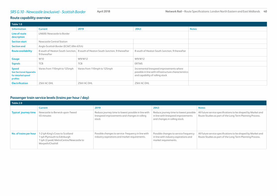
Network Rail – Route Specifications: London North Eastern and East Midlands 39April 2018SRS G.10 - Newcastle (exclusive) - Scottish Border
Route specification descriptionThis section of the East Coast Main Line (ECML) extends for just under 70 miles from Newcastle to the Scottish Border, three miles north of Berwick-upon-Tweed station. It is a predominantly two track section electrified throughout on the 25kV OHL system. There are up and down loops at Chevington, Alnmouth, Belford and Berwick-upon-Tweed, at Morpeth there is an Up Loop and a Down Slow line and at Heaton there is a track maintenance depot.
The line intersects at Bedlington North Junction with the Blyth & Tyne freight network to Bedlington and again with the Blyth & Tyne at Morpeth Junction and Morpeth North Junction. There is a freight connection to a coal disposal point at Butterwell, whilst at Alnmouth, Tweedmouth and Berwick-upon-Tweed there are sidings used mainly for engineers’ on-track machines and National Supply Chain traffic.
Train services are predominantly LDHS services and freight trains. There is also a broadly hourly local service between Newcastle and Morpeth and a very limited peak hour local service between Newcastle and Chathill.
There are stations at Manors, Cramlington, Morpeth, Pegswood, Widdrington, Acklington, Alnmouth, Chathill and Berwick-upon-Tweed. Only Morpeth, Alnmouth and Berwick are of sufficient length to accommodate LDHS trains, the remainder being served only by the local stopping service. Most of the stations have two platforms for up and down direction, except for Manors and Berwick-upon-Tweed which are island platforms with two faces. The station building at Berwick-upon-Tweed is listed and situated within a Conservation Area.
Geographic Map
Network Rail – Route Specifications: London North Eastern and East Midlands 40April 2018SRS G.10 - Newcastle (exclusive) - Scottish Border
Table 1.0
Information Current 2019 2043 Notes
Line of route description
LN600: Newcastle to Border
Section start Newcastle Central Station
Section end Anglo-Scottish Border (ECM7, 69m 67ch)
Route availability 8 south of Heaton South Junction, 9 thereafter
8 south of Heaton South Junction, 9 thereafter 8 south of Heaton South Junction, 9 thereafter
Gauge W10 W9/W12 W9/W12
Signals TCB TCB ERTMS
SpeedSee Sectional Appendix for detailed speed profiles
Varies from 110mph to 125mph Varies from 110mph to 125mph Incremental linespeed improvements where possible in line with infrastructure characteristics and capability of rolling stock
Electrification 25kV AC OHL 25kV AC OHL 25kV AC OHL
Passenger train service levels (trains per hour / day)Table 2.0
Current 2019 2043 Notes
Typical journey time Newcastle to Berwick-upon-Tweed45 minutes
Reduce journey time to lowest possible in line with linespeed improvements and changes in rolling stock
Reduce journey time to lowest possible in line with linespeed improvements and changes in rolling stock.
All future service specifications to be shaped by Market and Route Studies as part of the Long Term Planning Process.
No. of trains per hour 1-2 tph King’s Cross to Scotland1 tph Plymouth to Edinburgh1 tph (2 peak) MetroCentre/Newcastle to Morpeth/Chathill
Possible changes to service frequency in line with industry aspirations and market requirements.
Possible changes to service frequency in line with industry aspirations and market requirements.
All future service specifications to be shaped by Market and Route Studies as part of the Long Term Planning Process.
Route capability overview

Network Rail – Route Specifications: London North Eastern and East Midlands 41April 2018SRS G.10 - Newcastle (exclusive) - Scottish Border
Table 3.0
Current 2019 2043 Notes
Trains in one direction (as per WTT)
11 tpd For further information please see the Freight Market Study.
* Figures are for freight trains in one direction only on an average weekday.
Table 4.0
Type Current No. of level crossings 2019 No. of level crossings 2043 No. of level crossings
Supervised: 28As determined by Level Crossing policy.Automatic: 0
User: 23
Freight Trains (trains per day)
Level crossings on route

Network Rail – Route Specifications: London North Eastern and East Midlands 42April 2018SRS G.10 - Newcastle (exclusive) - Scottish Border
Table 5.0
Project Project Description ELR Implementation Date
Output change Status
IEP development/enabling works (IEP ECML Gauging)
Infrastructure works to accommodate operation of IEP rolling stock
ECM7 CP5 Increased capacity In delivery
IEP development/enabling works (IEP ECML OLE)
Infrastructure works to accommodate operation of IEP rolling stock
ECM7 CP5 Increased capacity In delivery
Proposed Infrastructure Investment

Network Rail – Route Specifications: London North Eastern and East Midlands 43April 2018SRS G.11 Border – Edinburgh
Route specification descriptionThis section of the East Coast Main Line (ECML) consists of 54 miles of predominantly two track railway extending from the interface with SRS G.10 to the east and P.01 to the west of Edinburgh Waverley station. It is electrified throughout on the 25kV Overhead Line Electrification (OHL) system. A branch line runs from Drem to North Berwick , which is currently cleared for passenger traffic only. The route includes Up and Down loops at Grantshouse and Drem, a Down/Up loop at Dunbar and an Up loop at Prestonpans. At the southern end, the line is largely a basic two track railway but the layout becomes more complex on its approach to Edinburgh, reflecting the greater concentration of population and industry. There is a Traction Maintenance Depot for LDHS services at Craigentinny. There are private freight sidings at Torness power station, Oxwellmains cement terminal, Dunbar waste terminal, Leith Yard and the Powderhall compaction plant.
There are six intermediate stations at Dunbar, Drem, Longniddry, Prestonpans, Wallyford and Musselburgh. All consist of two through platforms, with the exception of Dunbar which is a single platform accessed from the Up line onto the Down/Up passenger loop. Dunbar is additionally served by LDHS trains, the remainder being served only by local services. The single platform arrangement at Dunbar can at times be a source of congestion and delay in the event of service perturbation. A second platform is being progressed in CP5/6.
Portobello is a single lead junction which leads from the ECML to Newcraighall for passenger traffic, and freight to Millerhill Yard and Central Scotland. Portobello Junction also provides a route to the Edinburgh Suburban Line which is used for empty coaching stock (ECS) and freight movements.
Monktonhall Junction provides a route from the ECML to Millerhill Yard and the Edinburgh Suburban Line for freight traffic.
Prestonpans Up passenger loop provided freight access to the former Cockenzie power station.
Portobello Junction provides access to Leith Yard and Powderhall Junction provides access to the now closed Powderhall waste compaction facility.
Drem Junction on the ECML provides access to the North Berwick branch for passenger traffic.
LDHS services operate over the whole route with local services operating between Drem and Edinburgh and between Dunbar and Edinburgh
Future Aspirations
To provide the infrastructure to meet the 2043 Indicative Train Service Specification: e.g. Edinburgh Suburban Enhancement Programme and ECML Capacity Enhancements
Dunbar Station - aspiration to provide new Down platform which would improve performance and flexibility on the East Coast Main Line.
Stakeholder aspiration to deliver new stations at East Linton and Reston.
Geographic Map
DremDunbar
Wallyford
Longniddry
Musselburgh
Prestonpans
Edinburgh Waverley
Berwick-upon-Tweed
LegendStrategic Route Section : G.11
Strategic Route : G
Rail Network
I Major / Key Stations
I Stations
Coast
Strategic Route SectionG.11
Date: June 2010Map Produced By: Asset Information & Mapping TeamE-Mail: AssetInformation&[email protected]
OS Information reproduced from the Ordnance Survey Mapwith permission of the controller of Her Majesty’s Stationery Office.Crown Copyright. Licence No: 0100040692
Drem Jn
A = Powderhall JnB = Craigentinny Carriage DepotC = Portobello JnD = Monktonhall Jn
A B C
North Berwick
OxwellmainsCement Terminal
TornessPower Station
DunbarWaste Terminal
D
ECM8
ECM8
NBK

Network Rail – Route Specifications: London North Eastern and East Midlands 44April 2018
Table 1.0
Information Current 2019 2043 Notes
Line of Route Description Border to Edinburgh
Section Start Scottish Border (ECM7, 69m 67ch)
Section End Edinburgh Waverley Station
Route Availability (RA) Border to Edinburgh = RA10 RA10
Gauge W9 - W12 W12 from the Border to Monktonhall Jn
Signals Track Circuit Block (controlled from Edinburgh IECC)
Speed See Sectional Appendix for detailed speed profiles
Varies from 75mph to 125mph Raise linespeed to highest possible in line with infrastructure characteristics and capability of rolling stock
Electrification Yes
Table 2.0
Current 2019 2043 Opportunities to travel (ott) Notes
Typical Journey time Berwick-upon-Tweed to Edinburgh Waverley = 44 minutes
Introduction of Intercity Express Programme (IEP) coupled with implementation of infrastructure interventions can be expected to provide some improvement
All future service specifications to be shaped by Market and Route Studies as part of the Long Term Planning Process
No. of trains per hour 1-2 tph London King’s Cross to Scotland1 tph Penzance/Plymouth/to Edinburgh Waverley1 tph North Berwick to Edinburgh Waverley5 trains per day Edinburgh Waverley to Dunbar2tph Tweedbank to Edinburgh Waverley
Introduction of the 2018 timetable2 tph London Kings Cross to Scotland1 tph Penzance/Plymouth/to Edinburgh Waverley2tph North Berwick to Edinburgh Waverley2 tph Tweedbank to Edinburgh Waverley
South of England to Glasgow Central (via ECML) - 2 ott per hourSouth of England to Aberdeen (via ECML) - 1 ott per hourNewcastle/Berwick-upon-Tweed to Edinburgh Waverley - 1 ott per hourDunbar to Edinburgh Waverley - 1 ott per hourNorth Berwick to Edinburgh Waverley - 1 ott per hourEdinburgh Waverley to Tweedbank - 3 or 4 ott per hour (reduce fastest journey time by 20 minutes)
All future service specifications to be shaped by Market and Route Studies as part of the Long Term Planning Process
Route capability overview
Passenger train service level (trains per hour/day)
SRS G.11 Border – Edinburgh

Network Rail – Route Specifications: London North Eastern and East Midlands 45April 2018SRS G.11 Border – Edinburgh
Table 3.0
Current 2019 2043 Notes
Route Section
Daily paths in one direction (as per WTT)
12 As per forecasts in the Freight Market Study (2013) and Scotland Route Study (2016).
Table 4.0
Description of Level Crossing
SupervisedAutomaticUser
Current No. of Level Crossings
110
2019 No. of Level Crossings
As determined by Level Crossing policy
2043 No. of Level Crossings
As determined by Level Crossing policy
Notes
Current freight trains (paths per day)
Level Crossings on route Dunbar Station

Network Rail – Route Specifications: London North Eastern and East Midlands 46April 2018SRS G.11 Border – Edinburgh
Table 5.0
Project Project Description ELR Implementation date
Output change Status
ECML (North) to WCML Gauge enhancements
Gauge clear the route to W12 ECA2 CP5 To accommodate the carriage of deep sea container traffic from East Coast Ports to Scotland (Carstairs)
Completed
IEP enabling works Infrastructure works to accommodate operation of IEP rolling stock
ECM8 CP5 Ability to accommodate IEP services In delivery
New Down Platform at Dunbar Construction of a new Down Platform ECM8 CP5/6 Capacity and Capability In development
Edinburgh Suburban Enhancements Programme
This option will provide increased capacity and resilience for passenger and freight services helping to improve performance across the central belt and cross-border.
ECM8,SUB1, SUB2,NDE1,CKT
tbc Increased capacity and improved performance
In development
ECML Capacity Enhancements This option will maximise platform capacity and availability at a congested part of the network improving performance at a key location as part of the ECML corridor enhancements.
ECM8/9 tbc Longer term capacity, journey time and connectivity aspirations. Also giving more flexibility and better performance for both local and cross-border services at Waverley.
In development
Proposed Infrastructure Investment

Network Rail – Route Specifications: London North Eastern and East Midlands 47April 2018SRS G.12 North Berwick Branch
Route specification descriptionThis single track four mile branch line extends from Drem on the ECML to North Berwick station. It is electrified on the 25kV OHL system. There are no intermediate stations and no passing loops or sidings on the branch.
It forms the eastern terminal of most suburban stopping services to the east of Edinburgh Waverley and is adequate for the level of service provided which is basically hourly with a half hourly frequency at peak times and on Saturdays.
North Berwick station consists of a single platform of six-car length.
Geographic Map
I
IEdinburgh Waverley
Berwick-upon-Tweed
North Berwick
LegendStrategic Route Section : G.12
Strategic Route : G
Rail Network
I Major / Key Stations
I Stations
Coast
Strategic Route SectionG.12
Date: June 2010Map Produced By: Asset Information & Mapping TeamE-Mail: AssetInformation&[email protected]
OS Information reproduced from the Ordnance Survey Mapwith permission of the controller of Her Majesty’s Stationery Office.Crown Copyright. Licence No: 0100040692
Drem Jn
NBK
ECM8

Network Rail – Route Specifications: London North Eastern and East Midlands 48April 2018SRS G.12 North Berwick Branch
Table 1.0
Information Current 2019 2043 Notes
Line of Route Description North Berwick to Drem
Section Start North Berwick
Section End Drem Junction
Route Availability (RA) RA5
Gauge W7
Signals One Train Working (controlled from Edinburgh IECC)
Speed See Sectional Appendix for detailed speed profiles
Predominantly 50mph
Electrification Yes
Table 2.0
Current 2019 2043 Notes
Typical Journey time North Berwick to Drem = 9 minutes All future service specifications to be shaped by Market and Route Studies as part of the Long Term Planning Process
Passenger train service level (trains per hour/day)
Level Crossings on route
There are no level crossings in this route section.
Route capability overview
No. of trains per hour 1 tph North Berwick to Edinburgh Waverley (Mon-Fri) 2 tph North Berwick to Edinburgh Waverley (Sat)
1 tph North Berwick to Edinburgh Waverley (Mon-Fri) 2 tph North Berwick to Edinburgh Waverley (Sat)
North Berwick to Edinburgh Waverley - 1 ott per hour
All future service specifications to be shaped by Market and Route Studies as part of the Long Term Planning Process

Network Rail – Route Specifications: London North Eastern and East Midlands 49April 2018SRS G.12 North Berwick Branch
Proposed Infrastructure Investment
Project Project Description ELR Implementation date
Output change Notes Status
There is no planned investment in Control Period 5.
Table 3.0

Network Rail – Route Specifications: London North Eastern and East Midlands 50April 2018SRS G.13 - Newcastle (exclusive) - Carlisle
Route specification descriptionThis 58 mile non-electrified line consists throughout its length of double track and apart from crossovers at broadly 10 mile intervals has quite a simple track layout. Other than the connections to the East Coast Main Line (ECML) at Newcastle (King Edward Bridge South Junction) and the Settle & Carlisle line at Petteril Bridge Junction, the only interface is with the Low Fell single line which gives access to the Tyneside Royal Mail terminal and in a south-facing direction to the ECML.
The line is typically used by two local trains each hour between Newcastle and Hexham, one of which is a local stopping service terminating at Hexham, and the other of which is semi-fast and runs through to Carlisle (and sometimes onwards to south-west Scotland). Additionally, a local service operates at the Newcastle end as far as the MetroCentre at broadly half-hourly intervals geared mainly towards demand by shoppers. There is regular freight operation, typically linking the west of Scotland with east and north east England. The route also forms an important diversionary facility for Anglo-Scottish LDHS and freight trains when either the ECML or the WCML is unavailable north of Newcastle or Carlisle due to incident or planned engineering work.
There are 14 stations on the route, all of which consist of two platforms, with the exception of Dunston which is a single island platform with two faces. Demand is heaviest at the MetroCentre and Hexham, both of which have regular terminating trains.
There are few sidings – Up and Down recessing sidings (currently out of use) at Prudhoe, some lightly-used sidings at Hexham, a Down loop at Melkridge (formerly serving a coal disposal point and presently out of use), a Down recessing siding (currently out of use) at Haydon Bridge, and two Up sidings at Haltwhistle. There are no rolling stock depots or active private sidings anywhere on the route.
Several listed buildings or structures are to be found in the station areas at Hexham, Haltwhistle and Wetheral, which are also situated within Conservation Areas. There are listed structures at Wylam, Prudhoe and Riding Mill stations, whilst Haydon Bridge station is within a Conservation Area.
Geographic Map
Legend
Major / Key Station
Coastline
Strategic Route Section G.13
Strategic Route G
Station
Rail Network
Carlisle
Wetheral
Brampton
Haltwhistle
Bardon Mill
Haydon Bridge
Hexham
Corbridge
Riding Mill
Prudhoe
Stocksfield
Wylam
Blaydon
MetroCentre
Dunston
Newcastle
Strategic Route Section G.13

Network Rail – Route Specifications: London North Eastern and East Midlands 51April 2018SRS G.13 - Newcastle (exclusive) - Carlisle
Table 1.0
Information Current 2019 2043 Notes
Line of route description
LN682: Newcastle to Carlisle
Section start King Edward Bridge South Junction
Section end Petteril Bridge Junction
Route availability 8 8 8
Gauge W7 W7 W7
Signals Mainly Absolute Block with some Track Circuit Block
Mainly Track Circuit Block with some Absolute Block
ERTMS
SpeedSee Sectional Appendix for detailed speed profiles
Predominantly 60mph or 65mph Predominantly 60mph or 65mph Incremental linespeed improvements where possible in line with infrastructure characteristics and capability of rolling stock
Electrification None None Future electrification to be shaped as part of Long Term Planning Process
Passenger train service levels (trains per hour / day)Table 2.0
Current 2019 2043 Notes
Typical journey time Newcastle to Carlisle1 hour 32 minutes
Reduce journey time to lowest possible in line with linespeed improvements and changes in rolling stock
Reduce journey time to lowest possible in line with linespeed improvements and changes in rolling stock.
All future service specifications to be shaped by Market and Route Studies as part of the Long Term Planning Process.
No. of trains per hour 1 tph Morpeth to MetroCentre1 tph Newcastle to MetroCentre1 tph Middlesbrough to Hexham1 tph Newcastle to Carlisle/Glasgow Central
Possible changes to service frequency in line with industry aspirations and market requirements.
Possible changes to service frequency in line with industry aspirations and market requirements.
Route capability overview

Network Rail – Route Specifications: London North Eastern and East Midlands 52April 2018SRS G.13 - Newcastle (exclusive) - Carlisle
Table 3.0
Current 2019 2043 Notes
Trains in one direction (as per WTT)
9 tpd For further information please see the Freight Market Study.
* Figures are for freight trains in one direction only on an average weekday.
Table 4.0
Type Current No. of level crossings 2019 No. of level crossings 2043 No. of level crossings
Supervised: 7As determined by Level Crossing policy.Automatic: 7
User: 50
Freight Trains (trains per day)
Level crossings on route

Network Rail – Route Specifications: London North Eastern and East Midlands 53April 2018SRS G.13 - Newcastle (exclusive) - Carlisle
Table 5.0
Project Project Description ELR Implementation Date
Output change Status
IEP development/ enabling works (IEP ECML Gauging)
Infrastructure works to accommodate operation of IEP rolling stock
NEC1/2 CP5 Increased capacity. In delivery
Proposed Infrastructure Investment
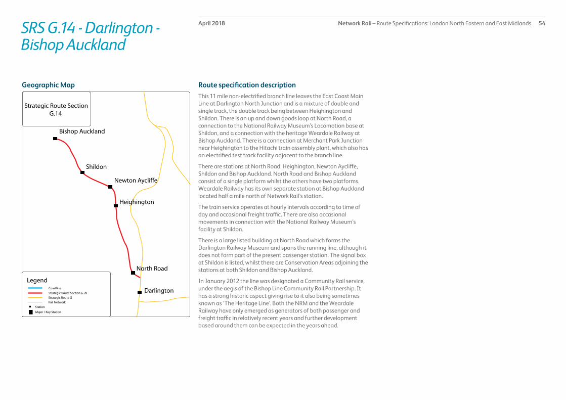
Network Rail – Route Specifications: London North Eastern and East Midlands 54April 2018SRS G.14 - Darlington - Bishop Auckland
Route specification descriptionThis 11 mile non-electrified branch line leaves the East Coast Main Line at Darlington North Junction and is a mixture of double and single track, the double track being between Heighington and Shildon. There is an up and down goods loop at North Road, a connection to the National Railway Museum’s Locomotion base at Shildon, and a connection with the heritage Weardale Railway at Bishop Auckland. There is a connection at Merchant Park Junction near Heighington to the Hitachi train assembly plant, which also has an electrified test track facility adjacent to the branch line.
There are stations at North Road, Heighington, Newton Aycliffe, Shildon and Bishop Auckland. North Road and Bishop Auckland consist of a single platform whilst the others have two platforms. Weardale Railway has its own separate station at Bishop Auckland located half a mile north of Network Rail’s station.
The train service operates at hourly intervals according to time of day and occasional freight traffic. There are also occasional movements in connection with the National Railway Museum’s facility at Shildon.
There is a large listed building at North Road which forms the Darlington Railway Museum and spans the running line, although it does not form part of the present passenger station. The signal box at Shildon is listed, whilst there are Conservation Areas adjoining the stations at both Shildon and Bishop Auckland.
In January 2012 the line was designated a Community Rail service, under the aegis of the Bishop Line Community Rail Partnership. It has a strong historic aspect giving rise to it also being sometimes known as ‘The Heritage Line’. Both the NRM and the Weardale Railway have only emerged as generators of both passenger and freight traffic in relatively recent years and further development based around them can be expected in the years ahead.
Geographic Map
Bishop Auckland
Shildon
Newton Aycliffe
Heighington
North Road
Darlington
Strategic Route Section G.14
Legend
Major / Key Station
Coastline
Strategic Route Section G.20
Strategic Route G
Station
Rail Network

Network Rail – Route Specifications: London North Eastern and East Midlands 55April 2018SRS G.14 - Darlington - Bishop Auckland
Table 1.0
Information Current 2019 2043 Notes
Line of route description
LN678: Darlington to Bishop Auckland
Section start Darlington North Junction
Section end Bishop Auckland Station
Route availability 8 8 8
Gauge W6 W6 W6
Signals Track Circuit Block except Absolute Block between Heighington and Shildon
Track Circuit Block, except Absolute Block between Heighington and Shildon
ERTMS
SpeedSee Sectional Appendix for detailed speed profiles
Predominantly 45mph Predominantly 45mph Incremental linespeed improvements where possible in line with infrastructure characteristics and capability of rolling stock
Electrification None None Future electrification to be shaped as part of Long Term Planning Process
Passenger train service levels (trains per hour / day)Table 2.0
Current 2019 2043 Notes
Typical journey time Darlington to Bishop Auckland26 minutes
Reduce journey time to lowest possible in line with linespeed improvements and changes in rolling stock
Reduce journey time to lowest possible in line with linespeed improvements and changes in rolling stock.
All future service specifications to be shaped by Market and Route Studies as part of the Long Term Planning Process.
No. of trains per hour 1 tph Bishop Auckland to Darlington/Middlesbrough/Saltburn
1 tph Bishop Auckland to Darlington/Middlesbrough/Saltburn
Possible changes to service frequency in line with industry aspirations and market requirements.
Route capability overview

Network Rail – Route Specifications: London North Eastern and East Midlands 56April 2018SRS G.14 - Darlington - Bishop Auckland
Table 3.0
Current 2019 2043 Notes
Trains in one direction (as per WTT)
Approximately one per week in each direction
For further information please see the Freight Market Study.
* Figures are for freight trains in one direction only on an average weekday.
Table 4.0
Type Current No. of level crossings 2019 No. of level crossings 2043 No. of level crossings
Supervised: 1As determined by Level Crossing policy.Automatic: 1
User: 6
Freight Trains (trains per day)
Level crossings on route

Network Rail – Route Specifications: London North Eastern and East Midlands 57April 2018SRS G.14 - Darlington - Bishop Auckland
Table 5.0
Project Project Description ELR Implementation Date
Output change Status
There is no planned investment in Control Period 5.
Proposed Infrastructure Investment

Network Rail – Route Specifications: London North Eastern and East Midlands 58April 2018SRS G.15 - Middlesbrough – Whitby
Route specification descriptionThis 30 mile rural single track branch line leaves the Middlesbrough to Saltburn line at Guisborough Junction, a short distance to the east of Middlesbrough station. There are passing loops at Nunthorpe and Glaisdale and run-round loops at Battersby and Whitby. Due to the way in which the rail network in the area has evolved, the track layout requires all trains to reverse at Battersby.
There are currently a total of 16 stations on the route (most of which consist of one platform). Two platforms are provided at Nunthorpe and Glaisdale due to their role as passing places. Grosmont has a total of four platforms, but only one forms part of the network, the remainder being owned and operated by the heritage North Yorkshire Moors Railway (NYMR). The only track connection to the branch is at Grosmont with the NYMR and faces towards Whitby.
The basic train service throughout the route consists of four local services per day in each direction between Middlesbrough and Whitby, which are supplemented by seven further journeys each way between Middlesbrough and Nunthorpe, reflecting the greater population at this end of the route. Most of the Nunthorpe terminating journeys extend through to Newcastle or Hexham via the Durham Coast.
During the summer months, NYMR operates (on an open access basis) three steam-hauled journeys each way per day between Grosmont and Whitby which form an extension of their long-established heritage operation between Grosmont and Pickering, thereby generally providing a through link from Pickering to Whitby. There is no regular freight traffic, the only freight movements being rolling stock to or from the NYMR. In July 2005 the branch was one of the first to be designated as a Community Rail Line, under the aegis of the Esk Valley Community Rail Partnership. There are listed station buildings at Whitby and Ruswarp; the latter is also in a Conservation Area.
The line runs for much of its distance through the North Yorkshire Moors National Park and thus serves many places of tourist interest as well as the coastal resort of Whitby. As such, it can be subject to heavy peaks of demand during the summer months leading at times to considerable overcrowding of train services, whilst at other times demand can be quite low, especially at the smaller intermediate stations. With aspirations by NYMR to enhance their services in the Grosmont – Whitby corridor, plus some evidence of increased interest by charter train operators, changes to the track layout at Whitby providing a new Platform 2 were delivered in 2014.
Geographic Map

Network Rail – Route Specifications: London North Eastern and East Midlands 59April 2018SRS G.15 - Middlesbrough – Whitby
Table 1.0
Information Current 2019 2043 Notes
Line of route description
LN634: Middlesbrough to Whitby
Section start Guisborough Junction
Section end Whitby Station
Route availability 7 7 7
Gauge W6 W6 W6
Signals Track Circuit Block between Middlesbrough and Nunthorpe.Nunthorpe to Whitby is No Signaller - Remote Token Working
Track Circuit Block between Middlesbrough and Nunthorpe.Nunthorpe to Whitby is No Signaller - Remote Token Working
ERTMS
SpeedSee Sectional Appendix for detailed speed profiles
Predominantly 45mph Predominantly 45mph Incremental linespeed improvements where possible in line with infrastructure characteristics and capability of rolling stock
Electrification None None Future electrification to be shaped as part of Long Term Planning Process
Passenger train service levels (trains per hour / day)Table 2.0
Current 2019 2043 Notes
Typical journey time Middlesbrough to Whitby1 hour 27 minutes
Reduce journey time to lowest possible in line with linespeed improvements and changes in rolling stock
Reduce journey time to lowest possible in line with linespeed improvements and changes in rolling stock.
All future service specifications to be shaped by Market and Route Studies as part of the Long Term Planning Process.
No. of trains per hour 4 tpd Middlesbrough to Whitby7 tpd Middlesbrough to Nunthorpe3 tpd Pickering to Whitby
7 tpd Middlesbrough to Whitby7 tpd Middlesbrough to Nunthorpe4 tpd Pickering to Whitby
Possible changes to service frequency in line with industry aspirations and market requirements.
Route capability overview

Network Rail – Route Specifications: London North Eastern and East Midlands 60April 2018SRS G.15 - Middlesbrough – Whitby
Table 3.0
Current 2019 2043 Notes
Trains in one direction (as per WTT)
0 For further information please see the Freight Market Study.
* Figures are for freight trains in one direction only on an average weekday.
Table 4.0
Type Current No. of level crossings 2019 No. of level crossings 2043 No. of level crossings
Supervised: 2As determined by Level Crossing policy.Automatic: 3
User: 62
Freight Trains (trains per day)
Level crossings on route

Network Rail – Route Specifications: London North Eastern and East Midlands 61April 2018SRS G.15 - Middlesbrough – Whitby
Table 5.0
Project Project Description ELR Implementation Date
Output change Status
There are no planned infrastructure investments in Control Period 5
Proposed Infrastructure Investment

Network Rail – Route Specifications: London North Eastern and East Midlands 62April 2018SRS G.16 / G.17 - Northallerton (exclusive) – Newcastle (exclusive) via Durham Coast
Route specification descriptionThis 59 mile mainly non-electrified two track secondary route includes a connection to the East Coast Main Line at Northallerton Station plus a further connection south of Northallerton (known as Longlands Loop) thereby forming an avoiding line around the station. It also includes a 3 mile branch from Sunderland to South Hylton used only by Tyne & Wear Metro trains. The South Hylton – Sunderland – Pelaw section is electrified on the 1,500x DC OHL system of the Tyne & Wear Metro.
The line fron Northallerton connects with the Darlington to Saltburn line at Eaglescliffe South Junction, and at Stockton Cut Junction with one line towards Stockton and another towards Middlesbrough. It has no freight facilities apart from sidings at Northallerton and Eaglescliffe which are largely used for engineers’ purposes. The line intersects with the Stockton Cut – Middlesbrough line at Bowesfield Junction and with the Stillington branch at Norton-on-Tees South and Norton-on-Tees East Junctions. At the northern end,the line interfaces with the Tyne & Wear Metro network at Pelaw and with the East Coast Main Line (ECML) at Newcastle. There is also a connection to the currently disused Leamside route at Pelaw.
A diverse group of markets is served by the line between Stockton Cut Junction and Newcastle. Operating over almost the entire length is the generally hourly local service between Middlesbrough and Hexham via Newcastle. Additionally there are five LDHS services each way per day from Sunderland southwards to London King’s Cross, whilst between South Hylton and Pelaw five trains per hour Tyne & Wear Metro services run. At Pelaw, the Metro trains leave Network Rail infrastructure and continue their journey on the Metro’s own dedicated network. There is also considerable freight traffic on the route.
There are 20 stations on this line of route; ten are small stations with two platforms served only by Metro trains, Seaton Carew and Seaham are two-platform stations, Billingham is a single island
platform with two faces, Hartlepool consists of a single platform on the Down line signalled reversibly plus a south-facing bay platform; these stations are served by heavy rail trains only. South Hylton is a single platform used only by Metro trains, whilst Sunderland consists of a long, subsurface island platform with two faces. Each of these is divided into two sections, allowing use by both Metro and heavy rail services. Heworth station has four platforms, two of which are on Network Rail infrastructure and two on Metro infrastructure, thereby providing interchange between heavy rail and Metro services. Yarm consists of two platforms, whilst Eaglescliffe consists of a single island platform with two faces, facilitating easy interchange. The passenger service over the Northallerton to Eaglescliffe section consists of an hourly service between Middlesbrough and Manchester Airport (via York and Leeds) and four LDHS services each way per day between Sunderland and London King’s Cross. Between Eaglescliffe and Stockton Cut Junction there are additionally the local services on the Darlington to Saltburn corridor, generally at a frequency of two trains each way per hour. There are substantial freight operations throughout, as the line forms a key link between the ECML and the numerous freight facilities on Teesside and Tyneside.
Between Stockton Cut Junction and Newcastle the line has numerous connections to freight facilities. At Billingham Junction the freight branch to Haverton Hill and Seal Sands diverges, serving numerous (mainly petrochemical) freight terminals. There is a steelworks connection at Greatham, whilst at Seaton Snook Junction a branch line connects to Hartlepool power station. Arising from the proximity of the line to the coast there are several active dock connections; namely to Seaham Harbour, Port of Sunderland and Tyne Dock. There is also a connection to Hartlepool Docks which is not in use. Tyne Dock traffic in particular has tended to see strong growth in recent times which has necessitated the reinstatement of Bolden East Curve and a loop at Tyne Dock. There is also a branch line to an oil terminal at Jarrow.
Geographic Map

Network Rail – Route Specifications: London North Eastern and East Midlands 63April 2018SRS G.16 / G.17 - Northallerton (exclusive) – Newcastle (exclusive) via Durham Coast
Table 1.0
Information Current 2019 2043 Notes
Line of route description
LN627: Northallerton to Newcastle East Junction
Section start Northallerton Station
Section end Newcastle East Junction
Route availability 8 (except 5 across Newcastle High Level Bridge)
8 (except 5 across Newcastle High Level Bridge) 8 (except 5 across Newcastle High Level Bridge)
Gauge W8 (except W6 Norton East Junction to Boldon Junctions)
W8-10 (except W6 Norton East Junction to Boldon Junctions)
W8-10 (except W6 Norton East Junction to Boldon Junctions)
Signals Track Circuit Block (except Absolute Block between Norton-on-Tees South and Billingham)
TCB
SpeedSee Sectional Appendix for detailed speed profiles
Predominantly 60mph and 70mph
Predominantly 60mph and 70mph Incremental linespeed improvements where possible in line with infrastructure characteristics and capability of rolling stock
Electrification None (except 1,500V DC OHL from South Hylton to Pelaw Metro Junction)
None (except 1,500V DC OHL from South Hylton to Pelaw Metro Junction)
Future electrification to be shaped as part of Long Term Planning Process
Passenger train service levels (trains per hour / day)Table 2.0
Current 2019 2043 Notes
Typical journey time Northallerton to Eaglescliffe18 minutesThornaby to Newcastle1 hour 15 minutes
Reduce journey time to lowest possible in line with linespeed improvements and changes in rolling stock
Reduce journey time to lowest possible in line with linespeed improvements and changes in rolling stock.
All future service specifications to be shaped by Market and Route Studies as part of the Long Term Planning Process.
No. of trains per hour 1 tph Manchester Airport to Middlesbrough2 tph (3 peak) Darlington to Middlesbrough/Saltburn5 tpd LDHS King’s Cross to Sunderland
Possible changes to service frequency in line with industry aspirations and market requirements.
Possible changes to service frequency in line with industry aspirations and market requirements.
Route capability overview

Network Rail – Route Specifications: London North Eastern and East Midlands 64April 2018SRS G.16 / G.17 - Northallerton (exclusive) – Newcastle (exclusive) via Durham Coast
Table 3.0
Current 2019 2043 Notes
Trains in one direction (as per WTT)
20 For further information please see the Freight Market Study.
* Figures are for freight trains in one direction only on an average weekday.
Table 4.0
Type Current No. of level crossings 2019 No. of level crossings 2043 No. of level crossings
Supervised: 6As determined by Level Crossing policy.Automatic: 6
User: 30
Freight Trains (trains per day)
Level crossings on route

Network Rail – Route Specifications: London North Eastern and East Midlands 65April 2018SRS G.16 / G.17 - Northallerton (exclusive) – Newcastle (exclusive) via Durham Coast
Table 5.0
Project Project Description ELR Implementation Date
Output change Status
New station at Horden New station LEN3 CP6 New station In design
IEP development/enabling works (IEP ECML Gauging)
Infrastructure works to accommodate operation of IEP rolling stock
LEN3 CP5 Increased capacity In delivery
Proposed Infrastructure Investment

Network Rail – Route Specifications: London North Eastern and East Midlands 66April 2018SRS G.18 / G.19 - Darlington (exclusive) - Saltburn
Route specification descriptionThis 27 mile section of non-electrified secondary route leaves the East Coast Main Line (ECML) by a single lead connection at Darlington South Junction. It is double track throughout, with 12 stations including Dinsdale, Teesside Airport and Allens West, each of which consists of two platforms, Thornaby which has a single island platform with two faces, Middlesbrough which has additional flexibility in the form of reversible working and multiple platform occupation and Saltburn consisting of two terminal platforms. There is a private siding at Maidendale (between Darlington and Dinsdale) and a disused freight siding at Allens West.
The line between Stockton Cut Junction and Saltburn has additional goods lines in the Thornaby – Middlesbrough – Whitehouse and South Bank – Lackenby corridors. There is a large marshalling yard at Tees Yard (now partly disused and subject to rationalisation proposals), numerous private siding facilities between Middlesbrough and Redcar (predominantly serving the steel and chemical industries), and some smaller passenger and freight sidings adjacent to Middlesbrough station. A connection exists at Grangetown into Tees Dock. There is a Down loop at Redcar and a small sidings complex at Saltburn, the latter mainly used in connection with charter trains and engineering traffic.
The route between Darlington and Eaglescliffe South Junction forms a key link for passenger and freight services between the ECML at Darlington and Teesside. The passenger service consists of two stopping trains each way per hour, some of which extend to/from Bishop Auckland. One train per week stops at Teesside Airport.
Between Middlesbrough and Saltburn, the passenger branch line to Whitby diverges at Guisborough Junction (near Middlesbrough) and the freight branch to Boulby diverges at Saltburn West Junction. The latter serves a steelworks at Crag Hall and a potash mine at Boulby. The line is owned and operated by Network Rail for the first seven miles to Crag Hall but beyond that is a private railway controlled by the potash mining company.
The route between Stockton Cut Junction and Middlesbrough accommodates heavy freight traffic to and from the Teesside industrial and port area, the local passenger services between Darlington and Saltburn and between Hexham/Newcastle and Middlesbrough, plus the hourly service between Middlesbrough and Manchester Airport via Northallerton. Between Middlesbrough and Guisborough Junction the line also accommodates the trains to/from the Whitby branch. Beyond Redcar Ore Terminal Junction traffic becomes lighter, being confined to two passenger trains per hour on the Darlington – Saltburn service and freight traffic for Crag Hall and Carlin How.
Geographic Map

Network Rail – Route Specifications: London North Eastern and East Midlands 67April 2018SRS G.18 / G.19 - Darlington (exclusive) - Saltburn
Table 1.0
Information Current 2019 2043 Notes
Line of route description
LN631: Darlington to Eaglescliffe South Junction
Section start Darlington South Junction
Section end Saltburn Station
Route availability 8 8 8
Gauge W8 W9, W12 W9, W12
Signals Track Circuit Block (except for Absolute Block around Redcar East and on the Goods Lines between Middlesbrough and Whitehouse)
Track Circuit Block (except for Absolute Block around Redcar East and on the Goods Lines between Middlesbrough and Whitehouse)
ERTMS
SpeedSee Sectional Appendix for detailed speed profiles
Varies from 30mph to 60mph Varies from 30mph to 60mph Incremental linespeed improvements where possible in line with infrastructure characteristics and capability of rolling stock
Electrification None None Future electrification to be shaped as part of Long Term Planning Process
Passenger train service levels (trains per hour / day)Table 2.0
Current 2019 2043 Notes
Typical journey time Darlington to Eaglescliffe14 minutes
Eaglescliffe to Saltburn 41 minutes
Reduce journey time to lowest possible in line with linespeed improvements and changes in rolling stock
Reduce journey time to lowest possible in line with linespeed improvements and changes in rolling stock.
All future service specifications to be shaped by Market and Route Studies as part of the Long Term Planning Process.
No. of trains per hour 2 tph (3 peak) Darlington to Middlesbrough/Saltburn1 tph Manchester Airport to Middlesbrough1tph Middlesbrough to Newcastle/Hexham
Possible changes to service frequency in line with industry aspirations and market requirements.
Possible changes to service frequency in line with industry aspirations and market requirements.
Route capability overview

Network Rail – Route Specifications: London North Eastern and East Midlands 68April 2018SRS G.18 / G.19 - Darlington (exclusive) - Saltburn
Table 3.0
Current 2019 2043 Notes
Trains in one direction (as per WTT)
20 For further information please see the Freight Market Study.
* Figures are for freight trains in one direction only on an average weekday.
Table 4.0
Type Current No. of level crossings 2019 No. of level crossings 2043 No. of level crossings
Supervised: 6As determined by Level Crossing policy.Automatic: 0
User: 14
Freight Trains (trains per day)
Level crossings on route

Network Rail – Route Specifications: London North Eastern and East Midlands 69April 2018SRS G.18 / G.19 - Darlington (exclusive) - Saltburn
Table 5.0
Project Project Description ELR Implementation Date
Output change Status
IEP development/enabling works (IEP ECML Gauging)
Infrastructure works to accommodate operation of IEP rolling stock
DSN1 CP5 Increased capacity. In delivery
Proposed Infrastructure Investment
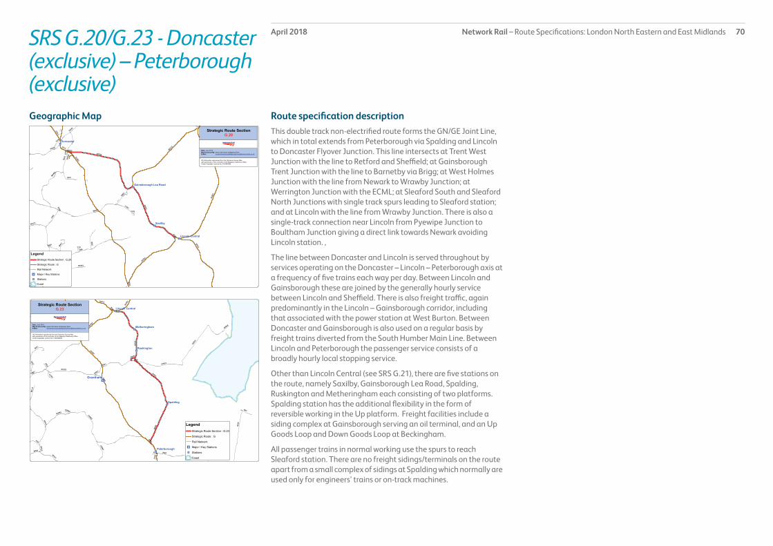
Network Rail – Route Specifications: London North Eastern and East Midlands 70April 2018SRS G.20/G.23 - Doncaster (exclusive) – Peterborough (exclusive)
Route specification descriptionThis double track non-electrified route forms the GN/GE Joint Line, which in total extends from Peterborough via Spalding and Lincoln to Doncaster Flyover Junction. This line intersects at Trent West Junction with the line to Retford and Sheffield; at Gainsborough Trent Junction with the line to Barnetby via Brigg; at West Holmes Junction with the line from Newark to Wrawby Junction; at Werrington Junction with the ECML; at Sleaford South and Sleaford North Junctions with single track spurs leading to Sleaford station; and at Lincoln with the line from Wrawby Junction. There is also a single-track connection near Lincoln from Pyewipe Junction to Boultham Junction giving a direct link towards Newark avoiding Lincoln station. ,
The line between Doncaster and Lincoln is served throughout by services operating on the Doncaster – Lincoln – Peterborough axis at a frequency of five trains each way per day. Between Lincoln and Gainsborough these are joined by the generally hourly service between Lincoln and Sheffield. There is also freight traffic, again predominantly in the Lincoln – Gainsborough corridor, including that associated with the power station at West Burton. Between Doncaster and Gainsborough is also used on a regular basis by freight trains diverted from the South Humber Main Line. Between Lincoln and Peterborough the passenger service consists of a broadly hourly local stopping service.
Other than Lincoln Central (see SRS G.21), there are five stations on the route, namely Saxilby, Gainsborough Lea Road, Spalding, Ruskington and Metheringham each consisting of two platforms. Spalding station has the additional flexibility in the form of reversible working in the Up platform. Freight facilities include a siding complex at Gainsborough serving an oil terminal, and an Up Goods Loop and Down Goods Loop at Beckingham.
All passenger trains in normal working use the spurs to reach Sleaford station. There are no freight sidings/terminals on the route apart from a small complex of sidings at Spalding which normally are used only for engineers’ trains or on-track machines.
Geographic Map

Network Rail – Route Specifications: London North Eastern and East Midlands 71April 2018SRS G.20/G.23 - Doncaster (exclusive) – Peterborough (exclusive)
Table 1.0
Information Current 2019 2043 Notes
Line of route description
LN170: Doncaster to Lincoln
Section start Black Carr Junction
Section end Werrington Junction
Route availability 8 10 10
Gauge W12 W12 W12
Signals Track Circuit Block Track Circuit Block ERTMS
SpeedSee Sectional Appendix for detailed speed profiles
Predominantly 70-75 mph. Lincoln (excl) to Gainsborough Lea Road (excl) is 60-65 mph.
Predominantly 70-75 mph. Lincoln (excl) to Gainsborough Lea Road (excl) is 60-65 mph.
Incremental linespeed improvements where possible in line with infrastructure characteristics and capability of rolling stock
Electrification None None Future electrification to be shaped as part of Long Term Planning Process
Passenger train service levels (trains per hour / day)Table 2.0
Current 2019 2043 Notes
Typical journey time Doncaster to Peterborough2 hours 17 minutes
Reduce journey time to lowest possible in line with linespeed improvements and changes in rolling stock
Reduce journey time to lowest possible in line with linespeed improvements and changes in rolling stock.
All future service specifications to be shaped by Market and Route Studies as part of the Long Term Planning Process.
No. of trains per hour 1 tph Sheffield to Lincoln5 tpd Doncaster to Lincoln8 tpd Lincoln to Peterborough5 tpd Spalding to Peterborough only
Possible changes to service frequency in line with industry aspirations and market requirements.
Possible changes to service frequency in line with industry aspirations and market requirements.
Route capability overview

Network Rail – Route Specifications: London North Eastern and East Midlands 72April 2018SRS G.20/G.23 - Doncaster (exclusive) – Peterborough (exclusive)
Table 3.0
Current 2019 2043 Notes
Trains in one direction (as per WTT)
20 tpd For further information please see the Freight Market Study.
* Figures are for freight trains in one direction only on an average weekday.
Table 4.0
Type Current No. of level crossings 2019 No. of level crossings 2043 No. of level crossings
Supervised: 33As determined by Level Crossing policy.Automatic: 11
User: 74
Freight Trains (trains per day)
Level crossings on route

Network Rail – Route Specifications: London North Eastern and East Midlands 73April 2018SRS G.20/G.23 - Doncaster (exclusive) – Peterborough (exclusive)
Table 5.0
Project Project Description ELR Implementation Date
Output change Status
Peterborough to GN/GE Southern Access (Werrington Junction)
Alterations to junction layout EM1, WEB, PMJ CP6 Increased capacity for both passenger and freight services through Peterborough
In design
IEP development/enabling works (IEP ECML Gauging)
Infrastructure works to accommodate operation of IEP rolling stock
SPD2/4 CP5 Increased capacity In delivery
Proposed Infrastructure Investment

Network Rail – Route Specifications: London North Eastern and East Midlands 74April 2018SRS G.21 - Newark - Barnetby
Route specification descriptionThis 46 mile non-electrified secondary route consists of two tracks almost throughout its entire length. There is a short four-track section between West Holmes and East Holmes Junctions and another through Lincoln station. The line interfaces end-on at Newark with the Newark to Nottingham line, whilst there is also a single track spur providing a connection with the East Coast Main Line (ECML) at Newark North Gate. At Lincoln, there are interfaces with the GN/GE Joint Line both towards Peterborough and towards Doncaster, whilst at Wrawby Junction this line joins with those from Doncaster via Scunthorpe and from Gainsborough via Brigg en route to Immingham and Cleethorpes.
The train service is most intensive over the Lincoln to Newark section, where there is an hourly passenger train service between Lincoln and Nottingham, together with the broadly two-hourly Newark North Gate to Grimsby via Market Rasen service. There are also two daily LDHS services each way to/from London (one via Peterborough and the other via Leicester). Within the Lincoln station area there are additionally the GN/GE Joint Line services, but beyond Lincoln the passenger service consists only of the Newark to Grimsby service. There are freight operations throughout reflecting that this route is a link from the intensively used port complex at Immingham to terminals in the Midlands.
There are stations at Collingham, Swinderby, Hykeham, Lincoln and Market Rasen, which all consist of two platforms, apart from Lincoln which has three through platforms and two bays facing towards Grimsby or Spalding. There are listed station buildings at Lincoln and Market Rasen; the former adjoins a Conservation Area. A private siding exists for petroleum traffic at Welton and an engineers’ siding is situated at Wickenby. There are few other features of note, although the line has a large number of level crossings as a result of the largely flat land through which it passes.
Geographic Map

Network Rail – Route Specifications: London North Eastern and East Midlands 75April 2018SRS G.21 - Newark - Barnetby
Table 1.0
Information Current 2019 2043 Notes
Line of route description
LN206: Newark to LincolnLN200: Lincoln to Wrawby Junction
Section start Newark North Gate Station
Section end Wrawby Junction
Route availability 8 8 (except 10 between West Holmes Junction and Pelham Junction)
8 (except 10 between West Holmes Junction and Pelham Junction)
Gauge W7 (Newark North Gate to West Holmes Junction), W8 (West Holmes Junction to Wrawby Junction)
W9/10 (Newark North Gate to Pelham Junction), W8 (Pelham Junction to Wrawby Junction)
W9/10 (Newark North Gate to Pelham Junction), W8 (Pelham Junction to Wrawby Junction)
Signals Track Circuit Block from Newark to Langworth SB; Absolute Block thereafter
Track Circuit Block from Newark to Langworth SB; Absolute Block thereafter
ERTMS
SpeedSee Sectional Appendix for detailed speed profiles
Predominantly 70 mph from Newark to Lincoln; predominantly 75mph from Lincoln to Wrawby Junction
Predominantly 70 mph from Newark to Lincoln; predominantly 75mph from Lincoln to Wrawby Junction
Incremental linespeed improvements where possible in line with infrastructure characteristics and capability of rolling stock
Electrification None None Future electrification to be shaped as part of Long Term Planning Process
Passenger train service levels (trains per hour / day)Table 2.0
Current 2019 2043 Notes
Typical journey time Newark North Gate to Barnetby1 hour 5 minutes
Reduce journey time to lowest possible in line with linespeed improvements and changes in rolling stock
Reduce journey time to lowest possible in line with linespeed improvements and changes in rolling stock.
All future service specifications to be shaped by Market and Route Studies as part of the Long Term Planning Process.
No. of trains per hour 1 tph Leicester to Lincoln7 tpd Grimsby to Newark North Gate
Possible changes to service frequency in line with industry aspirations and market requirements.
Possible changes to service frequency in line with industry aspirations and market requirements.
Route capability overview

Network Rail – Route Specifications: London North Eastern and East Midlands 76April 2018SRS G.21 - Newark - Barnetby
Table 3.0
Current 2019 2043 Notes
Trains in one direction (as per WTT)
11 For further information please see the Freight Market Study.
* Figures are for freight trains in one direction only on an average weekday.
Table 4.0
Type Current No. of level crossings 2019 No. of level crossings 2043 No. of level crossings
Supervised: 7As determined by Level Crossing policy.Automatic: 26
User: 51
Freight Trains (trains per day)
Level crossings on route

Network Rail – Route Specifications: London North Eastern and East Midlands 77April 2018SRS G.21 - Newark - Barnetby
Table 5.0
Project Project Description ELR Implementation Date
Output change Status
Lincoln High Street Level Crossing
Provision of pedestrian footbridge at Lincoln High Street
SPD3 CP5 Improved safety; ability to accommodate GN/GE traffic increases
Complete
IEP development/enabling works (IEP ECML Gauging)
Infrastructure works to accommodate operation of IEP rolling stock
NOB1/2, BHP CP5 Increased capacity In delivery
Brayford Wharf Level Crossing
Provision of pedestrian footbridge at Brayford Wharf
SPD3 CP5 Improved safety; ability to accommodate GN/GE traffic increases
In delivery
Proposed Infrastructure Investment

Network Rail – Route Specifications: London North Eastern and East Midlands 78April 2018SRS G22–Gainsborough-Barnetby (exclusive)
Route specification description This 21-mile rural route consists of a mixture of single and double track. The double track runs from Gainsborough Trent Junction to a point approximately one mile east of Gainsborough Central station, and from Kirton Lime Sidings Signal Box to Brigg; there is also a passing loop at Northorpe.
The line is predominantly used by freight traffic and provides an effective additional link westwards from Immingham to relieve pressure on the alternative routes via Scunthorpe and via Market Rasen. The passenger service is limited to three trains each way on Saturdays only between Cleethorpes and Sheffield.
There are three stations, at Gainsborough Central, Kirton Lindsey and Brigg. Kirton Lindsey has a single platform whilst the others have two platforms. There are no freight sidings or terminals on this line which serves the freight markets only by providing a through route.
Geographic Map

Network Rail – Route Specifications: London North Eastern and East Midlands 79April 2018SRS G22–Gainsborough-Barnetby (exclusive)
Table 1.0
Information Current 2019 2043 Notes
Line of route description
LN736: Gainsborough to Barnetby (exclusive) [Wrawby Junction]
Section start Gainsborough Trent East Junction
Section end Wrawby Junction
Route availability 8 8 8
Gauge W8 W8 W8
Signals Track Circuit Block , except Absolute Block around Brigg and Gainsborough Central stations
Track Circuit Block , except Absolute Block around Brigg and Gainsborough Central stations
ERTMS
SpeedSee Sectional Appendix for detailed speed profiles
Predominantly 60 mph Predominantly 60 mph Incremental linespeed improvements where possible in line with infrastructure characteristics and capability of rolling stock
Electrification None None Future electrification to be shaped as part of Long Term Planning Process
Passenger train service levels (trains per hour / day)Table 2.0
Current 2019 2043 Notes
Typical journey time 36 minutesSaturday only: 3 tpd Cleethorpes to Sheffield
Reduce journey time to lowest possible in line with linespeed improvements and changes in rolling stock
Reduce journey time to lowest possible in line with linespeed improvements and changes in rolling stock.
All future service specifications to be shaped by Market and Route Studies as part of the Long Term Planning Process.
No. of trains per hour Saturday only: 3 tpd Cleethorpes to Sheffield Possible changes to service frequency in line with industry aspirations and market requirements.
Possible changes to service frequency in line with industry aspirations and market requirements.
Route capability overview

Network Rail – Route Specifications: London North Eastern and East Midlands 80April 2018SRS G22–Gainsborough - Barnetby (exclusive)
Table 3.0
Current 2019 2043 Notes
Trains in one direction (as per WTT)
7 For further information please see the Freight Market Study.
* Figures are for freight trains in one direction only on an average weekday.
Table 4.0
Type Current No. of level crossings 2019 No. of level crossings 2043 No. of level crossings
Supervised: 3As determined by Level Crossing policy.Automatic: 2
User: 13
Freight Trains (trains per day)
Level crossings on route

Network Rail – Route Specifications: London North Eastern and East Midlands 81April 2018SRS G22–Gainsborough - Barnetby (exclusive)
Table 5.0
Project Project Description ELR Implementation Date
Output change Status
There are no proposed infrastructure investment projects in CP5.
Proposed Infrastructure Investment

Network Rail – Route Specifications: London North Eastern and East Midlands 82April 2018SRS G.90 - Stillington Branch
Route specification descriptionThe Stillington Branch runs for almost 11 miles from Norton Junctions (just north of Stockton) to Ferryhill South Junction (on the ECML between Darlington and Durham). It has two tracks along its whole length. It is normally a freight-only line, but can be used as a diversionary route for ECML passenger services. There are no stations or notable facilities along its length.
Geographic Map

Network Rail – Route Specifications: London North Eastern and East Midlands 83April 2018SRS G90–Stillington Branch
Table 1.0
Information Current 2019 2043 Notes
Line of route description
LN646: Norton South Junction to Ferryhill South Junction
Section start Norton-on-Tees South Junction
Section end Ferryhill South Junction
Route availability 8 8 8
Gauge W8 W9/10 W9/10
Signals Absolute Block (AB) Track Circuit Block ERTMS
SpeedSee Sectional Appendix for detailed speed profiles
Varies between 40mph and 50mph
Varies between 40mph and 50mph Incremental linespeed improvements where possible in line with infrastructure characteristics and capability of rolling stock
Electrification None None Future electrification to be shaped as part of Long Term Planning Process
Passenger train service levels (trains per hour / day)Table 2.0
Current 2019 2043 Notes
Typical journey time N/A Reduce journey time to lowest possible in line with linespeed improvements and changes in rolling stock
Reduce journey time to lowest possible in line with linespeed improvements and changes in rolling stock.
All future service specifications to be shaped by Market and Route Studies as part of the Long Term Planning Process.
No. of trains per hour N/A Possible changes to service frequency in line with industry aspirations and market requirements.
Possible changes to service frequency in line with industry aspirations and market requirements.
Route capability overview

Network Rail – Route Specifications: London North Eastern and East Midlands 84April 2018SRS G90–Stillington Branch
Table 3.0
Current 2019 2043 Notes
Trains in one direction (as per WTT)
4 tpd For further information please see the Freight Market Study.
* Figures are for freight trains in one direction only on an average weekday.
Table 4.0
Type Current No. of level crossings 2019 No. of level crossings 2043 No. of level crossings
Supervised: 1As determined by Level Crossing policy.Automatic: 0
User: 13
Freight Trains (trains per day)
Level crossings on route

Network Rail – Route Specifications: London North Eastern and East Midlands 85April 2018SRS G90–Stillington Branch
Table 5.0
Project Project Description ELR Implementation Date
Output change Status
IEP development/enabling works (IEP ECML Gauging)
Infrastructure works to accommodate operation of IEP rolling stock
STF CP5 Increased capacity In delivery
Proposed Infrastructure Investment

Network Rail – Route Specifications: London North Eastern and East Midlands 86April 2018SRS G91–Blyth & Tyne Network
Route specification descriptionThe Blyth & Tyne Network comprises a group of linked freight-only lines in North Tyneside and Northumberland, with a total length of approximately 32 route miles. There is a mixture of single and double track sections. The network intersects with the East Coast Main Line at Benton Junction, Morpeth Junction and Morpeth North Junction. These lines thereby connect the ECML with the following facilities:
• Former Butterwell Colliery
• Potland Burn Open Cast Mine
• The Alcan import berth in North Blyth
• Lynemouth Power Station
• Former Alcan’s aluminium works at Lynemouth and
• Port of Blyth
Specific sections in this Network are:
• Benton North Junction - Earsdon Junction (BNE) (Approximate length 2 miles)
• Bedlington Junction – Woodhorn/Alcan Boundary(BWC) (Approximate length 4 miles)
• Buttterwell North Junction Branch Arrival/Departure (BWO2) (Approximate length 1 mile)
• Earsdon Junction – Morpeth North Junction (EJM) (Approximate length 13 miles)
• Hepscott Junction – Morpeth Junction (HJM) (Approximate length 1 mile)
• Newsham North Junction – Newsham Road Level Crossing (ISC) (Approximate length 0.5 mile)
• Marchey House Junction – Winning Crossing Junction (MWJ) (Approximate length 0.3 mile)
• West Sleekburn Junction – North Blyth (WSB) (Approximate length 3 miles)
Geographic Map

Network Rail – Route Specifications: London North Eastern and East Midlands 87April 2018SRS G91–Blyth & Tyne Network
Table 1.0
Information Current 2019 2043 Notes
Line of route description
See Route Description
Section start See Route Description
Section end See Route Description
Route availability 8 8 8
Gauge W6, W8 W6, W8 W8
Signals Mix of Absolute and Track Circuit Block and One Train Working
Mix of Absolute and Track Circuit Block and One Train Working
ERTMS
SpeedSee Sectional Appendix for detailed speed profiles
Range 15-45 mph Range 15-45 mph Incremental linespeed improvements where possible in line with infrastructure characteristics and capability of rolling stock
Electrification None None Future electrification to be shaped as part of Long Term Planning Process
Passenger train service levels (trains per hour / day)Table 2.0
Current 2019 2043 Notes
Typical journey time N/A Reduce journey time to lowest possible in line with linespeed improvements and changes in rolling stock
Reduce journey time to lowest possible in line with linespeed improvements and changes in rolling stock.
All future service specifications to be shaped by Market and Route Studies as part of the Long Term Planning Process.
No. of trains per hour N/A Possible changes to service frequency in line with industry aspirations and market requirements.
Possible changes to service frequency in line with industry aspirations and market requirements.
Route capability overview

Network Rail – Route Specifications: London North Eastern and East Midlands 88April 2018SRS G91–Blyth & Tyne Network
Table 3.0
Current 2019 2043 Notes
Trains in one direction (as per WTT)
5 For further information please see the Freight Market Study.
* Figures are for freight trains in one direction only on an average weekday.
Table 4.0
Type Current No. of level crossings 2019 No. of level crossings 2043 No. of level crossings
Supervised: 11As determined by Level Crossing policy.Automatic: 8
User: 15
Freight Trains (trains per day)
Level crossings on route
Network Rail – Route Specifications: London North Eastern and East Midlands 89April 2018SRS G91–Blyth & Tyne Network
Table 5.0
Project Project Description ELR Implementation Date
Output change Funder Status
There are no proposed infrastructure investment projects in CP5.
Proposed Infrastructure Investment

Network Rail – Route Specifications: London North Eastern and East Midlands 90April 2018SRS G98/G99 Freight
Route specification descriptionThis SRS consists of a number of unrelated freight routes, with a total length of about 62 route miles. The map and tables below provide greater detail, but the SRS can be summarised by stating that it facilitates the following connections:
• The Durham Coast line at Boldon to Tyne Dock
• The Durham Coast line at Pelaw to Wardley Opencast Disposal (currently disused) and Shell’s facility at Jarrow
• The Durham Coast line near Billingham to numerous facilities on North Teesside (including Hartlepool Nuclear Power Station)
• The Durham Coast line at Hartlepool to Hartlepool Docks
• The Durham Coast line at Sunderland to Sunderland South Dock
• The Darlington to Saltburn line to the goods yard at Middlesbrough
• The Durham Coast line at Pelaw to the Tyne & Wear Metro system
• The ECML north of Northallerton to the Wensleydale Railway
• The Darlington to Saltburn line to Boulby potash mine and Skinningrove steelworks
• The Darlington to Saltburn line to ICI’s facility at Wilton
• The Durham Coast line at Dawdon to freight facilities at Seaham
• ECML at Connington to Connington Tip, Peterborough to the Nene Valley Railway, Doncaster to Rossington Colliery, Newcastle to Forth Banks Engineers Sidings (Elswick) and Newcastle to freight goods yard near Birtley.
Specific sections in this SRS are:
• Boldon West Junction - Tyne Dock (BGE) (1 mile)
• Boldon East Junction - Boldon North Junction (BMW) (0.2 mile)
• Boutham Junction – Pyewipe Junction (BHP) (0.5 mile)
• New Ground Sidings (Seaton Carew) (CLH1) (2 miles)
• Wardley - Pelaw Junction (FEP) (1 mile)
• Hartlepool Docks (HLD) (2 miles)
• Hendon Branch Ryhope Grange Junction – Sunderland South Dock (HNB) (2 miles)
• Jarrow Branch (JAW1) (3.5 miles)
• Longlands Junction – Northallerton East Junction (LLP) (13.5 miles)
• Low Fell Junction – Norwood Junction (NLF) (1.5 miles)
• Billingham Junction – Port Clarence (POC1) (3 miles)
• Phillips Sidng Junction – Greatham Creek (POC2) (2 miles)
• Seal Sands Branch (SES) (2.5 miles)
• Seaton Snook Junction - Seaton-on-Tees (SOT) (2 miles)
• Saltburn West Junction – Boulby Potash Mine (SSK1) (7.5 miles)
• Tees Yard Thornaby East Junction – Newport East Junction (TSY) (2.5 miles)
• Wilton ICI Branch (WC1) (3 miles)
• Connington Tip Siding (CTP) (1.5 miles)
• Fletton Junction – Orton Mere (FOM) (1.5 miles)
• Flyover West Junction – Rossington Colliery (FWR2) (1 mile)
• Grantham South Junction – Grantham Station (Sidings) (GMS) (1 mile)
• Newcastle West Junction – Elswick (NEN) (0.5 mile)
• Tyne Yard (TEY) (2 miles)
[All mileage lengths approximate]
Geographic Map

Network Rail – Route Specifications: London North Eastern and East Midlands 91April 2018SRS G98/G99–Freight
Table 1.0
Information Current 2019 2043 Notes
Line of route description
See Route Description
Section start See Route Description
Section end See Route Description
Route availability 8/9 8/9 8/9
Gauge W6, W9 W8/9 W8/9
Signals Mix of No Signaller Token, One Train Working, Absolute Block and Track Circuit Block
Mainly Track Circuit Block with some One Train Working
ERTMS
SpeedSee Sectional Appendix for detailed speed profiles
10-60 mph 25 mph Incremental linespeed improvements where possible in line with infrastructure characteristics and capability of rolling stock
Electrification None None Future electrification to be shaped as part of Long Term Planning Process
Route capability overview

Network Rail – Route Specifications: London North Eastern and East Midlands 92April 2018SRS G98/G99–Freight
Table 3.0
Current 2019 2043 Notes
Trains in one direction (as per WTT)
Dependent upon specific route section. For further information please see the Freight Market Study.
* Figures are for freight trains in one direction only on an average weekday.
Table 4.0
Type Current No. of level crossings 2019 No. of level crossings 2043 No. of level crossings
Supervised: 2As determined by Level Crossing policy.Automatic: 2
User: 13
Freight Trains (trains per day)
Level crossings on route

Network Rail – Route Specifications: London North Eastern and East Midlands 93April 2018SRS G98/G99–Freight
Table 5.0
Project Project Description ELR Implementation Date
Output change Status
There are no planned infrastructure investments in Control Period 5.
Proposed Infrastructure Investment

Network Rail – Route Specifications: London North Eastern and East Midlands 94April 2018SRS H.01 Leeds – Holbeck Junction
Route specification descriptionThis primary urban route runs in a westerly direction out of Leeds railway station in West Yorkshire, serving all routes west of Leeds.
It is a short section of 1.4 miles of route with up to six tracks serving Leeds railway station.
This route carries both local and long distance services between Leeds and Wakefield.
Leeds is the only railway station on this route, with 17 platforms (both through and terminal) serving local and regional destinations in Yorkshire as well as many others throughout the UK.
Leeds Station is a Network Rail managed station.
Geographic Map

Network Rail – Route Specifications: London North Eastern and East Midlands 95April 2018SRS H.01 Leeds – Holbeck Junction
Table 1.0
Information Current 2019 2043 Notes
Line of route description
Leeds – Holbeck Junction
Section start Leeds
Section end Holbeck Junction
Route availability 8/9 8/9 10
Gauge W8 W9, W12 W9, W12
Signals Track Circuit Block Track Circuit Block. ERTMS
SpeedSee Sectional Appendix for detailed speed profiles
Predominant linespeed 30 to 40 miles per hour (mph).
40 mph Incremental linespeed improvements where possible in line with infrastructure characteristics and capability of rolling stock
Electrification 25kV Overhead line 25kV Overhead line Future electrification to be shaped as part of Long Term Planning Process
Passenger train service levels (trains per hour / day)Table 2.0
Current 2019 2043 Notes
Typical journey time Leeds – Holbeck Junction 2 minutes. Leeds – Holbeck Junction 2 minutes. Reduce journey time to lowest possible in line with linespeed improvements and changes in rolling stock.
All future service specifications to be shaped by Market and Route Studies as part of the Long Term Planning Process.
No. of trains per hour Currently approximately 24 trains per hour use the route in each direction forming the off-peak hours rising to about 28 in the high-peak hours.
Possible changes to service frequency in line with industry aspirations and market requirements.
Possible changes to service frequency in line with industry aspirations and market requirements.
Route capability overview

Network Rail – Route Specifications: London North Eastern and East Midlands 96April 2018SRS H.01 Leeds – Holbeck Junction
Table 3.0
Current 2019 2043 Notes
Trains in one direction (as per WTT)
No booked freight services For further information please see the Freight Market Study.
* Figures are for freight trains in one direction only on an average weekday.
Table 4.0
Type Current No. of level crossings 2019 No. of level crossings 2043 No. of level crossings
Supervised: 0As determined by Level Crossing policy.Automatic: 0
User: 0
Freight Trains (trains per day)
Level crossings on route

Network Rail – Route Specifications: London North Eastern and East Midlands 97April 2018SRS H.01 Leeds – Holbeck Junction
Table 5.0
Project Project Description ELR Implementation Date
Output change Status
Leeds Station Capacity Improvements
Infrastructure improvements. HUL4 CP5 To meet HLOS passenger growth and improve capacity and performance in Leeds City Station area
In design
Proposed Infrastructure Investment

Network Rail – Route Specifications: London North Eastern and East Midlands 98April 2018SRS H.02 Leeds – York (via Harrogate)
Route specification descriptionThis rural route leads in a north easterly direction from Leeds station in West Yorkshire via Harrogate and into York.
This route consists of a section of 36 miles of route with a double track section from Leeds to Knaresborough and a single track from Knaresborough to Cattal. It is then double track from Cattal to Hammerton for approximately one and a half miles, before returning to a single track section for nearly five miles between Hammerton and Poppleton. The track is double between Poppleton and the approaches to Skelton Junction near York.
This route carries local passenger traffic between Leeds and York via Harrogate, with the busiest section being between Horsforth and Leeds at peak times.
The route contains 12 stations and one major tunnel. The route contains several major structures: HAY1/20 Nidd Viaduct, Knaresborough, (stone construction, one span), LEH1/3 Kirkstall Viaduct (stone construction, 23 spans) and LEH1/30 Arthington Viaduct (stone construction, 21 spans).
The major stations on this route are Harrogate and Knaresborough. Harrogate has three platforms with the remaining stations having two platforms of varying lengths.
Geographic Map

Network Rail – Route Specifications: London North Eastern and East Midlands 99April 2018SRS H.02 Leeds – York (via Harrogate)
Table 1.0
Information Current 2019 2043 Notes
Line of route description
Leeds – York (via Harrogate)
Section start Leeds
Section end York (via Harrogate)
Route availability 8 8 8
Gauge W6 W6 W6
Signals Mixture of Track Circuit Block and Absolute Block signalling with colour light and semaphore signals.Electric Token Block sections between Poppleton to Hammerton and Cattal to Knaresborough.
Mixture of Track Circuit Block and Absolute Block signalling with colour light and semaphore signals.Electric Token Block sections between Poppleton to Hammerton and Cattal to Knaresborough.
ERTMS
SpeedSee Sectional Appendix for detailed speed profiles
Predominant linespeed 60 miles per hour (mph).
Predominant linespeed 60 miles per hour (mph). Incremental linespeed improvements where possible in line with infrastructure characteristics and capability of rolling stock
Passenger train service levels (trains per hour / day)
Table 2.0
Current 2019 2043 Notes
Typical journey time Leeds – York via Harrogate 1 hour 15 minutes Leeds – York via Harrogate 1 hour 15 minutes Reduce journey time to lowest possible in line with linespeed improvements and changes in rolling stock.
All future service specifications to be shaped by Market and Route Studies as part of the Long Term Planning Process.
No. of trains per hour Leeds to Harrogate, there are four trains per hour peak and two per hour off peak.This includes one train an hour which travels all the way to York.
Leeds to Harrogate, there are four trains per hour - including a two hourly LDHS London - Harrogate.
Possible changes to service frequency in line with industry aspirations and market requirements.
To form part of Northern Connect service from 2019.
Route capability overview
Electrification Not electrified Not electrified Future electrification to be shaped as part of Long Term Planning Process

Network Rail – Route Specifications: London North Eastern and East Midlands 100April 2018SRS H.02 Leeds – York (via Harrogate)
Table 3.0
Current 2019 2043 Notes
Trains in one direction (as per WTT)
No booked freight services For further information please see the Freight Market Study.
* Figures are for freight trains in one direction only on an average weekday.
Table 4.0
Type Current No. of level crossings 2019 No. of level crossings 2043 No. of level crossings
Supervised: 11As determined by Level Crossing policy.Automatic: 1
User: 23
Freight Trains (trains per day)
Level crossings on route

Network Rail – Route Specifications: London North Eastern and East Midlands 101April 2018SRS H.02 Leeds – York (via Harrogate)
Table 5.0
Project Project Description ELR Implementation Date
Output change Status
Leeds Station Capacity Improvements:
Infrastructure improvements. HUL4 CP5 To meet HLOS passenger growth and improve capacity and performance in Leeds City Station area
In design
Capacity improvements Harrogate to York.
Infrastructure improvements to accomodate additional capacity
HAY 1 tbc Capacity improvements. In development
Proposed Infrastructure Investment

Network Rail – Route Specifications: London North Eastern and East Midlands 102April 2018SRS H.03 Leeds – Skipton / Ilkley
Route specification descriptionThis urban electrified secondary route carries passenger services and freight. It leads in a north westerly direction out of Leeds to Bradford Forster Square, Skipton and Ilkley forming what is known locally as the ‘Leeds Triangle’.
It forms a group of lines totalling approximately 50 miles of route outside the vicinity of Leeds. The majority of track is double with the exception of the Baildon Branch and the south curve at Shipley which are single.
There are up and down passing loops at Kirkstall which are mainly used for regulating freight traffic.
A freight only route from Rylstone joins this route at Skipton (see Strategic Route Specification H.98 for further details).
The route centres on Leeds station. This station with 17 platforms (both through and terminal) serves both local and regional destinations in Yorkshire as well as destinations across the country.
For more information regarding Leeds station please refer to Strategic Route Specification H.01.
The route to Skipton (and beyond to Carlisle) contains ten stations (including Shipley and new stations at Apperley Bridge and Kirkstall Forge) with the route to Ilkley containing five stations and the route to Bradford Forster Square contains three stations (including Shipley).
The route between Guiseley and Shipley has one station. The main stations are Shipley, Keighley, Skipton, Bradford Forster Square and Ilkley. Most stations have two platforms although Skipton has four, Shipley five, Bradford Forster Square three and Baildon has a single platform.
There is one tunnel on the route to Skipton (Thackley). The route to Ilkley and the single track route between Shipley and Guiseley contain three small tunnels each.
The route between Shipley and Guiseley contains a major structure, GUE2/12 Tong Park Viaduct consisting of 10 brick spans.
Geographic Map

Network Rail – Route Specifications: London North Eastern and East Midlands 103April 2018SRS H.03 Leeds – Skipton / Ilkley
Table 1.0
Information Current 2019 2043 Notes
Line of route description
Leeds – Skipton / Ilkley
Section start Leeds
Section end Skipton/Ilkley
Route availability 2 Baildon Branch7, 8 for remainder
8 8
Gauge W8 W8 W8
Signals TCB TCB ERTMS
SpeedSee Sectional Appendix for detailed speed profiles
Predominant linespeed 90 miles per hour.
Predominant linespeed 90 miles per hour. Incremental linespeed improvements where possible in line with infrastructure characteristics and capability of rolling stock
Electrification 25kV Overhead line 25kV Overhead line 25kV Overhead line
Passenger train service levels (trains per hour / day)
Table 2.0
Current 2019 2043 Notes
Typical journey time Leeds to Skipton: 43 minutes.Leeds to Ilkley: 28 minutes.Leeds to Bradford Forster Square (BFS): 40 minutes.
Leeds to Skipton: 43 minutes.Leeds to Ilkley: 28 minutes.Leeds to Bradford Forster Square (BFS): 40 minutes.
Reduce journey time to lowest possible in line with linespeed improvements and changes in rolling stock.
All future service specifications to be shaped by Market and Route Studies as part of the Long Term Planning Process.
No. of trains per hour Leeds to Ilkley, Leeds to Skipton, Leeds to Bradford Forster Square, and Ilkley to Bradford Forster Square services operate on a half hourly basis. They are supplemented by a diesel service operating at slightly more than two hour frequencies beyond Skipton to Carlisle or Morecambe / Lancaster. Additional trains in the peak period.
Possible changes to service frequency in line with industry aspirations and market requirements.
Possible changes to service frequency in line with industry aspirations and market requirements.
Route capability overview

Network Rail – Route Specifications: London North Eastern and East Midlands 104April 2018SRS H.03 Leeds – Skipton / Ilkley
Table 3.0
Current 2019 2043 Notes
Trains in one direction (as per WTT)
6 tpd For further information please see the Freight Market Study.
* Figures are for freight trains in one direction only on an average weekday.
Table 4.0
Type Current No. of level crossings 2019 No. of level crossings 2043 No. of level crossings
Supervised: 2As determined by Level Crossing policy.Automatic: 0
User: 15
Freight Trains (trains per day)
Level crossings on route

Network Rail – Route Specifications: London North Eastern and East Midlands 105April 2018SRS H.03 Leeds – Skipton / Ilkley
Table 5.0
Project Project Description ELR Implementation Date
Output change Status
Leeds Station Capacity Improvements
Infrastructure improvements. HUL4 CP5 To meet HLOS passenger growth and improve capacity and performance in Leeds City Station area
In design
Rylstone Capacity Increasing freight capacity to Rylstone tbc To accomodate additional freight demand
In development
Proposed Infrastructure Investment

Network Rail – Route Specifications: London North Eastern and East Midlands 106April 2018SRS H.04 Leeds – Halifax (via Bradford)
Route specification description This route leads in a west and south westerly direction out of Leeds station in West Yorkshire, to Bramley, New Pudsey, Bradford Interchange and Halifax and onto Greetland Junction and Milner Royd Junction on the Calder Valley Line.
For more information regarding Leeds station please refer to Strategic Route Specification H.01.
This is a section of approximately 20 miles of route all double track.
This route carries passenger services between Leeds and Bradford Interchange/Halifax. The route also sees passenger trains to Manchester via Rochdale and from York to Blackpool.
The route contains five stations with Bradford Interchange and Halifax being the two most significant on the route known as the Caldervale Line. The majority of stations have two platforms except Bradford Interchange which is a terminus station with four platforms and Halifax with a single island platform. The route contains 8 tunnels.
The route contains several major structures, namely:
• Copley Viaduct (MRB2), stone construction (23 spans)
• Beacon Hill Viaduct (MRB21), stone construction (10 spans)
• Bottom Hall Viaduct (MRB36), stone construction (11 spans).
Geographic Map

Network Rail – Route Specifications: London North Eastern and East Midlands 107April 2018SRS H.04 Leeds – Halifax (via Bradford)
Table 1.0
Information Current 2019 2043 Notes
Line of route description
Leeds – Halifax (via Bradford Interchange)
Section start Leeds
Section end Halifax (via Bradford)
Route availability 8 8 8
Gauge W6 W6 W6
Signals Track Circuit Block with colour light signals Leeds to Bradford Mill Lane Signal Box. Absolute Block with colour light signals Bradford Mill Lane to Halifax.
Track Circuit Block ERTMS
SpeedSee Sectional Appendix for detailed speed profiles
Predominant linespeed 60 miles per hour.
75 miles per hour Incremental linespeed improvements where possible in line with infrastructure characteristics and capability of rolling stock
Electrification Not electrified. Not electrified. Future electrification to be shaped as part of Long Term Planning Process
Passenger train service levels (trains per hour / day)Table 2.0
Current 2019 2043 Notes
Typical journey time Leeds to Halifax via Bradford Interchange, 35 minutes.
Reduce journey time to lowest possible in line with linespeed improvements and changes in rolling stock
Reduce journey time to lowest possible in line with linespeed improvements and changes in rolling stock.
All future service specifications to be shaped by Market and Route Studies as part of the Long Term Planning Process.
No. of trains per hour On the Leeds to Bradford route there are 4 tph including a Blackpool to York train and a half hourly service from Leeds to Manchester via Rochdale in each direction.
Introduction of Northern Connect services with direct service to Manchester Airport
Possible changes to service frequency in line with industry aspirations and market requirements.
Route capability overview

Network Rail – Route Specifications: London North Eastern and East Midlands 108April 2018SRS H.04 Leeds – Halifax (via Bradford)
Table 3.0
Current 2019 2043 Notes
Trains in one direction (as per WTT)
An occasional service between Laisterdyke and Healey Mills.
For further information please see the Freight Market Study.
* Figures are for freight trains in one direction only on an average weekday.
Table 4.0
Type Current No. of level crossings 2019 No. of level crossings 2043 No. of level crossings
Supervised: 0As determined by Level Crossing policy.Automatic: 0
User: 3
Freight Trains (trains per day)
Level crossings on route

Network Rail – Route Specifications: London North Eastern and East Midlands 109April 2018SRS H.04 Leeds – Halifax (via Bradford)
Table 5.0
Project Project Description ELR Implementation Date
Output change Status
Leeds Station Capacity Improvements.
Infrastructure improvements. HUL4 CP5 To meet HLOS passenger growth and improve capacity and performance in Leeds City Station area
In design
Re-signalling and re-control of Huddersfield and Bradford areas.
Re-signalling and re-control of signal boxes to York ROC
LBE3, MRB CP5 Renewal In development
Capacity improvements Hebden Bridge to Bradford
4 minute planning headways MVN2 CP5 Improved capacity and performance. In development
Northern Hub through services to Manchester Airport.
New layout at Bradford Mill Lane GRD, LBE1-4, MRB
CP5 New journey opportunities / capacity improvements
In development
Proposed Infrastructure Investment

Network Rail – Route Specifications: London North Eastern and East Midlands 110April 2018SRS H.05 North TransPennine: Leeds – Guide Bridge
Route specification descriptionThis Route Specification links Greater Manchester and Leeds via Huddersfield with a combination of regional, inter-urban and freight services. Commuting between West Yorkshire and Greater Manchester (and vice versa) are the dominant flows in addition to longer-distance trans-Pennine traffic. It is a double track 36 mile route covering both London North Eastern (LNE) and London North Western (LNW), with the boundary between the routes being to the west of Standedge Tunnel.
The route between Leeds (exclusive) and Thornhill Junction contains five stations, whilst the section of route from Heaton Lodge Junction to Stalybridge exclusive contains six stations.
Huddersfield station is the major station on this section of route. The station has eight platforms (two bays) with fast services to Manchester, Liverpool, Leeds, Hull and to the North East. This station also serves stopping services to/from Leeds and Wakefield Westgate and Sheffield to Penistone.
The route between Manchester and Stalybridge inclusive includes three stations of which Manchester Victoria and Stalybridge are the most significant. Manchester Victoria station contains six platforms serving Greater Manchester, the north west of England, Merseyside and Yorkshire. Stalybridge is served by five platforms and is the location where the route divides towards Guide Bridge and then Manchester Piccadilly , and to Manchester Victoria.
There are passenger loops at Dewsbury (Down), Huddersfield, Marsden, Diggle and Stalybridge and the route contains two major tunnels.
The section between Thornhill Junction and Heaton Lodge Junction has three tracks.
The route contains several major structures, namely:
• Dewsbury Viaduct (MDL1/9), stone viaduct, 11 arches
• Batley Viaduct (MDL1/27), stone viaduct, 16 arches
• Slaithwaite Viaduct (MVL3/61), stone and brick construction, 14 spans
• Crimble Viaduct (MVL3/64), stone and brick construction, 19 spans
• Milne Viaduct (Longwood) (MVL3/76), stone and brick construction, 20 spans
• Huddersfield Viaduct (MVL3/92), wrought iron and stone construction, 47 spans
• One grade separated junction at Heaton Lodge Junction.
There is also a Strategic Freight Site at Hillhouse on this route.
Geographic Map

Network Rail – Route Specifications: London North Eastern and East Midlands 111April 2018SRS H.05 North TransPennine: Leeds – Guide Bridge
Table 1.0
Information Current 2019 2043 Notes
Line of route description
North Trans Pennine: Leeds – Guide Bridge
Section start Leeds
Section end Guide Bridge
Route availability 8, 9
Gauge W6- 9 W8 W10, W12
Signals Track Circuit Block. Track Circuit Block. ERTMS
SpeedSee Sectional Appendix for detailed speed profiles
Predominant linespeed 80 miles per hour.
Linespeed improvements to be developed as part of TRU
Incremental linespeed improvements where possible in line with infrastructure characteristics and capability of rolling stock
Electrification Not electrified Not electrified Future electrification to be shaped as part of Long Term Planning Process
Passenger train service levels (trains per hour / day)Table 2.0
Current 2019 2043 Notes
Typical journey time Leeds – Huddersfield fast 20 minutes and slow 40 minutesLeeds – Manchester fast 54 minutes and slow 1 hr 23 minutesLeeds – Guide Bridge 1 hour 20 minutes
Leeds – Huddersfield fast 20 minutes and slow 40 minutesLeeds – Manchester fast 54 minutes and slow 1 hr 23 minutesLeeds – Guide Bridge 1 hour 20 minutes
Reduce journey time to lowest possible in line with linespeed improvements and changes in rolling stock.
All future service specifications to be shaped by Market and Route Studies as part of the Long Term Planning Process.
No. of trains per hour 5 tph Manchester/Liverpool to North East via Leeds, 1 tph Huddersfield to east of Leeds & Manchester, 1 tph Huddersfield & Mirfield East Junction.
Introduction of 4 tph York - Manchester Victoria 2 tph Leeds - Manchester Picadilly
Possible changes to service frequency in line with industry aspirations and market requirements.
Route capability overview

Network Rail – Route Specifications: London North Eastern and East Midlands 112April 2018SRS H.05 North TransPennine: Leeds – Guide Bridge
Table 3.0
Current 2019 2043 Notes
Trains in one direction (as per WTT)
4 tpd For further information please see the Freight Market Study.
* Figures are for freight trains in one direction only on an average weekday.
Table 4.0
Type Current No. of level crossings 2019 No. of level crossings 2043 No. of level crossings
Supervised: 1As determined by Level Crossing policy.Automatic: 0
User: 3
Freight Trains (trains per day)
Level crossings on route

Network Rail – Route Specifications: London North Eastern and East Midlands 113April 2018SRS H.05 North TransPennine: Leeds – Guide Bridge
Table 5.0
Project Project Description ELR Implementation Date
Output change Status
Leeds Station Capacity Improvements
Infrastructure improvements HUL4 CP5 To meet HLOS passenger growth and improve capacity and performance in Leeds Station area
In design
Transpennine Route Upgrade
Increased capacity and improved line speed
SAJ, MVL4, MVL3, MDL1
CP6 Improved journey times and additional capacity,
In development
Proposed Infrastructure Investment

Network Rail – Route Specifications: London North Eastern and East Midlands 114April 2018SRS H.06 Leeds – Colton Junction
Route specification description This secondary interurban route leads in an easterly direction out of Leeds station in West Yorkshire, to Cross Gates, Garforth, East Garforth, Micklefield and then north to Church Fenton, Ulleskelf and Colton Junction just south of the City of York in North Yorkshire.
It consists of approximately 20 miles of mainly double track route with the exception of Church Fenton to Colton Junction which is four track.
Leeds station is the main station on this route with 17 platforms (both through and terminal) serving both the local and regional destinations in Yorkshire as well as destinations UK wide. The remaining stations on the route are smaller two platform stations apart from Ulleskelf which is an island platform with two faces.
For more information regarding Leeds station please refer to Strategic Route Specification H.01.
Excluding Leeds this route contains 6 stations.
There is a train care depot located at Neville Hill. This facility undertakes light and heavy maintenance and stabling.
Geographic Map

Network Rail – Route Specifications: London North Eastern and East Midlands 115April 2018SRS H.06 Leeds – Colton Junction
Table 1.0
Information Current 2019 2043 Notes
Line of route description
Leeds – Colton Junction.
Section start Leeds
Section end Colton Junction
Route availability 8, 9 9 9
Gauge W8/9 W8/9 W10, W12
Signals Track Circuit Block Track Circuit Block ERTMS
SpeedSee Sectional Appendix for detailed speed profiles
Predominant linespeed 90 miles per hour
Predominant linespeed 90 miles per hour Incremental linespeed improvements where possible in line with infrastructure characteristics and capability of rolling stock
Electrification Not electrified Not electrified Future electrification to be shaped as part of Long Term Planning Process
Passenger train service levels (trains per hour / day)Table 2.0
Current 2019 2043 Notes
Typical journey time Leeds - Micklefield local stopper 18 minutes, inter-regional service (passing train) 10 minutes Micklefield - Colton local stopper 15 minutes, inter-regional service (passing train) 12 minutes
Leeds - Micklefield local stopper 18 minutes, inter-regional service (passing train) 10 minutes Micklefield - Colton local stopper 15 minutes, inter-regional service (passing train) 12 minutes
Reduce journey time to lowest possible in line with linespeed improvements and changes in rolling stock.
All future service specifications to be shaped by Market and Route Studies as part of the Long Term Planning Process.
No. of trains per hour Currently on the Leeds to Micklefield route there are typically 8 passenger tph. Between Micklefield and Church Fenton there are typically 6 passenger tph, between Church Fenton and Colton Junction there are 6 tph supplemented by an extra service every two hours.2 additional tph Leeds to Micklefield in each direction.1 additional tph Leeds to Colton Junction in each direction
Additional services as a result of franchise commitments
Possible changes to service frequency in line with industry aspirations and market requirements.
Route capability overview

Network Rail – Route Specifications: London North Eastern and East Midlands 116April 2018SRS H.06 Leeds – Colton Junction
Table 3.0
Current 2019 2043 Notes
Trains in one direction (as per WTT)
17 tpd For further information please see the Freight Market Study.
* Figures are for freight trains in one direction only on an average weekday.
Table 4.0
Type Current No. of level crossings 2019 No. of level crossings 2043 No. of level crossings
Supervised: 0As determined by Level Crossing policy.Automatic: 0
User: 9
Freight Trains (trains per day)
Level crossings on route

Network Rail – Route Specifications: London North Eastern and East Midlands 117April 2018SRS H.06 Leeds – Colton Junction
Table 5.0
Project Project Description ELR Implementation Date
Output change Status
Leeds Station Capacity Improvements:
Infrastructure improvements HUL4 CP5 To meet HLOS passenger growth and improve capacity and performance in Leeds City Station area
In design
Micklefield Jn Journey Time Improvement
S&C Renewal and line speed improvement works
HUL3 CP5 Infrastructure improvements to support Journey Time Improvement
In development
Transpennine Route Upgrade
Increased capacity and improve line speed
SAJ, MVL4, MVL3, MDL1 CFM NOC
CP6 Improved journey times and additional capacity
In development
Proposed Infrastructure Investment

Network Rail – Route Specifications: London North Eastern and East Midlands 118April 2018SRS H.07 Hull – Micklefield
Route specification descriptionThis secondary interurban route leads in a westerly direction out of Hull, through Ferriby, Gilberdyke and Selby towards Leeds. This Route Specification also includes Temple Hirst Junction to Selby South Junction, Hambleton North and South Curve, the Goods Line between Selby West Junction and Selby Canal Junction, and the route between Gascoigne Wood Junction and Sherburn Junction. The freight only Hull Docks branch line diverges from the Micklefield to Hull routes at Hessle Road Junction.
This is a multi route section of approximately 96 miles of mainly double track route with the exception of Selby West Junction to Selby Canal Junction (single track Goods Line) and Hambleton East Junction to Hambleton North Junction. Sherburn Junction to Gascoigne Wood is double track but with a single track lead approaching Gascoigne Wood Junction. The route contains eleven railway stations with Hull and Selby being the two most significant on this route. Hull railway station has seven platforms, with Long Distance High Speed services to London Kings Cross, Inter Urban services to Leeds, Manchester and Liverpool, Bridlington/Scarborough, Doncaster, Sheffield, York and local destinations. Selby station has three platforms.
The Potter Group operates a freight terminal at Selby and is accessed by a connection just prior to Barlby North Junction, and sees daily rail services bringing freight from across the UK and mainland Europe to Selby for storage or distribution by road. There is also a Train Maintenance Depot at Hull Botanic Gardens located approximately a mile north east of Hull station for stabling, servicing and heavy maintenance of various trains.
The route contains a major structure, namely Selby Swing Bridge at HUL2/25, a wrought iron bridge consisting of five spans over the river Ouse.
Geographic Map

Network Rail – Route Specifications: London North Eastern and East Midlands 119April 2018SRS H.07 Hull – Micklefield
Table 1.0
Information Current 2019 2043 Notes
Line of route description
Hull – Micklefield
Section start Hull
Section end Micklefield
Route availability 8 8 Micklefield – Gascoigne Wood (6 miles 27chains), 10 for remainder of route, remove Heavy Axle Weight restrictions.
8 Micklefield – Gascoigne Wood (6 miles 27chains), 10 for remainder of route, remove Heavy Axle Weight restrictions.
Gauge W8, W12 W8, W12 W9, W10, W12
Signals Mainly Track Circuit Block, Absolute Block between Brough east and Gilberdyke Signalboxes.
Track Circuit Block ERTMS
SpeedSee Sectional Appendix for detailed speed profiles
Predominant linespeed 90 miles per hour (mph)
Predominant linespeed 90 miles per hour Incremental linespeed improvements where possible in line with infrastructure characteristics and capability of rolling stock
Electrification Not electrified Not electrified Future electrification to be shaped as part of Long Term Planning Process
Passenger train service levels (trains per hour / day)Table 2.0
Current 2019 2043 Notes
Typical journey time Hull – Selby local stopper 40 minutes, inter-regional 30 minutes.Selby – Micklefield local stopper 17 minutes, interregional (passing train) 13 minutes.Selby – Templehirst Junction inter-regional (passing train) 9 minutes.
Reduce journey time to lowest possible in line with linespeed improvements and changes in rolling stock.
All future service specifications to be shaped by Market and Route Studies as part of the Long Term Planning Process.
No. of trains per hour Micklefield - Selby 2 tph with 1 tph extended to Hull in each direction. This service is supplemented with an extra peak service to Selby.There is 1 tpd Hull - Doncaster and 8 LDHS tpd between Hull and London operating over the route between Hull and Gilberdyke Jn.A passenger service operates every 1.5 hours (1 hour in 2019) between Hull and York traversing the route between Hull and Selby.
Possible changes to service frequency in line with industry aspirations and market requirements.
Route capability overview

Network Rail – Route Specifications: London North Eastern and East Midlands 120April 2018SRS H.07 Hull – Micklefield
Table 3.0
Current 2019 2043 Notes
Route section
Trains in one direction (as per WTT)
3 tpd For further information please see the Freight Market Study.
* Figures are for freight trains in one direction only on an average weekday.
Table 4.0
Type Current No. of level crossings 2019 No. of level crossings 2043 No. of level crossings
Supervised: 16As determined by Level Crossing policyAutomatic: 7
User: 52
Freight Trains (trains per day)
Level crossings on route

Network Rail – Route Specifications: London North Eastern and East Midlands 121April 2018SRS H.07 Hull – Micklefield
Table 5.0
Project Project Description ELR Implementation Date
Output change Status
Ferriby – Gilberdyke Signalling renewal with opportunities to improve headways
HUL1 2018 Resignalling and renewal to York ROC In delivery
Transpennine Route Upgrade
Increased capacity and improve line speed
HUL1-3 CP6 Improved journey times and additional capacity
In development
Proposed Infrastructure Investment

Network Rail – Route Specifications: London North Eastern and East Midlands 122April 2018SRS H.08 Gilberdyke – Hatfield and Stainforth/Knottingley and Church Fenton – Moorthorpe
Route specification descriptionThis secondary route consists of a two track section between Gilberdyke and Goole and Goole and Thorne North Junction, with the actual junction at Thorne North comprising a single lead. The route between Goole and Knottingley is double track with an eight mile single track section between Potters Grange Junction (near Goole) to approximately two miles east of Hensall.
A further section of route links Church Fenton in the north with Moorthorpe in the south. This is a double track railway. The route is also double track between Calder Bridge Junction (near Wakefield Kirkgate) and Normanton.
These routes carry a mixture of local passenger and freight traffic although the route between Goole and Knottingley is predominantly a freight route seeing numerous freight services to the Aire Valley Power Station at Drax (see Route Specification H.98). The link between Calder Bridge Junction and Turners Lane Junction (near Normanton) is a freight only route carrying freight traffic for Wakefield Europort and the Aire Valley Power Station. There are nine stations within this route specification area of which the two most significant are Goole and Knottingley. This route contains a major structure, namely Goole Swing Bridge at TJG2/5, a wrought iron bridge of six spans over the river Ouse.
Geographic Map

Network Rail – Route Specifications: London North Eastern and East Midlands 123April 2018SRS H.08 Gilberdyke – Hatfield and Stainforth/Knottingley and Church Fenton – Moorthorpe
Table 1.0
Information Current 2019 2043 Notes
Line of route description
Gilberdyke – Hatfield and Stainforth/Knottingley and Church Fenton – Moorthorpe
Section start Gilberdyke, Knottingley and Church Fenton
Section end Hatfield and Stainforth, Moorthorpe
Route availability 8, 9 9 9
Gauge W6, W8, W9W12 from Sherburn to Selby
W9, W10, W12 W9, W10, W12
Signals Mainly Track Circuit Block, Absolute Block between Gilberdyke and Goole Signalboxes
Mainly Track Circuit Block, ERTMS
SpeedSee Sectional Appendix for detailed speed profiles
Predominant linespeed 70 miles per hour (mph).
Predominant linespeed 70 miles per hour Incremental linespeed improvements where possible in line with infrastructure characteristics and capability of rolling stock
Electrification Not electrified Not electrified Future electrification to be shaped as part of Long Term Planning Process
Passenger train service levels (trains per hour / day)Table 2.0
Current 2019 2043 Notes
Typical journey time Gilberdyke – Thorne North, local (passing time) 20 minutes approximately.Church Fenton – Moorthorpe, 35 minutes
Reduce journey time to lowest possible in line with linespeed improvements and changes in rolling stock.
All future service specifications to be shaped by Market and Route Studies as part of the Long Term Planning Process.
No. of trains per hour Gilberdyke – Thorne 2 tph.Goole – Knottingley 2 tpd.Moorthorpe – Ferrybridge 2 tpd.Ferrybridge – Milford Junction 2 tpd.Milford Junction – Sherburn South Junction 2 tpd.Calder Bridge – Turners Lane Junction - nilTurners Lane – Normanton 3tph between Sheffield and Leeds.)Knottingley West Junction – Pontefract East Junction 1 tph plus 3 Bradford to London trains per day in each direction
Possible changes to service frequency in line with industry aspirations and market requirements.
Possible changes to service frequency in line with industry aspirations and market requirements.
Route capability overview
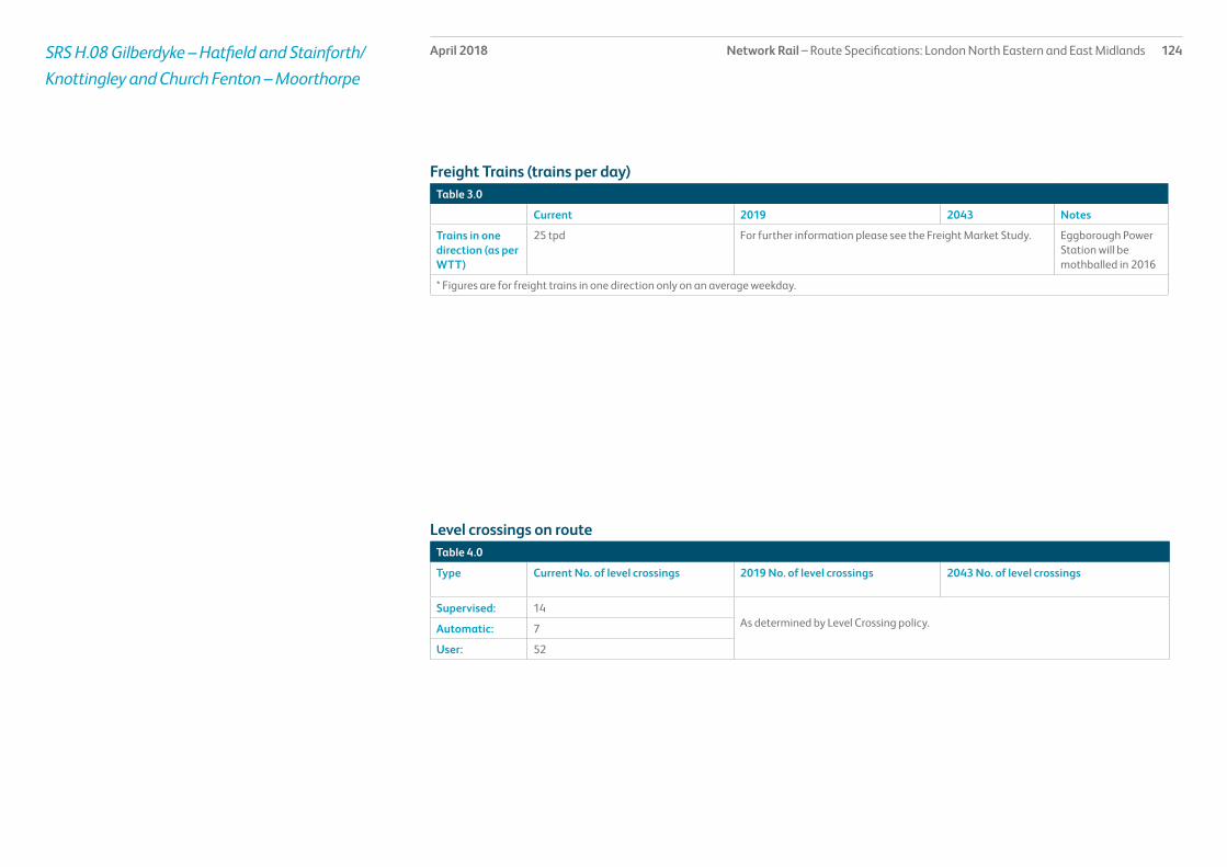
Network Rail – Route Specifications: London North Eastern and East Midlands 124April 2018SRS H.08 Gilberdyke – Hatfield and Stainforth/Knottingley and Church Fenton – Moorthorpe
Table 3.0
Current 2019 2043 Notes
Trains in one direction (as per WTT)
25 tpd For further information please see the Freight Market Study. Eggborough Power Station will be mothballed in 2016
* Figures are for freight trains in one direction only on an average weekday.
Table 4.0
Type Current No. of level crossings 2019 No. of level crossings 2043 No. of level crossings
Supervised: 14As determined by Level Crossing policy.Automatic: 7
User: 52
Freight Trains (trains per day)
Level crossings on route

Network Rail – Route Specifications: London North Eastern and East Midlands 125April 2018SRS H.08 Gilberdyke – Hatfield and Stainforth/Knottingley and Church Fenton – Moorthorpe
Table 5.0
Project Project Description ELR Implementation Date
Output change Status
Freight Gauge Enhancements: Doncaster to Stourton Junction
Provision of W10/W12 Various CP5 Capacity to carry deep sea containers on standard deck height wagons
In delivery
Ferriby to Gilberdyke Resignalling and recontrol HUL1, TJG2 2018 Resignalling and recontrol to York ROC In delivery
Proposed Infrastructure Investment

Network Rail – Route Specifications: London North Eastern and East Midlands 126April 2018SRS H.09 Knottingley – Mirfield via Crofton Jn/Castleford and via Castleford Jn – Leeds West Jn/Whitwood
Route specification descriptionThis secondary route is based in West Yorkshire and stretches from Knottingley in the East to Thornhill Jn (near Mirfield) in a westerly direction and Leeds in a northerly direction.
This is a multi section route of approximately 45 miles of double track. It consists of a number of urban lines and a selection of routes carrying passenger services and freight. Between Normanton and Leeds passenger rail services link the East Midlands and South Yorkshire to West Yorkshire.
The major stations outside Leeds are Castleford, Pontefract Monkhill and Wakefield Kirkgate. The route contains a major structure, namely Methley Viaduct which is a brick viaduct of five spans.
On the route between Altofts Jn and Leeds there are two major freight terminals; Wakefield Europort and Leeds Stourton (Hunslet). Both provide an important intermodal freight link between East Anglian ports and West Yorkshire. There is also a freight yard situated at Healey Mills on this route.
.
Geographic Map
I2I

Network Rail – Route Specifications: London North Eastern and East Midlands 127April 2018SRS H.09 Knottingley – Mirfield via Crofton Jn /Castleford and via Castleford Jn – Leeds West Jn /Whitwood
Table 1.0
Information Current 2019 2043 Notes
Line of route description
Knottingley – Mirfield (via Crofton Jn)/Castleford and via Castleford Jn) – Leeds West Jn/Whitwood
Section start Knottingley/Castleford
Section end Leeds West Jn/Whitwood
Route availability 8, 9 9 9
Gauge W6, W8, W9, W12 W9 W9
Signals Track Circuit Block Track Circuit Block ERTMS
SpeedSee Sectional Appendix for detailed speed profiles
The predominant linespeed is 60 miles per hour (mph) except for Methley Jn to Whitwood Jn which is 30mph
The predominant linespeed is 60 miles per hour (mph) except for Methley Jn to Whitwood Jn which is 30mph
Incremental linespeed improvements where possible in line with infrastructure characteristics and capability of rolling stock
Electrification Not electrified Not electrified Future electrification to be shaped as part of Long Term Planning Process
Passenger train service levels (trains per hour / day)Table 2.0
Current 2019 2043 Notes
Typical journey time Knottingley – Wakefield Kirkgate 25 minutes.Castleford – Leeds 23 minutes.Normanton – Leeds 32 minutes
Reduce journey time to lowest possible in line with linespeed improvements and changes in rolling stock.
All future service specifications to be shaped by Market and Route Studies as part of the Long Term Planning Process.
No. of trains per hour Mirfield East Jn – Thornhill LNW Jn 4 (increasing to 6) tph plus 3 tpd LDHS.Thornhill LNW Jn – Horbury Jn 1 tph plus 3 tpd LDHS.Horbury Jn – Wakefield Kirkgate 3 tph plus 3 tpd LDHS.Wakefield Kirkgate – Wakefield Westgate 1 tph.Wakefield Kirkgate – Turners Lane 3 tph.Normanton – Altofts 3 tph Sheffield to Leeds.Altofts to Methley 2 tph Sheffield to Leeds.Altofts – Whitwood 1 tph Sheffield to Leeds via Castleford.Whitwood Jn – Castleford 3 tph Sheffield to Leeds and Knottingley to Leeds.Whitwood Jn – Methley Jn 2 tph.Methley Jn – Leeds 4 tph including services from Sheffield (3) and Knottingley (1).Castleford – Pontefract West Jn 1 tph.Wakefield Kirkgate to Pontefract West Jn 1 tph plus 3 Bradford to London services.Pontefract West Jn – Pontefract East Jn 2 tph plus 3 Bradford to London services.
All the above applies in each direction.
Changes to service frequency as a result of franchise commitments
Possible changes to service frequency in line with industry aspirations and market requirements.
Route capability overview

Network Rail – Route Specifications: London North Eastern and East Midlands 128April 2018SRS H.09 Knottingley – Mirfield via Crofton Jn/Castleford and via Castleford Jn – Leeds West Jn/Whitwood
Table 3.0
Current 2019 2043 Notes
Trains in one direction (as per WTT)
19 tpd For further information please see the Freight Market Study. Ferrybridge Power Station expected to close in 2016
* Figures are for freight trains in one direction only on an average weekday.
Table 4.0
Type Current No. of level crossings 2019 No. of level crossings 2043 No. of level crossings
Supervised: 5As determined by Level Crossing policy.Automatic: 0
User: 5
Freight Trains (trains per day)
Level crossings on route

Network Rail – Route Specifications: London North Eastern and East Midlands 129April 2018SRS H.09 Knottingley – Mirfield via Crofton Jn/Castleford and via Castleford Jn – Leeds West Jn/Whitwood
Table 5.0
Project Project Description ELR Implementation Date
Output change Status
Freight Gauge Enhancements: Doncaster to Stourton Junction
Provision of W10/W11/W12 Various CP5 Capacity to carry deep sea containers on standard deck height wagons
In delivery
Proposed Infrastructure Investment

Network Rail – Route Specifications: London North Eastern and East Midlands 130April 2018SRS H.10 Manchester Victoria – Mirfield (via Rochdale)/Stalybridge
Route specification descriptionThis secondary urban route leads in an easterly direction from Manchester to Mirfield via Rochdale, with another route diverging to Stalybridge, via Ashton-under-Lyne. The former crosses the London North Western/London North Eastern boundary at 22 miles 62 chains on MVN2 just west of Hebden Bridge. The rural section between Miles Platting Junction and Rochdale East Junction via Oldham (the ‘Oldham Loop’) has been transferred to Transport for Greater Manchester who operate this line as part of Manchester Metrolink. There are approximately 46 miles of route in total. Manchester Victoria to Miles Platting Junction is four track with the remainder being double. There is a section of single line between Bradley and Bradley Wood junctions between Brighouse and Deighton.
There are fifteen stations on this route including Manchester Victoria and Stalybridge. Manchester Victoria is the major station on this route and has six platforms: two east facing bay platforms and four through platforms, with services radiating towards Yorkshire, Merseyside and various North West destinations. Other notable stations are Stalybridge, Rochdale, Todmorden, Hebden Bridge and Sowerby Bridge.
The Manchester to Mirfield via Rochdale and Manchester to Stalybridge routes are predominantly passenger routes with occasional freight services.
Geographic Map

Network Rail – Route Specifications: London North Eastern and East Midlands 131April 2018SRS H.10 Manchester Victoria – Mirfield (via Rochdale)/Stalybridge
Table 1.0
Information Current 2019 2043 Notes
Line of route description
Manchester Victoria – Mirfield (via Rochdale)/Stalybridge
Section start BBW 0m 0yds Bradley Junction), BPP -0m 197 yds (Phillips Park W. Junction), MPR1 1m 663 yds (Man. Vic.), MPR3 14m 0 yds (Oldham Loop), MVL1 1m 663 yds (Miles Platting), MVL2 7m 1012 yds (Stalybridge), MVM -0m 45 yds (Manchester Victoria), MVN2 2m 365 yds (Thorpes Bridge Junction), MVN2 9m 616 yds (Castleton)
Section end BBW 1m 393yds (Bradley Wood Junction), BPP 0m 525 yds (Brewery Junction), MPR1 2m 387 yds (Thorpes Bridge Junction), MPR3 14m 585 yds (Oldham Loop), MVL1 7m 1013 yds (Stalybridge), MVL2 7m 1630 yds (Stalybridge), MVM 1m 674 yds (Manchester Victoria), MVN2 9m 616 yds (Rochdale), MVN2 37m 779 yds (Heaton Lodge Junction)
Route availability 8, 9 9 9
Gauge W6-8 W8 W8
Signals Mixture of Absolute Block and Track Circuit Block
Track Circuit Block ERTMS
SpeedSee Sectional Appendix for detailed speed profiles
Predominant linespeed 60 miles per hour (mph)
Incremental linespeed improvements where possible in line with infrastructure characteristics and capability of rolling stock
Incremental linespeed improvements where possible in line with infrastructure characteristics and capability of rolling stock
Electrification Not electrified Not electrified Future electrification to be shaped as part of Long Term Planning Process
Passenger train service levels (trains per hour / day)Table 2.0
Current 2019 2043 Notes
Typical journey time Manchester Victoria – Stalybridge: 15 minutes.Manchester Victoria – Rochdale: 18 minutes. (In 2019, 14 minutes)Manchester Victoria – Mirfield: 1 hour 15 minutes
Reduce journey time to lowest possible in line with linespeed improvements and changes in rolling stock.
All future service specifications to be shaped by Market and Route Studies as part of the Long Term Planning Process.
No. of trains per hour Manchester – Stalybridge 2 trains per hour (tph) in each direction.Manchester – Rochdale 4 tph in each direction.Rochdale – Hall Royd Junction 3 tph in each direction.Hall Royd Junction – Milner Royd Junction 4 tph in each direction.Milner Royd Junction – Greetland Junction 1 tph in each directionGreetland Junction – Bradley Wood Junction 2 tph in each direction.Bradley Wood Junction – Heaton Lodge Junction 1 tph in each direction.Bradley Junction – Bradley Wood Junction 1 tph in each direction.
Changes to service frequency in line with journey time improvements and franchise commitments.
Possible changes to service frequency in line with industry aspirations and market requirements.
Route capability overview

Network Rail – Route Specifications: London North Eastern and East Midlands 132April 2018
Table 3.0
Current 2019 2043 Notes
Trains in one direction (as per WTT)
8 tpd For further information please see the Freight Market Study.
* Figures are for freight trains in one direction only on an average weekday.
Table 4.0
Type Current No. of level crossings 2019 No. of level crossings 2043 No. of level crossings
Supervised: 0As determined by Level Crossing policy.Automatic: 0
User: 2
Freight Trains (trains per day)
Level crossings on route
SRS H.10 Manchester Victoria – Mirfield (via Rochdale)/Stalybridge

Network Rail – Route Specifications: London North Eastern and East Midlands 133April 2018SRS H.10 Manchester Victoria – Mirfield (via Rochdale)/Stalybridge
Table 5.0
Project Project Description ELR Implementation Date
Output change Funder Status
Calder Valley - Journey Time Improvement
Journey time and connectivity improvements between Bradford and Manchester
SAJ 2018 Journey time improvements. In delivery
Elland railway station New station improving connectivity tbc New station to serve Elland In development
Proposed Infrastructure Investment

Network Rail – Route Specifications: London North Eastern and East Midlands 134April 2018SRS H.11 Hull – Seamer
Route specification descriptionThis rural route leads in a north and easterly direction out of Hull to Bridlington and along the coast line to Seamer just south of Scarborough.
The route is double track between Hull and Bridlington and is single track between Bridlington and Seamer South Junction except for a three mile section of double track between Hunmanby and Filey.
The route contains nine stations of which the most significant are Beverley, Bridlington and Filey and is part of the Yorkshire Coast Community Rail Partnership.
Geographic Map

Network Rail – Route Specifications: London North Eastern and East Midlands 135April 2018SRS H.11 Hull – Seamer
Table 1.0
Information Current 2019 2043 Notes
Line of route description
Hull – Seamer
Section start Hull
Section end Seamer
Route availability 6, 7, 8 7 7
Gauge W6, W8 W6, W8 W6, W8
Signals Mainly Track Circuit Block, Absolute Block between Beverley and Driffield Signalboxes.
Mixture of Track Circuit Block and Absolute Block. ERTMS
SpeedSee Sectional Appendix for detailed speed profiles
For passenger services, predominant speed Hull to Bridlington is 70mph, for Bridlington to Seamer 60mph and for freight 40mph.
For passenger services, predominant speed Hull to Bridlington is 70mph, for Bridlington to Seamer 60mph and for freight 40mph.
Incremental linespeed improvements where possible in line with infrastructure characteristics and capability of rolling stock
Electrified Not electrified. Not electrified. Future electrification to be shaped as part of Long Term Planning Process
Passenger train service levels (trains per hour / day)
Table 2.0
Current 2019 2043 Notes
Typical journey time Hull – Seamer, 1hour 20 minutes (direct service). Reduce journey time to lowest possible in line with linespeed improvements and changes in rolling stock.
All future service specifications to be shaped by Market and Route Studies as part of the Long Term Planning Process.
No. of trains per hour 1 train per half hour in each direction between Hull and Bridlington and 1 train every 1.5 hours in each direction between Bridlington and Seamer. 1 tpd Beverley - King’s Cross each direction.
Possible changes to service frequency in line with industry aspirations and market requirements.
Route capability overview

Network Rail – Route Specifications: London North Eastern and East Midlands 136April 2018SRS H.11 Hull – Seamer
Table 3.0
Current 2019 2043 Notes
Trains in one direction (as per WTT)
No booked freight traffic. For further information please see the Freight Market Study.
* Figures are for freight trains in one direction only on an average weekday.
Table 4.0
Type Current No. of level crossings 2019 No. of level crossings 2043 No. of level crossings
Supervised: 14As determined by Level Crossing policy.Automatic: 24
User: 58
Freight Trains (trains per day)
Level crossings on route

Network Rail – Route Specifications: London North Eastern and East Midlands 137April 2018SRS H.11 Hull – Seamer
Table 5.0
Project Project Description ELR Implementation Date
Output change Status
There is no planned investment in Control Period 5.
Proposed Infrastructure Investment

Network Rail – Route Specifications: London North Eastern and East Midlands 138April 2018SRS H.12 York – Scarborough
Route specification descriptionThis rural route leads in a north easterly direction through North Yorkshire from York to Scarborough on the East Coast via Malton and Seamer.
This is a forty two mile double track route.
There are four stations on this route including York. The City of York is served by a major railway station situated on the East Coast Main Line and the station has eleven platforms offering services to London, the North East, Scotland, Yorkshire, the Midlands, South West, South Coast and the North West of England.
Scarborough railway station has five platforms with services to York, Leeds, Manchester, Liverpool and Hull.
Malton railway station has a single platform and therefore makes this small section in essence a single line section for passenger services calling there.
This route is predominately used by an interurban operator with steam charters in the summer months.
Geographic Map

Network Rail – Route Specifications: London North Eastern and East Midlands 139April 2018SRS H.12 York – Scarborough
Table 1.0
Information Current 2019 2043 Notes
Line of route description
York – Scarborough
Section start York
Section end Scarborough
Route availability 8 8 8
Gauge W6 W6 W6
Signals Mixture of Absolute Block and Track Circuit Block.
Mixture of Absolute Block and Track Circuit Block. ERTMS
SpeedSee Sectional Appendix for detailed speed profiles
Predominant linespeed 90 mph Predominant linespeed 90 mph Incremental linespeed improvements where possible in line with infrastructure characteristics and capability of rolling stock
Electrification Not electrified. Not electrified. Future electrification to be shaped as part of Long Term Planning Process
Passenger train service levels (trains per hour / day)Table 2.0
Current 2019 2043 Notes
Typical journey time York – Scarborough, 50 minutes. Reduce journey time to lowest possible in line with linespeed improvements and changes in rolling stock.
All future service specifications to be shaped by Market and Route Studies as part of the Long Term Planning Process.
No. of trains per hour Liverpool – Scarborough 1 tph throughout the day in each direction, with train lengthening or additional shuttles at peak holiday times in each direction.
New hourly Northern service to be introduced between York and Scarborough.
Possible changes to service frequency in line with industry aspirations and market requirements.
Route capability overview

Network Rail – Route Specifications: London North Eastern and East Midlands 140April 2018SRS H.12 York – Scarborough
Table 3.0
Current 2019 2043 Notes
Trains in one direction (as per WTT)
No booked freight traffic For further information please see the Freight Market Study.
* Figures are for freight trains in one direction only on an average weekday.
Table 4.0
Type Current No. of level crossings 2019 No. of level crossings 2043 No. of level crossings
Supervised: 12As determined by Level Crossing policy.Automatic: 10
User: 60
Freight Trains (trains per day)
Level crossings on route

Network Rail – Route Specifications: London North Eastern and East Midlands 141April 2018SRS H.12 York – Scarborough
Table 5.0
Project Project Description ELR Implementation Date
Output change Funder Status
There is no planned investment in Control Period 5.
Proposed Infrastructure Investment

Network Rail – Route Specifications: London North Eastern and East Midlands 142April 2018SRS H.13 Chesterfield – Swinton via Sheffield
Route specification descriptionThis primary route extends northwards from Tapton Junction (near Chesterfield) to Swinton Junction and the Rotherham area. The route services several distinct passenger markets.
The first is for cross country type journeys linking Scotland, the North East, Yorkshire, the Midlands, Thames Valley and the South West.
The second is the interurban services linking Sheffield with Manchester, London, the East Midlands, East Anglia, South Yorkshire, West Yorkshire and South Humberside.
The third is between intermediate locations on the route and the above areas by direct services or by changing trains onto long distance services at Sheffield. The route also carries local services within South Yorkshire most of which are sponsored by South Yorkshire Passenger Transport Executive.
There are four stations on the lines of route within this SRS. Sheffield is the largest station which has eight platforms. Other key stations are Dronfield, Meadowhall and Rotherham. Meadowhall is a four platform station situated where the route diverges to Swinton and Barnsley. Rotherham Central is a two platform station situated on the chord between Meadowhall and Swinton/Doncaster. Sheffield station provides an important interchange facility between long distance passenger services to/from London, Northern East England, Scotland, East Midlands and South East, South West England and the regional centres of Manchester, West and South Yorkshire and Lincolnshire.
There is a Train Maintenance Depot for stabling and servicing trains at Sheffield. Sheffield station is also used to stable DMUs.
The Tapton Junction to Sheffield to Moorthorpe/Doncaster corridor features eleven flat junctions (excluding Sheffield stations and Doncaster station) within a twenty eight mile stretch. It is a two track railway, with an up and down passenger loop at Brightside. There is a currently disused loop on the Down line at Rotherham Masborough. The SRS contains a secondary route from Rotherham Central to Aldwarke Junction.
The chord via Rotherham and the primary freight route between Aldwarke and Mexborough (see H.14 Swinton – Brocklesby Junction), together with Sheffield station, permits the regulation of services.
The route contains 3 tunnels.
Geographic Map

Network Rail – Route Specifications: London North Eastern and East Midlands 143April 2018SRS H.13 Chesterfield – Swinton via Sheffield
Table 1.0
Information Current 2019 2043 Notes
Line of route description
Chesterfield – Swinton (via Sheffield)
Section start Chesterfield
Section end Swinton (via Sheffield)
Route availability 8, 10 8, 10 10
Gauge W8, W12 Chesterfield- Sheffield- Swinton
W9 W10
Signals Track Circuit Block Track Circuit Block ERTMS
Speed 90 mph 90 mph Incremental linespeed improvements where possible in line with infrastructure characteristics and capability of rolling stock
Electrification Not electrified. Sheffield to Rotherham 750 DC electrification for Tram Train.
Future electrification to be shaped as part of Long Term Planning Process
Passenger train service levels (trains per hour / day)Table 2.0
Current 2019 2043 Notes
Typical journey time 50 minutes (weekday, Dronfield – Swinton) 50 minutes (weekday, Dronfield – Swinton) Reduce journey time to lowest possible in line with linespeed improvements and changes in rolling stock.
All future service specifications to be shaped by Market and Route Studies as part of the Long Term Planning Process.
No. of trains per hour 6 tph Tapton Junction to Dore Station Junction 9 tpd Dore Station Junction to Sheffield 11 tpd Sheffield to Nunnery Main Line Junction 10 tph Nunnery Main Line Junction to Wincobank Station Junction 7 tph Wincobank Station Junction to Holmes Junction and Aldwarke Junction to Swinton4 tph Holmes Junction to Aldwarke Junction direct 3 tph Holmes Junction to Aldwarke via Rotherham Central 2 tpd Sheffield to York via Rotherham5 tpd Leeds and London via Sheffield
6 tph Tapton Junction to Dore Station Junction 9 tpd Dore Station Junction to Sheffield 11 tpd Sheffield to Nunnery Main Line Junction 10 tph Nunnery Main Line Junction to Wincobank Station Junction 7 tph Wincobank Station Junction to Holmes Junction and Aldwarke Junction to Swinton4 tph Holmes Junction to Aldwarke Junction direct 3 tph Holmes Junction to Aldwarke via Rotherham Central 2 tpd Sheffield to York via Rotherham5 tpd Leeds and London via SheffieldFrequent tram train service between Rotherham Parkgate and Sheffield
Possible changes to service frequency in line with industry aspirations and market requirements.
Route capability overview

Network Rail – Route Specifications: London North Eastern and East Midlands 144April 2018SRS H.13 Chesterfield – Swinton via Sheffield
Table 3.0
Current 2019 2043 Notes
Trains in one direction (as per WTT)
18 tpd For further information please see the Freight Market Study.
* Figures are for freight trains in one direction only on an average weekday.
Table 4.0
Type Current No. of level crossings 2019 No. of level crossings 2043 No. of level crossings
Supervised: 2As determined by Level Crossing policy.Automatic: 0
User: 1
Freight Trains (trains per day)
Level crossings on route

Network Rail – Route Specifications: London North Eastern and East Midlands 145April 2018SRS H.13 Chesterfield – Swinton via Sheffield
Table 5.0
Project Project Description ELR Implementation Date
Output change Status
Tram Train Trial Sheffield to Rotherham Parkgate. TJC3 CP5 Tram train trial In delivery
Hope Valley Dore Capacity Additional capacity at Dore DWS tbc Hope Valley capacity and journey time improvement
In development
Proposed Infrastructure Investment

Network Rail – Route Specifications: London North Eastern and East Midlands 146April 2018SRS H.14 Swinton Junction – Brocklesby Junction
Route specification descriptionThis primary route leads in a north easterly direction out of Swinton in South Yorkshire to Doncaster and along the South Humberside main line towards Thorne Junction, Scunthorpe and Brocklesby Junction.
This is a route of approximately forty seven miles comprising mainly double track with the exception of Kirk Sandall to Thorne Junction which is four track, with a three track section between Wrawby Junction and Brocklesby Junction. This SRS also contains a Primary Freight route between Aldwarke Junction and Mexborough.
There are 10 stations excluding Doncaster within this Route Specification, with 7 between Barnetby and Doncaster (exclusive) and 3 between Doncaster (exclusive) and Swinton (inclusive) with Scunthorpe the key station along the route.
Passenger services operate to Cleethorpes, Grimsby, Doncaster, Sheffield, Manchester, Lincoln and Barton on Humber. The route also crosses the East Coast Main Line at Doncaster and this provides an important passenger interchange with services to London, the North East and West Yorkshire.
Whilst this route carries an hourly interurban passenger service between Cleethorpes and South Yorkshire and the North West and regional passenger services between Hull/Scunthorpe and South Yorkshire, the route is primarily used by freight with some of the highest tonnage movements in the United Kingdom operating on the south bank of the Humber between the port of Immingham, Scunthorpe and Doncaster. Circa 60 freight trains per day operate each way on the core section between Brocklesby and Wrawby Junction carrying coal and biomass traffic for power stations, imported fuel for the steel works at Scunthorpe, imported iron ore for Scunthorpe steel works, steel production from Scunthorpe and oil products from the Humber port to various destinations. There is an extensive freight yard at Scunthorpe serving the Tata Steel Works and the Foreign Ore Terminal. There are also Up and Down goods loops at Scunthorpe.
Another section with significant freight flows is the Swinton/Doncaster/Rotherham/Chesterfield via Sheffield axis which sees considerable amount of through freight traffic between the North East and the Yorkshire and Humber region, and the Midlands and South West.
At Hexthorpe Junction the route diverges with passenger trains travelling towards Doncaster. Most freight takes the diverging route towards Bentley Junction thus avoiding Doncaster (see Route Specification H.91). The South Yorkshire Joint Line from Brancliffe East Junction joins at Kirk Sandall Junction. This is another freight only route avoiding Doncaster (see Route Specification H.91).
Approximately 3 miles further east at Hatfield and Stainforth the freight only route from the Aire Valley Power Stations and the ECML joins the South Humber Main Line (see Route Specification H.91). A further mile west sees the route diverge towards Goole and Hull (see Route Specification H.08) with the main line continuing eastwards towards Scunthorpe/Cleethorpes and the Humber Ports at Immingham. Finally, another freight only line to Roxby joins the South Humber Main Line at Scunthorpe.
This strategic route section contains one tunnel and several major structures, namely Keadby Drawbridge (DOW27), steel construction (1 span), King George V Bridge (Keadby Lift Bridge) (DOW 36), steel construction (5 spans) and Frodingham Viaduct (DOW39), brick construction (84 spans).
Geographic Map
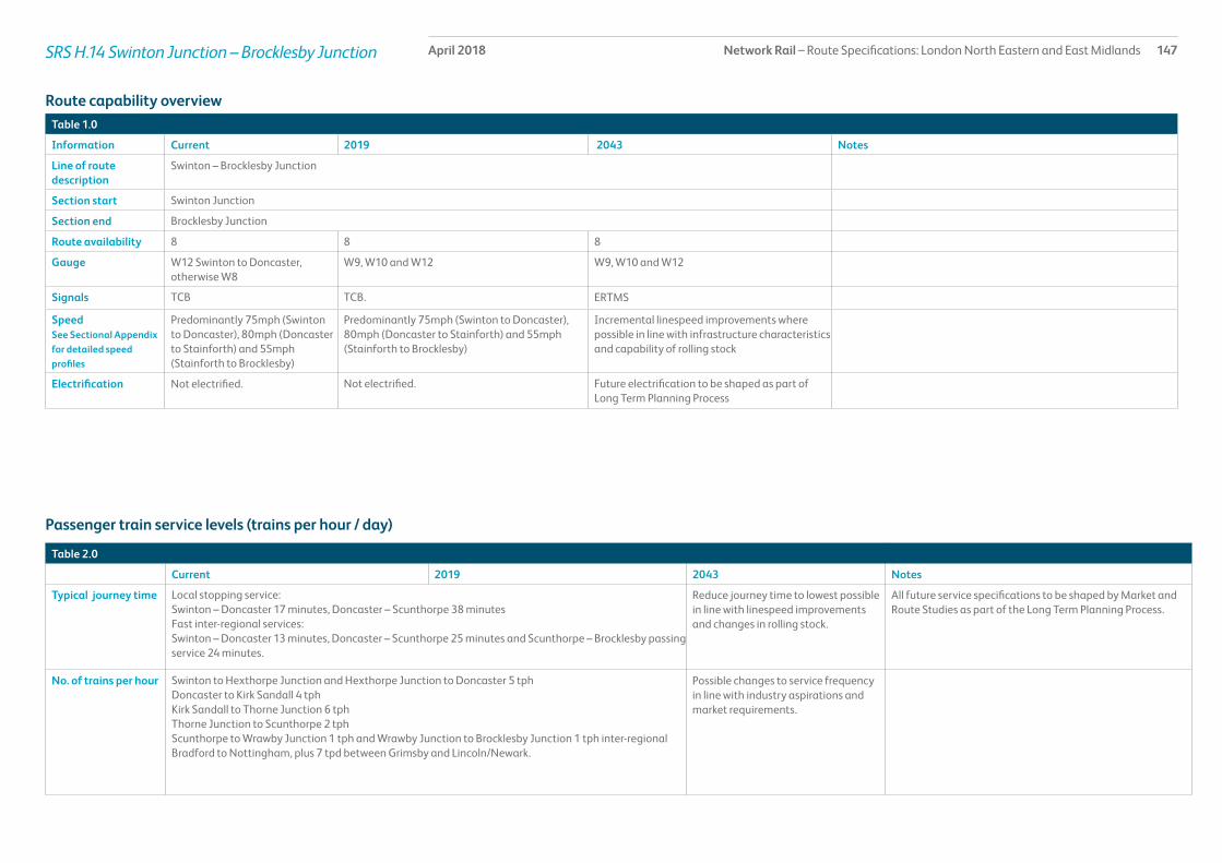
Network Rail – Route Specifications: London North Eastern and East Midlands 147April 2018SRS H.14 Swinton Junction – Brocklesby Junction
Table 1.0
Information Current 2019 2043 Notes
Line of route description
Swinton – Brocklesby Junction
Section start Swinton Junction
Section end Brocklesby Junction
Route availability 8 8 8
Gauge W12 Swinton to Doncaster, otherwise W8
W9, W10 and W12 W9, W10 and W12
Signals TCB TCB. ERTMS
SpeedSee Sectional Appendix for detailed speed profiles
Predominantly 75mph (Swinton to Doncaster), 80mph (Doncaster to Stainforth) and 55mph (Stainforth to Brocklesby)
Predominantly 75mph (Swinton to Doncaster), 80mph (Doncaster to Stainforth) and 55mph (Stainforth to Brocklesby)
Incremental linespeed improvements where possible in line with infrastructure characteristics and capability of rolling stock
Electrification Not electrified. Not electrified. Future electrification to be shaped as part of Long Term Planning Process
Passenger train service levels (trains per hour / day)
Table 2.0
Current 2019 2043 Notes
Typical journey time Local stopping service:Swinton – Doncaster 17 minutes, Doncaster – Scunthorpe 38 minutes Fast inter-regional services:Swinton – Doncaster 13 minutes, Doncaster – Scunthorpe 25 minutes and Scunthorpe – Brocklesby passing service 24 minutes.
Reduce journey time to lowest possible in line with linespeed improvements and changes in rolling stock.
All future service specifications to be shaped by Market and Route Studies as part of the Long Term Planning Process.
No. of trains per hour Swinton to Hexthorpe Junction and Hexthorpe Junction to Doncaster 5 tphDoncaster to Kirk Sandall 4 tphKirk Sandall to Thorne Junction 6 tphThorne Junction to Scunthorpe 2 tphScunthorpe to Wrawby Junction 1 tph and Wrawby Junction to Brocklesby Junction 1 tph inter-regional Bradford to Nottingham, plus 7 tpd between Grimsby and Lincoln/Newark.
Possible changes to service frequency in line with industry aspirations and market requirements.
Route capability overview
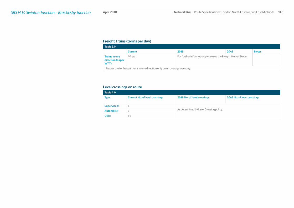
Network Rail – Route Specifications: London North Eastern and East Midlands 148April 2018SRS H.14 Swinton Junction – Brocklesby Junction
Table 3.0
Current 2019 2043 Notes
Trains in one direction (as per WTT)
40 tpd For further information please see the Freight Market Study.
* Figures are for freight trains in one direction only on an average weekday.
Table 4.0
Type Current No. of level crossings 2019 No. of level crossings 2043 No. of level crossings
Supervised: 6As determined by Level Crossing policy.Automatic: 3
User: 34
Freight Trains (trains per day)
Level crossings on route

Network Rail – Route Specifications: London North Eastern and East Midlands 149April 2018SRS H.14 Swinton Junction – Brocklesby Junction
Table 5.0
Project Project Description ELR Implementation Date
Output change Status
Freight enhancement: Immingham - ECML
Capacity improvements MAC3, DOW 2019 Improve gauge clearance to W12 In design
Proposed Infrastructure Investment

Network Rail – Route Specifications: London North Eastern and East Midlands 150April 2018SRS H.15 South Kirkby Junction – Swinton Junction
Route specification descriptionThis secondary route leads in a south westerly direction from South Kirkby Junction to Swinton in South Yorkshire and forms part of the South Yorkshire rail network.
It is a relatively short section of approximately 8 miles of route, all double track. This route includes 5 stations with services to Leeds and Sheffield. All have 2 platforms except Swinton station which has 3 platforms with services to Doncaster, Wakefield, Leeds, Rotherham, Sheffield and York.
Geographic Map

Network Rail – Route Specifications: London North Eastern and East Midlands 151April 2018SRS H.15 South Kirkby Junction – Swinton Junction
Table 1.0
Information Current 2019 2043 Notes
Line of route description
South Kirkby Junction -Swinton
Section start South Kirkby Junction
Section end Swinton Junction
Route availability 8 9 9
Gauge W12 W10 W10
Signals Track Circuit Block Track Circuit Block ERTMS
SpeedSee Sectional Appendix for detailed speed profiles
80 mph 80 mph Incremental linespeed improvements where possible in line with infrastructure characteristics and capability of rolling stock
Electrification Not electrified. Not electrified. Future electrification to be shaped as part of Long Term Planning Process
Passenger train service levels (trains per hour / day)Table 2.0
Current 2019 2043 Notes
Typical journey time South Kirkby Junction -Swinton, 15 minutes Reduce journey time to lowest possible in line with linespeed improvements and changes in rolling stock.
All future service specifications to be shaped by Market and Route Studies as part of the Long Term Planning Process.
No. of trains per hour 2 tph Moorthorpe to Swinton route throughout the day plus 4 tpd London to Leeds via Sheffield plus 2 tpd Sheffield to York between Swinton and Moorthorpe.
New Northern Connect Bradford Interchange to Nottingham service in 2019.
Possible changes to service frequency in line with industry aspirations and market requirements.
Route capability overview

Network Rail – Route Specifications: London North Eastern and East Midlands 152April 2018SRS H.15 South Kirkby Junction – Swinton Junction
Table 3.0
Current 2019 2043 Notes
Trains in one direction (as per WTT)
5 tpd For further information please see the Freight Market Study.
* Figures are for freight trains in one direction only on an average weekday.
Table 4.0
Type Current No. of level crossings 2019 No. of level crossings 2043 No. of level crossings
Supervised: 0As determined by Level Crossing policy.Automatic: 0
User: 1
Freight Trains (trains per day)
Level crossings on route

Network Rail – Route Specifications: London North Eastern and East Midlands 153April 2018SRS H.15 South Kirkby Junction – Swinton Junction
Table 5.0
Project Project Description ELR Implementation Date
Output change Status
There is no planned investment in Control Period 5.
Proposed Infrastructure Investment

Network Rail – Route Specifications: London North Eastern and East Midlands 154April 2018SRS H.16 Sheffield – Gainsborough
Route specification descriptionThis secondary route leads in an easterly direction from Sheffield Nunnery Main Line Junction to Trent Junctions just west of Gainsborough Central via Worksop. It serves stations in Nottinghamshire and Lincolnshire including Kiveton, Worksop, and Retford, before diverging towards Gainsborough Central/Gainsborough Lea Road and Lincoln. It comprises a section of approximately thirty three miles of route, all double track with freight sidings at Worksop with a passing loop at Gringley Road near Retford.
There are 7 stations served by an hourly service with some additional peak services between Immingham and the East Midlands.
Worksop and Retford are the main stations on this route.
The freight only route to Stocksbridge diverges from this route at Nunnery Junction and at Brancliffe East Junction the South Yorkshire Joint Line diverges towards Doncaster and Kirk Sandall Junction. See Route specification H.98 for further details.
The route contains one major tunnel.
This Route Specification also includes the single track link at Retford from Thrumpton West Junction to Retford Western Junction linking the Sheffield to Retford route with the ECML at Retford.
Geographic Map

Network Rail – Route Specifications: London North Eastern and East Midlands 155April 2018SRS H.16 Sheffield – Gainsborough
Table 1.0
Information Current 2019 2043 Notes
Line of route description
Sheffield – Gainsborough
Section start Sheffield
Section end Gainsborough
Route availability 8 8 8
Gauge W6-10, W12 W6-10, W12 W9
Signals Track Circuit Block other than Absolute Block controlled by Kiveton Park Signalbox.
Track Circuit Block other than Absolute Block controlled by Kiveton Park Signalbox.
ERTMS
SpeedSee Sectional Appendix for detailed speed profiles
Predominant linespeed 60 mph Predominant linespeed 60 mph Incremental linespeed improvements where possible in line with infrastructure characteristics and capability of rolling stock
Electrification Not electrified. Not electrified. Future electrification to be shaped as part of Long Term Planning Process
Passenger train service levels (trains per hour / day)Table 2.0
Current 2019 2043 Notes
Typical journey time Sheffield – Retford 40 minutesSheffield – Lincoln 1 hour 24 minutes
Journey time and capacity improvements from resignalling.
Reduce journey time to lowest possible in line with linespeed improvements and changes in rolling stock.
All future service specifications to be shaped by Market and Route Studies as part of the Long Term Planning Process.
No. of trains per hour Sheffield – Retford 1 tph. Northern Connect Lincoln to Leeds Possible changes to service frequency in line with industry aspirations and market requirements.
Route capability overview

Network Rail – Route Specifications: London North Eastern and East Midlands 156April 2018SRS H.16 Sheffield – Gainsborough
Table 3.0
Current 2019 2043 Notes
Trains in one direction (as per WTT)
9 tpd For further information please see the Freight Market Study.
* Figures are for freight trains in one direction only on an average weekday.
Table 4.0
Type Current No. of level crossings 2019 No. of level crossings 2043 No. of level crossings
Supervised: 6As determined by Level Crossing policy.Automatic: 2
User: 14
Freight Trains (trains per day)
Level crossings on route

Network Rail – Route Specifications: London North Eastern and East Midlands 157April 2018SRS H.16 Sheffield – Gainsborough
Table 5.0
Project Project Description ELR Implementation Date
Output change Status
Beighton and Woodhouse renewals
Signalling renewal BEW, MAC3 2019 Renewal of asset and recontrol to York ROC.
In development
Proposed Infrastructure Investment

Network Rail – Route Specifications: London North Eastern and East Midlands 158April 2018SRS H.17 South Trans Pennine: Dore – Hazel Grove
Route specification descriptionThis secondary interurban route leads in a westerly direction from Dore, south of Sheffield in South Yorkshire, through the Hope Valley (Hathersage and Edale) via New Mills South Junction to Hazel Grove, in the metropolitan borough of Stockport, Greater Manchester.
It is a section of approximately 30 miles of route, all double track with a change of boundary from London North Eastern to London North Western at Dore West Junction. There is down loop and Cement freight terminal at Earles. A freight line diverges at Chinley South Junction towards Buxton (see Freight Route Specification H98 ‘Peak Forest’ branch) and the route diverges at New Mills South Junction towards Hazel Gove and Romiley.
The route between Dore and New Mills South Junction contains seven stations. These consist of two platforms with the exception of Dore which is a single platform with services to Sheffield and Manchester. The route from New Mills South Junction to Hazel Grove East Junction does not have any stations. At Hazel Grove East the route converges with the Buxton to Manchester route.
Geographic MapThe Hope Valley line carries considerable aggregates traffic from the Peak District quarries and traffic connected with Hope Cement Works to the North East, East Midlands, North West and London/South East. The freight route from Buxton and the Peak Forest joins this route at Chinley (see Route Specification H.98). The route also carries some freight between Manchester and South Humberside.
The Hope Valley currently carries three distinct hourly passenger services between Manchester and Sheffield:
• Liverpool Lime Street – Norwich: this inter-regional service links Merseyside, Warrington, Manchester, the Hope Valley, Sheffield and destinations in the East Midlands and East Anglia.
• Manchester Airport – Cleethorpes: this inter-regional service provides a link between Manchester Airport, South Yorkshire and North Lincolnshire.
• Manchester – Chinley/Sheffield: Alternating stopping service linking communities in South East Greater Manchester and the Hope Valley with Central Manchester and Sheffield.
The route contains three major tunnels.

Network Rail – Route Specifications: London North Eastern and East Midlands 159April 2018SRS H.17 South TransPennine: Dore – Hazel Grove
Table 1.0
Information Current 2019 2043 Notes
Line of route description
South TransPennine: Dore Junction – Hazel Grove East Junction
Section start Dore Junction
Section end Hazel Grove East Junction
Route availability 8 8 8
Gauge W6/7 W6/7 W6-8
Signals Mixture of Track Circuit Block and Absolute Block
Mixture of Track Circuit Block and Absolute Block. ERTMS
SpeedSee Sectional Appendix for detailed speed profiles
Predominant linespeed 90 mph Predominant linespeed 90 mph Incremental linespeed improvements where possible in line with infrastructure characteristics and capability of rolling stock
Electrification Not electrified Not electrified Future electrification to be shaped as part of Long Term Planning Process
Passenger train service levels (trains per hour / day)
Table 2.0
Current 2019 2043 Notes
Typical journey time Manchester – Dore local stoping service 1 hour 8 minutesManchester – Dore fast passing 45 minutes
Reduce journey time to lowest possible in line with linespeed improvements and changes in rolling stock.
All future service specifications to be shaped by Market and Route Studies as part of the Long Term Planning Process.
No. of trains per hour Dore Station Junction to New Mills South Junction 3 trains per hour in each direction.New Mills South Junction to Hazel Grove 2 trains per hour in each direction
Possible changes to service frequency in line with industry aspirations and market requirements.
Route capability overview

Network Rail – Route Specifications: London North Eastern and East Midlands 160April 2018SRS H.17 South TransPennine: Dore – Hazel Grove
Table 3.0
Current 2019 2043 Notes
Trains in one direction (as per WTT)
18 tpd For further information please see the Freight Market Study.
* Figures are for freight trains in one direction only on an average weekday.
Table 4.0
Type Current No. of level crossings 2019 No. of level crossings 2043 No. of level crossings
Supervised:There are no level crossings in this SRS As determined by Level Crossing policy.Automatic:
User:
Freight Trains (trains per day)
Level crossings on route
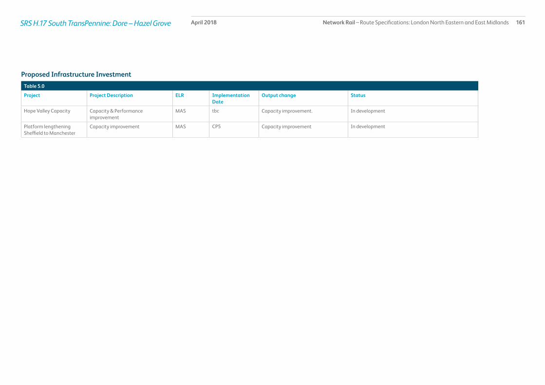
Network Rail – Route Specifications: London North Eastern and East Midlands 161April 2018SRS H.17 South TransPennine: Dore – Hazel Grove
Table 5.0
Project Project Description ELR Implementation Date
Output change Status
Hope Valley Capacity Capacity & Performance improvement
MAS tbc Capacity improvement. In development
Platform lengthening Sheffield to Manchester
Capacity improvement MAS CP5 Capacity improvement In development
Proposed Infrastructure Investment

Network Rail – Route Specifications: London North Eastern and East Midlands 162April 2018SRS H.18 Sheffield Meadowhall – Horbury Junction
Route specification descriptionThis secondary urban route leads in a northerly direction from Sheffield Meadowhall in South Yorkshire, through Barnsley and Darton to Horbury Junction in Wakefield, West Yorkshire.
This route is approximately twenty one miles, all double track and contains 5 stations. All the stations on this route have at least two platforms, offering services to Sheffield, Leeds, Huddersfield and Nottingham. Barnsley and Meadowhall are the principal stations on this route. The latter has 4 platforms with 2 platforms serving this route and a further two serving the Sheffield to Doncaster/Leeds rail corridor (H.15).
The route to Penistone and Huddersfield diverges at Barnsley.
The route contains 2 major tunnels and 1 major structure, namely Swaithe Viaduct (SHB63), steel construction (ten spans).
Geographic Map

Network Rail – Route Specifications: London North Eastern and East Midlands 163April 2018SRS H.18 Sheffield Meadowhall – Horbury Junction
Table 1.0
Information Current 2019 2043 Notes
Line of route description
Sheffield Meadowhall – Horbury Junction
Section start Sheffield Meadowhall
Section end Horbury Junction
Route availability 6, 7 6, 7 7
Gauge W6 W6 W6
Signals Track Circuit Block except for Absolute Block section controlled by Woolley Sidings Signalbox.
Track Circuit Block except for Absolute Block section controlled by Woolley Sidings Signalbox.
ERTMS
SpeedSee Sectional Appendix for detailed speed profiles
Predominant linespeed 70 mph Predominant linespeed 70 mph Incremental linespeed improvements where possible in line with infrastructure characteristics and capability of rolling stock
Electrification Not electrified Not electrified Future electrification to be shaped as part of Long Term Planning Process
Passenger train service levels (trains per hour / day)Table 2.0
Current 2019 2043 Notes
Typical journey time Meadowhall to Wakefield Kirkgate: 35 minutes Reduce journey time to lowest possible in line with linespeed improvements and changes in rolling stock.
All future service specifications to be shaped by Market and Route Studies as part of the Long Term Planning Process.
No. of trains per hour Wincobank Junction to Barnsley 4 trains per hour in each direction.
Barnsley to Horbury Junction 3 trains per hour in each direction
Possible changes to service frequency in line with industry aspirations and market requirements.
Route capability overview

Network Rail – Route Specifications: London North Eastern and East Midlands 164April 2018SRS H.18 Sheffield Meadowhall – Horbury Junction
Table 3.0
Current 2019 2043 Notes
Trains in one direction (as per WTT)
36 tpd For further information please see the Freight Market Study.
* Figures are for freight trains in one direction only on an average weekday.
Table 4.0
Type Current No. of level crossings 2019 No. of level crossings 2043 No. of level crossings
Supervised: 1As determined by Level Crossing policy.Automatic: 0
User: 2
Freight Trains (trains per day)
Level crossings on route

Network Rail – Route Specifications: London North Eastern and East Midlands 165April 2018SRS H.18 Sheffield Meadowhall – Horbury Junction
Table 5.0
Project Project Description ELR Implementation Date
Output change Status
Woolley to Wakefield Kirkgate
Signalling renewals BAH2 tbc Asset renewal In development
Proposed Infrastructure Investment

Network Rail – Route Specifications: London North Eastern and East Midlands 166April 2018SRS H.19 Brocklesby Junction – Cleethorpes
Route specification descriptionThis secondary route leads in a south easterly direction from Brocklesby Junction, through Habrough and Grimsby Town and onto Cleethorpes on the east coast.
This is a relatively short section of approximately thirteen miles of route forming part of the South Humberside main line from Doncaster to the east coast towns of Grimsby and Cleethorpes. It is double track as far as Grimsby Town where it becomes single track for almost 3 miles into Cleethorpes, with the exception of a short loop near Grimsby Docks station.
The route contains 8 stations with the main stations being Grimsby Town and Cleethorpes. The majority of the stations are served by local and interurban services.
Services using this route provide a direct link between North East Lincolnshire and South Yorkshire, the North West of England and the East Midlands.
Geographic Map

Network Rail – Route Specifications: London North Eastern and East Midlands 167April 2018SRS H.19 Brocklesby Junction – Cleethorpes
Table 1.0
Information Current 2019 2043 Notes
Line of route description
Brocklesby Junction – Cleethorpes
Section start Brocklesby Junction
Section end Cleethorpes
Route availability 8 8 8
Gauge W6, W8 W8 W8
Signals Mixture of Track Circuit Block and Absolute Block
Track Circuit Block ERTMS
SpeedSee Sectional Appendix for detailed speed profiles
Predominant linespeed 60 mph Brocklesby to Grimsby.Predominant linespeed Grimsby to Cleethorpes is 40 mph
Predominant linespeed 60 mph Brocklesby to Grimsby.Predominant linespeed Grimsby to Cleethorpes is 40 mph
Incremental linespeed improvements where possible in line with infrastructure characteristics and capability of rolling stock
Electrification Not electrified Not electrified Future electrification to be shaped as part of Long Term Planning Process
Passenger train service levels (trains per hour / day)Table 2.0
Current 2019 2043 Notes
Typical journey time Brocklesby Junction – Cleethorpes, 25 minute journey time for an inter-regional service Reduce journey time to lowest possible in line with linespeed improvements and changes in rolling stock.
All future service specifications to be shaped by Market and Route Studies as part of the Long Term Planning Process.
No. of trains per hour 1 train per hour interregional Cleethorpes to Doncaster1 train every 2 hours Cleethorpes to Barton on Humber and 7 trains per day between Grimsby and Lincoln/Newark (inter-regional)
Possible changes to service frequency in line with industry aspirations and market requirements.
Possible changes to service frequency in line with industry aspirations and market requirements.
Route capability overview

Network Rail – Route Specifications: London North Eastern and East Midlands 168April 2018SRS H.19 Brocklesby Junction – Cleethorpes
Table 3.0
Current 2019 2043 Notes
Trains in one direction (as per WTT)
There are no booked freight services between Brocklesby Junction and Cleethorpes
For further information please see the Freight Market Study.
* Figures are for freight trains in one direction only on an average weekday.
Table 4.0
Type Current No. of level crossings 2019 No. of level crossings 2043 No. of level crossings
Supervised: 8As determined by Level Crossing policy.Automatic: 3
User: 13
Freight Trains (trains per day)
Level crossings on route

Network Rail – Route Specifications: London North Eastern and East Midlands 169April 2018SRS H.19 Brocklesby Junction – Cleethorpes
Table 5.0
Project Project Description ELR Implementation Date
Output change Status
There is no planned investment in Control Period 5.
Proposed Infrastructure Investment

Network Rail – Route Specifications: London North Eastern and East Midlands 170April 2018SRS H.20 Penistone Line
Route specification descriptionThis rural route stretches south and east from Huddersfield in the Metropolitan borough of Kirklees through Berry Brow and Denby Dale to Penistone and then through Silkstone Common onto Barnsley in South Yorkshire.
It is a relatively short section of approximately 21 miles of route, mostly single track with passing loops between Stocksmoor and Shepley and at Penistone. The line becomes double track on the approach to Barnsley.
The route between Spring Wood Junction and Barnsley Station Junction contains ten stations; all managed by the Station Franchise Operator. Most of the stations are single platforms except for Stocksmoor, Shepley and Penistone. The route contains several major structures, namely:
• Paddock Viaduct (PEH/2), wrought iron and stone construction (20 spans)
• Lockwood Viaduct (PEH/10, stone construction (36 spans)
• Denby Dale Viaduct (PEH/45), stone construction (21 spans).
• The route is designated as a Community Rail Route.
The route has 7 tunnels as it crosses the Pennines.
Geographic Map

Network Rail – Route Specifications: London North Eastern and East Midlands 171April 2018SRS H.20 Penistone Line
Table 1.0
Information Current 2019 2043 Notes
Line of route description
Penistone Line: Huddersfield Spring Wood Junction to Barnsley Station Junction
Section start Huddersfield
Section end Barnsley
Route availability 8 8 8
Gauge W6, W8 W6 W6
Signals Track Circuit Block Track Circuit Block ERTMS
SpeedSee Sectional Appendix for detailed speed profiles
Predominant linespeed 50 mph Predominant linespeed 50 mph Incremental linespeed improvements where possible in line with infrastructure characteristics and capability of rolling stock
Electrification Not electrified Not electrified Future electrification to be shaped as part of Long Term Planning Process
Passenger train service levels (trains per hour / day)Table 2.0
Current 2019 2043 Notes
Typical journey time Barnsley – Huddersfield, 48 minutes Reduce journey time to lowest possible in line with linespeed improvements and changes in rolling stock.
All future service specifications to be shaped by Market and Route Studies as part of the Long Term Planning Process.
No. of trains per hour 1 tph Possible changes to service frequency in line with industry aspirations and market requirements.
Possible changes to service frequency in line with industry aspirations and market requirements.
Route capability overview

Network Rail – Route Specifications: London North Eastern and East Midlands 172April 2018SRS H.20 Penistone Line
Table 3.0
Current 2019 2043 Notes
Trains in one direction (as per WTT)
There are no booked freight services between Huddersfield and Barnsley along this route
For further information please see the Freight Market Study.
* Figures are for freight trains in one direction only on an average weekday.
Table 4.0
Type Current No. of level crossings 2019 No. of level crossings 2043 No. of level crossings
Supervised: 1As determined by Level Crossing policy.Automatic: 0
User: 8
Freight Trains (trains per day)
Level crossings on route

Network Rail – Route Specifications: London North Eastern and East Midlands 173April 2018SRS H.20 Penistone Line
Table 5.0
Project Project Description ELR Implementation Date
Output change Funder Status
There is no planned investment in Control Period 5.
Proposed Infrastructure Investment

Network Rail – Route Specifications: London North Eastern and East Midlands 174April 2018SRS H.21 Barton-on-Humber Branch
Route specification descriptionThis rural route is located in North Lincolnshire and stretches south and east from Barton-on-Humber through Thornton Abbey and Ulceby to Habrough.
This SRS covers approximately eleven miles and is single track from Barton-on-Humber to just south of New Holland when it becomes double track. The line then reverts to single track on the approach to Ulceby where it joins the double track route from Immingham to Brocklesby Junction. There is a single line passenger chord from Ulceby South Junction to Habrough Junction.
The route contains six small stations. The stations at Ulceby, New Holland, Barrow Haven, and Barton-on-Humber are all single platforms with the remaining stations consisting of two platforms.
A shuttle service operates between Cleethorpes and Barton-on-Humber.
Geographic Map

Network Rail – Route Specifications: London North Eastern and East Midlands 175April 2018SRS H.21 Barton-on-Humber Branch
Table 1.0
Information Current 2019 2043 Notes
Line of route description
Barton-on-Humber Branch
Section start Barton-on-Humber
Section end Habrough
Route availability 8 8 8
Gauge W6, W8 W8 W8
Signals Mixture of Absolute Block, Track Circuit Block and One Train Working
Mixture of Absolute Block, Track Circuit Block and One Train Working
ERTMS
SpeedSee Sectional Appendix for detailed speed profiles
Predominant linespeed 60 mph Predominant linespeed 60 mph Incremental linespeed improvements where possible in line with infrastructure characteristics and capability of rolling stock
Electrification Not electrified Not electrified Future electrification to be shaped as part of Long Term Planning Process
Passenger train service levels (trains per hour / day)Table 2.0
Current 2019 2043 Notes
Typical journey time Barton–on–Humber to Cleethorpes, 24 minutes Reduce journey time to lowest possible in line with linespeed improvements and changes in rolling stock.
All future service specifications to be shaped by Market and Route Studies as part of the Long Term Planning Process.
No. of trains per hour On the Barton–on–Humber to Cleethorpes service there is mainly 1 train every two hours
Possible changes to service frequency in line with industry aspirations and market requirements.
Possible changes to service frequency in line with industry aspirations and market requirements.
Route capability overview

Network Rail – Route Specifications: London North Eastern and East Midlands 176April 2018SRS H.21 Barton-on-Humber Branch
Table 3.0
Current 2019 2043 Notes
Trains in one direction (as per WTT)
40 tpd For further information please see the Freight Market Study.
* Figures are for freight trains in one direction only on an average weekday.
Table 4.0
Type Current No. of level crossings 2019 No. of level crossings 2043 No. of level crossings
Supervised: 5As determined by Level Crossing policy.Automatic: 2
User: 20
Freight Trains (trains per day)
Level crossings on route

Network Rail – Route Specifications: London North Eastern and East Midlands 177April 2018SRS H.21 Barton-on-Humber Branch
Table 5.0
Project Project Description ELR Implementation Date
Output change Status
There is no planned investment in Control Period 5.
Proposed Infrastructure Investment

Network Rail – Route Specifications: London North Eastern and East Midlands 178April 2018SRS H.90 Immingham and Killingholme Docks
Route specification descriptionThis SRS covers a 12 mile freight only network of lines serving the Humber Ports complex situated on the south bank of the Humber. The route links the docks complex and freight terminals at Killingholme, Immingham West and Immingham East with the passenger railway at Ulceby and with the South Humberside Main Line at Great Coates.
The following freight lines are collectively H.90:
• Ulceby North Junction to Humber Road Junction.
A two track railway of almost 5 miles. At Humber Road Junction two tracks diverge towards Immingham West Junction and Killingholme leaving a short single lead section before the track doubles towards Immingham East.
The busiest section amongst this freight network of lines is between Ulceby North Junction and Humber Road Junction and on the diverging route towards Immingham West.
Network Rail owns the route as far as Humber Road Junction.
• 105 mile post to Immingham East Junction.
There are two coal terminals and two major oil terminals in the vicinity of Humber Road Junction with a further oil terminal near Immingham East Junction.
• Adjacent to the Humber International Terminal (Association of British Ports) 0m 0ch to Killingholme 2m 70ch.
Single track section of just over two miles leading to various freight terminals
In 2014 the Network Rail boundary was shortened and now covers the branch from 1m 4ch near to Regent Oil Level Crossing to Killingholme 2m 70ch.
• Immingham East Junction to Pyewipe Road
Largely single track and known as the Grimsby Light Railway. This route experiences very little traffic but can be used occasionally as a diversionary route.
• Marsh Lane Junction to Grimsby Docks
A mixture of double and single track serving Grimsby Docks. This route experiences very little traffic.
The following routes are owned by the Association of British Ports:
• Humber Road Junction to 1m 4ch close to Regent Oil Level Crossing.
• North Killingholme/Storage West and Humber International Terminal (Association of British Ports) including a Level Crossing.
• Humber Road Junction and 105 mile post
• 106 mile 946 yards at Immingham East Junction towards the Eastern Jetty
• Pyewipe Road to Great Coates at 108 miles 748 yards.
There is a Traction Maintenance Depot near Immingham East used for stabling and servicing freight locomotives.
Freight traffic is subject to timetable fluctuations and is based on average number of trains.
Geographic Map
Legend
Major / Key Station
Coastline
Strategic Route Section H.90
Strategic Route H
Station
Rail Network
Strategic Route Section H.90
Habrough
Thornton Abbey
Goxhill
New HollandBarrow Haven
Ulceby

Network Rail – Route Specifications: London North Eastern and East Midlands 179April 2018SRS H.90 Immingham and Killingholme Docks
Table 1.0
Information Current 2019 2043 Notes
Line of route description
Immingham and Killingholme Docks
Section start -
Section end -
Route availability 8 8 8
Gauge W8 W8 W12
Signals Mix of Track Circuit Block and Absolute Block (with local instructions)
Mix of Track Circuit Block and Absolute Block (with local instructions)
ERTMS
SpeedSee Sectional Appendix for detailed speed profiles
20 mph 20 mph Incremental linespeed improvements where possible in line with infrastructure characteristics and capability of rolling stock
Electrification Not electrified Not electrified Future electrification to be shaped as part of Long Term Planning Process
Route capability overview

Network Rail – Route Specifications: London North Eastern and East Midlands 180April 2018SRS H.90 Immingham and Killingholme Docks
Table 3.0
Current 2019 2043 Notes
Trains in one direction (as per WTT)
40 tpd For further information please see the Freight Market Study.
* Figures are for freight trains in one direction only on an average weekday.
Table 4.0
Type Current No. of level crossings 2019 No. of level crossings 2043 No. of level crossings
Supervised: 3As determined by Level Crossing policy.Automatic: 3
User: 22
There is an Automatic Level Crossing situated on Third Party land.
Freight Trains (trains per day)
Level crossings on route

Network Rail – Route Specifications: London North Eastern and East Midlands 181April 2018SRS H.90 Immingham and Killingholme Docks
Table 5.0
Project Project Description ELR Implementation Date
Output change Status
Freight enhancement: Immingham - ECML
Capacity improvements MAC3, DOW 2019 Improve gauge clearance to W12 In design
Proposed Infrastructure Investment

Network Rail – Route Specifications: London North Eastern and East Midlands 182April 2018SRS H.91 - Freight
Route specification descriptionThis SRS consists of a number of unrelated freight routes. The map and tables below provide greater detail, but the SRS can be summarised by stating that it facilitates the following connections:
• The Sheffield to Worksop route with Barrow Hill and the Midland Main Line at Tapton Junction
• The route between Brancliffe East Junction and Kirk Sandall Junction that avoids Doncaster and is known as the South Yorkshire Joint Line
• The Midland Main Line to Rotherham/Aldwarke
• A freight diversionary route between South Humberside and West Yorkshire
• The main freight artery between the East Coast Main Line, South Yorkshire and the Humber Ports
• The main freight route between the Humber Ports and the Aire Valley Power Stations via South Yorkshire and the East Coast Main Line (ECML)
• A freight diversionary route between South Humberside and West Yorkshire.
• A direct route to the Aire Valley power stations from South Yorkshire.
• Direct link between Shaftholme and the Aire Valley power stations, with a connection to the Traction Maintenance Depot at Knottingley
• East Coast Main line at Shaftholme Junction to Knottingley and the Aire Valley power stations
• The East Coast Main Line via Hambleton to the Aire Valley power stations
• Castleford with Milford Junction
• Wakefield area to the main line between Sheffield and York
• South Yorkshire to the East Coast Main Line at Doncaster
• South Yorkshire Joint Line to the Up freight yards at Doncaster.
Specific sections in this SRS are:
• Beighton Junction to Woodhouse Junction (BEW) (1.5 miles)
• Brancliffe East Junction to Kirk Sandall Junction (BKS) (21 miles)
• Tapton Junction to Rotherham Masborough Station North Junction (CHR) (16 miles)
• Carcroft Junction to Stainforth Junction(CJS) (6 miles)
• Joan Croft Junction to Applehurst Junction (JCA) (0.5 miles)
• Skellow Junction to Adwick Junction (SKA) (1 mile)
• Ferrybridge North Junction to Knottingley West Junction (FKW) (0.5 miles)
• Hexthorpe Junction to Bentley Junction (HJB) (3 miles)
• Hare Park Junction to Crofton West Junction (HPC) (2 miles)
• Healey Mills Yard (HYM)
• Knottingley East Junction to Knottingley South Junction (KES) (0.2 miles)
• Knottingley West Junction to Shaftholme Junction (KWS) (10 miles)
• Milford Junction to Gascoigne Wood Junction (MGW) (0.5 miles)
• Normanton, Altofts Junction to Colton Junction (NOC) (15 miles)
• Pontefract East Junction to Ferrybridge South Junction (PEF) (0.5 miles)
• St James Junction to Bridge Junction Doncaster (SJB) (0.1 miles)
• Doncaster Low Ellers Curve Junction to Potteric Carr Junction (UDS) (1 mile)
[All mileage lengths approximate]
Geographic Map

Network Rail – Route Specifications: London North Eastern and East Midlands 183April 2018
Table 1.0
Information Current 2019 2043 Notes
Line of route description
BEW, BKS, CHR, CJS, JCA, SKA, FKW, HJB, HPC, HYM, KES, KWS, MGW, NOC, PEF, SJB, UDS
Section start Various see Route Specification
Section end Various see Route Specification
Route availability RA8 RA8 RA8
Gauge W6–9 W6–12 W6–12
Signals TCB TCB ERTMS
SpeedSee Sectional Appendix for detailed speed profiles
10–75 mph 10–75 mph Incremental linespeed improvements where possible
Electrification Non-electrified Non-electrified Future electrification to be shaped as part of Long Term Planning Process
Route capability overview
Table 4.0
Type Current No. of level crossings 2019 No. of level crossings 2043 No. of level crossings
Supervised: Dependent on specific route section As determined by Level Crossing policyAutomatic: Dependent on specific route section
User: Dependent on specific route section
Table 3.0
Current 2019 2043 Notes
Trains in one direction (as per WTT)
Dependent on specific route section For further information please see the Freight Market Study (2013).
* Figures are for freight trains in one direction only on an average weekday.
Freight trains (trains per day)
Level Crossings on route
SRS H.91 - Freight

Network Rail – Route Specifications: London North Eastern and East Midlands 184April 2018SRS H.98 and H.99 - Freight
Route specification descriptionThis SRS consists of a number of unrelated freight routes. The map and tables below provide greater detail, but the SRS can be summarised by stating that it facilitates the following connections:
• Hessle Road Junction to the boundary with the Associated British Ports
• Barrow Hill North Junction to a number of former East Midlands collieries in the Seymour/Oxcroft area
• Woodburn Junction to Aldwarke main line and Tinsley yard
• The former Seymour Junction area to former East Midlands collieries
• The power stations at Cottam to the main line at Clarborough Junction
• Drax power station to the Goole to Knottingley main line
• Eggborough power station to the Goole to Knottingley main line.
• The former East Midlands coalfields to the Tapton Junction to Masborough Station North Junction main line
• The DBS site at Hunslet East to the Leeds to York/Hull route
• Ferrybridge power station to the Moorthorpe to York main line
• Woodburn Junction to the steel terminal at Stocksbridge
• Maltby colliery to a connection off the South Yorkshire Joint Line
• Crofton East Junction to the freight facility at Monk Bretton
• Roxby Gullet waste management freight terminal to the Doncaster to Brocklesby main line
• The Monk Bretton branch to Oakenshaw
• Hessle East Junction to Hull freight yard
• Foreign Ore terminal to the main line near Scunthorpe
• Mexborough to Woodburn Junction main line to Tinsley Yard.
• The former Seymour Junction area to a UK coal freight facility at Seymour.
• Skipton to the freight terminal at Rylstone
• Hull Docks branch to the Hull to Bridlington route
• Tinsley Yard to the Tapton Junction to Masborough Station North Junction main line.
• The three plants at West Burton Power Station to the Sheffield to Lincoln/Gainsborough Central main line
• Wakefield to Normanton main line to the former Welbeck colliery
• Aldwarke Junction to Tinsley East Junction via Rotherham Central
• South Yorkshire Joint Line at Low Ellers Curve Junction to the Great Northern Great Eastern Joint Line (GN&GE) and the Doncaster Down Yard complex
• The freight terminals at Dowlow and Hindlow to Buxton
• Hope Valley route to the Stockport to Skelton Junction route
• Hyde route (Manchester to Rose Hill/Marple) at Woodley Junction to the Manchester waste site and the former tarmac site at Bredbury
Geographic Maps

Network Rail – Route Specifications: London North Eastern and East Midlands 185April 2018SRS H.98 and H.99 - Freight
Specific sections in this SRS are:
• Frickley Colliery Branch (FRC1)
• Dewsbury East Junction to Dewsbury Railway Street (DRS1)
• Eggborough Power Station (EGG1)
• Goole Docks Line (GDL) & Engine Shed Junction to Goole Docks
• Harworth Colliery: Firbeck Junction to Harworth (HAC)
• Hall Lane Junction to Foxlow Junction (HLF1/2)
• Hunslet East Goods (Leeds) (HUE)
• Ferrybridge Power Station (JMM)
• Deepcar to Cleethorpes: Stocksbridge Line 33m 588 yards to 42m 745 yards (MAC3)
• Maltby Colliery Branch Junction to Maltby Colliery (MAM1/2)
• Manton Colliery Branch (MAN1/2) Alexandra Dock to Hessle Road Junction (ADH1/2), Hull Hessle Road Junction to Saltend (HJS) including King George Dock Hull (KGD)
• Attercliffe Goods Yard (AGY)
• Barrow Hill North (Goods Line) Junction to Seymour Junction (BAC2) & Elmton and Creswell Junction to Seymour Junction (BAC3)
• Shepcote Lane East Junction to Broughton Lane Junction (BLJ)
• Bolsover Colliery (Seymour Junction to Bolsover) (BOC1)
• Bowers Row Opencast (Castleford) (BOO)
• Barlow Tip Branch (BTB)
• Brightside to Treeton Junction (Tinsley Yard) (BTJ) up to 159 miles 1672 yards
• Clarborough Junction to Cottam Power Station (Torksey Branch) (TYB1 & CPS)
• Drax Power Station (DRA)
• Monk Bretton Branch (MKB) and Oakenshaw South Junction to Crofton East Junction (OSC)
• Normanby Park Branch (formerly Scunthorpe West Junction to Normanby Park (NOP)
• Oakenshaw South Junction to Oakenshaw Junction (OAJ)
• Oxcroft Junction to Oxcroft Opencast (OXO)
• Hull Yard to Dairycoates (PHC)
• Roundwood Chord Junction to Silverwood Colliery Line (RSC)
• .Santon Ore Branch (Scunthorpe) (SAN)
• Scunthorpe, Trent Junction to Dawes Lane Junction (SCD)
• Shepcote Lane West Junction to Tinsley South Junction (SEL)/Broughton Lane Junction (BLJ)
• Seymour Colliery Branch (Barrow Hill) (SEY)
• Skipton Middle Junction to Grassington (SKS1/2)
• Spring Bank North Junction to Walton Street Junction (SPW)
• Scunthorpe Yards (SSH)
• Cudworth to Sandal and Walton
• Treeton North Junction to Catcliffe Junction (TNC)
• West Burton Power Station (WBC)
• Westgate Branch (Rotherham) (WBH)
• Welbeck Branch (WBK)
• Woodburn Junction to Mexborough Junction (WME)
• St Catherine Junction to Decoy South Junction (Doncaster) (YDS)
• Bolton Connecting Line
• Buxton to Hindlow (BUX)
• Peak Forest Junction to Chinley South Junction (CNB1/2/3/4)
• Chinley Chord (CYC)
• Earles Private Sidings (EPS)
• New Mills South Junction to Heaton Mersey Station Junction and Cheadle Heath South Junction to Cheadle Junction
• Glazebrook East Junction to Woodley Junction (WJP1)
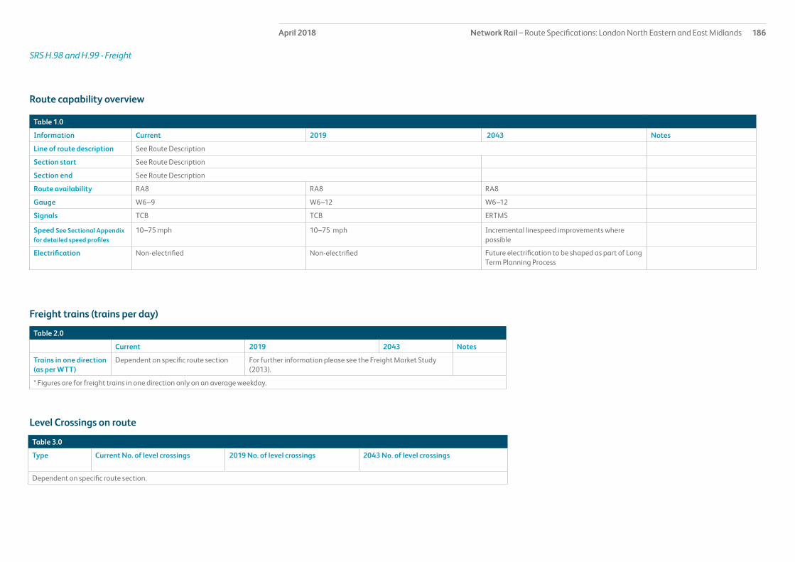
Network Rail – Route Specifications: London North Eastern and East Midlands 186April 2018
Table 1.0
Information Current 2019 2043 Notes
Line of route description See Route Description
Section start See Route Description
Section end See Route Description
Route availability RA8 RA8 RA8
Gauge W6–9 W6–12 W6–12
Signals TCB TCB ERTMS
Speed See Sectional Appendix for detailed speed profiles
10–75 mph 10–75 mph Incremental linespeed improvements where possible
Electrification Non-electrified Non-electrified Future electrification to be shaped as part of Long Term Planning Process
Route capability overview
Table 3.0
Type Current No. of level crossings 2019 No. of level crossings 2043 No. of level crossings
Dependent on specific route section.
Table 2.0
Current 2019 2043 Notes
Trains in one direction (as per WTT)
Dependent on specific route section For further information please see the Freight Market Study (2013).
* Figures are for freight trains in one direction only on an average weekday.
Freight trains (trains per day)
Level Crossings on route
SRS H.98 and H.99 - Freight

Network Rail – Route Specifications: London North Eastern and East Midlands 187April 2018SRS H.98 and H.99 - Freight
Route specification descriptionThe following Strategic Route Sections (SRS) are those that are freight only and other empty coaching stock train routes accessed via Strategic Route H. This document outlines each SRS identified and outlines the main characteristics of the route concerned. The order in which these routes are described is that order borne by the associated Strategic Route Section within Route H from which they are accessed. For example, the freight only line between Sandbach and Northwich via Middlewich is accessed at the Sandbach end from SRS H.22 Manchester Piccadilly to Crewe. Although this example is also accessed from SRS H.30 Guide Bridge and Stockport to Mouldsworth, it will be described when considering the lowest numbered SRS.
Freight traffic is subject to timetable fluctuations and is based on average number of trains.
SRS H.22 Manchester Piccadilly to Crewe
Sydney Bridge (former site of) – Sandbach (Manchester Independent Lines)
The Manchester Independent Line is a two-track route between Salop Goods Jn and Sandbach South Jn that links the wider freight area in Crewe (including Basford Hall yard) and the Crewe – Manchester line (H.22). The line is grade separated around the Crewe station area, running underneath the West Coast Main Line and to the west of Crewe station. The maximum linespeed is 60mph, with a reduction at 162m 17ch to 50mph and a further reduction to 25mph across Sandbach South Jn. The route is overhead AC electrified and the principle traffic flow is intermodal (container) traffic between Basford Hall (and beyond) and Trafford Park Freight Terminal in Manchester.
Sandbach North Junction to Northwich West Junction NW3029
The Northwich Branch line is a mainly single, non-electrified railway line between Sandbach South Junction and Northwich South Junction. The route is approximately 8.5 miles long and caters for occasional freight traffic, but is no longer maintained to passenger standard.
British Salt has a rail terminal with a south-facing connection approximately 1.75 miles from Sandbach and there is a passing loop (the ‘Middlewich Loop’) approximately 3.5 miles from Sandbach, at the site of the former Middlewich station. The prevailing line speed is 20mph (including junctions).
Geographic maps

Network Rail – Route Specifications: London North Eastern and East Midlands 188April 2018
Table 1.0
Information Current 2019 2043 Notes
Line of route description NW5001 Crewe North junction to Manchester Piccadilly
Route availability RA8 RA8 RA8
Gauge W9/10 W9/10 W9/10 Increase gauge as appropriate
Signals Track Circuit Block Track Circuit Block ERTMS
Speed See Sectional Appendix for detailed speed profiles
60 (50) mph 60 (50) mph 60 (50) mph
Electrification 25kV OLE 25kV OLE 25kV OLE
Route capability overview
Table 3.0
There are no level crossings on this route.
Table 2.0
Current 2019 2043 Notes
Trains in one direction (as per WTT)
30 - 35 tpd For further information please see the Freight Market Study (2013).
* Figures are for freight trains in one direction only on an average weekday.
Freight trains (trains per day)
Level Crossings on route
SRS H.98 and H.99 - Freight Sydney Bridge (former site of) – Sandbach – Manchester Independent Lines

Network Rail – Route Specifications: London North Eastern and East Midlands 189April 2018
Table 1.0
Information Current 2019 2043 Notes
Line of route description NW3029 Sandbach South Junction to Northwich South Junction
Route availability RA8 RA8 RA8
Gauge W7 W7 W7 Increase gauge as appropriate
Signals Track Circuit Block Track Circuit Block ERTMS
Speed See Sectional Appendix for detailed speed profiles
20 (15) mph 20 (15) mph 20 (15) mph
Electrification 0m0ch – 0m44ch is AC overhead electrified. Remainder of route is not.
0m0ch – 0m44ch is AC overhead electrified. Remainder of route is not.
Future electrification to be shaped as part of Long Term Planning Process
For longer term strategy - Future electrification to be shaped as part of Long Term Planning Process
Route capability overview
Table 3.0
There are no level crossings on this route.
Table 2.0
Current 2019 2043 Notes
Trains in one direction (as per WTT)
Average is less than 1 tpd For further information please see the Freight Market Study (2013).
* Figures are for freight trains in one direction only on an average weekday.
Freight trains (trains per day)
Level Crossings on route
SRS H.98 and H.99 - FreightSandbach North Junction to Northwich West Junction NW3029
Network Rail – Route Specifications: London North Eastern and East Midlands 190April 2018SRS H.98 and H.99 - Freight
SRS H.24 Deansgate to Allerton
Trafford Park Freightliner Terminal
Trafford Park is an intermodal freight terminal located adjacent to the Allerton West Junction – Castlefield Junction to the west of Manchester City Centre (in the vicinity of Manchester United Football Ground station). It is accessed via Trafford Park West Junction, which consists of two east-facing crossings, therefore permitting parallel moves on and off the terminal. The reception, departure and main route within the terminal are overhead electrified (25kV AC), but all other sidings and lines are non-electrified. There is no access from the West (Warrington/Merseyside direction) and the terminal accepts trains of W9 and W10 loading gauge and of RA8 clearance (non-heavy axle weight services).
Services to and from the terminal are operated by Freightliner Intermodal, DB Schenker and GB Railfreight and Trafford Park currently handles 2tph – one arriving and one departing. Forecasts indicate that by the end of the Control Period 5 (2019), the level of traffic will double to 2 arrivals and 2 departures per hour.
SRS H.30 Guide Bridge Junction and Stockport to Mouldsworth
Partington Line Branch for Shell Oil
Accessed from SRS H.30 at Skelton Junction, this line is now out of use.
Winnington Branch- Brunner Mond Oakleigh Sidings (Chemicals) NW3025
The Winnington Branch provides rail access to Winnington Works (Tata Chemicals) and Northwich Oakleigh Sidings from both directions of the Mid-Cheshire Line (NW3023) via single track chords at Hartford West and Hartford East Junctions. The chords merge into a short (5ch) single line at Hartford North Jn before splitting to a two track section for three quarters of a mile. Beyond 1m 03ch the route reduces to a single line for access to the aforementioned sites.
Hartford CLC/West Coast Main Line Chord NW3033
The Hartford Chord links the West Coast Main Line and Mid-Cheshire line north of Hartford station and west of Greenbank station. It is a bi-directional link consisting of a small section of two-track and small section of single line railway. The single line portion is overhead 25kV AC electrified to allow shunting of electric rolling stock off the West Coast Main Line. The two-track section and access to the Mid-Cheshire line is non-electrified and the whole chord is limited to 15mph maximum speed. The route is used for diversionary purposes and for Network Rail engineering trains.
SRS H.32 Blackpool North Branch NW4005
Burn Naze Branch NW4009
The route between Poulton-Le-Fylde Junction and the former Thornton Power Station is currently out of use. The line was a single track branch with passing loops located at Poulton-Le-Fylde Junction and the former Burn Naze station. The current connection at Poulton-Le-Fylde Junction is planned to be severed as part of the North West Electrification programme on the Blackpool North line, with passive provision for reconnection to the east of Poulton-Le-Fylde station should the branch be re-instated.

Network Rail – Route Specifications: London North Eastern and East Midlands 191April 2018SRS H.98 and H.99 - Freight
SRS H.33 Edge Hill to Manchester Victoria (Via Earlestown) and to Wigan NW2015
Bootle Branch NW2027/9
The main Bootle branch is a two-track, non-electrified railway linking the Edge Hill area with the Port of Liverpool (via a West-facing connection at the Edge Hill end). The line is situated in a variety of cuttings and tunnels and has a 20mph speed limit. The branch ends in the area of Regents Road Level Crossing, where there is a boundary point between the main network and the port.
There is a secondary bi-directional line (The Olive Mount Chord) which provides an east-facing link with NW2015 for traffic heading east towards the West Coast Main Line, Manchester, Yorkshire and the North East. It is connected to the main Bootle Branch line at Edge Lane Jn (approximately half a mile from Bootle Branch Jn).
A variety of freight flows access the port via the branch, including Coal, Containers, Steel and Biomass.
Pilkington Glass Oil Sidings (North West)
Pilkington Glass is adjacent to route NW2023, approximately half a mile south of St Helens Central station. The private sidings can be accessed via the Down Goods Loop.
St Helens Sutton Oak Chemical Branch via Ravenhead Junction NW2025
This route is accessed immediately south of St Helens Central station and is no longer in use.
Ince Moss Goods Branch NW1025
Ince Moss Chord is a single track, non-electrified route linking the St. Helens Branch (NW2023) with the West Coast Main Line Goods Lines at Bamfurlong Junction. Line speed is 20 mph and is TCB controlled from Warrington PSB. Electrification of the chord is due to be completed in 2014 as part of North West Electrification Phase 2. The primary use of this route is for freight trains travelling between Merseyside and the West Coast Main Line.
Up and Down Lowton Branch NW1021
This route links with the Chat Moss (SRS H.33) with the West Coast Main Line at Golborne Junction for services travelling between Manchester and Wigan North Western. The route is Overhead AC 25 kV electrified and is controlled at Warrington PSB with a 20 mph line speed. Manchester Airport – Scotland Transpennine services have recently begun using the line regularly due to the introduction of electric rolling stock for the services.
The service will revert to using the Bolton route in 2016 following electrification works.

Network Rail – Route Specifications: London North Eastern and East Midlands 192April 2018SRS H.98 and H.99 - Freight
Up Goods Loop – Eccles NW2015
The Eccles Up Goods Loop is located at Eccles station and also provides access to NW2017 (Up and Down Weaste branch line).
The loop has a speed of 40mph.
Castleton to Bolton Line NW7005
Accessed at Castleton South Junction, this diesel only line runs for three quarters of a mile under Network Rail control to the boundary with the East Lancs Railway Company.

Network Rail – Route Specifications: London North Eastern and East Midlands 193April 2018SRS I.01 St Pancras – Bedford
Route specification descriptionThis primary route section is predominantly four tracks with some additional tracks over certain sections in the St Pancras International – Hendon area and is electrified on the 25kV OHL system throughout its 80km length. A changeover point to 750v DC third rail traction exists at Farringdon for Thameslink services operating through to Kent and Sussex Routes and as a result all EMU stock currently operating on this line has dual voltage capability. A turnback siding is provided between the slow lines at St Albans, allowing inner suburban services to terminate.
There are 15 stations, a freight facility at Cricklewood and two freight terminals at Radlett and Elstow. Typically, the passenger stations have four platform faces serving the fast and slow lines, with an additional loop platform at Luton and a more complex layout at Bedford. Passenger rolling stock depot facilities exist at Cricklewood and Bedford.
This route covers part of the Midland Main Line (MML) from London to Bedford serving a large number of communities. It carries significant volumes of LDHS and commuter passenger services together with a number of key freight flows.It is part of the London to Leicester core route which forms the primary link between the East Midlands and London and serves a diversity of passenger and freight markets.
The route has a north-facing connection at Carlton Road Junction (near Kentish Town) to the Tottenham & Hampstead line which in turn accesses the East Coast Main Line at Ferme Park and the London, Tilbury & Southend line at Barking. There are connections at Cricklewood Curve Junction and Brent Curve Junction which between them provide both south and north-facing access to the Cricklewood curve, in turn linking with the North London Line at Acton Wells Junction.
At Bedford, the branch line to Bletchley makes a north-facing connection enabling trains to/from the Bletchley direction to access the MML or the bay platform. The London-end connections are used predominantly for freight traffic, whilst that at Bedford has a wider traffic mix including an hourly passenger service.
A key feature causing capacity constraints and affecting performance on this SRS is the mix and volume of traffic between London and Bedford and platform capacity at St Pancras International and Bedford. St Pancras International has four platforms in the high level part of the station for all interurban train services serving the East Midlands. The remainder of this part of the station is served by south eastern commuter services using High Speed 1. There are also two low level platforms for London commuter services operating on the corridor via Farringdon through to Gatwick Airport, Brighton, Sutton and other destinations south of the Thames.
St Albans and Harpenden stations are located within Conservation Areas.
Network Rail has declared the line from Leicester to Cricklewood as ‘Congested Infrastructure’ under the 2005 Access and Management Regulations. Network Rail has been unable to satisfy all the capacity requests on the Midland Main Line.
Geographic Map

Network Rail – Route Specifications: London North Eastern and East Midlands 194April 2018SRS I.01 St Pancras – Bedford
Table 1.0
Information Current 2019 2043 Notes
Line of route description
LN3201 St Pancras International to Tapton Junction (via Derby)
Section start St Pancras International
Section end Bedford
Route availability RA8 RA8 RA8
Gauge W7/8 W7/8 W10, W12 When electrifying the line or constructing new overbridges clear to W10/W12 gauge
Signals Track Circuit Block Track Circuit Block
SpeedSee Sectional Appendix for detailed speed profiles
Predominant linespeed 110mph on the fast lines with sections of 125mphPredominant linespeed 90mph on the slow lines
Overall 110mph fast lines with sections of 125mph
Predominant linespeed 90mph on the slow lines
PSR of 100mph on fast lines for electric trains
Incremental linespeed improvements where possible in line with infrastructure characteristics and capability of rolling stock
Electrification OHL (except the majority of the Hendon lines which are non electrified)
Future electrification to be shaped as part of Long Term Planning Process
Passenger train service levels (trains per hour / day)Table 2.0
Current 2019 2043 Notes
Typical journey time St Pancras International to Bedford1) 35 minutes LDHS2) 62 minutes Thameslink
Reduce journey time to lowest possible in line with linespeed improvements and changes in rolling stock
Reduce journey time to lowest possible in line with linespeed improvements and changes in rolling stock.
All future service specifications to be shaped by Market and Route Studies as part of the Long Term Planning Process.
No. of trains per hour 1) 5 LDHS2) 15 (peak)/8 (off peak) Thameslink
In 2020; 1) 6 LDHS2) 16 (peak)/10 (off peak) Thameslink
Possible changes to service frequency in line with industry aspirations and market requirements.
Route capability overview

Network Rail – Route Specifications: London North Eastern and East Midlands 195April 2018SRS I.01 St Pancras – Bedford
Table 3.0
Current 2019 2043 Notes
Trains in one direction (as per WTT)
13 tpd For further information please see the Freight Market Study.
* Figures are for freight trains in one direction only on an average weekday.
Table 4.0
Type Current No. of level crossings 2019 No. of level crossings 2043 No. of level crossings
Supervised: There are no level crossings in this route section
Automatic:
User:
Freight Trains (trains per day)
Level crossings on route

Network Rail – Route Specifications: London North Eastern and East Midlands 196April 2018SRS I.01 St Pancras – Bedford
Table 5.0
Project Project Description ELR Implementation Date
Output change Status
Wixams (Elstow) New station SPC1 CP6/7 New station In development
Radlett Connection to new freight terminal SPC1 CP5 Facilitate new freight operations In development
Brent Cross new station New station and significant track layout changes
SPC1 CP6 New station In development
Thameslink Programme Key Output 2
Concluding phase of Thameslink Programme
SPC1 CP5 Improve passenger capacity and improve connectivity to destinations south of London
In delivery
Improve approach controls at Flitwick and Leagrave
Provision of improved approach controls at Flitwick and Leagrave.
SPC1 CP6 Improve performance and reduce reactionary delays
In development
MML Key Output 1a Works to enable bi-mode trains SPC1 - 3 CP6 Facilitate rolling stock change In design
Proposed Infrastructure Investment

Network Rail – Route Specifications: London North Eastern and East Midlands 197April 2018SRS I.02 Bedford – Nottingham
Route specification descriptionThis primary route section contains stretches of two, three and four track railway along its 129km length. The route has 12 stations, a quarry at Mountsorrel and a power station at Ratclifffe plus a small number of other private sidings.
This route covers part of the Midland Main Line (MML) from Bedford to Nottingham serving a large number of communities in Bedfordshire, Leicestershire and Nottinghamshire together with the cities of Leicester and Nottingham. It carries significant volumes of LDHS, local and interurban passenger services and also accommodates the growing inter-urban services through Leicester on the Birmingham – Peterborough – Stansted Airport axis. It also carries a number of key freight flows, including increasing intermodal traffic from the East Coast ports passing through Leicester to reach the West Coast Main Line at Nuneaton or the West Midlands.
There are several interfaces with other routes. At Kettering, the line diverges to Corby and Market Harborough, at Wigston there are north and south-facing junctions with the line to Nuneaton and Birmingham, similarly at Syston there are north and south-facing junctions with the line via Melton Mowbray to Peterborough, whilst within the Trent and Nottingham junction complexes there are numerous diverging routes. A connection at Loughborough with Great Central Railway (North) provides a link to private sidings at East Leake.
Kettering Station area is constrained by the mix and timing of services, as although Kettering is a four platform station the layout in the surrounding area is characterised by single and double track sections which limit flexibility.
Nottingham station has six platforms reversibly signalled, and is heavily reliant on its western approach. Leicester Station consists of four platforms all of which are over 265m in length and can be used reversibly.
There are listed buildings within the station areas at Wellingborough, Kettering, Market Harborough, Leicester, Loughborough and Beeston. Barrow-upon-Soar station adjoins a Conservation Area which contains a listed bridge structure, whilst Nottingham station includes a listed building and is partly within a Conservation Area.
Network Rail has declared the line from Leicester to Cricklewood as ‘Congested Infrastructure’ under the 2005 Access and Management Regulations. Network Rail has been unable to satisfy all the capacity requests on the Midland Main Line.
Geographic Map

Network Rail – Route Specifications: London North Eastern and East Midlands 198April 2018SRS I.02 Bedford – Nottingham
Table 1.0
Information Current 2019 2043 Notes
Line of route description
LN3201 St Pancras International to Tapton Junction via DerbyLN3204 Trent South Junction to Nottingham East Junction
Section start Bedford
Section end Nottingham
Route availability RA8 RA8 RA8
Gauge W6-8, W10, W12 W6-8, W10, W12 W10,W12 When electrifying the line or constructing new overbridges clear to W10/W12 gauge
Signals Track Circuit Block Track Circuit Block ERTMS
SpeedSee Sectional Appendix for detailed speed profiles
Variable speeds to a maximum of 125mph on fast lines and 90mph on slow line
Variable speeds to a maximum of 125mph on fast lines and 90mph on slow lines
Incremental linespeed improvements where possible in line with infrastructure characteristics and capability of rolling stock
Linespeed increases on the MML recommended in the East Midlands Route Utilisation Strategy (RUS)
Electrification OHL at Bedford and then non electrified beyond Bedford
OHL to Kettering and then non-electrified beyond Kettering
Future electrification to be shaped as part of Long Term Planning Process
Passenger train service levels (trains per hour / day)Table 2.0
Current 2019 2043 Notes
Typical journey time LDHS service Bedford – Nottingham73 minutesInterurban service Wigston North Junction – Syston Junction14 minutesLocal service Leicester – Nottingham31 minutesLocal service Trent East Junction – Nottingham10 minutes
Reduce journey time to lowest possible in line with linespeed improvements , changes in rolling stock and stopping pattern.
Reduce journey time to lowest possible in line with linespeed improvements and changes in rolling stock.
All future service specifications to be shaped by Market and Route Studies as part of the Long Term Planning Process.
No. of trains per hour Bedford – Nottingham 2 LDHS Bedford – Trent South Junction4 LDHS (2 to Nottingham and 2 to Sheffield)Leicester – Nottingham 2 LDHS, 1 LocalWigston North Junction – Syston East Junction1 InterurbanTrent East Junction – Nottingham2 LDHS; 1 Interurban; 3 LocalThere are other services which use short sections of the route
Possible changes to service frequency in line with industry aspirations and market requirements.
Possible changes to service frequency in line with industry aspirations and market requirements.
Route capability overview

Network Rail – Route Specifications: London North Eastern and East Midlands 199April 2018SRS I.02 Bedford – Nottingham
Table 3.0
Current 2019 2043 Notes
Trains in one direction (as per WTT)
23 tpd For further information please see the Freight Market Study.
* Figures are for freight trains in one direction only on an average weekday.
Table 4.0
Type Current No. of level crossings 2019 No. of level crossings 2043 No. of level crossings
Supervised: 2As determined by Level Crossing policy.Automatic: 2
User: 16
Freight Trains (trains per day)
Level crossings on route

Network Rail – Route Specifications: London North Eastern and East Midlands 200March 2016SRS I.02 Bedford – Nottingham
Table 5.0
Project Project Description ELR Implementation Date
Output change Status
Mountsorrel level crossing Removal of level crossing and replacement with footbridge
SPC5 CP5 Removal of future safety risk In development
Syston to Trent Junction Gauge Enhancement to W12 SPC5 SSJ1/2 NSS CP6 W12 Gauge Capability In development
London to Corby Capacity Capacity improvement required to support the introduction of a sixth LDHS train path. Includes realignment and remodelling in Market Harborough area
SPC2, SPC3 CP5 Provide additional passenger and freight capacity. Upgrade Market Harborough station facilities
In development
Market Harborough realignment
Straighten track alignment through Market Harborough
SPC3 CP5 Improved journey time In delivery
Leicester South linespeed improvement
Enhanced renewal of Leicester South Junction SPC4 CP5 Improved journey time In delivery
Leicester Capacity Capacity improvements SPC3-5 CP6/7 Increase capacity In development
MML Key Output 1a Works to enable bi-mode trains SPC1 - 3 CP6 Facilitate rolling stock change In design
Proposed Infrastructure Investment

Network Rail – Route Specifications: London North Eastern and East Midlands 201April 2018SRS I.03 Wichnor Junction/Long Eaton – Chesterfield
Route specification descriptionThis SRS covers part of the Midland Main Line (MML) to Derby and on towards Sheffield. It also covers part of the cross country line from Birmingham to Derby where it joins the MML. It is also a key route for long distance cross country services operating on the North East – South West axis and a number of substantial freight flows. There is a connection to the line via Uttoxeter to Stoke-on-Trent at North Stafford Junction (near Willington), to the Sinfin freight branch at Peartree, to the Matlock branch at Ambergate and to the southern part of the MML at Sheet Stores Junction. At Stenson Junction (near Willington) a line diverges via Castle Donnington providing a freight link to the MML avoiding Derby. Near Burton-on-Trent there are east and west-facing connections at Leicester Junction and Branston Junction with the direct freight line to Leicester.
This primary route section is almost entirely a two track railway along its 82km length, with some relatively short four track sections at Burton-on-Trent, Derby, and south of Chesterfield. The route has 10 stations, two depots at Central Rivers (Burton-on-Trent) and Etches Park (Derby), a freight terminal at Burton-on-Trent and some private sidings in the Derby area mainly serving various rail industry suppliers. The depot at Central Rivers is critical to the operation of LDHS inter-urban services with more than a quarter of this fleet maintained there. The other depot is Derby Etches Park which serves LDHS and is similarly a key element in train service delivery. There are recessing loops near Peartree and Ambergate.
Derby station is the largest on this SRS and has six platforms all signalled for reversible working. Chesterfield station has three platforms whilst the remainder typically have two platforms, except for Burton-on-Trent and Duffield which are island platforms with two faces. The area surrounding Long Eaton station is the subject of Tree Preservation Orders, there are listed structures at Burton-on-Trent station which is partly in a Conservation Area, whilst Belper station is also in a Conservation Area.
The East Midlands Route Utilisation Strategy (RUS) recommended remodelling of the layout at Derby to segregate services and reduce conflicts, an option for this has been developed and will be implemented during 2018.
Geographic Map

Network Rail – Route Specifications: London North Eastern and East Midlands 202April 2018SRS I.03 Wichnor Junction/Long Eaton – Chesterfield
Table 1.0
Information Current 2019 2043 Notes
Line of route description
LN3201 St Pancras International to Tapton Junction (via Derby)LN3501 Derby London Road Junction to Tamworth
Section start Long EatonWichnor Junction
Section end Chesterfield
Route availability RA8 RA8 RA8
Gauge W7/8Wichnor Jn to Stenson Jn W12
W7/8Wichnor Jn to Stenson Jn W12
W10, W12 When electrifying the line or constructing new overbridges clear to W10/W12 gauge
Signals Track Circuit Block Track Circuit Block ERTMS
SpeedSee Sectional Appendix for detailed speed profiles
Various speeds to a maximum normal permitted linespeed on the fast line of 100mph (125mph on certain parts as a HST speed differential) and on the slow line of 70mph
Incremental linespeed improvements where possible in line with infrastructure characteristics and capability of rolling stock
Incremental linespeed improvements where possible in line with infrastructure characteristics and capability of rolling stock
Increased linespeeds recommended in the East Midlands RUS
Electrification Non-electrified Non-electrified Future electrification to be shaped as part of Long Term Planning Process
Passenger train service levels (trains per hour / day)Table 2.0
Current 2019 2043 Notes
Typical journey time 1) Tapton Junction – Sheet Stores Junction 32 minutes2) Wichnor Junction – Tapton Junction 38 minutesWichnor Junction – Sheet Stores Junction 35 minutes3) Sheet Stores Junction – Ambergate South Junction32 minutes4) Derby – North Stafford Junction8 minutes
1) LDHS (up to a maximum reduction of 1.5 minutes on some services )2) LDHS interurban (up to a maximum reduction of 1 minute on some services)3) Interurban (up to a maximum reduction of 2 minutes on some services)4) No change
Reduce journey time to lowest possible in line with linespeed improvements and changes in rolling stock.
1) CP5 scheme in development to remodel Derby. 2) CP5 scheme in development to electrify to Derby (2019) and Tapton Jn (2020).
No. of trains per hour 1) 2 LDHS 2) 2 LDHS interurban 3) 1 interurban4) 3 local
1) 2 LDHS 2) Up to 3 LDHS interurban 3) 1 interurban4) 3 local
1) 2 LDHS2) Up to 4 LDHS interurban (additional South West – North East service identified in Yorkshire and Humber RUS)3) 1 interurban4) 3 local
1) Sheffield – St Pancras International 2) South East – North East, South West – North East, North West – South Yorkshire, South Yorkshire – East Midlands3) Nottingham – Cardiff4) Nottingham – Matlock, Derby – Crewe and Nottingham - Birmingham
Route capability overview

Network Rail – Route Specifications: London North Eastern and East Midlands 203April 2018SRS I.03 Wichnor Junction/Long Eaton – Chesterfield
Table 3.0
Current 2019 2043 Notes
Trains in one direction (as per WTT)
22 tpd For further information please see the Freight Market Study.
* Figures are for freight trains in one direction only on an average weekday.
Table 4.0
Type Current No. of level crossings 2019 No. of level crossings 2043 No. of level crossings
Supervised: 3As determined by Level Crossing policy.Automatic: 0
User: 10
Freight Trains (trains per day)
Level crossings on route

Network Rail – Route Specifications: London North Eastern and East Midlands 204April 2018SRS I.03 Wichnor Junction/Long Eaton – Chesterfield
Table 5.0
Project Project Description ELR Implementation Date
Output change Status
Derby Remodelling Signalling renewal incorporating a new station layout to segregate services
SPC7/8 CP5 Improved journey times, performance and capacity within Derby area
In delivery
Improve station facilities at Burton-on-Trent
Forecourt works DBP1 CP6 Improve station facilities In development
Syston to Trent Junction Gauge Enhancement to W12 SPC5 SSJ1/2 NSS
CP5/CP6 W12 Gauge Capability In development
Ambergate Junction Renewal of S&C and possible enhancement
SPC8 CP5 Renewal and investigation of opportunities to increase linespeed
In design
Derby - Sheffield Journey Improvement
Reduce journey time SPC7/8, TJC1 CP6 Improved journey time In development
Proposed Infrastructure Investment

Network Rail – Route Specifications: London North Eastern and East Midlands 205April 2018SRS I.04 Worksop/Chesterfield – Nottingham
Route specification description This secondary route is two track along its 84km with a four track section between Trowell Junction and Pye Bridge Junction and single track between Bulwell and Kirkby-in-Ashfield. It has 13 stations, typically consisting of two platforms with the exception of those on the single track section which have one platform. A third platform is provided at Mansfield Woodhouse which forms a turnback. There are 249 bridges along this route one of which is the listed Mansfield Viaduct. A new station in Ilkeston was opened in April 2017.
Unusually, between Bulwell and Hucknall the formation is shared with the Nottingham Express Transit (NET) tramway electrified at 750v DC, although the Network Rail and NET parallel single tracks are owned and operated independently of each other.
This route links South Yorkshire and North Nottinghamshire with the city of Nottingham and carries the Norwich – Liverpool and Nottingham – Leeds interurban services as well as the Robin Hood line local suburban services in the Nottingham – Worksop corridor. Both the Norwich – Liverpool and the Robin Hood line services have shown strong growth in recent years and have proved highly successful in rebuilding the passenger market for rail in areas where for many years there had been little or no presence. This SRS also supports various freight operations.
Connections to private sidings serving coal disposal points exist at Codnor Park (Forge & Monument) and Doe Hill and to the heritage Midland Railway Centre, also at Codnor Park.
Historically there had been problems of poor performance on the Nottingham – Worksop line but matters have significantly improved recently as a result of small scale linespeed and signalling improvements.
Geographic Map
Legend
Major / Key Station
Coastline
Strategic Route Section I.04
Strategic Route I
Station
Rail Network
Strategic Route Section I.04
Derby
Sheffield
WhitwellCreswell
Shirebrook
Mansfield WoodhouseMansfield
Kirkby In AshfieldSutton Parkway
Newstead
Hucknall
Bulwell
Langley Mill
Alfreton
Langwith - Whaley Thorns
Ilkeston

Network Rail – Route Specifications: London North Eastern and East Midlands 206April 2018SRS I.04 Worksop/Chesterfield – Nottingham
Table 1.0
Information Current 2019 2043 Notes
Line of route description
LN3252 Mansfield Junction to Trowell South JunctionLN3207 Trent East Junction to Clay Cross North JunctionLN3255 Radford Junction to Kirkby Lane End JunctionLN3273 Codnor Park Junction to Shirebrook JunctionLN768 Mansfield Woodhouse to Shireoaks East JunctionLN782 Woodend Junction to Shireoaks West Junction
Section start Mansfield Junction
Section end Clay Cross Junction Woodend Junction/Shireoaks East Junction
Route availability RA7, RA8 RA7, RA8 RA7, RA8
Gauge W6, W8Trowell Jn to Clay Cross W10/W12
W6, W8Trowell Jn to Clay Cross W10/W12
W6, W8Trowell Jn to Clay Cross W10/W12
Signals Track Circuit Block except Absolute Block between Shirebrook Junction and Woodend Junction
Track Circuit Block ERTMS
SpeedSee Sectional Appendix for detailed speed profiles
Various speeds to maximum normal permitted linespeed of 80 mph on the Erewash Valley and 75mph on the Nottingham to Workshop line.
Incremental linespeed improvements where possible in line with infrastructure characteristics and capability of rolling stock
Incremental linespeed improvements where possible in line with infrastructure characteristics and capability of rolling stock
Electrification Non-electrified Non-electrified Future electrification to be shaped as part of Long Term Planning Process
Passenger train service levels (trains per hour / day)
Table 2.0
Current 2019 2043 Notes
Typical journey time 1) Clay Cross South Junction to Mansfield Junction29 minutes.2) Shireoaks East Junction to Mansfield Junction 59 minutes .
Reduce journey time to lowest possible in line with linespeed improvements and changes in rolling stock
Reduce journey time to lowest possible in line with linespeed improvements and changes in rolling stock.
All future service specifications to be shaped by Market and Route Studies as part of the Long Term Planning Process.
No. of trains per hour 1) 1 LDHS and 1 Local2) 2 local
Possible changes to service frequency in line with industry aspirations and market requirements.
Possible changes to service frequency in line with industry aspirations and market requirements.
Route capability overview

Network Rail – Route Specifications: London North Eastern and East Midlands 207April 2018SRS I.04 Worksop/Chesterfield – Nottingham
Table 3.0
Current 2019 2043 Notes
Trains in one direction (as per WTT)
10 tpd For further information please see the Freight Market Study.
* Figures are for freight trains in one direction only on an average weekday.
Table 4.0
Type Current No. of level crossings 2019 No. of level crossings 2043 No. of level crossings
Supervised: 4As determined by Level Crossing policy.Automatic: 6
User: 13
Freight Trains (trains per day)
Level crossings on route

Network Rail – Route Specifications: London North Eastern and East Midlands 208April 2018SRS I.04 Worksop/Chesterfield – Nottingham
Table 5.0
Project Project Description ELR Implementation Date
Output change Status
There is no planned investment in Control Period 5.
Proposed Infrastructure Investment

Network Rail – Route Specifications: London North Eastern and East Midlands 209April 2018SRS I.05 Nottingham – Newark Crossing
Route specification description This secondary route consists of two tracks almost throughout its 29km length. There are eight stations, each of which has two platforms. There is one depot at Eastcroft immediately to the east of Nottingham station which serves LDHS services. There are several crossovers along this line but no other facilities apart from an engineers’ siding at Lowdham. The line is predominantly rural in character with greater population density only at the Nottingham end and in the area surrounding Newark Castle station. At Newark, it continues into LNE Route to Lincoln and is covered in a separate SRS (G.21).
The main passenger market for this SRS is a mixture of stopping and semi-fast local services between Leicester, Nottingham and Lincoln for which it forms a valuable regional link. With the 2015 extension of Matlock-Nottingham services to Newark Castle, typical frequency is now two trains per hour in each direction, one stopping and one semi-fast. A LDHS Lincoln and St Pancras International service operates in each direction daily. Apart from the morning London service, all semi-fast trains stop at least at Lowdham and Newark Castle. There is also some freight traffic on this route. A constraint on any significant service expansion between Lincoln and Nottingham is the existence of the ‘at grade’ crossing over the East Coast Main Line (ECML) at Newark on which the combined demand for east-west and ECML timetable paths has taken up virtually all available capacity. It is likely that this could only be overcome by replacement of the existing crossing with a grade separated junction, the case for which is currently under consideration.
Modular resignalling of the line was completed in 2016.
There are listed station buildings at Newark Castle and this station is situated within a Conservation Area.
Geographic Map
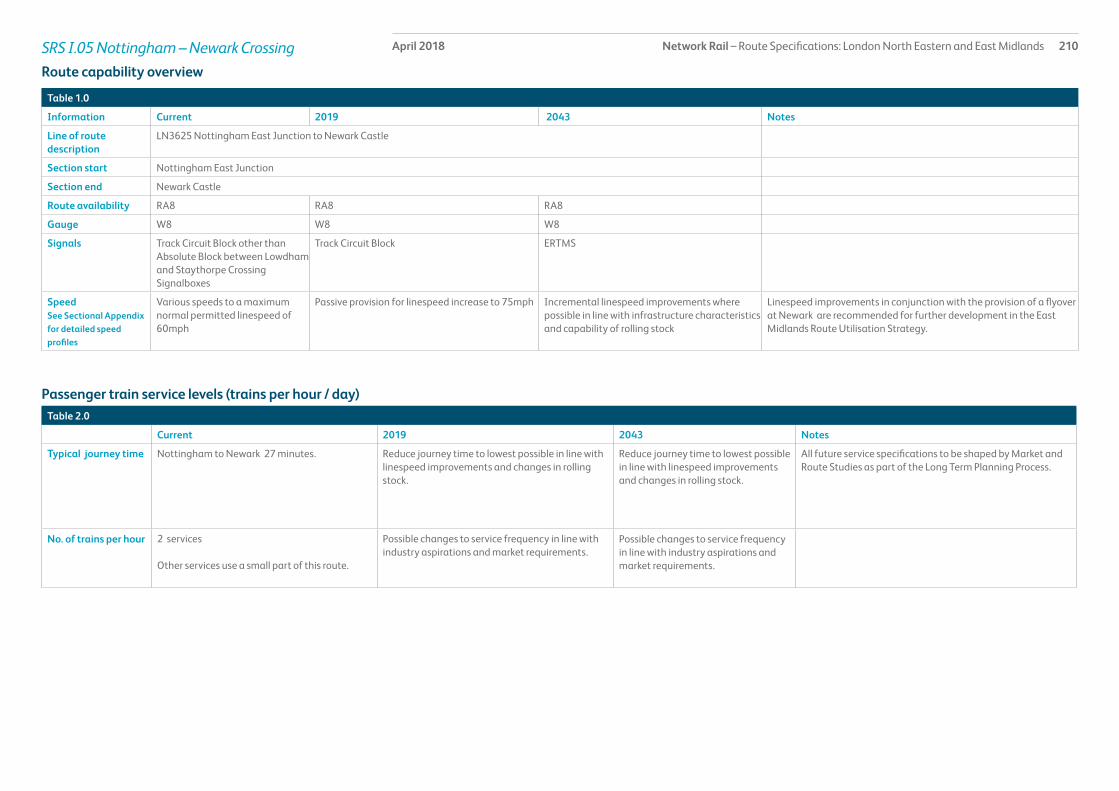
Network Rail – Route Specifications: London North Eastern and East Midlands 210April 2018SRS I.05 Nottingham – Newark Crossing
Table 1.0
Information Current 2019 2043 Notes
Line of route description
LN3625 Nottingham East Junction to Newark Castle
Section start Nottingham East Junction
Section end Newark Castle
Route availability RA8 RA8 RA8
Gauge W8 W8 W8
Signals Track Circuit Block other than Absolute Block between Lowdham and Staythorpe Crossing Signalboxes
Track Circuit Block ERTMS
SpeedSee Sectional Appendix for detailed speed profiles
Various speeds to a maximum normal permitted linespeed of 60mph
Passive provision for linespeed increase to 75mph Incremental linespeed improvements where possible in line with infrastructure characteristics and capability of rolling stock
Linespeed improvements in conjunction with the provision of a flyover at Newark are recommended for further development in the East Midlands Route Utilisation Strategy.
Passenger train service levels (trains per hour / day)Table 2.0
Current 2019 2043 Notes
Typical journey time Nottingham to Newark 27 minutes. Reduce journey time to lowest possible in line with linespeed improvements and changes in rolling stock.
Reduce journey time to lowest possible in line with linespeed improvements and changes in rolling stock.
All future service specifications to be shaped by Market and Route Studies as part of the Long Term Planning Process.
No. of trains per hour 2 services
Other services use a small part of this route.
Possible changes to service frequency in line with industry aspirations and market requirements.
Possible changes to service frequency in line with industry aspirations and market requirements.
Route capability overview

Network Rail – Route Specifications: London North Eastern and East Midlands 211April 2018SRS I.05 Nottingham – Newark Crossing
Table 3.0
Current 2019 2043 Notes
Trains in one direction (as per WTT)
6 tpd For further information please see the Freight Market Study.
* Figures are for freight trains in one direction only on an average weekday.
Table 4.0
Type Current No. of level crossings 2019 No. of level crossings 2043 No. of level crossings
Supervised: 8As determined by Level Crossing policy.Automatic: 6
User: 20
Freight Trains (trains per day)
Level crossings on route

Network Rail – Route Specifications: London North Eastern and East Midlands 212April 2018SRS I.05 Nottingham – Newark Crossing
Table 5.0
Project Project Description ELR Implementation Date
Output change Status
There is no planned investment in CP5
Proposed Infrastructure Investment

Network Rail – Route Specifications: London North Eastern and East Midlands 213April 2018SRS I.06 Matlock Branch
Route specification descriptionThe Matlock branch is designated as a rural route, and consists of a single track throughout its 12km length. There are five stations at Ambergate, Whatstandwell, Cromford, Matlock Bath and Matlock. The stations each consist of one platform, with the exception of Matlock where a second platform is available for heritage operations.
Traffic is essentially local passenger travel with an emphasis on commuting to Derby and to a lesser extent other urban centres in the East Midlands. The line runs through some very attractive countryside and close to the Peak District National Park together with a number of other tourist attractions and as such there is also significant leisure travel especially during the summer months. Enhanced renewal of Ambergate Junction is planned to be delivered during the Derby remodelling blockade in Autumn 2018. This is planned to increase the linespeed for Matlock services
Recent growth in patronage on the regular hourly weekday service on the Matlock – Derby corridor has increased passenger numbers and resulted in some overcrowding. Hourly train services from Matlock were extended to Newark from May 2015.
Matlock Branch has been designated by the Department of Transport as a Community Rail Line and Service under the aegis of the Derwent Valley Rail Partnership.
On this route section there are two listed structures, one is the footbridge at Cromford station and the other is an underline bridge at the River Amber just outside Ambergate station. The station building at Cromford is also listed and parts of the line run through Conservation Areas.
Geographic Map

Network Rail – Route Specifications: London North Eastern and East Midlands 214April 2018SRS I.06 Matlock Branch
Table 1.0
Information Current 2019 2043 Notes
Line of route description
LN3246 Ambergate Junction to Matlock
Section start Ambergate Junction
Section end Matlock
Route availability RA8 RA8 RA8
Gauge W6 W6 W6
Signals One train working One train working ERTMS
SpeedSee Sectional Appendix for detailed speed profiles
Maximum normal permitted linespeed 50mph
Incremental linespeed improvements where possible in line with infrastructure characteristics and capability of rolling stock
Incremental linespeed improvements where possible in line with infrastructure characteristics and capability of rolling stock
Electrification Non-electrified Non-electrified Future electrification to be shaped as part of Long Term Planning Process
Passenger train service levels (trains per hour / day)Table 2.0
Current 2019 2043 Notes
Typical journey time Ambergate Junction to Matlock18 minutes
Reduce journey time to lowest possible in line with linespeed improvements and changes in rolling stock
Reduce journey time to lowest possible in line with linespeed improvements and changes in rolling stock.
All future service specifications to be shaped by Market and Route Studies as part of the Long Term Planning Process.
No. of trains per hour 1 local Possible changes to service frequency in line with industry aspirations and market requirements.
Possible changes to service frequency in line with industry aspirations and market requirements.
Route capability overview

Network Rail – Route Specifications: London North Eastern and East Midlands 215April 2018SRS I.06 Matlock Branch
Table 3.0
Current 2019 2043 Notes
Trains in one direction (as per WTT)
There are no booked freight services on this route
For further information please see the Freight Market Study
* Figures are for freight trains in one direction only on an average weekday.
Table 4.0
Type Current No. of level crossings 2019 No. of level crossings 2043 No. of level crossings
Supervised: 0As determined by Level Crossing policy.Automatic: 0
User: 2
Freight Trains (trains per day)
Level crossings on route

Network Rail – Route Specifications: London North Eastern and East Midlands 216April 2018SRS I.06 Matlock Branch
Table 5.0
Project Project Description ELR Implementation Date
Output change Status
Ambergate Junction Renewal of S&C and possible enhancement
SPC8 2018/19 Renewal and investigation of opportunities to increase linespeed
In design
Proposed Infrastructure Investment

Network Rail – Route Specifications: London North Eastern and East Midlands 217April 2018SRS I.07 Netherfield – Grantham
Route specification descriptionThis route is designated rural and consists almost entirely of two tracks along its 31km. It has six stations at Netherfield, Radcliffe, Bingham, Aslockton, Elton & Orston and Bottesford.
Netherfield Station is formed of an island platform with two faces, whilst the other stations all comprise two platforms.
Radcliffe Viaduct over the River Trent is the only listed structure on this route.
The main passenger markets for this route are the Nottingham – Skegness and the interurban service between Norwich and Liverpool. Both services operate broadly hourly giving typically two trains per hour in each direction. The Norwich – Liverpool service is generally non-stop between Grantham and Nottingham, whilst the Skegness trains stop at least at Bingham, with the smaller stations served less frequently according to levels of demand.
The Skegness service is characterised by heavy leisure travel demand during the summer months, whilst the Norwich – Liverpool service experiences substantial year-round demand for a wide variety of journey purposes and becomes 2 -car by splitting at Nottingham
Geographic Map

Network Rail – Route Specifications: London North Eastern and East Midlands 218April 2018SRS I.07 Netherfield – Grantham
Table 1.0
Information Current 2019 2043 Notes
Line of route description
LN195 Grantham, Nottingham Branch Junction to Bottesford West JunctionLN3635 Bottesford West Junction to Netherfield Junction
Section start Nottingham Branch Junction
Section end Netherfield Junction
Route availability RA8 RA8 RA8
Gauge W7/8 W7/8 W7/8
Signals A mixture of Absolute Block and Track Circuit Block
Track Circuit Block ERTMS
SpeedSee Sectional Appendix for detailed speed profiles
Various speeds with the maximum normal permitted linespeed of 60mph
Passive provision for linespeed increase to 90mph Incremental linespeed improvements where possible in line with infrastructure characteristics and capability of rolling stock
Electrification Non-electrified Non-electrified Future electrification to be shaped as part of Long Term Planning Process
Passenger train service levels (trains per hour / day)Table 2.0
Current 2019 2043 Notes
Typical journey time Netherfield – Nottingham Branch Junction29 minutes
Reduce journey time to lowest possible in line with linespeed improvements and changes in rolling stock
Reduce journey time to lowest possible in line with linespeed improvements and changes in rolling stock.
All future service specifications to be shaped by Market and Route Studies as part of the Long Term Planning Process.
No. of trains per hour 1 interurban
1 local (supplemented by additional trains during the summer)
Possible changes to service frequency in line with industry aspirations and market requirements.
Possible changes to service frequency in line with industry aspirations and market requirements.
Route capability overview

Network Rail – Route Specifications: London North Eastern and East Midlands 219April 2018SRS I.07 Netherfield – Grantham
Table 3.0
Current 2019 2043 Notes
Trains in one direction (as per WTT)
1 tpd For further information please see the Freight Market Study.
* Figures are for freight trains in one direction only on an average weekday.
Table 4.0
Type Current No. of level crossings 2019 No. of level crossings 2043 No. of level crossings
Supervised: 3As determined by Level Crossing policy.Automatic: 3
User: 18
Freight Trains (trains per day)
Level crossings on route

Network Rail – Route Specifications: London North Eastern and East Midlands 220April 2018SRS I.07 Netherfield – Grantham
Table 5.0
Project Project Description ELR Implementation Date
Output change Status
There is no planned investment in Control Period 5
Proposed Infrastructure Investment

Network Rail – Route Specifications: London North Eastern and East Midlands 221April 2018SRS I.08 Skegness – Grantham
Route specification descriptionThis route, designated rural is a mainly two track railway with some single track sections along its 90km length. There are 11 stations and 159 bridges.
Skegness station at the easterly point of this SRS has six platforms (of which two are no longer in use), Sleaford station has three and the remainder of the stations have two platforms.
The main market for this route is the hourly passenger service between Nottingham and Skegness whilst there is some freight activity to and from Boston Docks. Passenger traffic is characterised by heavy demand during the summer months.
Linespeeds are relatively low, well below the maximum speed capability of the rolling stock used, and as such the aspiration exists for linespeed improvements to allow faster journey times.
This particular service has been designated a Community Rail Service by the Department of Transport under the aegis of the Poacher Line Community Rail Partnership.
There are listed buildings within the environs of the station at Sleaford, part of which is also in a Conservation Area. Heckington and Wainfleet stations are both in Conservation Areas, whilst West Street Junction signal box (Boston) is listed.
Geographic Map

Network Rail – Route Specifications: London North Eastern and East Midlands 222April 2018SRS I.08 Skegness – Grantham
Table 1.0
Information Current 2019 2043 Notes
Line of route description
LN185 Allington West Junction to SkegnessLN190 Allington East Junction to Allington North Junction
Section start Allington North/West/East Junction
Section end Skegness
Route availability RA7, RA8, RA10 RA7, RA8, RA10 RA7, RA8, RA10
Gauge W6, W8 W6, W8 W6, W8
Signals A mixture of Absolute Block and Track Circuit Block
Track Circuit Block ERTMS
SpeedSee Sectional Appendix for detailed speed profiles
Maximum Normal Permitted linespeed 50mph
Maximum Normal Permitted linespeed 50mph Incremental linespeed improvements where possible in line with infrastructure characteristics and capability of rolling stock
Electrification Non electrified Non electrified Future electrification to be shaped as part of Long Term Planning Process
Passenger train service levels (trains per hour / day)Table 2.0
Current 2019 2043 Notes
Typical journey time Nottingham Branch Junction to Skegness90 minutes
Reduce journey time to lowest possible in line with linespeed improvements and changes in rolling stock
Reduce journey time to lowest possible in line with linespeed improvements and changes in rolling stock.
All future service specifications to be shaped by Market and Route Studies as part of the Long Term Planning Process.
No. of trains per hour 1 local (supplemented by additional trains during the summer)
Possible changes to service frequency in line with industry aspirations and market requirements.
Possible changes to service frequency in line with industry aspirations and market requirements.
Route capability overview
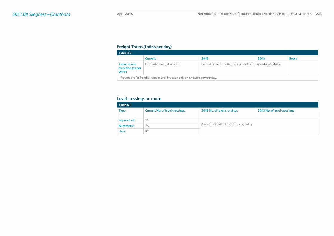
Network Rail – Route Specifications: London North Eastern and East Midlands 223April 2018SRS I.08 Skegness – Grantham
Table 3.0
Current 2019 2043 Notes
Trains in one direction (as per WTT)
No booked freight services For further information please see the Freight Market Study.
* Figures are for freight trains in one direction only on an average weekday.
Table 4.0
Type Current No. of level crossings 2019 No. of level crossings 2043 No. of level crossings
Supervised: 14As determined by Level Crossing policy.Automatic: 28
User: 87
Freight Trains (trains per day)
Level crossings on route

Network Rail – Route Specifications: London North Eastern and East Midlands 224April 2018SRS I.08 Skegness – Grantham
Table 5.0
Project Project Description ELR Implementation Date
Output change Funder Status
There is no planned investment in Control Period 5
Proposed Infrastructure Investment

Network Rail – Route Specifications: London North Eastern and East Midlands 225April 2018SRS I.09 Nuneaton – South Wigston
Route specification descriptionThis secondary route is predominantly a two track railway throughout its 26km length. There are three stations at South Wigston, Narborough and Hinckley.
This SRS links the East Anglia area through the East Midlands to the West Midlands.
With the completion of the Felixstowe to Nuneaton W10 gauge clearance scheme this route has become a core intermodal freight route for trains from Felixstowe and Bathside Bay bound for the West Coast Main Line at Nuneaton or terminals in the West Midlands. There is also aggregates traffic from Croft Quarry (located between Narborough and Hinckley).
The passenger service is broadly two trains each way per hour in the growing interurban corridor between Birmingham, Leicester, Peterborough and Stansted Airport. At present one train per hour generally terminates at Leicester, whilst the other continues to Stansted Airport.
Geographic Map

Network Rail – Route Specifications: London North Eastern and East Midlands 226April 2018SRS I.09 Nuneaton – South Wigston
Table 1.0
Information Current 2019 2043 Notes
Line of route description
LN3232 Wigston North Junction to HinckleyLN3232 Abbey Junction to Hinckley
Section start Wigston North Junction
Section end Nuneaton South Junction
Route availability RA8 RA8 RA8
Gauge W8, W10 W8, W10 W12
Signals Track Circuit Block Track Circuit Block ERTMS
SpeedSee Sectional Appendix for detailed speed profiles
Maximum normal permitted linespeed 75mph
Maximum normal permitted linespeed 75mph Incremental linespeed improvements where possible in line with infrastructure characteristics and capability of rolling stock
Electrification Non-electrified Non-electrified Future electrification to be shaped as part of Long Term Planning Process
Passenger train service levels (trains per hour / day)Table 2.0
Current 2019 2043 Notes
Typical journey time Nuneaton to Wigston North Junction1) interurban 17 minutes2) local 22 minutes
1) interurban (up to a maximum reduction of 0.5 minutes for some services)
Reduce journey time to lowest possible in line with linespeed improvements and changes in rolling stock.
All future service specifications to be shaped by Market and Route Studies as part of the Long Term Planning Process.
No. of trains per hour 1) 1 interurban2) 1 local
1) 2 interurban (local Birmingham – Leicester extended to Stansted Airport)
Possible changes to service frequency in line with industry aspirations and market requirements.
1) Birmingham – Stansted Airport2) Birmingham - Leicester
Route capability overview

Network Rail – Route Specifications: London North Eastern and East Midlands 227April 2018SRS I.09 Nuneaton – South Wigston
Table 3.0
Current 2019 2043 Notes
Trains in one direction (as per WTT)
10 tpd For further information please see the Freight Market Study.
* Figures are for freight trains in one direction only on an average weekday.
Table 4.0
Type Current No. of level crossings 2019 No. of level crossings 2043 No. of level crossings
Supervised: 1As determined by Level Crossing policyAutomatic: 0
User: 10
Freight Trains (trains per day)
Level crossings on route

Network Rail – Route Specifications: London North Eastern and East Midlands 228April 2018SRS I.09 Nuneaton – South Wigston
Table 5.0
Project Project Description ELR Implementation Date
Output change Status
Leicester Capacity Capacity improvements SPC3-5 CP6/7 Increase capacity In development
Proposed Infrastructure Investment

Network Rail – Route Specifications: London North Eastern and East Midlands 229April 2018SRS I.10 Syston – Peterborough/Corby
Route specification descriptionThis secondary route has mainly two tracks along its 94km, with the exception of the single track section between Kettering and Corby. The route has four stations at Stamford, Oakham, Melton Mowbray and Corby. The latter has one platform reflecting the fact that it is mainly used for terminating trains, whilst the other three have two platforms.
Along this route there are 3 key structures:
• Oakham Footbridge which is listed
• Harpers Book viaduct which is classified as a major structure
• Harringworth viaduct which is listed.
The route from Syston South Junction via Stamford to Peterborough effectively forms an extension of the Nuneaton – South Wigston SRS for the growing Birmingham – Leicester – Peterborough – Stansted Airport/Cambridge interurban service which according to time of day operates at a frequency of one or two trains per hour. It is also an increasingly key corridor for intermodal freight trains from Felixstowe or Bathside Bay bound for the West Coast Main Line at Nuneaton or terminals in the West Midlands and the North.
The Corby – Kettering section sees an hourly service of LDHS services between Corby and London (In Dec 2020, there will be 2 tph), whilst the section between Corby and Manton Junction is only served by two such trains each way per day. The whole of the line via Corby forms a significant route for freight and also provides a key diversionary route for passenger trains when the two track section of line between Kettering and Leicester is unavailable due to incident or pre-planned engineering work.
The station building at Stamford is listed and is situated within a Conservation Area.
Geographic Map

Network Rail – Route Specifications: London North Eastern and East Midlands 230April 2018SRS I.10 Syston – Peterborough/Corby
Table 1.0
Information Current 2019 2043 Notes
Line of route description
LN3615 Helpston Junction to Syston South JunctionLN3601 Kettering North Junction to Manton Junction
Section start Kettering North Junction
Section end Syston South JunctionManton Junction
Route availability RA8, RA9 RA8, RA9 RA8, RA9
Gauge W7/8, W10 W7/8, W10 W12 When electrifying the line or constructing new overbridges clear to W10/W12 gauge
Signals Track Circuit Block with Absolute Block between Melton Mowbray and Uffington Signalboxes
Track Circuit Block with Absolute Block between Melton Mowbray and Uffington Signalbox
ERTMS
SpeedSee Sectional Appendix for detailed speed profiles
Predominant linespeed of 75mph with a Sprinter differential of up to 90mph
Predominant linespeed of 75mph with a Sprinter differential of up to 90mph
Incremental linespeed improvements where possible in line with infrastructure characteristics and capability of rolling stock
Electrification Non-electrified Kettering North Junction – Corby OHL Future electrification to be shaped as part of Long Term Planning Process
Passenger train service levels (trains per hour / day)Table 2.0
Current 2019 2043 Notes
Typical journey time Syston Junction to Helpston44 minutesCorby to Kettering Junction9 minutesCorby to Manton/Syston
Reduce journey time to lowest possible in line with linespeed improvements and changes in rolling stock
Reduce journey time to lowest possible in line with linespeed improvements and changes in rolling stock.
All future service specifications to be shaped by Market and Route Studies as part of the Long Term Planning Process.
No. of trains per hour 4 tpd in peak 1) 2 LDHS2) 2 interurban (local Birmingham – Leicester extended to Stansted Airport)
1) 2 LDHS2) 2 interurban (local Birmingham – Leicester extended to Stansted Airport)
1) Corby – St Pancras International2) Birmingham – Stansted Airport
Route capability overview

Network Rail – Route Specifications: London North Eastern and East Midlands 231April 2018SRS I.10 Syston – Peterborough/Corby
Table 3.0
Current 2019 2043 Notes
Trains in one direction (as per WTT)
10 tpd For further information please see the Freight Market Study.
* Figures are for freight trains in one direction only on an average weekday.
Table 4.0
Type Current No. of level crossings 2019 No. of level crossings 2043 No. of level crossings
Supervised: 11As determined by Level Crossing policy.Automatic: 3
User: 52
Freight Trains (trains per day)
Level crossings on route

Network Rail – Route Specifications: London North Eastern and East Midlands 232April 2018SRS I.10 Syston – Peterborough/Corby
Table 5.0
Project Project Description ELR Implementation Date
Output change Status
Syston to Peterborough Proposed signalling renewals, capacity improvements including work in conjunction with the Leicester resignalling scheme
GSM2/3, PMJ/SEN
CP6 Increase in freight and passenger capacity and improved performance
In development
Kettering to Corby Capacity improvements
Capacity improvements between Kettering and Corby
GSM1/2 2020 Increase in freight and passenger capacity and improved performance
In delivery
Proposed Infrastructure Investment

Network Rail – Route Specifications: London North Eastern and East Midlands 233April 2018SRS I.11 North Stafford Junction – Stoke-on-Trent
Route specification descriptionThis secondary route comprises almost entirely two track railway throughout its 49km. There are four stations at Tutbury & Hatton, Uttoxeter, Blythe Bridge and Longton, each of which has two platforms.
Along the route there are 178 bridges of which 106 are classified as culverts and 52 as underbridges.
The route provides a valuable regional link facilitating travel between the East Midlands and destinations on the northern part of the West Coast Main Line, as well as more local commuting and leisure journeys particularly to Derby, Stoke-on-Trent and Crewe. The area in which it is situated is predominantly rural with a more urban environment at the western end between Blythe Bridge and Stoke-on-Trent.
The service Derby to Stoke-on-Trent extending to Crewe has been designated by the Department of Transport as a Community Rail Service under the aegis of the North Staffordshire Line Community Rail Partnership.
Geographic Map

Network Rail – Route Specifications: London North Eastern and East Midlands 234April 2018SRS I.11 North Stafford Junction – Stoke-on-Trent
Table 1.0
Information Current 2019 2043 Notes
Line of route description
LN3505 North Stafford Junction to Stoke Junction (exclusive)
Section start North Stafford Junction
Section end Stoke Junction (exclusive)
Route availability RA8 RA8 RA8
Gauge W7 W10 W10/W12
Signals Track Circuit Block except for Absolute Block between Caverswall and Egginton Junction Signalboxes
Track Circuit Block ERTMS
SpeedSee Sectional Appendix for detailed speed profiles
Variable speeds to a maximum of 70mph
Variable speeds to a maximum of 70mph Incremental linespeed improvements where possible in line with infrastructure characteristics and capability of rolling stock
Electrification Non-electrified Non-electrified Future electrification to be shaped as part of Long Term Planning Process
Passenger train service levels (trains per hour / day)Table 2.0
Current 2019 2043 Notes
Typical journey time North Stafford Junction to Stoke Junction 43 mins
Reduce journey time to lowest possible in line with linespeed improvements and changes in rolling stock
Reduce journey time to lowest possible in line with linespeed improvements and changes in rolling stock.
All future service specifications to be shaped by Market and Route Studies as part of the Long Term Planning Process.
No. of trains per hour 1 local Possible changes to service frequency in line with industry aspirations and market requirements.
Possible changes to service frequency in line with industry aspirations and market requirements.
Route capability overview

Network Rail – Route Specifications: London North Eastern and East Midlands 235April 2018SRS I.11 North Stafford Junction – Stoke-on-Trent
Table 3.0
Current 2019 2043 Notes
Trains in one direction (as per WTT)
No booked freight services For further information please see the Freight Market Study.
* Figures are for freight trains in one direction only on an average weekday.
Table 4.0
Type Current No. of level crossings 2019 No. of level crossings 2043 No. of level crossings
Supervised: 9As determined by Level Crossing policy.Automatic: 10
User: 41
Freight Trains (trains per day)
Level crossings on route

Network Rail – Route Specifications: London North Eastern and East Midlands 236April 2018SRS I.11 North Stafford Junction – Stoke-on-Trent
Table 5.0
Project Project Description ELR Implementation Date
Output change Status
There is no planned investment in Control Period 5.
Proposed Infrastructure Investment

Network Rail – Route Specifications: London North Eastern and East Midlands 237April 2018SRS I.98 and I.99 - Freight
This SRS consists of a number of unrelated freight routes. The map and tables below provide greater detail, but the SRS can be summarised by stating that it facilitates the following connections:
• Wigston to Burton (Leicester Junction)/Branston Junction
• The Midland Main Line to the main line between Derby and Birmingham
• The Pinxton Branch connecting the Erewash Valley line to the Nottingham to Worksop line
• The Midland Main Line to Toton Yard from the south, east and west
• Rolls Royce Plant to the main lines near Derby
• The Midland Main Line to the Peterborough to Nuneaton line
• The Nottingham to Worksop line to Thorseby and Webeck Collieries, the Rail Innovation and Development Centre (RIDC) and High Marnham power station
• The Kettering to Manton line to the Corby Automotive Terminal and Corby Works (steel terminal)
• Nottingham to Grantham line to the Oil Terminal at Colwick.
Specific sections in this SRS are:
• Knighton Junction to Leicester Junction/Branston Junction (KSL)
• Sheet Stores Junction to Stenson Junction (SSJ1&2)
• Pye Bridge Junction to Kirkby Summit(PBS1)
• Trent East Junction to Attenborough Junction to Trowell Junction (TCC)
• Melbourne Junction to Sinfin Branch (MJS1)
• Wigston South Junction to Glen Parva Junction(WGP)
• Shirebrook Junction to High Marnham (including the branch lines for Welbeck/Thoresby and Bevercotes Collieries) (HIM)
• Corby Branch(BSC)
• Branch line for Colwick Oil Terminal(DEX)
Geographic Map

Network Rail – Route Specifications: London North Eastern and East Midlands 238April 2018SRS I.98 and I.99 - Freight
Table 1.0
Information Current 2019 2043 Notes
Line of route description
See Route Description
Section start See Route Description
Section end See Route Description
Route availability RA8 RA8 RA8
Gauge W6–9 W6–12 W6–12
Signals TCB TCB ERTMS
Speed See Sectional Appendix for detailed speed profiles
10–75 mph 10–75 mph Incremental linespeed improvements where possible
Electrification Non-electrified Non-electrified Future electrification to be shaped as part of Long Term Planning Process
Route capability overview
Table 3.0
Type Current No. of level crossings 2019 No. of level crossings 2043 No. of level crossings
Supervised: Dependent on specific route sectionAs determined by Level Crossing policyAutomatic: Dependent on specific route section
User: Dependent on specific route section
Table 2.0
Current 2019 2043 Notes
Trains in one direction (as per WTT)
Dependent on specific route section For further information please see the Freight Market Study (2013).
* Figures are for freight trains in one direction only on an average weekday.
Freight trains (trains per day)
Level Crossings on route
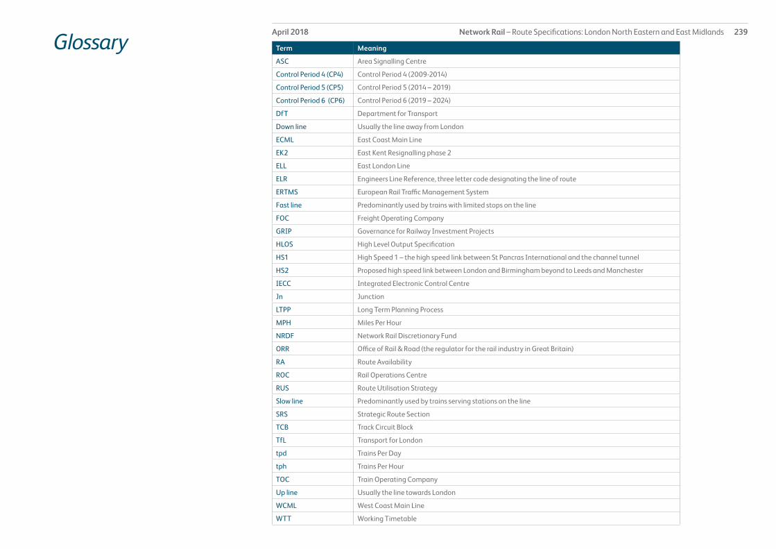
Network Rail – Route Specifications: London North Eastern and East Midlands 239April 2018
Glossary Term Meaning
ASC Area Signalling Centre
Control Period 4 (CP4) Control Period 4 (2009-2014)
Control Period 5 (CP5) Control Period 5 (2014 – 2019)
Control Period 6 (CP6) Control Period 6 (2019 – 2024)
DfT Department for Transport
Down line Usually the line away from London
ECML East Coast Main Line
EK2 East Kent Resignalling phase 2
ELL East London Line
ELR Engineers Line Reference, three letter code designating the line of route
ERTMS European Rail Traffic Management System
Fast line Predominantly used by trains with limited stops on the line
FOC Freight Operating Company
GRIP Governance for Railway Investment Projects
HLOS High Level Output Specification
HS1 High Speed 1 – the high speed link between St Pancras International and the channel tunnel
HS2 Proposed high speed link between London and Birmingham beyond to Leeds and Manchester
IECC Integrated Electronic Control Centre
Jn Junction
LTPP Long Term Planning Process
MPH Miles Per Hour
NRDF Network Rail Discretionary Fund
ORR Office of Rail & Road (the regulator for the rail industry in Great Britain)
RA Route Availability
ROC Rail Operations Centre
RUS Route Utilisation Strategy
Slow line Predominantly used by trains serving stations on the line
SRS Strategic Route Section
TCB Track Circuit Block
TfL Transport for London
tpd Trains Per Day
tph Trains Per Hour
TOC Train Operating Company
Up line Usually the line towards London
WCML West Coast Main Line
WTT Working Timetable

Network Rail 1 Eversholt Street London NW1 2DN
www.networkrail.co.uk