defining stone walls of historic and ......ii historic and landscape importance of stone walls they...
TRANSCRIPT

DEFINING STONE WALLS OF HISTORIC AND LANDSCAPE
IMPORTANCE
Final Report produced for Defra and partners by
Land Use Consultants with AC Archaeology
April 2007 Incorporating the findings of methodology field testing
14 Great George Street
Bristol BS1 5RH Tel: 0117 929 1997 Fax: 0117 929 1998

This report is formatted for double-sided printing
Cover photograph: Lower Duddon Valley, The Lake District – a landscape with a rich natural heritage of stone walls
Historic and landscape importance of stone walls i
CONTENTS
Executive summary ................................................................................. iii
1. Introduction ......................................................................................... 1 The purpose of this study .................................................................................................................1 The scope of GAEC 13......................................................................................................................1 Protection of stone walls other than through GAEC 13...........................................................2 Structure of this report .....................................................................................................................2 Field testing of the proposed methodology ..................................................................................3 Acknowledgements.............................................................................................................................3
2. Data on current distribution of stone walls in England................... 5 Overall length of stone walls ............................................................................................................5 Regional distribution of stone walls ................................................................................................6 Future additional sources of information ....................................................................................11 Conclusions ........................................................................................................................................12
3. Overview of the historical and landscape importance of stone walls in England.................................................................................. 13 The historical value of stone walls ................................................................................................13 The landscape value of stone walls ...............................................................................................14 Walls in the wider landscape..........................................................................................................14 Local variations in the style of stone walls ..................................................................................16 Conclusions ........................................................................................................................................20
4. Existing methods for assessing the value of stone walls................ 23 Historic Landscape Assessment.....................................................................................................23 Landscape Character Assessment.................................................................................................24 Assessment of stone walls in agri-environment schemes ........................................................25 The ADAS survey of stone walls...................................................................................................27 Dry Stone Walling Association survey of Churchyard Walls .................................................28 The Hedge (and wall) Importance Test (HIT)............................................................................29 Local surveys of stone walls ...........................................................................................................30 Stone walls and GAEC elsewhere in the EU ..............................................................................31 Means of assessing the value of hedgerows ................................................................................33 Conclusions ........................................................................................................................................36
5. Proposed criteria for defining stone walls of historic or landscape importance ......................................................................................... 37 Definition of stone walls..................................................................................................................37 Principles for defining the criteria .................................................................................................37 Criteria for defining stone walls of historic importance ..........................................................38 Criteria for defining stone walls of landscape importance ......................................................40 Overall observations on the proposed criteria..........................................................................42 An enforceable framework for adopting the criteria................................................................43
ii Historic and landscape importance of stone walls
The need to field-test the proposed criteria ..............................................................................44
6. Guidance for farmers, the RPA and other authorities.................. 47 Farmers ...............................................................................................................................................47 The Rural Payments Agency ...........................................................................................................48 Local authorities and other statutory bodies .............................................................................49 Advisers...............................................................................................................................................49 Use in relation to agri-environment and other schemes .........................................................50 Proforma for assessing whether a stone wall has historical or landscape importance.....51 1. Walls on land under an agri-environment scheme agreement ..........................................51 2. Criteria for walls of great historical importance..................................................................52 3. Criteria for walls likely to be of historic or landscape importance .................................53 4. Factors that should be taken into account in the further assessment of the landscape importance of the stone wall..........................................................................................................54
Appendix 1. The wording of GAEC 13 ................................................ 57
Appendix 2. Defra’s Guidance to farmers on GAEC 13 ..................... 59
Appendix 3. Regulatory impact assessment ....................................... 61
Appendix 4. The Hedge (& Wall ) Importance Test (HIT) survey form (© Guild of Cornish Hedgers) ................................................. 63
Appendix 5. Historical importance criteria from the Hedgerows Regulations 1997 not translated into criteria for stone walls....... 65
Historic and landscape importance of stone walls iii
EXECUTIVE SUMMARY
The purpose of this study has been to facilitate the application of the Good Agricultural and Environmental Condition that protects stone walls from removal (GAEC No 13). It has sought to do this by providing a simple, transparent and workable definition of stone walls of historic or landscape importance, as well as guidance based on that definition, that may be used by farmers, Local Authorities and the Rural Payments Agency (RPA).
The study is not intended to extend the scope of cross compliance in relation to stone walls but rather it has sought to clarify and assist the enforcement of the existing conditions, in particular making clear the circumstances under which derogations will be provided to farmers.
The report reviews data on the distribution of stone walls in England, it summarises the historical and landscape importance of stone walls and examines existing methods for assessing the value of stone walls. Criteria for defining stone walls of historic or landscape importance are subjected to critical analysis. A four stage process for determining whether particular stone walls are of historic or landscape importance is described. Finally the need for guidance for farmers, the RPA and other authorities and agencies is reviewed.
The distribution of stone walls in England
There is much less information available on the length, distribution and character of stone walls compared to many of the broad habitat types such as woodland, flower-rich grassland and heathland.
A number of studies have provided estimates of the total length of stone wall in England. However, there is significant variation in these estimates probably due to different sampling techniques used and the way in which walls were defined. These estimates vary between 80,000 km and 112,600 km. Very roughly this is equivalent to 10% of the total length of field boundaries in England.
Data on the regional distribution of stone walls shows the predominance of stone walls in upland areas, with high concentrations along the Pennines (Cheviots, Yorkshire Dales and Peak District), in the Lake District and North York Moors and on the South West uplands of Dartmoor and Exmoor. In the English lowlands, stone walls are present in lower densities across much of the East Midlands, West Midlands, the Cotswolds, and the South West. They are virtually absent from the East of England, the Severn and Avon Vales, Somerset Levels and the Weald in the South East.
Further contextual information about the character of stone walls is likely to be provided in historic landscape characterisations which have been undertaken, or are currently underway, and which cover most of the areas where stone walls are common. Similarly, contextual information about the contribution of stone walls to landscape character is contained in landscape character descriptions.
There is no dataset that gives anything like comprehensive coverage of the location of individual stone walls across England. However, the requirement in the Entry Level of Environmental Stewardship for farmers to mark the presence of stone walls on a farm map should, over time, provide a valuable, if not comprehensive, resource at the level of individual farms. But, because this information is not held digitally, access to the information will be limited to visual examination of individual agreement maps.
Overview of the historical and landscape importance of stone walls
Stone walls have a history in England going back to the 2nd millennium BC and have been constructed during a number of distinct periods since then. There is often a complex pattern of walls from different eras occupying the same landscape.
Although stone walls may have their own intrinsic archaeological interest, a large part of their historical value comes from the evidence

ii Historic and landscape importance of stone walls
they provide collectively for the origins and subsequent development of patterns of land use.
Dry stone walls are often seen as unifying features of the landscapes where they are found. The network of stone walls often provides the ‘skeleton’ to the landscape, giving it form, coherence, structure, perspective and distinction.
Although most stone walls share a number of common features (such as a height of around 1.3 metres and the presence of a row of copestones along the top), methods of walling and the vernacular styles of wall vary significantly across the country according to geology, age, topography and function. The regional and sub-regional differences in the stone they are made from and their physical structure help to give areas a distinctive local character.
Individual walls may include particular features, such as wall heads, sheep holes and stone stiles, which add to their landscape interest.
Methods for assessing the value of stone walls
There is no single authoritative method for surveying stone walls. A variety of methods have been developed over the last 30 years or so to suit particular purposes. Most of these are primarily descriptive and designed to collect information rather than identify stone walls of particular historical or landscape importance.
GAEC in nine other territories across the EU, including Scotland, Wales and Northern Ireland, provide protection of some kind to stone walls. From the information available to this study, none of these GAEC appear to provide criteria for determining the historic or landscape importance of stone walls.
The Hedgerows Regulations 1997 provide legal protection to hedgerows that are deemed to be important according to a set of eight criteria, five of which cover historical importance and can be applied to stone walls, and three of which cover wildlife and landscape importance, which are outside the scope of this study. The regulations do not cover to any significant degree the scenic or
cultural value of hedgerows. Nor do they seek to assess the physical condition or integrity of the hedgerow in a way that could be adapted to stone walls.
Criteria for defining stone walls of historic or landscape value
This study proposes three principles that should underpin the criteria which define walls of landscape and historical value. The criteria should:
a. Be capable of being understood and operated by farmers or their advisers;
b. Be capable of forming the basis of a verifiable standard against which compliance can be judged by the Rural Payments Agency; and
c. Apply across the whole of England, taking account of the variation in character of construction of stone walls.
Four defining criteria are suggested. The first two cover historic importance and the second two landscape importance. These criteria can be summarised as follows.
A. Recorded historic value of the wall. Walls designated as a Scheduled Monument, or are within the designated area of a Scheduled Monument, or are recorded on the local authority’s Historic Environment Record (HER).
B. Age of the wall. Walls whose location is shown on the 1st edition Ordnance Survey map.
C. Style of construction and condition. Walls which are a good example of the local vernacular style of construction, or are in a good state of repair.
D. Contribution to landscape quality. Walls which are recorded in Natural England’s Joint Character Area descriptions as a key component of local landscape character, or those which are visually prominent when seen from popular view points, or those which are well connected to the network of other walls and other built stone features.
In terms of these criteria’s compliance with the three principles above, it is clear that additional guidance is needed for their

Historic and landscape importance of stone walls iii
purpose and methodology to be understood by farmers and their advisers, particularly those covering landscape importance. All of the criteria are capable of reflecting the regional variation of walls across England, but it is likely that two of the criteria (age of the wall and identification as a key component of local landscape character) will capture the majority of walls.
There is a major difficulty with the objective verification by RPA of most elements of the two landscape criteria. This reflects the intrinsic value-based assessment of landscape character and quality which cannot easily be replaced by measurable criteria.
To take account of the differential thresholds set by the criteria and difficulty of verifying landscape importance, the study suggests a four stage process which can be followed consecutively.
1. The first ‘pre-qualification’ stage identifies stone walls on land under agri-environment scheme agreements (including Entry Level Stewardship which covers a large proportion of farmland in England). The conditions of these agreements are likely to prevent the removal of stone from walls regardless of their landscape or historic importance.
2. The second stage uses a single criterion that can be objectively verified by RPA and which, on its own, is sufficient to define stone walls of historic importance. This is criterion A (recorded archaeological value)
3. The third stage uses two criteria that can be objectively verified by RPA and which indicate that a stone wall is likely to be of historic or landscape importance. These are criteria B (age of the wall) and the first part of D (recorded key components of local landscape character).
4. The final stage uses criteria which require judgements to be made by suitably qualified independent advisers to determine whether a stone wall identified in the second stage is of historic or landscape importance. These are criteria C (style of construction and condition)
and the remainder of D (visual prominence and connectedness).
This four stage process, leading to a recommendation on whether RPA will issue a derogation to remove the wall, or stone from the wall, is shown as a simplified decision flowchart below.
The initial study recommended that Defra should undertake a brief initial field trial of the proposed process. This has been done. This trial confirmed that the proposed methodology was broadly effective and straightforward to use, taking around two hours in full (not including travel or reporting) to assess the importance of each stone wall. It suggested a number of detailed changes which have been taken into account in this final report.
Guidance for farmers, RPA and other agencies
The report proposes a self-assessment proforma that runs through the four stage assessment process. It is suggested that Defra includes a reference or link to this proforma in the next editions “Cross Compliance Handbook” and “Inspectors guidance” as well as the “Derogation Framework” when it is published and full information in the new edition of the “Cross Compliance Guidance for the Management of Habitats and Landscape Features”. The guidance should also suggest alternative sources of stone to repair walls such as small on-farm quarries.
In addition this will need to be available on the internet and via the Defra, RPA, NE and Momenta helplines. RPA will need to send a copy of the self-assessment proforma to all farmers who request a derogation to remove a stone wall or to remove stone from a wall. RPA should be in a position (other factors not over-riding) to base their decision on whether to allow the derogation based on the information provided (verified by RPA or other suitable intermediary where appropriate).
In order for Historic Environment Record (HER) operators to participate in the assessment process, Defra will need to inform local authorities operating HERs (through the

iv Historic and landscape importance of stone walls
Association of Local Government Archaeological Officers) of the proposed historic criteria relating to records of stone walls on the HER and their role in checking the HER for records.
It is also suggested that Defra might liaise with the other Devolved Authorities who may be able to use this template in their own regions.
The assessment process assumes that farmers or their advisers are able to access information relating to their farm over the internet. The links to some of this information, particularly for scheduled monuments through the magic.gov.uk portal, are currently complex and will need to be streamlined if farmers are to make use of this information.
The final stage of the process relies on a professional assessment to be made by a suitably qualified expert or professional with appropriate experience, membership of a relevant professional organisation or a background in an associated field. It is suggested that advisers employed by the Farming and Wildlife Advisory Group (FWAG) or members of the Landscape Institute or the Institute of Environmental Management and Assessment (IEMA) should be regarded as suitably qualified experts.
Finally, it is suggested that Natural England is invited to consider whether the criteria proposed by this study could play a part in the prioritisation of the repair and ‘quarrying’ of different walls under Environmental Stewardship.

Historic and landscape importance of stone walls v
Simplified flowchart for assessing whether a stone wall is of historic or landscape importance
2. Does the wall have a recorded historical value?
Yes
No
3. Is the wall shown as a boundary on the 1st edition OS map OR Are stone walls mentioned as key features in the landscape character description for the area?
4. Is the wall judged to be of landscape importance due to its style and condition of construction, visual prominence or connectedness?
The wall is NOT likely to be of historic or landscape importance.
RPA is likely to issue a derogation to remove the wall or remove stone from the wall if appropriate.
The wall IS of historic or landscape importance.
RPA will only issue a derogation under exceptional circumstances.
No
Yes
Yes No
On the basis of professional assessment …
1. Is the wall on land that is in an agri-environment scheme?
No
The wall is subject to conditions of the scheme which are likely to prevent the removal of stone from the wall.
Yes


Historic and landscape importance of stone walls 1
1. INTRODUCTION
The purpose of this study 1.1. The purpose of this study is to facilitate the application of the Good Agricultural and
Environmental Condition (GAEC) in England1 relating to stone walls (No. 13 – see Appendix 1), specifically by providing a simple, transparent and workable definition of stone walls of historic or landscape importance, as well as guidance based on that definition, that may be used by farmers, Local Authorities and the Rural Payments Agency (RPA).
1.2. The study is not involved in extending the scope of cross compliance in relation to stone walls or other areas, but rather it seeks to clarify and assist the enforcement of the existing conditions, in particular making clear the circumstances under which derogations could be provided to farmers.
The scope of GAEC 13 1.3. It is important to appreciate that GAEC 13 as it stood in 2006/7 (this may be revised
for 2008) currently allows farmers to remove stone from a stone wall without seeking approval from RPA under three circumstances: a). To widen an existing gateway in a wall to enable machinery or livestock access to
a maximum width of 10m b). To repair another stone wall on the farmer’s land which is in a better condition
than the one from which stone is removed. c). To make minor improvements to a public footpath on the farmer’s land.
1.4. The definition of walls of historic and landscape importance has no bearing on farmers’ ability to remove stone for these purposes, unless the wording of GAEC 13 is amended. This is due to the lack of an accepted definition of ‘historic and landscape’ value in relation to stonewalls.
1.5. Defra has prepared guidance to farmers on how GAEC 13 should be adopted. This is contained in the Cross Compliance Guidance for the Management of Habitats and Landscape Features booklet that is available to farmers over the internet2 and is due to be revised for 2008. The relevant text from the 2005 booklet is shown in Appendix 2 of this report. The guidance states that “walls are important in defining the landscape and historic character of some areas” and that “derelict walls should be retained where they are of landscape or historic value” but this guidance is best practice and not mandatory on farmers under cross compliance.
1.6. Before the introduction of the GAEC Defra undertook a Regulatory Impact Assessment (RIA) of each of the proposed conditions3. The text from the RIA that deals with GAEC 13 is shown in Appendix 3. This states that GAEC effectively provides equivalent protection to stone walls to that already afforded to hedgerows
1 The GAEC are part of the cross compliance requirements on farmers receiving the Single Farm Payment and, from January 2007, payments under the Rural Development Programme. 2 www.defra.gov.uk/farm/capreform/pubs/pdf/habitathb2005.pdf 3 Defra, 2004. Final Regulatory Impact Assessment of options for the implementation of cross compliance – Good Agricultural and Environmental Condition. Defra, Nobel House, London. 9 July 2004

2 Historic and landscape importance of stone walls
through the Hedgerows Regulations 1997. It suggests that the exemptions allowed for removal of stone to widen gates or repair other walls may stimulate interest from farmers in Environmental Stewardship. It notes that the measure will initially suffer from the problem that there is no record of the location, extent or condition of walls on farmland. However, it anticipates that, as Defra introduces the Whole Farm Approach, stone walls could be recorded on the plans as baseline data for future compliance monitoring.
Protection of stone walls other than through GAEC 13 1.7. It should be noted that the limited protection applied through GAEC 13 only applies
to stone walls on land covered by the Single Payment Scheme. The large majority, but not all, of farmed land in England is covered by this scheme. There may be an additional increase in land and hence walls covered from 2007 when agri-environment schemes which commenced from 2007 also require cross compliance.
1.8. The Ancient Monuments and Archaeological Areas Act 1979 gives legal protection to Scheduled Monuments which may include stone walls (see proposed criteria A under paragraph 5.8 of this report). The Wildlife and Countryside Act 1981, amended by the Countryside and Rights of Way Act 2000, gives legal protection to Sites of Special Scientific Interest which also may include stone walls.
1.9. The Environmental Impact Assessment (Agriculture) (England) (No.2) Regulations 2006 require an Environmental Impact Assessment to be done on any restructuring project involving the addition or removal of any field boundary, including a stone wall, but only where the length of boundary involved exceeds a given length. This part of the regulation is not under cross compliance.
1.10. Finally, land under agreement in agri-environment schemes are subject to conditions, including cross compliance, which confer degrees of protection on the land, including stone walls. These schemes include Entry Level Stewardship which covers a large proportion of farmland in England and contains explicit conditions preventing the removal of walling stone off the land and damage or removal of stone from substantially complete ruined traditional farm buildings or field boundaries (paragraph 5.18 of this report).
Structure of this report 1.11. The report is split into a further five chapters:
2. Data on the current distribution of stone walls in England
3. Overview of the historical and landscape importance of stone walls in England
4. Existing methods for assessing the value of stone walls
5. Proposed criteria for defining stone walls of historic or landscape importance
6. Guidance for farmers, the RPA and other authorities and agencies

Historic and landscape importance of stone walls 3
1.12. Appendices are provided that show the wording of GAEC 13 from 2006/7 (Appendix 1), Defra’s Guidance to farmers on GAEC 13 from the 2005 guidance (Appendix 2), the relevant text from the regulatory impact assessment (Appendix 3), the Hedge (& Wall ) Importance Test survey form developed by the Guild of Cornish Hedgers (Appendix 4) and a commentary on the suitability of the historic importance criteria contained in The Hedgerows Regulations, 1997 (Appendix 5).
Field testing of the proposed methodology 1.13. Following the recommendation made in this report, Defra commissioned a small
team from Land Use Consultant’s London office to trial the methodology proposed here on a small selection of stone walls across England. The experts who undertook this field testing were not involved in devising the methodology and therefore came to the work without preconceptions. A separate report has been prepared on this work. The findings of this field testing, including refinements to the methodology, are included in Chapters 5 and 6 and in the Proforma that follows them.
Acknowledgements 1.14. This study has been led by David Rigal from Defra’s Sustainable Agriculture Unit and
has been steered by a group which has included Vince Hollyoak from English Heritage, Martin Gallagher and Rachael Brewer from the Rural Payments Agency, Kaley Hart and Victoria Hunns from Natural England, Frances Griffith and Ken Smith from the Association of Local Government Archaeological Officers and Fiona Howie from the National Farmers Union. Many other specialists from national agencies and local authorities provided valuable information as consultees to the study. The contributions of all these colleagues to this study are gratefully acknowledged.


Historic and landscape importance of stone walls 5
2. DATA ON CURRENT DISTRIBUTION OF STONE WALLS IN ENGLAND
2.1. Information about the current distribution of stone walls is important to this study in two respects:
1. Judgements about the historic or landscape importance of stone walls must be made relative to the totality of walls in England (possibly even the UK). This requires an understanding of the distribution of stone walls in different regions and the variation in the historical and landscape character across these regions.
2. It will be extremely helpful, if not essential, that the precise location of stone walls at the scale of individual farms is known. This allows judgements and inspections to be made in relation to applications by farmers for derogations to remove walls.
2.2. In comparison to many of the broad habitat types such as woodland, flower-rich unimproved grassland or heathland, there is little reliable up-to-date information on either the overall length of stone walls in England, their condition or their regional distribution. Nevertheless, a number of key surveys have provided information.
Overall length of stone walls 2.3. Although not essential to considerations of historic and landscape value, a review of
knowledge of the total length of stone walls in England provides useful background information to this study.
2.4. A study by ADAS into dry stone walls in Environmentally Sensitive Areas (ESA)4 reviewed earlier estimates of the total length of walls in England. It noted that these estimates vary significantly from a figure of around 80,000 km which was estimated to be 8% of total hedge, wall and bank length (Countryside Survey 1990 – CS 1990), 94,000 km (The Monitoring Landscape Change – MLC - surveys, 1986) to 112,600 km (an ADAS survey for the Countryside Commission in 1994).
2.5. The ADAS ESA study noted that this variation may be due to the different sampling techniques used. The CS1990 data was collected by ground survey in 508 randomly selected 1 km2 sample squares from across Great Britain, stratified by the 32 Institute of Terrestrial Ecology (ITE) national land cover classes. The MLC survey data was interpreted from aerial photographs of 140 randomly selected 12 km2 sample areas, stratified by county, across England and Wales. The Countryside Commission data was also derived from field survey in a random sample of 690 Ordnance Survey 1 km2 National Grid squares across England located above 100 metres.
2.6. The most recent survey identified by this study is the Countryside Survey 2000 (CS 2000) which was based on sample field surveys that took place in 1998. The survey included an assessment of stone walls, which were defined as “a built structure of natural stone or manufactured blocks, mostly of traditional dry stone wall construction but including mortared walls. Includes walls with fences and lines of trees or shrubs”. The
4 ADAS, 2002. Dry stone walls on ESA agreement holdings

6 Historic and landscape importance of stone walls
survey estimated that in 1998 there was a total length of wall in England and Wales of 105,800 km (and a further 87,100 km in Scotland). This represents 8.4% of the total field boundary length in England and Wales (and 22.8% in Scotland). No individual data for England or the English Regions was available to this study.
Regional distribution of stone walls 2.7. As noted above, no empirical data at a regional level was available to this study from
CS 2000. However, the Countryside Information System (www.cis-web.org.uk) provides access to scalable maps showing the density of stone walls based on CS 2000 data (the data are based on a sample of 569 1km squares survey in 1998 using the revised ITE Land Classification).
2.8. Figure 2.1 shows the density map of stone walls for Great Britain produced from CIS. Overall, the patterns in this map are the result of a combination of one or more of three factors.
• Firstly, they reflect altitude, with stone walls usually taking over from hedgerows as the dominant field boundary in the uplands, where growing conditions do not favour a live hedge.
• Secondly, the patterns reflect the underlying geology and the available of suitable stone near the surface for wall construction. These include the gritstones of the Pennines, the limestone of the Jurassic belt extending from Dorset through the Cotswolds to Lincolnshire and the granite of Dartmoor.
• Thirdly, it reflects average field size (and therefore the overall density of field boundaries, of which stone walls maybe the dominant form). This in turn is a result of the history of field enclosure (the planned landscapes of the parliamentary enclosures often having a larger average field size than the ancient pre-enclosure landscapes) and of land use (with arable landscapes usually having a larger average field size than pastoral landscapes).
2.9. As far as England is concerned, the map shows the concentration of stone walls in the upland areas of the north (the Pennine spine from the Cheviot Hills to the Peak District, including the Lake District, and also the North York Moors), as well as relatively high concentrations in the South West uplands of Exmoor and Dartmoor (in contrast Bodmin Moor is not highlighted).
2.10. High densities are also evident in the Clun Hills in Shropshire and the Lincolnshire Wolds. Lower, but nevertheless significant densities of stone walls, occur throughout Cornwall and most of Devon (characterised by the stone-faced earth banks common there) and across the North West and North East Regions.
2.11. It is perhaps surprising, given the strong association of stone walls with the Cotswolds’ landscape that the Cotswolds is not picked out more strongly (although a line of high density is evidence along the scarp). This reflects the generally large field size in this landscape, rather than a predominance of other types of field boundary.
2.12. In contrast, there is a notable absence of stone walls in the East of England, the Severn and Avon Vales, Somerset (with the exception of Exmoor and the Mendip Hills), West Dorset and the Weald in Kent and East Sussex.

Historic and landscape importance of stone walls 7
Figure 2.1. Distribution of stone walls in Great Britain, 1998

8 Historic and landscape importance of stone walls
2.13. The ADAS survey undertaken for the Countryside Commission in 1994 (paragraph 2.4) made estimates of the length and density of stonewalls in key counties (Figure 2.2). In general this corresponds with the distribution in Figure 2.1 and shows that the northern counties of North Yorkshire and Cumbria together account for a third of the total length. Cornwall also has a high length of stone walls (being the characteristic ‘Cornish Hedge’) and this county has by far the highest density of stone walls. Although much lower than Cornwall’s, Cheshire has a surprisingly high density of walls. This may reflect the relatively small size of fields in Cheshire predominantly pastoral landscape as well as locally high densities of stone walls along the Welsh border.
Figure 2.2. County breakdown of estimated wall length and density (accurate to within 8 per cent or less, unless indicated otherwise) County Estimated length (km) Estimated density (m2/km) Cumbria 15,050 3,070 North Yorkshire 20,900 4,440 Northumberland 5,800 1,550 Cornwall (1) 14,460 8,250 Devon (2) 5,120 1,090 Derbyshire 9,420 4,550 Gloucestershire 4,800 3,050 Lancashire 5,780 3,720 Staffordshire 7,640 3,560 West Yorkshire 7,020 5,410 Durham 4,590 2,320 Wiltshire 650 250 Somerset 1,100 700 Oxfordshire 400 300 South Yorkshire 2,500 3,900 Hereford & Worcester 400 200 Warwickshire 200 200 Greater Manchester 1,600 2,500 Cheshire (3) 1,700 3,800 Avon (4) 200 400 Cleveland (5) 500 3,200 Source: Countryside Commission, 1994. The condition of England’s dry stone walls. Report by ADAS. CCP 482. Notes: (1) Includes 'Cornish hedge banks' (2) Excludes 'Devon banks' (3) Figures accurate to within 14 per cent
(4) Figures accurate to within 20 per cent (5) Figures accurate to within 45 per cent
Information from historic landscape characterisations
2.14. The continuing English Heritage programme of historic landscape characterisation (HLC) utilises the national frameworks of the Countryside Agency Character map and English Heritage’s Atlas of Settlement Diversity, but is undertaken on a county basis. Figure 2.3 identifies those areas where the process is either complete or ongoing as of February 2006.

Historic and landscape importance of stone walls 9
2.15. Many of the areas within which stone walls are a major landscape features are covered by completed HLCs. These include the South West Peninsula, the Welsh Marches, the North Midlands and the North West. In other areas, principally the North East, the programme is continuing.
2.16. HLC is a broad brush approach to characterising the historic environment using as its basic building block a group of fields or land parcels. Although the focus is not on the boundary features themselves, boundary type is an important attribute, and the nature of the boundaries and the presence of stone walls is often a defining characteristic of HLC areas.
Figure 2.3. Coverage of historic landscape characterisations in England
Source: English Heritage.

10 Historic and landscape importance of stone walls
Information from landscape character descriptions
2.17. Landscape character assessment is an established methodology for describing the attributes of landscape types (generic areas of relatively homogenous landscape character) and landscape areas (specific locations, usually consisting of one type). This is described in more detail in a later Chapter (4.7 onwards).
2.18. At the scale of the 159 terrestrial Joint Character Areas (JCA), work undertaken in 2004 for the Countryside Agency and partners5 provides an indication of where stone walls might be considered as important in the landscape. This work analysed existing landscape character area descriptions (local authority and protected landscape descriptions as well as those for JCAs) for references to a wide range of features targeted by Environmental Stewardship, including stone walls. Figure 2.4 maps these JCAs where stone walls were stone walls were included as significant features in landscape character descriptions.
2.19. On the one hand it is interesting to note the close correlation between the parts of the country shaded in Figure 2.4 with the counties where a historic landscape characterisation has been completed or is in progress (suggesting a good level of coverage of the territory covered by stone walls in historic landscape characterisations).
2.20. On the other hand, it must be appreciated that just because a JCA is not shaded in Figure 2.4, does not mean that an individual stone wall would not be considered important. For instance, it has already been identified that there is a relatively high density of walls in the Lincolnshire Wolds, an area that is not shaded in Figure 2.4.
5 LUC et al, 2004. Collating Fine-grained Landscape Information for all 158 Joint Character Areas in England to inform targeting of the Environmental Stewardship Scheme. Research report for the Countryside Agency.

Historic and landscape importance of stone walls 11
Figure 2.4. Joint Character Areas where stone walls are highlighted as landscape features in landscape character descriptions
Future additional sources of information 2.21. It is worth noting that applicants to the Entry Level of Environmental Stewardship are
required to complete a Farm Environment Record (FER) which is essentially a map of the farm on which key environmental features are drawn and colour coded. One of the types of features that must be identified is “stone walls and stone-faced banks”.

12 Historic and landscape importance of stone walls
This information is included in the agreement between the farmer and Natural England.
2.22. Assuming that, over time, the large majority of farmland in England is entered into this scheme, this will provide a reservoir of information on the precise location of stone walls on each individual farm. However, it should be noted that the map is held as a scanned image, not as digital data. This means that the location of stone walls record on FER maps cannot be searched or extracted electronically. As noted in a later Chapter (paragraph 4.15 onwards) more detailed information on the condition of stone walls is recorded in higher level agri-environment agreements but these are not planned to cover more than a minority of England.
Conclusions
• There is much less information available on the length, distribution and character of stone walls compared to many of the broad habitat types such as woodland, flower-rich grassland and heathland.
• A number of studies have provided estimates of the total length of stone wall in England. However, there is significant variation in these estimates probably due to different sampling techniques used, and the way in which walls were defined. These estimates vary between 80,000 km and 112,600 km. Very roughly this is equivalent to 10% of the total length of field boundaries.
• Data on the regional distribution of stone walls is available from Countryside Survey 2000 (based on sample field surveys in 1998 and from a study for the Countryside Commission by ADAS in 1994. These show the predominance of stone walls in upland areas, with high concentrations along the Pennines (Cheviots, Yorkshire Dales and Peak District), in the Lake District and North York Moors and on the South West uplands of Dartmoor and Exmoor. In the English lowlands, stone walls are present in lower densities across much of the East Midlands, West Midlands, the Cotswolds, and the South West. They are virtually absent from the East of England, the Severn and Avon Vales, Somerset Levels and the Weald in the South East.
• Further contextual information about the character of stone walls is likely to be provided in historic landscape characterisations which have been undertaken, or are currently underway, and which cover most of the areas where stone walls are common. Similarly contextual information about the contribution of stone walls to landscape character is contained in landscape character descriptions.
• There is no dataset that gives anything like comprehensive coverage of the location of individual stone walls across England. However, the requirement in the Entry Level of Environmental Stewardship, for farmers to mark the presence of stone walls on a farm map should, over time provide a valuable, if not comprehensive, resource at the level of individual farms. But, because this information is not held digitally, access to the information will be limited to visual inspection of the individual agreement maps.
Historic and landscape importance of stone walls 13
3. OVERVIEW OF THE HISTORICAL AND LANDSCAPE IMPORTANCE OF STONE WALLS IN ENGLAND
3.1. This Chapter reviews available information on the significance of stone walls to England’s historic environment and its landscape. This information is drawn from a variety of sources including the House of Commons Environment Select Committee on ‘The Protection of Field Boundaries’ (November 1998), the National Trust commissioned publication Hedges and Walls by Tom Williamson (2002) and the BTCV practical handbook on Dry Stone Walling (1999).
THE HISTORICAL VALUE OF STONE WALLS 3.2. The present landscape is the result of human interaction with the natural
environment over many centuries. As one of the most visible components of the historic rural landscape, boundary features including stone walls provide a significant contribution to an understanding of the past settlement pattern.
3.3. The chronological span of field systems composed in part or wholly of stone walls extends back to the 2nd millennium BC. Early examples include sites in the south-western peninsula such as West Penwith and parts of Dartmoor. The Rippon Tor system in Dartmoor extends across some 4,500 hectares and includes integrated settlement enclosures and hut circles. Other early systems dating to the late prehistoric or Romano-British periods can be found in a number of areas including the Lake District and the western Pennines, where renewed phases of enclosure activity are recorded during the medieval period, particularly the 14th and 15th centuries.
3.4. The Parliamentary Inclosures from the mid-18th century onwards often had a significant effect on the organisation of upland areas leading to a significant new episode in wall construction. In some areas this added to or amended a pre-established pattern, but elsewhere the inclosure process created new field systems across previously undivided areas. A majority of field boundaries in the Cotswolds can be traced to this period, and the scale of the transformation is well illustrated from Cornwall, where it has been estimated that 17% of the county’s land surface was first enclosed during the 18th and 19th centuries (evidence to the Select Committee).
3.5. In evidence given to the Select Committee many of the respondents were clear that they defined the historic value of walls and other boundaries not as isolated features but as components within a wider historic landscape. English Heritage stressed:
‘All field boundaries have their own character and interest, but their importance is rarely measurable only in terms of an individual boundary. Every boundary is part of a wider pattern, and a large part of the importance of field boundaries to their historic environment resides in their contribution to the broader patterning of the countryside. Of particular importance in archaeological and historical terms is a boundary's contribution to the field systems (the main economic unit of rural life) of which they are part.’

14 Historic and landscape importance of stone walls
3.6. And the Council for British Archaeology stated:
‘... the whole of the system offers significantly more information than the sum of its parts. Conversely therefore, the loss of one element can disproportionately damage the whole.’
3.7. In the absence of detailed mapping, surviving field boundaries of medieval and earlier date are often the best evidence for the layout and organisation of the countryside in pre-modern times. Evidence presented to the Select Committee by English Heritage summarised the contribution of such features in the following terms:
• the pattern of field systems indicates the division of land which itself reflects the wider organisation society
• the chronological depth of the overlaying of one system by another illustrates change and development of the rural landscape through time
• the physical remains of walls provide evidence for construction methods and the use of materials, and may incorporate data relating to past vegetation and environmental change
• the relationship of field boundaries with each other and with other built landscape features such as settlements and roadways provides enhanced group value
THE LANDSCAPE VALUE OF STONE WALLS 3.8. The landscape importance of dry stone walls is widely acknowledged. This is both in
terms of the local vernacular styles of construction which vary across the country (and indeed locally), and in their contribution to wider landscape character. This section considers both of these landscape values.
Walls in the wider landscape 3.9. Stone walls are valued and attractive features of many landscapes across the country,
particularly in the uplands. This is reflected in the number of Joint Character Areas (JCA) where stone walls are considered important aspects of landscape character. The results from a study in 20046 found that 51 out of the 159 JCA landscapes were characterised by stone wall field boundaries. This is further acknowledged in the first round of targeting statements for Higher Level Stewardship, with 61 targets in total relating to dry stone walls, for 55 JCAs. Of these, 49 are primary targets, which emphasises the national importance placed on the maintenance and restoration of stone walls through agri-environment payments.
3.10. Dry stone walls are often seen as unifying features of the landscapes where they are found, particularly where the stone used reflects the underlying geology, and the same stone and vernacular styles are used in other built structures found in the landscape such as field barns – this is particularly apparent in areas such as the Cotswolds and the Yorkshire Dales. The use of stone is also thought to give contrast to the natural landscape in terms of colour, texture and line. This point was considered by the Select Committee on the Protection of Field Boundaries (1998).
6 Land Use Consultants et al (2004) Collating fine-grained landscape information to help inform agri-environment targeting. For the Countryside Agency, Cheltenham.

Historic and landscape importance of stone walls 15
The Committee added that field boundaries enhance local landscapes by giving ‘form, coherence, structure, perspective and distinction’.
3.11. The pattern of stone walls in landscapes tells the story of their historic use and function, with the matrix or ‘patchwork quilt’ (Countryside Commission, 1998) of walls indicating the division of land in the past – both for agricultural purposes and to mark different land ownerships. As part of its evidence to the Select Committee, English Heritage gave further detail to this point, stating that boundaries such as stone walls are ‘the skeleton on which the present landscape hangs’. The relationship of boundaries such as walls to wider systems such as estates and commons is important – hence individual walls need to be considered in terms of their role in the overall historic land use framework, rather than as ‘individual pieces of a jigsaw puzzle’ (Council for British Archaeology, 1998). The preservation of field boundaries such as stone walls provides a link between past and future development. Reinforcing this point, Williamson (2002) comments that stone walls ‘have much to say about the ways in which our ancestors developed and managed the environment’.
3.12. Contributing to the Select Committee, The Campaign to Protect Rural England (CPRE) expressed that the landscape importance of field boundaries was the reason why they are so valued by the public, and argued that the contribution of them to a local area should be the first consideration in determining the importance or otherwise of any boundary. The public strongly associates stone walls with certain areas of the country, and expects to see them in those landscapes. For example, illustrations used by Yorkshire Tea in their television commercials and on their website to promote their brand capitalise on the strong identity of the Yorkshire Dales landscape, with its patchwork of fields divided by dry stone walls, old stone cottages, rolling hills and viaducts. Figure 3.1 is an example of one of the illustrations used by the company in their promotion, with dry stone walls certainly playing a key role.
Figure 3.1: Illustration used to promote Yorkshire Tea
Source: www.yorkshiretea.co.uk. Copyright: Taylors of Harrogate

16 Historic and landscape importance of stone walls
3.13. Stone walls also often feature in paintings and photographs of the English countryside and have formed the inspiration for several works, including the recent ‘Sheepfolds’ project in Cumbria by renowned artist Andy Goldsworthy which was completed in 2003 and involved rebuilding 46 sheep folds using traditional stone walling skills and involving local wallers.
Local variations in the style of stone walls 3.14. Methods of walling and the vernacular styles of wall vary significantly across the
country according to geology, age, topography and function (both historic and present). This section describes the key features of walls found in example landscapes in England to which they are particularly associated, particularly focusing on the influence of local geology. This gives a flavour for the diverse range of wall styles found across the country, although it should be emphasised that walls outside these areas may also be of historic or landscape importance.
3.15. Firstly, there are features that are generally common to all walls, including:
• They are generally over 1.3 metres in height.
• They normally consist of two faces of large stones (‘the double’) which taper towards the top.
• The cavity between the double is filled with small stones (‘fill’ or ‘hearting’).
• Longer stones link the two sides of the wall together at intervals (‘throughstones’), often placed half-way up the wall.
• Most field walls are raised on a foundation of large, square stones, with long axis at right angles to the wall.
• Larger stones are generally used in the lower courses of the wall, with slightly smaller ones towards the top.
• Walls taper to around 38cm; levelled and surmounted by copestones.
The Pennines
3.16. The Pennines represent the single greatest expanse of walled country in England, stretching around 220 kilometres from the Staffordshire/Derbyshire border to the Tyne Gap.
3.17. Geology is a significant factor in the style of walls found in the Pennines. Even on a very small scale, subtle and detailed changes in geology can be reflected in the pattern of walling – with walls in Wensleydale (Yorkshire) displaying marked dark and light stripes as they climb the fells reflecting the alternating underlying limestones and grits.
3.18. The key variations in bedrock geology across the area are relatively simple, yet the contrasts seen in walling style are quite stark. Carboniferous limestone is found in the Craven district of North Yorkshire and in the central Peak District of Derbyshire. In contrast, Millstone Grit and Coal Measures cap the geological series of most of South and West Yorkshire and Derbyshire. The different properties of the stone across the area have led to distinct differences in wall styles.
Historic and landscape importance of stone walls 17
3.19. The gritstone found in the area comes in rough blocks and flags which have given rise to fairly regular walls. Coal Measure areas have still neater, more evenly coursed walls. Both types of wall are dark brown in colour and have many suitable throughstones, with the rough surface of the stones providing good adhesion so that walls can be quite narrow with reduced tapering towards the top. Their appearance is often enhanced by carefully shaped copestones, particularly in settlements.
3.20. Marked contrast can be made with walls constructed of Carboniferous limestone – which are often in close proximity. Most obviously is the colour – with the limestone being nearly white in places. Unlike the grit and coal measure walls, they are built of smaller, more irregular stones, which are often arranged without clear lines or courses. Due to the sometimes short supply of suitable throughstones, these walls tend to have wider bases for stability.
Lake District
3.21. The diverse geology of the Lake District, despite its relatively small area (48 km) has led to marked differences in building styles - from the Skiddaw Slate walls found in the northern hills to the igneous and volcanic rocks found in the walls in the far north, and the Carboniferous limestone walls found on the border with the Pennines.
3.22. The oldest geology in the district - the Skiddaw Slates of the northern peaks - form neat and regular walls of dark or occasionally greenish fissile slates and flags. Silurian slates and shales found in the south are used to build walls of a similar style, with regular, thin blocks of stone again forming neat walls. The ease of cleaving both types of slate into shape has led to the tidy appearance of the walls found in these areas. Roughly quarried slates around Coniston, Hawkshead and Ambleside have been used to form locally unusual walls – with the slates sometimes being placed upright, in a line, to form a crude fence.
3.23. In sharp contrast are the walls found between Ambleside and Keswick, where a wide variety of igneous rocks form the bedrock. These rocks are difficult to cut and shape, leading to very large volcanic boulders appearing in the lower courses of the walls. Some huge ‘cycolpean’ boulder walls of over two and a half metres are found in several places, including above the Duddon Valley.
3.24. Still more variations are found in the Lake District due to its complex geology – including slightly irregular silvery-grey limestone walls in the south-east (of similar style to the neighbouring Yorkshire Pennines), again in north-west Cumbria, rusty-red walls of New Red Sandstone with shaped and well-bedded rocks in the Eden Valley, and a narrow belt of gritstone walls in-between.
Cotswolds
3.25. The Jurassic limestone walls associated with the Cotswolds landscape are particularly distinctive. The poorer, shelly limestone found close to surface is used for field walls, whereas better building stones from the thicker oolitic beds are used for buildings. The honey coloured stone used uniformly in built features across the Cotswolds is a particular aspect of the area’s identity.
18 Historic and landscape importance of stone walls
3.26. The stones used in the walls are small and soft, with a shortage of stones large enough for throughs and copestones. Partly due to this, walls tend to be lower than in upland areas, with the copestones or ‘combers’ being sporadically mortared for stablitity. In villages, the softness of stone has allowed wallers to trim them into shape, producing neat and regular walls. Out in the fields stones are generally less prepared – often laid with their length along the wall rather than at right angles to it. Due to the susceptibility of the stones to frost damage, local wallers take particular care to slope stone surfaces away from the wall to prevent water penetration.
3.27. Further variations are found across the oolitic limestone outcrop which stretches beyond the Cotswolds. Similar but rougher stones are used in the heath district of Lincolnshire to produce more irregular walls, and lighter and coarser stone are used in walls on the Isle of Purbeck resulting in brightly coloured grey walls but of a rather crude construction.
Cornwall
3.28. Cornish ‘hedges’, which have a stone wall backed by an earth core as their key element, are particularly distinctive features of the historic and visual landscape of the county. All linear enclosing features which are not regular masonry are termed ‘hedges’ in mid- and west-Cornwall (BTCV, 1999). Types of hedge vary considerably across the county, with research by the Cornish Archaeological Association suggesting that around 12 main types can be identified.
3.29. Factors that have influenced the different varieties of hedge in Cornwall include age, local building traditions, and location, as well as the local geology and the properties of the stone available. Although they have an earth core, most Cornish hedges are more like dry stone walls in dimension and structure. BTCV comments that, rather than being ‘an earth bank with a stone skin’, the stonework and earth core of Cornish hedges form an integral structure.
3.30. The majority of ‘hedges’ in Cornwall have bases of roughly the same width as the height. The bank tapers to around half its width at the top with stones often laid so that they tilt towards the centre of the wall. This is different to conventional dry stone walls, due to hedgers wanting vegetation to colonise the top of the hedge – with water needing to penetrate through to the base of the earth core.
3.31. The stone used in Cornwall to face the hedges is mainly either slate or granite, depending on location. Blue elvan is also used locally, although it is difficult to handle due to its smoothness and tendancy to splinter into wedge-shaped pieces. In addition, spar is used around Truro, supplemented by waste stone from tin and copper mines, and by quarried granite.
3.32. The ‘herringbone’ pattern of stone facing is normally a characteristic of the top two courses of hedges where thin slabs of material dominate, such as slate. This helps to use up small pieces of stone (remains from the face stones during building) and also serves to provide good rooting material for the turf or vegetation capping. However, many hedgers prefer to use rough horizontal coursing of largely untrimmed material, which makes construction quicker and easier (and, as some believe, makes the hedge stronger).

Historic and landscape importance of stone walls 19
3.33. Age and location, as discussed, also play a part in the style of hedge. For example, the hedges of West Penwith are of prehistoric origin, with foundations of huge granite boulders cleared from the surrounding fields making the hedges massive features in the landscape. The high winds of such coastal locations mean that conventional hedges would not be able to be established. The location of the hedges also dictates the nature of vegetation cover – with some in very exposed locations having no vegetation capping apart from perhaps the occasional gorse, compared to more sheltered (especially roadside) locations where they carry an almost continuous line of shrubs, often of high biodiversity value.
Stone wall features
3.34. The tremendous variety in the style of stone wall field boundaries across England has been highlighted in the above four area examples, which show that, even on a very local scale, walls can vary significantly in style due to geology, local building traditions, function and age. It would be impossible to describe the variations of all stone walls in the country but this certainly gives a feel for some of the main types in key walled landscapes.
3.35. At a finer grain of detail, there are features found within walls that give an extra level of local distinctiveness to the built form. When deciding whether a section of wall is particularly important, the presence of any one of these features can certainly ‘add value’ in landscape, functional, and historic terms. Examples of stone wall features (which again vary nationally) include:
• Wall head – (‘check’, ‘gate-end’) where a wall comes to a free-standing end, the gap can be used for a gate, or other purposes. Two wall heads next to each other were used to show where responsibility for the upkeep of a communal wall changed.
• Gateposts – e.g. of stone brought in from another area. For example, limestone walls in the White Peak area of the Peak District have gateposts of shaped millstone grit. These were used after the middle of 19th century coinciding with spread of railway network which facilitated transportation of bulky items.
• Sheep holes – (‘creep hole’, ‘cripple’, ‘lunky’, ‘hogg hole’, ‘smoot’). There are many variations of sheep hole found across country relating to age and local materials. It is a small hole at base of wall, with a strong stone as a lintel. They allowed sheep to pass easily from field to field when appropriate. A similar design is often found where walls pass over small streams.
• Stiles – stiles consisting of stones protruding from a wall date from 17th century, while openings in the wall date from enclosure period (according to archaeologist Richard Hodges, as acknowledged in Williams, 2002). The style used also depends on the type of livestock kept in the adjacent fields – i.e. squeeze stiles would act as barrier to cattle but not sheep.
• Markers of land ownership – in the Mendip Hills, for example, old parish boundary markers remain in some walls. Like ‘mini gravestones’, these display the letters of the two parishes that meet at that point in the wall.

20 Historic and landscape importance of stone walls
• Protruding stones on the ‘wild’ side of the wall - there is anecdotal evidence about some stone walls in the Yorkshire Dales (from Tom Lord, speaking on Radio 4) that protruding stones which stick out from the upper courses of medieval walls which face the moorland were used to prevent wild animals (particularly wolves) from jumping over the boundary and into cultivated or livestock areas. Such features are also common to walls in south-east France where wolves were also once widespread.
• Fogou – Specific to Cornish hedges, a ‘fogou’ is Cornish for cave (see Figure 3.2). Entrances to fogues are sometimes found within hedges, leading to an underground structure associated with the Iron Age. It is unclear what role they played – religious, cold storage, or refuges from raiders are some theories.
Figure 3.2: Entrance to a fogou
Conclusions
• Stone walls have a history in England going back to the 2nd millennium BC and have been constructed during a number of distinct periods since then. There is often a complex pattern of walls from different eras, for instance the Roman, medieval and parliamentary inclosure periods, occupying the same landscape.
• Although stone walls may have their own intrinsic archaeological interest, a large part of their historical value comes from the evidence they provide collectively for the origins and subsequent development of patterns of land use.
• Dry stone walls are often seen as unifying features of the landscapes where they are found. In some areas, such as the Cotswolds and the Yorkshire Dales, they take on an iconic identity, being the feature most closely identified with the area’s landscape character. The network of stone walls often provide the ‘skeleton’ to the landscape, giving it form, coherence, structure, perspective and distinction.

Historic and landscape importance of stone walls 21
• Although most stone walls share a number of common features (such as a height of around 1.3 metres and the presence of a row of copestones along the top), methods of walling and the vernacular styles of wall vary significantly across the country according to geology, age, topography and function (both historic and present). These regional and sub-regional differences in the stone they are made from and their physical structure help to give areas a distinctive local character.
• Individual walls may include particular features which add to their landscape interest. These features include the wall head, where a wall comes to a free-standing end; sheep holes (created to allow sheep to pass from field to field); stone gateposts; and stiles, which may be constructed in a variety of different ways.


Historic and landscape importance of stone walls 23
4. EXISTING METHODS FOR ASSESSING THE VALUE OF STONE WALLS
4.1. This Chapter considers the techniques that have been developed for assessing the historic and landscape value of stonewalls, and also looks at methods for assessing the overall public value of hedgerows and walls more generally. Where relevant this Chapter comments on the suitability of these to this study, in relation to cross compliance.
4.2. It is important to distinguish between assessments of the physical condition of walls and the quite separate judgement of their historic or landscape value.
• The current condition of a wall has no bearing on its historic value. For instance a wall first constructed in the Medieval period should be regarded as historically important, regardless of whether the wall is currently stockproof or not, by virtue of the fact that it preserves an early arrangement of the landscape.
• In contrast, the quality of construction of a wall and its size contributes strongly to its landscape value. For instance stone walls that are substantially intact and create a strongly connected network will usually have a greater visual impact, and create a more ‘parcelled’ landscape, than walls that have eroded, are fragmented, and allow livestock to wander between fields. The ‘state of repair’ of a stone wall is also likely to contribute to the cultural perceptions that people hold about a landscape. For instance stone walls that have been maintained as stock proof boundaries are likely to lend a ‘well kept’ impression to a locality, in contrast to tumbled down or derelict walls that might give the impression of an ‘uncared’ for landscape.
Historic Landscape Assessment 4.3. The methodology of Historic Landscape Assessment now used for HLC has evolved
from early trials undertaken in Cornwall in the mid 1990s. The principles and practice have been set out and reviewed in two documents by English Heritage: Taking Stock of the Method (2002) and Using Historic Landscape Characterisation (2004).
4.4. The process seeks firstly to identify, map, describe and interpret blocks of rural and urban landscapes. From this information value judgements may be derived which can inform management and conservation policies. The underlying assumption behind the method is that is that patterns and groupings of landscape attributes reflect past land use and historical development. Landscape attributes considered include current and known past land use, field morphology, the distribution of buildings, settlements and natural features, geology, and archaeological’ documentary and early cartographic evidence.
4.5. For counties where Historic Landscape Character (HLC) surveys have been completed it will be possible to identify those zones where stone walls comprise an important or significant component of the historic landscape. The approach specifically avoids the treatment of landscape elements as if they were individual sites,

24 Historic and landscape importance of stone walls
however, and the value of single walls will not readily be established from the HLC data.
4.6. For some parts of the country additional information will be available from other, local surveys. On Bodmin Moor, for example, a detailed typology of stone wall types has been developed which would allow an appraisal of the rarity and importance of individual constructional types in that area. Such surveys will not have been carried out with consistent methodologies, will not provide comprehensive coverage and will therefore not have general application.
Landscape Character Assessment 4.7. A nationally accepted methodology for describing landscape character is contained in
the Landscape Character Assessment: Guidance for England and Scotland, produced by the Countryside Agency and Scottish Natural Heritage (2002). This guidance emphasises the difference between the relatively value-free process of describing landscape character and the subsequent making of judgements based on knowledge of landscape character. This study is clearly more interested in the latter stage in relation to ‘important’ stone walls, but it needs to be understood that this judgement cannot be made without the understanding provided by the initial characterisation.
4.8. With respect to the first stage of landscape description, it should be noted that the landscape is composed of generic landscape character types which may occur throughout the territory being described (such as chalk river valleys or rocky moorlands) and also of landscape character areas which are the discrete geographical localities of a particular landscape type.
4.9. In order to describe landscape character, two different sets of factors need to be taken into account. These are natural factors (covering geology, landform, river and drainage systems soils and land cover) and cultural/social factors (covering land use, settlement pattern, patterns of field enclosure and ‘time depth’ - the historic dimension of the landscape). Stone walls are useful to this process in providing evidence of both underlying geology and patterns of field enclosure.
4.10. Landscape character assessments developed using this process exist across the whole of England at the scale of the 159 terrestrial Joint Character Areas or JCAs (a typology developed by the Countryside Agency and English Nature and increasingly regarded as the ‘building blocks’ of landscape by Defra for schemes such as Environmental Stewardship). Many of the statutorily protected landscapes (National Parks and Areas of Outstanding Natural Beauty) also have landscape character assessments developed to a finer scale than those for JCAs. In addition, most County Councils and many Districts have prepared fine-grained landscape character assessments for their administrative areas to inform their planning policy (although not to the extent of providing specific guidance on policy which is the remit of landscape strategies – these require the process of judgement covered in the second stage).
4.11. With respect to the second stage of making judgements based on landscape character, the national guidance suggests that these judgements must be based at least in part on “the relative value or importance that stakeholders attach to different

Historic and landscape importance of stone walls 25
landscapes and their reasons for valuing them. The reasons may be set out according to a range of more detailed criteria that may include the following:
• landscape quality: the intactness of the landscape and the condition of features and elements;
• scenic quality: the term that is used to describe landscapes which appeal primarily to the visual senses;
• rarity: the presence of rare features and elements in the landscape, or the presence of a rare landscape character type;
• representativeness: whether the landscape contains a particular character, and/or features and elements, which is felt by stakeholders to be worthy of representing;
• conservation interests: the presence of features of particular wildlife, earth science or archaeological, historical and cultural interest can add to the value of a landscape as well as having value in their own right;
• wildness: the presence of wild (or relatively wild) character in the landscape which makes a particular contribution to sense of place;
• associations with particular people, artists, writers, or other media, or events in history”.
4.12. These seven criteria are also the criteria that are used to assess whether landscapes are of sufficient natural beauty to qualify as a nationally important designated landscape (National Park or Area of Outstanding Natural Beauty).
4.13. It is clear that subjective (but informed) judgements are required to assess these criteria and also that a considerable amount of knowledge may be required to determine how these criteria relate to stone walls in general and to an individual stone wall in particular. For instance, while few people would argue that stone walls contribute significantly to the scenic quality of the North York Moors, there would probably be a wide range of views of the contribution that individual walls make to the overall quality of the landscape.
4.14. There is increasing interest, both at a local authority and also a regional level, in developing landscape strategies (and, at a finer-grained scale, supplementary planning documents) using these judgements. However, it is understood that a small minority of England is currently covered by landscape strategies that would give the kind of detailed assessment needed to judge the landscape importance of individual stone walls. As a general rule, only in the statutorily protected landscapes (National Parks and AONBs) is there likely to be existing material to allow these judgements to be made easily.
Assessment of stone walls in agri-environment schemes 4.15. It has already been noted that, as part of the application to the Entry Level of
Environmental Stewardship, farmers are expected to mark the location of stone walls on a map of the farm provided by Natural England (paragraph 2.21). This does not amount to an assessment of the value of these walls, but merely that they exist.
26 Historic and landscape importance of stone walls
4.16. However, for the higher level agri-environment schemes, techniques have been developed to allow Defra to assess how well the scheme is conserving and enhancing walls, where they exist as a priority for the scheme.
ESA condition assessment
4.17. As part of the monitoring of Environmentally Sensitive Areas (ESAs) conducted by ADAS for MAFF during the 1980s and 1990s, a method of visual assessment of the condition of stone walls was developed. This was used to create a baseline of evidence against which progress was measured.
4.18. The assessment categorised walls (split into lengths between ‘nodes’ in the network of walls) into one of seven categories. These are summarised in Figure 4.1 but were described in more detail as encompassing ‘essential characteristics’ and ‘secondary characteristics’ and were illustrated by a sketched example of how the wall might look.
Figure 4.1. Condition categories developed for walls in ESAs Wall condition category Summary Description A Excellent condition Full height wall, no gaps, does not require maintenance B Sound with minor defects Minor structural defects, repair or replacement of some
top stones required. Not in danger of collapse. C Major signs of advancing
or potential deterioration Structural defects which require major repair or rebuilding, may be in danger of collapse. Up to 40% topstone missing.
D Early stage of dereliction Gaps in wall - up to one-fifth of wall length E Derelict wall Gaps on over one-fifth of wall length. F Remnants of wall Totally derelict, much stone removed or buried. G Wall removed No signs of wall or part wall.
Environmental Stewardship Condition Assessment
4.19. Applicants to the Higher Level of Environmental Stewardship (ES) are required to complete a Farm Environment Plan (FEP). Where the farm contains stone walls (defined by ES as “a built structure of natural stone or stone blocks, mostly of traditional dry stone wall construction. This also includes mortared walls where they form a field boundary”), the FEP must map the stone walls and provide a condition assessment of each section. The factors that must be taken into account in the assessment are listed in Figure 4.2.
Figure 4.2. Factors taken into account in the FEP assessment 1 Continuity Full height wall to below top stones and no gaps along the length
of the boundary. 2 Materials Any repair or maintenance carried out has been in traditional
materials used in the original construction and style characteristic of the local area.
3 Structure Minor signs of bulging, slumping or bellying are acceptable, but wall not in danger of collapse.
4 Completeness Some top stones can be displaced but at least 75% must be present.
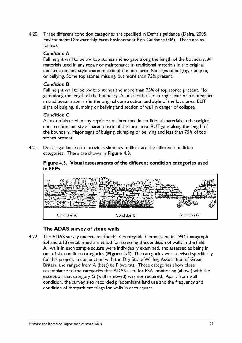
Historic and landscape importance of stone walls 27
4.20. Three different condition categories are specified in Defra’s guidance (Defra, 2005. Environmental Stewardship Farm Environment Plan Guidance 006). These are as follows:
Condition A Full height wall to below top stones and no gaps along the length of the boundary. All
materials used in any repair or maintenance in traditional materials in the original construction and style characteristic of the local area. No signs of bulging, slumping or bellying. Some top stones missing, but more than 75% present.
Condition B Full height wall to below top stones and more than 75% of top stones present. No
gaps along the length of the boundary. All materials used in any repair or maintenance in traditional materials in the original construction and style of the local area. BUT signs of bulging, slumping or bellying and section of wall in danger of collapse.
Condition C All materials used in any repair or maintenance in traditional materials in the original
construction and style characteristic of the local area. BUT gaps along the length of the boundary. Major signs of bulging, slumping or bellying and less than 75% of top stones present.
4.21. Defra’s guidance note provides sketches to illustrate the different condition categories. These are shown in Figure 4.3.
Figure 4.3. Visual assessments of the different condition categories used in FEPs
The ADAS survey of stone walls 4.22. The ADAS survey undertaken for the Countryside Commission in 1994 (paragraph
2.4 and 2.13) established a method for assessing the condition of walls in the field. All walls in each sample square were individually examined, and assessed as being in one of six condition categories (Figure 4.4). The categories were devised specifically for this project, in conjunction with the Dry Stone Walling Association of Great Britain, and ranged from A (best) to F (worst). These categories show close resemblance to the categories that ADAS used for ESA monitoring (above) with the exception that category G (wall removed) was not required. Apart from wall condition, the survey also recorded predominant land use and the frequency and condition of footpath crossings for walls in each square.
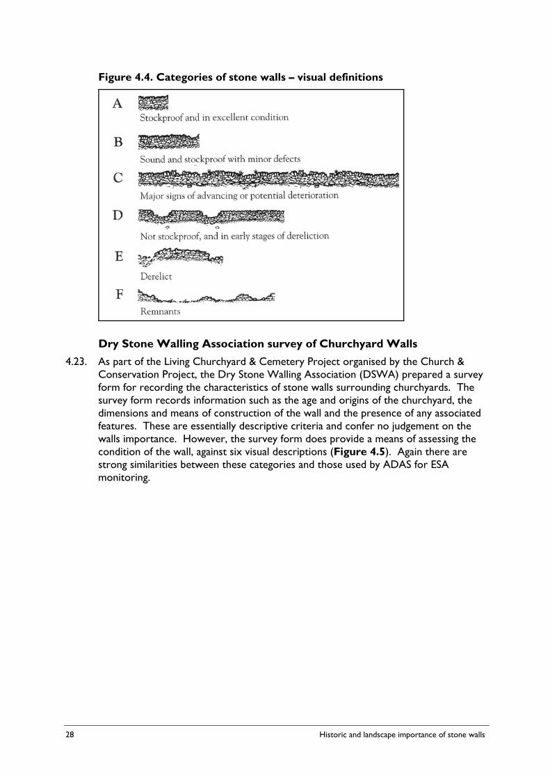
28 Historic and landscape importance of stone walls
Figure 4.4. Categories of stone walls – visual definitions
Dry Stone Walling Association survey of Churchyard Walls 4.23. As part of the Living Churchyard & Cemetery Project organised by the Church &
Conservation Project, the Dry Stone Walling Association (DSWA) prepared a survey form for recording the characteristics of stone walls surrounding churchyards. The survey form records information such as the age and origins of the churchyard, the dimensions and means of construction of the wall and the presence of any associated features. These are essentially descriptive criteria and confer no judgement on the walls importance. However, the survey form does provide a means of assessing the condition of the wall, against six visual descriptions (Figure 4.5). Again there are strong similarities between these categories and those used by ADAS for ESA monitoring.

Historic and landscape importance of stone walls 29
Figure 4.5. Stone wall condition classes provided in the DSWA survey of churchyard walls
Condition Class
Wall farming value
Description of condition of the section of wall
A Stockproof Excellent condition. Top stones nearly all in place. All sides smooth and straight. No sign of bowing, bellying or slumping. Almost no fallen stones.
B Stockproof Some structural defects but effective. A few fallen stones and occasional top stones missing. Obvious temporary repairs such as gap filled with single width of rubble.
C Stockproof Almost complete but signs of future problems, bellying, slumping, bowing. Extensive tree growth at wall base or shrub growth in wall.
D Not stockproof Boundary still used a stockproof boundary but the wall plays a secondary or negligible role to a fence.
E Not stockproof Boundary not maintained stockproof in any way. Large gaps and reduced wall height. Most stone still present.
F Not stockproof Very derelict along its entire length with apparent large loss of stone, removed or buried. Apparent mainly because of a raised bank.
The Hedge (and wall) Importance Test (HIT) 4.24. In 2005, Robin Menneer of the Guild of Cornish Hedgers developed a method for
accessing the importance of hedges and walls7. This is intended for use anywhere in the UK. It uses a field survey form, consisting of 24 questions on two pages, to assess the hedge’s value in landscape, history and wildlife. The record form is shown in Appendix 4 of this report. Answers to the questions on the form are used to create a Hedge Importance Test (HIT) score on a scale of one to ten.
4.25. Although the HIT is intended to apply equally to hedges and walls, in reality four of the questions relate to vegetation structure or species and are unlikely to be relevant to most walls.
4.26. Of the 20 questions that are applicable to all walls:
• Nine can be considered to address the scenic value of the wall (Questions 1, 2, 3, 4, 5, 9, 10, 11 and 12);
• Three address its cultural significance in terms of its vernacular style (Questions 6 and 7) or history (Question 18); and
• Three questions assess the wall’s archaeological significance (Questions 17, 19 and 20).
4.27. Although this relatively simple and quantitative approach is worthy of consideration in relation to this study, there are potential problems.
7 www.cornishhedges.com
30 Historic and landscape importance of stone walls
4.28. Firstly although all of the questions can be answered objectively (i.e. they require a quantitative measurement or selection of one of a range of unambiguous categories), the way that answers are given a score that contributes to the overall ‘HIT score’ has involved a subjective judgement. For instance Question 1 refers to the hedge/wall’s proximity to settlements and a higher score is attributed to hedges/walls within a village or town to those which are not. Question 5 refers to whether the sea can be seen from anywhere along the hedge/wall, with a higher score being given to those which can. Question 22 measures the altitude of the hedge/wall with hedges/walls at a higher altitude receiving a higher score than those at a lower altitude. These judgements are unlikely to be considered valid in all landscapes or regions of England.
4.29. Secondly the ‘HIT score’ is relatively simplistic and does not allow, as it is currently formulated, for a hedge/wall that may score poorly in most aspects but has a single overwhelmingly important characteristic to score highly.
4.30. Finally, there are characteristics of walls that are not covered by the test. Most significantly, it takes no account of the structural condition of the wall in ways that the ADAS and DSWA surveys already described do (this is deliberate since the test wishes to avoid giving a low score to a hedge/wall that has been purposely badly managed). It also does not assess a wall’s contribution to the intactness of the landscape or historic environment (i.e the extent to which it contributes to the overall ‘assemblage’ of the field boundary pattern).
Local surveys of stone walls 4.31. There have been a number of local surveys of wall condition, notably in the
Cotswolds (1992), the Lake District (1975 and 1980), the Yorkshire Dales (1992) and Mendip Hills (2006-ongoing).
4.32. Most surveys are predominantly concerned with wall condition, largely to ascertain where to target restoration works. However, some more recent studies have looked at the historic and landscape value of walls – although landscape has generally been given less attention. A survey undertaken in four areas of Northumberland National Park in 2004, for a National Park Authority bid to the Heritage Lottery for training in traditional boundary skills, considered the historic evolution of the existing boundary system as well as wall condition. This was used to build up a picture of the evolution of the agricultural landscape in the areas surveyed. Information gathered included:
• Desk-top study of tithe and enclosure maps, early OS maps, aerial photography and farm/estate records.
• Information on the local geology, as well as the location of former quarries that could have been sources of building stone (from old maps or observed in fieldwork.
• Likely direct physical relationships between the surveyed boundaries and other known historic or archaeological sites.
• Different walling styles and the presence of ‘wall furniture’, such as stiles, gates and sheep holes.
Historic and landscape importance of stone walls 31
4.33. A pilot project by Gwynedd Archaeological Trust in Wales (funded by the Countryside Council for Wales and Cadw) has involved compiling a national Atlas of Regional Boundary Types. Building on from this, the second stage of the project has involved seeking further detail on the chronological importance of certain boundary types found in Wales, in addition to case study Tir Gofal farms being surveyed to look at both the historic importance of their boundaries and their contribution to local distinctiveness. The latter task was used to develop a systematic boundary survey technique that could potentially be used to engage archaeologists and others (including Tir Gofal project officers) to effectively record field boundaries on a farm scale in a practical way.
4.34. One of the recommendations made in the report was that ‘there is a need to move beyond the examination of individual boundaries, to look at them in their immediate context and in particular at the patterns they form in the landscape’. The project also recommended that the next stage of work should be a study of the variety of boundary ‘furniture’, which they emphasised plays an important role in local boundary distinctiveness.
4.35. In the Mendip Hills, Heritage Lottery funding has been secured in 2006 to undertake a detailed survey of the area’s stone walls involving local people in recording the information. Information required through the survey not only relates to wall condition, but also asks the surveyor to record the stone used, the presence and design of coping stones, and the location of any wall furniture including stone stiles, sheep holes and standing stones. As part of the project, archaeologists have also been commissioned to survey lengths of wall, with recent excavations revealing that lime mortar was used when the walls were originally built – a fact that was previously unknown.
Stone walls and GAEC elsewhere in the EU 4.36. Stone walls occur in a number of other EU member states, particularly in arid regions
where they were traditionally used as stock proof boundaries. It is instructive to examine whether stone walls are assessed and protected by GAEC in these countries and whether this reveals useful approaches to defining historic or landscape value. The main source for this section is a study for Defra by the Institute for European Environmental Policy in 20068 augmented with information collected by this study for Wales, Scotland and Northern Ireland.
4.37. Stone walls are included as landscape features, and afforded a degree of protection, through the GAEC in nine counties (Figure 4.6).
8 Swales V, Farmer M, Bartley J & Kettunen M (2006). A Review of GAEC Standards Relating to Undergrazing and Landscape Features in the EU-15. IEEP: London.
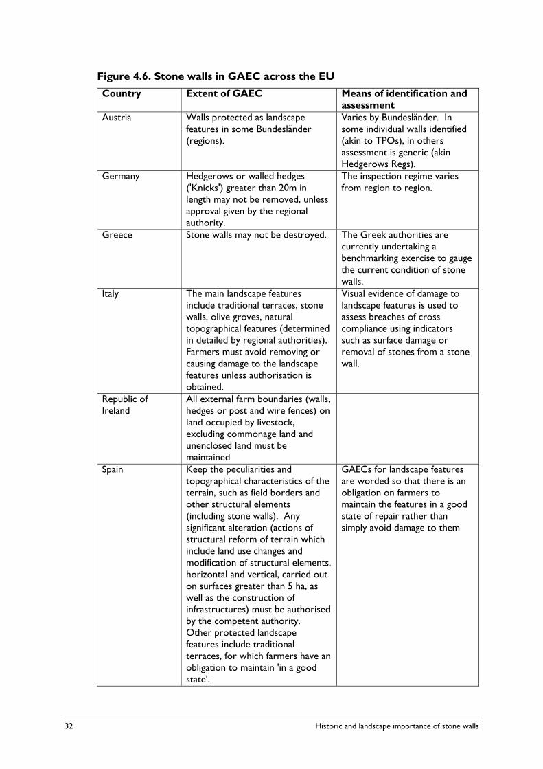
32 Historic and landscape importance of stone walls
Figure 4.6. Stone walls in GAEC across the EU Country Extent of GAEC Means of identification and
assessment Austria Walls protected as landscape
features in some Bundesländer (regions).
Varies by Bundesländer. In some individual walls identified (akin to TPOs), in others assessment is generic (akin Hedgerows Regs).
Germany Hedgerows or walled hedges ('Knicks') greater than 20m in length may not be removed, unless approval given by the regional authority.
The inspection regime varies from region to region.
Greece Stone walls may not be destroyed. The Greek authorities are currently undertaking a benchmarking exercise to gauge the current condition of stone walls.
Italy The main landscape features include traditional terraces, stone walls, olive groves, natural topographical features (determined in detailed by regional authorities). Farmers must avoid removing or causing damage to the landscape features unless authorisation is obtained.
Visual evidence of damage to landscape features is used to assess breaches of cross compliance using indicators such as surface damage or removal of stones from a stone wall.
Republic of Ireland
All external farm boundaries (walls, hedges or post and wire fences) on land occupied by livestock, excluding commonage land and unenclosed land must be maintained
Spain Keep the peculiarities and topographical characteristics of the terrain, such as field borders and other structural elements (including stone walls). Any significant alteration (actions of structural reform of terrain which include land use changes and modification of structural elements, horizontal and vertical, carried out on surfaces greater than 5 ha, as well as the construction of infrastructures) must be authorised by the competent authority. Other protected landscape features include traditional terraces, for which farmers have an obligation to maintain 'in a good state'.
GAECs for landscape features are worded so that there is an obligation on farmers to maintain the features in a good state of repair rather than simply avoid damage to them
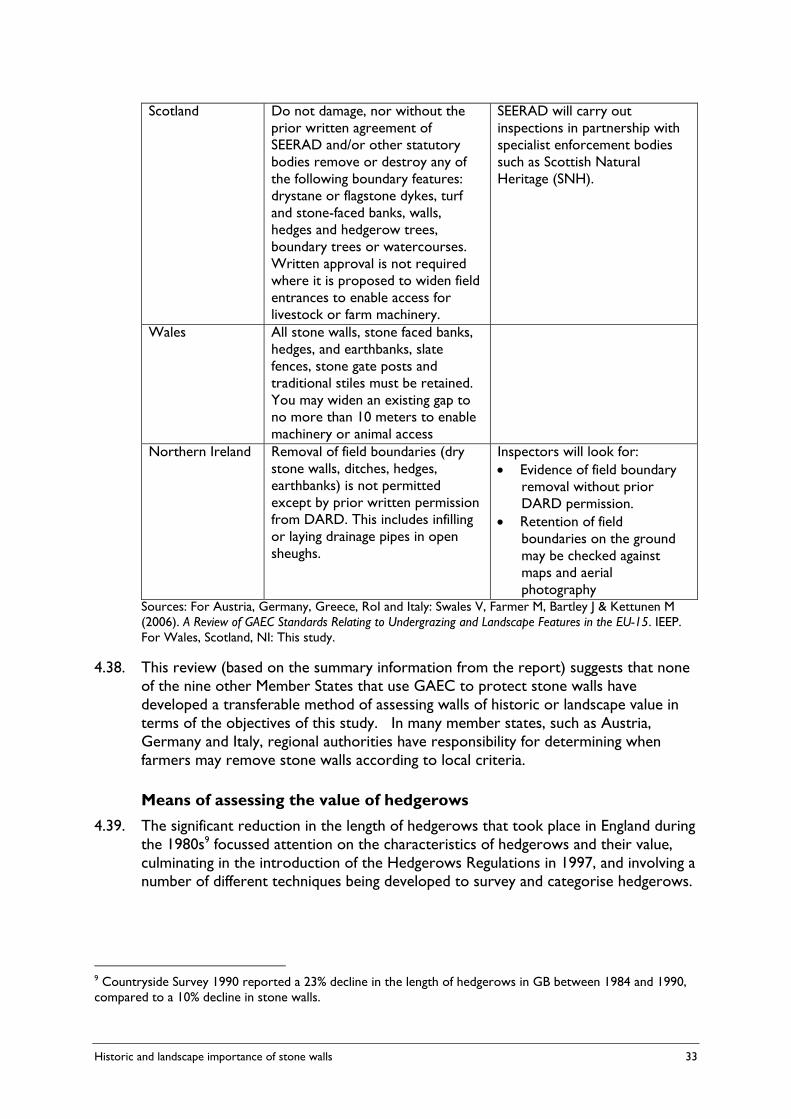
Historic and landscape importance of stone walls 33
Scotland Do not damage, nor without the prior written agreement of SEERAD and/or other statutory bodies remove or destroy any of the following boundary features: drystane or flagstone dykes, turf and stone-faced banks, walls, hedges and hedgerow trees, boundary trees or watercourses. Written approval is not required where it is proposed to widen field entrances to enable access for livestock or farm machinery.
SEERAD will carry out inspections in partnership with specialist enforcement bodies such as Scottish Natural Heritage (SNH).
Wales All stone walls, stone faced banks, hedges, and earthbanks, slate fences, stone gate posts and traditional stiles must be retained. You may widen an existing gap to no more than 10 meters to enable machinery or animal access
Northern Ireland Removal of field boundaries (dry stone walls, ditches, hedges, earthbanks) is not permitted except by prior written permission from DARD. This includes infilling or laying drainage pipes in open sheughs.
Inspectors will look for: • Evidence of field boundary
removal without prior DARD permission.
• Retention of field boundaries on the ground may be checked against maps and aerial photography
Sources: For Austria, Germany, Greece, RoI and Italy: Swales V, Farmer M, Bartley J & Kettunen M (2006). A Review of GAEC Standards Relating to Undergrazing and Landscape Features in the EU-15. IEEP. For Wales, Scotland, NI: This study.
4.38. This review (based on the summary information from the report) suggests that none of the nine other Member States that use GAEC to protect stone walls have developed a transferable method of assessing walls of historic or landscape value in terms of the objectives of this study. In many member states, such as Austria, Germany and Italy, regional authorities have responsibility for determining when farmers may remove stone walls according to local criteria.
Means of assessing the value of hedgerows 4.39. The significant reduction in the length of hedgerows that took place in England during
the 1980s9 focussed attention on the characteristics of hedgerows and their value, culminating in the introduction of the Hedgerows Regulations in 1997, and involving a number of different techniques being developed to survey and categorise hedgerows.
9 Countryside Survey 1990 reported a 23% decline in the length of hedgerows in GB between 1984 and 1990, compared to a 10% decline in stone walls.

34 Historic and landscape importance of stone walls
The Hedgerows Regulations 1997
4.40. As stated above, these regulations were introduced in 1997 following over a decade of concern by the public and Government about the removal of hedgerows by farmers. The regulations place an obligation on landowners who wish to remove any hedgerow (as defined) to notify the Local Planning Authority. The Authority then has 42 days to determine whether the hedgerow is classified as being ‘important’ according to eight criteria. If the hedgerow is classified as important the hedgerow may not be removed. There are a number of exemptions and complicating factors which do not need to be covered here. The Regulations have been under review for several years and proposals for amendments are expected from Defra shortly.
4.41. The first five criteria cover the historical importance of the hedgerow and the other three cover its wildlife and landscape importance. These criteria are summarised in Figure 4.7.
4.42. For the purposes of this study, the five criteria covering the historical importance of hedgerows are relevant, and could be applicable, to this study. Of the three criteria covering wildlife and landscape importance, Criterion 6 relates to biodiversity and Criterion 8 refers principally to woody species, although several of the associated features would apply to walls. Criterion 7 relates to public access which is not relevant to this study.
4.43. There are clearly aspects of stone walls that would be considered to contribute to their historic or landscape importance that are not covered by the Hedgerows Regulations. The scenic and cultural significance of the boundary is not covered (presumably because, as noted above, these tend to rely on subjective or highly informed judgements). Nor is the physical condition (structural integrity) of the boundary addressed in ways that the assessment methodologies reviewed earlier cover.
4.44. Nevertheless, the Hedgerows Regulations demonstrate that a legally robust methodology can be used to identify field boundaries that are considered important for their historical, landscape and wildlife value.

Historic and landscape importance of stone walls 35
Figure 4.7. Summary of the criteria defining an important hedgerow under the Hedgerows Regulations 1997 A hedgerow is considered important where it:
1. Marks the boundary, or part of the boundary, of at least one historic parish or township; and for this purpose "historic" means existing before 1850.
2. Incorporates an archaeological feature which is either (a) designated as a Scheduled Monument; or (b) recorded at the ‘relevant date’ in a Sites and Monuments Record.
3. Is either (a) situated wholly or partly within a Scheduled Monument or is on land adjacent to and associated with such a site; and (b) is associated with any monument or feature on that site.
4. Either (a) marks the boundary of a pre-1600 AD estate or manor recorded at the relevant date in a Sites and Monuments Record or in a document held at that date at a Record Office; or (b) is visibly related to any building or other feature of such an estate or manor.
5. Is either (a) recorded in a document held at the ‘relevant date’ at a Record Office as an integral part of a field system pre-dating the Inclosure Acts; or (b) is part of, or visibly related to, any building or other feature associated with such a system, and that system is (i) substantially complete; or (ii) of a pattern which is recorded in a document prepared before the ‘relevant date’ by a local planning authority, for the purposes of development control within the authority's area, as a key landscape characteristic.
6. Contains species in part I of Schedule 1; Schedule 5; or Schedule 8 of the Wildlife & Countryside Act 1981; or various other defined species including certain Red Data Book species
7. Is adjacent to a public right of way (not counting an adopted highway) and at least 4 woody species as defined in Schedule 3 of the regulations plus at least two Associated Features
8. Includes one or more of the following: • At least 7 woody species • At least 6 woody species plus at least three associated features • At least 6 woody species including a black poplar; large-leaved lime, small-
leaved lime or wild service tree • At least 5 woody species and at least 4 associated features
Associated Features are: a bank or wall for at least half the length; a ditch for at least half the length; gaps over no more than 10% of the length; at least one standard tree per 50m; at least 3 ground flora woodland species as defined in Schedule 2 of the Regulations within 1m of the hedgerow; connections scoring 4 or more points, where connection a hedgerow counts as one, a broad-leaved woodland or pond counts as two; and a parallel hedge within 15m (the last two features do not count if a public right of way is being included in the criterion).
Where a hedgerow is situated wholly or partly in specified counties (in the North of England) the number of woody species mention is to be treated as reduced by one.
The ‘relevant date’ is the date on which the regulations came into force which was 27 March 1997.
36 Historic and landscape importance of stone walls
UK Hedgerow Survey Handbook
4.45. In 2002 the steering group for the Biodiversity Action Plan for ancient and/or species-rich hedgerows commissioned Catherine Bickmore Associates to develop a standard methodology for surveying hedgerows across the UK. The methodology is based on a range of local surveys conducted by bodies such as the Campaign for the Protection of Rural England, Wildlife Trusts and Local Authorities and the methodology developed by the study was piloted in North West Wales, Peterborough, Dorset and East Devon. The methodology is written up in a Handbook10.
4.46. In the context of this study it is important to appreciate that the methodology established in the Handbook is limited to describing hedgerows. It does not seek to make judgements on their value. Information is recorded on the dimensions and shape of the hedge (and any associated bank and ditch), the adjacent land use, form of management, and the woody and ground flora species present. The methodology provides an additional sheet for recording the information necessary to determine whether the hedgerow is protected by the Hedgerows Regulations.
Conclusions • There is no single authoritative method for surveying stone walls. A variety of
methods have been developed to suit particular purposes.
• Most methods are primarily descriptive and designed to collect information rather than identify stone walls of particular historical or landscape importance.
• However, most methods provide a means of describing the physical condition of the wall in relation to set categories based on visual assessment against pictures or textual description.
• The Hedge (and Walls) Importance Test (HIT) developed by Robin Menneer for the Guild of Cornish Hedgers provides a relatively simple and objective framework. Although it reflects underlying judgements that have been made about the value of Cornish hedges which are unlikely to apply in other areas, the overall approach could be applied, with modification, to assess the importance of stone walls across England.
• GAEC in nine other territories across the EU, including Scotland, Wales and Northern Ireland, provide protection of some kind to stone walls. From the information available to this study, none of these GAEC appear to provide criteria for determining the historic or landscape importance of stone walls.
• The Hedgerows Regulations 1997 provide legal protection to hedgerows that are deemed to be important according to a set of eight criteria, five of which cover historical importance and would be relevant to stone walls, and three of which cover wildlife and landscape importance, which would not. The regulations do not cover, to any significant degree, the scenic or cultural value of hedgerows. Nor do they seek to assess the physical condition or integrity of the hedgerow in a way that could be adapted to stone walls.
10 Defra, 2002. The Hedgerow Survey Handbook. A standard procedure for local surveys in the UK. Prepared for the Steering Group of the UK Biodiversity Action Plan for Ancient and/or Species-rich Hedgerows.

Historic and landscape importance of stone walls 37
5. PROPOSED CRITERIA FOR DEFINING STONE WALLS OF HISTORIC OR LANDSCAPE IMPORTANCE
5.1. This Chapter proposes, and considers the suitability of, four criteria that can be used to define stone walls that are important in terms of their historic value or contribution to landscape quality.
Definition of stone walls 5.2. Before examining the criteria for historic and landscape importance of walls, it is
helpful to review the current definition of a stone wall contained in GAEC 13. The definition reads: ‘Stone wall’ means a stone wall used as a field boundary, with:
• a continuous length of at least 10 metres, regardless of condition; or
• a continuous length of less than 10 metres and meeting (whether by intersection or junction) another field boundary at each end, or forming a small enclosure.
5.3. The two bulleted sub-sections are concerned with the minimum length of the wall and are based on the definition contained in the Hedgerows Regulations although the length of 10m is half that used in the Hedgerows Regulation (a 20m minimum length). Given the variation in type of construction of stone walls across England (paragraph 3.14 et sequ.), a more precise definition would be problematic. Although field boundary walls are often referred to as ‘dry stone walls’, some areas historically used lime mortar (paragraph 4.35) and such a phrase would probably exclude the stone-faced earth banks found in the South West.
5.4. The phrase ‘field boundary’ might be problematic in a strictly legal sense since the definition is clearly intended to cover walls that were constructed to contain stock but have since lost their agricultural function, now occurring within a larger agricultural parcel. It is suggested that the definition should also include walls that were constructed as stock enclosures (such as sheep pens and folds) within fields where these enclosures are not strictly field boundaries. These points could be taken into account by replacing the first line of the definition with “‘Stone wall’ means a stone wall originally constructed as a field boundary or stock enclosure, with …:”.
Principles for defining the criteria 5.5. As noted in the introductory chapter, farmers are allowed to remove stone from
walls in three circumstances but are encouraged to preserve walls of historic or landscape importance by Defra’s guidance document (Appendices 1 and 2). Under these circumstances, the criteria need to be regarded as extensions to the guidance to farmers and may need to be used by them in the first instance.
5.6. Where farmers wish to remove stone from a wall under other circumstances, or where they are suspected of having done so, the criteria will need to be used by the Rural Payments Agency or possibly other bodies whom the RPA approach for advice

38 Historic and landscape importance of stone walls
or are refereeing an issue to the RPA. When the criteria are used in this way, they must be capable of objective assessment and verification through field inspection or by reference to remote sensing or documents and in extreme circumstances to a legal challenge.
5.7. This suggests that, in order to be suitable for incorporation in GAEC 13, the criteria should: a. Be capable of being understood and operated by farmers or their agents and
advisers; b. Be capable of forming the basis of a verifiable standard against which compliance
can be judged by the Rural Payments Agency, other Competent Control Authority, or someone acting on their behalf, based on suitably qualified advice from the local authority or relevant national agency (e.g. Natural England); and
c. Apply across the whole of England, taking account of the variation in character of construction of stone walls.
Criteria for defining stone walls of historic importance 5.8. The Hedgerows Regulations 1997 provide an existing mechanism by which the
historic value of certain boundary features may be assessed and which has general relevance to the determination of the heritage importance of stone walls (see above, 4.40 et seq.). By adaptation of the wording of the relevant clauses, the five criteria for defining historically important hedgerows set out in the Hedgerows Regulations (Figure 4.7) can be reduced to two.
Proposed criteria Reasoning and notes A. Recorded archaeological value
The wall incorporates an archaeological feature which is -
i) included in the schedule of monuments compiled by the Secretary of State under section 1 (schedule of monuments) of the Ancient Monuments and Archaeological Areas Act 1979; or
ii) situated wholly or partly within the designated scheduled area of such a monument; or
iii) recorded in a Historic Environment Record
Based on Criterion 2 of Part II of the Hedgerows Regulations. (Figure 4.7).
Sub-criterion (i) mirrors protection that is already provided by GAEC 7
Should discourage damage to scheduled monuments of which stone walls form either an integral part or where stone walls cross scheduled areas.
Will safeguard other directly associated heritage features in the landscape and provide protection for walls not otherwise included by these regulations but which are nonetheless assessed as being of historic significance.
Status at the time of enquiry rather than at an arbitrary date should be the defining factor.
Compared to the Hedgerows Regulations, removal of ‘relevant date’ requirement would mean that a wall could change status if reassessed.
Anticipated to be a rarely used criterion.
B. Age of the wall
The wall is shown as a boundary on the 1st edition Ordnance Survey 6” or 25” series.
Based on Criterion 5 of Part II of the Hedgerows Regulations, but substitutes an objective test for the imprecise date used in the Hedgerows Regulations.
The effective date will depend on the date of the OS survey for a particular area, ranging from the 1840s to the early 1880s. These maps are already used for baseline

Historic and landscape importance of stone walls 39
Environmental Stewardship applications, and the 6” series is available online at http://www.old-maps.co.uk/. A short trial period is required to test how easy it is to match boundaries shown on the 1st edition maps with current maps.
There is no requirement to assess the completeness of field systems as it is unlikely to define walls not already covered by this criterion.
The criterion assumes that walls built since the 1st edition OS map are historically less important. However, this may not be the case for late enclosure walls (such as those surrounding late C19th moorland and common land enclosures)
5.9. In relation to the three principles set out above (paragraph 5.7), the following
conclusions can be drawn.
a. Clarity to farmers: Although farmers in general are likely to be unfamiliar with the legislation protecting ancient monuments, it is expected that those with a scheduled monument on their land will be. Most farmers will be unfamiliar with the Historic Environment Record as a source of information and so guidance will need to be provided on how to access this information. Most farmers are likely to be only vaguely aware of the existence of the first edition OS maps and again guidance will need to given on how to access them.
b. Verifiability by RPA: Both these criteria are capable of objective assessment. Although both require reference to external sources (the Historic Environment Record and the 1st edition OS map), these sources are readily accessible and form the basis of assessments that applicants and their advisors are expected to make when applying to the Higher Level Environmental Stewardship scheme. Historic Environment Record operators (contactable via the local planning authority or county council) will already be aware of the criteria applying to hedgerows and therefore the nature of the information required.
c. Applicability across England: Both criteria should be capable of being operated efficiently in all areas of England, although the way in which data on the Historic Environment Record is held and may be searched (i.e. electronically or manually) varies between Local Authorities.
5.10. It should be noted that while the first criterion is likely to apply to a minority of stone walls, the second will apply to the large majority. It could be argued that this means that the second criterion is too strict and that it should set an earlier date as the threshold for historic importance. However, the second criterion is broadly consistent with the equivalent criterion for important hedgerows. In addition there is no widely accessible record of the location of field boundaries across the whole of England before the 1st edition OS maps (the c.1840 tithe maps, for instance, are not available for all parts of the country and cannot be viewed on-line).
5.11. For information, the criteria for assessing historic hedgerows set out in the Hedgerows Regulations but not proposed for use in defining important stone walls are shown in Appendix 5.

40 Historic and landscape importance of stone walls
Criteria for defining stone walls of landscape importance 5.12. As already noted, the Hedgerows Regulations do not contain criteria that relate to
landscape importance11 and there are few other examples of assessment methodologies that do so. The following two criteria are therefore based on the nationally accepted methodology for landscape assessment12 and on consultation with stakeholders during this study.
Proposed criteria Reasoning and notes C. Style of construction and condition i) The wall is a good example of the local vernacular style of construction, containing one or more special features such as a stone stile, gate post or water trough. ii). The wall is in a good state of repair, with no gaps (top stones in place along at least 75% of the length), with no signs of bulging, slumping or bellying.
(i) The structure of stone walls varies significantly across England and each region has its own traditional style which has been described by bodies such as the Dry Stone Walling Association and British Trust for Conservation. Judgements need to be made in relation to the materials, colour and texture of the wall to assess whether it shares the typical characteristics of walls in its locality. (ii) The physical condition of the wall can be assessed against the categories used by Natural England in relation to Farm Environment Plans used for the Higher Level of Environmental Stewardship (Figure 4.3).
D. Contribution to landscape quality
The wall makes a significant visual contribution to the overall character of the local landscape, in terms of:
i) The place of stone walls as a key component of local landscape character
ii) Its prominence when seen from popular view points such as settlements, roads or public rights of way
iii) Its connectedness to the network of other walls and other built stone features, such as stone barns
The assessment of landscape importance must include a judgement about the wall’s contribution to landscape quality in an aesthetic sense. The methodology for landscape character assessment, in which the attributes of different elements and features in the landscape are analysed provides a means of doing this. Concepts such as the scale & enclosure, unity and coherence of landscape features need to be interpreted in relation to stone walls. For each of the sub-criteria a) to d), the stone wall needs to be scored in a similar way to the assessments in the Hedge (and Wall) Importance Test (paragraph 4.24 and Appendix 3). i) This can be assessed in relation to published landscape character descriptions for the area. The descriptions for the Joint Character Areas are available through Natural England’s website www.countryside.gov.uk/LAR/Landscape/CC/jca.asp). ii) Prominence can depend on the wall’s place in the landform (for instance on a ridge) and its size. The wall can be placed in one of there categories: prominent, apparent and negligible. iii) The overall network of stone walls usually contribute greatly to the shape and structure of the landscape. A stone wall that forms a central part of this network is likely to be more important than one which has few connections. As with sub-criterion (ii), the wall can be placed into one of three categories: strong, broken/intermittent and : weak.
11 It should be noted that Criterion 7 of the Hedgerows Regulations takes account of hedgerows that are adjacent to Public Rights of Way. 12 Countryside Agency and Scottish Natural Heritage (2002). Landscape Character Assessment: Guidance for England and Scotland. www.countryside.gov.uk/lar/landscape/cc/landscape/publication/
Historic and landscape importance of stone walls 41
5.13. In relation to the three principles set out above (paragraph 5.7), the following conclusions can be drawn.
a. Clarity to farmers: Most farmers will not be familiar with the process of landscape character assessment but they are likely to be comfortable with the idea that stone walls and other countryside features contribute to the visual and cultural character of an area. Most farmers are well qualified to make a judgement about the vernacular style of stone wall construction in their locality and about the physical condition of walls (as involved in the first criterion). The concepts contained in the second criterion of landscape ‘components’ and their prominence and connectedness require definition but, if this is done, the purpose and method of assessment of the criterion should be clear (even if, as noted below, farmers may question the objectivity of the assessment).
b. Verifiability by RPA: These two criteria are based principally on a visual assessment of the stone wall in the field, as opposed to the two historical criteria which are desk-based (the exception being criterion D(i) which is made in relation to a published Landscape Character Assessment). These criteria therefore require a site visit by the RPA or another body (such as the Local Authority) acting on the RPA’s behalf.
The landscape criteria also involve the use of informed but potentially subjective judgements about what is a ‘good’ example of local vernacular style and what makes a ‘significant’ contribution to landscape character. Although the role of landscape character assessment in policy delivery in the countryside is growing (for instance in relation to the Environmental Impact Assessment Regulations), these criteria are unlikely to satisfy the high burden of proof required by the European Commission in relation to cross compliance.
Although it would be theoretically possible to define more objectively verifiable criteria, based around the presence or absence of features and the dimensions and density of stone walls, this runs contrary to the accepted methodology for assessing landscape character and value using informed and value-driven assessments. Furthermore, the number of different aspects that would need to measured and the need take account of the variation in the styles of walls and character of landscapes would defeat objective of creating a “simple, transparent and workable definition” (paragraph 1.1).
c. Applicability across England: The proposed criteria take a relative, rather than absolute, approach to assessing landscape value by considering individual stonewalls in their local context. This means that the criteria should be able to take account of the wide regional variations in stone walls and the settings in which they exist. As noted above, the need to take account of regional variation is another reason why a set of more quantifiable criteria would not be suitable.
42 Historic and landscape importance of stone walls
Overall observations on the proposed criteria 5.14. The relationship between the criteria. Although the four criteria are divided
between the two topics of the historic environment and landscape, these are closely linked. For instance the age of a stone wall is an important factor in determining people’s understanding of its contribution to the landscape and the means of construction of a wall can be considered of historic interest. These factors go some way to address the concerns of those giving evidence to the Select Committee (paragraph 3.5) that historic significance should encapsulate some notion of context and setting.
5.15. Likely coverage of the criteria. It is likely that the majority of stone walls will be considered important by one or more of the criteria (this will only be confirmed in the light of more extensive use in the field). Criterion B (the age of walls) is likely to apply to most stone walls in pre-enclosure landscapes. There is an expectation from Defra and the stakeholders consulted during this study that the definitions of historic and landscape importance should not prevent removal of stone from all stone walls, but should rather prioritise protection to the most important walls. This suggests that while some criteria should be sufficient on their own to define a wall as of historic or landscape importance, other criteria might act in concert. This is developed further below in this Chapter and in the final Chapter.
5.16. Verifiability of the criteria. As noted above, whereas the two historic criteria and part of the second landscape criterion (D.i) can be determined objectively based on documentary evidence, the other landscape criteria rely more on judgements, albeit on the basis of informed decisions in relation to the sub-criteria. This suggests that, when it comes to defining stone walls of landscape importance, a more qualitative process, involving informed assessment by suitably qualified advisers, will be needed. There will be advantages in involving farmers themselves this process so that, where possible, agreement can be reached on the landscape importance of stone walls, accepting that landscape criteria that rely on informed assessments are more likely to be open to legal challenge than more objectively verifiable criteria.
5.17. The lack of objectively verifiable criteria for assessing landscape importance presents more of a problem when it comes to RPA compliance inspections. If the RPA field inspector finds that stone was been removed from a wall and that none of the exemptions in GAEC 13 apply they may need to try to determine whether the wall was of historic or landscape importance before the stone was removed. Not only will it be difficult to do this retrospectively, but third party assessment will need to be undertaken to determine if the wall was of landscape importance. If the farmer is to be subject to a payment reduction on the basis that the assessment decides that the wall was of landscape importance, RPA will need to be confident that this assessment would stand up to challenge by or on behalf of the farmer. It is understood that landscape assessments of the type proposed in this report have not been legally tested in this way and the risk will need to be acknowledged by Defra if this is adopted.

Historic and landscape importance of stone walls 43
5.18. Relationship with agri-environment schemes. Land under agreement in one of the agri-environment schemes13 is covered by the conditions of these agreements which will add additional constraints to the proposed criteria for historic or landscape importance. By far the largest scheme, in terms of the area of land covered is Entry Level Stewardship (ELS). Section 5.6 of the Entry Level Stewardship Handbook14 lists additional conditions that apply to ELS agreement holders. These include the following:
• Do not remove any useable building stone, walling stone or traditional roofing material off the land, excluding materials produced from established quarries.
• Do not damage, demolish or remove stone from substantially complete ruined traditional farm buildings or field boundaries.
5.19. These conditions make it clear that, for land covered by the ELS, stone should not be removed from walls regardless of whether the wall is considered to be of historical or landscape importance. Similar conditions apply to the other agri-environment schemes in England.
An enforceable framework for adopting the criteria 5.20. Taking account of the points made above about the differential thresholds set by the
criteria and the different means of verification, it is proposed that a four stage process should be implemented to adopt the definitions of historic and landscape importance. To do this, it is necessary to partly re-number and re-order the criteria described earlier in this Chapter so that they are divided, not on the basis of whether they address historic or landscape importance, but on the basis of how they are assessed and whether they amount on their own or in combination to a definition of historic or landscape importance. It is also necessary to add a ‘pre-qualification stage’ that excludes walls that lie on land in agri-environment schemes.
• The first, pre-qualification, stage establishes whether the wall is covered by an agri-environment scheme agreement15. If this is the case, RPA will not issue a derogation to GAEC 13 unless Natural England has stated that doing so is compatible with the conditions of the agri-environment agreement.
• The second stage uses one criterion that can be objectively verified by RPA and which, on its own, is sufficient to define stone walls of historic importance. This is criterion A (recorded archaeological value)
• The third stage uses two criteria that can be objectively verified by RPA and which indicate that a stone wall is likely to be of historic or landscape importance.
13 These agri-environment schemes are Environmental Stewardship, with its three tiers of Entry Level, Organic Entry Level and Higher Level, as well as the previous schemes, the Countryside Stewardship and Environmentally Sensitive Area Schemes. 14 Defra, 2005. Entry Level Stewardship Handbook. PB10355. February 2005 15 The only exception being where the farmer can demonstrate that exceptional circumstances apply such as for access to utilities and services for repair and construction, human or animal health or safety, and control of pest or weed infestations (paragraph 32 of Defra’s Cross Compliance Handbook for England, 2006 edition).

44 Historic and landscape importance of stone walls
These are criteria B (age of the wall) and D.i (recorded key components of landscape character).
• The final stage uses criteria which require judgements to be made by suitably qualified independent advisers to determine whether a stone wall identified in the second stage is of historic or landscape importance. These are criteria C (style of construction and condition) and D.ii (visual prominence) and D.iii (connectedness).
5.21. This four stage process, leading to a recommendation on whether RPA will issue a derogation to remove the wall, or stone from the wall, is shown as a decision flowchart in Figure 5.1.
The need to field-test the proposed criteria 5.22. These criteria were initially developed in consultation with appropriate specialists but
were not subjected to trialling for specific walls. Following the completion of the first stage of the work, it was recommended that Defra should instigate a trial in at least three different locations across England, before the methodology was confirmed and brought into general use. As noted at the end of Chapter 1, Defra commissioned a small team from Land Use Consultant’s London office to undertake a swift process of field testing. This involved taking the methodology to three locations (the Peak District in Derbyshire, Kesteven Uplands in Leicestershire / Lincolnshire and Bodmin Moor in Cornwall). A total of 12 stone walls that represented the range of circumstances present in these areas were assessed using the proposed methodology. A separate report has been prepared on this work, the conclusions of which can be summarised as follows:
• The field testing confirmed that the proposed methodology was broadly effective and straightforward to use, both in terms of the proforma and the availability of background information, such as historic map and Scheduled Monument data.
• It found that gathering the evidence on the historic and landscape importance of each stone wall takes approximately 1-2 hours for the documentary information and a further 30 minutes spent recording each wall in the field. This does not include travel or written reporting.
• It was suggested that perceptual and experiential aspects of landscape character should take account of aesthetic factors such as materials, colour and texture and be recorded under the heading ‘style of construction and condition’, rather than under the heading of ‘prominence’ as originally proposed.
• A three point scale for categorising prominence was suggested, with objective definitions used to describe each point on the scale.
• Similarly, a three point scale for categorising connectedness was suggested, with definitions for each point.
• Finally, it was suggested that there should be a five point, rather than three point (as originally proposed), scale for the physical condition of the wall. Because the three point scale originally suggested was taken from one that is already in use for Farm Environment Plans, this report has maintained the three categories but has
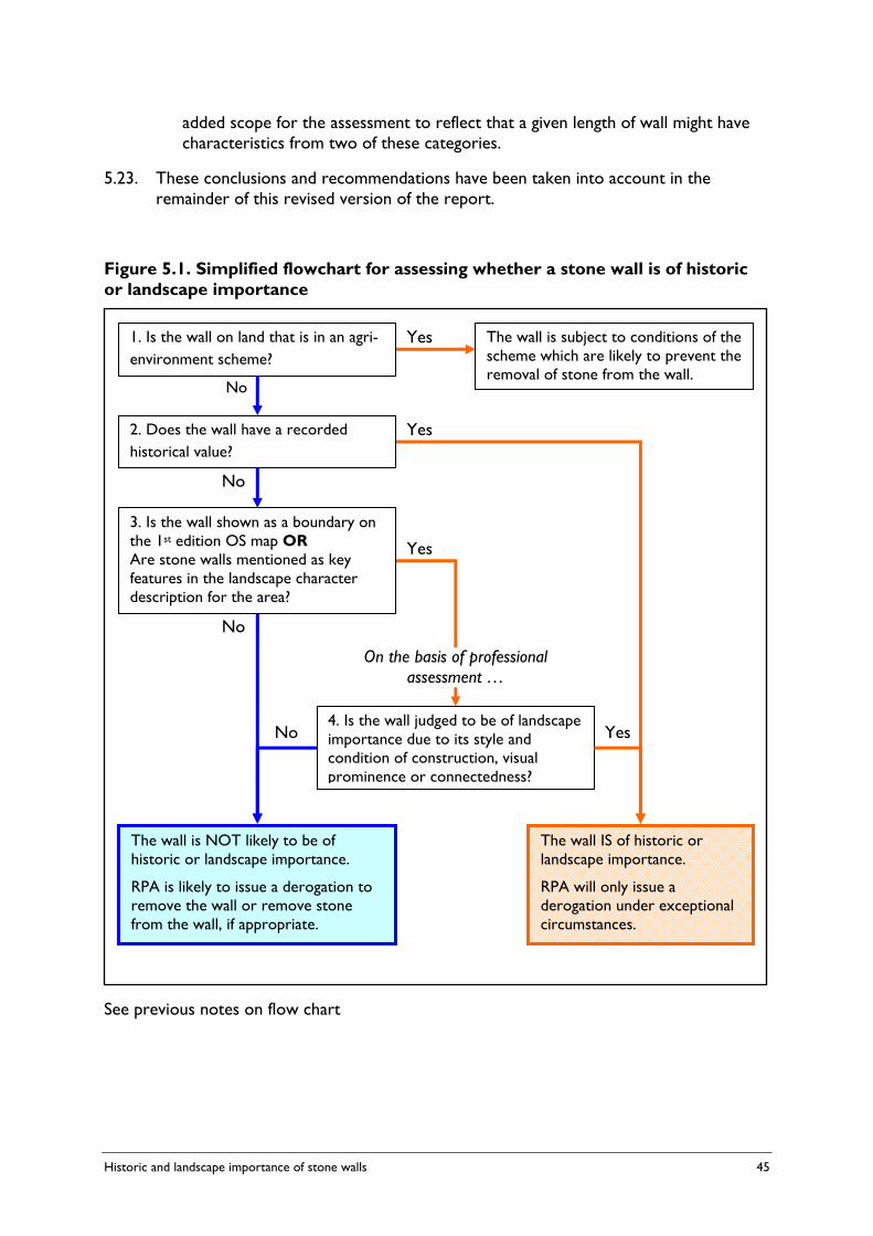
Historic and landscape importance of stone walls 45
added scope for the assessment to reflect that a given length of wall might have characteristics from two of these categories.
5.23. These conclusions and recommendations have been taken into account in the remainder of this revised version of the report.
Figure 5.1. Simplified flowchart for assessing whether a stone wall is of historic or landscape importance
See previous notes on flow chart
2. Does the wall have a recorded historical value?
Yes
No
3. Is the wall shown as a boundary on the 1st edition OS map OR Are stone walls mentioned as key features in the landscape character description for the area?
4. Is the wall judged to be of landscape importance due to its style and condition of construction, visual prominence or connectedness?
The wall is NOT likely to be of historic or landscape importance.
RPA is likely to issue a derogation to remove the wall or remove stone from the wall, if appropriate.
The wall IS of historic or landscape importance.
RPA will only issue a derogation under exceptional circumstances.
No
Yes
Yes No
On the basis of professional assessment …
1. Is the wall on land that is in an agri-environment scheme?
No
The wall is subject to conditions of the scheme which are likely to prevent the removal of stone from the wall.
Yes


Historic and landscape importance of stone walls 47
6. GUIDANCE FOR FARMERS, THE RPA AND OTHER AUTHORITIES
6.1. This study is charged with producing guidance on the definition of stone walls of historic or landscape importance. There are several different audiences for this guidance and their needs are different. This Chapter describes these audiences and their needs and suggests the wording of the guidance that should be made available to them. Recommendations are made on how these can be adopted.
Farmers 6.2. GAEC 13 allows farmers to remove stone under relatively wide circumstances
without seeking a derogation (paragraph 1.3). Because of this, there is little evidence on the extent of removal of stone from walls by farmers. During the first 18 months of cross compliance, there has only been one case of the RPA investigating a breach of GAEC 13 (where a wall was removed) and around a dozen requests for derogations where farmers have sought approval to remove stone outside the conditions allowed by GAEC 13. Consultees to the study did not raise concern about a significant level of removal of stone from walls across England.
6.3. Although the wording of GAEC 13 does not require farmers to take account of the historic or landscape importance of stone walls when these exempted circumstances apply, there is scope for providing farmers with guidance to encourage them to consider the importance of the walls before they remove the stone. This is particularly the case when farmers are considering removing stone from one wall to make repairs to another.
6.4. Consultees to the study have emphasised that farmers should be encouraged to look for other sources of suitable stone, particularly from small-scale quarries on the same holding, before ‘robbing’ stone from other walls. In areas where walls are common many farms have such quarries (most now disused). Clearly the opening of a new commercial quarry selling stone off the farm would require planning permission and require a consideration of its environmental impact. However, the removal of small quantities of stone for use on the farm can be conducted under permitted development rights (unless the quarry is statutorily protected such as through designation as a Site of Special Scientific Interest).
6.5. Where there is no alternative source of stone, it is important to ensure that the wall which is being ‘robbed’ of stone is not more important than the one that is being repaired. The proposed criteria should provide farmers with a way of making this comparative assessment. It is important that guidance to farmers enables them or their advisers to run through the four stage process outlined at the end of the last Chapter. A suggested proforma is included at the end of this Chapter.
6.6. Guidance is currently provided to farmers on the management of features within GAEC in a booklet that was sent to all Single Payment Scheme claimants in 200516
16 Defra, 2005. Cross Compliance Guidance for the Management of Habitats and Landscape Features. 2005 Edition. PB 10222B

48 Historic and landscape importance of stone walls
The guidance provided in this booklet for GAEC 13 is shown in Appendix 2. There is clearly scope for adding to this guidance to describe how the historic and landscape importance of individual sections of wall can be assessed, based on the proposed criteria. This will depend on Defra’s plans to update and re-issue the booklet to farmers.
6.7. Where farmers wish to remove an entire section of wall, or wish to remove stone under circumstances that are not covered by the exemptions in GAEC 13, they must apply to RPA for a derogation. Although it is for the RPA to decide whether the derogation can be given, it is important that the farmer understands the criteria that are being used. In addition, as suggested below, the RPA may wish to involve the farmer in make their own assessment of the importance of the wall.
It is suggested that Defra includes the proposed criteria and self-assessment form for farmers in or as an adjunct to the next edition of “Cross Compliance Guidance for the Management of Habitats and Landscape Features” and that this should be made available to all SPS claimants.
It is suggested that RPA reference or send a copy of the proposed self-assessment proforma (shown at the end of this Chapter) to all farmers who request a derogation to remove a stone wall or to remove stone from a wall in circumstances other than those which are already exempted.
6.8. Several of the criteria require farmers to access information about stone walls on their farm over the internet. It will be important that Defra’s, RPA’s and Momenta’s guidance documents can describe simply the web page links so that farmers are able to navigate easily to the information they need. This is currently not necessarily the case for the information on individual Scheduled Monuments (accessed through the www.magic.gov.uk portal).
It is suggested that a simpler web link is created to enable farmers to access information about individual Scheduled Monuments on their land if the technical structure is in place and resources are available.
The Rural Payments Agency 6.9. The RPA is the Competent Control Authority for GAEC 13 and it must therefore be
able to verify compliance of the standard by farmers who it inspects. Furthermore, the RPA must be able to determine whether derogations for GAEC 13 are given to farmers who ask for them. Although the RPA may ask for expert advice from other bodies, such as those considered below, it is the RPA that is responsible for decisions that may be challenged by farmers and scrutinised by the European Commission.
6.10. In this respect, the difficulty of drawing up criteria that are free from subjective judgement about the landscape quality of stone walls and their contribution to scenic character has already been discussed (paragraph 5.16 et sequ.). It is accepted that the landscape criteria suggested do not meet the stringent test for objectivity that RPA and the European Commission normally expect. However, it is hoped that the third and fourth stages of the suggested process will allow a sufficiently rigorous assessment, based on independent advice that will allow the criteria to be enforced.
Historic and landscape importance of stone walls 49
Local authorities and other statutory bodies 6.10. The operator of the Historic Environment Record will need to be involved in
responding to requests from farmers and their agents on whether stone walls are identified on the Record. Although consultees to this study have indicated that the relevant local authorities (normally County Councils) are likely to be willing to do this as part of the formal consultation arrangements that exist in the planning system, Defra will need to inform these authorities of the purpose of the requests and how the information they provide will be used.
It is suggested that Defra informs local authorities operating Historic Environment Records (through ALGAO) of the proposed historic criteria relating to records of stone walls on the HER and their role in checking the HER for records.
6.11. There may be occasions where other local authorities (particularly the Local Planning Authority) and statutory agencies (particularly English Heritage and Natural England) wish to refer cases to or provide advice to RPA, or when RPA will need to consult them, on the historic or landscape importance of particular walls. It is not recommended that formal consultation procedures needs to be established on all occasions when farmers seek a derogation to remove stone from a wall under GAEC 13. However, there will be a need for the relevant national specialists in these organisations as well as the LGA be kept informed about the criteria experienced gained by RPA in operating the criteria.
Advisers 6.12. As noted in the previous Chapter, the final part of the assessment process requires
informed judgements to be made about the contribution of the stone wall to landscape character and quality. The suggested process requires that farmers may need to commission a suitably qualified third party adviser to make this assessment, including a copy of this assessment with their application for a derogation to RPA.
6.13. Several of the other GAEC (for instance GAEC 12 ‘Eligible land which is not in agricultural production’) allow for derogations to be issued based on independent assessments provided to RPA by suitably qualified experts or professionals with appropriate experience, membership of a relevant professional organisation or a background in an associated field. The particular skills required in relation to the proposed process are an experience of landscape character assessment, based on the national guidance published by the Countryside Agency and Scottish Natural Heritage.17.
6.14. Ideally it would be possible to specify the qualifications or chartered professional organisations that would provide the required level of accreditation. The Landscape Institute and the Institute of Environmental Management and Assessment (IEMA) are two such organisations. However, in practice, many of the environmental advisers working in the countryside are not members of either of these organisations. Recognition of suitably qualified environmental advisers is an issue that Defra has
17 Countryside Agency and Scottish Natural Heritage (2002). Landscape Character Assessment: Guidance for England and Scotland. www.countryside.gov.uk/lar/landscape/cc/landscape/publication/

50 Historic and landscape importance of stone walls
examined in the past and deserves further consideration within the resource limitations that Defra is experiencing.
6.15. One organisation that provides national coverage and should be able to provide the necessary independently qualified assessments is the Farming and Wildlife Advisory Group (www.fwag.org.uk). Other advisers who are members of the Landscape Institute (www.landscapeinstitute.org) or IEMA (www.iema.net) should be considered as suitably qualified.
Defra may need to look at this in depth to ensure that a suitable definition of independently qualified assessments can be agreed upon.
Use in relation to agri-environment and other schemes 6.16. It is worth noting that the use of stone from ‘derelict’ stone walls to repair other
walls may be taking place as part of an agri-environment scheme (Environmental Stewardship, Environmentally Sensitive Area or Countryside Stewardship Scheme) or under a Local Authority funded countryside management scheme. The criteria proposed in this study, and the farmer self-assessment form, may be of assistance in this schemes as well as in relation to GAEC 13. The methodology prepared for the Farm Environment Plan (required of applicants to the Higher Level of Environmental Stewardship) already makes use of the Ist edition OS map of the farm. The criterion for assessing the physical condition of stone walls proposed by this study is also taken from the methodology for Farm Environment Plan.
It is suggested that Natural England is invited to consider whether the criteria proposed by this study could play a part in the prioritisation of the repair and ‘quarrying’ of different walls under Environmental Stewardship.

Historic and landscape importance of stone walls 51
Proforma for assessing whether a stone wall has historical or landscape importance This form is intended to provide a simple checklist for farmers and their advisers to work out whether a section of stone wall is important in terms of its historical or landscape value. The form must be completed by farmers seek a derogation to remove a stone wall or to remove stone from a wall where this is not covered by an exemption under GAEC 13.
The form is split into four sections.
• The first section identifies walls that are subject to conditions of agri-environment scheme agreements (including Entry Level Stewardship) which prevent the removal of stone regardless of whether they are of historic or landscape importance.
• The second section describes the stone walls of great historical importance for which the Rural Payments Agency will only issue a derogation under exceptional circumstances.
• The third section describes the stone walls that are likely to be of historic or landscape importance and where further assessment by an independent adviser will be required before RPA will give a derogation.
• The fourth section describes the factors that should be taken into account as part of this independent assessment.
1. Walls on land under an agri-environment scheme agreement
Land which is under agreement with Defra in an agri-environment scheme is subject to additional conditions which are likely to constrain or prevent the removal of stone from stone walls. These schemes include Environmental Stewardship (both Entry and Higher Levels) and the previous schemes, the Countryside Stewardship and Environmentally Sensitive Area Schemes. The rules of Entry Level Stewardship (ELS), for instance, state that agreement holders should not remove walling stone off the land, excluding materials produced from established quarries, and should not damage, demolish or remove stone from substantially complete ruined traditional farm buildings or field boundaries (paragraph 5.6 of the ELS handbook).
Is the wall on land currently under agreement in an agri-environment scheme?
Yes
No
If you have ticked yes to this question, the wall is likely to be covered by the conditions of the scheme. These are likely to prevent the removal of stone from the wall. You should refer to your agreement documents or contact the scheme project officer at Natural England for further information. If you wish to apply to RPA for a derogation you will need to provide evidence that approval to do so has been granted by Natural England.

52 Historic and landscape importance of stone walls
2. Criteria for walls of great historical importance
Walls that are protected by law as Scheduled Monuments, or are associated with these monuments, or have been identified in the records of archaeological sites kept by Local Authorities, are historically important. In order to assess these criteria you will need to refer to documentary information or information obtained from other bodies.
2.a) Is the wall part of a Scheduled Monument? Scheduled Monuments are designated by English Heritage under Section 1 of the Ancient Monuments and Archaeological Act 1979. English Heritage notifies all landowners about Scheduled Monuments on their land. If you have a Scheduled Monument on your land, please refer to the schedule provided by English Heritage or refer to the description available on www.magic.gov.uk18
Tick ‘Yes’ if the wall itself is scheduled (i.e. it is described by the schedule and is itself protected).
Yes
No
2.b) Does the wall occur within the boundary of a Scheduled Monument? Some stonewalls occur within the boundary of a scheduled site but are not themselves legally protected (for instance the schedule may apply to buried archaeology). However these walls are likely to be historically important because of their association with the scheduled feature. If you have a Scheduled Monument on your land, please refer to the map showing the boundaries of the scheduled land. This is available on www.magic.gov.uk.
Tick ‘Yes’ if the wall lies in the boundary of a Scheduled Monument.
Yes
No
2.c) Is the wall recorded in the County Historic Environment Record? Archaeological Departments in Local Authorities (usually the County Council) keep a database of sites and features known to have archaeological and historical interest. This is known as the Historic Environment Record (previously the Sites and Monuments Record). You will need to contact the Local Authority Archaeologist and provide them with a grid reference of the wall and a map highlighting the length of wall in question.
Tick ‘Yes’ if they inform you that the wall itself is identified on the Historic Environment Record. You will need to provide the RPA with a copy of their written response to you.
Yes
No
If you have ticked ‘yes’ to any of the three questions above, the wall is considered to be of significant historical importance. The Rural Payments Agency will only issue a derogation under exceptional circumstances (see paragraph 32 of the Single Payment Scheme Cross Compliance Handbook for England, 2006 edition).
18 A broadband internet connection is recommended. [Note: navigating through to the Schedule for each site is complicated using MAGIC and certainly too complex to describe here. A simpler link is needed].
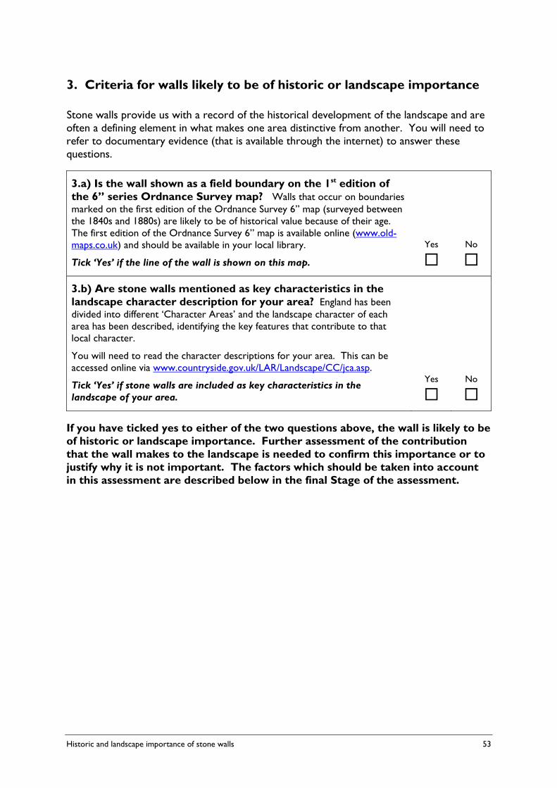
Historic and landscape importance of stone walls 53
3. Criteria for walls likely to be of historic or landscape importance
Stone walls provide us with a record of the historical development of the landscape and are often a defining element in what makes one area distinctive from another. You will need to refer to documentary evidence (that is available through the internet) to answer these questions.
3.a) Is the wall shown as a field boundary on the 1st edition of the 6” series Ordnance Survey map? Walls that occur on boundaries marked on the first edition of the Ordnance Survey 6” map (surveyed between the 1840s and 1880s) are likely to be of historical value because of their age. The first edition of the Ordnance Survey 6” map is available online (www.old-maps.co.uk) and should be available in your local library.
Tick ‘Yes’ if the line of the wall is shown on this map.
Yes
No
3.b) Are stone walls mentioned as key characteristics in the landscape character description for your area? England has been divided into different ‘Character Areas’ and the landscape character of each area has been described, identifying the key features that contribute to that local character.
You will need to read the character descriptions for your area. This can be accessed online via www.countryside.gov.uk/LAR/Landscape/CC/jca.asp.
Tick ‘Yes’ if stone walls are included as key characteristics in the landscape of your area.
Yes
No
If you have ticked yes to either of the two questions above, the wall is likely to be of historic or landscape importance. Further assessment of the contribution that the wall makes to the landscape is needed to confirm this importance or to justify why it is not important. The factors which should be taken into account in this assessment are described below in the final Stage of the assessment.

54 Historic and landscape importance of stone walls
4. Factors that should be taken into account in the further assessment of the landscape importance of the stone wall
The following four factors assess the extent to which the stone wall contributes to the character and quality of the local landscape. They should be assessed by a suitably qualified expert or professional with appropriate experience, membership of a relevant professional organisation or a background in an associated field who is familiar with the process of landscape character assessment. These include advisers from the Farming and Wildlife Advisory Group and other advisers who are members of the Landscape Institute or Institute of Environmental Management and Assessment. If seeking a derogation from RPA, a written report from the independent adviser (including reference to the relevant professional qualifications they hold) should be provided to RPA. The written report should cover the following topics and should refer, where relevant, to the different categories of walls referred to below.
4.a) Style of construction
Is the wall a good example of the local style of construction with one or more vernacular features? The way in which a stone wall is constructed and the vernacular features that it contains contribute strongly to the distinctiveness of the locality and provide a ‘sense of place’. Each region where stone walls are common has its own style of construction, reflecting the type of available stone and traditions of wall building (for instance including shaped capping or top stones, banding of stones or earth cores). Please describe the walls’ style of construction (not its state of repair which is covered below) in comparison with others in the area. You should use aesthetic considerations such as the materials, colour and texture of the wall to decide if the wall is a good example of the local style.
In addition, walls often contain special features such as end stones, stone stiles (gap or step stiles), stone gate posts, holes for animals to pass through (often called creep or cripple holes), boundary markers or stone water troughs. This list is not definitive. Please record which of such features, if any, are present in the wall.
4.b) Physical condition
Is the wall in a good state of repair? A method has been developed for assessing the condition of stone walls as part of the Farm Environment Plan required for applications to the Higher Level of the Environmental Stewardship scheme. This uses short descriptions and pictures to allocate walls to one of three categories, as described and illustrated below. Under most circumstances, a wall in a ‘good state of repair’ is one in which the majority (by length) is in Condition A, with the remainder in Condition B. Please describe in words which one of two of these categories most closely describes the length of wall. • Condition A: Full height wall to below top stones and no gaps along the length of the boundary.
All materials used in any repair or maintenance in traditional materials in the original construction and style characteristic of the local area. No signs of bulging, slumping or bellying. Some top stones missing, but more than 75% present.
• Condition B: Full height wall to below top stones and more than 75% of top stones present. No gaps along the length of the boundary. All materials used in any repair or maintenance in traditional materials in the original construction and style of the local area. BUT signs of bulging, slumping or bellying and section of wall in danger of collapse.
• Condition C: All materials used in any repair or maintenance in traditional materials in the

Historic and landscape importance of stone walls 55
original construction and style characteristic of the local area. BUT gaps along the length of the boundary. Major signs of bulging, slumping or bellying and less than 75% of top stones present.
Schematic illustration of walls in different categories of physical condition
4.c) Visual prominence
Does the wall occupy a prominent position in the landscape? The location of stone walls in relation to the overall landform (for instance on a ridge or in a valley), as well as their colour and texture compared to the land around them, determine whether they make a big or small impact in the landscape.
It is often helpful to consider this impact from the locations where people most often see the landscape (such as settlements, roads and rights of way). The location of the wall close to a public right of way is likely to strongly influence this factor (making it more likely it is of landscape importance). You will need to visit these locations and consider the impact that the wall makes in the overall landscape.
You should place the wall into one of the following three categories, also providing a written description qualifying this decision. Sketches on the final page illustrate these categories. • Prominent: Stone walls are a key boundary feature relating strongly to prominent landform
elements such as ridges and crags; • Apparent: Stone walls are interspersed with other boundary features, e.g. hedgerows and
fencing. They may also be a less prominent feature due to a more gently undulating and less striking landform character;
• Negligible: Stone walls are only intermittent in occurrence and do not define key landform variations.
4.d) ‘Connectedness’ to the network of other field boundaries and features
Does the wall connect with a significant number of other walls or features? Like other field boundaries, the overall network of walls often provides the ‘skeleton’ of the countryside’s landscape. Walls that form connections to other field boundaries and features make more of a contribution to this network than those that are more isolated.
Again, you should place the wall into one of the following three categories, providing a written description qualifying this decision. Sketches on the following page illustrate these categories. • Strong: Stone walls define a clear, coherent and linked network of field boundaries, which is
fundamental to sense of place, enclosure and landscape pattern. Stockproof and/or well maintained, visually continuous walls;
• Broken/intermittent: The spine of the wall network is still apparent but beginning to break down due to decay and boundary loss;
• Weak: The network has been substantially eroded so that it no longer forms a coherent landscape pattern. Isolated, unconnected stone walls.

56 Historic and landscape importance of stone walls
Schematic diagrams illustrating categories for Prominence and Integration/Connectedness

Historic and landscape importance of stone walls 57
APPENDIX 1. THE WORDING OF GAEC 13
GAEC 13. STONE WALLS In these rules, ‘stone wall’ means a stone wall used as a field boundary, with:
• a continuous length of at least 10 metres, regardless of condition; or
• a continuous length of less than 10 metres and meeting (whether by intersection or junction) another field boundary at each end, or forming a small enclosure.
You must not:
• remove a stone wall from your land; or
• remove stone from a stone wall on your land, except for the following purposes:
o It is necessary to widen an existing gateway in a wall to enable machinery or livestock access. No more of the stone wall should be removed than is necessary for the purpose, and the gateway should be no wider than 10 metres. It must also be formalised, with the newly created wall-ends built and maintained to a vertical-face finish. If you wish to widen a gateway to more than 10 metres, you must seek permission from RPA.
o The stone is used to repair another stone wall on your land which is in a better condition than the one from which stone is removed.
o The stone is used for minor improvements to a public footpath on your land, such as providing a solid footing on very wet ground or stone pitching and stepping on steep slopes. If you wish to carry out more substantial repair or improvement, you must seek permission from RPA.
If you wish to remove a stone wall or remove stone from it for any other reason, please contact RPA’s Customer Service Centre. In exceptional circumstances, permission may be granted for environmental, access or agronomic reasons.
Source: Defra 2006. Single Payment Scheme - Cross Compliance. Handbook for England. 2006 edition. PB 11305


Historic and landscape importance of stone walls 59
APPENDIX 2. DEFRA’S GUIDANCE TO FARMERS ON GAEC 13
The following text is taken from Defra’s Cross Compliance Guidance for the Management of Habitats and Landscape Features, 2005 Edition (PB 10222B)19. This guidance is not mandatory on farmers.
GAEC 13 – STONE WALLS This is a new measure for farmers. You will need to comply with these requirements to meet your obligations under GAEC.
Why do we need this measure and what are we trying to achieve?
Walls are an important part of our countryside, but many have declined into a state of disrepair or been removed, as farming practices have become more mechanised and less labour intensive. Walls are important in defining the landscape and historic character of some areas, as well as providing valuable wildlife corridors. GAEC will encourage the retention of walls for the benefit of the landscape, wildlife and future generations.
Good practice – actions to help get the best results
Consider carefully the amount by which you need to increase the width of an existing gap in a wall to enable machinery or livestock to pass through. This will preserve more of the wall and enhance the aims of this measure.
If you are thinking of removing stone from a derelict wall to repair a wall in better condition or a footpath, ask for advice from either the historic environment or archaeological officer, or the landscape officer in your local authority. What may look like a poor quality wall could be of greater historical importance than suggested by its appearance. Make sure you remove only the minimum quantity of stone required to complete the repair. Wall foundations should not be removed. Traditional stone walls enhance the landscape. Derelict walls should be retained where they are of landscape or historic value.
Exceptions
If you wish to widen an existing gap to more than 10m, you must seek permission to do so from the RPA.
Taking stone from a derelict wall for wall repairs under a capital works programme within an agri-environment scheme requires prior permission from the Rural Development Service (RDS).
Opportunities under agri-environment schemes
Environmental Stewardship may have options for the management of walls, offering capital grants for creation and restoration that may allow you to put together a programme of wall maintenance. 19 www.defra.gov.uk/farm/capreform/pubs/pdf/habitathb2005.pdf

60 Historic and landscape importance of stone walls
Other legislation and codes of good practice you should follow
• Wildlife and Countryside Act 1981.
Further information
• Dry Stone Walling – A Practical Handbook, Alan Brooks & Sean Adcock 1999, BTCV, ISBN 0 946752 19 2.
• Dry Stone Walling Techniques and Traditions – The Dry Stone Walling Association. ISBN 0 9512306 8 9.
Historic and landscape importance of stone walls 61
APPENDIX 3. REGULATORY IMPACT ASSESSMENT
Text from Defra’s Final Regulatory Impact Assessment of options for the implementation of cross compliance – Good Agricultural and Environmental Condition, 9 July 2004
HABITAT AND LANDSCAPE – PROTECTION OF DRY STONE WALLS
Description
Farmers will not be permitted to remove or destroy stone walls on the land subject to cross compliance without consent from the relevant authority. This wording uses the hedgerow regulation as a basis and mirrors the standard in Good Farming Practice (GFP) - to provide a minimum possible level of regulation to protect this important regional landscape features across England.
This effectively uses cross compliance to safeguard walls from active destruction and extends to dry stonewalls the protection already afforded to hedges under the Hedgerow Regulations.
Derogations would be given for particular circumstances which will add a degree of flexibility for farmers;
i. Widen field entrances to enable access for livestock or farm machinery;
ii. Enable stone to be used for repair or construction of other stone walls or similar essential purpose, where the existing wall does not function as a means of stock control and has no significant value as a landscape feature.
Economic impacts – public accounts
There will be a modest cost in setting up the derogation system and informing farmers how to use it. This information may stimulate more interest in the already popular field boundary management options in the Entry Level Stewardship Scheme (ELS), although there is increasing pressure on the ELS budget.
Economic impacts – farm business
The only direct costs would be in applying for derogation, plus the opportunity cost if consent were withheld. Walls would not be expected to be maintained under cross compliance and farmers would not be penalised for allowing walls to degrade naturally. The provision for maintenance of stonewalls would be covered by agri-environment schemes such as ELS or the Higher Tier Scheme (HTS).
Environmental impacts
The landscape impact would be significant, preventing active removal of walls (whether for land improvement or simply ’quarrying’ as a source of stone for other purposes). As there is no maintenance requirement, walls would not be protected against gradual deterioration or
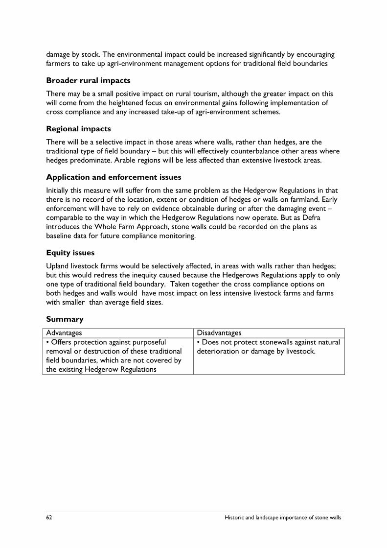
62 Historic and landscape importance of stone walls
damage by stock. The environmental impact could be increased significantly by encouraging farmers to take up agri-environment management options for traditional field boundaries
Broader rural impacts
There may be a small positive impact on rural tourism, although the greater impact on this will come from the heightened focus on environmental gains following implementation of cross compliance and any increased take-up of agri-environment schemes.
Regional impacts
There will be a selective impact in those areas where walls, rather than hedges, are the traditional type of field boundary – but this will effectively counterbalance other areas where hedges predominate. Arable regions will be less affected than extensive livestock areas.
Application and enforcement issues
Initially this measure will suffer from the same problem as the Hedgerow Regulations in that there is no record of the location, extent or condition of hedges or walls on farmland. Early enforcement will have to rely on evidence obtainable during or after the damaging event – comparable to the way in which the Hedgerow Regulations now operate. But as Defra introduces the Whole Farm Approach, stone walls could be recorded on the plans as baseline data for future compliance monitoring.
Equity issues
Upland livestock farms would be selectively affected, in areas with walls rather than hedges; but this would redress the inequity caused because the Hedgerows Regulations apply to only one type of traditional field boundary. Taken together the cross compliance options on both hedges and walls would have most impact on less intensive livestock farms and farms with smaller than average field sizes.
Summary
Advantages Disadvantages • Offers protection against purposeful removal or destruction of these traditional field boundaries, which are not covered by the existing Hedgerow Regulations
• Does not protect stonewalls against natural deterioration or damage by livestock.
Historic and landscape importance of stone walls 63
APPENDIX 4. THE HEDGE (& WALL ) IMPORTANCE TEST (HIT) SURVEY FORM (© GUILD OF CORNISH HEDGERS)

64 Historic and landscape importance of stone walls
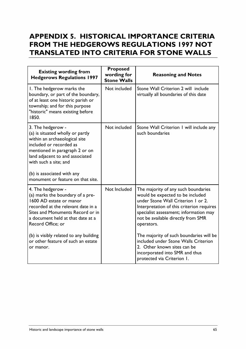
Historic and landscape importance of stone walls 65
APPENDIX 5. HISTORICAL IMPORTANCE CRITERIA FROM THE HEDGEROWS REGULATIONS 1997 NOT TRANSLATED INTO CRITERIA FOR STONE WALLS
Existing wording from Hedgerows Regulations 1997
Proposed wording for Stone Walls
Reasoning and Notes
1. The hedgerow marks the boundary, or part of the boundary, of at least one historic parish or township; and for this purpose "historic" means existing before 1850.
Not included Stone Wall Criterion 2 will include virtually all boundaries of this date
3. The hedgerow - (a) is situated wholly or partly within an archaeological site included or recorded as mentioned in paragraph 2 or on land adjacent to and associated with such a site; and (b) is associated with any monument or feature on that site.
Not included Stone Wall Criterion 1 will include any such boundaries
4. The hedgerow - (a) marks the boundary of a pre-1600 AD estate or manor recorded at the relevant date in a Sites and Monuments Record or in a document held at that date at a Record Office; or (b) is visibly related to any building or other feature of such an estate or manor.
Not Included The majority of any such boundaries would be expected to be included under Stone Wall Criterion 1 or 2. Interpretation of this criterion requires specialist assessment; information may not be available directly from SMR operators. The majority of such boundaries will be included under Stone Walls Criterion 2. Other known sites can be incorporated into SMR and thus protected via Criterion 1.