december 16, 2011 to january 4, 2012 margaret and eric sommer · 2012-01-18 · the seven national...
TRANSCRIPT
The Seven National Parks Tour – aka The Red Hartebeest Tour Page 1
The Red Hartebeest Tour December 16, 2011 to January 4, 2012
Margaret and Eric Sommer
Toyota Land Cruiser 79 series Bakkie! – “Transmogrifier”
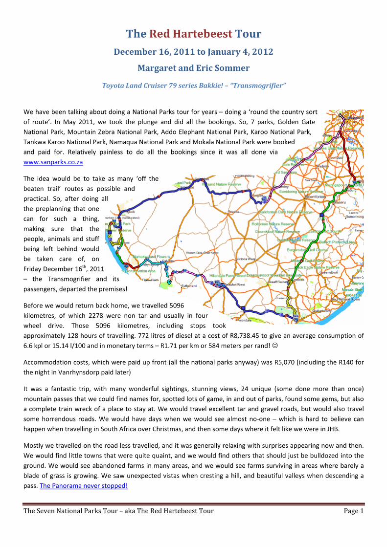
We have been talking about doing a National Parks tour for years – doing a ‘round the country sort of route’. In May 2011, we took the plunge and did all the bookings. So, 7 parks, Golden Gate National Park, Mountain Zebra National Park, Addo Elephant National Park, Karoo National Park, Tankwa Karoo National Park, Namaqua National Park and Mokala National Park were booked and paid for. Relatively painless to do all the bookings since it was all done via www.sanparks.co.za
The idea would be to take as many ‘off the beaten trail’ routes as possible and practical. So, after doing all the preplanning that one can for such a thing, making sure that the people, animals and stuff being left behind would be taken care of, on Friday December 16th, 2011 – the Transmogrifier and its passengers, departed the premises!
Before we would return back home, we travelled 5096 kilometres, of which 2278 were non tar and usually in four wheel drive. Those 5096 kilometres, including stops took approximately 128 hours of travelling. 772 litres of diesel at a cost of R8,738.45 to give an average consumption of 6.6 kpl or 15.14 l/100 and in monetary terms – R1.71 per km or 584 meters per rand!
Accommodation costs, which were paid up front (all the national parks anyway) was R5,070 (including the R140 for the night in Vanrhynsdorp paid later)
It was a fantastic trip, with many wonderful sightings, stunning views, 24 unique (some done more than once) mountain passes that we could find names for, spotted lots of game, in and out of parks, found some gems, but also a complete train wreck of a place to stay at. We would travel excellent tar and gravel roads, but would also travel some horrendous roads. We would have days when we would see almost no-one – which is hard to believe can happen when travelling in South Africa over Christmas, and then some days where it felt like we were in JHB.
Mostly we travelled on the road less travelled, and it was generally relaxing with surprises appearing now and then. We would find little towns that were quite quaint, and we would find others that should just be bulldozed into the ground. We would see abandoned farms in many areas, and we would see farms surviving in areas where barely a blade of grass is growing. We saw unexpected vistas when cresting a hill, and beautiful valleys when descending a pass. The Panorama never stopped!

The Seven National Parks Tour – aka The Red Hartebeest Tour Page 2
We would experience weather that would leave us hot, cold, warm, melting, but in general, we had fantastic weather for the whole trip. The only really hot days we had, where we were taking a bit of strain, were the day we arrived at Mountain Zebra National Park, the day we arrived at Tankwa Karoo National Park and the two days at Mokala National Park. We saw some Skiet Skop and Donner, some a little too close! We would see winds which would wreak havoc with k@k tents! We saw skies so blue it was mesmerizing, sunsets and sunrises that just kept you captivated by what was going to come next.
We had magical moments with elephant, mice and a young pair of plovers. We had an assault on our nostrils when we found a dead elephant. Our ears were treated to sounds of Africa in a myriad of places, some melodic, some cacophonic, some sweet, some – well, not so sweet. We had some stunning evenings in remote locations, we also had some evenings that had us wondering what we were doing there. We had days packed full of new sights, and we had days where things were a little more relaxed. We had some hectic travel days and we had some days when the world sort of slowed down. We met up with some friends along the way, and we met a few strangers – some stranger than others.
We discovered that there are a few things we won’t take on the next trip, and we discovered a few other things we would take on the next trip. Mostly we discovered that we actually had things right.
At the end of it all, we had taken over 1000 pictures and video’s, we had visited so many places that one could easily have spent 3 months doing this trip, never mind 3 weeks. We have collected so many stories and anecdotes one simply cannot put them all down.
Would I recommend that people spend more of their travel budget in South Africa? That they get off the main lines and hit the back roads? Will I do a trip like this again, over Christmas?
YES, YES and YES.
Here is our story! (Note: There are many hyperlinks to pictures and videos – click to view them)
Eric & Margaret Sommer January 2012
Day 1 – Friday December 16th, 2011 Kromdraai to Golden Gate National Park
• Distance - 350 kms (68 non tar) • Travel Time - 6.5 hours (total time, including all stops) • Elevation Range – 1424m to 1916m • Weather – Sunny, Days warm, nights COLD • Pass Count : 1
Kromdraai is a laid back little area, and just to prove a point, as we are leaving we come across an African lady with a box on her head – with several holes in it – and out of one of the holes – A chicken had poked its head and was curiously watching where it was going. My bet – the soup pot! That got us into holiday mode almost right away and so we made our way down to the N1 and scuttled our butts to Sasolburg. Simply had to get away from the big smoke as quickly as possible. We also came across a rather poorly named funeral hearse – Phokeng Funerals! OK, so the H is supposed to be silent, but …..
At Petrus Steyn the first signs of construction were starting, but that didn’t matter as we ducked off to the right and got onto a secondary road which soon became gravel. Good condition, and of course, no

The Seven National Parks Tour – aka The Red Hartebeest Tour Page 3
traffic (or construction) we made good time and soon found ourselves approaching Bethlehem. Here we got into some construction, but not much and the 12km left into Bethlehem were quickly covered.
Passing through Bethlehem without incident, we drove past (intentionally) the turnoff to Clarens and took a smaller farm road just 2kms past the turn and followed that around until eventually you come out 3.7kms before Clarens – just in time to take the Noupoortnek pass.
Now, the plan was to have lunch there, but we hadn’t made up our mind as to what kind of lunch. So we sort of cruisered the streets and discovered that parking on this holiday was at a premium. Clarens is not such a small place anymore! In front of an establishment called Clementine’s, we found ample parking, and as such, they got our business.
Well, we had a very good lunch, prepared by Chef Addo, and also discovered a rather nice beer from the Clarens Brewery. After asking about the origins/source of the beer, we got directions to the actual brewery and headed over there to get some (it is next to the Ugly Duckling on the SE corner of the square). Turns out that Clementine’s is the only other place in town that serves that beer. So, having purchased a box of 8, we continued on our way to Golden Gate National Park.
After check-in, we met up with some friends (Andre and Helene Strauss) who were on their way to meet up with yet more folk and our paths happened to cross in this park. We also were accosted by a rather pompous Honorary Ranger. They were on the warpath for electricity users who hadn’t paid for electricity. Fortunately, I was not plugged in and so not subject to her attentions! As we started getting chow ready for supper the wind really picked up and the temperature dropped quite rapidly. Not having an endless supply of firewood, by 21:00 it was lights out and in bed as that was the only warm place!
Day 2 – Saturday December 17th, 2011 Golden Gate National Park
• Distance - 44 kms • Travel Time – 2.6 hours • Elevation Range – 1738m to 2162m • Weather – Sunny, Days warm, nights COLD • Pass Count : 1 (2)
After a leisurely breakfast, and goodbyes to Andre and Helene, we took a tour around the park taking in the various loops which presented some nice views (1 2 3), and took in Lichens Pass. Stunning scenery and nice sightings of Eland, Mountain Zebra, Black Wildebeest, some smaller buck and yes, Red Hartebeest. It does not take long to meander around this park.
The ablutions were spotless, well maintained and looked almost new. The only drawback with this campsite is the proximity to the main road and the attendant insecurity that brings with it.
That night, again it was cold, and we were soon tucked away. The teenagers in the tents next to us however, were not interested in sleeping, and an off and on argument and screaming matches went on long into the night. Next morning we had devious plans in mind to take a certain cruiser with air horns up to their tent and wake them up, but they got up about the same time as us, so that robbed us of the pleasure.

The Seven National Parks Tour – aka The Red Hartebeest Tour Page 4
Day 3 – Sunday December 18th, 2011 Golden Gate National Park to Mountain Zebra National Park
• Distance - 622 kms (55 non tar) • Travel Time – 9 hours • Elevation Range – 1927m to 825m • Weather – Start Sunny, then clouded over Days HOT, Nights cool. • Pass Count : 4 (6)
Now that we had spent two days having a relaxing time and getting rid of the ‘going on holiday’ stress, we were ready to start the real trip.
We bugged out just after 6am, and headed back towards Clarens. Just before we exited the park, a few Eland were spotted doing their impression of mountain goats! Continuing on we turned south on the R26. There is only one word to describe huge chunks of this road. Stuffed. It falls into the category as one of the worst 4x4 tar roads I have ever seen. There are sections where entire strips of the road are nothing but potholes! Horrible. Not all of the road, but enough that it sticks in your mind as a cr@p road. Along the way we came upon Commandonek Pass, Kommissiepoort Pass, Tienfonteinhoogte Pass.
In any case, we took it easy, and heading down we had been planning to stop in one of the little towns for breakfast, but it seems this was a foolish idea. Sunday’s in Pondokiedorp is not the time to find a breakfast place! By the time we got to Aliwal North, it was high time to stop in at the Riverside Lodge and refuel the bodies. A venison burger (which is 2 large patties about 2cm thick) and a couple of beers and we were sufficiently replenished to tackle the R26 again. Of course, the toilet break was interesting as they seem to have very thin people there that need large basins in the WC!
We continued until we got to the R56, and instead of turning towards Steynsburg, we carried on straight using the Groot-Doringhoek Pass to get down to Hofmeyer. This is a scenic little interlude, and it is in much better condition than the R26 is. Hofmeyer is a scruffy little town with a massive pink religious monstrosity dominating the skyline.
Soon after that, Cradock came into view, and we could feel the temperature was getting very warm (read f’n hot!). On arrival at the entrance gate, the time it took for the formalities to be completed was enough for the temp in the truck to get up to 105 and the madman was screaming at us. Even turning off the air did not help. Anyway, soon we were signed in and a little spurt up to 60 kph quickly got the temp down to under a 100.
We arrived at the campsite and were a little shocked at the cramped conditions. The sites there are barely big enough to put your tent down on, never mind your vehicle. There is all the space in Africa – and your tent pegs are practically in the neighbours tent! We grabbed the first spot that could potentially support a second tent as Peter and Elmarie would be joining us for 2 days the next day.
When I say it was hot, it was hot. Numbers approaching 40 and higher were quoted by various folks. I decided against getting out my meter as I didn’t want to know. Besides it was too hot to expend the effort! We pitched our gazebo and silver sheet first and got that settled in, then proceeded with the tent. I pegged out the windows and figured that this would be enough in the camp area since it was not really that exposed. Duh – about 30 minutes later the sky gets dark, and a wind storm of note kicks up and things start to move. Two quick pegs in the leading corners and that stabilized the tent. Others in the camping area were not so lucky and a few of those “k@k” tents and gazebo’s had their life span shortened considerably. Of course, then there is also a wee bit of rain just too really liven things up. Then a bit of Skiet, Skop and Donner to go with it.

The Seven National Parks Tour – aka The Red Hartebeest Tour Page 5
That evening we enjoyed a dry meal under that gazebo, and after plugging in the fan in the tent as it was still very warm, had a wonderful night sleep.
Day 4 – Monday December 19th, 2011 Mountain Zebra National Park
• Distance - 55 kms (45 non tar) • Travel Time – 4.75 hours • Elevation Range – 1195m to 1625m • Weather – Sunny with showers, Days HOT, Nights cool. • Pass Count : 0 (6)
The next morning was clear, warm and perfect for a game drive. So, guess what, we did. Since Peter and Elmarie Bonfrer would be joining us sometime in the afternoon, and he also wanted to do the 4x4 trails, we did not do any of those, but rather concentrated on the Rooiplaat Loop and the Kranskop Loop. The scenery from the top of these routes is absolutely stunning. We did the Kranskop loop first as we wanted to end up at a reasonable time at one of the two picnic places and make our brunch there.
After brunch, we did the Rooiplaat Loop, and noticed a rather ominous set of clouds approaching, but figured it was just a shower and would quickly be over. HA! As we drove into the storm, the rain, thunder and lightning was quite intense at times, and here is us, in a metal box, with a 2 meter antenna sticking out on top, on one of the highest points around driving in an open veld. Figuring that a moving target was harder to hit, we just kept moving! (at least it made sense at the time ) During our drive, we of course saw Mountain Zebra, Eland, Black Wildebeest, Ostrich, Springbok, Gemsbok, Vervet Monkey, Baboon, Secretary Birds, Rock Monitor, Blesbok, a large tortoise, some smaller buck and yes, Red Hartebeest.
After about 30 minutes the rain subsided and we were soon on our way down the unnamed pass back to the camp. We no sooner got there and parked and drops of rain the size of golf balls started falling. Within minutes there was a river of water 100mm deep running through the entire area we were camped in. All I can say is that I am glad I spent the money on good tents!
Peter and Elmarie arrived around 4pm, and as there was another storm building quickly, we all pitched in to get their tent and stuff setup before the rain hit. And yes, it did. The rain did have one gratifying result in that it broke the intense heat and the temperature was now quite pleasant.
We cooked supper that night (Fillet with blueberry sauce, peas, carrots and onions to go along with the Mustard Mash followed by icecream with Strawberry Sauce, Lindt 70% Thins and Nachtmusik for dessert!) After copious quantities had been consumed it was time for bed. No need for fans tonight as the temp had really gone down quite nicely.

The Seven National Parks Tour – aka The Red Hartebeest Tour Page 6
Day 5 – Tuesday December 20th, 2011 Mountain Zebra National Park
• Distance - 95 kms (85 non tar) • Travel Time – 7.5 hours • Elevation Range – 1049m to 1460m • Weather – Sunny with showers, Days Warm, Nights
cool. • Pass Count : 0 (6)
The next day, after a hearty breakfast was consumed, it was time to go find those Eland as Peter was quite keen to see them after I described the size of them. So, off we went up Rooiplaat loop and onto the Ubejane loop which leads to the Sonnenrust 4x4 trail. And yes, you do need 4x4 and low range to work this loop. All the regular suspects were spotted, but, alas, no Eland. We continued on down and towards the end of the loop, close to the old abandoned farm buildings Margaret spotted something pointy in the bushes to our left. A little careful manoeuvring and we suddenly had a good sighting of two black Rhino! Very skittish they were, and after about 5 minutes, they turned, took 3 paces further into the bush and disappeared! The third vehicle behind us is still wondering what all the fuss was about because they saw nothing.
We continued from there onto the Juriesdam 4x4 trail. And again, yes, you need 4x4 and low range to get up the hill to even start the loop. But after that it gets a bit lame and to be honest, irritating. Not much game up there, views are so so, and the only other good thing about the loop is the descent.
The last 4x4 trail is the Umngeni. It is a short 4x4 trail (and again, yes you need 4x4 and low range) which connects back up with the Rooiplaat loop. About 2/3rds of the way through this, we finally spotted the herd of Eland – with the massive bulls in attendance and Peter was finally happy! They really are magnificent specimens.
By now it was getting close to 3pm and it was time to head back into the camp where it was Peter and Elmarie’s turn to cook the meal. Strangely enough, both of us had chosen Fillet as the meat – not a problem mind you – it was very nice with a creamy mushroom sauce and ice cream for desert! After another bottle of very fine wine had been condemned, it was time to hit the sack.
Oh, you want to know if it rained – well, as a matter of fact, it did – but it was a mild shower just after we got back from our drive. Nothing like the days before!

The Seven National Parks Tour – aka The Red Hartebeest Tour Page 7
Day 6 – Wednesday December 21st, 2011 Mountain Zebra National Park to Addo Elephant National Park
• Distance - 268 kms (248 non tar) • Travel Time – 6.75 hours • Elevation Range – 1615m to 95m • Weather – Started sunny and then clouded over for next 3 days.
Days Warm, Nights cool. • Pass Count : 4 (10)
After good-byes and well wishes to Peter and Elmarie, we departed at 7:45 and headed into Craddock to get supplies as we would not be getting anywhere to anything of decent size town for the rest of the day. Our route took us over Maraiskloof Pass and Swaerhoek Pass in quick succession. From there we continued on down alongside the Klien Vis River to the R63 where we had a short piece of tar road before continuing on a gravel road down to Middlewater. At this point, the GPS units were saying to turn left, even though it was sort of a smallish track, but hey, we’re on holiday, so we turned. The Garmap product told us we had only 5 kms to go to our destination. (snort – they have got some weird locations for the national parks).
Along this little road, which involves a goodly number of cattle gates, donga’s and soft sections, not quite 4x4 needed, but recommended. Definitely not someplace I would take platkar! Suddenly, creeping along towards us with some trepidation, is a Corolla with 4 people on board. We stop beside them and they ask “how far is it to the park entrance and does the road get any better?” Seeing as I had just gone through a dip which would keep that car in it until the next floods, I took pity on them, and programmed in the correct location for the park, and then made sure that they made it out to Beenleegte before leaving them to their own devices. We still had 100kms to go, and I wasn’t going to lead them around the whole way. We left them on good gravel roads, with a GPS with the correct destination (verified) and bid them adieu.
We continued south now towards Stonefountain and then up and over Suurberg Pass then onto Doringnek Pass before finally descending to the R342 and the entrance to the park. The stretch over these two passes has stunning scenery and is really beautiful. The corrugations towards the end can get a bit much.
At 14h15 we pulled up to reception, did the check-in thing and then headed for the Spekboom hide where there is now 5 tented camps with communal ablutions and kitchen. You are situated in between all the trees in the hide and it is quite nice. You cannot however, be out during curfew, but you have private access to the hide all night and can go whenever you like! We got ourselves settled into tent #1, and made ourselves a nice supper which went along with a nice bottle of wine.

The Seven National Parks Tour – aka The Red Hartebeest Tour Page 8
Day 7 – Thursday December 22nd, 2011 Addo Elephant National Park
• Distance - 50 kms (50 non tar) • Travel Time – 5.0 hours • Elevation Range – 115m to 330m • Weather – Cloudy, Days Warm, Nights cool. • Pass Count : 0 (10)
The day dawned cloudy after a threat of rain the night before, at around 9 we headed out for a drive around the park. We of course saw lots and lots of elephant, zebra, eland, kudu, monkeys, baboons, black headed heron, dung beetles (which have right of way ), Bushbuck, Meercats, mongoose and yes, Red Hartebeest as well as tortoise, springbok, jackal and a few others.
On the way to main camp we also detected a rather strong, disgusting odour. We investigated, and although we felt like gagging, eventually found the elephant carcass. We did not stay for long.
Stopped in at main camp and had a nice lunch and did some shopping before heading out again. We were back at the hide around 14:15 and spent the afternoon reading, wandering down to the hide lookout and then later making dinner – PIZZA! . Relaxing day all told.
Day 8 – Friday December 23rd, 2011 Addo Elephant National Park
• Distance - 75 kms (75 non tar) • Travel Time – 4.5 hours • Elevation Range – 12m to 349m • Weather – Cloudy, Days Warm, Nights cool. • Pass Count : 0 (10)
The day started a little later and we decided to take in the southern part of the park. Nice scenic drive with a view on the ocean further down. Good game sightings, although not as many elephants as would be expected. We did however, see some nice buffalo specimens, a monstrous warthog (about 1.5m long!), more eland, wildebeest, springbok, zebra and yes, Red Hartebeest as well as a single lazy male lion!
On the way back to Spekboom, we saw, what looked like an elephant considering suicide. He was slowly moving down a steep slope towards an even steeper drop-off. We watched in amazement as he slowly turned himself sideways and managed to bum slide his way bit by bit to a ledge. Here he stayed for a short while, and then proceeded to go even further down. He had obviously done this before, and it was amazing to watch!
We got back to the hide at around 14h15, and spent the rest of the afternoon reading, watching game and generally relaxing.
The Seven National Parks Tour – aka The Red Hartebeest Tour Page 9
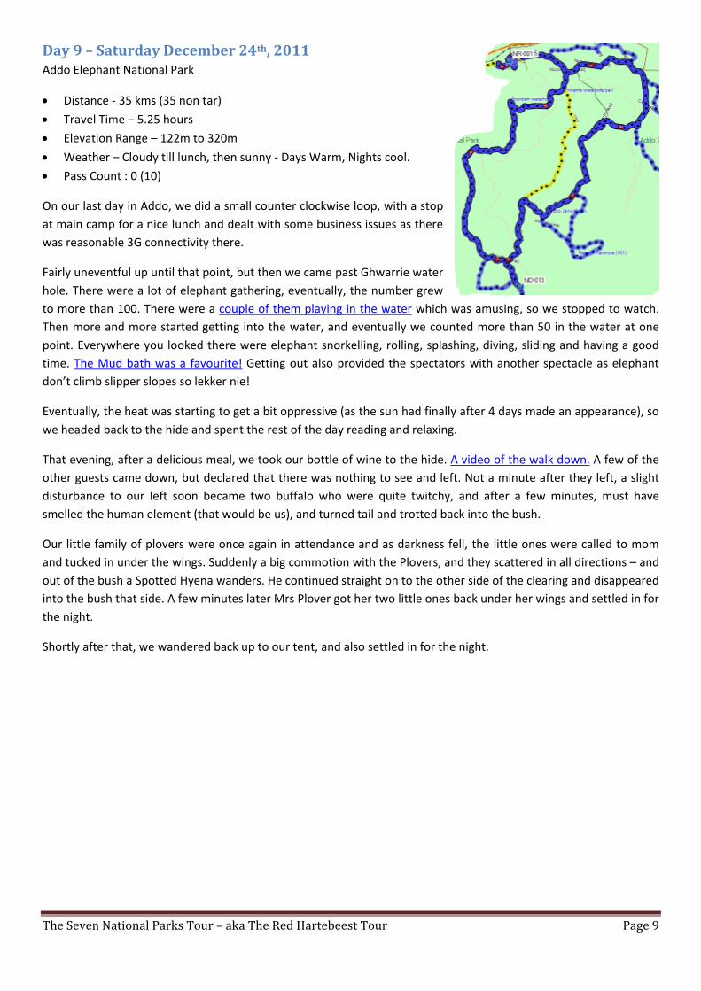
Day 9 – Saturday December 24th, 2011 Addo Elephant National Park
• Distance - 35 kms (35 non tar) • Travel Time – 5.25 hours • Elevation Range – 122m to 320m • Weather – Cloudy till lunch, then sunny - Days Warm, Nights cool. • Pass Count : 0 (10)
On our last day in Addo, we did a small counter clockwise loop, with a stop at main camp for a nice lunch and dealt with some business issues as there was reasonable 3G connectivity there.
Fairly uneventful up until that point, but then we came past Ghwarrie water hole. There were a lot of elephant gathering, eventually, the number grew to more than 100. There were a couple of them playing in the water which was amusing, so we stopped to watch. Then more and more started getting into the water, and eventually we counted more than 50 in the water at one point. Everywhere you looked there were elephant snorkelling, rolling, splashing, diving, sliding and having a good time. The Mud bath was a favourite! Getting out also provided the spectators with another spectacle as elephant don’t climb slipper slopes so lekker nie!
Eventually, the heat was starting to get a bit oppressive (as the sun had finally after 4 days made an appearance), so we headed back to the hide and spent the rest of the day reading and relaxing.
That evening, after a delicious meal, we took our bottle of wine to the hide. A video of the walk down. A few of the other guests came down, but declared that there was nothing to see and left. Not a minute after they left, a slight disturbance to our left soon became two buffalo who were quite twitchy, and after a few minutes, must have smelled the human element (that would be us), and turned tail and trotted back into the bush.
Our little family of plovers were once again in attendance and as darkness fell, the little ones were called to mom and tucked in under the wings. Suddenly a big commotion with the Plovers, and they scattered in all directions – and out of the bush a Spotted Hyena wanders. He continued straight on to the other side of the clearing and disappeared into the bush that side. A few minutes later Mrs Plover got her two little ones back under her wings and settled in for the night.
Shortly after that, we wandered back up to our tent, and also settled in for the night.

The Seven National Parks Tour – aka The Red Hartebeest Tour Page 10
Day 10 – Sunday December 25th, 2011 Addo Elephant National Park to Karoo National Park
• Distance - 412 kms (125 non tar) • Travel Time – 6.75 hours • Elevation Range – 32m to 950m • Weather – Sunny with cloudy patches and showers. Days Warm, Nights cool. • Pass Count : 3 (13)
Christmas day arrived and we were expecting a nice quiet drive to Beaufort West, and we were not to be disappointed. Heading out the western gate, we followed the Sundays River route for a long ways to Kirkwood before joining the R65 heading towards Willowmore. Along the way we traversed the Waaipoort Pass and the Noorspoort Pass before coming into Steytlerville. What a surprise! This town is SPOTLESS! On our way in the flags of the various rulers of South Africa are visible for quite a ways and they seem to be maintained regularly. We also came across a Defender 90 with an overland sticker on the back just as we popped into town. The most amazing thing about this little town is how clean and well looked after it is. It is also has the street lined with flags – each one with a different family name of residents of the town and area. We were so surprised and open mouthed at the sight of this we completely forgot to take any pictures!
We continued on to Willowmore, taking in roughly 32 kms of a single lane concrete road! At Willowmore we turned north on the N9 for 18kms up Perdepoort Pass before turning onto the R306 for a stretch of 110kms of gravel road. This road was in extremely good condition and we travelled a comfortable 100kph on it. As we approached Beaufort West, (which is almost visible from the start of that 110 kms of road – it is flat there! ) – rain started falling, quite heavily at times, but it fortunately stopped before we actually got to our campsite!
Checking into reception at around 13:00 it was quite warm. We were presented with a personalized Christmas card from the team there – nice touch. Service was quick and very efficient and we were soon into our campsite. As you enter the campsite you are greeted with very large tortoises waddling around the camp. Again, a bit disappointed in the size of the sites and the proximity to your neighbours. Although larger than MZNP, (they are at least deep enough so you can park your vehicle in your site), we found them to be a bit plak op elkar! There is however, lots of shade, clean ablutions, and the grounds well maintained. Got ourselves shady site and got busy with setting up.
A little while later, some very dark clouds started approaching, and it was time to batten down the hatches. The rain was quite heavy, but only for a short period of time. Supper and a few glasses of fine red, and it was soon time to hit the sack.

The Seven National Parks Tour – aka The Red Hartebeest Tour Page 11
Day 11 – Monday December 26th, 2011 Karoo National Park
• Distance - 84 kms (70 non tar) • Travel Time – 5.25 hours • Elevation Range – 830m to 1265m • Weather – Sunny with cloudy patches
and showers. Days Warm, Nights cool. • Pass Count : 2 (15)
There were a number of ‘4x4’ trails on the map that was issued at reception, and I was keen to try these out, if only that it would keep the platkars away from us. So, we headed to reception to find out the rules. As the rain had been fairly heavy the day before, we expected a closure or delay of some sort. Everything is open to use, (all 4x4 trails btw are counter clockwise in this park), except the Pienaar’s pass which is a cost of R195. The head ranger was contacted regarding accessibility to the trail and he asked us to please wait until 10am before tackling it to let it dry up sufficiently to be safe. The brochure says “4x4, lowrange and lockers – not for beginners” – they are not kidding – but more on that later.
We decided to do the Klipspringer Pass and the Afsal loop first. Klipspringer Pass is a very scenic drive up a gorge. The Afsal loop, although shown as 4x4 only, can be traversed with a high clearance vehicle. A platkar will struggle along much of it however. Nice scenery, good game viewing, with Gemsbok, Springbok, Wildebeest and yes, Red Hartebeest making an appearance.
We got back to the camp around 11h00 – closed up tents and took the laundry off the line as it looked like it might rain before we got back again, and then, grabbing the key to the gate at the start of the Pienaar’s Pass trail, we departed.
This trail is very interesting. It starts out almost immediately as you pass through the gate with conditions which will stop a platkar. It soon progresses to a point where a 4x2 bakkie will be left scratching its head. Then the first dry river bed crossing comes into view and in the distance, way up on the side of the mountain, you can see a thin little orangeish streak which looks like somebody painted a road onto the side of the mountain. I mounted the camera in the window so we could video this trip up. With the naked eye you can see a thin, very thin ledge which looks like a goat path. At this point the beginner starts having second thoughts! When you get there, you find out it is bigger than that, but only by one goat!
In total it takes about 30 minutes to do the pass, 1st gear, low range, lockers on. And this is where the park was a little lax – they did not ask what vehicle, condition of tyres, if you have lockers and experience level. Although not difficult with the right kit, a bakkie with no lockers and / or poor tyres will struggle immensely up this slope, causing damage to the trail and if they get it wrong, in a few places, they could find themselves over the edge. It is definitely not for beginners. It should not be considered an obstacle course to be beaten into submission, but rather a trail to be appreciated and treated with respect and left in the same condition you entered it!
It is a beautiful drive up, with sheer drop-offs at the top of the trail as you round the mountain. Highly recommended, and although a bit short for the R195 they charge, it serves to keep the numbers on the trail down and the trail in good condition. We were asked when booking to report any damage to the trail and if there was maintenance needed anywhere, and in a few places the previous traveller had kicked loose some large rocks. Other than that, in good condition and this was duly reported.

The Seven National Parks Tour – aka The Red Hartebeest Tour Page 12
At the top of the trail, you are back onto the main loop, and we headed back down the Klipspringer pass back to camp. Arriving back at around 12:50, we settled in to relax, read, and prepare our Christmas dinner – Ham, Pineapple with a hobo pack of Carrots, Potatoes and Onions. A nice day, satisfying and a good sleep followed!
Day 12 – Tuesday December 27th, 2011 Karoo National Park
• Distance - 150 kms (145 non tar) • Travel Time –8.25 hours • Elevation Range – 815m to 1265m • Weather – Sunny with cloudy patches and
showers. Days Warm, Nights cool. • Pass Count : 0 (15)
There were still a number of 4x4 trails to do, and as the theory of not being bothered by the platkar was proven true the day before, we set out around 07:30, headed up the Klipspringer pass and around to the Doornhoek picnic place. Just past this is the split for the 4x4 trails – they all start here. Just after getting onto the Afsal loop, there are the Nuweveld and Kookfontein loops. These are a bit more demanding and a high clearance vehicle, although it can make it, will need a bit more caution in places to get through. However, at the far end of the Nuweveld loop, there is a river crossing, with large rocks and water, that only a 4x4 with low range can get through. Even a softroader will not make this crossing as you need to get into the river and traverse it for about 50m before turning back out onto the track again.
Along the way here, many sightings of game, and grand vistas and some interesting sights into the past when you pass by old abandoned farms. Game sightings included Black Backed Jackal, Steenbook, Red Hartebeest (of course), both kinds of zebra, wildebeest, klipspringer, kudu. There is also, after about 18kms, the turnoff to Embizweni Cottage – which we went to visit to see if it was something to think about next time. Arriving there, it is a proper little house, which (as we found out later) can sleep 4 to 6 (sleeper couch). It has an outside braai, 12V lighting and gas water heater. And an amazing view! To get there from reception, you would need to have 4x4 with low range recommended for a few places, as well as leave yourself 3 hours to get there. It is quite a hike and you cannot drive fast on the trail. However, next time we are travelling down to the cape, a 2 night stop at Embizweni cottage is on the cards!
We decided to have brunch there (nobody in the cottage) and spent almost an hour there relaxing. Then we continued with the route as it was still some 60kms back to camp. This is when we came across that river crossing. We also found a few more abandoned farms, which would in their heyday been quite the setup. For the most part, well-constructed, and only neglect causing the decay.
It took us another 5 hours and 87 kms to get back to camp as we also took in the Kookfontein and Sandriver portions that we had not yet done.
A longish day, but very satisfying. During the entire time we were on the 4x4 trails, we saw not a single vehicle! Arriving back at camp around 16:00, we read until the light got too bad and then it was time for supper. We even managed to have a bit of a social (kijk vuur) as the rain that day was light and very short lived. The camp kids (about 20 of them by this point in time) organized a large game of hide and seek, which was highly amusing at times and provided some entertainment for all the adults!

The Seven National Parks Tour – aka The Red Hartebeest Tour Page 13
Day 13 – Wednesday December 28th, 2011 Karoo National Park to Tankwa Karoo National Park
• Distance - 360 kms (346 non tar) • Travel Time –7.75 hours • Elevation Range – 490m to 1540m • Weather – Sunny Days Hot, Nights cool. • Pass Count :3 (18)
We were quite excited to get onto this part of our trip and where looking forward to three days of isolation without hundreds of other campers practically on your door step. The site we had booked in Tankwa was an un-serviced site with no ablutions or water. It was also an isolated site with the two sites being 1.8km apart from each other. So, we started out quite early in the morning, packed up and lashed down everything in the back as this was going to be a completely off-tar route. At 07:50 we headed out and were soon on the gravel road that runs NW along the park on its way to the Oukloof Pass. This is a stunning little pass which you can see gets some heavy punishment during heavy rains. The road criss-crosses the river bed and in a few places has to get into it. Signs of recent heavy equipment being used to re-open the road after boulders the up to the size of a small car had tumbled into the road! Beautiful drive up. Topping out at around 1540 meters, the view back down the valley was stunning!
Our route took us towards Fraserburg where we planned to fill up with fuel and get some supplies. Well, the total station looked like a bomb had hit it – it was being reconstructed and there was no fuel in town. As it was still holiday season, the town was filled with not so sober folks and the shops were looking rather unsavoury! We opted to just skip it and continued on towards Sutherland.
However this road was shocking, and when presented with an opportunity, just past Droogvoetspoort Pass, to head up to Calvinia on a less travelled and much better condition road, we took it – immediately. The scenery was very nice, but it started to get a bit monotonous at times. This was however broken up with the occasional bright splash of green as you travelled past obvious springs where a farm had been built and trees and green grass were in stark contrast to the rest of the terrain around you. We also came across the Riet River with an amazing stretch of tall green reed grass just before getting to Vlie-Kraal. Here we opted to continue on the more direct route and eventually crossed the Renoster River, Vis River and the Muiskraat River. At Nuwerus we turned down towards Middlepos and the Tankwa Karoo National Park.
Middlepos is owned by the local farmer. The hotel, the postoffice, the store, the petrol station , everything. The store is like a little time capsule from the early 70’s – and take away the electric lighting, one could easily believe you had stepped into a time warp of some sort. Mannequins dressed in 70’s clothing, swatches of cloth from the same era, eyes following you everywhere, it was interesting. We needed some potatoes, and firelighters. We got the potatoes, but when I asked if they had any blitz etc., we were told they didn’t have. A little while later as we were perusing the store, the proprietress comes out with an empty egg carton and offers that as a firestarter! We thanked her but we would be fine.
Finishing up there, we continued on our way and soon came to the top of Gannaga Pass. What a stunning view presented itself to us! On the way down the pass the views of the road below you (you drop 500 meters on this pass) are quite breathtaking! Even after the pass is done, you continue to drop another 250 meters in elevation.
Arriving at reception, we were left waiting a few times as there seemed to be only one person in attendance, even though a few others were flitting about. But in any case, we eventually were dealt with and then we were handed keys. I’m thinking – ‘oh, there must be gates’. Nope – these are keys to the new ablutions and kitchen. Each site now

The Seven National Parks Tour – aka The Red Hartebeest Tour Page 14
has private flush toilet, large shower and a kitchen. Ok, unexpected, but nice. Then the shock – the two sites have been moved onto the same bit of ground and the two ablution sets are actually in one building with a site on either side of the building. Ok, so we will have neighbours, but it will be only one site, and with all the space available, we were still confident we would have a few days of isolation after the crowds in the previous parks.
We head out (and it is very warm out), we start the 12 km trip up the track to the campsite. On the way we spotted some game, including yes, Red Hartebeest , and eventually we arrived at the site. What an utter disappointment. Site #2 had been allocated to us, which is around the back of the ablutions, next to the water tower and windmill. Although site #1 is adequate and has sufficient flatish ground for tents and such, as well as a view of the mountains and valley in both directions without a building in the way, Site #2 is cramped, has only 1 flat area, other than the flatish one with the shade cover for your car (which is barely large enough for a Yaris). The only spot where one could put a tent down was occupied with hard clumps of cement from the building operation and was unusable. The view in any direction, except straight up the mountain behind you, included a ruin which blocked your view down the valley, the ablutions which obstructed your view across the valley, and the water tower & windmill which made looking up the valley impossible.
Although the ablutions are stunningly nice, the camp site is not usable and should be abandoned as a bad idea. Site #1 is acceptable, but site #2 is useless. With that disappointment, we decided to travel up to the end of the track and see if we could rather camp there. But on arriving there, the site has been mostly overgrown with drie doornen and 3 steps completely caked the bottom of your shoes with thorns. On the way back to the official campsite, we looked again at the workers site (now abandoned) about 300 meters north of the official site – it’s an option. On return to the site, we found the occupants of #1 one there, Russell and his mate from the landcruiser forum. We chatted for a while, and then we made up our mind we were not going to camp at the ablution block, but would return to the site 300 meters north.
We stopped at that spot, and as the temperature was still screamingly hot (40+ would be my guess), grabbed a few beers, our books and hid in the shade of the truck until the temperature had dropped sufficiently to setup camp. We also discussed whether we should camp there for 3 days, or only 1, go back to ask if we could be moved for the other two days, or just leave and go someplace else. We decided to sleep on it. After a stunning evening, looking at the sun setting on the hills opposite us, with a meal around the fire and clear night skies, and as the temperatures had now dropped quite a bit, the hot water heater was pressed into service, giving us a nice hot shower and we ducked into bed.
Next morning, decision made, we would depart and head to the coast and look for something there for 2 nights

The Seven National Parks Tour – aka The Red Hartebeest Tour Page 15
Day 14 – Thursday December 29th, 2011 Tankwa Karoo National Park to Vanrhynsdorp Caravan Park
• Distance - 284 kms (136 non tar) • Travel Time –7.0 hours • Elevation Range – 104m to 1478m • Weather – Sunny Days Hot,
Nights cool. • Pass Count :1 (19)
Having made the decision that we would not be staying another night, for the simple reasons that we were breaking the rules by staying in a spot we should not be, and there was no way we would camp in that abortion of a camp site at Langkloof #2, we were packed and ready to go by 8:00. It was a disappointment, but as we had heard the day before while at reception, they were full, and getting them to squeeze us in with others would simply have spoiled it even further – for us and those we were being squeezed in with.
We stopped at the official site, and since we had paid for the use of the ablutions, had a shower before moving on down the trail back to reception. Here we reported our disappointment, handed back the keys and informed them we were moving on. They had nothing to say.
We opted to go back up the Gannaga Pass as it was quite stunningly beautiful and we had a spot in mind about half way up to stop and make breakfast. This we did, while being monitored carefully by a klipspringer! Breakfast done, we continued up the pass and made our way to Calvinia. We didn’t go back to Middlepos, but took one of the other roads and after 136kms of sometimes bone jarring corrugations, joined the R27 for the last 20kms or so into Calvinia. Here we fuelled up, did some shopping, replenished other fuel supplies, looked half-heartedly at some of the camping places and moved on. While getting some cash from the ATM, the local kids were trying to sell us standard gov’t loaves at R5 and then later at the liquor store they tried to sell us pamphlets – old ones! Enterprising little devils!
Continuing with the R27 we soon arrived in Nieuwoudtville where there was a supposed campsite or two. Don’t believe a word of that. All abandoned or closed or just so scruffy I wouldn’t stay there. It was still plenty early and we just carried on, down the Vanrhyns Pass until we arrived at Vanrhynsdorp. Here we found Vanrhynsdorp Caravan and Camping. It was respectable looking, there were other campers there, so we decided that we had travelled enough for the day. With everyone trying to park up top close to the ablutions, we opted for the lower section of the facility and setup in a nice shady site. Cost was R140 – and we scored a bag of ice courtesy of the establishment.
That night we made pizza, and enjoyed a quiet evening around a fire and contemplated where we would go tomorrow. No real plan other than to head to Lutzville and hit the coast and see what we could find. With that done, and a few bottles of nice red having been wrung out, we hit the sack.
(PS: There is a nice restaurant there, but it was closed for the holidays – the owners needed a break It looks clean and respectable with a well-stocked bar. We would have tried it out had they been open.)

The Seven National Parks Tour – aka The Red Hartebeest Tour Page 16
Day 15 – Friday December 30th, 2011 Vanrhynsdorp Caravan Park to Transhex Mining Concession
• Distance - 143 kms (88 non tar) • Travel Time –4.0 hours • Elevation Range – 4m to 150m • Weather – Sunny Days Hot, Nights cool. • Pass Count :0 (19)
This was going to turn out to be an interesting day. Early in the morning, we overheard several other campers discussing that they had been looking for a place along the coast for almost a week and there was nothing available. We sort of expected that, but it presented a challenge. So, packing up and grabbing a quick shower, we were ready to roll by 8:15
As soon as we started driving, we continued with our search for places to stay using the GPS units. We had hunted around a bit the afternoon before with the laptop, but had not found anything yet. We passed through Vredendal then Lutzville where we crossed the Olifantsrivier as it was obvious from our search that heading towards Strandfontein would be a waste of time.
We found reference to a Boesmangrot campsite. So we headed there and on arrival found it ‘interesting’ but not really someplace to camp. It was filed under ‘last resort’. Continuing along the road we ended up at the Transhex Mining concession and there were boom gates and security. Oh well, started to turn around when Margaret suggested asking if we could go through. “Sure, no problem – just sign here.” And open the boom gate went.
You cannot go far, but there are two places where you can get down to the beach, one of them right across from Elephant Rock Island. At the other spot, we saw a cruiser and an off-road caravan packing up after obviously staying there for the night. A little idea started sprouting. As you can’t go any further than the gate just past the Elephant Rock Island spot, we headed back to the boom gate and asked if we could camp there. “Nope – sorry”. But we still had a plan now. So we headed back, and not far from the signage declaring that you are entering the Transhex yada yada, is a farm lane. We followed that for several kms, getting ever closer to the beach and suddenly you pop out in the mining concession again. With a locked gate to our right, and knowing there is a locked gate to the left somewhere, we decided that staying there was perhaps not a good idea and backtracked.
Looking at the GPS, Skaapvlei looked like the next best place to attempt a beach camp. So, soon we found ourselves rattling down a corrugated road, meeting 4x4’s with and without off-road trailers bolting out at very high speeds. Phucking idiots! But, it gave us hope that we could find someplace to camp. We met a local vehicle from the mines coming towards us just after we passed Skaapvlei and flagged him down. “If you can find space, you can camp – just stay away from any operational areas” was the answer to our question as to the availability of camping. (we would discover the significance of the words ‘if you can find space’ the next day) We continued another 4.5kms and since we were now on obvious slow driving tracks, we stopped to grab a beer and a nature break. There was a little track heading to the left, which we followed and soon we found a little lane that dropped down to a little cove which had just been abandoned by another camper. We pulled in, and as it was quite secluded, sheltered and flat, decided we had found home for the night. It was 12:30
We setup camp, and spent the afternoon wandering around on the rocks, looking at the ocean, reading and generally had a brilliant afternoon on the beach. The temperature started to descend into the chilly zone, so after preparing a nice chunk of rump, we built up a nice fire and had a stunning evening watching the sunset (starts at

The Seven National Parks Tour – aka The Red Hartebeest Tour Page 17
19:55 – dark at around 21:00), listening to the waves and watching the stars slowly winking on. Later we fired up the water heater and got ourselves a nice hot shower before ducking into bed!
Day 16 – Saturday December 31st, 2011 Transhex Mining Concession to Namaqua National Park
• Distance - 201kms (150 non tar) • Travel Time –5.25 hours • Elevation Range – 4m to 802m • Weather – Sunny Days Hot, Nights cool. • Pass Count :3 (22)
We had a lazy morning as we did not have far to go to Skilpad, and had a lazy breakfast before packing up and heading out at 9:45
We drove no more than a kilometre and we started to get the significance of the words “if you can find space you can camp!” Wow – every single little spot that you could put down a tent, park a caravan or park and pop up the roof top was filled. We stopped counting the number of vehicles when we got into the hundreds, and we had only travelled a few kilometres! For close to 60 kms, up past the salt works, right to and past the actual mine (which was operating btw), every little spot was taken. We then realized how lucky we were with the spot we got the night before. Yes, we could have found a place to park off, but it would have been a windy, exposed site which would not have been near as enjoyable as the one we were in.
After a beautiful drive up the coast, with a lot of deep sandy sections thrown in for good measure, we arrived at the Brakriver and we turned inland. We could have continued along the coast to Groenrivier, but wanted to get to our cabin at Skilpad. The road to Garies slowly gets bigger until eventually it is a badly corrugated road and the tar of the N7 was welcomed.
We had used up a good portion of our wood the night before with our kijk vuur and running the water heater , so replenishment was needed. We also wanted to get some icecream to create an excuse to have some more of the Nachtmusik! So, we pop into the OK Grocer there and realised that our timing was about perfect – it was after all a Saturday and the last day of the year (you forget these things when travelling) and they were about to close the shop. Rolls, Icecream, wood/charcoal, firelighters. Ummmmm – no wood, no charcoal, no firelighters. Not a scrap of bread in any shape or form in the shop – Margaret finds the icecream, but by now we are getting a bit suspicious of anything in the shop! So, she opens the tub (the seals were broken already) to discover that it is half eaten! Checks another one, same thing. Obviously, the little blighters are sneaking a snack right in the shop, and the matron at the door missed that one! So, leaving without anything on our list, we headed up Garies Pass, Brakdam se Hoogte Pass and Darter's Poort Pass heading for Kammieskroon and our turnoff for Namaqua National Park.
We found wood and rolls in Kammieskroon (Margaret reports the shop as reasonable selection of basics), filled up with diesel and soon the last 20 kms to the park were done. Check-in was a breeze and we headed to the cabin. As we crested the hill just past the Roof of Namakwaland the sight that greeted us was stunning. Then we opened the cabin and walked in – what stunningly nice cabins! Very well equipped, very clean and nicely laid out. Even a bottle of champagne, Lindt 70% Thins and a ‘compliments of the season’ card addressed to us. Stunning views over the valley, built in braai in the lounge, windows that open all the way so you have the open air feeling, very very nice. It was only 14:00 and we were soon unpacked and we settled in for a relaxing afternoon. Well, after we cleaned out the beer fridge that is! The corrugations had rattled open a MGD that had tipped sideways and the bottom of the fridge had, well, a bottle’s worth of beer puddled in it!

The Seven National Parks Tour – aka The Red Hartebeest Tour Page 18
Come supper time, as the wind was a little too brisk for a fire outside, we opted for the indoor braai, which turned out to be not such a bad thing as the temperature was also dropping quite rapidly towards the single digits. (Next morning it was 9C) Closing up the windows, getting fillet cooked, which went along with a nice mustard and Gruyere mash and of course a nice bottle of red, we sat by the fire watching the sunset!
A relaxing day, with stunning views, both along the ocean and on the inland routes – we were now looking forward to the Caracal Eco trail the next day!
Day 17 – Sunday January 1st, 2012 Namaqua National Park – Caracal Eco Trail
• Distance - 325kms (285 non tar) • Travel Time –10.75 hours • Elevation Range – 4m to 802m • Weather – Sunny Days Hot, Nights cool. • Pass Count :1 (23)
Up early as we knew this was going to be a long day, and we departed at 6h30. We had looked at the various options for the trail, but decided to drive the trail as per the booklet from beginning to end. The Caracal Eco trail has been expanded and is now split into two sections, the Inland Portion (red) and the Coastal Portion (Cyan). The inland portion is further bisected by a public road for 33kms.
We set out and being still early and very cool (10C on the truck’s madman water temp) – the rock dassies were sunning themselves in the early morning sun. Gemsbok, Springbok, Bat Eared Fox, Ostrich, Wildebeest and yes, the Red Hartebeest all made an appearance at some point during the day. The views and vistas presented to you as you wind through valleys and then up ‘mountains’ were stunning. I can only imagine what it looks like during flower season. Soon we were at the top of Wildeperdehoek Pass and we started our way down. Not a pass to be taken at speed! Once at the bottom you have a 29km run along a good gravel road to continue with the trail itself.
There are two shortcut options on the Caracal Eco trail, one which will save 18kms or if you take the earlier shortcut via Soebatsfontein it will chop off 30kms and if you choose to take the most direct route to the restart of the trail where it leaves the main road, you’ll chop off 40kms. Personally, if doing this again out of flower season, I would do the first part of the trail up to Kookfontein, and then hook a left direct to the restart point. It gets a bit monotonous and add some serious time onto the trip. Although, the majority of the time is taken up in the southernmost portion of the coastal section.
In any case, after 111kms, we arrived at the end of the inland section, and although scenic and it has some interesting things, this section will be most beautiful during the flower season. Signing in across the road for the coastal section (need to have your permit or campsite reservation to get in), we immediately discovered that this portion is travelled a lot, and the corrugations in places were horrible. Just a bit further is a gate, with a sign “Please don’t steal the gate. Just close it”! 17kms in, a cutoff towards the Spoegrivier caves gave us welcome relief from the corrugations. Now the sand started to get thicker and the corolla travelling behind us eventually gave it up and the passengers got out into the bakkie following them. The sand got really thick then, but still easily driven. Arriving at the Spoegrivier caves, Margaret climbed up into the right eye socket where she could be the twinkle in the eye! Locals of course ignore all the closed road signs and drive wherever they please as we discovered just then when that bakkie with the corolla passengers came down a clearly marked (at both ends) closed road. Eish!

The Seven National Parks Tour – aka The Red Hartebeest Tour Page 19
The day then became an ocean view day with many little stops along the way to admire the view and investigate each little camp along the way. The 80kms of the coastal section of the trail took us almost 5 hours to complete! We stopped to make some soup for lunch, we assisted a couple who had gotten stuck in the southern sands, and generally took our time to travel this piece. At one point we spotted some Cape Fur Seals having some play time. (Cape Fure Seals). We also spotted some Sandpipers scurrying along the beach. (Sandpipers) The sand in the south is really thick and speed of any sort is impossible what with undulations which rock you side to side viciously! At around 15:00 we got to the southern end, and any thoughts of going back up the trail to go home were put aside as that would be a long long ride back.
So, we headed for Garies, but presented with an option to not go directly to Garies, but to take a road up to Bitter River, we did. This brings you out at the top of the Garies Pass. Another 40kms and we were back in Kammieskroon and the 24kms back to the cabins was quickly covered. Just before we got to the park gates themselves, we spotted two Bat Eared Foxes, literally meters away from a flock of sheep, who didn’t give a d@mn!
Back at around 17:15, it had been a long day, but an immensely satisfying one. That night, the temp was also a bit cool, so, the indoor braai was pressed into service again, but this time for a kijk vuur as we were having Chicken a la king for supper. We had a wonderful time watching the sunset, and then sitting in front of the fire as the wind outside made it feel very much like you were surrounded by flying snow! Three bags of wood later, some good red wine, some port and sherry, and … - ah – it’s k@k in Africa!
Day 18 – Monday January 2nd, 2012 Namaqua National Park to Mokala National Park
• Distance – 883kms (140 non tar) • Travel Time –10.25 hours • Elevation Range – 450m to 1395m • Weather – Sunny Days Hot, Nights
cooling from warm. • Pass Count :1 (24)
Again, up early as this was going to be a long, long day. Fairly easy going for the most part, but long none the less. Originally the plan was to take mostly secondary roads, but the sheer length of the drive made that a silly plan and we opted to head up to Springbok, Uppington, Griekwastad, Campbell, Douglas and finally into the Mokala National Park. So, leaving at 05h35, back to Kammieskroon, up Burkes pass and on to Springbok, Aggeneys, Pofadder, Kakamas, Keimoes and into Upington where we fuelled up at the BP and tried to buy some chomp. Greasy burgers and questionable sammies resulted in an icrecream sandwich instead.. Then it was on to Groblershoop, Griekwastad and Campbell where we turned onto gravel again. From here, except for a short little piece in Douglas would be gravel, some very badly corrugated sections and by the time we reached gates of Mokala, we were pretty gatvol of them.
It was hot, very hot, when we arrived at the entrance to the park, and after using the radio to inform them we had arrived, the gate was opened and we entered. We immediately broke a rule, got out of the truck, opened up the back and grabbed a few beers!
6kms to the reception office, get checked in, buy 4 bags of Kameeldoring and off to Haak en Steek Kamp where we arrived at 15:40! As we pulled in we saw a nice shady spot to the right of 2 vehicles parked there and I pulled up there to check things out. Turns out we didn’t move the truck from there anymore! We plunked our tent on the ground, setup the gazebo with silver sheet, pegged everything down and sat down to watch a herd of, yes, Red Hartebeest around the watering hole! And now you know why this was called the Red Hartebeest Tour. In every

The Seven National Parks Tour – aka The Red Hartebeest Tour Page 20
single park, and quite often on the drives between parks, we saw Red Hartebeest! Every single day, including the day we did the Caracal Eco trail we saw Red Hartebeest!
Other critters spotted were Giraffe, Gemsbok, Black and Blue Wildebeest, Mountain and Birchells Zebra, Roan Antelope, Warthog, Cape Hare, Eland, Tsessebe, Jackal, Baboon, Steenbok, Springbok and the list goes on. The relocation from Vaalbos has obviously not bothered this lot too much and they have adopted their new home easily!
When the temperature cooled to a more reasonable level, we heated the Chilli and together with some crackers and a nice red wine, had a good supper. It was quite warm, so the inverter was pressed into service, and the fan was placed in the tent and by 10pm we were gone!
Day 19 – Tuesday January 3rd, 2012 Mokala National Park
• Distance – 62kms (62 non tar) • Travel Time –3.5 hours • Elevation Range – 1153m to 1286m • Weather – Sunny Days Hot, Nights cooling from warm. • Pass Count :0 (24)
As you can well imagine, today was not going to be a day of long game drives. We didn’t even consider driving up to the top of the park – it’s a long way and we had ample entertainment at our own camp.
We set out just before 10:00 after a nice breakfast and decided to do the Matopi loop, which is around our camp first. There is now a nice picnic area at the northern end of this loop, complete with braais and ablutions. That would determine if we felt like driving more, and getting to the end of that, we then did the Tsessebe Loop, on which we saw no Tsessebe, but we did see ?? yup Red Hartebeest!
Stopping at reception to make use of the ablutions there we then did the Kameeldoring loop, where there is now a new Bird hide with flush toilet and at the northern end of this, a new picnic area (it will be called Kameeldoring Picnic Area according to the rangers) – also with Ablutions.
On the way back we stopped in at the new camp, Motswedi, where there are 6 camp sites, each with their own ablutions and kitchen (each building has two sets of everything – one for a site). Looks pretty reasonable and being that there can only be 6 groups, should be nice.
Back to our camp, which in my view is the better of the two, even though the ablutions leave a bit to be desired. The lack of any fencing at all, and the direct view onto a small dam which is visited 24 x 7 by a wide variety of game makes it the better place.
The honorary rangers who were camped there were a chatty lot, with a malfunctioning volume control. They had been there so long they had sort of moved into the men’s ablutions, and thought nothing of having a smoke while taking their morning constitutional – which is fine – but not when you are hogging 50% of the available facilities!

The Seven National Parks Tour – aka The Red Hartebeest Tour Page 21
That night, our last, we braaied a nice rump steak, made a hobo pack of Carrots and Onions, warmed up the Gruyere mash from a couple of nights back, opened up a good bottle of red and had a very nice meal, looking onto the watering hole, watching the antics of the zebra, tsessebe, red hartebeest (of course), cape hare, warthogs, wildebeest etc.
It was not going to be a long day the next day, so we sat up a bit later than normal. It was still quite warm, so the inverter and fan were pressed into service again when we went to bed. It really does make for a good night’s sleep. Part way through the night the temperature cools enough and you simply reach over and switch off the fan, and go back to sleep. Zzzzzzzzzzzz
Day 20 – Wednesday January 4th, 2012 Mokala National Park to Kromdraai
• Distance – 587kms (70 non tar) • Travel Time –7.3 hours • Elevation Range – 1115m to 1730m • Weather – Sunny Days Hot, Nights cooling from warm. • Pass Count :0 (24)
We had not been looking forward to the last part of the trip on the N12 – it is, to put it bluntly, a POS to drive. We left at 7:30 and although the traffic on the N12 south of Kimberly was light, we fully expected it to get heavier as we went along. In Kimberly, one of the GPS units indicates a hook onto the R64 – taking a look at it, I saw that it would be a less travelled route, and was in fact, slightly shorter. So we did as Sally said, and turned onto the R64 (after a brief stop for a mini- roadblock) and soon we were on our way NE towards home on the R64.
What a pleasure – other than 40kms of gravel from Boshoff towards Hertzogville – it is a mostly empty road and travels easily. Yes, there are a few sections which have some potholes, but compared to other roads we have driven on this trip, acceptable. We opted to continue over to Parys and then onto the N1 as that would avoid the N12 altogether and it turned out to be a good choice. The 587kms quickly went by and we were home just on 15:00
No unpacking happened, two of our daughters were home and had kindly replenished the beer supply (thanks Cornelia and Alida) and we spent the afternoon catching up with the happenings at home and regaling them with some of the stories of the trip!
Home Sweet Home!

The Seven National Parks Tour – aka The Red Hartebeest Tour Page 22
Final Thoughts Places we would definitely visit again are Addo Elephant, Karoo (at Embixweni Cottage), Transhex Concession, Namaqua and Mokala. Mountain Zebra misses out only because the sites are so d@mn small. Golden Gate is at best an overnighter – it’s just too noisy and close to the road. Tankwa – well, when some other travellers report an improvement or can show that other sites are better, I’ll reconsider – for now – no.
Our favourite of this trip? Namaqua and the Transhex Concession.
Time of year – although it is pleasant, albeit a bit warm in places – by staying off the main routes and PREBOOKING everything – this is a very doable trip with little or no stress. Certain areas would of course be better by visiting in their prime time, such as Namaqua, but I doubt that the coastal section will be as pleasant at that time.
Length of trip – some places could benefit from a longer stay (Namaqua, Transhex, Mokala), others, like Addo and Golden Gate was a day too long – but in general – 3 weeks is about right for this.
We also discovered that the 500ml ‘buddy’ bottles are the ideal cold drinks size, and they have multiple uses. First, your drinks don’t get punctured, they are re-sealable, can be used for water afterwards, and can also be frozen to make ice cubes. We froze them, the tapped them on the edge of the shovel while turning them to induce cracks in the ice (move up a few cm’s each time you have completed the circle of tapping) – the peel the plastic with a sharp knife (don’t cut yourself), and then using same knife, a sharp tap on the fracture – and voila – an icecube!
Cold drink cans have become so thin that the slightest injury to them results in a leak, they are not re-sealable and can’t be used for anything after they are opened other than cutting yourself!
We also learned that the fuel supply may not be as you expect it, and we were very glad (although we didn’t use it) that we had an extra 20L in a jerry can. Supplies away from the bigger towns get thin, and you can really only rely on getting the basics and staples.
We also learned that just because somebody submitted a POI to T4A, it doesn’t mean it is suitable, even in an emergency. You need to check these things, and don’t drive until dark only to find out the place is a scrapheap, unsuitable, dangerous and you are now desperate.
So, start your planning for your own round the country trip – and have fun!
We did!
Eric & Margaret Sommer, January 2012