deakin avenue urban design guidelines...the deakin avenue urban design guidelines project will...
TRANSCRIPT

i

Deakin Avenue Urban Design Guidelines | Key Issues Report
© planisphere 2015 2
© Planisphere 2015.
This publication is copyright. No part may be reproduced by any process except in accordance with the provisions of the Copyright Act 1968.
PROJECT CONTROL
NAME NO. PM APPROVED PD APPROVED DATE
Key Issues Report 1 CE LR 26/06/2015
Key Issues Report 2 KW MS 10/07/2015
The Study Team recognises that the State of Victoria has an ancient and proud Aboriginal history and complex ownership and land stewardship systems stretching back many thousands of years. We would like to acknowledge the Traditional Owners of this land, and offer our respect to the past and present Elders, and through them to all Aboriginal and Torres Strait Islander People.

Deakin Avenue Urban Design Guidelines | Key Issues Report
© planisphere 2015 3
CONTENTS
1. Background............................................................................................. 1
1.1 The Project .................................................................................... 2
1.2 Study Area .................................................................................... 4
1.3 The History ................................................................................... 6
1.4 Strategic Documents Review ........................................................ 7
2. Existing Conditions ............................................................................... 14
2.1 Planning Scheme ........................................................................ 15
2.2 Demographic Overview ............................................................... 23
2.3 Existing conditions analysis ......................................................... 24
3. Issues and Opportunities ....................................................................... 35
3.1 What we Heard ........................................................................... 36
3.2 Key Issues ................................................................................... 38
3.3 Key Opportunities ....................................................................... 40
3.4 Summary of key considerations .................................................. 47
4. Appendices ........................................................................................... 48
Appendix A - Summary of Responses ....................................................... 49

1
1 BACKGROUND

Deakin Avenue Urban Design Guidelines | Background
© planisphere 2015 2
1.1 THE PROJECT
The Deakin Avenue Urban Design Guidelines project will respond to and guide the current and future development of the Avenue. The project aims to present a vibrant image that will maintain the Avenue’s sense of place and unique character.
Deakin Avenue, which is also part of the Sturt Highway, is the main spine of Mildura that ties the majority of the neighbourhoods together. The Avenue may be considered one of the most significant remaining examples of a true boulevard in regional Australia. In form, the Avenue is a typical American Style Boulevard defined as a wide, multi-lane arterial thoroughfare, divided by a median down the centre, with parking lanes and paths for bicycle and pedestrian usage, and often with above-average landscaping and scenic quality.
The design of Deakin Avenue was influenced by Californian street models of the 1800’s which allowed generous space for planting and trams (street cars), but which were later paved over to make way for more traffic lanes. Now, Mildura’s Deakin Avenue stands as one of only a few, traditionally scaled streets in the world.
To maintain this unique scale and geometry the Guidelines must consider:
Ways to integrate new development that complements historic buildings
The need for precinct definition to guide the future uses and activity
Retention of existing vegetation or revegetation to maintain the historic character on both private and public land
The Deakin Avenue spine is becoming more vital and multi-faceted than just a main street of a town, though that role will remain. It is time to re-invigorate the Avenue as a vital artery of Mildura’s civic and social identity.
The Avenue needs to maintain and enhance its various roles as:
A spine of strategic land uses
An avenue of destinations
A primary connector of activity centre to neighbourhoods
A serial, image-defining, visual experience
1.1.1 KEY ISSUES REPORT
This report has been produced to provide an overview of all the key issues, preliminary opportunities and relevant statutory requirements that have ongoing impact, or have the potential to impact on the form and function of the Avenue. The report is structured in three chapters which discuss the background, existing conditions and issues and opportunities along Deakin Avenue.
Chapter 1 provides an overview of the project and the study area. It discusses the history and development of Deakin Avenue and more broadly the township of Mildura. A review of the relevant strategic documents that have shaped the planning and development of Deakin Avenue is also undertaken.
Chapter 2 provides an existing conditions analysis which looks at current planning scheme controls and policies including summary descriptions of the relevant zones and overlays which apply to the study area. A demographic overview establishes the housing and economic trends which provide a basis for a detailed analysis of land use, public realm, townscape and urban design and road access and movement elements.

Deakin Avenue Urban Design Guidelines | Background
© planisphere 2015 3
Chapter 3 provides a review of the issues and opportunities along Deakin Avenue, including initial feedback which was provided at the commencement of the project by key stakeholders. The feedback highlights important issues which need to be addressed by this project and which underpin a number of key opportunities that to be explored.

Deakin Avenue Urban Design Guidelines | Background
© planisphere 2015 4
1.2 STUDY AREA
The study area incorporates all land and built form fronting Deakin Avenue, up to and including the road verge. The study area does not include the centre median strip or the road pavement. However, the relationship between the road/median strip with the built form and verge will be considered and addressed.
Deakin Avenue passes through a wide variety of urban, suburban and rural forms, beginning at the south side of the railway line on the Murray River extending through the town centre to Gordon Avenue where the Sturt Highway turns north-west.
The length of the study area is shown on the following page at Figure 1 – Deakin Avenue Study Area Map.

Deakin Avenue Urban Design Guidelines | Background
© planisphere 2015 5
Figure 1 - Deakin Avenue Study Area Map

Deakin Avenue Urban Design Guidelines | Background
© planisphere 2015 6
1.3 THE HISTORY
This project provides an opportunity to reconsider and express the legacy of three giants of Australian regional development: Alfred Deakin, and the Chaffey brothers.
A major drought in Victoria from 1877 to 1884 prompted Alfred Deakin, then a State Government minister and chairman of a Royal Commission on water supply, to visit the irrigation areas of California. There he met George and William Chaffey.
In 1886 George Chaffey came to Australia and selected a derelict sheep station known as Mildura as the site for his first irrigation settlement, signing an agreement with the Victorian government to spend at least £300,000 on permanent improvements. The settlement of Mildura was established in 1887.
The influence of the Chaffey brothers on Mildura’s planning and development was ahead of its time in more ways than one. It presaged the rising influence of American economics and culture on Australian daily life that was to reach maturity from World War 2 onwards. Southern California provided a template for irrigation-based fruit growing, but it also inspired an approach to city planning. Los Angeles is replete with boulevards that at one time accommodated street cars and median plantations of the kind that inspired the layout of Deakin Avenue. (Deakin Avenue was planned as the route of a tramway from Mildura to the original site of Irymple, a place name originally associated with the current location of the city’s airport.)
Deakin Avenue (Deakin later became Australia’s second prime minister) has a series of monuments and memorials representing the history of Mildura. The Californian inspiration doesn’t end with the public realm of Deakin Avenue. The architectural style with red-ish roof tiles, rounded window arches and colonnades represent the Spanish style prevalent in the more historic buildings.

Deakin Avenue Urban Design Guidelines | Background
© planisphere 2015 7
1.4 STRATEGIC DOCUMENTS REVIEW
1.4.1 INTERNAL DOCUMENTS
MILDURA CBD PLAN 2007
The Mildura CBD Plan was completed in conjunction with a review of the 1999 Mildura Urban Design Framework. It identifies and implements urban design initiatives and makes recommendations for future actions to occur.
The Plan focuses on land between Seventh and Eleventh Streets and Walnut and San Mateo Avenues, recognising six key priorities for the CBD area. These priorities are supported by a number of example initiatives and regenerative ideas. The Plan also discusses the CBD in the context of four broad themes; activities, buildings, access and spaces. Within each of these themes objectives, strategies and detailed actions are outlined.
A number of precincts are also identified in the Plan. In particular, a number of issues and opportunities for Deakin Avenue are described including the following key opportunities:
Encourage active ground floor uses at the northern end of Deakin Avenue
Improve pedestrian crossing points at Eighth and Ninth Streets
Investigate the possibility of a cycle link along the Deakin Avenue median linking to the river environment
Allow high built form in the Avenue
Encourage larger scale business headquarters, regional offices and civic functions along the Avenue
Implement the findings of the Deakin Avenue Masterplan and prepare Urban Design Guidelines for the Avenue
Encourage redevelopment of Working Man's Club site for mixed use office and residential development and retain existing building
Mark entrance to the CBD with buildings of excellent architectural quality
The Plan makes the recommendation to prepare Urban Design Guidelines for the Avenue that provide direction for building heights (up to four storeys), setbacks, heritage, frontages, crossings, streetscape, weather protection and general public amenities. It also makes recommendations for improving cycling links, developing an Arts Precinct and consolidating civic buildings.
MILDURA SOUTH URBAN DESIGN PLAN 2014
Mildura South has been identified as an area that will accommodate future residential growth for more than a decade. The Plan aims to facilitate the orderly and sustainable development of Mildura South and in particular the conversion of agricultural land to residential. The Plan comprises a Precinct Structure Plan and a Development Plan for a segment of the Study area.
MILDURA SOUTH PRECINCT STRUCTURE PLAN
The precinct structure plan affects land on the eastern and western side of Deakin Avenue generally from Sixteenth to Seventeenth Street.
Opportunities to enhance Deakin Avenue as a ‘bush boulevard’ and strengthen its connectivity both into the Mildura CBD and to the airport are articulated throughout the Plan.
The vision reaffirms the strategic work undertaken in the previous framework plan (2007) to ‘create a sustainable and highly liveable urban expansion to the south of Mildura’. It is underpinned by a number of key directions. Specifically relating to Deakin Avenue the Plan promotes:

Deakin Avenue Urban Design Guidelines | Background
© planisphere 2015 8
New major active recreation reserve (including regional indoor sporting facilities) to be developed at the intersection of Sixteenth Street and the eastern side of Deakin Avenue
Public open space reserve on the western side of Deakin Avenue at the intersection of Sixteenth Street which will also incorporate a wetland and retention basin
The development of a road network that is safe, attractive and well connected to facilitate walking and cycling, whilst ensuring adequate standards of vehicular access.
A continuous linear park and green spine along Sixteenth Street, connecting the western side of the Avenue to the eastern one.
Neighbourhood Activity Centre (NAC)
SIXTEENTH & DEAKIN WEST DEVELOPMENT PLAN
Based on the strategic work expressed in the Mildura South Precinct Structure Plan, this document sets out the main components of the Development Plan including the overarching design and planning principles. The Plan identifies key elements such as movement and open space networks and residential development densities, and outlines a number of guidelines which are to be used for the assessment of applications within the designated areas.
The Plan affects land to the west of the intersection of Sixteenth Street and Deakin Avenue. It identifies and promotes the following features:
Gateway sites at the intersections of Deakin Avenue and Sixteenth and Seventeenth Streets
A primary public open space and recreation area at the corner of Sixteenth Street and Deakin Avenue
Residential cells of development interfacing with Deakin Avenue
Boulevard treatment to the Avenue including appropriate built form and siting guidelines
Increased connectivity and access between the western and eastern side of Deakin Avenue at Sixteenth Street
A green corridor along Sixteenth Street
A reinforced role of Deakin Avenue in its civic function, as well as its role as the gateway to the study area and the Mildura City
MILDURA SOUTH (SIXTEENTH & DEAKIN WEST) DEVELOPMENT PLAN 2014
The Mildura South Development Plan sets out the vision, planning and design principles for Mildura South. The Plan recognises the issues and opportunities within the study area and outlines a vision based on four key elements: access and movement, open space and landscape and infrastructure. The vision for the plan is to ‘set a new benchmark for development that promotes improved health and well-being outcomes for the community’. A number of detailed design principles are described within the four key elements of the vision.
The Plan recognises Deakin Avenue as the main boulevard which forms the key structural and character element of the study area. The plan proposes to continue the dual carriageway configuration from Fifteenth Street toward the airport in the longer term. A number of other recommendations are made regarding the planting, landscaping treatment and movement networks along the Avenue. Primarily, all recommendations encourage a high quality design response to all buildings, landscaping and access along the Avenue. For lots specifically facing the Avenue, the following objectives are outlined:
To promote development that responds to the gateway civic boulevard

Deakin Avenue Urban Design Guidelines | Background
© planisphere 2015 9
To minimise crossover access to this key through road
To ensure that signage, lighting and street infrastructure do not dominate the streetscape and visual clutter is minimised
To recognise an increase in height that may be accommodated given the width of the road reserve.
MILDURA URBAN DESIGN FRAMEWORK 1999
Funded by the Victorian Government in 1999, the Mildura Urban Design Framework was prepared to provide direction for the growth of the centre of Mildura for the next 10 years. The Framework sets a long term vision for the Mildura Riverside as a Tourist Precinct, the CBD as a premier regional activity centre and for a stronger local economy. The visions are supported by a number of detailed strategies aimed at directing growth, guiding appropriate forms of development, establishing design principles and assessing the feasibility of development opportunities.
FIFTEENTH & DEAKIN STRUCTURE PLAN 2010
The Fifteenth and Deakin Structure Plan sets out a framework for integrated development to guide change and development for the next 15 years. It identifies opportunities and strategies and defines policy objectives and actions. A review of the Council’s Retail Strategy 2000 was also conducted as part of the analysis to provide an up to date assessment of the area’s retail needs. The Report recognises two main retailing precincts within the study area: City Gate and Fifteenth Street. The City Gate Precinct comprises the Centro complex with land directly abutting Deakin Avenue. The role of the City Gate Precinct, as identified in the study, is to establish a consistent built form pattern that provides a clear transition from the contemporary image of Mildura to the Fifteenth Street Precinct. The Study makes recommendations for the implementation of a Design and Development Overlay in accordance with general design guidelines outlined in the study. The design guidelines make recommendations based on land use and
activity, access, car parking, building scale and siting, building design, prominent corner sites, signage and landscaping. These guidelines should be taken into consideration, specifically for sites located on the corner of, and in proximity to Deakin Avenue and Fifteenth Street.
COUNCIL PLAN 2013-2017
The Council Plan sets out to recognise the needs and wants of the local community and provide a set of goals and actions to achieve these desires. It has the Vision to make Mildura ‘the most liveable, people-friendly community in Australia’. The Plan discusses community aspirations through the four themes of community, environment, economy and council. Within each theme a number of topics are covered which are accompanied by goals, actions and an implementation timeframe. The Plan puts forward two actions relating specifically to Deakin Avenue:
Develop Deakin Avenue Urban Design Guidelines (from 2014- 2015)
Implement the Deakin Avenue Master Plan ( from 2013 to 2017)
MILDURA SOCIAL INDICATOR REPORT 2012
The Social Indicator Report provides demographic and economic analysis based on the 2011 Census. The Report provides an overview and detailed analysis regarding various health and social indicators including health, social distress, education, safety, environment and community engagement. Results from the report are compared against Melbourne and State-wide data and while the report discusses Mildura as a whole, it provides some clear direction as to the gaps and issues that should be addressed when considering changes to the built form.
MILDURA RETAIL STRATEGY 2010
Prepared in 2010, the Mildura Retail Strategy assesses the demand and supply trends for the retail sector within urban Mildura. The aim of the
Deakin Avenue Urban Design Guidelines | Background
© planisphere 2015 10
Strategy was to guide the future location and development of the retail sector from 2010 to 2025. The Study considered the urban areas of Mildura, Merbein, Irymple and Red Cliffs. It was divided into two sections; an assessment of the existing retailing conditions of Mildura and a core retailing strategy.
One of the main study objectives was to provide advice on the opportunities for retail development along Deakin Avenue/Fifteenth Street for inclusion in the Structure Plan. The Report recognises that the majority of retail opportunities exist within the CBD. It observes that Deakin Avenue has limited development potential and little relevance for retail as it is largely occupied by non-retail uses. It identifies that the small neighbourhood centre between Twelfth and Thirteenth Streets should continue to serve in its existing role.
The Strategy outlines actions to consolidate retail activities to the west of Deakin Avenue to support the main CBD. This includes limiting and discouraging further large format retail along the Avenue.
MILDURA HOUSING AND SETTLEMENT STRATEGY 2013
The Mildura Housing and Settlement Strategy outlines a strategic framework for settlement throughout Mildura. It evaluates various aspects of housing policy and outlines design guidelines that seek to provide clear guidance around key issues identified throughout the Strategy.
The Strategy provides an overview of the various settlement structures within Mildura including the core urban area and rural living and low density developments. It also discusses issues and opportunities relating to housing diversity, affordability, sustainability and infrastructure. There is no specific discussion relating to residential land directly abutting Deakin Avenue however detail for the strategic direction of land within the residential hinterland (to the east and west of Deakin Avenue) is outlined.
DEAKIN AVENUE, MILDURA LANDSCAPE MASTERPLAN 2006
The purpose of the Mildura Landscape Masterplan for Deakin Avenue was to provide ‘a vision for the future development of this important Mildura Icon’. The Masterplan sets out a strategy to guide the landscape management of Deakin Avenue. The Masterplan describes four character zones along the avenue:
Formal –Town Centre Character
Informal – Suburban Character
Natural – Suburban Character
Natural – Rural Character
The Masterplan expressed a number of key issues including the importance of the Avenue to the image and identity of the township, protection of the heritage elements of the avenue, public safety, activation of the Avenue and sustainable water use.
CITY AND SHIRE OF MILDURA CONSERVATION STUDY, ANDREW C WARD AND ASSOCIATES 1988
The Conservation Study provides important information regarding Mildura’s built form and environmental heritage. It assesses the importance of Mildura’s heritage as a local and state resource and develops a programme for the conservation of heritage within the planning framework. The Study documents each of the heritage buildings within the municipality and classifies each according to their level of local, regional or state significance. It also makes recommendations for the protection of each building.
The Study expresses the historic role of the churches and the local government buildings along the Avenue greatly contribute to the cultural significance of the street.
Deakin Avenue, as a whole, is recognised in the study as having local significance however a number of buildings along the Avenue have higher

Deakin Avenue Urban Design Guidelines | Background
© planisphere 2015 11
levels of significance. Recommendations are made to preserve and enhance the physical and historical themes that contribute to the character and the precincts’ cultural significance.
ALFRESCO DINING POLICY 2013
The Alfresco Dining Policy seeks to encourage high quality alfresco dining facilities that contribute positively to the streetscape and integrate with existing business activity. Additionally it seeks to improve the physical and visual amenity of footpaths and to ensure that alfresco dining does not interfere with pedestrian and vehicular movements. The Policy waives the requirement of a planning permit from Council for buildings and works associated with an Alfresco Dining Area, in accordance with Local Laws. A number of ‘elements’ and design considerations are outlined in the Policy which give direction to the location, streetscape and amenity, chairs and tables, heaters fans and lighting, shelter and barriers, advertising and hazard management. The policy focuses on areas primarily within the CBD, west of Deakin Avenue, however it does make reference to encouraging alfresco dining opportunities beyond the CBD area. There are many opportunities along Deakin Avenue for Alfresco Dining and future land use frameworks should consider the implications and design recommendations of this policy.
MILDURA TRACKS AND TRAILS STRATEGY 2012
The Tracks and Trails Strategy aims to identify, manage and make recommendations for upgrades and missing trails throughout Mildura. The focus of the study was on existing and future off-road cycling and walking paths and on-road cycling opportunities. Through a rigorous community consultation session, a number of general issues and opportunities have arisen.
Community consultation have raised a number of issues specifically relating to Deakin Avenue such as concerns of safety access, lack of directional signage, lack of shade along the trails. Issues of pavement surfacing, increasing number of crossovers and lack of linkages were also cited.
The strategy makes recommendations for the development of a priority north-south and east –west commuter cycling route along Deakin Avenue. A number of other supplementary recommendations are made including the need for longer priority for pedestrian signalling at the intersections with Eighth and Ninth Streets.
MILDURA PLANNING SCHEME REVIEW 2014
In 2014, a review of the Mildura Planning Scheme was undertaken. The Review considered the impacts of recent planning reforms implemented by the Victorian State Government, other strategic work undertaken by Council and views expressed by stakeholder and community contributions. The Review excluded consideration of residential areas, apart from the Mixed Use Zone. As part of the Review, a detailed audit identified a number of issues and provided a broad range of recommendations relating to land use, environmental considerations and other built form and policy frameworks.
Specifically it recognised issues with heavy vehicle movements along Deakin Avenue and recommended further investigations into the operation issues of the DDO controls in the Benetook industrial area. Furthermore, it also recommends further work to be undertaken to develop urban design guidelines for Deakin Avenue.
The Review acknowledges the potential implications relating to the application of the C1Z in drawing away retail activity from the Mildura CBD. It also suggests varying the schedule to the C1Z to include a 80sqm leasable floor area limit for the shops along Deakin Avenue.
The recommendations of the report will form the basis of an amendment to the Mildura Planning Scheme and provide direction for Council's future strategic planning program.

Deakin Avenue Urban Design Guidelines | Background
© planisphere 2015 12
1.4.2 EXTERNAL DOCUMENTS
OUR CITIES, OUR FUTURE: A NATIONAL URBAN POLICY FOR A PRODUCTIVE, SUSTAINABLE AND LIVEABLE FUTURE 2011
This document forms the National Urban Policy and sets a vision for cities to ensure Australian cities are ‘globally competitive, productive, sustainable, liveable, socially inclusive and well placed to meet future challenges and growth’.
Although the document is heavily focused around city infrastructure some key objectives arising from the policy include encouraging housing diversity in regional areas, improving road infrastructure to reduce heavy vehicle movements off some regional roads, improve access to services and key community facilities and reduce motor vehicle dependence.
The Policy is a high level document and is broad in definition and has no direct policy implications for the Study.
SAFER DESIGN GUIDELINES FOR VICTORIA (CRIME PREVENTION VICTORIA AND DEPARTMENT OF SUSTAINABILITY AND ENVIRONMENT, 2005)
This document was prepared to facilitate safe urban environments and reduce perceptions of crime.
The document sets out 10 design elements relating to built form, urban structure, public transport and the public realm. With each of these elements, a number of objectives and associated design suggestions are outlined. The document has been incorporated into all Victorian Planning Schemes as a reference document at Clause 11 ‘Settlement’ and Clause 15 ‘Built Environment and Heritage’ and should be considered with any future strategic work or guidelines.
URBAN DESIGN CHARTER FOR VICTORIA (DEPARTMENT OF PLANNING AND COMMUNITY DEVELOPMENT 2009)
The Urban Design Charter sets out twelve principles of good urban design in the following themes: accessibility, legibility, animation, fit and function, complementary mixed uses, sense of place, consistency and variety, continuity and chance, safety, inclusiveness and interact and sensory pleasure. These principles provide useful definitions and objectives to achieve high quality public spaces and should be considered as a baseline for any strategic urban design work.
ACTIVITY CENTRE DESIGN GUIDELINES (DEPARTMENT OF SUSTAINABILITY AND ENVIRONMENT, 2005)
Set out in a similar format to the Safer Design Guidelines, this document assists developments in creating well design activity centres. It discusses elements of design including urban structure, public transport, street and building design, public spaces, mall areas, higher density housing and car parking.
The Guidelines have been incorporated into all Victorian Planning Schemes as a reference document at Clause 11 ‘Settlement’ and Clause 15 ‘Built environment and heritage’.
Deakin Avenue is the vertical spine connecting the CBD to Mildura Central. Although no activity centres are proposed along the Avenue, these guidelines provide important principles that need to be considered when proposing certain urban design outcomes.
INTERIM DESIGN GUIDELINES FOR LARGE FORMAT RETAIL PREMISES 2007
These Guidelines were prepared to assist designers, developers and planners in creating positive built form outcomes for large format retail premises with regard to their sitting and design. The Guidelines encourage large format retail premises to develop good internal and external spaces which

Deakin Avenue Urban Design Guidelines | Background
© planisphere 2015 13
contribute positively to the public realm and integrate with the surrounding context. The Guidelines look at four key design elements: urban context, equitable access, public amenity and the environment.
Mildura Central is an example of large format retail located on the corner of Fifteenth Street and Deakin Avenue. Although it is privately owned, these guidelines will be useful in assisting with the preparation of urban design principles around the Mildura Central shops.
PLACES FOR PEOPLE: AN URBAN DESIGN PROTOCOL FOR AUSTRALIAN CITIES 2011
Places for People is a document published by the Federal Government’s Major Cities Unit. The document aims to implement the Urban Design Protocol to encourage world class urban design. This protocol is underpinned by twelve pillars that have the combined aim of creating ‘prosperous, sustainable and liveable places for people through leadership and the integration of design excellence’.
URBAN DESIGN FRAMEWORKS FOR VICTORIA 2002
The UDF for Victoria assists with the preparation of Urban Design Frameworks. It sets out the policy context in which urban design sits and the ways in which urban design interacts with other components of planning such as strategic planning and master planning. The practice note outlines the key characteristics of an urban design framework which should be considered in all strategic work. The document emphasizes the need to ensure that urban design isn’t considered in isolation, rather other disciplines and specialist skills must also be considered.

14
2 EXISTING CONDITIONS

Deakin Avenue Urban Design Guidelines | Existing Conditions
© planisphere 2015 15
2.1 PLANNING SCHEME
2.1.1 STATE PLANNING POLICY
The State Planning Policy Framework (SPPF) provides broad objectives and strategies in relation to key future directions. Mildura is recognised within the State Planning Policy Framework as an appropriate location for rural residential growth. Clause 11 ‘Settlement’ outlines strategies to facilitate the growth of Mildura as a regional City and to encourage urban consolidation around the CBD. While there are no other specific references to Mildura, the SPPF provides guidance around built form and heritage outcomes as well as integrated transport, urban design principles, environmental objectives and housing.
2.1.2 LOCAL PLANNING POLICY
The Local Planning Policy Framework (LPPF) outlines policies, objectives and strategies aimed at managing a range of locally specific issues relating to built form, environment, economic development and transport. Clause 21.02 ‘Key Influences and Issues’ recognises that Deakin Avenue and the adjoining residential development is one of the most impressive boulevards in regional Victoria.
Clause 21.03 ‘Vision and Strategic Framework’ reinforces the vision outlined in the Council Plan 2013-2017. It notes specifically that:
Deakin Avenue will be Mildura’s main boulevard providing residents and visitors a grand entrance to, and exit from, the City. All development and use along its route will be sensitive and enhance its visual amenity.
Of most relevance is Clause 21.07 ‘Built Environment and Heritage’ which sets out local content to support the Clause 15 of the SPPF. The Clause provides an overview of Deakin Avenue as the most significant boulevard in the Mildura urban area with a high visual amenity both abutting and within the road reserve. It lists two primary objectives as follows:
To protect the visual integrity and land use functions and appearance of Deakin Avenue
To maintain Deakin Avenue as a high quality boulevard entrance into the Mildura urban area.
To support these objectives, the following strategies are outlined:
Discourage the establishment of food and drink premises or restaurants in the General Residential Zone, Commercial 1 Zone along Deakin Avenue
Ensure development is consistent with the design guidelines contained in Schedule 1 of the Design and Development Overlay
Further strategic work identified in the Clause includes the preparation of urban design guidelines for Deakin Avenue.
The Clause also outlines the importance of heritage within Mildura and has objectives to conserve, enhance buildings with special aesthetic, archaeological, architectural, cultural, historical, scientific or social significance.
Clause 21.08 ‘Economic Development’ recognises the need to apply the Commercial 1 Zone to the land on the east corner of Deakin Avenue and Tenth Street.
Clause 21.10 sets out objectives and strategies for local areas within the municipality. Of relevance is Clause 21.10-1 which outlines the need to sustain the Mildura CBD as the primary activity centre and ensure its development is consistent with the Mildura CBD Plan 2007. Specifically it notes that land uses between Eleventh Street and Gallagher Lane respect heritage features, setbacks and vegetation. In addition they must promote high built form and encourage large scale office and civic buildings consistent with the Deakin Avenue Master Plan 2006. Furthermore, new development is encouraged in appropriate locations that allow for mid-block links between Langtree Mall, Pine Avenue and Deakin Avenue.
HO308 is specifically mentioned:
Within the Deakin Avenue area (HO308) the following objectives apply:

Deakin Avenue Urban Design Guidelines | Existing Conditions
© planisphere 2015 16
Conserve and enhance the visual prominence of the following features:
The churches and related buildings within the area;
The scheduled corner buildings within the area; and
The public buildings as envisaged in the Chaffey Plan for the Mildura Irrigation Colony;
Protect and preserve the original plantings within the landscaped plantations in Deakin Avenue;
Retain and make prominent all evidence of nineteenth century building activity and especially the red brick architecture which is typical of this period; and
Preserve the architecture of the 1920's which makes a significant contribution to this area's built form by retaining all scheduled and unscheduled buildings and works representative of this period.
Reference to the Deakin and Fifteenth structure plan is also made throughout the Clause.
Clause 22.01 outlines the policy basis for budget accommodation within Mildura which includes, hostels, backpackers lodges, motels and other forms of group accommodation. The policy ensures that these land uses minimise any off-site amenity impacts and directs the location of this accommodate toward the Mildura CBD. The policy strongly discourages budget accommodation within the General Residential zone.
2.1.3 ZONES
FARMING ZONE
The Farming Zone (FZ) applies to land in the southern segment of Deakin Avenue generally between Sixteenth Street and the Sturt Highway. The purpose of the farming zone is to primarily provide land for the use of agriculture. Any non-agricultural uses, including dwellings, must not adversely affect the use of the land for agricultural uses. Only one dwelling is
permitted on a lot with a minimum lot size of 40ha for all land within a gazetted irrigation district. All other land has a minimum subdivision area of 100ha.
Some lots abutting Deakin Avenue within the Farming Zone have been subdivided beyond the minimum lot size and contain a single dwelling. The majority of farming zone land currently abutting the study area contains active vineyards.
Land within the Farming Zone in Mildura is subject to the controls outlined in the Mildura Older Irrigation Areas Incorporated Document, 2013.
GENERAL RESIDENTIAL ZONE
The General Residential Zone (GRZ) applies to the majority of land abutting Deakin Avenue. The purpose of the zone is to encourage development that respects the neighbourhood character of the area and to provide for a diversity of housing types and allow for moderate housing growth in locations with good access to services and transport. Additionally the zone allows for some educational, religious, community and a limited range of non residential uses to operate. A planning permit is not required to develop a residential dwelling on a lot in the GRZ.
The largest amount of continuous GRZ applies to land between Fifteenth and Seventeenth Streets. A large strip of GRZ land also applies to lots between Eleventh and Fifteenth Streets however land uses in this stretch are interspersed with a variety of non-residential uses such as medical centers and group accommodation. There is only one schedule to the GRZ in Mildura, which does not propose any variations to ResCode Standards or set any other supplementary controls.
COMMERCIAL 1 ZONE
Two main segments of Commercial 1 Zone (C1Z) apply to lots abutting Deakin Avenue. The purpose of the C1z s to encourage vibrant mixed used commercial areas which allow for retail, office, business, entertainment and community activities. Residential development which is complementary to

Deakin Avenue Urban Design Guidelines | Existing Conditions
© planisphere 2015 17
the scale and role of the centre is permitted in C1z. The main segment of C1Z land is located in the town centre (CBD) between Seventh Street and Eleventh Street. An additional block of C1Z land is located at the corner of Deakin Avenue and Fifteenth Street which is currently used by Mildura Central, a large big-box retail centre. A spine of C1Z land also runs along the western side of the avenue between Fifteenth and Fourteenth Streets.
COMMERCIAL 2 ZONE
The purpose of the Commercial 2 Zone (C2Z) is to encourage a range of office, manufacturing and light industrial uses to operate. Dwellings are not permitted within the C2Z, the zone however does allow for the use of the land to comprise a Motel.
Only a small segment of land is zoned within the C2Z on the corner of Deakin Avenue and Fifteenth Street. These lots comprise a motel and caravan park.
SPECIAL USE ZONE
There are several sites distributed along Deakin Avenue between Eleventh and Fourteenth Street zoned Special Use (SUZ). The purpose of the Special Use Zone (SUZ) is to recognise or provide for the use and development of land for specific purposes.
SCHEDULE 1 PRIVATE EDUCATION AND RELIGIOUS ESTABLISHMENTS
Schedule 1 to the SUZ allows for the use and development of land for the purpose of private education and religious establishments. A number of uses are permitted on this land however a permit may be required.
ROAD ZONE CATEGORY 1
The Road Zone Category 1 (RDZ1) applies to the whole Deakin Avenue within the study area. The purpose of RDZ1 is to identify existing significant roads and to identify land which has been acquired for a significant proposed Road. Land within the RDZ1 is owned by VicRoads, who are also the referral
authority for any application which protrudes out, or may directly abut Deakin Avenue.
PUBLIC PARK AND RECREATION ZONE
A small parcel of Public Park and Recreation Zone (PPRZ) applies to land at the corner of Thirteenth Street and Deakin Avenue, known as Henderson Park. The purpose of the PPRZ is to recognise and protect areas for public recreation and open space.
PUBLIC USE ZONE
The purpose of the Public Use Zone (PUZ) is to recognise public land use for public utilities, community services and facilities. Associated uses that are consistent with the intent of the public land are permitted. There are a number of sites zoned with the PUZ including PUZ1 (Service & Utility), PUZ2 (Education), PUZ3 (Health and Community) and PUZ6 (Local Government)
REFORMED ZONES FOR VICTORIA
In July 2013 a range of new zones were implemented into all Victorian Planning Schemes by the State Government of Victoria. Amendment VC100 introduced three amended residential zones, two new commercial zones and three amended industrial zones. In the same year a number of reformed rural zones were also introduced into the Victorian Planning Provisions via amendment VC103. The reformed residential zones saw the introduction of three amended zones: the Neighbourhood Residential, General Residential and Residential Growth Zones. At present, only the General Residential Zone (the default residential zone) applies to land within Mildura Rural City Council. VC100 also introduced two new Commercial Zones to replace the five former business zones. As discussed, C1Z provides for a range of land uses, including residential on the upper levels where as the C2Z focuses on

Deakin Avenue Urban Design Guidelines | Existing Conditions
© planisphere 2015 18
providing land for larger format offices, light industrial and manufacturing purposes. The C1Z replaced former Business 1, 2 and 5 and the C2Z replaced former Business 3 and 4 Zone. As a result of the translation, a large area of former B2Z between Seventh and Eleventh Street was rezoned to C1Z, expanding the range of uses possible on the land. The increased flexibility and application of the C1Z along Deakin Avenue conflicts with local policy objective at Clause 22.07 which seeks to ‘discourage the establishment of food and drink premises or restaurants in the General Residential Zone and Commercial 1 Zone along Deakin Avenue’. There were also a number of changes to the rural zones which generally increased the flexibility of the land by removing some restrictions relating to types of land uses permitted and the ability to subdivide land in certain instances.
2.1.4 INCORPORATED DOCUMENTS
MILDURA OLDER IRRIGATION AREAS INCORPORATED DOCUMENT, DECEMBER 2013
The Mildura Older Irrigation Areas Incorporated Document (MOIA) protects land for horticulture within the Mildura older irrigation area and provides for the growth and expansion of the horticultural industry within this area. It was written in response to the recommendations of the Mildura Planning Taskforce Final Report (2009). It was incorporated into the schedules to Clauses 52.03 and 81.07 of the Mildura Planning Scheme via amendment C58.
The MOIA consists of an area of approximately 16,000 hectares of prime agricultural land which makes a significant contribution to the agriculture, horticulture and the manufacturing of local produce. This land contributes significantly to the economy of Mildura and is also important on a State and National level.
The MOIA Incorporated Document protects land for horticulture and encourages/facilitates the growth and expansion of horticultural business
within the designated area. It applies to the land within the irrigation districts of Merbein, Mildura and Red Cliffs. It also aims to restrict new dwellings and minimise the conflict between non-horticultural uses and horticultural businesses.
The primary mechanism for the protection of these areas was to specify a number of conditions in the farming zone such as increasing the minimum lot size and requiring increased setbacks from Road Zones and boundaries. Importantly the MOIA Incorporated Document restricts new dwellings, subdivision and boundary realignments and dwelling excisions.

Deakin Avenue Urban Design Guidelines | Existing Conditions
© planisphere 2015 19
Figure 2 – Zone Map

Deakin Avenue Urban Design Guidelines | Existing Conditions
© planisphere 2015 20
2.1.5 RELEVANT OVERLAYS
HERITAGE OVERLAY SCHEDULE
The Heritage Overlay has the purpose to conserve and enhance heritage places of natural or cultural significance and aims to protect heritage elements from inappropriate development. Most commonly, a permit is required for buildings and works for lots that fall within the Heritage Overlay. There are 19 sites within the heritage overlay along Deakin Avenue which include buildings, churches and structures including the central median strip. Notably, HO 201 covers land within the central median and road reserve between Seventh and Fifteenth Streets. HO308 covers a large area within the Deakin Avenue Precinct generally between Seventh and Eleventh Streets.
DESIGN AND DEVELOPMENT OVERLAY
The Design and Development (DDO) has the purpose to identify areas which are affected by specific requirements relating to the design and built form of new development. The DDO allows a number of built form parameters to be varied through a schedule including building setbacks, building heights, plot ratio and landscaping. Generally a permit is required for all buildings and works unless specified in the schedule.
SCHEDULE 1 DEAKIN AVENUE
Schedule 1 to the DDO applies to lots directly interfacing Deakin Avenue generally between Seventh and Fifteenth Streets. The purpose of DDO1 is to protect and enhance the landscape and visual amenity of the boulevard and to ensure that new development improves the built form and character of the streetscape. Additionally the DDO also seeks to retain the strong landscaped form and appearance within the front setback of abutting lots.
The DOO also seeks to protect the heritage of the avenue, guide appropriate development and specify appropriate outdoor advertising signage.
SCHEDULE 3 MILDURA CBD
Schedule 3 to the DDO applies to land within the Mildura Central Business District. The DDO sets out the vision for the CBD as a primary activity centre that provides a range of retail, commercial, community and recreational opportunities. To achieve this vision a number of design objectives are stated that focus on strengthening the identity and character of the CBD through encouraging high quality design and architecture of buildings and public spaces. The need to strengthen linkages with surrounding areas and managing car parking demands are also important design objectives expressed in the DDO.
The DOO provides specific guidance relating to the height of buildings and setbacks which encourages excellence in built form outcomes. An extensive list of decision guidelines accompany DOO3 which must be considered before the approval of an application.
SCHEDULE 6 MILDURA AIRPORT
Schedule 6 to the DDO applies to the Mildura Airport and environs. The purpose of the overlay is to ensure that the height of buildings does not adversely affect the operation of the Airport. A permit is only required for buildings and works that are not consistent with the Mildura Airport Master Plan 2010 or if they exceed 4m above natural ground level.
SCHEDULE 7 MILDURA AIRPORT
Schedule 7 to the DDO applies to the Mildura Airport and environs. As with Schedule 6, the purpose of the overlay is to ensure that the height of buildings does not adversely affect the operation of the Airport. A permit is only required for buildings and works that are not consistent with the Mildura Airport Master Plan 2010 or if they exceed 20m above natural ground level.

Deakin Avenue Urban Design Guidelines | Existing Conditions
© planisphere 2015 21
SCHEDULE 8 MILDURA AIRPORT – OBSTACLE HEIGHT AREA NO. 1
Schedule 8 to the DOO applies to land within a radius from the Mildura Airport. The purpose of the overlay is to ensure that building heights do not adversely affect the operation of the Mildura airport. This generally affects lots on both side of Deakin Avenue south of Fifteenth Street.
DEVELOPMENT PLAN OVERLAY
A Development Plan Overlay (DPO1) applies to land to the west and east of Deakin Avenue between Fifteenth and Seventeenth Streets. The purpose of the Development Plan is to identify areas which require details regarding the use and development to be shown on a plan before a permit can be granted. The land in which the area falls is currently under review and is subject to a proposed Precinct Structure Plan (PSP). Future urban design guidelines must consider the recommendations of the PSP to ensure consistency in built form outcomes.
AIRPORT ENVIRONS OVERLAY
The Airport Environs (AEO) intersects with a small segment of land in the far western corner of Deakin Avenue. The AEO identifies areas which are subject to high levels of aircraft noise including areas where uses sensitive to aircraft noise are to be applied. It also seeks to ensure that land use and development are compatible with the operation of airports, and where appropriate, limit the number of people who live within an area subject to an AEO.
SCHEDULE 1
Schedule 1 sets out a list of uses which override any zoning provisions set out in the Planning Scheme. Under AEO1, land must not be used for a range of accommodation, education, hospital or child care uses. Additionally, the overlay requires a permit for a number of residential, office and general accommodation uses. Any uses listed in the schedule are required to be referred to the airport owner under Section 55 of the Planning and Environment Act.
SCHEDULE 2
Schedule 2 to the AEO requires that a range of sensitive uses as listed in the schedule are referred to the airport owner under section 55 of the Planning and Environment Act. It does not prohibit or trigger permit requirements.
DEVELOPMENT CONTRIBUTIONS PLAN OVERLAY
The Development Contributions Plan Overlay (DCPO) applies to land generally between Fourteenth and Seventeenth Streets along Deakin Avenue and more broadly beyond.
The purpose of the DCPO is to identify areas which require the preparation of a DCP for the purpose of levying contributions for the provision of works, services and facilities before any development commences. Any buildings, works or subdivision cannot commence before the DCP has been incorporated into the planning scheme.
SCHEDULE 1 & 2
DCPO1 &DCPO2 specify the levy amounts required for specific sites covered by the overlay. These sites are identified on a map contained within the schedule.

Deakin Avenue Urban Design Guidelines | Existing Conditions
© planisphere 2015 22
Figure 3 – Relevant Overlays Map

Deakin Avenue Urban Design Guidelines | Existing Conditions
© planisphere 2015 23
2.2 DEMOGRAPHIC OVERVIEW
DEMOGRAPHIC AND HOUSING TRENDS
Mildura is experiencing a steady increase in population with an estimated 31,298 residents and the wider Mildura-Wentworth region has approximately 59,920 people. A large proportion of the region includes families with 22.5% of the population consisting of youth aged 0-15 years. Seniors (65 +) also make up a large proportion of the population with 16.2%.
Approximately 96% of the population occupy private dwellings, with the vast majority in separate houses. Two to five person households make up the majority of housing structure, with 28% in two-person households and 20% in four person households.
The population is predominantly made up of Australian born residents (84.5%), including more than 4% of indigenous Australians.
The Mildura LGA is ranked third most disadvantaged on the SEIFA (Socio-economic Indexes for Areas, 2011) Index and weekly income levels in the region reflect this with more than 50% of the population earning less than $600 per week.
The region experienced a slight decrease in jobs between 2006 and 2011, with an unemployment rate of 7.1% in 2014.
Motor vehicle ownership is relatively high with 40% of all households owning 2 vehicles and 22% of households owning 3 or more vehicles.
Demographic trends along Deakin Avenue and within the broader study area vary. As there is a wide mixture of land uses along the Avenue, there is also a wide variety of users who use the avenue for recreational, commercial, educational, religious, cultural and civic purposes.
ECONOMIC TRENDS
The Mildura-Wentworth region, also known as Sunraysia, is a nationally significant agricultural and horticultural area, incorporating dryland farming and irrigation horticulture such as, table grapes, wine grapes, dried grapes, citrus and vegetables.. It has diversified into manufacturing, food and beverage processing, transport and logisitics, mining and renewable energy. Of the total $3 Billion Gross Regional Product, 85.41% is contributed by Mildura.
It is estimated that 21,137 people work in the region and approximately 88% of those jobs are in the town of Mildura. The most common employment positions by industry are:
14.18% in the retail trade;
12.69% in health care and social assistance;
11.59% in agriculture, forestry and fishing; and
9.18% in education and training.
However, the manufacturing industry continues to generate the highest output with $5.8 Billion (20%).
Tourism remains a high economic contributor to Mildura with an estimated 1,619 jobs supported by tourism. This includes various industry sectors such as retail, accommodations, cafes/restaurants, cultural and recreational activities.
Deakin Avenue plays an important role in supporting the Mildura economy as it incorporates a significant proportion of Mildura’s retail trade, health care, education and general commercial activity. It also includes a section of agricultural use.
Source: www.economicprofile.com.au/mildura and www.communityprofile.com.au/mildura

Deakin Avenue Urban Design Guidelines | Existing Conditions
© planisphere 2015 24
2.3 EXISTING CONDITIONS ANALYSIS
A detailed site survey was undertaken along Deakin Avenue to provide a thorough understanding of the existing conditions. This included documenting the following:
The condition and siting of built form; colours, materials, styles, heights, setbacks and access.
The public realm; the relationship between the built form and street, furniture, character and street activation.
Access, movement and connectivity.
2.3.1 LAND USES
Figure 4 on the following page shows the various land uses along the Avenue which are categorised as follows:
VINEYARD/AGRICULTURAL LAND
Much of the land from the Mildura Airport to Sixteenth Street is currently used for the purposes of productive vineyards and agricultural land, with some smaller residential allotments fronting the Avenue.
However, a Precinct Structure Plan for Mildura South has been adopted to cater for future residential growth. This incorporates most of the land along Deakin Avenue (on both sides) between Sixteenth and Seventeenth Streets.
RESIDENTIAL
Residential uses are scattered along Deakin Avenue. Larger residential lots are dotted amongst the agricultural land from the Airport to Sixteenth Street and then progressively become smaller as they near the town centre. Clusters of residential lots and unit developments are seen from Sixteenth Street to Eleventh Street, as well as aged care and independent living developments.
Closer to the CBD there are fewer residential lots, particularly between Twelfth Street to Seventh Street, which includes only one small subdivision on the corner of Twelfth and Deakin Avenue.
COMMUNITY USES
Community uses are located at various places throughout Deakin Avenue from Sixteenth Street to Seventh Street. However, the middle of Deakin Avenue, from Sixteenth Street to Thirteenth Street, has the highest concentration of these types of uses. As shown on the map at Figure 2, this area has a greater focus on community uses, with four large school sites, a number of Churches and numerous health care uses.
The Mildura town centre, from Eleventh Street to Seventh Street, incorporates several civic uses and government buildings, such as Council, Centrelink and the Police Station.
COMMERCIAL AND RETAIL
Small format retail uses and offices are generally clustered together in the Mildura CBD, from Eleventh Street to Seventh Street. However, they also extend as far as Hunter Street.
Mildura Central Shopping Centre is on the corner of Deakin Avenue and Fifteenth Street, somewhat segregated from the main retail core in the town centre. Several larger format retail uses are found in this vicinity, from Sixteenth to Fourteenth Streets.
RESTAURANTS AND CAFES
Fast food restaurants and convenience stores are scattered along the Avenue (after Sixteenth Street), however generally the concentration of restaurants and cafes on the Avenue are located closer to the retail core of Mildura.

Deakin Avenue Urban Design Guidelines | Existing Conditions
© planisphere 2015 25
Figure 4- Existing Land Uses

Deakin Avenue Urban Design Guidelines | Existing Conditions
© planisphere 2015 26
2.3.2 PUBLIC REALM
As shown on the map at Figure 5, the Avenue has a number of different public realm surfaces present, both within the nature strip and path area. The inconsistency of surface types reflects the land uses adjacent to the Avenue.
The agricultural land has predominantly bark/dirt within the verge width, however a large portion to the north is grassed.
There is an inconsistency in the presence of powerlines along the Avenue. For example, between Eleventh and Twelfth Streets there are no power lines or poles. This also applies to the western side of the Avenue between Fourteenth and Fifteenth Street and Sixteenth Street and the Airport.
From Sixteenth to Seventh Streets the verge width generally displays the common lawn nature strip and concrete path, especially in front of residential uses. Other materials such as asphalt, gravel, brick banding, red brick pavers and grey pavers are also used in various scatted locations. The town centre from Eleventh to Seventh Streets generally provides a more urban ‘feel’ with less lawn and more paving and concrete.
Public realm elements that can be found along Deakin Avenue include black metal tree guards and bicycle racks, wood/metal park benches and metal bus shelters. Within the paved areas of the retail core (from Eleventh to Seventh Street) the occasional planter box and vine canopy is also seen.
A shared pedestrian and cycle path is provided within the western verge width from Fifteenth Street to Tenth Street where it becomes a formalised footpath to Seventh Street. A standard concrete pedestrian path is provided elsewhere between Sixteenth and Seventh Streets.

Deakin Avenue Urban Design Guidelines | Existing Conditions
© planisphere 2015 27
Figure 5 - Public Realm Surfaces and Elements

Deakin Avenue Urban Design Guidelines | Existing Conditions
© planisphere 2015 28
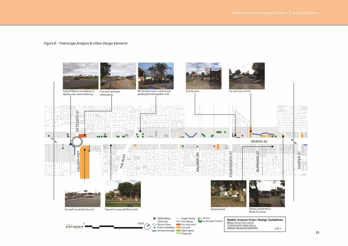
2.3.3 TOWNSCAPE & URBAN DESIGN ELEMENTS
This section refers to the four maps on the following pages, Figures 6-9.
BUILT FORM
Development along Deakin Avenue is predominantly single storey with the exception of a few scattered sites double storey buildings. The majority of the double storey buildings are clustered together within the ‘retail core’ of Mildura (Seventh to Tenth Street) and iconic taller Church buildings.
ARCHITECTURE
As an overall understanding of the architecture along Deakin Avenue, older buildings are located at the Murray River end and buildings are younger as the Avenue stretches towards the airport. Although there are many exceptions.
Churches are easily recognisable as feature buildings with their varying styles and setbacks, their height is significant comparing to the neighbouring buildings. Some Civic buildings, shown in the following diagrams, are also significant.
Motels are reminiscent of California Modern which follows the theme of a Californian Boulevard. Yet some newer buildings attract visual attention, such as the Intersport building on the corner of Eleventh Street, due to a zero setback and bright blue colour creating a deep contrast to the other three corner buildings at the intersection.
EAVES AND VERANDAHS
Verandahs or shop canopies, in Mildura, tend to be deeper than in other places providing greater sun protection for both the pedestrian and the shop. The heights vary and verandahs that are low and very wide create a footpath that feels dark and hidden.
MATERIALS
Bricks are a common building material in Mildura both historically and today. Painted bricks are also common. The trend for new buildings is to use a variety of materials such as steel, concrete and rendered brick.
COLOUR
Yellow, light brown and cream colours are a typical Deakin Avenue colour. Terracotta colour is present on roofs, and concrete will have light brown appearance relating to the red soil. New and old buildings follow this colour palette, yet the odd building that has a colour in the cool spectrum (often blue) dominates the streetscape.
SETBACKS AND STREET ACTIVATION
Setbacks
Buildings from Thirteenth to Eleventh Street often provide very ‘strong’ frontages with zero setbacks and the potential for good street activation. From Eleventh Street setbacks vary from few retail units at zero metres to residential at six metres. Homes in the rural area can range from 6 to 20 metre.
Larger buildings will often not follow the Deakin Avenue alignment creating triangular front garden spaces and an inconsistency in frontage.
KERB SIDE DINING
The CBD end of Deakin Avenue has a few Kerb side dining locations, some with vines creating an arbour that greens the street, provides sun protection in summer, and sun access in winter. The wide footpaths mean Deakin Avenue is ideal for kerb side dining.

Deakin Avenue Urban Design Guidelines | Existing Conditions
© planisphere 2015 29
Figure 6 – Townscape Analysis & Urban Design Elements

Deakin Avenue Urban Design Guidelines | Existing Conditions
© planisphere 2015 30
Figure 7 – Townscape Analysis & Urban Design Elements
Deakin Avenue Urban Design Guidelines | Existing Conditions
© planisphere 2015 31
Figure 8 – Townscape Analysis & Urban Design Elements

Deakin Avenue Urban Design Guidelines | Existing Conditions
© planisphere 2015 32
Figure 9 – Townscape Analysis & Urban Design Elements

Deakin Avenue Urban Design Guidelines | Existing Conditions
© planisphere 2015 33
2.3.4 ROAD ACCESS AND MOVEMENT
Deakin Avenue, where it begins at the Gordon Street / Sturt Highway intersection, is a single carriageway road with unmade road shoulders and a reserve for future duplication. At Seventeenth Street an informal slip lane can be seen to the east of the Avenue, accessed only by the dwellings and allotments fronting it. This slip lane becomes more formalised around Sixteenth Street.
At Fifteenth Street the single carriageway transitions to the dual carriageway with large median strip that typifies the Boulevard feel of Mildura.
Angled car parking is provided on the road pavement on both sides of the Avenue from Eleventh Street to Seventh Street and to the east between Thirteenth and Twelfth Streets. Ample space for parallel parking is provided on the remainder of the Avenue. Refer Figure 10.

Deakin Avenue Urban Design Guidelines | Existing Conditions
© planisphere 2015 34
Figure 10- Road Use Map
35
3 ISSUES AND OPPORTUNITIES

Deakin Avenue Urban Design Guidelines | Issues and Opportunities
© planisphere 2015 36
3.1 WHAT WE HEARD
At the commencement of the project, preliminary consultation workshops were held to gather information to inform the key issues and opportunities that are outlined in this report.
Two of these preliminary workshops allowed for an open discussion around the issues along Deakin Avenue with key department and government stakeholders and community representatives (including landowners, business owners and residents).
A community flyer was also distributed to landowners and residents along Deakin Avenue that invited community to input into the project by answering a series of survey questions. Thirty-two survey responses were received, of which, 87.5% of respondents were residents of Mildura, the rest of which were from commercial landowners and/or business owner/employee.
Also included in the response summaries are four letter responses and six Facebook comment responses.
This section provides an overview of the responses received. A full summary is provided at Appendix A.
WHAT DO YOU LIKE ABOUT DEAKIN AVENUE? WHAT SHOULD STAY THE SAME? I.E. FAVOURITE BUILDING, PLACE OR THING TO DO ON DEAKIN AVENUE.
There were a variety of responses about elements residents liked about the Avenue covering a range of topics from heritage, land uses and landscaping.
The public realm and central median strip were the most discussed topics with a number of submitters expressing that the large mature trees, lawns and public furniture were their favourite features.
A number of heritage buildings were also cited as important aspects of the Avenue including the churches on the corner of Tenth and Eleventh streets and the iconic civic buildings.
The landscaping and vegetation within the median strip including the gum trees and jacarandas were also identified as iconic which contributed positively to the character of the Avenue.
WHAT DO YOU DISLIKE ABOUT DEAKIN AVENUE? WHAT SHOULD CHANGE? IE IS DEAKIN AVENUE SAFE AT NIGHT? WHAT CAN BE IMPROVED? WHAT DOES IT NEED MORE OF?
There were a variety of responses regarding people’s dislikes for the Avenue. Building quality, scale and design were cited as the most common detractions from the Avenue. Specifically the larger format retail outlets and the Centrelink building were unfavourable among local residents.
A number of public realm and safety issues were also cited including the lack of street furniture and street lights, choice of landscaping in some segments and truck movements throughout the Avenue.
Land uses conflicts between the Funeral Parlour and the School, located between Fifteenth and Sixteenth Streets, were an issue for some residents as well as lack of health and community related uses along the Avenue in general.
Opportunities to increase the variety of land uses, improve landscaping and the overall image of Mildura were proposed.
WHAT IMAGE DO THE BUILDINGS AND ACTIVITIES ALONG DEAKIN AVENUE PRESENT TO VISITORS?
There was a general sentiment that a negative image was portrayed along Deakin Avenue for visitors to Mildura. This was described as largely attributed to the high presence of fast food outlets, large format retail and poor built form. Design details such as colour palette, scale and height were

Deakin Avenue Urban Design Guidelines | Issues and Opportunities
© planisphere 2015 37
also considered to be inappropriate and in many instances, out of context to the surrounding environment.
Some residents submitted that Deakin Avenue should present a green, lush image to visitors which could be portrayed by decreasing the number of blank walls, reducing the amount of car parking in front setbacks, better maintain gardens and landscaping and reducing the scale and bulk of some signage.
HOW SHOULD DEAKIN AVENUE LOOK IN THE FUTURE? MAYBE IN 10, 20 OR 30 YEARS TIME.
A number of ideas were put forward to inspire the look of the Avenue into the future.
There were a number of submissions which made recommendations to extend the centre median strip from Fifteenth Avenue to the airport. There was a general consensus that larger setbacks were required which would allow for more vegetation and a greener streetscape appearance. More native trees and vegetation was supported by several submitters. One submitter discussed the importance of balancing the old with the new while also respecting the traditional culture of the land.
A desire to improve the public realm and encourage high quality design outcomes was generally supported by the majority of submissions.
WHAT DO YOU BELIEVE ARE THE MAIN ISSUES THAT NEED TO BE ADDRESSED ON DEAKIN AVENUE? IE WHAT NEEDS FIXING? WHAT NEEDS CHANGING?
A number of suggestions were made to improve the Avenue which reflected the general sentiment of responses to the questions above.
One submitter suggested that a clear vision of what the Avenue should look like into the future was a key priority.
A number of traffic improvements were suggested, such as the inclusion of trafficlights at the intersection of Sixteenth Street and the re-routing of trucks off Deakin Avenue.
Several submitters wanted to see the removal of the public toilets within the median strip while others suggested that parking on the median strips should be considered.
The treatment of the corner of Fifteenth Street and Deakin Avenue was a popular topic amongst submitters, with some suggestions to remove and demolish the ‘Cheap as Chip’s’ store at the corner. In addition petrol stations, large format retail centres, backpacker hostels and fast food outlets were also seen as ‘unsightly’ developments along the Avenue.
The re-activation of vacant sites and rundown buildings were also important to some submitters. There were suggestions to improve signage and directional way finding to provide a sense of consistency to the Avenue and allow visitors and residents to orientate themselves.
Finally there were mixed opinions regarding the landscape treatment of the median strip with some submitters wanting to see more consistency along the strip while others thought that there were too many trees already along the median and thought that it could be used for a better purpose.

Deakin Avenue Urban Design Guidelines | Issues and Opportunities
© planisphere 2015 38
3.2 KEY ISSUES
A number of issues have been highlighted throughout the preliminary consultation process or identified by the study team during site survey work.
This section discusses the key issues identified under the following headings with further details:
Built form quality
Maintenance and planting of gardens/landscapes
Land uses
Safety and lighting
Image of Mildura
Access and movement
Public realm provisions
Refer to Figures 11, 12, 13 and 14.
BUILT FORM QUALITY
A recurring issue that was discussed during preliminary consultation is the poor quality of built form on Deakin Avenue, especially in relation to newer buildings and unit developments.
While it was agreed that some big brand names, such as McDonalds, had taken steps to use a colour palette that is respectful of the Mildura character with heavily vegetated setbacks, it was a common concern that development is too bold and unattractive in its use of colours used to display business signage and brand recognition (e.g. Red Rooster and intersport).
Materials were also raised as an issue where it causes development to stand out as uncharacteristic of Mildura, such as the metal grate used on the units near Twelfth Street.
Blank walls often front the Avenue, especially in the case of unit developments, which results in a sense of ‘inactivity’ and community concerns for safety.
MAINTENANCE AND PLANTING OF GARDENS/LANDSCAPES
The poor condition of nature strips from time to time is a key issue for both the streetscape character and the ‘image’ of Mildura. A lack of trees in some areas, as well as the use of gravel contributes to this issue. At times the nature strip is used for car parking.
The irrigation of the nature strips was cited as an issue in that the central median strip is controlled and maintained by the Council whereas the verge is administered by the landowners.
Choice of vegetation is considered an issue by some respondents, due to the plants dying off in summer. While some people are happy with the Palm Trees, others believe this is an issue and that native trees only should be used in the public realm (e.g. gums).
Vegetation on properties vary dramatically from dense and diverse planted front gardens to treeless spaces with patchy grass. Some properties have large trees that have a significant impact on the streetscape.
LAND USES
There is a clear segregation between the Mildura Central Shopping Centre on the corner of Fifteenth Street and the ‘CBD’ (from Seventh to Eleventh Street). The distance is not considered ‘walkable’ and there are no clear visual links between the retail precincts.
Vacant buildings and abandoned dwellings result in an unkempt view of the Avenue and raises issues of appropriate land uses along the strip.
Land use conflicts were highlighted, especially in the case of Mildura South Primary School and North West Funerals. The primary issues being car

Deakin Avenue Urban Design Guidelines | Issues and Opportunities
© planisphere 2015 39
parking and traffic congestion in the immediate vicinity when a funeral is being held at the same time as school drop off/pick up.
Diversity of dining, retail and business options has also been considered an issue.
SAFETY AND LIGHTING
Many survey respondents highlighted that safety, especially for pedestrians at night, is a big issue on Deakin Avenue. While this has been predominantly highlighted as being a lighting issue, there are a number of factors that can make a street feel unsafe. Often older style buildings have less opportunity for visual surveillance (eye’s on the street) and for street activation, such as kerb side dining or glass frontages. Large setbacks and dense vegetation can provide places for concealment. All of these factors, along with limited night time uses on the Avenue, may contribute to the feeling of safety.
IMAGE OF MILDURA
The lack of a consistent ‘vision’ for Deakin Avenue has resulted in little consistency along the strip and limited guidance for design outcomes.
Petrol stations and fast food chains are highlighted by community members as presenting an unattractive image for Mildura as they approach the town. The present mix of land uses from approximately Sixteenth to Twelfth Streets is a concern, as it is not showcasing the rich history or beauty of Mildura.
Car parking in the front setbacks or within the nature strips of allotments fronting the Avenue is a key issue that is contributing to an unattractive approach into Mildura.
ACCESS AND MOVEMENT
Truck movements through the town via Deakin Avenue are frequent, as Mildura is the major route between Adelaide and Sydney. This is a big issue
for the town as the trucks contribute to traffic congestion, pedestrian safety and road degradation. The unofficial by-pass route that is sometimes used, via Fifteenth Street and Benetook Ave, has not been upgraded to allow for truck movements and turning.
The need for intersection upgrades has been highlighted as a key issue at the intersections of Sixteenth and Seventh Streets. This would require further investigation via traffic and transport study.
PUBLIC REALM PROVISIONS
Street furniture, such as seating, shade and lighting is provided intermittently and is an issue that could be improved to present a better and more consistent image of Mildura, encourage walking and enhance feelings of safety.
Directional signage was also highlighted as an issue, especially in welcoming visitors to Mildura and guiding road users to the Murray River, which is very much hidden from the Avenue.
A key issue for visitors is the lack of places to stop and use toilet facilities on approaching Mildura, especially visitors with caravans.

Deakin Avenue Urban Design Guidelines | Issues and Opportunities
© planisphere 2015 40
3.3 KEY OPPORTUNITIES
Deakin Avenue is available to many new opportunities and enhancements. These opportunities could be extensive, however based on the responses received via consultation and identified through background work undertaken, the key opportunities have been summarised under the following headings:
Public realm
Built form
Image of Mildura
Land uses
Landscape and vegetation
Access and movement
Lighting and safety
Refinement of these opportunities will lead to developing a ‘vision’ and objectives for Deakin Avenue.
Refer to Figures 11, 12, 13 and 14 over page.
PUBLIC REALM
The public realm provides the best opportunity to enhance the vision and image of Mildura, while creating functional spaces that the community and visitors want to be a part of. It provides the space to enhance the relationship of the built form with the street and tie together land uses that may have had been disconnected.
Street furniture and art installations could be used as tools that are both functional and promote increased usage of the spaces, to design elements that provide a consistency along the spine of Deakin Ave to enhance experience and approach into Mildura.
The Deakin Avenue palette of footpaths could be improved and made consistent within the town. Increased planter boxes could be added to increase the aesthetics of the street, especially in the CBD area, while seating and shade trees/structures will enhance walkability, increasing street activation and healthy living.
There is a great opportunity to encourage more uses along the Avenue that have open shop fronts, with kerb side dining, glass frontages and/or uses that spill onto the street.
The popular overhead vines between Seventh and Eighth Streets, which are a visual feature in the CBD and provide much needed shade in warmer months, could also be extended or replicated in other parts of the Avenue. Similar ‘green’ elements within the verge or setback (e.g. vertical gardens) are also an opportunity.
BUILT FORM
The built form ‘grandeur’ that is experienced between Seventh and Ninth Streets, due to the historically significant buildings, creates a very unique feel to Mildura. There is an opportunity to enhance the feeling of grandeur without replicating past styles through design detail, appropriate colours and materials and setbacks.
Corner sites especially provide the opportunity to create new iconic buildings that provide a landmark or feature, keeping in character with the story of Mildura.
Shop and business awnings should be extended to increase foot traffic on the Avenue, providing sun protection and visual interest for pedestrians and increased sustainability in Mildura’s climate. Built form in the CBD (‘retail core’) could be designed to allow for more open style frontages that provide greater opportunities for using the street verge (e.g. kerb-side dining).

Deakin Avenue Urban Design Guidelines | Issues and Opportunities
© planisphere 2015 41
IMAGE OF MILDURA
Deakin Avenue provides a great opportunity to introduce visitors to Mildura with a ‘gateway’ statement. There are opportunities to provide this by:
Extending the Boulevard appearance of the Avenue further towards the airport, using the large median strip and consistent large trees.
Art installations that begin to introduce the Mildura ‘story’ earlier on (e.g. the Sturt Highway).
Directional, informative and welcoming signage
The image of Mildura can also be enhanced along the length of the Avenue through consistency in plant species, street furniture and colours/materials used in the public realm. Smaller ‘gateway’ experiences could be introduced at the beginning of each precinct, as shown on the Opportunities Map.
Introducing built form guidelines that require a colour and material palette specific to Mildura to be used would also assist in enhancing the image of the town. While, encouraging the vegetation and landscaping of setbacks in the private realm to be maintained and enhanced, as well as in the public realm, would also create a much more attractive appearance and image.
There is also an opportunity to introduce elements of the Murray River along Deakin Avenue, as a way of linking the river to the airport and enhancing this significant feature as a part of the Mildura ‘story’.
Retaining the palm trees and historic buildings in the centre of Mildura will continue to be an important part of the image of Mildura.
LAND USES
Clearly defined land use ‘precincts’ have been identified in the Opportunities Map to assist in identifying the opportunity to expand on appropriate land uses in areas along the Avenue.
These include:
Edge/Growth Precinct
Transition Precinct
Middle Precinct
City Precinct
Sub-precincts have been identified to capture the niche land uses that occur and could be expanded upon.
There is the opportunity to concentrate retail, restaurants, civic uses and entertainment venues in the City Precinct; health, education and hotels/motels in the middle precinct; residentially sensitive uses (e.g. medical, education, residential) in the Transition Precinct; and residential uses and agricultural activities in the Growth Precinct.
LANDSCAPING AND VEGETATION
Opportunities exist to increase the image of Mildura through vegetation and landscaping, by ensuring consistency along the stretch of the Avenue through plant species and maintenance. The image of the tall palm trees in the median strip could be extended along the Avenue, by planting rows of street trees that frame the Avenue.
Native vegetation and trees will enhance wildlife habitat and provide clearer links between the more rural areas on Mildura towards the airport and the Murray River, with its River Red Gums.
Landscaping initiatives identified in the Deakin Avenue Masterplan (2006) provide an important framework that increases the opportunities to improve the public realm and landscaped image of the whole Avenue.

Deakin Avenue Urban Design Guidelines | Issues and Opportunities
© planisphere 2015 42
ACCESS AND MOVEMENT
The duplication of the road from Fifteenth Street to the Airport is a significant opportunity that will assist in enhancing the image of the town and contribute to more effective access and movement along Deakin Avenue. In addition, the creation of a bypass would further assist in improving public amenity, safety and congestion.
Extending the dual carriageway road and wide median strip as far back as the Mildura Airport, would create a great sense of arrival for Mildura and open up many more opportunities for image enhancing and gateway features.
A bypass which would see Benetook Avenue as the diversion route for heavy vehicles and trucks, has been considered in previous strategic work. It is also identified in the Mildura Planning Scheme at Clause 21.10 as a local policy objective. The bypass would create a more pedestrian and cycle-friendly environment from Fifteenth Street.
Opportunities are also present to provide intersection upgrades where appropriate and undertake maintenance works to broken kerbs that would enhance the functionality and aesthetics of the strip.
Introducing a tram line along the length of Deakin Avenue is an opportunity in the future and any interventions should not prevent this possibility.
LIGHTING AND SAFETY
Enhancing the lighting and safety of the Avenue, especially in the City Precinct, is an opportunity that could really transform the Avenue and the amount of users/visitors at night.
Improved and coloured lighting could become a feature within the public realm and be used to light up key features, trees and historic buildings. While this is not as important in the ‘Edge Precinct’, appropriate lighting to ensure adequate safety is important.
Street activation through built form design and night time uses, as well as increasing ‘eyes on the street’ through window placement, will enhance feelings of safety and encourage walking and use of public spaces.

Deakin Avenue Urban Design Guidelines | Issues and Opportunities
© planisphere 2015 43
Figure 11 – Issues and Opportunities

Deakin Avenue Urban Design Guidelines | Issues and Opportunities
© planisphere 2015 44
Figure 12 – Issues and Opportunities

Deakin Avenue Urban Design Guidelines | Issues and Opportunities
© planisphere 2015 45
Figure 13 – Issues and Opportunities

Deakin Avenue Urban Design Guidelines | Issues and Opportunities
© planisphere 2015 46
Figure 14 – Issues and Opportunities

Deakin Avenue Urban Design Guidelines | Issues and Opportunities
© planisphere 2015 47
3.4 SUMMARY OF KEY CONSIDERATIONS
Based on the issues and opportunities analysis, the following key considerations will form the basis for the next stage of work to develop the vision and objectives for the Avenue:
A public realm environment that is consistent, functional, safe and welcoming
Land uses that are compatible/ varied/ desirable
Built form design that:
Complements Mildura’s historic ‘story’
Reflects or is compatible with the colours, materials and styles commonly found in the area
Addresses Deakin Avenue and provides opportunities for street activation and surveillance
Retains historic features, views or forms where appropriate
Responds to the climate and is sustainable
Quality?
Well maintained gardens and landscaping that provides visual links between uses and features
Movement along the Avenue that is safe and efficient
An image for Mildura that enhances the ‘story’ of the area and provides a strong, welcoming and visual experience for visitors

Project Name | Appendices
© planisphere 2015 48
APPENDICES

Project Name | Appendices
© planisphere 2015 49
APPENDIX A - SUMMARY OF RESPONSES
WHAT DO YOU LIKE ABOUT DEAKIN AVENUE? WHAT SHOULD STAY THE SAME? I.E. FAVOURITE BUILDING, PLACE OR THING TO DO ON DEAKIN AVENUE.
There were a variety of responses covering a range of topics from heritage, land uses, landscaping
The public realm and centre median strip, including the large mature trees, lawns, vegetation, sculptures, rotunda and fountains.
The Churches on the corners of Tenth and Eleventh Streets.
The grandeur of Seventh to Ninth Street (large trees aligned).
Highly maintained landscape.
The variety of land uses.
The wide double carriageway of the Avenue from Seventh to Fifteenth Streets.
Old iconic buildings.
New well-designed buildings.
The gum trees and Jacarandas.
The shopping strips.
Park opposite the new health centre.
WHAT DO YOU DISLIKE ABOUT DEAKIN AVENUE? WHAT SHOULD CHANGE? IE IS DEAKIN AVENUE SAFE AT NIGHT? WHAT CAN BE IMPROVED? WHAT DOES IT NEED MORE OF?
Bark and organic garden beds.
Large format retail outlets.
Land fragmentation and unit developments.
Poor condition of nature strips and choice of vegetation (such as Bottlebrushes). Plants die off in Summer.
Building quality is poor (including the Centrelink building)
Toilet block between Seventh and Eighth Streets.
Consistency of street tree planting.
Land use conflict between the school and funeral parlour.
Colourbond fences.
Segregation of the uses on Fifteenth Street with the ‘CBD’.
Not enough health related uses (i.e. shops and cafes)
Lack of street lights.
The termination of the centre median strip.
Zoning between Hunter Street and Centre Way.
Zero setbacks.
The image of Mildura beyond Fifteenth Street.
Truck movement through the town centre. Need better intersections for turning B-doubles (esp. Seventh Street).
Lack of safety at night, especially for pedestrians. Need better lighting.
More street furniture.
Something to welcome visitors at Fifteenth Street roundabout.
Vacant sites, houses and shops.
Need more dining, shopping and business options.
Direction signage to the Murray River.

Project Name | Appendices
© planisphere 2015 50
WHAT IMAGE DO THE BUILDINGS AND ACTIVITIES ALONG DEAKIN AVENUE PRESENT TO VISITORS?
A ‘cheap and nasty’ image, due to fast food outlets, large format retail and poor built form quality.
Older buildings are well presented but newer buildings are often too ‘brash’ in their colourings.
Better maintenance of gardens and rear car parking would present a better image.
Too many blank walls, inactivity and car parking in front setbacks.
An image of ‘desert to nice green gardens’.
‘A welcoming feeling and a beautiful place to visit. A town where the people of Mildura are proud and content in where they live.’
Dislike the image of petrol stations and large signage.
The history of the area on display.
A ‘clean’, ‘green’ and ‘tidy’ image.
HOW SHOULD DEAKIN AVENUE LOOK IN THE FUTURE? MAYBE IN 10, 20 OR 30 YEARS TIME.
Extend the centre median strip to the airport.
Larger lots, greater setbacks and more vegetation.
Large canopy trees in the nature strips.
No car parks on the Avenue and a bypass to minimise truck movements.
Native trees that provide beauty and bird habitat.
More commercial land uses between Fifteenth and Eighteenth Streets.
‘A beautiful balance of the old and the new - of nature and of art. Beautiful gardens and art that embraces community, diversity and respects the traditional culture of the land. A place that is thriving.’
Development to the airport.
Views to the Murray River.
Well maintained and ‘green’ gardens and landscapes.
Intersection treatment at Seventh Street.
Tram lines.
Better public realm – planter boxes, open shop fronts and nice footpaths.
No residential uses, just commercial.
Better design detail in new buildings (i.e. colours and materials).
Pedestrian path in the median strip.
No petrol stations.
WHAT DO YOU BELIEVE ARE THE MAIN ISSUES THAT NEED TO BE ADDRESSED ON DEAKIN AVENUE? IE WHAT NEEDS FIXING? WHAT NEEDS CHANGING?
There needs to be a clear vision of what the avenue should look like and a strict design code.
Too many trees in median strips and the roads are too narrow.
Intersections Deakin Avenue with 8th
and 16th
Streets should have traffic lights instead of a roundabout.

Project Name | Appendices
© planisphere 2015 51
More commercial land uses within the area between 15th and 18th street developed to similar scale as the CBD.
Rerouting the Sturt Highway away from Deakin Avenue with better signage to guide heavy vehicles away.
Low quality design of new developments, especially on corners.
Parking on median strips.
Stricter restrictions on what can be built. No more backpackers or tin roofs.
Better maintenance of trees.
Remove the toilets.
The road needs better maintenance from 15th street to the airport.
Deakin Avenue needs a public toilet block between the airport and 15th street for visitors and caravaners.
Acquire and demolish unsightly buildings such as the ‘Cheap as Chips’ building.
Fast food outlets, petrol stations and large signage, are all unattractive.
Issues of broken kerbing and maintenance of the Italian Garden
Lack of lighting at night and would like more police presence.
Better signage directing visitors to recreational areas.
Upgrade the infrastructure to beautify the road.
Abandoned buildings are run down and unattractive.
Continue the divided carriageways along the length of Deakin Avenue.
.

Project Name | Appendices
© planisphere 2015 52