dating of graptolite zones by sedimentation rates: implications for rates of evolution
TRANSCRIPT

Dating of graptolite zones by sedimentation rates: implications for rates of evolution CLAIRE CARTER. JAMES H. TREXLER, JR. AND MfCHAEL CHURKIN, JR
LETH AIA Carter, Claire, Trexler, James H., Jr., Churkin, Michael, Jr. 1980 10 IS: Dating of graptolite zones by sedimentation rates: implications for rates of evolution. Lethoia, Vol. 13, pp. 279-287. Oslo. ISSN
Preliminary determinations of ancient pelagic sedimentation rates agree with modern rates at about 4 meters per million years. By combining data on the thickness of graptolite zones from the North American Cordillera with data from other parts of the world, we have refined the Early Silurian time scale and obtained much better resolution than is possible for radiometric dates. The new Early Silurian time scale allows estimation of true rates of change in graptolite diversity. The Llandoverian diversity explosion is twice as rapid as was previously thought. The brevity of diversity lows and rapidity of speciation support modern theories of quantum evolution.
Claire Carter, James H . Trexler, Jr . and Michael Churkin, Jr., U.S. Geological Survey, 345 Middlefield Road, Menlo Park, California 94025; 15th September, 1980.
0024-1164.
In a recent study (Churkin rt al. 1977), the accumulation rate of graptolitic shales was used to calculate the duration of graptolite zones and from that to subdivide the Ordovician and Early Silurian time scale. The calculations were based on data from a few selected graptolitic shale sequences within the Cordilleran foldbelt of North America (Esquibel Island, Alaska; Trail Creek, Idaho; Toquima Range, Nevada). Since 1977, we have obtained more data on the thick- ness of graptolite zones from published sources and from written communications with col- leagues. In addition, we have analyzed data from the world literature, some of which we published in appendix form (Churkin et al. 1977) but did not use in our calculations. Therefore, we now have expanded our study to areas outside the Cordillera, and the new data have yielded results that permit further examination of the time span of graptolite zones. We also make a preliminary attempt here to understand graptolite diversity trends in terms of the newly established time scale.
Previous study Researchers in the Deep Sea Drilling Project routinely estimate the age of acoustic basement by extrapolating from overlying, dated stratigraphic horizons down to the basement, assuming constant rates of pelagic sediment ac- cumulation. This procedure gave us one of the
basic ideas for our study: if the sedimentation rate is constant, then the duration of a graptolite zone is proportional to its thickness. Because sedimentation rate varies with lithology, and because graptolitic shales and cherts resemble modern deep-sea pelagic deposits, we selected the purest shale and chert sections we were acquainted with for our measurements of zonal thickness, namely the Descon Formation (Ordovician and Early Silurian) of southeastern Alaska, the Phi Kappa Formation (Ordovician and Early and Middle Silurian) of central Idaho, and the Petes Summit Formation of Kay (1960; Ordovician) of central Nevada.
Using known radiometric dates, we calculated the time span of various parts of the Ordovician, then divided the corresponding thicknesses of graptolitic shale by the time span to arrive at a sedimentation rate of 4 k 1 m of rock per million years. Other workers have made these same sedimentation-rate calculations and come up with comparable results (Jackson 1966:477; Cooper 1979:21). Once the sedimentation rate is known, the entire time scale can be calculated simply by converting the thickness of each zone into its equivalent duration. A preliminary time scale, based on our Cordilleran data for the Ordovician and on calculated means from new data for the Early Silurian, is shown in Fig. 1. This time scale includes only the Middle Ordovi- cian through earliest Silurian graptolite zones because of the limited nature of our data.
In the Phi Kappa Formation, between the
19 - Lethaia 4/80

280 Claire Carter and others LETHAIA 13 (1980)
European
S t W
Llandoverian
Ashgillian
Caradacian
Llondeilian
Llonvirnion
Graptalite m e and calculated ages
of boundaries, in millions of ywrs
415 5
426 5 M. fum'culafus
M. sedgwickti --I
M. conuolufus
M. gregarius 43:
M. cyphus ,C. uesiculosusm,!
-". C. persculptus D. o m a h a
L P. linearis
43€ UB.!
D. clingani
---? _ - _ _ _ _ L- 4s
"Passage beds"
of Carter and Churkin,
1977
- - - -?-_ 457
D. rnulfideru
455
N. gracilis
454
G. fcrefiusculus 1Mc
D. rnurchisoni
ne durat
of zone I million
of years
I+
1.5
I
6.5
- - -?- -
7.0
3.0 -
9.0
2.0
5+
Fig. I . Preliminary time scale and duration of graptolite zones for Middle Ordovician through earliest Silurian, based on Cordilleran data. Revisions since first published (Churkin et al. 1977) include addition of Caradocian 'passage beds' and Llandoverian zones, which are based on calculated mean values from new data (see text). Duration of zones and ages of zone boundaries are rounded. Asterisk indicates approximate figure where section is complicated by faulting.
Clirnacograptus tubuliferus Zone (approxi- mately the Dicranograptus clingani Zone of Great Britain) and the Clirnacograptus bicornis Zone (approximately the Diplograptus multidrns Zone of Great Britain), is a 27.4 m interval of shale containing a sparse fauna not distinctive enough to merit zonal status. This interval has been termed 'passage beds' (Carter & Churkin 1977) and must be included in any time scale based on the Phi Kappa Formation. Therefore, the boundary between the D . clingani Zone and the D. rnultidens Zone is uncertain.
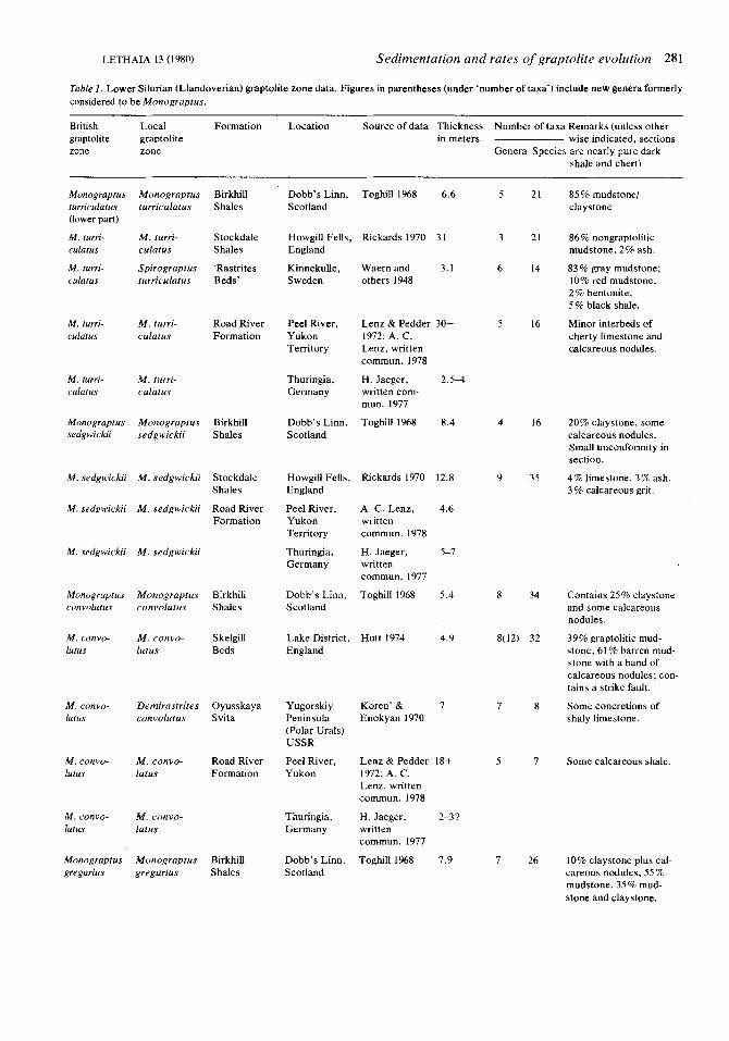
New data After publication of the initial study (Churkin et al. 1977), we received additional data, including details of some Early Silurian graptolite zone thicknesses from A. C. Lenz (western Canada), Hermann Jaeger (Thuringia, Germany), and Ni Yu-nan (China). These data were added to our previously assembled data from the world litera- ture (Table l), and all are represented in graphic form in Fig. 2. Measured sections of more or less pure graptolitic shale and chert of Ordovican age are rare, so we have concentrated on the Early Silurian.
In Fig. 2 , the lithologies of the various Early Silurian graptolite zones, as determined by their individual authors, are shown symbolically. Be- cause lithologic names can be ambiguous and because these lithologic determinations were not all made by a single person, there is an inherent uncertainty in comparing zonal thicknesses from place to place. Even in relatively pure shale sections, there may be differences in thickness due to difficulties and inaccuracies in zonal correlation or to undetected complications in the stratigraphic section, such as faults, folds, and (or) diastems. We realize that many of the zones included in our study are contaminated with various amounts of silt and other more rapidly deposited sediments. Thus the time scale shown in Fig. 1 is only a preliminary attempt, subject to change as more and better measured sections become available.
Analysis of the data In Fig. 3 are plotted the measured thicknesses of each of the eight early Silurian zones studied. The dashed line indicates the upper 95% confi-
LETHAIA 13 (1980) Sedimentation and rates of graptolite evolution 281
Table 1 . Lower Silurian (Llandoverian) graptolite zone data. Figures in parentheses (under ‘number of taxa’) include new genera formerly considered to be Monograptus.
British Local Formation Location Source of data Thickness Number of taxa Remarks (unless other- graptolite graptolite in meters wise indicated, sections zone zone Genera Species are nearly pure dark
shale and chert)
Monograptus Monograptus Birkhill turriculatus turriculatus Shales (lower part)
M. turri- M . turri- Stockdale culatus culatus Shales
M. turri- Spirograptus ‘Rastrites culatus turriculatus Beds’
M. turri- M . turri- Road River culafus culatus Formation
M. turri- M . turri- culatus culatus
Monograptus Monograptus Birkhill sedgwickii sedgwickii Shales
M. sedgwickii M . sedgwickii Stockdale
M . sedgwickii M . sedgwickii Road River Formation
Shales
M. sedgwickii M . sedgwickii
Monograptus Monograptus Birkhill conrolutus convolutus Shales
M. convo- M . convo- Skelgill lutus IUlUS Beds
M . convo- Demirastr i trs Oyusskaya lutus convolutus Svita
M. convo- M . convo- Road River lurus lutus Formation
Monograptus Monograptus Birkhill gregarius gregarius Shales
Dobb’s Linn, Toghill 1968 6.6 Scotland
Howgill Fells, Rickards 1970 3 I England
Kinnekulle, Waern and 3.1 Sweden others 1948
Peel River, Yukon 1972; A. C. Territory Lenz, written
Thuringia, H. Jaeger, 2.5-4 Germany written com-
Dobb’s Linn, Toghill 1968 8.4 Scotland
Lenz & Pedder 30-t
commun. 1978
mun. 1977
Howgill Fells, England
Peel River, Yukon Territory
Thuringia, Germany
Dobb’s Linn, Scotland
Lake District, England
Yugorskiy Peninsula (Polar Urals) USSR
Peel River, Yukon
Thuringia, Germany
Dobb’s Linn, Scotland
Rickards 1970 12.8
A. C. Lenz, 4.6 written commun. 1978
H. Jaeger, 5-7 written commun. 1977
Toghill 1968 5.4
Hutt 1974 4.9
Koren’ & 7 Enokyan 1970
Lenz & Pedder 18t 1972; A. C. Lenz, written commun. 1978
H. Jaeger, 2-3? written commun. 1977
Toghill 1968 7.9
5
3
6
5
4
9
8
8(12)
7
5
7
21
21
14
16
16
35
34
32
8
7
26
85% mudstonel clay stone
86% nongraptolitic mudstone, 2% ash.
83% gray mudstone; 10% red mudstone, 2% bentonite, 5% black shale.
Minor interbeds of cherty limestone and calcareous nodules.
20% claystone, some calcareous nodules. Small unconformity in section.
4% limestone, 3% ash, 3 % calcareous grit.
Contains 25% claystone and some calcareous nodules.
39% graptolitic mud- stone, 61 % barren mud- stone with a band of calcareous nodules: con- tains a strike fault.
Some concretions of shaly limestone.
Some calcareous shale.
10% claystone plus cal careous nodules, 55% mudstone, 35% mud- stone and claystone.

282 Claire Carter and others LETHAIA 13 (1980)
British Local Formation graptolite graptolite zone zone
Location Source of data Thickness Number of taxa Remarks (unless other- in meters wise indicated, sections
Genera Species are nearly pure dark shale and chert)
M . gregarius Monograpius Skelgill argenteus, Beds Diplograptus magnus, and Monograptus triangularus
M . gregarius M . gregarius Rheidol Formation
M . grrgarius Pristograpius Oyusskaya gregarius and Svita Demirastrites triangularus
M . gregarius M . grrgarius Road River Formation
Lake District, Hutt 1974 8.1 lO(14) 43 England
39% graptolitic mud- stone, 61 % barren mud- stone with a band of cal- careous nodules; con- tains a strike fault.
Rheidol Gorge, Wales
Yugorskiy Peninsula (Polar Urals) USSR
Peel River, Yukon Territory
Sudbury 1958 19.8 8 40 73% mudstone.
Koren’ & 9.5 5 5 Enokyan 1970
Calcareous concretions.
Lenz & Pedder 13.1 + 5 5 1972; A. C. Lenz, written commun. 1978
H. Jaeger, 2 written commun. 1977
Toghill 1968 7.3 8 25
Minor calcareous shale.
M . gregarius M . gregarius Thuringia, Germany
Monogruptus Monograptus Birkhill cyphus cyphus Shales
M . cyphus Monograptus Stockdale acinaces and Shales M . cyphus
and M. cyphus Beds M . cyphus M . acinaces Skelgill
Dobb’s Linn, Scotland
Howgill Fells, England
10% yellow and orange clay stone.
100% dark gray mud- stone.
Rickards 1970 3.8 8 21
Lake Di~trict . Hutt 1974 2.7 8(3) 31 England
79% black, graptolitic mudstone, 21% barren mudstone.
6% limestone. May extend up into M . gregarius Zone.
Minor calcareous shale.
M . cyphus Pernero- ‘Rastrites grapius Beds’ rrvolutus
M . cyphus M . cyphus and Road River Monograpius Formation acinaces
Kinnekulle, Waern and 3.2 3 4 Sweden others 1948
Peel River, Yukon Territory
Lenz & Pedder 9. I 4 5 1972; A. C. Lenz, written commun. 1978
H. Jaeger, O.tGl.1 written commun. I977
Ni Yu-nan, 6.8 written commun. 1978
Toghill 1%8 1.3 7 13
M . cyphus M . cyphus Thuringia, Germany
M . cyphus Prisiio- grupius cyphus
Cystograptus Cystograptus Birkhill vesiculosus vesiculosus Shales
C . vesiculosus Monograptus Stockdale
C. vesiculosus M . atavus Skelgill
afavus I Shales
Beds
Y ichang, western Hupeh, China
Dobb’s Linn, Scotland
Howgill Fells, England
Lake District England
Precise lithology uncertain.
2% claystone, 98% black mudstone.
100% dark gray, grapto- litic mudstone.
Hard, black, pyritous mudstone with grapto- lites throughout.
84% gray mudstone 16% black shale, tops lithologically defined.
Rickards 1970 2.7 6 12
Hutt 1974 10.2 9 20
C . vesiculosus Dimorpho- ‘Rastrites grapius Beds’ exienuatus
C . vesiculosus M . a favus Road River Formation
Kinnekulle, Waern and 3.0 3 3 Sweden others 1948
Peel River, Lenz & Pedder 1.5 4 6 Yukon 1972; A. C. Territory Lenz, written
commun. 1978

LETHAIA 13 (1980) Sedimentatiorl and rates of graptolite evolution 283
British Local Formation Location Source of data Thickness Number of taxa Remarks (unless other- graptolite graptolite in meters wise indicated, sections zone zone Genera Species are nearly pure dark
shale and chert)
C. vesiculosus C. vesiculosus
C. vesiculosus Orthograptus vesiculosus
Akidograptus Akidograptus Birkhill acuminatus acuminatus Shales
A. acumina- A . acumina- Stockdale tus tlls Shales
A. acumina- A. acumina- Skelgill tus tus Beds
A. acumina- A . acumina- ‘Rastrites tus t U S Beds’
A . acumina- A . acumina- Road River t U S tus Formation
A. acumina- A . acuminatus t U S and Akidograp-
tus ascensus
A. acumina- A . acumina- tus t U S
Glyptograptus Glyptograptus Birkhill persculptus persculptus Shales
G . persculptus G . persculptus Skelgill Beds
Thuringia, Germany
Yichang, western Hupeh, China
Dobb’s Linn, Scotland
Howgill Fells, England
Lake District, England
H. Jaeger, written commun. 1977
Ni Yu-nan, written commun. 1978
Toghill 1968
Rickards 1970
Hutt 1974
Kinnekulle, Waern and Sweden others 1948
Peel River, Yukon written Territory commun. 1978
Thuringia, H. Jaeger, Germany written
Yichang, Ni Yu-nan, western written Hupeh, China commun. 1978
Dobb’s Linn, Toghill 1968 Scotland
Lake District, Hutt 1974 England
, A. C. Lenz,
commun. 1977
0.4-1.3
2.2
5.0 6 12
. I 5 8
11.7 7 12
5 11 6.5
3
1
0.6
1.1 3 6
0.3+? 3 4
Precise lithology uncertain.
90% black mudstone, 10% claystone.
100% dark-gray mud- stone.
Hard, black, pyritous mudstone with grapto- Jites throughout; 1/4-1 m of pale gray mud- stone at base.
90% gray mudstone, 7 % black shale, 3 % limestone.
Precise lithology uncertain.
15% claystone, 85% black mudstone.
Pale gray mudstone, base not exposed.
dence level for the data. In all cases the lower limit is less than zero. The large range of confi- dence limits is due both to scatter and to the low number of samples. Inferences drawn from calculated statistical parameters are not valid for these small data sets.
The nature of the data allows us to qualita- tively improve the data set. Almost every zone is characterized by one or two sections that are much thicker than the others, and we believe that these sections are thicker because they have been contaminated with large amounts of silt. The thickest sections appear to be the most contaminated and least valid as a measure of passive pelagic sedimentation rates. In many
cases, it is clear that the lowest measured thick- ness is also invalid, usually because the section is either truncated by faults or covered. Systematic elimination of the highest and lowest values for each zone results in much better clustering of the data and limits the biasing influence of contamination and truncation. A preliminary time span for each zone was then calculated by taking the arithmetic mean of the modified data sets and using the conversion factor of 4 m of sediment accumulation per million years (m. y.). It is important to note that the time represented by the range of values for any one zone is less than the error range of a good radiometric date (Churkin et al. 1977).

E NOIIVNVYX3 L SC
(0861) El VIVHLZIT

LETHAIA 13 (1980) Sedimentation and rates of graptolite evolution 285
35
30
25 m
I- 25 2 z20
8 3 l 5 5 5
z- N
I I-
10
5
0
T I
Upper limit, 5’5% confidence level for the calculate0 maan L
T I
1
i
1 L
Fig. 3. Data for thickness of Early Silurian graptolite zones. The large range of confidence limits is due both to scatter and to the low number of samples. Inferences drawn from calculated statistical parameters are not valid for these small data sets.
species could arise. This period of stability may extend another million years to the beginning of the M . sedgwickii Zone. There, speciation and extinction both begin to increase, suggesting a more active and challenging environment.
Stanley (1979) has made a strong case for quantum speciation (rapid radiation of species, as opposed to gradualistic phyletic evolution), based in part on Rickards’ (1977) analysis of graptolite zones. Our application of a time scale to Rickards’ diversity data strengthens this argu- ment. The ‘Llandoverian explosion’ requires only about 2.8 m. y., and in three successive zones (C. vesiculosus, M . cyphus, and M . gre- garius) there are individual increases of from 12 to 20 new species, each in less than 500,000
years. This increase in diversity appears to be directly related to the introduction and success- ful radiation of the Monograptus lineage. Our time scale allows a recalculation of Stanley’s (1979:253) value for the rate of speciation (R) for graptolites during the Llandoverian explosion. This value for R, 0.32 m. y. - I , can be revised to 0.57 m. y. -’ on the basis of the shortening of the first four Llandoverian zones from 5 m. y. to 2.8 m. y. This result suggests that graptolites were capable of short-term speciation rates among the highest measured (Stanley 1979:23 I).
Other anomalies are obvious, but have no ready explanation. The C . vesiculosus Zone has a very high speciation rate for so short a zone. The ‘notch’ in all the diversity curves at the

286 Claire Carter and others
-Total number of species --- Number of new species
+ Ordovician Silurian + I ’ Mono#mprw > i d p i r k u
., ...................
435 434
M o n o ~ n p r w Nmru!.lrw
.................. --
.....
------ ...................
------
1
!
433 432 431 430 429
LETHAIA 13 (1980)
............ Number of extinctions
1 425
MILLIONS OF YEARS BEFORE PRESENT
Fig. 4 . Comparison of graptolite zone duration with graptolite diversity in the Early Silurian of the British Isles. Zone duration is based on estimated mean thickness (as discussed in text) converted lo time by a factor of 4 m of sediment accumulation per million years. (Graptolite diversity data from Rickards 1977.)
beginning of the M . cyphus Zone (representing the M . acinaces subzone) is unaccounted for. Finally, the M . convolutus, M . sedgwickii, and M. ~urriculatus Zones, all of similar length, show a relatively slow increase in speciation over a 4 m. y. period of stable diversity.
Pelagic sediment accumulation rate offers a method of relating absolute time to thickness of rock units. Comparison of modern pelagic ac- cumulation rates with radiometrically dated Paleozoic rock units gives good agreement on rates ranging from 2 to 5 mlm. y., averaging an estimated 4 mlm. y. Subdivision of stratigraphic units allows resolution at least an order of magnitude better than the error margin of a good radiometric date. Ultimately, this method should allow definition of faunal and lithologic bound- aries to within much less than 1 m. y., and probably on the order of plus or minus 100,000
years. The effect of this method on paleontology is to convert surmised rates to true measured rates, thus lending credence to modern theories of evolution such as quantum speciation and the punctuational model for evolution.
This study has enabled us to refine the time scale for a small part of the Early Silurian and to establish a preliminary time scale for the Late Ordovician on the basis of the duration of graptolite zones. Its principal aim is to show the application and value of the method. Further refinement will require many more carefully measured sections of pelagic rocks, standardiza- tion of measurement techniques, and develop- ment of methods for dealing with impure sec- tions. This new approach to time resolution de- serves further development and testing on older and younger rocks of appropriate lithology and those with other fauna.

LETHAIA 13 (1980) Sedimentation and rates of graptolite evolution 287
References Carter, Claire & Churkin, M., Jr. 1977: Ordovician and
Silurian graptolite succession in the Trail Creek area, central Idaho - a graptolite zone reference section. U.S. Geol. Surv Prof. Pap. 1020.
Churkin, M., Jr., Carter, Claire & Johnson, B. R. 1977: Subdivision of Ordovician and Silurian time scale using accumulation rates of graptolitic shale. Geology 5 , 452-456.
Churkin, M., Jr., Carter, Claire & Eberlein, G. D. 1971: Graptolite succession across the Ordovician-Silurian bound- ary in southeastern Alaska. Q. J . Geol. Soc. Lond. 126, 3 19-330.
Cooper, R. A. 1979: Ordovician geology and graptolite faunas of the Aorangi Mine area, northwest Nelson, New Zealand. New Zealand Geol. Surv., Paleontol. Bull. 47.
Hutt, Jana E. 1974: The Llandovery graptolites of the English Lake District. Palaeont. roc. (Lond.) Mons. 1.
Jackson, D. E. 1966: Graptolitic facies of the Canadian Cordillera and Arctic Archipelago: A review. Can. Petrol. Bull. 14, 469485.
Kay, M. 1960: Paleozoic continental margin in central Nevada, western United States. Int. Geul. Congr., Rep. 21st Sess., Copenhagen, Denmark 12, 93-103.
Kobayashi, T. & Hamada, T. 1974: On the time-relation between the graptolite zones and Dalmanitina Beds near the Ordovician-Silurian boundary in Eurasia. Proc. Japan Acad. SO, 487.
Koren’, Tat’yana N. & Enokyan, V. S. 1970: [Siluriyskie i nizhnedevonskie otlozhenia severo-zapadnoy chasti Yugorskogo poluostrova i ostrovov Pechorskogo morya. Uch. zap. NIIGA palaeont. i biostratigr.] 30, 5-25.
Lentz, A. C. & Pedder, A. E. H . 1972: Lower and Middle Paleozoic sediments and paleontology of Royal Creek and Peel River, Yukon and Powell Creek, N.W.T. XXIV Int. Geol. Congr., Montreal, Guidebook to Excursion A-14.
Rickards, R. B. 1970: The Llandovery (Silurian) graptolites of the Howgill Fells, northern England. Palaeont. Soc. Mon., 1-108.
Rickards, R. B. 1976: The sequence of graptolite zones in the British Isles. J . Geol. 11, Part 2, 153-188.
Rickards, R. B. 1977: Patterns of evolution in graptolites. I n Hallam, A. (ed.): Patterns of Evolution, as Illustrated by the Fossil Record, 333-358. Elsevier, Amsterdam.
Stanley, S. M. 1979: Macroevolution, Pattern and Process. W. H. Freeman, San Francisco.
Sudbury, Margaret 1958: Triangulate monograptids from the Mongraptus gregarius zone (lower Llandovery) of the Rheidol Gorge (Cardiganshire). Roy. Soc. Lond. Philos. Trans. B: 241, 485-555.
Toghill, P. 1968: The graptolite asdmblages and zones of the Birkhill Shales\ (Lower Silurian) at Dobb’s Linn. Palaeontology 11, Part 5 , 654-668.
Waern, B., Thorslund, P. & Henningsmoen, G. 1948: Deep boring through Ordovician and Silurian strata at Kinnekulle, Vestergotland. Uppsala Univ. Geol. Inst. Bull. 32, 337473.
LETHAIA FORUM . International Commission on Stratigraphy
Lethaia, Vol. 13, p. 287. Oslo, 1980 10 15
The Devonian-Carboniferou s boundary EVA PAPROTH
The Working Group on the Devonian-Carboniferous Boun- dary has agreed to issue a recommendation on a more accurate definition of the Devonian-Carboniferous boundary, meeting the operating needs of modern stratigraphy. The level chosen represents an attempt at closest possible conformity with the current definition of the boundary, namely at the base of the Gattendorfia Zone as recommended by the 1935 Heerlen Con- gress. It is at the first appearance of the conodont Siphono- della sulcata within the evolutionary lineage from S . prae- sulcata to S . sulcata. This is immediately below the lowermost record of Gattendorfia in the Honnetal.
It is now essential to begin the search for the section best
J suitable as the boundary stratotype, i.e. best displaying the said Siphonodella lineage at the same time as it contains the best possible representation of other fossil groups of major importance in biostratigraphical correlation.
The Working Group invites submissions from all interested stratigraphers on sections Suitable for a boundary stratotype at the now defined level.
Dr. Eva Paproth, Geologisches Landesamt Nordrhein- West- falen, Posrfach 1080, 0-415 Krefeld. Federal Republic of Germany; 17th June, 1980.