darwin mid-suburbs area plan discussion paper booklet
TRANSCRIPT

DARWINMID SUBURBSAREA PLANSDISCUSSION PAPERSEPTEMBER 2015

1
DARWIN MID SUBURBS AREA PLANS
Contents1 Introduction: Area planning for Darwin’s Mid Suburbs ............................................................ 2
2 What are area plans? ..................................................................................................................... 2
3 How are area plans prepared? ...................................................................................................... 2
4 What reference material will guide the area plans? .................................................................. 3
4.1 Darwin Regional Land Use Plan 2015 .........................................................................3
4.2 Northern Territory Compact Urban Growth Policy .......................................................3
5 Darwin’s Mid Suburbs – the story so far ..................................................................................... 4
6 Residential ...................................................................................................................................... 6
7 Activity centres and service commercial corridor .................................................................... 8
7.1 Activity centres ............................................................................................................8
7.2 Service commercial corridor ........................................................................................8
8 Transport networks ......................................................................................................................10
8.1 Road network .............................................................................................................10
8.2 Buses and public transport .......................................................................................10
8.3 Pedestrian and cycle paths .......................................................................................10
9 Community spaces .......................................................................................................................12
9.1 Open space ..............................................................................................................12
9.2 Recreational uses .....................................................................................................12
9.3 Community purpose sites .........................................................................................12
9.4 Communities .............................................................................................................12
10 Darwin airport controls ...............................................................................................................14
11 Stormtideandriverineflooding ...............................................................................................16
12 Further investigations .................................................................................................................16
13 Contact us ......................................................................................................................................16

DARWIN MID SUBURBS AREA PLANS
2
1 Introduction: Area planning for Darwin’s Mid Suburbs
Area plans are an opportunity to create a plan for suburbs and neighbourhoods that reflect the current and future needs of the community.
This document provides information about:
• the principles that will guide development of the area plan
• the process for preparing the area plan
• Darwin’s Mid Suburbs – Ludmilla, Coconut Grove, Nightcliff, Rapid Creek and Millner.
This document contains a number of questions that may help you prepare a submission or ask for more information. Your thoughts, comments, questions and feedback will help develop draft area plans for further consultation.
2 What are area plans?
Area plans are part of the NT Planning Scheme, and provide future strategic planning direction by establishing a long term vision and land use framework for future development in an area.
An area plan usually contains a map or plan that outlines how land can be best used in the future. These maps or plans are accompanied by planning principles that guide decision-makers and help people understand the development objectives of the plan. By clearly identifying these objectives, area plans can provide the community, including owners, residents, businesses, developers and decision-makers, with confidence about the direction for future growth and investment.
Area plans also allow service authorities, such as Power and Water Corporation and City of Darwin to plan and manage future infrastructure upgrades.
3 How are area plans prepared?
This diagram shows the steps involved in preparing an area plan.
STAGE 1 Information gathering and analysis, including community consultation
STAGE 2Prepare a draft area plan informed by initial community feedback and other information obtained during Stage 1, and undertake further consultation on the draft area plan
STAGE 3 Finalise the area plan and recommend it be exhibited as a proposed Planning Scheme amendment
NO
W
EAR
LY 2
016
MID
201
6
Stage 1 includes information gathering – this is your opportunity to share your thoughts and ideas on how the mid suburbs can meet the challenges associated with a growing population. Your input will be considered by the area planning team who will begin drafting the area plans in Stage 2.

3
DARWIN MID SUBURBS AREA PLANS
4 What reference material will guide the area plans?
4.1 Darwin Regional Land Use Plan 2015The Darwin Regional Land Use Plan 2015 was included in the NT Planning Scheme as a reference document in July 2015. It considers the opportunities and constraints of the whole region, forming a holistic view for future development including key objectives when undertaking development. It establishes threshold populations and the quantity of services and facilities required to meet their needs. This high level context provides the framework for the greater region, so more detailed planning can focus on specific subregions.
The area plans will provide the detail required to plan for the districts and suburbs of the Darwin Region.
4.2 Northern Territory Compact Urban Growth Policy The policy was incorporated into the NT Planning Scheme as a reference policy in June 2015 and is aimed at the efficient use of land. It covers the services and infrastructure that support land use and the creation of compact /mixed use urban activity centres that improve lifestyle, health, economy, environment and the community as a whole.
Compact urban growth localities should:
• take place around existing activity centres and public transport nodes, where dwelling and activity density may already be at its highest
• take place along transport corridors that are within 400 metre walking distance from an activity centre
• include a transition zone, where dwelling and activity density will become less intense, in line with the density of the surrounding locality. This zone is usually 400 metres away from the activity centre and public transport
• encourage buildings that are in keeping with changes anticipated around an activity centre/transport corridor
• protect the existing character of areas outside the compact urban growth locality
400m radius
200m radius
Lower densities/continuation of existing density
Density transition zone
Highest densities are around activity centre/transport corridor and public transport node
Public transport node and activity centre
Transport corridor
Figure 1: Higher densities are encouraged within 400 metres of activity centres and high frequency public transport corridors.

DARWIN MID SUBURBS AREA PLANS
4
5 Darwin’s Mid Suburbs – the story so far
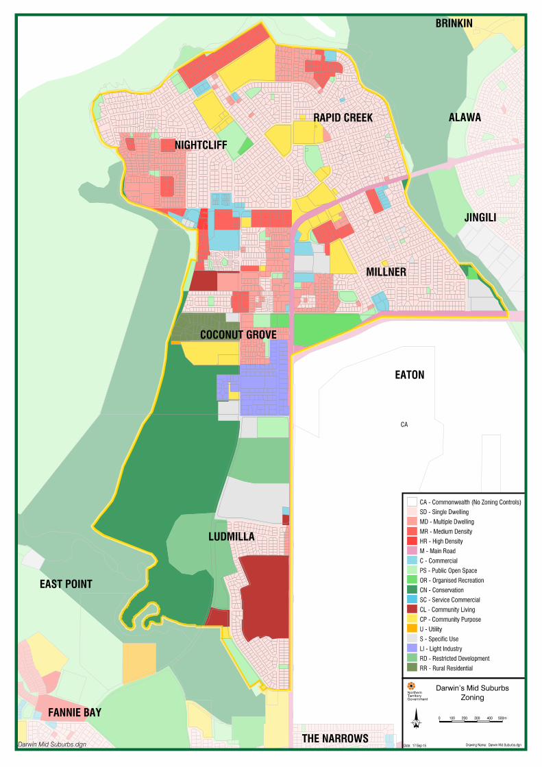
Darwin’s Mid Suburbs are strategically located between the major centres of the Darwin CBD and Casuarina, within the boundaries of Ludmilla Creek and Rapid Creek. Parts of the area are significantly impacted by the Darwin International Airport/RAAF base located east of the study area.
The mid suburbs include Ludmilla, Coconut Grove, Nightcliff, Rapid Creek and Millner.
Population growth projections estimate that over the next 40 to 50 years, the Darwin Region will almost double in population, with an increase of about 120,000 residents. Darwin’s Mid Suburbs will accommodate some of this growth, with estimates suggesting that about 410 new dwellings will be required in the mid and northern suburbs by 2025, and 2,490 by 2065 (Darwin Regional Land Use Plan 2015).
NEW DWELLINGS 2025 2065Darwin City 1,060 5,320
Darwin Inner Suburbs 900 4,490
Darwin Mid and Northern Suburbs 410 2,490
Darwin Palmerston Corridor 4,180
PalmerstonandLitchfield 880 8,500
Figure 2: Extra dwellings required for increase in population.


DARWIN MID SUBURBS AREA PLANS
6
6 Residential
Tell us…
How and where would you accomodate more people in Darwin’s Mid Suburbs?
How do we make neighbourhoods more compact while keeping the area’s tropical character?
What areas have the most potential for change, and what areas should stay the same?
Darwin’s Mid Suburbs have a mix of housing types.
Detached housing is generally distributed throughout the mid suburbs.
Attached housing is mostly found in Coconut Grove between Bagot Road and Dick Ward Drive and the south west part of Nightcliff. Some smaller areas of attached housing are scattered through the other suburbs. There are a number of zoned sites with potential to accommodate additional density.
Apartments and units are mostly located on the shorelines of Nightcliff and Rapid Creek and close to the Nightcliff/Coconut Grove and Sabine Road commercial centres. There are other areas of apartments and units located in the other suburbs, except for Ludmilla. There are a number of zoned sites that have not been developed to their full potential.
Various older public housing sites across Darwin are approaching their end of life and could present an opportunity for future redevelopment. Redevelopment of any public housing sites will be a consideration of the relevant Northern Territory Government agencies.
38%Detached housing
36%Attached housing
(two storey terraces, townhouses etc.)
26%
Unit and apartment housing
DARWIN MID SUBURBS AREA PLANS
8
7 Activity centres and service commercial corridor
Activity centres and service commercial corridors provide local jobs and commerce opportunities.
Tell us…
What kind of development do you want in activity centres?
Should more land in Darwin’s Mid Suburbs be available for other commercial activities, such as shops, showrooms etc?
7.1 Activity centres Activity centres have a mix of shops, offices, community and residential developments, and are usually the central hub in a neighbourhood. Here are the activity centres in Darwin’s Mid Suburbs:
• Nightcliff and Rapid Creek Shopping Centres are secondary centres that service the weekly needs of the community and cater for surrounding communities.
• Progress Drive, Millner and Aralia Street shops are local activity centres focusing on convenience retailing that serves the community’s day-to-day needs.
• Jape Homemaker Village is a specialist activity centre that includes a range of unique themes and bulky goods. It attracts people from all over greater Darwin.
7.2 Service commercial corridorThere is potential to establish a significant mixed-use service corridor along the north-west boundary of the Darwin International Airport between Osgood Road, McMillans Road and Bagot Road. This developing corridor has three parts:
• Coconut Grove Light Industrial Area is a well-established diverse industrial precinct with a strong semi-commercial/retail sector along Bagot Road. The light industrial area together with Bunnings on the east side of Bagot Road forms a strong anchor at the end of the service commercial corridor.
• Midway along the corridor, a small mixed use centre is developing around Neale Street and Osgood Drive on the airport side of McMillians Road. This area is directly adjacent to the study area and under the control of the Darwin International Airport. The area demonstrates further potential for development and influence on the mid suburbs. There is a large games centre, a petrol station and industrial buildings under construction.
• At the north-east end of the corridor is Sabine Road, a mixed use local activity centre.


DARWIN MID SUBURBS AREA PLANS
10
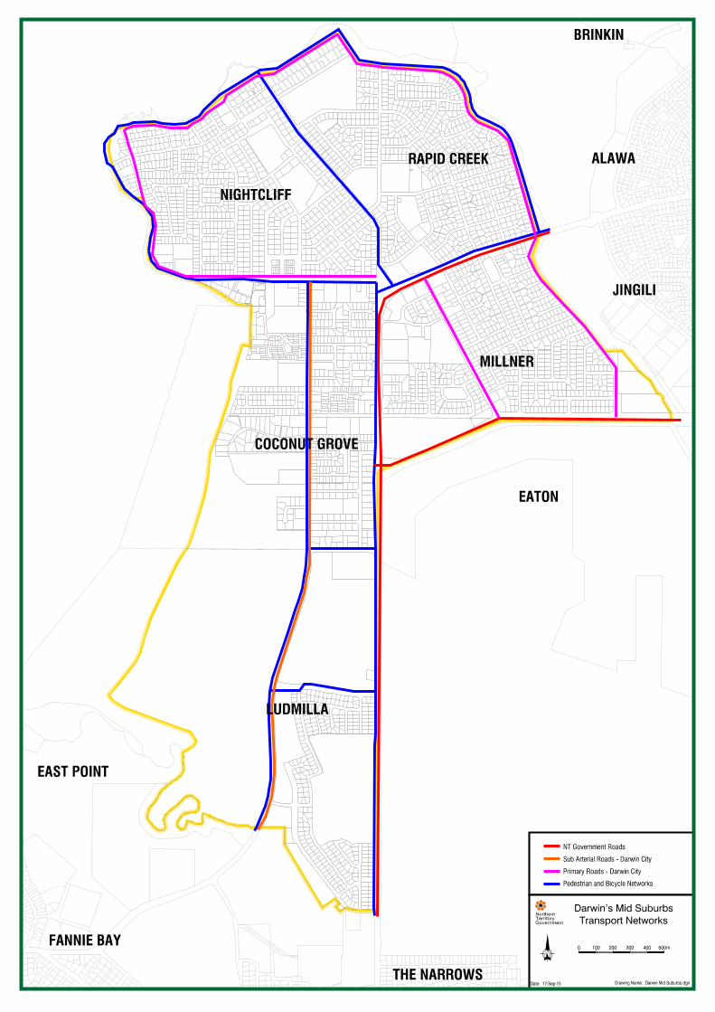
8 Transport networks
Tell us…
How would more people in Darwin’s Mid Suburbs affect the local transport network?
How could we improve the local transport network, including roads, pedestrian and cycling links in Darwin’s Mid Suburbs?
What other kinds of public transport might suit Darwin?
8.1 Road networkDarwin’s Mid Suburbs consists of a number of significant transport corridors such as Dick Ward Drive, Progress Drive, Bagot Road, Trower Road, Nightcliff Road, Ryland Road, Sabine Road, McMillans Road, Old McMillans Road and Rapid Creek Road, which links to other major areas such as Casuarina, Palmerston and Darwin CBD.
8.2 Buses and public transport Darwin’s Mid Suburbs are connected by regional bus corridors along Dick Ward Drive and Bagot Road, which link Nightcliff and Rapid Creek to Darwin CBD, Casuarina and Palmerston. These regional corridors are complemented by six local public bus routes that serve the mid suburbs exclusively, plus 11 school buses which serve the study area.
8.3 Pedestrian and cycle paths An established bike and pedestrian network connects the mid suburbs to Darwin CBD, East Point, Palmerston, Nightcliff, Casuarina and the northern suburbs. This network is also used for passive and active recreation by the community especially along the foreshore.

DARWIN MID SUBURBS AREA PLANS
12
9 Community spaces
Tell us …
Is there enough open space in Darwin’s Mid Suburbs?
Should there be new public open space available in sizeable developments?
What types of community facilities do you want for the area in the future?
9.1 Open space There are many sites within Zone PS (Public Open Space) and Zone OR (Organised Recreation) in the mid suburbs, including the Nightcliff Pool, Foreshore, Sports Club and oval, Rapid Creek Beach, tennis courts, playgrounds and public parks amongst others.
The Jingili Water Gardens are located immediately adjacent to the study area and also service the community of the mid suburbs. In addition to the water gardens, there is a skate park, community garden, playground and picnic area.
A substantial coastline including large areas of conservation land also contributes to the green space of the mid suburbs
9.2 Recreational uses Demand for sporting fields across Darwin is currently outstripping supply and many of the existing sports ovals are operating at their full capacity. Many of the future needs of the population may be met by making better use of the facilities and spaces that are already available in the mid suburbs.
9.3 Community purpose sites Zone CP (Community Purpose) provides for community services and facilities, including civic and government administration. The land and facilities may be privately or publically owned and operated. There are 26 sites in Zone CP in the study area, including schools, libraries, churches and cultural centres, health service facilities and government buildings.
9.4 Communities There are three Aboriginal communities within the mid suburbs, being Kulaluk, Minmarama and Bagot Community. Both Kulaluk and Minmarama are located within a Crown lease held by the Gwalwa Daraniki Association.
The Northern Territory Government is currently working on a separate project with Gwalwa Daraniki to develop an economic master plan for 3km² of Crown land between Ludmilla Creek and Nightcliff. Much of the lease area will remain as conservation land however plans have already been approved to develop a retail precinct and medical centre on land between Dick Ward Drive and Bagot Road. Future land uses could also include commercial and residential developments.


DARWIN MID SUBURBS AREA PLANS
14
10 Darwin airport controls
In addition to any controls in the NT Planning Scheme, airport control legislation applies additional land use controls to the study area. All the mid suburbs are subject to height restrictions of various degrees which are enforced by the Department of Defence, and some areas are further subject to Aircraft Noise Intrusion.
Height restrictions
As shown on the map opposite, there are various levels of height restrictions in the mid suburbs depending on how close they are to the airport runway. There are areas of each suburb that are subject to Department of Defence approval for structures over 15m, and Ludmilla in particular has increased development restrictions in place.
Noise
Australian Noise Exposure Forecast (ANEF) maps produced by the Department of Defence provide information regarding aircraft noise exposure near Defence bases. The map opposite illustrates the ANEF contours and the level of exposure each suburb faces.
This table lists acceptable types of future use or development within the ANEF contours.
ANEF contour Acceptable use <20 residential, hotel/motel/hostel, commercial, light industry, general industry
<25 hotel/motel/hostel, commercial, light industry, general industry
<30 light industry, general industry
>30 general industry only
Figure 3: ANEF contours
Public Safety Zones
Public Safety Zones (PSZs) are areas of land next to the end of a runway where development is restricted to limit the number of people on the ground at risk of injury or death in the event of an aircraft accident at take-off or landing. For Darwin International Airport, the PSZ is located in Ludmilla.
Safety Zone boundaries are determined by looking at the statistical likelihood of an accident at a particular location. The number of aircraft movements and the distance of the location from take-off and landing points are used to estimate the likelihood of a fatal accident at the location over a one-year period.


DARWIN MID SUBURBS AREA PLANS
16
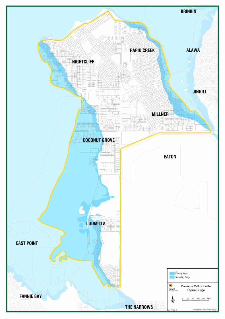
11 Storm tide and riverine flooding
Storm tide is the collective name for the inundation level above the normal high tide water level along the shore as a result of a storm surge event associated with strong onshore winds, which cause water to pile up against the coast.
Darwin’s Mid Suburbs are located in the primary and secondary storm surge meaning if and when a storm tide event happens in conjunction with a high or spring tide, the storm tide can reach areas that might otherwise have remained dry.
The mid suburbs, especially Rapid Creek and Ludmilla, can also be affected by riverine flooding or flooding due to storm water drainage issues.
During Cyclone Carlos in 2011, about 67 properties were affected by floodwater from Rapid Creek.
Significant funding has been allocated to address flooding in the Darwin Region. More information on flood mitigation in Rapid Creek and Ludmilla is available here: http://www.lands.nt.gov.au/flooding-in-the-NT
12 Further investigations
Further investigations for this area plan study are looking at:
• local road networks and the traffic capabilities of these networks
• drainage capabilities
• public open space and community facilities
• power, sewer and water networks and their capacities.
We will provide more information about these studies during Stage 2 of this project.
13 Contact us
You can get more information and provide feedback to the Planning Commission at:
Website: www.planningcommission.nt.gov.au
Email: [email protected]
Phone: 08 8924 7540

For more information:
Email: [email protected]
Visit: www.planningcommission.nt.gov.au
Phone: 08 8924 7540
Say Hello:
See the website for a list of dates and locations
NT Planning Commission Level 5, Energy House 18-20 Cavenagh Street
Darwin
GPO Box 1680 Darwin NT 0801
The Northern Territory Planning Commission is an independent and advisory statutory authority that prepares strategic land use plans to manage growth in anticipation rather than response.
The Planning Commission proactively sets the strategic framework for better integrated land use, transport and infrastructure planning, delivering more sustainable and cost-effective outcomes for the community, with sensitivity to environmental and heritage values.