damage/needs assessment in the affected area of the 2011
TRANSCRIPT

Damage/Needs Assessment In the Affected Area of
The 2011 off the Pacific Coast of Tohoku Earthquake and Tsunami
11th of April 2011
SEEDS Asia, OYO International Corporation and Kyoto University

About this Report This report summarizes the key observations from the field trip undertaken between 1st of April and 5th of April 2011. At the end of the report, basic analysis is provided on what worked and what did not. A few recommendations towards short and medium term recovery are given.
Acknowledgements The survey was sponsored by Japan Platform (JPF: http://www.japanplatform.org/). OYO International Corporation (OIC) bears the cost of its staff members. The survey team visited many affected areas and learned a lot in the affected areas. Different kinds of people told the team about tsunami situation and recovery while they have a lot of difficulties and problems. We deeply appreciate the cooperation of local governments, local people and volunteers and non-profit organizations in Iwate and Miyagi Prefectures.
Team Members Rajib Shaw [Associate Professor of Kyoto University and Chairperson of SEEDS Asia]
Yuko Nakagawa [Chief Operating Officer, SEEDS Asia] Koichi Shiwaku [OYO International Corporation and Member of SEEDS Asia] Tomoko Shaw [Manager of OYO International Corporation and Member of SEEDS Asia] Fumito Kaneko [General Manager of OYO International Corporation and Member, SEEDS Asia]
Contacts Rajib Shaw [[email protected]] Yuko Nakagawa [[email protected]] Koichi Shiwaku [[email protected]]
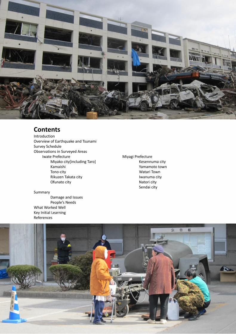
About the Cover The middle photo is from Rikuzen Takata of Iwate prefecture, where there were several thousands of pine trees as the coastal green belt. All the trees are broken in the disaster, leaving only one tree, as the symbol of hope for the future. The photo on the top is the damages in Taro in Miyako town, where a 10 m high, and 2.5 km long dyke was constructed. The photo in the bottom is the devastated area in Kesennuma port, where a major fire broke out due to leakage of oil.
Contents Introduction Overview of Earthquake and Tsunami Survey Schedule Observations in Surveyed Areas
Iwate Prefecture Miyako city[including Taro] Kamaishi
Tono-city Rikuzen Takata city Ofunato city
Miyagi Prefecture Kesennuma city Yamamoto town Watari Town Iwanuma city Natori city
Sendai city Summary Damage and Issues People’s Needs What Worked Well Key Initial Learning References


1
Introduction
A massive earthquake of magnitude of 9.0 occurred Friday 11 March, off the Pacific
coast of the northeastern part of the Japanese main land (Tohoku Region), causing
devastating damages. The Japan Meteorological Agency (JMA) named this earthquake
"The 2011 off the Pacific coast of Tohoku Earthquake" (JMA, 2011). In addition, this
earthquake caused the large scale of tsunami which hit Tohoku and Kanto Region.
Because of the earthquake and tsunami, more than 12,000 people were died and the
number of the missing persons is more than 15,000 (NPA, 2011). The survey team
which consisted of SEEDS Asia, OYO International Corporation and Kyoto University
conducted the survey in Iwate and Miyagi Prefecture, the most affected area by the
tsunami, in order to understand the damages by the earthquake and tsunami and to
grasp the needs of the local community and the government. This report is the
summary of the survey.
Overview of the Earthquake and Tsunami
Table 1 and 2 and Figure 1 are the overview of the earthquake and tsunami provided
by JMA (2011).
Table 1 Earthquake Details
Date and Time 11 March 2011 14:46 JST (05:46 UTC) Magnitude 9.0 (interim value; the largest earthquake recorded in
Japan) Hypocenter N38.1, E142.9 (130km ESE off Ojika Peninsula) Depth
24km (interim value) JMA Seismic Intensity (refer to Figure 1)
7 (Max): Kurihara City of Miyagi Prefecture 6+: 28 cities and towns (including Wakuya Town, Tome City, Osaki City, Natori City) in Miyagi, Fukushima, Ibaraki, and Tochigi Prefectures 6- or weaker: Observed nationwide from Hokkaido to Kyushu
Source: National Geographic

2
Figure 1. Seismic intensity map for The 2011 off the Pacific coast of Tohoku Earthquake
(JMA, 2011)
Table 2. Tsunami warning and advisories
Date and Time Action Number of Areas (Total : 66 areas)
Warning (3m
or higher)
Warning
(Up to
2m)
Advisory
(About 0.5m)
11 March 2011 14:49 JST (05:49 UTC) Issued 3 5 15
11 March 2011 15:14 JST (06:14 UTC) Increased 6 7 23
11 March 2011 15:33 JST (06:33 UTC) Increased 10 24 11
11 March 2011 16:08 JST (07:08 UTC) Increased 17 19 17
11 March 2011 18:47 JST (09:47 UTC) Increased 17 19 18
11 March 2011 21:35 JST (12:35 UTC) Increased 17 22 19
11 March 2011 22:53 JST (13:53 UTC) Increased 18 21 19
12 March 2011 03:20 JST (18:20 UTC) Increased 18 21 27
12 March 2011 13:50 JST (04:50 UTC) Decreased 4 11 26
12 March 2011 20:20 JST (11:20 UTC) Decreased 0 4 21
13 March 2011 07:30 JST (22:30 UTC) Decreased 0 0 15
13 March 2011 17:58 JST (08:58 UTC) Lifted 0 0 0

3
Survey Schedule
Table 3 shows the survey schedule and Figure 2 shows the survey areas.
Table 3. Survey schedule
Day Activities/Survey areas 1st April 2011 Reached to Morioka, Iwate 2nd April 2011 Iwate Prefecture (Miyako-city (including Taro area),
Yamada town, Otsuchi-cho, Kamaishi- city, and Tono- city)
3rd April 2011 Iwate Prefecture (Rikuzen-Takata- city, and Ofunato-city) and Miyagi Prefecture (Kesennuma-city, Minami-Sanriku-town, and Ishinomaki-city)
4th April 2011 Miyagi Prefecture (Yamamoto-town, Watari-town, Iwanuma-city, Tohoku University)
5th April 2011 Natori-shi, Sendai, and leave Miyagi Prefecture
Location
Taro
Miyako
Kesennuma
Ishinomaki
Kamaishi
Natori
Iwanuma
Watari
Ofunato
YamadaOtsuchi
Tono
Rikuzen-Takata
Minami-Sanriku
Sendai
Map source: Google map
Figure 2. Survey areas

4
Observations in Surveyed Areas
This section is the survey report on the affected area and other related area where the
team surveyed with emphasis.
Iwate Prefecture Miyako-shi (including Taro area)
Taro area was damaged by the tsunami caused by Syowa-Sanriku Earthquake, which
occurred in 1933. After the event, 10-meater dikes are built to prevent damages by
future tsunami. But the area had devastating damages by the tsunami this time. Figure
3 shows the dike and damages. Figure 4 shows the buildings which survived from the
tsunami because of the dikes. Most of the houses and buildings are flowed and
collapsed by the tsunami. But some buildings are remained. From this result, it was
identified that the dikes could not prevent tsunami damages but that they are effective
to some extent.
Figure 5 and 6 show fishes which had been kept in storage. These fishes planed to be
carried to other places but these were damaged because of the tsunami. Therefore, the
fishes will be disposed. The survey team visited the Miyako Fishery Association to
understand damages and needs on fisheries. The main works of member of the
association are fishing and aquaculture. Because of the tsunami, many members lost
their own fish boat. In addition, it is impossible to do aquaculture because the
members lost equipments for it and many kinds of things including rubble, car, waste,
and others were flowed to sea. Therefore, the members can not start their work. Other
problem is insurance. All members did not purchase insurance for their own properties.
If such member starts their works, they have to purchase equipments or ships by
themselves. In addition, most of fisheries are elderly. According to the interview, the
average age of the fisheries is around 60 years old. It was expected that it is seriously
difficult to recover fishery industry in Miyako without any external help.

5
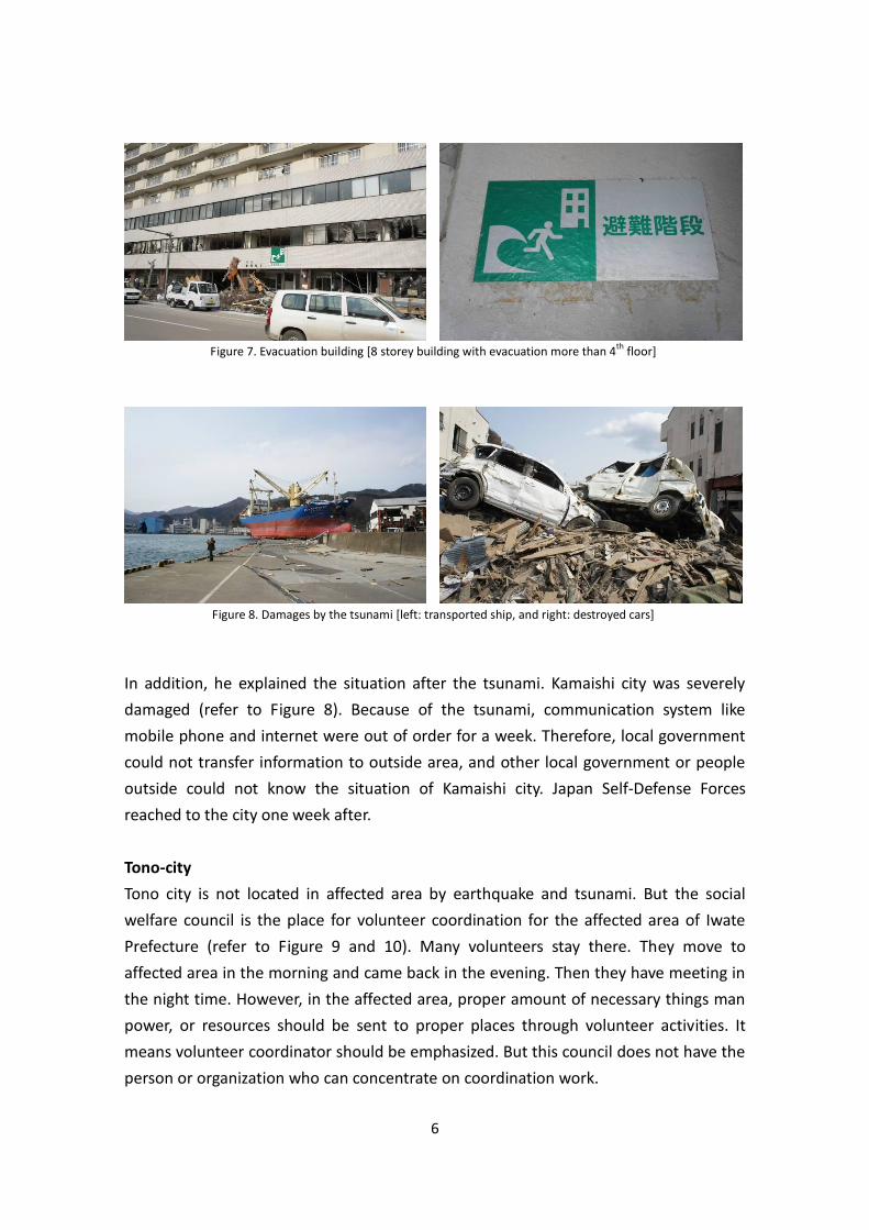
Kamaishi city
In Kamaishi, there are two tsunami evacuation building officially decided by the local
government for evacuation. The survey team visited one of them shown in Figure 7.
The number of stories of this building is eight. The first to third floors are used for
offices and fourth to eighth floors are residential spaces. There are also road near this
building for evacuation in tsunami situation. One of inhabitant told the tsunami came
to the third floor of this building. Local residents were evacuated in this building and
the road temporally. In addition, he mentioned they had evacuation training 3rd March.
It is expected that the training was effective for local people to re-realize the place for
evacuation and how to do in tsunami situation.
Figure 5. Damages to frozen fish in Miyako area Figure 6. Destroyed truck is lifted from sea in Miyako
Figure 4. Buildings which survived during the tsunami
in Taro area
Figure 3. Damages by the tsunami in Taro area
6
In addition, he explained the situation after the tsunami. Kamaishi city was severely
damaged (refer to Figure 8). Because of the tsunami, communication system like
mobile phone and internet were out of order for a week. Therefore, local government
could not transfer information to outside area, and other local government or people
outside could not know the situation of Kamaishi city. Japan Self-Defense Forces
reached to the city one week after.
Tono-city
Tono city is not located in affected area by earthquake and tsunami. But the social
welfare council is the place for volunteer coordination for the affected area of Iwate
Prefecture (refer to Figure 9 and 10). Many volunteers stay there. They move to
affected area in the morning and came back in the evening. Then they have meeting in
the night time. However, in the affected area, proper amount of necessary things man
power, or resources should be sent to proper places through volunteer activities. It
means volunteer coordinator should be emphasized. But this council does not have the
person or organization who can concentrate on coordination work.
Figure 8. Damages by the tsunami [left: transported ship, and right: destroyed cars]
Figure 7. Evacuation building [8 storey building with evacuation more than 4th
floor]
7
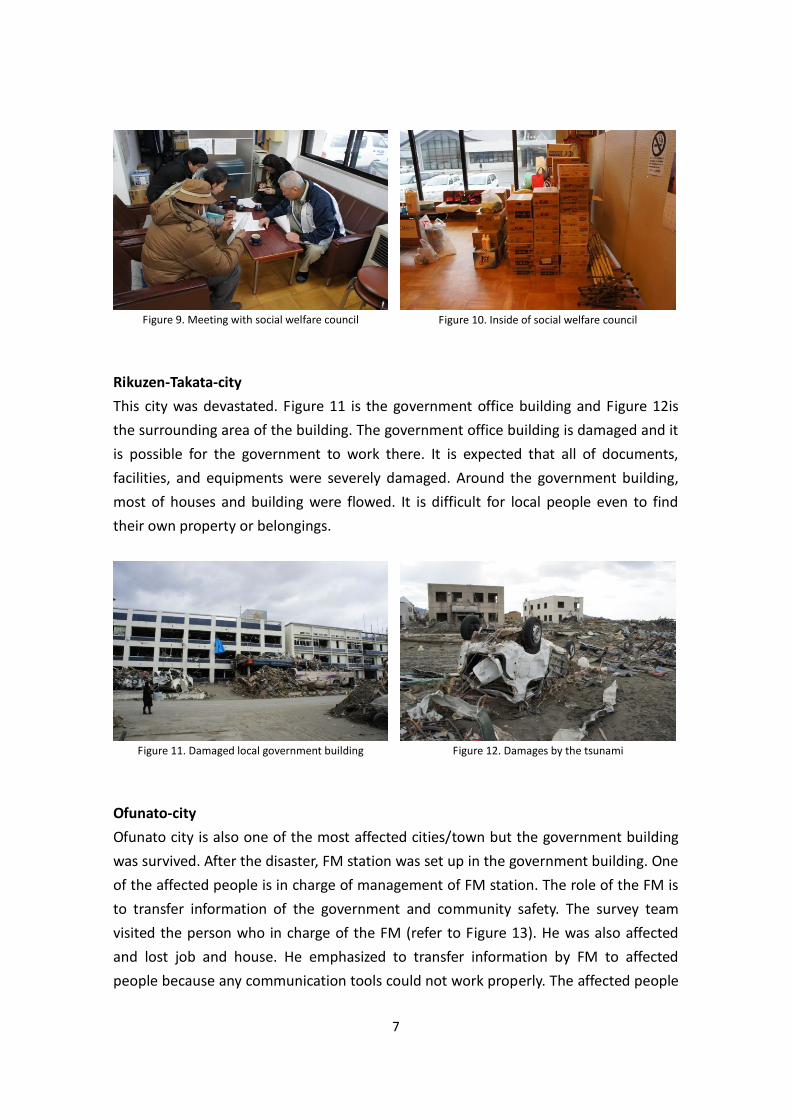
Rikuzen-Takata-city
This city was devastated. Figure 11 is the government office building and Figure 12is
the surrounding area of the building. The government office building is damaged and it
is possible for the government to work there. It is expected that all of documents,
facilities, and equipments were severely damaged. Around the government building,
most of houses and building were flowed. It is difficult for local people even to find
their own property or belongings.
Ofunato-city
Ofunato city is also one of the most affected cities/town but the government building
was survived. After the disaster, FM station was set up in the government building. One
of the affected people is in charge of management of FM station. The role of the FM is
to transfer information of the government and community safety. The survey team
visited the person who in charge of the FM (refer to Figure 13). He was also affected
and lost job and house. He emphasized to transfer information by FM to affected
people because any communication tools could not work properly. The affected people
Figure 9. Meeting with social welfare council Figure 10. Inside of social welfare council
Figure 11. Damaged local government building Figure 12. Damages by the tsunami

8
have various needs to survive in disaster situation. FM has the possibility to solve this
problem. Figure 14 shows the radio booth on the air. The girl who is on the right side is
fifteen years old. If the disaster did not happen, she would enter high school this April.
But the government cannot start schools. Therefore, she came there and contributed
to FM broadcasting. Generally, the role of new FM station in disaster situation is to
make recovery smooth. Actually, the license of FM station was given for three month.
Ofunato city consists of coastal/plain area and mountain area. In Iwate prefecture,
damages by earthquake are not much. It means most of the damages were caused by
the tsunami. Therefore, houses in the mountain area are not damaged severely. He
mentioned the gap of people’s awareness between two areas as future expected
problems in this city. His aim of the FM is community development through the FM as
well as disaster recovery/reconstruction.
Miyagi Prefecture Kesennuma-city
Kesennuma city is severely damaged. In this city, heavy oil was flow out and it was
burned. Therefore, many burnt pieces of rubble are seen in the city (refer to Figure
15). The city was devastated. Train could not run in this area because rail tracks are
also damaged (refer to Figure 15).
Figure 13. Meeting with person who is in charge of
community FM
Figure 14. High school student giving message
through FM
Figure 15. Damages by tsunami and burnt areas

9
Yamamoto-town
Yamamoto town was heavily damaged by the tsunami because it is located in plane
area (refer to Figure 16). But the government building was remained. In the first floor
of the building, FM station was established. The roles of the FM station were similar to
that of Ofunato city. The person who is in charge of management of FM station is a
person who retired from TBC (Tohoku Broadcasting Campany). He moved to live in this
town after his retiring. Because he was an announcer in TBC and had several
connection due to his working history, he and local community could establish FM
station. He has similar aims on FM station which the person in Ofunato city has. The
FM station invites government persons including the town mayor and asks them to
announce the current status and future plan for recovery and reconstruction (refer to
Figure 17). As mentioned before, the person who is in charge of the FM station
emphasized the radio should be utilized for community development as well as prompt
and appropriate recovery and reconstruction. Inviting the government persons is one
of challenges to achieve it. Because of this challenge, FM station can make the linkage
between local community and the government. He is considering that FM station
would be able to be continued for community development if the local government
understands the importance of FM station.
Watari-town
Watari town is the next town to Yamamoto town and these towns are located in the
same county named as Watari-gun. The government building of Yamamoto town was
being used even after the disaster but the building of Watari town was not. But
temporary offices were provided from outside. In the temporary offices, the
government could continue recovery works and others. Next to the office, FM station
was established (refer to Figure 18 and 19). The person who is in charge here had the
connection with the person at FM station in Yamamoto town. Therefore, Watari town
Figure 16. Damages by the tsunami Figure 17. Town mayor giving message or explanation
on the town through FM

10
could establish FM station smoothly. The person at FM station told the situation in this
town. In disaster situation, the community wireless system to provide local community
with tsunami warning was out of order. It is one of reasons to increase human damage
in this town. Additionally, recent houses have high performance of noise barrier. People
can not hear announces from the system when they are driving cars. Because of these
reasons, the wireless system is not appropriate for the current life style. As another
issue, she pointed the cost to prepare the same kind of wireless system again in this
town. It is expected that cost for it is higher than cost to distribute radio to all persons
in this town. She pointed out that local government should provide warning through
radio in emergency situation.
One of the big problems in tsunami affected area is how house rubbles is demolish
earlier to start recovery and reconstruction works. Under the general government
works, house owner asks the government to demolish. But the government has more
works in emergency situation, compared to general time. In Watari town and other
city/town, house owner can leave message on demolishment, using the flags (refer to
Figure 20). House owner select one of color flag from three flags and give it to their
own house. Red means houses and rubbles round house can be demolished by the
government or appointed companies. Yellow means only rubbles around houses can be
demolished and green shows any demolishment is not necessary. Because of this, it is
easy to understand house owner’s decision and the government can start recovery
works earlier.
Figure 18. Temporary government office Figure 19. Community FM station

11
Iwanuma-shi
In Iwanuma city, the local government is providing information the damages in the city
and government recovery work in front of the government building (refer to Figure 21).
The government can this kind of works because the building was safe to the officer can
concentrate to recovery works. From this, it is obvious that the government building is
important. The survey team visited the office of the social welfare council in this city.
The social welfare council is also working effectively. The council coordinates
volunteers who came to this city. The staff told external help is not so necessary for
coordination works but some recovery works like removal of clay or mud and house
moving needs more volunteers (refer to Figure 22).
Natori-city
Sendai airport is located in Natori city. The airport is the biggest one in Tohoku area and
it is not available because of the disaster (refer to Figure 23). Therefore, relief goods or
other necessary things needs to be carried from other airport of Tohoku area or on the
road. In the residential area of Natori city, there is the small hill (refer to Figure 24).
Figure 21. Information on damages and recovery
works which were provided by the government
Figure 22. Meeting with social welfare works
Figure 20. Three kinds of flags to show the house status

12
This place is a temporary evacuation place for Tsunami but this hill was also attacked by
the tsunami. Figure 25 is the memorial thing for the tsunami this time. Some survived
people visit this hill to pray. Figure 26 is the memorial stone for the tsunami caused by
Syowa Sanriku Earthquake in 1933. The history of that tsunami was mentioned on the
stone. The stone was established on the hill but flowed by the tsunami. It was
considered that local community people visited the hill and know the past tsunami
there before the tsunami and their awareness had been raised. But, the tsunami this
time was much larger scale than the past one.
Sendai city
Iwate and Miyagi Prefecture are the most affected prefectures by the Tsunami. This
time, the scale of the earthquake was also historically much bigger one. But collapsed
houses or buildings by earthquake are not seen in Iwate Prefecture. In Sendai city and
other city/town in Miyagi Prefecture, some damages by the earthquake are seen. For
house, clay tile on a roof were damaged. Some large scale building in Sendai city had
damages on the structure (refer to Figure 27). However, completely destructed houses
Figure 25. Memorial things on the hill Figure 26. Memorial stone flowed from the hill
Figure 23. Damages around the airport Figure 24. Hill for tsunami evacuation in residential
area

13
or buildings could not seen in the both prefectures.
Summary
The survey team went around the several affected city/town in Iwate and Miyagi
Prefecture. The following are the damages/problems, needs, and findings by the
earthquake and tsunami. Based on these, suggestions and future plan are pointed to
conclude the survey.
Damages and Problems
・ Individual residences and government building: Damages by the earthquake is not
much. Most of damages are caused by the tsunami. Therefore, damages are seen in
coastal area and plain area.
・ Industry: Fishery industry is heavily damaged because the tsunami attacked coastal
area. Other industry or shops were also damaged.
・ Isolated area: Because communication system was down, Kamaishi city could not
transfer the information to outside area.
・ Temporary evacuation place: Some of evacuation place worked effectively. But
human damages were increased in plain area because the number of evacuation
place is few, compared to largeness of area.
・ Safety confirmation: In local government or evacuation centers, local people are
giving information of their safety or information to looking for other persons. These
are paper base information. Therefore, it is expected that nobody knows which is
new or which is not necessary already.
Figure 27. Building damaged by the earthquake
14
・ Amount of rubble: Tsunami is different from earthquake. In case of tsunami, it is
almost impossible to understand whose property. But rubble should be demolished
for recovery reconstruction.
・ Community wireless system: In case of big hazards, the system [bousai musen in
Japanese] is damaged and it does not work properly.
People’s Needs
・ Temporary house and spaces: Many people lost their own house. These people are
staying evacuation places. Temporary houses are necessary but it is necessary large
spaces to build.
・ Equipments and resources to start works: To start works again, equipments need
to be prepared but it takes cost. If people cannot earn money, they cannot survive
in emergency situation and their life after the reconstruction.
・ Job: Job is related to the need mentioned above. Many people lost their jobs. In
reconstruction process, it takes much cost to recover their own lives. Therefore, job
hunting is one of the most important tasks for affective people.
What Worked Well
Early warning system: The earthquake occurred at 14:46, the tsunami warning was
provided at 14:49, and was on the JMA [Japan Meteorological Agency] website at 14:50.
The tsunami warning in Japan has two parts: tsunami warning and tsunami advisory. A
map is shown in the TV with three different colors, red [major tsunami, with more than
3 m], orange [up to 2 m], and yellow [height about 0.5 m]. The red and orange colors
are warning, and yellow one is advisory. The estimated arrival time is also shown in
the JMA website. People evacuated to the nearby places, however the height of the
tsunami was beyond expectation.
Past earthquake and tsunami and its impacts: The affected area was hit repeatedly by
major earthquake and tsunami: on 15th June, 1896, on 3rd March 1933, and also on the
22nd May 1960 Chile earthquake and tsunami. In 1896, more than 22,000 people died,
a local culture of “tendenco” emerged from it. In 1896, many people wanted to look
for their family, neighbors after the tsunami, and the tsunami arrived meanwhile. This
culture has a deep meaning, which is built on the mutual trust. People were taught to
be evacuated, with the trust and belief that their family members will also take proper
shelter. This culture of “tendenco” saved many people’s lives.

15
Infrastructure measures: Due to past several events in the same area, infrastructures
like sea-dykes were built in several places. The 10 m high, 2.5 km long dyke in Taro,
Miyako town in Iwate prefecture is a classic example of this. Although part of the dyke
was damaged, and tsunami overflew the 10 m dyke, it surely reduced the impacts of
the event. In Kamaishi, in Iwate prefecture, tsunami evacuation building was built with
instructions, and people were safe who evacuated above 4th floor.
Evacuation drill and disaster education: Several areas performed regular disaster drills
on 3rd of March [the day of 1933 earthquake and tsunami], which was just one week
before the disaster. Disaster education was also performed in several schools, and the
impact was that in Kamaishi, 5 out of 2,900 school children died. The middle high
school students took shelter in the higher areas, along with the nearby elementary
school children.
Strong Earthquake risk reduction measures: in spite of a 9 magnitude event, and with
intensity 7 [in JMA scale, which is equivalent to XII in MMI], there was insignificant
impacts on buildings and infrastructures. Although liquefaction was observed in the
soft soil in reclaimed land, the buildings were safe in most cases. The destruction is
mostly concentrated in the narrow zone of 4-5 km along the coast. If there were added
damages on earthquake, the situation would have been worse.
Key Initial Learning1
Linking hard and soft measures [combination of infrastructures and education]: it is
of extreme importance that the risk reduction measures need to be locally customized,
and there needs to be a balance approach of soft [education, awareness] and hard
[infrastructures] measures. Based on the local topography and physical features, this
balanced mix is required to be customized.
Early warning system is effective when it is properly perceived: Although there was an
early warning issued immediately, people underestimated the height of the tsunami
due to repeated occurrences of earthquakes, and a “feel safe” mis-perception prevailed.
Proper perception is required to take necessary actions.
1 There would be lots of lessons learned in due course. This part summarizes some of the emerging learning issues, which appeared from the field survey.
16
Evacuation order and its effectiveness: although the evacuation advisory and
evacuation order are issued, people usually take their own judgment. To enhance the
proper decision of people, it is required to mention the expected height of the tsunami
in the evacuation order and advisory.
Investment in risk reduction pays: This disaster shows that the investment in risk
reduction pays to save people’s lives, both in terms of preventive and educative
measures. Japan has been a role model for earthquake risk reduction, however, it
needs to incorporate more multi-hazard risk reduction measures.
Dissemination of information to future generations: In several areas in the affected
region, dissemination of past experiences through storytelling to the school children
from the old people. This is considered as an important educational tool. In Natori,
there was the memorial stone to explain the past tsunami. For future generation as
well as current generation, the experiences this time should be shared.
Customized information sharing: Community FM was working effectively to transfer
government information to community. The need of customized information sharing
between the affected people and government is very important, and this can be done
through need survey and provide need specific programs through radio.
Importance of the government building: If government building is survived, the
government can start response and recovery works earlier. In addition, the government
can spare spaces for community.
Volunteer coordinator: In case of big disasters, many volunteers come to affected area
from outside. Volunteer coordinator is necessary to distribute proper volunteers to
proper area. This should be considered as a full-time specialized work, with access and
knowledge to different mapping tools and social networking system.
Reconstruction and community development: several areas were completely
devastated. Even if disaster did not happen, some of the local governments were in
verge of declination, and several villages became marginal villages due to its higher
aged population. Keeping this mind, it is necessary to integrate reconstruction and
community development with new livelihood concept and looking at the far future,
while serving the need of the near future.

17
Reduction of gap between affected and non-affected people: This time, damages by
earthquake is not prominent. So people in higher areas were not affected much, while
the whole coastal neighborhood in the same town or village has been destroyed. In the
future, it is expected that there would be a gap between the affected and non-affected
people. Reconstruction process should include non-affected people as well as affected
people in order to make safer and comfortable society cooperatively.
Data back up and preparedness of temporary offices of local government: If local
government had data of community, they can start recovery works earlier. Local
government should prepare backup data and temporally offices so that they can use
when necessary.
References JMA (2011). The 2011 off the Pacific coast of Tohoku Earthquake, -Portal-
http://www.jma.go.jp/jma/en/2011_Earthquake.html, accessed in April 2011.
NPA (National Police Agency) (2011). The damage information by The 2011 off the
Pacific coast of Tohoku Earthquake (version 10:00, 6th April 2011),
http://www.npa.go.jp/archive/keibi/biki/higaijokyo.pdf , accessed in April 2011. (in
Japanese)

SEEDS Asia www.seedsasia.org OYO International Corporation
Kyoto University Graduate School of Global Environmental Studies
Internaitonal Environment and Disaster Management Laboraoty
http://www.iedm.ges.kyoto-u.ac.jp/