d3.1 data models, object models and ontology …...data models, object models and ontology...
TRANSCRIPT
www.moveus-project.eu @moveus-project
D3.1 Data models, object models and ontology definition
ICT cloud-based platform and mobility services available,
universal and safe for all users
Deliverable Id : D3.1
Deliverable Name : Data models, object models
and ontology definition
Status : Final
Dissemination Level : PU
Due date of deliverable : M10 (updated in M12)
Actual submission date : 21/10/2014
07/04/2015 amended
version after 1st year review
Work Package : WP3
Organization name of lead
contractor for this
deliverable :
TEC
Author(s): Sergio Campos, Iraide
Unanue, Begoña Molinete
Partner(s) contributing : ALL
Abstract: This document describes the current outcome of Task 3.1, which addresses the definition of MoveUs data and objects model. At this stage, the focus is put on the main functional modules supporting the provision of multimodal, personalized and eco-efficient mobility services.
Data models, object models and
ontology definition
- 2 -
www.moveus-project.eu
HISTORY
Version Date Modification reason Modified by
0.1 17/06/2014 TOC TEC
0.2 03/07/2014 Registry, PT Operation, Traffic
Management, Feedback
TEC with
contributions
from SOF, TEC
0.3 10/07/2014 Incentives, Energy Efficiency TEC with
contributions
from SOF,
QRY,CDG, TUT,
TRE
0.4 18/07/2014 Madrid use-cases analysis, PT
Operation, Journey Planning
update, conclusions
TEC with
contributions
from SICE, EMT
0.5 21/07/2014 Description of model aspects TEC
0.6 23/07/2014 Description of model aspects
(Public Transport)
TEC
0.7 24/07/2014 Description of model aspects
(Traffic Management)
TEC
0.9 11/08/2014 Quality Check ATOS
1.0 11/08/2014 Final Version ATOS
1.05 26/09/2014 Minor adjustments to the
model searching for full
alignment with D3.2 and D3.3
SICE, SOF, TEC
1.09 10/10/2014 Minor adjustments after final
crosscheck with WP3
deliverables
SOF, TEC
1.1 21/10/2014 Updated Final Version TEC
FINAL amended
version
07/04/2015 Amendments after first review
meeting
TEC with the
support of ALL
Data models, object models and
ontology definition
- 3 -
www.moveus-project.eu
Contents
HISTORY ...................................................................................................... 2
Contents ...................................................................................................... 3
List of Figures ............................................................................................... 5
List of Tables ................................................................................................ 6
List of Abbreviations ...................................................................................... 7
Executive Summary ....................................................................................... 9
1 MoveUs Overview ................................................................................... 10
2 Methodology .......................................................................................... 11
3 MoveUs data model ................................................................................ 15
3.1 Functional block User Management ..................................................... 15
3.1.1 Existing specifications ................................................................. 15
3.1.2 Extensions ................................................................................. 16
3.2 Functional block Traffic Management .................................................. 23
3.2.1 Existing specifications ................................................................. 24
3.2.2 Extensions ................................................................................. 36
3.3 Public Transport Operation Management ............................................. 48
3.3.1 Existing specifications ................................................................. 48
3.3.2 Extensions ................................................................................. 50
3.4 Functional Traveller Journey Assistance ............................................... 52
3.4.1 Existing specifications ................................................................. 53
3.4.2 Extensions ................................................................................. 56
3.5 Functional block Incentive Management .............................................. 57
3.5.1 Existing specifications ................................................................. 59
3.5.2 Extensions ................................................................................. 59
3.6 Functional block CF/EC Estimation ...................................................... 64
3.6.1 Existing specifications ................................................................. 65
3.6.2 Extensions ................................................................................. 65
3.7 Functional block Feedback ................................................................. 66
3.7.1 Existing specifications ................................................................. 66
3.7.2 Extensions ................................................................................. 67
3.8 Functional Block Registry................................................................... 67
3.8.1 Existing specifications ................................................................. 67
3.8.2 Extensions ................................................................................. 67

Data models, object models and
ontology definition
- 4 -
www.moveus-project.eu
4 Conclusions ........................................................................................... 70
5 References ............................................................................................ 71
Data models, object models and
ontology definition
- 5 -
www.moveus-project.eu
List of Figures
Figure 1 MoveUs data model definition process................................................. 12
Figure 2 eMotion status & scope ..................................................................... 12
Figure 3 In-Time status & scope ..................................................................... 13
Figure 4 Co-Cities status & scope ................................................................... 14
Figure 5 User management extensions (Taxonomy) .......................................... 17
Figure 6 User management extensions (Information) ........................................ 22
Figure 7 User management extensions (Organizations) ..................................... 23
Figure 8 Road Data Model .............................................................................. 26
Figure 9 Traffic Related Data .......................................................................... 27
Figure 10 Measured data publication ............................................................... 28
Figure 11 Data values ................................................................................... 30
Figure 12 Elaborated data publication ............................................................. 31
Figure 13 Incidence Related Data ................................................................... 33
Figure 14 Incidence Related Data. Non road Event ............................................ 33
Figure 15 Dynamic Weather Model .................................................................. 34
Figure 16 Dynamic Traffic Event Information .................................................... 35
Figure 17 Dynamic Parking Model ................................................................... 36
Figure 18 Intersection information static model (partial view) ............................ 39
Figure 19 Intersection data frame ................................................................... 40
Figure 20 Approach Object data frame ............................................................ 40
Figure 21 Intersection static info global data model .......................................... 42
Figure 22 Intersection static info global data model. Lane information ................. 43
Figure 23 BT readers (BTFix receptors) static model ......................................... 43
Figure 24 BT readers (BTFix receptors) dynamic model ..................................... 44
Figure 25 SPAT data model ............................................................................ 45
Figure 26 SRM data model ............................................................................. 46
Figure 27 SSM data model ............................................................................. 47
Figure 28 Dynamic Bike sharing Model ............................................................ 48
Figure 29 Public Transport (PT) Service Model .................................................. 49
Figure 30 Carpooling Service Model ................................................................ 50
Figure 31 PT Line Management Model ............................................................. 51
Figure 32 PT Line Management Model (detail) .................................................. 52
Figure 33 Journey Planning services ................................................................ 54
Figure 34 Journey Planning services (II) .......................................................... 54
Figure 35 Journey Planning services ................................................................ 55
Figure 36 Link between Journeys and Incentives .............................................. 56
Figure 37 Journey with additional information .................................................. 56
Figure 38 Trace Spatio-temporal information ................................................... 56
Figure 39 Incentive Management Functional View ............................................. 57
Figure 40 Incentive Currencies ....................................................................... 60
Figure 41 Incentive Transactions .................................................................... 61
Figure 42 Incentive & Rules ........................................................................... 62
Figure 43 Coupons & Awards.......................................................................... 64
Figure 44 Feedback Model ............................................................................. 67
Figure 45 Registry Model ............................................................................... 69
Data models, object models and
ontology definition
- 6 -
www.moveus-project.eu
List of Tables
Table 1 MoveUs users ................................................................................... 18
Table 2 MoveUs equipment and systems ......................................................... 18
Table 3 Incentive data blocks ......................................................................... 58
Table 4 Measure/Currency Units ..................................................................... 59
Table 5 Energy Efficiency concepts ................................................................. 65
Data models, object models and
ontology definition
- 7 -
www.moveus-project.eu
List of Abbreviations
<Abbreviation> <Explanation>
App Application
ATOS ATOS SPAIN
BSM Basic Safety Message
BT Bluetooth
BTFix Fix Bluetooth Reader
CF Carbon Footprint
D Deliverable
DATEX2 Standard for ITS on European Roads
EC Energy Consumption
EMT Empresa Municipal de Transportes de Madrid
FCD Floating Car Data
ID Identification
IFOPT Identification of Fixed Objects in Public Transport
ISO International Organization for Standardization
IT Information Technology
ITS Intelligent Transport System
KPI Key Performance Indicator
MAP Map Data
MSG Message
POI Point of Interest
PT Public Transport
RHW Road Hazard Warning
RSU Road Side Unit
RT Real Time
SAE SAE international (Society of Automotive Engineers)
SICE Sociedad Ibérica de Construcciones Eléctricas, S.A.
Data models, object models and
ontology definition
- 8 -
www.moveus-project.eu
SIRI Service Interface for Real Time Information
SOF Softeco Sismat Srl
SPAT Signal Phase And Timing Message
SRM Signal Request Message
SSM Signal Status Message
TECNALIA Tecnalia Research and Innovation
TPEG Transport Protocol Experts Group
TRE Tampereen Kaupunki
TUT Tampere University of Technology
UC Use-case
UML Unified Modelling Language
URL Uniform resource locator (internet)
V2I Vehicle to Infrastructure
V2V Vehicle to Vehicle
VIM Vehicle Interface Module
WG Working group
WP Work Package
Data models, object models and
ontology definition
- 9 -
www.moveus-project.eu
Executive Summary
WP3 as a whole is concerned with the MoveUs Architecture design and the platform
component specification, to be implemented and deployed in the different city
pilots. Specifically, this deliverable addresses the underlying data and object
models, able to support the information needs of the different processes and
interfaces, with existing data sources, field devices and involved actors.
The methodology to implement this data model, starts eliciting the information
needs by analysing the different use-cases, continues with the validation of
these data requirements, checks their coverage by previous reference data
models (from eMotion, In-time and Co-Cities projects) and finally, fills existing
gaps.
The conceptual MoveUs Data Model has been set up in Unified Modelling Language
(UML), by using the Enterprise Architect CASE Tool. This ensures standard
compliance and service generation support.
The main conclusion remarks that existing models cover a significant portion
of the concepts needed for the storage of information and provision of MoveUs
services. Nevertheless, the most innovative project goals: incentive
management, energy efficiency, services customization and specific
intelligent traffic management have not been previously addressed, so
appropriate extensions have been provided.
Furthermore, the work package scheduling determines an iterative approach,
constituting this document (v1.1) a final version, updated after the original delivery
date (M10) to perfectly match the platform and services specification and design,
which have just been completed at the end of the 1st project year (M12).

Data models, object models and
ontology definition
- 10 -
www.moveus-project.eu
1 MoveUs Overview
This Deliverable D3.1 is the first deliverable expected for WP3 – Analysis,
Specification and Design of the MoveUs Architecture and City Services.
The objectives of WP3 are:
To define the data models relevant for MoveUs operation.
To define the high-level architecture for the MoveUs Cloud-based platform
and its functional specifications in detail.
To provide detailed specifications and design for the set of services to be
provided in MoveUs pilots.
To identify the data security and privacy issues to be taken into account in
the MoveUs architecture and include them in the definition of the platform
and services.
Develop innovative business models determining the users’ willingness to
pay for the uptake of MoveUs services.
Specifically, Task 3.1 is aimed at collecting and identifying major data protocols and
data and object models relevant for MoveUs. After this analysis versus previously
elicited use-cases, and aligned with architectural and service design, a common
data model is defined.
Data models, object models and
ontology definition
- 11 -
www.moveus-project.eu
2 Methodology
The initial step of Task 3.1, was to identify, analyze and evaluate reference
ontologies in the context of MoveUs and evaluate their implementation. To this day
we can find different references for ontologies in the field of Smart Cities and
traffic, namely, being the most remarkable: Ontology of Traffic Networks (OTN) [1],
which extends GDF formalizing in OWL, Ontology of Urban Planning Process (OUPP)
[2] based on the CityGML model on survey data, LinkedGeoData (OSM) [3] and the
Townontology COST initiative [4] among others.
Although some successful results [5][6], after a deeper analysis, we can conclude
that these solutions are not compatible with each other, and cover partially the
needs elicited in MoveUs project, so an important effort should be necessary to
extend and harmonize these initiatives.
On the other hand, the potential of ontologies and semantics, in general, is
maximized in scenarios with unstructured, textual and multimedia data. Although,
MoveUs manages heterogeneous information, this is basically structured. Besides,
is not intended to address issues as dynamic service composition and semantic
reasoning, so prioritizing the efficiency of information capture and access
processes, our approach is to maintain a single relational data model as data
structure for MoveUs project and implement specific adaptors when needed.
Once set our scope, the data and objects models definition included in this
document has been developed following the next key concepts and methodology:
It is important to remark that one of the main objectives of the MoveUs project is
to develop a data model following the more relevant related standards and previous
European projects. In this way, the data model will not start from the scratch,
reusing previous development and aligning itself with other European initiatives and
standardization activities, and consequently, making the whole project more
interoperable. Another point to stand out is that the model is formally defined in
UML (Unified Modelling Language) by using the EA (Enterprise Architect) tool.
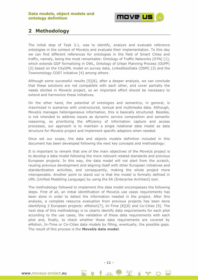
The methodology followed to implement this data model encompasses the following
steps. First of all, an initial identification of MoveUs use cases requirements has
been done in order to detect the information needed in the project. After this
analysis, a complete resource evaluation from previous projects has been done
identifying 3 European projects: eMotion[7], In-Time [8][8] and Co-Cities [9]. The
next step of this methodology is to clearly identify data requirements for each pilot
according to the use cases, the validation of these data requirements with each
pilot and, finally, to check whether these data requirements are covered by
eMotion, In-Time or Co-Cities data models by filling, eventually, the possible gaps.
The result of this process is the MoveUs data model.
Data models, object models and
ontology definition
- 12 -
www.moveus-project.eu
Figure 1 MoveUs data model definition process
Before going deeply into MoveUs data model, a concise description of the identified
European projects is presented in this document:
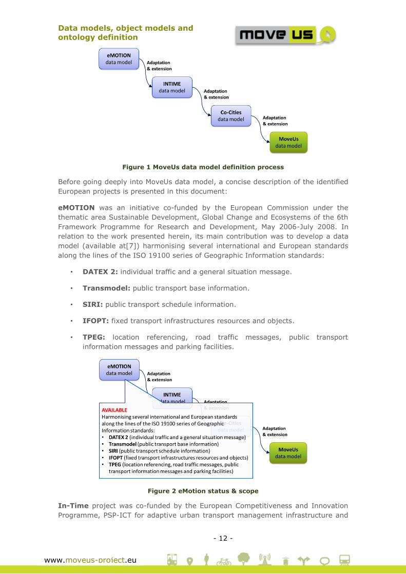
eMOTION was an initiative co-funded by the European Commission under the
thematic area Sustainable Development, Global Change and Ecosystems of the 6th
Framework Programme for Research and Development, May 2006-July 2008. In
relation to the work presented herein, its main contribution was to develop a data
model (available at[7]) harmonising several international and European standards
along the lines of the ISO 19100 series of Geographic Information standards:
• DATEX 2: individual traffic and a general situation message.
• Transmodel: public transport base information.
• SIRI: public transport schedule information.
• IFOPT: fixed transport infrastructures resources and objects.
• TPEG: location referencing, road traffic messages, public transport
information messages and parking facilities.
Figure 2 eMotion status & scope
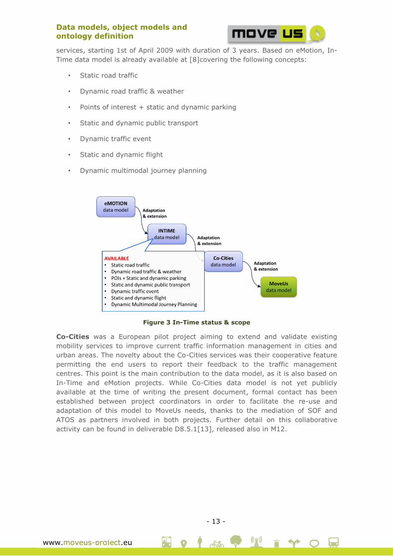
In-Time project was co-funded by the European Competitiveness and Innovation
Programme, PSP-ICT for adaptive urban transport management infrastructure and
Data models, object models and
ontology definition
- 13 -
www.moveus-project.eu
services, starting 1st of April 2009 with duration of 3 years. Based on eMotion, In-
Time data model is already available at [8]covering the following concepts:
• Static road traffic
• Dynamic road traffic & weather
• Points of interest + static and dynamic parking
• Static and dynamic public transport
• Dynamic traffic event
• Static and dynamic flight
• Dynamic multimodal journey planning
Figure 3 In-Time status & scope
Co-Cities was a European pilot project aiming to extend and validate existing
mobility services to improve current traffic information management in cities and
urban areas. The novelty about the Co-Cities services was their cooperative feature
permitting the end users to report their feedback to the traffic management
centres. This point is the main contribution to the data model, as it is also based on
In-Time and eMotion projects. While Co-Cities data model is not yet publicly
available at the time of writing the present document, formal contact has been
established between project coordinators in order to facilitate the re-use and
adaptation of this model to MoveUs needs, thanks to the mediation of SOF and
ATOS as partners involved in both projects. Further detail on this collaborative
activity can be found in deliverable D8.5.1[13], released also in M12.

Data models, object models and
ontology definition
- 14 -
www.moveus-project.eu
Figure 4 Co-Cities status & scope

Data models, object models and
ontology definition
- 15 -
www.moveus-project.eu
3 MoveUs data model
Although performed in parallel with task T3.2, the data model is aligned with the
different functional blocks so far identified on the functional architecture. Moreover,
the fact of relying on the FRAME methodology [10][10] helps to identify high-level
information needs by means of the DFD’s data stores, conceptual repositories of
information supporting selected functionalities.
At this stage of the project, the following functional blocks can be identified:
User Management
Traffic Management
Public Transport Operation Management
Incentive Management
CF/EC Estimation
Feedback
Register
3.1 Functional block User Management
The requirements in terms of User Management, identity provision and access
rights emerging from the Use Case definition suggest that in principle a basic level
of service could be provided for anonymous users. A user profile, instead, is
required for:
Personalized access to the mobility services
Management of the incentives-related operations
Management of the energy efficiency operations
The level of complexity of the user profile, associated to the two previous aspects
can vary from a simple pair: userID - password to a complete personal profile made
of a rich set of datatypes for the storage of preferences, habits, personal settings
etc.
3.1.1 Existing specifications
For the present and future needs in MoveUs, the definition a complete user profile,
based on the possibilities identified in the Use Cases is foreseen. This includes also
personal information that is non-mandatory1 in the data model.
1 The feature types introduced in the data model can have attributes with different
multiplicity, identified with square brackets and two identifiers: one for the lower
limit and one for the upper limit of possible instances of the attribute. A multiplicity
of [0..1] for instance indicates that the attribute is not mandatory (zero or one
instances are allowed) like in the case of personal data that are introduced and
Data models, object models and
ontology definition
- 16 -
www.moveus-project.eu
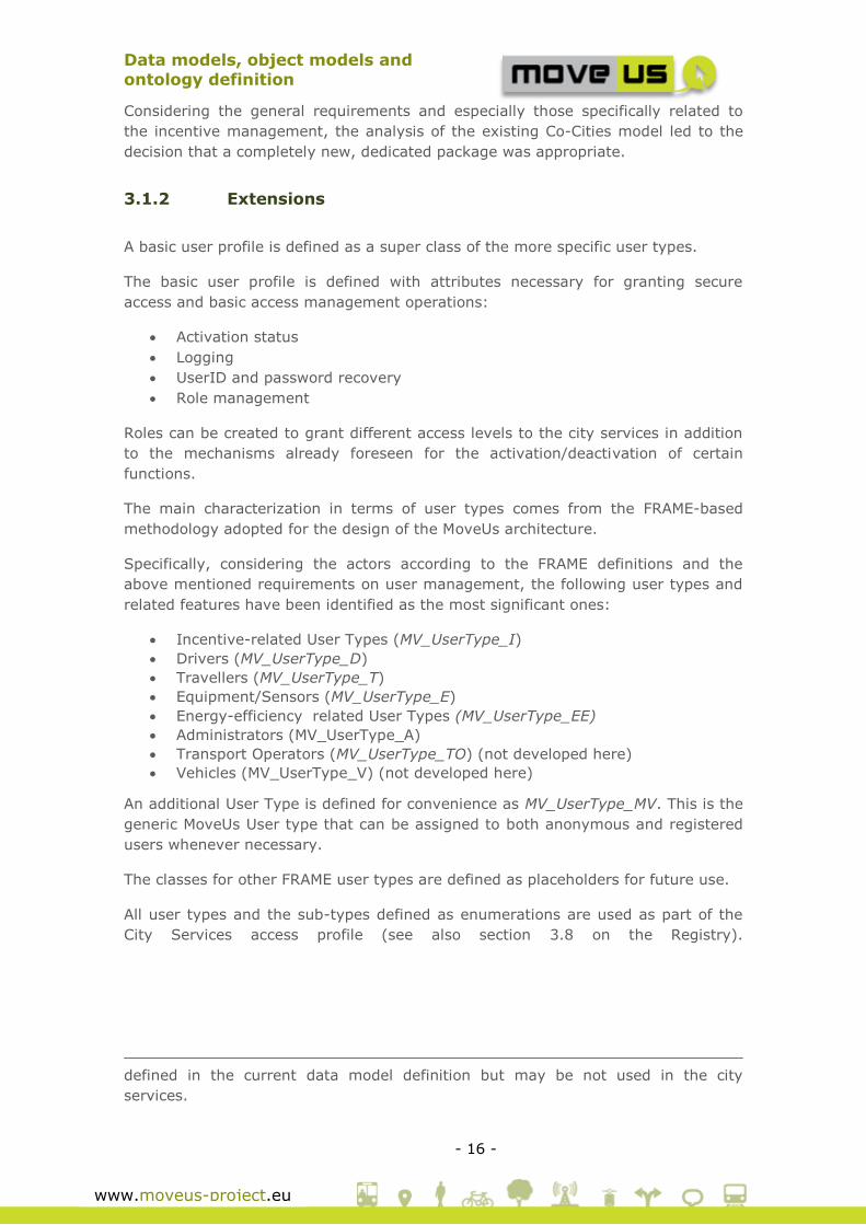
Considering the general requirements and especially those specifically related to
the incentive management, the analysis of the existing Co-Cities model led to the
decision that a completely new, dedicated package was appropriate.
3.1.2 Extensions
A basic user profile is defined as a super class of the more specific user types.
The basic user profile is defined with attributes necessary for granting secure
access and basic access management operations:
Activation status
Logging
UserID and password recovery
Role management
Roles can be created to grant different access levels to the city services in addition
to the mechanisms already foreseen for the activation/deactivation of certain
functions.
The main characterization in terms of user types comes from the FRAME-based
methodology adopted for the design of the MoveUs architecture.
Specifically, considering the actors according to the FRAME definitions and the
above mentioned requirements on user management, the following user types and
related features have been identified as the most significant ones:
Incentive-related User Types (MV_UserType_I)
Drivers (MV_UserType_D)
Travellers (MV_UserType_T)
Equipment/Sensors (MV_UserType_E)
Energy-efficiency related User Types (MV_UserType_EE)
Administrators (MV_UserType_A)
Transport Operators (MV_UserType_TO) (not developed here)
Vehicles (MV_UserType_V) (not developed here)
An additional User Type is defined for convenience as MV_UserType_MV. This is the
generic MoveUs User type that can be assigned to both anonymous and registered
users whenever necessary.
The classes for other FRAME user types are defined as placeholders for future use.
All user types and the sub-types defined as enumerations are used as part of the
City Services access profile (see also section 3.8 on the Registry).
defined in the current data model definition but may be not used in the city
services.
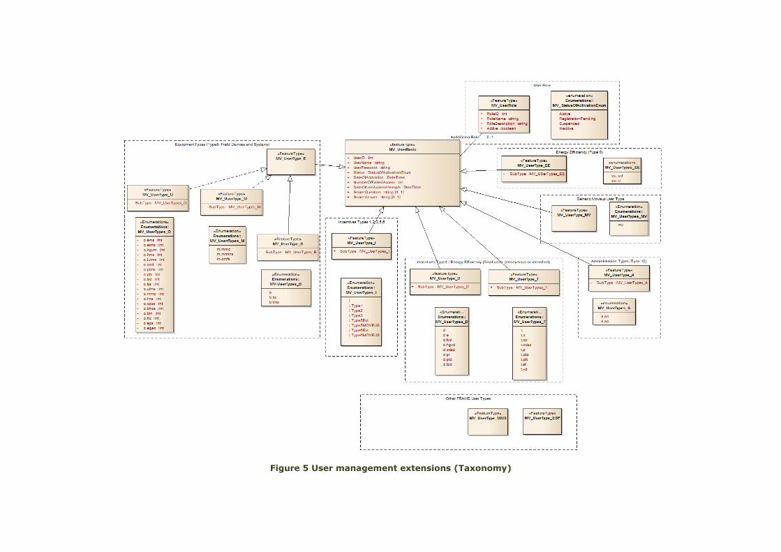
Figure 5 User management extensions (Taxonomy)

The sub-types attribute for each user type defines the specific actor (user) within a
main user category.
Table 1 MoveUs users
d.e Emergency Vehicle Driver
d.fvd Freight Vehicle Driver
d.hgvd Hazardous Goods Vehicle Driver
d.odsd On-Demand Service Driver
d.pr Private Driver
d.ptd Public Transport Driver
d.tpd Trip Planning Driver
t.c Cyclist
t.cp Car-Pooler
t.odsp On-Demand Service Passenger
t.p Pedestrian
t.ptp Public Transport Passenger
t.ptt Pre-Trip Traveller
t.st Static Traveller
t.vd Vehicle Driver
Analogously, the sub-types attributes for different equipment and systems within
the equipment category are the following:
Table 2 MoveUs equipment and systems
bti.bs Bridge Structures
bti.tms Tunnel Management System
mms.mmc Multi-Modal Crossing
mms.mmms Multi-Modal Management System
mms.omfs Other Mode Freight System
ors.ems Emergency Management System
ors.etms Environmental Traffic Management System
ors.hgvm Hazardous Goods Vehicle Route Monitoring
ors.itms Incident Traffic Management System
ors.iutms Inter-urban Traffic Management System
ors.ond Other Navigation Device (e.g. OBU)
ors.ptms Public Transport Management System
ors.pts Public Transport Stop
ors.tsc Traffic Signal Controller
ors.tss Traffic Simulation System
ors.utms Urban Traffic Management System
ors.mmp Multi-modal Planner
ors.ims Incentive management system
ors.cpos Car pooling Operator System
ors.bhos Bike Hiring Operator System
ors.btn Bluetooth Network
ors.ltc Local Traffic Controller
ors.eps External Payment System
ors.egeo External Geocode
Data models, object models and
ontology definition
- 19 -
www.moveus-project.eu
In blue, those specifically defined for MoveUs requirements.
The characterization of MV_UserType_I comes from the definitions given for the
Incentives-related operations2:
Electronic Wallet Registry: set of payments systems;
Coupon: a digital code that allow you to get discounts;
Voucher: a digital code that corresponds to a prepaid purchase;
Advertisement: a set of information and data that can be used to publish
or link an advertisement3;
Incentives: set of material and virtual objects that help modifying the
mobility behaviour to obtain a reduction of driving and/or a use of
alternative modes (i.e. from private vehicle to public transportation, or to a
higher Euro class). Incentives can be also defined as the generic ‘money’
that can be spent to get benefits (awards).
The user types defined for these objects are:
o Type 1: Entity defining RULES
o Type 2: Entity providing INCENTIVES
o Type 3: Entity where INCENTIVES can be spent, entity providing
awards (benefits that can be obtained with a certain amount of
incentives)
o Type 4: Final users (these are defined in the model as User Types
“D” and “T”)
o Type 5: Entity providing COUPONS. It can be:
UT5_MOVEUS: MoveUs Internal module usable by other
entities to provide COUPONS.
UT5_EXT: External entities providing directly COUPONS via a
MoveUs interface available for this purpose.
o Type 6: Entity providing ADVERTISEMENTS
UT6_MOVEUS: MoveUs Internal module usable by other
entities to provide ADVERTISEMENT
UT6_EXT: External entities providing directly
ADVERTISEMENT via a MoveUs interface available for this
purpose
For the other MoveUs services, the following types (MV_UserType_E, MV-
UserType_A) are defined:
o Type 7 (UT7): Transport/Mobility Service Operator
UT7_CarPollingOp: Car Pooling Service Operator
UT7_PTBusOp: Bus Public Transport Operator
UT7_PTRailOp: Railway Public Transport Operator
UT7_PTSubwayOp: Subway Public Transport Operator
UT7_PTTranOp: Tran Public Transport Operator
UT7_PTOtherOp: Other Public Transport Operator
UT7_BikeHiringOp: Bike hiring Service Operator
UT7_TrafficControlOp: Centralized Traffic Control Operator
o Type 8 (UT8): Field Devices and systems
2 Refer to Deliverable D2.2 [12] for more information on the Incentives model 3 The Advertisements are not functionally related to the incentives. Together with the coupons, these are introduced as a possibility for future financial sustainability of MoveUs.

Data models, object models and
ontology definition
- 20 -
www.moveus-project.eu
UT8_MMPlanner: Multi-modal Planner
UT8_IncManSys: Incentive management system
UT8_CarPoolingSys: Car Pooling Operator System
UT8_BikeHiringSys: Bike Hiring Operator System
UT8_BTNetwork: Bluetooth Network
UT8_TLC: Traffic Light Controller
UT8_LTC: Local Traffic Controller
UT8_EXTGC: External Geocode
UT8_BusOBU: On-board Unit (bus)
o Type 10 (UT10): MoveUs Platform Administrator
UT10_AdminCity: MoveUs City Administrator
UT10_AdminPlatform: MoveUs Platform Administrator
Final User (UT4) can log with a personal identification or in a totally anonymous
mode.
Final UT4_Anonymous: User that wants to keep their identity anonymous
(for a basic service set e.g. excluding car pooling and incentives)
UT4_Identified: Users that provide their information to the MoveUs
platform
Although energy consumption issues are currently under definition in WP4 and set
later, two additional users are expected:
Type 9 (UT9): MoveUs Energy-efficiency module users
o UT9_IncEqDef: Entity that receives the incentives equivalences –
green points values per journey
o UT9_IncCharge: Entity in charge of updating the equivalences of
energy efficiency and carbon footprint to incentives (credits/green
points) based on the characteristics of different cities
From this definition, the different types of users involved in the incentive model can
be clustered into two main categories:
Final users (private or professional users): users of Type 4
Organizations: all other types of users (except those associated to field
devices and systems (Type 8)).
Two main sets of attributes can then be defined and associated to the above
categories. These attributes are identified considering that the “Organization”
object is mainly defined for the purposes of incentives assignment, definition and
operational information provision, while type 4 users are those who typically access
the MoveUs mobility City Services and can do this in a personalized way thanks to
the mobility profile they have defined and that is constantly updated and refined
within the normal service usage. The assumption, given these considerations is that
the users of type 4 are exactly the Drivers and the Travellers, each with a specific
characterization:
Drivers: generally professional drivers that can use a specific profile of
MoveUs services
Travellers: end users that can use the common MoveUs services and in a
few cases specific parts of them (e.g. the carpooling)
Data models, object models and
ontology definition
- 21 -
www.moveus-project.eu
3.1.2.1 User Type 4
The User type 4 is described by a personal profile where all strictly personal
information is non-mandatory.
Each main Class (MV_UserType_D and MV_UserType_T) has specific feature types
associated to it that form an extended profile used for the operations in MoveUs.
The Traveller profile comprises:
Interest
Mobility-related preferences, needs and parameters
Settings on the possibility of receiving notifications or get tracked.
Incentives-related settings
Energy-efficiency measurements
The Carpooling-related profile with the preferences and parameters
necessary for the carpooling service according to the definition given in the
Use Case definition (D2.2)[12]. This data type support the definition and
storage of the carpooler’s profile and can be used eventually at applicative
level to find and match the different trip offerings:
o Indicators about habits of the carpooler (smoker, has animals etc.)
o Temporal thresholds allowed for departure and arrival time
o Spatial thresholds for departure and arrival position
o Size of an ideal corridor around the journey path where possible pick-
ups are allowed
o Preferences about other carpoolers
The Vehicle profile and the Preferences are, instead associated to the personal
profile because these are in common to both Drivers and Travellers.
MV_PersonalProfile is also associated with the feature type MV_SpatialExtent to
allow defining a default city for the user according to the criteria of selection of the
active City, described in the trip planning city service (Deliverable D3.3)[14].
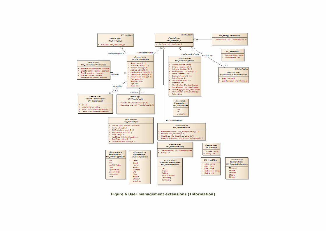
Figure 6 User management extensions (Information)
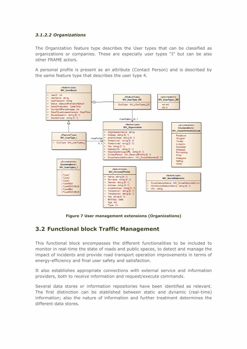
3.1.2.2 Organizations
The Organization feature type describes the User types that can be classified as
organizations or companies. These are especially user types “I” but can be also
other FRAME actors.
A personal profile is present as an attribute (Contact Person) and is described by
the same feature type that describes the user type 4.
Figure 7 User management extensions (Organizations)
3.2 Functional block Traffic Management
This functional block encompasses the different functionalities to be included to
monitor in real-time the state of roads and public spaces, to detect and manage the
impact of incidents and provide road transport operation improvements in terms of
energy-efficiency and final user safety and satisfaction.
It also establishes appropriate connections with external service and information
providers, both to receive information and request/execute commands.
Several data stores or information repositories have been identified as relevant.
The first distinction can be stablished between static and dynamic (real-time)
information; also the nature of information and further treatment determines the
different data stores.
Data models, object models and
ontology definition
- 24 -
www.moveus-project.eu
Urban Road Static Data. This static data covers the actual layout, topology and
configuration of the urban road network, being used as reference by a variety of
functions to monitor, regulate and predict road traffic. It could be also used by
Public Transport Operation System (buses, tram) to define services, routes and
schedules, overlapping both networks and other systems.
Inter-urban Road Static Data. It shall contain the static data for the inter-urban
traffic road network managed by the system, being its meaning analogous to the
urban one. In the scope of MoveUs, only segments coming to urban city have
significance (as traffic source or sink).
Urban Traffic Data. It contains traffic flow and other traffic related data for the
urban road network. The data in the store shall be divided into two parts
comprising historic and current data.
Inter-Urban Traffic Data. Analogous semantics as previous one, only segments
coming to urban city are relevant.
Incident Data. Collected data about mobility incidences (e.g. traffic, maintenance,
events, environmental). Commonly, the information is captured and refreshed
iteratively, evolving In-Time aspects.
Urban Car Park Data. Static and dynamic data related to the car parks available
in the urban zone: location, availability and occupancy level.
Road Traffic Prediction Data. In MoveUs, these data will be produced from
previously collected data (e.g. historical register), by application of prediction rules
involving relevant parameters (e.g. day of year/week, hour, incidences). Detailed
information needs will be elicited based on WP5 algorithms.
Aggregated Road Data. Reference representation of the monitored road network
(Urban Road Static) to which additional layers are added. On the various links
between nodes, information from vehicles crossing at each instant of time (stored
position and velocity) and measurements from stations/fixed sensors (e.g.
Bluetooth sensor network) will be managed.
Aggregated Road Historic Data. Historical repository of Aggregated Road
Information, which stores data belonging to a predefined time interval.
Environmental Data. It integrates data about the environmental conditions within
the geographic area managed by the System.
3.2.1 Existing specifications
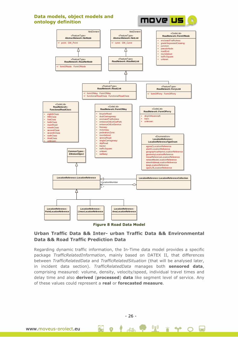
Urban Road && Inter-urban Road Static Data
In-Time project already defines a network data model including a location
reference and road network specification, being both specifications general
enough to be applicable to different domains (Figure 8).
Starting with the location reference specification, it can be used to give points
(PointLocationReference), lines (LinearLocationReference) or areas

Data models, object models and
ontology definition
- 25 -
www.moveus-project.eu
(AreaLocationReference) addressing different geometry types (Figure 8). It is
important to remark that different locations can be grouped by using
LocationReferenceCollection class. For extended details see[8].
In-Time network model defines 2 abstract feature types to represent network
points (nodes, NetNode) and linear areas (links, NetLink). Both features are
NetElements although they differ in their attributes: NetNode has a mandatory
point attribute (GM_Point) representing a point geometry and NetLink are edges in
a network graph with curve attribute (GM_Curve).
Going deeply into the road networks, it is important to point out that In-Time
specification uses concepts from EuroRoads project and defines GML as encoding
for data exchange, based on the ISO TC211 framework of “geo-standards”. This
model is even simpler than EuroRoads model as it is limited to just nodes
(RoadNetNode and links (RoadNetLink) maintaining its attributes e.g. formOfNode
for RoadNetNode describing the network node type, such as junction, roundabout,
etc. For ferry (FerryLink) and road (RoadNetLink) links, the class RoadNetLink is
defined. For extended details see[8].
Data models, object models and
ontology definition
- 26 -
www.moveus-project.eu
Figure 8 Road Data Model
Urban Traffic Data && Inter- urban Traffic Data && Environmental
Data && Road Traffic Prediction Data
Regarding dynamic traffic information, the In-Time data model provides a specific
package TrafficRelatedInformation, mainly based on DATEX II, that differences
between TrafficRelatedData and TrafficRelatedSituation (that will be analysed later,
in incident data section). TrafficRelatedData manages both sensored data,
comprising measured: volume, density, velocity/speed, individual travel times and
delay time and also derived (processed) data like segment level of service. Any
of these values could represent a real or forecasted measure.
class Simplified Static Road Data Model
LocationReference::LocationReference
LocationReference::
PointLocationReference
LocationReference::
LinearLocationReference
LocationReference::
AreaLocationReference
CommonTypes::
EMotionObject
LocationReference::LocationReferenceCollection
«Enumeration»
LocationReference::
LocationReferenceTypeEnum
agoraCLocationReference
alertCLocationReference
geographicalNameLocationReference
geometryLocationReference
linearReferenceLocationReference
networkNodeLocationReference
streetAddressLocationReference
tpegLocationReference
openLRLocationReference
«FeatureType»RoadNetwork::RoadNetNode
+/ formOfNode: FormOfNode
«FeatureType»RoadNetwork::RoadNetLink
«CodeList»
RoadNetwork::FormOfNode
+ enclosedTrafficArea:
+ gradeSeparatedCrossing:
+ junction:
+ pseudoNode:
+ roadEnd:
+ roundabout:
+ trafficSquare:
+ unkown:
«FeatureType»RoadNetwork::RoadLink
+/ formOfWay: FormOfWay
+/ functionalRoadClass: FunctionalRoadClass
«FeatureType»RoadNetwork::FerryLink
+/ formOfFerry: FormOfFerry
«CodeList»
RoadNetwork::FormOfWay
+ bicycleRoad:
+ dualCarriageway:
+ enclosedTrafficArea:
+ entranceOrExitCarPark:
+ entranceOrExitService:
+ freeway:
+ motorway:
+ pedestrianZone:
+ roundabout:
+ serviceRoad:
+ singleCarriageway:
+ slipRoad:
+ tractor:
+ trafficSquare:
+ unkown:
+ walkway:
«CodeList»
RoadNetwork::
FunctionalRoadClass
+ eighthClass:
+ fifthClass:
+ firstClass:
+ forthClass:
+ mainRoad:
+ ninethClass:
+ secondClass:
+ seventhClass:
+ sixthClass:
+ thirdClass:
+ unknown:
«CodeList»
RoadNetwork::FormOfFerry
+ shipOrHovercraft:
+ train:
+ unknown:
NetElement
«FeatureType»AbstractNetwork::NetLink
+/ curve: GM_Curve
NetElement
«FeatureType»AbstractNetwork::NetNode
+/ point: GM_Point
+locationMember
1..*
Data models, object models and
ontology definition
- 27 -
www.moveus-project.eu
Figure 9 Traffic Related Data
Measured data are captured, usually periodically, by direct sensors or equipment
(e.g. loops, cameras, weather stations) as traffic values (flow, speed, traffic density
and individual vehicle data (FCD)), environmental/weather values (pollution,
temperature, wind and precipitations), travel times and traffic status.
A measurement data set is represented by the SiteMeasurements class, associated
locally to a site or location (measurementSiteReference) and temporal period
(measurementTimeDefault).
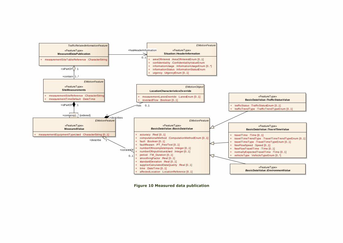
Figure 10 Measured data publication
class MeasuredDataPublication
TrafficRelatedInformationFeature
«FeatureType»
MeasuredDataPublication
+ measurementSiteTableReference :CharacterString
EMotionFeature
«FeatureType»
SiteMeasurements
+ measurementSiteReference :CharacterString
+ measurementTimeDefault :DateTime
EMotionFeature
«FeatureType»
MeasuredValue
+ measurementEquipmentTypeUsed :CharacterString [0..1]
EMotionFeature
«FeatureType»
Situation::HeaderInformation
+ areaOfInterest :AreaOfInterestEnum [0..1]
+ confidentiality :ConfidentialityValueEnum
+ informationUsage :InformationUsageEnum [0..*]
+ informationStatus :InformationStatusEnum
+ urgency :UrgencyEnum [0..1]
EMotionObject
LocationCharacteristicsOv erride
+ measurementLanesOverride :LanesEnum [0..1]
+ reversedFlow :Boolean [0..1]
EMotionFeature
«FeatureType»
BasicDataValue::BasicDataValue
+ accuracy :Real [0..1]
+ computationalMethod :ComputationMethodEnum [0..1]
+ fault :Boolean [0..1]
+ faultReason :PT_FreeText [0..1]
+ numberOfIncompleteInputs :Integer [0..1]
+ numberOfInputValuesUsed :Integer [0..1]
+ period :TM_Duration [0..1]
+ smoothingFactor :Real [0..1]
+ standardDeviation :Real [0..1]
+ supplierCalculatedDataQuality :Real [0..1]
+ time :DateTime [0..1]
+ affectedLocation :LocationReference [0..1]
«FeatureType»
BasicDataValue::Trav elTimeValue
+ travelTime :Time [0..1]
+ travelTimeTrendType :TravelTimeTrendTypeEnum [0..1]
+ travelTimeType :TravelTimeTypeEnum [0..1]
+ freeFlowSpeed :Speed [0..1]
+ freeFlowTravelTime :Time [0..1]
+ normallyExpectedTravelTime :Time [0..1]
+ vehicleType :VehicleTypeEnum [0..*]
«FeatureType»
BasicDataValue::TrafficStatusValue
+ trafficStatus :TrafficStatusEnum [0..1]
+ trafficTrendType :TrafficTrendTypeEnum [0..1]
«FeatureType»
BasicDataValue::EnvironmentValue
+has 0..1
+describes1
+consistsOf
0..1
+describe 1
index+contain 1..* {ordered}
+isPartOf 1
+hasHeaderInformation
0..1
+contain 1..*
+isPartOf 1

This class constitutes the basis for the specific types of measures
(TrafficStatusValue, TravelTimeValue, TrafficValue, WeatherValue and
supplementaryPositionalDescription). The image bellow shows the most relevant
types of measures managed.
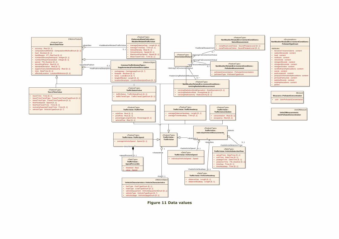
Figure 11 Data values
class BasicDataValue
EMotionFeature
«FeatureType»
BasicDataValue
+ accuracy :Real [0..1]
+ computationalMethod :ComputationMethodEnum [0..1]
+ fault :Boolean [0..1]
+ faultReason :PT_FreeText [0..1]
+ numberOfIncompleteInputs :Integer [0..1]
+ numberOfInputValuesUsed :Integer [0..1]
+ period :TM_Duration [0..1]
+ smoothingFactor :Real [0..1]
+ standardDeviation :Real [0..1]
+ supplierCalculatedDataQuality :Real [0..1]
+ time :DateTime [0..1]
+ affectedLocation :LocationReference [0..1]
«FeatureType»
TrafficStatusValue
+ trafficStatus :TrafficStatusEnum [0..1]
+ trafficTrendType :TrafficTrendTypeEnum [0..1]
«FeatureType»
Trav elTimeValue
+ travelTime :Time [0..1]
+ travelTimeTrendType :TravelTimeTrendTypeEnum [0..1]
+ travelTimeType :TravelTimeTypeEnum [0..1]
+ freeFlowSpeed :Speed [0..1]
+ freeFlowTravelTime :Time [0..1]
+ normallyExpectedTravelTime :Time [0..1]
+ vehicleType :VehicleTypeEnum [0..*]
EMotionObject
CommonTrafficRelatedTypes::
SupplementaryPositionalDescription
+ carriageway :CarriagewayEnum [0..*]
+ footpath :Boolean [0..1]
+ lanes :LanesEnum [0..*]
+ lengthAffected :Length [0..1]
+ locationDescriptor :LocationDescriptorEnum [0..*]
«FeatureType»
ElaboratedDataPublication::
WeatherRelatedTrafficValue
+ AverageDistanceGap :Length [0..1]
+ AverageTimeGap :Time [0..1]
+ CriticalDensity :Real [0..1]
+ CriticalVelocity :Speed [0..1]
+ MaximumFreeSpeed :Speed [0..1]
+ MeanTravelTime :Time [0..1]
«FeatureType»
TrafficValue::
TrafficValue
«FeatureType»
TrafficValue::
Indiv idualVehicleMeasurements
«DataType»
TrafficValue::
SpeedPercentile
+ threshold :Real
+ value :Speed
«FeatureType»
TrafficValue::
TrafficConcentration
+ concentration :Real [0..1]
+ occupancy :Real [0..1]
«FeatureType»
TrafficValue::TrafficFlow
+ axleFlow :Real [0..1]
+ pCUFlow :Real [0..1]
+ percentageLongVehicles :Percentage [0..1]
+ vehicleFlow :Real [0..1]
«FeatureType»
TrafficValue::TrafficHeadway
+ averageDistanceHeadway :Length [0..1]
+ averageTimeHeadway :Time [0..1]
«FeatureType»
TrafficValue::TrafficSpeed
+ averageVehicleSpeed :Speed [0..1]
«DataType»
TrafficValue::VehicleDetectionTime
+ arrivalTime :DateTime [0..1]
+ exitTime :DateTime [0..1]
+ passageTime :DateTime [0..1]
+ presenceTime :TM_Duration [0..1]
+ timeGap :Time [0..1]
+ timeHeadway :Time [0..1]
«DataType»
TrafficValue::VehicleHeadway
+ distanceGap :Length [0..1]
+ distanceHeadway :Length [0..1]
«DataType»
TrafficValue::VehicleSpeed
+ individualVehicleSpeed :Speed
EMotionObject
VehicleCharacteristics::VehicleCharacteristics
+ fuelType :FuelTypeEnum [0..1]
+ loadType :LoadTypeEnum [0..1]
+ vehicleEquipment :VehicleEquipmentEnum [0..1]
+ vehicleType :VehicleTypeEnum [0..*]
+ vehicleUsage :VehicleUsageEnum [0..1]
«FeatureType»
NonWeatherRelatedEnv ironmentConditions::
PollutionMeasurement
+ pollutantConcentration :PollutantConcentration
+ pollutantType :PollutantTypeEnum
«Enumeration»
NonWeatherRelatedEnv ironmentConditions::
PollutantTypeEnum
Attributes
+ benzeneTolueneXylene :content
+ carbonMonoxide :content
+ lead :content
+ methane :content
+ nitricOxide :content
+ nitrogenDioxide :content
+ nitrogenMonoxide :content
+ nitrogenOxides :content
+ nonMethaneHydrocarbons :content
+ ozone :content
+ particulates10 :content
+ polycyclicAromaticHydrocarbons :content
+ primaryParticulate :content
+ sulphurDioxide :content
+ totalHydrocarbons :content
+ pollen
«FeatureType»
NonWeatherRelatedEnv ironmentConditions::
IonizingRadiationMeasurement
+ ionizingRadiationDosisEquivalent :DoseEquivalent [0..1]
+ ionizingRadiationRate :EnergyDose [0..1]
+ ionizingRadioactivity :Radioactivity [0..1]
«FeatureType»
NonWeatherRelatedEnv ironmentConditions::
NoiseMeasurement
+ noiseMeanLevelValue :SoundPressureLevel [0..1]
+ noisePeekLevelValue :SoundPressureLevel [0..1]
«FeatureType»
EnvironmentValue
Measure
Measures::PollutantConcentration
+ uom :UomPollutantConcentration
UnitOfMeasure
UnitsOfMeasurement::
UomPollutantConcentration
+hasPositionalDescription
0..1+describesPosition
1
+hasWeatherRelatedTrafficValue
0..1
+describes
1
+speedPercentil 0..1
+describes 1 +hasVehicleDetectionTime
0..1
+detects
1
+hasVehicleHeadway 0..1
+describes
1
+hasVehicleSpeed 0..1
+describes 1
+has 0..1
+characterise
1
+hasIonizingRadiationMeasurement
0..*
+belongsToEnvironmentValue
1
+hasNoiseMeasurement
0..*
+belongsToEnvironmentValue
1
+hasPollutionMeasurement0..*
+belongsToEnvironmentValue
1
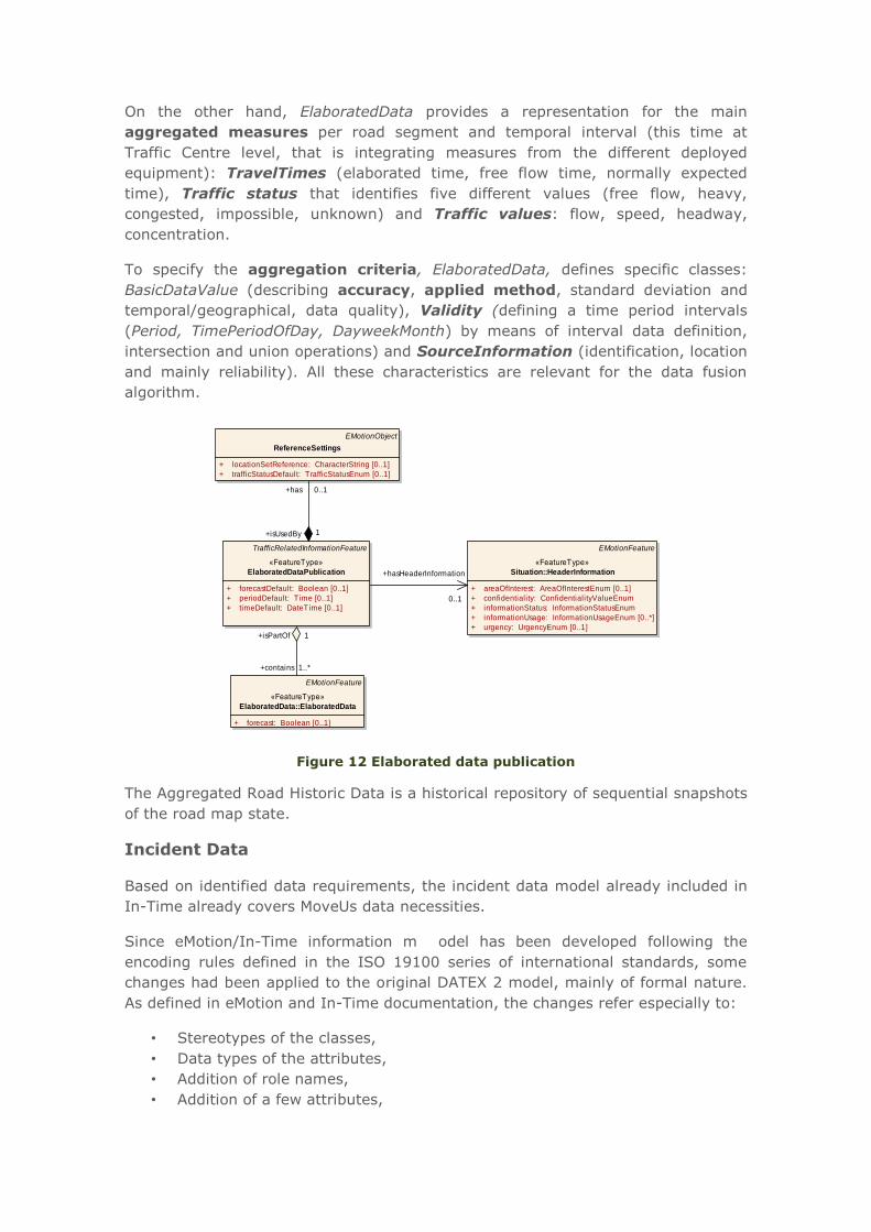
On the other hand, ElaboratedData provides a representation for the main
aggregated measures per road segment and temporal interval (this time at
Traffic Centre level, that is integrating measures from the different deployed
equipment): TravelTimes (elaborated time, free flow time, normally expected
time), Traffic status that identifies five different values (free flow, heavy,
congested, impossible, unknown) and Traffic values: flow, speed, headway,
concentration.
To specify the aggregation criteria, ElaboratedData, defines specific classes:
BasicDataValue (describing accuracy, applied method, standard deviation and
temporal/geographical, data quality), Validity (defining a time period intervals
(Period, TimePeriodOfDay, DayweekMonth) by means of interval data definition,
intersection and union operations) and SourceInformation (identification, location
and mainly reliability). All these characteristics are relevant for the data fusion
algorithm.
Figure 12 Elaborated data publication
The Aggregated Road Historic Data is a historical repository of sequential snapshots
of the road map state.
Incident Data
Based on identified data requirements, the incident data model already included in
In-Time already covers MoveUs data necessities.
Since eMotion/In-Time information m odel has been developed following the
encoding rules defined in the ISO 19100 series of international standards, some
changes had been applied to the original DATEX 2 model, mainly of formal nature.
As defined in eMotion and In-Time documentation, the changes refer especially to:
• Stereotypes of the classes,
• Data types of the attributes,
• Addition of role names,
• Addition of a few attributes,
class ElaboratedDataPublication
TrafficRelatedInformationFeature
«FeatureType»
ElaboratedDataPublication
+ forecastDefault: Boolean [0..1]
+ periodDefault: Time [0..1]
+ timeDefault: DateTime [0..1]
EMotionFeature
«FeatureType»
Situation::HeaderInformation
+ areaOfInterest: AreaOfInterestEnum [0..1]
+ confidentiality: ConfidentialityValueEnum
+ informationStatus: InformationStatusEnum
+ informationUsage: InformationUsageEnum [0..*]
+ urgency: UrgencyEnum [0..1]
EMotionObject
ReferenceSettings
+ locationSetReference: CharacterString [0..1]
+ trafficStatusDefault: TrafficStatusEnum [0..1]
EMotionFeature
«FeatureType»
ElaboratedData::ElaboratedData
+ forecast: Boolean [0..1]
+has 0..1
+isUsedBy 1
+hasHeaderInformation
0..1
+contains 1..*
+isPartOf 1
Data models, object models and
ontology definition
- 32 -
www.moveus-project.eu
• Variation of the Location Reference and
• Adaptation of enumerations.
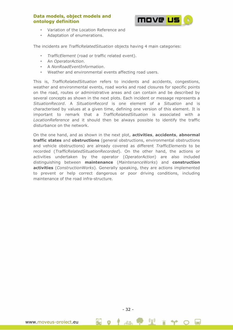
The incidents are TrafficRelatedSituation objects having 4 main categories:
• TrafficElement (road or traffic related event).
• An OperatorAction.
• A NonRoadEventInformation.
• Weather and environmental events affecting road users.
This is, TrafficRelatedSituation refers to incidents and accidents, congestions,
weather and environmental events, road works and road closures for specific points
on the road, routes or administrative areas and can contain and be described by
several concepts as shown in the next plots. Each incident or message represents a
SituationRecord. A SituationRecord is one element of a Situation and is
characterised by values at a given time, defining one version of this element. It is
important to remark that a TrafficRelatedSituation is associated with a
LocationReference and it should then be always possible to identify the traffic
disturbance on the network.
On the one hand, and as shown in the next plot, activities, accidents, abnormal
traffic states and obstructions (general obstructions, environmental obstructions
and vehicle obstructions) are already covered as different TrafficElements to be
recorded (TrafficRelatedSituationRecorded). On the other hand, the actions or
activities undertaken by the operator (OperatorAction) are also included
distinguishing between maintenance (MaintenanceWorks) and construction
activities (ConstructionWorks). Generally speaking, they are actions implemented
to prevent or help correct dangerous or poor driving conditions, including
maintenance of the road infra-structure.

Data models, object models and
ontology definition
- 33 -
www.moveus-project.eu
Figure 13 Incidence Related Data
Figure 14 Incidence Related Data. Non road Event
Data models, object models and
ontology definition
- 34 -
www.moveus-project.eu
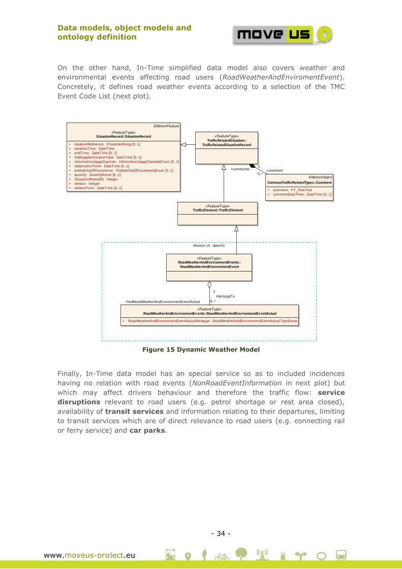
On the other hand, In-Time simplified data model also covers weather and
environmental events affecting road users (RoadWeatherAndEnviromentEvent).
Concretely, it defines road weather events according to a selection of the TMC
Event Code List (next plot).
Figure 15 Dynamic Weather Model
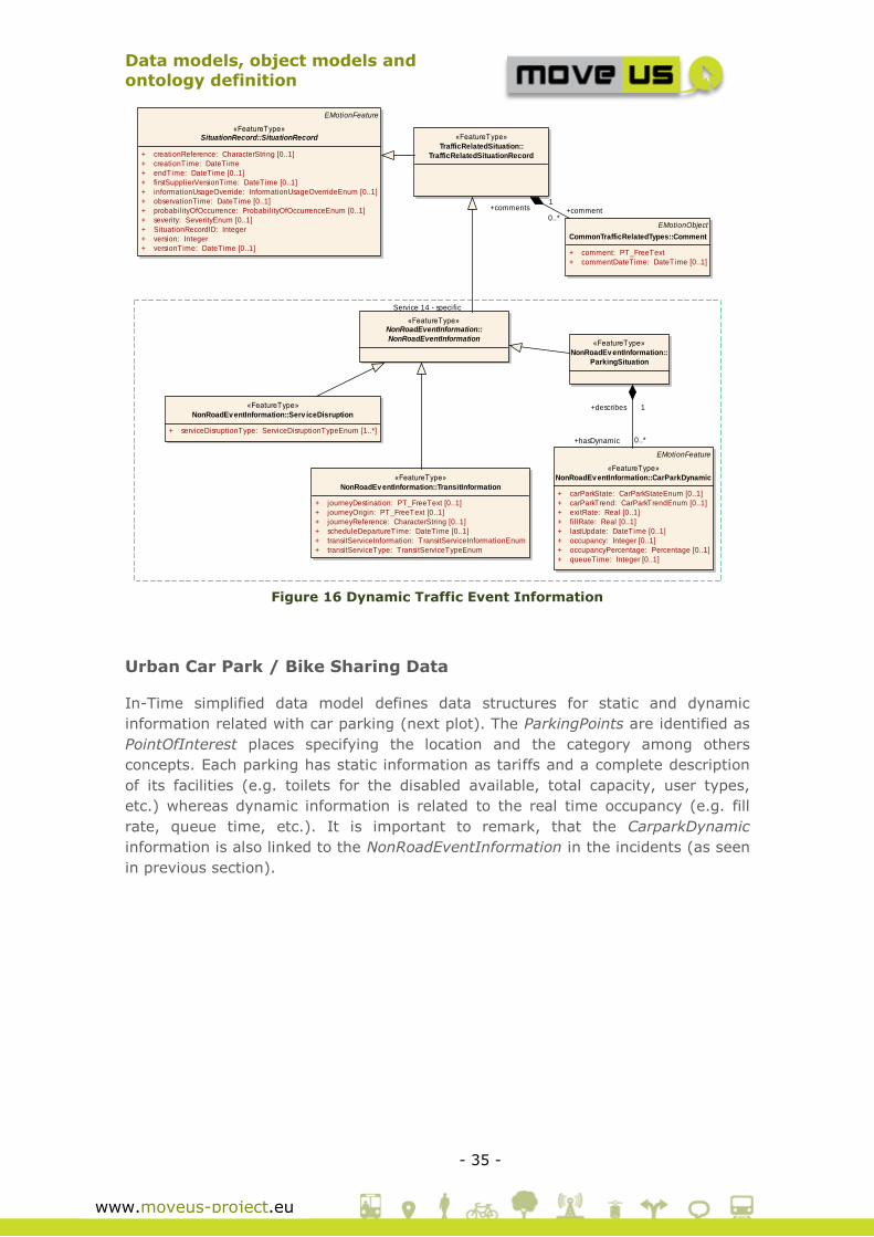
Finally, In-Time data model has an special service so as to included incidences
having no relation with road events (NonRoadEventInformation in next plot) but
which may affect drivers behaviour and therefore the traffic flow: service
disruptions relevant to road users (e.g. petrol shortage or rest area closed),
availability of transit services and information relating to their departures, limiting
to transit services which are of direct relevance to road users (e.g. connecting rail
or ferry service) and car parks.
class Simplied Dynamic Road Weather Model
Service 15 - specific
«FeatureType»RoadWeatherAndEnvironmentEvents::
RoadWeatherAndEnvironmentEvent
«FeatureType»
RoadWeatherAndEnv ironmentEv ents::RoadWeatherAndEnv ironmentEv entActual
+ RoadWeatherAndEnvironmentEventActualMessage: RoadWeatherAndEnvironmentEventActualTypeEnum
EMotionFeature
«FeatureType»SituationRecord::SituationRecord
+ creationReference: CharacterString [0..1]
+ creationTime: DateTime
+ endTime: DateTime [0..1]
+ firstSupplierVersionTime: DateTime [0..1]
+ informationUsageOverride: InformationUsageOverrideEnum [0..1]
+ observationTime: DateTime [0..1]
+ probabil ityOfOccurrence: Probabil ityOfOccurrenceEnum [0..1]
+ severity: SeverityEnum [0..1]
+ SituationRecordID: Integer
+ version: Integer
+ versionTime: DateTime [0..1]
«FeatureType»
TrafficRelatedSituation::
TrafficRelatedSituationRecord
EMotionObject
CommonTrafficRelatedTypes::Comment
+ comment: PT_FreeText
+ commentDateTime: DateTime [0..1]
«FeatureType»TrafficElement::TrafficElement
+comment0..*
+comments1
+hasRoadWeatherAndEnvironmentEventActual 0..*
+belongsTo
1
Data models, object models and
ontology definition
- 35 -
www.moveus-project.eu
Figure 16 Dynamic Traffic Event Information
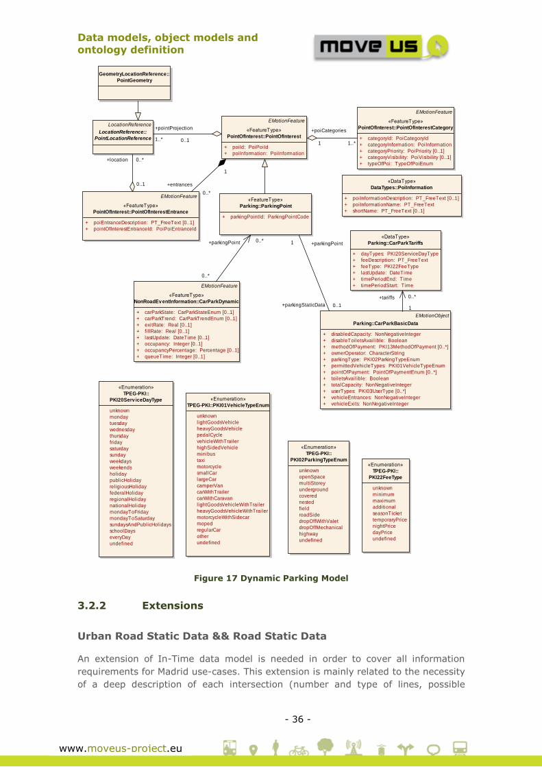
Urban Car Park / Bike Sharing Data
In-Time simplified data model defines data structures for static and dynamic
information related with car parking (next plot). The ParkingPoints are identified as
PointOfInterest places specifying the location and the category among others
concepts. Each parking has static information as tariffs and a complete description
of its facilities (e.g. toilets for the disabled available, total capacity, user types,
etc.) whereas dynamic information is related to the real time occupancy (e.g. fill
rate, queue time, etc.). It is important to remark, that the CarparkDynamic
information is also linked to the NonRoadEventInformation in the incidents (as seen
in previous section).
class Serv ice 14 - Dynamic Traffic Ev ent Information - PROPOSED
Service 14 - specific
EMotionFeature
«FeatureType»SituationRecord::SituationRecord
+ creationReference: CharacterString [0..1]
+ creationTime: DateTime
+ endTime: DateTime [0..1]
+ firstSupplierVersionTime: DateTime [0..1]
+ informationUsageOverride: InformationUsageOverrideEnum [0..1]
+ observationTime: DateTime [0..1]
+ probabilityOfOccurrence: ProbabilityOfOccurrenceEnum [0..1]
+ severity: SeverityEnum [0..1]
+ SituationRecordID: Integer
+ version: Integer
+ versionTime: DateTime [0..1]
«FeatureType»
TrafficRelatedSituation::
TrafficRelatedSituationRecord
EMotionObject
CommonTrafficRelatedTypes::Comment
+ comment: PT_FreeText
+ commentDateTime: DateTime [0..1]
EMotionFeature
«FeatureType»
NonRoadEv entInformation::CarParkDynamic
+ carParkState: CarParkStateEnum [0..1]
+ carParkTrend: CarParkTrendEnum [0..1]
+ exitRate: Real [0..1]
+ fi l lRate: Real [0..1]
+ lastUpdate: DateTime [0..1]
+ occupancy: Integer [0..1]
+ occupancyPercentage: Percentage [0..1]
+ queueTime: Integer [0..1]
«FeatureType»NonRoadEventInformation::
NonRoadEventInformation«FeatureType»
NonRoadEv entInformation::
ParkingSituation
«FeatureType»
NonRoadEv entInformation::Serv iceDisruption
+ serviceDisruptionType: ServiceDisruptionTypeEnum [1..*]
«FeatureType»
NonRoadEv entInformation::TransitInformation
+ journeyDestination: PT_FreeText [0..1]
+ journeyOrigin: PT_FreeText [0..1]
+ journeyReference: CharacterString [0..1]
+ scheduleDepartureTime: DateTime [0..1]
+ transitServiceInformation: TransitServiceInformationEnum
+ transitServiceType: TransitServiceTypeEnum
+hasDynamic 0..*
+describes 1
+comment0..*
+comments1
Data models, object models and
ontology definition
- 36 -
www.moveus-project.eu
Figure 17 Dynamic Parking Model
3.2.2 Extensions
Urban Road Static Data && Road Static Data
An extension of In-Time data model is needed in order to cover all information
requirements for Madrid use-cases. This extension is mainly related to the necessity
of a deep description of each intersection (number and type of lines, possible
class Simplified Dynamic Parking Model
GeometryLocationReference::
PointGeometry
LocationReference
LocationReference::
PointLocationReference
EMotionFeature
«FeatureType»
PointOfInterest::PointOfInterest
+ poiId: PoiPoiId
+ poiInformation: PoiInformation
EMotionFeature
«FeatureType»
PointOfInterest::PointOfInterestCategory
+ categoryId: PoiCategoryId
+ categoryInformation: PoiInformation
+ categoryPriority: PoiPriority [0..1]
+ categoryVisibil ity: PoiVisibil ity [0..1]
+ typeOfPoi: TypeOfPoiEnum
«FeatureType»
Parking::ParkingPoint
+ parkingPointId: ParkingPointCode
EMotionFeature
«FeatureType»
PointOfInterest::PointOfInterestEntrance
+ poiEntranceDescription: PT_FreeText [0..1]
+ pointOfInterestEntranceId: PoiPoiEntranceId
EMotionObject
Parking::CarParkBasicData
+ disabledCapacity: NonNegativeInteger
+ disableToiletsAvailible: Boolean
+ methodOfPayment: PKI13MethodOfPayment [0..*]
+ ownerOperator: CharacterString
+ parkingType: PKI02ParkingTypeEnum
+ permittedVehicleTypes: PKI01VehicleTypeEnum
+ pointOfPayment: PointOfPaymentEnum [0..*]
+ toiletsAvailible: Boolean
+ totalCapacity: NonNegativeInteger
+ userTypes: PKI03UserType [0..*]
+ vehicleEntrances: NonNegativeInteger
+ vehicleExits: NonNegativeInteger
«DataType»
Parking::CarParkTariffs
+ dayTypes: PKI20ServiceDayType
+ feeDescription: PT_FreeText
+ feeType: PKI22FeeType
+ lastUpdate: DateTime
+ timePeriodEnd: Time
+ timePeriodStart: TimeEMotionFeature
«FeatureType»
NonRoadEv entInformation::CarParkDynamic
+ carParkState: CarParkStateEnum [0..1]
+ carParkTrend: CarParkTrendEnum [0..1]
+ exitRate: Real [0..1]
+ fi l lRate: Real [0..1]
+ lastUpdate: DateTime [0..1]
+ occupancy: Integer [0..1]
+ occupancyPercentage: Percentage [0..1]
+ queueTime: Integer [0..1]
«DataType»
DataTypes::PoiInformation
+ poiInformationDescription: PT_FreeText [0..1]
+ poiInformationName: PT_FreeText
+ shortName: PT_FreeText [0..1]
«Enumeration»
TPEG-PKI::PKI01VehicleTypeEnum
unknown
lightGoodsVehicle
heavyGoodsVehicle
pedalCycle
vehicleWithTrailer
highSidedVehicle
minibus
taxi
motorcycle
smallCar
largeCar
camperVan
carWithTrailer
carWithCaravan
lightGoodsVehicleWithTrailer
heavyGoodsVehicleWithTrailer
motorcycleWithSidecar
moped
regularCar
other
undefined
«Enumeration»
TPEG-PKI::
PKI02ParkingTypeEnum
unknown
openSpace
multiStorey
underground
covered
nested
field
roadSide
dropOffWithValet
dropOffMechanical
highway
undefined
«Enumeration»
TPEG-PKI::
PKI20Serv iceDayType
unknown
monday
tuesday
wednesday
thursday
friday
saturday
sunday
weekdays
weekends
holiday
publicHoliday
religiousHoliday
federalHoliday
regionalHoliday
nationalHoliday
mondayToFriday
mondayToSaturday
sundaysAndPublicHolidays
schoolDays
everyDay
undefined
«Enumeration»
TPEG-PKI::
PKI22FeeType
unknown
minimum
maximum
additional
seasonTicket
temporaryPrice
nightPrice
dayPrice
undefined
0..*
+parkingPoint 0..*
1
+tariffs 0..*
+entrances
0..*
1
+parkingPoint1
+parkingStaticData 0..1
+poiCategories
1..*1
+pointProjection
1..* 0..1
+location 0..*
0..1

Data models, object models and
ontology definition
- 37 -
www.moveus-project.eu
movements, etc.) and the equipment installed around them, concretely Bluetooth
readers.
ETSI TS 102 637 is a technical specification that specifies the vehicular
communication standard produced by ETSI Technical Committee Intelligent
Transport System (ITS).
The second part (part 2) of the document includes the specification of cooperative
awareness basic service, while the third part (part 3) includes the specification of
decentralized environmental notification basic service.
Cooperative Awareness data is sent to neighbouring nodes through the Cooperative
Awareness Messages (CAM) as defined in part 2 of the ETSI TS 102 637 document.
The CAM messages are distributed within the V2X communication network and
provide information of presence, positions as well as basic status of communicating
ITS stations to neighbouring ITS stations that are located within a single hop
distance.
In the case of urban traffic controllers involved in the use cases of Madrid, those
cooperative awareness data do not comply with the status data related to the traffic
controllers, that include signal phasing and timing, and are very limited with
respect to the geometrical localization of the traffic lights.
Therefore, the CAM messages do not provide complete information about the status
of the urban traffic lights, and are therefore disregarded in comparison with SPAT
and MAP messages as they are being nowadays specified in CEN ISO TS 19091 and
as already described in SAE J2735.
The European Commission Directorate General for Communication Networks,
Content and Technology and the United States Department of Transportation
Intelligent Transportation System (ITS) Joint Program Office have been working
together so as to internationally harmonize cooperative ITS standards to support
cooperative ITS.
Since December 2012 strong support from CEN/TC278/WG16 & ISO/TC204/WG18
working groups to modify SAE J2735 “Dedicated short Range Communications
Message Set Dictionary” standard [11] to meet apparent needs for immediate
deployment in Europe based of trials conducted to date and to harmonize the
message sets, and to create the CEN ISO TS 19091 standard.
At the time this document is created, the CEN ISO TS 19091 document structure is
still at current thinking and a draft version is available only for internal evaluation
at WG level, and a technical review of it is planned by the third quarter of the year
2014.
However, the SAE J2735 “Dedicated short Range Communications Message Set
Dictionary” standard [11]
has published a second edition of the standard (version 29 of the document)
published in 2008 and available for use.
Therefore, the SAE J2735 has been identified as starting point for the static and
dynamic information related with intersections, and has been selected for the
Data models, object models and
ontology definition
- 38 -
www.moveus-project.eu
development of the use cases in Madrid in MoveUs project, in the absence of an
European standard document published and available for use by the consortium at
the current moment.
. The aim of this standard is to specify all messages, data frames and data
elements used for both Vehicle to Vehicle (V2V) and Vehicle to Infrastructure (V2I)
exchanges.
Based on this standard and taking into account the requirements identified for
Madrid use-cases, a selection of the messages and data frames has been done in
order to cover both, static and dynamic information related with intersections.
There are 4 messages defined in this standard, which are been also specified in
CEN ISO TS 19091, to support intersection mapping, signal phase and timing and
priority and pre-emption data:
Signal Phase and Timing Message (SPAT): Relates the current
intersection signal light phases[11].
Map Data (MAP): Relates the Physical Geometry of the intersection [11].
Signal Request Message (SRM): Requests preemption or priority
services[11].
Signal Status Messages (SSM): As a reply to the priority request
(SRM)[11].
Map Data message has been selected to include the static information related with
intersections while the other 3 messages are going to be used for dynamic
information (next subsection).
The following plot (Figure 18) shows the IntersectionInfo class where a Map Data
message and geographical information (Circle and ValidRegion) are combined in
order to cover Madrid uses cases requirements.
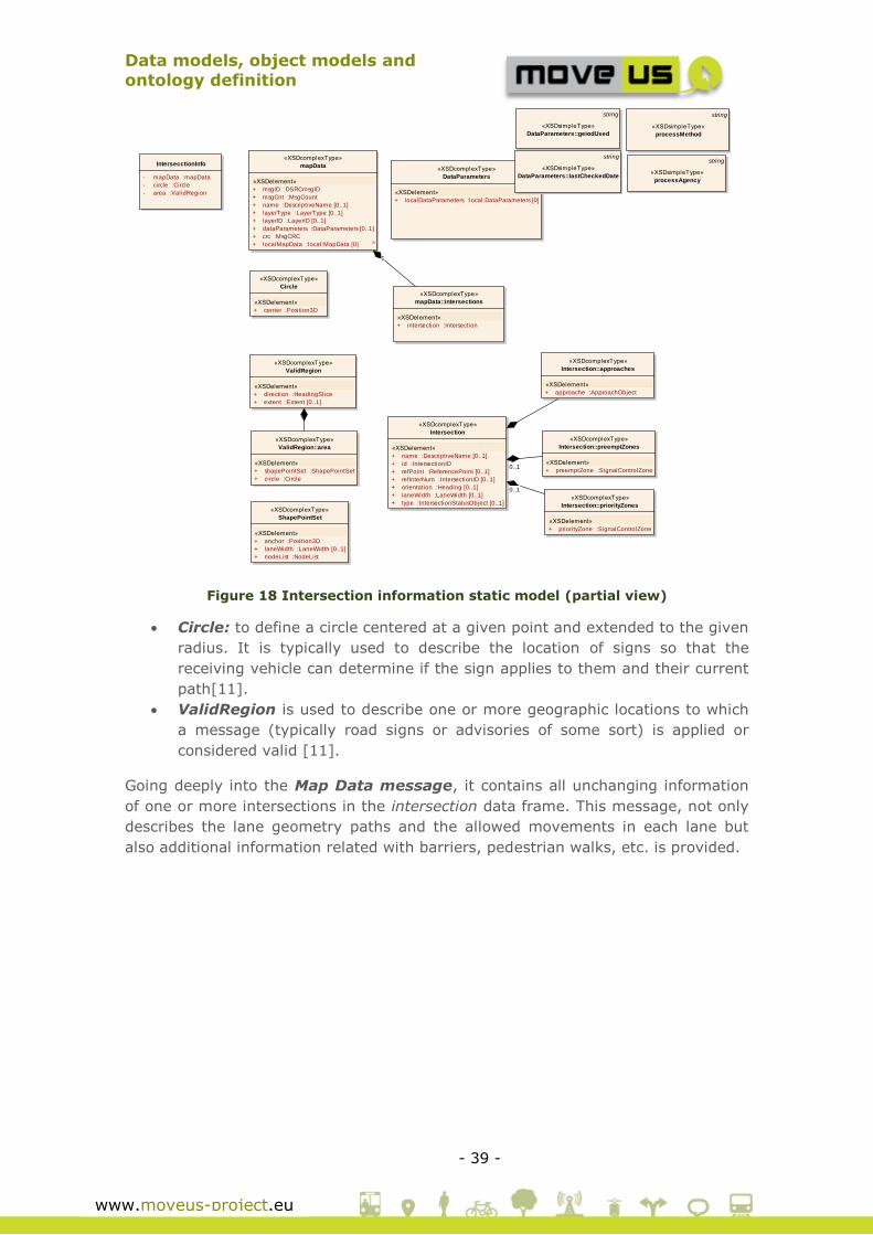
Data models, object models and
ontology definition
- 39 -
www.moveus-project.eu
Figure 18 Intersection information static model (partial view)
Circle: to define a circle centered at a given point and extended to the given
radius. It is typically used to describe the location of signs so that the
receiving vehicle can determine if the sign applies to them and their current
path[11].
ValidRegion is used to describe one or more geographic locations to which
a message (typically road signs or advisories of some sort) is applied or
considered valid [11].
Going deeply into the Map Data message, it contains all unchanging information
of one or more intersections in the intersection data frame. This message, not only
describes the lane geometry paths and the allowed movements in each lane but
also additional information related with barriers, pedestrian walks, etc. is provided.
class J235ALL_v 2 static
«XSDcomplexType»
mapData
«XSDelement»
+ msgID :DSRCmsgID
+ msgCnt :MsgCount
+ name :DescriptiveName [0..1]
+ layerType :LayerType [0..1]
+ layerID :LayerID [0..1]
+ dataParameters :DataParameters [0..1]
+ crc :MsgCRC
+ localMapData :local:MapData [0] A
IntersecctionInfo
- mapData :mapData
- circle :Circle
- area :ValidRegion
«XSDcomplexType»
mapData::intersections
«XSDelement»
+ intersection :Intersection
«XSDcomplexType»
Intersection
«XSDelement»
+ name :DescriptiveName [0..1]
+ id :IntersectionID
+ refPoint :ReferencePoint [0..1]
+ refInterNum :IntersectionID [0..1]
+ orientation :Heading [0..1]
+ laneWidth :LaneWidth [0..1]
+ type :IntersectionStatusObject [0..1]
«XSDcomplexType»
DataParameters
«XSDelement»
+ localDataParameters :local:DataParameters [0]
string
«XSDsimpleType»
DataParameters::geiodUsed
string
«XSDsimpleType»
DataParameters::lastCheckedDate
string
«XSDsimpleType»
processAgency
string
«XSDsimpleType»
processMethod
«XSDcomplexType»
Intersection::approaches
«XSDelement»
+ approache :ApproachObject
«XSDcomplexType»
Intersection::preemptZones
«XSDelement»
+ preemptZone :SignalControlZone
«XSDcomplexType»
Intersection::priorityZones
«XSDelement»
+ priorityZone :SignalControlZone
«XSDcomplexType»
Circle
«XSDelement»
+ center :Position3D
«XSDcomplexType»
ValidRegion
«XSDelement»
+ direction :HeadingSlice
+ extent :Extent [0..1]
«XSDcomplexType»
ValidRegion::area
«XSDelement»
+ shapePointSet :ShapePointSet
+ circle :Circle
«XSDcomplexType»
ShapePointSet
«XSDelement»
+ anchor :Position3D
+ laneWidth :LaneWidth [0..1]
+ nodeList :NodeList
1
0..1
0..1
Data models, object models and
ontology definition
- 40 -
www.moveus-project.eu
.
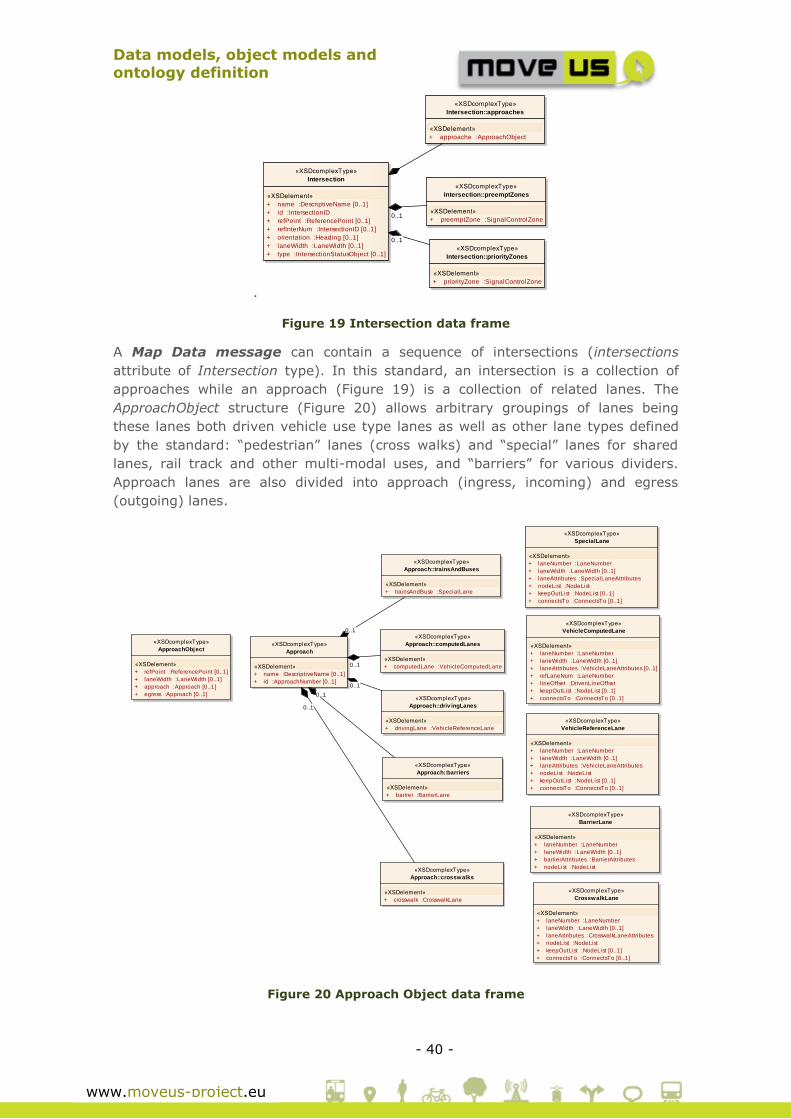
Figure 19 Intersection data frame
A Map Data message can contain a sequence of intersections (intersections
attribute of Intersection type). In this standard, an intersection is a collection of
approaches while an approach (Figure 19) is a collection of related lanes. The
ApproachObject structure (Figure 20) allows arbitrary groupings of lanes being
these lanes both driven vehicle use type lanes as well as other lane types defined
by the standard: “pedestrian” lanes (cross walks) and “special” lanes for shared
lanes, rail track and other multi-modal uses, and “barriers” for various dividers.
Approach lanes are also divided into approach (ingress, incoming) and egress
(outgoing) lanes.
Figure 20 Approach Object data frame
class J235ALL_v 2 static
«XSDcomplexType»
mapData
«XSDelement»
+ msgID :DSRCmsgID
+ msgCnt :MsgCount
+ name :DescriptiveName [0..1]
+ layerType :LayerType [0..1]
+ layerID :LayerID [0..1]
+ dataParameters :DataParameters [0..1]
+ crc :MsgCRC
+ localMapData :local:MapData [0] A
IntersecctionInfo
- mapData :mapData
- circle :Circle
- area :ValidRegion
«XSDcomplexType»
mapData::intersections
«XSDelement»
+ intersection :Intersection
«XSDcomplexType»
Intersection
«XSDelement»
+ name :DescriptiveName [0..1]
+ id :IntersectionID
+ refPoint :ReferencePoint [0..1]
+ refInterNum :IntersectionID [0..1]
+ orientation :Heading [0..1]
+ laneWidth :LaneWidth [0..1]
+ type :IntersectionStatusObject [0..1]
«XSDcomplexType»
DataParameters
«XSDelement»
+ localDataParameters :local:DataParameters [0]
string
«XSDsimpleType»
DataParameters::geiodUsed
string
«XSDsimpleType»
DataParameters::lastCheckedDate
string
«XSDsimpleType»
processAgency
string
«XSDsimpleType»
processMethod
«XSDcomplexType»
Intersection::approaches
«XSDelement»
+ approache :ApproachObject
«XSDcomplexType»
Intersection::preemptZones
«XSDelement»
+ preemptZone :SignalControlZone
«XSDcomplexType»
Intersection::priorityZones
«XSDelement»
+ priorityZone :SignalControlZone
«XSDcomplexType»
Circle
«XSDelement»
+ center :Position3D
«XSDcomplexType»
ValidRegion
«XSDelement»
+ direction :HeadingSlice
+ extent :Extent [0..1]
«XSDcomplexType»
ValidRegion::area
«XSDelement»
+ shapePointSet :ShapePointSet
+ circle :Circle
«XSDcomplexType»
ShapePointSet
«XSDelement»
+ anchor :Position3D
+ laneWidth :LaneWidth [0..1]
+ nodeList :NodeList
1
0..1
0..1
class J235ALL_v 2 static
«XSDcomplexType»
ApproachObject
«XSDelement»
+ refPoint :ReferencePoint [0..1]
+ laneWidth :LaneWidth [0..1]
+ approach :Approach [0..1]
+ egress :Approach [0..1]
«XSDcomplexType»
Approach
«XSDelement»
+ name :DescriptiveName [0..1]
+ id :ApproachNumber [0..1]
«XSDcomplexType»
Approach::barriers
«XSDelement»
+ barrier :BarrierLane
«XSDcomplexType»
Approach::computedLanes
«XSDelement»
+ computedLane :VehicleComputedLane
«XSDcomplexType»
Approach::crosswalks
«XSDelement»
+ crosswalk :CrosswalkLane
«XSDcomplexType»
Approach::driv ingLanes
«XSDelement»
+ drivingLane :VehicleReferenceLane
«XSDcomplexType»
Approach::trainsAndBuses
«XSDelement»
+ trainsAndBuse :SpecialLane
«XSDcomplexType»
SpecialLane
«XSDelement»
+ laneNumber :LaneNumber
+ laneWidth :LaneWidth [0..1]
+ laneAttributes :SpecialLaneAttributes
+ nodeList :NodeList
+ keepOutList :NodeList [0..1]
+ connectsTo :ConnectsTo [0..1]
«XSDcomplexType»
BarrierLane
«XSDelement»
+ laneNumber :LaneNumber
+ laneWidth :LaneWidth [0..1]
+ barrierAttributes :BarrierAttributes
+ nodeList :NodeList
«XSDcomplexType»
CrosswalkLane
«XSDelement»
+ laneNumber :LaneNumber
+ laneWidth :LaneWidth [0..1]
+ laneAttributes :CrosswalkLaneAttributes
+ nodeList :NodeList
+ keepOutList :NodeList [0..1]
+ connectsTo :ConnectsTo [0..1]
«XSDcomplexType»
VehicleReferenceLane
«XSDelement»
+ laneNumber :LaneNumber
+ laneWidth :LaneWidth [0..1]
+ laneAttributes :VehicleLaneAttributes
+ nodeList :NodeList
+ keepOutList :NodeList [0..1]
+ connectsTo :ConnectsTo [0..1]
«XSDcomplexType»
VehicleComputedLane
«XSDelement»
+ laneNumber :LaneNumber
+ laneWidth :LaneWidth [0..1]
+ laneAttributes :VehicleLaneAttributes [0..1]
+ refLaneNum :LaneNumber
+ lineOffset :DrivenLineOffset
+ keepOutList :NodeList [0..1]
+ connectsTo :ConnectsTo [0..1]
0..1
0..1
0..1
0..1
0..1

Data models, object models and
ontology definition
- 41 -
www.moveus-project.eu
As additional attributes in Intersection (Figure 19) the preemptionZones and
priorityZones are defined in order to provide support for priority and preemption
requests at the intersection. These two concepts are used to determine which
specific request to make, allowing the mapping of the intersection geometry into
specific request zones and values (0~7).
The global model of the static information related with intersections is shown in
Figure 21 and Figure 22. For further details see[11].
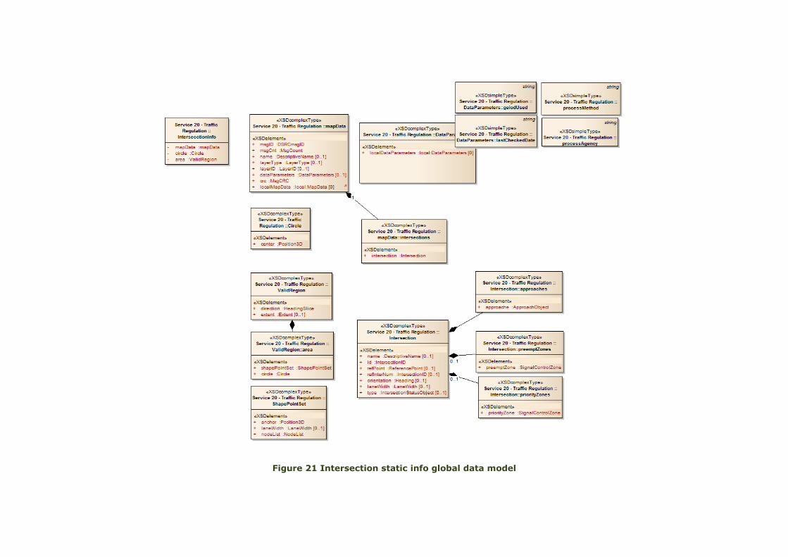
Figure 21 Intersection static info global data model
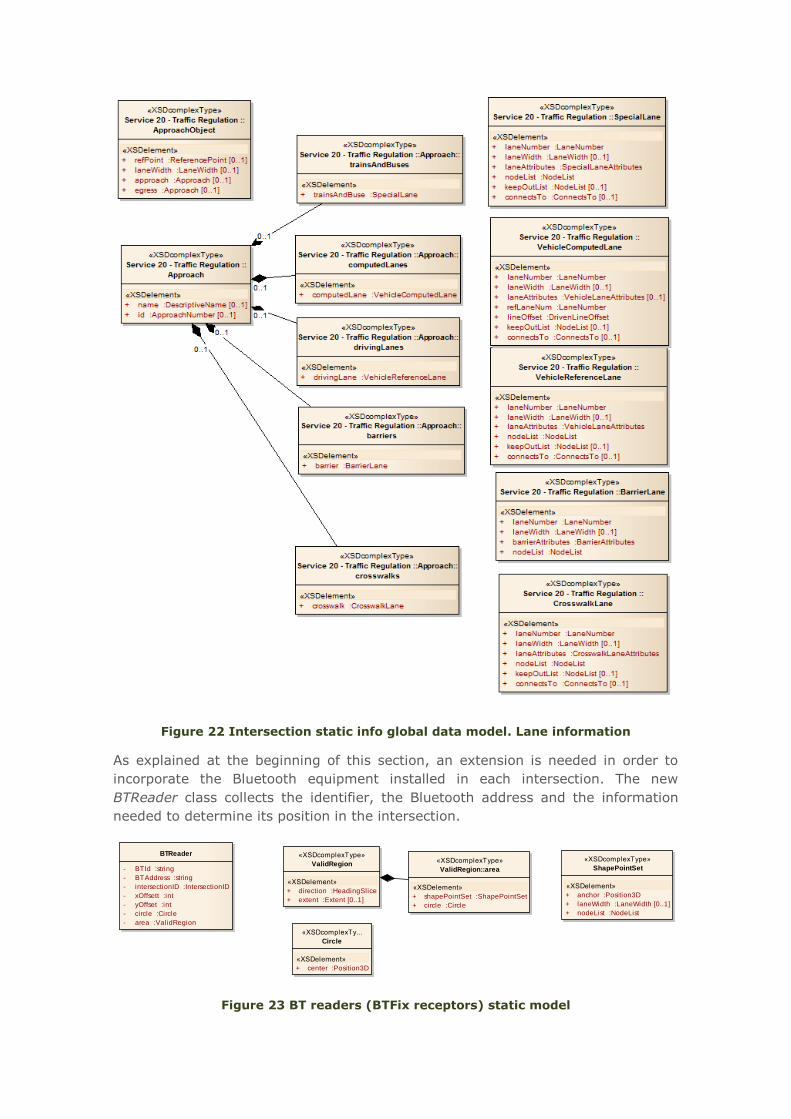
Figure 22 Intersection static info global data model. Lane information
As explained at the beginning of this section, an extension is needed in order to
incorporate the Bluetooth equipment installed in each intersection. The new
BTReader class collects the identifier, the Bluetooth address and the information
needed to determine its position in the intersection.
Figure 23 BT readers (BTFix receptors) static model
class BT
BTReader
- BTId :string
- BTAddress :string
- intersectionID :IntersectionID
- xOffsett :int
- yOffset :int
- circle :Circle
- area :ValidRegion
«XSDcomplexType»
ValidRegion
«XSDelement»
+ direction :HeadingSlice
+ extent :Extent [0..1]
«XSDcomplexTy...
Circle
«XSDelement»
+ center :Position3D
«XSDcomplexType»
ValidRegion::area
«XSDelement»
+ shapePointSet :ShapePointSet
+ circle :Circle
«XSDcomplexType»
ShapePointSet
«XSDelement»
+ anchor :Position3D
+ laneWidth :LaneWidth [0..1]
+ nodeList :NodeList

Data models, object models and
ontology definition
- 44 -
www.moveus-project.eu
Urban Traffic Data && Inter-urban Traffic Data && Environmental
Data && Road Traffic Prediction Data
Analogously to the previous subsection, an extension is needed in order to cover
the information sent by each Bluetooth reader. This information is recorded as an
event (BTDetectionEvent) linking the detected device with the Bluetooth device of
the road infrastructure that is responsible of generating that event (i.e. the
Bluetooth reader).
Figure 24 BT readers (BTFix receptors) dynamic model
As explained in previous subsection, the SAE J2735 has been used as starting point
in order to define the dynamic information related with intersections, in absence of
a published version of the European standard CEN ISO TS 19091 that could be
available for use for the MoveUs consortium at present. Concretely, these 3
messages have been identified:
Signal Phase and Timing Message (SPAT): Relates the current
intersection signal light phases[11].
Signal Request Message (SRM): Requests preemption or priority
services[11].
Signal Status Messages (SSM): As a reply on previous request message
(SRM)[11].
Starting with the message selected for the smart crossing use case from Madrid,
the Signal Phase and Timing Message (SPAT) data model is shown in Figure
25.
class Equipment
BTReader
- BTId :string
- BTAddress :string
- IntersectionID :IntersectionID
- xoffset :int
- yoffset :int
- circle :DF circle
- area :DFValidRegion
BTDetectionEv ent
- detectedBTID :string
- timestamp :DateTime
- BTId :string
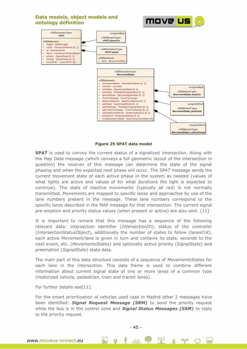
Data models, object models and
ontology definition
- 45 -
www.moveus-project.eu
Figure 25 SPAT data model
SPAT is used to convey the current status of a signalized intersection. Along with
the Map Data message (which conveys a full geometric layout of the intersection in
question) the receiver of this message can determine the state of the signal
phasing and when the expected next phase will occur. The SPAT message sends the
current movement state of each active phase in the system as needed (values of
what lights are active and values of for what durations the light is expected to
continue). The state of inactive movements (typically all red) is not normally
transmitted. Movements are mapped to specific lanes and approaches by use of the
lane numbers present in the message. These lane numbers correspond to the
specific lanes described in the MAP message for that intersection. The current signal
pre-emption and priority status values (when present or active) are also sent. [11]
It is important to remark that this message has a sequence of the following
relevant data: intersection identifier (IntersectionID), status of the controller
(IntersectionStatusObject), additionally the number of states to follow (lanesCnt),
each active Movement/lane is given in turn and contains its state, seconds to the
next event, etc. (MovementsStates) and optionally active priority (SignalState) and
preemption (SignalState) state data.
The main part of this data structure consists of a sequence of MovementsStates for
each lane in the intersection. This data frame is used to combine different
information about current signal state of one or more lanes of a common type
(motorized vehicle, pedestrian, train and transit lanes).
For further details see[11].
For the smart prioritization of vehicles used case in Madrid other 2 messages have
been identified: Signal Request Message (SRM) to send the priority request
while the bus is in the control zone and Signal Status Messages (SSM) to reply
to the priority request.
dfd J235ALL_v 2 SPAT
«XSDcomplexType»
sPAT
«XSDelement»
+ msgID :DSRCmsgID
+ name :DescriptiveName [0..1]
+ id :IntersectionID
+ status :IntersectionStatusObject
+ priority :SignalState [0..1]
+ prempt :SignalState [0..1]
+ localSPAT :local:SPAT [0]
unsignedByte
«XSDsimpleType»
sPAT::lanesCnt
«XSDcomplexType»
sPAT::states
«XSDelement»
+ state :MovementState
«XSDcomplexType»
Mov ementState
«XSDelement»
+ movementName :DescriptiveName [0..1]
+ laneSet :LaneSet
+ currState :SignalLightState [0..1]
+ pedState :PedestrianSignalState [0..1]
+ specialState :SpecialSignalState [0..1]
+ timeToChange :TimeToChange
+ stateConfidence :StateConfidence [0..1]
+ yellState :SignalLightState [0..1]
+ yellPedState :PedestrianSignalState [0..1]
+ yellTimeToChange :TimeToChange [0..1]
+ yellStateConfidence :StateConfidence [0..1]
+ pedDetect :PedestrianDetect [0..1]
+ localMovementState :local:MovementState [0]
unsignedByte
«XSDsimpleType»
Mov ementState::laneCnt
unsignedShort
«XSDsimpleType»
Mov ementState::pedCount
unsignedShort
«XSDsimpleType»
Mov ementState::v ehicleCount
1
0..1
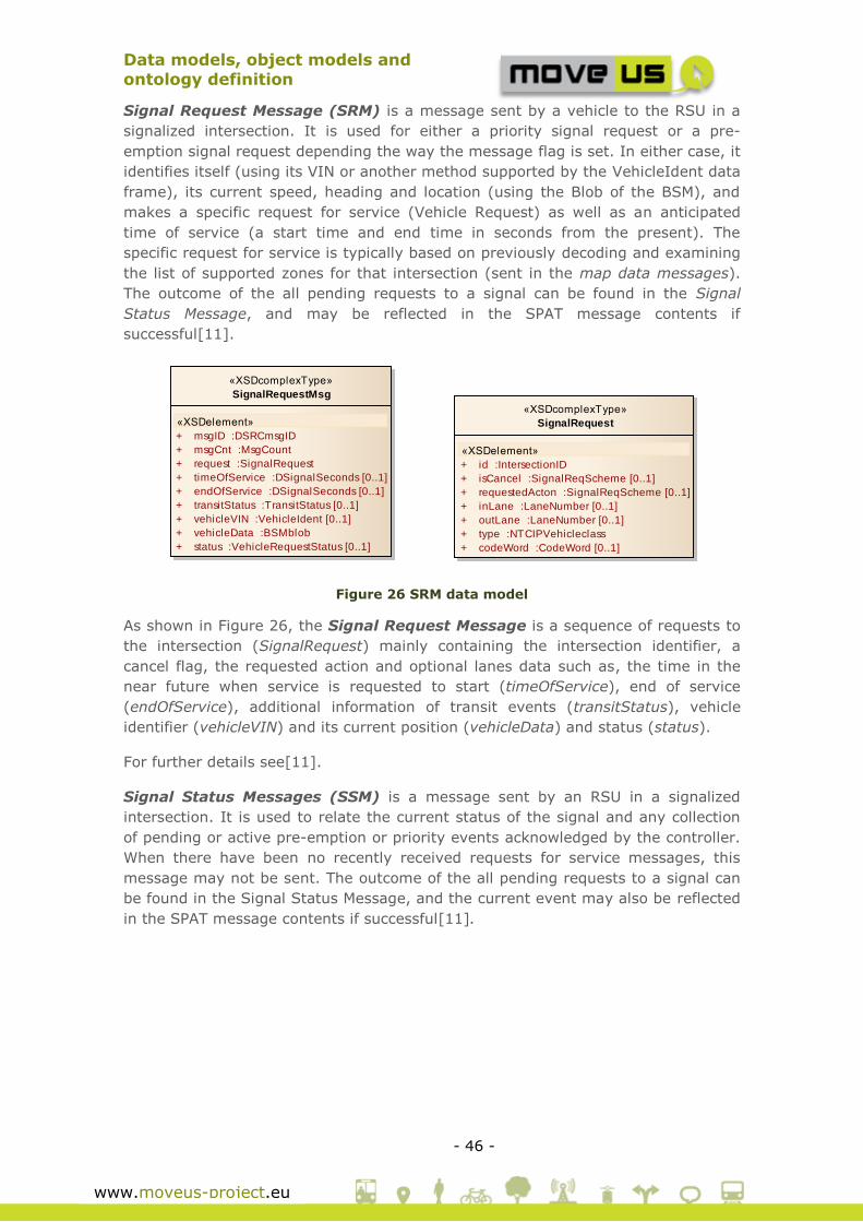
Data models, object models and
ontology definition
- 46 -
www.moveus-project.eu
Signal Request Message (SRM) is a message sent by a vehicle to the RSU in a
signalized intersection. It is used for either a priority signal request or a pre-
emption signal request depending the way the message flag is set. In either case, it
identifies itself (using its VIN or another method supported by the VehicleIdent data
frame), its current speed, heading and location (using the Blob of the BSM), and
makes a specific request for service (Vehicle Request) as well as an anticipated
time of service (a start time and end time in seconds from the present). The
specific request for service is typically based on previously decoding and examining
the list of supported zones for that intersection (sent in the map data messages).
The outcome of the all pending requests to a signal can be found in the Signal
Status Message, and may be reflected in the SPAT message contents if
successful[11].
Figure 26 SRM data model
As shown in Figure 26, the Signal Request Message is a sequence of requests to
the intersection (SignalRequest) mainly containing the intersection identifier, a
cancel flag, the requested action and optional lanes data such as, the time in the
near future when service is requested to start (timeOfService), end of service
(endOfService), additional information of transit events (transitStatus), vehicle
identifier (vehicleVIN) and its current position (vehicleData) and status (status).
For further details see[11].
Signal Status Messages (SSM) is a message sent by an RSU in a signalized
intersection. It is used to relate the current status of the signal and any collection
of pending or active pre-emption or priority events acknowledged by the controller.
When there have been no recently received requests for service messages, this
message may not be sent. The outcome of the all pending requests to a signal can
be found in the Signal Status Message, and the current event may also be reflected
in the SPAT message contents if successful[11].
class J235ALL_v 2 SignalRequest
«XSDcomplexType»
SignalRequest
«XSDelement»
+ id :IntersectionID
+ isCancel :SignalReqScheme [0..1]
+ requestedActon :SignalReqScheme [0..1]
+ inLane :LaneNumber [0..1]
+ outLane :LaneNumber [0..1]
+ type :NTCIPVehicleclass
+ codeWord :CodeWord [0..1]
«XSDcomplexType»
SignalRequestMsg
«XSDelement»
+ msgID :DSRCmsgID
+ msgCnt :MsgCount
+ request :SignalRequest
+ timeOfService :DSignalSeconds [0..1]
+ endOfService :DSignalSeconds [0..1]
+ transitStatus :TransitStatus [0..1]
+ vehicleVIN :VehicleIdent [0..1]
+ vehicleData :BSMblob
+ status :VehicleRequestStatus [0..1]

Data models, object models and
ontology definition
- 47 -
www.moveus-project.eu
Figure 27 SSM data model
The SSM mainly includes the information related with general status of each signal
controller (status), an optional attribute covering active priority (priority of
SignalState) and preemption (prempt of SignalState) state data, optional also the
identification of the vehicle asking for priority (priorityCause) or preemption
(preemptCause) and, finally, additional information pertaining to transit evens
(transitStatus).
For further details see[11].
Incident Data
No extension is necessary as In-Time simplified data model already covers all data
requirements. Part 3 of the ETSI TS 102 637 document will be taken as basis in
the case Road Hazard Warning (RHW) use cases would be considered in MoveUs
Project.
Urban Car Park Data
No extension is necessary as In-Time simplified data model already covers all data
requirements for static and dynamic information related with car parking. However,
to cover other public transport as bike sharing, car hiring or electric vehicle hiring
and charging, an analogue model is proposed. In the case of bikes, the information
related to bike sharing is kept in an analogous structure, with the following
adaptations: BikeSharingPoints are included as possible PointOfInterest; additional
datatypes BikeUsingTariffs, BikeSharingDynamic and BikeBasicData are included.
For those elements being outdoors, specific attributes of parking places are
removed (e.g. queue estimation, entrances/exit location, type, disabled capability).
class J235ALL_v 2 SignalStatus
«XSDcomplexType»
SignalStatusMessage
«XSDelement»
+ msgID :DSRCmsgID
+ msgCnt :MsgCount
+ id :IntersectionID
+ status :IntersectionStatusObject
+ priorityCause :VehicleIdent [0..1]
+ preemptCause :VehicleIdent [0..1]
+ transitStatus :TransitStatus [0..1]
«XSDcomplexType»
SignalStatusMessage::prempt
«XSDelement»
+ prempt-item :SignalState
«XSDcomplexType»
SignalStatusMessage::priority
«XSDelement»
+ priority-item :SignalState
0..1
0..1

Data models, object models and
ontology definition
- 48 -
www.moveus-project.eu
Figure 28 Dynamic Bike sharing Model
3.3 Public Transport Operation Management
The main objective of this section is to model all the information needed in order to
fulfil MoveUs pilot and use cases requirements in terms of public transport
operation and management. This information covers a wide range of different
concepts such as the definition and planning of different lines or routes or journey
tracking (vehicle of each trip, departure and arrival times, etc.).
3.3.1 Existing specifications
The existing In-Time simplified model (package Dynamic Public transport
Information) covers the main part of MoveUs requirements as it includes the data
models for journeys, service description and information related with stop points.
Each trip or journey is tracked by recording the TargetVehicleJourney, the
information related to that vehicle (TargetVehicleJourneyInfo) and concepts related
with the service and operator. It is important to remark that each trip is also linked
with the Line description (specifying the direction, the line and the name) and the
stop point elements. The stop point description is related to the
timetabledStopVisit; more timetabledStopVisit form the Timetable. The
class MOVEUS Serv ice 18 - Dynamic Bike Pool Information
GeometryLocationReference::
PointGeometry
LocationReference
LocationReference::
PointLocationReference
EMotionFeature
«FeatureType»
PointOfInterest::PointOfInterest
+ poiId :PoiPoiId
+ poiInformation :PoiInformation
EMotionFeature
«FeatureType»
PointOfInterest::PointOfInterestCategory
+ categoryId :PoiCategoryId
+ typeOfPoi :TypeOfPoiEnum
+ categoryInformation :PoiInformation
+ categoryPriority :PoiPriority [0..1]
+ categoryVisibil ity :PoiVisibil ity [0..1]
EMotionFeature
«FeatureType»
PointOfInterest::PointOfInterestEntrance
+ pointOfInterestEntranceId :PoiPoiEntranceId
+ poiEntranceDescription :PT_FreeText [0..1]
«DataType»
DataTypes::PoiInformation
+ poiInformationName :PT_FreeText
+ poiInformationDescription :PT_FreeText [0..1]
+ shortName :PT_FreeText [0..1]
«FeatureType»
BikeSharingPoint
+ BikePointId :BikePointCode
EMotionObject
BikeSharingBasicData
+ methodOfPayment :PKI13MethodOfPayment [0..*]
+ ownerOperator :CharacterString
+ pointOfPayment :PointOfPaymentEnum [0..*]
+ totalCapacity :NonNegativeInteger
+ userTypes :PKI03UserType [0..*]
«DataType»
BikeSharingTariffs
+ dayTypes :PKI20ServiceDayType
+ timePeriodStart :Time
+ timePeriodEnd :Time
+ feeType :PKI22FeeType
+ feeDescription :PT_FreeText
+ lastUpdate :DateTimeEMotionFeature
«FeatureType»
BikeSharingDynamic
+ BickSharingState :BikeSharingStateEnum [0..1]
+ exitRate :Real [0..1]
+ fi l lRate :Real [0..1]
+ lastUpdate :DateTime [0..1]
+ occupancy :Integer [0..1]
+ occupancyPercentage :Percentage [0..1]
+ queueTime :Integer [0..1]
1
+tariffs 0..*
+entrances0..*
1
+poiCategories
1..*1
+pointProjection
1..* 0..1
+location 0..*
0..1
0..1
+BikeSharingPoint 0..1
+BikeSharingStaticData 0..1
+BikeSharingPoint
1
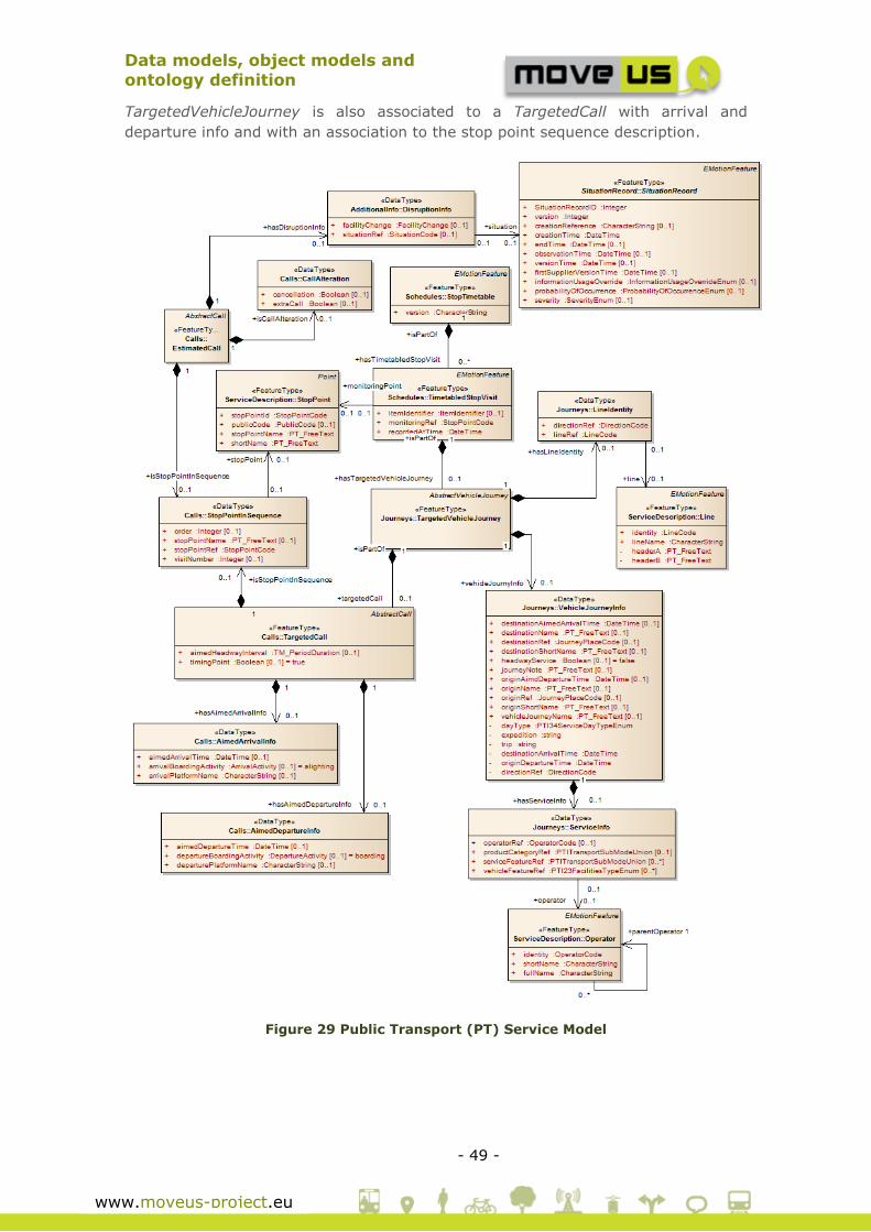
Data models, object models and
ontology definition
- 49 -
www.moveus-project.eu
TargetedVehicleJourney is also associated to a TargetedCall with arrival and
departure info and with an association to the stop point sequence description.
Figure 29 Public Transport (PT) Service Model

Data models, object models and
ontology definition
- 50 -
www.moveus-project.eu
3.3.2 Extensions
An extension of the data model is operated for Car Pooling Management according
to the requirements emerging from the Use Case definition and the City Service
specification.
The trips stored as carpooling offerings are defined by the MV_CarPoolingTrips
feature types. Here the same feature types used for Journey Origin and
Destinations are used to identify the origin and destination of the carpooling trip
(JP:OriginDestinationRequestType).
Additionally this feature type includes the attributes that define the additional
details of the trip offering, typical of the car-pooling:
Calendar: set the days of the week and time when the offering is available
Role: driver, passenger or unspecified
Visibility: set if the offering is visible or not
Roundtrip: to specify whether it is a round trip
Validity: to specify until when the offering is valid
In order to achieve the integration of functionalities from external (federated) Car-
Pooling systems, according to the working principles of the Car Pooling Service,
described in the Deliverable D3.3[14], an association is established from
MV_CarPoolingTrips to the feature type of the Registry package that defines the
external local services (in this case used for the external local car poling system).
This allow each single trips to be associated with the metadata (including the URL)
of the external system thus enabling the foreseen behaviour.
Figure 30 Carpooling Service Model
«FeatureType»
MV_CarPoolingTrips
+ TripID: int
+ UserID: int
+ Origin: JP_OriginDestinationRequestType
+ Destination: JP_OriginDestinationRequestType
+ Calendar: MV_DayAndTimeSlots [1..*]
+ CarPoolerRole: MV_CarPoolerRoleType
+ IsVisible: boolean
+ IsRoundTrip: boolean
+ Notes: string [0..1]
+ Validity: MV_TemporalExtent [0..1]
«Enumeration»
MV_CarPoolerRoleType
«enum»
Driver
Passenger
Unspecified
«feature type»
Mov eUS CommonTypes::
MV_DayAndTimeSlots
+ DayType: MV_DayTypeEnum
+ StartTime: time
+ EndTime: time
«Enumeration»
Mov eUS CommonTypes:
:MV_DayTypeEnum
«enum»
undefined
monday
tuesday
wednesday
friday
thursday
saturday
weekdays
wekends
holidays
mondayToFriday
mondayToSaturday
workingDays
schoolDays
sundaysAndHolidays«feature type»
Mov eUS CommonTypes::
MV_TemporalExtent
+ StartDate: DateTime
+ EndDate: DateTime
«DataType»
ScopingParameters::
JP_OriginDestinationRequestType
+ givenName: CharacterString [0..1]
«FeatureType»
ScopingParameters::
JP_OriginDestinationNode
+ journeyTime: DateTime [0..1]
EMotionFeature
«FeatureType»
ServiceDescription::Place
+ pointProjection: PointLocationReference [0..*]
+ zoneProjection: AreaLocationReference [0..*]
+ l inkProjection: LinearLocationReference [0..*]
+ placeId: PlaceId
«FeatureType»
Registry::ExternalLocalServ ices
+ ID: string
+ name: string
+ URI: string
+ Description: string
+ Type: ExternalLocalServiceTypes
0..*
+place
+madeUpOf 1..*
+availableOnExternalSystem 0..1
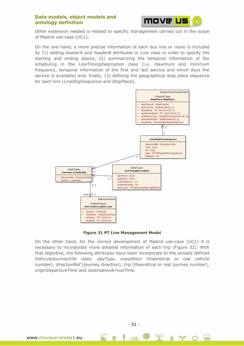
Data models, object models and
ontology definition
- 51 -
www.moveus-project.eu
Other extension needed is related to specific management carried out in the scope
of Madrid use-case (UC1):
On the one hand, a more precise information of each bus line or route is included
by (1) adding headerA and headerB attributes in Line class in order to specify the
starting and ending places, (2) summarizing the temporal information of the
scheduling in the LineTimingDescription class (i.e. maximum and minimum
frequency, temporal information of the first and last service and which days the
service is available) and, finally, (3) defining the geographical stop place sequence
for each line (LineStopSequence and StopPlace).
Figure 31 PT Line Management Model
On the other hand, for the correct development of Madrid use-case (UC1) it is
necessary to incorporate more detailed information of each trip (Figure 32). With
that objective, the following attributes have been incorporate to the already defined
VehiculeJourneyInfo class: dayType, expedition (theoretical or real vehicle
number), directionRef (journey direction), trip (theoretical or real journey number),
originDepartureTime and destinationArrivalTime.
class Simplified Dynamic Public Transport Model
«DataType»
Journeys::LineIdentity
+ directionRef :DirectionCode
+ lineRef :LineCode
EMotionFeature
«FeatureType»
Serv iceDescription::Line
+ identity :LineCode
+ lineName :CharacterString
- headerA :PT_FreeText
- headerB :PT_FreeText
«DataType»
LineTimingDescription
- startTime :time
- stopTime :time
- minFrequency :int
- maxFrequency :int
- dayTypes :PTI34ServiceDayTypeEnum
LineStopPlaceSequence
- directionRef :DirectionCode
- long :long
- lat :long
- type :PTI15RoutePointTypeEnum
- distance :int
AbstractStopPlaceElement
«FeatureType»
StopPlace::StopPlace
+ stopPlaceId :StopPlaceId
+ publicCode :PublicCode [0..1]
+ shortName :PT_FreeText [0..1]
+ stopPlaceName :PT_FreeText [0..1]
+ stopPlaceType :StopPlaceTypeEnum [0..1]
+ parentPlaceRef :StopPlaceId [0..1]
+ weighting :InterchangeWeightingEnum
0..1
+line 0..1
1..*1
1..*
1..*
1
1
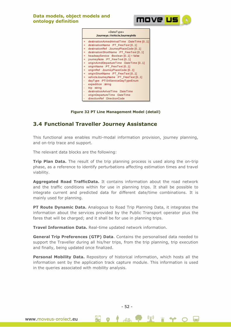
Data models, object models and
ontology definition
- 52 -
www.moveus-project.eu
Figure 32 PT Line Management Model (detail)
3.4 Functional Traveller Journey Assistance
This functional area enables multi-modal information provision, journey planning,
and on-trip trace and support.
The relevant data blocks are the following:
Trip Plan Data. The result of the trip planning process is used along the on-trip
phase, as a reference to identify perturbations affecting estimation times and travel
viability.
Aggregated Road TrafficData. It contains information about the road network
and the traffic conditions within for use in planning trips. It shall be possible to
integrate current and predicted data for different date/time combinations. It is
mainly used for planning.
PT Route Dynamic Data. Analogous to Road Trip Planning Data, it integrates the
information about the services provided by the Public Transport operator plus the
fares that will be charged; and it shall be for use in planning trips.
Travel Information Data. Real-time updated network information.
General Trip Preferences (GTP) Data. Contains the personalised data needed to
support the Traveller during all his/her trips, from the trip planning, trip execution
and finally, being updated once finalized.
Personal Mobility Data. Repository of historical information, which hosts all the
information sent by the application track capture module. This information is used
in the queries associated with mobility analysis.
class Simplified Dynamic Public Transport Model
«DataType»
Journeys::VehicleJourneyInfo
+ destinationAimedArrivalTime :DateTime [0..1]
+ destinationName :PT_FreeText [0..1]
+ destinationRef :JourneyPlaceCode [0..1]
+ destinationShortName :PT_FreeText [0..1]
+ headwayService :Boolean [0..1] = false
+ journeyNote :PT_FreeText [0..1]
+ originAimdDepartureTime :DateTime [0..1]
+ originName :PT_FreeText [0..1]
+ originRef :JourneyPlaceCode [0..1]
+ originShortName :PT_FreeText [0..1]
+ vehicleJourneyName :PT_FreeText [0..1]
- dayType :PTI34ServiceDayTypeEnum
- expedition :string
- trip :string
- destinationArrivalTime :DateTime
- originDepartureTime :DateTime
- directionRef :DirectionCode
Data models, object models and
ontology definition
- 53 -
www.moveus-project.eu
3.4.1 Existing specifications
Trip Planning Data (Personal/Road and Public Transport). The next plot is
extracted from eMotion data model and represents a complete single-multimodal
journey planning. This single-multimodal journey planning covers the following
options:
• Dynamic Road Traffic Routing Information.
• Dynamic Public Transport Journey Routing.
• Dynamic Walking Planning.
• Dynamic Cycling Planning.
• Comparative Dynamic Multi Modal Journey Planning.
JP_Journey class describes a journey and it is made up by several JP_Legs (a leg is
a structure that is used to define each single journey. A journey can be made of
several legs). There are 4 leg types:
• Timed Leg: a leg that has specific timing points associated to a timetable
e.g. Public Transport.
• Frequency Leg: a leg that runs at specified frequencies.
• Continuous Leg: a continuous leg does not have a specific timing or
frequency and is suitable for legs not covered by public transport, e.g. it can
be used for car or walk legs.
• Interchange Leg: interchange legs are typically used for walking trips for
interchange purposes. They have an origin and a destination and are
described with a navigation path.
Another important concept to point out from this data model is that each JP_Leg
can include information on Tracking&mapping (JP_LegTrack).

Data models, object models and
ontology definition
- 54 -
www.moveus-project.eu
Figure 33 Journey Planning services
Figure 34 Journey Planning services (II)

Data models, object models and
ontology definition
- 55 -
www.moveus-project.eu
For deeper detail of classes and attributes needed for each leg see In-Time data
model, which includes information regarding messages, service origin, etc.
Personal Mobility Data
As mentioned in the previous section, each JP_Leg can include information on
Tracking&mapping (JP_LegTrack). The TrackingAndMapping contains data types
suitable for Mapping and Tracking purposes. Objects of type JP_Tracks include a
JP_Map and may include instructions. The next plot is extracted from eMotion data
model.
Figure 35 Journey Planning services
class TrackingAndMapping
«DataType»
JP_Map
+ renderedMapURL: CharacterString [0..1]
LocationReference
LocationReference::
PointLocationReference
«DataType»
JP_Feature
+ absoluteBearing: Angle [0..1]
+ distance: Distance [0..1]
+ featureDescription: CharacterString [0..1]
+ onwardName: CharacterString [0..1]
+ relativeBearing: JP_RelativeBearing
+ roadNumber: CharacterString [0..1]
NetNode
«FeatureType»RoadNetwork::RoadNetNode
+/ formOfNode: FormOfNode
«DataType»
JP_TrackInstructions
+ summary: CharacterString
«DataType»
JP_LegTrack
+ polyline: string
+ totalDistance: Distance
«DataType»
JP_Track
+ mapSystemReference: JP_MapSystemReference
«DataType»
JP_MapSystemReference
«Enumeration»
JP_Relativ eBearing
left
right
straightAhead
uTurn
unknown
+featureTypeDefinedAs
+instructionsGivenBy
0..1+including
+madeUpOf 1..*
+mapping 2..*
{ordered}
+includes 1..*
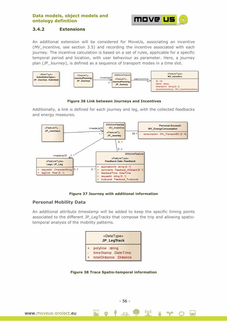
Data models, object models and
ontology definition
- 56 -
www.moveus-project.eu
3.4.2 Extensions
An additional extension will be considered for MoveUs, associating an incentive
(MV_incentive, see section 3.5) and recording the incentive associated with each
journey. The incentive calculation is based on a set of rules, applicable for a specific
temporal period and location, with user behaviour as parameter. Here, a journey
plan (JP_Journey), is defined as a sequence of transport modes in a time slot.
Figure 36 Link between Journeys and Incentives
Additionally, a link is defined for each journey and leg, with the collected feedbacks
and energy measures.
Figure 37 Journey with additional information
Personal Mobility Data
An additional attribute timestamp will be added to keep the specific timing points
associated to the different JP_LegTracks that compose the trip and allowing spatio-
temporal analysis of the mobility patterns.
Figure 38 Trace Spatio-temporal information
class Interface Response
«BasicType»
SubstitutionTypes::
JP_Journeys_Substitute
«FeatureTy...
JourneyPlanning::
JP_Journeys
EMotionFeature
«FeatureTy...
JourneyPlanning::
JP_Journey
«FeatureType»
MV_incentive
- ID :int
- Name :string
- Description :string [0..1]
- IncentiveCurrency :MV_IncentiveCurrency
+madeUpOf
1..*
assocIncentive
class TrackingAndMapping
«DataType»
JP_LegTrack
+ polyline :string
- timeStamp :DateTime
+ totalDistance :Distance
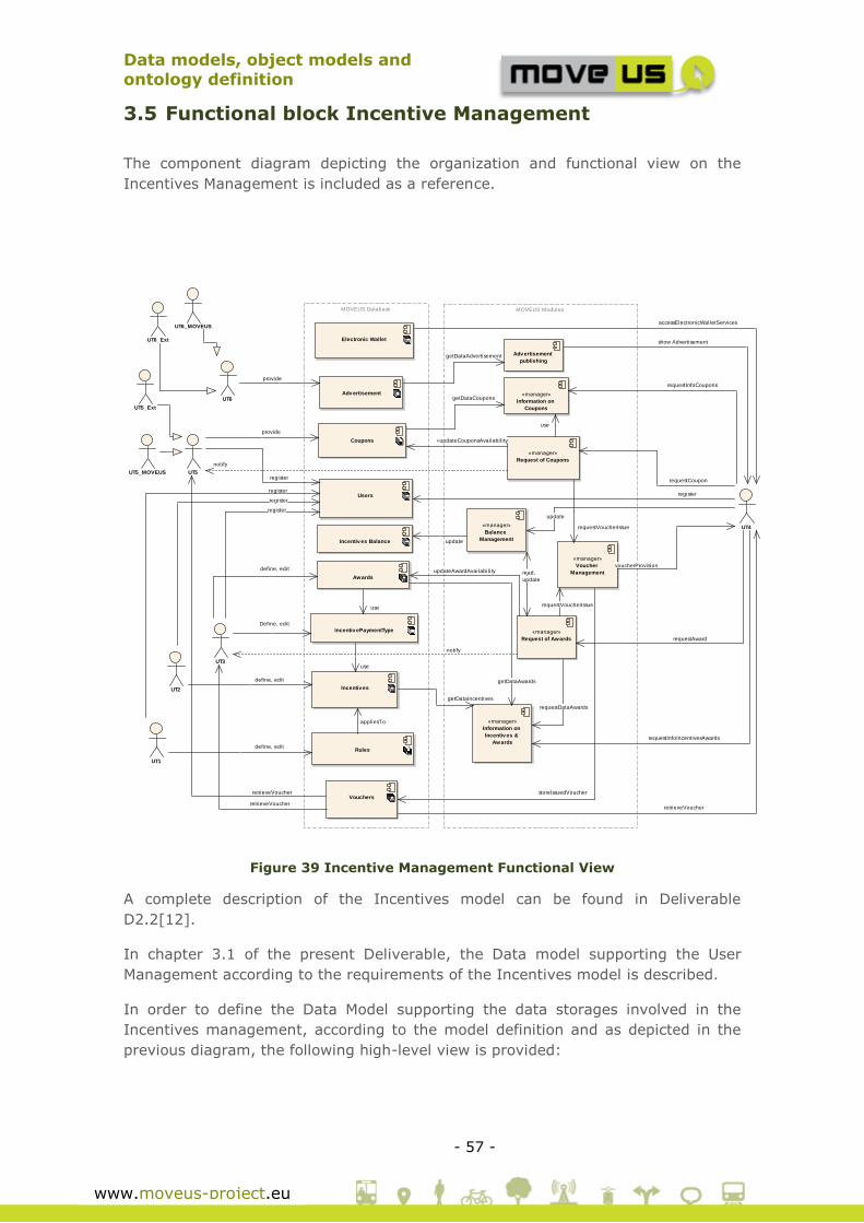
Data models, object models and
ontology definition
- 57 -
www.moveus-project.eu
3.5 Functional block Incentive Management
The component diagram depicting the organization and functional view on the
Incentives Management is included as a reference.
Figure 39 Incentive Management Functional View
A complete description of the Incentives model can be found in Deliverable
D2.2[12].
In chapter 3.1 of the present Deliverable, the Data model supporting the User
Management according to the requirements of the Incentives model is described.
In order to define the Data Model supporting the data storages involved in the
Incentives management, according to the model definition and as depicted in the
previous diagram, the following high-level view is provided:
MOVEUS Database MOVEUS Modules
Coupons
Electronic Wallet
Incentiv es Balance
UT5
«manager»
Information on
Coupons
«manager»
Request of Coupons
UT4
«manager»
Request of Awards
«manager»
Information on
Incentiv es &
Awards
Incentiv es
«manager»
Voucher
Management
UT3
UT2
UT1
Users
Rules
«manager»
Balance
Management
Awards
UT5_Ext
UT5_MOVEUS
Vouchers
Adv ertisementUT6
UT6_Ext
UT6_MOVEUS
Adv ertisement
publishing
Incentiv ePaymentType
provide
getDataCoupons
+updateCouponsAvailabil ity
use
notify
requestCoupon
requestInfoCoupons
accessElectronicWalletServices
requestAward
requestDataAwards
requestInfoIncentivesAwards
getDataIncentives
requestVoucherIssue
voucherProvision
requestVoucherIssue
notify
define, edit
register
registerregister
register
register
appliesTo
define, edit
update
update
read,
update
define, edit updateAwardAvailabil ity
getDataAwards
retrieveVoucher
retrieveVoucher storeIssuedVoucher
retrieveVoucher
provide
getDataAdvertisement
show Advertisement
use
Define, edit
use
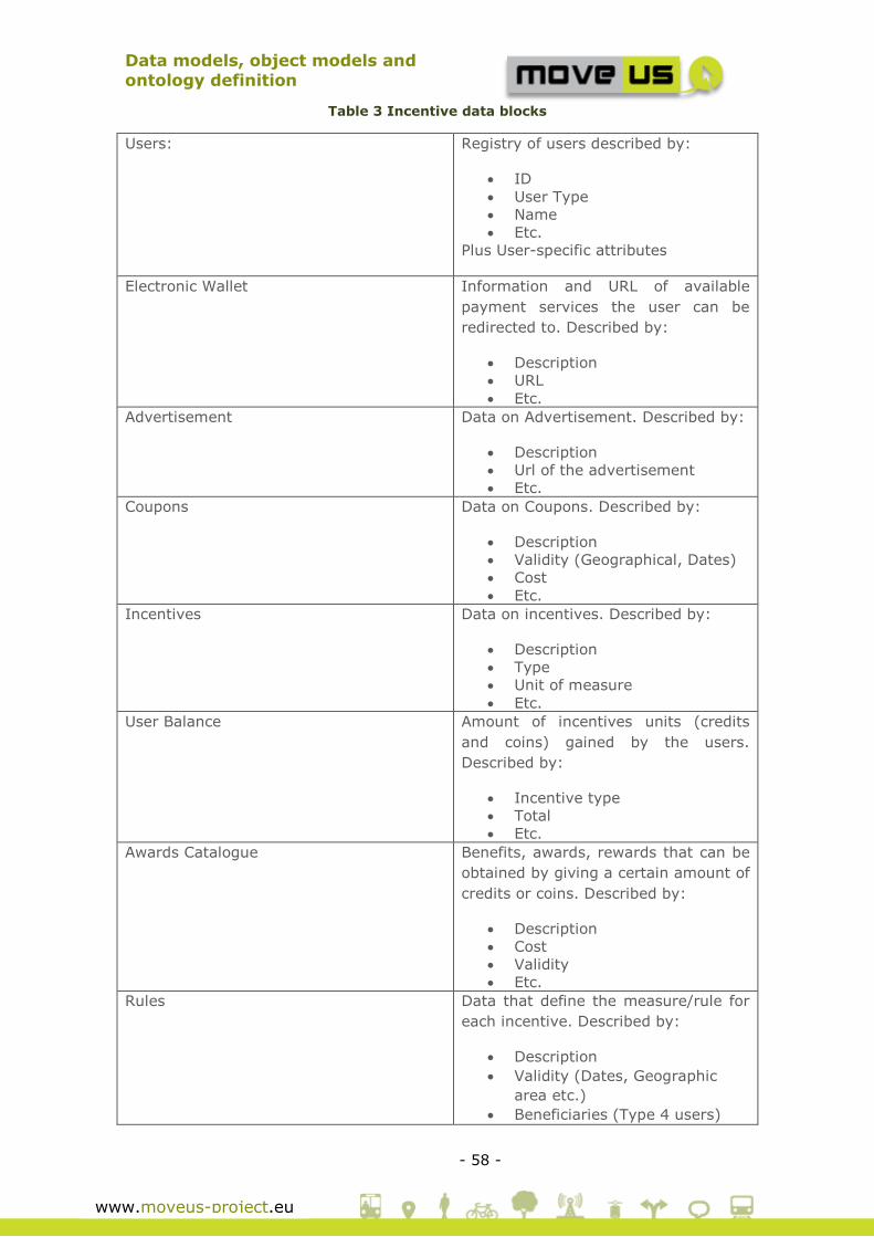
Data models, object models and
ontology definition
- 58 -
www.moveus-project.eu
Table 3 Incentive data blocks
Users: Registry of users described by:
ID
User Type
Name
Etc.
Plus User-specific attributes
Electronic Wallet Information and URL of available
payment services the user can be
redirected to. Described by:
Description
URL
Etc.
Advertisement Data on Advertisement. Described by:
Description
Url of the advertisement
Etc.
Coupons Data on Coupons. Described by:
Description
Validity (Geographical, Dates)
Cost
Etc.
Incentives Data on incentives. Described by:
Description
Type
Unit of measure
Etc.
User Balance Amount of incentives units (credits
and coins) gained by the users.
Described by:
Incentive type
Total
Etc.
Awards Catalogue Benefits, awards, rewards that can be
obtained by giving a certain amount of
credits or coins. Described by:
Description
Cost
Validity
Etc.
Rules Data that define the measure/rule for
each incentive. Described by:
Description
Validity (Dates, Geographic
area etc.)
Beneficiaries (Type 4 users)

Data models, object models and
ontology definition
- 59 -
www.moveus-project.eu
etc.
Vouchers Contains the historical data on Issued
Vouchers.
The incentives-related data model is described by focusing on three aspects that
together form the overall Incentives-related package:
Introduction of incentive currencies
Assignment of incentives to the user
Definition of incentives and rules
Awards, coupons, advertisement
3.5.1 Existing specifications
The incentive schema defined within MoveUs is supported by a specific and
dedicated Data Model which needs to be defined completely. No existing parts of
the In-Time/Co-Cities Data Model are then re-used.
3.5.2 Extensions
3.5.2.1 Incentive currencies
The basic types of incentives can be identified with three base units of measure or
currencies:
Table 4 Measure/Currency Units
Unit of measure /
Currency
Type of incentive
CREDIT Incentives that are calculated from Energy Efficient
Behaviour and can be spent at more UT3s
M_COIN (MoveUs Coins) Incentives that can be spent in general at more
UT3s associated to MoveUs
B_COIN (Bonded Coin) Incentives that can be spent only at one specific
UT3
In order to allow a higher flexibility, an additional MV_IncentiveCurrency extends
the base currency by adding the same features to it:
A name
A monetary value
A temporal and spatial validity
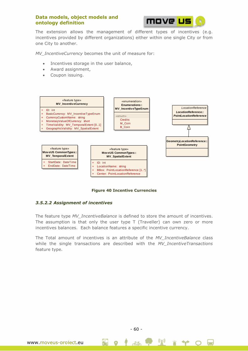
Data models, object models and
ontology definition
- 60 -
www.moveus-project.eu
The extension allows the management of different types of incentives (e.g.
incentives provided by different organizations) either within one single City or from
one City to another.
MV_IncentiveCurrency becomes the unit of measure for:
Incentives storage in the user balance,
Award assignment,
Coupon issuing.
Figure 40 Incentive Currencies
3.5.2.2 Assignment of incentives
The feature type MV_IncentiveBalance is defined to store the amount of incentives.
The assumption is that only the user type T (Traveller) can own zero or more
incentives balances. Each balance features a specific incentive currency.
The Total amount of incentives is an attribute of the MV_IncentiveBalance class
while the single transactions are described with the MV_IncentiveTransactions
feature type.
«feature type»
MV_Incentiv eCurrency
+ ID: int
+ BasicCurrency: MV_IncentiveTypeEnum
+ CurrencyCustomName: string
+ MonetaryValueOfCurrency: short
+ TimeValidity: MV_TemporalExtent [0..1]
+ GeographicValidity: MV_SpatialExtent
«enumeration»
Enumerations::
MV_Incentiv eTypeEnum
«enum»
Credits
M_Coin
B_Coin
«feature type»
Mov eUS CommonTypes::
MV_TemporalExtent
+ StartDate: DateTime
+ EndDate: DateTime
«feature type»
Mov eUS CommonTypes::
MV_SpatialExtent
+ ID: int
+ LocationName: string
+ BBox: PointLocationReference [1..*]
+ Center: PointLocationReference
GeometryLocationReference::
PointGeometry
LocationReference
LocationReference::
PointLocationReference
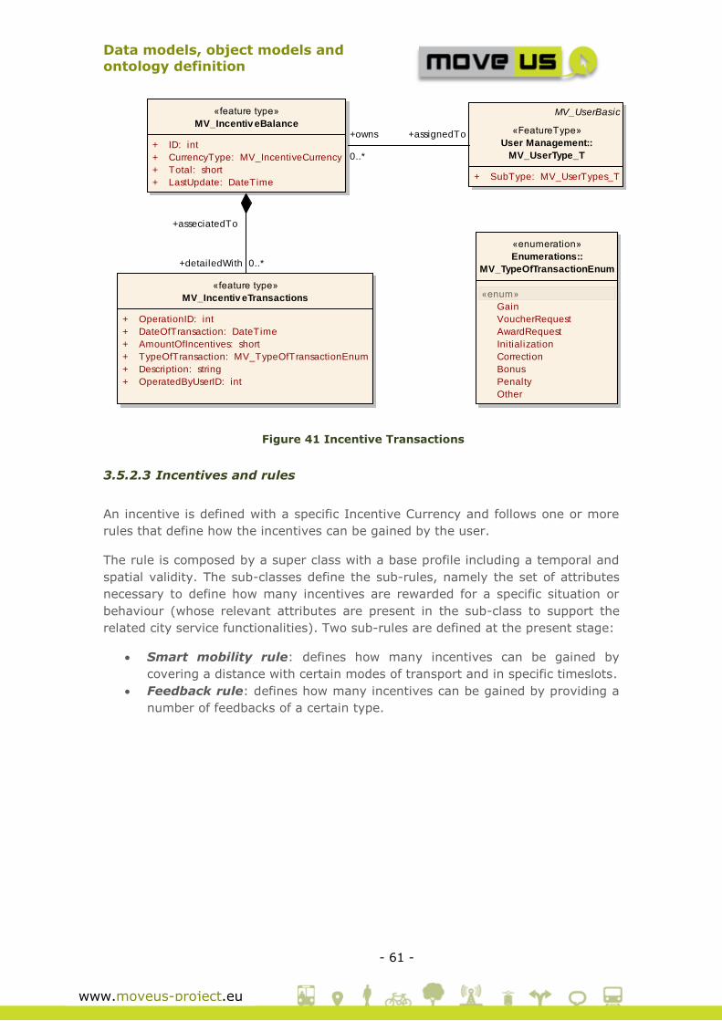
Data models, object models and
ontology definition
- 61 -
www.moveus-project.eu
Figure 41 Incentive Transactions
3.5.2.3 Incentives and rules
An incentive is defined with a specific Incentive Currency and follows one or more
rules that define how the incentives can be gained by the user.
The rule is composed by a super class with a base profile including a temporal and
spatial validity. The sub-classes define the sub-rules, namely the set of attributes
necessary to define how many incentives are rewarded for a specific situation or
behaviour (whose relevant attributes are present in the sub-class to support the
related city service functionalities). Two sub-rules are defined at the present stage:
Smart mobility rule: defines how many incentives can be gained by
covering a distance with certain modes of transport and in specific timeslots.
Feedback rule: defines how many incentives can be gained by providing a
number of feedbacks of a certain type.
«feature type»
MV_Incentiv eBalance
+ ID: int
+ CurrencyType: MV_IncentiveCurrency
+ Total: short
+ LastUpdate: DateTime
«feature type»
MV_Incentiv eTransactions
+ OperationID: int
+ DateOfTransaction: DateTime
+ AmountOfIncentives: short
+ TypeOfTransaction: MV_TypeOfTransactionEnum
+ Description: string
+ OperatedByUserID: int
«enumeration»
Enumerations::
MV_TypeOfTransactionEnum
«enum»
Gain
VoucherRequest
AwardRequest
Initialization
Correction
Bonus
Penalty
Other
MV_UserBasic
«FeatureType»
User Management::
MV_UserType_T
+ SubType: MV_UserTypes_T
+detailedWith 0..*
+asseciatedTo
+assignedTo+owns
0..*

Data models, object models and
ontology definition
- 62 -
www.moveus-project.eu
Figure 42 Incentive & Rules
«feature type»
MV_Incentiv e
+ ID: int
+ Name: string
+ Description: string [0..1]
+ IncentiveCurrency: MV_IncentiveCurrency
«feature type»
MV_I_Rule_Basic
+ ID: int
+ Name: string
+ Description: string
+ GeographicValidity: MV_SpatialExtent [0..*]
+ TimeValidity: MV_TemporalExtent
«feature type»
MV_I_Rule_SmartMobility
+ Reward: short
+ Distance: short
+ ModeOfTransport: MV_TransportModes
+ TimeSlots: DayAndTimeSlots [1..*]
«feature type»
Mov eUS CommonTypes::
MV_DayAndTimeSlots
+ DayType: MV_DayTypeEnum
+ StartTime: time
+ EndTime: time
«Enumeration»
Mov eUS CommonTypes::
MV_DayTypeEnum
«enum»
undefined
monday
tuesday
wednesday
friday
thursday
saturday
weekdays
wekends
holidays
mondayToFriday
mondayToSaturday
workingDays
schoolDays
sundaysAndHolidays
«FeatureType»
MV_I_Rule_FeedbackProv ision
+ Reward: short
+ TypeOfFeedback: int
+ NumberOfFeedbacks: int
+follow 1..*
+appliesTo 0..*

Data models, object models and
ontology definition
- 63 -
www.moveus-project.eu
3.5.2.4 Coupons, awards, vouchers, electronic wallet service and
advertisement
The coupons are described by a complex feature (MV_coupons) that can be used to
describe most aspects of the object associated to the coupon. An URL of a detail
page is present to link the coupon to the organization that provides it.
The MV_Award describe the single entry of a catalogue of awards. A single award
applies to one or more incentives.
Awards can be obtained and paid by means of an Incentive Payment Type. The
feature type MV_IncentivePaymentType extends the concept of Incentive Currency
previously introduced by adding a monetary tradeoff. This tradeoff expresses the
percentage that could be applied to pay an award partially in incentives and
partially in real money.
Example:
An instance of IncentiveCurrency named “CustomCoin” is of type “B_COIN”,
and each coin has a value of 1 euro.
An instance of IncentivePaymentType has the value of CustomCoin and
additionally has a monetary tradeoff of the 50%.
An award of value = 100Euro can be then obtained with 100 CustomCoin or
with 50 CustomCoin + 50 Euros.
MV_Advertisement is a basic feature type supporting the Advertisement object.
MV_Vouchers is used to store the information of the Vouchers that have been
issued and can be used for historical purposes or for retrieving the details of the
Voucher (for example at the moment of use of the voucher).
The Electronic Payment Service Registry (MV_EPS_Registry) is defined for the
Electronic Wallet Service according to the definition of this service in the Use Case
description. Having the characteristics of the Registry entity defined in 3.8. The
MV_EPS_Registry is defined as a super class of it. See 3.8 for more details on the
registry features.
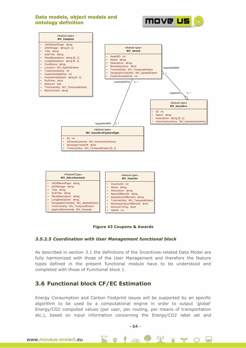
Data models, object models and
ontology definition
- 64 -
www.moveus-project.eu
Figure 43 Coupons & Awards
3.5.2.5 Coordination with User Management functional block
As described in section 3.1 the definitions of the Incentives-related Data Model are
fully harmonized with those of the User Management and therefore the feature
types defined in the present functional module have to be understood and
completed with those of Functional block 1.
3.6 Functional block CF/EC Estimation
Energy Consumption and Carbon Footprint issues will be supported by an specific
algorithm to be used by a computational engine in order to output ‘global’
Energy/CO2 computed values (per user, per routing, per means of transportation
etc.), based on input information concerning the Energy/CO2 label set and
«FeatureType»
MV_Adv ertisement
+ UrlOfDetailPage: string
+ UrlOfImage: string
+ Title: string
+ SubTitle: string
+ ShortDescription: string
+ LongDescription: string
+ GeographicValidity: MV_SpatialExtent
+ TimeValidity: MV_TemporalExtent
+ ApplicableInterests: MV_Interests
«feature type»
MV_Award
+ AwardID: int
+ Name: string
+ Description: string
+ MonetaryValue: short
+ TimeValidity: MV_TemporalExtent
+ GeographicValidity: MV_SpatialExtent
+ CurrentAvailabil ity: int
«feature type»
MV_Coupons
+ UrlOfDetailPage: string
+ UrlOfImage: string [0..1]
+ Title: string
+ SubTitle: string
+ ShortDescription: string [0..1]
+ LongDescription: string [0..1]
+ Conditions: string
+ Location: MV_SpatialExtent
+ TotalAvailabil ity: int
+ CurrentAvailabil ity: int
+ Availabil ityDetails: string [0..1]
+ FullPrice: short
+ Discount: real
+ TimeValidity: MV_TemporalExtent
+ MainContact: string
«feature type»
MV_Incentiv ePaymentType
+ ID: int
+ AllowedCurrency: MV_IncentiveCurrency
+ MonetaryTradeoff: short
+ TimeValidity: MV_TemporalExtent [0..1]
«feature type»
MV_Incentiv e
+ ID: int
+ Name: string
+ Description: string [0..1]
+ IncentiveCurrency: MV_IncentiveCurrency
«feature type»
MV_Voucher
+ VoucherID: int
+ Name: string
+ Description: string
+ NameOfBenefit: string
+ DescriptionOfBenefit: string
+ TimeValidity: MV_TemporalExtent
+ MonetaryValueOfBenefit: short
+ AmountToPay: short
+ UserID: int
+awardedWith
0..*
+appliesTo 1..*
+availableFor 1..*
+payableWith 1..*

Data models, object models and
ontology definition
- 65 -
www.moveus-project.eu
information related to mobility options chosen by users in real time. The
assessment methodology, methods and underlying data needs are currently under
definition in WP4.
3.6.1 Existing specifications
No existing parts of the In-Time/Co-Cities Data Model are then re-used. The energy
efficiency schema defined in WP4 will be supported by a specific and dedicated Data
Model which needs to be defined from scratch.
3.6.2 Extensions
Expected extensions of the common MoveUs data model are expected according to
the WP4 working progress. The CEN ISO TS 19324 standard will be considered in
the context of WP4, being updated this part of the data model accordantly if
applies.
In advance, some of the key concepts to be managed are outlined at the table
below.
Table 5 Energy Efficiency concepts
KPI Set of Key Performance Indicators related with energy efficiency and
carbon footprint in the transportation domain.
Described by:
Description
Calculation
Relation to transportation modality
Etc.
Energy
labels
Set of translations of energy efficiency values for users. Described by:
Description
Equivalence to user meaningful values, e.g. cost,
Energy
affecting
parameters
Set of parameters that are affected by KPIs in the different living labs.
Described by:
Description
KPIs related to this parameter
Positive or negative effect for energy consumption and carbon
footprint
Etc.

Data models, object models and
ontology definition
- 66 -
www.moveus-project.eu
3.7 Functional block Feedback
MoveUs proposes a co-operative mobility concept, seen as the interconnection of
users, vehicles and infrastructure that enables a full sharing of information between
the different actors. Here, is a key issue the final user involvement. Specifically, the
feedback provided by users enables cities and transportation operators to adapt
their plans and offer in a more efficient way.
This feedback can be achieved in two different ways: passive, as automated
application process, or active, answering the own user questions related to the
quality of the own MoveUs Application information or the public transport
environment (e.g. feedback traffic and transportation related events and metrics).
3.7.1 Existing specifications
The existing Co-Cities Data model defines a package of feedback-related feature
types that are used in MoveUs.
Among the set of feedback services specified in Co-Cities, two domains are
specifically considered for MoveUs:
1. Journey Planning-related feedbacks
2. Traffic-related feedbacks
The super-class Feedback features the base feedback attributes. This includes a
Trust Level that can be used to differentiate (namely, assign different reliability
levels) the subject who formulated the feedback.
The sub-classes of Feedback define the specific data types of the feedback
information:
Traffic feedback (new data about a traffic event): this is a class with an
attribute of type TrafficElement (see section 3.2).
Traffic quality feedback (quality of information of a given traffic event): a set
of boolean values indicating if the specific information given about a traffic
event is correct or not.
Journey Planning quality feedback (quality of information of a given
journey): a set of Boolean values indicating if the specific information given
for each leg of a journey is correct or not.
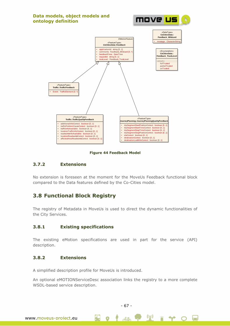
Data models, object models and
ontology definition
- 67 -
www.moveus-project.eu
Figure 44 Feedback Model
3.7.2 Extensions
No extension is foreseen at the moment for the MoveUs Feedback functional block
compared to the Data features defined by the Co-Cities model.
3.8 Functional Block Registry
The registry of Metadata in MoveUs is used to direct the dynamic functionalities of
the City Services.
3.8.1 Existing specifications
The existing eMotion specifications are used in part for the service (API)
description.
3.8.2 Extensions
A simplified description profile for MoveUs is introduced.
An optional eMOTIONServiceDesc association links the registry to a more complete
WSDL-based service description.
«FeatureType»
Traffic::TrafficFeedback
+ Event: TrafficElement [0..*]
«FeatureType»
Traffic::TrafficQualityFeedback
+ additionalInfoCorrect: boolean [0..1]
+ trafficProblemCauseCorrect: boolean [0..1]
+ trafficInfoAvailable: boolean [0..1]
+ locationTrafficInfoCorrect: boolean [0..1]
+ roadworksInfoAvailable: boolean [0..1]
+ locationRoadworksCorrect: boolean [0..1]
+ affectedAreaRoadworksCorrect: boolean [0..1]
EMotionFeature
«FeatureType»
CoCitiesData::Feedback
+ applicationId: string [0..1]
+ comments: Feedback_Wildcard [0..*]
+ feedbackTime: DateTime
+ requestId: string [0..1]
+ trustLevel: Feedback_TrustLevel
«Enumeration»
CoCitiesData::
Feedback_TrustLev el
«enum»
fullTrusted
partialTrusted
unTrusted
«DataType»
CoCitiesData::
Feedback_Wildcard
+ message: CharacterString
«FeatureType»
JourneyPlanning::JourneyPlanningQualityFeedback
+ tripSegmentStartPositionCorrect: boolean [0..1]
+ tripSegmentStartTimeCorrect: boolean [0..1]
+ tripSegmentStopTimeCorrect: boolean [0..1]
+ tripSegmentStopPositionCorrect: boolean [0..1]
+ etaCorrect: boolean [0..1]
+ destinationCorrect: boolean [0..1]
+ destinationLastMileCorrect: boolean [0..1]

Data models, object models and
ontology definition
- 68 -
www.moveus-project.eu
MV_Registry is a superclass of local registry entities (MV_LocalRegistry) that have a
spatial extent (mandatory) and a temporal extent (non-mandatory). For example
there may be an instance of MV_LocalRegistry for Madrid, one for Genoa and one
for Tampere.
The service descriptions MoveUs-specific (URIs) or eMotion-based (WSDL:Service)
are associated to MV_LocalRegistry.
MV_LocalRegistry has also an association with the feature type
ExternalLocalServices containing the metadata that describes the external services
or systems used by MoveUs for the Electronic Wallet and Car Pooling services. The
access criteria, necessary for differentiating the functionalities in the city services
are defined by considering the user type, defined as the union of the different (sub-
)user types and also the additional role ID (see 3.1.2 for more details on these data
types). With the implementation of the services a differentiation can then be
operated by considering generic (MV_UserType_MV) or specific (types “I”, “T” or
“D”) user profiles and by combining these with the additional User role if necessary.
The possibilities can be:
Anonymous access (generic MoveUs user type and commonly agreed user
role)
Access regulated by User Type only (using a common or known user role)
Access regulated by User Role only (using the generic MoveUs user type)
Combination of the previous two options
For each instance of access criteria a set of pair key-values is defined as a generic
method for activating, de-activating or differencing the functionalities and features
of the city services.
More information on the dynamic behaviour of the City Services can be found in
Deliverable D3.3[14].
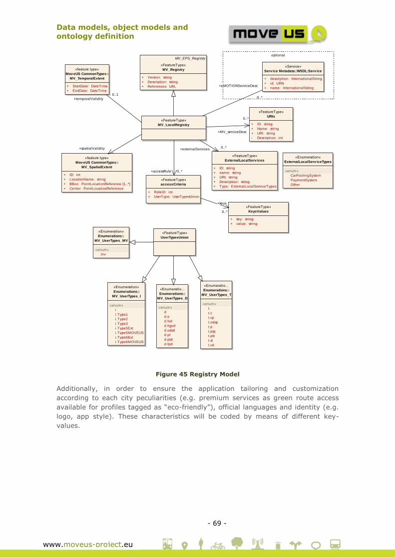
Data models, object models and
ontology definition
- 69 -
www.moveus-project.eu
Figure 45 Registry Model
Additionally, in order to ensure the application tailoring and customization
according to each city peculiarities (e.g. premium services as green route access
available for profiles tagged as “eco-friendly”), official languages and identity (e.g.
logo, app style). These characteristics will be coded by means of different key-
values.
optional
«feature type»
Mov eUS CommonTypes::
MV_SpatialExtent
+ ID: int
+ LocationName: string
+ BBox: PointLocationReference [1..*]
+ Center: PointLocationReference
MV_EPS_Registry
«FeatureType»
MV_Registry
+ Version: string
+ Description: string
+ References: URL
«FeatureType»
URIs
+ ID: string
+ Name: string
+ URI: string
- Description: int
«FeatureType»
KeysValues
+ key: string
+ value: string
«FeatureType»
accessCriteria
+ RoleID: int
+ UserType: UserTypesUnion
«feature type»
Mov eUS CommonTypes::
MV_TemporalExtent
+ StartDate: DateTime
+ EndDate: DateTime
«Service»
Serv ice Metadata::WSDL:Serv ice
+ description: InternationalString
+ id: URN
+ name: InternationalString
«FeatureType»
MV_LocalRegistry
«Enumeration»
Enumerations::
MV_UserTypes_I
«enum»
i
i.Type1
i.Type2
i.Type3
i.Type5Ext
i.Type5MOVEUS
i.Type6Ext
i.Type6MOVEUS
«Enumeratio...
Enumerations::
MV_UserTypes_T
«enum»
t
t.c
t.cp
t.odsp
t.p
t.ptp
t.ptt
t.st
t.vd
«Enumeratio...
Enumerations::
MV_UserTypes_D
«enum»
d
d.e
d.fvd
d.hgvd
d.odsd
d.pr
d.ptd
d.tpd
«FeatureType»
UserTypesUnion
«Enumeration»
Enumerations::
MV_UserTypes_MV
«enum»
mv
«FeatureType»
ExternalLocalServ ices
+ ID: string
+ name: string
+ URI: string
+ Description: string
+ Type: ExternalLocalServiceTypes
«Enumeration»
ExternalLocalServ iceTypes
«enum»
CarPoolingSystem
PaymentSystem
Other
+externalServices0..*
+eMOTIONServiceDesc
0..*+temporalValidity
0..1
+spatialValidity
+MV_serviceDesc
0..*
+accessRule 0..*
+keys
0..*

Data models, object models and
ontology definition
- 70 -
www.moveus-project.eu
4 Conclusions
The outcomes of Task 3.1 remark the existing work in the field of mobility services
and in particular the availability of information models, which cover quite of the
static and dynamic elements identified as relevant. A significant portion of the
concepts needed for the storage of information and provision of services in MoveUs
project have been previously considered in the projects taken as reference.
However, a deep analysis of the use cases has determined necessary to define
adaptations and specific packages for the most innovative project goals, i.e.:
incentives management, energy efficiency, services customization and of course,
those aspects related to intelligent traffic management.
Furthermore, the parallel execution of the definition activities for the information
model (T3.1), system architecture (T3.2), service specifications (T3.3) and the
underlying algorithms (e.g. calculation of energy efficiency and trip planner) have
motivated an iterative working approach during this phase of the project.
While the document delivered in M10 (v1.0) constituted a mature version of the
MoveUs data model integrating most of the specific and complex aspects before
mentioned, this update (v1.1) was deemed necessary at the end of the 1st project
year (M12) to make sure that the final T3.1 result is fully aligned with the final
outcome of the two parallel tasks mentioned (T3.2 and T3.3), now already
available.

Data models, object models and
ontology definition
- 71 -
www.moveus-project.eu
5 References
[1] REWERSE- Reasoning on the web. A1.D1. Ontology of Transportation Networks http://rewerse.net/deliverables/m18/a1-d4.pdf
[2] N. Kaza and L.D. Hopkins. Ontology for Land Development Decisions and Plans, Studies in Computational Intelligence (SCI),61, 47–59 (2007)
[3] LinkedGeoData. www.linkedgeodata.org
[4] COST ACTION C21 – TOWNONTOLOGY. Urban Ontologies for an Improved Communication in Urban Civil Engineering Projects (2008)
[5] Metral, G. Falquet, K.Karatzas. Ontologies for the integration of Air Quality Models and 3D City Models. Institut d'Architecture. University of Geneva (2005)
[6] T. Malgundkar, M.Rao, S.S. Mantha. GIS Driven urban traffic analysis based on ontology.International Journal of Managing Information Technology (IJMIT) Vol.4, No.1, February 2012 (2012)
[7] eMotion Project. http://www.emotion-project.eu/
[8] In-Time Project. http://www.emotion-project.eu/
[9] Co-cities Project. http://www.co-cities.eu/
[10] FRAME Framework. http://www.frame-online.net
[11] SAE J2735 DEDICATED SHORT RANGE COMMUNICATIONS (DSRC) (Rev 29)(2008)
[12] MoveUs deliverable D2.2 - Use cases, incentives-based model concept and common specifications for the pilots
[13] MoveUs deliverable D8.5.1 - First report on cooperation with other projects
[14] MoveUs deliverable D3.3 - MOVEUS city services: specification and design