currie wood - woodland trust
TRANSCRIPT
Currie Wood
Currie Wood
Management Plan
2020-2025
Currie Wood
2
MANAGEMENT PLAN - CONTENTS PAGE
ITEM Page No.
Introduction 3
Plan review and updating 3
Woodland Management Approach 4
Summary 5
1.0 Site details 5
2.0 Site description 5
2.1 Summary Description 5
2.2 Extended Description 5
3.0 Public access information 8
3.1 Getting there 8
3.2 Access / Walks 8
4.0 Long term policy 9
5.0 Key Features 10
5.1 Planted Ancient Woodland Site 10
5.2 Connecting People with woods & trees 15
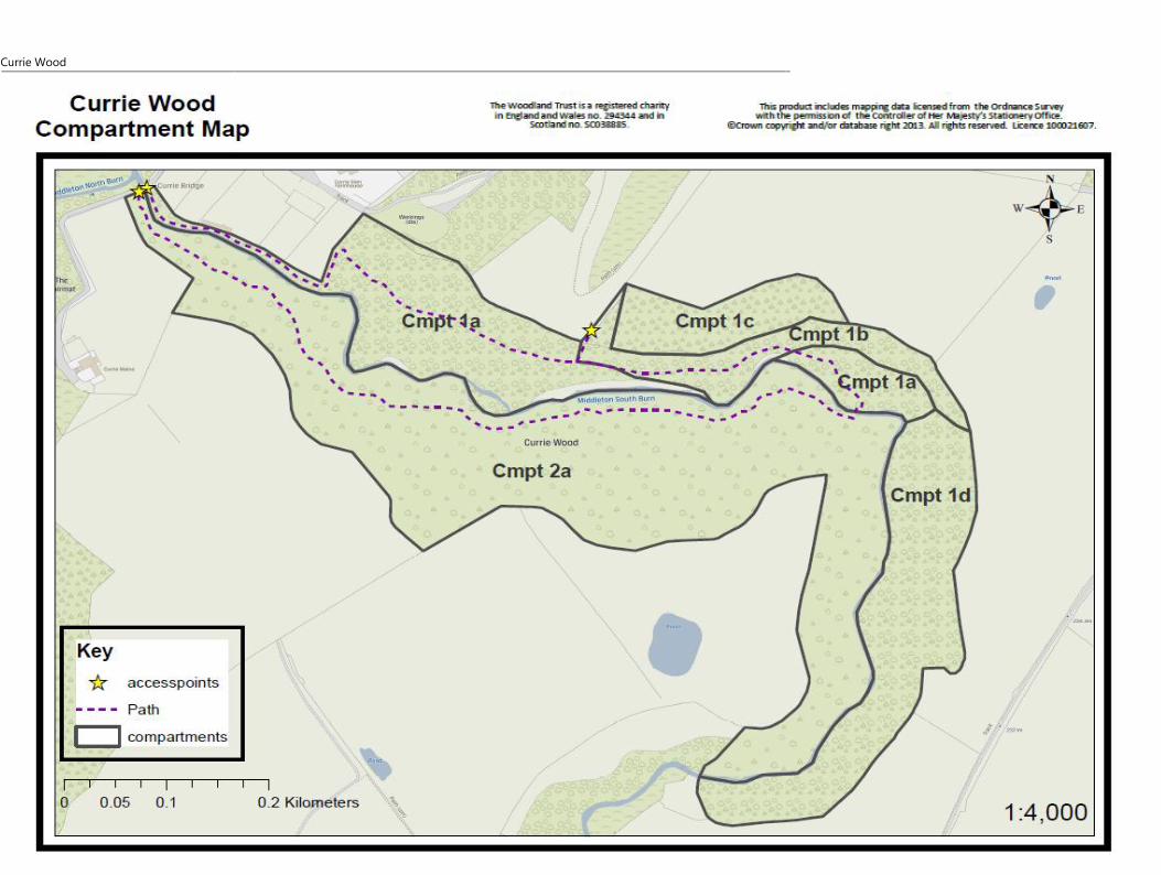
6.0 Compartment Map
PAWS assessment Map
18
19
Appendix 1: Compartment descriptions 20
Appendix 2: Harvesting operations (20 years) 23
Glossary 24
Currie Wood
3
THE WOODLAND TRUST
INTRODUCTION
PLAN REVIEW AND UPDATING
The Trust’s corporate aims and management
approach guide the management of all the
Trust’s properties, and are described on Page 4.
These determine basic management policies and
methods, which apply to all sites unless
specifically stated otherwise. Such policies
include free public access; keeping local people
informed of major proposed work; the retention
of old trees and dead wood; and a desire for
management to be as unobtrusive as possible.
The Trust also has available Policy Statements
covering a variety of woodland management
issues.
The Trust’s management plans are based on the
identification of Key Features for the site and
setting objectives for their management. A
monitoring programme (not included in this
plan) ensures that these objectives are met and
any necessary management works are carried
out.
Any legally confidential or sensitive species
information about this site is not included in this
version of the plan.
The information presented in this Management
plan is held in a database which is continuously
being amended and updated on our website.
Consequently this printed version may quickly
become out of date, particularly in relation to the
planned work programme and on-going
monitoring observations.
Please either consult The Woodland Trust
website www.woodlandtrust.org.uk or contact
the Woodland Trust
([email protected]) to confirm
details of the current management programme.
There is a formal review of this plan every 5 years
and a summary of monitoring results can be
obtained on request.
Currie Wood
4
WOODLAND MANAGEMENT APPROACH
The management of our woods is based on our charitable purposes, and is therefore focused on
improving woodland biodiversity and increasing peoples’ understanding and enjoyment of
woodland.
Our strategic aims are to:
• Protect native woods, trees and their wildlife for the future
• Work with others to create more native woodlands and places rich in trees
• Inspire everyone to enjoy and value woods and trees
All our sites have a management plan which is freely accessible via our website
www.woodlandtrust.org.uk. Our woods are managed to the UK Woodland Assurance Standard
(UKWAS) and are certified with the Forest Stewardship Council® (FSC®) under licence FSC-C009406
and through independent audit.
In addition to the guidelines below we have specific guidance and policies on issues of woodland
management which we review and update from time to time.
We recognise that all woods are different and that the management of our sites should also reflect
their local landscape and where appropriate support local projects and initiatives. Guidelines like
these provide a necessary overarching framework to guide the management of our sites but such
management also requires decisions based on local circumstances and our Site Manager’s intimate
knowledge of each site.
The following guidelines help to direct our woodland management:
1. Our woods are managed to maintain their intrinsic key features of value and to reflect those of the
surrounding landscape. We intervene when there is evidence that it is necessary to maintain or improve
biodiversity and to further the development of more resilient woods and landscapes.
2. We establish new native woodland using both natural regeneration and tree planting, but largely the
latter, particularly when there are opportunities for involving people.
3. We provide free public access to woods for quiet, informal recreation and our woods are managed to
make them accessible, welcoming and safe.
4. The long term vision for our non-native plantations on ancient woodland sites is to restore them to
predominantly native species composition and semi-natural structure, a vision that equally applies to
our secondary woods.
5. Existing semi-natural open-ground and freshwater habitats are restored and maintained wherever their
management can be sustained and new open ground habitats created where appropriate.
6. The heritage and cultural value of sites is taken into account in our management and, in particular, our
ancient trees are retained for as long as possible.
7. Woods can offer the potential to generate income both from the sustainable harvesting of wood
products and the delivery of other services. We will therefore consider the potential to generate income
from our estate to help support our aims.
8. We work with neighbours, local people, organisations and other stakeholders in developing the
management of our woods. We recognise the benefits of local community woodland ownership and
management. Where appropriate we allow our woods to be used to support local woodland,
conservation, education and access initiatives.

Currie Wood
5
9. We use and offer the estate where appropriate, for the purpose of demonstration, evidence gathering
and research associated with the conservation, recreational and sustainable management of woodlands.
In particular we will develop and maintain a network of long-term monitoring sites across the estate.
10 Any activities we undertake will conform to sustainable forest management principles, be appropriate for
the site and will be balanced with our primary objectives of enhancing the biodiversity and recreational
value of our woods and the wider landscapes.
Currie Wood
6
SUMMARY
This public management plan briefly describes the site, specifically mentions information on public
access, sets out the long term policy and lists the Key Features which drive management actions.
The Key Features are specific to this site – their significance is outlined together with their long (50
year+) and short (5 year) term objectives. The short term objectives are complemented by a
detailed Work Programme for the period of this management plan. Detailed compartment
descriptions are listed in the appendices which include any major management constraints and
designations. A short glossary of technical terms is at the end. The Key Features and general
woodland condition of this site are subject to a formal monitoring programme which is maintained
in a central database. A summary of monitoring results is available on request.
1.0 SITE DETAILS
Site name: Currie Wood
Location: Borthwick
Grid reference: NT374593, OS 1:50,000 Sheet No. 66
Area: 21.35 hectares (52.76 acres)
Designations: Conservation Area, Planted Ancient Woodland Site
2.0 SITE DESCRIPTION
2.1 Summary Description
Currie Wood is a hidden gem situated close to Edinburgh set in the steep gorge of Middleton South
Burn above Borthwick Castle. The site is over 21 hectares of mixed broadleaved and coniferous high
forest with the majority being classified as Plantation on an Ancient Woodland Site (PAWS). The
circular footpath travels through fantastic walks with impressive views of the burn below. The site
includes a large range of moss and plant species.
2.2 Extended Description
Currie Wood is located in Borthwick Glen, near the village of North Middleton, 3km south east of
Gorebridge in Midlothian. The dominant aspect is northerly, with lesser areas of south, east, and
west facing slopes. The site is situated within the steep-sided, sheltered valley of the Middleton
South Burn which runs through the wood in a northerly direction for about 500m and then in a
westerly direction for another 1000m. Parts of the wood are inaccessible with sheer cliffs and
gradients over 40 degrees in some places. The MLURI climate map of Scotland classifies the area as
fairly warm, moist lowland and foothill subject to moderate exposure and moderate winters.
Currie Wood
7
The solid geology of the site consists of sandstone from the Tournaisian and Visean Carboniferous
limestone series with impressive outcrops in the ravine of the burn. Underlying volcanic strata are
exposed on the burn bed further up the glen. Fluvoglacial deposits overlie the bedrock on higher
ground. This parent material gives rise predominantly to fertile brown earth forest soils with
occasional humus iron podsols and gleys. Soils on the site are generally damp with wet flushes and
small seasonal water flows are common on slopes of northerly aspect.
Extending to 21.35 hectares, the site is composed of mixed broadleaved and coniferous high forest.
The whole woodland area (except compartment 1c) is classified as Plantation on an Ancient
Woodland Site (PAWS) and part of the site also falls within the Borthwick & Crichton Conservation
Area for Midlothian Council Planning Department. Currie wood is bordered by extensive farmland to
the south and north of the site reflecting the typical open, rural landscape found locally.
A survey of ancient woodland features is carried out on a 5 year cycle previously completed in 2005,
2010, 2015 and 2020. The key remnant ancient woodland features that are present and which have
potential for protection & restoration are: (1) native ground flora suppressed (or absent) due to
shading by dense conifer; (2) native trees & shrubs (both mature and young) suppressed by dense
conifer; and (3) old walls and earthworks within the site.
The wood has a diverse structure, and although semi-natural elements are present, it has been
significantly modified by the planting of non-native species. There are native trees (birch, oak,
rowan, hazel, ash, alder, wild cherry, wych elm) of various ages, most notably mature oaks which
have grown as multi-stemmed following previous felling or coppicing (c.1955). There are also
plantings of mature and semi-mature beech and sycamore. In addition, there are significant areas of
non-native conifers (Norway & Sitka spruce, grand fir, Douglas fir, larch) planted in the 1960's. The
conifers are still very dense in places and have shaded out the ground flora. The under-storey
consists of mixed broadleaf regeneration, including ash, sycamore, and beech, and suppressed or
regenerating conifers. Sapling trees are abundant in many areas but established natural
regeneration is patchy. The brown hare and Roe deer populations could impact on the success of
natural regeneration on the site. However, at present, browsing and fraying is evident but only
occasional and not currently (2020) considered a threat.
Considering the dense canopy, abundance of non-native conifers and restricted vehicle access, a
gradual program of restoration through targeted thinning-to-recycle of conifers commenced in
2000. This restoration strategy included ring-barking for standing deadwood in 2004 and 2009. This
resulted in an abundance of deadwood remaining onsite as an essential habitat, particularly in
inaccessible areas.
The ground flora consists mainly of areas of woodrush, wood sorrel, blaeberry, broad-buckler fern,
heather and mosses, as well as bare ground under dense shade. The ground flora suggests a mosaic
of NVC (National Vegetation Classification) classes of W7 (damp alder/ash), W9 (dry
ash/hazel/rowan), W11 (grassy oak/birch oak) and W17 (mossy oak/birch).

Currie Wood
8
The Middleton South Burn forms a central feature of the wood. To the east, small glades either side
of the burn represent the only open ground on the site. In most areas, however, the margins of the
burn are densely shaded by non-native conifers. There are several rock outcrops along the course of
the burn, mainly on the northern and eastern sides, which tend to have the steepest slopes.
A survey in 1999 identified a total of 105 vascular plant species and 53 bryophyte species, many of
which are indicators of ancient woodland. The more open areas of the wood were found to have
richer flora, including some relatively uncommon species such as moschatel, greater pond-sedge,
marsh hawksbeard, wood horsetail, wood cranesbill, and oak fern. Additional flora species out with
the 105 listed are known to be present on site including ancient woodland indicator species such as
sanicle. The wood was evaluated as being of local and regional significance for conservation interest.
The site is also inhabited by badger, fox, roe deer and brown hare. Herons and buzzards are known
for passing through and a significant resident rook population has also been reported. Additionally,
according to the NBN atlas there have been 9 different types of slug (including the leopard and the
tree slug) and 9 different types of snail (including the white-lipped and Garlic snail) recorded on site
(2003 & 2007). There is currently (2020) no survey information on birds or other invertebrates found
in the wood.
There are few records of the history of the wood prior to management by the Forestry Commission
in the 1960's. The site is listed on the SNH Ancient Woodland Inventory as Long Established
Woodland of Semi-Natural Origin (LEPO) (2a). This indicates that it appears on the 1st Edition
Ordnance Survey maps of 1860 but not as woodland on the Roy maps of 1750. A description of the
woodland in the New Statistical Account for Midlothian from 1845 refers to 'some remarkable oak
roots' being assumed to be the remains of a forest 'of great antiquity, which has frequently been cut
down'. This suggests a long history of management as an oak wood at least as far back as the 18th
century. The ground flora composition also suggests continuity of woodland cover over a very long
period. The same document makes mention of a quarry on the site, and speculates that the stone
for Borthwick Castle came from this source. Within both the south and the west of the wood are
areas of disturbed ground with humps and hollows that may be indicative of past human activity.
These linear gullies could possibly be part of old extraction routes for coppice, timber and quarry
produce-which could date back to when or before Borthwick Castle was built in1430.There are also
internal and external boundary drystone dykes and access tracks.
The site was acquired by the Woodland Trust in 1989. Since then extensive path works have defined
the circular route (over 2km) that covers approximately two-thirds of the wood. These works have
included construction of a timber bridge some 900m from the woodland entrance as well as
multiple sections over wetter sections of path south of the burn. However, some sections are
seasonally muddy even with improvements to drainage. Access off the footpath network is difficult
due to the steep and often wet nature of the ground. The south eastern arm of the wood, in
particular, is not easily accessible and subsequently no footpaths have been installed in this area.
Currie Wood
9
Due to the steep terrain, management access to and within the wood is restricted. There are no
vehicular tracks within the wood, and the minor road is unsuitable for timber lorries.
The site is classified as WT Access Category C - Low Usage (5-15 people using one entrance per
day). The path is used daily by a small number of mainly local users who highly value the peaceful
secluded setting and regularly provide feedback to the Trust. It also receives very favourable
comments from geocachers who visit the site looking for the geocaches hidden here. The path route
provides great variety with botanical, geological, and landscape interest. The wood also lies adjacent
to several rights of way and tracks that form a local network, although few of them pass through
woodland. There is no car park on site but there is space for 3 or 4 cars at the entrance to the
adjacent Borthwick Campsite, by permission of Midlothian Council.
3.0 PUBLIC ACCESS INFORMATION
3.1 Getting there
Currie Wood is located in Borthwick Glen, near the village of North Middleton, 3km south east of
Gorebridge in Midlothian. The wood is situated within the steep-sided, sheltered valley of the
Middleton South Burn. The wood has two entrances, which are adjacent to each other either side of
a bridge which carries a road across the burn to Currie Mains.
By car, from the A7 take the minor road through North Middleton, 2km (1.5 miles) south of
Gorebridge. Follow the road through the villages of North Middleton and Borthwick, and after
crossing the Gore Water take the first minor road on your right (2km, 1.5 miles). Take the 2nd turn
on the right after 0.5km (0.3 miles) and parking for 3 cars is available at the entrance to the Scout
Camp (subject to use by the Scouts).
The nearest access point by bus is to North Middleton, on the regular service between Edinburgh
and Galasheils. From North Middleton, the walk is along minor roads (no footway) as described
above (2.5km, 1.5 miles).
The nearest train station is located at Gorebridge (located 2.6 miles away).
3.2 Access / Walks

Currie Wood
10
The woodland is accessed by the public at its west end where the unclassified public road (U87) to
Currie Mains crosses the burn.
There is a circular path of 2km that passes through a variety of woodland types, with mixed woodland
of broadleaves and conifers, and provides interesting views into the gorge of the Middleton South
Burn and of the sandstone cliffs along its north side. The path is mainly un-surfaced but wetter areas
have been crossed by sections of boardwalk with steps at intervals. The unsurfaced path is often
narrow, sometimes steep and in the shady south side of the gorge becomes muddy in winter. Due to
the steep and winding nature of some of the route a reasonable level of mobility is required. The burn
is crossed by a footbridge. The south eastern leg of the wood has no formal paths and is not easily
accessible.
The wood lies adjacent to several rights of way and tracks that form a local network between
Borthwick and local farms, although none of them link directly into the woodland paths.
The nearest public toilets (with disabled access) are at Hunterfield Road (B704) Gorebridge (3miles
away approximately a 12 minute drive).
The steep terrain makes access unsuitable for any management or emergency vehicles to move
internally across the majority of the site.
Currie Wood
11
4.0 LONG TERM POLICY
WOODLAND RESTORATION
The long term vision is to gradually restore the natural diversity of this ancient woodland site as far
as possible.
Throughout the woodland there will be a healthy & diverse ground flora characteristic of native
broadleaved woodland (NVC classes W7, W9, W11, & W17 as appropriate). The tree canopy will be
almost entirely broadleaved, with a high proportion of native species. Additionally, some large
mature conifers may be retained to the end of their natural lifespan providing biodiversity and
landscape interest. Timber and brash from thinning will be left in situ as deadwood habitat.
The objective will be to secure the ancient woodland components. Achieving this, will require a
gradual increase in light levels where ground flora is suppressed by heavy shade. This will be
achieved by gradually reducing shade and competition around native trees (especially mature oaks)
to encourage growth and seed production. Along with light selective thinning as required, halo-
thinning around relic native trees will also be utilized. Selective thinning will focus initially on the
conifers such as Sitka spruce, Norway spruce, Grand fir and Douglas fir. These species will be
thinned-to-recycle leaving essential deadwood on site where practical and appropriate. Thinning will
take place initially on a 5-year cycle, with assessment carried out before each operation as to the
timing, location and required intensity.
Natural regeneration is expected to continue to fill any gaps in the canopy and has been successfully
establishing to date. If the hare and deer populations are considered to be preventing future
regeneration and options such as protection of regeneration, planting, and/or control will need to
be considered as circumstances dictate. Any measures introduced must be practical considering the
site terrain.
PUBLIC ACCESS
The path network will be managed to provide quiet informal recreation. Improvements to the
condition of paths in severely muddy areas will be made as needed. These will take the form of
improvements in drainage and/or additional boardwalk or stone pitched sections. It is not
anticipated that public use will increase significantly above current levels.
The woodland restoration works have already made the woodland walk lighter, more diverse and
floristically interesting. The steep eastern area of the woodland will not be developed for formal
public access due to the steep terrain, but also to provide a less-disturbed refuge for wildlife.
Currie Wood
12
5.0 KEY FEATURES
The Key Features of the site are identified and described below. They encapsulate what is important
about the site. The short and long-term objectives are stated and any management necessary to
maintain and improve the Key Feature.
5.1 Planted Ancient Woodland Site
Description
The whole site (except 1c) is classified as a Plantation on an Ancient Woodland Site (PAWS).
Although compartment 1c is not PAWS it forms a valuable area for ground flora expansion and will
be treated using the same management principles.
The wood has a diverse structure, as native woodland of oak/birch, and ash/elm types is clearly
identifiable and notable old oak coppice stools are present throughout the site. Where deciduous
trees are thriving on site there is a mix of species including hazel, holly, rowan and common alder.
There are also plantings of mature and semi-mature beech and sycamore. Although semi-natural
elements are present, it has been significantly modified by the planting of non-native species. There
are significant areas of non-native conifers (Norway and Sitka spruce, grand fir, Douglas fir, larch) as
well as Scot's pine planted in the 1960's. The latter are very dense in places and have in many areas
eliminated the ground flora.
The ground flora consists mainly of areas dominated by woodrush, wood sorrel, heather and
blaeberry, broad-buckler fern and mosses, wet flushes of grasses, rushes and sedges as well as bare
ground in dense shade. The ground flora suggests a mosaic of NVC classes of W7 (damp alder/ash),
W9 (dry ash/hazel/rowan), W11 (grassy oak/birch oak) and W17 (mossy oak/birch) depending on
conditions.
Open ground at Currie is currently concentrated around the Middleton South burn that cuts
through the center of the woodland and totals approximately 1.1ha equivalent to just over 5% of
the total site.
A PAWS survey (as per WT PAWS Practice Guide) is carried out on a 5-year cycle in line with the
management plan review. This assessment allows for the analysis of the site’s current condition and
informs future management practices in response to the findings. The PAWS assessment conducted
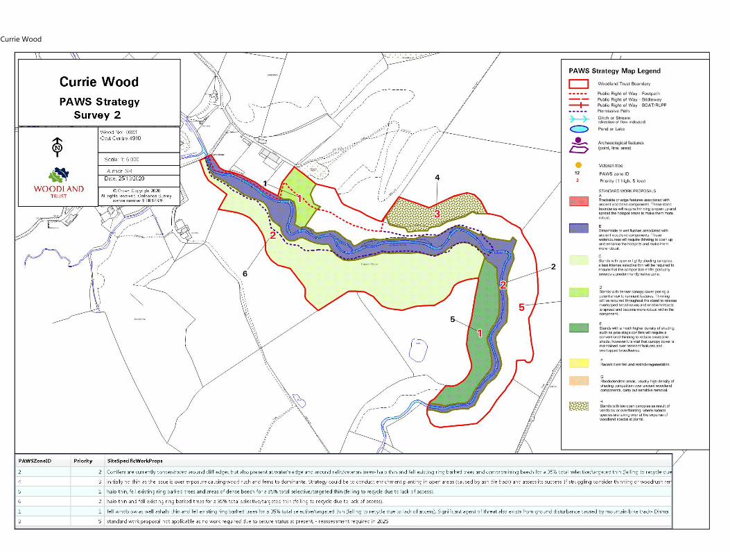
has been carried out at Currie in 2005, 2010, 2015 & 2020. The most recent assessment identified:
- Woodland specialist ground flora in critical condition under dense conifers, threatened under
scattered conifers and dense beech and secure under native broadleaves.
- Occasional mature native trees in most areas, many now critically impacted by shading from
plantation conifers
- Occasional young native trees & shrubs threatened by suppression from the faster growing
Currie Wood
13
plantation conifers
- Abundant standing and fallen deadwood following thinning-to-recycle and ringbarking of conifers
in 2004 & 2009
- Drystone dykes (internal & boundary) and evidence of earthworks with the latter now threatened
by the unauthorized construction of a mountain bike track in compartment 1a during the 2020
Covid19 lockdown.
Following the assessment (2020) the woodland has been divided into 6 zones- The condition of
each zone has been determined as secure, threatened or critical and allocated with specific
management strategies. These approaches are designed to protect and support the present ancient
woodland features within these zones and promote restoration suitable for its current composition.
Zone 1 is located in compartment 1a north of the Middleton South Burn. This area is particularly
suffering from high conifer densities that are suppressing the growth of relic veteran oaks and other
mature and developing native trees. Furthermore, the ground flora and archaeological earthworks in
this area has been significantly impacted by the constructed of the unauthorized mountain bike
track. Consequently, this area is currently considered to be in critical condition.
Zone 2 covers the riparian area of land approximately 20m either side of the burn and rocky-
outcrops above. The habitat here benefits from flora varieties due in part to damp soils. However,
this is currently affected by significant shade due to high densities of non-native conifers
(particularly Douglas fir) in some areas. The shading cast here is less dominant than in zone 1 but
continues to impact on relic broadleaves and regeneration of native species. This area is considered
to be in threatened condition.
Zone 3 covers the remaining area of compartment 1a, most of compartment 1b as well as the whole
of compartment 1d. This zone actually has a high diversity of native broadleaves with some age
complexity and minimal presence of non-native conifers. Regeneration is occurring slowly over this
zone as more trees develop towards the age of generating seed. Although some coarse vegetation
is present (woodrush, bramble and bracken) it remains infrequent and is not undermining the
diverse woodland specialist flora are spread across this area. This zone is considered to be in secure
condition in its current state.
Zone 4 covers the whole of compartment 1c which is dominated by Larch and ferns. Additionally a
small section of 1b is covered within this zone due to dominance by woodrush and impact of Ash
Die Back on the dominant broadleaf species here. In this zone the threat is actually over exposure to
light that has allowed for a monopoly of coarse vegetation impacting on ground flora diversity as
well as native tree regeneration. This area is considered to be in threatened condition.
Zone 5 covers the eastern area of compartment 2a and suffers from heavy shading from a mature
stand of predominately Sitka spruce and areas of dense beech restricting natural regeneration and
ground flora. The terrain includes very steep slopes and the beech border on the south boundary
Currie Wood
14
ride-side with the agricultural field. This area is considered to be in critical condition as native trees
and flora are particularly absent through the majority of this zone. This zone is considered to be
critical at this stage.
Zone 6 stretches across the majority of compartment 2a which includes damp ground and gentler
north facing slopes. Overall, there is a more diverse and open canopy that allows for richer
vegetation here than the majority of the site. However, the presence of conifers is impacting on
regeneration of native species here. This area is considers to be in threatened condition.
See supporting PAWS map on page 19 for illustrated areas of the zones and proposed strategy. The
zones have then been prioritized depending on their current condition and corresponding need for
intervention has been detailed in the short-term management objectives where appropriate.
Significance
Currie Wood is a Plantation on an Ancient Woodland Site (PAWS) and is listed in the SNH Ancient
Woodland Inventory. It lies within a local group of isolated ancient woodland blocks and contains
remnant ancient woodland features which are capable of protection and restoration. This meets the
Trusts corporate objectives of protecting ancient woodlands and improving woodland biodiversity.
The Woodland Trust Scotland is committed to restoring all non-native conifer PAWS type woodland
to Restored Ancient Woodland Site (RAWS) in its ownership and to ensure the continuing survival,
and where possible, enhancement of the ancient woodland components. Currie wood is generally
well sheltered, hence there is a real opportunity to carry out attentive adjustments to light levels
under very favourable PAWS restoration conditions which are not often available elsewhere on
many PAWS sites in Scotland due to exposure & waterlogged soils.
Currie Wood also serves as an important wildlife refuge as it is mostly surrounded by fields and the
woodland also provides an essential corridor for wildlife to travel to other forested parts of the local
area. Furthermore, the site supports Local Biodiversity Action Plan (LBAP) & Forest Habitat Network
initiatives in the region.
Opportunities & Constraints
Opportunities:
To protect and restore remnant ancient woodland features and continue to move the ancient
woodland features from threatened to secure through a program of targeted and phased
operations designed to conserve and enhance the remnant ancient woodland features and extend
existing hotspots of flora. Where the remnant features are secure, operations can be targeted at
Currie Wood
15
long-term improvements to gradually transform the woodland to one that is predominantly of
native species.
The percentage of open space on site could expand beyond the current (2020) 5% due to the
thinning works informed by the PAWS assessment.
Constraints:
Access for timber extraction is restricted or absent throughout the wood. Low impact timber
extraction methods will be considered. Such as horse logging to minimize risk of compaction
damage and limit damage to forest soils and ancient woodland specialist plant communities.
Browsing by hare and deer may limit natural regeneration, and the terrain makes control difficult as
fencing may not be suitable in some areas and poaching on site may be impractical.
Factors Causing Change
Although current levels are low, browsing damage may limit the success of natural regeneration and
have an impact on ground flora composition.
Decline of old broadleaved trees will limit seed production, but halo thinning may help to reverse
this.
Stressed oaks are prone to windblow - therefore halo thinning will be gradual.
Continued growth of conifers increases shade, but strategy for targeted thinning should gradually
improve light levels as the woodland is restructured during this plan period.
Ash Die Back (ADB) is now widespread across Scotland and is currently affecting ash on site which
could naturally open up areas of the canopy.
Phytophthera ramorum has been recorded in West Lothian and if this disease were to spread to
Midlothian and Currie this would require clear felling of Larch in the woodland. This would be
particularly significant for compartment 1c where this is the dominant species.
Bike trail created without permission during covid19 lock down disturbed soils and compacted
ground creating more paths and impacting ground flora in these areas.
Previously ring barked trees now require attention- the process has failed as the ring barked area
has healed but created a weak point lower in the tree structure therefore those next to paths require
removal.
Future thinning works and safety felling will result in a significant increase of deadwood onsite. Care

Currie Wood
16
must be taken to ensure areas of sensitive habitats/flora are not damaged or shaded during or
following these works.
Long term Objective (50 years+)
To increase, enhance and perpetuate the ancient woodland composition by gradually restoring the
ancient woodland characteristics of the woodland.
The tree composition will be predominantly native species and the ground flora typical of the NVC
types found on site. The objective, to establish a secure, healthy & diverse ground flora
characteristic of broadleaved native woodland (NVC W7, W9, W11, & W17 as appropriate). The tree
canopy will be almost entirely broadleaved, with a high proportion of native species.
The canopy may be punctuated with occasional mature non-native trees and there will be frequent
standing and fallen deadwood.
Short term management Objectives for the plan period (5 years)
These targets make reference to the Woodland Trust PAWS assessment method.
1) Preserve and restore woodland specialist flora focusing on threatened areas:
a) Zone 2- assess in spring/early summer to accurately capture floral diversity in the riparian
zone and identify hotspots as well as specific areas in need of thinning (2021)
b) Zone 1- Avoid over exposure or scorching through a gradual increase light levels by
targeted, light, selective thinning-to-recycle of conifers (2021-2022)
i) Ensure no decrease in security of ground flora from shading by brash from operations-
spread brash thinly, and avoiding leaving timber stacked on patches of healthy
flora
c) Zone 4 – consider removal of woodrush in trail plots to allow for natural flora response
and possible diversity (2023)
2) Retain frequent density of deadwood on site
a) further thinning will result in additional deadwood for the site (2021-2025)
b) in areas with abundant or dominant deadwood and further thinning required consider
horse logging as a possible extraction method to avoid excessive ground coverage (2021-
2025)
3) Support and encourage the growth & development of relic native trees
a) Halo thinning of conifers around native trees- particular focus on relic individuals
i) Zone 1- currently critical zone. Subject to a selective thin of non-native conifers
surrounding veteran trees up to a maximum 35% of these individuals (2021-2022)
ii) Zone 2 and 6- currently threatened zone. Subject to selective thin of Douglas firs
shading native species with up to a maximum of 35% total thin of these individuals

Currie Wood
17
(2022-2023)
b) Zone 5- currently critical zone. Subject to up to total 35% targeted thin for the conifers
throughout the zone focused on Sitka spruce, Douglas fir and dense beech shaded areas
(2021-2022)
i) Brash conifers up to chest height throughout this zone prior to thinning works to allow
for appropriate access (2021)
c) Percentage thins to include the removal of ring barked trees across the site:
i) Prioritise those by paths for health and safety (2020-2021)
ii) by relic/native species (2021-2023)
iii) watercourses and remaining conifer dominant areas (2022-2025)
4) Enable native tree regeneration
a) Remove non-native saplings with volunteers where appropriate/safe to do so (2021-2025)
b) Consider enrichment planting in zone 4 (the majority of which is not ancient woodland)
currently suffering from minimal diversity dominated by woodrush, ferns, larch and
declining ash (2023-2025)
5) Protect archaeological features
a) dismantle unauthorised mountain bike track including jumps in compartment 1a (2020)
b) check for signs of continued mountain bike use by staff, Estate Maintenance Contractor
(EMC) and volunteers (2020-2025)
c) arranged for further dismantling of any other unauthorised structures (as required)
6) Revise PAWS assessment every five years to ensure the retention of ancient woodland
specialist species, precursor trees, deadwood, and other remnant ancient woodland features
remain intact, and where possible are enhanced during the restoration process (2025)
a) Consider if works over the planning period have enabled any of the critical zones (1 and
5) or the threatened zones (2, 4 and 6) to be reclassified as recovering, declining or
showing no change
b) Critically assess if zone 3 remains secure or requires intervention
Currie Wood
18
5.2 Connecting People with woods & trees
Description
Currie Wood is located in Borthwick Glen (population estimated at just under 3,000), near the village
of North Middleton, 3km south east of Gorebridge (population of approx. 6,500) in Midlothian. The
closest school is Moorfoot Primary located less than 2 miles from the site and it takes under 5
minutes to walk from the woodland to the Borthwick Castle. There is no car park on site but there is
space for 3 at the entrance to the adjacent Borthwick Campsite, by permission of Midlothian
Council.
Although it is a low-use site, Currie Wood is a treasured place used by the local community as a
peaceful walking destination. Typically, users are in pairs or walking the dog and previously the site
has been used for geocaching. Due to the narrow paths it is not suitable for large groups or
pushchairs. The path route provides great variety with botanical, geological, and landscape interest.
Entrance to the site is accessed by the public at its west end where the unclassified public road (U87)
to Currie Mains crosses the Middleton burn. There are two entrances here approximately 10m apart
which allow visitors to start the circular route either from the north or south side of the Middleton
South Burn, crossing via a timber footbridge at the mid-point of the walk. The 2022m of footpath
covers about two-thirds of the wood passing through a variety of woodland types and affords good
views into the ravine of the burn. The majority of the northern side of the path is steep and winding
and requires a reasonable level of mobility. There are no footpaths passing through the southern
arm of the wood as the steep and rough terrain is not easily accessible.
The wood lies adjacent to several rights of way and tracks that form a local network, although few of
them pass through woodland. The path is now linked with the Borthwick-Crichton Right Of Way
(ROW) with a Scotways sign marking the route. Crichton circular walk from Vogrie via Crichton,
Borthwick and Gorebridge is an 8 mile circular route that include compartment 1a of Currie Wood.
The internal footpaths of Currie Wood are mainly un-surfaced and previous works have involved
the installation of numerous sections of boardwalk built in 2006, and stone pitched sections laid in
2010. However, some sections remain seasonally muddy. Large sections of the footpath to the north
of the burn include edging which now needs replacing. The site has previously benefitted from
volunteer groups conducting path upgrades such as these, and there is opportunity to develop this
further with the creation of a local Woodland Working Group.
Cyclists and mountain bikers have been known to use the site with more intense use by the latter
recently as an unauthorized mountain bike track was developed in early 2020. Previously there have
also been issues with fires on site (2017). There is currently one Volunteer Woodland Warden that
covers the site, conducting regular patrols and providing reports of any issues in the area.
Currie Wood
19
As Currie wood is located immediately south of the Borthwick Scout Campsite it allows for direct use
by this group and their activities. There is an opportunity to directly link up with this group for
annual sessions about responsible use of the woods and potential practical volunteer work.
Significance
The path is used daily by a small number of mainly local users who highly value the peaceful
secluded setting and regularly provide feedback to the Trust. The site is classified as WT Access
Category C - Low Usage (5-15 people using one entrance per day).
The path route provides great variety with botanical, geological, and landscape interest. The wood
lies adjacent to several rights of way and tracks that form a local network, although few of them
pass through woodland.
Its management supports the Trust's corporate objective of increasing people's understanding &
enjoyment of woodlands.
Opportunities & Constraints
Opportunities
Upgrade entrance signage to bring it in line with other central Scotland sites and current branding
Engaged local community showing support and interest in contributing ideas and time through
volunteering- Opportunity for Woodland Working Group (WWG) to be set up and run regularly to
help maintain the site.
Engage with local Scout group through annual contact to foster a sense of ownership and
responsibility between local people and this woodland.
Create a new volunteer Warden post focused on ecological recording - providing better
understanding of the wildlife present in the wood year-round and help to inform management
practices.
Constraints
Steep wet ground and narrow paths makes this site unsuitable for those with poor mobility or prams
Minimal parking near site, lack of emergency vehicle access and narrow paths limits potential for
events
Limited access to get machinery or material on site impacts on ability and cost for footpath and
infrastructure work
Currie Wood
20
Factors Causing Change
Increased use by mountain bikes has caused various desire-lines to appear making path routes
confusing for visitors as well as unsafe in areas if walkers and cyclists are using the same narrow
areas.
A lot of the built infrastructure was installed at the same time and will require repairs and renewals
within this management plan.
Some areas of the path are poorly drained throughout the year encouraging visitors to travel
through the undergrowth to avoid muddy areas. This is causing paths to widen and is impacting on
surrounding vegetation.
Long term Objective (50 years+)
There will be a safe, welcoming and well-maintained access to allow local people and visitors to
enjoy the variety of woodland types, and will link into external paths where practical.
Improvements to the condition of paths in severely muddy areas will be made as needed to provide
a well-drained route for mainly local users.
The steep eastern area of the woodland will not be developed for formal public access due to the
steep terrain, but also to provide a less-disturbed refuge for wildlife.
The paths will be free from encroaching vegetation and obstructions appreciated by the local
community for its rich natural surroundings and tranquil setting.
Short term management Objectives for the plan period (5 years)
During this plan period, the short term objective is to continue to provide public access at Currie
wood which is safe and welcoming. This will be achieved by:
1) Managing access to Woodland Trust Access Category C standard:
a) Incorporate Currie within Estate Maintenance Contract (EMC) remit for maintenance works
including:
i) Burn clearance to remove rubbish and large items of debris to prevent flooding (as
required)
ii) Annual vegetation cut backs from path to allow for access (2021-2025)
a) Strim/scrape vegetation from boardwalk twice a year (2021-2025)
iii) Dismantle any unauthorized bike track to ensure visitor safety and monitor the site for
any new tracks (as required)
2) Footpath repairs
Currie Wood
21
a) Footpath audit required to fully assess paths and to inform strategy for repair works
required (2020/2021)
b) Improve condition of path in severely muddy areas by improvements in drainage
(2022-2025)
c) Replace edging and steps as required with volunteers (2022-2025)
3) Renewal of built structures
a) Replace fencing and welcome signage at the two entrances to the west of the site
(2021)
b) Renew way markers across the site (2021-2022)
c) Replace footbridge (2021-2022)
d) Maintain and repair boardwalks (as required)
4) Developing community engagement and volunteering opportunities by:
a) Engagement with scout group annually (2021-2025)
b) Create a woodland working group to harness local engagement and help to maintain the
paths and maintenance (2021-2025)
c) Recruit Woodland Warden focused on ecological recording for the site (2021)
Currie Wood
Currie Wood
23
Currie Wood
Cpt
No.
Area
(ha)
Main
Species
Year
Designations
1a 3.81 Mixed
conifers
1963 PAWS
restoration
Gullies/Deep
Valleys/Uneven/Rocky
ground, No/poor
vehicular access within
the site, Very steep
slope/cliff/quarry/mine
shafts/sink holes etc
Informal
Public
Access
Conservation
Area, Planted
Ancient
Woodland Site
Split into two sections with the majority located at the west of the site and a smaller section located
to the east of 1b. Overall the sub-compartment is mixed high forest with a variable species mix
throughout, from pure conifer to pure broadleaf groups and intimate mixtures. Conifers occupy
c.50% of the canopy with a high proportion of Douglas and Grand fir casting shade over the areas
they dominate. Stands of grand fir and Norway spruce occupy much of the western end of the sub-
compartment. Within these areas are a number of mature oaks, in many cases suppressed by the
dominant conifers. Thinning work in 2004 and 2008-2014 has helped to improve light conditions
while maintaining woodland cover. There are also areas of silver birch with rowan, hazel and
hawthorn. Individuals and groups of grand fir and Norway spruce are common on the lower valley
slopes and on the flatter benches along the valley floor. Scots pine, Douglas fir and larch are found in
mixture with older broadleaves on upper slopes. Beech is also present as a few mature individuals
and widespread saplings. Regeneration in the understorey is patchy and includes young trees and
recent seedlings of firs and broadleaves. The ground flora varies from acid loving heather & blaeberry
dominated areas, woodrush and buckler fern areas, to bare ground, depending on shading
conditions. There is abundant deadwood from thinning to waste and standing deadwood from
ringbarked conifers. The majority of rocky outcrops are located within this compartment.
1b 1.38 other oak
spp
1900 PAWS
restoration
Gullies/Deep
Valleys/Uneven/Rocky
ground, No/poor
vehicular access within
the site, Very steep
slope/cliff/quarry/mine
shafts/sink holes etc
Informal
Public
Access
Conservation
Area, Planted
Ancient
Woodland Site
Former oak coppice, unmanaged for many years, with regenerated mixed broadleaves, including ash
and birch, with some sycamore, beech, hazel and rowan. Conifers, mainly larch but with a small
proportion of spruce, are mainly confined to the edge of the boundary with compartment 1c and to
the area between the path and the burn. There is an understorey of mainly birch saplings, but no
recent regeneration. Ash dieback (Chalara) is evident within this compartment allowing the canopy to
gradually open overtime. The ground flora is typical of the W11d oak/downy birch woodland type,
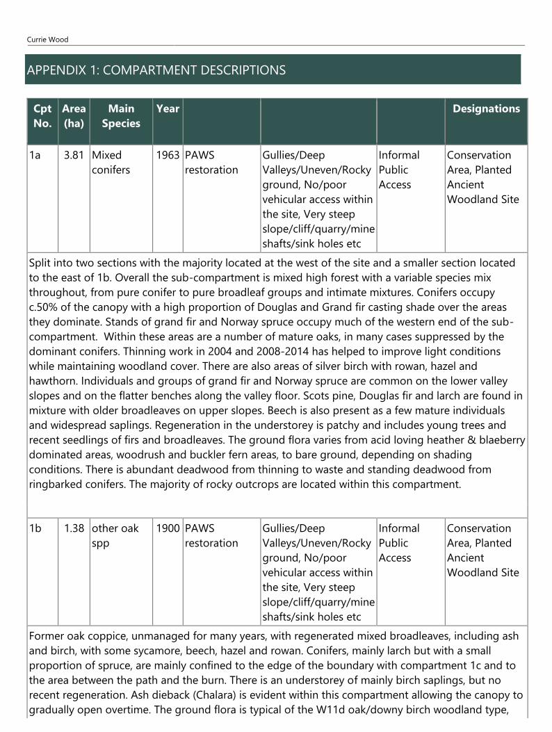
APPENDIX 1: COMPARTMENT DESCRIPTIONS
Currie Wood
25
with large patches of greater woodrush on damper slopes, as well as wavy-hair grass. There is
frequent conifer deadwood.
1c 1.18 Hybrid
larch
1963 PAWS
restoration
Management factors
(eg grazing etc),
No/poor vehicular
access within the site,
Sensitive
habitats/species on or
adjacent to site
Informal
Public
Access
Conservation
Area
Located on the northern boundary of the site, this is a plantation of pure larch, planted in 1963. A 1 in
4 thinning of the canopy was carried out in 2004, with some additional felling in 2009. This has
resulted in good levels of deadwood and light conditions have improved. The ground flora includes
abundant wood sorrel, foxglove, dog's violet, wood avens and ferns. This is the only compartment
that does not include the Middleton South burn. There are also no managed footpaths in this
compartment.
1d 3.61 Mixed
conifers
1900 PAWS
restoration
Gullies/Deep
Valleys/Uneven/Rocky
ground, No/poor
vehicular access within
the site, Very steep
slope/cliff/quarry/mine
shafts/sink holes etc
Informal
Public
Access
Conservation
Area, Planted
Ancient
Woodland Site
Mixed high forest varying in structure from pure conifer to groups of broadleaves and intimate
mixtures. Conifers occupy 40% of the canopy. Common species include oak, larch, Norway spruce,
silver birch, ash, sycamore and Douglas fir. Mature native species are found throughout this
compartment particularly focused along the filed boundary. There are quite frequent broadleaf
saplings, mainly ash. The ground flora is characterised largely by wood sorrel, broad-buckler fern,
woodrush and mosses. Much of the area occupied by dense-shading conifers is very steep with rocky
outcrops and is therefore difficult to access for management purposes. Two steep gullies, both
previously used as middens by the adjacent farm, run from the boundary fence in the south-east to
the burn. There are no footpaths in this compartment due to the steep terrain.
2a 11.41 Mixed
broadleaves
1960 PAWS
restoration
Gullies/Deep
Valleys/Uneven/Rocky
ground, No/poor
vehicular access within
the site, Very steep
Informal
Public
Access
Conservation
Area, Planted
Ancient
Woodland Site
Currie Wood
26
slope/cliff/quarry/mine
shafts/sink holes etc,
Sensitive
habitats/species on or
adjacent to site
Mixed high forest with varied structure ranging from pure groups of conifers and broadleaves to
intimate mixtures of both. Conifers (Norway & Sitka spruce, larch, Douglas fir & occasional Scots
pine) comprise 35% of the canopy, with non-native broadleaves (sycamore and beech) accounting for
a further 25% of the area. Native species make up the remaining 40% of the area and include silver
birch, oak, ash, alder and rowan. Many of the mature broadleaves, mainly oak, have been heavily
shaded by conifers - with halo thinning and ring-barking to improve light levels (2009). The generally
sparse understorey is composed of conifers, elder, birch, sycamore, wych elm, ash, and hawthorn.
Most regeneration is at sapling stage, particularly in the western section. To the south of the
compartment there is a dominance of sycamore and ash (approximately 40 years as of 2020).
Sycamore becoming dominant in this area and potential need for thinning to be considered in the
long-term to allow for regeneration as well as diversity. The ground flora varies depending on
shading, from bare patches under dense conifers to a rich flora of bugle, opposite-leaved golden
saxifrage, wood sorrel, primrose, and rushes and sedges in wetter gullies. The shallow and unstable
soils mean that windblow of conifers and broadleaves is a regular occurrence and can occasionally
block the path. The wet ground in this compartment has resulted in a number of boardwalk sections
being installed on the southern part of the circular path and drainage remains a problem here.
Landslides have also occurred leading to re-routing/reconstruction of the path.
Currie Wood
27
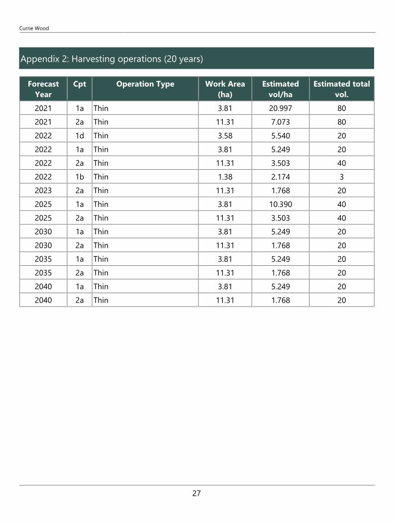
Appendix 2: Harvesting operations (20 years)
Forecast
Year
Cpt Operation Type Work Area
(ha)
Estimated
vol/ha
Estimated total
vol.
2021 1a Thin 3.81 20.997 80
2021 2a Thin 11.31 7.073 80
2022 1d Thin 3.58 5.540 20
2022 1a Thin 3.81 5.249 20
2022 2a Thin 11.31 3.503 40
2022 1b Thin 1.38 2.174 3
2023 2a Thin 11.31 1.768 20
2025 1a Thin 3.81 10.390 40
2025 2a Thin 11.31 3.503 40
2030 1a Thin 3.81 5.249 20
2030 2a Thin 11.31 1.768 20
2035 1a Thin 3.81 5.249 20
2035 2a Thin 11.31 1.768 20
2040 1a Thin 3.81 5.249 20
2040 2a Thin 11.31 1.768 20
Currie Wood
28
GLOSSARY
Ancient Woodland
Ancient woods are defined as those where there has been continuous woodland cover since at least 1600 AD. In Scotland ancient woods are defined strictly as sites shown as semi-natural woodland on the ‘Roy’ maps (a military survey carried out in 1750 AD, which is the best source of historical map evidence) and as woodland all subsequent maps. However, they have been combined with long-established woods of semi-natural origin (originating from between 1750 and 1860) into a single category of Ancient Semi-Natural Woodland to take account of uncertainties in their identification. Ancient woods include Ancient Semi-Natural Woodland and plantations on Ancient Woodland Sites (see below). May support many species that are only found in ancient woodland.
Ancient Semi - Natural Woodland
Stands in ancient woods defined as those consisting predominantly of native trees and shrubs that have not obviously been planted, which have arisen from natural regeneration or coppice regrowth.
Ancient Woodland Site
Stands in ancient woods that have been converted to plantations, of coniferous, broadleaved or mixed species, usually for timber production, including plantations of native species planted so closely together that any semi-natural elements of the understorey have been suppressed.
Beating Up
Replacing any newly planted trees that have died in the first few years after planting.
Broadleaf
A tree having broad leaves (such as oak) rather than needles found on conifers (such as Scots pine).
Canopy
The uppermost layer of vegetation in a woodland, or the upper foliage and branches of an individual tree.
Clearfell
Felling of all trees within a defined area.
Compartment
Permanent management division of a woodland, usually defined on site by permanent features such as roads. See Sub-compartments.
Conifer
A tree having needles, rather than broadleaves, and typically bearing cones.
Continuous Cover forestry
Currie Wood
29
A term used for managing woods to ensure that there are groups or individual trees of different ages scattered over the whole wood and that some mature tree cover is always maintained. Management is by repeated thinning and no large areas are ever completely felled all at once.
Coppice
Trees which are cut back to ground levels at regular intervals (3-25 years).
Exotic (non-native) Species
Species originating from other countries (or other parts of the UK) that have been introduced by humans, deliberately or accidentally.
Field Layer
Layer of small, non-woody herbaceous plants such as bluebells.
Group Fell
The felling of a small group of trees, often to promote natural regeneration or allow planting.
Long Term Retention
Discrete groups of trees (or in some cases single trees) that are retained significantly past their economic felling age. Operations may still be carried out within them and thinning is often necessary to maintain stability.
Minimum Intervention
Areas where no operations (such as thinning) will take place other than to protect public safety or possibly to control invasive exotic species.
Mixed Woodland
Woodland made up of broadleaved and coniferous trees.
National vegetation classification (NVC)
A classification scheme that allows an area of vegetation to be assigned to the standardised type that best matches the combination of plant species that it contains. All woodlands in the UK can be described as being one of 18 main woodland types (W1 - W18), which principally reflect soil and climatic conditions. For example, Upland Oakwoods are type W11, and normally occur on well drained infertile soils in the cooler and wetter north and west of Britain. Each main type can be subdivided into numerous subtypes. Most real woods contain more than one type or sub-type and inevitably some woods are intermediate in character and can't be properly described by any sub type.
Native Species
Species that arrived in Britain without human assistance.
Natural Regeneration
Naturally grown trees from seeds falling from mature trees. Also regeneration from coppicing and suckering.
Origin & Provenance
Currie Wood
30
The provenance of a tree or seed is the place where seed was collected to grow the tree or plant. The origin is the geographical location within the natural range of a species from where seeds/tree originally derives. Thus an acorn collected from a Turkey oak in Edinburgh would have an Edinburgh provenance and a southern European origin.
Re-Stocking
Re-planting an area of woodland, after it has been felled.
Shrub Layer
Formed by woody plants 1-10m tall.
Silviculture
The growing and care of trees in woodlands.
Stand
Trees of one type or species, grouped together within a woodland.
Sub-Compartment
Temporary management division of a compartment, which may change between management plan periods.
Thinning
The felling of a proportion of individual trees within a given area. The remaining trees grow to fill in the space created.
Tubex or Grow or Tuley Tubes
Tubes placed over newly planted trees or natural regeneration that promote growth and provide protection from animals such as rabbits and deer.
Weeding
The control of vegetation immediately around newly planted trees or natural regeneration to promote tree growth until they become established. Either by hand cutting or with carefully selected weed killers such as glyphosate.
Windblow/Windthrow
Trees or groups of trees blown over (usually uprooted) by strong winds and gales.
The Woodland Trust, Kempton Way, Grantham, Lincolnshire NG31 6LL.
The Woodland Trust is a charity registered in England and Wales no. 294344 and in Scotland no. SC038885.
A non-profit making company limited by guarantee. Registered in England no. 1982873. The Woodland Trust logo is a
registered trademark.