cultural resrouce managemetn report phase 1b ... · 28 c where removal of sediment will be limited...
TRANSCRIPT
____________________________________________________________________________________________
26
Geddes Pier
The Geddes Pier was constructed at the southwest corner of Onondaga Lake in the vicinity of the mouth of
Harbor Brook. The pier was constructed between the mid 1860s and 1871, and was used by Fred Ganier to boat visitors
over to the Lake View Point Resort (Thompson 2002). The pier is identified in 1874 (Figure 10, p. 14) as a steamboat
landing (Sweet 1874). From the 1870s through the late 19 century, boats ran regularly from the pier and stopped atth
all of the lakeside resorts (Syracuse Post Standard 4/14/1957). The pier was approximately 50 ft wide and extended 100
ft into Onondaga Lake. By 1889, the pier was named the Geddes Pier (Figure 11, p. 15) (Sweet 1889). In 1890, John
Ryan erected a bath house at Geddes Pier (Syracuse Post Standard 7/29/1890). Through the 1890s, the pier served as
one of three public piers with boats transporting people from the region around Syracuse to the lakeside resorts. In 1899,
a trolley line was constructed along the west side of Onondaga Lake, and that line along with the earlier rail line (also
on the west side of Onondaga Lake) led to the demise of the boat traffic to the lakeside resorts (Thompson 2002). By
1908, the pier no longer appeared to be intact, since it is noted as a dotted line on the map and is identified as the Old
Geddes Pier (Figure 14, p. 18) (1908 Hopkins). By 1924, the pier had been either removed (Figure 16, p. 20) or had been
flooded over by the rising of the lake level in 1915 (1924 Hopkins). Historic maps suggest that the Geddes Pier may
have been located just to the southeast of the current confluence of Harbor Brook and Onondaga Lake.
West Shore Railroad
The West Shore Railroad was constructed beginning in 1874 and is initially identified on the 1889 map (Figure
11, p. 15) (Sweet 1889). By 1885, the West Shore Railroad was chartered and was leased to the New York Central for
475 years (www.kinglyheirs.com/NewYorkStateRailroads/WestShore1.html). Although it was part of the New York
Central, it retained its identity as the West Shore Railroad. The Railroad is identified on the maps afterward as either
the West Shore Railroad or as part of the New York Central (Figures 14-19, pp. 18-23) (1908 Hopkins, 1910 Sanborn,
1924 Hopkins, 1928 Sanborn, 1938 Hopkins, 1947 USGS). The 1908 and 1938 maps (Figures 14 and 18, pp. 18 and
22) identify the railroad as a single line (Hopkins 1908, Hopkins 1938). In 1952, the New York Central took total control
of the West Shore line and began to abandon the tracks. By 1973, the single line of the West Shore Railroad had been
abandoned in the vicinity of the project area (1973 USGS).
NY Central Railroad
The New York Central Railroad was constructed through a series of connecting lines by 1839 and served the
large majority of the urban centers throughout New York State. The line in Syracuse was part of the Auburn and
Syracuse Railroad, as well as the Rochester and Syracuse Railroad. The Rochester and Syracuse portion of the New
York Central was located west of Onondaga Lake, with most of the line being located to the southwest of Harbor Brook;
however, a portion of the line splits off to run to the south of Onondaga Lake. The split line was identified as the
Syracuse Junction Railroad in 1874 and 1889 (Figures 9-11, pp. 13-15) and was identified as part of the New York
Central by 1898 (Figure 12, p. 16) (Sweet 1874, Sweet 1889, 1898 USGS). The rail line splitting to the south of
Onondaga Lake and cutting over Harbor Brook remains in operation through the present day, with Harbor Brook flowing
underneath through a culvert system. An additional line of the New York Central Railroad was also constructed just
to the west of the West Shore Railroad between 1928 and 1938 (Figures 17-18, pp. 21-22), but was abandoned by 1973
(Sanborn 1928, Hopkins 1938). The New York Central Railroad merged in 1968 to form Penn Central and again merged
in 1976 to form Conrail. Figures 19-21, pp. 23-25, identify the modern route of the NY Central/Conrail Railroad. (1947
USGS, 1950 Sanborn, 1978 USGS). Conrail was broken up in 1998, and the rail lines were eventually absorbed by CSX
(http://wnyrails.org/railroads/nyc/nyc_home.htm).
Auburn Branch of the NY Central Railroad
The Auburn branch of the New York Central Railroad is located farther to the west and which remains that
portion of the line that runs just to the west of Harbor Brook. The line continues this day as part of the CSX railroad
system.
____________________________________________________________________________________________
27
Oswego and Syracuse Railroad
The Oswego and Syracuse Railroad was located on the west side of Onondaga Lake to the east of the New
York Central Railroad. The railroad was constructed by 1848 and became part of the Delaware, Lackawanna and
Western Railroad by 1872. In 1852, the line followed the west side of the lake and formed a larger right-of-way with
the New York Central Railroad (Figure 7, p. 11) (1852 Fagan). By the early 20 century, the Delaware, Lackawannath
and Western Railroad had moved its line to cut across the southwestern corner of Onondaga Lake (Figure 16, pp. 20)
(1924 Hopkins). The railway company merged into the Erie and Lackawanna Railroad in 1960 and has since become
part of the Conrail and CSX systems (http://en.wikipedia.org/wiki/Oswego and Syracuse Railroad). Portions of the line
north of Harbor Brook have been removed, although parts of the line remain in place to the east and southwest of Harbor
Brook.
State Fair Boulevard
State Fair Boulevard was constructed in the vicinity of the project area at Harbor Brook as part of Lake Avenue
between 1852 and 1874 (Figures 7-10, pp. 11-14) (1852 Fagan, 1874 Sweet). The northern end of the road in the 19 th
century ended just to the north of Harbor Brook. Between 1898 and 1908 (Figures 12 and 14, pp. 16 and 18), Lakeside
Boulevard/State Fair Boulevard was constructed across Harbor Brook (1898 USGS, 1908 Hopkins). The road was
eventually moved in 1960s for the construction of I-690 (1978 USGS).
Post-contact Sensitivity Assessment
As with the precontact period, the area adjacent to Harbor Brook would have been sensitive for a variety
of short-term campsites and sites related to the procurement and processing of various land and water resources. During
the last two centuries, use of the project area may be identified through any remains of the Geddes Pier (under water,
or on the edge of Onondaga Lake), as well as existing culverts and the existing railroad lines. The railroad lines and the
road have limited potential for archaeological resources, although architectural resources associated with the railroad
lines may be potentially eligible for the National Register of Historic Places.
V. RECONNAISSANCE SURVEY METHODOLOGY
Following the Phase 1A assessment, a geomorphological assessment was completed in January of 2010
(Aiuvalasit and Schuldenrein 2010; Appendix II, pp. 47-52) to determine if there were any areas near Wastebed B/Harbor
Brook IRM with the potential to contain intact deposits and cultural material from the precontact and/or post-contact
periods. The geomorphological assessment determined that the area was located in deep ditches or contained fill and
waste materials down to depths of 6 m (20 ft). Aiuvalasit and Schulderein (2010) noted “none of the boring logs are
suggestive of buried deeply buried intact shorelines or nearshore settings. Instead, the thick marl deposits are indicative
of basin and subaqueous shoreline deposits, which are neither conducive to prehistoric settlement, nor archaeological
preservation.” The geomorphological assessment also noted “there appears to be little potential for Harbor Brook to
retain deeply buried intact sediments and soils.” Geoarcaheology Research Associates recommended that the Harbor
Brook area does not require additional archaeological investigations.
Because of the geomorphological assessment, the only archaeological work that was recommended and
acknowledged by New York State Office of Parks, Recreation and Historic Preservation (NYS OPRHP), New York State
Department of Environmental Conservation (NYSDEC) and the Environmental Protection Agency (EPA) included a
surface inspection on the edge of Onondaga Lake to search for remains of the Geddes Pier. Therefore, no further
archaeology work was to be conducted in areas identified with the following types of potential impacts:
C within the existing channel of Harbor Brook (e.g., south of I-690);
C for the regrading of Wastebed B in the vicinity of the proposed platform to construct the wall across Wastebed
B;
C the collection trenches behind the barrier wall will extend only to 356 ft ASL, but may extend to a maximum
depth of 350 ft ASL, which places the trenches in fill, Solvay waste, as well as some of the marl horizon;
C the sheet metal barrier wall in Wastebed B;
____________________________________________________________________________________________
28
C where removal of sediment will be limited to areas of open water, ditches, culverts, and adjacent (confirmed)
wetlands; and
C where groundwater collection trenches may be placed underneath existing ditches.
In addition to the surface survey for Geddes Pier, an architectural survey was recommended and undertaken for
the culverts along Harbor Brook within the project area. The architectural survey consisted of a visual walkover and
inspection of the architectural resources within the project area by an architectural historian (Cynthia Carrington Carter)
and/or the assistant director of PAF (Christopher Hohman), as well as background research on the architectural resources.
The inspection of the resources and background research determine if a resource is eligible for listing in the National
Register of Historic Places.
VI. ARCHAEOLOGICAL SURVEY RESULTS
Christopher Hohman and Alex Nevgloski of the Public Archaeology Facility, and Peter Petrone and Heather Philip
of Parsons conducted a walkover of the area in the vicinity of the former Geddes Pier in order to determine if any
remains of the pier were visible on the surface adjacent to Onondaga Lake. The area in the vicinity of the former pier
is covered with Phragmites, identical to the land associated with Wastebed B (Figure 23, p. 57). No remains of the 19 th
century Geddes Pier were found during the walkover.
Adam Kane of Lake Champlain Maritime Museum conducted an initial underwater assessment in the area near
the former pier and identified Anomaly 5 as a collection of acoustic and magnetic anomalies potentially associated with
Geddes Pier as well as unassociated modern debris (Kane and DellaSalla 2008). Additional sonar investigations by Kane
and the Lake Champlain Maritime Museum were of limited utility. Kane et. al. (2010) noted “All of the methodologies
were hampered by dense aquatic vegetation in the research area. Additional consultation with Parsons’ staff revealed
that the acoustic anomaly located by CRE in 2005 was buoyant piping associated with water monitoring activities. The
limited data from the inspection and the low intensity distantly distributed sonar and magnetometer anomalies from the
2005 CRE fieldwork suggest that the anomaly sources are isolated modern debris. “
Historic maps suggest that the Geddes Pier extended out away from land that is now considered Wastebed B. The
pier was approximately 100 ft (30 m) long and probably consisted of a series of wooden pilings. The Geddes Pier was
noted by 1908 as being the Old Geddes Pier, suggesting that it was no longer in use by that time. By 1924 (Figure 16,
p. 20), nothing remains on the map as remains of the Geddes Pier. This may suggest that at the time of the construction
of the Barge Canal (between 1903 and 1918), those pilings may have been removed or may have collapsed and were
no longer visible to any survey along and above Onondaga Lake. The historic map analysis suggests that the location
of Anomaly 5 is too far out in the lake to be remnants of the Geddes Pier (Kane and DellaSalla 2008).
During the survey for remnants of the Geddes Pier, a remnant of a wooden bulkhead was found on the north side
of Harbor Brook and which was also identified as Anomaly 54 by Kane et. al. (2010). An examination of historic maps
identify bulkheads that were in place on the east side of Wastebed B as early as 1908 (Fig. 14, p. 18). The bulkhead is
noted in 1938 as being filled in diagonally from an area on the west side of Onondaga Lake to the Delaware, Lackawanna
and Western Railroad culvert (Fig. 18, p. 22). Harbor Brook remained in a similar orientation from 1908 through 1947
(Figure 19, p. 23). By the early 1970s, the Onondaga County soil survey aerials identified a change in the orientation
with Harbor Brook being channeled at an angle off the original alignment. The continued dumping of materials into
Wastebed B may have prompted a change in the mouth of Harbor Brook and this bulkhead may have been put into this
location when the mouth of Harbor Brook was altered in the mid 20 century. The bulkhead consists of a wood timberth
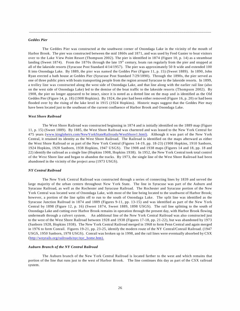
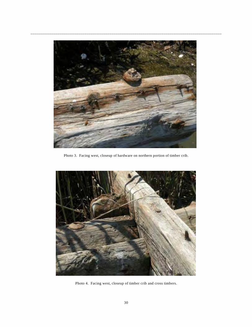
crib oriented parallel to the shore with cross timbers centrally situated along the crib (Photos 1-2). The wood timber crib
is approximately 25 x 30 cm (10 x 12 in) in size with a second timber underneath with iron spikes and other iron
hardware fastening the two together (Photos 3-4). The cross timbers are two 10 x 25 cm (4 x 10 in) planks stacked
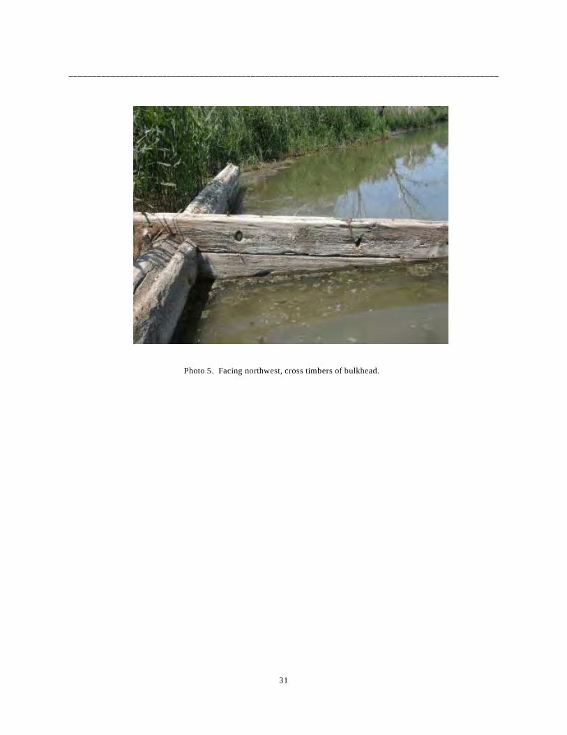
vertically on top of each other and fastened with iron spikes (Photo 5). The crosstimbers extend onto the wastebed and
extend approximately 3 m (10 ft) into Onondaga Lake. The wooden bulkhead, constructed in the mid 20 century, isth
not a significant resource, was not designated as a site, and is recommended as not eligible for the National Register of
Historic Places.

____________________________________________________________________________________________
29
Photo 1. Facing south, southern portion of bulkhead at the mouth of Harbor Brook.
Photo 2. Facing southwest, northern portion of timber crib at the mouth of Harbor Brook.
____________________________________________________________________________________________
30
Photo 3. Facing west, closeup of hardware on northern portion of timber crib.
Photo 4. Facing west, closeup of timber crib and cross timbers.
____________________________________________________________________________________________
31
Photo 5. Facing northwest, cross timbers of bulkhead.

____________________________________________________________________________________________
32
VII. ARCHITECTURAL SURVEY
Following the submittal of the Phase 1A assessment and the Phase 1B workplan, it was determined that the
culverts along Harbor Brook required an architectural survey to determine if any of them would be eligible for listing
in the National Register of Historic Places. Three key concepts are used in determining if a property is eligible - historic
significance, historic integrity, and historic context. Historic significance is the importance of a property to the history,
architecture, archaeology, engineering, or culture of a community, state, or the nation. Significance may be associated
with: 1) historic events or activities (Criterion A), 2) important persons (Criterion B), 3) distinctive design or physical
characteristics (Criterion C), or 4) the potential to provide important information about prehistory or history (Criterion
D). Historic integrity is based on the composite of seven qualities: location, design, setting, materials, workmanship,
feeling, and association. Historic contexts are organized by theme, place and time and link historic properties to
important historic trends. Architectural surveys locate and identify historic properties eligible for inclusion in the
National Register of Historic Places so that their protection can be considered during the design and planning of new
projects. Architectural surveys may also increase public understanding of local history and generate interest in historic
sites.
The project area includes five culverts and the stone-lined banks of Harbor Brook between the West Shore
Railroad culvert and the New York Central Railroad culvert to the west (Figure 23). Four culverts channeled Harbor
Brook underneath former railroad lines and roads, as well as an additional culvert associated with the present CSX
Railroad line and I-690. Four of the culverts appear to be more than 50 years old, with the remaining culvert being
constructed or reconstructed in the mid 20 century and appears to be less than 50 years old. Only the West Shoreth
Railroad culvert is recommended as eligible for the National Register of Historic Places. Evaluations were based on
National Register Criteria as defined in National Register Bulletin 15: “How to Apply the National Register Criteria for
Evaluation” (National Park Service 1990).
A list of all culverts and the stone-lined banks surveyed and eligibility recommendations is included in Table 1and
a discussion of the reason for their eligibility follows on pp. 32-47. Culverts are listed in order of location along Harbor
Brook. Only one of the culverts is recommended as NRE (eligible for listing in the National Register of Historic
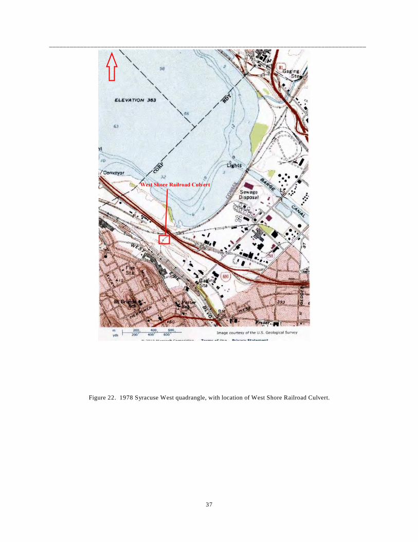
Places), the West Shore Railroad Culvert. Figure 22 shows the location of the West Shore Railroad Culvert. Culverts
less than 50 years old are generally not eligible for the National Register of Historic Places. An OPRHP Building-
Structure Inventory Form was completed for the one eligible culvert. The remaining four culverts and the stone-lined
banks are recommended as not eligible for listing in the National Register of Historic Places.
Table 1. Harbor Brook/Wastebed B, Onondaga Lake Upland Remediation Project, City of Syracuse, Onondaga
County, New York.
City of Syracuse, Onondaga County, New York (MCD 06740)
Address < 50 yrs. > 50 yrs. NRE Not NRE
Delaware, Lackawanna and Western
Railroad CulvertX X
Delaware, Lackawanna and Western
Railroad Southwestern CulvertX X
CSX Railroad Culvert (prior Syracuse
Junction Railroad Culvert)X X
West Shore Railroad Culvert X X
Harbor Brook Stone-lined banks X X
New York Central Railroad Culvert X X

____________________________________________________________________________________________
33
7.1 Structures Recommended as Eligible for the National Register of Historic Places
The West Shore Railroad Culvert is a single span, stone arch culvert constructed, circa 1880. to carry the West
Shore Railroad over Harbor Brook. The cut limestone arch culvert, with integral wing walls, rises approximately 3m
(10 ft) above the surface of Harbor Brook. The tracks were abandoned in the mid 20 century and the rails removed.th
The culvert is located in a wooded area with industrial development to the north and south. Active tracks curve around
this location, with multiple tracks running north and a single track running south.
The West Shore Railroad Culvert was constructed to carry the railroad tracks over Harbor Brook at the south end
of Onondaga Lake in the City of Syracuse. The West Shore Railroad was established in 1874 as a direct competitor to
the New York Central Railroad. It had reached Buffalo by 1874, but was bankrupt, and, in 1885 was purchased by the
New York Central. Although part of the New York Central system, it retained its identity as the West Shore Railroad
and continued to operate as such. In 1952, the New York Central took control of the railroad and began to abandon the
tracks.
Although the culvert is associated with a historic network of railroad corridors operating near Onondaga Lake,
it is not specifically associated with particular historic events or activities (Criterion A). The culvert is not associated
with any individual known to be important in local, state, or national history (Criterion B). The single span stone arch
culvert and integral wing walls is an excellent example of the engineering used in building the infrastructure of the West
Shore Railroad (Criterion C). The stone culvert does embody the distinctive characteristics of the period and the method
of constructing stone arch bridges. Most stone masonry arch bridges in New York were constructed from the 1840s
through the 1890s and were built by local craftsmen with local materials (Mead and Hunt 1999: 16, 29). The voussoirs
or wedge-shaped stones that comprise the arch are clearly visible on both sides of the culvert as are the integral wing
walls.
In New York State, using the Department of Transportation standards, stone arch bridges are generally considered
eligible under Criterion C unless there are significant integrity problems (Mead and Hunt and Allee Rose & Fleming Inc.
2002: 4-14). In this case, the structure retains six of the seven aspects of integrity. The culvert maintains its original
location, its overall setting has gradually become more urban but the immediate setting is still represented by a series
of interrelated railroad corridors. The design (arch with integral wing walls) and materials (cut limestone) are intact with
no evidence of repair or subsequent alteration; workmanship is illustrated by the wedge-shaped stones creating the arch
(e.g., no keystone feature) which most likely indicates onsite processing of the stone by stone masons. The overall
feeling of a stone arch culvert spanning Harbor Brook is retained. The abandonment and removal of railroad tracks have
resulted in a loss of association. The stone arch culvert remains an excellent example of the engineering used in building
the infrastructure for the West Shore Railroad and is recommended as eligible for listing in the National Register of
Historic Places. Current remediation plans do not call for disturbing the West Shore Railroad Culvert (Petrone, pers.
comm 1/19/2011).
NEW YORK STATE OFFICE OF PARKS, RECREATION , AND HISTORIC PRESERVATION
HISTORIC RESOURCE INVENTORY FORM
34
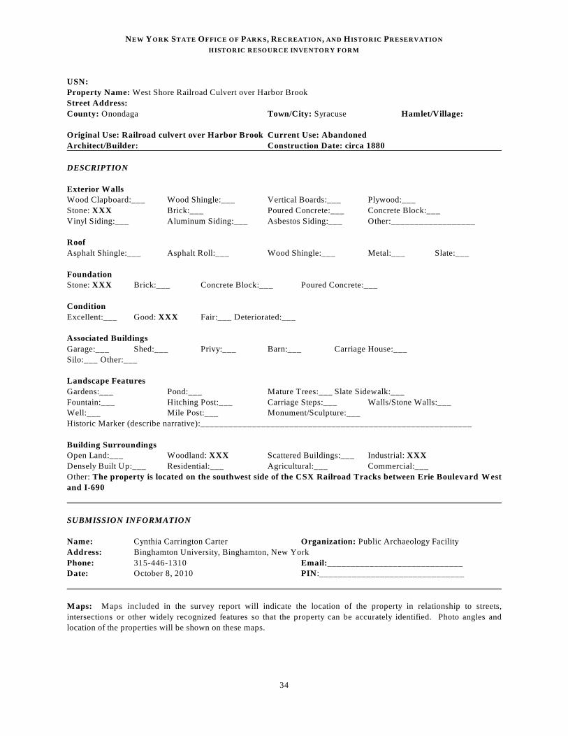
USN:
Property Name: West Shore Railroad Culvert over Harbor Brook
Street Address:
County: Onondaga Town/City: Syracuse Hamlet/Village:
Original Use: Railroad culvert over Harbor Brook Current Use: Abandoned
Architect/Builder: Construction Date: circa 1880
DESCRIPTION
Exterior Walls
Wood Clapboard:___ Wood Shingle:___ Vertical Boards:___ Plywood:___
Stone: XXX Brick:___ Poured Concrete:___ Concrete Block:___
Vinyl Siding:___ Aluminum Siding:___ Asbestos Siding:___ Other:__________________
Roof
Asphalt Shingle:___ Asphalt Roll:___ Wood Shingle:___ Metal:___ Slate:___
Foundation
Stone: XXX Brick:___ Concrete Block:___ Poured Concrete:___
Condition
Excellent:___ Good: XXX Fair:___ Deteriorated:___
Associated Buildings
Garage:___ Shed:___ Privy:___ Barn:___ Carriage House:___
Silo:___ Other:___
Landscape Features
Gardens:___ Pond:___ Mature Trees:___ Slate Sidewalk:___
Fountain:___ Hitching Post:___ Carriage Steps:___ Walls/Stone Walls:___
Well:___ Mile Post:___ Monument/Sculpture:___
Historic Marker (describe narrative):__________________________________________________________
Building Surroundings
Open Land:___ Woodland: XXX Scattered Buildings:___ Industrial: XXX
Densely Built Up:___ Residential:___ Agricultural:___ Commercial:___
Other: The property is located on the southwest side of the CSX Railroad Tracks between Erie Boulevard West
and I-690
SUBMISSION INFORMATION
Name: Cynthia Carrington Carter Organization: Public Archaeology Facility
Address: Binghamton University, Binghamton, New York
Phone: 315-446-1310 Email:_____________________________
Date: October 8, 2010 PIN:_______________________________
Maps: Maps included in the survey report will indicate the location of the property in relationship to streets,
intersections or other widely recognized features so that the property can be accurately identified. Photo angles and
location of the properties will be shown on these maps.

NEW YORK STATE OFFICE OF PARKS, RECREATION , AND HISTORIC PRESERVATION
HISTORIC RESOURCE INVENTORY FORM
35
Photographs: Provide clear, original color photographs of the property recommended for National Register eligibility.
Submitted views should represent the property as a whole and its relationship to the road. Include general setting,
outbuildings and landscape features.
NARRATIVE DESCRIPTION OF PROPERTY
Briefly describe the property’s location (e.g., north side of NY 17, west of Jones Road); a general description of the
building, structure or feature including such items as architectural style (if known), number of stories, type and shape
of roof (flat, gabled, mansard, shed or other), and materials. Describe in detail the property’s setting and contributing
landscape features.
The cut limestone arch culvert, with integral wing walls, rises approximately 10 feet above the surface of Harbor
Brook. The tracks were abandoned in the mid 20 century and the rails removed. The culvert is located in ath
wooded area with industrial development to the north and south. Active tracks curve around this location, with
multiple tracks running north and a single track running south.
NARRATIVE DESCRIPTION OF NATIONAL REGISTER ELIGIBILITY
Briefly describe those characteristics by which this property meets the National Register eligibility criteria. The
narrative should support the eligibility recommendation, citing all specific National Register criteria that apply:
Associative Value (Criteria A & B): Properties significant for their association in or linkage to events (Criterion A) or
persons (Criterion B) important in the past; Design or Construction value (Criterion C)
The culvert is recommended as eligible for listing in the National Register of Historic Places under Criterion C.
It is a stone arch railroad culvert and dates to the late 19 century. It was constructed by the West Shoreth
Railroad to carry the railroad tracks over Harbor Brook at the south end of Onondaga Lake in the City of
Syracuse. The West Shore Railroad was established in 1874 as a direct competitor to the New York Central
Railroad. It had reached Buffalo by 1884, but was bankrupt, and in 1885, was purchased by the New York
Central. Although part of the New York Central system, it retained its identity as the West Shore Railroad and
continued to operate as such. In 1952, the New York Central took control of the railroad and began to abandon
the tracks.
Although the culvert is associated with a historic network of railroad corridors operating near Onondaga
Lake, it is not specifically associated with particular historic events or activities (Criterion A). The culvert is not
associated with any individual known to be important in local, state, or national history (Criterion B). The single
span stone arch culvert and integral wing walls is an excellent example of the engineering used in building the
infrastructure of the West Shore Railroad (Criterion C). The stone culvert does embody the distinctive
characteristics of the period and the method of constructing stone arch bridges. Most stone masonry arch bridges
in New York were constructed from the 1840s through the 1890s and were built by local craftsmen with local
materials (Mead and Hunt 1999: 16, 29). The voussoirs or wedge-shaped stones that comprise the arch are clearly
visible on both sides of the culvert as are the integral wing walls.
In New York State, using the Department of Transportation Bridge standards, stone arch bridges are
generally considered eligible under Criterion C unless there are significant integrity problems (Mead & Hunt and
Allee King Rosen and Fleming, Inc. 2002: 4-14). In this case, the structure retains six of the seven aspects of
integrity. The culvert maintains its original location; its overall setting has gradually become more urban but the
immediate setting is still represented by a series of interrelated railroad corridors. The design (arch with integral
wing walls) and materials (cut limestone) are intact with no evidence of repair or subsequent alteration;
workmanship is illustrated by the wedge-shaped stones creating the arch (e.g., no keystone feature) which most
likely indicates onsite processing of the stone by stone masons. The overall feeling of a stone arch culvert
spanning Harbor Brook is retained. The abandonment and removal of the railroad tracks have resulted in loss
of association. The stone arch culvert remains an excellent example of the engineering used in building the
infrastructure of the West Shore Railroad and is recommended as eligible for listing in the National Register of
Historic Places.

____________________________________________________________________________________________
36
SOURCES
Include sources that document/support the construction date along with the National Register eligibility
recommendations. This would include architectural guidebooks, interviews, articles, county histories, newspapers, oral
histories, building cornerstones, previous Cultural Resource Survey reports, and primary sources (deeds, census
records).
Historic Maps:
New York Central Lines Map, 1918;
Sanborn Map of the City of Syracuse, 1882;
Hopkins maps of Syracuse - 1908, 1924, and 1938.
Other Sources:
Mead & Hunt
1999 Contextual Study of New York State’s Pre-1961 Bridges. Prepared for the New York State Department of
Transportation, Albany, NY. Available on line at https://www.nysdot.gov//divisions/engineering/environmental-
analysis/repository/bridgescontextuastudy-99.pdf.
Mead & Hunt and Allee King Rosen & Fleming Inc.
2002 Final Report, Evaluation of National Register Eligibility, Task C3 of the Historic Bridge Inventory and
Management Plan. Prepared for the New York State Department of Transportation, Albany, NY and the Federal
Highway Administration, Albany, NY. Available online at https://www.nysdot.gov/divisions/engineering/
envrionmental-analysis/repository/nationalregistereligibilityreport.pdf.
____________________________________________________________________________________________
37
Figure 22. 1978 Syracuse West quadrangle, with location of West Shore Railroad Culvert.
____________________________________________________________________________________________
38
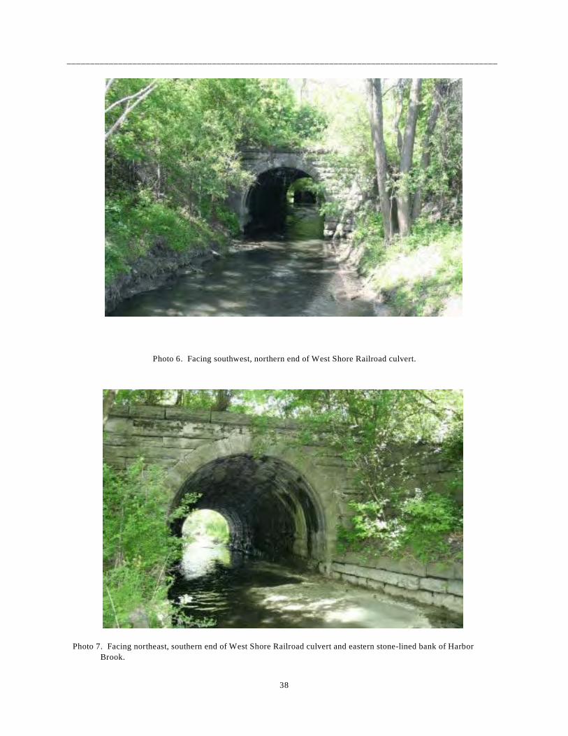
Photo 6. Facing southwest, northern end of West Shore Railroad culvert.
Photo 7. Facing northeast, southern end of West Shore Railroad culvert and eastern stone-lined bank of Harbor
Brook.

____________________________________________________________________________________________
39
Photo 8. Facing north, western edge of West Shore Railroad culvert.

____________________________________________________________________________________________
40
7.2 Structures Not Eligible for National Register of Historic Places
Photo 9. Facing south, northern end of Delaware, Lackawanna, and Western Railroad Culvert. This is a reinforced
concrete single box culvert constructed in the early to mid 20 century to carry the Delaware, Lackawanna, and Westernth
Railroad over Harbor Brook. The culvert appears to be in place by either 1924 or 1938 (Hopkins 1924; Hopkins 1938)
(Figs. 16 and 18, pp. 20 and 22). This culvert was evaluated using the National Register criteria for significance. There
is no known association with any historic events or activities that make the culvert eligible under Criterion A. The
culvert is not associated with any individual known to be important in local, state, or national history; therefore, the
property is not eligible under Criterion B. Criterion C identifies buildings that embody the distinctive characteristics
of a type, period, or method of construction, or that represent the work a master. The culvert is not eligible under
Criterion C. Criterion D is limited to archaeological sites, not standing structures. Given that the culvert does not meet
the standard for significance, no further evaluation is deemed necessary. This structure is not recommended as eligible
for listing in the National Register of Historic Places.
____________________________________________________________________________________________
41
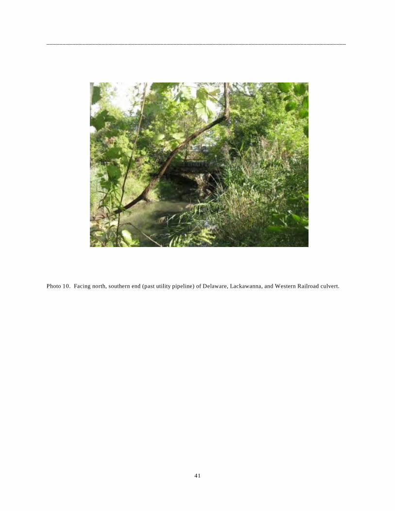
Photo 10. Facing north, southern end (past utility pipeline) of Delaware, Lackawanna, and Western Railroad culvert.
____________________________________________________________________________________________
42
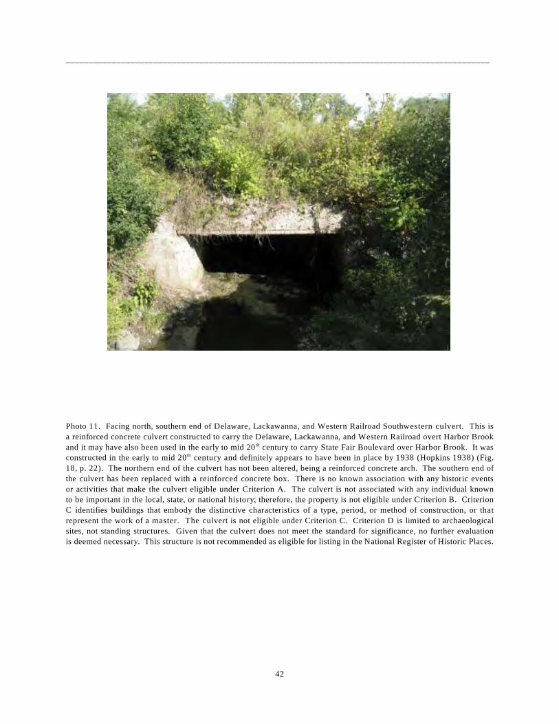
Photo 11. Facing north, southern end of Delaware, Lackawanna, and Western Railroad Southwestern culvert. This is
a reinforced concrete culvert constructed to carry the Delaware, Lackawanna, and Western Railroad overt Harbor Brook
and it may have also been used in the early to mid 20 century to carry State Fair Boulevard over Harbor Brook. It wasth
constructed in the early to mid 20 century and definitely appears to have been in place by 1938 (Hopkins 1938) (Fig.th
18, p. 22). The northern end of the culvert has not been altered, being a reinforced concrete arch. The southern end of
the culvert has been replaced with a reinforced concrete box. There is no known association with any historic events
or activities that make the culvert eligible under Criterion A. The culvert is not associated with any individual known
to be important in the local, state, or national history; therefore, the property is not eligible under Criterion B. Criterion
C identifies buildings that embody the distinctive characteristics of a type, period, or method of construction, or that
represent the work of a master. The culvert is not eligible under Criterion C. Criterion D is limited to archaeological
sites, not standing structures. Given that the culvert does not meet the standard for significance, no further evaluation
is deemed necessary. This structure is not recommended as eligible for listing in the National Register of Historic Places.

____________________________________________________________________________________________
43
Photo 12. Facing southwest, northern end of Delaware, Lackawanna, and Western Railroad Southwest culvert.

____________________________________________________________________________________________
44
Photo 13. Facing northwest, southern end of CSX Railroad culvert. This double pipe culvert set in concrete was
constructed to carry the CSX Railroad over Harbor Brook. The culvert was originally constructed in the mid 20 th
century, with the northern end of the culvert being reconstructed in the late 20 /early 21 century. There is no knownth st
association with any historic events or activities that make the culvert eligible under Criterion A. The culvert is not
associated with any individual known to be important in local, state, or national history; therefore, the property is not
eligible under Criterion B. Criterion C identifies buildings that embody the distinctive characteristics of a type, period,
or method of construction, or that represents the work of a master. The culvert is not eligible under Criterion C.
Criterion D is limited to archaeological sites, not standing structures. Given that the culvert does not meet the standard
for significance, no further evaluation is deemed necessary. The structure is not recommended as eligible for listing in
the National Register of Historic Places.

____________________________________________________________________________________________
45
Photo 14. Facing south, northern end of CSX Railroad culvert.
____________________________________________________________________________________________
46
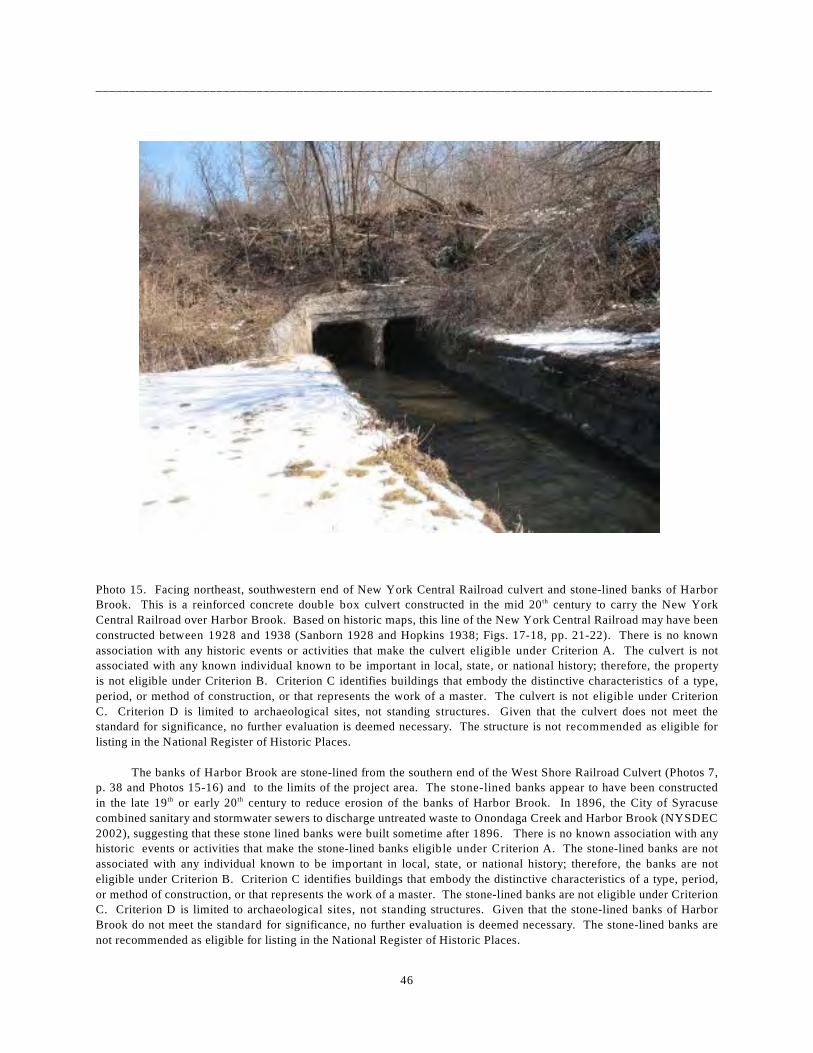
Photo 15. Facing northeast, southwestern end of New York Central Railroad culvert and stone-lined banks of Harbor
Brook. This is a reinforced concrete double box culvert constructed in the mid 20 century to carry the New Yorkth
Central Railroad over Harbor Brook. Based on historic maps, this line of the New York Central Railroad may have been
constructed between 1928 and 1938 (Sanborn 1928 and Hopkins 1938; Figs. 17-18, pp. 21-22). There is no known
association with any historic events or activities that make the culvert eligible under Criterion A. The culvert is not
associated with any known individual known to be important in local, state, or national history; therefore, the property
is not eligible under Criterion B. Criterion C identifies buildings that embody the distinctive characteristics of a type,
period, or method of construction, or that represents the work of a master. The culvert is not eligible under Criterion
C. Criterion D is limited to archaeological sites, not standing structures. Given that the culvert does not meet the
standard for significance, no further evaluation is deemed necessary. The structure is not recommended as eligible for
listing in the National Register of Historic Places.
The banks of Harbor Brook are stone-lined from the southern end of the West Shore Railroad Culvert (Photos 7,
p. 38 and Photos 15-16) and to the limits of the project area. The stone-lined banks appear to have been constructed
in the late 19 or early 20 century to reduce erosion of the banks of Harbor Brook. In 1896, the City of Syracuseth th
combined sanitary and stormwater sewers to discharge untreated waste to Onondaga Creek and Harbor Brook (NYSDEC
2002), suggesting that these stone lined banks were built sometime after 1896. There is no known association with any
historic events or activities that make the stone-lined banks eligible under Criterion A. The stone-lined banks are not
associated with any individual known to be important in local, state, or national history; therefore, the banks are not
eligible under Criterion B. Criterion C identifies buildings that embody the distinctive characteristics of a type, period,
or method of construction, or that represents the work of a master. The stone-lined banks are not eligible under Criterion
C. Criterion D is limited to archaeological sites, not standing structures. Given that the stone-lined banks of Harbor
Brook do not meet the standard for significance, no further evaluation is deemed necessary. The stone-lined banks are
not recommended as eligible for listing in the National Register of Historic Places.
____________________________________________________________________________________________
47
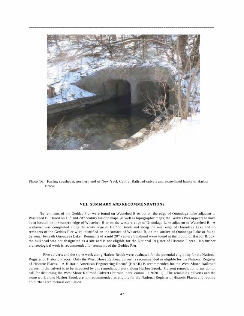
Photo 16. Facing southeast, northern end of New York Central Railroad culvert and stone-lined banks of Harbor
Brook.
VIII. SUMMARY AND RECOMMENDATIONS
No remnants of the Geddes Pier were found on Wastebed B or out on the edge of Onondaga Lake adjacent to
Wastebed B. Based on 19 and 20 century historic maps, as well as topographic maps, the Geddes Pier appears to haveth th
been located on the eastern edge of Wastebed B or on the western edge of Onondaga Lake adjacent to Wastebed B. A
walkover was completed along the south edge of Harbor Brook and along the west edge of Onondaga Lake and no
remnants of the Geddes Pier were identified on the surface of Wastebed B, on the surface of Onondaga Lake or found
by sonar beneath Onondaga Lake. Remnants of a mid 20 century bulkhead were found at the mouth of Harbor Brook;th
the bulkhead was not designated as a site and is not eligible for the National Register of Historic Places. No further
archaeological work is recommended for remnants of the Geddes Pier.
Five culverts and the stone work along Harbor Brook were evaluated for the potential eligibility for the National
Register of Historic Places. Only the West Shore Railroad culvert is recommended as eligible for the National Register
of Historic Places. A Historic American Engineering Record (HAER) is recommended for the West Shore Railroad
culvert, if the culvert is to be impacted by any remediation work along Harbor Brook. Current remediation plans do not
call for disturbing the West Shore Railroad Culvert (Petrone, pers. comm. 1/19/2011). The remaining culverts and the
stone work along Harbor Brook are not recommended as eligible for the National Register of Historic Places and require
no further architectural evaluation.

____________________________________________________________________________________________
48
APPENDIX I. REFERENCES
Aiuvalasit, Michael and Joseph Schuldenrein
2010 Preliminary Geomorphological Observations for the Onondaga Lake Project. Geoarchaeology Research
Associates, Yonkers, New York.
Bradley, James W.
1987 Evolution of the Onondaga Iroquois: accommodating change: 1500-1655. Reprinted in 2005 by the Board of
Regents of the University of Nebraska.
Bruce, Dwight H.
1896 Onondaga’s Centennial. Boston History Company, Boston.
Fagan, L.
1852 Map of Onondaga County, New York.
Hohman, Christopher D.
2010 Work Plan Addendum for Onondaga Lake Project, Upland and Shoreline Area, Onondaga County, New York.
Public Archaeology Facility, Binghamton, New York.
2004 Cultural Resource Management Report, Phase 1A Cultural Resource Assessment, Onondaga Lake Project,
Onondaga Lake, Wastebed B and Wastebed 13, Towns of Camillus, Geddes and Salina and City of Syracuse,
Onondaga County, New York. Public Archaeology Facility, Binghamton University, Binghamton, New York.
Hohman, Christopher D. and Dr. Nina Versaggi
2010 Cultural Resource Management Report, Phase 1B Archaeological Work Plan, Onondaga Lake Project, Upland
and Shoreline Area, Wastebed 13, Geddes Brook IRM, Tributary of Geddes Brook, Ninemile Creek RI/FS,
Shoreline Survey and Wastebed B/Harbor Brook IRM, Town of Camillus and Geddes, Onondaga County, New
York. Public Archaeology Facility, Binghamton, New York.
Hopkins, G.M.
1938 Map of the City of Syracuse, Onondaga County, New York. G.M. Hopkins Company, Philadelphia.
1924 Map of the City of Syracuse, Onondaga County, New York. G.M. Hopkins Company, Philadelphia.
1908 Map of the City of Syracuse, Onondaga County, New York. G.M. Hopkins Company, Philadelphia.
http://en.wikipedia.org/wiki/NewYorkCentral Railroad.
http://en.wikipedia.org/wiki/OswegoandSyracuseRailroad.
Johnston, William F. and Eugene M. Carpenter
1985 Tamarack. USDA Forest Service.
Kane, Adam I. (in progress)
2010 Phase 1B Survey, Onondaga Lake Bottom Subsite of the Onondaga Lake Superfund Site, Onondaga County, New
York. Lake Chmaplain Maritime Museum, Vergennes, Vermont.
Kane, Adam I. and Joanne M. DellaSalla
2008 Underwater and Shoreline Archaeological Resources Phase 1B Work Plan for the Onondaga Lake Bottom,
Subsite of the Onondaga Lake Superfund Site, Onondaga County, New York. Lake Champlain Maritime Museum,
Vergennes, Vermont.
Mead & Hunt
1999 Contextual Study of New York State’s Pre-1961 Bridges. Prepared for the New York State Department of
Transportation, Albany, NY. Available on line at https://www.nysdot.gov//divisions/engineering/environmental-
analysis/repository/bridgescontextuastudy-99.pdf.
____________________________________________________________________________________________
49
Mead & Hunt and Allee King Rosen & Fleming Inc.
2002 Final Report, Evaluation of National Register Eligibility, Task C3 of the Historic Bridge Inventory and
Management Plan. Prepared for the New York State Department of Transportation, Albany, NY and the Federal
Highway Administration, Albany, NY. Available online at https://www.nysdot.gov/divisions/engineering/
envrionmental-analysis/repository/nationalregistereligibilityreport.pdf.
National Park Service
1990 “How to Apply the National Register Criteria for Evaluation”. National Register Bulletin 15.
New York State Department of Environmental Conservation
2002 Site Overview & Historical Perspective from Chapter 1 of the Onondaga Lake Remedial Investigation Report.
Parker, Arthur C.
1922 The Archaeological History of New York. New York State Museum Bulletin. State University of New York,
Albany, New York.
Sanborn Fire Insurance Company
1950 Insurance Maps of Syracuse, New York. Sanborn-Perris, New York
1928 Insurance Maps of Syracuse, New York. Sanborn-Perris, New York.
1910 Insurance Maps of Syracuse, New York. Sanborn-Perris, New York.
Sweet, Homer
1889 Map of Onondaga County, New York. C.W. Burdeen, New York.
1874 Map of Onondaga County, New York. Walker Brothers and Company, New York.
1859 Map of Onondaga County, New York. A.R.Z. Dawson, Philadelphia.
Syracuse Post Standard
1905 Daily newspapers.
Thompson, Donald H.
2002 The Golden Age of Onondaga Lake Resorts. Purple Mountain Press, Fleischmanns, New York.
United States Department of Agriculture
1977 Soil Survey of Onondaga County, New York. USDA, Washington, D.C.
1938 Soil Survey of Onondaga County, New York. USDA, Washington, D.C.
United States Geological Survey
1978/ 7.5 minute, Syracuse West, NY quadrangle.
1973
1973 7.5 Minute, Syracuse West, NY quadrangle.
1947 7.5 Minute, Syracuse West, NY quadrangle.
1898 15 Minute, Syracuse, NY quadrangle.
Vose, J.W. and Co.
1892 Atlas of the City of Syracuse, New York, Onondaga County, New York. J.W. Vose and Co., New York.
www.kinglyheirs.com/NewYorkStateRailroads/WestShore1.html

____________________________________________________________________________________________
56
APPENDIX III/FIGURE 23. PROJECT MAP

____________________________________________________________________________________________
57
Figure 23. Conceptual Approach for Wastebed B/Harbor Brook IRM with locations of culverts (boxes in red), walkover area (pink hatching), Harbor Brook bulkhead, and photo angles (in red).