a survey of ditches along county roads for their …
TRANSCRIPT

A SURVEY OF DITCHES ALONG COUNTY ROADS FORTHEIR POTENTIAL TO AFFECT STORM RUNOFF WATER
QUALITY
Performed for
SNOHOMISH COUNTY SURFACE WATER MANAGEMENT DIVISION
SNOHOMISH COUNTY ROAD MAINTENANCE
KING COUNTY LAND AND WATER RESOURCES DIVISION
KING COUNTY DEPARTMENT OF TRANSPORTATION, ROAD MAINTENANCE
PIERCE COUNTY PUBLIC WORKS AND UTILITIES
By
Shanti Colwell
Richard R. Horner
Derek B. Booth
Dalius Gilvydis
Center for Urban Water Resources ManagementDepartment of Civil and Environmental Engineering
University of WashingtonSeattle, WA 98195
July 2000

1
EXECUTIVE SUMMARY
SURVEY RATIONALE AND COVERAGE Twenty years of research have demonstrated that the water quality of stormwater runoff can improve after flowing in a well-vegetated channel, relatively slowly, at a depth below the vegetation height. These channels are commonly called “biofiltration swales.” Roadside ditches that are vegetated also may have the potential to provide the same water quality benefits as biofiltration swales by removing pollutants. Conversely, ditches that are devoid of vegetation are subject to erosion and could be significant sources of sediments and other pollutants. If the potential benefits are to be realized, and the pollutant source avoided, ditch condition and maintenance must be consistent with not only conveyance but also water-quality objectives. Because no systematic data have been collected that describe ditch characteristics with respect to water-quality considerations, Snohomish and King counties commissioned the Center for Urban Water Resources Management to evaluate ditch status in the two jurisdictions and to consider how road maintenance crews might maximize their potential for water-quality performance. The goal of this investigation was to develop strategies for improving runoff treatment and reducing downstream sediment loading from existing ditches, while retaining their hydraulic function of conveying roadway runoff. The principal focus was to guide maintenance actions, but it was anticipated that design of future ditches should also benefit. This report documents one aspect of the investigation— a systematic survey of ditches during the summer and fall of 1998, designed to evaluate the water-quality performance of ditches in the two counties’ road networks. The survey encompassed 113 ditch segments in Snohomish County and 87 segments in King County, ranging in length from 200 to 600 feet. Single-family residential is by far the dominant land use in the catchments adjacent to the ditches surveyed, a circumstance representative of areas in the two counties with roadside ditches. Specific measurements and observations were made at several transects in each ditch, extending across the width and spaced along the length of each segment. In total, 1000 transects were surveyed for this project, emphasizing the data collection and analysis of those factors that were anticipated to be both beneficial and detrimental to improving water quality. SURVEY RESULTS The surveyed ditches have a number of characteristics that should promote pollutant reduction and reduce the tendency of the ditch itself to become a pollutant source. Most ditches have a U-shaped profile (94 and 92 percent, respectively, in Snohomish County [SC] and King County [KC]). This geometry tends to spread flow and reduce velocity, thus helping to limit erosion and advance treatment. Ditches generally have a gradual slope along the direction of flow (mean of 1.9 percent in SC, 1.7 percent in KC), which also contributes to free flow with only moderate velocity. Many of the common causes of vegetation mortality were observed only infrequently: significant erosion, sediment deposition on vegetation, shading, and herbicide applications.
2
The types and stature of the dominant vegetation observed tend to promote pollutant removal. Fine, close-growing material, either grasses or mixed herbaceous plants, made up most of the vegetation communities. For example, grasses were present in 72 percent of SC ditch bed transects and 50 percent in KC; and other herbaceous growth was present in 34 percent of SC transects and 31 percent in KC, often in combination with grasses. Where vegetation grew, it was generally both relatively high (mean heights of 9.3 and 8.0 inches in SC and KC, respectively) and erect (55 and 51 percent erect, respectively). Despite the existence of a number of factors favorable to water quality, other conditions in the surveyed ditches were not favorable, retarding their ability to remove pollutants and raising the likelihood that they are presently acting as pollutant sources instead of sinks. Rocks and gravel, not a good base for herbaceous plant growth, are fairly common (found in 32 percent of SC transects and 57 percent in KC). Standing water, which harms many grasses with low tolerance of persistent wetness, occurred in 27 percent (SC) and 28 percent (KC) of the observations. Both conditions were commonly associated with low plant cover. Mowing ditches without removing grass clippings was evident in SC (35 percent of cases), although much less so in KC (11 percent). There appeared to be some association of clipping accumulations with reduced plant cover. In addition, nutrients in decomposing plant tissues would be expected to dissolve in runoff and travel to receiving waters (although no downstream sampling has been done in this region to test the importance of this process). On the other hand, litter, while unsightly and common (69 and 67 percent of SC and KC transects, respectively), did not appear to compromise vegetation cover or condition. Structural measures that avoid erosion and improve vegetative treatment are rare in the area’s roadside ditches. Most ditches (about 75 percent in both counties) only received sheet flow from adjacent road surfaces without an upstream point discharge. Of those fed at a single point, only about one in 12 in SC and one in six in KC had any form of energy dissipation or flow spreading (uniformly rip-rap). None of the surveyed ditch segments had any check dams. Whereas gradual longitudinal slopes limit velocity and help prevent erosion, the grades were so slight (<2 percent) in most of the surveyed ditches that the inverse problem of standing or poorly draining flow was relatively common and did limit vegetation growth. Side slopes averaged about 2:1 (horizontal:vertical), but many were steeper and hence an erosion risk. In general, the single most important factor in achieving runoff treatment and preventing ditches from becoming sediment sources is thorough, uniform cover by fine, dense vegetation. While the types of vegetation were usually favorable, their overall coverage and health were much less so. In Snohomish County, 54 percent of ditch bed transects had 95-100 percent vegetation cover (and 25 percent had 70-95 percent coverage). However, this was true in only 18 percent of KC transects (and 15 percent with 70-95 percent coverage). Indeed, more KC ditch beds had ? 5 percent cover (36 percent) than ? 70 percent cover (33 percent). However, only 21 and 23 percent of the SC and KC bed plants, respectively, were rated as “healthy.” Therefore, the combination of full or nearly full cover of healthy growth was rare (12 percent on SC beds and 11 percent on KC’s). The main cause of poor health was drought (55 and 44 percent of SC and KC bed transects, respectively), but standing water was also quite common as a cause.

3
RECOMMENDATIONS FOR MANAGING TO IMPROVE WATER QUALITY The recommendations growing out of the survey to improve water quality benefits and attenuate ditch pollutant sources fall into two categories— those practices that are currently being followed to good effect, and that should be continued (or applied more universally); and those new practices that would likely produce good results. Continuation of Existing Practices
1. In future roadside ditch site selection and design continue to avoid heavy shading and steep slopes. Continue to use U-shaped ditch profiles.
2. Make side slopes no steeper than 3:1 (horizontal:vertical), if possible, and never steeper
than 2:1.
3. In new designs where high flow velocities could occur, regulate velocity at the point inlet, if any, using an energy dissipater (e. g., rip-rap pad) and within the channel using check dams (see biofiltration guidance in the King County Surface Water Design Manual for specifics).
4. Remove large woody growth before it has an opportunity to damage or take space from
finer growth that makes a better treatment medium.
5. Continue to avoid herbicide applications that damage ditch vegetation. Recommended New Practices 1. Design point inlets of new ditches to distribute flow across the full width using a flow
spreader (see biofiltration guidance in the King County Surface Water Design Manual for specifics).
2. Retrofit existing ditches having evidence of channelized, incising flow with energy
dissipaters, check dams, and/or flow spreaders. 3. If a poor growth medium, especially rocky soil, is present, over-excavate the poor medium
and replace with a more favorable one. 4. Attempt to avoid standing water by siting ditches where high water table is not likely, sloping
at least 2-3 percent if possible, and carefully grading to avoid low spots. If high water table is likely to produce persistent wetness, establish wetland growth as the dominant plant community rather than grass.
5. Specify and plant a mix of grasses and other fine, close-growing herbaceous plants, including
wet-tolerant and drought-tolerant species.
4
6. There may be aesthetic and other operational reasons for mowing. Environmentally, there is
not enough evidence, at least at this time, to support any specific recommendations on large-scale mowing of roadside ditches for water pollutant reduction. However, residents often mow ditches in the public right of way; they should be educated, and if necessary required, to collect and dispose of their clippings in a manner that does not harm the vegetation nor release nutrients from decaying vegetation into stormwater runoff.
In summary, most physiographic conditions are generally favorable for achieving some water-quality function from the region’s roadside ditches. Roadway and hillside gradients are moderate, the volume and velocity of most flows are not highly erosive, and the road-related drainage network does not generally concentrate large discharges into the head of ditch segments. Yet other conditions are less favorable, particularly the lack of rainfall in August and September, and the common occurrence of seasonally high water tables in the winter and spring. A reasonable suite of design and maintenance practices should maximize the potential for water-quality improvements with little or no change in current operations and design (or, at least, the current standards for operations and design). Yet certain intrinsic factors, particularly high water tables or overly well-drained soils, will likely render roadside ditches ineffective for water-quality improvement in certain parts of these counties. Where such unavoidable conditions are recognized, such structural measures as flattened side slopes, energy-dissipation pads, and check dams should receive additional attention to help compensate for the likely absence of vegetation over the long term.

i
TABLE OF CONTENTS
Page LIST OF TABLES ii ACKNOWLEDGMENTS iii INTRODUCTION 1 BACKGROUND 1 SURVEY PURPOSES, OBJECTIVES, AND PRODUCTS 2 SURVEY METHODS 3 FIELD SURVEY METHODS 3 DATABASE AND DATA ANALYSIS METHODS 4 SURVEY RESULTS 5 GENERAL ROADSIDE DITCH PROFILE 5 Survey Coverage 5 Landscape Settings 5
Disturbance 6 Geometric and Hydraulic Characteristics 8 Vegetation Characteristics 9 EXAMINATION OF CONDITIONS PROMOTING AND INTERFERING
WITH VEGETATION 12 SUMMARY AND RECOMMENDATIONS 17 FACTORS BENEFICIAL TO WATER QUALITY 17 FACTORS DETRIMENTAL TO WATER QUALITY 18 CONSIDERATIONS FOR MANAGEMENT 18
SUMMARY OF MANAGEMENT RECOMMENDATIONS 20 Applicability of Recommendations 20
Maintenance Recommendations 21 Design and Construction Recommendations 22 RECOMMENDATIONS FOR FUTURE WORK 22 Approach 22 Additional Survey Work 23 Experimental Work 23 REFERENCES 25 APPENDIX A: DITCH SURVEY PROTOCOL APPENDIX B: DITCH SURVEY DATA SHEET APPENDIX C: DITCH SURVEY DATA ANALYSIS SUMMARY

ii
LIST OF TABLES
Page 1. Principal Landscape Settings of Roadside Ditches 6 2. Key Disturbance Survey Results 7 3. Key Geometric and Hydraulic Survey Results 8 4. Key Vegetation Survey Results 10 5. Ratios of the Presence of Grass to Mixed Herbaceous (MH) Plants at Ditch Transects
in Relation to Plant Cover 12 6. Ratios of the Presence of Grass to Mixed Herbaceous (MH) Plants at Ditch Transects
in Relation to Plant Condition 13
7. Ratios of Transects with Good or Excellent Cover of Healthy Bed Vegetation to Transects Overall in the Presence of Various Factors 15
iii
ACKNOWLEDGMENTS The survey of roadside ditches for their potential to affect storm runoff water quality was performed as part of a research project aimed at improving maintenance of vegetated drainage facilities to gain water quality benefits. King County Land and Water Division and Snohomish County Surface Water Management Division cooperatively funded the project. The authors gratefully acknowledge Clint Loper and Bill Leif of these respective organizations for their support and advice on this and other aspects of the project. A number of individuals from the road agencies in the two counties also contributed in various ways, including by helping to locate survey sites, advising on the design of the survey, explaining maintenance policies and practices, serving on a project technical advisory committee, and arranging to identify sites by global positioning system in King County. The authors thank Kirk Greenhalgh, Dennis Konopinski, and Roy Scalf of Snohomish County Road Maintenance for their assistance. From King County Road Maintenance, we acknowledge the contributions of Pat Bahor, Jerry Creek, Chad Durand, Gary Grieve, Joann Kosai-Eng, Roderick Matsuno, Rick Meininger, and Kathy Murata-Smit

1
INTRODUCTION
BACKGROUND Research over the past 20 years has demonstrated the potential for vegetated channels, often known as biofiltration swales, to remove pollutants from stormwater through filtration by plants, biodegradation of organic contaminants on the vegetation surfaces, plant uptake of nutrients, and physiochemical mechanisms in the soil (Wang 1981, Wang et al. 1981, Mar et al. 1982, Little et al. 1983, Municipality of Metropolitan Seattle, 1992). Although not specifically constructed for water-quality benefits, many miles of roadside ditches in suburban and rural areas are also vegetated. Conversely, others are devoid of vegetation and subject to erosion, and thus release of sediment and associated pollutants. Roadside ditches have traditionally been built to convey runoff, keep the road sub-base dry, and provide a transition from the public road to private property. As they often are or could be vegetated, though, many roadside ditches have the potential to provide the same water-quality benefits as swales that are formally constructed for that purpose. On the other hand, eroding ditches could be a significant source of sediments and the other pollutants that they transport. Interest in these possibilities for both positive and negative effects on water quality associated with the widespread roadside ditch systems in the Puget Sound region has further increased with recent salmonid fish listings under the Endangered Species Act. Although the treatment benefits of biofiltration swales have been well documented, and conditions for achieving these benefits are well established, swales have often failed to develop the necessary conditions. Failure can occur because of poor site selection, improper design, errors in construction and choosing or establishing vegetation, and poor maintenance (Koon 1995, Mazer 1998, Schultz 1998). Roadside ditches could fail to improve water quality improvement for the same reasons. Avoiding failure will require progress in each of these areas. If the potential benefits of roadside ditches are to be realized and their pollutant sources avoided, the condition and maintenance must be consistent with not only conveyance but also water-quality objectives. Given the expense of ditch maintenance and the potential water-quality influence represented by the large ditch networks around Puget Sound work is needed to define their status, to examine their ability to serve dual hydraulic and water-quality functions, and to devise maintenance strategies to promote dual use where feasible. King County Land and Water Resources Division and Snohomish County Surface Water Management Division contracted with the University of Washington’s Center for Urban Water Resources Management in the spring of 1998 to perform several studies aimed at improving maintenance of both roadside ditches and biofiltration swales to enhance runoff water quality. Work on ditches began with a systematic survey to give a representative picture of ditches in the two counties’ road networks as a basis for initial recommendations on maintenance and, possibly, future monitoring studies to confirm and refine strategies. The survey was conducted in the summer and fall of 1998. Database development took place in the first half of 1999, followed by data analysis. Work on swales continues and will be reported separately.

2
Washington State Department of Transportation funded additional work beginning in July 1999 to investigate the effects of alternative maintenance practices on water quality in ditches along freeways. The results of this work are likely to have some application in county road systems. SURVEY PURPOSES, OBJECTIVES, AND PRODUCTS The first element of the roadside ditch investigation was a survey of existing facilities. The survey’s purposes were to: (1) identify factors present in the roadside ditch systems of Snohomish and King County beneficial to water quality; (2) also identify factors detrimental to water quality; (3)recommend management actions that could be taken to sustain beneficial factors and alleviate detrimental ones, especially in maintenance programs, but also in design and construction; and (4) recommend future work to close important knowledge gaps and confirm the effectiveness of management actions. The specific objective of this roadside ditch survey was to survey a large and representative population of county road ditches to profile their surrounding land use types, geometric and hydraulic characteristics, and conditions and practices relevant to water-quality performance. This objective was accomplished by:
? ? Identifying a representative, unbiased set of ditches and devising a survey to collect the desired data; and
? ? Systematically surveying at least 200 ditch segments at least 200 ft in length in the two
counties. The survey’s products are this report and a computerized data base recording all measurements and observations made on the 200 segments. The report covers the survey methods and results and, in the Summary and Recommendations section, highlights the factors beneficial and detrimental to water quality and the recommendations for management and future work.

3
SURVEY METHODS
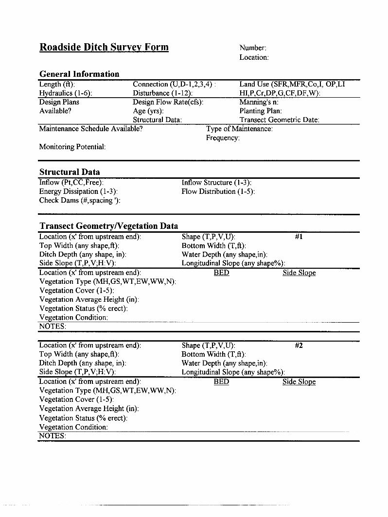
FIELD SURVEY METHODS The survey was conducted according to the following general protocol:
1. Identify regions in the two counties with ditch concentrations. 2. Target 200 ditch segments each at least 200 ft long for survey. 3. Allocate the 200 segments approximately 60 percent to Snohomish County and 40
percent to King County, since roadside ditches are the major interest of Snohomish and swales in King will get more attention. Then, allocate the segments approximately in proportion to the areas of the regions.
For example, if there would be two regions in Snohomish with ditch
concentrations, one of 10 square miles and the other of 5 square miles, the first region would be the site of 2/3 of the 120 segments allocated to Snohomish (80), with the remaining 40 in the second region.
4. Randomly pick squares from Thomas Guide maps in each region. Record the order
selected and conduct surveys in that order. 5. For the chosen Thomas Brothers map squares, survey all ditches present in the
squares. If a ditch extends outside of the square, determine where the upstream and downstream ends are and include the entire ditch in the survey.
6. Continue to survey if a ditch extends through a short culvert (e. g., across a
driveway). 7. Stop surveying if a ditch enters a long culvert (e. g., at a road crossing). 8. Continue to survey if a ditch turns onto and extends along an intersecting road. 9. If the total continuing ditch length is < 500 ft, survey transects at 0, 25, 50, 75, and
100 percent of its length. 10. If the total continuing ditch length is 500-1000 ft, identify two segments each 1/3 of
the full length at the upstream and downstream ends. Survey transects in each at 0, 25, 50, 75, and 100 percent of the segment length. (Note: Therefore, a ditch of this length would supply two of the 200 segments.)
11. If the total continuing ditch length is >1000 ft, identify three segments each 1/5 of the
full length at the upstream end, approximate middle, and downstream end. Survey

4
transects in each at 0, 25, 50, 75, and 100 percent of the segment length. (Note: Therefore, a ditch of this length would supply three of the 200 segments.)
Appendix A presents the specific observations and data collection for the segments as a whole and the identified transects within segments. Information about the segment included surrounding land uses, hydraulic connections to other drainage systems, structural elements (e. g., inflow structures), and disturbances that may detract from water quality. Transect data collection characterized geometrical dimensions and vegetation type, cover, and condition. All observations and measurements were recorded on data forms (Appendix B). King County requested that the ditch segments surveyed in that county be located using the County’s global positioning system (GPS) equipment. The GPS work was done subsequent to the surveys. It employed a Trimble Pro XR receiver and TDC1 data logger with sub-meter accuracy after differential correction. DATABASE AND DATA ANALYSIS METHODS A survey database was developed using Microsoft ACCESS software. The database was used to compute numerical characteristics and descriptive statistics for the various survey categories and to explore associations between certain pairs of variables. Results were transferred to Microsoft EXCEL spreadsheets for display purposes. Appendix C summarizes the results in a series of tables, which are referenced in the Survey Results section of the report text. Tables in the individual sections highlight key results. The database can be downloaded from the Center for Urban Water Resources Management’s website at http://depts.washington.edu/cuwrm/.

5
SURVEY RESULTS GENERAL ROADSIDE DITCH PROFILE Survey Coverage The survey encompassed 113 ditch segments in Snohomish County: 30 in the Mill Creek region, 27 in the Clearview region, 21 near Monroe, 11 near Everett, six in the Snohomish region, nine in the Jamison Corner region, and nine in the Wagner region. Geometric and vegetation characteristics were surveyed at a total of 565 transects in these 113 segments, 240 in the months July-September and 325 during October-December 1998. Segment lengths ranged from 200 to 500 ft, with a mean of 275 ft (Appendix Table C-1). The intended allocation of approximately 60 percent of the segments to Snohomish County fell slightly short because of a tracking error. The King County portion of the survey involved 87 segments: 24 in areas off the Woodinville-Duvall Road, 27 in regions east of Redmond, 11 in the Avondale region, 10 in the Maple Valley region, nine on the Enumclaw Plateau, and six near Hobart. A total of 435 transects were surveyed for geometry and vegetation, of which 170 were surveyed during July-September and 265 in October-December 1998. King County ditch segments ranged in length from 200 to 600 ft, with a mean of 322 ft (Appendix Table C-1). The database locates each ditch according to the Thomas Brothers map page and square. A note gives a more detailed description of the road location. For both counties, considerable efforts were made to obtain design information and maintenance records for the surveyed ditches. However, the road agencies were not able to supply these records. In this region, some roadside ditches are classified by resource agencies as “streams,” which can and sometimes do host salmonids. County records were examined to find out if any of the ditches in the survey were in this category. Although available records were not comprehensive, none of these ditches appeared to have such a classification. The surveyors’ observations were consistent with this view, in that the ditches surveyed had no direct connection with natural upstream tributaries. Landscape Settings Landscape settings were surveyed with respect to adjacent land use and the hydraulic connections upstream and downstream of the surveyed segments. Land use classification was in terms of the dominant and secondary land uses along the road served by the ditch and in the contributing drainage area visible from survey location. Notation was made of any connection to another ditch, a closed culvert, or a natural water body. Appendix Table C-2 summarizes land uses that occur adjacent to the ditches surveyed and their hydraulic connections to other drainage systems. Table 1 indicates the principal landscape settings by county.
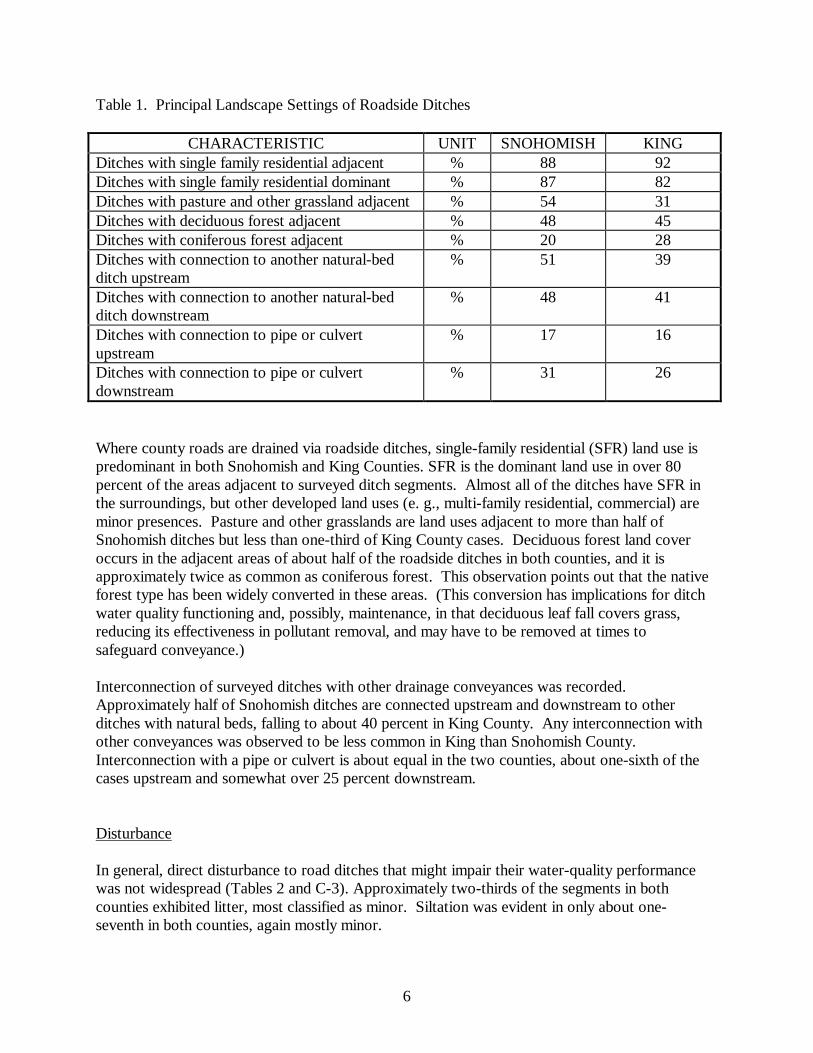
6
Table 1. Principal Landscape Settings of Roadside Ditches
CHARACTERISTIC UNIT SNOHOMISH KING Ditches with single family residential adjacent % 88 92 Ditches with single family residential dominant % 87 82 Ditches with pasture and other grassland adjacent % 54 31 Ditches with deciduous forest adjacent % 48 45 Ditches with coniferous forest adjacent % 20 28 Ditches with connection to another natural-bed ditch upstream
% 51 39
Ditches with connection to another natural-bed ditch downstream
% 48 41
Ditches with connection to pipe or culvert upstream
% 17 16
Ditches with connection to pipe or culvert downstream
% 31 26
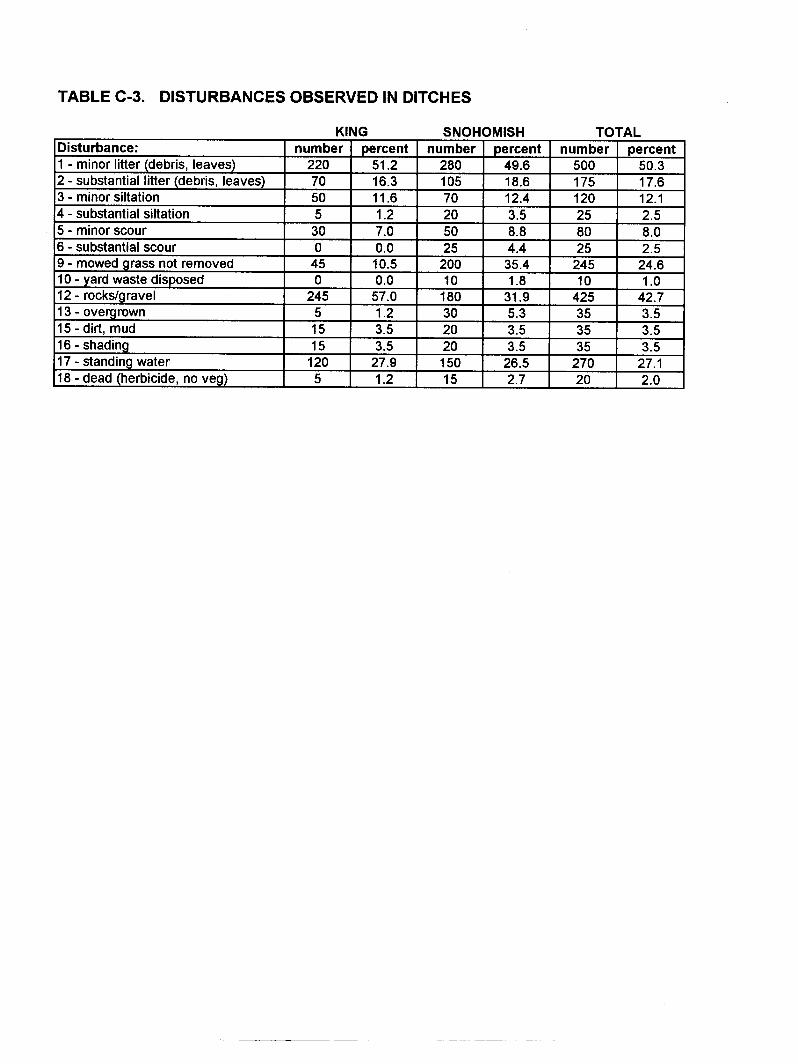
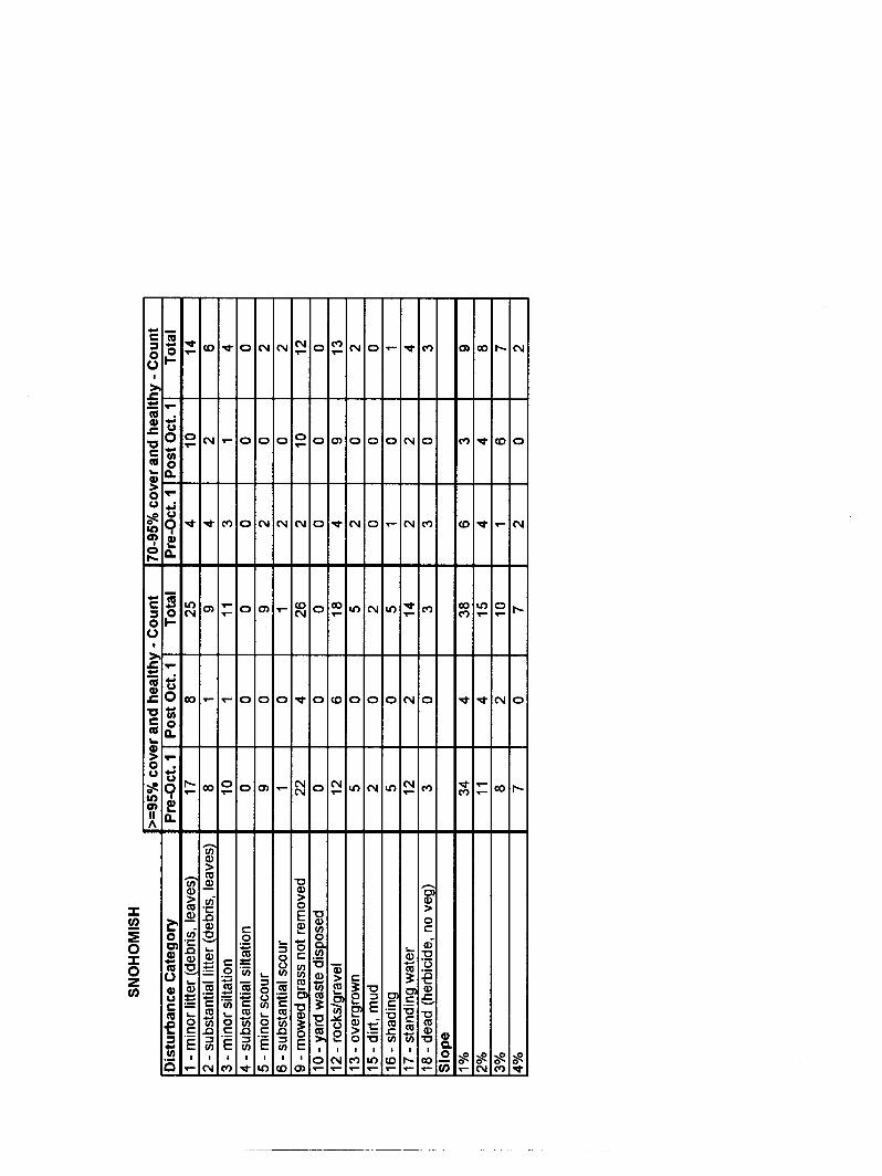
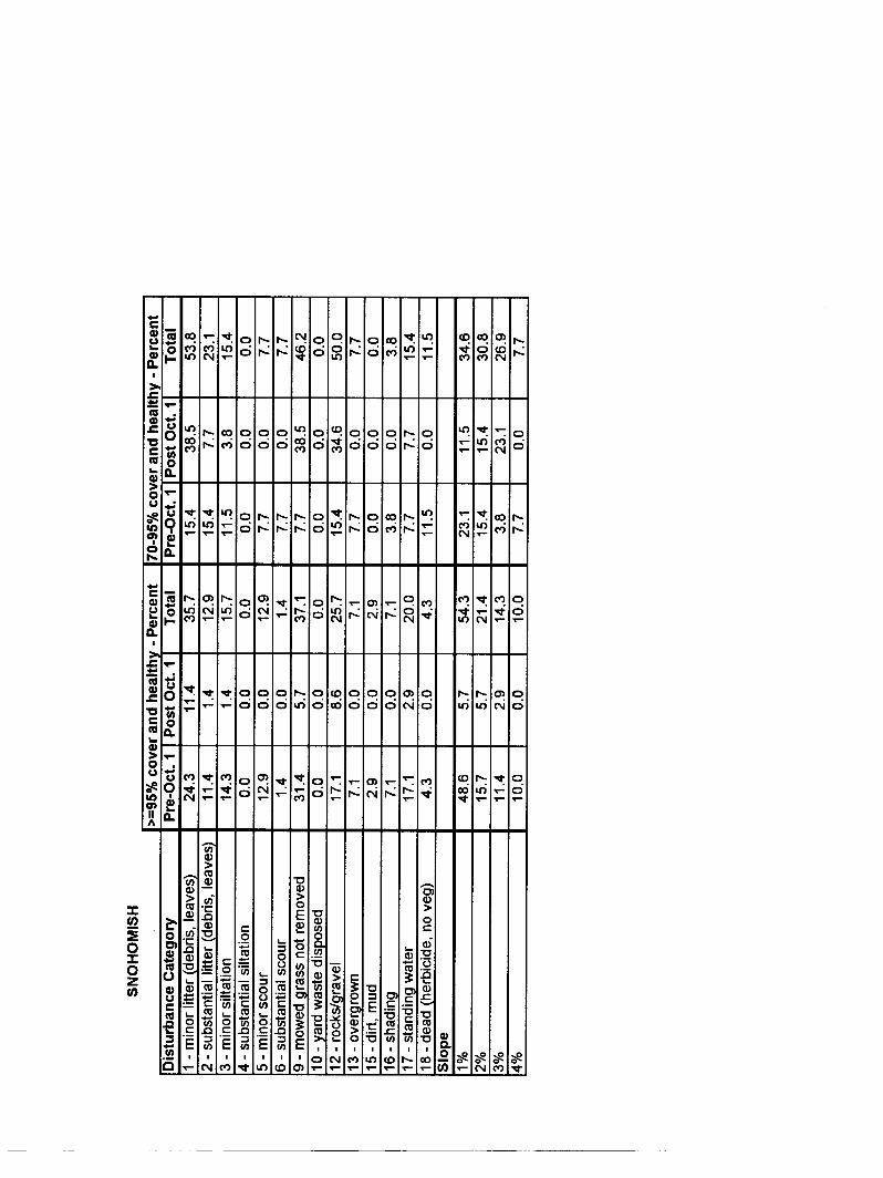
Where county roads are drained via roadside ditches, single-family residential (SFR) land use is predominant in both Snohomish and King Counties. SFR is the dominant land use in over 80 percent of the areas adjacent to surveyed ditch segments. Almost all of the ditches have SFR in the surroundings, but other developed land uses (e. g., multi-family residential, commercial) are minor presences. Pasture and other grasslands are land uses adjacent to more than half of Snohomish ditches but less than one-third of King County cases. Deciduous forest land cover occurs in the adjacent areas of about half of the roadside ditches in both counties, and it is approximately twice as common as coniferous forest. This observation points out that the native forest type has been widely converted in these areas. (This conversion has implications for ditch water quality functioning and, possibly, maintenance, in that deciduous leaf fall covers grass, reducing its effectiveness in pollutant removal, and may have to be removed at times to safeguard conveyance.) Interconnection of surveyed ditches with other drainage conveyances was recorded. Approximately half of Snohomish ditches are connected upstream and downstream to other ditches with natural beds, falling to about 40 percent in King County. Any interconnection with other conveyances was observed to be less common in King than Snohomish County. Interconnection with a pipe or culvert is about equal in the two counties, about one-sixth of the cases upstream and somewhat over 25 percent downstream. Disturbance In general, direct disturbance to road ditches that might impair their water-quality performance was not widespread (Tables 2 and C-3). Approximately two-thirds of the segments in both counties exhibited litter, most classified as minor. Siltation was evident in only about one-seventh in both counties, again mostly minor.

7
Table 2. Key Disturbance Survey Results
CHARACTERISTIC UNIT SNOHOMISH KING Minor litter % 50 51 Substantial litter % 19 16 Minor siltation % 12 12 Substantial siltation % 4 1 Rocks and gravel % 32 57 Mowed grass not removed % 35 11 Standing water % 27 28 Rocks and gravel, generally poor substrates for growing vegetation, are quite common in King County ditches, being observed at more than half of the segments. Snohomish ditches differed considerably in this respect, with rocks and gravel recorded in less than one-third of the observations. These differences are probably not a consequence of differing design or maintenance standards in the two counties, but of the natural soils. While these substrates are not a disturbance in the sense of a human-induced condition, they are potentially amenable to modification when ditches are built originally or rebuilt. Snohomish ditches exhibited cut grass in over one-third of the segments, about three times as common as in King County. It was evident during the surveys that some of the cuttings were from mowing by adjacent property owners, which often extended into the ditches. In other cases a continuous pattern of cuttings along a segment indicated mowing by road maintenance forces. Because no maintenance records could be found for either county, it was impossible to make a definite determination of the reason for the difference between the counties. King County’s practice (Matsuno, personal communication) is to user mowers equipped with flail-type cutting heads, which cut the vegetation finely and promote rapid decomposition. King County does not remove clippings. Therefore, their relative paucity in King County, at least visually, may be a reflection of the mulching mowing equipment. Standing water was observed occasionally in Snohomish County before October and more frequently later in both counties, for a total instance of just over one-quarter of all segments in each county. When the survey occurred during rain and the ditch was flowing, it was not always clear if standing water would persist long after rain ended. Also, segments that were dry during early surveys could develop standing water in the wet season. Therefore, some uncertainty on this factor exists. Nevertheless, the data on standing water were used in the analysis to see if there was a sign of its influence on vegetation cover and health. Poor growth in biofiltration swales has been attributed to standing water, which inhibits the grasses that are commonly planted and have low wet tolerance (Mazer 1998). Small problems observed in both counties included local scour of the ditches by high velocities, disposal of yard waste, shading, and herbicide applications. The minor extent of these factors suggests that they do not broadly limit vegetation growth for water-quality improvement.

8
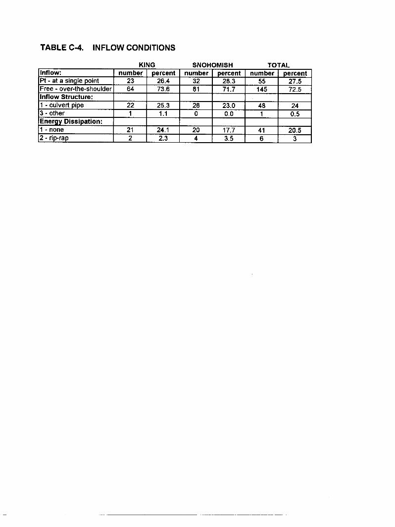
Geometric and Hydraulic Characteristics By far the most common mode by which flow enters is over-the-shoulder sheet flow with the upstream end at a topographic divide, the case in about three-fourths of the ditches surveyed in both counties (Tables 3 and C-4). In the remainder, flow enters at a single point and almost all via culvert. Of those with a point inflow discharge, very few have any form of energy dissipation or flow spreading. Table 3. Key Geometric and Hydraulic Survey Results
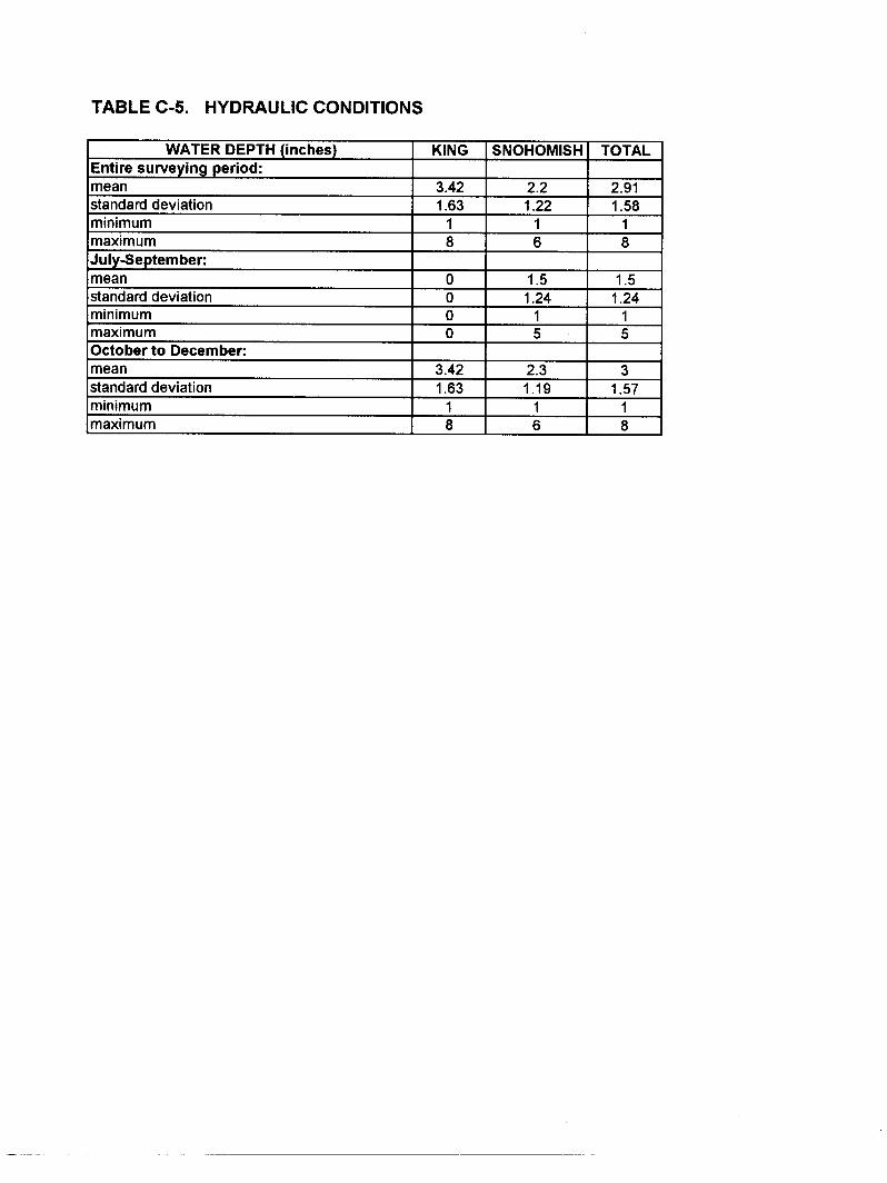
CHARACTERISTIC UNIT SNOHOMISH KING INFLOW CONDITIONS: Sheet flow % 72 74 Point discharge % 28 26 Culvert % 25 23 Energy dissipation (all rip-rap) % 2 4 GEOMETRY: U-shaped % 94 92 Mean top width ft 4.2 4.4 Mean bottom width ft 2.8 2.3 Mean ditch depth inches 14 16 Mean longitudinal slope % 1.9 1.7 Mean side slope % 50 47 HYDRAULICS: Dry in July-September %a 88 100 Dry in October-December %a 29 30 a These are percentages of the observations made in the periods of time given. Otherwise, percentages are expressed with respect to the total observations in the entire survey. The geometry of nearly all ditches was favorable for water-quality improvements. More than 90 percent of the transects surveyed in both counties are U-shaped and thus do not have the sharp corners of the trapezoidal and V-shapes, which are more subject to erosion. The dimensions of the ditches were highly variable compared to other measurements, as indicated by the size of the standard deviations relative to the means in Table C-1. Depths ranged up to 4 ft in Snohomish and 6 ft in King County. Longitudinal slopes were low to moderate in all cases, averaging between 1.5 and 2 percent with a maximum of 4 percent. These slopes help minimize flow velocities, which create elevated shear stresses on ditch beds and banks and cause erosion. However, such slight average slopes can more readily include minor irregularities that result in standing water, which harms water-intolerant vegetation. The relationship of slope and vegetation cover and condition is examined later under Vegetation Characteristics. Slope is usually dictated by terrain, with little flexibility
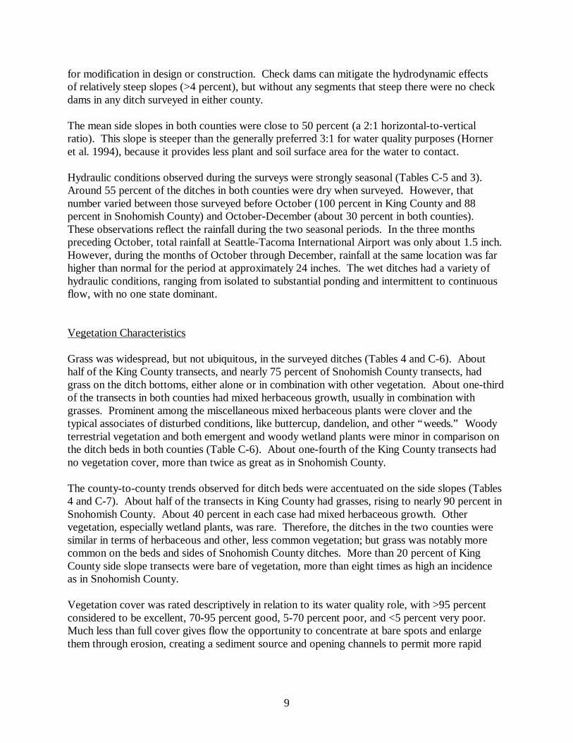
9
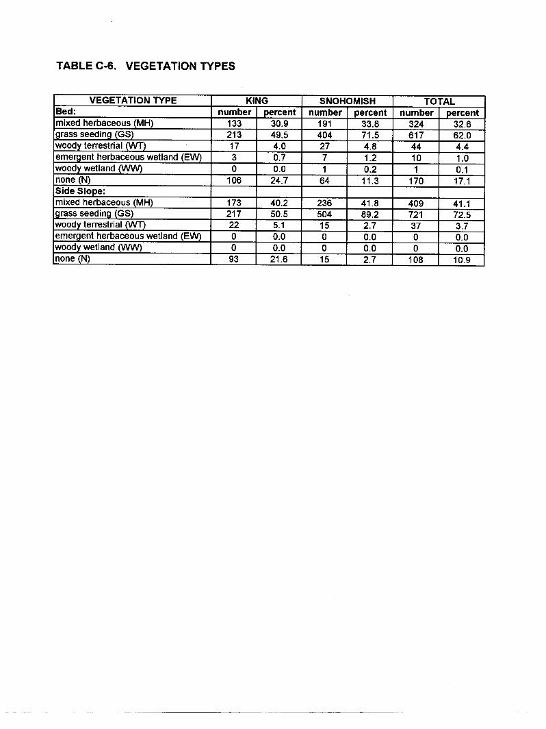
for modification in design or construction. Check dams can mitigate the hydrodynamic effects of relatively steep slopes (>4 percent), but without any segments that steep there were no check dams in any ditch surveyed in either county. The mean side slopes in both counties were close to 50 percent (a 2:1 horizontal-to-vertical ratio). This slope is steeper than the generally preferred 3:1 for water quality purposes (Horner et al. 1994), because it provides less plant and soil surface area for the water to contact. Hydraulic conditions observed during the surveys were strongly seasonal (Tables C-5 and 3). Around 55 percent of the ditches in both counties were dry when surveyed. However, that number varied between those surveyed before October (100 percent in King County and 88 percent in Snohomish County) and October-December (about 30 percent in both counties). These observations reflect the rainfall during the two seasonal periods. In the three months preceding October, total rainfall at Seattle-Tacoma International Airport was only about 1.5 inch. However, during the months of October through December, rainfall at the same location was far higher than normal for the period at approximately 24 inches. The wet ditches had a variety of hydraulic conditions, ranging from isolated to substantial ponding and intermittent to continuous flow, with no one state dominant. Vegetation Characteristics Grass was widespread, but not ubiquitous, in the surveyed ditches (Tables 4 and C-6). About half of the King County transects, and nearly 75 percent of Snohomish County transects, had grass on the ditch bottoms, either alone or in combination with other vegetation. About one-third of the transects in both counties had mixed herbaceous growth, usually in combination with grasses. Prominent among the miscellaneous mixed herbaceous plants were clover and the typical associates of disturbed conditions, like buttercup, dandelion, and other “weeds.” Woody terrestrial vegetation and both emergent and woody wetland plants were minor in comparison on the ditch beds in both counties (Table C-6). About one-fourth of the King County transects had no vegetation cover, more than twice as great as in Snohomish County. The county-to-county trends observed for ditch beds were accentuated on the side slopes (Tables 4 and C-7). About half of the transects in King County had grasses, rising to nearly 90 percent in Snohomish County. About 40 percent in each case had mixed herbaceous growth. Other vegetation, especially wetland plants, was rare. Therefore, the ditches in the two counties were similar in terms of herbaceous and other, less common vegetation; but grass was notably more common on the beds and sides of Snohomish County ditches. More than 20 percent of King County side slope transects were bare of vegetation, more than eight times as high an incidence as in Snohomish County. Vegetation cover was rated descriptively in relation to its water quality role, with >95 percent considered to be excellent, 70-95 percent good, 5-70 percent poor, and <5 percent very poor. Much less than full cover gives flow the opportunity to concentrate at bare spots and enlarge them through erosion, creating a sediment source and opening channels to permit more rapid

10
Table 4. Key Vegetation Survey Results
CHARACTERISTIC UNIT SNOHOMISH KING VEGETATION TYPE (BED): Grass % 72 50 Mixed herbaceous % 34 31 None % 11 25 VEGETATION TYPE (SIDE SLOPES): Grass % 89 51 Mixed herbaceous % 42 40 None % 3 22 VEGETATION COVER (BED): Excellent (>95) % 34 23 Good (70-95) % 22 15 Poor (5-70) % 21 23 Very poor (<5) % 24 39 VEGETATION COVER (SIDE SLOPES): Excellent (>95) % 54 18 Good (70-95) % 25 16 Poor (5-70) % 15 30 Very poor (<5) % 6 36 VEGETATION CONDITION (BED): Healthy % 21 23 Some drought damage % 21 22 Substantial drought damage % 15 10 Some damage from depositsa % 35 20 Substantial damage from depositsa % 25 23 VEGETATION CONDITION (SIDE SLOPES): Healthy % 30 25 Some drought damage % 49 28 Substantial drought damage % 6 16 Some damage from depositsa % 23 9 Substantial damage from depositsa % 5 13 VEGETATION HEIGHT AND STATUS (BED): Mean height inches 9.3 8.0 Mean status % erect 55 51 VEGETATION HEIGHT AND STATUS (SIDE SLOPES):
Mean height inches 6.3 12.1 Mean status % erect 82 65 a Primarily, presence of debris, vegetation clippings, or both.

11
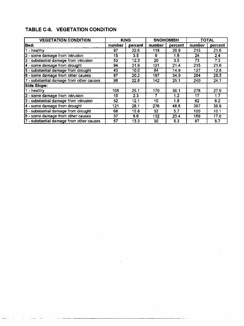
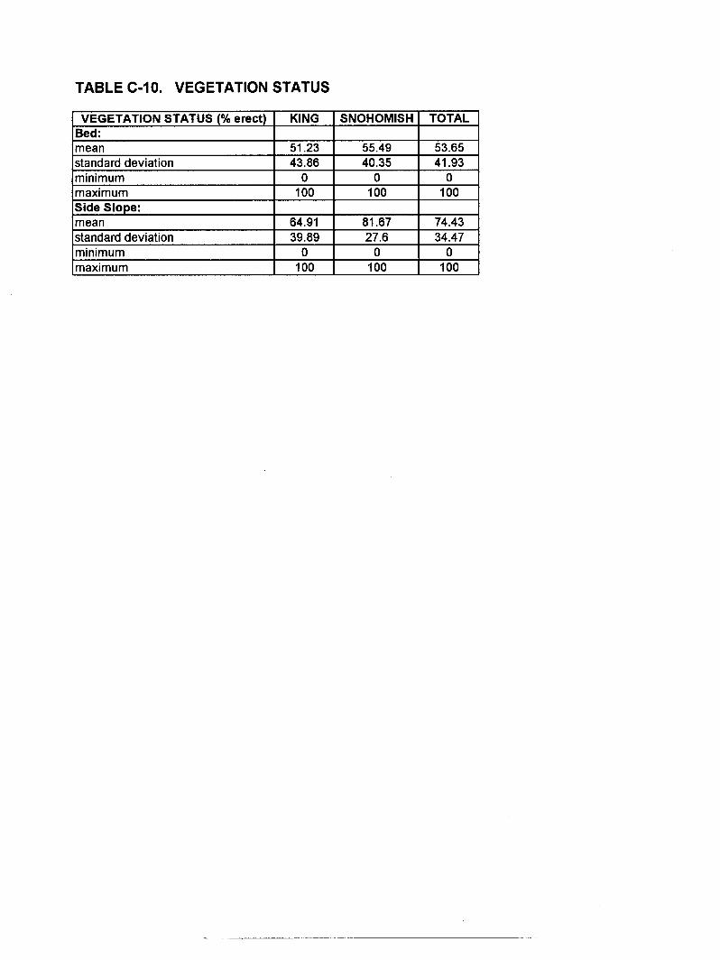
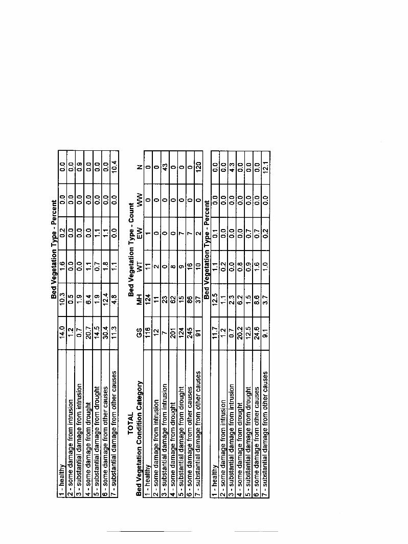
travel. Reduced hydraulic residence time and contact with vegetation decreases sedimentation and other pollutant removal mechanisms. Bed cover tended to concentrate at either the highest or lowest end of the scale. More than one-third of Snohomish County and greater than one-fifth of King County bed transects had above 95 percent cover. A majority in Snohomish County had >70 percent. On the other hand, almost one-fourth of the bed transects in Snohomish County and almost 40 percent in King County had little or no cover (<5 percent). Side slopes in Snohomish County were very well covered, with the majority having >95 percent and more than three-fourths above 70 percent cover. In contrast, little more than one-third of King County side slope transects had greater than 70 percent cover. On the other end of the scale, about one-third of the side slope transects in King County had no more than 5 percent cover, much more than the 6 percent of Snohomish County side slopes in this condition. It is evident in all these observations that there is a systematic difference in vegetation cover in the two counties, the possible reasons for which are explored below under Relationships Among Variables. The condition of the bed and side slope vegetation was not good, with only about 20 percent of the bed growth and not much more of the side slope growth rated “healthy” in each county (Tables 4 and C-8). Deposits of sediments, cut vegetation, litter, or a combination were the leading causes of reduced health on the ditch beds, with drought next. The importance of these two causes was reversed in the case of side slopes. Human intrusion (e.g., foot or vehicle traffic) was a relatively minor cause of decreased health in both counties (Table C-8). It should be noted that health could improve if the damaging agent is removed, and lack of full health on the survey occasion is not necessarily a sign that the vegetation will die and reduce runoff water quality. Nevertheless, these observations do indicate that roadside ditch vegetation is vulnerable to damage that lowers its potential for viability. Transects exhibiting both healthy and completely covering (>95 percent) vegetation constituted only 12 percent of the total in Snohomish and 11 percent in King County. The equivalent figures for 70-95 percent cover by healthy plants were 5 and 4 percent, respectively. These combined statistics must be raised if roadside ditches are to serve a significant role in improving road runoff water quality. Appendix Tables C-9 and C-10 have the data for vegetation heights and status (percent erect), respectively; and Table 4 summarizes. On average, total ditch depths averaged about 6 inches more than vegetation heights. Thus, where vegetation was present at all, much of the ditch cross sections were taken up by plants of a height sufficient to be a good runoff treatment medium. In addition, bed vegetation status on average was over 50 percent erect in both counties. Vegetation status increased on the side slopes to averages of 65 and over 80 percent erect in King and Snohomish Counties, respectively. Therefore, not only was vegetation, where it existed, quite high relative to likely flow depths; but the majority of it stood erect to serve a treatment function.
12
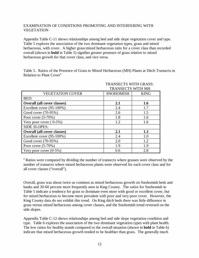
EXAMINATION OF CONDITIONS PROMOTING AND INTERFERING WITH VEGETATION Appendix Table C-11 shows relationships among bed and side slope vegetation cover and type. Table 5 explores the association of the two dominant vegetation types, grass and mixed herbaceous, with cover. A higher grass:mixed herbaceous ratio for a cover class than recorded overall (shown in bold in Table 5) signifies greater presence of grass relative to mixed herbaceous growth for that cover class, and vice versa. Table 5. Ratios of the Presence of Grass to Mixed Herbaceous (MH) Plants at Ditch Transects in Relation to Plant Covera
TRANSECTS WITH GRASS: TRANSECTS WITH MH
VEGETATION COVER SNOHOMISH KING BED: Overall (all cover classes) 2.1 1.6 Excellent cover (95-100%) 2.4 1.7 Good cover (70-95%) 2.6 1.5 Poor cover (5-70%) 1.8 1.6 Very poor cover ( 0-5%) 1.2 1.6 SIDE SLOPES: Overall (all cover classes) 2.1 1.3 Excellent cover (95-100%) 2.4 1.0 Good cover (70-95%) 2.0 1.2 Poor cover (5-70%) 1.9 1.9 Very poor cover (0-5%) 0.6 2.8
a Ratios were computed by dividing the number of transects where grasses were observed by the number of transects where mixed herbaceous plants were observed for each cover class and for all cover classes (“overall”). Overall, grass was about twice as common as mixed herbaceous growth on Snohomish beds and banks and 30-60 percent more frequently seen in King County. The ratios for Snohomish in Table 5 indicate a tendency for grass to dominate even more with good or excellent cover, but for mixed herbaceous to become more prevalent with poor and very poor cover. However, the King County data do not exhibit this trend. On King ditch beds there was little difference in grass versus mixed herbaceous among cover classes, and the Snohomish trend reversed on the side slopes. Appendix Table C-12 shows relationships among bed and side slope vegetation condition and type. Table 6 explores the association of the two dominant vegetation types with plant health. The low ratios for healthy stands compared to the overall situation (shown in bold in Table 6) indicate that mixed herbaceous growth tended to be healthier than grass. The generally much
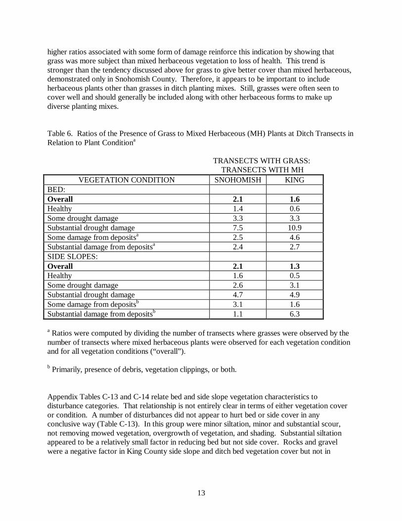
13
higher ratios associated with some form of damage reinforce this indication by showing that grass was more subject than mixed herbaceous vegetation to loss of health. This trend is stronger than the tendency discussed above for grass to give better cover than mixed herbaceous, demonstrated only in Snohomish County. Therefore, it appears to be important to include herbaceous plants other than grasses in ditch planting mixes. Still, grasses were often seen to cover well and should generally be included along with other herbaceous forms to make up diverse planting mixes. Table 6. Ratios of the Presence of Grass to Mixed Herbaceous (MH) Plants at Ditch Transects in Relation to Plant Conditiona
TRANSECTS WITH GRASS: TRANSECTS WITH MH
VEGETATION CONDITION SNOHOMISH KING BED: Overall 2.1 1.6 Healthy 1.4 0.6 Some drought damage 3.3 3.3 Substantial drought damage 7.5 10.9 Some damage from depositsa 2.5 4.6 Substantial damage from depositsa 2.4 2.7 SIDE SLOPES: Overall 2.1 1.3 Healthy 1.6 0.5 Some drought damage 2.6 3.1 Substantial drought damage 4.7 4.9 Some damage from depositsb 3.1 1.6 Substantial damage from depositsb 1.1 6.3
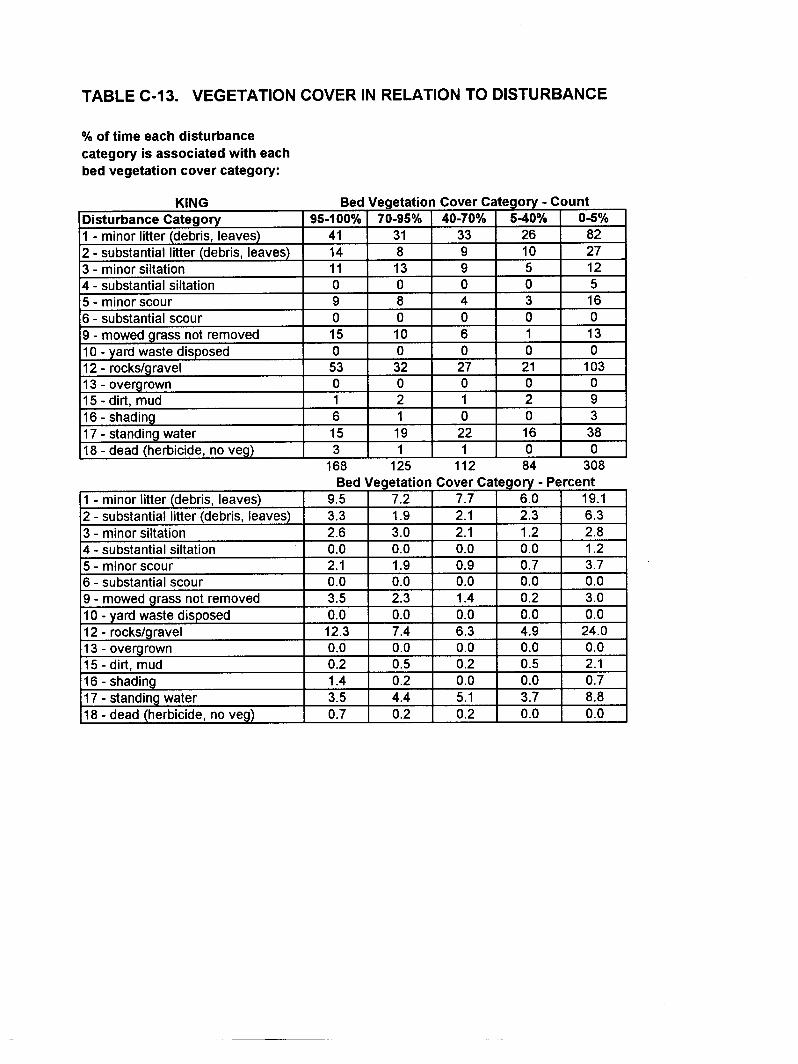
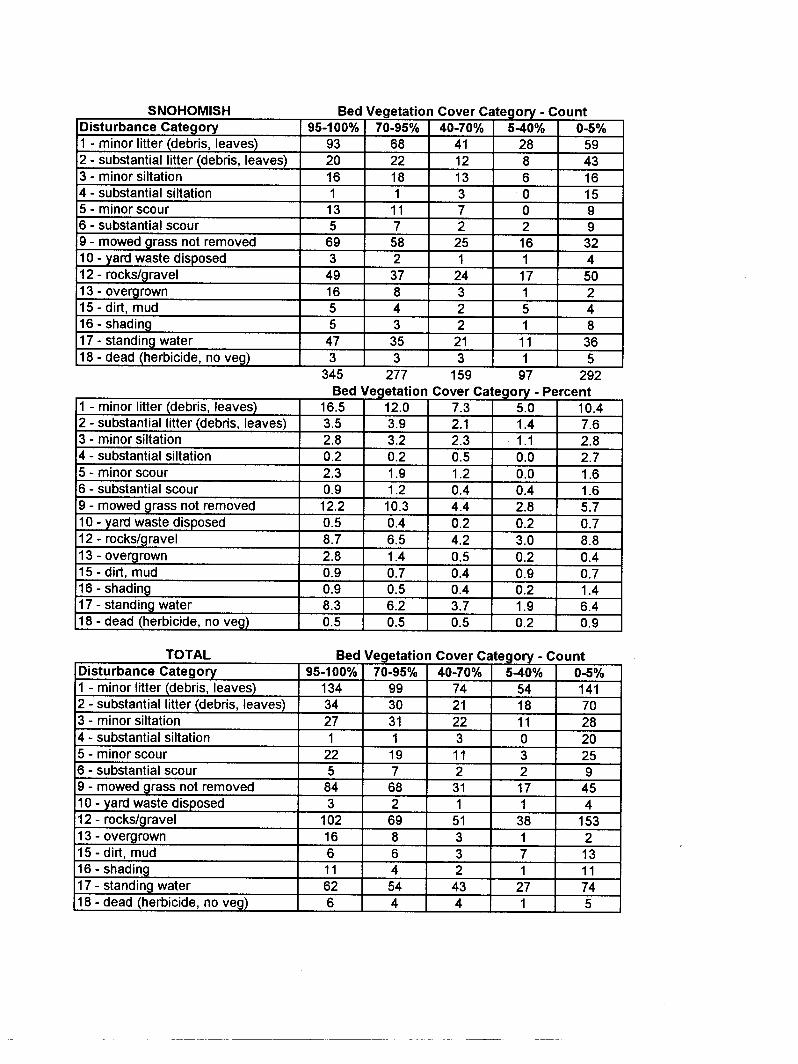
a Ratios were computed by dividing the number of transects where grasses were observed by the number of transects where mixed herbaceous plants were observed for each vegetation condition and for all vegetation conditions (“overall”). b Primarily, presence of debris, vegetation clippings, or both. Appendix Tables C-13 and C-14 relate bed and side slope vegetation characteristics to disturbance categories. That relationship is not entirely clear in terms of either vegetation cover or condition. A number of disturbances did not appear to hurt bed or side cover in any conclusive way (Table C-13). In this group were minor siltation, minor and substantial scour, not removing mowed vegetation, overgrowth of vegetation, and shading. Substantial siltation appeared to be a relatively small factor in reducing bed but not side cover. Rocks and gravel were a negative factor in King County side slope and ditch bed vegetation cover but not in
14
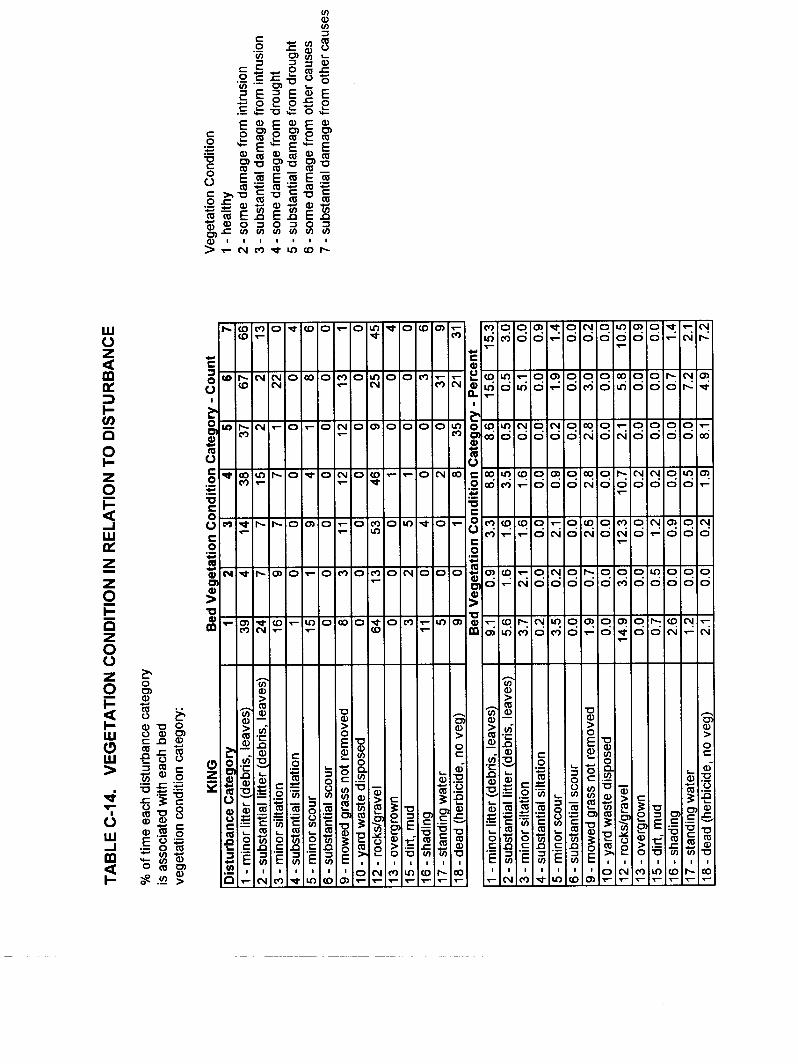
Snohomish County. Similarly, standing water was more weakly associated with low cover on King County beds and banks but not in Snohomish ditches. Comparison of disturbance and vegetation condition showed few clear signs of cause and effect (Table C-14). Minor litter reports were associated with some plant damage on the ditch beds in both counties. However, substantial litter was not, pointing out that the minor litter-plant damage association may be an artifact. Appendix Table C-15 was prepared to attempt to identify factors associated with both relatively full and healthy vegetation cover on ditch beds. Table 7 expresses the presence of various factors when vegetation cover was good (70-95 percent) or excellent (>95 percent) and healthy relative to the occurrence of these factors overall. If the tabulated ratio is greater than 1.0, it can be concluded that the associated factor was not harmful to good growth. If the ratio is less than 1.0, the associated factor may be implicated in reducing cover, health, or both; although the existence of a cause-effect relationship cannot necessarily be concluded. It may be seen in Table 7 that few factors produced ratios uniformly <1.0 or >1.0 for both counties and both levels of vegetation cover. The strongest factor associated with good growth is the presence of mixed herbaceous forms in the vegetation mix (ratio always >>1.0), strengthening the demonstration in Table 6 of the better health of soft-stem plants that are not grasses. Grasses were about equally represented in the best vegetation communities in Snohomish County as overall (ratios = 1.0), but in King County were less prevalent in the best communities than in general. Most consistently inhibitory to well covering, healthy plants (ratios always <1.0) were substantial siltation, disposal of yard waste, and standing water. The finding for siltation and yard waste fits with the earlier observation that vegetation on ditch beds was most often damaged by something deposited on it. The strength of this conclusion is somewhat mitigated by not having many reports in the overall database of substantial siltation and yard waste. In contrast, there were substantially more instances of standing water observed in the full survey. Longitudinal slope of 1 percent was more regularly associated with good growth than 3 percent or, especially, 2 percent (ratios always <1.0). This result overturns the preconception that 2-3 percent slopes are ideal. This idea was based on the theory that 2-3 percent slope promotes better drainage, causing less tendency toward standing water than 1 percent slopes, while still not being steep enough to elevate velocity much and increase erosion. There is no mechanistic reason why 3 percent should be more favorable than 2 percent, and no real difference in vegetation may exist between the two slopes. The effect of 4 percent slope was inconclusive; but few ditches sloped that much, especially in King County. Minor litter was generally a factor in poorer cover and health together, but substantial litter was not. The same conundrum was observed in considering vegetation health alone. This second observation further suggests that minor litter is not a cause of poor growth, and the connection may be an artifact.
15
Table 7. Ratios of Transects with Good or Excellent Cover of Healthy Bed Vegetation to Transects Overall in the Presence of Various Factorsa
TRANSECTS HAVING GIVEN COVER:OVERALL TRANSECTS
IN CONJUNCTION WITH GIVEN FACTOR
FACTOR
>95% HEALTHY
COVER (SC)
70-95% HEALTHY
COVER (SC)
>95% HEALTHY
COVER (KC)
70-95% HEALTHY
COVER (KC) DISTURBANCE: Minor litter 0.7 1.1 0.7 0.6 Substantial litter 0.7 1.2 1.8 1.0 Minor siltation 1.3 1.2 1.4 1.4 Substantial siltation 0b 0b 0b 0b Minor scour 1.5 0.9 2.4 3.8 Substantial scour 0.3 1.8 0 0 Mowed grass not removed 1.0 1.3 1.0 0.5 Yard waste disposed 0c 0c 0c 0c Rocks/gravel 0.8 1.6 1.2 1.0 Vegetation overgrown 1.3 1.5 0 0 Dirt, mud 0.8 0 0.6 3.0 Shading 2.0 1.1 3.6 1.5 Standing water 0.8 0.6 0.3 0.8 Herbicide 1.6 4.3 5.3 4.4 LONGITUDINAL SLOPE: 1% 1.5 0.9 1.5 1.4 2% 0.5 0.8 0.7 0.9 3% 0.8 1.4 0.4 0 4% 2.0 1.5 0 0 VEGETATION PRESENT: Grass 1.0 1.0 0.9 0.6 Mixed herbaceous 1.4 1.6 2.1 2.6 a Ratios were computed by dividing percentages for cover class in Table C-15 by percentages reported for the same factor in Table C-3 (for disturbances), Table C-1 (for slopes), or Table C-6 (for vegetation). SC— Snohomish County; KC— King County b Only 3.5 percent of the segments in Snohomish and 1.2 percent in King County were observed to have substantial siltation. c Only 1.8 percent of the segments in Snohomish and no segments in King County were observed to have yard waste disposed.

16
Several disturbances were eliminated, quite conclusively, as not being factors in reducing plant viability: minor siltation, minor scour, shading, and herbicides. Two others, not removing mowed grass and rocks and gravel, can almost as conclusively be disregarded as negative factors. There was a suggestion in the earlier examination of cover alone relative to disturbance that rocks and gravel were limiting. However, that relationship did not hold up in this more quantitative assessment of the role of disturbances with respect to cover and health together. Other disturbances in Table 7 were not conclusively demonstrated to be negative toward the development of full, healthy vegetation cover. This analysis leaves unanswered why King County ditches were substantially less vegetated than Snohomish County’s. The principal factors seen to be associated with relatively full, healthy cover were presence of herbaceous species besides grasses and avoidance of standing water, substantial siltation, and yard waste. Tables 2 and 4 show that King County ditches did not have notably unfavorable conditions for any of these factors relative to Snohomish. The earlier suspicion that more rocks and gravel in King County ditches might be the answer was not borne out in the final analysis. The reason for the poorer growth thus remains unknown. It may lie in soil conditions that were not investigated (e.g., greater compaction, lower nutrition) or less effort in original vegetation establishment. Records do not exist to substantiate or refute these possibilities, but additional field survey and interviewing of personnel who have been involved in ditch construction in the two counties could shed light. Such an effort is beyond the scope of this study but could be pursued in future work.

17
SUMMARY AND RECOMMENDATIONS FACTORS BENEFICIAL TO WATER QUALITY Roadside ditches in Snohomish and King Counties have a number of assets that tend to promote functioning to reduce pollutants in stormwater runoff and reduce the tendency of the ditch itself to become a pollutant source. These assets include:
? ? U-shaped cross section, which tends to spread flow and reduce velocity, thus helping to limit erosion;
? ? Gradual sloping along the direction of flow, which moderates velocity and avoids
standing water;
? ? Minimal erosion that scours vegetation along with increasing sediment transport;
? ? Minimal shading that limits vegetation growth;
? ? Little vegetation mortality through herbicide applications;
? ? Minimal sediment deposition on vegetation; and
? ? Vegetation types, generally those most beneficial to pollutant removal. Fine, close growing vegetation, either grasses or other herbaceous forms, made up most of the plant communities. This type of growth, with its many stems and high surface area, promotes pollutant reduction through filtering, organic decomposition by organisms in surface biofilms, and plant uptake, especially of nutrients. Where vegetation grew, it was generally both relatively high and erect; both of these characteristics enhance the operation of pollutant removal mechanisms. Fine-stemmed plants other than grasses are instrumental in forming both relatively complete and healthy plant cover. Prominent among miscellaneous herbaceous vegetation was clover, which can grow relatively well in nutrient-deprived soils because of its ability to fix nitrogen from the atmosphere. Beyond its ability to overcome nitrogen deficiency, clover is desirable in the mix because of its relatively fine, close-growing nature and low-growing stature, making mowing generally unnecessary. Some other forms among the mixed herbaceous group are weedy species that have competitive advantages in disturbed conditions. While botanists and landscape personnel often consider these species to be undesirable, these results show their presence to be instrumental, if the objective is to have full, healthy cover for filtering runoff and avoiding erosion from bare areas in the difficult growth environment of a roadside ditch. Of course, more desirable species could
18
potentially be fostered, if conditions were established to meet their needs. This subject is a potential area for further work. FACTORS DETRIMENTAL TO WATER QUALITY Despite the existence of a number of factors favorable to water quality, other conditions retard the ability of ditches to remove pollutants and raise their potential to be pollutant sources instead of sinks. These conditions include:
? ? Widespread examples of little or no vegetation or unhealthy vegetation (The combination of full or nearly full cover with healthy growth was quite rare in both counties.);
? ? Standing water, which is negatively associated with good or excellent cover of healthy
plants; ? ? Substantial siltation and yard waste, which were relatively rare but damaging to
vegetation cover where present;
? ? Mowing within or near ditches and then leaving grass clippings, quite common in Snohomish County, which presumably releases nutrients that stimulate eutrophication in receiving waters;
? ? Steep side slopes, which were commonly steeper than the recommended maximum of 2:1
for the best performance in treating runoff. CONSIDERATIONS FOR MANAGEMENT As a general principle, agency personnel should consider how they can best sustain the conditions found to benefit water quality and alleviate those discovered to be detrimental. Future design and construction should recognize these same issues and incorporate them initially. Applying some of the survey’s lessons is simply a matter of continuing practices that are beneficial. In other circumstances, however, some modification is needed for the ditch to be a positive water quality feature and will require more extensive efforts in design, construction, and/or maintenance. These more substantial changes will have organizational and budget impacts. Specifically addressing organizational adjustments and costs is beyond the scope of this report but will need to be considered by road agencies that adopt its recommendations. Ditch geometry generally presented no water quality drawbacks. Most ditches had a favorable shape (U-shaped), a design and construction practice that should be continued. Longitudinal slopes are generally acceptable, although those lying outside of the range of 1-4 percent require special treatment. Should ditches be built in more steeply sloping terrain, check dams should be designed and installed. Likewise, if existing ditches sloping more than 4 percent are found to be eroding, they should be retrofitted with check dams. On low-gradient reaches,

19
special care is needed to avoid reverse slopes or localized depressions, because standing water is otherwise likely and will inhibit plant growth. In persistently wet areas, planting wetland herbaceous species is probably the most cost-effective strategy. From the water quality standpoint, ditch side slopes should generally not be steeper than 2:1 and preferably more gradual. Although extensive sidewall erosion was not common in the ditches surveyed, in general erosion is frequently associated with steep channel sides. There should be every attempt in future projects to limit roadside ditch side slopes to a 2:1 maximum steepness. Of the deposits that inhibit vegetation, substantial siltation and yard waste appear to have the largest effect. Maintenance forces should be made aware of this problem and be on the lookout for it in the field. They should be prepared to remove heavy deposits harming plants and help them to reestablish, particularly when getting water quality benefits from the ditch is an objective. The appropriate county agency should also give attention to control of sediments at their source. Construction sites are the most likely sources of sediments, and they should be controlled with adequate erosion and sediment control practices to prevent damage to water quality and the public drainage system. Repeated dumping of yard waste should be met by signs discouraging the practice and public education as needed to stop it. The consensus among water quality professionals is that mowing vegetation at the end of the growing season prevents the release of nutrients that cause eutrophication when plants die back and tissue decays. That position is under study in other work proceeding under this project, and a final recommendation on mowing for this purpose is being withheld until that work finishes. There is no mowing equipment on the market that is suitable for the scale of mowing performed by road agencies and picks up cuttings (Scalf, personal communication). At a smaller scale, residents who mow roadside ditches near their homes should be educated, and if necessary required, to gather and dispose of their clippings through a yard waste program or compost the cuttings themselves. The greatest effort should be in ensuring good vegetation establishment after initial construction or renovation of failing vegetation in existing ditches. Mixed herbaceous growth, with grasses and other species, gives a community the greatest chance for success. New ditches intended to provide a water quality benefit should definitely be planted with such a mix. Preparation of an appropriate seed bed must precede planting. Existing ditches to be upgraded for water quality objectives will need the same approach where vegetation is not growing well. Additional work is needed to prescribe the best planting mix and associated conditions, although the field and greenhouse study by Mazer (1999) suggested that the best grasses for relatively well drained settings are Festuca arundinacea (tall fescue) and Agrostis alba var. stolinifera. In the meantime, a qualified botanist or landscape professional should advise road agencies on the plants to choose and preparations to make before both new construction and vegetation rehabilitation. Leif (personal communication) suggested the following attributes be considered in identifying optimum vegetation species for roadside ditches:
? ? Ability to provide the cover needed to remove pollutants effectively;

20
? ? Tolerance of anticipated conditions, especially the range of hydrologic conditions
(inundation and drought) that often typify roadside ditches;
? ? Good root mass, to minimize ditch erosion;
? ? Low mature plant height, to avoid or reduce the frequency of mowing and still maintain motorist sight distance and ditch hydraulic capacity;
Implementing maintenance recommendations will probably require alteration of how ditches are viewed by road agency staff, as well as some change in practices and marginally increased commitment from maintenance forces. Management should begin by encouraging the perception that ditches can be an asset in meeting their agency’s environmental obligations. The principal need will be for approximately quarterly visual inspections of the ditch network where water quality benefits are targeted to note conditions that detract from those benefits, and to follow upwith necessary actions. These inspections should look for areas with little or no vegetation cover, unhealthy vegetation, standing water, and deposits of various kinds. They could be conducted in a drive-by mode for efficiency. The main increased commitment would arise in the follow up. Along with these changes would come needs for employee training and management oversight.
SUMMARY OF MANAGEMENT RECOMMENDATIONS Applicability of Recommendations These recommendations presume that goals include gaining runoff treatment benefits and avoiding pollutant sources in roadside ditches, while still adequately maintaining the original conveyance function. Where conveyance sufficient for safe driving conditions and protection of the road bed cannot be maintained in conjunction with water quality gains, these recommendations do not apply. These cases will probably be where the conveyance design flow rate cannot pass through dense vegetation without overtopping the ditch. Hydraulic analysis will be necessary to distinguish these cases from safe applications. Water quality goals would pertain in any case where the ditch is in a drainage path to a natural receiving water, the situation in most of Snohomish and King Counties. They would be especially prominent goals where discharge to a natural water body, especially a small lake or stream, is immediate, with no intermediate opportunity to mitigate runoff pollutants. Another case where these goals would have high priority is with a risk to groundwater quality, generally where road runoff can rapidly infiltrate coarse soils to a water table relatively near the surface. Where the discharge to a surface or sub-surface receiving water is less immediate but still occurs at some point, these goals would still be important, because mitigation opportunities are limited in engineered drainage systems. These goals would not have to be pursued where ditches are in closed systems, without surface discharge, and are relatively isolated from groundwater.

21
Maintenance Recommendations 1. Make approximately quarterly drive-by inspections of ditches intended to provide water
quality benefits to determine the need for corrective maintenance. Take note especially of bare areas; unhealthy vegetation; standing water; deposits of sediments, yard waste, or litter that are harming plant growth; and vegetation clippings.
2. Repair areas with poor and unhealthy vegetation by preparing an appropriate seed bed
and planting a mix of herbaceous species including grasses and other forms. Obtain a qualified botanist’s or landscape professional’s advice to select the species and specify the preparation. Previous work suggests that Festuca arundinacea (tall fescue) and Agrostis alba var. stolinifera would be successful grasses in relatively well drained ditches.
3. Where persistent standing water is harming vegetation, investigate the reason for the lack
of drainage, considering the following possible causes and solutions:
? ? Local depressions— smooth the bed surface to eliminate and then reestablish vegetation according to Recommendation 1;
? ? Base flow from a surface or subsurface source, or adverse slope that cannot be
corrected without major reconstruction— with the help of a qualified wetland botanist or landscape professional, determine if conditions will support wetland herbaceous plants and establish them if the determination is positive.
4. Remove deposits of sediments, yard waste, litter, and any other solids that are
suppressing plant growth; and reestablish vegetation according to Recommendation 1. Correct the root problem through:
? ? Sediments— with the help of the agency having charge of grading permit
oversight, have erosion and sediment controls installed to prevent soil loss from construction sites;
? ? Yard waste, litter— place “no dumping” signs, distribute flyers discouraging
dumping, and consider other public education measures. 5. If residents mow roadside ditches and leave substantial clippings, educate, and if
necessary require, them to remove and dispose of cuttings in a manner that does not release nutrients to receiving waters.
6. Remove large woody growth before it shades or crowds out finer growth that makes a
better treatment medium.
7. Ditches on slopes steeper than 4 percent, or that are eroding because of high water velocities, should be retrofitted with check dams to prevent erosion in the channel, add energy dissipaters if erosion is occurring at a point inlet.

22
8. Provide the needed employee training and management oversight to implement the
foregoing recommendations effectively. Training, which would probably best be given in “tailgate” or on-the-job sessions, should explain the benefits of new procedures, as well as teach techniques.
Design and Construction Recommendations
1. In future roadside ditch site location and design, continue to use U-shaped ditch profiles
and, if possible, to avoid building on steep slopes.
2. Be aware of the potential for erosive velocities to develop if ditches will be placed on slopes steeper than 4 percent, and take steps to avoid high velocities. Erosion at a steeply sloping point inlet can be avoided with an energy dissipater (e.g., rip-rap pad) and, within the channel, by using check dams (see biofiltration guidance in the King County Surface Water Design Manual for specifics).
3. Make side slopes no steeper than 3:1 (horizontal:vertical), if possible, and never steeper
than 2:1.
4. Attempt to avoid standing water by careful grading to avoid depressions in ditch beds and compaction of the soil. Finish construction by tilling if the soil does get compacted.
5. In ditches without a surface or subsurface base flow source, plant a mix of herbaceous
species including grasses and other forms, after preparing an appropriate seed bed. Obtain a qualified botanist’s or landscape professional’s advice to select the species and specify the preparation.
6. In ditches having a surface or subsurface base flow source, determine if conditions will
support wetland herbaceous plants, and establish them if the determination is positive, using the help of a qualified wetland botanist or landscape professional.
RECOMMENDATIONS FOR FUTURE WORK Approach While the present study identified several factors favorable and detrimental to water quality and produced associated design, construction, and maintenance recommendations, some additional work would solidify the knowledge of how roadside ditches affect water quality and permit refining recommendations. Suggested future work is divided into additional survey, in which the instrument devised for this work would be refined for more pointed investigations, and experimental work, in which quantitative measurements would be taken according to statistically based experimental designs. The most useful next step would probably be to perform the first of the two suggested experiments, which involves establishing the best planting mixes.

23
Additional Survey Work
1. Perform a geographic analysis of ditches with highly favorable and unfavorable water quality conditions to determine if these conditions tend concentrate by location. This knowledge would help to pinpoint especially favorable and unfavorable conditions, suggest what to seek or avoid in future construction, and focus maintenance and rehabilitation.
2. Investigate more closely the vegetation species present and the various influencing
conditions where cover is good or excellent and plants are healthy. Determine more exactly the factor or combination of factors responsible for plant conditions favorable to water quality.
3. Investigate more closely the effects of disturbances, especially standing water and
deposits of various solids, on vegetation cover and health. Quantify the extent of disturbances and plant cover and health in the immediate vicinity (this survey covered deposits on a segment-wide basis and vegetation at discrete transects along the segment).
4. Survey a set of ditches during at least two periods in the year, in particular summer (when
vegetation identifications can best be made) and winter (when the benefits or problems to water quality are most pronounced). Determine the effects of seasonal circumstances on conclusions (e.g., Are the effects of summer drought relieved by rains? Are fall and winter conditions like leaf fall and greater sediment transport related to decline in vegetation cover, health, and/or status? Does standing water in the growing season have a particularly negative effect; how about the greater extent and persistence of standing water in the wet season?).
5. Develop a stronger relationship between vegetation cover and health and longitudinal
slope. Test the hypothesis that there is no significant difference in vegetation at slopes up to 3 or 4 percent. Use an accurate clinometer to measure slope in order to investigate the effects of differences in this range.
6. Determine the specific causes of observed standing water; assess their effects on
vegetation and the extent to which they can be alleviated. Experimental Work
1. Establish the best herbaceous planting mixes with field trials of alternative choices evaluated according to their ability to produce reliable, full, healthy cover in representative roadside ditch service conditions. Attempt to identify herbaceous plants that produce good cover and are also not weedy species that spread aggressively. Perform trials in spots ranging from relatively well draining to poorly draining without any surface or subsurface base flow source, as well as in places with the potential for hosting wetland plants.

24
2. Perform a monitoring program to demonstrate directly the effects on water quality of selected conditions (e.g., good versus poor vegetation, using a conventional versus a mulching mower, removing versus not removing clippings).

25
REFERENCES Koon, J. 1995. Evaluation of Water Quality Ponds and Swales in the Issaquah/East Lake
Sammamish Basins. King County Surface Water Management Division, Seattle, WA. Horner, R. R., J. J. Skupien, E. H. Livingston, and H. E. Shaver. 1994. Fundamentals of Urban
Runoff Management: Technical and Institutional Issues. Terrene Institute, Washington, D. C.
Leif, W., Snohomish County Surface Water Management Division, Everett, WA, personal
communication. Little, L. M., R. R. Horner, and B. W. Mar. 1983. Assessment of Pollutant Loadings and
Concentrations in Highway Stormwater Runoff, WA-RD-39.17. Washington State Department of Transportation, Olympia, WA.
Mar, B. W., R. R. Horner, J. F. Ferguson, D. E. Spyridakis, and E. B. Welch. 1982. Summary—
Washington State Highway Runoff Water Quality Study, 1977-1982, WA-RD-39.16. Washington State Department of Transportation, Olympia, WA.
Matsuno, R., King County Road Maintenance Section, Seattle, WA, personal communication. Mazer, G. 1998. Environmental Limitations to Vegetation Establishment and Growth in
Vegetated Stormwater Biofilters. Center for Urban Water Resources Management, University of Washington, Seattle, WA.
Mazer, G. 1999. Environmental Limitations to Vegetation Establishment and Growth in
Vegetated Stormwater Biofilters. M.S. thesis, Center for Urban Horticulture, University of Washington, Seattle, WA.
Municipality of Metropolitan Seattle. 1992. Biofiltration Swale Performance,
Recommendations, and Design Considerations. Municipality of Metropolitan Seattle, Seattle, WA.
Scalf, R., Snohomish County Road Maintenance, Everett, WA, personal communication. Schultz, D. 1998. Current Status of Vegetation Management in Roadside Ditches and
Stormwater Management Facilities: Implications for Stormwater Quality. Center for Urban Water Resources Management, University of Washington, Seattle, WA.
Wang, T. S. 1981. Transport, Deposition, and Control of Heavy Metals in Highway Runoff. M.
S. C. E. Thesis, Department of Civil Engineering, University of Washington, Seattle, WA.

26
Wang, T. S., D. E. Spyridakis, R. R. Horner, and B. W. Mar. 1982. Transport, Deposition, and Control of Heavy Metals in Highway Runoff, WA-RD-39.10. Washington State Department of Transportation, Olympia, WA.