ctbuh.org/papers title...related to energy, comfort, daylight and climate should be considered...
TRANSCRIPT

Title: High-Rise Urban Form and Environmental Performance - An Overview onIntegrated Approaches to Urban Design
Author: Feng Yang, College of Architecture and Urban Planning, Tongji University
Subject: Sustainability/Green/Energy
Keywords: MicroclimateSustainability
Publication Date: 2016
Original Publication: International Journal of High-Rise Buildings Volume 5 Number 2
Paper Type: 1. Book chapter/Part chapter2. Journal paper3. Conference proceeding4. Unpublished conference paper5. Magazine article6. Unpublished
© Council on Tall Buildings and Urban Habitat / Feng Yang
ctbuh.org/papers

International Journal of High-Rise Buildings
June 2016, Vol 5, No 2, 87-94International Journal of
High-Rise Buildingswww.ctbuh-korea.org/ijhrb/index.php
High-Rise Urban Form and Environmental Performance
- An Overview on Integrated Approaches to Urban Design
for a Sustainable High-Rise Urban Future
Feng Yang1,2,†
1College of Architecture and Urban Planning, Tongji University2Key Laboratory of Ecology and Energy-Saving Study of Dense Habitat, Tongji University, Ministry of Education, China
Abstract
High-rise as a building typology is gaining popularity in Asian mega-cities, due to its advantages in increasing volumetricdensity with limited land resources. Numerous factors contribute to the formation of high-rise urban form, from economicaland institutional, environmental to socio-political. Environmental concerns over the impact of rapid urbanization in developingeconomies demand new thought on the link between urban environment and urban form. Outdoor and indoor climate,pedestrian comfort, and building energy consumption are all related to and impacted by urban form and building morphology.There are many studies and practices on designing individual “green” high-rise buildings, but far fewer studies on designinghigh-rise building clusters from the perspective of environmental performance optimization.. This paper focuses on theenvironmental perspective, and its correlation with the evolution of the high-rise urban form. Previous studies on urbanmorphology in terms of environmental and energy performance are reviewed. Studies on “parameterizing” urban morphologyto estimate its environmental performance are reviewed, and the possible urban design implications of the study aredemonstrated in by the author, by way of a microclimate map of the iconic Shanghai Xiao Lujiazui CBD. The study formulatesthe best-practice design guidelines for creating walkable and comfortable outdoor space in a high-rise urban setting, includingproper sizing of street blocks and building footprint, provision of shading, and facilitating urban ventilation.
Keywords: Microclimate, Outdoor thermal comfort, Pedestrian friendly, Environmental sustainability, High rise, Urban mor-phology
1. Introduction: High-Rise and Environ- mental Sustainability
Sustainability is undoubtedly one of the most important
issues today, but the meaning is often paradoxical and it
can be difficult to measure the degree of sustainability
due to its all-embracing definition. It is widely accepted
that there are three pillars of sustainability, i.e., economic,
social and environmental. The interest of this article is on
the environmental aspect. Generally, the high-rise build-
ing typology is not usually considered environmentally
sustainable, due to its intensive use of energy, material
and other resources during its whole life cycle, although
it has merits, such as saving land resources and transpor-
tation costs [1]. When assessing the environmental sus-
tainability of buildings, often a target of “doing less harm”
instead of “doing more good” is set, and it certainly app-
lies to high-rise buildings. A number of tall buildings fea-
tured with sustainable environmental design can be found
in different geographical locations with distinct climates,
for example, the Commerzbank in Frankfurt by Foster and
Partners, Menara Mesiniaga in Subang Jaya, Malaysia, by
Ken Yeang, Deutsche Messe AG in Hannover, Germany,
by Thomas Herzog, KfW Westarkade by Sauerbruch Hu-
tton, etc. Invariably they focus on individual tall buildings,
rather than a group of buildings. By contrast, the sustain-
able environmental urban design of high-rise buildings is
much less studied. Research at larger scales is an urgent
need, as high-rise urban form is changing the skylines of
Asian mega-cities, whereas a number of environmental
issues (air pollution, urban smog, urban heat islands, etc.)
are considered related to high-rise, high-density urban
development.
The high-rise housing morphology found in Asian mega-
cities can be traced back to the Radiant City advocated by
Le Corbusier nearly 100 years ago, which has had pro-
found influences on modern urban planning. In addition
to high capital cost of land, the concerns over climate, i.e.,
striving for more daylight, cooler breeze and less humi-
dity (and fewer mosquitoes…) are probably understated
reasons why high-rise living is widely accepted by urban
dwellers in Asian cities such as Shanghai, Hong Kong and
Singapore, which have warm and humid climates. For ins-
tance, increasing urban ventilation is welcomed in these
†Corresponding author: Yang FengTel: +86-21-65980048-105; Fax: +86-21-65980048-220E-mail: [email protected]

88 Feng Yang | International Journal of High-Rise Buildings
Asian cities, and it is supported by scientific research that,
given the same density and plot ratio, the high-rise urban
housing, compared to the low-rise detached houses, on
average a receives significantly higher level of ventilation
in both indoor and outdoor spaces [2-3].
2. Urban Form and Energy
Studies on vernacular settlement and habitats reveal the
close relationship between form, climate and energy per-
formance. Energy conservation and passive design to
harness free energy (solar, wind, daylight) are key issues
in evolving historic urban forms. Urban from factors rela-
ted to energy performance, e.g., aspect ratio, surface-
volume ratio, window-wall ratio have long been used in
studies on urban form and energy. More recent research
using advanced image analyzing techniques reveals that
the passive-to-active volume ratio can be more import-
ant than surface-volume ratio when considering energy
consumption holistically [4].
A historical study investigates high-rise building and
energy consumption from its birth in the US and classifies
tall buildings into five chronological generations [5]. It
analyzes the impact of building and urban form on heat-
ing, cooling and lighting energy consumption. It is high-
lighted that the landmark Zoning Law that was instated
in 1916 reformed the urban geometry, resulting in taller,
more slender and set-back, “wedding-cake” towers (Fig.
1). This form improves daylighting conditions for both
indoor and outdoor spaces, but building surface-to-volume
ratio is increased, and consequently heating energy con-
sumption increased. Therefore, in assessing the environ-
mental performance of the high-rise urban form, aspects
related to energy, comfort, daylight and climate should be
considered holistically.
3. High-Rise Urban Form and Climate-Responsive Design
Variation of high-rise urban form exists to accommo-
date various needs of climate moderation. High-rise clus-
ters in cold climates, for instance, generally contain build-
ings with homogeneous height within a neighborhood, or
restrict drastic changes in height between adjacent build-
ings. The purpose is to create more skimming flow over
the urban canopy layer (UCL) and thus less downward
cold air into the pedestrian level [6]. Therefore, for cities
in cold or temperate climates, it was proposed that, for the
purpose of wind protection, “…building height would rise
less abruptly. In general, building heights would increase
gradually…towards the city center. Building heights in
downtown areas would be set similar to the contour lines
of a hill, with the highest structures permitted in the cen-
ter. Wherever height zones are abutted, the change in
height allowed would be less than half of that allowed in
the adjacent higher height zone” [7]. The resultant urban-
center skyline could be found, for instance, in downtown
San Francisco [8]. In cold climates, the geometry of tall
buildings flanking streets would generally favor multi-
story buildings, with recessed podiums and large canopies
over the main building entrance, to prevent downward air-
flow from reaching the primary pedestrian area [9]. Tall
building clusters in hot climates, on the contrary, should
encourage wind channeling and turbulence. Building foot-
Figure 1. The impact on tall building form and surface-volume ratio [5].
High-Rise Urban Form and Environmental Performance 89
prints should be reduced to generate tall and slim shapes
(called “pencil buildings” in some Asian cities) for better
outdoor and indoor ventilation. Building height should be
varied in a random manner to generate more turbulence
and downward airflow into deep urban canyons. For cities
in monsoon climates with opposite winter and summer
prevailing wind directions, building clusters can be orga-
nized by gradually lowering allowable building heights
towards the summertime prevailing wind direction [10,
11]. Towers without protruding podiums can introduce
more airflow from above down to the pedestrian area, and
recessed entrances and portico façades can be ventilation-
friendly features for pedestrians [10].
4. Regulations Regarding Urban Form and Environmental Performance
High-rise morphology, if improperly manipulated, can
negatively impact the urban environment, particularly at
the lower floors and pedestrian levels. In order to alle-
viate potential environmental hazards related to high-rise
development, regulations and by-laws are researched, pro-
posed and reinforced in some Asian countries and cities.
For instance, Hong Kong has a typical high-rise high-
density urban setting. Located near the tropic of Cancer
and within a hot-humid climate, the urban area has long
suffered from stagnant air, which leads to a stuffy and un-
comfortable pedestrian environment. This can have seri-
ous comfort and health impacts on local people. After the
outbreak of SARS in 2003, the Hong Kong government
initiated a study to explore scientific approaches to eva-
luating the ventilation impact of new or existing urban de-
velopments on local pedestrian areas. The study resulted
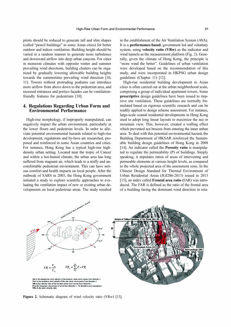
in the establishment of the Air Ventilation System (AVA).
It is a performance-based, government led and voluntary
system, using velocity ratio (VRw) as the indicator and
wind tunnels as the measurement platform (Fig. 2). Gene-
rally, given the climate of Hong Kong, the principle is
“more wind the better”. Guidelines of urban ventilation
were developed based on the recommendation of this
study, and were incorporated in HKPSG urban design
guidelines (Chapter 11) [12].
High-rise residential building development in Asian
cities is often carried out at the urban neighborhood scale,
comprising a group of individual apartment towers. Some
prescriptive design guidelines have been issued to imp-
rove site ventilation. These guidelines are normally for-
mulated based on rigorous scientific research and can be
readily applied to design scheme assessment. For instance,
large-scale coastal residential developments in Hong Kong
used to adopt long linear layouts to maximize the sea or
mountain view. This, however, created a walling effect
which prevented sea breezes from entering the inner unban
area. To deal with this potential environmental hazard, the
Building Department of HKSAR reinforced the Sustain-
able building design guidelines of Hong Kong in 2008
[14]. An indicator called the Porosity ratio is manipula-
ted to regulate the permeability (P) of buildings. Simply
speaking, it stipulates ratios of areas of intervening and
permeable elements at various height levels, as compared
to the whole projected area of the assessment zone. In the
Chinese Design Standard for Thermal Environment of
Urban Residential Areas (JGJ286-2013) issued in 2013
[15], an index called Frontal area ratio (FAR) was intro-
duced. The FAR is defined as the ratio of the frontal area
of a building facing the dominant wind direction in rela-
Figure 2. Schematic diagram of wind velocity ratio (VRw) [13].
90 Feng Yang | International Journal of High-Rise Buildings
tion to its largest possible frontal area. The ratio relates
the building geometry and orientation with the seasonal
prevailing wind direction. New residential developments
should comply with the requirements of the summer fron-
tal area ratio based on their respective climate zones. For
instance, for the hot-summer and cold-winter (HSCW)
zone, site-average frontal area ratio should be lower than
70% [15]. This is particularly important for the linear
housing form, so that major façades should be at a certain
angle to the prevailing winds, to facilitate site ventilation
without compromising building ventilation. The index is
very useful for building footprints of a square or circular
shape.
5. Mapping Microclimate in High-Rise Urban Form
Since the Modern Architecture movement, contempo-
rary urban planning normally adopts a top-down approach,
but historically, cities mainly grow from the bottom up,
demonstrating the complex interaction among economic,
political, cultural and geographical/climatic forces. Scien-
tific approaches, such as network science and fractal geo-
metry, have been developed to explore the complex inter-
action of these forces and the growth of the urban form,
so as to better understand urban density, sprawl, compact-
ness and related sustainability [16]. Similarly, a new me-
thodology is needed to better understand the relationship
between urban form and urban climate. This is because
contemporary urban growth has been occurring at unpre-
cedented rates due to rapid urbanization, and the ever-
increasing height, compactness and density can result in
very complex microclimates and thermal environments. It
is necessary to understand this relationship and further de-
velop measures to control and improve the microclimate.
Urban designers work on the scale of neighborhoods to
urban districts, comprising tens or even hundreds of buil-
dings. The urban climate at this scale (10-2~103 m [6]), can
be referred to as a “microclimate,” and it could be mani-
pulated by design interventions: building form, height and
spacing, pavement and façade materials, street parks and
trees, etc. [17]. As mentioned in the previous section, there
are plenty of “rules of thumb” of urban building design in
response to various kinds of urban climate. Nowadays, as
cities keep growing larger and denser, designers are con-
stantly faced with the challenges of working in high-den-
sity and high-heterogeneity urban environments. As such,
there is a great need for tools to help designers gain a
better microclimatic understanding by providing predic-
tive results for different design scenarios with acceptable
accuracy and validity. At the more advanced or complex
levels, it is necessary to quantitatively evaluate the en-
vironmental performance of high-rise urban form to meet
certain criteria, e.g., LEED ND compliance. Today the
commonly employed tools are based on computational
fluid dynamics (CFD) [18]. CFD tools require expertise
to operate, are generally resource-costly, and thus unfami-
liar and not user-friendly to architects and urban designers.
On the other hand, at the urban scale, urban climatic
mapping (UC-Map) is a design decision-supporting tool
that aims to provide urban planners with both analytical
and visual information [19]. Over the last decade it has
received increasing attention from both the research and
practice fields. Studies have been carried out in a number
of cities in Europe, North America and Asia. On the me-
tropolitan and urban scale, the urban form-based vari-
ables are generally categorized into two layers: Thermal
Load and Dynamic Potential; regional wind information
was also provided [20]. The established framework has
been applied in various cities in Germany, and has influ-
enced the paradigms used in subsequent UC-Map studies
and applications across the world [21,22].
Earlier UC-Maps generally stratify climate information
based on land use, and rely largely on expert evaluation.
A more recent UC-Map in Hong Kong factors building
density, topography, ground roughness and greenery into
street-level urban microclimate evaluation [23]. Additio-
nally, a moresystematic and quantitative approach is taken,
using the two key urban morphological variables, sky view
factor (SVF) and frontal area density (FAD), to describe
thermal and aerodynamic characteristics of the high-den-
sity Hong Kong urban environment. Aided with digital
image analysis techniques and GIS systems, the morpho-
logical factors are mapped onto virtual city spaces and
overlaid based on expert estimates to generate microcli-
mate thermal comfort maps [24]. The authors further dev-
eloped this approach by incorporating empirical models
built upon carefully-selected urban morphological varia-
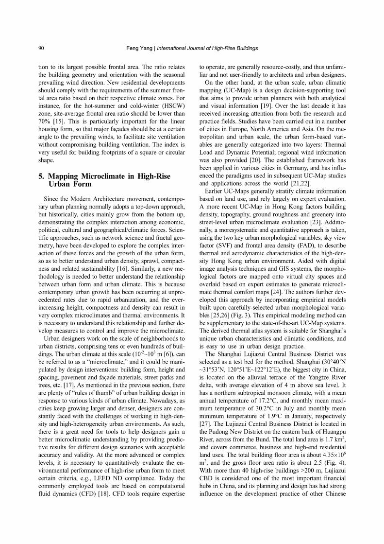
bles [25,26] (Fig. 3). This empirical modeling method can
be supplementary to the state-of-the-art UC-Map systems.
The derived thermal atlas system is suitable for Shanghai’s
unique urban characteristics and climatic conditions, and
is easy to use in urban design practice.
The Shanghai Lujiazui Central Business District was
selected as a test bed for the method. Shanghai (30°40’N
~31°53’N, 120°51’E~122°12’E), the biggest city in China,
is located on the alluvial terrace of the Yangtze River
delta, with average elevation of 4 m above sea level. It
has a northern subtropical monsoon climate, with a mean
annual temperature of 17.2°C, and monthly mean maxi-
mum temperature of 30.2°C in July and monthly mean
minimum temperature of 1.9°C in January, respectively
[27]. The Lujiazui Central Business District is located in
the Pudong New District on the eastern bank of Huangpu
River, across from the Bund. The total land area is 1.7 km2,
and covers commerce, business and high-end residential
land uses. The total building floor area is about 4.35×10⁶
m2, and the gross floor area ratio is about 2.5 (Fig. 4).
With more than 40 high-rise buildings >200 m, Lujiazui
CBD is considered one of the most important financial
hubs in China, and its planning and design has had strong
influence on the development practice of other Chinese

High-Rise Urban Form and Environmental Performance 91
cities.
Six key morphological indicators, i.e., sky view factor,
pavement cover ratio, vehicle traffic density, green plot
ratio, frontal area index, and proximity to heat sink (refer
to ref. [28] for details of these parameters) were used to
describe different aspects of the urban thermal environ-
ment including building density, land use, anthropogenic
heat, greenery, ventilation potential, and heat sink. Spatial
analysis tools were developed in GIS to generate maps
for these morphological indicators using the digital eleva-
tion model (DEM). In-situ meteorological measurements
were carried out on peak summer days to investigate the
spatial variation of microclimatic parameters, based on
which the physiological equivalent temperature (PET)
index was calculated. Empirical regression models were
built, correlating PET values with local morphological
indicators, from which PET maps were generated. This
thermal atlas system can rapidly analyze and visualize the
spatial variations of urban microclimate from the thermal
comfort aspects as affected by different urban design sce-
Figrue 3. Interconnection among urbanization, morphology and urban energy balance (after [6]).
Figure 4. (a) Map of Lujiazui CBD in Shanghai (b) DEM.

92 Feng Yang | International Journal of High-Rise Buildings
narios. Thus, it can be a useful decision-support tool for
urban design meant to alleviate urban heat island intensity
and improve outdoor thermal comfort [28].
Based on the thermal zoning map (Fig. 5), proposals are
made to improve summertime microclimate and thermal
comfort, including: 1) providing opaque shading devices
for major pedestrian spaces along the Century Walkway
and Waterfront Esplanade. 2) Reducing the size of street
blocks, and dividing massive single buildings into build-
ing clusters with smaller spacing. Denser urban fabric
creates shaded outdoor spaces between buildings, whereas
isolated tall or large buildings generally occupy larger
street blocks, and are separated by wide roads. This leads
to an uncomfortable pedestrian environment, because of
lessened solar protection, and more sensible heat from
nearby road pavement materials. Refining the urban grid
and building fabric a block size of 150~250 m on each
side not only improves daytime thermal comfort, but also
makes the city more pedestrian-friendly. 3) Improving the
accessibility to the prominent heat sinks. For instance, ex-
panding the existing walkway system to improve the con-
nection between surrounding office buildings with Lujiazui
Central Green, so as to increase the occupation and usage
of LCG during lunch hours and weekend days; designing
building and landscape elements carefully, for instance, by
reorganizing short walls, trees etc., so as to introduce more
cool breeze from LCG to its surrounding built-up areas.
6. Concluding Remark
Today, the mainstream of sustainable design requires
energy-efficient and carbon-neutral design to combat res-
ource depletion and global warming. Tall buildings face
lots of challenges because they are considered to consume
more materials and energy during the whole life cycle
process. To make the tall building “greener”, the design
of tall buildings is undergoing a paradigm shift. For ins-
tance, designers are nowexploring form and façade design
to harness renewable energy and resources (solar, wind,
rain, greenery, etc.), which can be witnessed by the pro-
jects mentioned in the first section of this article. Compa-
red with individual buildings, the environmental perfor-
mance of tall building clusters at the neighborhood and
district levels are under-investigated.
Based on concepts developed in systems ecology, Bra-
ham explores environmental building design at three nes-
ted scales, i.e., shelter, setting and site. Environmentally
sound buildings and cities should act as resilient self-
organized ecosystems [29]. From the environmental point
of view, tall buildings should not be considered stand-
alone objects, but a part of larger web of interwoven eco-
logical systems. As reviewed in this article, there are inc-
reasing numbers of studies on the ecological and environ-
mental performance of the high-rise urban form from
various aspects. As the trend of building tall will likely
continue in urban areas, particularly in large Asian cities,
the studies at neighborhood and district scales are highly
necessary. As evidenced in the Shanghai Lujiazui study, a
top-down urban design approach that delivers only an
iconic “postcard” urban image can have many negative
consequences, one of which is a deteriorated outdoor
microclimate that is not supportive of sustainable urban
Figure 5. Summer daytime thermal atlas of Shanghai Lujiazui CBD (index: PET) and Thermal zoning map based on PETmap.
High-Rise Urban Form and Environmental Performance 93
spaces. Environmentally, a high-rise city is a high-risk and
a high-potential at the same time. To maximize the poten-
tial and minimize the risk, more inter-disciplinary and
cross-disciplinary research is needed now, and in the near
future.
Acknowledgements
The paper is supported by the China National Natural
Science Funds (Project No.: 51378354), the Innovation
Program of Shanghai Municipal Education Commission
(Project No.: 15ZZ020), and the Fundamental Research
Funds for the Central Universities (Project No.: 0100219
161).
References
[1] Gonçalves, J. C. S. and É. M. Umakoshi, The Environ-
mental Performance of Tall Buildings. 2010, London:Earthscan.
[2] Kubota, T., et al., Wind tunnel tests on the relationship
between building density and pedestrian-level wind velo-
city: Development of guidelines for realizing acceptable
wind environment in residential neighborhoods. Buildingand Environment, 2008. 43(10): p. 1699-1708.
[3] Ng, E., et al., Designing high-density cities - parametric
studies of urban morphologies and their implied environ-
mental performance, in Tropical Sustainable Architecture:
Social and environmental dimemsions, J. H. Bay and B.L. Ong, Editors. 2006, Architectural Press: Oxford, UK.p. 151-180.
[4] Ratti, C., N. Baker, and K. Steemers, Energy consump-
tion and urban texture. Energy and Buildings, 2005. 37:p. 762-776.
[5] Oldfield, P., D. Trabucco, and A. Wood, Five energy
generations of tall buildings: an historical analysis of
energy consumption in high-rise buildings. The Journal ofArchitecture, 2009. 14(5): p. 591-613.
[6] Oke, T. R., The Boundary Layer Climates (2nd edition).1987, London and New York: Methuen.
[7] Bosselmann, P., et al., Urban Form and Climate: Case
Study Toronto. Journal of the American Planning Asso-ciation, 1995. 61(2): p. 226-239.
[8] Brown, G. Z., Sun, Wind & Light: Architectural Design
Strategies. 2000: John Wiley & Sons.[9] Meng, X.W. and T. Setoguchi, Development of Urban
Design Guidelines with Wind Tunnel Simulations for
Downtown Districts in Winter Cities - New Urban Design
Approaches for Cold Region Cities. Journal of Asian Ar-chitecture and Building Engineering, 2010. 9(2): p. 355-362.
[10] Ng, E., et al., Improving the wind environment in high-
density cities by understanding urban morphology and
surface roughness: A study in Hong Kong. Landscape andUrban Planning, 2011. 101: p. 59-74.
[11] Ng, E., ed. Designing High-Density Cities: For Social
and Environmental Sustainability. 2009, Routledge: Lon-don.
[11] Ng, E., Policies and technical guidelines for urban plan-
ning of high-density cities - Air ventilation assessment
(AVA) of Hong Kong. Building and Environment, 2008.44(7): p. 1478-1488.
[12] Planning Department Hong Kong SAR, Feasibility
Study for Establishment of Air Ventilation Assessment
System - Final Report. 2005, Department of ArchitectureCUHK,.
[13] Building Department Hong Kong SAR, Sustainable
Building Design Guidelines, in APP-152. 2008.[14] MOHURD (Ministry of Housing and Urban-Rural De-
velopment), Design standard for thermal environment of
urban residential areas, in JGJ286-2013. 2014, ChinaArchitecture and Building Press: Beijing.
[15] Batty, M., Cities and Complexity: Understanding Cities
with Cellular Automata, Agent-Based Models, and Frac-
tals. 2005, Cambridge MA: MIT Press.[16] Stewart, I. D., T. R. Oke, and E. S. Krayenhoff, Evalua-
tion of the' local climate zones' scheme using temperature
observations and model simulations. International Journalof Climatology, 2013. 33(8): p. 1-19.
[17] Chen, Q., Using computational tools to factor wind into
architectural environment design. Energy and Buildings,2004. 36: p. 1197-1209.
[18] Chen, L., et al., Sky view factor analysis of street can-
yons and its implications for daytime intra-urban air
temperature differentials in high-rise, high-density urban
areas of Hong Kong: a GIS-based simulation approach.
International Journal of Climatology, 2012. 32(1): p. 121-136.
[19] VDI., VDI-Guideline 3787, Part 1: Environmental Met-
eorology-Climate and Air Pollution Maps for Cities and
Regions. 1997, Beuth Verlag: Berlin.[20] TMG (2005) The thermal environment map and areas
designated for the implementation of measures against
the Heat Island Phenomenon.[21] Planning Department Hong Kong SAR, Urban Climatic
Map and Standards for Wind Environment - Feasibility
Study - Final Report. 2009, Department of ArchitectureCUHK: Hong Kong.
[22] Ng, E., Towards planning and practical understanding
of the need for meteorological and climatic information
in the design of high-density cities: A case-based study of
Hong Kong. International Journal of Climatology, 2012.32(4): p. 582-598.
[23] Chen, L. and E. Ng, Quantitative urban climate mapping
based on a geographical database: A simulation app-
roach using Hong Kong as a case study. InternationalJournal of Applied Earth Observation and Geoinforma-tion, 2011. 13(4): p. 586-594.
[24] Yang, F., S.S.Y. Lau, and F. Qian, Urban design to lower
summertime outdoor temperatures: An empirical study on
high-rise housing in Shanghai. Building and Environment,2011. 46(3): p. 769-785.
[25] Yang, F., F. Qian, and S.S.Y. Lau, Urban form and den-
sity as indicators for summertime outdoor ventilation pot-
ential: A case study on high-rise housing in shanghai.
Building and Environment, 2013. 70: p. 122-137.[26] Shanghai Municipal Statistics Bureau, ed. Shanghai

94 Feng Yang | International Journal of High-Rise Buildings
Statistical Yearbook 2014. 2015, China Statistical Press:Shanghai.
[27] Yang, F. and L. Chen, Developing a thermal atlas for
climate-responsive urban design based on empirical
modeling and urban morphological analysis. Energy and
Buildings, 2016. 111: p. 120-130.[28] Braham, W.W., Architecture and Systems Ecology: Ther-
modynamic Principles of Environmental Building Design,
in three parts. 2015, London and New York: Routledge.