cruise report japan marine science and technology center … · i cruise report japan marine...
TRANSCRIPT
i
CRUISE REPORT JAPAN MARINE SCIENCE AND TECHNOLOGY
CENTER R/V Natsushima Cruise NT0517
Studies of submarine arc volcanism in the southern
Mariana Arc
October 8, 2005 to October 20, 2005
(Guam to Saipan)
i
TABLE OF CONTENTS:
List of cruise personnel ............................................................................. ii Acknowledgements .................................................................................... iv Summary ..................................................................................................... v 1. Introduction ............................................................................................ 1 2. Scientific Objectives ............................................................................. . 4 3. Cruise narrative and schedule of operations............................................ 7 4. Operations and data processing information ..................................... 7 5. Scientific Results .................................................................................... 8
5.1 Bathymetric surveys .................................................................... 8 5.2 MAPR Measurements................................................................. 9 5.3 Water and temperature sampling................................................ 9 5.4 Hyper-dolphin Studies and Sample Descriptions......................... 9
5.4.1 Dive 480 ................................................ ..................... 10 5.4.2 Dive 481 ................................................. .................... 17 5.4.3 Dive 482 ................................................. .................... 23 5.4.4 Dive 483 ................................................. .................... 29 5.4.5 Dive 484 ................................................. .................... 37 5.4.6 Dive 485 ................................................. .................... 45 5.4.7 Dive 486 ................................................. .................... 50 5.4.8 Dive 487 ................................................. .................... 56 5.4.9 Dive 488 ................................................. .................... 61 5.4.10 Dive 489 .................................................................... 67
6. Future studies ..................................................................................... 74 7. References............................................................................................. 75 Appendices: Appendix A: Descriptions of samples ................................................. ......... 76 Appendix B: Sample distribution list ............................................................ 85
ii
LIST OF CRUISE PERSONNEL: SCIENTIFIC PERSONNEL: Yoshihiko TAMURAGroup Leader JAMSTEC Institute for Research on Earth Evolution (IFREE) Japan Agency for Marine-Earth Science and Technology
Osamu ISHIZUKA Institute of Geoscience, Geological Survey of Japan/AIST
Hiroshi SHUKUNOInstitute for Research on Earth Evolution (IFREE) Japan Agency for Marine-Earth Science and Technology
Hisako HIRAYAMAExtremobiosphere Research Center (XBR), Japan Agency for Marine-Earth Science and Technology
Robert W. Embley Senior Research Scientist Pacific Marine Environmental Laboratory (PMEL), NOAA
Sherman Bloomer Professor Department of Geosciences, Oregon State University
Robert J. Stern Professor GeosciencesDept.University of Texas at Dallas
Alison Shaw postdoctoral researcher Carnegie Institution of Washington
Edward John KohutAssistant Professor
iii
University of Delaware , Dept. of Geology
Julie Ann O’LearyGraduate student Division of Geological and Planetary Sciences California Institute of Technology
Neil K. Basu Graduate student Geosciences Dept. University of Texas at Dallas
Ayumi MIZOTAMarine Techician Nippon Marine Enterprises, LTD.
ROV HYPER-DOLPHIN Operation Team Operation Manager Kazuhiro CHIBA 2st Submersible Staff Homare WAKAMATSU 2st Submersible Staff Tomoe KONDO 3nd Submersible Staff Katsushi CHIBA 3nd Submersible Staff Shigeru KIKUYA 3nd Submersible Staff Atsushi TAKENOUCHI
3nd Submersible Staff Kensuke TOTSUKA 3rd Submersible Staff Seiji SHIGETAKE
iv
R/V NATSUSHIMA Crew Captain Fusao SAITO
Chief Officer Yasuo DEAI 2nd Officer Isao MAEDA 3rd Officer Yoshiki KON Chief Engineer Toshihiro KIMURA 1st Engineer Tadashi ABE 2nd Engineer Koji FUNAE Jr. 2nd Engineer Chikara ONOHARA 3rd Engineer Fumihiko NATSUI Chief Electronic Operator Hideyuki AKAMA 2nd Electronic Operator Yohei YAMAMOTO 3rd Electronic Operator Yuichi UMETANI Boat Swain Yoshiaki SHIRAI Able Seamen Kazumi OGASAWARA Able Seamen Kazushirou OSAKO Able Seamen Katsuhiko SATO Able Seamen Tsuyoshi CHIMOTO Able Seamen Tetsuo SHIRAYAMA Sailor Hideaki OISHI No.1 Oiler Seiichi MATSUDA Oiler Shuichi SONO Oiler Yoshinori KAWAI Oiler Masanori UEDA Oiler Shota WATANABE Chief Steward Tomihisa MORITA Steward Yoshinobu HASATANI Steward Shigeto ARIYAMA Steward Kazuhiro HIRAYAMA Steward Takahiro ABE Trainee Yoshiharu IWASAKI ACKNOWLEDGEMENTS We are grateful to Captain Fusao Saito and the excellent crew of the R/V Natsushima, the Hyper Dolphin operation team manager Kazuhiro Chiba and the Hyper Dolphin team for their outstanding efforts to make this scientific program successful. We also thank JAMSTEC for their support of this project. The U.S. science group acknowledges the support of a National Science Foundation grant to the University of Texas at Dallas.
v
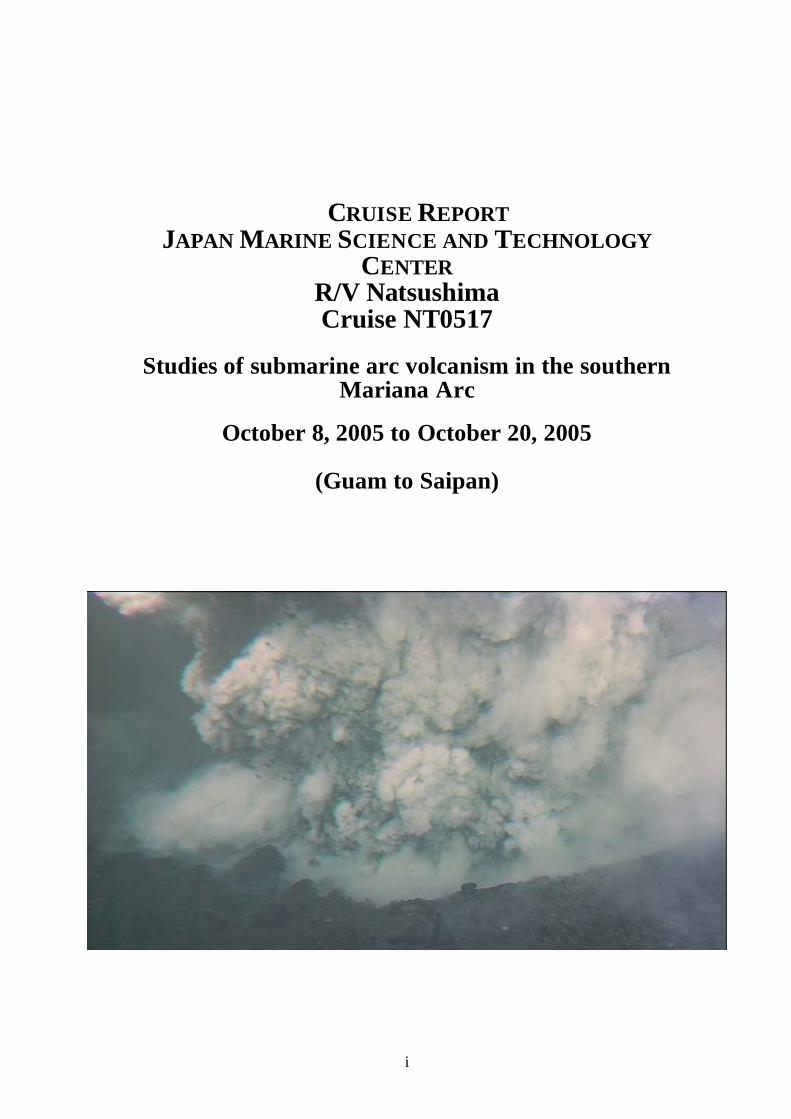
SUMMARY OF PRINCIPAL CRUISE RESULTS During this cruise, JAMSTEC’s R/V Natsushima and ROV Hyper-Dolphin and a Japan-US team of scientists studied volcanism and sedimentation near the southern end of the active Izu-Bonin-Mariana arc (Stern et al., 2003). We focused on the Southern Seamount Province of the active Mariana Arc between 14°10’N and 15°20’N (Fig. 1, 2, 3) . The targets lie just west of the Mariana frontal arc islands, especially Rota, Tinian, and Saipan. The cruise completed additional multibeam maps of the seafloor, completed ten dives of Hyper-Dolphin, and recovered more than 130 samples of rocks, water, and sediment. The cruise provided important insights to active venting of sulphur, hyaloclastite formation, vent biology, and water chemistry at the summit of NW Rota-1 volcano; the structure and evolution of a silicic caldera at West Rota Seamount; the origin of primitive lavas at Chaife Seamount, the development of giant sediment waves west of Esmeralda Bank; the evolution of arc seamounts at parasitic cones on NW Rota-1 and West Rota; and the nature of volcanism on parasitic cones on NW Rota-1 and W. Rota volcanoes. The following paragraphs summarize our findings; more detailed discussions are found in individual dive summaries that follow the introduction.
NW Rota-1 volcano: Dives 480 and 481 (Oct. 9 & 10) revisited the summit region of this young submarine volcano. Activity near the summit region of NW Rota-1 was discovered by CTD casts in 2003 (Embley et al., 2004) and observed with ROV ROPOS during TT-167 in Spring of 2004 (Embley et al., submitted). These studies discovered a deep pit (Brimstone Pit) just south of the summit that was throwing out sulphur globules and basaltic lapilli. Acidic vent fluids stimulated a biological community, dominated by shrimp. NW-Rota-1 Brimstone Pit represents an extremely early stage in the evolution of a submarine arc hydrothermal field. The associated biota also seems to be in the earliest stages, with a low diversity community that consists of only the most mobile invertebrate species, especially shrimp. Studies during NT05-17 indicate that vigorous activity around the pit continues and is at an increased level of intensity relative to observations in 2004. Dive 488 (Oct. 18) examined and sampled two small parasitic cones on the southeastern flanks of NW Rota-1. The pillow lavas, sampled at deeper depths and that run down from the ridge trending east-southeastwardly are primitive cpx-ol basalt lavas. The two parasitic knolls themselves consist of pl-phyric ol-cpx basalts. These may represent two types of basalt lavas derived from a wet and dry mantle source beneath a single volcano, as suggested in the Sumisu caldera volcano, Izu-Bonin arc (Tamura et al., 2005), or these may be primitive and evolved lavas derived from the same primary basalt magma.
W. Rota Volcano: Dives 482, 483, and 484 studied the steep eastern wall of West Rota caldera. Dive 489 (Oct. 19th) traversed two parasitic cones on the southeastern flanks of West Rota. W. Rota is an extinct submarine volcano with a caldera that is similar in size to Crater Lake, Oregon. This is by far the largest caldera in the Mariana arc but was unknown until 2001. The four Hyper Dolphin dives were very successful, identifying the location of hydrothermally altered lavas and stockwork sulfide mineralization towards the bottom of the caldera walls in Dives 482 and 484. This marks the exhumed roots of an arc hydrothermal system. Dive 483 found a weak but active low-T hydrothermal vent at the bottom of the SE caldera wall. Chemosynthetic macrofauna was not present, but
vi
tan to orange microbial mat was actively forming. Abundant dacitic dikes were observed during dive 483 which could be traced upwards into coarse pyroclastic flows, and the abundance of basaltic material erupted simultaneously with rhyodacitic pyroclastics suggests that the final, caldera-forming eruptions were triggered by injection of basaltic melt into a felsic magmatic body. The abundance of dikes observed during HD 483 suggests that the SE portion of the volcano was its magmatic apex. Dive 489 (October 19th) traversed two small cones on the southeast flank of West Rota and recovered a number of lava types. Chaife and Mt. Manganese: Dives 485 and 486 examined smaller volcanoes in the eastern part of the 14°40’N cross-chain. One of these seamounts – Chaife - has erupted the most primitive lavas (picrite and ankaramite) reported from the Neogene IBM arc (Kohut et al., submitted). These samples were recovered in a single dredge (D14) during the Cook 7 expedition. Whole rock samples have Mg# = 76-77 and olivines are as Mg-rich as FO 93. Chaife lavas have estimated (OL-SP geothermometry) magmatic equilibration temperatures of up to 1478°C and magmagenesis was largely anhydrous (Kohut et al., submitted) Dives 485 and 486 provided important new data on the nature and composition of Chaife Seamount and Mt. Manganese. Although locally faulted, Chaife appears to be built on top of a NNE striking fissure. Lavas recovered from blocky flows were CPX-PLAG phyric basalts on the lower slopes (2300-2050 meters depth), ankaramitic and picritic on the mid- slopes (2055-1896 m) (similar to those sampled in 2001 by Cook 7), and aphyric basalts on the upper flanks (1875-1686 m). These lavas occurred in steep ridges, separated by flatter sediment covered slopes. Mt. Manganese is bisected by the fracture zone on its northern side. The bottom of the rift valley contains NNW-ESE trending flow channels in pumiceous sediment and small cones of tephra, lava and breccias. The cones are eroded and Mn-encrusted. Some lavas in the may have be primitive. The western fault scarp of the fracture zone exposes the flows on Mt. Manganese. These were basaltic in composition and Mn-coated. No intermediate or felsic lavas were observed. Giant sediment waves around Esmeralda (Dive HD-487): On the aprons of many volcanic islands and larger submarine volcanoes, sediment waves with wavelengths of up to 2.0 km and amplitudes up to 100 m commonly occur (Embley et al. 2003). Giant sediment waves (GSW) of similar scale commonly occur in fine-grained sediments associated with turbidite channel levees and bottom current depostional areas Stow and Wynn, 2002). GSW in the Marianas appear to be limited to submarine slopes around active volcanoes and probably formed by major eruptions which discharged great volumes of sediment. HD 487 examined 2 lee slopes and one intervening upcurrent slope of GSW on the SW flanks of Esmeralda bank volcano, an active submarine volcano west of Tinian. The deeper of the two lee slopes appeared to be a depositional feature (perhaps draped over thinly-bedded volcaniclastics) whereas the shallower lee slope clearly revealed a cut bank of well-bedded volcaniclastics, which we infer were exposed by currents that deposited GSW farther downslope.
1
1. INTRODUCTION AND BACKGROUND
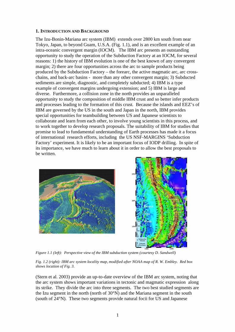
The Izu-Bonin-Mariana arc system (IBM) extends over 2800 km south from near Tokyo, Japan, to beyond Guam, U.S.A. (Fig. 1.1), and is an excellent example of an intra-oceanic convergent margin (IOCM). The IBM arc presents an outstanding opportunity to study the operation of the Subduction Factory at an IOCM, for several reasons: 1) the history of IBM evolution is one of the best known of any convergent margin; 2) there are four opportunities across the arc to sample products being produced by the Subduction Factory – the forearc, the active magmatic arc, arc cross-chains, and back-arc basins - more than any other convergent margin; 3) Subducted sediments are simple, diagnostic, and completely subducted; 4) IBM is a type example of convergent margins undergoing extension; and 5) IBM is large and diverse. Furthermore, a collision zone in the north provides an unparalleled opportunity to study the composition of middle IBM crust and so better infer products and processes leading to the formation of this crust. Because the islands and EEZ’s of IBM are governed by the US in the south and Japan in the north, IBM provides special opportunities for teambuilding between US and Japanese scientists to collaborate and learn from each other, to involve young scientists in this process, and to work together to develop research proposals. The suitability of IBM for studies that promise to lead to fundamental understanding of Earth processes has made it a focus of international research efforts, including the US NSF-MARGINS ‘Subduction Factory’ experiment. It is likely to be an important focus of IODP drilling. In spite of its importance, we have much to learn about it in order to allow the best proposals to be written.
Figure 1.1 (left): Perspective view of the IBM subduction system (courtesy D. Sandwell) Fig. 1.2 (right): IBM arc system locality map, modified after NOAA map of R. W. Embley. Red box shows location of Fig. 3.
(Stern et al. 2003) provide an up-to-date overview of the IBM arc system, noting that the arc system shows important variations in tectonic and magmatic expression along its strike. They divide the arc into three segments. The two best studied segments are the Izu segment in the north (north of 30°N) and the Mariana segment in the south (south of 24°N). These two segments provide natural focii for US and Japanese
2
investigators to study arc systems, and the along-strike variations provide opportunities for scientists from these two nations to compare and contrast the different perspectives that these provide. The Mariana arc is further divided into the Northern Seamount Province, Central Island Province, and Southern Seamount Province (SSP) (Bloomer et al. 1989). The Mariana SSP lies close to populated islands of Guam, Rota, Tinian, and Saipan and SSP volcanoes are within the US EEZ. In spite of this, there have been relatively few studies of these volcanoes, although this is changing. In 2001 this region was surveyed with HAWAII MR-1 and extensively dredge-sampled during the COOK 7 cruise (R/V Melville; Bloomer and Stern, co-chief scientists). In 2003 a NOAA cruise (R/V Thompson, Bob Embley, chief scientist) surveyed the region and identified likely sites of hydrothermal activity with CTD casts. In 2004 this team returned for interdisciplinary studies of vent geology, biology, and chemistry using ROV ROPOS. Guam and Saipan have good ports and international airports.
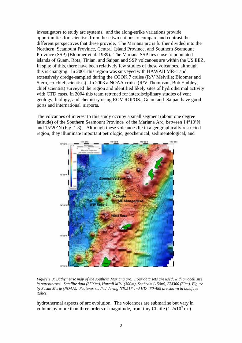
The volcanoes of interest to this study occupy a small segment (about one degree latitude) of the Southern Seamount Province of the Mariana Arc, between 14°10’N and 15°20’N (Fig. 1.3). Although these volcanoes lie in a geographically restricted region, they illuminate important petrologic, geochemical, sedimentological, and Figure 1.3: Bathymetric map of the southern Mariana arc. Four data sets are used, with gridcell size in parentheses: Satellite data (3500m), Hawaii MR1 (300m), Seabeam (150m), EM300 (50m). Figure by Susan Merle (NOAA). Features studied during NT0517 and HD 480-489 are shown in boldface italics. hydrothermal aspects of arc evolution. The volcanoes are submarine but vary in volume by more than three orders of magnitude, from tiny Chaife (1.2x10⁹ m3)
3
through medium-sized), and NW Rota-1 (1.2x10¹¹ m3), to the largest volcanoes in the SSP, West Rota (5.2x10¹¹ m3) and Esmeralda Bank (6.5x10¹¹ m3). NW Rota and West Rota were the principal targets of our dive program.
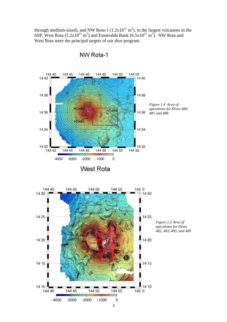
Figure 1.4 Area of operations for Dives 480, 481 and 488
Figure 1.5 Area of operations for Dives 482, 483, 483, and 489
4
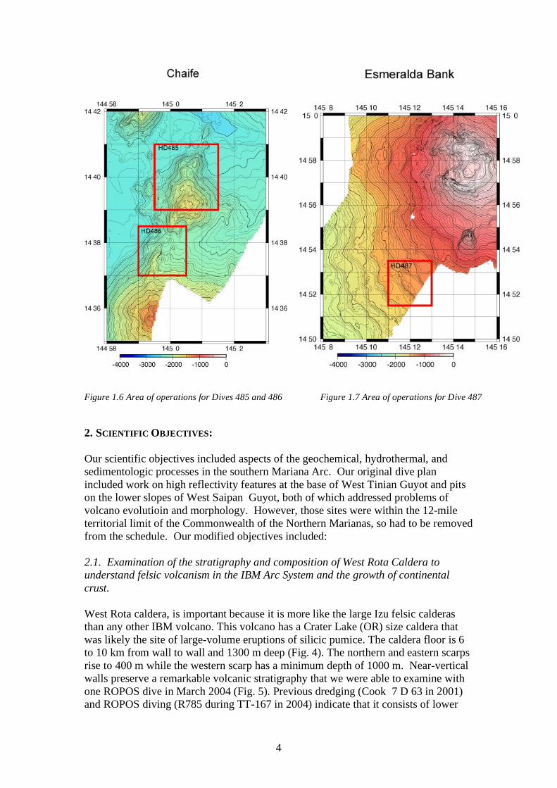
Figure 1.6 Area of operations for Dives 485 and 486 Figure 1.7 Area of operations for Dive 487 2. SCIENTIFIC OBJECTIVES: Our scientific objectives included aspects of the geochemical, hydrothermal, and sedimentologic processes in the southern Mariana Arc. Our original dive plan included work on high reflectivity features at the base of West Tinian Guyot and pits on the lower slopes of West Saipan Guyot, both of which addressed problems of volcano evolutioin and morphology. However, those sites were within the 12-mile territorial limit of the Commonwealth of the Northern Marianas, so had to be removed from the schedule. Our modified objectives included: 2.1. Examination of the stratigraphy and composition of West Rota Caldera to understand felsic volcanism in the IBM Arc System and the growth of continental crust.
West Rota caldera, is important because it is more like the large Izu felsic calderas than any other IBM volcano. This volcano has a Crater Lake (OR) size caldera that was likely the site of large-volume eruptions of silicic pumice. The caldera floor is 6 to 10 km from wall to wall and 1300 m deep (Fig. 4). The northern and eastern scarps rise to 400 m while the western scarp has a minimum depth of 1000 m. Near-vertical walls preserve a remarkable volcanic stratigraphy that we were able to examine with one ROPOS dive in March 2004 (Fig. 5). Previous dredging (Cook 7 D 63 in 2001) and ROPOS diving (R785 during TT-167 in 2004) indicate that it consists of lower
5
andesite flows, upper dacite-rhyolite pyroclastics and volcaniclastics, and hydrothermally altered rocks. Two 40Ar/39Ar ages on andesites yield good plateau ages of 347±14 Ka and 572±117 Ka (Basu and Stern, unpublished data). We don’t know (yet) when felsic volcanism and caldera collapse occurred, but it must have happened in the last 350,000 years. Major goals of our work included the identification of the roots of an extinct hydrothermal system, description of the volcanic stratigraphy of West Rota, and collection of samples for petrologic, geochemical, isotopic, and geochronologic studies. 2.2. Early stage hydrothermal activity in the IBM arc system at NW Rota-1 NW-Rota-1 is nearly perfect cone that rises about 2,500 m above the surrounding sea floor (Fig. 6A). It was first surveyed and sampled during Cook 7, where D9 recovered fresh dacite ~65% SiO2). In 2003, CTD casts by a NOAA-funded research team led by Bob Embley found a 200-m-thick layer of intense hydrothermal plumes above the volcano summit, indicating that a vigorous hydrothermal vent system was active. The 2004 T167 cruise using ROPOS dived four times (Dives 782, 783, 784, and 786; note that these dives were typically 18 hours in duration) on this site, and quickly found that activity was concentrated near the summit. The first site we found (above the pit) was a large area of sand with shimmering (100°C) water percolating through it. Further exploration revealed the main hydrothermal vent, located about 30m below the summit and which was called ‘Brimstone Pit” (Fig. 6B). We believe that NW-Rota-1 Brimstone Pit represents and extremely early stage in the evolution of a submarine arc hydrothermal field. The associated vent community also seems to be in the earliest stages, with a low diversity community that consists of only the most mobile invertebrate species, especially shrimp. In contrast to other hydrothermal sites surveyed during TT167, NW-Rota-1 showed little bacterial mat growth. To test the hypothesis that this vent is in the earliest stages of formation, we need to revisit the area for the purpose of establishing a time series of how this system is evolving and to set the stage for future research on this fascinating and important geobiological system. 2. 3 Eruption of young ‘komatiite-like’ lavas at Chaife Seamount
Very primitive lavas from Chaife seamount were recovered in a single dredge (D14) during the Cook 7 expedition (Fig. 7A). Primitive lavas such as boninites are common for Paleogene lavas of the infant IBM arc, but Neogene IBM arc lavas are quite fractionated, with Mg# <60. Ar-Ar dating of the D14 samples yield plateau ages of 2.49±0.18 Ma for the picrite and 1.73±0.06 Ma for the ankeramite, so these lavas are part of the Mariana magmatic arc that formed after the Mariana Trough opened. Understanding these primitive lavas is important for understanding temperatures in the sub-arc mantle wedge, for understanding the composition of primitive melts in arcs, and for testing the ‘hot fingers’ hypothesis of (Tamura et al. 2002). Chaife
6
lavas also are important for addressing an important controversy about the tectonic setting of Archean komatiites. Most scientists prefer the interpretation that komatiites formed in Archaen mantle plumes (Arndt 2003), but some scientists argue that they may have formed in subduction zone environments (Grove and Parman 2004). Further study of Chaife and its lavas is expected to contribute to this important geoscientific controversy. 2.4. Giant sediment waves at Esmeralda Bank The submarine flanks of the submarine volcanoes and islands of the central and northern Mariana Arc consist largely of low relief aprons, presumably made up of volcaniclastic sediments and minor lava flows. On the aprons of many volcanic islands and larger submarine volcanoes, sediment waves with wavelengths of up to 1.0 km and amplitudes up to 50 m commonly occur (Embley et al. 2003). We can recognize at least 8 sites on the flanks of the larger Mariana islands and seamounts with GSW fields. For these fields, sediment wave crests parallel regional contours, indicating a formation mechanism that is related to down-slope flow, probably initially as a result of flank failure. Recognizing and understanding of the distribution of GSW in the IBM arc is likely to be important for IODP drilling in the IBM arc. Giant sediment waves in volcanic arc environments were previously largely unknown because few volcaniclastic aprons have been imaged in sufficient detail to recognize them; we suspect that they also exist on the flanks of other arc volcanoes, including northern IBM, but have not yet been recognized. HMR-1 and EM300 backscatter imagery show distinct alternating high and low reflectivity wave-parallel bands associated with these features. We interpret this as that could be grain-size sorting and further evidence that at least some of GSW are related to fluidized flow. For these fields, sediment wave crests parallel regional contours, indicating a formation mechanism that is related to down-slope flow, probably initially as a result of flank failure. In some places we have observed relationships between mass wasting on the volcanoes' steep, upper flanks and sediment waves on the gentler, lower slopes. In other places, it appears that GSW formed during the transition from channelized to unconstrained flows. Typical Mariana giant sediment waves appear to be among the largest amplitude and wavelength coarse-grained sediment waves known. Recognizing and understanding of the distribution of GSW in the IBM arc is likely to be important for IODP drilling in the IBM arc. These deposits consist of very unconsolidated pumice-rich sands and gravels, and drilling through them will require different approaches than drilling through more consolidated units. Our objectives were to study the giant sediment waves west of Esmeralda Bank, which is a very active submarine volcano (Stern and Bibee, 1984).. In this part of the cruise we hope to examine how two waves in the field vary as a function of depth and distance from the volcano summit. 2.5. Structure and composition of parasitic volcanic cones at NE Rota-1 and West Rota Small, parasitic volcanic cones are common features of large arc volcanoes. These can have highly variable compositions, but may be sites of unusually primitive magma compositions. They also represent an important evolutionary feature of arc

7
volcanoes and provide a site where small volume lavas with key characteristics may be sampled. Our plan was to map and obtain representative samples for two such cones. 3. Cruise narrative and schedule of operations R/V Natsushima departed Apra Harbor, Guam at 1100 on October 8th, 2005. The ship arrived at NW Rota-1 that evening and completed Seabat multibeam sonar surveys of the volcano until dive operations commenced at 0900 on October 9th. Dive 480 was completed that day at NW Rota-1, Dive 481 was at the same site on October 10th. Upon recovery of Hyper Dolphin on Oct 10th Natsushima proceeded to West Rota Seamount, where dives 482, 483, and 484 were completed on October 11, 12, and 13. Surveys around the seamount were completed during the evenings. The ship transited to Chaife Seamount the evening of October 13th, and upon completion of bathymetric surveys did dives 485 and 486 at Chaife and Mt. Manganese on Oct. 14th and 15th. Sunday October 16th was used as a day to do maintenance and catch up on archiving and describing the results from the first 7 dives. Preliminary sampling of the recovered materials was completed. Operations began again with Dive 487 on giant sand waves west of Esmeralda Bank, and concluded with Dives 488 and 489 on parasitic cones of NW Rota-1 and West Rota on October 18th and 19th. Natsushima entered port at Saipan early on October 20th where the scientific party disembarked. 4. Operations and data processing information The only underway data collection was by the hull-mounted multibeam system Seabat. Data from the Seabat surveys will be merged with existing Seabeam, Seabat, and EM-300 data at the NOAA research labs in Oregon. Hyper Dolphin dove with payloads that included the rock sampling basket and two sample canisters with swivel lids for dives 482, 483, 484, 485, 486, 488, and 489. Dives 480 and 481 mounted two push or M-type cores and one lidded box in the sample basket, as well as a temperature probe and water sampler mounted on the starboard arm and the body of HyperDolphin. Dive 487 used two lidded boxes, the two lidded canisters, and two M-type cores. Dives 480 through 488 mounted a small nephelometer provided by the NOAA participant R. Embley. Data and samples from the dives were archived as customary. Half of all samples will be archived at JAMSTEC. Samples distributed to the scientific party are listed in Appendix B. Standard data products were provided to the shipboard scientific party.
8
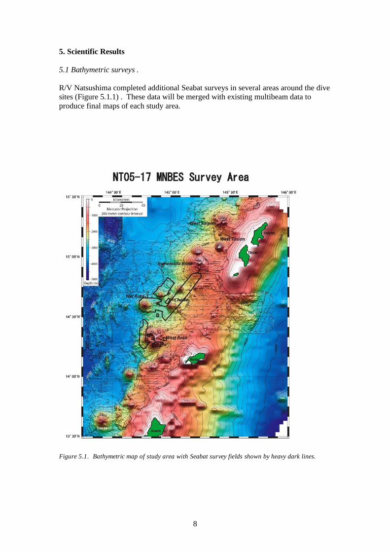
5. Scientific Results 5.1 Bathymetric surveys . R/V Natsushima completed additional Seabat surveys in several areas around the dive sites (Figure 5.1.1) . These data will be merged with existing multibeam data to produce final maps of each study area.
Figure 5.1. Bathymetric map of study area with Seabat survey fields shown by heavy dark lines.
9
5.2 MAPR Measurements The MAPR is a self-contained (battery powered) unit capable of recording pressure, temperature and water turbidity at pre-set time intervals (but no less than 5 sec). The unit was mounted on the front upper bar of the Hyper-Dolphin on all dives except for Dive 487 and 489. Data were collected by the MAPR on dives HD-480, 481, 482, 483, 486 and 488. It failed to collect data on HD-484 because of low voltage on the batteries and on HD-485 because the delay time was set incorrectly. It was not deployed on HD-487 and 488. The primary objective of the MAPR unit during NT-05-17 was to collect data on the plumes over NWRota-1. The unit was deployed and collected data on all three dives at that site (HD-480, 481 and 488). Only the nephelometer data were looked at during the cruise. Although data appeared to be somewhat noisy it clearly showed the turbid clouds around the Brimstone Pit and it is hoped useful information about the water column turbidity will be derived by post-processing and filtering the data. 5.3 Water and temperature sampling Water samples and temperature measurements were collected using instrumentation from the Extremobiosphere Research Center (XBR), Japan Agency for Marine-Earth Science and Technology during Dives 480 and 481. Water samples from the plume had pH less than 2.0 and temperatures in excess of 120oC were measured within the eruptive plume. 5.4 Hyper-dolphin Studies and Sample Descriptions Summaries of the results of each dive with representative pictures, start and finish locations, track maps, and dive logs are included in the sections below. A comprehensive list of samples with brief descriptions is included in Appendix A.
10
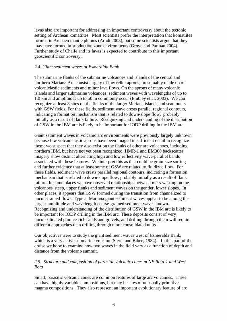
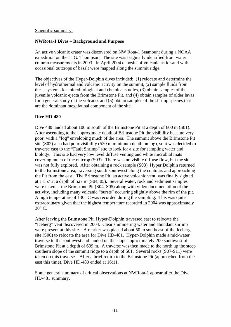
5.4.1 Dive 480 Technical information: Location: NW Rota-1 Seamount, summit ridge Objective: survey rim of Brimstone Pit, assess activity, sample, examine
hydrothermal activity DIVE 480 On bottom: Off bottom: Time (local) 09:21 16:11 Latitude: 14o 35.989’N 14 o 36.008’N Longitude: 144 o 46.515’E 144 o 46.476’E Depth (m): 600 496 Samples returned: 10 rocks (one lost on ascent), 1 scoop, 2 cores, 1 water sample Representative images:
Figure 480A: Cinder pile with altered rocks or hydrothermal precipitate, with warm fluids venting from summit and sides. (image hdc20051009110941
Figure 480B: Bacterial (?) mats or fibers growing on rocks in low-temperature field (image hdc20051009110941)
Figure 480C: Plume emerging from active vent at Brimstone Pit. Plume periodically emitted bursts dense in rock fragments (image hdc20051009120057_1)
11
Scientific summary: NWRota-1 Dives – Background and Purpose An active volcanic crater was discovered on NW Rota-1 Seamount during a NOAA expedition on the T. G. Thompson. The site was originally identified from water column measurements in 2003. In April 2004 deposits of volcaniclastic sand with occasional outcrops of basalt were mapped along the summit ridge. The objectives of the Hyper-Dolphin dives included: (1) relocate and determine the level of hydrothermal and volcanic activity on the summit, (2) sample fluids from these systems for microbiological and chemical studies, (3) obtain samples of the juvenile volcanic ejecta from the Brimstone Pit, and (4) obtain samples of older lavas for a general study of the volcano, and (5) obtain samples of the shrimp species that are the dominant megafaunal component of the site. Dive HD-480 Dive 480 landed about 100 m south of the Brimstone Pit at a depth of 600 m (S01). After ascending to the approximate depth of Brimstone Pit the visibility became very poor, with a “fog” enveloping much of the area. The summit above the Brimstone Pit site (S02) also had poor visibility (520 m minimum depth on log), so it was decided to traverse east to the “Fault Shrimp” site to look for a site for sampling water and biology. This site had very low level diffuse venting and white microbial mats covering much of the outcrop (S03). There was no visible diffuse flow, but the site was not fully explored. After obtaining a rock sample (S03), Hyper Dolphin returned to the Brimstone area, traversing south-southwest along the contours and approaching the Pit from the east. The Brimstone Pit, an active volcanic vent, was finally sighted at 11:57 at a depth of 527 m (S04, 05). Several water, rock and sediment samples were taken at the Brimstone Pit (S04, S05) along with video documentation of the activity, including many volcanic “bursts” occurring slightly above the rim of the pit. A high temperature of 130° C was recorded during the sampling. This was quite extraordinary given that the highest temperature recorded in 2004 was approximately 30° C. After leaving the Brimstone Pit, Hyper-Dolphin traversed east to relocate the “Iceberg” vent discovered in 2004. Clear shimmering water and abundant shrimp were present at this site. A marker was placed about 50 m southeast of the Iceberg site (S06) to relocate the area for Dive HD-481. Hyper-Dolphin made a mid-water traverse to the southwest and landed on the slope approximately 200 southwest of Brimstone Pit at a depth of 639 m. A traverse was then made to the north up the steep southern slope of the summit ridge to a depth of 561. Several rocks (S07-S11) were taken on this traverse. After a brief return to the Brimstone Pit (approached from the east this time), Dive HD-480 ended at 16:11. Some general summary of critical observations at NWRota-1 appear after the Dive HD-481 summary.
12
Figure 480D: Bathymetry and station locations for HD 480
13
Table 480A: Dive Log NT0517HD480
Time (Local)
Depth (m)
Vehicle Hdg Notes Sample #
8:35 In water
9:21 600 359
On bottom. Loose scoria or bombs perhaps. Looks volcaniclastic. Variety of colors, reds to grays and blacks with speckled whites. Majority of clasts 5-20 cm diameter?
9:26 606 15 Sampling glassy (?) vesicular basalt (?). ~20-30 cm placed in front of box.
NT0517HD-480-1-R-01
9:30 601 8
Moving up slope, encountering blocky flow or outcrop or bombs, up to ~1m diameter sub-rounded blocks. Not the freshest looking rocks. Some coated with orange crust (manganese?). Whitish to yellowish coating on others. Perhaps sulfur. Moving closer to Brimstone pit perhaps.
9:40 560 359
Still moving up slope. Much more suspended particulate matter, mostly white in color. The surrounding loose bombs are mostly all covered in white material now. A few more fish present than at the beginning of dive. Clearly more turbid than at 600 meters.
9:45 541 359 Very fine white to grey particulate venting. Very turbid, not great visibility. Quite "smokey".
9:48 536 359
Very heavy venting. Smoke resuspension perhaps due to vehicle, but mostly encountering active venting. Looks like it has been continuous since at least April 2004.
9:52 531 359
Audio finally turns on!! Heading up a ridge composed of very fine sand sized ejecta. Large blocks protruding from fine grained material and covered with white to yellow sulfur. First encounter with shimmering water. Small venting area. Appears that we've gone passed where the pit is supposed to be.
9:57 526 359 Temperature probe but I didn't hear an official temperature.
10:06 527 48
Scoop sample of the basaltic sand comprising the ridge that is resting at the angle of repose. NW trending ridge.
NT0517HD-480-2-S-01
10:15 526 53
This fog seems to be coming directly out of the sand. Really no obvious source yet for this material. Going to go see if we can find the pit. This is certainly a different style of venting than 2004. The 'smoke' is just diffusing out of the very permeable slope. Plumbing system has gone to hell. Temperature and chemistry has probably changed over the last 18 months.
10:17 525 53 Appears to be a finely layered rock amidst the small vent area.
10:22 525 55
Taking temperature directly from where the smoke is diffusing from. The discolored rocks may be due to some type of acid leaching.
10:25 525 48 Observing a rock exhibiting ash water fall layering. Probably pseudo-cemented and then slightly deformed.
10:28 525 46
The lack of shrimp is odd. The temperature has probably dropped since 2004 because the smoke is much more milky than before. The pit may have collapsed and what we see venting is just seeping
14
through the sand.
10:31 525 45 Temperature reading from a small vent is 9°C.
10:38 520 26 Appears to be the summit. A little more current up here results in ripples along the top.
10:43 522 30 Observing some bacterial mat. Fe staining?
10:47 520 100
Changing course. Absencs of hydrogen sulfide results in no biology. Coming over to the north side. Very sharp ridge. Shrimp!! Not sure if this is the same species that was observed last year. The north slope is gentle and everything comes over the top and falls down the south side resulting in a steeper slope on the south.
11:00
Flying over to "Fault Shrimp" on the eastern edge. Hopefully find some better sites for water sampling with some more focused flow.
11:08 570 270 Fault-Shrimp. Appears to be some venting. Microbial mat! But where are the shrimp?
11:13 574 234 Sampling rock with microbial mat on it. Placed in the box with the scoop sample.
NT0517HD-480-3-R-02
11:22 564 239
Cruising over a fairly gentle slope covered in fine grained light colored rippled ash. Looking for a place to take water samples.
11:28 551 308
On the south side of the Fault Shrimp area. Some 'snow' suspended in the water. Shrimp and a crab observed. Small community grazing on the bacterial mat.
11:35 559 308
Maybe some pillow lavas observed in passing. But mainly similar to the first blocky slope we observed at the beginning of the dive.
11:38 550 309 Found some more milky smoke. Fairly dense.
11:42 539 309
Similar venting as earlier venting through the sand. Probably getting closer to the source of sediment falling through the water column. Lapilli sized fragments suspended as well.
11:52 527 322
Searching for the source of all of this suspended matter. Hard to find though if we're down current. It is coming out from many different areas so may be difficult to pinpoint a single venting site. The concentrated haze is hugging the floor.
11:55 527 311 Very dense 'cumulus' like cloud. Probably too dense to be diffusing through the sand.
11:57 534 311
Found the rim of the pit! Bellowing broccoli-like dense clouds almost the same as last year. It was a pit but certainly has built up since last year. Perhaps more active than last year? The colulmn of smoke has a vortex to it, perhaps from some interaction with the water current. The billowing plumes are white and yellow. Big fist sized pieces of rock in there! Much longer and stronger bursts than last year. Certainly more active than last year. The bursts also seem to be more violent and powerful.
12:04 533 21
Push-core sample next to the pit. I think I heard the temperature is 120 or 130 C. Empty, returned to aft holder
NT0517HD-480-4-C-01
15
12:14 533 21 Water sampling into bag. NT0517HD-480-4-W-01
12:21 533 22 Push-core sample? Used corer in aft holder again, this is C-01
NT0517HD-480-4-C-01
12:22 533 22 Rock sample of bomb. I assume it is spatter. NT0517HD-480-4-R-03
12:27 507 3 64 m off sea floor; moving to next goal; discussing plan
12:31 522 340 back near bottom; 4 meters off;
12:32 531 268 over small bench, c/c tohead due west; can see edge of plume
12:35 532 29 highly turbid water; fragments of rocks in plume; lens of camera has spots on it; probably sulfur drops/
12:36 527 30
can see edge of plume, looks like a seep out of the cinder pile; cinders covering yeloowish-orange coated blocks; sit down on bottom, sampling
12:38:45 527 26
attempting a push core sample; very resistant and hard to push in; multiple attempts;mostly seems to wash out on pull out; may have collected a little; goes in forward core holder
NT0517HD-480-5-C-02
12:42 526 30 underway heading NNE
12:43 519 316 came along and off a fairly sharp ridge'; 4.5 meters off bottom
12:45 536 340 heading NNW along a sloping surface; looks like significant sulfur on surfaces
12:47 521 339 looks like came over summit of ridge…
1251 533 318 not active out here; considering moving towards the other end of the ridge
13:15 580 24 Heading back towards Snow Cone. Many fish all aligned in the same direction.
13:20 565 311 Small colony of red shrimp grazing on some loose material. Seems to be a small amount of bacterial mat.
13:26 561 309 Left a marker
13:32 546 311 Encounter another colony of shrimp and crab on an outcrop. Sampling rock from colony. Pie-shaped piece.
NT0517HD-480-6-R-04
13:36 545 314 Sampling another rock. NT0517HD-480-6-R-05
13:39 538 314
Shimmering water at another shrimp colony. Broad extent area with very large amounts of shimmering sands.
13:54 533 18 Temperature probe at a shrimp-infested vent. 14:00 In transit 14:15 543 300 Back into the cloud. Dense but not as many fragments. 14:23 543 357 Cruising around some clouds. 14:33 516 250 The clouds seem stationary. Striking, really.
14:48 639 0.8 Sampling a rock at a blocky pile with a few shrimp but basically barren. Sample is fist sized, probably basalt.
NT0517HD-480-7-R-06
15:01 624 16 Rock sample. Looks like a dogs head. Vesicular basalt? NT0517HD-480-8-R-07
15:06 596 351 Large blocky flow with some sulfur staining. 15:09 589 339 Viewing very large and striking shrimp.
15:10 589 339 Rock sample with some slight sulfur crust or staining. NT0517HD-480-9-R-08
15:15 582 343 Large flow, or maybe a dike.
15:21 570 296 Rock sample with some type of Fe crust. Fresh basalt? NT0517HD-480-10-R-

16
09
15:28 561 358 Rock sample from Fe crusted pillow outcrop. Seems pretty fresh from the fresh surfaces.
NT0517HD-480-10-R-10
15:45 547 83 Back into the cloud. Lots of fine material.
15:56 532 335 Looking into the pit from the rim. Just as violent as it was this morning.
16:11 496 227 Ascending
17
5.4.2 Dive 481 Technical information: Location: NW Rota-1 Seamount, summit ridge Objective: water samples from eruptive column, sampling of summit region rocks
and hydrothermal materials, rock sampling of lower fault flank fault scarp
DIVE 481 On bottom: Off bottom: Time (local) 09:23 15:08 Latitude: 14o 36.037’N 14 o 36.820’N Longitude: 144 o 46.436’E 144 o 46.780’E Depth (m): 623 709 Samples returned: 14 rocks, 2 cores, 1 water sample, miscellaneous pieces in basket a and box Representative images:
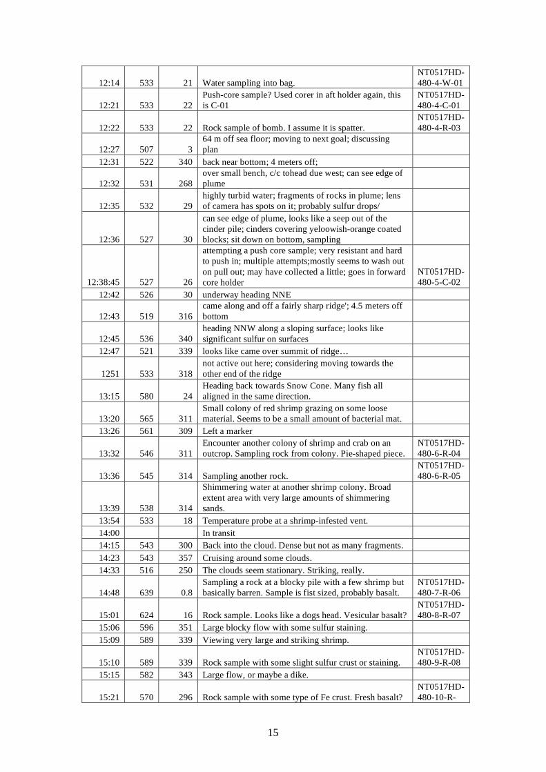
Figure 481A: Active venting from edge of Brimstone Pit. Note small density flows down the right side of the cinder crater (image hdc20051010095743_1)
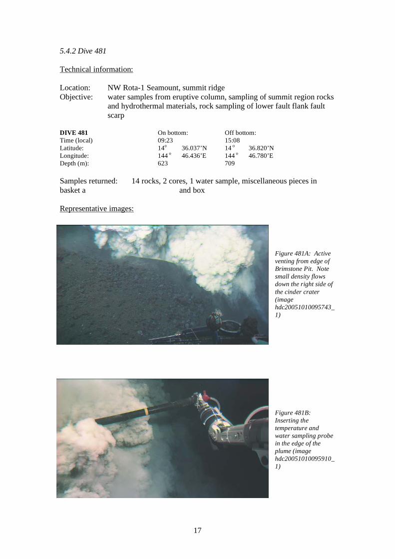
Figure 481B: Inserting the temperature and water sampling probe in the edge of the plume (image hdc20051010095910_1)

18
Scientific summary: Also see background section in front of Dive HD-480 The objectives of Dive HD-481 were to revisit the Brimstone Pit to take additional water samples and obtain rock samples of other locations on the summit area. The Hyper-Dolphin landed about 150 m west of the Brimstone pit at 623 m and headed east obliquely upslope. The Brimstone Pit was found at 09:47. The activity was somewhat more subdued than observed on dive HD-480, although there were still frequent bursts and the Hyper-Dolphin was frequently showered with volcanic ejecta while sampling at the rim of the crater. Several scoop and rock samples were taken of the pit’s ejecta (S1), including some large pieces that landed in the basket. A water sample was taken, but its temperature probe was not giving reliable data. At 10:35, Hyper-Dolphin made a traverse to the marker left on Dive HD-480. A sediment scoop was made of the volcaniclastic sand (S02) which also captured four of the smaller shrimp. A short traverse upslope to the Iceberg site was then made and a water sample (S03) was taken at the base of one of the white-coated outcrops. Several rocks were also taken in the vicinity (S03). Hyper-Dolphin then drove south through mid-water to set up for an upslope traverse to collect rock samples. It landed at a depth of 1080 m. It then traversed upslope to 728 m taking a series of rock samples (S04-S13) before terminating the dive at ~730 m at 15:08. Summary of NWRota-1 Dives The very active volcanic plume at Brimstone Pit showed that the volcano continued to be active after almost 18 months since its discovery in March 2004. The higher plume temperature (up to 100 C higher than measured in April 2004) and the expulsion of significantly larger volcanic ejecta compared to 2004 indicates that the October 2005 volcanic episode was more intense than the activity observed in April 2004. The bursts of the ejecta were observed to collapse into small volcaniclastic flows that formed density currents. The position of the Brimstone Pit appears unchanged, although the upper rim may be shallower compared to 2004. However, this will have to be confirmed by careful comparison with the 2004 dive data. The lower turbidity plume below 700 m that was observed both visually and by a nephelometer (instrument that measures light scattering) mounted on a CTD in 2004 did not appear to be as intense this year, which is somewhat surprising given the increased intensity of the Brimstone Pit. Post-cruise laboratory analysis of data taken with a nephelometer on the NOAA/PMEL MAPR instrument mounted on Hyper-Dolphin should resolve this issue.
19
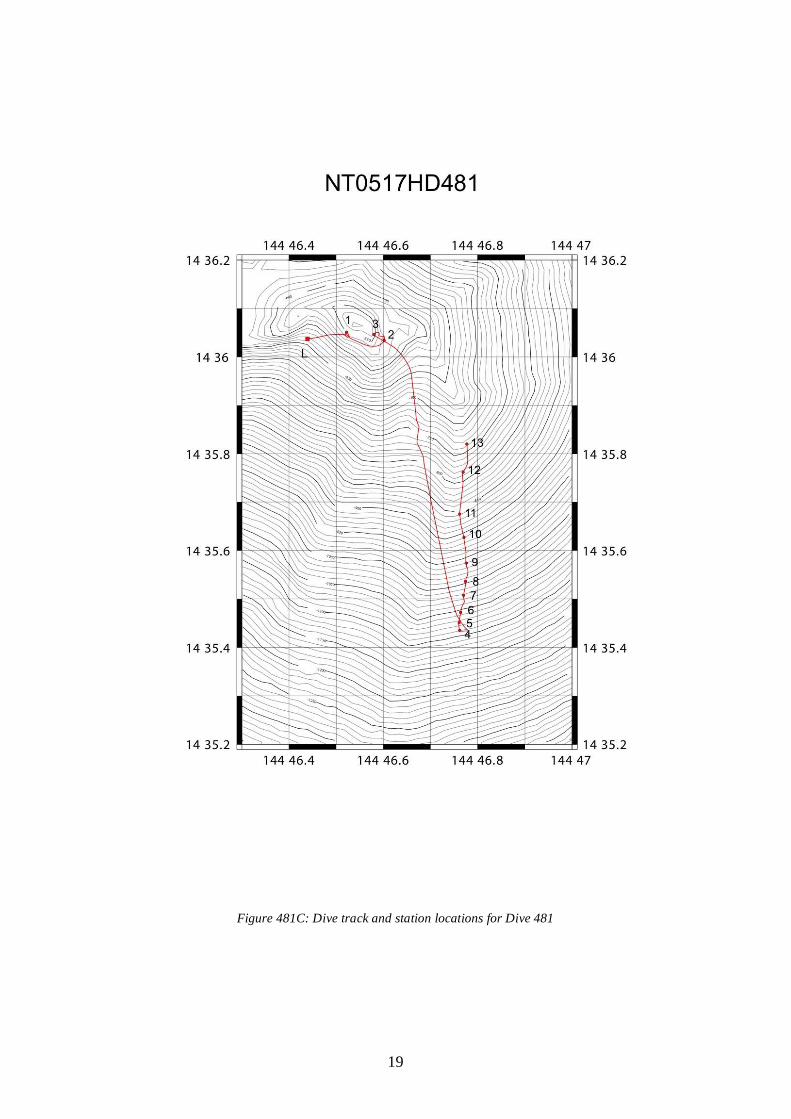
Figure 481C: Dive track and station locations for Dive 481
20
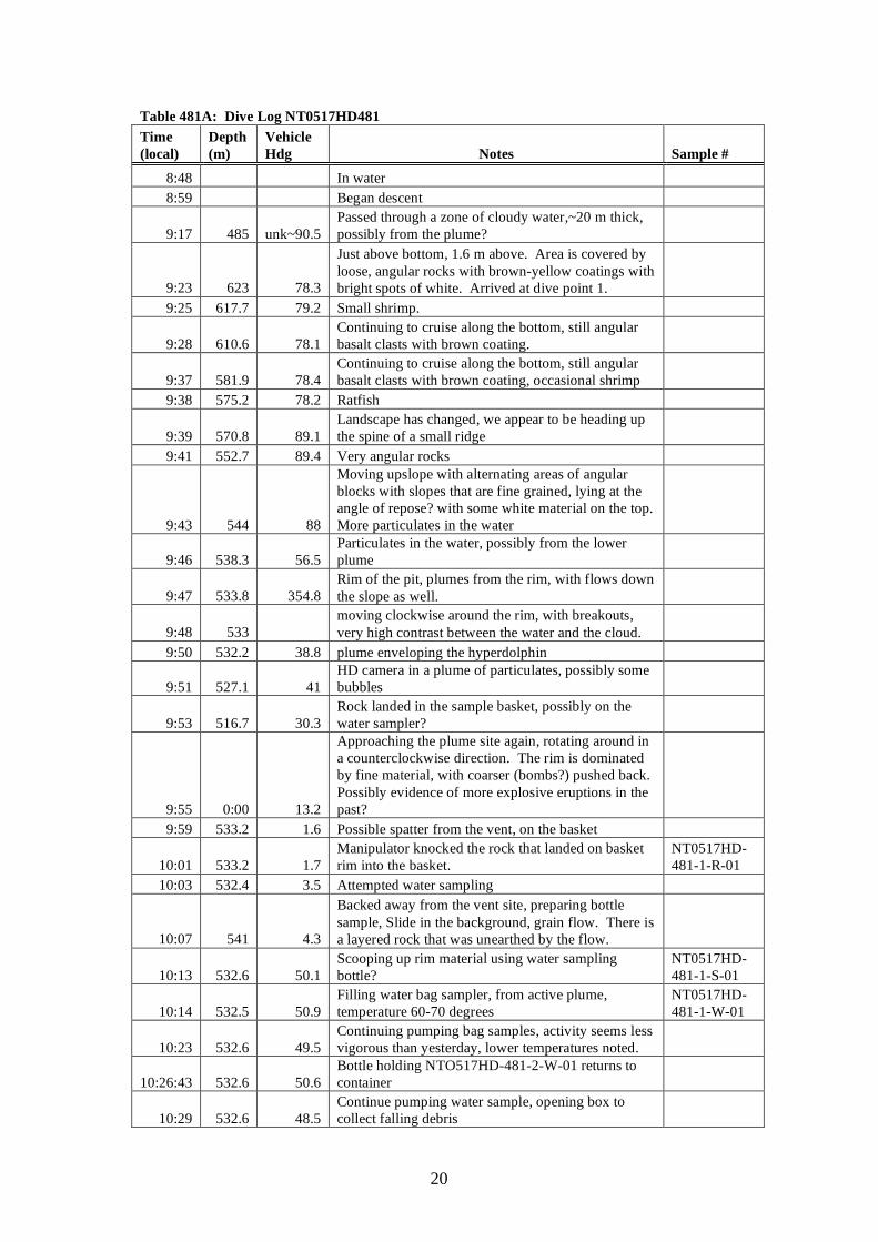
Table 481A: Dive Log NT0517HD481 Time (local)
Depth (m)
Vehicle Hdg Notes Sample #
8:48 In water 8:59 Began descent
9:17 485 unk~90.5 Passed through a zone of cloudy water,~20 m thick, possibly from the plume?
9:23 623 78.3
Just above bottom, 1.6 m above. Area is covered by loose, angular rocks with brown-yellow coatings with bright spots of white. Arrived at dive point 1.
9:25 617.7 79.2 Small shrimp.
9:28 610.6 78.1 Continuing to cruise along the bottom, still angular basalt clasts with brown coating.
9:37 581.9 78.4 Continuing to cruise along the bottom, still angular basalt clasts with brown coating, occasional shrimp
9:38 575.2 78.2 Ratfish
9:39 570.8 89.1 Landscape has changed, we appear to be heading up the spine of a small ridge
9:41 552.7 89.4 Very angular rocks
9:43 544 88
Moving upslope with alternating areas of angular blocks with slopes that are fine grained, lying at the angle of repose? with some white material on the top. More particulates in the water
9:46 538.3 56.5 Particulates in the water, possibly from the lower plume
9:47 533.8 354.8 Rim of the pit, plumes from the rim, with flows down the slope as well.
9:48 533 moving clockwise around the rim, with breakouts, very high contrast between the water and the cloud.
9:50 532.2 38.8 plume enveloping the hyperdolphin
9:51 527.1 41 HD camera in a plume of particulates, possibly some bubbles
9:53 516.7 30.3 Rock landed in the sample basket, possibly on the water sampler?
9:55 0:00 13.2
Approaching the plume site again, rotating around in a counterclockwise direction. The rim is dominated by fine material, with coarser (bombs?) pushed back. Possibly evidence of more explosive eruptions in the past?
9:59 533.2 1.6 Possible spatter from the vent, on the basket
10:01 533.2 1.7 Manipulator knocked the rock that landed on basket rim into the basket.
NT0517HD-481-1-R-01
10:03 532.4 3.5 Attempted water sampling
10:07 541 4.3
Backed away from the vent site, preparing bottle sample, Slide in the background, grain flow. There is a layered rock that was unearthed by the flow.
10:13 532.6 50.1 Scooping up rim material using water sampling bottle?
NT0517HD-481-1-S-01
10:14 532.5 50.9 Filling water bag sampler, from active plume, temperature 60-70 degrees
NT0517HD-481-1-W-01
10:23 532.6 49.5 Continuing pumping bag samples, activity seems less vigorous than yesterday, lower temperatures noted.
10:26:43 532.6 50.6 Bottle holding NTO517HD-481-2-W-01 returns to container
10:29 532.6 48.5 Continue pumping water sample, opening box to collect falling debris
21
10:31 526.4 98.8 Turned off the water sampling pump 10:37 558 88.4 Jellyfish!
10:39 546 94.8 proceeding along a steep slope of fine material, with a white coating
10:40 545.1 91.8 Bottom flattened out with dunes
10:44 563.8 24.3
Returned to marker HD480-2, for sample, scooped up scoria,water, and maybe some shrimp, definitely at least one.
NT0517HD-481-2-S-02
10:55 564.8 262.7 Completed scoop sampling
10:58 549.5 294.7
Position 12 on the map, outcrop is coated with white material, possibly sulfur or possibly bacteria, and reddish areas. Scattered shrimp around.
11:04 534 291.7 Outcrop is a series of lava flows, are layer boundaries acting as conduits for hydrothermal fluids?
11:06 532.4 322.8 Warm water diffusely venting from white-coated hillside
11:12 531 325.3
At base of an outcrop with hydrothermal fluid venting, granular material resting on the slopes, fallout from the vent ~ 100 m distant around the base of the outcrop.
11:13 531.1 323.7
Water sampling at the boundary bretween the granular material and the white coated material, sampling probe was pressed close to the white coated rock
NT0517HD-481-3-W-02
11:30 531.2 319 Continuing to collect water samples, Texture of rocks is like the bark of a tree, it is ropy.
11:40 532.2 317.6 Continuing to sample water 11:41 531.3 317 Finished water sampling 11:43 531.4 317.3 Opened box
11:44 531.4 320.5
Collected rock sample from wall where water sample was taken. The sample has a white coating on the outside. Rock put into closed-lid box.
NT0517HD-481-3-R-02
11:47 531.1 320.3
Trying to collect another sample, the manipulator arm is breaking off the coating, the rock beneath is black.
11:51 531.1 319.7
Sample from wall where rock sample was collected, dark with white coating on the outside. Also placed in closed-lid box.
NT0517HD-481-3-R-03
11:54 531.1 319
Sample from wall where rock sample was collected, dark with white coating on the outside. Also placed in closed-lid box.
NT0517HD-481-3-R-04
12:03 526 162.4 departing stn 3 and heading downslope to site -500, +300 in grid
12.08 540.2 180 small jellyfish floated by 12:17 550.2 195.8 transiting to site for rock sampling 12:23 560.1 189.9 Jellyfish on CCD camera 12:52 560.1 169.8 Continuing transit to rock sampling site 12:55 58 169.5 Started descent at rock sampling side 13:04 165.9 809.2 Water is turbid
13:14 1079 1.1 Sandy looking bottom, with broken blocks, probably basalts
13:16 1080.2 352.3
Rock sample picked up from rubble, sample has oxide sltaining on the outside, possibly filling vesicles
NT0517HD-481-4-R-05
13:18 1079.7 355 Shrimp? With very long legs, walking in side steps across the bottom. This is a diferent one from those
22
we have seen before
13:23 1068.3 3.9 Rock sample from the bottom, basalt NT0517HD-481-5-R-06
13:29 1047.4 5.9 Heading up slope, large blocks or possible outcrop, sampled block, white spots on the outside.
NT0517HD-481-6-R-07
13:35 1041.2 6.4 Outcrop with small white balls attached to the side
13:43 1019.2 0.8 Traversed along slope to a field of angular clasts, pyramidal shaped sample
NT0517HD-481-7-R-08
13:46 1009 0.2
Continuing upslope, many shrimp, both with long legs and antennae and ones similar to those we have seen before. The two types of shrimp are comparable in size, the long legged ones have a more delicate body than the regular ones and are a much darker red.
13:50 1002 0.3 Vesicular rock, red material filling in the vesicles.
13:54 992.4 354.5 Large rock sample picked from amongst block on the floor.
NT0517HD-481-8-R-09
14:01 976.7 348.6 A long unidentified creature swims by on the CCD
14:04 970.3 347.5
A fish, unidentified, has large eyes, translucent body, that swam with a waddling strokes, with fluttering fins
14:09 951.9 344.1 Large rock sample, rounded, placed in basket between the scoop samples and the marker flag
NT0517HD-481-9-R-10
14:11 951.7 342.7 Outcrop made of vesicular rocks, closeup images taken
14:27 901.1 346.6 Rock sample, looks fresh, basalt? Shaped like a piece of pie with a bite taken out.
NT0517HD-481-10-R-11
14:29 899.2 345.6 Outcrop with iron staining 14:30 896 346 Sea anenome
14:32 884 346 branching structures off of rocks, sessile organisms of some kind, possibly coral
14:36 856 354 Stalk attached to the rock, possibly coral, indicating that the surface has been stable for some time.
14:38 848 353 Rock sample, float taken from an area with large weathered blocks. Sample looks somewhat altered
NT0517HD-481-11-R-12
14:42 827.5 354 Continuing upslope, turbidity increasing
14:50 771.4 346 Rock sample, one very flat edge, oblong in shape, I think it was placed on top of sample 10 in the basket
NT0517HD-481-12-R-13
15:00 728 291.8
Rock sample, minimum dimension is the max grasp of the manipulator Dark,fine grained, front of the box, a little bit on the lid
NT0517HD-481-13-R-14
15:08 709 302.5 Began ascent
23
5.4.3 Dive 482 Technical information: Location: West Rota Seamount Objective: map and sample stratigraphy inside caldera, eastern slope DIVE 482 On bottom: Off bottom: Time (local) 09:39 15:06 Latitude: 14o 19.661’N 14 o 19.433’N Longitude: 144 o 51.098’E 144 o 51.669’E Depth (m): 1012 414 Samples returned: 12 rocks, 1 scoop Representative images:
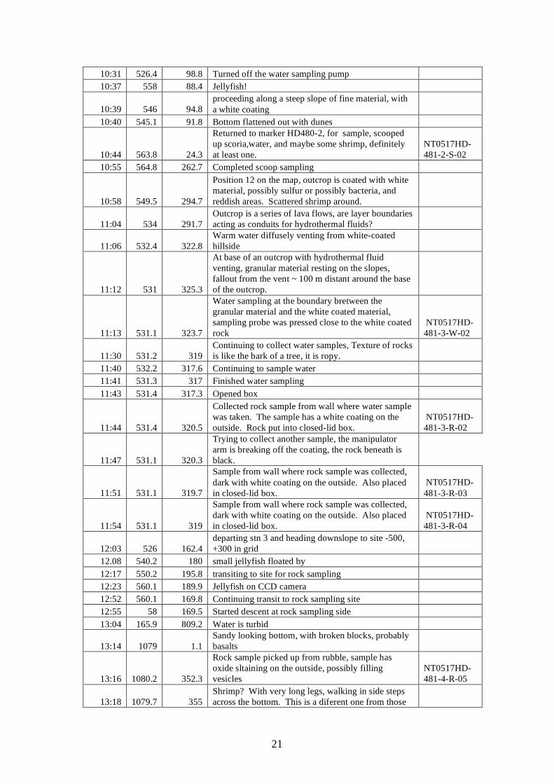
Fig. 482A (Left) Hydrothermally altered and silicified (white) lavas at about 980m depth. Note dark resistant ribs anastamatosing through outcrop. These ribs are likely mineralized. Fig. 482B (Right) Breccia consisting of easily eroded altered volcanics (white) set in a matrix of dark, resistant, mineralized rocks, observed at ~750m depth. Sample 482-R10 was collected from the dark matrix.
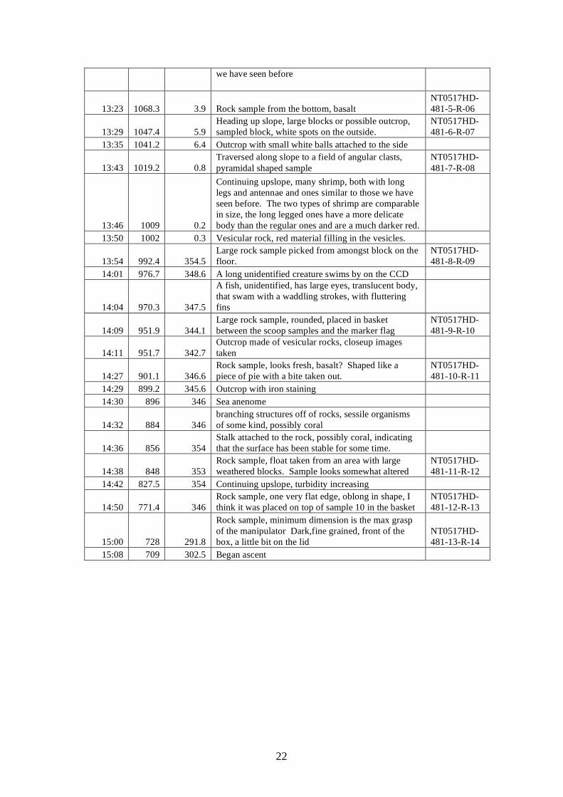
Fig. 482C (Left) Outcrop of altered pillows at 753m. Note large sample at top with brown center. This was collected as sample R9. Fig. 482D (Right) Photo of sample collected at this site. Note many concentric layers, with bleached outer rind and inner, darker interior.
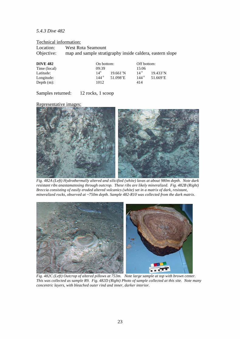
24
Fig. 482E (Left) Felsic pyroclastic flow overlying heterolithologic breccia with abundant mafic and intermediate clasts at ~600m depth. Fig. 482F (Right) Coarse felsic pyroclastic flow overlain by weakly layered pumice-rich tuff at ~550m.
Fig. 482G (Right) Reversely graded, weakly layered tuff at ~570m, probably formed by fragments settling out of water, with ash and smaller pumice clasts becoming saturated with water and sinking sooner than larger pumice clasts. Note Fe-stained horizons. Fig. 482H. Pyroclastic flow with dark grey and light grey clasts. Scientific summary: This dive ascended through an exposed section of about 600m of West Rota volcano. The observed section can be about equally divided into lower altered lavas and upper pyroclastics. The lower, altered section consists of about 250m of variably – and sometimes intensely – altered andesite and dacitic tuff, overlain. Eight of the nine samples collected at depths greater than ~760m appear in hand specimen to be hydrothermally altered. Altered rocks were inferred to exist as shallow as 640m, the depth at which the pyroclastic section begins. Altered rocks are bleached very white and very friable, although more silicified and mineralized veins sand out as irregular ribs (Fig 482A,B). Some of the altered lavas contain disseminated sulfide mineralization. Some of the altered rocks are breccias, although it is not clear
25
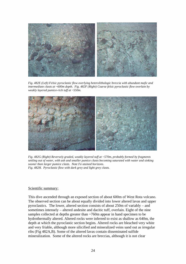
whether brecciation occurred before alteration (volcanic breccia) or was associated with mineralization. A very distinctive zone in the altered rocks may have originally been pillowed lavas which have been silicified and show concentric metasomatic zonation (Fig. 482 C, D). Similar sorts of alteration have been observed near the Galapagos in the eastern Pacific. A diverse sequence of pyroclastic rocks was observed at depths shallower than about 750m. This sequence consisted of about 13 distinctive units of heterolithologic breccia (Fig. 482E), felsic pyroclastic flows (Fig. 482F), and fine-grained tuffs. These units ranged in thickness from a few meters up to 80 meters. Some clearly reflect debris flow deposits, such as the heterolithologic and homolithologic breccias. Abundance of dark, mafic and andesitic clasts in heterolithologic breccias (Fig. 482E) may mark when a new eruptive vent was established or may indicate contemporaneous mafic and felsic igneous activity. The pyroclastic section observed during HD 482 appears to have been deposited close to the vents that produced this ejecta, and the generally upward-coarsening nature of the deposits suggests that explosive volcanism became increasingly violent with time. The friable and unwelded nature of the deposits suggest that these were deposited in a submarine environment, with eruption mechanisms varying from units deposited by pyroclastic flows (Fig. 482G, H).
26
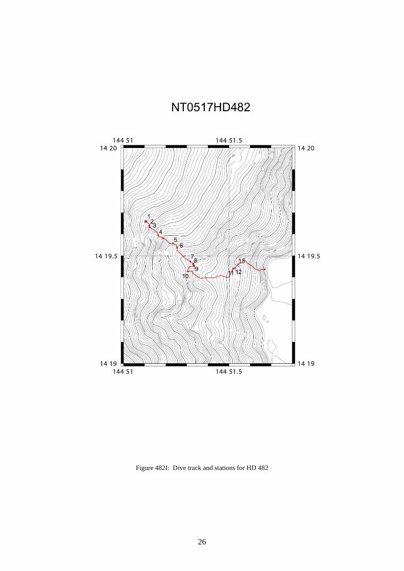
Figure 482I: Dive track and stations for HD 482
27
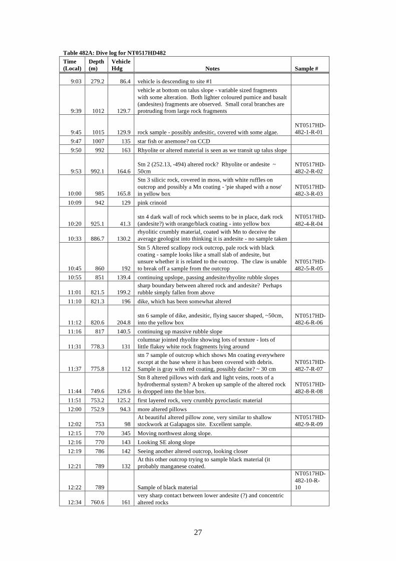
Table 482A: Dive log for NT0517HD482 Time (Local)
Depth (m)
Vehicle Hdg Notes Sample #
9:03 279.2 86.4 vehicle is descending to site #1
9:39 1012 129.7
vehicle at bottom on talus slope - variable sized fragments with some alteration. Both lighter coloured pumice and basalt (andesites) fragments are observed. Small coral branches are protruding from large rock fragments
9:45 1015 129.9 rock sample - possibly andesitic, covered with some algae.
NT0517HD-482-1-R-01
9:47 1007 135 star fish or anemone? on CCD 9:50 992 163 Rhyolite or altered material is seen as we transit up talus slope
9:53 992.1 164.6 Stn 2 (252.13, -494) altered rock? Rhyolite or andesite ~ 50cm
NT0517HD-482-2-R-02
10:00 985 165.8
Stn 3 silicic rock, covered in moss, with white ruffles on outcrop and possibly a Mn coating - 'pie shaped with a nose' in yellow box
NT0517HD-482-3-R-03
10:09 942 129 pink crinoid
10:20 925.1 41.3 stn 4 dark wall of rock which seems to be in place, dark rock (andesite?) with orange/black coating - into yellow box
NT0517HD-482-4-R-04
10:33 886.7 130.2 rhyolitic crumbly material, coated with Mn to deceive the average geologist into thinking it is andesite - no sample taken
10:45 860 192
Stn 5 Altered scallopy rock outcrop, pale rock with black coating - sample looks like a small slab of andesite, but unsure whether it is related to the outcrop. The claw is unable to break off a sample from the outcrop
NT0517HD-482-5-R-05
10:55 851 139.4 continuing upslope, passing andesite/rhyolite rubble slopes
11:01 821.5 199.2 sharp boundary between altered rock and andesite? Perhaps rubble simply fallen from above
11:10 821.3 196 dike, which has been somewhat altered
11:12 820.6 204.8 stn 6 sample of dike, andesitic, flying saucer shaped, ~50cm, into the yellow box
NT0517HD-482-6-R-06
11:16 817 140.5 continuing up massive rubble slope
11:31 778.3 131 columnar jointed rhyolite showing lots of texture - lots of little flakey white rock fragments lying around
11:37 775.8 112
stn 7 sample of outcrop which shows Mn coating everywhere except at the base where it has been covered with debris. Sample is gray with red coating, possibly dacite? ~ 30 cm
NT0517HD-482-7-R-07
11:44 749.6 129.6
Stn 8 altered pillows with dark and light veins, roots of a hydrothermal system? A broken up sample of the altered rock is dropped into the blue box.
NT0517HD-482-8-R-08
11:51 753.2 125.2 first layered rock, very crumbly pyroclastic material 12:00 752.9 94.3 more altered pillows
12:02 753 98 At beautiful altered pillow zone, very similar to shallow stockwork at Galapagos site. Excellent sample.
NT0517HD-482-9-R-09
12:15 770 345 Moving northwest along slope. 12:16 770 143 Looking SE along slope 12:19 786 142 Seeing another altered outcrop, looking closer
12:21 789 132 At this other outcrop trying to sample black material (it probably manganese coated.
12:22 789 Sample of black material
NT0517HD-482-10-R-10
12:34 760.6 161 very sharp contact between lower andesite (?) and concentric altered rocks
28
12:43 758.4 153.9 large phenocrysts are visible within concentric zones 12:51 739 153.3 still in the alteration zone - therefore at least 20m thick 12:53 721.6 153.1 transiting to way point 2 12:54 714 150 more altered rocks 13:12 681.3 90.2 piles of fist sized pumice covering a fairly large area
13:16 666.9 89.5 outcrop encountered (-660, -110) - very altered breccia with possible black dikes
13:24 644.5 88.9 traveling across the pumice rubble pile 13:25 639.7 40.6 reached way pt 3 and heading to way pt 4
13:35 636.7 344.6 stn 11 sample of altered material in hopes of finding hornblende or biotite to date the eruption
NT0517HD-482-11-S-01
13:44 638.2 41.7 very faint layering, but mostly very massive
13:47 621.9 38.4 continuing through the pyroclastic unit, some darker clasts can be seen; everything looks quite altered
13:49 613 40.1 unit looks much darker and poorly sorted, possibly a boundary with lower unit
13:57 611.7 38.6 possible contact between unit with larger more defined clasts and lower more massive unit; large clasts seen at boundary
14:02 610.9 15.7 sampling of an andesitic block from the contact layer - possibly signifying the eruption of a new vent?
NT0517HD-482-12-R-11
14:07 602 40.6 possible contact between unit containing andesite blocks and a more altered pumice rich unit above
14:15 588.6 3.8 sharp boundary
14:16 589 2.5
contacts between pumiceous deposits, some red banding, oxidation, capped by breccia with rounded cobbles? Blocks appear to be largely rhyolitic? Not mixed lithologies
basket filled with pumice when ran into slope.
14:29 579.8 27.5 airfall pumice?
14:32 580.6 28.3 sample of pumice deposited into rear tube (2) - we may be able to find some biotites to date the material
NT0517HD-482-13-R-12
14:42 572 39.6 travelling upslope - difficult to see any structure - may not be subaerial since there is no welding
14:44 558 40.7 layering of flows - may be fall deposit - alternating light and and dark horizons
14:47 550.2 3.4 distinctive unit with orange layer on top of darker material (looks like a paleosoil, but this is submarine)
14:50 547 122 transit to next way pt looking at pyroclastic flow
14:51 563 120.2 coming up to a wall with normal faults all through it - cross bedding is visible
14:53 549 123.6 pyroclastic flow units with layers 14:54 522.8 144.7 thick dark bands within pyroclastic layers
14:57 506 117 still within the flow unit, which is capped by a bright orange layer (possibly a paleosoil)
15:00 480 89.3 vertical pyroclastic flow with lots of lithic (< fist sized)
15:06 413.7 88.6 travelling up to surface, end of dive - pumice from dive is seen floating out of basket
29
5.4.4 Dive 483 Technical information: Location: West Rota Seamount, southeast wall of caldera Objective: Map and sample stratigraphy exposed in SE wall of W. Rota caldera. DIVE 483 On bottom: Off bottom: Time (local) 09:23 16:15 Latitude: 14o 17.739’N 14 o 17.644’N Longitude: 144 o 51.130’E 144 o 51.694’E Depth (m): 1150 662 Samples returned: 20 rocks (one lost on ascent), 2 scoops Representative images:
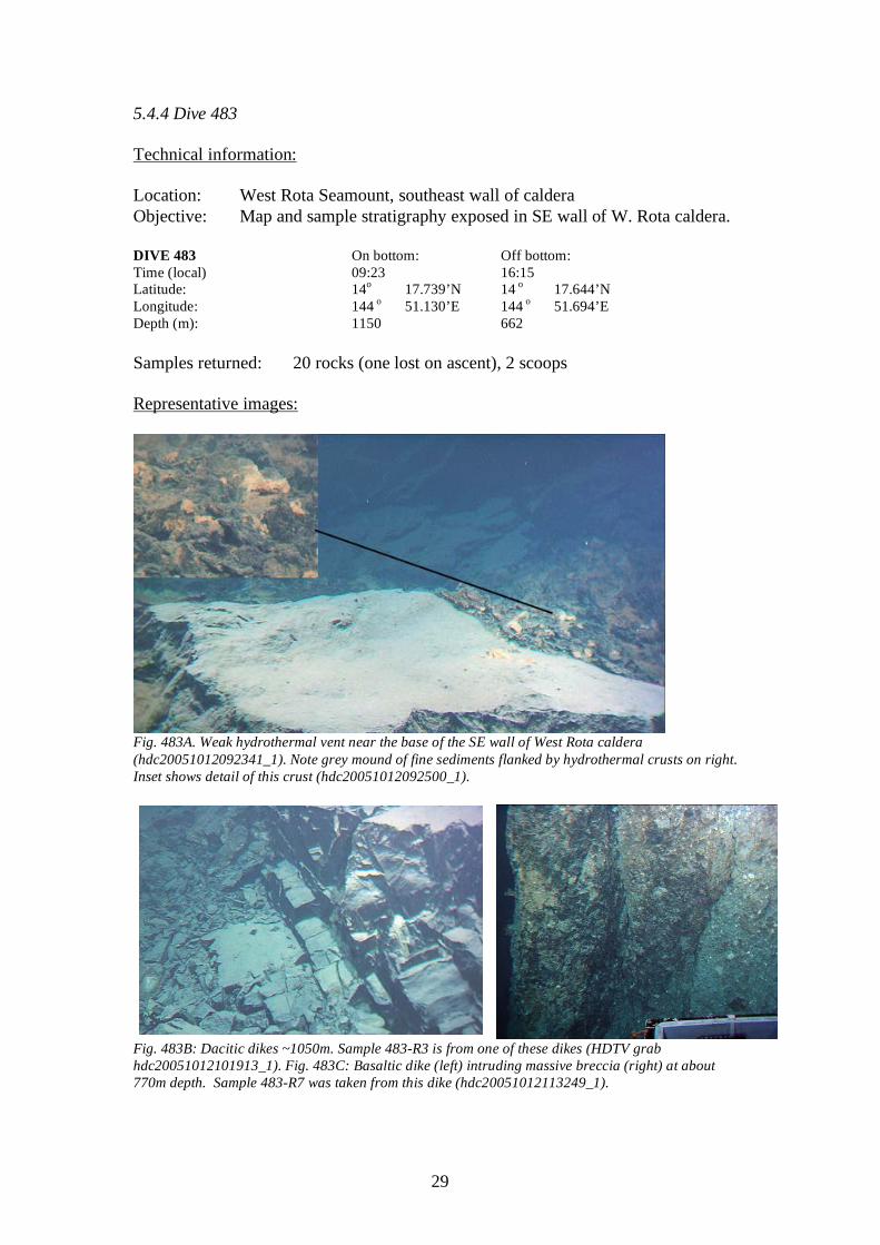
Fig. 483A. Weak hydrothermal vent near the base of the SE wall of West Rota caldera (hdc20051012092341_1). Note grey mound of fine sediments flanked by hydrothermal crusts on right. Inset shows detail of this crust (hdc20051012092500_1).
Fig. 483B: Dacitic dikes ~1050m. Sample 483-R3 is from one of these dikes (HDTV grab hdc20051012101913_1). Fig. 483C: Basaltic dike (left) intruding massive breccia (right) at about 770m depth. Sample 483-R7 was taken from this dike (hdc20051012113249_1).
30
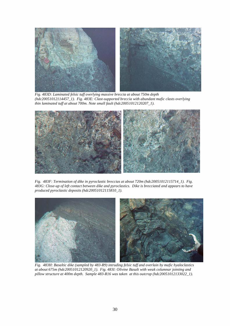
Fig. 483D: Laminated felsic tuff overlying massive breccia at about 750m depth (hdc20051012114457_1). Fig. 483E: Clast-supported breccia with abundant mafic clasts overlying thin laminated tuff at about 700m. Note small fault (hdc20051012120207_1).
Fig. 483F: Termination of dike in pyroclastic breccias at about 720m (hdc20051012115714_1). Fig. 483G: Close-up of left contact between dike and pyroclastics. Dike is brecciated and appears to have produced pyroclastic deposits (hdc20051012115810_1).
Fig. 483H: Basaltic dike (sampled by 483-R9) intruding felsic tuff and overlain by mafic hyaloclastics at about 675m (hdc20051012120920_1). Fig. 483I: Olivine Basalt with weak columnar jointing and pillow structure at 400m depth. Sample 483-R16 was taken at this outcrop (hdc20051012133022_1).
31
Scientific summary: Principal results: This dive ascended through an exposed section of about 800m of West Rota volcano and then moved east to continue the dive at 790-660 m water depth. At the bottom of the dive we observed a weak hydrothermal vent with a weak flow of shimmering water and possible bacterial mat (Fig. 483A). We suspect that other, perhaps more vigorous vents may exist near the base of the caldera wall. The caldera wall up to 850m is dominated by dikes. We sampled three of these: two from the lower section are dacites and one from ~890m is andesite. Moving up-section through this interval dike density was observed to decrease such that dikes at the bottom had a sheeted (dike-on-dike) appearance, with increasing proportions of volcanic screens as we rose through the section. These dikes indicate that the SE part of the caldera wall was an important magmatic conduit for West Rota Volcano. Hydrothermally altered and mineralized rocks like those encountered during HD 482 and 484 do not appear to be an important component in the lower wall of the SE caldera. We speculate that this region was to hot to allow seawater to penetrate, circulate, and alter the rocks in the immediate region of the volcanic conduit. At about 750m laminated felsic tuffs were found to overly the massive volcanic brccia, and from this depth upward the proportion of dikes decreases. The pyroclasitc succession is bimodal in composition, dominated by dacite and basalt as shown by the abundance of mafic clasts in some breccias (Fig. 483E), mafic dikes and tuffs (Fig. 483H) and basalt flows (Fig. 483I). One dike was observed to terminate within the pyroclastic. The dike itself was brecciated and appears to have provided material for the breccias that it intrudes (Fig. 483F&G). Many of the dark clasts found in heterolithologic breccias observed during HD482-484 came may have come from contemporaneous basalt flows or dikes such as those observed in the upper part of HD483. Samples 483-R9 to 17 all are basalts and about half of these contain visible olivine, suggesting that these were primitive magmas. Felsic samples are under-represented because these are very friable and break apart during sampling, in contrast to fresh basalts that were easily collected with ROV manipulators. The abundance of basalts near at least one volcanic center suggests that dacitic eruptions may have been triggered by an influx of mafic melt into a felsic magma chamber.

32
Figure 483H: Dive track and station locations for HD 483
33
Table 483A: Dive Log NT0517HD483 Time (local)
Depth (m)
Vehicle Hdg Notes Sample #
820 0 in water; start a bit earlier because of weather 8:37 98 79 on descent
9:19 1122.8 141.8 Can see an outcrop that appears to be a vertical wall, possibly the crater wall?
9:23 1149.8 139.5
Completed descent, travelled down a vertical wall. The block in front looks like andesite? The floor is covered in rusty red alteration.
9:26 1150.7 139.7 Attempted to sample a flat rock, the claw is able to crush an edge, material seems friable.
9:29 1150.7 138.8 Spotted a hydrothermal seep, there is yellow alteration around the rim. Possibly associated bacterial mats.
9:33 1149.6 158.2 Ground material and rock coatings are very easy to stir up.
9:36 1149.6 157.9
Sampling a white and gray surface that looks like it is a bacterial mat, scoop consistest of red material and white + gray material, sample went into front closed container
NT0517HD-483-1-S-01
9:49 1149.2 157.8
Discussion of what the seeping water may mean, including possibilities of enhanced mineralization and remaining magma acting as a heat source.
9:53 1140.7 158.9
Dikes in the wall we are ascending, attempting to sample what may be a dike or may be andesite. Sample fell into the blue box
NT0517HD-483-2-R-01
10:00 1146.9 158.7 Dike with columnar jointing 10:03 1123 continuing up a wall of massive andesites
10:10 1104.9 138.4
407, -472, station 3, sampling an in situ andesite, though it shatters easily. Sample looks very glassy, possibly a dacite vitrophyre. Sample is placed in a blue box
NT0517HD-483-3-R-02
10:15 1101.8 138.5 Continuing upslope, more possible dikes, dacitic composition?
10:17 1081 138.6 Very different from similar depths along other traverses, arrived at point 1 on the dive plan
10:19 1068.6 140 dike, dipping off the the right, still no breccias
10:21 1057.1 139 Another massive wall, with pronounced planer features, dips to the left
10:25 1055.8 145.8
Sample directly off what looked like a planaqr dike, the broken surface looks like a rhyolite, these may be all rhyolite dikes, sample went into the blue box, a pretty rectangular piece.
NT0517HD-483-4-R-03
10:31 1032.2 164.2 Continuing upslope, increased amount of loose cover over outcrops
10:35 1025.2 164.2 stopping to sample massive outcrop of dark rock
10:42 987.7 158.4 Texture of outcrop has changed, looks almost like pillows, but is most likely a fracture pattern.
10:48 950.6 174.5 Trying to sample from the side of the wall. Unable to get a piece the rock wall appears quite solid
10:54 935.7 186.9
Found a good place to set down the ROV and sample pieces from the wall. Sample has a rust coating, shaped lke a potato, ~20x40 cm. Sample placed behind blue basket, x=259m, -y = 331m
NT0517HD-483-5-R-04
10:58 926 178.9 Rocks in outcrop are shattered, with lots of sediment on top
11:01 901 129.8 Way point 2, columnar jointed dikes
11:07 888.2 187.3 Sampling the wall. NT0517HD-483-6-R-05
34
11:09 179 886.2 Texture of outcrop has changed, looks almost like pillows, but is most likely a fracture pattern.
11:10 867 148.8
Rhyolitic appearance, with some alteration showing on broken surfaces. Weathered surfaces are black, fresher surfaces are grey with some rust staining.
11:13 862.20 173.5
Collected a 20cm long sample of very soft, black stained, rock with a light colored interior, sample went into blue box,
NT0517HD-483-7-R-06
11.19 822.6 111 More dikes, at least two 11:26 789 111.2 Tuff? There is some layering
11:27 788 150.6
Attempting to scratch the surface of the outcrop, too hard for tuff, but it is very broken up and lithology is difficult to infer. X= -180 y = -188
11:31 753 124.6
Brecciated tuff, clast sizes are difficult to see estimated largest ones are 5 cm There is some kind of layering, clast vary from dark to light, red to green, mostly angular, some sub-rounded to rounded. Heterolithic, dikes are intruding into breccia but do not seem to progress very far.
11:37 752.5 82.9
Sampling the dike to try to get a piece of obsidian? This location is between the contact of the dike and the dacite, rock was placed in the blue box.
NT0517HD-483-8-R-07
1143 745 82.9 Layered series, lying right on top of the breccia, contact is sharp, laminated white tuff, very friable
11:48 740.1 82.1 Breccia and layered series are next to each other, possibly juxtaposed by a faults.
11:48 736 112.9 Back into breccia from thin wite laminated area 11:49 732 112 Layered series 11:49 730 Back into breccia
11:50 730.7 124.2 Collecting a small sample, a clast from breccia, with d=10cm, covered with slime, into blue box
NT0517HD-483-9-R-08
11:53 726.4 113.5 In the background you get the sense that there are alternating layers of tuff and breccia
11:54 719 113 Dark clasts are gone, there is prominent lamination, we will be going up v-shaped notch.
11:55 711 114 another breccia unit, lots of faulting.
11:57 711 111 Vertical structure, possibly a dike that is at its maximum elevation, like it reached the surface.
12:01 702 113 Stopping to look at a breccia zone
12:06 690 108 Climbing up talus covered slope; lot of light colored gravel and cobbles mixed with darker pieces
12:08 675 108 Beautiful outcrop of dark rock intruding white rock with layered stuff above. Sampling dark intrusion rock
NT0517HD-483-10-R-09
12:14 677 67 R-9 placed in basket; Start upslope again. 12:15 672 108 Continuing upslope on dipslope 12:17 667 109 Crest of local ridge, going along it now
12:18 666 119 came over a lava flow and now going off ridge off bottom
12:19 658 115 Seeing bottom again, in rough terrain of ridge after ridge; looks like mafic dikes, then looks like truncated pillows
12:20 645 181 sampling looks like breccia deposits? Into blue bucket NT0517HD-483-11-R10
12:26 645 188
looked like another rock may have gotten into bucket; probably in top of blue box?; nope, didn't get in, keep trying to get another piece; got one put behind blue box
NT0517HD-483-11-R11
12:28 637 142 underway upslope; irregular knobbly outcrop; breccias?

35
12:31 639.9 123.5 Shark!
12:32 638.6 140
traversing through very coarse breccia, maybe close to the volcanic eruption site, due to observations of today, very coarse breccias, feeder dikes.
12:34 624 unk orange crust in fractures and on surfaces of the breccia. 12.36 614 119 x = 20.4,y = 112 12:39 597 113 continuing through a covered interval. 12:42 566 118 massive breccia, exposed by mass wasting 12:43 562 119 crude layering in the breccia
12:46 556.9 118.9 Sampling breccia, angular block, 20cm, placed behind blue basket
NT0517HD-483-12-R12
12:49 554.6 118 waypoint 4
12:53 533.7 147 Layering is more aparent, note the absence of an rhyolite balloons
12:56 518 140 Looks like lava flows, took a sample, very fractures, maybe 40 cm. Chevrons in one surface, in yellow basket
NT0517HD-483-13-R13
13:01 508 150 In a covered interval
13:03 500.8 150.1 Fractured rock, still mostly covered, but with visible fractures filled with something, breccia is massive.
13:06 473 155 bigger blocks 13:08 461 153 bigger blocks of breccia
13:09 456 153
Blocky lava flow or a dike, sample is round, with some iron staining on the outside, sample in front of the yellow box,
NT0517HD-483-14-R14
13:15 447.6 153 Way point 5 13:19 433 153 More vent breccia
13:30 429 153.1 Sample of blocky from bottom, has a starfish attached to the bottom, placed behind the blue box
NT0517HD-483-15-R15
13:26 414 156 Massive outcrop
13:29 396 162
Massive outcrop, looks like there is some columnar jointing, and some spherical, placed in front of the yellow basket
NT0517HD-483-16-R16
13:32 393.7 153.1 chaotic large blocks
13:34 389 151.3
Looks like a lava dome, large chaotic blocks with nearly black to rusty brown coating. The wall in this area was overhanging
13:41 370 92.1 Completed planned dive, so now we turn east up ridge 13:42 377 90 Encountered big blocks of rhyolite?
13:47 378 167
Took a sample of large blocky rhyolite outcrop, has a couple of small sponges attached, placed behind the blue box.
NT0517HD-483-17-R17
13:57 361.4 129.4 Continuing up the ridge, seeing cooling joints, maybe a massive, welded tuff, with some volcanoclastic breccia
13:59 365 131 Alternating layers of breccia and welded tuff 14:00 354 130 Nice black sand with layering 14:05 344.5 60.3 traversing across a big pumice covered slope 14:07 343 61.7 traversing across a big pumice covered slope
14:11 341 89.3
Still on the pumice plain, took a scoop sample of the pumice at location x=-327 y = -47, tube in the back was filled
NT0517HD-483-18-S2
14:35 334.2 73.7 still travelling on pumice slope, the grade is very gentle
14:38 331 78 Completed the dive plan, now go east to look for dikes within the volcano. X=250, y = 250
14:42 331 78 Shark! unk reached new dive site
1535 788 148 Nice looking dike with columnar jointing
36
15:39 784 117 Used claw on wall of dacitic or rhylitic dikes, the claw ripped right through the material
15:43 780 130 Very nice columnar jointing in a dacitic dike 15:46 778 131 Attempting to sample dike, unable to get sample
15:47 773 131 dikes intruding tuff? Breccia present at 800 m. Layers of tuff with some dikes.
15:48 760 132 Clast increased in size during ascent
15:49 740 150 Between this entry and the last there appears to be either a fault or a dike alongside breccia
15:52 726 150 x =350, attempting to sample a columnarly jointed dike, placed in front of yellow basket. Large, flat sample
NT0517HD-483-19-R18
16:00 701 149.2 massive rocks
16:03 678 150
Picked up loose rocks from a pile of rocks presumably from the steep wall, two samples were picked up in one grab, rocks 19 and 20. Both rocks are oblong. One rock is 2-3 times the size of the other.
NT0517HD-483-20-R19
16:03 678 150 Same as previous entry NT0517HD-483-20-R20
16:13 664 129 Dropped a sample trying to get the scoop back in the box 16:15 662.3 129.2 Began ascent
37
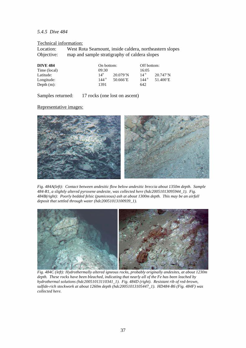
5.4.5 Dive 484 Technical information: Location: West Rota Seamount, inside caldera, northeastern slopes Objective: map and sample stratigraphy of caldera slopes DIVE 484 On bottom: Off bottom: Time (local) 09:30 16:05 Latitude: 14o 20.079’N 14 o 20.747’N Longitude: 144 o 50.666’E 144 o 51.400’E Depth (m): 1391 642 Samples returned: 17 rocks (one lost on ascent) Representative images:
Fig. 484A(left): Contact between andesitic flow below andesitic breccia about 1350m depth. Sample 484-R1, a slightly altered pyroxene andesite, was collected here (hdc20051013095944_1). Fig. 484B(right): Poorly bedded felsic (pumiceous) ash at about 1300m depth. This may be an airfall deposit that settled through water (hdc20051013100939_1).
Fig. 484C (left): Hydrothermally altered igneous rocks, probably originally andesites, at about 1230m depth. These rocks have been bleached, indicating that nearly all of the Fe has been leached by hydrothermal solutions (hdc20051013110341_1). Fig. 484D (right). Resistant rib of red-brown, sulfide-rich stockwork at about 1260m depth (hdc20051013105447_1). HD484-R6 (Fig. 484F) was collected here.
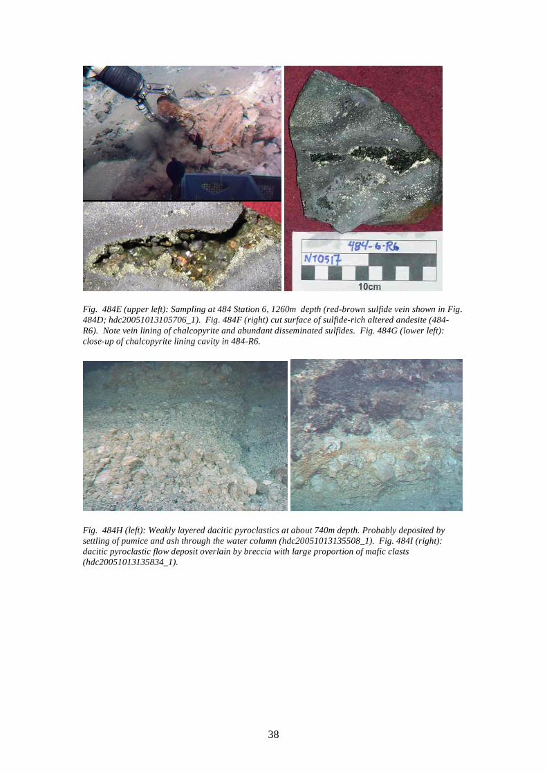
38
Fig. 484E (upper left): Sampling at 484 Station 6, 1260m depth (red-brown sulfide vein shown in Fig. 484D; hdc20051013105706_1). Fig. 484F (right) cut surface of sulfide-rich altered andesite (484-R6). Note vein lining of chalcopyrite and abundant disseminated sulfides. Fig. 484G (lower left): close-up of chalcopyrite lining cavity in 484-R6.
Fig. 484H (left): Weakly layered dacitic pyroclastics at about 740m depth. Probably deposited by settling of pumice and ash through the water column (hdc20051013135508_1). Fig. 484I (right): dacitic pyroclastic flow deposit overlain by breccia with large proportion of mafic clasts (hdc20051013135834_1).
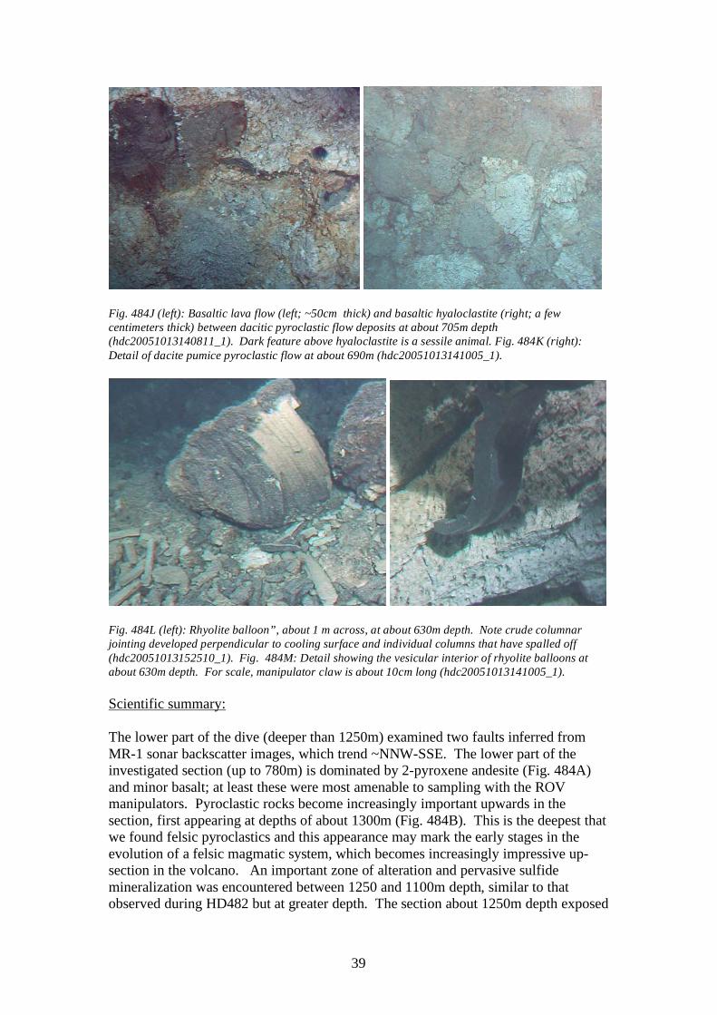
39
Fig. 484J (left): Basaltic lava flow (left; ~50cm thick) and basaltic hyaloclastite (right; a few centimeters thick) between dacitic pyroclastic flow deposits at about 705m depth (hdc20051013140811_1). Dark feature above hyaloclastite is a sessile animal. Fig. 484K (right): Detail of dacite pumice pyroclastic flow at about 690m (hdc20051013141005_1).
Fig. 484L (left): Rhyolite balloon”, about 1 m across, at about 630m depth. Note crude columnar jointing developed perpendicular to cooling surface and individual columns that have spalled off (hdc20051013152510_1). Fig. 484M: Detail showing the vesicular interior of rhyolite balloons at about 630m depth. For scale, manipulator claw is about 10cm long (hdc20051013141005_1). Scientific summary: The lower part of the dive (deeper than 1250m) examined two faults inferred from MR-1 sonar backscatter images, which trend ~NNW-SSE. The lower part of the investigated section (up to 780m) is dominated by 2-pyroxene andesite (Fig. 484A) and minor basalt; at least these were most amenable to sampling with the ROV manipulators. Pyroclastic rocks become increasingly important upwards in the section, first appearing at depths of about 1300m (Fig. 484B). This is the deepest that we found felsic pyroclastics and this appearance may mark the early stages in the evolution of a felsic magmatic system, which becomes increasingly impressive up-section in the volcano. An important zone of alteration and pervasive sulfide mineralization was encountered between 1250 and 1100m depth, similar to that observed during HD482 but at greater depth. The section about 1250m depth exposed
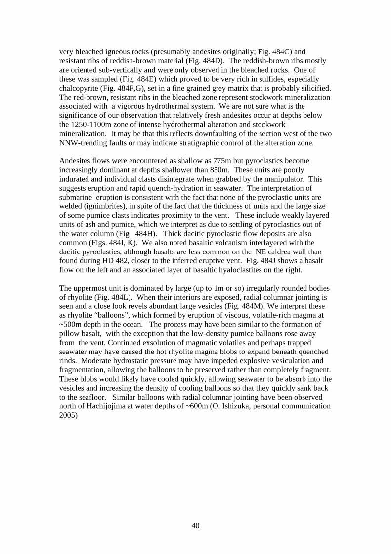
40
very bleached igneous rocks (presumably andesites originally; Fig. 484C) and resistant ribs of reddish-brown material (Fig. 484D). The reddish-brown ribs mostly are oriented sub-vertically and were only observed in the bleached rocks. One of these was sampled (Fig. 484E) which proved to be very rich in sulfides, especially chalcopyrite (Fig. 484F,G), set in a fine grained grey matrix that is probably silicified. The red-brown, resistant ribs in the bleached zone represent stockwork mineralization associated with a vigorous hydrothermal system. We are not sure what is the significance of our observation that relatively fresh andesites occur at depths below the 1250-1100m zone of intense hydrothermal alteration and stockwork mineralization. It may be that this reflects downfaulting of the section west of the two NNW-trending faults or may indicate stratigraphic control of the alteration zone. Andesites flows were encountered as shallow as 775m but pyroclastics become increasingly dominant at depths shallower than 850m. These units are poorly indurated and individual clasts disintegrate when grabbed by the manipulator. This suggests eruption and rapid quench-hydration in seawater. The interpretation of submarine eruption is consistent with the fact that none of the pyroclastic units are welded (ignimbrites), in spite of the fact that the thickness of units and the large size of some pumice clasts indicates proximity to the vent. These include weakly layered units of ash and pumice, which we interpret as due to settling of pyroclastics out of the water column (Fig. 484H). Thick dacitic pyroclastic flow deposits are also common (Figs. 484I, K). We also noted basaltic volcanism interlayered with the dacitic pyroclastics, although basalts are less common on the NE caldrea wall than found during HD 482, closer to the inferred eruptive vent. Fig. 484J shows a basalt flow on the left and an associated layer of basaltic hyaloclastites on the right. The uppermost unit is dominated by large (up to 1m or so) irregularly rounded bodies of rhyolite (Fig. 484L). When their interiors are exposed, radial columnar jointing is seen and a close look revels abundant large vesicles (Fig. 484M). We interpret these as rhyolite “balloons”, which formed by eruption of viscous, volatile-rich magma at ~500m depth in the ocean. The process may have been similar to the formation of pillow basalt, with the exception that the low-density pumice balloons rose away from the vent. Continued exsolution of magmatic volatiles and perhaps trapped seawater may have caused the hot rhyolite magma blobs to expand beneath quenched rinds. Moderate hydrostatic pressure may have impeded explosive vesiculation and fragmentation, allowing the balloons to be preserved rather than completely fragment. These blobs would likely have cooled quickly, allowing seawater to be absorb into the vesicles and increasing the density of cooling balloons so that they quickly sank back to the seafloor. Similar balloons with radial columnar jointing have been observed north of Hachijojima at water depths of ~600m (O. Ishizuka, personal communication 2005)
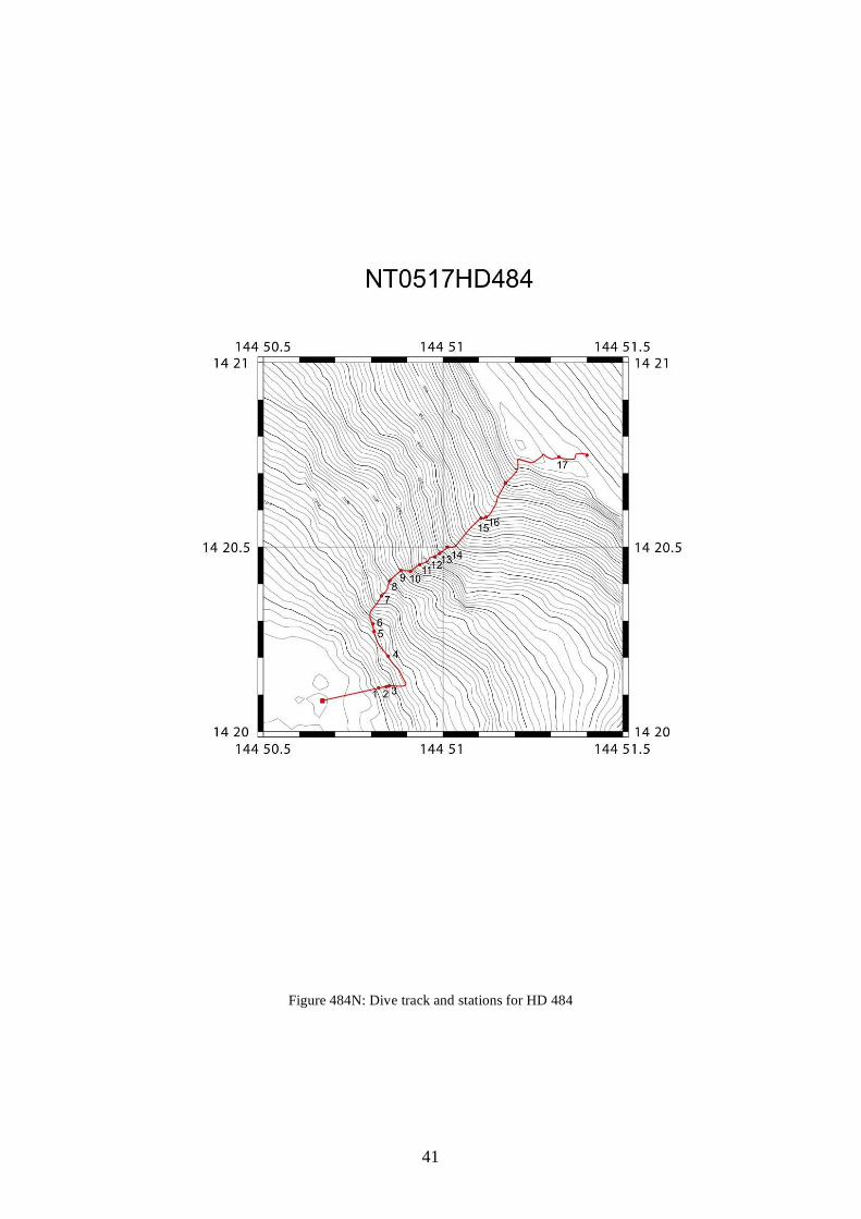
41
Figure 484N: Dive track and stations for HD 484
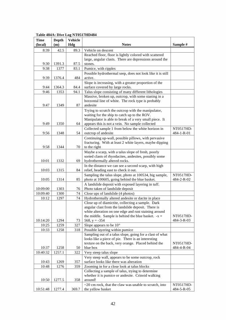
42
Table 484A: Dive Log NT0517HD484 Time (local)
Depth (m)
Vehicle Hdg Notes Sample #
8:39 42.5 89.3 Vehicle on descent
9:30 1391.3 87.5
Reached floor, floor is lightly colored with scattered large, angular clasts. There are depressions around the stones.
9:38 1377 83.1 Pumice, with ripples
9:39 1376.4 484 Possible hydrothermal seep, does not look like it is still active.
9:44 1364.3 84.4 Slope is increasing, with a greater proportion of the surface covered by large rocks.
9:46 1353 94.1 Talus slope consisting of many different lithologies
9:47 1349 87
Massive, broken up, outcrop, with some staning in a horzontal line of white. The rock type is probably andesite
9:49 1350 64
Trying to scratch the outcrop with the manipulator, waiting for the ship to catch up to the ROV. Manipulator is able to break of a very small piece. It appears this is not a vein. No sample collected
9:56 1348 54 Collected sample 1 from below the white horizon in outcrop of andesite
NT0517HD-484-1-R-01
9:58 1344 70
Continuing up-wall, possible pillows, with pervasive fracturing. With at least 2 white layers, maybe dipping to the right
10:01 1332 69
Maybe a scarp, with a talus slope of fresh, poorly sorted clasts of rhyodacites, andesites, possibly some hydrothermally altered rocks.
10:03 1315 84 In the distance we can see a second scarp, with high relief, heading east to check it out.
10:05 1314 85 Sampling the talus slope, photo at 100534, big sample, photo at 100605, going behind the blue basket.
NT0517HD-484-2-R-02
10:09:00 1303 76 A landslide deposit with exposed layering in tuff. Photo taken of landslide deposit
10:09:40 1300 74 Close ups of landslide (4 photos) 10:12 1297 74 Hydrothermally altered andesite or dacite in place
10:14:20 1294 73
Close up of diamictite, collecting a sample. Dark angular clast from the landslide deposit. There is white alteration on one edge and rust staining around the middle. Sample is behind the blue basket. -x = 568, y = -354
NT0517HD-484-3-R-03
10:25 1259 327 Slope appears to be 10° 10:33 1258 318 Possible layering within pumice
10:37 1258 50
Sampling out of a talus slope, going for a clast of what looks like a piece of pie. There is an interesting texture on the back, very orange. Placed behind the blue box
NT0517HD-484-4-R-04
10:40:32 1257.1 322 Very steep talus slope
10:43 1269 357 Very steep wall, appears to be some outcrop, rock surface looks like there was alteration
10:48 1276 359 Zooming in for a close look at talus blocks
10:50 1277.5 358
Collecting a sample of talus, trying to determine whether it is pumice or andesite. Crinoid walking around!
10:51:48 1277.4 369.7 ~20 cm rock, that the claw was unable to scratch, into the yellow basket
NT0517HD-484-5-R-05
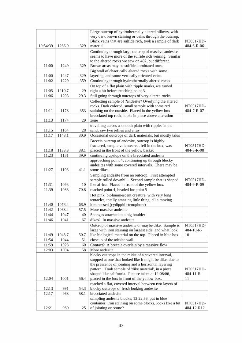
43
10:54:39 1266.9 329
Large outcrop of hydrothermally altered pillows, with very dark brown staining or veins through the outcrop. Black veins that are sulfide rich, took a sample of dark material.
NT0517HD-484-6-R-06
11:00 1249 329
Continuing through large outcrop of massive andesite, seems to have more of the sulfide rich veining. Similar to the altered rocks we saw on 482, but different. Brown areas may be sulfide dominated ones.
11:00 1247 329 Big wall of chaotically altered rocks with some layering, and some vertically oriented veins.
11:02 1229 359 Continuing through hydrothermally altered rocks
11:05 1210.7 29 On top of a flat plain with ripple marks, we turned right a bit before reaching point 3.
11:06 1203 29.3 Still going through outcrops of very altered rocks
11:11 1178 353
Collecting sample of ?andesite? Overlying the altered rocks. Dark colored, small sample with some red staining on the outside. Placed in the yellow box
NT0517HD-484-7-R-07
11:13 1174 29 brecciated top rock, looks in place above alteration zone
11:15 1164 28 travelling across a smooth plain with ripples in the sand, saw two jellies and a ray
11:17 1148.1 30.9 Occasional outcrops of dark materials, but mostly talus
11:18 1133.3 38.1
Breccia outcrop of andesite, outcrop is highly fractured, sample volunteered, fell in the box, was placed in the front of the yellow basket
NT0517HD-484-8-R-08
11:23 1131 39.9 continuing upslope on the brecciated andesite
11:27 1103 41.1
approaching point 4, continuing up through blocky andesites with some covered intervals. There may be some dikes
11:31 1093 10
Sampling andesite from an outcrop. First attempted sample rolled downhill. Second sample that is shaped like africa. Placed in front of the yellow box.
NT0517HD-484-9-R-09
11.39 1083 70.8 reached point 4, headed for point 5
11:40 1078.4 68.9
Hot pink, bioluminescent creature, with very long tentacles, totally amazing little thing, cilia moving luminecsed (cydippid ctenophore)
11:42 1063.4 57.5 More massive andesite 11:44 1047 40 Sponges attached to a big boulder 11:46 1041 67 dikes? In massive andesite
11:49 1043.7 50.7
Outcrop of massive andesite or maybe dike. Sample is large with iron staining on largest side, and what look like biological material on the top. Placed in blue box.
NT0517HD-484-10-R-10
11:54 1044 51 closeup of the adesite wall 11:59 1023 60 Contact? A breccia overlain by a massive flow 12:03 1004 58 More andesite
12:04 1001 56.4
blocky outcrops in the midst of a covered interval, stopped at one that looked like it might be dike, due to the prescence of jointing and a horizontal layering pattern. Took sample of 'dike material', in a piece shaped like california. Picture taken at 12:08:06, placed in the box in front of the yellow box.
NT0517HD-484-11-R-11
12:13 991 54.3 reached a flat, covered interval between two layers of blocky outcrops of fresh looking andesite
12:17 963 58.1 brecciated andesite
12:21 960 25
sampling andesite blocks; 12:22.56, put in blue container; iron staining on some blocks, looks like a bit of jointing on some?
NT0517HD-484-12-R12
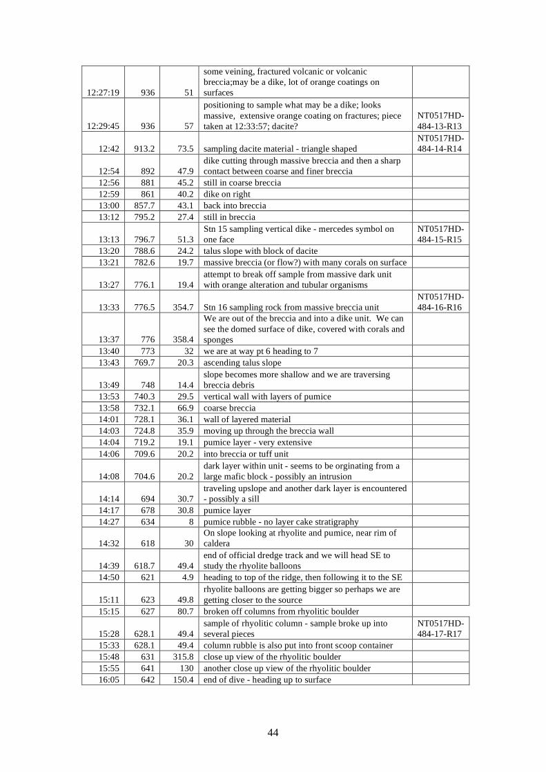
44
12:27:19 936 51
some veining, fractured volcanic or volcanic breccia;may be a dike, lot of orange coatings on surfaces
12:29:45 936 57
positioning to sample what may be a dike; looks massive, extensive orange coating on fractures; piece taken at 12:33:57; dacite?
NT0517HD-484-13-R13
12:42 913.2 73.5 sampling dacite material - triangle shaped NT0517HD-484-14-R14
12:54 892 47.9 dike cutting through massive breccia and then a sharp contact between coarse and finer breccia
12:56 881 45.2 still in coarse breccia 12:59 861 40.2 dike on right 13:00 857.7 43.1 back into breccia 13:12 795.2 27.4 still in breccia
13:13 796.7 51.3 Stn 15 sampling vertical dike - mercedes symbol on one face
NT0517HD-484-15-R15
13:20 788.6 24.2 talus slope with block of dacite 13:21 782.6 19.7 massive breccia (or flow?) with many corals on surface
13:27 776.1 19.4 attempt to break off sample from massive dark unit with orange alteration and tubular organisms
13:33 776.5 354.7 Stn 16 sampling rock from massive breccia unit NT0517HD-484-16-R16
13:37 776 358.4
We are out of the breccia and into a dike unit. We can see the domed surface of dike, covered with corals and sponges
13:40 773 32 we are at way pt 6 heading to 7 13:43 769.7 20.3 ascending talus slope
13:49 748 14.4 slope becomes more shallow and we are traversing breccia debris
13:53 740.3 29.5 vertical wall with layers of pumice 13:58 732.1 66.9 coarse breccia 14:01 728.1 36.1 wall of layered material 14:03 724.8 35.9 moving up through the breccia wall 14:04 719.2 19.1 pumice layer - very extensive 14:06 709.6 20.2 into breccia or tuff unit
14:08 704.6 20.2 dark layer within unit - seems to be orginating from a large mafic block - possibly an intrusion
14:14 694 30.7 traveling upslope and another dark layer is encountered - possibly a sill
14:17 678 30.8 pumice layer 14:27 634 8 pumice rubble - no layer cake stratigraphy
14:32 618 30 On slope looking at rhyolite and pumice, near rim of caldera
14:39 618.7 49.4 end of official dredge track and we will head SE to study the rhyolite balloons
14:50 621 4.9 heading to top of the ridge, then following it to the SE
15:11 623 49.8 rhyolite balloons are getting bigger so perhaps we are getting closer to the source
15:15 627 80.7 broken off columns from rhyolitic boulder
15:28 628.1 49.4 sample of rhyolitic column - sample broke up into several pieces
NT0517HD-484-17-R17
15:33 628.1 49.4 column rubble is also put into front scoop container 15:48 631 315.8 close up view of the rhyolitic boulder 15:55 641 130 another close up view of the rhyolitic boulder 16:05 642 150.4 end of dive - heading up to surface
45
5.4.6 Dive 485 Technical information: Location: Chaife Seamount, northern flanks Objective: map and sample lava distribution on Chaife Seamount, examine
exposures on fault cutting volcano, recover primitive lava compositions
DIVE 485 On bottom: Off bottom: Time (local) 09:40 15:41 Latitude: 14o 40.600’N 14 o 39.312’N Longitude: 145 o 00.526’E 145 o 00.454’E Depth (m): 2308 1684 Samples returned: 20 rocks Representative images:
Figure 485A: lower slopes of the northern end of Chaife Seamount (image hdc20051014094216_1)
Figure 485B: mid-slopes of the northern end of Chaife Seamount (image hdc20051014142357_1)
46
Scientific summary: Chaife Seamount is a small volcano located on the Mariana magmatic front. It is located at the arc end of a cross-chain of seamounts that extend roughly along 14° 35’ N latitude. Unlike the Guguan cross-chain there is no large arc volcano associated with the 14° 35’ cross-chain. Adjacent to Chaife (~1 km to the south) is a larger volcano labeled “Mt. Manganese” by the Cook 7 science party in 2001. Recent EM3 side-scan data show that Chaife appears to be built on top of a large NNE striking fracture. This fracture may also cut into Chaife, indicating rifting and magmatism occurred over the same time interval. The fracture also bisects the northern flank of “Mt. Manganese”. Side-scan imagery also shows a smaller cone, “Little Chaife” on Chaife’s eastern flank. In 2001, the Cook 7 cruise aboard R/V Melville dredged Chaife (D14) and recovered samples of picritic and ankaramitic lavas. Analyses of these lavas indicated they were primitive, with Mg#s >70 and MgO contents of ~15 wt%. These lavas also had Indian Ocean-type mantle isotopic signature and subdued arc-like trace-element signatures. These lavas erupted 2.18 and 1.79 Ma. based on Ar39/Ar40 dating. Melt inclusion analyses indicated that the lavas’ parental melts had ~17-18% MgO and were relatively anhydrous with 0.3-0.5 wt% water.
Hyper Dolphin Dive 488 landed on the northern flank of Chaife and traversed upslope SSW along the western side of the fracture zone and intersected the track of Cook 7 Dredge 14 along the western flank. Hyper Dolphin then continued along the D14 track SE towards the summit. Hyper Dolphin encountered steep slopes of blocky lava flows alternating with gentler slopes covered with sediment. The blocky flows in many locations had ~0.5 to 1 meter rounded protuberances suggestive of pillows. The lava flows were very competent and difficult to sample directly, probably in part due to significant growth of manganiferous crusts. Many separated clasts were cemented to the flows by manganese. Several outcrops with a “lumpy” surface were likely breccias. At 2124 and 1940 meters depth steeply dipping, NNE striking fracture surfaces (likely fault scarps) were observed. Twenty rock samples were recovered. Samples R1-R4 collected on the lowest slopes were plagioclase-CPX phyric basalts. Most of these lavas displayed alteration rinds of 1 to 4 cm and several had interior alteration zones. The next lava flow contained largely olivine and CPX phyric basalt with little to no plagioclase phenocrysts. Manganese crust was thickest here. Further upslope (~2050-1876 meters) the next flow contained picritic and ankaramitic lavas (R11-R16) similar to those sampled by the Cook 7 cruise. This flow was part of a ridge that extends into the region dredged by Cook 7. Flow morphology was similar to that on the lower slopes, but also contained vesiculated sheet flows. The lavas on the upper slopes of Chaife (1896-1686 meters) were largely aphyric and altered.
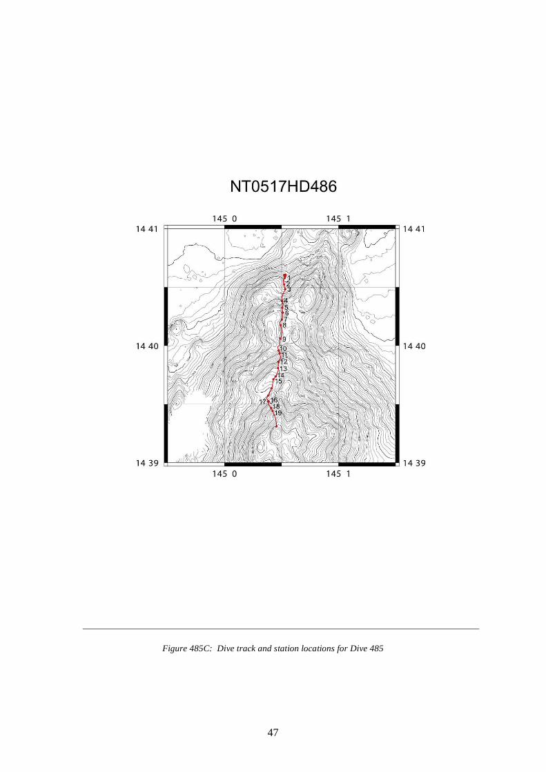
47
Figure 485C: Dive track and station locations for Dive 485
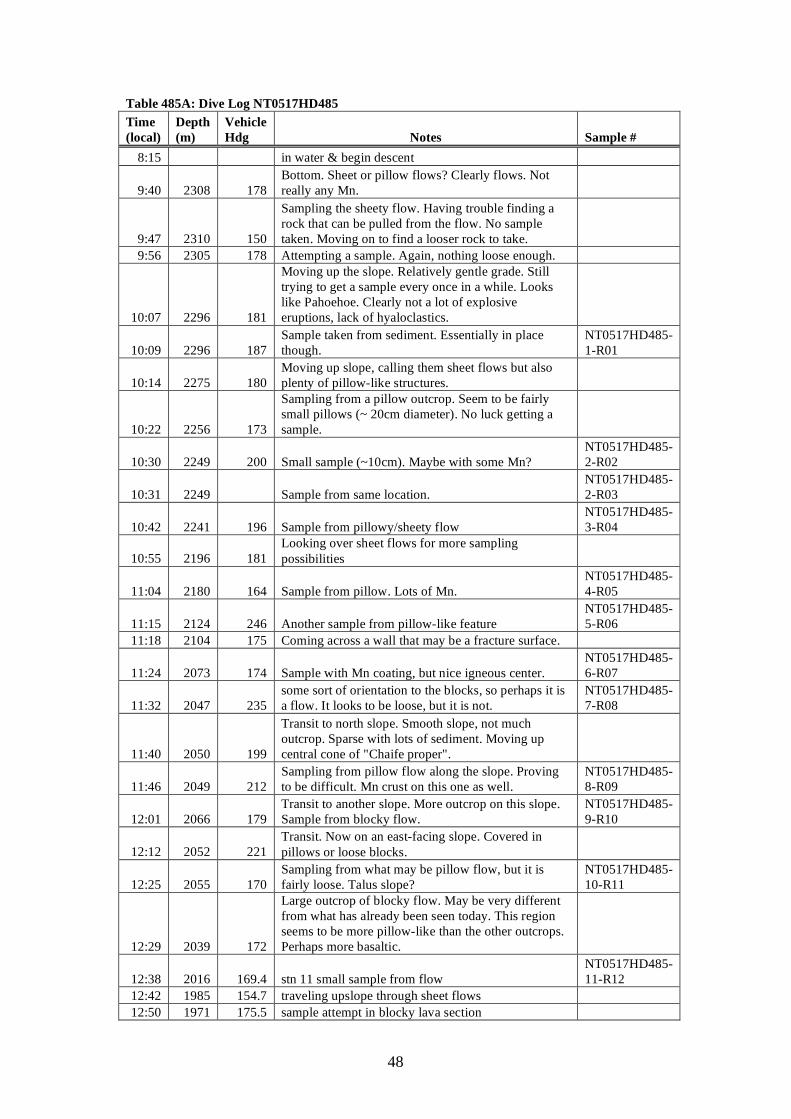
48
Table 485A: Dive Log NT0517HD485 Time (local)
Depth (m)
Vehicle Hdg Notes Sample #
8:15 in water & begin descent
9:40 2308 178 Bottom. Sheet or pillow flows? Clearly flows. Not really any Mn.
9:47 2310 150
Sampling the sheety flow. Having trouble finding a rock that can be pulled from the flow. No sample taken. Moving on to find a looser rock to take.
9:56 2305 178 Attempting a sample. Again, nothing loose enough.
10:07 2296 181
Moving up the slope. Relatively gentle grade. Still trying to get a sample every once in a while. Looks like Pahoehoe. Clearly not a lot of explosive eruptions, lack of hyaloclastics.
10:09 2296 187 Sample taken from sediment. Essentially in place though.
NT0517HD485-1-R01
10:14 2275 180 Moving up slope, calling them sheet flows but also plenty of pillow-like structures.
10:22 2256 173
Sampling from a pillow outcrop. Seem to be fairly small pillows (~ 20cm diameter). No luck getting a sample.
10:30 2249 200 Small sample (~10cm). Maybe with some Mn? NT0517HD485-2-R02
10:31 2249 Sample from same location. NT0517HD485-2-R03
10:42 2241 196 Sample from pillowy/sheety flow NT0517HD485-3-R04
10:55 2196 181 Looking over sheet flows for more sampling possibilities
11:04 2180 164 Sample from pillow. Lots of Mn. NT0517HD485-4-R05
11:15 2124 246 Another sample from pillow-like feature NT0517HD485-5-R06
11:18 2104 175 Coming across a wall that may be a fracture surface.
11:24 2073 174 Sample with Mn coating, but nice igneous center. NT0517HD485-6-R07
11:32 2047 235 some sort of orientation to the blocks, so perhaps it is a flow. It looks to be loose, but it is not.
NT0517HD485-7-R08
11:40 2050 199
Transit to north slope. Smooth slope, not much outcrop. Sparse with lots of sediment. Moving up central cone of "Chaife proper".
11:46 2049 212 Sampling from pillow flow along the slope. Proving to be difficult. Mn crust on this one as well.
NT0517HD485-8-R09
12:01 2066 179 Transit to another slope. More outcrop on this slope. Sample from blocky flow.
NT0517HD485-9-R10
12:12 2052 221 Transit. Now on an east-facing slope. Covered in pillows or loose blocks.
12:25 2055 170 Sampling from what may be pillow flow, but it is fairly loose. Talus slope?
NT0517HD485-10-R11
12:29 2039 172
Large outcrop of blocky flow. May be very different from what has already been seen today. This region seems to be more pillow-like than the other outcrops. Perhaps more basaltic.
12:38 2016 169.4 stn 11 small sample from flow NT0517HD485-11-R12
12:42 1985 154.7 traveling upslope through sheet flows 12:50 1971 175.5 sample attempt in blocky lava section
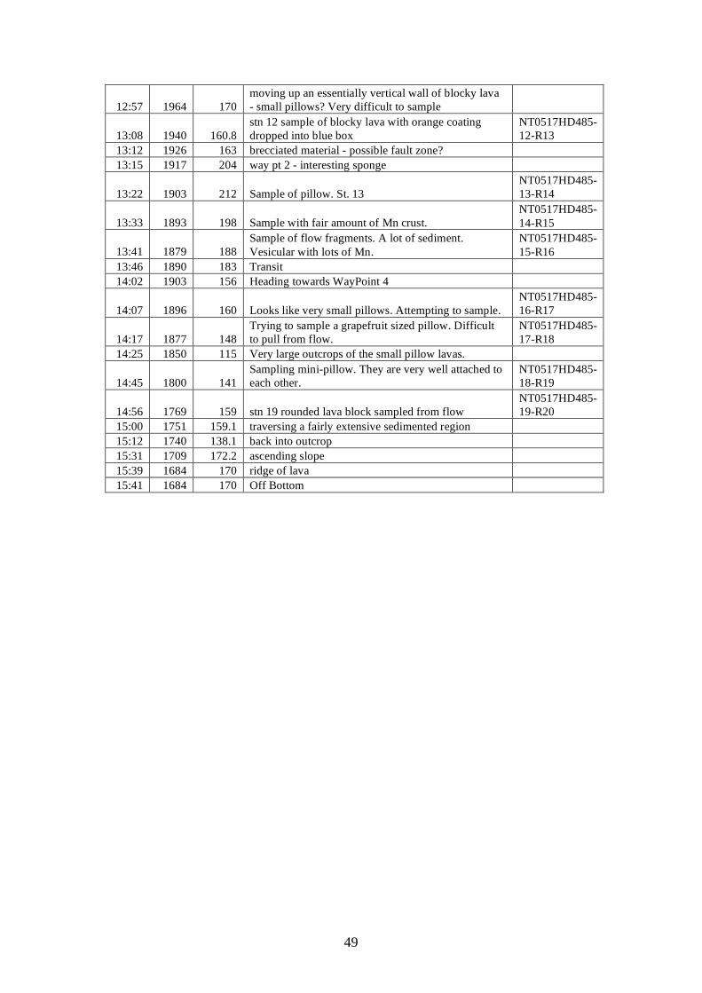
49
12:57 1964 170 moving up an essentially vertical wall of blocky lava - small pillows? Very difficult to sample
13:08 1940 160.8 stn 12 sample of blocky lava with orange coating dropped into blue box
NT0517HD485-12-R13
13:12 1926 163 brecciated material - possible fault zone? 13:15 1917 204 way pt 2 - interesting sponge
13:22 1903 212 Sample of pillow. St. 13 NT0517HD485-13-R14
13:33 1893 198 Sample with fair amount of Mn crust. NT0517HD485-14-R15
13:41 1879 188 Sample of flow fragments. A lot of sediment. Vesicular with lots of Mn.
NT0517HD485-15-R16
13:46 1890 183 Transit 14:02 1903 156 Heading towards WayPoint 4
14:07 1896 160 Looks like very small pillows. Attempting to sample. NT0517HD485-16-R17
14:17 1877 148 Trying to sample a grapefruit sized pillow. Difficult to pull from flow.
NT0517HD485-17-R18
14:25 1850 115 Very large outcrops of the small pillow lavas.
14:45 1800 141 Sampling mini-pillow. They are very well attached to each other.
NT0517HD485-18-R19
14:56 1769 159 stn 19 rounded lava block sampled from flow NT0517HD485-19-R20
15:00 1751 159.1 traversing a fairly extensive sedimented region 15:12 1740 138.1 back into outcrop 15:31 1709 172.2 ascending slope 15:39 1684 170 ridge of lava 15:41 1684 170 Off Bottom
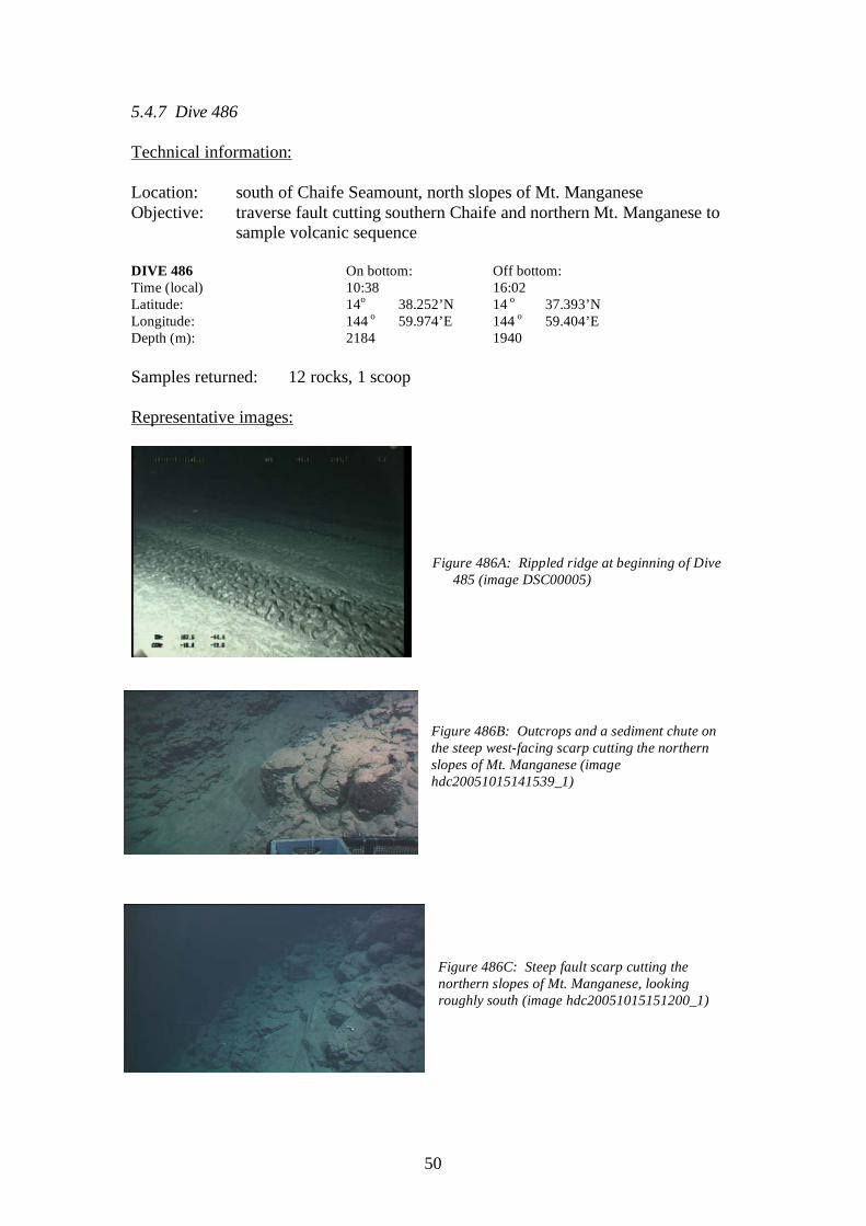
50
5.4.7 Dive 486 Technical information: Location: south of Chaife Seamount, north slopes of Mt. Manganese Objective: traverse fault cutting southern Chaife and northern Mt. Manganese to
sample volcanic sequence DIVE 486 On bottom: Off bottom: Time (local) 10:38 16:02 Latitude: 14o 38.252’N 14 o 37.393’N Longitude: 144 o 59.974’E 144 o 59.404’E Depth (m): 2184 1940 Samples returned: 12 rocks, 1 scoop Representative images:
Figure 486A: Rippled ridge at beginning of Dive
485 (image DSC00005)
Figure 486B: Outcrops and a sediment chute on the steep west-facing scarp cutting the northern slopes of Mt. Manganese (image hdc20051015141539_1)
Figure 486C: Steep fault scarp cutting the northern slopes of Mt. Manganese, looking roughly south (image hdc20051015151200_1)
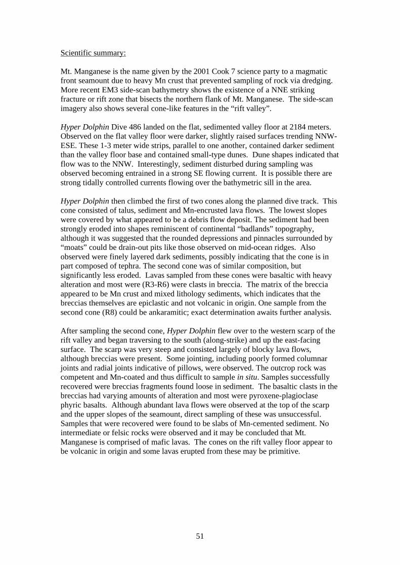
51
Scientific summary: Mt. Manganese is the name given by the 2001 Cook 7 science party to a magmatic front seamount due to heavy Mn crust that prevented sampling of rock via dredging. More recent EM3 side-scan bathymetry shows the existence of a NNE striking fracture or rift zone that bisects the northern flank of Mt. Manganese. The side-scan imagery also shows several cone-like features in the “rift valley”. Hyper Dolphin Dive 486 landed on the flat, sedimented valley floor at 2184 meters. Observed on the flat valley floor were darker, slightly raised surfaces trending NNW-ESE. These 1-3 meter wide strips, parallel to one another, contained darker sediment than the valley floor base and contained small-type dunes. Dune shapes indicated that flow was to the NNW. Interestingly, sediment disturbed during sampling was observed becoming entrained in a strong SE flowing current. It is possible there are strong tidally controlled currents flowing over the bathymetric sill in the area. Hyper Dolphin then climbed the first of two cones along the planned dive track. This cone consisted of talus, sediment and Mn-encrusted lava flows. The lowest slopes were covered by what appeared to be a debris flow deposit. The sediment had been strongly eroded into shapes reminiscent of continental “badlands” topography, although it was suggested that the rounded depressions and pinnacles surrounded by “moats” could be drain-out pits like those observed on mid-ocean ridges. Also observed were finely layered dark sediments, possibly indicating that the cone is in part composed of tephra. The second cone was of similar composition, but significantly less eroded. Lavas sampled from these cones were basaltic with heavy alteration and most were (R3-R6) were clasts in breccia. The matrix of the breccia appeared to be Mn crust and mixed lithology sediments, which indicates that the breccias themselves are epiclastic and not volcanic in origin. One sample from the second cone (R8) could be ankaramitic; exact determination awaits further analysis. After sampling the second cone, Hyper Dolphin flew over to the western scarp of the rift valley and began traversing to the south (along-strike) and up the east-facing surface. The scarp was very steep and consisted largely of blocky lava flows, although breccias were present. Some jointing, including poorly formed columnar joints and radial joints indicative of pillows, were observed. The outcrop rock was competent and Mn-coated and thus difficult to sample in situ. Samples successfully recovered were breccias fragments found loose in sediment. The basaltic clasts in the breccias had varying amounts of alteration and most were pyroxene-plagioclase phyric basalts. Although abundant lava flows were observed at the top of the scarp and the upper slopes of the seamount, direct sampling of these was unsuccessful. Samples that were recovered were found to be slabs of Mn-cemented sediment. No intermediate or felsic rocks were observed and it may be concluded that Mt. Manganese is comprised of mafic lavas. The cones on the rift valley floor appear to be volcanic in origin and some lavas erupted from these may be primitive.
52
Figure 486C: Dive track and station locations for Dive 486
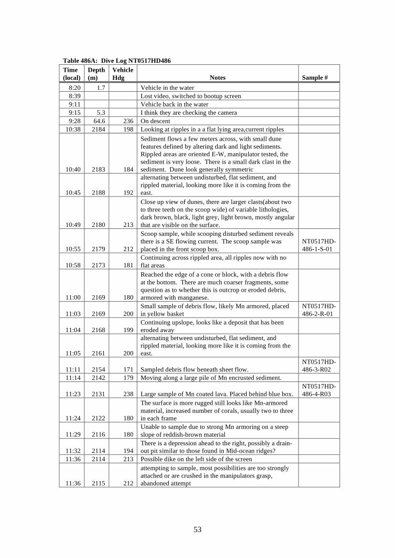
53
Table 486A: Dive Log NT0517HD486 Time (local)
Depth (m)
Vehicle Hdg Notes Sample #
8:20 1.7 Vehicle in the water 8:39 Lost video, switched to bootup screen 9:11 Vehicle back in the water 9:15 5.3 I think they are checking the camera 9:28 64.6 236 On descent
10:38 2184 198 Looking at ripples in a a flat lying area,current ripples
10:40 2183 184
Sediment flows a few meters across, with small dune features defined by altering dark and light sediments. Rippled areas are oriented E-W, manipulator tested, the sediment is very loose. There is a small dark clast in the sediment. Dune look generally symmetric
10:45 2188 192
alternating between undisturbed, flat sediment, and rippled material, looking more like it is coming from the east.
10:49 2180 213
Close up view of dunes, there are larger clasts(about two to three teeth on the scoop wide) of variable lithologies, dark brown, black, light grey, light brown, mostly angular that are visible on the surface.
10:55 2179 212
Scoop sample, while scooping disturbed sediment reveals there is a SE flowing current. The scoop sample was placed in the front scoop box.
NT0517HD-486-1-S-01
10:58 2173 181 Continuing across rippled area, all ripples now with no flat areas
11:00 2169 180
Reached the edge of a cone or block, with a debris flow at the bottom. There are much coarser fragments, some question as to whether this is outcrop or eroded debris, armored with manganese.
11:03 2169 200 Small sample of debris flow, likely Mn armored, placed in yellow basket
NT0517HD-486-2-R-01
11:04 2168 199 Continuing upslope, looks like a deposit that has been eroded away
11:05 2161 200
alternating between undisturbed, flat sediment, and rippled material, looking more like it is coming from the east.
11:11 2154 171 Sampled debris flow beneath sheet flow. NT0517HD-486-3-R02
11:14 2142 179 Moving along a large pile of Mn encrusted sediment.
11:23 2131 238 Large sample of Mn coated lava. Placed behind blue box. NT0517HD-486-4-R03
11:24 2122 180
The surface is more rugged still looks like Mn-armored material, increased number of corals, usually two to three in each frame
11:29 2116 180 Unable to sample due to strong Mn armoring on a steep slope of reddish-brown material
11:32 2114 194 There is a depression ahead to the right, possibly a drain-out pit similar to those found in Mid-ocean ridges?
11:36 2114 213 Possible dike on the left side of the screen
11:36 2115 212
attempting to sample, most possibilities are too strongly attached or are crushed in the manipulators grasp, abandoned attempt
54
11:47 2115 208
Sample taken from beneath a horizontal ledge, one side is lumpy, with reddish brown colored placed behind the blue basket. Sample is a large, flat, oval.
NT0517HD-486-5-R04
11:48 2115 207 Zoomed in on layers beneath ledge, alternating dark and light layers, of unknown scale but small.
11:48 2021 215 We reached the top of the mound, the ground is falling away from the ROV.
11:52 2121 221 Possible outcrop of dark brown material partially draped by white sediments
11:58 2124 324
Attempting to sample from a nearly vertical wall of rounded brown rocks, partially draped by sediments, unable to get anything.
11:59 2121 210
Alternating between undisturbed, flat sediment, and rippled material. Similar to what was seen on the north slope
12:05 2132 177 Boundary between rippled material and rounded brown rocks
12:17 2127 181 Flying through rounded blocky material that looks armored with Mn.
12:25 2125 353 Trying to sample from a partially sediment covered outcrop, very difficult to get a piece. Abandoned attempt
12:30 2121 171 Still in the soft sediment draping outcrops of dark rocks
12:32 2119 189 Little to no sediment cover, outcrop has many small pieces
12:38 2120 215
A rounded sample of Mn coated lava. Dark brown, taken from a nearly vertical wall of rounded, blocky material. There is some red staining on one side. Placed in the yellow basket.
NT0517HD-486-6-R05
12:42 2120 215
Sample of Mn-coated lava, with one side shaped like a chair, much larger than the previous sample, placed in the yellow basket.
NT0517HD-486-6-R06
12:44 2115 180 Passed over a small rippled plain, to another blocky looking outcrop
12:50 2099 182 Out onto a rippled plane
12:52 2102 86 Approaching an outcrop of a flow the has a knobby appearance.
12:55 2102 86
Pulled a sample out of the sediment at the base of the outcop noted in previous entry, small sample, has a dark brown crust, lots of biological material on the outside. Placed in the yellow basket.
NT0517HD-486-7-R07
13:03 2087 169 Continuing up the flow slope
13:07 2084 145 Sample with crust. Placed in blue box (?) NT0517HD-486-8-R08
13:11 2079 240 transit 13:55 2034 197 End transit 13:57 2040 252 Appears to be a scarp, on the side of the rift
14:04 2042 265
Attempting to sample, picked up a small sample at the base of an outcrop, sample is black, placed in the blue basket.
NT0517HD-486-9-R09
14:07 2037 211 Continuing on our way, the surface is similar to what we have seen earlier in the day.
14:19 2026 264 A rounded outcrop of Mn-covered lava? Broke off a rounded piece, the sample is ovoid shaped, dark brown.
NT0517HD-486-10-R10
14:23 2030 209 Looks very steep 14:24 2033 192 Steep outcrops of rounded flows
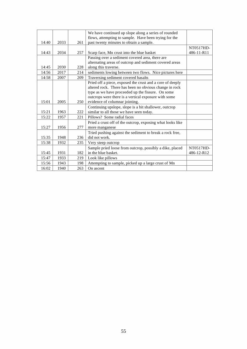
55
14:40 2033 261
We have continued up slope along a series of rounded flows, attempting to sample. Have been trying for the past twenty minutes to obtain a sample.
14:43 2034 257 Scarp face, Mn crust into the blue basket NT0517HD-486-11-R11
14:45 2030 228
Passing over a sediment covered area, there are alternating areas of outcrop and sediment covered areas along this traverse.
14:56 2017 214 sediments lowing between two flows. Nice pictures here 14:58 2007 209 Traversing sediment covered basalts
15:01 2005 250
Pried off a piece, exposed the crust and a core of deeply altered rock. There has been no obvious change in rock type as we have proceeded up the fissure. On some outcrops were there is a vertical exposure with some evidence of columnar jointing.
15:21 1963 222 Continuing upslope, slope is a bit shallower, outcrop similar to all those we have seen today.
15:22 1957 221 Pillows? Some radial faces
15:27 1956 277 Pried a crust off of the outcrop, exposing what looks like more manganese
15:35 1948 236 Tried pushing against the sediment to break a rock free, did not work.
15:38 1932 235 Very steep outcrop
15:45 1931 182 Sample pried loose from outcrop, possibly a dike, placed in the blue basket.
NT0517HD-486-12-R12
15:47 1933 219 Look like pillows 15:56 1943 198 Attempting to sample, picked up a large crust of Mn 16:02 1940 263 On ascent

56
5.4.8 Dive 487 Technical information: Location: Giant sediment waves southwest of Esmeralda Bank Objective: examine characteristics of giant sediment waves, sample for grain size
and compositional analysis DIVE 480 On bottom: Off bottom: Time (local) 09:22 15:52 Latitude: 14o 52.137’N 14 o 52.637’N Longitude: 145 o 11.591’E 145 o 12.632’E Depth (m): 1485 1269 Samples returned: 4 scoops, 2 cores, 5 rocks (one lost on ascent) Representative images:
Picture 1: Ledge-like outcrops in lower slopes of western dune form (image hdc20051017100930_1)
Picture 2: ripples near crest of western dune form (image hdc20051017113000_1 Picture 3: Outcrop of thin-bedded material in lower slopes of eastern dune from (image hdc20051017144154_1)
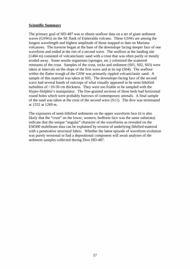
57
Scientific Summary The primary goal of HD-487 was to obtain seafloor data on a set of giant sediment waves (GSWs) on the SE flank of Esmeralda volcano. These GSWs are among the longest wavelength and highest amplitude of those mapped to date on Mariana volcanoes. The traverse began at the base of the downslope facing steeper face of one waveform and ended at the rim of a second wave. The seafloor at the landing site (1484 m) consisted of volcaniclastic sand with a crust that was often partly or mostly eroded away. Some sessile organisms (sponges, etc.) colonized the scattered remnants of the crust. Samples of the crust, rocks and sediment (S01, S02, S03) were taken at intervals on the slope of the first wave and at its top (S04). The seafloor within the flatter trough of the GSW was primarily rippled volcaniclastic sand. A sample of this material was taken at S05. The downslope-facing face of the second wave had several bands of outcrops of what visually appeared to be semi-lithified turbidites of ~10-50 cm thickness. They were too friable to be sampled with the Hyper-Dolphin’s manipulator. The fine-grained sections of these beds had horizontal round holes which were probably burrows of contemporary animals. A final sample of the sand was taken at the crest of the second wave (S11). The dive was terminated at 1552 at 1269 m. The exposures of semi-lithified sediments on the upper waveform face (it is also likely that the “crust” on the lower, western, bedform face was the same substrata) indicate that the unique “angular” character of the waveforms as revealed on the EM300 multibeam data can be explained by erosion of underlying lithified material with a penetrative structural fabric. Whether the latest episode of waveform evolution was purely erosional or had a depositional component will await analyses of the sediment samples collected during Dive HD-487.
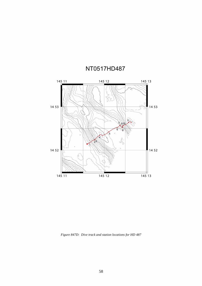
58
Figure 847D: Dive track and station locations for HD 487
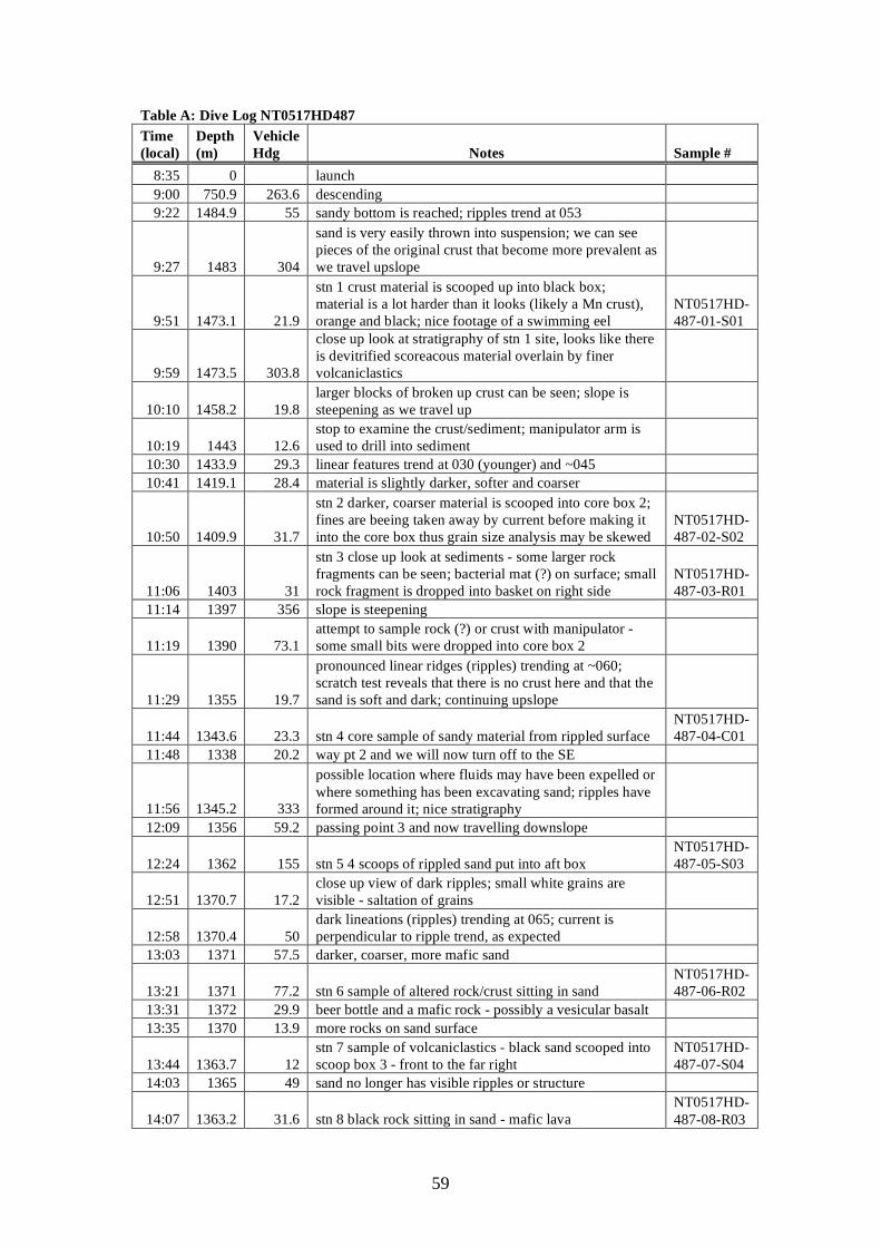
59
Table A: Dive Log NT0517HD487 Time (local)
Depth (m)
Vehicle Hdg Notes Sample #
8:35 0 launch 9:00 750.9 263.6 descending 9:22 1484.9 55 sandy bottom is reached; ripples trend at 053
9:27 1483 304
sand is very easily thrown into suspension; we can see pieces of the original crust that become more prevalent as we travel upslope
9:51 1473.1 21.9
stn 1 crust material is scooped up into black box; material is a lot harder than it looks (likely a Mn crust), orange and black; nice footage of a swimming eel
NT0517HD-487-01-S01
9:59 1473.5 303.8
close up look at stratigraphy of stn 1 site, looks like there is devitrified scoreacous material overlain by finer volcaniclastics
10:10 1458.2 19.8 larger blocks of broken up crust can be seen; slope is steepening as we travel up
10:19 1443 12.6 stop to examine the crust/sediment; manipulator arm is used to drill into sediment
10:30 1433.9 29.3 linear features trend at 030 (younger) and ~045 10:41 1419.1 28.4 material is slightly darker, softer and coarser
10:50 1409.9 31.7
stn 2 darker, coarser material is scooped into core box 2; fines are beeing taken away by current before making it into the core box thus grain size analysis may be skewed
NT0517HD-487-02-S02
11:06 1403 31
stn 3 close up look at sediments - some larger rock fragments can be seen; bacterial mat (?) on surface; small rock fragment is dropped into basket on right side
NT0517HD-487-03-R01
11:14 1397 356 slope is steepening
11:19 1390 73.1 attempt to sample rock (?) or crust with manipulator - some small bits were dropped into core box 2
11:29 1355 19.7
pronounced linear ridges (ripples) trending at ~060; scratch test reveals that there is no crust here and that the sand is soft and dark; continuing upslope
11:44 1343.6 23.3 stn 4 core sample of sandy material from rippled surface NT0517HD-487-04-C01
11:48 1338 20.2 way pt 2 and we will now turn off to the SE
11:56 1345.2 333
possible location where fluids may have been expelled or where something has been excavating sand; ripples have formed around it; nice stratigraphy
12:09 1356 59.2 passing point 3 and now travelling downslope
12:24 1362 155 stn 5 4 scoops of rippled sand put into aft box NT0517HD-487-05-S03
12:51 1370.7 17.2 close up view of dark ripples; small white grains are visible - saltation of grains
12:58 1370.4 50 dark lineations (ripples) trending at 065; current is perpendicular to ripple trend, as expected
13:03 1371 57.5 darker, coarser, more mafic sand
13:21 1371 77.2 stn 6 sample of altered rock/crust sitting in sand NT0517HD-487-06-R02
13:31 1372 29.9 beer bottle and a mafic rock - possibly a vesicular basalt 13:35 1370 13.9 more rocks on sand surface
13:44 1363.7 12 stn 7 sample of volcaniclastics - black sand scooped into scoop box 3 - front to the far right
NT0517HD-487-07-S04
14:03 1365 49 sand no longer has visible ripples or structure
14:07 1363.2 31.6 stn 8 black rock sitting in sand - mafic lava NT0517HD-487-08-R03
60
14:15 1358 29.4 coarser grained volcaniclastic material with no visible layering
14:20 1351.9 29.6
layered deposits; detailed photographs -well indurated ash layers (surge deposits? slumped subaerial ash deposits)
14:37 1350 10.6 travelling up the layers - soft sediment deformation vs. dunes or ripples
14:44 1345 24.5 these may be turbidite units - with coarser material, grading up into laminated clay rich sediments with dunes
14:50 1344.5 25 large holes in fine grained unit - tube worm burrows?
14:51 1344.5 25 stn 9 basalt from breccia unit from burrowed/vesicular unit
NT0517HD-487-09-R04
14:55 1343 25.1 close up of burrows - and you can see a crab on ledge
15:01 1340.7 25.2 travelling upslope you can see another unit of layers - soft sediment deformation is apparent
15:08 1324.4 51.9 Stn 10, basaltic clast NT0517HD-487-10-R05
15:13 1316 52.9 bright red crab as we traverse the brecciated unit
15:19 1284 50 back into sand with very subtle ripples becoming more defined
15:20 1282 50.8 a small sequence of fine altered ash layers
15:25 1270 52.2 stn 11 rippled sand near top of crest NT0517HD-487-11-C02
15:36 1268 51.6 ripples become increasingly chaotic - much less linear 15:39 1268.5 143 way pt 6 - now heading SE to way pt 7 15:52 1269 126.2 off the bottom and ascending to surface
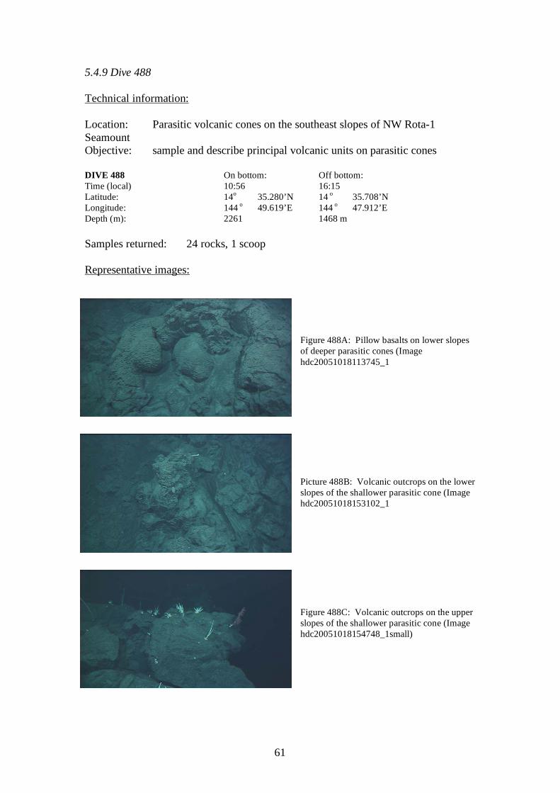
61
5.4.9 Dive 488 Technical information: Location: Parasitic volcanic cones on the southeast slopes of NW Rota-1 Seamount Objective: sample and describe principal volcanic units on parasitic cones DIVE 488 On bottom: Off bottom: Time (local) 10:56 16:15 Latitude: 14o 35.280’N 14 o 35.708’N Longitude: 144 o 49.619’E 144 o 47.912’E Depth (m): 2261 1468 m Samples returned: 24 rocks, 1 scoop Representative images:
Figure 488A: Pillow basalts on lower slopes of deeper parasitic cones (Image hdc20051018113745_1
Picture 488B: Volcanic outcrops on the lower slopes of the shallower parasitic cone (Image hdc20051018153102_1 Figure 488C: Volcanic outcrops on the upper slopes of the shallower parasitic cone (Image hdc20051018154748_1small)
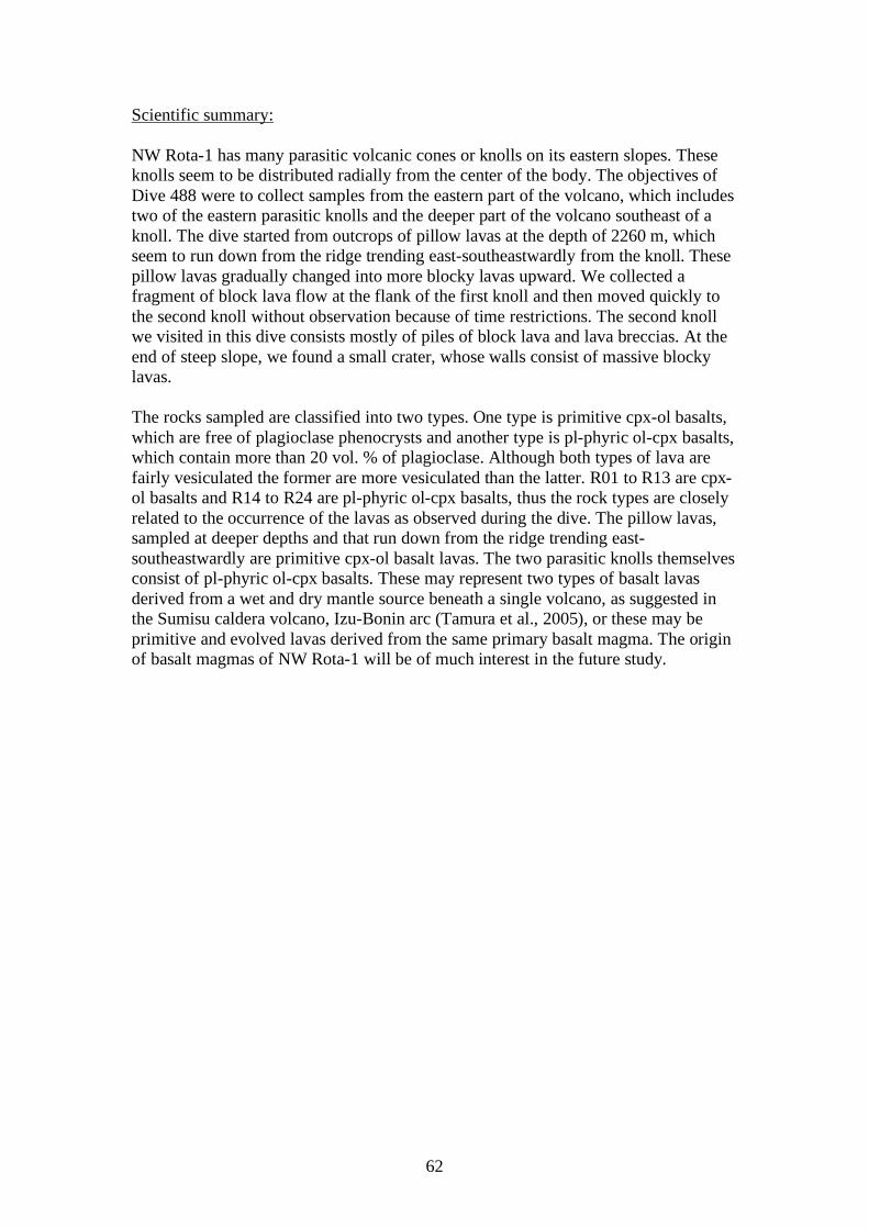
62
Scientific summary: NW Rota-1 has many parasitic volcanic cones or knolls on its eastern slopes. These knolls seem to be distributed radially from the center of the body. The objectives of Dive 488 were to collect samples from the eastern part of the volcano, which includes two of the eastern parasitic knolls and the deeper part of the volcano southeast of a knoll. The dive started from outcrops of pillow lavas at the depth of 2260 m, which seem to run down from the ridge trending east-southeastwardly from the knoll. These pillow lavas gradually changed into more blocky lavas upward. We collected a fragment of block lava flow at the flank of the first knoll and then moved quickly to the second knoll without observation because of time restrictions. The second knoll we visited in this dive consists mostly of piles of block lava and lava breccias. At the end of steep slope, we found a small crater, whose walls consist of massive blocky lavas. The rocks sampled are classified into two types. One type is primitive cpx-ol basalts, which are free of plagioclase phenocrysts and another type is pl-phyric ol-cpx basalts, which contain more than 20 vol. % of plagioclase. Although both types of lava are fairly vesiculated the former are more vesiculated than the latter. R01 to R13 are cpx-ol basalts and R14 to R24 are pl-phyric ol-cpx basalts, thus the rock types are closely related to the occurrence of the lavas as observed during the dive. The pillow lavas, sampled at deeper depths and that run down from the ridge trending east-southeastwardly are primitive cpx-ol basalt lavas. The two parasitic knolls themselves consist of pl-phyric ol-cpx basalts. These may represent two types of basalt lavas derived from a wet and dry mantle source beneath a single volcano, as suggested in the Sumisu caldera volcano, Izu-Bonin arc (Tamura et al., 2005), or these may be primitive and evolved lavas derived from the same primary basalt magma. The origin of basalt magmas of NW Rota-1 will be of much interest in the future study.
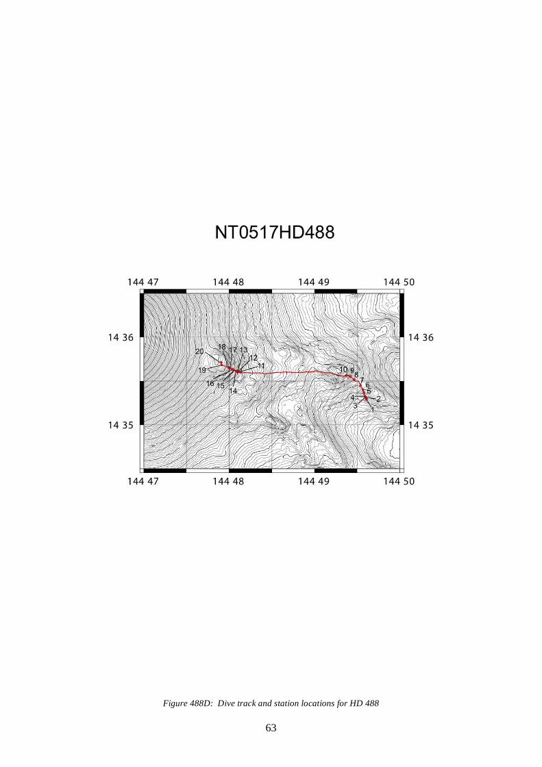
63
Figure 488D: Dive track and station locations for HD 488
64
Table 488A: Dive Log NT0517HD488 Time (local)
Depth (m)
Vehicle Hdg Notes Sample #
10:56 2261 311 Bottom. Ripples and some rocks. Sampled a loose rock from rippled seds.
NT0517HD488-1-R01
11:05 2257 334 Moving up gentle slope. Approaching blocky flows. Sample.
NT0517HD488-2-R2
11:07 2247 328
Rippled sediment drapes amongst pillow flows. The best pillow structures we've seen thus far. Probably farily old and altered though. All of the sediment and cover is streaky black and white but mostly white.
11:13 2237 488 Sample from pillow. NT0517HD488-3-R03
11:15 2237 488 Another sample from the weathered pillow. NT0517HD488-3-R04
11:22 2229 333 Trying to sample glassy material. But it looks pretty weathered to me. Some Mn crust as well.
NT0517HD488-4-R05
11:27 2229 332 Sample from base of heavily fractured pillow. Very small piece (10 cm?)
NT0517HD488-4-R06
11:32 2228 332 Hypnotic ripples. Sample of weathered vesicular pillow. Perhaps phenocryst rich?
NT0517HD488-4-R07
11:37 2221 333
The pillow outcrop is becoming steeper and the pillows seem to be rounder and perhaps less weathered toward the top. Actually blockier.
11:39 2217 327 Moving across a small flat of well developed ripples before heading up another pillow flow.
11:42 2202 327 Flows seem to be getting blockier and more fractured.
11:52 2200 1.6 Spent the last 10 minutes cruising around attempting samples.
11:55 2197 359 Sample small rock from base of pillow outcrop. Vesicular piece of pillow.
NT0517HD488-5-R08
11:56 2194 342
Moving up the flank of the volcanic region to the east. A steep sediment rippled slope. The blocky outcrop is much more sparse and consists of much smaller pieces. Patches of unknown white material.
12:00 2179 328 The water is surprisingly non-murky.
12:03 2180 329 Sample from outcrop of small pillows and blocks. Again, quite fractured. Into blue box.
NT0517HD488-6-R09
12:05 2179 326 Traveling along a submarine skree slope. More disseminated patches of white material.
12:07 2167 322 Seem to have left the pillows behind and among lower profile blocky flows.
12:09 2164 328 Large flow, blocky, but almost pahoehoe 'ooze' features.
12:14 2153 328 Moving over a humocky section of flow.
12:16 2151 330 Large sample with light brown discoloration. NT0517HD488-7-R10
12:19 2151 329 rock sample, rough terrane NT0517HD488-7-R11
12:21 2148 328 mixed rock outcrops and rippled sediment patches
12:22 2145 328 near WP2, in uniformly sedimented area; some ripplling; quite linear in places
12:25 2135 293 at WP2, c/c to the NW; uniformly sedimented and rippled; slope drops away a little bit
65
12:31 2117 324
outcrop rising out of sediment; somewhat pillowed,white "litter" on sediment and rock; sampling attempt; a lot of heave today; successful;
NT0517HD488-8-R12
12:34 2114 320 mixed outcrop and sediment; then long section of linear ripples;
12:36 2107 319
uniofrmly sediment now, an occational block of rock on surface; does look like a fair amount of cobble or coarse sandy debris on bottom too
12:38 2086 322
still visible ripples, though we are about 4 m off bottom, a little dark to see; some places with concentrations of debris; also may be rubbly outcrops sticking out of slope
12:39 2082 316
now into more otucrop sticking our of sediment; rough,angular blocks and outcrop, doesn't seem particularly pillowed
12:40 2079 302
landing to sample a piece; angular piece, bit of brown on bottom, loose in sediment; into blue basket
NT0517HD488-9-R13
12:42 2076 298
mixed rubble and sediment; linear ripples or troughs downslope in sediment; piece and occasional outcrop still angular and broken, not really pillowed
12:46 2053 299 similar, with occasionally larger blocks, then into largely sediment at 12:47
12:49 2038 303
into area with blocks of rubble sticking out from sediment; head in to sample; angular blocks, not pillowed; large angular block recovered, ibehind blue basket (it is very large, having some problems fitting it in
NT0517HD488-10-R14
12:57 2029 294 Moving off bottom to WP 4
14:34 1675 277
Back on bottom, mixed outcrop and sediment, angular irregular blocks of rock; setting down for sampling; took piece loose in pile;
NT0517HD488-11-R15
14:34 1675 277 Second sample from same station. NT0517HD488-11-R16
14:39 1666 279
Complex sandy ripples. Broken, humocky blocky…blocks. Hard to tell if they are outcrop or just blocks that have fallen from above.
14:43 1654 279 Reaching WP 4. Continuing up slope of mossy-like covering on the rocks and vast sediment ripples.
14:48 1649 279
Sample of loose rock from silt pile. Sharp edged lava. May be the surface of a flow…pillow-like textures on the top.
NT0517HD488-12-R17
14:50 1645 290
Cruising over incredible sediment ripples. Seems to be quite a bit of algae or some growth on the surface of almost every exposed rock.
14:57 1641 290 Small sample of dark blocky lava. NT0517HD488-13-R18
15:00 1633 290
Rounded blocky outcrop with bright white clasts of something. Hard to tell if it is a sponge, bivalve or not biology at all. Steep blocky flows.
15:05 1628 280 Lava from blocky flow NT0517HD488-14-R19
15:07 1629 280 Trying to figure out what the small white pieces are. Found a white anemone, but the majority seem to be
66
hard.
15:10 1624 289
Continuing up the steep slope. White flecks still on surface of sediment and outcrop. Probably broken pieces of the white branched corals.
15:14 1606 288 Moving up, the flows seem to be much more blocky than the lower areas of the slope.
15:18 1593 288 Dark, somewhat vesiculated lava into the yellow box.
NT0517HD488-15-R20
15:20 1583 287
The grade of the slope seems to be steeping somewhat. Back into the pillow structuresl although still some blockier flows. The ripples are less orderly and neat relative to down slope. Consistent with a steepening grade.
15:23 1566 288 Higher concentration of large, blocky flows with steeper slope.
15:26 1565 285 Sample easily taken from fractured sediment covered flow.
NT0517HD488-16-R21
15:29 1556 290 Perhaps some jointing in a very large rock with coral growing on it.
15:31 1546 290 Larger blocks in general. Quite a bit of jointing within these flows.
15:36 1526 291
Sample taken from very loose sediment at base of flow. This whole area is very different. Looks like some of this has been reworked.
NT0517HD488-17-R22
15:38 1515 289 Very unstable-looking large fresh talus blocks.
15:41 1505 273 Freshesh block taken from massive block pile. Perhaps andesite.
NT0517HD488-18-R23
15:44 1496 265
Clearly out of the sediment/lava flow area and now only very large loose blocks. Enormous amount of various corals growing on the rough surfaces. Truly a lot of life here. Spectacular!
15:47 1492 263
Zoomed in on one coral. The structure of it is remarkable. This particular coral was built just like a phalenopsis orchid.
15:50 1490 265
The top of the slope has flattened out. Extremely well-defined black and light ripples aligned parallel to slope. The edge of the ridge is defined by very blocky flow. Perhaps some cooling fractures were observed in this flow. Unbelievable. A submarine zen garden. Multiple perpendicular sets of ripples.
15:55 1474 292 Some layering in the upper few meters of the flow.
16:00 1473 332 Fresh sample taken from vertical wall. Impressive. NT0517HD488-19-R24
16:02 1470 330
Back into rippled area of fine grained ash. These ripples are composed of three hues:black, white and gray. Some areas of ripples are covered by a darker band of non-rippled newer fallout.
16:09 1468 338
Scoop sampling from very fine-grained ash ripple layer. Hopefully find some olivine grains. Seems to be a very thick unit (thickness of scooper) of unconsolidated ash that was scoop sampled.
NT0517HD488-20-S01
16:15 Fin
67
5.2.10 Dive 489 Technical information: Location: Parasitic volcanic cones on the slopes of West Rota Seamount Objective: sample and describe principal volcanic units on parasitic cones DIVE 489 On bottom: Off bottom: Time (local) 09:12 16:10 Latitude: 14o 16.214’N 14 o 16.887’N Longitude: 144 o 53.741’E 144 o 52.035’E Depth (m): 1229 491 Samples returned: 21 rock samples, 1 scoop sample Representative images:
Figure 489A: Outcrops of silicic? Volcanics on slopes of deeper parasitic cone (Image hdc20051019104642_1) Figure 489B: Large pumice boulders or “balloons” on seafloor, typical of many parts of the dive track (Image hdc20051019130919_1) Figure 489C: A chute of pumice running between two outcrops of darker volcanic rock, in the upper portions of the dive traverse (Image hdc20051019153018_1)

68
Scientific summary: The objective of this dive is to investigate three small cones on the SW flank of W Rota seamount. Basaltic lavas observed in the three knolls are all plagioclase-phyric (~20 vol. %) basalts, which contain rare olivine and/or augite. Thus, all rocks are fairly evolved compared to the last dive on NW Rota-1. In the Izu-Bonin arc, we generally have plagioclase-enriched and mafic-poor lavas. When magma is dry, plagioclase floats and mafic minerals sink in magma chambers. Thus, these plagioclase-enriched basalts may suggest low water contents in the source of W Rota basalts. Although olivines are rare in these basalts, melt inclusion study should reveal water content of these magmas. Interestingly, we observed a dacite dike intrude a basaltic lava at a depth of 1150 m. This is a beautiful hornblende dacite and we found similar dacite at the depth of 820m as talus blocks of the third knoll. One possibility is that the three basalt knolls appeared comtemporaneously and then at a later point were intruded by dacite. The caldera-forming eruption produced rhyolite balloons, which cover most of this area. Thus, the eruption order is from pl-phyric basalt through dacite to rhyolite pumice eruptions. However, the first knoll was not covered by large pumices very much, which is fairly strange given the short distance between the first knoll and the second and third knolls. Another possibility is that the third knoll appeared after the caldera-forming rhyolite eruption. The detailed chemical and petrographical studies of these basalts and dacites may show differences among knolls and should help us distinguish between these scenarios. Dive 489 landed approximately 200m southeast of the small knoll on the southeast flank of W Rota (SO1). The area of the landing site was dominated by brecciated basaltic lava flows. From the site where the Hyper Dolphin began ascending the cone, we bagan collecting samples of basaltic lavas. Along the side of the first ridge, blocks of pumice were encountered ~1/5 of the way up the side and were observed with increasing frequency during ascent. Upon arriving at a depth of 1030 m, large, rounded boulders of rhyolite were found. These boulders, described as rhyolite ‘balloons’, are similar to those found on the eastern margin of W Rota during the 2004 TT167 expedition. As Hyper Dolphin continued to ascend pumice, became the dominant rock type observed with a field of rhyolite boulders of ~.5m in diameter. At a depth of 1015m Hyper Dolphin transited across a depression to a depth of 787m (SO3) and traversed to the summit of the hill over a field of pumice (sizes ranged from < 10 cm to > 1 m in diameter). We observed ‘black pumice’ beneath rhyolite boulders and we thought this could be a dacite lava dome. However, these ‘black pumices’ are found to be pl-phyric basalts, which are similar to those we found in the first knoll. From the top of the first hill (SO4), Hyper Dolphin transited to another ridge on the SE flank of W Rota Caldera where a steep talus slope of rhyolite balloons and angular, black blocks of lava was found, several rock samples were collected. These black blocks (R19 and R20) are dacite and basalt, respectively, which are similar to those we found in the first knoll. At this point Hyper Dolphin encountered a strong current that made sampling and ascending the slope extremely difficult. The choice was made to ascend a short distance and then try to approach the slope at a shallower
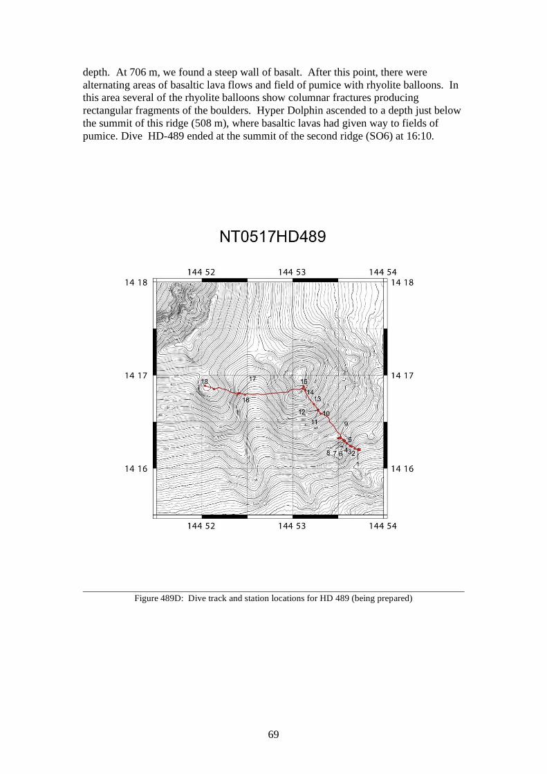
69
depth. At 706 m, we found a steep wall of basalt. After this point, there were alternating areas of basaltic lava flows and field of pumice with rhyolite balloons. In this area several of the rhyolite balloons show columnar fractures producing rectangular fragments of the boulders. Hyper Dolphin ascended to a depth just below the summit of this ridge (508 m), where basaltic lavas had given way to fields of pumice. Dive HD-489 ended at the summit of the second ridge (SO6) at 16:10.
Figure 489D: Dive track and station locations for HD 489 (being prepared)
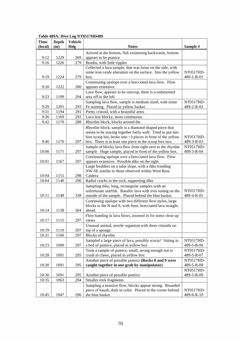
70
Table 489A: Dive Log NT0517HD489 Time (local)
Depth (m)
Vehicle Hdg Notes Sample #
9:12 1229 269 Arrived at the bottom, fish swimming backwards, bottom appears to be pumice
9:16 1226 279 Bombs, with little ripples
9:19 1224 279
Collected a lava sample, that was loose on the side, with some iron oxide alteration on the surface. Into the yellow box.
NT0517HD-489-1-R-01
9:20 1222 280 Continueing upslope over a brecciated lava flow. Flow appears extensive.
9:23 1199 294 Lava flow, appears to be outcrop, there is a sedimented area off to the left
9:29 1201 293 Sampling lava flow, sample is medium sized, with some Fe staining. Placed in yellow basket
NT0517HD-489-2-R-02
9:31 1194 291 Pretty crinoid, with a beautiful arms 9:36 1169 292 Lava less blocky, more continuous 9:42 1170 288 Rhyolite block, blocks around the
9:46 1170 297
Rhyolite block, sample is a diamond shaped piece that seems to be staying together fairly well. Tried to put into fore scoop bin, broke into ~3 pieces in front of the yellow box. There is at least one piece in the scoop box two.
NT0517HD-489-3-R-03
10:00 1171 297 Sample of blocky lava flow from right next to the rhyolite sample. Huge sample, placed in front of the yellow box.
NT0517HD-489-3-R-04
10:01 1167 297 Continueing upslope over a brecciated lava flow. Flow appears extensive. Possible dike on the right.
10:04 1151 298
Large boulders on a talus slope, with a dike trending NW-SE similar to those observed within West Rota Caldera
10:04 1148 296 Radial cracks in the rock, supporting dike
10:11 1148 338
Sampling dike, long, rectangular samples with an unfortunate starfish. Basaltic lava with iron stainig on the outside of the sample. Placed behind the blue basket.
NT0517HD-489-4-R-05
10:14 1138 304
Continuing upslope with two different flow styles, large blocks to the N and S, with finer, brecciated lava straight ahead.
10:17 1115 297 Flow banding in lava flows, zoomed in for some close up views
10:19 1110 297 Unusual animal, sessile organism with three crinoids on top of a sponge.
10:21 1106 297 Blocks of rhyolite
10:23 1090 297 Sampled a large piece of lava, possibly scoria? Sitting in a bed of pumice, placed in yellow box
NT0517HD-489-5-R-06
10:28 1091 295 Took a sample of pumice, small, strong enough not to crush in claws, placed in yellow box
NT0517HD-489-5-R-07
10:30 1091 295 Another piece of possible pumice (Rocks 8 and 9 were caught together in one grab by manipulator)
NT0517HD-489-5-R-08
10:30 1091 295 Another piece of possible pumice NT0517HD-489-5-R-09
10:35 1063 294 Smaller rock fragments
10:45 1047 296
Sampling a massive flow, blocks appear strong. Rounded piece of basalt, dark in color. Placed in the corner behind the blue basket.
NT0517HD-489-6-R-10
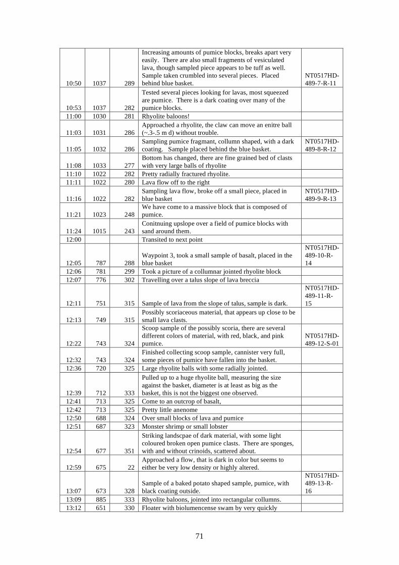
71
10:50 1037 289
Increasing amounts of pumice blocks, breaks apart very easily. There are also small fragments of vesiculated lava, though sampled piece appears to be tuff as well. Sample taken crumbled into several pieces. Placed behind blue basket.
NT0517HD-489-7-R-11
10:53 1037 282
Tested several pieces looking for lavas, most squeezed are pumice. There is a dark coating over many of the pumice blocks.
11:00 1030 281 Rhyolite baloons!
11:03 1031 286 Approached a rhyolite, the claw can move an enitre ball (~.3-.5 m d) without trouble.
11:05 1032 286 Sampling pumice fragmant, collumn shaped, with a dark coating. Sample placed behind the blue basket.
NT0517HD-489-8-R-12
11:08 1033 277 Bottom has changed, there are fine grained bed of clasts with very large balls of rhyolite
11:10 1022 282 Pretty radially fractured rhyolite. 11:11 1022 280 Lava flow off to the right
11:16 1022 282 Sampling lava flow, broke off a small piece, placed in blue basket
NT0517HD-489-9-R-13
11:21 1023 248 We have come to a massive block that is composed of pumice.
11:24 1015 243 Conitnuing upslope over a field of pumice blocks with sand around them.
12:00 Transited to next point
12:05 787 288 Waypoint 3, took a small sample of basalt, placed in the blue basket
NT0517HD-489-10-R-14
12:06 781 299 Took a picture of a collumnar jointed rhyolite block 12:07 776 302 Travelling over a talus slope of lava breccia
12:11 751 315 Sample of lava from the slope of talus, sample is dark.
NT0517HD-489-11-R-15
12:13 749 315 Possibly scoriaceous material, that appears up close to be small lava clasts.
12:22 743 324
Scoop sample of the possibly scoria, there are several different colors of material, with red, black, and pink pumice.
NT0517HD-489-12-S-01
12:32 743 324 Finished collecting scoop sample, cannister very full, some pieces of pumice have fallen into the basket.
12:36 720 325 Large rhyolite balls with some radially jointed.
12:39 712 333
Pulled up to a huge rhyolite ball, measuring the size against the basket, diameter is at least as big as the basket, this is not the biggest one observed.
12:41 713 325 Come to an outcrop of basalt, 12:42 713 325 Pretty little anenome 12:50 688 324 Over small blocks of lava and pumice 12:51 687 323 Monster shrimp or small lobster
12:54 677 351
Striking landscpae of dark material, with some light coloured broken open pumice clasts. There are sponges, with and without crinoids, scattered about.
12:59 675 22 Approached a flow, that is dark in color but seems to either be very low density or highly altered.
13:07 673 328 Sample of a baked potato shaped sample, pumice, with black coating outside.
NT0517HD-489-13-R-16
13:09 885 333 Rhyolite baloons, jointed into rectangular collumns. 13:12 651 330 Floater with biolumencense swam by very quickly
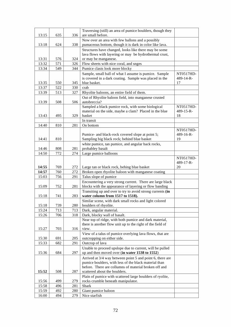
72
13:15 635 336 Traversing (still) an area of pumice boulders, though they are small before.
13:18 624 338 Now over an area with few ballons and a possibly pumaceous bottom, though it is dark in color like lava.
13:31 576 324
Structures have changed, looks like there may be some lava flows with layering or may be hydrothermal crust, or may be manganese.
13:32 571 326 Flow sheets with nice coral, and snges 13:34 549 344 Pumice clasts look more blocky
13:35 550 345
Sample, small ball of what I assume is pumice. Sample is covered in a dark coating. Sample was placed in the blue basket.
NT0517HD-489-14-R-17
13:37 522 330 crab 13:39 513 327 Rhyolite baloons, an entire field of them.
13:39 508 506 Out of Rhyolite baloon field, into manganese crusted autobreccia?
13:43 495 329
Sampled a black pumice rock, with some biological material on the side, maybe a clam? Placed in the blue basket
NT0517HD-489-15-R-18
In transit 14:40 810 281 On bottom
14:41 810 Pumice- and black-rock covered slope at point 5; Sampling big black rock; behind blue basket
NT0517HD-489-16-R-19
14:46 808 281 white pumice, tan pumice, and angular back rocks, probabley basalt
14:50 772 274 Large pumice balloons
14:55 769 272 Large tan or black rock, behing blue basket
NT0517HD-489-17-R-20
14:57 760 272 Broken open rhyolite baloon with manganese coating 15:03 756 291 Talus slope of pumice
15:09 752 281 Encountering a very strong current. There are large black blocks with the appearance of layering or flow banding
15:18 741 283 Transiting up and over to try to avoid strong currents (in water column from 1517 to 1518).
15:18 739 280 Similar scene, with dark small rocks and light colored boulders of rhyolite.
15:24 713 713 Dark, angular material. 15:26 706 318 Dark, blocky wall of basalt.
15:27 703 316
Near top of ridge, with both pumice and dark material, there is another flow unit up to the right of the field of view.
15:30 691 205 View of a talus of pumice overlying lava flows, that are outcropping on either side.
15:33 682 291 Outcrop of lava
15:36 684 297 Unable to proceed upslope due to current, will be pulled up and then moved over (in water 1538 to 1552)
15:52 508 287
Arrived at 3/4 way between point 5 and point 6, there are pumice boulders, with less of the black material than before. There are collumns of material broken off and scattered about the boulders.
15:56 499 279 Plain of pumice with scattered large boulders of ryolite, rocks crumble beneath manipulator.
15:58 496 281 Shark 15:59 492 280 Giant pumice baloon 16:00 494 279 Nice starfish

73
16:00 494 279 Crab 16:03 489 280 Biolumunescent floater flashed by
16:08 492 274 Large piece of pumice, fragmented when we put it in the basket, 4-5 pieces? In the blue basket?
NT0517HD-489-18-R-21
16:10 491 273 On ascent, end of dive (bold notes by S. Bloomer after review of video tape)l
74
6. Future studies A comprehensive work plan for the rock and sediment samples was developed by the shipboard scientific party. This work will include major element analyses, trace element analyses, geochronologic studies, mineral analyses, fluid inclusion studies, petrographic characterization, and stable and radiogenic isotope characterization. The work will be completed at the various labs of the shipboard scientific party. Bathymetric data will be merged with existing databases at the NOAA labs in Newport, Oregon and will be provided to all participants. Oxygen isotope analyses of minerals separates will be carried out on primitive basalts collected from NW Rota 1, and Chaife to relate oxygen isotope variations in Marianas Arc lavas to the addition of altered oceanic crust materials. Studies of materials collected during NT-0517 will complement previous studies of the oxygen chemistry of the Marianas Arc system.
75
References: Embley, R. W., W. W. Chadwick, et al. (2003). "New mapping of Mariana submarine volcanoes with
sidescan and multibeam sonars." Eos Trans. Am. Geophys. Union 84: Abstract T32A-0913. Embley, R.W., Chadwick, Jr., W. W., Baker, E. T., Butterfield, D.A., Resing, J.A., de Ronde, C.E.J.,
Tunnicliffe, V.E., Lupton, J.E., Juniper, S.K., Rubin, K.H., Stern, R.J., Lebon, G.T. , Nakamura, K.-I., Merle, S.G., Hein, J.R., and Wiens, D.A., submitted. Eruptive Activity at a Submarine Arc Volcano. Nature
Fryer, P., N. Becker, B. Applegate, F. Martinez. M. Edwards, and G. Fryer. 2003. Why is the
Challenger Deep so Deep? Earth and Planetary Sciences Letters. 211, 259-269. Gvirtzman, Z., and Stern, R.J., 2004. Bathymetry of Mariana Trench-Arc System and Formation of the
Challenger Deep as a Consequence of Weak Plate Coupling. Tectonics, TC2011, doi:10.1029/2003TC001581, 2004
Ito, E., Stern, R.J., and Douthitt, C., 2003. Insights into Operation of the “Subduction Factory” from
the Oxygen Isotopic Values of Southern Izu-Bonin-Mariana Arc The Island Arc, 12, 383-397.
Kohut, E.J., Stern, R.J., Kent, A.J.R., Nielsen, R.L., Bloomer, S.H., and Leybourne, M. submitted. Evidence for Decompression Melting in the Southern Mariana Arc From High-Mg Lavas and Melt Inclusions. Contributions to Mineralogy and Petrology.
Pearce, J.A., Stern, R.J., Bloomer, S.H., and Fryer, P. 2005. Geochemical Mapping of the Mariana
Arc-Basin System: Implications for the Nature and Distribution of Subduction Components. Geophysics, Geochemistry, Geosystems, v. 6, No. 7, Q07006, doi:10.1029/2004GC000895
Stern, R. J., and Bibee, L. D. 1984. Esmeralda Bank: Geochemistry of an active submarine volcano in
the Mariana Island Arc. Contrib. Mineral. Petrol., 86, p. 159.
Stern, R.J., Fouch, M.J., and Klemperer, S., 2003. An Overview of the Izu-Bonin-Mariana Subduction Factory in J. Eiler and M. Hirschmann (eds.) Inside the Subduction Factory, Geophysical Monograph 138, American Geophysical Union, 175-222.
Stern, R.J., and Smoot, N.C., 1998. A bathymetric overview of the Mariana forearc. The Island Arc 7,
525-540.
Tamura, Y., Tani, K., Ishizuka, O., Chang, Q., Shukuno, H., and Fiske, R. S., 2005. Are arc basalts dry, wet, or both? Evidence from the Sumisu caldera volcano, Izu-Bonin arc, Japan. Journal of Petrology 46, 1769-1803.
Wynn, R. B. and Stow, A.V. 2002. Classification and characterization of deep-water sediment waves. Marine Geology 192, 7-22.
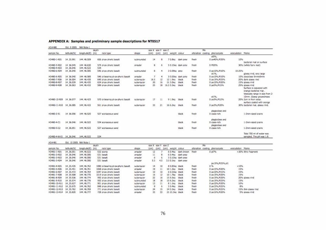
76
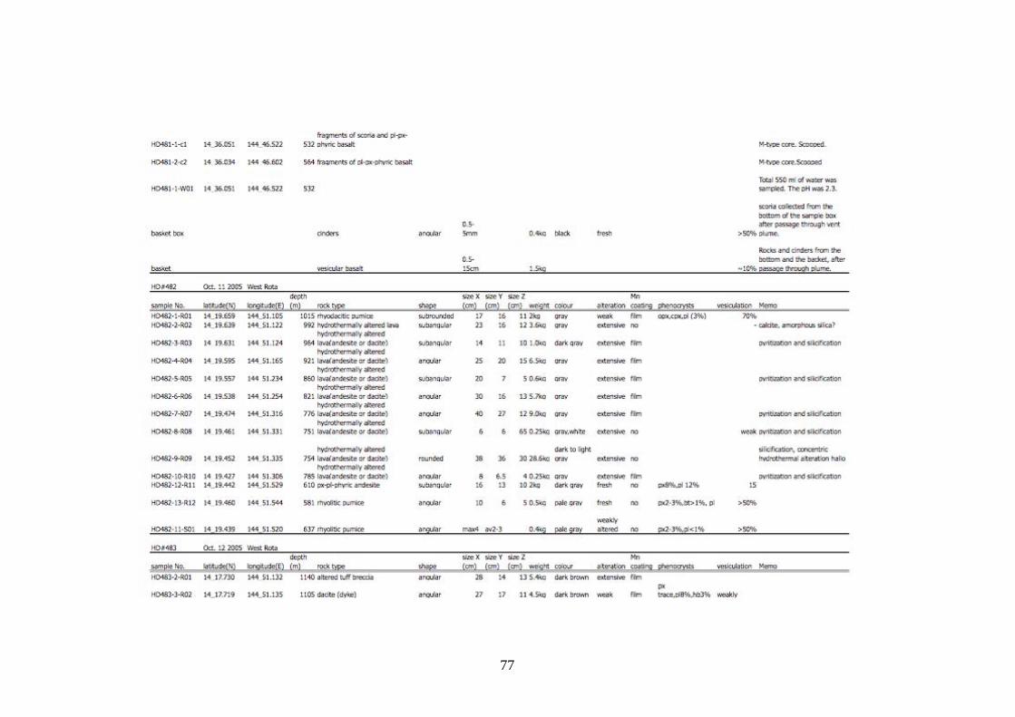
77
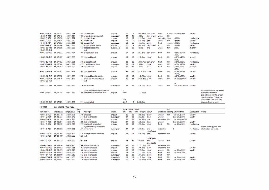
78
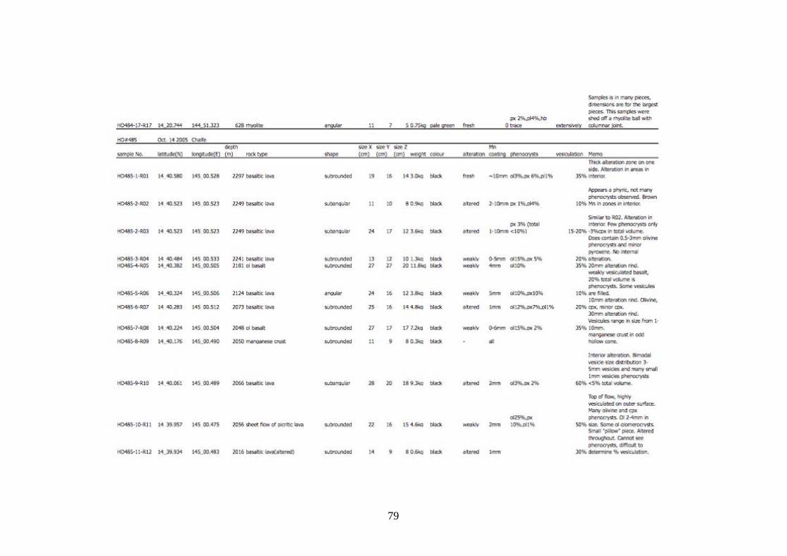
79
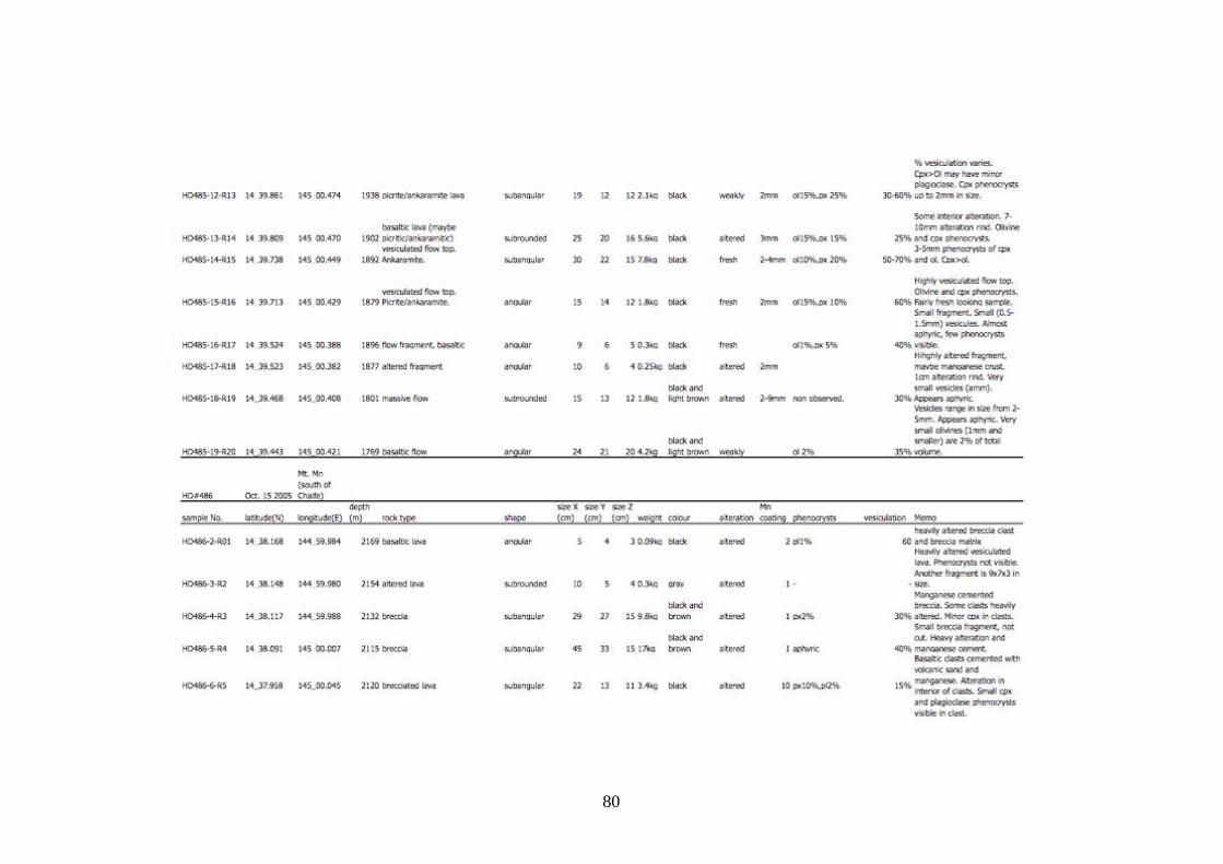
80
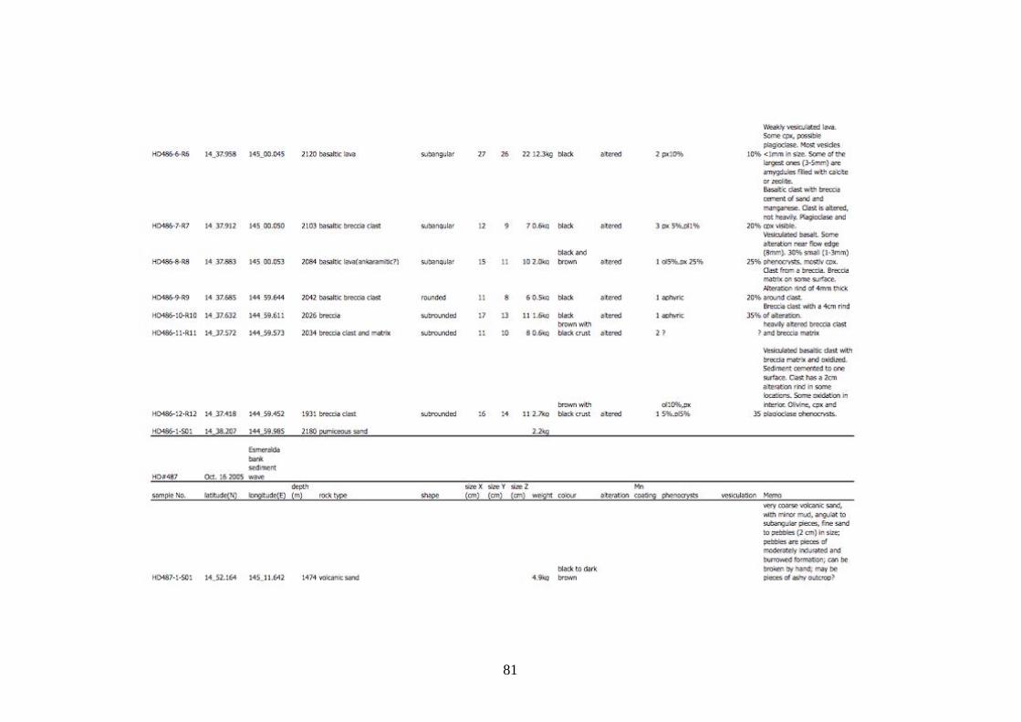
81
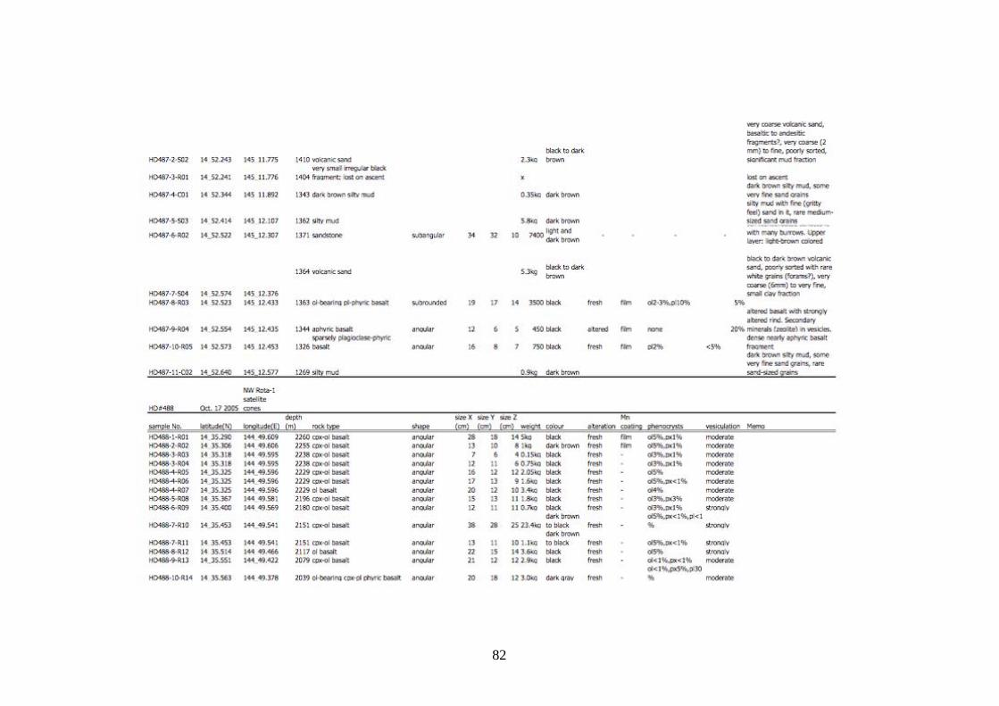
82
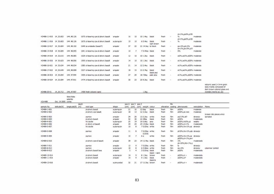
83

84
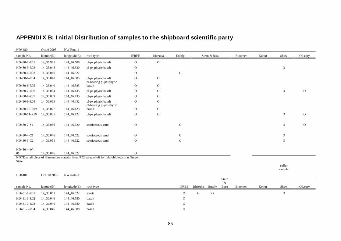
85
APPENDIX B: Initial Distribution of samples to the shipboard scientific party HD#480 Oct. 9 2005 NW Rota-1
sample No. latitude(N) longitude(E) rock type IFREE Ishizuka Embly Stern & Basu Bloomer Kohut Shaw O'Leary
HD480-1-R01 14_35.991 144_46.509 pl-px phyric basalt O O HD480-3-R02 14_36.045 144_46.630 pl-px phyric basalt O O
HD480-4-R03 14_36.046 144_46.522 O O
HD480-6-R04 14_36.040 144_46.585 pl-px phyric basalt O O
HD480-6-R05 14_36.040 144_46.585 ol-bearing pl-px-phyric basalt O O
HD480-7-R06 14_36.004 144_46.435 pl-px phyric basalt O O O O
HD480-8-R07 14_36.039 144_46.435 pl-px phyric basalt O O
HD480-9-R08 14_36.063 144_46.432 pl-px phyric basalt O O
HD480-10-R09 14_36.077 144_46.423 ol-bearing pl-px-phyric basalt O O
HD480-11-R10 14_36.085 144_46.422 pl-px phyric basalt O O O O
HD480-2-S1 14_36.056 144_46.520 scoriaceous sand O O O O
HD480-4-C1 14_36.046 144_46.522 scoriaceous sand O O O
HD480-5-C2 14_36.051 144_46.522 scoriaceous sand O O O
HD480-4-W-01 14_36.046 144_46.522 O NOTE:small piece of filamentous material from R02 scraped off for microbiologists at Oregon State
sulfur
sample
HD#481 Oct. 10 2005 NW Rota-1
sample No. latitude(N) longitude(E) rock type IFREE Ishizuka Embly
Stern &
Basu Bloomer Kohut Shaw O'Leary
HD481-1-R01 14_36.051 144_46.522 scoria O O O O
HD481-3-R02 14_36.046 144_46.580 basalt O
HD481-3-R03 14_36.046 144_46.580 basalt O
HD481-3-R04 14_36.046 144_46.580 basalt O
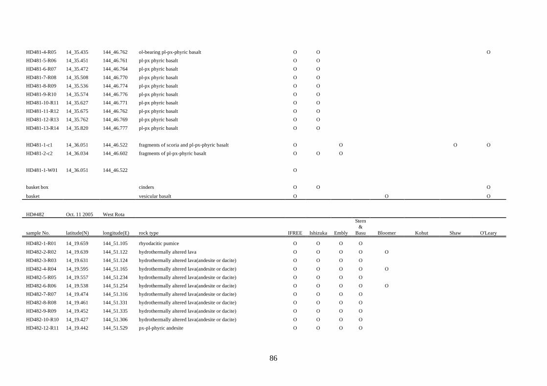
86
HD481-4-R05 14_35.435 144_46.762 ol-bearing pl-px-phyric basalt O O O
HD481-5-R06 14_35.451 144_46.761 pl-px phyric basalt O O
HD481-6-R07 14_35.472 144_46.764 pl-px phyric basalt O O
HD481-7-R08 14_35.508 144_46.770 pl-px phyric basalt O O
HD481-8-R09 14_35.536 144_46.774 pl-px phyric basalt O O
HD481-9-R10 14_35.574 144_46.776 pl-px phyric basalt O O
HD481-10-R11 14_35.627 144_46.771 pl-px phyric basalt O O
HD481-11-R12 14_35.675 144_46.762 pl-px phyric basalt O O
HD481-12-R13 14_35.762 144_46.769 pl-px phyric basalt O O
HD481-13-R14 14_35.820 144_46.777 pl-px phyric basalt O O
HD481-1-c1 14_36.051 144_46.522 fragments of scoria and pl-px-phyric basalt O O O O
HD481-2-c2 14_36.034 144_46.602 fragments of pl-px-phyric basalt O O O
HD481-1-W01 14_36.051 144_46.522 O
basket box cinders O O O
basket vesicular basalt O O O
HD#482 Oct. 11 2005 West Rota
sample No. latitude(N) longitude(E) rock type IFREE Ishizuka Embly
Stern &
Basu Bloomer Kohut Shaw O'Leary
HD482-1-R01 14_19.659 144_51.105 rhyodacitic pumice O O O O
HD482-2-R02 14_19.639 144_51.122 hydrothermally altered lava O O O O O HD482-3-R03 14_19.631 144_51.124 hydrothermally altered lava(andesite or dacite) O O O O HD482-4-R04 14_19.595 144_51.165 hydrothermally altered lava(andesite or dacite) O O O O O HD482-5-R05 14_19.557 144_51.234 hydrothermally altered lava(andesite or dacite) O O O O HD482-6-R06 14_19.538 144_51.254 hydrothermally altered lava(andesite or dacite) O O O O O HD482-7-R07 14_19.474 144_51.316 hydrothermally altered lava(andesite or dacite) O O O O HD482-8-R08 14_19.461 144_51.331 hydrothermally altered lava(andesite or dacite) O O O O HD482-9-R09 14_19.452 144_51.335 hydrothermally altered lava(andesite or dacite) O O O O HD482-10-R10 14_19.427 144_51.306 hydrothermally altered lava(andesite or dacite) O O O O HD482-12-R11 14_19.442 144_51.529 px-pl-phyric andesite O O O O
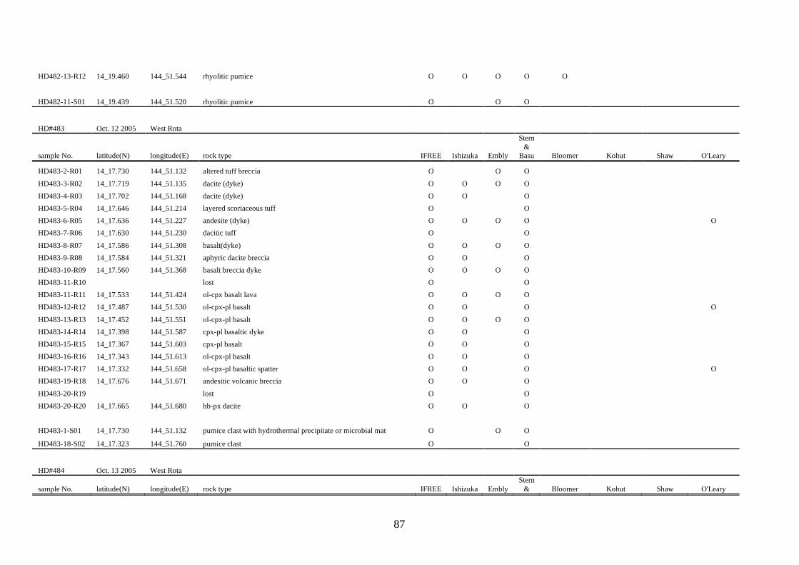
87
HD482-13-R12 14_19.460 144_51.544 rhyolitic pumice O O O O O
HD482-11-S01 14_19.439 144_51.520 rhyolitic pumice O O O
HD#483 Oct. 12 2005 West Rota
sample No. latitude(N) longitude(E) rock type IFREE Ishizuka Embly
Stern &
Basu Bloomer Kohut Shaw O'Leary
HD483-2-R01 14_17.730 144_51.132 altered tuff breccia O O O HD483-3-R02 14_17.719 144_51.135 dacite (dyke) O O O O HD483-4-R03 14_17.702 144_51.168 dacite (dyke) O O O HD483-5-R04 14_17.646 144_51.214 layered scoriaceous tuff O O HD483-6-R05 14_17.636 144_51.227 andesite (dyke) O O O O O HD483-7-R06 14_17.630 144_51.230 dacitic tuff O O HD483-8-R07 14_17.586 144_51.308 basalt(dyke) O O O O HD483-9-R08 14_17.584 144_51.321 aphyric dacite breccia O O O HD483-10-R09 14_17.560 144_51.368 basalt breccia dyke O O O O HD483-11-R10 lost O O HD483-11-R11 14_17.533 144_51.424 ol-cpx basalt lava O O O O HD483-12-R12 14_17.487 144_51.530 ol-cpx-pl basalt O O O O HD483-13-R13 14_17.452 144_51.551 ol-cpx-pl basalt O O O O HD483-14-R14 14_17.398 144_51.587 cpx-pl basaltic dyke O O O HD483-15-R15 14_17.367 144_51.603 cpx-pl basalt O O O HD483-16-R16 14_17.343 144_51.613 ol-cpx-pl basalt O O O HD483-17-R17 14_17.332 144_51.658 ol-cpx-pl basaltic spatter O O O O HD483-19-R18 14_17.676 144_51.671 andesitic volcanic breccia O O O HD483-20-R19 lost O O HD483-20-R20 14_17.665 144_51.680 hb-px dacite O O O HD483-1-S01 14_17.730 144_51.132 pumice clast with hydrothermal precipitate or microbial mat O O O
HD483-18-S02 14_17.323 144_51.760 pumice clast O O
HD#484 Oct. 13 2005 West Rota
sample No. latitude(N) longitude(E) rock type IFREE Ishizuka Embly Stern
& Bloomer Kohut Shaw O'Leary
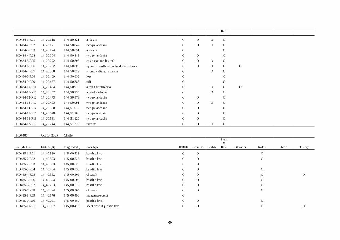
88
Basu
HD484-1-R01 14_20.118 144_50.821 andesite O O O O HD484-2-R02 14_20.121 144_50.842 two-px andesite O O O O HD484-3-R03 14_20.124 144_50.851 andesite O O HD484-4-R04 14_20.204 144_50.848 two-px andesite O O O HD484-5-R05 14_20.272 144_50.808 cpx basalt (andesite)? O O O O HD484-6-R06 14_20.292 144_50.805 hydrothermally-alteredand jointed lava O O O O O HD484-7-R07 14_20.368 144_50.829 strongly altered andesite O O O HD484-8-R08 14_20.409 144_50.853 lost O O HD484-9-R09 14_20.437 144_50.883 tuff O O HD484-10-R10 14_20.434 144_50.910 altered tuff breccia O O O O HD484-11-R11 14_20.452 144_50.935 altered andesite O O O HD484-12-R12 14_20.473 144_50.978 two-px andesite O O O HD484-13-R13 14_20.483 144_50.991 two-px andesite O O O O HD484-14-R14 14_20.500 144_51.012 two-px andesite O O O HD484-15-R15 14_20.578 144_51.106 two-px andesite O O O HD484-16-R16 14_20.581 144_51.120 two-px andesite O O O
HD484-17-R17 14_20.744 144_51.323 rhyolite O O O O
HD#485 Oct. 14 2005 Chaife
sample No. latitude(N) longitude(E) rock type IFREE Ishizuka Embly
Stern &
Basu Bloomer Kohut Shaw O'Leary
HD485-1-R01 14_40.580 145_00.528 basaltic lava O O O HD485-2-R02 14_40.523 145_00.523 basaltic lava O O O HD485-2-R03 14_40.523 145_00.523 basaltic lava O O HD485-3-R04 14_40.484 145_00.533 basaltic lava O O O HD485-4-R05 14_40.382 145_00.505 ol basalt O O O O HD485-5-R06 14_40.324 145_00.506 basaltic lava O O O HD485-6-R07 14_40.283 145_00.512 basaltic lava O O O HD485-7-R08 14_40.224 145_00.504 ol basalt O O O HD485-8-R09 14_40.176 145_00.490 manganese crust O HD485-9-R10 14_40.061 145_00.489 basaltic lava O O O HD485-10-R11 14_39.957 145_00.475 sheet flow of picritic lava O O O O
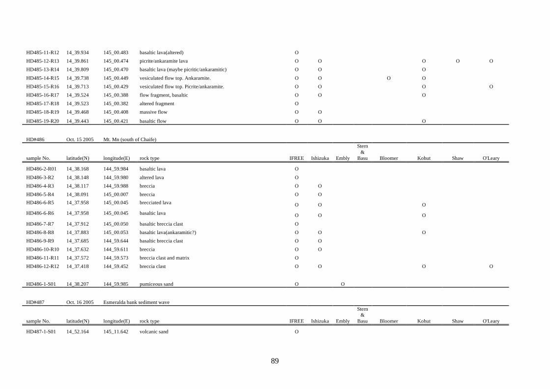
89
HD485-11-R12 14_39.934 145_00.483 basaltic lava(altered) O HD485-12-R13 14_39.861 145_00.474 picrite/ankaramite lava O O O O O HD485-13-R14 14_39.809 145_00.470 basaltic lava (maybe picritic/ankaramitic) O O O HD485-14-R15 14_39.738 145_00.449 vesiculated flow top. Ankaramite. O O O O HD485-15-R16 14_39.713 145_00.429 vesiculated flow top. Picrite/ankaramite. O O O O HD485-16-R17 14_39.524 145_00.388 flow fragment, basaltic O O O HD485-17-R18 14_39.523 145_00.382 altered fragment O HD485-18-R19 14_39.468 145_00.408 massive flow O O
HD485-19-R20 14_39.443 145_00.421 basaltic flow O O O
HD#486 Oct. 15 2005 Mt. Mn (south of Chaife)
sample No. latitude(N) longitude(E) rock type IFREE Ishizuka Embly
Stern &
Basu Bloomer Kohut Shaw O'Leary
HD486-2-R01 14_38.168 144_59.984 basaltic lava O HD486-3-R2 14_38.148 144_59.980 altered lava O HD486-4-R3 14_38.117 144_59.988 breccia O O HD486-5-R4 14_38.091 145_00.007 breccia O O HD486-6-R5 14_37.958 145_00.045 brecciated lava O O O HD486-6-R6 14_37.958 145_00.045 basaltic lava O O O HD486-7-R7 14_37.912 145_00.050 basaltic breccia clast O HD486-8-R8 14_37.883 145_00.053 basaltic lava(ankaramitic?) O O O HD486-9-R9 14_37.685 144_59.644 basaltic breccia clast O O HD486-10-R10 14_37.632 144_59.611 breccia O O HD486-11-R11 14_37.572 144_59.573 breccia clast and matrix O HD486-12-R12 14_37.418 144_59.452 breccia clast O O O O
HD486-1-S01 14_38.207 144_59.985 pumiceous sand O O
HD#487 Oct. 16 2005 Esmeralda bank sediment wave
sample No. latitude(N) longitude(E) rock type IFREE Ishizuka Embly
Stern &
Basu Bloomer Kohut Shaw O'Leary
HD487-1-S01 14_52.164 145_11.642 volcanic sand O
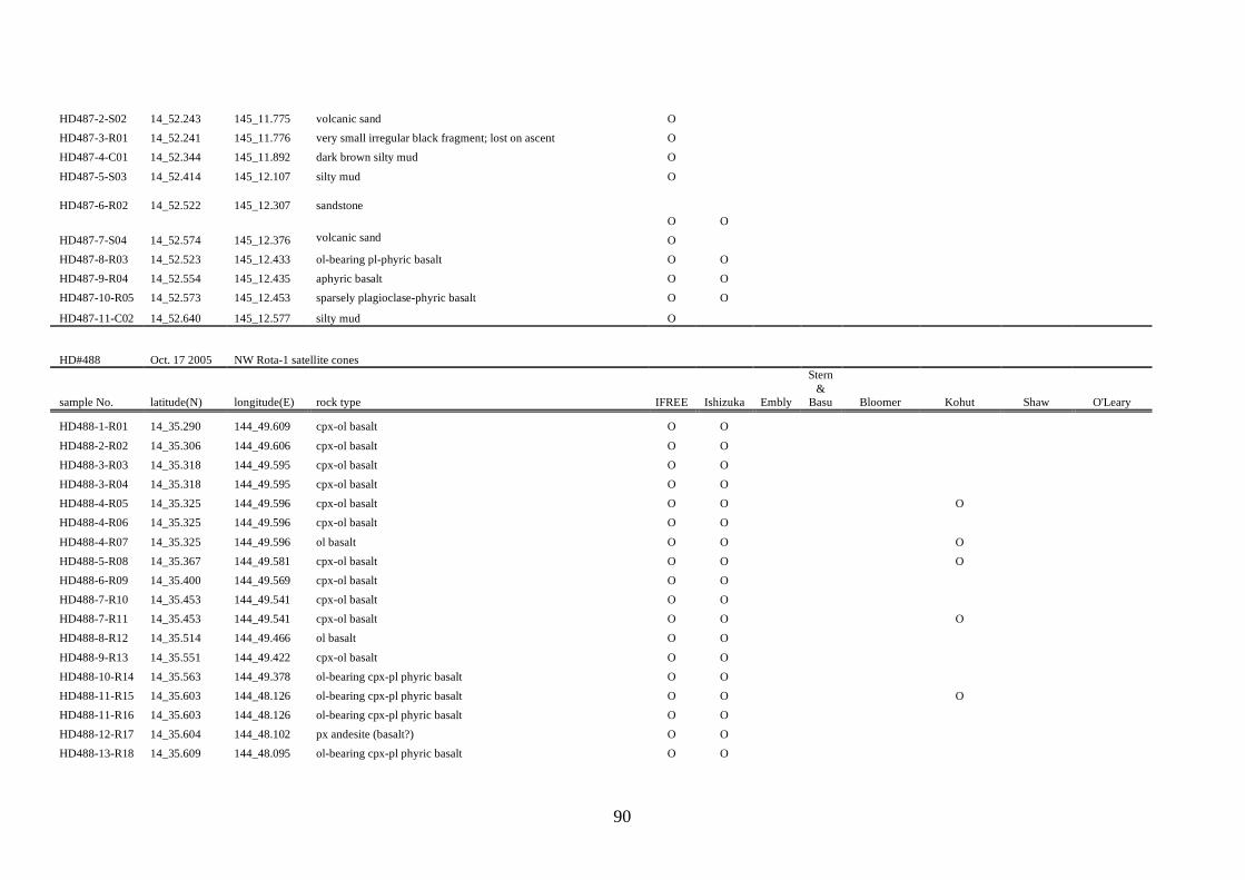
90
HD487-2-S02 14_52.243 145_11.775 volcanic sand O HD487-3-R01 14_52.241 145_11.776 very small irregular black fragment; lost on ascent O HD487-4-C01 14_52.344 145_11.892 dark brown silty mud O HD487-5-S03 14_52.414 145_12.107 silty mud O
HD487-6-R02 14_52.522 145_12.307 sandstone O O
HD487-7-S04 14_52.574 145_12.376 volcanic sand O HD487-8-R03 14_52.523 145_12.433 ol-bearing pl-phyric basalt O O HD487-9-R04 14_52.554 145_12.435 aphyric basalt O O HD487-10-R05 14_52.573 145_12.453 sparsely plagioclase-phyric basalt O O
HD487-11-C02 14_52.640 145_12.577 silty mud O
HD#488 Oct. 17 2005 NW Rota-1 satellite cones
sample No. latitude(N) longitude(E) rock type IFREE Ishizuka Embly
Stern &
Basu Bloomer Kohut Shaw O'Leary
HD488-1-R01 14_35.290 144_49.609 cpx-ol basalt O O HD488-2-R02 14_35.306 144_49.606 cpx-ol basalt O O HD488-3-R03 14_35.318 144_49.595 cpx-ol basalt O O HD488-3-R04 14_35.318 144_49.595 cpx-ol basalt O O HD488-4-R05 14_35.325 144_49.596 cpx-ol basalt O O O HD488-4-R06 14_35.325 144_49.596 cpx-ol basalt O O HD488-4-R07 14_35.325 144_49.596 ol basalt O O O HD488-5-R08 14_35.367 144_49.581 cpx-ol basalt O O O HD488-6-R09 14_35.400 144_49.569 cpx-ol basalt O O HD488-7-R10 14_35.453 144_49.541 cpx-ol basalt O O HD488-7-R11 14_35.453 144_49.541 cpx-ol basalt O O O HD488-8-R12 14_35.514 144_49.466 ol basalt O O HD488-9-R13 14_35.551 144_49.422 cpx-ol basalt O O HD488-10-R14 14_35.563 144_49.378 ol-bearing cpx-pl phyric basalt O O HD488-11-R15 14_35.603 144_48.126 ol-bearing cpx-pl phyric basalt O O O HD488-11-R16 14_35.603 144_48.126 ol-bearing cpx-pl phyric basalt O O HD488-12-R17 14_35.604 144_48.102 px andesite (basalt?) O O HD488-13-R18 14_35.609 144_48.095 ol-bearing cpx-pl phyric basalt O O
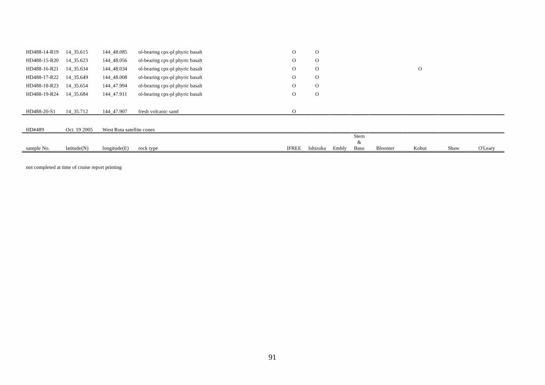
91
HD488-14-R19 14_35.615 144_48.085 ol-bearing cpx-pl phyric basalt O O HD488-15-R20 14_35.623 144_48.056 ol-bearing cpx-pl phyric basalt O O HD488-16-R21 14_35.634 144_48.034 ol-bearing cpx-pl phyric basalt O O O HD488-17-R22 14_35.649 144_48.008 ol-bearing cpx-pl phyric basalt O O HD488-18-R23 14_35.654 144_47.994 ol-bearing cpx-pl phyric basalt O O HD488-19-R24 14_35.684 144_47.911 ol-bearing cpx-pl phyric basalt O O
HD488-20-S1 14_35.712 144_47.907 fresh volcanic sand O
HD#489 Oct. 19 2005 West Rota satellite cones
sample No. latitude(N) longitude(E) rock type IFREE Ishizuka Embly
Stern &
Basu Bloomer Kohut Shaw O'Leary
not completed at time of cruise report printing