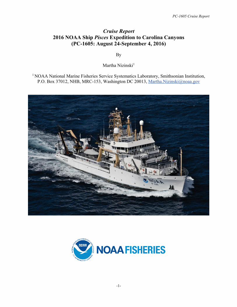
cruise report 2016 noaa ship pisces expedition to carolina
TRANSCRIPT
PC-1605 Cruise Report
-1-
Cruise Report 2016 NOAA Ship Pisces Expedition to Carolina Canyons
(PC-1605: August 24-September 4, 2016)
By
Martha Nizinski1
1 NOAA National Marine Fisheries Service Systematics Laboratory, Smithsonian Institution, P.O. Box 37012, NHB, MRC-153, Washington DC 20013, [email protected]

PC-1605 Cruise Report
-2-
Introduction Submarine canyons continue to be areas of high interest to federal and state agencies tasked with research and management responsibilities, particularly those for deep-sea corals. Most canyons are poorly known, but based on data collected during previous investigations, many scientists and managers believe submarine canyons provide refuge for a variety of fauna including corals, fishes, and other animals. Beginning on August 24, 2016, a multidisciplinary team of scientists and engineers (Table 1), aboard NOAA Ship Pisces spent 12 days-at-sea exploring three deep-water canyons off the coast of North Carolina. Specifically, the team targeted Keller, Pamlico, and Hatteras canyons. With the overall goal of surveying suspected deep-sea coral habitats associated with these canyons using the AUV Sentry, the primary objectives for this mission were to:
1. survey canyon and inter-canyon slope environments to characterize benthic habitats and identify areas of coral presence;
2. conduct multibeam mapping in canyon and slope areas where data are missing or incomplete;
3. assess geological features to characterize canyon morphology; 4. conduct CTD sampling; and 5. collect water samples and monocore samples during specific CTD casts.
This cruise marked the first of several missions scheduled to take place off the Southeast U.S. with the aim to collect contemporary scientific information needed by managers to protect and conserve deep-sea coral ecosystems. Several NOAA line-offices (National Marine Fisheries Service, Office of Ocean Exploration and Research, National Ocean Service), other government agencies (Bureau of Ocean Energy Management, U.S. Geological Survey), and regional resource managers are interested in deep-sea coral habitats in this region. Narrative of cruise results Despite numerous challenges, the research team was able to address each of our objectives. Objective 1. The research team completed three AUV dives between 700 and 1900 m depth, for a total of 50 hours of bottom time covering 71 km distance over ground (Table 2). Strong surface currents (4 knots) prevented the science team from surveying Keller Canyon. Further south and outside the direct influence of the Gulf Stream, AUV Sentry completed one successful dive in Pamlico Canyon and two successful dives in Hatteras Canyon (Figures 1-3). Based on the preliminary analysis of the >50,000 collected images, the team documented the presence of deep-sea corals and sponges in both of these canyons (Figures 4-5). Additionally, a variety of fishes, crustaceans and cephalopods were observed in many of the images. Furthermore, AUV Sentry collected optical backscatter, oxidation-reduction potential (ORP), dissolved oxygen and temperature data along the imaging path (Figure 5). Objective 2. The research team mapped the head of Hatteras Canyon using the ship’s ME70 multibeam system to generate maps of bathymetric features. Although numerous mapping

PC-1605 Cruise Report
-3-
priority areas were identified, the ME70 was nonfunctional for the majority of the cruise. AUV Sentry, outfitted with sidescan sonar, collected bottom profile data during the three imaging deployments. Objective 3. Images revealed a variety of habitats, including smooth canyon walls and flat sedimented plains. The morphology, and presumably the underlying geology, of these two canyons are quite different then that observed in canyons further north. Objective 4. AUV Sentry collected CTD data during all imaging deployments (Figure 5). Additionally, seven CTD-Niskin casts were completed during the mission. Three casts were made at the Cape Fear landslide site; the remaining four casts collected water column data along the axis of Hatteras Canyon (Table 3). Objective 5. Water and monocore samples were collected during seven CTD casts (Table 3). A series of four core samples, taken along the axis of Hatteras Canyon, was collected at depth intervals comparable to those sampled in nearby Norfolk and Baltimore canyons. These cores, sectioned into layers, resulted in 74 samples. Additionally, 56 liters of water were filtered while at sea. Analyses of these sediment and water samples will provide information on the amount, composition, and quality of food available to benthic organisms living in the canyon environment. Further processing of these samples for isotope analyses will be conducted by personnel at USGS in Gainesville, Florida. Due to poor weather conditions (tropical depressions passing through the study area) the ship traveled further south, outside the original study area. At this southern, more inland location, the science team collected three core samples at a landslide area off Cape Fear to support research interests of USGS colleague, Jason Chaytor. Analysis of these core samples will further understanding of sediment flows as well as provide better estimates of the timing of recent underwater landslides. These samples were shipped to J. Chaytor (USGS, Woods Hole, MA) for processing. Outreach This cruise, designated a NOAA Office of Ocean Exploration and Research signature cruise, was highlighted on the OER website: http://oceanexplorer.noaa.gov/explorations/16carolina/welcome.html. Daily logs were posted while at sea. At-sea scientists engaged with students in North Carolina and Florida as well as answered questions posted to the website. Cruise highlights were also linked to the North Carolina Museum of Natural Sciences.
PC-1605 Cruise Report
-4-
Participant list Table 1. List of participants of 2016 expedition to the North Carolina Canyons aboard the NOAA Ship Pisces (PC-1605).
Name Role Affiliation Martha Nizinski Chief Scientist NOAA National Marine Fisheries Service Amanda Demopoulos Scientist United States Geological Survey Elizabeth Shea Scientist Delaware Museum of Natural History Elizabeth Baird Science Educator North Carolina Museum of Natural Sciences Katie Wagner Web Coordinator NOAA Office of Exploration and Research Shelby Bowden Scientist College of Charleston William Hefner Scientist College of Charleston Carl Kaiser AUV Sentry team lead Woods Hole Oceanographic Institute Michael McCarthy AUV Sentry team Woods Hole Oceanographic Institute Justin Fujii AUV Sentry team Woods Hole Oceanographic Institute Zachary Berkowitz AUV Sentry team Woods Hole Oceanographic Institute Molly Curran AUV Sentry team Woods Hole Oceanographic Institute
PC-1605 Cruise Report
-5-
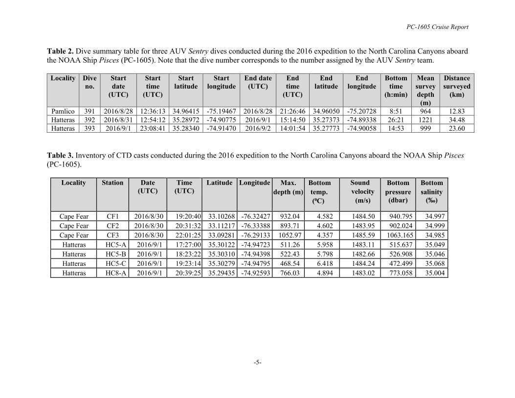
Table 2. Dive summary table for three AUV Sentry dives conducted during the 2016 expedition to the North Carolina Canyons aboard the NOAA Ship Pisces (PC-1605). Note that the dive number corresponds to the number assigned by the AUV Sentry team.
Locality Dive no.
Start date
(UTC)
Start time
(UTC)
Start latitude
Start longitude
End date (UTC)
End time
(UTC)
End latitude
End longitude
Bottom time
(h:min)
Mean survey depth (m)
Distance surveyed
(km)
Pamlico 391 2016/8/28 12:36:13 34.96415 -75.19467 2016/8/28 21:26:46 34.96050 -75.20728 8:51 964 12.83 Hatteras 392 2016/8/31 12:54:12 35.28972 -74.90775 2016/9/1 15:14:50 35.27373 -74.89338 26:21 1221 34.48 Hatteras 393 2016/9/1 23:08:41 35.28340 -74.91470 2016/9/2 14:01:54 35.27773 -74.90058 14:53 999 23.60
Table 3. Inventory of CTD casts conducted during the 2016 expedition to the North Carolina Canyons aboard the NOAA Ship Pisces (PC-1605).
Locality Station Date (UTC)
Time (UTC)
Latitude Longitude Max. depth (m)
Bottom temp. (⁰C)
Sound velocity
(m/s)
Bottom pressure (dbar)
Bottom salinity
(‰)
Cape Fear CF1 2016/8/30 19:20:40 33.10268 -76.32427 932.04 4.582 1484.50 940.795 34.997 Cape Fear CF2 2016/8/30 20:31:32 33.11217 -76.33388 893.71 4.602 1483.95 902.024 34.999 Cape Fear CF3 2016/8/30 22:01:25 33.09281 -76.29133 1052.97 4.357 1485.59 1063.165 34.985 Hatteras
HC5-A 2016/9/1 17:27:00 35.30122 -74.94723 511.26 5.958 1483.11 515.637 35.049
Hatteras
HC5-B 2016/9/1 18:23:22 35.30310 -74.94398 522.43 5.798 1482.66 526.908 35.046 Hatteras
HC5-C 2016/9/1 19:23:14 35.30279 -74.94795 468.54 6.418 1484.24 472.499 35.068
Hatteras
HC8-A 2016/9/1 20:39:25 35.29435 -74.92593 766.03 4.894 1483.02 773.058 35.004
PC-1605 Cruise Report
-6-
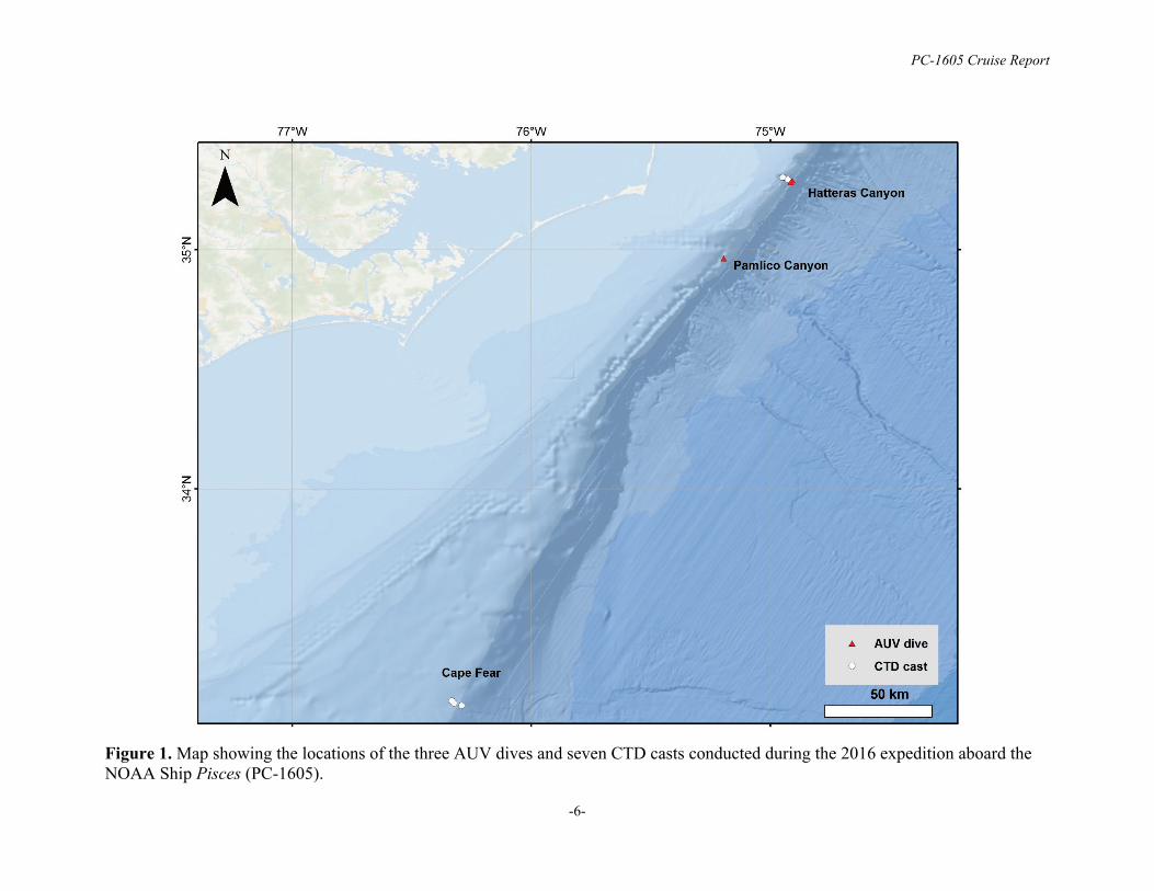
Figure 1. Map showing the locations of the three AUV dives and seven CTD casts conducted during the 2016 expedition aboard the NOAA Ship Pisces (PC-1605).

PC-1605 Cruise Report
-7-
Figure 2. Dive tracks of the three AUV Sentry dives conducted during the 2016 expedition aboard the NOAA Ship Pisces (PC-1605) including (top) dive 391 in Pamlico Canyon, and (bottom) dives 392-393 in Hatteras Canyon. 100 m contour lines are shown in black.
PC-1605 Cruise Report
-8-
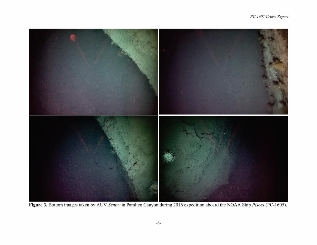
Figure 3. Bottom images taken by AUV Sentry in Pamlico Canyon during 2016 expedition aboard the NOAA Ship Pisces (PC-1605).
-9-
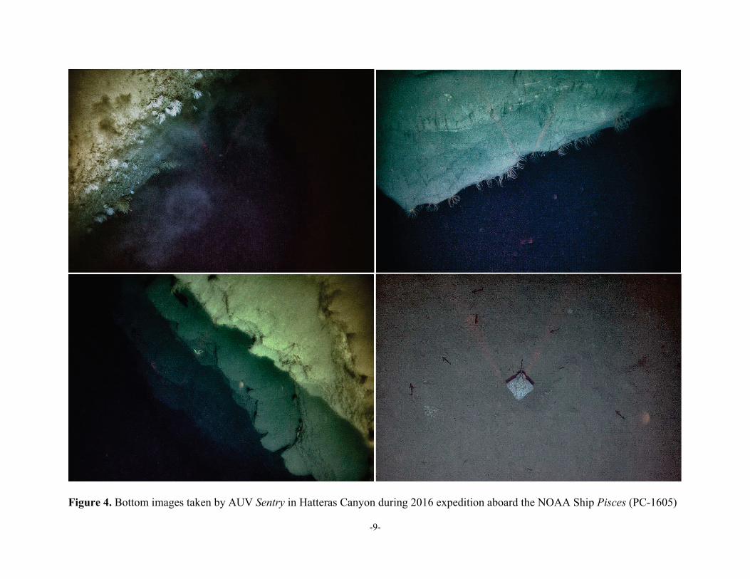
Figure 4. Bottom images taken by AUV Sentry in Hatteras Canyon during 2016 expedition aboard the NOAA Ship Pisces (PC-1605)

-10-
Figure 5. Time series plot of environmental data collected by AUV Sentry sensors during dive 391 in Pamlico Canyon. Plots are representative of the environmental data collected during the three AUV dives conducted during the expedition. From top to bottom: temperature, salinity, optical backscatter, dissolved oxygen, and oxidation-reduction potential (ORP).