cross calibration over snow fields near barrow, alaska...
TRANSCRIPT
SPIE’s 48th Annual Meeting, 3-8 Aug 2003, San Diego, USA 5151-46; Nieke et al. 1
Cross calibration over snow fields near Barrow, Alaska
orInitial “check-up” of GLI performance in
comparison with other “well-known” space sensors
Jens Nieke, Masahiro Hori (NASDA National Space Development Agency of Japan
EORC Earth Observation Research Center)Teruo Aoki (MRI)
Tomonori Tanikawa (University of Tsukuba)Hiroki Motoyoshi (Space Service Inc.)
Yukinori Nakajima (RESTEC)
SPIE’s 48th Annual Meeting, 3-8 Aug 2003, San Diego, USA 5151-46; Nieke et al. 2
Introduction
GLI on ADEOS-2 was launched successfully in Dec 2002 (and GLI is fully operational since April 03)
There are various calibration approaches ongoing:
• On-board calibration (solar, lamp, etc.)
• Vicarious calibration methods (ocean, desert etc.)
• Comparison with other space sensors (cross-calibration)
Goal:
=> A “reasonable good” understanding of GLI’s performance is expected for the end of the CalVal phase (Dec. 03)
SPIE’s 48th Annual Meeting, 3-8 Aug 2003, San Diego, USA 5151-46; Nieke et al. 3
General Approach
1. CalVal site 2 x 2 km2 located near Barrow, Alaska
2. Ground-truth data: aerosol optical thickness (AOT), snow reflectance measurements etc.
3. Macro site (6 x 6 km2) was used for uniformity check
4. GLI, MERIS, SeaWiFS, MODIS (terra, aqua) and AVHRR (N16/17) TOA radiance/reflectance data were taken
5. Sensor TOA radiance/reflectance were compared to Radiative Transfer Code 6S* calculations
* Vermote-1997

SPIE’s 48th Annual Meeting, 3-8 Aug 2003, San Diego, USA 5151-46; Nieke et al. 4
Advantages of snow fields in the polar region
• Semi-Simultaneous measurements between polar orbiting satellites
• Minimum correction for atmospheric effects
• Near Lambertian properties of New-Snow
• Same reflectance properties over a large region
• Dry and sunny condition periods in Spring/Autumn
• New-Snow conditions over longer period
SPIE’s 48th Annual Meeting, 3-8 Aug 2003, San Diego, USA 5151-46; Nieke et al. 5
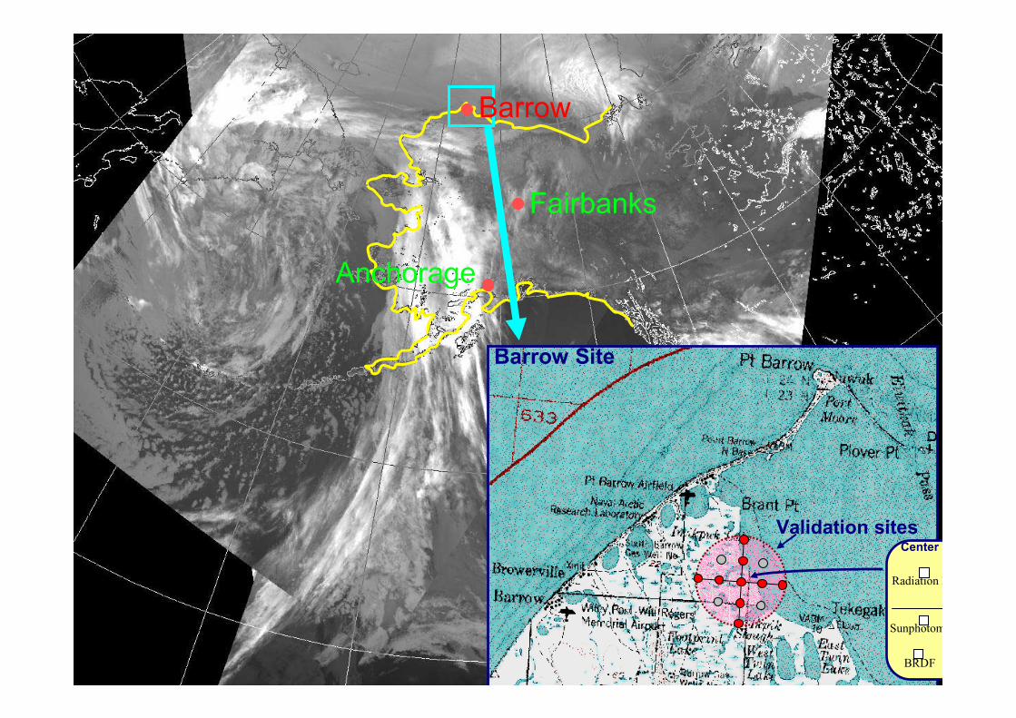
Barrow
Fairbanks
Anchorage
Barrow Site
BRDF
Center p
Radiation B
Sunphotom
Validation sites
SPIE’s 48th Annual Meeting, 3-8 Aug 2003, San Diego, USA 5151-46; Nieke et al. 6
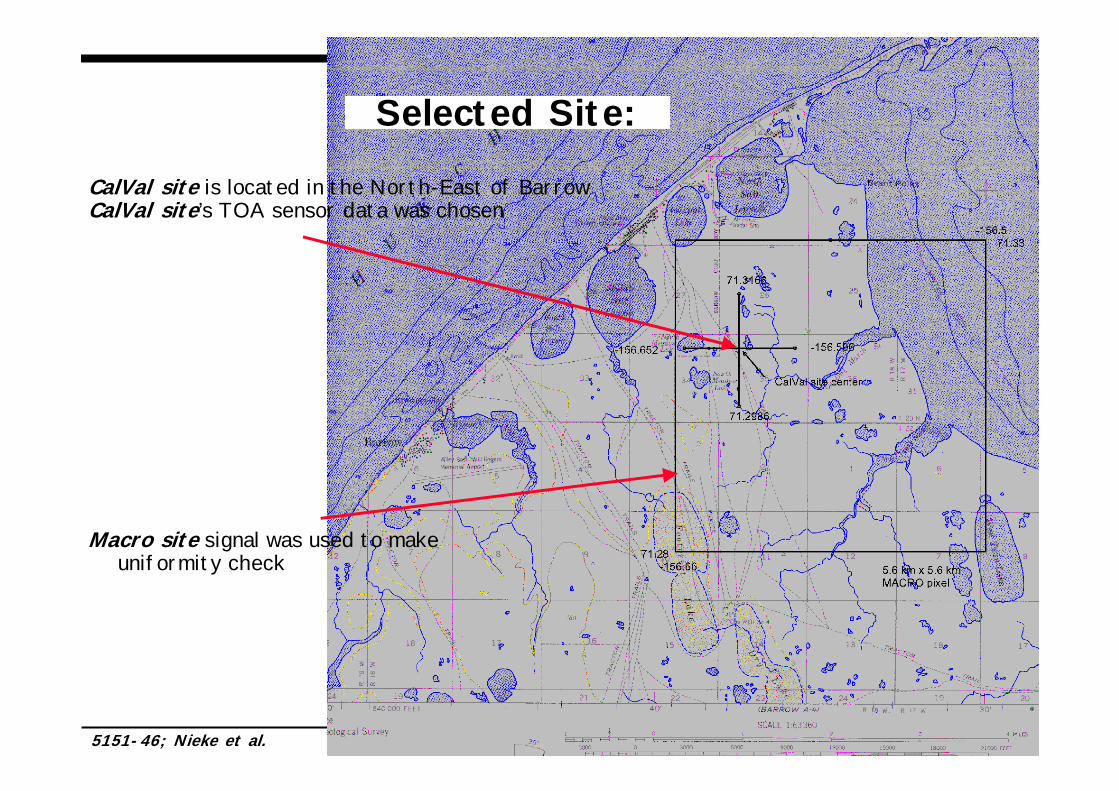
Selected Site:
Macro site signal was used to make uniformity check
CalVal site is located in the North-East of BarrowCalVal site’s TOA sensor data was chosen
SPIE’s 48th Annual Meeting, 3-8 Aug 2003, San Diego, USA 5151-46; Nieke et al. 7
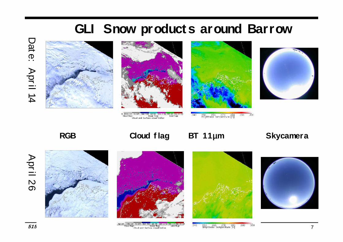
Date: A
pril 14 A
pril 26
GLI Snow products around Barrow
RGB Cloud flag BT 11µµµµm Skycamera
SPIE’s 48th Annual Meeting, 3-8 Aug 2003, San Diego, USA 5151-46; Nieke et al. 8
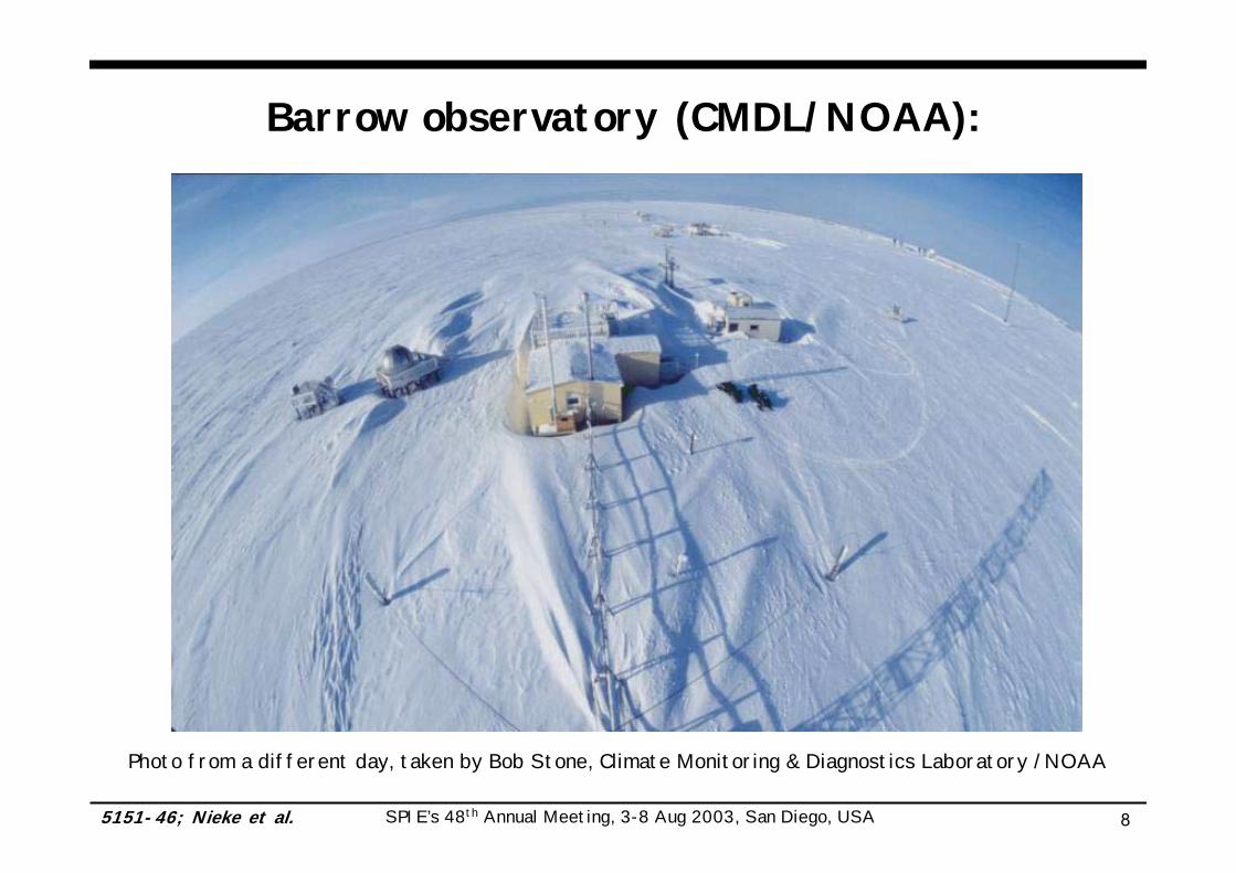
Barrow observatory (CMDL/NOAA):
Photo from a different day, taken by Bob Stone, Climate Monitoring & Diagnostics Laboratory /NOAA
SPIE’s 48th Annual Meeting, 3-8 Aug 2003, San Diego, USA 5151-46; Nieke et al. 9
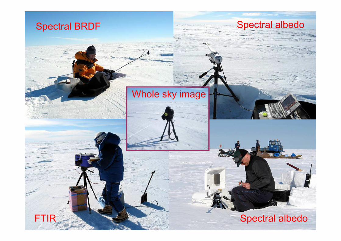
Spectral albedo
Spectral albedo
Spectral BRDF
FTIR
Whole sky image

SPIE’s 48th Annual Meeting, 3-8 Aug 2003, San Diego, USA 5151-46; Nieke et al. 10
Data Flow Chart for Inter-satellite Comparison
TOA reflectance or
radiance
Assumptions: • Site is homogenous and ‘lambertian’ (no directional effects) in the applied spectral range / viewing angles• Atmosphere (AOT, type, H2O, O3) and snow reflectance are constant, each period• Aerosol component for both days is “typical polar aerosol type”at Barrow
Ground Truth, AOT, snow reflectance,
atmospheric conditions
SPIE’s 48th Annual Meeting, 3-8 Aug 2003, San Diego, USA 5151-46; Nieke et al. 11
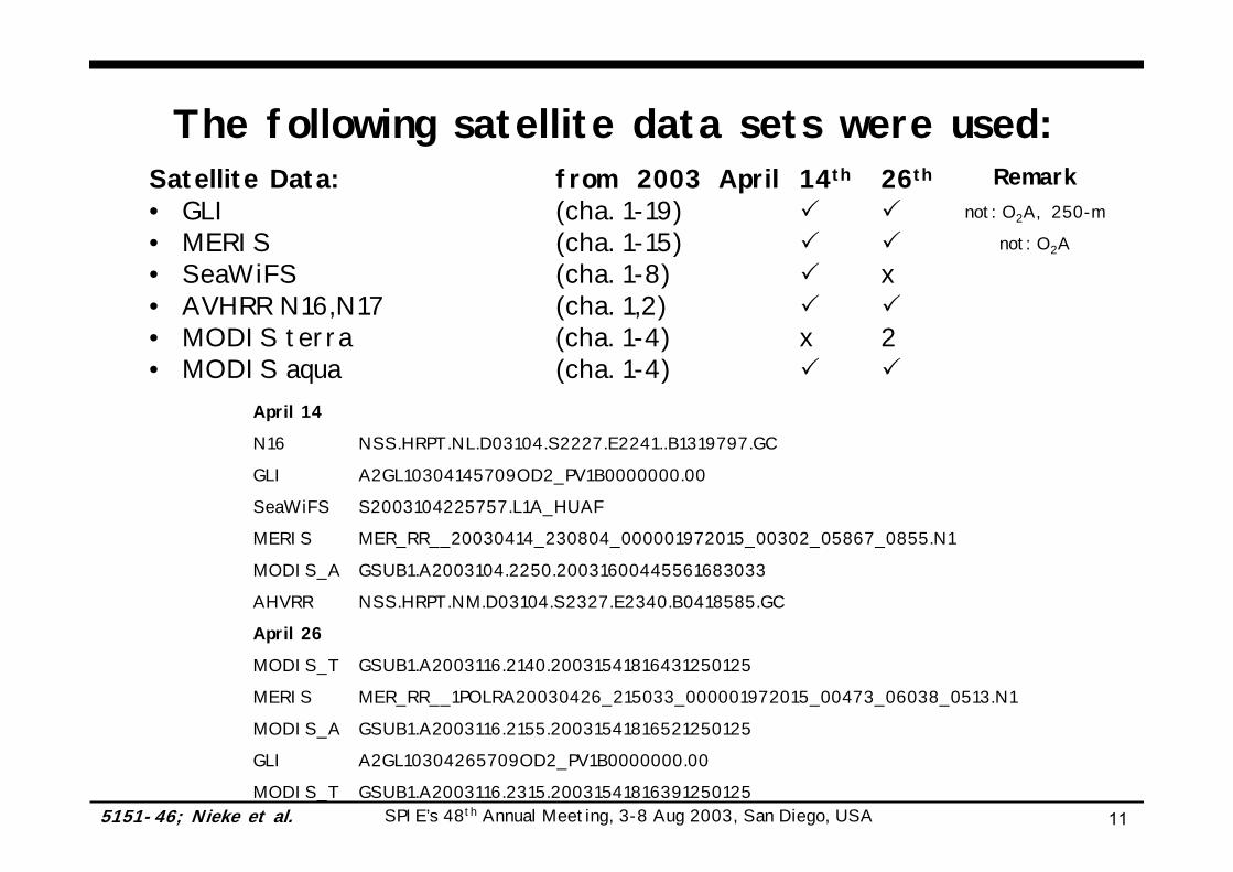
Satellite Data: from 2003 April 14th 26th
• GLI (cha. 1-19)• MERIS (cha. 1-15)• SeaWiFS (cha. 1-8) x• AVHRR N16,N17 (cha. 1,2)• MODIS terra (cha. 1-4) x 2• MODIS aqua (cha. 1-4)
The following satellite data sets were used:Remark
not: O2A, 250-m
not: O2A
April 14
N16 NSS.HRPT.NL.D03104.S2227.E2241..B1319797.GC
GLI A2GL10304145709OD2_PV1B0000000.00
SeaWiFS S2003104225757.L1A_HUAF
MERIS MER_RR__20030414_230804_000001972015_00302_05867_0855.N1
MODIS_A GSUB1.A2003104.2250.20031600445561683033
AHVRR NSS.HRPT.NM.D03104.S2327.E2340.B0418585.GC
April 26
MODIS_T GSUB1.A2003116.2140.20031541816431250125
MERIS MER_RR__1POLRA20030426_215033_000001972015_00473_06038_0513.N1
MODIS_A GSUB1.A2003116.2155.20031541816521250125
GLI A2GL10304265709OD2_PV1B0000000.00
MODIS_T GSUB1.A2003116.2315.20031541816391250125

SPIE’s 48th Annual Meeting, 3-8 Aug 2003, San Diego, USA 5151-46; Nieke et al. 12
GLI (green)
MERIS (red)
SeaWiFS (black)
RSP interpolated to 6S
2.5-nm-spectral intervals
Spectral Response Functions

SPIE’s 48th Annual Meeting, 3-8 Aug 2003, San Diego, USA 5151-46; Nieke et al. 13
Selected Overflights April 14th 2003
N17
SeaWiFS
GLIN16
MERIS Modisaqua
GMT Satellite sensors SunAZ SatAZ SunZ SatZ
22:35:46 N16 AHVRR 182.59 152.96 61.80 0.78
22:54:11 Terra MODIS X X X X
22:57:46 ADEOS-2 GLI 188.68 242.36 61.97 24.09
23:01:00 Orbview SeaWiFS 189.89 122.42 62.03 49.47
23:08:00 ENVISAT MERIS 191.76 312.13 62.13 31.37
23:09:00 Aqua MODIS 192.02 255.86 62.14 34.58
23:33:00 N17 AHVRR 198.66 314.07 62.61 33.62
SPIE’s 48th Annual Meeting, 3-8 Aug 2003, San Diego, USA 5151-46; Nieke et al. 14
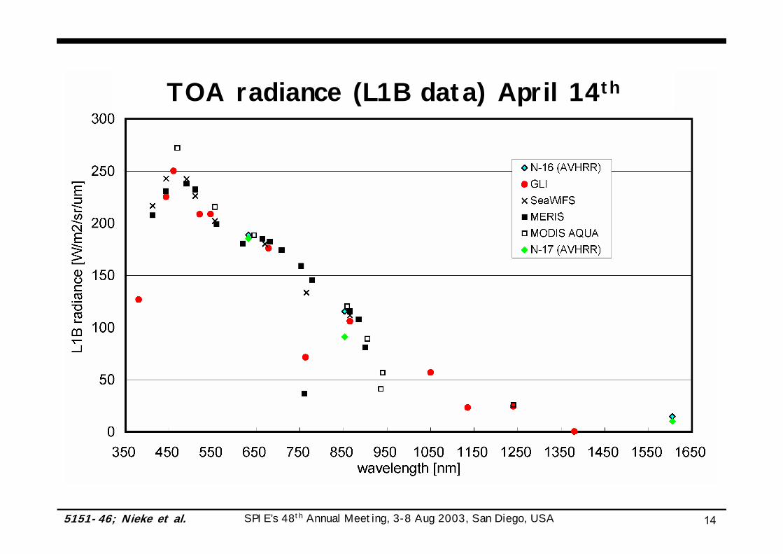
TOA radiance (L1B data) April 14th
SPIE’s 48th Annual Meeting, 3-8 Aug 2003, San Diego, USA 5151-46; Nieke et al. 15
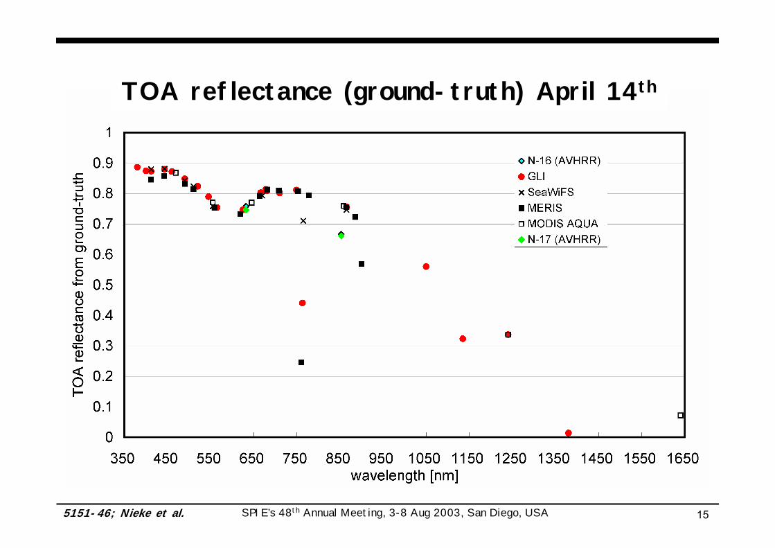
TOA reflectance (ground-truth) April 14th
SPIE’s 48th Annual Meeting, 3-8 Aug 2003, San Diego, USA 5151-46; Nieke et al. 16
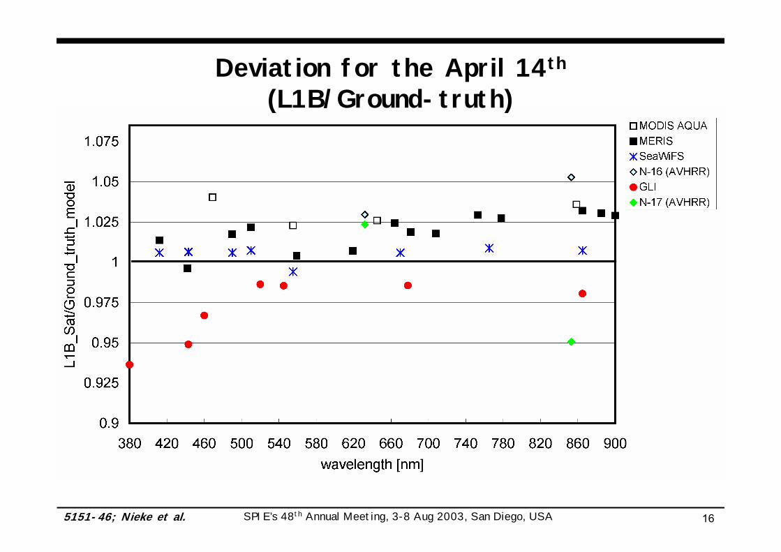
Deviation for the April 14th
(L1B/Ground-truth)
SPIE’s 48th Annual Meeting, 3-8 Aug 2003, San Diego, USA 5151-46; Nieke et al. 17
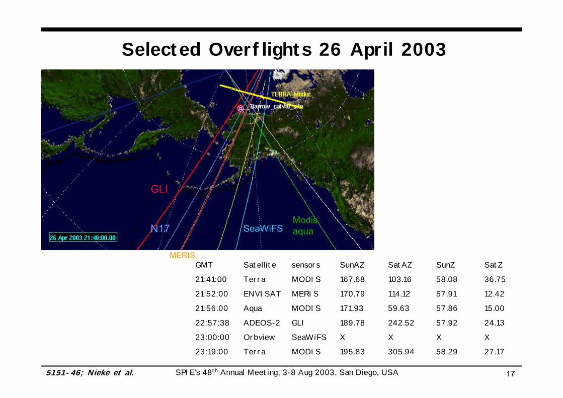
Selected Overflights 26 April 2003
N17 SeaWiFS
GLI
MERIS
Modisaqua
GMT Satellite sensors SunAZ SatAZ SunZ SatZ
21:41:00 Terra MODIS 167.68 103.16 58.08 36.75
21:52:00 ENVISAT MERIS 170.79 114.12 57.91 12.42
21:56:00 Aqua MODIS 171.93 59.63 57.86 15.00
22:57:38 ADEOS-2 GLI 189.78 242.52 57.92 24.13
23:00:00 Orbview SeaWiFS X X X X
23:19:00 Terra MODIS 195.83 305.94 58.29 27.17
SPIE’s 48th Annual Meeting, 3-8 Aug 2003, San Diego, USA 5151-46; Nieke et al. 18
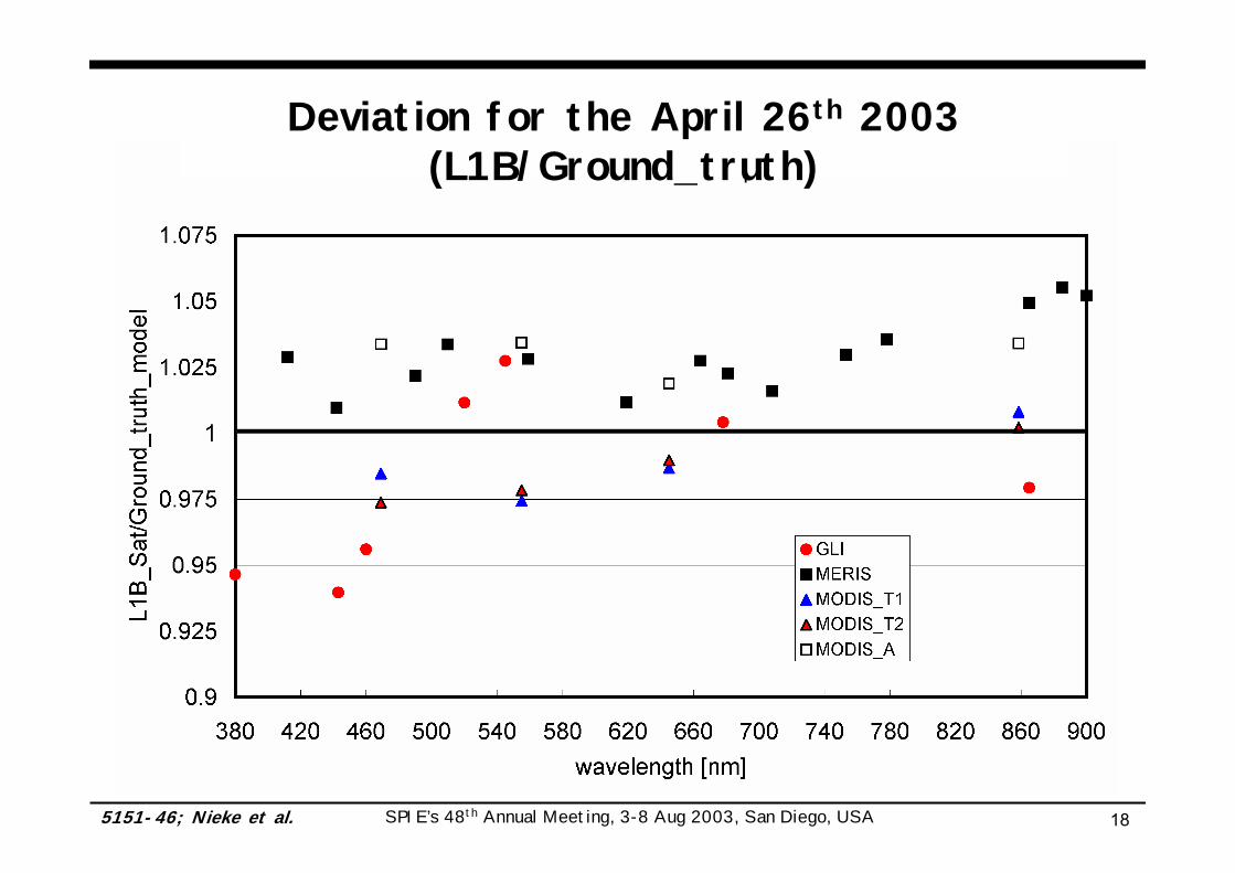
Deviation for the April 26th 2003 (L1B/Ground_truth)
SPIE’s 48th Annual Meeting, 3-8 Aug 2003, San Diego, USA 5151-46; Nieke et al. 19
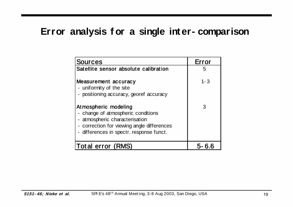
Error analysis for a single inter-comparison
SourcesSourcesSourcesSources Error Error Error Error Satellite sensor absolute calibrationSatellite sensor absolute calibrationSatellite sensor absolute calibrationSatellite sensor absolute calibration 5
Measurement accuracyMeasurement accuracyMeasurement accuracyMeasurement accuracy 1-3 - uniformity of the site - positioning accuracy, georef accuracy
Atmospheric modelingAtmospheric modelingAtmospheric modelingAtmospheric modeling 3 - change of atmospheric conditions - atmospheric characterisation - correction for viewing angle differences - differences in spectr. response funct.
Total error (RMS)Total error (RMS)Total error (RMS)Total error (RMS) 5-6.6 5-6.6 5-6.6 5-6.6
SPIE’s 48th Annual Meeting, 3-8 Aug 2003, San Diego, USA 5151-46; Nieke et al. 20
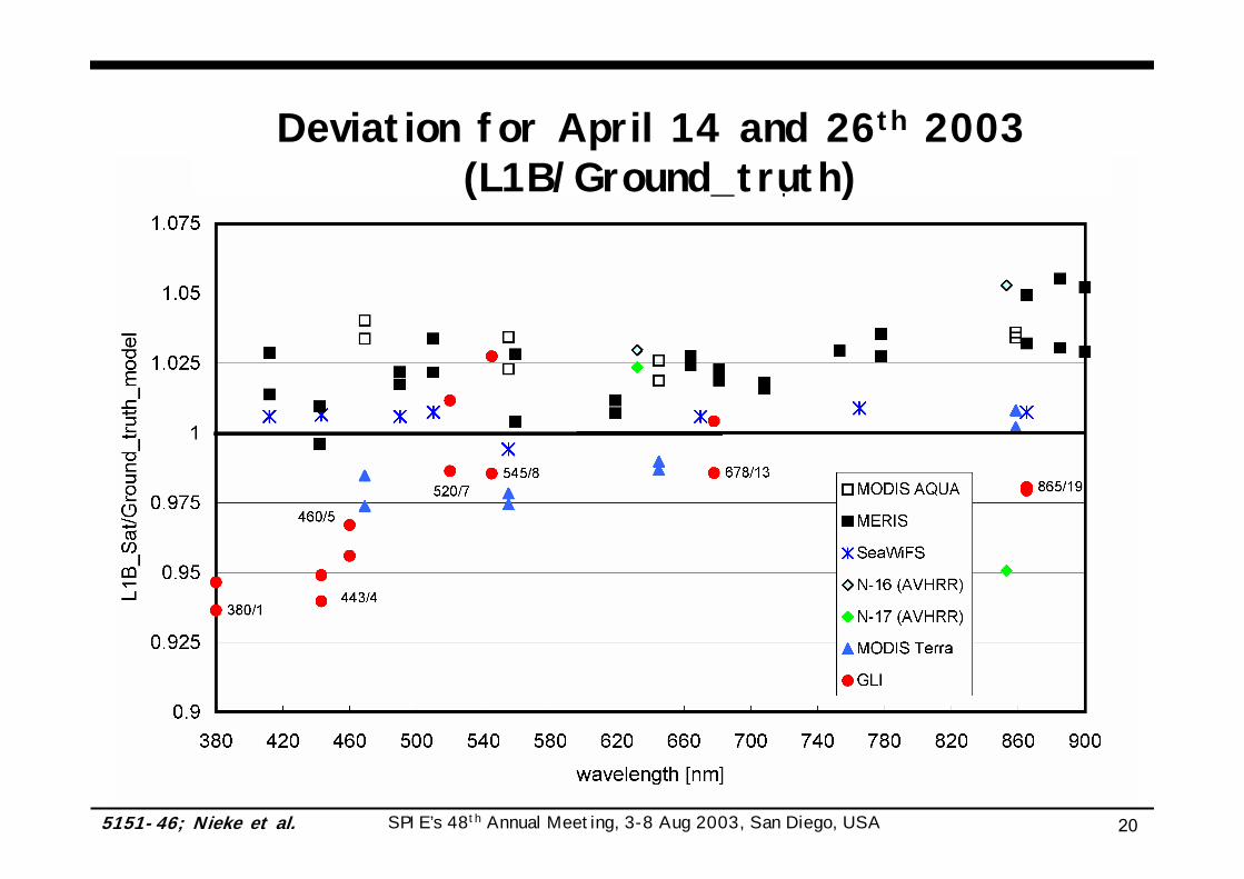
Deviation for April 14 and 26th 2003(L1B/Ground_truth)
SPIE’s 48th Annual Meeting, 3-8 Aug 2003, San Diego, USA 5151-46; Nieke et al. 21
Conclusion
The goal of this comparison is a “first check-up”of GLI performance.
Note, GLI CalVal phase is ongoing until Dec. 2003!
The error budget of single event comparison is high at about 5-7%, however, the following tendency is “interesting”:
GLI’s agreement with ground-truth and other space sensors in encouraging (+/- 6%)
• good agreement in the VIS (cha: 7/8/13)• GLI seems to be too low in the UV/blue (cha 1, 4, 5)
SPIE’s 48th Annual Meeting, 3-8 Aug 2003, San Diego, USA 5151-46; Nieke et al. 22
We would like to acknowledge
• NASA (DAAC, SeaWiFS project),
• NOAA (SAA),
• ESA & Brockmann,
• Aeronet/ARM site,
• C.R. McClain (SeaDAS code) and
• E. Vermote (6S code)
for the production and distribution of data and codes used in this investigation.
Future Steps
Acknowledgement
• Improvement of the method, e.g.,
understanding the difference between the sensors (BRDF, flatness of the site)
including more satellite data (Vegetation, POLDER2, AATSR)
• etc.

SPIE’s 48th Annual Meeting, 3-8 Aug 2003, San Diego, USA 5151-46; Nieke et al. 23
6S input data
• AOT data 14th 26th
• AOT @ 550 nm 0.0263 0.235 • Atmosphere profile:
• H2O: 0.6 0.68 cm • O3: 450 400 DU
• Aerosol type (typical):• dust-like components: 2.85 2.85 %• water-soluble components: 70 70 %• oceanic components: 12.85 12.85 %• soot components: 14.3 14.3 %
• Snow site reflectance
• Assumptions: • Site is homogenous and ‘lambertian’ (no directional effects) in the applied spectral
range / viewing angles• Atmosphere (AOT, type, H2O, O3) and snow reflectance are constant, each period• Cirrus layer (non-visible) at TOA for April 26th (2000m from ARM MPL)• Aerosol component for both days is “typical polar aerosol type” at Barrow