creating a family history geography road trip · creating a family history geography road trip ......
TRANSCRIPT

1http://heritagecollector.comCopyright Marlo E. Schuldt 2014OcCreating a Family History Geography
Volume 8 #1
Creating a Family History Geography Road Trip
We live in a fast changing world. The old homeand buildings on our grandparent’s farm mayhave been torn down when the farm was sold.
The home we grew up in may have beenextensively remodeled making it almostunrecognizable and hard to find. Many of thelandmarks and places we visited as childrenhave changed or no longer exist. The contextof our personal history and geographic cluesare changing, deteriorating and disappearingbefore our eyes.
It’s time to take the family on a Road Trip!
Preservation - It’s Now or Never!
Changes in our personal geography makes family
history more abstract,
less tangible and
difficult for our children
to comprehend when all
that’s left are a few old
photos and stories told
out of context at family
gatherings.
Marinus Baadsgaard
traveled from Denmark to
the United States in
around 1896. At sixteen
years of age, his first job
was to heard sheep for
his room and board.
c
The Old ShoeboxNewsletter
by Marlo E. Schuldt
Copyright 2014
In the 1960’s I worked at this Conoco gas station with
my dad. The job helped me earn spending money. I
worked each day after school and on weekends. My
dad taught me how to work on cars which benefits me
to this day. This job paid for my gas and the first used
car I purchased after graduating from high school. Many
memories are associated with this location and photo.
Years later the service station was converted to a Mr.
Brake business. The photo above was taken in 2009
showing yet another name change and repurposing to
become a Domino’s Pizza. I’m glad the building
continues to survive. 43 29.68670 N 112 2.96494 W
2http://heritagecollector.comCopyright Marlo E. Schuldt 2014OcCreating a Family History Geography
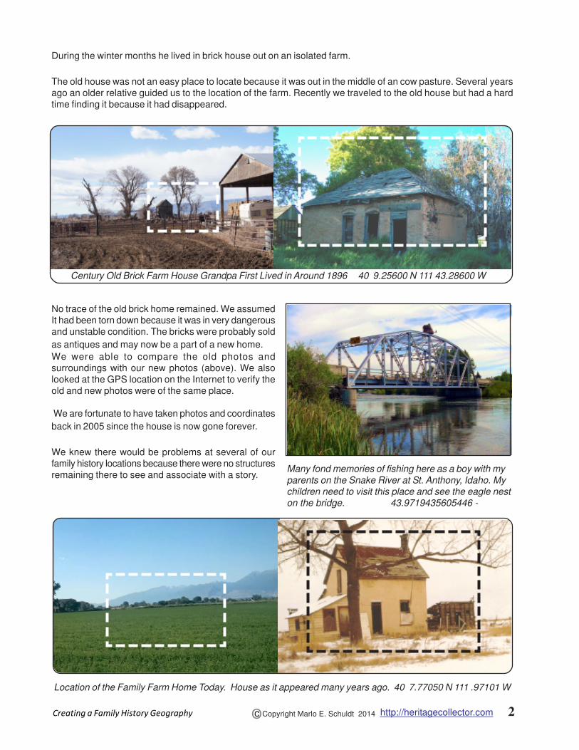
During the winter months he lived in brick house out on an isolated farm.
The old house was not an easy place to locate because it was out in the middle of an cow pasture. Several years
ago an older relative guided us to the location of the farm. Recently we traveled to the old house but had a hard
time finding it because it had disappeared.
No trace of the old brick home remained. We assumed
It had been torn down because it was in very dangerous
and unstable condition. The bricks were probably sold
as antiques and may now be a part of a new home.
We were able to compare the old photos and
surroundings with our new photos (above). We also
looked at the GPS location on the Internet to verify the
old and new photos were of the same place.
We are fortunate to have taken photos and coordinates
back in 2005 since the house is now gone forever.
We knew there would be problems at several of our
family history locations because there were no structures
remaining there to see and associate with a story.
Location of the Family Farm Home Today. House as it appeared many years ago. 40 7.77050 N 111 .97101 W
Many fond memories of fishing here as a boy with my
parents on the Snake River at St. Anthony, Idaho. My
children need to visit this place and see the eagle nest
on the bridge. 43.9719435605446 -
Century Old Brick Farm House Grandpa First Lived in Around 1896 40 9.25600 N 111 43.28600 W

3http://heritagecollector.comCopyright Marlo E. Schuldt 2014OcCreating a Family History Geography
The century old brick house had been torn down and
the old family home on the family farm had been leveled
to utilize more ground. Grandpa passed several years
ago so he could not be there tell his life and death
swimming story.
Travel Back in Time - Take a Road Trip
Recently we invited our brothers, sisters and their children
to go on a short guided tour of their family history.
Our goal was to visit the locations of stories and events
from our personal history. Combining stories with photos
at each stop helped everyone feel more connected with
the events in their family history.
We traveled in a caravan to each location, gathered
everyone around, and shared a story that occurred at
each location. Other previously unknown stories were
spontaneously offered which enriched each experience.
We gathered at the appointed time in the parking lot of
a restaurant near an interstate highway. A brief summary
was given about each of the places we planned to visit
in case someone became separated during the journey.
Heritage Collector was used to print a GPS map. It had
correspondingly numbered photo thumbnails to assist
with the navigation route marker to each location.
Our tour began at the old farm home where great
grandfather lived around 1896. The old brick home was
gone making it difficult for the children to visualize where
their great great grandfather had lived as a teenager.
However, holding up and passing around the 2005 photo
of the house while telling the story made it easy to
associate the missing landmark with the story.
Economic times were difficult in the early days and
people worked hard just to feed their families. The
children learned where their grandpa had worked at the
sugar factory while standing in front of the old refinery.
His mode of transportation was by foot during the summer
heat, or the cold and snowy days of winter. The distance
is now hard to visualize at ground level. However, looking
at the terrain from a satellite view makes it easier to
see how far grandpa had to travel each day.
Children and their parents visit the graves and hear
stories about their great grand parents.
40 6.19667 N 111 38.75167 W
Geographical Landmarks Combined With StoriesEnrich and Make the Experience Real and Tangible
Photo of the old sugar processing plant today.
40 6.32628 N 111 40.80898 W

4http://heritagecollector.comCopyright Marlo E. Schuldt 2014OcCreating a Family History Geography
Preparing for Your Family History Road Trip
1. Create a Family History Geography
collection. Import or copy photos into the
collection.
2. Travel and take photos of all the remaining
landmarks, homes and locations that have
relevance to your family history.
3. Use a smart phone to associate GPS
coordinates with each of the photos. Make sure
your phone has the location option turned on
so the photos will have GPS coordinates added
as you take each photo.
4. Don’t have a smart phone? Use the “Get GPS”
option in the Edit Info option to get and associate
coordinates. Right click on the thumbnail and
select Edit Info. Click the “Get GPS” button.
This will display a map. Zoom out and drag your
cursor to the location of the image. Left click on
the map. This will display the GPS coordinates
in the upper left window. Click OK. This will
return you to the photo display with the
coordinates. Click the Save button. Refer to
pages 41 and 49 In your manual or click the
Help button at the bottom of the Edit Info display
and then scroll down to the information about
adding GPS coordinates to a photo.
Showing a photo of the missing family farm house
while standing in front of the location makes it
easier to visualize where the house stood (above).
Comparing the photo of the farm house with the
photo of grandma standing in front of the house
makes it easy to verify where the photo was taken
right).
Grandma standing in front of the family farm home.
It appears they had just cut down a very large tree.
40 7.77050 N 111 42.97101 W

5http://heritagecollector.comCopyright Marlo E. Schuldt 2014OcCreating a Family History Geography
Preparing for Your Road Trip Tour of Discovery
A little advanced planning and preparation can save
frustration and time and make the experience more
enjoyable for all attending.
While in the GPS Track option, Print out a map for
each family attending or for each car that will be in your
caravan. This will help keep everyone together if you
get separated along the journey.
1. Select the collection, click the GPS Tab and
then click the GPS Track option.
2. Zoom down on the map to get a more
detailed view listing the road and street
names.
3. Click the
Print button
and select
Map and
Thumbnails
with captions.
Travel Suggestions
1. There may be several cars in your procession.
Scout out in advance the route so you can
select safe places to park along the road.
2. You may be making several U turns. Make the
U turn BEFORE you stop at the site so
everyone will ready to proceed to the next stop.
This will save time and confusion before you
start your presentation and help keep everyone
together as you depart from each site.
3. Safety is critical since you will have children
along the side of roads and highways that might
be busy. Everyone needs to be vigilant in
watching out for everyone standing on the side
of a roadway.
4. Review and give everyone a map before you
start so you can all stay together.
5. Allow for extra time for stories and questions
that will come up at each stop.
6. Take photos, video and audio recordings at each
stop to capture the new information.
7. Add the new information to the geography
collection.
8. For those who can not attend, there may be a
desire to travel to these locations in the future
to get more of a feel and to put it into
perspective. Share the geography collection via
a Gift CD /DVD or via a shared folder in Dropbox.
Note that the thumbnails are numbered to correspond
with the number on the orange pointer on the map.
(See bottom of page three).
Grandchildren touching the same bricks laid by their
great grandpa as he built the 60 foot chimney for this
beautiful old school. 40 2.62286 N 111 43.44737 W
Advanced Tip. Go into the GPS Track option. Clicking
the “Play” button at the top left will cause a split screen
slideshow to play with oral narrative while showing the
photo and a GPS satellite view of the site of the location.