coyote creek south - odfw conservation...coyote creek south site in lane county, oregon, for the...
TRANSCRIPT
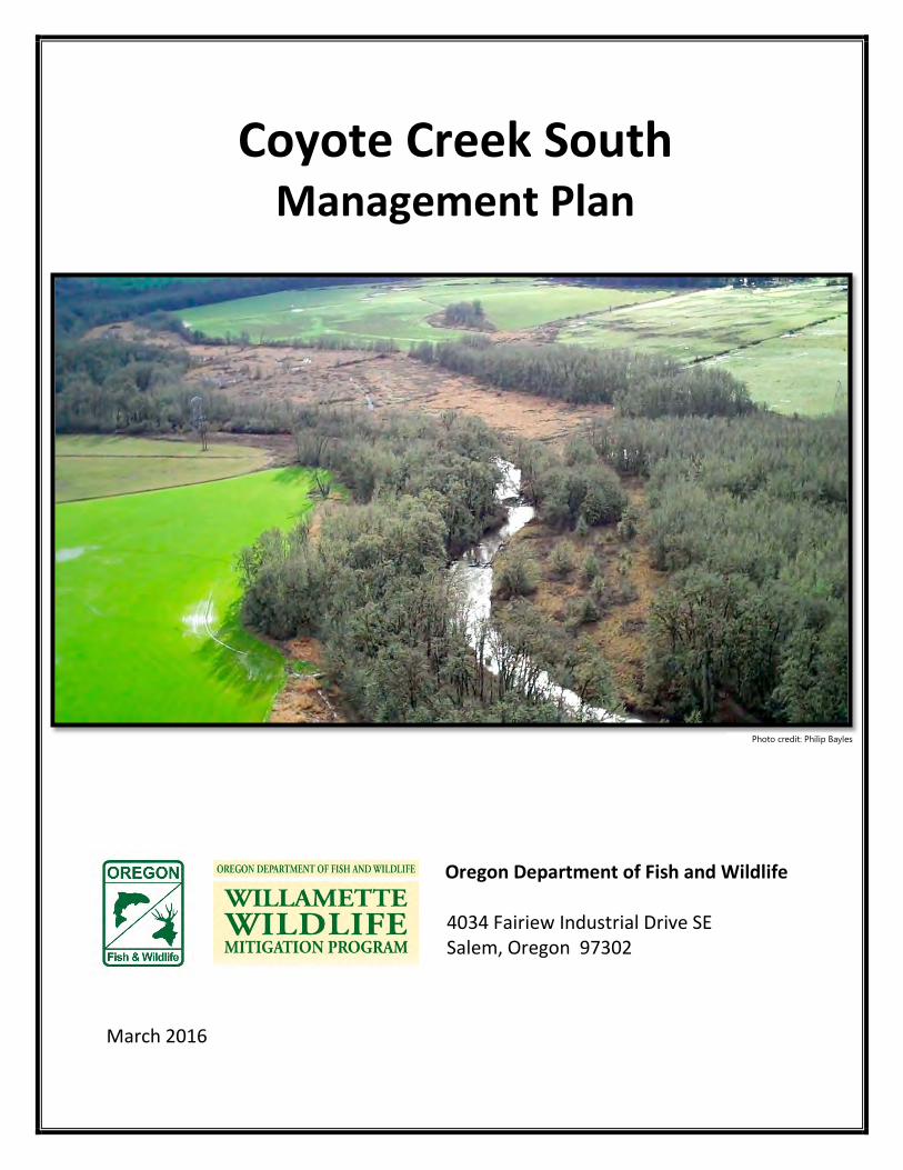
Coyote Creek South Management Plan
Oregon Department of Fish and Wildlife 4034 Fairiew Industrial Drive SE Salem, Oregon 97302
March 2016
Photo credit: Philip Bayles

LIST OF CONTRIBUTORS
The following individuals, mainly consisting of Oregon Department of Fish and Wildlife biologists and program coordinators, provided valuable input into this plan:
• Ann Kreager, Willamette Wildlife Mitigation Project Biologist, South Willamette Watershed, ODFW • Emily Steel, Restoration Ecologist, City of Eugene • Trevor Taylor, Natural Areas Restoration Team Supervisor, City of Eugene • Bruce Newhouse, Ecologist, Salix Associates • David Stroppel, Habitat Program Manager, South Willamette Watershed, ODFW • Wayne Morrow, Wildlife Manager, Fern Ridge Wildlife Area, ODFW • Kevin Roth, Wildlife Technician Senior, Fern Ridge Wildlife Area, ODFW
In addition, the plan draws on the work of professional ecologists and planners, and feedback from a wide variety of representatives from ODFW and partner agencies, including:
• Ed Alverson, Botanist • Diane Steeck, Wetland Ecologist, City of Eugene • Paul Gordon, Wetland Technical Specialist, City of Eugene • Steve Marx, SW Watershed District Manager, ODFW • Bernadette Graham-Hudson, Fish & Wildlife Operations and Policy Analyst, ODFW • Laura Tesler, Wildlife Wildlife Mitigation Staff Biologist, ODFW • Shawn Woods, Willamette Wildlife Mitigation Restoration Biologist, ODFW • Sue Beilke, Willamette Wildlife Mitigation Project Biologist, ODFW • Susan Barnes, NW Region Wildlife Diversity Biologist, ODFW • Keith Kohl, Wildlife Area Operations Coordinator, ODFW • David Budeau, Assistant Staff Biologist, ODFW • Chris Yee, Asst. Wildlife Biologist, ODFW • David Budeau, Game Bird Staff Biologist, ODFW • Chris Yee, Asst. Wildlife Biologist, ODFW • Katie MacKendrick, Restoration Ecologist, Long Tom Watershed Council • Jarod Jabousek, Wildlife Biologist, USFWS Partners for Fish and Wildlife Program • Wes Messinger, Botanist, US Army Corps of Engineers • Garrett Dorsey, Wildlife Biologist, US Army Corps of Engineers • Bob Altman, American Bird Conservancy • Stan van de Wetering, Confederated tribes of Siletz Indians • Kelly Warren, Confederated Tribes of the Warm Springs • Lawrence Schwabe, Confederated Tribes of Grand Ronde
FINAL
Executive Summary ............................................................................................... 6
Introduction and Background ................................................................ 8 1 Purpose of the Management Plan ............................................................................. 10 1.1 Conservation Values........................................................................................................ 10 1.2 ODFW Mission and Authority ...................................................................................... 11 1.3 Property and Administrative Oversight ................................................................... 11 1.4 Willamette Wildlife Mitigation Program ................................................................. 11 1.5 Ecological Significance of the Coyote Creek South Site.................................... 12 1.6
Site Description and Public Use ........................................................... 14 2 Existing Conditions .......................................................................................................... 14 2.1
2.1.1 Landscape Setting ................................................................................... 14 2.1.2 Physical Description, Topography, and Boundaries ............................... 14 2.1.3 Habitat Types/Land Use/Invasive Vegetation ........................................ 18 2.1.4 Coyote Creek ........................................................................................... 20 2.1.5 Soils and Geology .................................................................................... 22 2.1.6 Facilities, Roads, and Maintenance Access ............................................. 24
Site History ......................................................................................................................... 25 2.22.2.1 Historic Vegetation ................................................................................. 25 2.2.2 Historic and Cultural Land Use ................................................................ 25 2.2.3 Cultural Resources/SHPO Consultation .................................................. 27
Public Access and Site Use ........................................................................................... 28 2.32.3.1 Public Access, Use, and Recreation ........................................................ 28 2.3.2 BPA Conservation Easement ................................................................... 31 2.3.3 Zoning ..................................................................................................... 32 2.3.4 Agricultural Lease ................................................................................... 32
Environmental Setting .................................................................................................... 32 2.42.4.1 Climate .................................................................................................... 32 2.4.2 Hazardous Waste .................................................................................... 33 2.4.3 Water Rights ........................................................................................... 33
Strategy Habitats and Species: Existing Conditions, Threats, and 3Conservation Importance ..................................................................... 33
Strategy Habitats .............................................................................................................. 35 3.13.1.1 Priority Habitats ...................................................................................... 35 3.1.2 Important Restorable Habitats ............................................................... 47
Priority Conservation Species ...................................................................................... 49 3.2
Strategy Habitats: Desired Future Conditions and Management 4Goals and Objectives ............................................................................. 50
Priority Habitats ................................................................................................................ 52 4.14.1.1 Wetlands ................................................................................................. 52 4.1.2 Riparian Forest ........................................................................................ 57

FINAL
4.1.3 Freshwater Aquatic ................................................................................. 59 Important Restorable Habitats .................................................................................... 61 4.2
4.2.1 Oak Savanna ........................................................................................... 61 4.2.2 Grasslands ............................................................................................... 63
Public Access and Use ........................................................................... 65 5 Desired Future Conditions and Goals, Objectives, and Strategies ................ 65 5.1
Management Plan Implementation ..................................................... 69 6 Prioritization of Restoration and Enhancement Actions with Suggested 6.1
Timeframes ................................................................................................................................... 69 Projected Restoration Timeline and Activities ...................................................... 70 6.2 Adaptive Management .................................................................................................. 77 6.3 Monitoring .......................................................................................................................... 78 6.4
6.4.1 Effectiveness Monitoring ........................................................................ 78 6.4.2 Compliance Monitoring .......................................................................... 79
Planning Process and Public Participation ............................................................. 79 6.5 Regulatory Requirements ............................................................................................. 80 6.6 Operations & Management ......................................................................................... 81 6.7 Management Plan Development and Reporting ................................................. 81 6.8 Management Staff Contact Information ................................................................. 82 6.9
References Cited .................................................................................... 83 7

FINAL
List of Figures Figure 1. Landscape Setting ........................................................................................................................................ 9 Figure 2. Conservation Context .............................................................................................................................. 16 Figure 3. Site Features and Topography ............................................................................................................ 17 Figure 4. Habitat Type and Land Use .................................................................................................................. 19 Figure 5. Hydrology ................................................................................................................................................... 21 Figure 6. Soils Map ..................................................................................................................................................... 23 Figure 7. Historic Vegetation circa 1850's ......................................................................................................... 26 Figure 8. Desired Future Conditions .................................................................................................................... 51 Figure 9. Public Access and Use ............................................................................................................................ 66 Figure 10. Restoration Phases ................................................................................................................................ 74 Figure 11. Vernal Pool Restoration………………………………………………………………………………………………76 Figure 12. Kiosk Diagram……………………………………………………………………………………………………………..77
List of Tables Table 1. Soils of the Coyote Creek South Site, Lane County, Oregon ...................................................... 22 Table 2. Priority and Important Restorable Habitats and Species for the Coyote Creek South Site.
................................................................................................................................................................................... 36 Table 3. Restoration Timeline and Activities ...................................................................................................... 70 List of Appendices
Appendix 1: BPA Conservation Easement Appendix 2: Willamette Valley Focal Conservation Species Appendix 3: Property Legal Description Appendix 4: Historical Aerial Photos Appendix 5: Plant and Wildlife Species Inventory Appendix 6: Focal Conservation Species Descriptions and Conservation Actions Appendix 7: Summary of Permitted/Prohibited Uses and Management Action Compliance
FINAL
Executive Summary
In March 2013, the Oregon Department of Fish and Wildlife (ODFW) purchased the 309-acre Coyote Creek South Site in Lane County, Oregon, for the purposes of protecting Coyote Creek and its riparian corridor, and restoring Willamette Valley habitats for the benefit of native fish, wildlife and plants. In 2010, the Bonneville Power Administration (BPA) and the State of Oregon signed an agreement to settle BPA wildlife habitat mitigation obligations in the Willamette Valley, guaranteeing more than $117 million for fish and wildlife habitat conservation and restoration, protecting a minimum of 16,880 acres of important native habitats. The property is ODFW’s first acquisition under the ODFW/BPA’s Willamette Wildlife Mitigation Program (WWMP). ODFW granted BPA a permanent conservation easement on the property in exchange for the program funds. The conservation easement identifies the Conservation Values of the site as native riparian forest, restorable wet prairie, a western pond turtle population, and restorable habitat for foraging waterfowl, grassland birds, coastal cutthroat trout, ash swales, and grasslands. The site provides a key habitat connection between two other protected West Eugene Wetlands properties. Restoration benefitting the Conservation Values will improve habitat quality for many additional native plant species, invertebrates, and vertebrates partly or wholly dependent on Willamette Valley grassland, wetland, aquatic, and riparian systems. Acquistion of this site will add to the overall acreage managed and protected by the Fern Ridge Wildlife Area, which contains over 5,000 acres of conserved land. This plan describes the overall goals and objectives of ODFW’s management of the Coyote Creek South Site for the next 10 years (2014-2024), and serves to guide restoration and management actions as well as public access and use. The plan provides context for the site’s local and regional conservation importance, documents site features and history, and designates the habitat types and species that will be the focus of management and restoration actions. It describes the present and desired future conditions for the site and then outlines a suite of actions to move the site towards those conditions, including a schedule of implementation. The plan is based on an adaptive management framework, recognizing the importance of monitoring and evaluation, and the value of integrating improved site understanding into ongoing restoration and management regimes.
The four (4) primary goals under this plan are:
1. Restore and enhance wetlands and riparian habitat for the benefit of native species dependent upon these habitats;
2. Improve habitat quality in riparian and grassland habitats to support priority conservation and Oregon Conservation Strategy species;
3. Provide compatible public uses and access; and 4. Conduct monitoring for Mitigation program compliance, management effectiveness and
program implementation. Under this plan the 309-acre site will transform from its current agricultural use and unmanaged riparian area to a large expanse of restored (functioning) wet prairie and seasonal

FINAL
wetlands bisected by a healthier riparian forest. The improved site is expected to support a suite of common and uncommon native wildlife and plants. Visitors will access the site for wildlife viewing, nature exploration, hunting, and angling.
FINAL
Coyote Creek South Management Plan 8
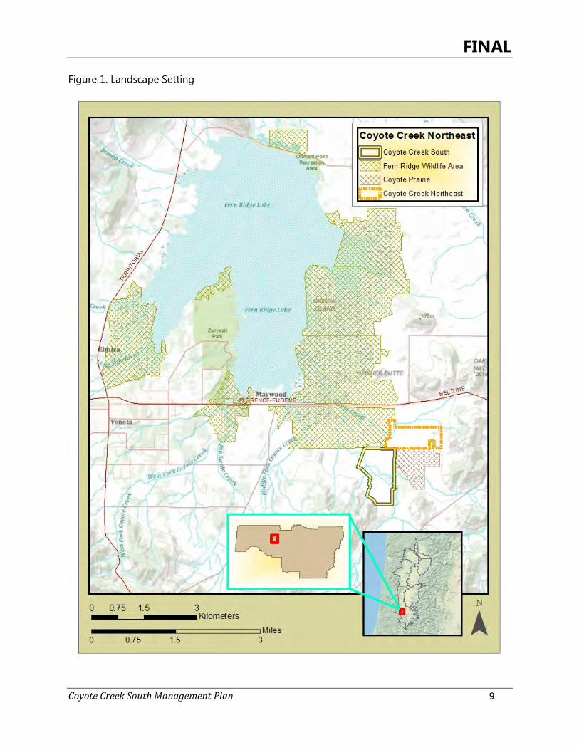
Introduction and Background 1The Oregon Department of Fish and Wildlife (ODFW) acquired the Coyote Creek South Site in March 2013, the first new acquisition of land by ODFW in over ten years, and the first site purchased by ODFW under the ODFW/BPA WWMP. Named for Coyote Creek which flows through the center of the property, the site is located within several priority conservation areas as highlighted within the Oregon Conservation Strategy (OCS)(ODFW 2006), and hosts both a native forested riparian corridor as well as areas restorable to high quality native wet prairie. The site holds tremendous potential for improving habitat conditions for numerous native fish, wildlife and plant species, including several OCS strategy species that are in decline in the Willamette Valley. The Coyote Creek South Site adds an important piece of protected land to the Fern Ridge Wildlife Area (FRWA) and compliments conservation management on the West Eugene Wetlands, a network of conserved and managed prairie, savanna, woodland, and riparian areas totaling over 3,500 acres. The site’s acquisition creates a key connection between three adjoining conservation areas: the U.S. Army Corps’ (USACE) Fern Ridge complex, much of which is managed by ODFW as the FRWA, the City of Eugene’s Coyote Prairie site, and the proposed Coyote Creek Northeast site which has been approved for acquisition through the WWMP. (Figure 1). The Coyote Creek South Site’s addition directly implements the Oregon Conservation Strategy. Benefits of proposed management also fit within the long-term vision of the Rivers to Ridges Partnership, a group of 14 agencies and organizations including ODFW, to connect a landscape scale habitat corridor for the benefit of native fish, wildlife, plants, and people. The purchase of the site by ODFW preserves the property in perpetuity, and the conservation easement on the property held by BPA designates that the site be managed for the purpose of preserving the site’s documented Conservation Values. The Oregon Conservation Strategy provides the foundation for management of the Coyote Creek South Site. The OCS is predicated on using the best available science to create a broad vision for long-term conservation of Oregon’s native fish and wildlife, as well as various invertebrates and native plants. The intent of the plan is to help ensure these resources are passed on to future generations by proactively conserving declining species and habitats to reduce the possibility of future federal or state listings. The Willamette Valley ecoregion has one of the fastest growing human populations in Oregon and supports the states’ three largest urban centers including the city of Eugene which is a short distance east of the Coyote Creek South Site. Goals and objectives set by this plan will assist with conserving, restoring, and reconnecting key habitats in the area to help achieve wildlife and habitat goals in the Willamette Valley consistent with the vision set by the Oregon Conservation Strategy.
FINAL
Coyote Creek South Management Plan 9
Figure 1. Landscape Setting
FINAL
Coyote Creek South Management Plan 10
Purpose of the Management Plan 1.1
This Management Plan (Plan) provides the guidance for site management and restoration for the next ten years (2014-2024). It summarizes existing site conditions, past uses, and site history, envisions future habitat conditions, outlines public access and use opportunities, communicates management and restoration goals and objectives, provides a timeline for undertaking restoration actions, and suggests a monitoring strategy. Management and restoration goals and desired future conditions identified in this plan will serve as the foundation for the development of more specific operational prescriptions and budgets for individual projects, as well as for grant applications to secure restoration funding. As with any restoration and management plan, the goals and objectives outlined in the plan drive actions by ODFW on the ground; timing and/or sequencing outlined in the plan are projections and actual timing will be contingent on evaluation of effectiveness of the treatments to ensure project success , and also in response to available funding. Targets and success criteria for the Coyote Creek South Site will be based on achieving habitat restoration and management goals and objectives identified in this plan within the prescribed timeline.
Conservation Values 1.2
The permanent conservation easement between ODFW (State of Oregon) and BPA (United States of America) lists the Conservation Values associated with the property at the time of purchase. As stated therein (Appendix 1), the property’s Conservation Values include, but are not limited to:
• Native riparian forest (99 acres) and wet prairie (210 acres) along a section of Coyote Creek;
• A portion of Coyote Creek supporting populations of western pond turtle; • Seasonal ponds and backwater areas which provide habitat for waterfowl, herons, and
several other bird and mammal species; • Restorable habitat for foraging waterfowl, grassland birds, coastal cutthroat trout, ash
swales, and grasslands; • Connectivity between ODFW’s FRWA, USACE’s Fern Ridge Reservoir and land
ownership, and the City of Eugene’s Coyote Prairie site; • Location within the West Eugene Conservation Opportunity Area and the Coyote Creek
Conservation Opportunity Area; and • Ability to manage the site for wildlife management similar to ODFW’s FRWA as well as
suitability for restoration to native Willamette Valley wet prairie habitat for supporting federal and state-listed plant species.
FINAL
Coyote Creek South Management Plan 11
ODFW Mission and Authority 1.3
ODFW’s mission is, “To protect and enhance Oregon’s fish and wildlife and their habitats for use and enjoyment by present and future generations.” ODFW is the only state agency charged exclusively with protecting Oregon’s fish and wildlife resources, and the state wildlife policy (ORS 496.012) and food fish management policy (ORS 506.109) govern management of fish and wildlife resources. ODFW’s authorites are further defined in Oregon Administrative Rule.
Property and Administrative Oversight 1.4
The FRWA functions within the West Region for ODFW to meet overarching goals as identified in the Mission and Authority above, department policies and procedures, species management plans, the Oregon Conservation Strategy, and FRWA goals. It is located within boundaries of the USACE Fern Ridge Lake Project and was created authorizing the state to “develop, conserve, and manage all wildlife resources” on land and water within the Fern Ridge Project. The Coyote Creek South site will be under the direct management of FRWA and will be included as part of the FRWA. Management plan goals and objectives identified in this plan will be incorporated into the FRWA plan and the full plan added as an appendices. The Wildlife Area Manager is responsible for meeting program goals with assistance from WWMP staff support including project and restoration biologists and seasonal fish and wildlife technicians. The property, restoration work, and ongoing maintenance will be under the direction of the FRWA Manager
Willamette Wildlife Mitigation Program 1.5
As part of the construction, subsequent inundation, and on-going operation of the Willamette River Basin Flood Control and Hydroelectric Projects in the Willamette River basin, BPA is required to provide wildlife mitigation for habitat affected by these facilities. In 2010, BPA and ODFW created the WWMP, to run from 2011-2025 with a goal of protecting a minimum of 16,880 acres in the basin, for the benefit of native species affected by habitat loss. Over the lifetime of the program, BPA will provide over $117 million in habitat acquisition funds, as well as over $26 million to ODFW to administer the program, including development and implementation of a monitoring and evaluation program. The WWMP aims for projects that meet the following goals:
• Protect wildlife habitat with significant cultural value; • Use cost-sharing measures to ensure the WWMP meets or exceeds its protected
acreage goal; • Draw on partnerships to enhance the likelihood of successful project completion;
FINAL
Coyote Creek South Management Plan 12
• Provide public access to WWMP properties in a manner consistent with each site’s Conservation Values; and
• Encourage the use of ecosystem services markets.
Ecological Significance of the Coyote Creek South Site 1.6
The floor of the southern Willamette Valley was once characterized by large expanses of wet and upland prairie, braided river systems with wide riparian forests and numerous backwaters and sloughs, and Oregon white oak savannas and woodlands on foothills. With Euro-American settlement of the valley beginning in the mid-1800s, nearly all of the original grassland, riparian forest, and oak ecosystems have been converted to agricultural, urban, and rural development, and harvested for timber. Less than 2% of historic prairie and oak savanna and 7% of oak woodland persist today (ODFW 2006), and both have been impacted extensively by invasive species. ODFW’s OCS identifies these habitats plus wetland and riparian habitats as Strategy Habitats for the Willamette Valley Ecoregion. As a result of the scale of habitat loss and function, especially in prairies and savannas, the Willamette Valley ecoregion is recognized as globally imperiled (Noss et al. 1995, Floberg et al. 2004, Hoekstra et al. 2005). Remaining Willamette Valley grasslands are threatened by ecosystem degradation from invasive species (plant and animal) and by successional changes to shrublands and woodland due to fire suppression (ODFW 2006, USFWS 2010). Riparian areas also have been greatly reduced and impacted by land use conversion and increasing development since the 1850s. Hydrologic modification and flood control, timber harvest, grazing and agricultural uses and urban development have significantly decreased the extent and habitat quality of streams and rivers and their associated riparian areas, including the Coyote Creek system (Thieman 2000). Often only a narrow corridor remains to support wildlife and maintain water quality (ODFW 2006). Invasive species have degraded riparian sytems. Riparian systems serve a multitude of wildlife species, including several listed and at-risk species dependent upon in-stream habitat, ephemeral and permanent wetlands, and forests vital to various life history stages of fish, birds, amphibians, reptiles, and invertebrates. Similarly, numerous wildlife and animal species including some endemic to the Willamette basin are dependent upon prairie and oak systems (Christy and Alverson 2011, Floberg et al. 2004, Alverson 2005, Vesely and Rosenberg 2010), and many are experiencing population decline. Habitat loss, conversion, fragmentation, and impacts from invasive species have been identified as the major limiting factors affecting most of the Endangered Species Act listed and at-risk wildlife species in the Willamette Valley (ODFW 2006, USFWS 2010, Vesely and Rosenberg 2010, Primozich and Bastasch 2004). Several efforts to identify the highest priority areas for conserving Willamette Valley ecosystems and species have been undertaken in the last decade. Protection and restoration of prairie, oak savanna, oak woodlands, wetlands, and headwater streams have been identified as critical conservation needs by ODFW, Oregon Department of Forestry, the U.S. Fish and Wildlife Service (USFWS), the Oregon Watershed Enhancement Board, the Northwest Power and Conservation Council, The Nature Conservancy (TNC), Partners in Flight, the Oregon Biodiversity
FINAL
Coyote Creek South Management Plan 13
Project, and the Pacific Coast Joint Venture, in addition to local watershed councils, conservation organizations, and researchers. Locally, the Ridgeline Area Open Space Vision and Action Plan (LCOG 2008) identifies the area of the Coyote Creek South Site as a potential open space anchor that protects priority habitats and provides landscape connectivity. The OCS draws upon regional conservation planning efforts and species’ population data to identify ecoregional Strategy Habitats, map localized Conservation Opportunity Areas (COAs), and designate Strategy Habitats and Strategy Species for each COA. The Coyote Creek South Site is located in the OCS West Eugene Wetlands (WV-23) COA, and all of the Strategy Habitats identified for the COA are present on the site: aquatic, wet prairie and wetlands, oak woodlands (in the riparian area), and grasslands and oak savanna. Key wildlife species for the West Eugene Wetlands COA include waterfowl, Fender’s Blue Butterfly (Icaricia icarioides fender), and western pond turtle (Actinemys marmorata). The western pond turtle is known to use the Coyote Creek system but has not been detected on the property site. Riparian habitat, a Strategy Habitat for the Willamette Valley, is also found on the site. Numerous OCS species occur at the Coyote Creek South Site, including streaked horned lark (Eromphila alpestris strigata), western meadowlark (Sturnella neglecta), northern red-legged frog (Rana aurora), Bradshaw’s lomatium (Lomatium bradshawii), willow flycatcher (Empidonax traillii), Lewis’ woodpecker (Melanerpes lewis), and chipping sparrow (Spizella passerine). Many additional Strategy Species, while not yet observed at the site, are known to occur within a few miles of the site and may use the site following restoration and enhancement. These include grasshopper sparrow (Ammodramus savannarum), Oregon vesper sparrow (Pooecetes gramineus affinins), slender-billed nuthatch (Sitta carolinensis aculeate), short-eared owl (Asio flammeus), western bluebird (Sialia Mexicana), coastal cutthroat trout (Oncorhynchus clarki clarki), California myotis (bat) (Myotis californicus), Townsend’s big-eared bat (Corynorhinus townsendii), and western gray squirrel (Sciurus griseus)(Appendix 2). A recent mapping effort by TNC aims to focus conservation efforts where they are greatly needed and can have a significant impact. TNC’s Willamette Valley Synthesis Project (2010) reviewed major conservation plans for the Willamette Valley including ODFW’s Oregon Conservation Strategy (2006), and mapped areas common to multiple plans resulting in refined COAs for the Willamette Basin. The Coyote Creek South Site falls within two separate Willamette Synthesis COAs, the West Eugene-Spencer Creek COA (for terrestrial portions of the site) and the Coyote Creek COA (the creek and riparian area).
FINAL
Coyote Creek South Management Plan 14
Site Description and Public Use 2
Existing Conditions 2.1
2.1.1 Landscape Setting
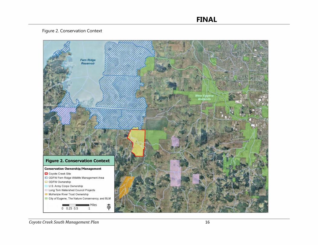
The Coyote Creek South Site is located on the valley floor at the southern end of the Willamette Valley, among a complex of protected lands comprising the West Eugene Wetlands, with surrounding land use of rural residences and agriculture. It is approximately halfway between the cities of Eugene and Veneta, and currently comprises the southernmost unit of ODFW’s FRWA. This site provides a direct connection between neighboring permanently protected property to the east owned by the City of Eugene and the ODFW area to the north (Figure 2). Numerous additional properties within a few miles of the Coyote Creek South Site are managed for conservation of native ecosystems and species by a suite of government agencies and non-profit organizations, including ODFW, who have formed a collaborative partnership known as the Rivers to Ridges Partnership (R2R). Established in the mid-1990s as the West Eugene Wetlands Partnership, this group has become nationally recognized for its success at protecting rare habitats and populations of rare and declining species at the edge of an urban area. In the last decade, the group completed a regional visioning effort, which involved public input and was widely endorsed by city and county governments, the public, and organizations representing birds and native plants to environmental education and trails. The Rivers to Ridges Metropolitan Regional Parks and Open Space Study (LCOG 2003) describes a regional vision for open space protection and connectivity, identifying seven guiding principles: variety, scenic quality, connectivity, recreation and education, habitat, protection and conservation of wetlands, waterways, and the ridgeline, and community buffers. This plan and the partners working to implement it are beginning to achieve a degree of regional and local landscape-level connectivity in protected and restored habitat conditions. The acquisition of the Coyote Creek South Site is a critical piece in implementing this vision, in addition to meeting ODFW’s and BPA’s goals for acquiring and managing valuable habitat for conservation and public use under the WWMP.
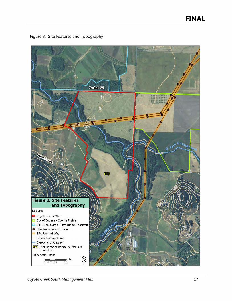
2.1.2 Physical Description, Topography, and Boundaries
The Coyote Creek South Site is located south of Cantrell Road in an unincorporated area of Lane County, west of the city limits of Eugene and south of Fern Ridge Reservoir (Figure 2). The site encompasses restorable prairie, emergent wetlands, ash swales, native riparian forest, and nearly one mile of a meandering section of Coyote Creek. The property consists of two tax lots, the larger of the two stretching from Cantrell Road south all the way to the site entrance along Halderson Road, and the other comprising the southwest
FINAL
Coyote Creek South Management Plan 15
quadrant of the site. It is bisected by a BPA transmission line corridor, which runs northeast to southwest across the entire site. Specifically, the site is located on Lane County tax lots 400 and 100 in Township 18N, Range 5W, S 02, NW, NE, and SE quarter sections. An approximate centroid is 44° 2'3.59" N, 123°15'23.21" W. The full legal description is included as Appendix 3. The site is zoned as Exclusive Farm Use (Figure 3). The Coyote Creek South Site is nearly level across its entire acreage at about 380 feet in elevation, with the exception of the Coyote Creek channel, some small berms constructed to the south of the channel for the purposes of impounding surface flow (Figure 3), and the sourthern edge of the site near Halderson Road (about 400 feet in elevation). While the topographic map shows small rises in the northern section of the site, these areas are not noticeable at the ground surface. At this elevation, much of the site is inundated during winter wet periods. The property is bounded by numerous parcels developed for rural residential housing or currently being used for agricultural production, primarily grass seed and hay (Figures 2 and 3). Neighboring properties to the north (across Cantrell Road) and east are ODFW’s FRWA and City of Eugene’s Coyote Prairie, respectively. The properties to the northeast are agricultural. To the west, bordering properties are a combination of riparian forest along a stretch of Coyote Creek, a privately-owned hunting club (including some riparian forest), and agricultural. The southern portion of the site is bordered by forested foothills and rural residences, agriculture, and an upstream section of Coyote Creek and its associated riparian forest. The northern portion of the Coyote Creek South Site is buffered from Cantrell Road by a hedgerow of small trees and shrubs. The perimeter of the site is nearly fully fenced with standard field fence consisting of metal or wooden fence posts. The fence is incomplete along the southern boundary. In addition, there are some interior fences running along field edges which are intact in some places and in disrepair in others. A small waterfowl hunting blind is located on the site at a ponded area just south of Coyote Creek, and a small deer hunting platform is located in a large tree in the riparian forest just north of the creek channel.
FINAL
Coyote Creek South Management Plan 16
Figure 2. Conservation Context Figure 2. Conservation Context
FINAL
Coyote Creek South Management Plan 17
Figure 3. Site Features and Topography

FINAL
Coyote Creek South Management Plan 18
2.1.3 Habitat Types/Land Use/Invasive Vegetation
Existing vegetation cover and land use on the site is varied, and is comprised of Coyote Creek, agriculture (grass seed and hay), riparian forest, wet prairie, emergent wetland, ash swales and planted ash stands, and small areas of open water and oak savanna (Figure 4). The conservation easement for the site categorizes these as riparian forest and wet prairie, which represent historic and restorable habitats. The mapping presented in this management plan reflects current vegetative cover and improved understanding of site conditions following initial site surveys. It establishes finer-resolution baseline site conditions but does not substantively change the site’s Conservation Values. The site is characterized by riparian and wetland habitats. Wet prairie and agricultural lands (restorable wet prairie) make up the greatest proportion of the site (220.6 acres, or 71%). The gently meandering segment of Coyote Creek (7 acres) and its associated oak and oak-ash riparian forest (36.4 acres) comprise another significant landscape feature, together accounting for 14% of the site. Coyote Creek bisects the site from southwest to northeast, and at least half of the site is within its floodplain. The riparian forest contains mostly Oregon ash (Fraxinus latifolia) of various sizes, and some very large open-grown Oregon white oaks (Quercus garryana). It also has a significant native component in the shrub and herbaceous layers, including some patches of very uncommon plants. However, young Oregon ash are becoming well-established in many locations in the riparian forest and are crowding the oaks, and some areas are impacted by dense patches of invasive shrubs and the herbaceous plant, shining geranium (Geranium lucidum). Emergent wetland or marsh, created by impounding an historical area of wet prairie (Figure 5), is found on approximately 19.5 acres (6%) of the site, and exhibits highly degraded conditions, consisting predominantly of reed canarygrass interspersed with open water. Despite its current condition, this habitat is important for the population of western pond turtles that occur within the Coyote Creek drainage (C. Yee, pers. comm.). Lastly, ash-dominated swales occupy 15.5 acres (5%) of the site. Ash swales are found in two small areas while a third area is a combination of an area of planted ash and then ash encroachment into historic wet prairie.
Upland habitats are found only on a minor portion of the site, and consist of agricultural land that is categorized as disturbed habitat but can be restorable to upland prairie (16 acres, 5% of site), a very small band of oak savanna (3.5 acres, 1% of site) in the floodplain of Coyote Creek, and a disturbed area that is now a maintenance access point. The oak savanna area contributes some structural vegetation diversity on the site, but is impacted by shrub and invasive species encroachment. The existing or restorable upland areas are all characterized by nearly complete cover of non-native vegetation in the herbaceous layer.

FINAL
Coyote Creek South Management Plan 19
Figure 4. Habitat Type and Land Use
FINAL
Coyote Creek South Management Plan 20
An extensive floral survey was conducted in 2013 and the results are contained in Appendix 5. Invasive plants species occur onsite and have been documented and mapped in a GIS database. The three dominant Invasive plant communities consist of reed canary grass (Phalaris arundinacea) (31 acres), Armenian (Himalayan) blackberry (Rubus armeniacus) (22 acres), and shining geranium (30 acres of riparian understory). See Section 3.1 for a more detailed description of each of these natural communities.
2.1.4 Coyote Creek
Coyote Creek is a low-gradient, meandering, perennial water body that drains a 104 square-mile area including the Spencer Creek watershed and flows into Fern Ridge Reservoir (Fern Ridge Lake). Land uses in the Coyote Creek watershed consists of forestry (59%), agriculture (28%) and rural residential (11%)(Thieman 2000). The reach that flows through the Coyote Creek South Site is approximately 1.5 miles upstream from where the creek enters the reservoir. The reservoir, Long Tom River, and some adjoining wetlands support populations of coastal cutthroat trout and western pond turtle, both at-risk species. The reach of Coyote Creek within the site has not been surveyed to determine whether either of these species is present. The creek averages about 40 feet wide from bank to bank as it flows through the site. Channel banks are incised, steep, and unvegetated, although the adjoining riparian forest is moderately intact. The creek’s substrate is characterized by fine-grained sediments, giving rise to high turbidity and an overall ‘muddy’ appearance to the water. The creek has impaired water quality for temperature, bacteria, dissolved oxygen, and phosphorus (Thieman 2000, ODEQ 2006). Coyote Creek tops its banks anywhere from 1-7 times per winter following heavy rainfall events, with associated flooding along Cantrell Road. High water events can take days to weeks to subside (ODFW 2009). Historically a tributary of the Long Tom River, the confluence of Coyote Creek and the Long Tom is now located within the main water body of the reservoir.

FINAL
Coyote Creek South Management Plan 21
Figure 5. Hydrology
FINAL
Coyote Creek South Management Plan 22
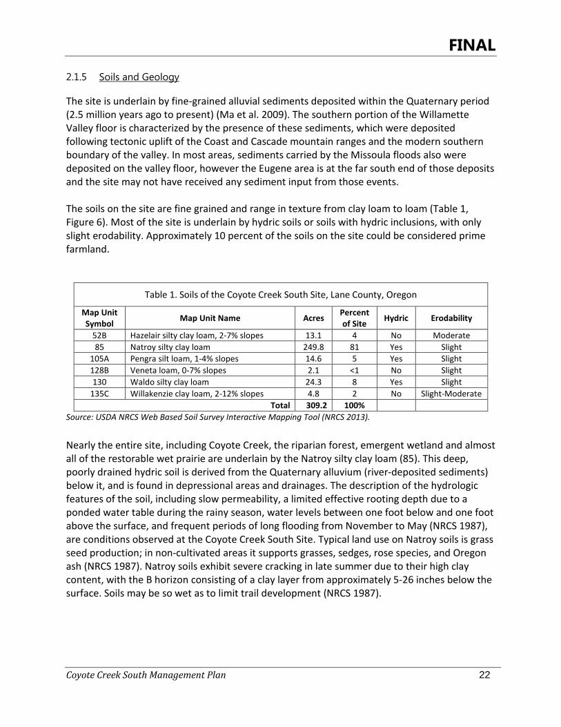
2.1.5 Soils and Geology
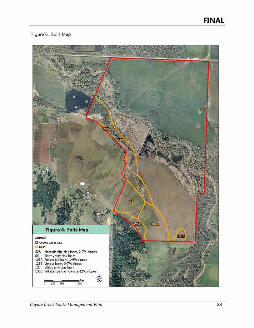
The site is underlain by fine-grained alluvial sediments deposited within the Quaternary period (2.5 million years ago to present) (Ma et al. 2009). The southern portion of the Willamette Valley floor is characterized by the presence of these sediments, which were deposited following tectonic uplift of the Coast and Cascade mountain ranges and the modern southern boundary of the valley. In most areas, sediments carried by the Missoula floods also were deposited on the valley floor, however the Eugene area is at the far south end of those deposits and the site may not have received any sediment input from those events. The soils on the site are fine grained and range in texture from clay loam to loam (Table 1, Figure 6). Most of the site is underlain by hydric soils or soils with hydric inclusions, with only slight erodability. Approximately 10 percent of the soils on the site could be considered prime farmland.
Table 1. Soils of the Coyote Creek South Site, Lane County, Oregon
Map Unit Symbol Map Unit Name Acres Percent
of Site Hydric Erodability
52B Hazelair silty clay loam, 2-7% slopes 13.1 4 No Moderate 85 Natroy silty clay loam 249.8 81 Yes Slight
105A Pengra silt loam, 1-4% slopes 14.6 5 Yes Slight 128B Veneta loam, 0-7% slopes 2.1 <1 No Slight 130 Waldo silty clay loam 24.3 8 Yes Slight
135C Willakenzie clay loam, 2-12% slopes 4.8 2 No Slight-Moderate Total 309.2 100%
Source: USDA NRCS Web Based Soil Survey Interactive Mapping Tool (NRCS 2013).
Nearly the entire site, including Coyote Creek, the riparian forest, emergent wetland and almost all of the restorable wet prairie are underlain by the Natroy silty clay loam (85). This deep, poorly drained hydric soil is derived from the Quaternary alluvium (river-deposited sediments) below it, and is found in depressional areas and drainages. The description of the hydrologic features of the soil, including slow permeability, a limited effective rooting depth due to a ponded water table during the rainy season, water levels between one foot below and one foot above the surface, and frequent periods of long flooding from November to May (NRCS 1987), are conditions observed at the Coyote Creek South Site. Typical land use on Natroy soils is grass seed production; in non-cultivated areas it supports grasses, sedges, rose species, and Oregon ash (NRCS 1987). Natroy soils exhibit severe cracking in late summer due to their high clay content, with the B horizon consisting of a clay layer from approximately 5-26 inches below the surface. Soils may be so wet as to limit trail development (NRCS 1987).
FINAL
Coyote Creek South Management Plan 23
Figure 6. Soils Map
FINAL
Coyote Creek South Management Plan 24
Soils underlying the remaining restorable wet prairie are the Pengra silt loam, 1-4% slopes and the Veneta loam, 0-7% slopes, respectively (soil map units 105A and 128B). Both of these soils have very similar characteristics to the Natroy silty clay loam, being deep, somewhat poorly drained, with a high water table from November to May (1.5-2.5 feet for Pengra soils, 3-6 feet for the Veneta loam). The Pengra is considered hydric, while the Veneta loam is predominantly non-hydric (NRCS 2013). They have slow to very slow permeability due to clay subsoils. The Pengra silt loam is considered prime farmland if drained, with an effective rooting depth of 18-30 inches and bedrock deeper than 60 inches. Runoff from both soils are slow, there is only a slight erosion hazard, and both are limited for recreational development due to low permeability and seasonal high water conditions (NRCS 1987). The Waldo silty clay loam (130), found in a linear band along much of the western boundary of the Coyote Creek South Site, also possesses these same characteristics (NRCS 1987). The remaining two soil types at the site, the Hazelair silty clay loam, 2-7% slopes and the Willakenzie clay loam, 2-12% slopes are upland soils typically found on convex slopes and foothills. These soils are moderately deep, moderately well to well drained, and not hydric. The Willakenzie is considered prime farmland. Effective rooting depth and depth to bedrock are both 20-40 inches, and both soils have slow permeability and slow runoff, but slight to moderate erosion hazard due to landscape position. The Hazelair silty clay loam has a seasonally high water table found 12-24 inches below the surface. If footpaths or roads are constructed upon these soils, Hazelair soils are limited by wetness and require drainage, and Willakenzie soils may require erosion stabilization (NRCS 2013).
2.1.6 Facilities, Roads, and Maintenance Access
The Coyote Creek South Site is undeveloped. Two maintenance access points, one on Cantrell Road and one on Halderson Road, are used by a lessee who rents the agricultural fields and uses the entrances to seed, maintain, and harvest grass seed and hay fields that make up the bulk of the site. They are also used by others on occasion, without permission. This unauthorized access should cease from the Cantrell Road entrance now that a new gate has been installed. A temporary gate has also been installed at the Halderson Road entrance and will be replaced with a permanent gate in 2015. ODFW can use these same access points to enter the site. Both are wide enough for vehicles, including farm equipment, to travel through. There are no structures on the site, with the exception of a dilapidated old hunting blind on the south bank of the largest pond. While there are no formal improved roads on the site, the historical aerial photos show a network of field roads on the south side of Coyote Creek that date back to at least the 1950s and were maintained until as recently as the mid-1990s. Review of more recent aerial photos suggests these roads are still in place, although they appear to be grown over with blackberries and other vegetation. A standard farm/field fence consisting of metal or wooden fence posts encircles most of the site’s perimeter, although it is down in some places, including along the southern border of the site. Interior fences are present along old field edges on the southern portion of the site.
FINAL
Coyote Creek South Management Plan 25
Site History 2.2
2.2.1 Historic Vegetation
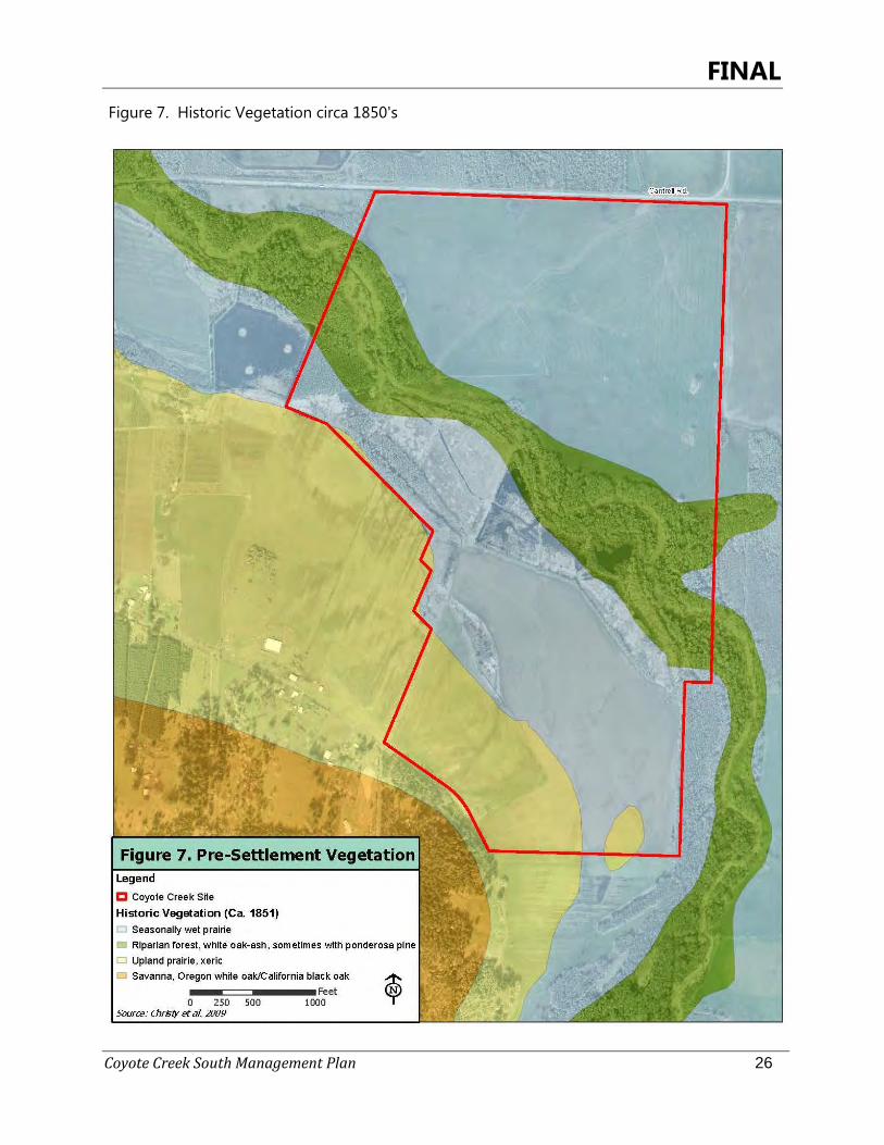
General Land Office surveys in the 1850s document the vegetation in the area of Coyote Creek as predominantly seasonal wet prairie, with a forested riparian corridor bisecting the site much as it does today (Figure 7, Christy et al. 2009). The mapped riparian forest was characterized by Oregon white oak and Oregon ash, sometimes with Ponderosa pine (Pinus ponderosa) and in places with a black cottonwood (Populus trichocarpa) and willow (Salix sp.) component. A swath of lands at the southern portion of the site are mapped as upland prairie. The surrounding area is mapped as prairie and savanna lands extending in all directions.
2.2.2 Historic and Cultural Land Use
Prior to Euro-American settlement, the area around what is now Fern Ridge Reservoir and the historic Long Tom River was occupied by the Chemala or Long Tom Band of the Kalapuya, whose descendants today belong to the Confederated Tribes of the Grand Ronde. The FRWA Management Plan summarizes the known cultural resources surveys that have occurred in the area of the Fern Ridge project boundary (ODFW 2009):
“A number of cultural resource surveys and archeological excavations have been conducted within Fern Ridge project including wildlife area licensed lands. The project area was visited by members of the River Basin Surveys prior to 1930 (Strong et al. 1930). Field crews from the University of Oregon surveyed the eastern shoreline (Minor 1978) and the rest of the project was surveyed in the early 1980s (Cheatham 1984, Cheatham 1988). During these surveys the lake level appears to have been between elevation 353 and 360 feet. Over 119 archeological sites were recorded within the Fern Ridge project boundaries. Over 80 known prehistoric sites spanning 8,000 years of prehistory and a dozen sites with historic components are located within the pool. There has been at least one find of a Clovis point within the fluctuation of the operating pool that may date back 10,000 years. The 1980s archeological work included archeological excavations at Kirk Park, Perkins Peninsula, and Hannavan Creek to determine site areas and evaluate site significance. Additional surveys were conducted along the Long Tom drainage (Toepel 1985) and the lower reaches of Amazon Creek (Oetting 1995).”
The historic wet prairies, Coyote Creek, riparian forest, nearby low hills dominated by Oregon white oak trees, and known long-term human presence in the area makes it likely that the Coyote Creek South Site was used by the Kalapuya people. Kalapuyan management activities that may have occurred at the Coyote Creek South Site include regular burning to maintain open prairie and savanna conditions, including stimulating growth of culturally significant plants such as camas and other lily bulbs, tarweed, and yampah and maintenance of open conditions in the site’s oak stands. Euro-American settlement appeared well underway by the mid-1930s, the earliest date of available historical aerial photos for the site (Appendix 4). Coyote Creek meanders through the
FINAL
Coyote Creek South Management Plan 26
Figure 7. Historic Vegetation circa 1850's
FINAL
Coyote Creek South Management Plan 27
site in the same channel as it is found today. The 1936 photo shows that conversion of most of the site to agricultural land use had already occurred. The southern portion of the site is cultivated, two drainage ditches are visible in the northern portion of the site, and two small areas along the riparian corridor are cleared of tree cover. A building existed at what is now the south entrance to the site, along Halderson Road. The riparian forest has lower tree cover than it does today, with several smaller trees visible, especially on the southern side of Coyote Creek. There are also small clusters of trees in the northern portion of the site, with two notable patches near the eastern boundary and northwestern corner, respectively. Cantrell Road and Ken Nielsen Road are also already present. The BPA transmission line right-of-way was constructed in 1951, and clearing of the vegetation in the corridor is evident in the 1952 photo. Also by this time, a network of field roads has been constructed on the southern portion of the site, as has the system of levees and impoundments that created marsh and open water habitat on the site. Two additional structures are visible at the Halderson Road entrance. Trees along the riparian corridor in the area that is now oak savanna have been removed, and the ash forest appears to have been planted. In the 1960 photo, many of the existing trees on the south side of Coyote Creek have grown, and trees along some field edges have been removed. The next available photo is from 1977, and between 1960 and 1977 nearly all of the trees were removed from the northern portion of the site, and it was put into cultivation as well. The drainage ditch near the northeastern corner of the site appears to be bordered by shrubs or other non-cultivated vegetation. The areas on the south side of the site that form today’s ash swale and ash forest habitats also display their current boundaries, and the trees are noticeably maturing. The 1984 photo shows the site in wetter conditions than the others, and while there are no significant changes to the site’s vegetation cover or use, the photo provides a good representation of the wetness of the area, as evidenced by darker areas. In addition, two of the three buildings by Halderson Road have been removed. By 1990, the last building has been removed, the open areas in the riparian forest understory have grown in with trees or blackberries, and the site vegetation is much as it is today.
2.2.3 Cultural Resources/SHPO Consultation
As mentioned above, the setting of the Coyote Creek South Site with seasonal wet prairie adjacent to a riparian zone in this part of the south Willamette Valley and the known historic presence of the Kalapuya people makes it likely that the site was used by native people. However, the decades of agricultural use of the Coyote Creek South Site have resulted in repeated soil disturbance to the upper few feet of the soil profile, homogenizing it and likely exposing any artifacts or culturally significant items at the surface years ago. Since ODFW acquired the site in 2013, other than the presence of plant species valued by the Kalapuya, there have not yet been any discoveries of features that suggest that the site was occupied for long periods of time, such as camas ovens or mounds.
FINAL
Coyote Creek South Management Plan 28
ODFW will contact the State Historic Preservation Office (SHPO) for a review of potential historic or cultural sites present if a project disturbing the soil is planned. Disturbance could include the creation of vernal pool habitat, excavation of soils to alter drainage conditions, and similar work. In the event that any cultural material is encountered during project activities, state and federal regulations will apply. Generally, a project would be put on hold and a qualified archeologist would be contacted to evaluate the discovery. The City of Eugene has consulted with SHPO on occasion for similar projects at the neighboring Coyote Prairie site, and to date no evidence of long-term cultural use has been determined (T. Taylor, pers. comm.).
Public Access and Site Use 2.3
The Coyote Creek South Site was officially added as the South Coyote unit of the FRWA in July 2013. The site currently may be accessed by the public from one of two entrance points on either Cantrell Road or Halderson Road (Figure 3). The Cantrell Road entrance is the preferred public access, as there are parking facilities within ¼ mile on the north side of the road in the Coyote West Unit of the WA. The southern entrance is on a dead end road hosting rural residential housing and small farms and is not well-suited to handle increased traffic.
2.3.1 Public Access, Use, and Recreation
ODFW strives to balance public use with resource protection on wildlife areas (ODFW 2009). Currently the site is open to non-motorized public use, although there are no parking, trail, or wayfinding facilities. Foot travel within the site is allowed during daylight hours except for seasonal closure dates, which will be posted at the site entrances as they are for other units of the wildlife area. Allowed and anticipated public uses of the South Coyote unit are the same as for other units of the FRWA: nature access, wildlife viewing, education and interpretation, hunting, and angling. The Coyote Creek South Site could provide a similar visitor experience along the Coyote Creek riparian corridor as is currently found on other units of the FRWA, however the site is lacking trails and the agricultural fields must be crossed in order to access the riparian area and the creek itself. Independent visitors and local schools currently using the FRWA units north of Cantrell Road are generally expected to continue to do so until facilities are better developed at the Coyote Creek South Site. As the site undergoes restoration, there will be a unique opportunity to offer school groups from elementary to college-age students exposure to and participation in restoration actions and monitoring. With prior coordination with the FRWA manager, school groups can take field trips to the restoration areas, and internship programs already in place at FRWA with Lane Community College, the University of Oregon, and Oregon State University can provide field experience at the college and university levels. To inform the public on the regulations and purpose of the site, an informational kiosk could be installed on Cantrell Road near the northeast corner at the gate. The information could not only assist users with the boundaries and regulations, but also to inform them about the
FINAL
Coyote Creek South Management Plan 29
WWMP and prairie restoration. Currently one panel (8’x4’) has been designed (See Figure 12). A similar size panel panel could be designed with a focus on prairie restoration and the WWMP. The panels would be attached to wooden polls with a small overhanging roof structure for protection. FRWA is managed to provide both hunting access and wildlife sanctuary during hunting season, specifically for waterfowl (ODFW 2009). Hunting and angling are allowed on the Coyote Creek South Site. All lands owned or controlled by ODFW and the USACE in and around Fern Ridge reservoir are open to hunting during all authorized game bird and game mammal seasons, with restrictions published annually by ODFW. Annual bird hunting season dates, hunting hours, allowable species to harvest and other information is provided in ODFW’s Oregon Game Bird Regulation booklet. In addition to bird hunting, game mammals including black-tailed deer (Odocoileus hemionus) may be hunted, and angling is also an allowed site use. The South Coyote unit will require that hunters and anglers obtain a self-service free daily hunting permit for the site, and once established, parking permits will also be required, similar to other units of the FRWA. All hunters must use non-toxic shot, except deer/elk hunters using slugs or buckshot in shotguns, or archery equipment as per hunting regulations. ODFW may adjust hunting regulations annually based on flyway regulations, wildlife population assessments, and other social and habitat considerations. Since 2006, ODFW has utilized seasonal closures and access restrictions during and after the hunting season for the purpose of providing rest and undisturbed forage for the wintering goose population, including the dusky Canada goose (Brandt canadensis occidentalis) (ODFW 2009). This practice also has resulted in providing sanctuary for all wetland-dependent wildlife species including large concentrations of waterfowl that use the FRWA. Trapping is used by ODFW to help manage infrastructure and species populations. Generally, trapping is limited to nutria (Myocaster coypus) that damage earthen levees by aggressive burrowing (ODFW 2009). Any trapping requires a permit or contract issued through ODFW. In addition to these allowed uses, some uses of the property by the public are expressly prohibited, including:
• Camping and open fires; • Off-leash dogs (except during authorized game bird seasons); • Discharge of firearms except during authorized game bird or game mammal seasons; • Discharge of rifles, handguns, BB guns, airguns, and paintball guns at all times; • Motorized vehicle use beyond parking areas; • Horseback riding; • Litter or garbage dumping; • Possession or use of any shot other than federally-approved non-toxic shot at any time
except for big game hunters using buckshot; • Target shooting and clay pigeon shooting;

FINAL
Coyote Creek South Management Plan 30
• Hunting dog training; and • Any public use during the hours of 10 p.m. to 4 a.m. (the FRWA is day-use only).
FINAL
Coyote Creek South Management Plan 31
2.3.2 BPA Conservation Easement
The Coyote Creek South Site was originally purchased by TNC and then transferred to ODFW on March 13, 2013, at which time ODFW became the fee-title owner of the property and assumed all legal responsibilities stated in the conservation easement. The conservation easement was deeded by ODFW to BPA in perpetuity, for the purpose of protecting the Conservation Values (Section 1.2) associated with the site. Permitted and prohibited uses that have relevance for short- and long-term actions recommended under this management plan are summarized below. Permitted Uses
ODFW shall:
• Preserve and protect the Conservation Values of the property, including restoring and enhancing the site for fish and wildlife habitat as approved in the management plan or by BPA;
• Change the use of any owned or acquired water rights appurtenant to the property to instream flow purposes in a timely manner in accordance with applicable law, or if not appropriate or feasible shall use the amount of water to which it is entitled as legally allowed, for a beneficial purpose and without waste, and shall not abandon any of the water rights appurtenant to the property due to non-use;
• Develop a Management Plan consistent that will fully protect the Conservation Values in perpetuity and meets BPA’s obligations under the Northwest Power Act and Endangered Species Act, including plans for restoring, enhancing, and maintaining the property, expected activities and uses of the property, and allowable public access and use;
• Provide reasonable public access to the site, including hunting of game animals (as described in ORS 498) and fishing to be accessed on foot only, unless any of these public uses are determined to impair one of the site’s Conservation Values;
Prohibited Uses The following uses are strictly prohibited on the property except as described above or as permitted upon approval of this Management Plan: • Division, partition, subdivision, or de facto subdivision; • All residential, commercial, or industrial uses of the property, including timber harvesting,
grazing of livestock, agricultural production, and installation of new utilities, with the exception of BPA’s continued operation of high voltage electric lines;
• Construction of buildings, structures, fences, roads, and parking lots; • Vegetation alteration not consistent with protection of the Conservation Values or this
Management Plan;
FINAL
Coyote Creek South Management Plan 32
• Any mining, extraction, or exploration, of any surface or subsurface material except as held by any third party with valid rights (minimum 60 days’ notice to BPA required);
• Dumping; • Alteration of the natural topography of the site by digging, plowing, diking, or other
means; • Any alteration to watercourses, wetlands, seasonally wet areas, or tampering with
existing water control devices; • Off-road motorized vehicle use; • Erecting any billboard or sign except “No trespassing”, “For sale”, or signs identifying
ODFW as the owner of the site (limited to 15 square feet in size); • Granting or permitting liens, easements, or property interests that would be inconsistent
with the protection of the Conservation Values.
2.3.3 Zoning
The entire site is zoned as Exclusive Farm Use (EFU) by Lane County (Figure 3).
2.3.4 Agricultural Lease
A one-year, annually renewable agricultural lease was in place for 2013 when the property was acquired by ODFW. The lessee seeds, maintains, and harvests grass seed and hay crops over approximately 200 acres on the site, north and south of Coyote Creek. The agricultural lease will be phased out to implement restoration activities. Income generated from the lease will be used toward activities that advance the goals of the management plan. The income could also be used as match to leverage federal dollars/grant dollars.
Environmental Setting 2.4
2.4.1 Climate
About 75 percent of the annual precipitation falls from October through March, and less than 5 percent falls in July and August. Average high temperatures at in the project area range from 48 °F to 84 °F (8.9- 28.9°C) and low temperatures range from 34 °F to 53 °F (1.1-11.7 °C). The highest recorded temperature recorded historically was 108 °F (42.2 °C) in 2002 and the lowest recorded temperature was -3 °F (-19.4 °C) in 1972. January is the average coolest month and December is the average wettest month. Average precipitation is lowest in July and highest in December, with averages ranging from 0.57 inches (1.45 cm) to 8.13 inches (20.65 cm).
FINAL
Coyote Creek South Management Plan 33
2.4.2 Hazardous Waste
There are no known solid, liquid, or contained gas hazardous wastes on the property. Herbicides have been used on the site to manage the agricultural fields.
2.4.3 Water Rights
There are no water rights associated with the property.
Strategy Habitats and Species: Existing Conditions, Threats, 3and Conservation Importance
The Coyote Creek South Site is characterized by a large expanse of historic wet prairie currently in agricultural use, bisected by Coyote Creek and its riparian forest with other, smaller blocks of various habitat types adjoining the riparian area (Figure 4). Many of these are OCS Strategy Habitats, with wetland and freshwater aquatic systems occupying most of the site’s acreage. Conservation priorities and management actions recommended in this plan include two levels of restoration: first, restoring and managing Strategy Habitats to support native wildlife and plant species that depend on them, and second, improving and maintaining specific habitat conditions for rare, uncommon, or declining species that use these habitats. Almost the entire site (91%) is covered by existing or restorable aquatic, wetland, and riparian habitats. Approximately 17% of the site currently supports riparian forest and ash swales, 3% is Coyote Creek or open water, 6% is occupied by ermergent vegetation (marsh), and 65% is in agricultural use for grass seed and hay but is restorable to wet prairie. Smaller areas of restorable upland prairie and oak savanna account for approximately 6% of the site. Much of the site is highly impacted by conversion to agriculture, invasive species, or overly dense shrub and subcanopy layers in the riparian forests; however most on-site habitats contain important features that support rare and declining wildlife or plant species. Several such species are found on site, on adjoining conservation properties, or within a few miles of the site; restoration at the Coyote Creek South Site can directly benefit local and Willamette Valley populations of these species. To improve knowledge and understanding of the site, several site visits were conducted over the 2013 growing season (and will continue into 2014) to develop a plant species list, with timing optimized to also opportunistically record any observations of key bird species, mammals, amphibians and reptiles, and pollinators (Appendix 5). The surveys targeted specific habitats or areas of the site where priority conservation species were anticipated to occur, employing the intuitive-meander method where a biologist traverses the site moving between higher quality areas where these species are most likely to occur, documenting all species observed along the way. A total of 255 vascular plant species have been documented at the site
FINAL
Coyote Creek South Management Plan 34
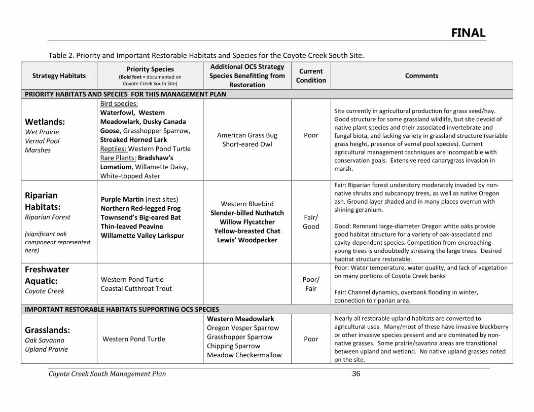
so far, of which 60% are native (Salix Associates 2013). Locations of rare or high-quality plant populations or important wildlife habitat features were documented using GPS, to nform development of this management plan and facilitate their protection during restoration and enhancement actions. The site’s species list will be continually added to and revised as new species are found in the future. As described further in Section 6.4, an objective, all-species approach was used to evaluate the different OCS on-site Strategy Habitats and determine which are restoration priorities for Coyote Creek South Site under this 10-year management plan. Numerous federal, state, and non-governmental organization conservation planning efforts for the Willamette Valley or the Willamette Subbasin have identified priority conservation habitats and ecosystem types, as well as focal species whose habitat needs represent groups of at-risk species (e.g., western meadowlark and grassland birds) or who are imperiled enough that the species themselves are a high conservation priority (e.g., Bradshaw’s lomatium). Determination of restoration priorities at the Coyote Creek South Site drew on the body of work encompassed by these plans, including the federal Endangered Species Act (USFWS), Oregon Endangered Species Act and the OCS (ODFW/Oregon Department of Agriculture (ODA)) listed and Oregon Conservation Strategy habitat types and species), and other efforts documenting declining species, wildlife-habitat relationships, and locally rare or uncommon species (Willamette Restoration Initiative, OWEB, Oregon Biodiversity Information Center (ORBIC), Partners in Flight (PIF), Native Plant Society Oregon (NPSO). A summary table of this information is included as Appendix 2. Potential Coyote Creek South Site priorities included existing or restorable habitats, as well as individual wildlife or plant species which would benefit from from restoration of those habitats. Once the priority habitat types were identified, a second review of potential priority wildlife and plant species was conducted to determine which species the site has the greatest opportunity to benefit. Selection of the focal species accounted for existing or restorable features of on-site habitats, whether the species has been documented on-site or within a couple of miles in the West Eugene Wetlands (higher potential to colonize the site), and how rare these species are in the Willamette Valley. Appendix 6 provides a summary of the life history characteristics and important conservation actions for the focal wildlife and plant species selected under this plan. Four “Priority Habitats” (wetlands, riparian habitats, freshwater aquatic, and grasslands)(Table 2) were identified as the primary habitat conservation targets for this site and are directly tied to the OCS (2006) and the Conservation Values expressed in BPA’s conservation easement for the site. Important Restorable Habitats provide structural diversity and support a different suite of species than the priority habitats, but which are limited in extent on the site. Lastly, the ash swale and ash forest habitats are very limited in extent and/or entirely the result of recent human actions at the site; while these habitats also provide diversity to the site, their vegetation structure, origin, and extent on the site caused them not to be a focus under this management plan. The current condition of the priority and important restorable habitats is described below.
FINAL
Coyote Creek South Management Plan 35
Strategy Habitats 3.1
3.1.1 Priority Habitats
Wetlands - Wet Prairie OCS Status and Habitat Type Description
Wet prairie is one of the Strategy Habitats identified in the OCS for the West Eugene (WV-23) Conservation Opportunity Area (COA). Wet prairies support two of the Strategy Species groups for the West Eugene COA, waterfowl and Fender’s blue butterfly, by providing forage and nectar, respectively. Restoring and maintaining wetland habitats along Coyote Creek is one of the stated Recommended Conservation Actions in the OCS (ODFW 2006). Wet prairies in the Willamette Valley are typically comprised of herbaceous vegetation dominated by bunchgrasses, in particular tufted hairgrass (Deschampsia cespitosa). Native wet prairie is found primarily on the valley bottom on poorly drained soils characterized by a high clay content, which perches water resulting in saturated or inundated conditions in winter and spring. Soils completely dry out in summer and stay dry through the early fall. The shrinking, swelling, and cracking of the clay creates microtopography at the soil surface, leading to variation and increased complexity in microsite conditions. Many plant and animal species take advantage of these niches, resulting in a highly diverse biotic community. While wet prairies historically supported an array of native forb species, these species are largely gone from wet prairies today due to agricultural cultivation, invasive grass colonization, and alteration of natural wet prairie hydrology. The OCS identifies land use conversion/habitat loss, habitat fragmentation, invasive species, and altered fire regimes as limiting factors in wet prairie habitats. Willamette Valley wet prairies were historically maintained in an open condition by humans setting periodic fires, which prevented establishment of woody vegetation and succession to shrub and forested habitats. Over a century of lack of use of fire by people has allowed native and non-native woody vegetation and trees to encroach in these systems, fundamentally changing the grassland nature of the habitat and displacing both typical and rare prairie species from grassland birds to wet prairie plants. Agricultural conversion and management techniques, primarily for the production of grass seed, have significantly contributed to the loss of native wildlife and plant species diversity across historic wet prairie acreage in the valley.
FINAL
Coyote Creek South Management Plan 36
Table 2. Priority and Important Restorable Habitats and Species for the Coyote Creek South Site.
Strategy Habitats Priority Species
(Bold font = documented on Coyote Creek South Site)
Additional OCS Strategy Species Benefitting from
Restoration
Current Condition Comments
PRIORITY HABITATS AND SPECIES FOR THIS MANAGEMENT PLAN
Wetlands: Wet Prairie Vernal Pool Marshes
Bird species: Waterfowl, Western Meadowlark, Dusky Canada Goose, Grasshopper Sparrow, Streaked Horned Lark Reptiles: Western Pond Turtle Rare Plants: Bradshaw’s Lomatium, Willamette Daisy, White-topped Aster
American Grass Bug Short-eared Owl
Poor
Site currently in agricultural production for grass seed/hay. Good structure for some grassland wildlife, but site devoid of native plant species and their associated invertebrate and fungal biota, and lacking variety in grassland structure (variable grass height, presence of vernal pool species). Current agricultural management techniques are incompatible with conservation goals. Extensive reed canarygrass invasion in marsh.
Riparian Habitats: Riparian Forest (significant oak component represented here)
Purple Martin (nest sites) Northern Red-legged Frog Townsend’s Big-eared Bat Thin-leaved Peavine Willamette Valley Larkspur
Western Bluebird Slender-billed Nuthatch
Willow Flycatcher Yellow-breasted Chat Lewis’ Woodpecker
Fair/ Good
Fair: Riparian forest understory moderately invaded by non-native shrubs and subcanopy trees, as well as native Oregon ash. Ground layer shaded and in many places overrun with shining geranium. Good: Remnant large-diameter Oregon white oaks provide good habitat structure for a variety of oak-associated and cavity-dependent species. Competition from encroaching young trees is undoubtedly stressing the large trees. Desired habitat structure restorable.
Freshwater Aquatic: Coyote Creek
Western Pond Turtle Coastal Cutthroat Trout
Poor/ Fair
Poor: Water temperature, water quality, and lack of vegetation on many portions of Coyote Creek banks
Fair: Channel dynamics, overbank flooding in winter, connection to riparian area.
IMPORTANT RESTORABLE HABITATS SUPPORTING OCS SPECIES
Grasslands: Oak Savanna Upland Prairie
Western Pond Turtle
Western Meadowlark Oregon Vesper Sparrow Grasshopper Sparrow Chipping Sparrow Meadow Checkermallow
Poor
Nearly all restorable upland habitats are converted to agricultural uses. Many/most of these have invasive blackberry or other invasive species present and are dominated by non-native grasses. Some prairie/savanna areas are transitional between upland and wetland. No native upland grasses noted on the site.
FINAL
Coyote Creek South Management Plan 37
Existing Wet Prairie Conditions at the Coyote Creek South Site
Wet prairie is present in the middle of the site, in a 22-acre area stretching from the south bank of Coyote Creek to the western property boundary where it encircles one of the site’s two ash swales (Figure 4). A portion of the wet prairie floods in winter when Coyote Creek overtops its banks, however several ditches drain this area during other times of year (Figure 5). An outlet ditch extending west to east through the center of the wet prairie drains water from the artificially impounded marsh land to the east, and drainage ditches from the southwestern corner of the site that extend through an ash swale capture and hold some overland flow that might otherwise reach the wet prairie. The vegetation is dominated by non-native grasses including several large patches of the highly invasive reed canarygrass (Phalaris arundinacea), as well as encroaching woody vegetation, much of which is young Oregon ash seedlings spreading northward from the ash swale. While most native plant cover has been lost, pockets that were too wet to cultivate or are located at the property edges, agricultural field edges, or along ash swales host very small remnant patches of native wet prairie plants, with occasional occurrences of native forbs, grasses, and sedges. Of particular note is an occurrence of the federally endangered Bradshaw’s lomatium (Lomatium bradshawii), with a few plants discovered in the wet prairie within the BPA power line corridor. A larger population exists nearby in the portion of the site mapped as oak savanna. Other uncommon plant species present at the site include large-flowered startulip (Calochortus uniflorus), Lobb’s water buttercup (Ranunculus lobbii) (in a small ditch), and false golden sedge (Carex hassei). Several native wet prairie species are also present, including two species of popcorn flower (Plagiobothrys figuratus and Plagiobothrys scouleri), Oregon saxifrage (Micranthes oregana), common camas (Camassia quamash), Oregon sunshine (Eriophyllum lanatum), beautiful lotus (Lotus formosissimus), tarweed (Madia spp.) buttercups (Ranunculus spp.), some sizeable patches of water foxtail (Alepocurus geniculatus), meadow barley (Hordeum brachyantherum), and several sedge species (Carex spp.). Lastly, a fairly sizeable population of showy milkweed (Asclepias speciosa) is located within the BPA right-of-way and along the southwestern property fence; this species is a host plant for the declining monarch butterfly (Danaus plexippus). While limited to localized spots and in low abundance, the presence of these species provides a reference for the site’s history and demonstrates the ability of the site to host a diverse assemblage of native wet prairie plant species. Much of the area currently in agricultural production is wetland, and wet prairie stands to become the most abundant habitat type at the site following restoration (201.8 acres or 65% of the site). The restorable wet prairie areas occur in two large blocks to the north and south of the Coyote Creek corridor. Currently the agricultural areas support wetland soils and hydrology, but almost all of the vegetation community has been converted to near monocultures of non-native grass species grown for grass seed or hay. Several wildlife species have been observed in the site’s wet prairies, including within the agricultural areas (Appendix 5). Western meadowlarks were documented on the southern side of the Coyote Creek South Site just after nesting season, and wintering birds have been
FINAL
Coyote Creek South Management Plan 38
observed foraging north of Coyote Creek. Other species of conservation interest including common yellowthroat (Geothlypis trichas), northern harrier (Circus cyaneus), and field crescent butterfly to more common species such as great blue heron (Ardea Herodias), coyote (Canis latrans), and silvery blue butterflies (Glaucopsyche lygdamus) have also been documented. Streaked horned larks, recently listed as federally threatened (USFWS 2013) have been detected on the north side of the site after the breeding season. Similarly, dusky Canada geese have been observed foraging on the site in winter. The wildlife species list is expected to grow in the first few years of site ownership, as further site surveys are conducted and staff make observations.
Threats to Wet Prairie at the Coyote Creek South Site
Agricultural use of the wet prairie habitats is the single most significant threat to wet prairie at the site, having replaced the native vegetation over much of the site. Continued agricultural site management may result in further losses of native plant patches at the edges of agricultural fields. Threats to the 22 acres of existing wet prairie on the site include continued encroachment by reed canarygrass, Himalayan blackberry (Rubus bifrons), woody vegetation, and non-native grasses and forbs. In addition, BPA may construct an access road into the site under the power lines; if built the road could impact some Bradshaw’s lomatium plants, the showy milkweed population, act as a dam blocking sheet flow across the wet prairie areas, and potentially become a vector for weed invasions. This issue is particularly important on the northern portion of the site, where the position of the planned road could impound overbank floodwaters from Coyote Creek for prolonged periods. Ditches on the site continue to affect wetland hydrology by draining, channelizing, and transporting surface water flow off-site, and those ditches that divert flow to neighboring properties should be removed. In addition to converstion of habitat, two additional factors also pose threats to wet prairie: the loss of regular burning and climate change. Prairies are fundamentally fire-dependent systems and their vegetative structure and composition was substantially determined for thousands of years by frequent fires set by humans. The abundance of woody vegetation cover in non-agricultural areas and lack of many native plant adapted to frequent burning reflect the absence of fire at the Coyote Creek South Site. Regarding climate change, southern Willamette Valley annual average temperatures are expected to increase 2-4 °F (1.1-2.2 °C) or more by 2050, with greater increases in summer temperatures (4-6°F [2.2-3.3 °C] on average) (Doppelt et al. 2009). Less precipitation is expected during spring, summer and fall, while a small increase is possible in winter months, and the region may experience more frequent flooding due to increased storm events (Doppelt et al. 2009). For Willamette Valley grasslands, this may mean higher winter and spring water levels, increases in spring flooding events, and a noticeably warmer and prolonged summer drought period. Two recent modeling studies using NatureServe’s Climate Change Vulnerability Index investigated the climate vulnerability of Willamette Valley prairie plant and butterfly species (Kaye et al. 2012) and OCS species (Steel et al. 2011). The studies both found grassland plants and butterflies, including rare and listed species, to be moderately to highly vulnerable to predicted climate change, and terrestrial wildlife species to be stable to moderately vulnerable. While it is unlikely that much measurable
FINAL
Coyote Creek South Management Plan 39
climate change will be noted during the 10-year timeframe of this plan, it makes sense to consider how the site can provide habitat for many wet prairie species that may be vulnerable to climate change effects over longer periods. Wetlands – Vernal Pool OCS Status and Habitat Type Description
Wetlands are identified as one of the Strategy Habitats for the West Eugene COA, and vernal pools are listed as one type of seasonally wet habitat that is important for migrating waterfowl, shorebirds, waterbirds, songbirds, mammals, amphibians, and reptiles, all of which use the Coyote Creek South Site. The OCS recommends restoring and maintaining wetland habitats along Coyote Creek as an important conservation action. The OCS describes vernal pools as wetland habitat which holds water during the winter and spring but typically dry up during the dry summer months. Vernal pools occur in complexes of networked depressions that are seasonally-filled with rain water. They host a variety of species with unique adaptations (OCS 2006). Existing Vernal Pool Conditions at the Coyote Creek South Site
Vernal pool habitat at the Coyote Creek site is located primarily in the 198.5 acres of agriculture fields (figure 4). These seasonally wet areas occur along naturally low contours and range in size, shape, and depth. Many of these wetted depressions currently exist under the BPA ROW. Current vegetation is dominated by non-native grasses as a result of years on agriculture production along with a lesser component of annual forb species. Surface water typically dries up by early summer however soil conditions remain wet through mid to late summer in many areas, often evident by the presence of large ruts created by heavy farm equipment during summer harvest activities. A ditch running through the two agriculture fields on the north side of the property has significantly altered the sites natural hydrology in an attempt to improve agriculture production and access. Threats to Vernal Pools at the Coyote Creek South Site
There are two main threats to the vernal pool habitat on Coyote Creek, alteration to the natural hydrology of the site, and the abundance of non-native vegetation. The drainage ditch that separates the two agriculture fields on the north half of the property begins near the main access gate on Cantrell Road and flows into Coyote Creek near where the power lines cross the creek. This drainage ditch system removes surface water at a faster rate than what would occur in a natural system resulting in a reduce abundance of vernal pool habitat. A second threat is the presence of intensively managed non-native plant species that occur throughout the agriculture fields. This plant community of non-native crop and invasive weed species lacks the diversity seen in natural vernal pool habitats.
FINAL
Coyote Creek South Management Plan 40
Wetlands - Marsh OCS Status and Habitat Type Description
Wetlands are one of the Strategy Habitats for the West Eugene COA, and marshes are one type of wetland identified. Marshes support two of the Strategy Species groups for the West Eugene COA, western pond turtle and waterfowl, both of which use the Coyote Creek South Site. The OCS (2006) recommends restoring and maintaining wetland habitats along Coyote Creek as an important conservation action. The OCS describes marshes and emergent marshes as seasonally to permanently flooded areas found in depressions, on river terraces, or around the fringes of lakes or ponds. They are dominated by herbaceous species, mostly graminoids in the genera Carex, Scirpus, Eleocharis, and Juncus (Floberg et al. 2004) and can also have a forb component. Soils in these systems are generally mucky and can have a high mineral content (ODFW 2006). Existing Marsh Conditions at the Coyote Creek South Site
The marsh habitat at the Coyote Creek South Site is artificially created. Historical aerial photography (Appendix 4) shows that in 1936 the area is grassland, but by 1952 a system of ditches, berms and levees were installed (Figure 5) to create a series of impoundments for the purpose of waterfowl hunting. The structures are privately owned with no managment or right-of-ways associated with them by other parties. The ponds get progressively deeper and wetter from east to west, and now occupy an area that is approximately 19.5 acres in size (6% of the site). The smaller earthen impoundment berms run generally north-south and consist of small trees, shrubs, blackberry, and grasses. The levee, nearly 3,700 ft long, follows the sinuosity of Coyote Creek from south-east to the north-west. Made of soil, the levee is wide and stable enough to have equipment (i.e. tractors) drive on top. Shining geranium is prolific on the levee surface. Additionaly, the sides of the structure have vegetation growing on them. The ponded side is mostly reed canarygrass with willows scattered at the base. The Coyote Creek side consists of a dominant mix of snowberry and blackberry. A central drainage channel, approximately 3,160 feet long, runs east to west through the impoundments, ultimately discharging to the current wet prairie habitat. The impoundments are hydrologically connected by piping (some metal, some plastic), and flow between impoundments occurs when the water level exceeds the pipe elevation. At present condition there are no functioning structures to manage water levels, such as with flashboard risers or head gates. Review of aerial photos over the decades since the 1950s shows that the area has been seasonally inundated, with a few small areas that were more deeply excavated holding water through the year, and most of the area drying up substantially in the growing season. Decaying wooden waterfowl blinds are still present in some locations, evidence of the historical hunting uses on the property.
FINAL
Coyote Creek South Management Plan 41
Vegetation in the marsh area is heavily impacted by reed canarygrass, which is present throughout the marsh and dominant over nearly half of the mapped marsh area. In many places it is a monoculture, with no other vegetation observed growing below it or among the stems, a common phenomenon for this species. However, there are pockets of native sedges and rushes, including an uncommon association of western inflated sedge (Carex exsiccate) and common spike rush (Eleocharis palustris) that is unique in this area (B. Newhouse, pers. comm.) A variety of sedges (Carex spp.) and rushes (Juncus spp). are found throughout the marsh, in places in large patches, and in other areas in small clumps persisting among the reed canarygrass. The area on the northern side of the drainage channel is consistently wetter than the area to the south, possibly receiving hyporheic flows from Coyote Creek and the open water impoundment (also man made). It also is lower in elevation, thus holding water for a longer period of time throughout each year. Although the marsh is man-made and heavily impacted, it is currently functioning to provide habitat for waterfowl and beaver (Castor canadensis), and likely also provides habitat for western pond turtle and northern red-legged frog. Wood ducks (Aix sponsa) were observed in the impoundments in May, and sedge dominated areas where the water is somewhat deep likely provide some breeding habitat for waterfowl. Fresh beaver activity was noted near the open water area in spring, although no dams or dens were found. The emergent vegetation structure and ponded open water have potential under a restoration scenario to support western pond turtle basking as well as rearing habitat for hatchlings. The seasonality of the emergent marsh area may provide some refuge from depredation for young turtles. At a site tour, ODFW biologists identified the marsh habitat as a key feature of the site for western pond turtle, stating that without it on the site any turtles moving through the Coyote Creek corridor would continue until encountering suitable off-channel habitat (C. Yee, pers. comm.). In general, the turtles will not lay eggs in wet areas, preferring sunny upland areas instead. The marsh also provides breeding habitat for northern red-legged frog, which has been confirmed on the site. Threats to Marsh at the Coyote Creek South Site
There are two main threats to the marsh habitat at Coyote Creek, the abundance and dominance of reed canarygrass, and the age and unknown structural condition of the dike system. Reed canarygrass, aided by the system of impoundments, has displaced native vegetation from a minimum of 10 acres of the marsh area. It forms a dense monoculture, and in many places no other vegetation grows. It forms continuous mats of vegetation at the ground level, and dense vegetation over five feet tall across much of the area. While the encroachment of reed canarygrass may not dramatically alter emergent marsh vegetation structure (herbaceous-dominated), its presence at this degree of infestation affects native plant diversity, as well as quality of forage for herbivorous invertebrates and larger wildlife species, some breeding site characteristics, and movement conditions that benefit numerous wildlife species. A second threat is that the levee system does not appear to have received much maintenance in the last several decades. While the most downstream pipe connecting the marsh to the wet prairie is relatively new, the others are considerably aged, rusting and only
FINAL
Coyote Creek South Management Plan 42
partly intact, and the levees themselves have been colonized by trees and shrubs, which may be affecting their structural integrity. These areas require assessment and could need maintainance in order to preserve the extent of marsh habitat on the site. Riparian Habitats – Riparian Forest OCS Status and Habitat Type Description
The riparian forest on the Coyote Creek South Site occupies 36.4 acres (12% of the site) and is characterized primarily by Oregon ash and in several areas, large, open grown Oregon white oak. The summary here provides information pertinent both to riparian forests and oak woodlands, as the site essentially supports an oak woodland in a riparian setting. Oak woodland is a Strategy Habitat identified in the OCS for the West Eugene COA, while riparian forest is not (although it is a Strategy Habitat for the Willamette Valley). Restoring and maintaining riparian habitats along Coyote Creek and minimizing impacts of development on oak woodlands are two of three Recommended Conservation Actions for the West Eugene COA in the OCS (ODFW 2006). Riparian forest is a habitat type on the valley floor that is typically dominated by deciduous species. Many riparian areas in the Willamette Valley historically were much more extensive than they are today, often having been harvested and reduced to increase lands suitable for cultivation (Hulse et al. 2002). Riparian habitats vary depending on the hydrologic dynamics of the river system, landscape setting, soil texture, and vegetation successional stage. Small patches of wetland habitat types associated with floodplains, including shrub thickets, emergent marsh and forested sloughs, are often nested within larger blocks of riparian forest. Riparian forests are often diverse, supporting a large array of wildlife and acting as migration corridors across the landscape.
Oak woodlands are dominated primarily by Oregon white oak, with occasional California black oak (Quercus kelloggii), and may also contain other deciduous species. Canopy cover generally ranges from 30-60% cover in healthy woodlands, but can be much higher in unmanaged sites experiencing encroachment. Canopy morphology for the oaks is typically more “vase-shaped,” reflecting the higher density of trees in a woodland as compared to “mushroom-shaped” canopy morphology observed in savanna settings. The understory in oak woodlands has a shrub component, often including snowberry (Symphoricarpos albus var. laevigatus) and poison oak (Toxicodendron diversilobum). Without fire or other active management in the long term, the canopy in this habitat frequently becomes colonized by shade-tolerant trees and shrubs, often causing a decline in oak health and recruitment. Invasion of the understory by exotic plants is common, with typical species including Himalayan blackberry and more recently shining geranium (Geranium lucidum).
Existing Riparian Forest Conditions at the Coyote Creek South Site
The riparian forest on the Coyote Creek South Site is characterized by a somewhat uncommon canopy association of Oregon white oak and Oregon ash, also dominant in large portions of the Coyote Creek system south and north of Fern Ridge Reservoir. Large diameter, open-grown
FINAL
Coyote Creek South Management Plan 43
Oregon white oak trees account for mature canopy cover over roughly half of the riparian forest acreage, and provide habitat structure and features important to many wildlife species. The earliest information available describing the riparian corridor dates to the 1830s, when a botanist traveling near Coyote Creek south of Fern Ridge described the area in a journal entry as oak-dominated (Thieman 2000). This account is supported by mapping derived from 1850s General Land Office surveys (Christy et al. 2009, Figure 7), which shows the riparian corridor occupying a fairly narrow band on either side of Coyote Creek, ranging from 600-750 feet and widening to over 1000’ feet at the site’s eastern boundary. While narrower in some places today as compared to the historic maps (which provide a good representation of historic conditions but are not necessarily intended for use at the site-scale), the extent of riparian forest does not appear to have changed much on the site in the past 150 years. The large, open grown oaks are likely legacy trees remaining from this time, while the Oregon ash appear to be younger, based on diameter, height, and canopy size. Overall the reach of Coyote Creek south of Fern Ridge reservoir remains a somewhat connected forested corridor, despite the fact that the creek crosses numerous ownership boundaries (nearly every quarter mile). In several places, there is no riparian forest present on one bank of the creek, while in others areas a strip of forest cover up to 500 feet wide remains on at least one of the banks. The forest canopy composition also appears to reflect conditions present in more recent times. Aerial photos dating back to 1936 show the oaks adjacent to Coyote Creek much as they are today, although at that time small portions of the riparian forest appear to have been cleared, and there were also some trees present north of the Coyote Creek corridor in what is today the northern agricultural field that are now gone (Appendix 4). Conditions in the riparian forest in the early photos appear to be more open, and likely reflect haying or grazing land use. These once-open areas have come to be dominated by Oregon ash, native and non-native shrubs, and blackberry (native and non-native). Oregon ash has also encroached on the large oaks, competing with lower branches for light and contributing to the decline of the health of the oaks in places. These oaks are also parasitized by oak mistletoe (Phoradendron villosum), which further degrades their condition. Overall, tree species diversity is low in the riparian forest, overwhelmingly dominated by Oregon white oak and Oregon ash, with occasional California black oak and cascara (Rhamnus purshiana). The riparian understory vegetation is a mix of intact native vegetation and heavily impacted areas. The shrub layer in the forest contains a fair amount of native snowberry, some osoberry (Oemleria cerasiformis), poison oak, tall Oregon grape (Berberis aquifolium) and California hazel (Corylus cornuta var. californica), but also is impacted by dense patches of non-native roses (Rosa multiflora and Rosa eglanteria), Himalayan blackberry, and non-native plums (Prunus domestica). A population of an unusual larkspur was documented in the riparian forest during biodiversity surveys in 2013. Currently referred to as Willamette Valley larkspur (Delphinium oreganum), the plants at Coyote Creek don’t perfectly fit the characters of this species, but the use of the Latin name Delphinium oreganum temprorarily was selected as the most apt by OSU botanists until the population receives detailed molecular analysis. It is being used in this management
FINAL
Coyote Creek South Management Plan 44
plan to facilitate discussion about management of this plant population at the Coyote Creek Site. This plant is known only in the local area: on the FRWA and on the Coyote-Spencer Wetlands (thousands of plants, B. Newhouse, pers. comm.), an upstream site managed by the McKenzie River Trust. Two thin-leaved peavine plants (Lathyrus holochlorus, federal species of concern) also have been documented on the site. Other native herbaceous vegetation in the riparian forest includes tall camas (Camassia leicthlinii), miner’s lettuce (Claytonia sibirica), fringecup (Tellima grandiflora), buttercups (Ranunculus spp.), lovage (Ligusticum apifolium), sedge species (Carex spp.), and hairy honeysuckle (Lonicera hispidula). Native patches of vegetation are threatened by large patches of thriving shining geranium (Geranium lucidum), growing densely and knee-high in many places. The riparian forest habitat structure and composition and winter overbank flooding support many riparian- and oak-associated wildlife species. Strategy species including northern red-legged frog, willow flycatcher, purple martin (Progne subis), and slender-billed nuthatch (Sitta carolinensis) have been documented at the Coyote Creek South Site, and numerous other species have been observed or would be supported by enhancing the riparian vegetation. The open-grown oaks provide suitable habitat for guilds such as cavity nesting birds and roosting bats. The riparian forest structure and floodplain productivity provide needed forage and resting habitat for songbird migration, and secluded areas also provide refuge for large mammals; a two-day old elk (Cervus Canadensis roosevelti) calf was discovered during biodiversity surveys in summer 2013, and a wintering herd of 60 was noted in November. While these habitat features are understood to serve important life stages of numerous wildlife species, the site has not yet been thoroughly inventoried; further understanding will be gained in the first few years of management. Threats to Riparian Forest at the Coyote Creek South Site
The OCS identifies numerous threats to riparian habitats, including general habitat loss, loss of habitat complexity and connectivity, decrease in floodplain function, and colonization by invasive plants. For oak woodlands, land use conversion, habitat loss, loss of habitat structure, invasive species, and loss of disturbance (fire suppression) are identified as limiting factors (ODFW 2006). At Coyote Creek South Site, the main threats to the riparian forest are invasive species in the understory and shrub layer, the proliferation of Oregon ash in areas that have not been managed in recent years, and the overall age and health of the Oregon white oak canopy trees; the status of oak recruitment on the site is not currently known.
Invasive species threats are posed by non-native roses and blackberries in areas of the riparian forest that were historically more open. These areas have become choked with thickets that sprung up in the absence of human or animal (grazing) activity in areas of the riparian forest where people removed tree cover over the last century. Equally problematic and much more difficult to address, shining geranium establishment in the forest understory poses a major threat to native riparian understory vegetation, including some of the uncommon species found at the Coyote Creek South Site. Where shining geranium is present, the primary other species observed was candyflower (Claytonia sibirica). Shining geranium is a highly invasive species of oak habitats, and in the riparian environment at the Coyote Creek South Site the population is
FINAL
Coyote Creek South Management Plan 45
robust. This species poses a significant threat to native vegetation by shading the ground surface, and may also possess allelopathic properties (producing a growth deterrent in the soil that limits the presence of other species). Seed likely is transported into the site via animals and floodwaters from upstream infestations along Coyote Creek. While very difficult (or not possible) to control, limiting the further spread of this species will be important for this habitat.
Climate change is not expected to be a significant threat to this habitat over the next 50 years, as Oregon white oak is found over a continuum of moist to dry settings on the landscape. If drying were to occur, the oaks should tolerate those conditions, and many of the understory species should be similarly not affected, although there could be shifts in composition. The flooding period for Coyote Creek is during the winter rainy season, and small changes in precipitation are not expected to have significant effects on vegetation communities on the site. Although the site is located in the lower segment of Coyote Creek, a major increase in flashiness and intensity of flood events and resultant scouring, bank failure, or channel migration is also not anticipated.
Freshwater Aquatic Habitats – Coyote Creek OCS Status and Habitat Type Description
Freshwater aquatic habitats identified by the OCS include a range of water body types, including streams. Waterbodies provide conditions required by many species, including basic life function, breeding, and rearing habitat (ODFW 2006). Aquatic habitats are one of the Strategy Habitats identified by the OCS for the West Eugene COA, with restoration of riparian habitat along the Coyote Creek corridor mentioned as a Recommended Conservation Action (ODFW 2006). Existing Coyote Creek Conditions at the Coyote Creek South Site
Coyote Creek is a wide, slow-moving perennial water body that occupies a meandering channel through the site. The segment of Coyote Creek within the site is approximately 0.9 river miles, flowing from the southeast to the northwest. The creek drains the Coyote Creek sub-watershed, a 104-square mile area of the larger watershed of the Long Tom River. A main tributary to the Long Tom, Coyote Creek now drains into Fern Ridge reservoir about 1.5 miles from the site boundary. Land use upstream from the Coyote Creek South Site is predominantly agricultural, often with hydrologic alteration to the creek and its riparian forest. Within the site, Coyote Creek ranges from approximately 35-60 feet wide, bank to bank, with a total area of about 7 acres (2% of site). In winter, the creek’s water level reaches and regularly overtops is banks, while summer flows can be extremely low. Fine-grained substrate creates high turbidity levels in the creek and lends a muddy look to the water. The banks of Coyote Creek are nearly vertical in places and the creek is quite incised, however pioneer journals indicate that the creek channel may have been this way during early Euro-American explorations (B. Newhouse, fide E. Alverson, pers. comm). The quality of the water in Coyote Creek is greatly compromised, and it is ranked as impaired for temperature, bacteria, dissolved
FINAL
Coyote Creek South Management Plan 46
oxygen, and phosphorus due to upstream inputs and land use alterations for agricultural uses (Thieman 2000, ODEQ 2006). The creek tops its banks anywhere from 1-7 times per winter following heavy rainfall events, with associated flooding along Cantrell Road. High water events in the area can take days to weeks to subside (ODFW 2009). Interestingly, historic peak flows for Coyote Creek appear similar from the mid 1940s-early 1990s (Thieman 2000). Fern Ridge Reservoir and some of its tributaries support populations of coastal cutthroat trout and western pond turtle, both at-risk species. A native fish inventory was conducted in the reach within the site in the summer of 2014, and no native fish species were detected. Additional surveys will be conducted at future intervals.
FINAL
Coyote Creek South Management Plan 47
Threats to Coyote Creek
Coyote Creek’s water quality remains its most significant threat. The cause of these threats relates to land use higher up in the watershed. Coyote Creek has a low percentage (6%) of channelized miles along its length, but it also has a high proportion of impoundments. Its upper reaches have been deforested and now lack coarse woody debris recruitment, significantly decreasing wildlife habitat value. Runoff from agricultural lands has historically contributed to a very high level of phosphorus, as well as dissolved oxygen and fecal coliform. Tests at the culvert under Cantrell Road continue to show elevated levels of bacteria. The creek consistently tests high for temperature (Thieman 2000, LTWC 2013), likely owing to the loss of riparian vegetation in its upper reaches, and the lack of dense native shrubs shading the wide water surface in this system. On-going operation of the Fern Ridge dam affects water levels in Coyote Creek; the USACE draws down water levels in the reservoir in winter to create capacity for storm storage, lowering water levels in Coyote Creek at a time when there would otherwise be seasonal flow. This results in lowered water levels in Coyote Creek within the Coyote Creek South Site that correspond with management of the reservoir. Invasive species with potential to affect the on-site reach of the creek include Eurasian watermilfoil (Myriophyllum spicatum), a highly invasive species that is known from within Fern Ridge Reservoir but has not yet been documented at Coyote Creek. Invasive vegetation such as Himalayan blackberry or Scotch broom (Cytisus scoparius)along the creek banks can create bare soil where native plants are shaded out.
3.1.2 Important Restorable Habitats
In addition to the Priority Habitats that are the primary focus of this plan, the site also contains small areas of oak savanna and restorable upland prairie, both of which have been determined Important Restorable Habitats under this plan. These habitats play an important role on the site, but are limited in extent. Grassland Habitats - Oak Savanna OCS Status and Habitat Type Description
Oak savanna is defined by widely spaced individual or clusters of Oregon white oak trees, with grasses and forbs dominant in the herbaceous layer. Canopy cover is generally 5-30%, or the equivalent of 1-5 trees per acre. In the absence of fire or other active management, oak savannas are often quickly overtaken by Himalayan blackberry, Scotch broom, English hawthorn (Crataegus monogyna), Douglas-fir (Pseudotsuga menzeisii), and even dense stands of very small diameter oaks. Savannas occur in a range of hydrologic settings from moist to very dry.
FINAL
Coyote Creek South Management Plan 48
Existing Oak Savanna Conditions at the Coyote Creek South Site
Oak savanna occurs in a small 3.5-acre band (1% of site) in the northwest portion of the site along the south bank of Coyote Creek. Historical aerial photos show that in the 1930s about half of the area had tree canopy similar to other areas of riparian forest, but by the 1950s, many of those trees had been removed and the mature canopy cover has remained largely the same since that time (Appendix 4). A patch of Oregon white oak persists adjacent to the bank of Coyote Creek. Currently the area is impacted by non-native woody species that commonly invade such habitats: fruit trees (Pyrus communis), English hawthorn and Himalayan blackberry. The setting of the oak savanna in the floodplain of Coyote Creek means it has moister soils than is commonly thought of for savanna habitat. This is of particular importance as this habitat supports a population of the federally endangered Bradshaw’s lomatium (Lomatium bradshawii). A formal survey has not been conducted, but the population is persisting just at the boundary between the oak savanna and what is now an ash forest, in a place where ash have advanced and converted the historic grassland. Bradshaw’s lomatium has been found in similar settings in a few other locations within the West Eugene Wetlands. At the Coyote Creek South Site, review the historical aerial photos shows that this area was once much more open. Large-flowered star tulip (Calochortus uniflorus), another uncommon plant more closely associated with open conditions has also been found in this area, providing additional insight as to the site’s historic vegetation composition. Threats to Oak Savanna at the Coyote Creek South Site
The OCS identifies land use conversion, land management conflicts (grazing), invasive species, loss of habitat complexity, loss of habitat connectivity, and altered fire regimes as limiting factors in grassland habitats (ODFW 2006). Additional threats in oak savannas include build-up of grass thatch that may inhibit reproduction by seed, especially of key forb species, and altered nutrient cycles. In addition to woody invasive species mentioned above, non-native grasses, often introduced for forage or cultivation, strongly outcompete native plants and frequently displace much of the native biological diversity in these habitats. On the Coyote Creek South Site, continued invasion of non-native and encroachment on native woody species are the most significant concerns. Oregon ash should be removed from the historic savanna extent for the benefit of the understory natives, including rare plant species, and to allow for future oak establishment in this area. All conifers and non-native trees and shrubs should also be removed. Grassland Habitats - Upland Prairie Existing Upland Prairie Conditions at the Coyote Creek South Site
Native upland prairie is currently not present at the Coyote Creek South Site. Upland prairie could be restored to an approximately 16-acre area on the southwestern portion of the site currently in hay production where soils are moderately well-drained.
FINAL
Coyote Creek South Management Plan 49
Threats to Upland Prairie at the Coyote Creek South Site
The OCS identifies land use conversion, land management conflicts (grazing), invasive species, loss of habitat connectivity, and altered fire regimes as limiting factors in upland prairie (grassland) habitats. The main threat to upland prairie at Coyote Creek South Site at the time of writing of this plan is its complete conversion to non-native grass for the purpose of harvesting hay. Some of the species present, including rat-tail fescue (Vulpia bromoides) are particularly difficult to eradicate, and do not form the bunchgrass structure sought by many native wildlife species.
Priority Conservation Species 3.2
Salix Associates conducted several site visits during the 2013 growing season to conduct rare plant surveys across the site, focusing on prairie (current and historic) and savanna, but also documenting riparian and marsh flora on the site. Survey timing was also optimized to opportunistically record any observations of key bird species, amphibians, and pollinators and a complete list of species known from the site is included as Appendix 5. The site visits occurred over a period from May through October, timed with the flowering phenology of specific rare plants with suitable habitat at the site. The surveys used a combination of targeting specific habitats where priority conservation species were anticipated to occur, and the intuitive-meander method where the biologist traverses the site moving between areas of likely high-quality, while documenting all species observed along the way. A total of 255 vascular plant species were documented at the site, of which 60% are native (Salix Associates 2013). Surveyors located a population of the federally endangered Bradshaw’s lomatium as well as thin-leaved peavine, a federal species of concern. Locations of rare or important plant species were recorded in GPS, to assist the development of this plan as well as short-term management actions undertaken by ODFW stewardship crews. The site’s species list will be continually added to and revised as new species are found in the future. The restoration of the site’s habitats will benefit all native species associated with those systems. In addition, a small group of rare, uncommon, and declining species have been selected as priority conservation species for the Coyote Creek South Site (Table 2). These species were individually evaluated along with all of the others identified as focal species by multiple agencies and conservation plans (Appendix 2) to determine which might benefit from restoration or enhancement of the site’s priority and important restorable habitats. The priority conservation species are subsequently specific to the Coyote Creek South Site and represent a subset of the broader category. The habitat requirements of the selected priority species for this plan are similar to those of some other species of conservation concern, and as such they can be loosely viewed as ‘umbrella’ species for a larger suite of flora and fauna dependent on the habitats found at Coyote Creek South Site. Some, but not all, of the priority species are currently present at the site.
FINAL
Coyote Creek South Management Plan 50
Species were selected to be a priority under this plan by considering the following factors: whether they were identified in regional conservation plans; rarity; whether they were identified in Conservation Values; species observed on the site; known nearby populations; and suitability of existing or restorable site habitat features to the species’ biological needs. A brief description of the status and habitat requirements of each species is provided in Appendix 6. This information will inform restoration goals and objectives and site management over the ten years covered by this plan.
Strategy Habitats: Desired Future Conditions and Management 4Goals and Objectives
Management of the Coyote Creek South Site in the first 10 years of ODFW ownership will focus on restoration and enhancement of native habitats for the benefit of native wildlife and plant species, and on providing key features which support a suite of at-risk and declining Willamette Valley species. The desired future conditions envisioned for the Coyote Creek South Site and the related goals and objectives to achieve those conditions reflect the property’s Conservation Values and regional conservation priorities. Desired future conditions (DFCs) describe characteristics of the site following restoration and management (Figure 8). They are referenced when developing restoration projects and prescriptions, and can also be used to measure progress toward achieving restoration objectives and meeting the needs of focal species. DFCs are intended to be guidelines and should be applied with flexibility in consideration of project context, short- and long-term objectives, current and future vegetation potential, soils and topography, habitat patch size, and landscape context. A map depicting the DFCs for habitat at the Coyote Creek South Site is included as Figure 8. The goals, objectives, and strategies are designed to protect the site’s Conservation Values, native habitats, and unique and important ecological features, while also providing a framework to guide short-term restoration and management actions. Goals are broad statements describing the transition from the site’s current condition to its desired future condition. Each goal has one or more objectives; these actions direct implementation of site activities. Each objective is assigned one or more strategies which are used to evaluate whether the objective has been met.
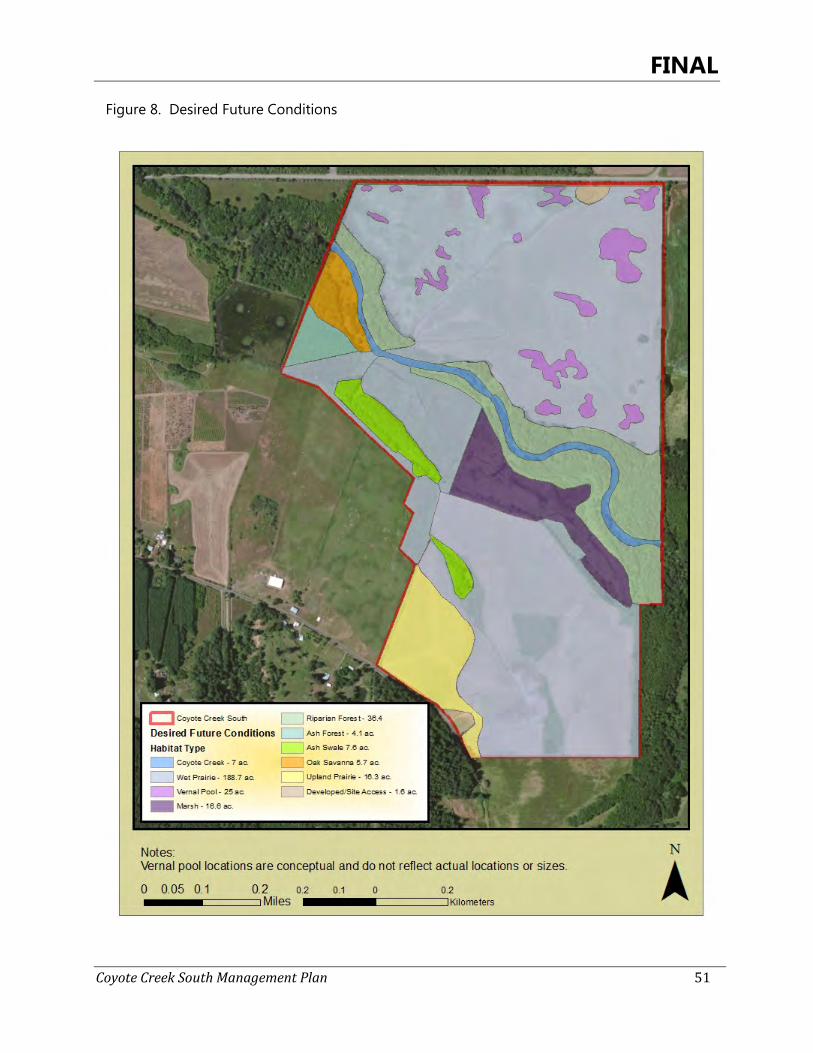
FINAL
Coyote Creek South Management Plan 51
Figure 8. Desired Future Conditions
FINAL
Coyote Creek South Management Plan 52
Priority Habitats 4.1
4.1.1 Wetlands
Wetland habitats are highly diverse and are saturated with water either permanently or seasonally. On Coyote Creek South, seasonally wet habitats include wet prairies and vernal pools, while permanently wet habitats include marshes. The agricultural areas that currently make up the majority of the site’s land use will be restored to a mosaic of native wet prairie and vernal pool habitat. High native plant diversity is achievable in wet prairie restorations (Wold et al. 2011) and the Coyote Creek South Site should aim for several native species to occur and to restore moderate- to high-quality restored wet prairies. The wet prairie will be dominated by native bunchgrass, such as tufted hairgrass (Deschampsia cespitosa) or in places shorter-statured species such as California oatgrass (Danthonia californica), with a significant forb component. Bunchgrass structure should be present and sufficiently dense to provide nest sites and cover for grassland birds such as western meadowlarks. Forb species should support pollinators by flowering over the entire growing season, and providing a range of flower morphology, including species accessible to generalists (e.g., Asteraceae). Total vegetative cover in the wet prairie (not including vernal pools) should optimally aim for 90% cover, for the purpose of competing with weeds and To minimize management needs. This is a goal that should be realistically achievable over time. The Rivers to Ridges Partnership operates a Native Plant Materials Program which collects locally-sourced seed from within 20 miles of Eugene and contracts with a commercial nursery to grow out plants for seeds and plugs, to increase suitable materials available for restoration projects. ODFW should join this group for readily available, suitable seed meeting the diversity goals for the Coyote Creek South Site.
Woody vegetation in the form of shrubs or small trees should not exceed 5% cover (all species combined) in wet prairie areas. Woody vegetation that remains should provide perching and singing habitat and be of an appropriate height for grassland birds, but not so high as to deter site use by streaked horned larks. Oregon white oak is an exception; the few remnant mature, open-grown Oregon white oaks should be retained and protected, and recruitment of a new age class of Oregon white oak may occur along the northern edge of the Coyote Creek riparian area. Any highly invasive species, such as blackberry or reed canarygrass, should be treated as soon as possible following detection, and management should aim to keep cover of these species to no greater than 10% in a given restoration unit. Problematic invasive species commonly occurring in wet prairie restorations, such as rat-tail fescue, pennyroyal (Mentha pulegium)(, and creeping bentgrass (Agrostis stolonifera), together should not exceed 15% cover in any one restored area. By restoring the wet prairies on the site to moderate to high-quality conditions by establishing native species and controlling invasive species, ODFW should have suitable options within the plant community for reintroduction of Bradshaw’s lomatium, Willamette daisy, and shaggy horkelia (Horkelia congesta), to help meet U.S Fish and Wildlife Service Willamette Valley recovery goals for each of those species. These conditions will also benefit the overall native wet prairie flora and wet prairie-associated wildlife species.
FINAL
Coyote Creek South Management Plan 53
Restoration of a hydrologically-connected set of vernal pools, ranging in depth and size, will be evaluated for areas in the northern portion of the site. Development will target creation of 15 acres of vernal pool/seasonal wetland habitat with specific attributes (size, depth, contours) south of the transmission corridor to benefit migrating and wintering waterfowl, shorebirds, red-legged frogs, salamanders, and other species supported by this habitat type. Additional vernal pool habitat, area to be determined, would be designed in an experimental effort to create habitat for streak horned lark. The northern portion of the site has been selected for vernal pool/seasonal wetlands as it has fewer known weed issues than the southern side of the creek, and restored vernal pools on the northern portion of the Coyote Creek South Site would make a landscape-scale connection with 13 vernal pools which have been restored next door on the City’s Coyote Prairie site. When seeded, native plants will be utilized to add diversity to the site. Vernal pool/seasonal wetland habitats will be predominantly located between the riparian forest and the BPA transmission line right-of-way would be designed to hold water into June to provide foraging habitat for wintering waterfowl and to support northern red-legged frog and native salamander reproduction; these should also contain coarse woody debris elements and incorporate emergent species or have other biotic substrate to which amphibians may attach egg masses. Vernal pools north of the BPA right-of-way will include those designed as a pilot effort to test whether vernal pool habitat can be created within a hydrologically-connected wet prairie matrix to support breeding streaked horned lark (See Figure 11). Pools should vary in depth so that some are dry as early as May (in an average hydrologic year) so the larks can initiate nesting. These vernal pools should aim to be 0.5-2 acres or greater in size, with uneven edges forming contours that appear natural on the landscape. The use of vernal pools within a wet prairie matrix for the purpose of providing streaked horned lark habitat will be a pilot effort and will be well-documented and closely monitored to determine its effectiveness. ODFW should partner with American Bird Conservancy, streaked horned lark researchers at OSU, and working groups within the OR-WA range for this species who are managing and monitoring streaked horned lark populations to develop vernal pool specifications and management regimes for the Coyote Creek South Site. Wet prairie and vernal pool habitats will be maintained by regular disturbance, including controlled ecological burns, mowing, haying, grazing, herbicide treatments and if needed, limited tilling, disking, or other means of removing unwanted vegetation. Once restored vegetation has established sufficiently to carry fire, controlled ecological burns should be implemented on a 3-5 year return interval (local weather conditions permitting). The Rivers to Ridges Partnership has a well-established program for conducting controlled ecological burns that ODFW could join. Mowing will aid in reducing thatch in years when burning does not occur. For both mowing and controlled ecological burns, especially if rare plant species are introduced to the site, only a portion of the restored areas would be treated in any given year, to provide refugia for less mobile species as well as year-round cover for species such as small mammals. Unmowed areas will also support raptors and mammals by providing prey populations in winter. Mechanized activities in prairies will be delayed at least until after July 15 or later and foot traffic will be limited in known grassland bird nesting areas to avoid nest disruption or
FINAL
Coyote Creek South Management Plan 54
fledgling mortality. Depending on how the vernal pools establish, limited tilling or herbicide application may be required to maintain open conditions in the centers of the pools. This would occur during the late dry season when the pools are not likely to be used by wildlife, and would occur only as needed to prevent dense vegetation from becoming established and altering the function of the pools. The marsh habitat will undergo straightforward but transformative vegetation management to improve habitat conditions for western pond turtle, northern red-legged frog, waterfowl, and native plant populations. A first step will be to remove vegetation from the berm tops and assess the structural integrity of the berms, their water control devices, and the depth of water they are seasonally impounding. They will be evaluated to determine if removal or lowering is appropriate to increase hydrologic connection and floodplain function while achieving management objectives for marsh habitat. Replacement of the water control devices with a slightly more sophisticated type such as a flashboard riser will facilitate better control of water levels in the impoundments but should be evaluated for practicality and may not be implemented. Woody and invasive vegetation removal should achieve cover targets appropriate for providing nesting sites for western pond turtles. Treated areas will be re-seeded with low-stature grasses, and mowed annually. Woody vegetation will also be removed from the southwestern portion of the marsh, where Oregon ash is encroaching much in the same way as is found in the wet prairie system to the west of the marsh boundary. Young Oregon ash will be removed from this area and replaced with native herbaceous sedges, rushes, and grasses. Furthermore, the treeline that runs along an old fenceline at the southern edge of the marsh habitat where it adjoins the agricultural area will also be greatly reduced, providing wide openings in the canopy for better landscape connectivity and reducing the future reinvasion potential of the ash into both the marsh and the agricultural area that will one day be restored to wet prairie. Other than removing woody vegetation, the other primary enhancement action for the marsh under this plan is to greatly reduce the reed canary grass infestation, and replace it with native graminoids. The reed canary grass can be controlled with a combination of mowing, herbicide application, and flooding. Treatment regimes should draw on successful efforts at Fern Ridge for specific methods and timing. While completely removing reed canary grass from the marsh would be ideal and may be achievable over a longer timeframe, this management plan aims to reduce it to no greater than 50% cover in the marsh during the 10 year period from 2014-2024. This population is well established, and it’s expected to take several years of treatment before its extent can be significantly reduced; the 50% goal reflects removal of nearly half of the existing cover of this problematic species. Areas where reed canary grass is successfully removed will be seeded either with native wetland bunchgrasses such as tufted hairgrass, or with other graminoids adapted to greater inundation (i.e., species in the genera Carex, Juncus, Scirpus, Schoenoplectus) to provide habitat more similar to that found in remnant marsh areas. Localized patches of uncommon sedges should be mapped and protected during reed canary grass control activities; these sedges may also be propagated for increasing their abundance throughout the marsh.
FINAL
Coyote Creek South Management Plan 55
Wetland Goals, Objectives, and Strategies Wet Prairie
Goal WP1. Restore native wet prairie plant communities (188.7 acres).
Objective 1a. Convert agricultural crop fields to native wet prairie.
Strategy: 1) Maintain agricultural crop contract until wet prairie restoration begins to prohibit invasion of non-native plants.
2) Restore wet prairie throughout agricultural crop fields. • Incorporate plant species into restoration mixes that hold cultural significance for native tribes
who historically occupied the area around Fern Ridge. • Non-native vegetation (woody or herbaceous) in wet prairies is not to exceed 5%.
• Wet prairie will be planted with a diverse mix of native grass and forb species.
Objective 1b. Actively manage wet prairie restoration areas.
Strategy: 1) Maintain a periodic disturbance every 3-4 years. • Management methods include prescribed fire, herbicide, grazing or mechanical techniques.
Strategy: 2) Invasive plant species will occupy no more than 5% of restored areas. Prefer
Objective 1c. Create and maintain grassland structure to attract grassland bird species.
Strategy: 1) Create a heterogeneous structure by planting a diverse mix of native grasses, sedges, and forbs with varying vegetation heights and densities.
2) Include 10 to 30 percent forb diversity to attract pollinators as a food source. 3) Manage trees along northeast and east borders of the northern wet prairie restoration area to avoid
further encroachment. 4) Incorporate periodic management to restrict establishment of woody vegetation.
Objective 2a. Work with BPA to manage the power line easement.
Strategy: 1) Obtain Land Use Agreement (LUA) with BPA outlining the proposed restoration plans within the right-of-way (ROW).
2) Maintain vegetation within ROW according to specifications within the LUA.
Goal WP2. Restore surface hydrology in wet prairie restoration areas. Objective 1a. Restore surface hydrological connection between Coyote Creek South and the City of Eugene
mitigation site and between vernal pools.
Strategy: 1) Work with the property owner to seek to modify the elevated access road between Coyote Creek South and the City to achieve this objective. This access road lies on the Tapp Family Property. If the property is acquired in the future, evaluate opportunity to decomission the road and restore hydrologic connectivity.
Goal WP3. Evaluate feasibility of reintroduction of Bradshaw’s lomatium, Willamette daisy and White-topped aster populations in wet prairie habitats. Objective 1a. Re-introduce Bradshaw’s lomatium, Willamette daisy and white-topped aster if appropriate
conditions exist in wet prairie restorations.
FINAL
Coyote Creek South Management Plan 56
Wetland Goals, Objectives, and Strategies Strategy: 1) Assess effectiveness of wet prairie restorations to determine if reintroduction of these species is
feasible and/or desired.
• Work with USFWS and ODA to acquire all needed regulatory permits.
Strategy: 2) Collaborate with COE botanists at Fern Ridge for reference sites and possible seed collection sources.
• For Bradshaw’s lomatium, collect and use seed from the Coyote Creek South Site and known nearby populations (several patches are present within 0.5-3 miles of the site).
Wetland Goals, Objectives, and Strategies
Vernal Pools Goal VP1. Restore vernal pool habitats to support amphibians, waterfowl, shorebirds, and nesting areas for streaked horned larks, and native plant species (15-25 acres). Objective 1a.
Design and construct 15 acres of new vernal pool/seasonal wetland habitat to support migrating and wintering waterfowl, red-legged frogs, salamanders, and other species supported by this habitat type. See Figure 11 for estimated locations.
Strategy: 1) Assess site hydrology to better understand annual patterns on the site and assist with design. • Document the frequency and extent of winter flooding from Coyote Creek in
winter 2014-15. • Map low wet areas across the northern portion of the site, and document
duration of inundation. • Combine onsite hydrologic monitoring data with historic aerials, LiDAR
imagery to analyze high-resolution topography, and known habitat requirements to guide development of a final plan.
Strategy: 2) Create a range of sizes, shapes and depths to provide diversity within the pools and to provide a natural appearance to the site. • Re-grade areas to create broad and shallow swales that provide areas of
deeper surface water and which holds water later into the summer. • Add vegetative diversity to provide habitat conditions important for the life
cycle of native amphibians, aquatic invertebrates, and wintering waterfowl. • Add coarse woody debris elements or incorporate emergent species or other
biotic substrate to which amphibians may attach egg masses. • If any pools design will impact BPA ROW, consult with Real Property Services
or Vegetation Management group.
Objective 1b. Design vernal pools as a demonstration/pilot project for providing nesting habitat for streaked horned lark. Creation of vernal pool habitat for streaked horned lark will be in addition to the 15 acres identified in Objective 1a.
Strategy: 1) Develop metrics for minimum size, recommended depth, vegetation, edge features, options for substrate, recommended pool density in a 40-60 acre wet prairie matrix, and management of the wet prairie matrix for the purpose of encouraging site use by streaked horned larks.
Strategy: 2) Complete plans for vernal pool creation north of the BPA power line right-of-way.
Strategy: 3) Develop monitoring plan for vernal pool use by streaked horned larks.
FINAL
Coyote Creek South Management Plan 57
Wetland Goals, Objectives, and Strategies Strategy: 4) Develop maintenance plan focused on invasive species control (aim for ≤15%
cover of invasive species in any one pool) and maintaining open, unvegetated conditions over portions of the vernal pools.
Objective 1c.
Restore native plant species to vernal pool habitats if needed.
Strategy: 1) Evaluate native plant response for three years following creation or enhancement to determine if native plant enhancement is warranted.
Wetland Goals, Objectives, and Strategies
Marshes Goal M1. Maintain and enhance marsh habitats to support native wildlife species (16.6 acres). Objective 1a. Enhance and restore hydrologic conditions to support marsh habitats.
Strategy: 1) Restore connectivity of marsh habitats with Coyote Creek and floodplain areas or water drainages. • Maintain water control feature. • Repair, reduce or remove berms, impoundments, and levees if assessment shows
failure may occur. • Assess culverts and berm condition. Make necessary repairs and/or upgrades during
dry season. 2) Maintain integrity of impoundment berms to improve access to site and provide potential
nesting areas for western pond turtle. • Remove trees, shrubs, and invasive species from berms separating impoundments.
Objective 1b. Restore herbaceous vegetation dominance to southeastern portion of marsh habitat.
• Remove young encroaching Oregon ash, non-native shrubs, and invasive blackberry.
• Decrease or completely remove Oregon ash-dominated treeline along fenceline with agricultural field.
Goal M2. Enhance native vegetation composition in marsh. Objective 2a. Increase native plant cover and diversity.
Strategy: 1) Reduce presence of reed canary grass to achieve ≤50% cover by this species in the marsh habitat.
• Reseed or plant with native sedges and rushes that provide habitat structure for breeding amphibians (including northern red-legged frog) and waterfowl, and also provide rearing habitat for western pond turtle.
• Protect uncommon species during invasive control efforts, and expand extent of these species as part of enhancement efforts.
• Disk, flood, and/or other actions to reduce or eliminate reed canary grass.
4.1.2 Riparian Forest
The desired future condition for the riparian forest is for an oak-dominated system with a largely native understory which supports breeding and migrating common and at-risk wildlife,
FINAL
Coyote Creek South Management Plan 58
and which remains hydrologically connected to Coyote Creek. The canopy composition and density will be enhanced for the protection of Oregon white oak, by releasing large diameter trees with open-grown or woodland form (vase-shaped) canopies from competition with Oregon ash. These trees provide the greatest wildlife habitat benefit via cavities, mast, mistletoe, and similar features. Review of aerial photography suggests that some of these trees have been present for approximately the last 100 years. A baseline inventory including mapping with GPS and assessment of individual tree health and vigor (UOELP 2010) will help establish priority trees or areas for release. Trees in various stages of intactness will provide nest or roost sites for purple martin, Townsend’s big-eared bat and other bat species, and secondary cavity nesters such as slender-billed nuthatch, although it is not anticipated that colonies of purple martin or bats would inhabit the site. Woody vegetation in the form of native and non-native mature trees, subcanopy trees, shrubs and woody canes will be removed from the riparian area. This may include a potentially large amount of material, and will ameliorate the choked conditions in the riparian forest. The resulting forest canopy will be oak-dominated with a component of Oregon ash in pockets throughout, and will achieve a canopy cover range of 30-70%. If young oak trees are lacking in the riparian forest, some trees will be allowed to establish on the northern side of the forest edge (see Figure 8) where there is ample light, to provide for at least some stand replacement. Total shrub and small tree cover will range between 10-40%, and invasive shrubs should account for no greater than 5% cover, taken together over the entire riparian area. Coarse woody debris shall be left in place to provide nesting and cover for amphibians, birds, and mammals. Coarse woody debris may also be added using material that is thinned from the forest canopy. With more light reaching the forest floor, some of the shining geranium should be knocked back, however additional light will not be sufficient to control the infestation of this species. Shining geranium seeds enter the site annually during overbank flooding events, transported from infestations upstream; a greater degree of control or near eradication of this species from the Coyote Creek South Site is unfortunately not achievable. The current extent of shining geranium will be mapped, and subsequent control efforts will aim to decrease cover in areas occupied by Oregon larkspur or thin-leaved peavine, and to contain the spread of the population elsewhere, with a focus on scouting and controlling the geranium areas that are currently characterized by native species. The riparian forest understory will continue to support populations of uncommon native species, namely Oregon larkspur (Delphinium oreganum) and thin-leaved peavine. Both species will receive baseline assessments documenting their extent, population size, proportion of reproductive plants, and identification of key threats. The information will be used to develop a management regime that will include improving habitat quality within patches, recommendations for expanding populations to other portions of the riparian area if appropriate, and collection and propagation of seed if needed.
Riparian Forest Goals, Objectives, and Strategies Goal RF1. Enhance riparian forest vegetation structure and composition to improve forest health (36.4 acres)
FINAL
Coyote Creek South Management Plan 59
Riparian Forest Goals, Objectives, and Strategies Objective 1a. Release open-grown and woodland-form Oregon white oaks and California black oaks from
competition. Strategy: 1) Complete a baseline assessment of oak distribution, age-class, and health in the riparian forest on
both sides of the creek.
Strategy: 2) Remove subcanopy non-native trees and native Oregon ash from the dripline of large-diameter oak trees.
Strategy:
Strategy:
3) Remove co-dominant Oregon ash where review of historical aerial photos and baseline assessment show significant encroachment and decline in oak vigor.
4) Evaluate stream temperatures and changes in understory vegetation compostion as a result of management.
Strategy: 5) Woody vegetation removal uses methods that minimize disturbance to the soil surface, to protect uncommon native plant populations and prevent scarification of the weed seed bank.
Objective 1b. Remove or limit the spread of invasive species.
Strategy: 1) Remove all non-native shrubs.
Strategy: 2) Highly invasive woody species (e.g. Himalayan blackberry, scotch broom), taken together, do not exceed 5% cover.
Strategy: 3) Shining geranium is mapped, and management focuses on containing population to 2014 boundaries, as well as decreasing cover to 50% in areas of rare or uncommon plant populations.
Objective 1c. Protect, monitor, and expand populations of rare and unusual plant species.
Strategy: 1) Survey thin-leaved peavine population to determine baseline (2014) numbers, extent, and threats.
Strategy: 2) Survey Oregon larkspur population to determine baseline (2014) numbers and extent.
Strategy: 3) Manage areas within and around these populations to reduce non-native plant cover, and to create suitable sites for seed germination.
Strategy: 4) If appropriate and/or needed, collect seed from these populations for use in expanding on-site populations. Work with Technical Advisory Group on additional seed sources.
Goal RF2. Enhance woody features for wildlife. Objective 2a. Maintain and restore structure for oak-associated cavity-nesters.
Strategy: 1) Large-diameter Oregon white oak or California black oak, especially those with existing cavities, are prioritized for release.
Strategy: 2) Snags are created as opportunities exist. Minimum snag height is 10-30 feet and minimum diameter at breast height is 12 inches (15-20 inches optimal).
Objective 2b. Retain downed woody debris as cover and breeding habitat for amphibians, birds, and small mammals.
Strategy: 1) Existing large woody debris is left in place, unless it prevents critical maintenance access.
Strategy: 2) Large woody debris is added where appropriate, using materials generated from woody vegetation removal activities. Mature, large-diameter trees are preferred, but smaller material may also be used. Large logs or piles of smaller logs are created.
4.1.3 Freshwater Aquatic
FINAL
Coyote Creek South Management Plan 60
Desired future conditions for Coyote Creek are for the creek to continue to flow in its meandering channel through the site, remain connected to its floodplain via winter overbank flooding and hyporrheic flows, and to provide habitat for native fish, amphibians, and western pond turtles. The creek’s incised channel banks are largely devoid of vegetation, but seem fairly stable and unless repeated slumping or erosion occurs that is outside expectations of natural channel meandering, the creek channel itself will not require much restoration work during the timeframe of this management plan. A 100 foot riparian setback area as measured perpendicular from the ordinary high water line will be maintained/enhanced to provide protection and enhancement of water quality, maintenance and enhancement of fish and wildlife habitats, limit erosion and sedimentation and to provide a source for long term recruitment of large wood. The creek tops will be enhanced to remove thickets of Himalayan blackberry and stands of reed canary grass, and in such areas native shrubs will be planted to provide improved riparian habitat for songbirds, while also leaving sufficient openings that western pond turtle move into the site from the creek channel for resting and breeding in the site’s marsh and upland prairie areas. Fish surveys will be conducted to assess and evaluate the fish populations in this stretch of Coyote Creek. It’s anticipated that species present will be similar to those known on the FRWA. Recommendations for improving the creek’s physical conditions to support native fish species, including coastal cutthroat trout, will be made following the assessment. As the water quality issues are largely due to upstream conditions and land use, and water levels are affected by seasonal drawdowns of Fern Ridge reservoir, options for improving those aspects of Coyote Creek within the site are limited. However, it is likely that coarse woody debris is present at lower than optimal densities, and can be easily added to the system using on-site material.
Freshwater Aquatic Goals, Objectives, and Strategies Goal CC1. Restore and enhance riparian habitat along Coyote Creek (7 acres). Objective 1a. Promote and maintain a 100 foot riparian setback area as specified in the Lane County riparian
regulations. Native streamside riparian vegetation will be diverse in structure, species and age class with adequate numbers of mature trees to provide for long recruitment of coarse woody debris in Coyote Creek.
Strategy: 1) Preserve and restore native riparian vegetation that is diverse in structure and species. • Manage riparian habitat to allow for a naturally recruiting oak dominated forest with a
diverse component of native trees / shrubs. • Plant native riparian trees / shrubs in areas with inadequate cover to meet objective 1a.
2) Remove invasive species from creek banks and tops while preserving native riparian vegetation.
• Decrease cover of Himalayan blackberry to no more than 5%.
• Decrease cover of reed canary grass to no more than 10%.
• All other invasive species, taken together, account for no more than 10% cover.
FINAL
Coyote Creek South Management Plan 61
Freshwater Aquatic Goals, Objectives, and Strategies Objective 1b. Prevent the occurrence and spread of invasive plant species.
Strategy: 1) Employ an early-detection-rapid-response (EDRR) approach to any discoveries of highly invasive species. • Any highly invasive species (e.g. Eurasian watermilfoil (Myriophyllum spicatum), false brome
(Brachypodium sylvaticum), purple loosestrife (Lythrum salicaria), etc.) discovered in the creek or on its banks or tops over the period of this management plan are treated as soon as is appropriate, and all are treated within one year of discovery.
Goal CC2. Improve fish habitat conditions within Coyote Creek. Objective 2a. Restore Coyote Creek aquatic habitats to support native fish populations.
Strategy: 1) Evaluate and restore habitat suitability for native fish including cutthroat trout. • ODFW biologists survey creek stretch within site boundaries to determine fish species
present.
Strategy: 2) ODFW biologists develop management recommendations for improving habitat for native fish species.
Objective 2b. Evaluate habitat complexity including presence of large woody debris to support native fish, reptile, and amphibian populations.
Strategy: 3) Manage for long-term recruitment of coarse large woody debris in Coyote Creek. • Allow natural recruitment of large wood in Coyote Creek through natural processes such
as storm events, hydrological events, and beaver activity. • Consult with ODFW biologists on need and strategies for placement of additional large
wood.
Important Restorable Habitats 4.2
4.2.1 Oak Savanna
The oak savanna on the site will be restored to true oak savanna cover, with a goal of only 10% cover by trees and shrubs, will continue to host the Bradshaw’s lomatium population, and will be greatly expanded in area by removing Oregon ash trees that have colonized this once-open area. Oregon white oak will be the dominant (if only) canopy species, and multiple age-classes of oaks will be retained to allow for replacement of mature trees as the savanna continues to mature. The Bradshaw’s lomatium population will receive a more detailed baseline assessment, including mapping the extent of the population, counting the total number of individuals, and an estimation of the proportion of reproductive plants. Several monitoring efforts on Rivers to Ridges partner lands utilize a straightforward and basic protocol for documenting similar information about Bradshaw’s lomatium. ODFW should at a minimum incorporate the same data into monitoring at the Coyote Creek South Site, to facilitate comparisons with other nearby Bradshaw’s lomatium patches and to contribute to reporting on the status of this species in the USFWS’ West Eugene Recovery Zone (USFWS 2010). Overtopping Oregon ash will
FINAL
Coyote Creek South Management Plan 62
be removed from the Bradshaw’s lomatium area to increase light to the plants and return grassland vegetation structure. At least two other Bradshaw’s lomatium patches in the West Eugene Wetlands have been found in a similar setting, and removing the overtopping ash has benefitted both populations. Once trees are removed, the area should receive annual late season mowing to keep grass thatch from becoming too dense; annual mowing in a large population on City property has enabled the population to thrive, despite the non-native grass matrix in which it is located (D. Steeck, pers. comm.). Furthermore, if controlled ecological burns occur on the property, this area could also be burned to help remove thatch. Bradshaw’s lomatium populations throughout the West Eugene Wetlands have responded positively with greater numbers of individuals in the few years following burning (TNC, USACE, BLM); this treatment is optimal at a 3-5 year cycle. Lastly, the entire oak savanna area should be expanded by continuing the removal of Oregon ash to the boundary of the planted area mapped as ash forest. This entire area was once open, as shown on historical aerial photos, and other native prairie species including the uncommon large-flowered star-tulip occur in this area, providing evidence that wet prairie vegetation was once present. The grassland structure should be returned to this entire area.
Oak Savanna Goals, Objectives, and Strategies Goal OS1. Enhance oak savanna habitat (5.7 acres) Objective 1a. Promote and maintain oak habitats at densities consistent with habitat classification for oak
savanna.
Strategy: 1) Average tree cover in oak savanna does not exceed 10% and is dominated by Oregon white oak. • On north side of creek, thin oaks along the riparian edge to promote oak release. • Remove Oregon ash trees to encourage Oregon white oak as the dominant canopy
species.
Strategy: 2) Retain multiple age classes of Oregon white oak.
Objective 1b.
Strategy:
Promote and maintain oak savanna habitats to improve conditions for Bradshaw’s lomatium.
1) Survey and map extent of Bradshaw’s lomatium population.
Strategy: 2) Complete a baseline count of number of plants, using the same protocols as applied in other West Eugene Wetlands sites, to allow comparison of Coyote Creek South Site populations and contribute to USFWS West Eugene Recovery Zone for this species.
Strategy: 3) Identify any key threats not already known for this population.
Objective 1c. Reduce the threat of invasive shrubs and trees to avoid impacts to oak management goals.
Strategy: 1) Native shrubs with highest wildlife value may be retained.
Strategy: 2) All non-native and invasive woody vegetation is removed.
Strategy: 3) Some young Oregon white oak are retained consistent with oak protection/maintenance objectives.
Objective 1d. Remove vegetation encroaching on Bradshaw’s lomatium population.
FINAL
Coyote Creek South Management Plan 63
Oak Savanna Goals, Objectives, and Strategies Strategy: 1) Tree canopy is gradually opened up over a period of years, achieving total cover of ≤25%.
• Trees and shrubs within and immediately overtopping the Bradshaw’s lomatium population are removed, using techniques that minimize soil disturbance.
• Invasive species in the vicinity of the existing Bradshaw’s lomatium are removed. •
4.2.2 Grasslands
The upland prairie will be restored to native bunchgrasses, primarily for the purpose of providing nesting habitat for western pond turtle and grassland birds. The transition of this area to native cover will be somewhat challenging due to the presence of some highly invasive species such as rat-tail fescue. However, as the primary goal is to provide wildlife nesting habitat, the species composition can be managed over time and progressively become more native. To support breeding habitat for western pond turtle, the upland prairie area should be restored to low-statured vegetation with some bare ground areas that provide nest sites. In this old field setting it’s expected that broad-leaved weeds or non-native grasses will likely colonize any open areas; nest site availability will likely be achieved via treatment of weeds and resulting bare spots in the soil. A mowing regime can help keep vegetation stature low to attract turtles as well. ODFW biologists will determine possible routes of access to the upland prairie for western pond turtles using Coyote Creek South Site or the marsh habitat, and can recommend additional treatments in those areas that will aid in turtles finding and using the upland prairie area. Exclosures may be put in place to aid nest success. In addition to turtles, the upland prairie can provide habitat for nesting grassland birds. The upland prairie is located within approximately ½ mile of a known nesting location of Oregon vesper sparrow at a nearby Christmas tree farm. Western meadowlark were also detected nearby on Cantrell Road during 2008-09 roadside surveys. Bunchgrass structure adjoining the large herbaceous-dominated agricultural fields will provide the open landscapes these birds seek for breeding. As there are currently no shrubs or trees in these fields, perching habitat can be provided by the southern border fence and also by wooden or metal posts stationed sporadically throughout the upland prairie area. Posts in this kind of setting are typically used not only by singing grassland birds, but also by raptors; short-eared owls have been observed perching at the adjacent Coyote Prairie site. Grassland Goals, Objectives, and Strategies Goal UP1. Upland Prairie Habitat - Restore native plant dominance and vegetation structure to improve
habitat quality for native wildlife species with an emphasis on at-risk species (16.3 acres). Objective 1a. Remove non-native grasses competing with or that compromise restoring upland prairie habitat.
Strategy: 1) Divide area into two phases, and phase restoration over time.
Strategy: 2) Conduct a minimum of 2 years of site preparation prior to seeding.
Objective 1b. Restore upland prairie habitats with native bunchgrass and other seed mixes consistent with this

FINAL
Coyote Creek South Management Plan 64
habitat type.
Strategy: 1) Seed with a native bunchgrass and forb mix to create suitable habitat structure.
Strategy: 2) Facilitate any needed follow-up weed management.
Objective 1c. Maintain large areas in short-statured vegetation, to provide nesting habitat for western pond turtle.
Strategy: 1) Use short-statured grasses in seed mixes.
Strategy: 2) Periodically manage (i.e., mow, graze, controlled ecological burn) large areas several acres in size, to help reduce thatch and keep vegetation heights low.
FINAL
Coyote Creek South Management Plan 65
Public Access and Use 5
This addition of the Coyote Creek South Site to the FRWA is a key step expanding ODFW’s capacity to protect native Willamette Valley habitats for the enjoyment of people and the benefit of common and uncommon wildlife and plants. Public access and use of the Coyote Creek South Site is welcomed and encouraged. Over the next 10 years, the site will evolve to a condition that will refine site opportunity to experience native habitats and the outdoors.
Desired Future Conditions and Goals, Objectives, and Strategies 5.1
The future vision of public use at the site is a mix of passive recreation opportunities that fit under the current uses of similar areas in the FRWA. The site will be open for walkers, wildlife observers and nature enthusiasts year round, and hunting and angling during authorized seasons. Dogs will only be permitted on-leash (except during authorized game bird seasons), but no motorized vehicle use will be permitted, in order to protect the at-risk wildlife and areas undergoing restoration. There are several factors to consider regarding optimal access to the site for future recreation. Figure 9 depicts potential site access points and conceptual footpath layouts. The northern portion of the site provides the easiest access; Cantrell Road is a wide county through-way that also already hosts parking and trailhead access into other FRWA units. An envisioned regional bike path would bring cyclists south down Ken Nielsen Road and turn west on to Cantrell Rd. right in this location. However, the northern portion of the site is also where much of the restoration aimed at sensitive wildlife and plant species is recommended, and these two uses may not be compatible. A second option is to have a public access point on Halderson Road, which may be the preferred hunting access to the site. In this case, limitations include less available parking and the quiet, rural nature of this dead-end road with neighboring residences. Careful consideration will be given before developing public access in this area. An informal trail system may be established to aid the public in moving through the site and accessing Coyote Creek, while protecting the site’s Conservation Values. The trail would bring users to several of the different habitats, including wet prairie (as it is restored), marsh, and riparian forest. An informal trail system is recommended for several reasons. Providing a trail system is the best means for directing (non-hunting) and concentrating recreational use of the site. Hydrologic patterns are not yet well understood on the site, and any trail siting should be in a location that is not going to be annually washed out or seasonally unavailable. Furthermore, restoration will involve some earthmoving on the northern portion of the site and until that is complete siting a trail will be difficult. In general, the site will be undergoing significant restoration efforts, for which large equipment will be utilized and site safety for users will be a factor. The agricultural areas will be slowly phased into restoration, and the lessee will have access to the site with large equipment and likely be applying broadcast
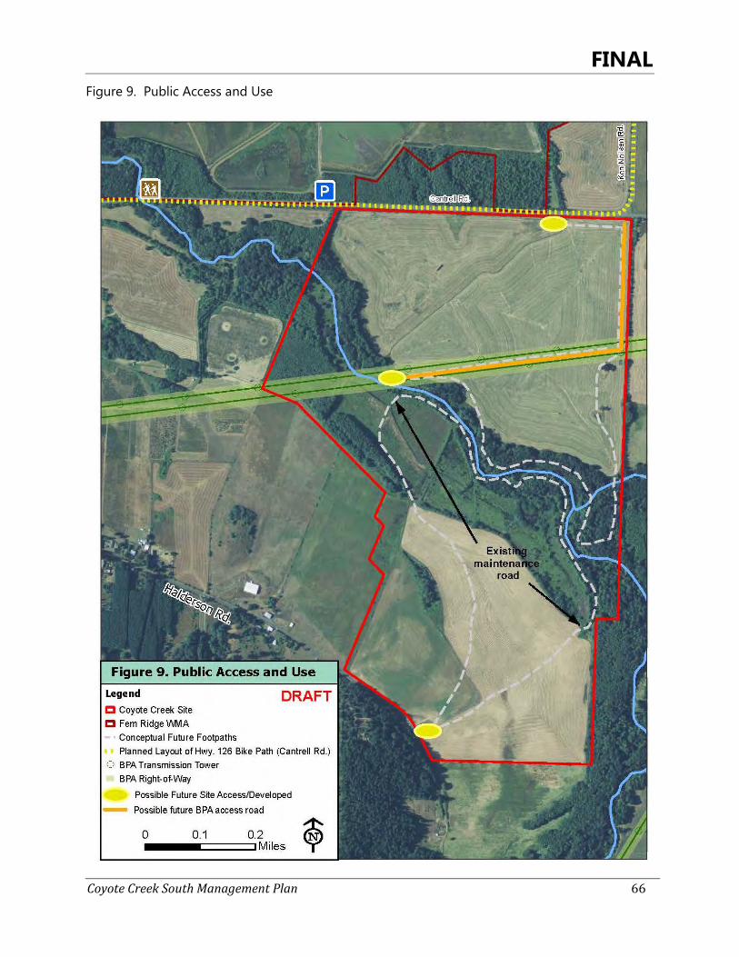
FINAL
Coyote Creek South Management Plan 66
Figure 9. Public Access and Use
FINAL
Coyote Creek South Management Plan 67
herbicide; although infrequent, the agricultural use of large portions of the site is not compatible with trail use. More formal trail siting and construction is best left for after this level of on-site work is completed. In addition, soils on the site are not well suited to trail system development, and a formal trail system would likely be costly and require a fair amount of maintenance. Rather, in informal system linking on-site maintenance roads to site entrances will function to create loop systems that bring visitors to desired locations and protect wildlife and plant populations while minimizing construction and maintenance costs. For example, a system of old roads associated with the levee system in the marsh can function as a partial trail system if connected to the southern site entrance with a mowed path through the agricultural field. A similar arrangement could work on the north side of the site on BPA's new access road, if allowable by BPA. Both of these approaches would take advantage of existing infrastructure, helping to minimize costs. The development of a sustainable trail system over the long-term at the Coyote Creek South Site may be desirable, to provide and facilitate recreational use as well as offer education and outreach opportunities, and should be considered when this management plan is updated. Public Access and Use Goals, Objectives, and Strategies Goal PAU1. Provide public access compatible with habitat and species management goals for Coyote
Creek. Objective 1a. Provide access to Coyote Creek for wildlife viewing, hunting, and angling consistent with habitat
and species management goals. Strategy: 1) Hunting for waterfowl and big game is allowed during the designated hunting seasons
Strategy: 2) Provide viewing opportunities through creation of access trails and viewing locations. • Once restoration activities in wet prairie habitat have been completed and site stabilization
is underway,hiking trails and viewing platforms will be established in locations that minimize impacts to habitats and sensitive species.
Strategy:
Strategy:
3) Considerations on trails and viewing platforms into the site are balanced with the habitat needs of listed and sensitive wildlife species for which habitat is being managed or restored.
4) Evaluate public use to assess potential conflicts between users and habitat/species conservation goals and implement seasonal or site specific restrictions to minimize conflicts when necessary.
Objective 1b. Evaluate parking area(s) to facilitate access to the property.
Strategy: 1) Consider number of parking spots, seasonality, and entry pathways into the site, balanced with the habitat needs of listed and sensitive wildlife species for which habitat is being managed or restored.
Strategy: 2) Develop plan for BPA approval should parking areas be desired.
FINAL
Coyote Creek South Management Plan 68
Public Access and Use Goals, Objectives, and Strategies Objective 1c. Provide walking and viewing trail(s) from the parking area into the site.
Strategy: 1) Any planned trail alignment is sited to protect the site’s Conservation Values.
Strategy: 2) Trails are sited to balance site use with the habitat needs of listed and sensitive wildlife species for which habitat is being managed or restored.
Strategy: 3) As the trail may not be an improved surface, a low-impact system of marking the trail alignment (e.g., marker posts, blazes, etc.) may be installed to direct users along the trail corridor, for the purpose of minimizing unintentional visits through sensitive areas of the site.
Objective 1d. Provide information and interpretive sites to help inform the public of use restriction and management goals for Coytoe Creek.
Strategy: 1) Kiosks educate users about the site’s Conservation Values and funding sources, provide mapping to keep visitors oriented on property, and clearly describe allowable site uses. • Install informational kiosks.
Goal PAU2. Evaluate effects of public use on site wildlife and Conservation Values. Objective 2a. Implement a monitoring plan to assess public use and identify potential conficts with habitat and
wildlife conservation objectives.
Strategy: 1) Evaluate public use over the period of this management plan to better understand site use, effects of use on wildlife species and Conservation Values, and to inform the next revision to this plan. Make adjustments to access timing or location if needed for this unit of the FRWA.
Objective 2b. Monitor trespass and/or vandalism.
Strategy: 1) Monitor trespass/vandalism.
Strategy: 2) Address unauthorized/illicit use as needed. • Gates are installed similar to those currently found on other management units of the
FRWA. • Install fencing if needed to establish property boundaries and prevent livestock intrusion.
Goal PAU3. Support outreach and education opportunities. Objective 3a. Facilitate educational opportunities as they arise.
Strategy: 1) Consider including Coyote Creek South Site in FRWA internship program.
Strategy: 2) Provide site access to school groups, individual students, adult learning classes, etc. as feasible.
Objective 3b. Provide outreach opportunities for the site.
Strategy: 1) Offer field tours for agency staff and conservation partners as part of restoration activities.
FINAL
Coyote Creek South Management Plan 69
Management Plan Implementation 6
Prioritization of Restoration and Enhancement Actions with Suggested 6.1Timeframes
The restoration and enhancement work recommended by this plan for the Coyote Creek South Site ranges from straightforward, short-term treatments to long-term multi-year efforts, and the overall scope and cost is significant. Prioritization is needed to focus management actions where they have the most immediate effect, and to build in needed time to plan and secure funds for larger-scale efforts. The prioritization recommended here accounts for these needs as well as the degree of threat to existing plants, wildlife, and habitats, especially listed species; baseline information needed; potential to achieve moderate to high quality habitat conditions; feasibility of projects within the 10-year timeframe of this management plan; availability of funding, and anticipated sequencing of actions.
Considering these factors, the following objectives are the highest priority:
• Completion of baseline assessments (2014-2017): - Hydrologic conditions in the northern wet prairie/vernal pool restoration area
(Goal VP1, Objective 1a) by spring 2016 - Canopy condition in the riparian forest (Goal RF1 and 2) - Bradshaw’s lomatium population in the oak savanna (Goal OS1, Objective 1b and
1 d)) - Thin-leaved peavine and Oregon larkspur populations in the riparian forest (Goal
RF1, Objective 1c) - Levee and water control structure condition in the marsh (Goal M1, Objective
1a.1) - Western pond turtle potential nesting areas and travel corridors within the site
in marsh, wet prairie, and upland prairie habitats (Goal M1, Objective 1a.2, Goal UP1, Objective 1c)
• Initiating woody vegetation removal and invasive species treatments (2014-2017): - Riparian forest (Goal RF1, Objective 1a, 1b) - Wet prairie (Goal WP1, Objective 1b.2, 1c) - Marsh (Goal M1, Objective 1b) - Oak savanna habitats (Goal OS1, Objective 1c, 1d)
• Complete development of a conceptual design and management regime for wet prairie, seasonal wetlands, vernal pool creation (2014-2016), and subsequent grant application(s) for for restoring moderate to high-quality wet prairie, piloting creation of streaked horned lark nesting habitat in vernal pools on restoration sites, and creation of vernal pools for waterfowl and northern red-legged frog habitat. (Goal VP1, Objective 1a and 1b)
FINAL
Coyote Creek South Management Plan 70
Medium priority projects consist of:
• Implementing the wet prairie, seasonal wetland, and vernal pool restoration on the northern portion of the site, (2014-2023); (Goal WP1, Goal VP1, Goal M1 and M2)
• Stabilizing the site boundaries and access areas (2014-2015); (Goal PAU1, Objective 1b, 1c)
• Controlling herbaceous invasive species (Perpetual); - Riparian and marsh habitats (Goal M2, Objective 2a, Goal RF1, Objective1b) - Reed canarygrass in both habitats, shining geranium in the riparian forest (Goal
M2, Objective 2a, Goal RF1, Objective1b) • Enhancing the upland prairie for wildlife habitat (2015-2020), (Goal UP1) • Construction and installation of public use facilities (2022-2024). (Goal PAU1
Projected Restoration Timeline and Activities 6.2
A generalized schedule indicating projected restoration timeline and activities is shown in Table 3. Actual timelines are subject to vagaries of grant approvals, weather conditions, site response, schedule adaptations, etcetera. Figure 10 outlines the fields to be restored.
Table 3. Restoration Timeline and Activities
YEAR TASK DESCRIPTION
Fall 2014 Broadcast spray (Glyphosate) North Field #1
Spring 2015
Broadcast spray (Glyphosate) North Field #1
Spring 2015-Summer 2016
Forms, Agreements and Permit Applications
North Fields # 1 & 2: Submit Lane County Land Use Compatibility form, develop cooperative landowner agreement with LTWC, prepare Joint Permit application for wet prairie-vernal pool restoration, cultural resource review/archaeological survey and consultation, USFWS Section 7 consultation
Spring 2015-Summer 2016
Wet prairie-vernal pool conceptual plan and final plan development, including seed mixes drafted and reviewed
North Fields # 1 & 2: hydrologic monitoring, LiDAR imagery, bird and amphibian monitoring. Finalize seed mixes for project area. Finalize vernal pool plan with Coyote Creek Advisory Group and Engineer
Spring 2015-Fall 2017
Wet Prairie-vernal pool restoration implementation
North Fields # 1 & 2: Contract for vernal pool-wet prairie engineering final design, seed mix review, streaked horn lark surveys, earthwork, seeding, and herbicide treatments.
FINAL
Coyote Creek South Management Plan 71
YEAR TASK DESCRIPTION
Spring 2015-Fall 2019
Wet Prairie-vernal pool restoration implementation
North Fields # 1 & 2: Site preparation, earth work, vernal pool stabilization, seeding, bulb planting, follow-up herbicide treatments, and streaked horn lark survey throughout all activities to restore a matrix of vernal pool and wet prairie habitat.
Spring 2015-Fall 2017
Wet Prairie-vernal pool restoration implementation
North Fields # 1 & 2: Contract for vernal pool-wet prairie engineering final design, seed mix review, streaked horn lark surveys, earthwork, seeding, and herbicide treatments.
Spring 2015-Fall 2017
Wet Prairie-vernal pool restoration implementation
North Fields # 1 & 2: Native plant material procurement.
Spring 2015-Fall 2019
Wet Prairie-vernal pool restoration implementation
North Fields # 1 & 2: Site preparation, grading, seeding, follow-up herbicide treatments, and vernal pool disturbance to maintain bare ground.
Fall 2015 Broadcast spray (Glyphosate) North Field #1
Fall 2015 Broadcast spray (Glyphosate) North Field #2
Fall 2015 – Fall 2017
Oak release along riparian habitat
Riparian: Vegetation around large oaks will be cleared to allow for development of full canopy. Invasive species will be treated my mechanical/ chemical application.
Spring 2016
Broadcast spray -Glyphosate- if needed North Field #1
Fall 2016 Broadcast spray -Glyphosate &/or Rx Burn North Field #1
Fall 2016 Broadcast Forbs North Field #1 Spring 2016
Broadcast spray (Glyphosate) North Field #2
Spring 2017
Spot/Broadcast Spray Poast North Field #1
Fall 2016 Broadcast spray (Glyphosate) North Field #2
Fall 2017 Spot/Broadcast Spray Poast North Field #1
FINAL
Coyote Creek South Management Plan 72
Fall 2017 Drill grass North Field #1
YEAR TASK DESCRIPTION
Spring 2017
Broadcast spray (Glyphosate) North Field #2
Fall 2017 Broadcast spray -Glyphosate &/or Rx Burn North Field #2
Fall 2018 Broadcast Forbs North Field #2
Fall 2017 Broadcast spray (Glyphosate) South Field #4
Spring 2018
Broadcast spray (Glyphosate) South Field #4
Spring 2018
Spot/Broadcast Spray Poast North Field #2
Fall 2018 Broadcast spray (Glyphosate) South Field #4
Fall 2018 Spot/Broadcast Spray Poast North Field #2
Fall 2018 Drill grass North Field #2 Spring 2019
Broadcast spray (Glyphosate) South Field #4
Fall 2019 Broadcast spray -Glyphosate &/or Rx Burn South Field #4
Fall 2019 Broadcast Forbs South Field #4
Fall 2019 Broadcast spray (Glyphosate) South Field #3
Spring 2020
Broadcast spray (Glyphosate) South Field #3
Spring 2020
Spot/Broadcast Spray Poast South Field #4
Fall 2020 Broadcast spray (Glyphosate) South Field #3
Fall 2020 Spot/Broadcast Spray Poast South Field #4
Fall 2020 Drill grass South Field #4 Spring 2021
Broadcast spray (Glyphosate) South Field #3
Fall 2021 Broadcast spray -Glyphosate &/or Rx Burn South Field #3
Fall 2021 Broadcast Forbs South Field #3 Spring 2022
Spot/Broadcast Spray Poast South Field #3
Fall 2022 Spot/Broadcast Spray Poast South Field #3
Fall 2022 Drill grass South Field #3

FINAL
Coyote Creek South Management Plan 73
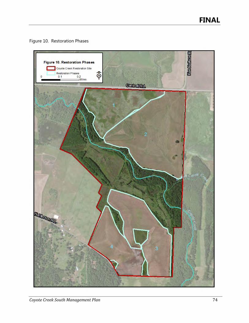
FINAL
Coyote Creek South Management Plan 74
Figure 10. Restoration Phases
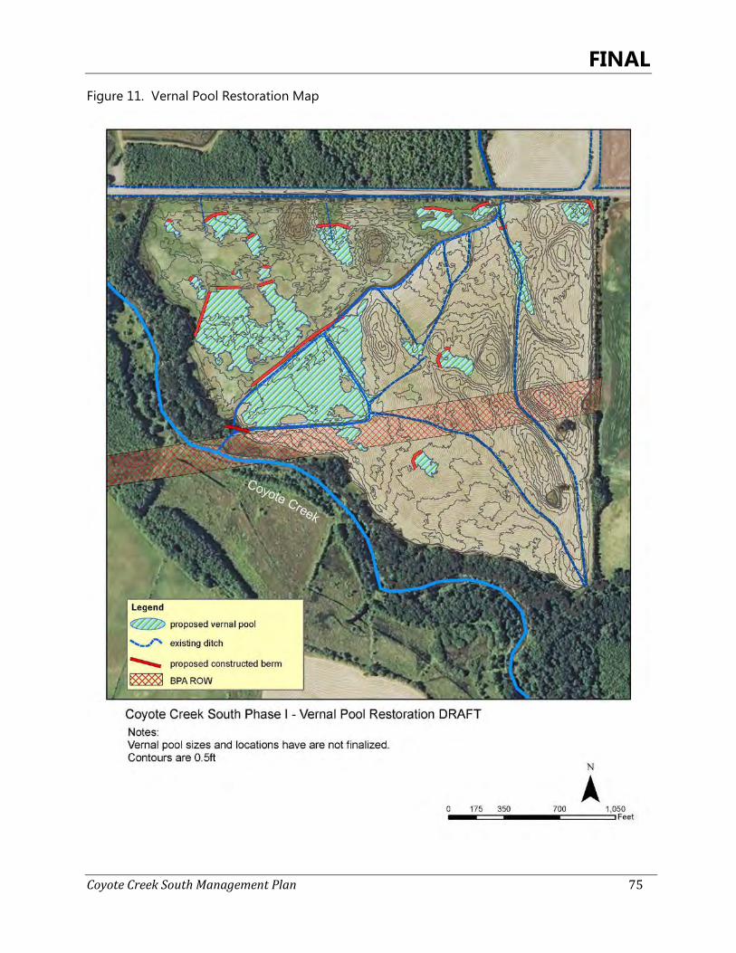
FINAL
Coyote Creek South Management Plan 75
Figure 11. Vernal Pool Restoration Map
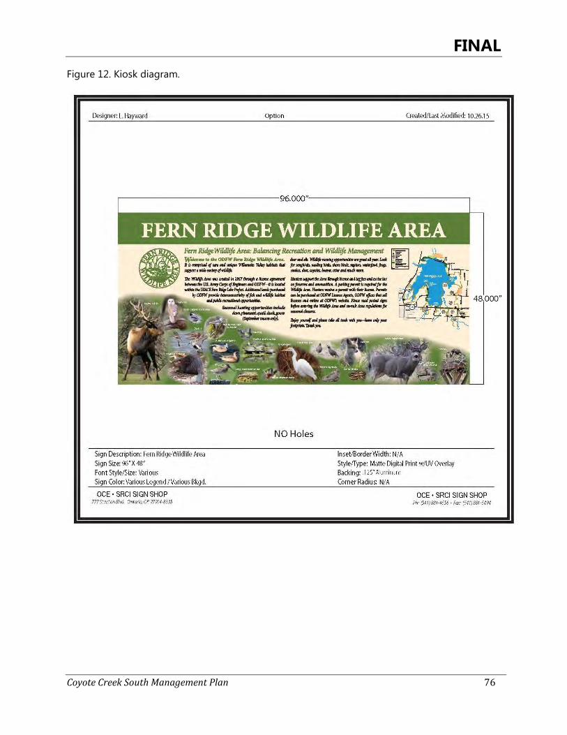
FINAL
Coyote Creek South Management Plan 76
Figure 12. Kiosk diagram.
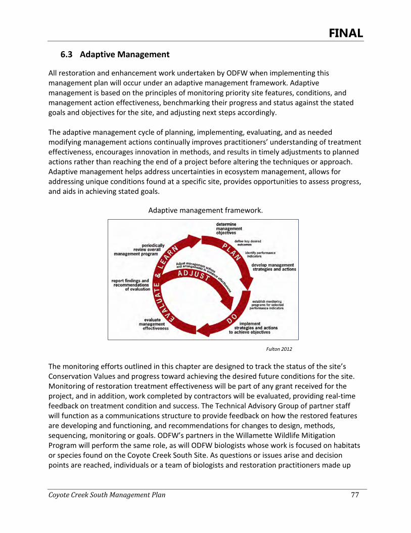
FINAL
Coyote Creek South Management Plan 77
Adaptive Management 6.3
All restoration and enhancement work undertaken by ODFW when implementing this management plan will occur under an adaptive management framework. Adaptive management is based on the principles of monitoring priority site features, conditions, and management action effectiveness, benchmarking their progress and status against the stated goals and objectives for the site, and adjusting next steps accordingly. The adaptive management cycle of planning, implementing, evaluating, and as needed modifying management actions continually improves practitioners’ understanding of treatment effectiveness, encourages innovation in methods, and results in timely adjustments to planned actions rather than reaching the end of a project before altering the techniques or approach. Adaptive management helps address uncertainties in ecosystem management, allows for addressing unique conditions found at a specific site, provides opportunities to assess progress, and aids in achieving stated goals.
Adaptive management framework.
Fulton 2012
The monitoring efforts outlined in this chapter are designed to track the status of the site’s Conservation Values and progress toward achieving the desired future conditions for the site. Monitoring of restoration treatment effectiveness will be part of any grant received for the project, and in addition, work completed by contractors will be evaluated, providing real-time feedback on treatment condition and success. The Technical Advisory Group of partner staff will function as a communications structure to provide feedback on how the restored features are developing and functioning, and recommendations for changes to design, methods, sequencing, monitoring or goals. ODFW’s partners in the Willamette Wildlife Mitigation Program will perform the same role, as will ODFW biologists whose work is focused on habitats or species found on the Coyote Creek South Site. As questions or issues arise and decision points are reached, individuals or a team of biologists and restoration practitioners made up
FINAL
Coyote Creek South Management Plan 78
from these groups can conduct site visits to further assess and discuss ecological values, threats, management options, scheduling, and follow-up actions.
Monitoring 6.4
All monitoring will occur under the broader framework of ODFW’s Monitoring Program for Willamette Wildlife Project sites, which is under development at the time of the writing of this management plan. As development of ODFW’s monitoring program is underway, adjustments may be made to the monitoring descriptions provided here to ensure agreement with the adopted ODFW program.
6.4.1 Effectiveness Monitoring
Effectiveness monitoring for the Coyote Creek South Site will focus on baseline documentation described in Chapter 4, status of the site’s Conservation Values, and restoration effectiveness. Effectiveness monitoring is designed to provide important biological and ecological information about the site, while minimizing duplication of other monitoring efforts. ODFW will share the monitoring data collected at Coyote Creek South Site with other conservation-oriented groups and the public, with the exception of sensitive species data which will be limited to appropriate government agencies (i.e., USFWS, ODA, ORBIC, etc.), WWMP partners, and the Rivers to Ridges partners who are managing populations of the same species on nearby lands. Any monitoring will employ scientific principles and professionally accepted techniques. Much of the monitoring is designed to be collected at a rapid assessment level of detail and will be qualitative in nature, however some data (e.g. wildlife monitoring) may be quantitative in nature. All monitoring data generated will be stored electronically as photos or in databases created and maintained by ODFW. Four monitoring efforts will occur under this plan: 1. Photo points. Six additional photo points sited to track restoration and enhancement
actions were added to the seven photo points established for the Conservation Easement Baseline Documentation Report. All 13 will be monitored yearly in the spring to document site condition and protection of the site’s Conservation Values over the course of this plan. Protocols will follow those established for the baseline report.
2. Baseline Assessments of rare plant populations. Bradshaw’s lomatium, thin-leaved
peavine, and Oregon larkspur populations will be assessed to establish baseline data on population size, extent, and reproductive status, and to document specific threats to each patch. All locations will be mapped with a GPS unit, and flagged in the field to alert field staff and contractors of the location of the patches. Bradshaw’s lomatium monitoring will follow a protocol in use by other Rivers to Ridges partners for monitoring populations in the West Eugene Wetlands, as mentioned above. Representative photos will be taken of each patch of plants. Monitoring information will be used inform management prescriptions for
FINAL
Coyote Creek South Management Plan 79
enhancing habitat conditions in areas where these species are present, to ensure that restoration actions do not negatively impact the plants.
Baseline surveys were conducted throughout 2013 and in early 2014. Species will be monitored yearly to assess effects of management activities on populations.
3. Wildlife surveys. Surveys for breeding western meadow lark, streaked horned lark, Oregon vesper sparrow, purple martin, western pond turtle, northern red-legged frog, and coastal cutthroat trout will be completed within the first 3 years of site ownership. Monitoring of dusky Canada goose use on the property will be ongoing. This effort will utilize accepted protocols and methods for each species, and initial efforts should be designed for detection. If a species is detected, subsequent surveys will be conducted as resources allow to determine population size and if possible, reproductive success. All nests located will be recorded using GPS.
4. Major restoration and enhancement actions. Pre- and post-project monitoring will occur
in the riparian forest in areas that are thinned, and post-monitoring will occur in wet prairie and vernal pool restoration areas where significant hydrologic modification and native plant seeding occurs. Monitoring may be conducted by ODFW biologists or monitoring staff, by contractors undertaking the restoration work, or by researchers. Habitat extent mapping will be used to track the site’s trajectory toward achieving desired future conditions. Specific monitoring goals and protocols will be utilized for different types of projects. In the riparian forest, monitoring should capture changes in canopy closure and species composition following oak release and subcanopy thinning, as well as response by thin-leaved peavine, Oregon larkspur, and shining geranium. In the wet prairie and vernal pool areas, tracking the development of appropriate hydrology, native vegetation establishment, and use of the site by breeding wildlife are all monitoring targets.
6.4.2 Compliance Monitoring
Compliance monitoring for the Coyote Creek South site will be conducted consistent with the WWMP monitoring plan currently in development, at least once every five years and potentially more frequently, to determine if the terms established in the conservation easement and management plan are being followed and if enforcement action is necessary. Compliance monitoring is a requirement of BPA and intends to identify consistent implementation of conservation easement and management plan restrictions and actions.
Planning Process and Public Participation 6.5
The development of this management plan involved several steps. A core team of ODFW biologists, field staff, and program managers met initially to discuss management plan content and ODFW goals and needs for the project. Following initial site visits, ODFW hosted a site tour
FINAL
Coyote Creek South Management Plan 80
for partner organizations and requested input on best uses of the site. Representatives from ODFW, including species’ specialists, wildlife area managers, and Willamette Wildlife Mitigation Program staff, USACE, City of Eugene, U.S Fish and Wildlife Service’s Partners for Fish and Wildlife program, Long Tom Watershed Council, Confederated Tribes of the Warm Springs, and American Bird Conservancy attended the tour and provided input into the site’s restoration potential. After field surveys were completed by Salix Associates, the core team met again to discuss site goals and recommended restoration actions. The core team reviewed the draft management plan, and a revised draft was sent to the partner organizations listed above, as well as to those who were not able to make the site tour, including Oregon Department of Agriculture’s rare plant species program, Confederated Tribes of the Grande Ronde, Confederated Tribes of the Siletz, The Nature Conservancy, and McKenzie River Trust. Comments from these groups were reviewed and incorporated as appropriate. The draft plan was then presented to the public at a public meeting on December 19, 2013, via a presentation and discussion with ODFW staff. Comments were received and questions were answered at the meeting. Five members from the public were in attendance. Following is a summary of the statements and questions received:
• Funding of sites should be made more apparent (e.g. signage on kiosks at trail heads); • Information should be made clear on the intended use of Coyote Creek South; • Hunters would like to see forage crops planted to draw in wildlife; • What are the desired future acquisitions in the area? • Major concern for cultural significance of hunting and hunting opportunities; • Opportunity to integrate habitat for dusky geese on north end of site; • Desire to maintain current hunting regs of FRWA; • Concern for overlapping use (e.g. hunting and birding) and potential for conflict.
Regulatory Requirements 6.6
ODFW will comply with all applicable laws, regulations, and other requirements that apply to properties acquired through the WWMP. Federal, State, and local jurisdictional regulations that may require consultation or permitting as a result of management activities at the Coyote Creek South Site, include:
• Cultural Resource Review - Federal and State agencies must factor historic preservation into project requirements • National Historic Preservation Act (Section 106) • State Historic Preservation (ORS 358.635)
• Joint Permit – Required for wet prairie-vernal pool restoration • Clean Water Act (Section 404) (U.S. Army Corps of Engineers) • Removal-Fill Law (ORS 196.765-990) (Oregon Department of State Lands)
• Federal-and State- listed Endangered Species • Endangered Species Act (Section 7) (U.S. Fish and Wildlife Service) • Listed Plant Permits (Oregon Department of Agriculture)
• Land Use Compatibility – (Lane County)
FINAL
Coyote Creek South Management Plan 81
• Cooperative Landowner Agreement (Long Tom Watershed Council)
Operations & Management 6.7
Funds have been provided by BPA to enhance, operate, maintain, and protect the property to preserve or enhance the conservation values described in Section 1.2. These funds will be expended towards the following kinds of activities:
• Regular maintenance of boundaries and signs; • Monitor surrounding land uses that could adversely affect the conservation values; • Maintain current photos, maps, and tax information; • Create and maintain management plans; • Maintain gates, fences, and locks; • Facilitate and manage public access; • Prevent and remove encroachment; • Habitat mapping and evaluation; • Outreach to neighbors, stakeholders, and local governments; • Equipment specific to stewardship needs; • Invasive species management at a maintenance level
Restoration activities associated with the property will be funded with sources other than the O&M funds provided under the stewardship agreement. All revenue generated from farming leases must be spent on managing or restoring the property.
Management Plan Development and Reporting 6.8
This management plan is a working document that will be actively used by ODFW biologists and field staff to direct on-the-ground restoration and management actions, according to the stated goals, objectives, and strategies. The strategies are written as actions with assigned timelines, and will be used to design a sequence of work over the coming years. In this regard, the management plan will be actively implemented and frequently updated, by design. The information contained in this plan meets ODFW’s needs and interests, as well as BPA requirements described in the Conservation Easement. The timeline of this management plan was set to coincide roughly at its 5-year interval (2019) with the first major progress review and incorporation into to ODFW’s FRWA Management Plan (2009-2019). A review of this plan by ODFW and BPA will be conducted at this 10-year point (2024) to determine if an updated set of goals and actions are warranted, if understanding of the site changes significantly, or changes are required as part of the FRWA plan update. Otherwise, in 2024 ODFW and BPA will determine whether a revision to this plan is needed, or that the site can transition from a restoration and enhancement mode to an operations and maintenance mode. Stewardship reports will be completed on an annual basis and will include updates on habitat conditions, surrounding land use, development or changes in the management plan, observed or reported trespass, relationships with surrounding landowners, and the potential or observed
FINAL
Coyote Creek South Management Plan 82
effect of each of these changes to the property. Any herbicide use will be listed following standards of BPA’s Habitat Improvement Programmatic (HIP) Herbicide and State or Oregon reporting guidelines.
Management Staff Contact Information 6.9
Fern Ridge Wildlife Area Manager, Primary management responsibility of Wildlife Area; responsible for meeting WWMP program goals and implementation of management plans with WWMP staff assistance; oversees property restoration work and ongoing maintenance.
26969 Cantrell Road, Eugene 97402 541-935-2591
Willamette Wildlife Mitigation Project Biologist, Assist wildlife area staff with management plan development;monitoring per WWMP monitoring plan; and grant development. South Willamatte Watershed District Office 7118 NE Vandenberg Ave., Corvallis, OR 97330 541-757-4186 Willamette Wildlife Mitigation Restoration Biologist, Assist wildlife area staff with restoration design and implementation, monitoring, property operations and maintenance, and grant development as needed.
South Willamatte Watershed District Office 7118 NE Vandenberg Ave., Corvallis, OR 97330 541-757-4186 Willamette Wildlife Mitigation Habitat Technician – one of the habitat technicians under the program will be stationed at Fern Ridge Wildlife Area to assist with restoration, monitoring, and maintenance activities of mitigation properties associated with the wildlife area. This staff member will also assist other mitigation property managers with maintenance and operations.
26969 Cantrell Road, Eugene 97402 541-935-2591
FINAL
Coyote Creek South Management Plan 83
References Cited 7Adams, J., C. Pearl, and R. Bury. 2004. Wetland Management for Amphibians in the Willamette
Valley. USGS Forest and Rangeland Ecosystem Science Center, Corvallis, OR. Altman, B. 1997. Distribution, abundance, and habitat associations of declining and state
sensitive birds breeding in Willamette Valley grasslands. Unpublished report prepared for Oregon Department of Fish and Wildlife. Portland, OR.
Altman, B. 1999. Status and conservation of state sensitive grassland bird species in the
Willamette Valley. Unpublished report prepared for the Oregon Department of Fish and Wildlife, Portland, OR.
Altman, B. 2000. Conservation Strategy for Landbirds in Lowlands and Valleys of Western
Oregon and Washington. Oregon-Washington Partners in Flight, http://www.orwapif.org/consplan.html.
Altman, B. 2003. Western meadowlark account. In Marshall, D.B., M. Hunter and Contreras, A.
(eds.). Birds of Oregon: a general reference. Oregon State University Press. Corvallis, OR. Altman, B. 2011. Historical and Current Distribution and Populations of Bird Species in Prairie-
Oak Habitats in the Pacific Northwest. Northwest Science 85(2): 194-222. Altman, B. and J. Stephens. 2012. Land Managers Guide to Bird Habitat and Populations in Oak
Ecosystems of the Pacific Northwest. American Bird Conservancy and Klamath Bird Observatory. 82 pp.
Alverson, E. 1991. New localities for Aster curtus in western Oregon. Madrono 38:202-203. Alverson, E. 2005. Preserving Prairies and Savannas in a Sea of Forest. Plant Talk 40: 23-27. Brenner, G. 2005. Species Fact Sheet, American Grass Bug (Acetropis americana Knight). Pacific
Analytics, LLC, Albany, OR. http://www.fs.fed.us/r6/sfpnw/issssp/documents/planning-docs/20050906-fact-sheet-acetropis-americana.doc, accessed October 2013.
Bury, B., H. Welsh Jr., D. Germano, D. Ashton, eds. 2012. Western Pond Turtle: Biology,
Sampling Techniques, Inventory and Monitoring, Conservation, and Management. Northwest Fauna Number 7. Society for Northwestern Vertebrate Biology, Olympia, WA.
Christy, J., and E. Alverson. 2011. Historical vegetation of the Willamette Valley, Oregon, circa
1850. Northwest Science 85(2):93–107, BioOne http://www.bioone.org/doi/full/10.3955/046.085.0202.
FINAL
Coyote Creek South Management Plan 84
Christy, J., E. Alverson, M. Dougherty, S. Kolar, C. Alton, S. Hawes, L. Ashkenas, and P. Minear. 2009. GLO historical vegetation of the Willamette Valley, Oregon, 1851-1910. ArcMap shapefile, Version 2009_07. Oregon Natural Heritage Information Center, Oregon State University, Corvallis, OR.
DeMars, C. A. 2008. Conserving avian diversity in agricultural systems: the role of isolated
Oregon white oak legacy trees. M. S. Thesis. Oregon State University. Corvallis, OR. Doppelt, B., R. Hamilton, C. Williams, M. Koopman, S. Vynne. 2009. Preparing for Climate
Change in the Upper Willamette River Basin of Western Oregon, Co-Beneficial Planning for Communities and Ecosystems. Climate Leadership Initiative, University of Oregon, Eugene, OR.
Eltzroth, E.K. 2003. Western Bluebird (Sialia mexicana). Pp 474-477. In, D. B. Marshall, M.G.
Hunter, and A.L. Contreras. 2003. Birds of Oregon: A General Reference. Oregon State University Press, Corvallis, OR.
Floberg, J., M. Goering, G. Wilhere, C. MacDonald, C. Chappell, C. Rumsey, Z. Ferdana, A. Holt,
P. Skidmore, T. Horsman, E. Alverson, C. Tanner, M. Bryer, P. Iachetti, A. Harcombe, B. McDonald, T. Cook, M. Summers, and D. Rolph. 2004. Willamette Valley-Puget Trough-Georgia Basin Ecoregional Assessment. Volume one: Report. Prepared by The Nature Conservancy with support from The Nature Conservancy of Canada, Washington Department of Fish and Wildlife, Washington Department of Natural Resources (Natural Heritage and Nearshore Habitat programs), Oregon State Natural Heritage Information Center and the British Columbia Conservation Data Centre. 150 pp.
Fulton, B. 2012., 2013. Adaptive management cycle figure, Management Strategy Evaluation, in
Commonwealth Scientific and Industrial Research Organisation (CSIRO) Marine and Atmospheric Research . Accessed February 28, 2013, http://www.cmar.csiro.au/research/mse/images/adaptive_cycle.gif
Gaines, W. L., M. Haggard, J. F. Lehmkuhl, A. L. Lyons, and R. J. Harrod. 2007. Short-term
response of land birds to ponderosa pine restoration. Restoration Ecology 15:670-678. Gisler, S.D. 2004. Developing biogeographically based population introduction protocols for at-
risk Willamette Valley plant species. Report to U.S. Fish and Wildlife Service, Portland, OR. Native plant Conservation Program, Oregon Department of Agriculture, Salem, OR. 230 pp.
Granholm, S. 1988. Chipping Sparrow (Spizella passerina). In, Zeiner, D.C., W.F.Laudenslayer, Jr.,
K.E. Mayer, and M. White, eds. 1988‐1990. Californiaʹs Wildlife. Vol. I‐III. California Depart. of Fish and Game, Sacramento, California.
FINAL
Coyote Creek South Management Plan 85
Grubb, Jr., T. C. and V. V. Pravosudov. 2008. White-breasted Nuthatch (Sitta carolinensis ), The Birds of North America Online (A. Poole, Ed.). Ithaca: Cornell Lab of Ornithology; Retrieved from the Birds of North America Online: http://bna.birds.cornell.edu.proxy.library.oregonstate.edu/bna/species/054
Hagar, J. C. 2003. White-breasted nuthatch (Sitta carolinensis). In, D. B. Marshall, M.G. Hunter,
and A.L. Contreras. Birds of Oregon: A General Reference. Oregon State University Press, Corvallis, OR.
Hammerson, G. 2008. Rana aurora. In: IUCN 2011. IUCN Red List of Threatened Species. Version
2011.1, www.iucnredlist.org, accessed October 14, 2011. Hoekstra, J., T. Boucher, T. Ricketts, and C. Roberts. 2005. Confronting a biome crisis: global
disparities of habitat loss and protection. Ecology Letters 8:23-29. Horvath, E.G. 2003. Purple Martin account. In Marshall, D.B., M. Hunter and Contreras, A.
(eds.). Birds of Oregon: a general reference. Oregon State University Press. Corvallis, OR. Jackson, J.A. 1979. Tree surfaces as foraging substrates for insectivorous birds. Pages 69-93 in J.
G. Dickson, R. N. Conner, R. R. Fleet, J. A. Jackson, and J. C. Kroll, editors. The role of insectivorous birds in forest ecosystems. Academic Press, Inc., New York, NY.
Kaye, T.N., and A. Brandt. 2005. Seeding and transplanting rare Willamette Valley prairie plants
for population restoration. Final Report. Institute for Applied Ecology, Corvallis, OR. Kaye, T.N., J. Cramer, and A. Brandt. 2003. Seeding and transplanting rare Willamette Valley
plants for population restoration: third year report. Institute for Applied Ecology, Corvallis, OR.
Kaye, T.N. and K. Kuykendall. 2001. Germination and propagation techniques for restoring rare
Pacific Northwest prairie plants. In: Reichard, S.H., P.W. Dunwiddie, J. G. Gamon, A. R. Kruckeberg, D. L. Salstrom, eds. Conservation of Washington’s Native Plants and Ecosystems. Washington Native Plant Society, Seattle, WA.
Kaye, T.N., I. Pfingsten, T. Taylor, and E. Steel. 2012. Climate Change Vulnerability Assessment
for West Eugene Wetland Species – Final Report for Listed Taxa. Institute for Applied Ecology, Corvallis, OR and City of Eugene, Eugene, Oregon.
Lane Council of Governments. 2008. Ridgeline Area Open Space Vision and Action Plan. Eugene,
OR. http://www.lcog.org/ridgeline/default.cfm
FINAL
Coyote Creek South Management Plan 86
Lane Council of Governments. 2003. Rivers to Ridges Metropolitan Regional Parks and Open Space Study, Vision and Strategies. Eugene, OR. http://www.lcog.org/documents/natres/RiversRidgesVision.pdf
Lannoo, M., ed. 2005. Northern red-legged frog species account in Amphibian Declines: The
Conservation Status of United States Species, University of California Press, Berkeley, CA. http://amphibiaweb.org/cgi/amphib_query?where-genus=Rana&where-species=aurora, accessed Oct. 14.
Long Tom Watershed Council. 2013. Stream Temperature Monitoring Data for Coyote Creek.
http://www.longtom.org/science-projects/watershed-activities/, accessed September 19, 2013.
Ma, L., I. Madin, K. Olson, and R. Watzig. 2009. Oregon Geologic Data Compilation, vector
digital data, OGDC, v5. Oregon Department of Geology and Mineral Industries, Portland, OR. http://www.oregongeology.org/sub/default.htm, http://navigator.state.or.us/sdl/data/OGDCv5.zip.
Marshall, D., M. Hunter, and A. Contreras, eds. 2003. Birds of Oregon. Oregon State University
Press, Corvallis, OR. Mazzacano, C. 2011. Surveys to determine the status of the rare American grass bug (Acetropis
Americana Knight) at historic localities and in suitable habitat on BLM and FS lands in the Willamette Valley of Oregon, Project completion report to the Interagency Special Status/Sensitive Species Program (ISSSSP) Financial Assistance Agreement No. L08AC13768 - Modification 4. Xerces Society, Portland, OR.
Middleton, A.L., 1998. Chipping Sparrow (Spizella passerina). In, A. Poole and F. Gill (eds.), The
birds of North America, No. 334. Academy of Natural Sciences, Philadelphia, and the American Ornithological Union, Washington, D.C.
Myers, A. and D.A. Kreager. 2010. Declining and State Sensitive Bird Species Breeding in
Willamette Valley Grasslands: 2008-09 Status Update. Prepared for The Oregon Zoo Foundation and the U.S. Fish and Wildlife Service. Oregon Department of Fish and Wildlife, Corvallis, OR.
Natural Resources Conservation Service. 1987. Soil Survey of Lane County Area, Oregon. United
States Department of Agriculture, Natural Resources Conservation Service. NatureServe. 2011. Thin-leaved peavine (Lathyrus holochlorus). NatureServe Explorer: An
online encyclopedia of life [web application]. Version 7.1. NatureServe, Arlington, Virginia. http://www.natureserve.org/explorer, accessed: October 12, 2011.
FINAL
Coyote Creek South Management Plan 87
Noss, R., E. LaRoe III, and J. Scott. 1995. Endangered Ecosystems of the United States: A Preliminary Assessment of Loss and Degradation. U.S. Geological Service, Biological Resources Division. http://el.erdc.usace.army.mil/emrrp/emris/EMRIS_PDF/ec.pdf
Oregon Biodiversity Project. 1998. Oregon’s Living Landscape, Strategies and Opportunities to
Conserve Biodiversity. Defenders of Wildlife, Lake Oswego OR. Oregon Department of Environmental Quality. 2006. Willamette Basin TMDL: Upper Willamette
Subbasin, Portland, OR. Oregon Department of Fish and Wildlife. 2009. Fern Ridge Wildlife Area Management Plan.
Oregon Department of Fish and Wildlife, Salem, OR. Oregon Department of Fish and Wildlife. No date. Landowner’s guide to creating grassland
habitat for the Western meadowlark and Oregon’s other grassland birds. Oregon Department of Fish and Wildlife. http://www.dfw.state.or.us/conservationstrategy/grassland_birds.asp
Oregon Department of Fish and Wildlife. 2006. Oregon Conservation Strategy. Oregon
Department of Fish and Wildlife, Salem, OR. Oregon Wildlife Institute. No date. Species account: Chipping sparrow. Oregon Wildlife
Institute. Corvallis, OR. http://oregonwildlife.org/Publish/docs/chipsparrow_web2.pdf Oregon Wildlife Institute. No date. Species account: Oregon vesper sparrow. Oregon Wildlife
Institute. Corvallis, OR. http://oregonwildlife.org/Publish/docs/vesper_web2.pdf Ortega, Y. K., K. S. McKelvey, and D. L. Six. 2006. Invasion of an exotic forb impacts reproductive
success and site fidelity of a migratory songbird. Oecologia 149:340-351. Pacific Flyway Council. 2008. Pacific Flyway management plan for the dusky Canada goose.
Dusky Canada Goose Subcomm., Pacific Flyway Study Comm. [c/o USFWS], Portland, OR. Unpubl. rept. 38 pp.+ appendices.
Pendergrass, K.L., P.M. Miller, J.B. Kauffmann, and T.N. Kaye. 1999. The role of prescribed
burning and maintenance of an endangered plant species, Lomatium bradshawii. Ecological Applications 9:1420-1429.
Primozich, D. and R. Bastasch. 2004. Draft Willamette Subbasin Plan. The Northwest Power and
Conservation Council. Prepared by Willamette Restoration Initiative. Reynolds, J. D. and R. W. Knapton. 1984. Nest-site selection and breeding biology of the
Chipping Sparrow. Wilson Bull. 96:488-493.
FINAL
Coyote Creek South Management Plan 88
Rosenberg, D. J. Gervais, and D. Vesely, 2009. Conservation Assessment of the Western Pond Turtle in Oregon (Actinemys marmorata), Version 1.0. Oregon Wildlife Institute, Corvallis, OR.
Salix Associates. 2005. Vegetation Mapping and Management Recommendations for Baskett
Butte, Baskett Slough NWR, Polk County, Oregon. Unpublished Report to U.S. Fish and Wildlife Service. Salix Associates, Corvallis, OR.
Salix Associates. 2013. Plant and Wildlife Species Inventory of the Coyote Creek Property,
Biodiversity Survey List. Eugene, OR. Scheuering, R.W. 2003. Chipping sparrow (Spizella passerina). Pp 538-540. In, D. B. Marshall,
M.G. Hunter, and A.L. Contreras. 2003. Birds of Oregon: A General Reference. Oregon State University Press, Corvallis, OR.
Scheuering, E.J. 2003. Short-eared Owl (Asio flammeus). Pp 326-327. In, D. B. Marshall, M.G.
Hunter, and A.L. Contreras. 2003. Birds of Oregon: A General Reference. Oregon State University Press, Corvallis, OR.
Schultz, C. 1998. Dispersal behavior and its implications for reserve design for a rare Oregon
butterfly. Conservation Biology 12: 284-292. Schultz, C. and K. Dlugosch. 1999. Nectar and hostplant scarcity limit populations of an
endangered Oregon butterfly. Oecologia 119: 231-238. Schultz, C., P. Hammond, and M. Wilson. 2003. Biology of the Fender’s blue butterfly (Icaricia
icarioides fenderi Macy), an endangered species of western Oregon native prairies. Natural Areas Journal 23:61-71.
Steel, Z., M. Wilkerson, P. Grof-Tisza, and K. Sulzner. 2011. Assessing species and area
vulnerability to climate change for the Oregon Conservation Strategy: Willamette Valley Ecoregion. Conservation Management Program, University of California-Davis, Davis, CA.
Thieman, C. 2000. Long Tom Watershed Assessment. Long Tom Watershed Council, Eugene,
OR. Thorpe, A.S. and T.N. Kaye. 2007. Erigeron decumbens var. decumbens (Willamette daisy):
Population monitoring and evaluation of mowing and burning at Oxbow West (West Eugene Wetlands). 2007 Progress Report. Institute for Applied Ecology, Corvallis, OR.
U.S. Fish and Wildlife Service. 1988. Endangered and threatened wildlife and plants; Final
endangered status for Lomatium bradshawii (Bradshaw’s lomatium). Federal Register 53:38448-38451. September 30, 1988.
FINAL
Coyote Creek South Management Plan 89
U.S. Fish and Wildlife Service. 2000. Endangered and threatened wildlife and plants: Endangered status for Erigeron decumbens var. decumbens (Willamette daisy) and Fender’s blue butterfly (Icaricia icarioides fenderi) and threatened status for Lupinus sulphureus ssp. kincaidii (Kincaid’s/spurred lupine). Federal Register 65:3875-3890. January 25, 2000.
U.S. Fish and Wildlife Service. 2010. Recovery Plan for Prairie Species of Western Oregon and
Southwestern Washington. USFWS Oregon Fish and Wildlife Office, Portland, Oregon. http://www.fws.gov/oregonfwo/Species/PrairieSpecies/default.asp
U.S. Fish and Wildlife Service. 2013. Endangered and threatened wildlife and plants;
Determination of Endangered Status for the Taylor’s Checkerspot Butterfly and Threatened Status for Streaked Horned Lark; final rule. Federal Register 78:61452-61503. October 3, 2013. http://federalregister.gov/a/2013-23567.
University of Oregon Environmental Leadership Program. 2010. Oak habitat mapping and
monitoring in the southern Eugene Ridgeline. University of Oregon, Eugene, OR. Verts, BJ and Carraway, LN. 1998. Land mammals of Oregon. Oregon State University Press.
Corvallis, OR. Vesely, D. and D. Rosenberg. 2010. Wildlife Conservation in the Willamette Valley’s Remnant
Prairie and Oak Habitats: A Research Synthesis. Oregon Wildlife Institute, Corvallis, OR. 130 pp.
Viste-Sparkman, K. 2005. White-breasted nuthatch density and nesting ecology in oak
woodlands of the Willamette Valley, Oregon. M. S. Thesis. Oregon State University. Corvallis, OR.
Wold, E., J. Jancaitis, T. Taylor, and D. Steeck. 2011. Restoration of agricultural fields to diverse
wet prairie plant communities in the Willamette Valley, Oregon, Northwest Science 85(2):269-287.
Young-Mathews, A. 2012. Plant fact sheet for meadow checkerbloom (Sidalcea campestris).
USDA-Natural Resources Conservation Service, Plant Materials Center, Corvallis, OR.
APPENDIX 1
BPA CONSERVATION EASEMENT
APPENDIX 2
WILLAMETTE VALLEY FOCAL CONSERVATION SPECIES
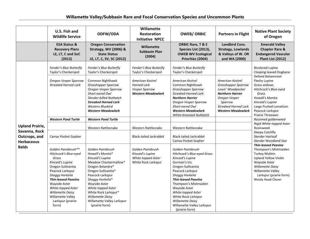
Willamette Valley/Subbasin Rare and Focal Conservation Species and Uncommon Plants
U.S. Fish and Wildlife Service ODFW/ODA
Willamette Restoration
Initiative NPCC OWEB/ ORBIC Partners in Flight Native Plant Society
of Oregon
ESA Status & Recovery Plans
LE, LT, C and SoC (2013)
Oregon Conservation Strategy, WV (2006) &
State Status LE, LT, C, SV, SC (2012)
Willamette Subbasin Plan
(2004)
ORBIC Rare, T & E Species List (2013),
OWEB WV Ecological Priorities (2004)
Landbird Cons. Strategy, Lowlands & Valleys of W. OR
and WA (2000)
Emerald Valley Chapter Rare &
Endangered Vascular Plant List (2012)
Upland Prairie, Savanna, Rock Outcrops, and Herbaceous Balds
Fender’s Blue Butterfly Taylor’s Checkerspot Oregon Vesper Sparrow Streaked Horned Lark Western Pond Turtle Camas Pocket Gopher Golden Paintbrush** Hitchcock’s Blue-eyed
Grass Kincaid’s Lupine Oregon Sullivantia Peacock Larkspur Shaggy Horkelia Thin-leaved Peavine Wayside Aster White-topped Aster Willamette Daisy Willamette Valley
Larkspur (prairie form)
Fender’s Blue Butterfly Taylor’s Checkerspot Common Nighthawk Grasshopper Sparrow Oregon Vesper Sparrow Short-eared Owl Slender-billed Nuthatch Streaked Horned Lark Western Bluebird Western Meadowlark Western Pond Turtle Western Rattlesnake Golden Paintbrush Howell’s Montia* Kincaid’s Lupine Meadow Checkermallow* Oregon Bolandra* Oregon Sullivantia* Peacock Larkspur Shaggy Horkelia* Wayside Aster White-topped Aster White Rock Larkspur* Willamette Daisy Willamette Valley Larkspur
(prairie form)
Fender’s Blue Butterfly Taylor’s Checkerspot American Kestrel Horned Lark Vesper Sparrow Western Meadowlark Western Rattlesnake Black-tailed Jackrabbit Golden Paintbrush Kincaid’s Lupine White-topped Aster White Rock Larkspur
Fender’s Blue Butterfly Taylor’s Checkerspot American Kestrel Common Nighthawk Grasshopper Sparrow Streaked Horned Lark Northern Harrier Oregon Vesper Sparrow Short-eared Owl Western Meadowlark White-breasted Nuthatch Western Rattlesnake Black-tailed Jackrabbit Camas Pocket Gopher Golden Paintbrush Hitchcock’s Blue-eyed Grass Kincaid’s Lupine Gorman’s Iris Oregon Sullivantia Peacock Larkspur Shaggy Horkelia Thin-leaved Peavine Thompson’s Mistmaiden Wayside Aster White-topped Aster White Rock Larkspur Willamette Daisy Willamette Valley Larkspur
(prairie form)
American Kestrel Grasshopper Sparrow Lewis’ Woodpecker Northern Harrier Oregon Vesper
Sparrow Streaked Horned Lark Western Meadowlark
Bicolored Lupine Clasping-leaved Dogbane Deltoid Balsamroot Fleshy Lupine Grass widows Hitchcock’s Blue-eyed
Grass Howell’s Montia Kincaid’s Lupine Large Fruited Lomatium Peacock Larkspur Prairie Threeawn Racemed goldenweed Rigid White-topped Aster Rosinweed Sleepy Catchfly Slender Hairleaf Slender Woodland Star Thin-leaved Peavine Thompson’s Mistmaiden Turkey Mullein Upland Yellow Violet Wayside Aster Willamette Daisy Willamette Valley
Larkspur (prairie form) Wooly Head Clover

Willamette Valley/Subbasin Rare and Focal Conservation Species and Uncommon Plants
U.S. Fish and Wildlife Service ODFW/ODA
Willamette Restoration
Initiative NPCC OWEB/ ORBIC Partners in Flight Native Plant Society
of Oregon
ESA Status & Recovery Plans
LE, LT, C and SoC (2013)
Oregon Conservation Strategy, WV (2006) &
State Status LE, LT, C, SV, SC (2012)
Willamette Subbasin Plan
(2004)
ORBIC Rare, T & E Species List (2013),
OWEB WV Ecological Priorities (2004)
Landbird Cons. Strategy, Lowlands & Valleys of W. OR
and WA (2000)
Emerald Valley Chapter Rare &
Endangered Vascular Plant List (2012)
Wetland Prairie and Seasonal Marsh/ Emergent Wetland
Northern Red-legged
Frog Western Pond Turtle Bradshaw’s Lomatium Hitchcock’s Blue-eyed
Grass Nelson’s
Checkermallow Peacock larkspur Shaggy Horkelia White-topped Aster Willamette Daisy
American Grass Bug Dusky Canada Goose Western Meadowlark Short-eared Owl Northern Red-legged Frog Northwestern Pond Turtle Western Painted Turtle Bradshaw’s Lomatium Hitchcock’s Blue-eyed Grass Howell’s Montia* Nelson’s Checkermallow Peacock Larkspur Shaggy Horkelia* Willamette Daisy White-topped Aster
Dunlin Common Yellowthroat Northern Harrier Sora Northern Red-legged
Frog Bradshaw’s Lomatium Peacock larkspur Nelson’s Checkermallow Willamette Daisy
Black Tern Dunlin Dusky Canada Goose Peregrine Falcon Western Meadowlark Short-eared Owl White-tailed Kite Bradshaw’s Lomatium Hitchcock’s Blue-eyed Grass Nelson’s Checkermallow Peacock Larkspur Shaggy Horkelia White-topped Aster Willamette Daisy Willamette Navarretia
Grasshopper Sparrow Northern Harrier Streaked Horned Lark Western Meadowlark
Bradshaw’s Lomatium Blue verbena California Broomrape Close Flowered Knotweed Dwarf Montia Dwarf Rush False golden sedge Hemp Dogbane Howell’s Brodiaea Howell’s Montia Indian Pink Large-flowered Startulip Large Flowered Toadflax Large Godetia Lobb’s Buttercup Mad Dog Skullcap Narrowleaf Milkweed Hitchcock’s Blue-eyed
Grass Meadow Checkermallow Pacific Brome Pale Bulrush Rigid White-topped Aster Shaggy Horkelia Slenderspike Mannagrass Slender Woolyheads Smooth Goldfields Timwort Tooth Cup Willamette Daisy Willamette Navarretia Western Goldenrod Western Hedge Parsley
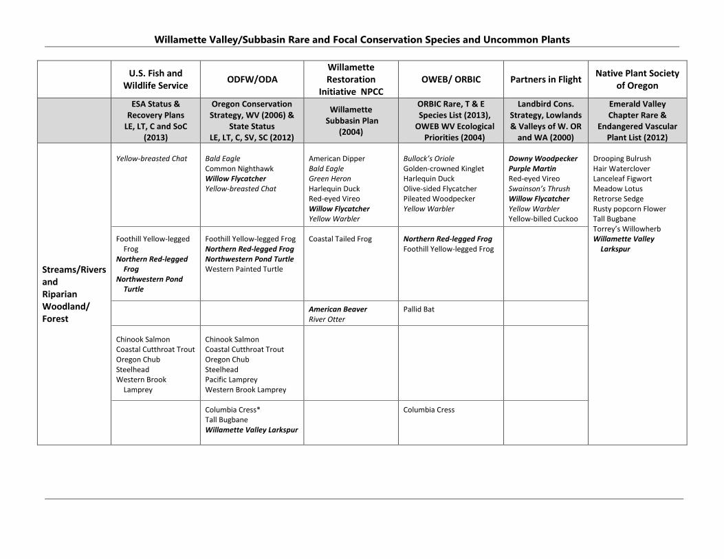
Willamette Valley/Subbasin Rare and Focal Conservation Species and Uncommon Plants
U.S. Fish and Wildlife Service ODFW/ODA
Willamette Restoration
Initiative NPCC OWEB/ ORBIC Partners in Flight Native Plant Society
of Oregon
ESA Status & Recovery Plans
LE, LT, C and SoC (2013)
Oregon Conservation Strategy, WV (2006) &
State Status LE, LT, C, SV, SC (2012)
Willamette Subbasin Plan
(2004)
ORBIC Rare, T & E Species List (2013),
OWEB WV Ecological Priorities (2004)
Landbird Cons. Strategy, Lowlands & Valleys of W. OR
and WA (2000)
Emerald Valley Chapter Rare &
Endangered Vascular Plant List (2012)
Streams/Rivers and Riparian Woodland/ Forest
Yellow-breasted Chat Foothill Yellow-legged
Frog Northern Red-legged
Frog Northwestern Pond
Turtle Chinook Salmon Coastal Cutthroat Trout Oregon Chub Steelhead Western Brook
Lamprey
Bald Eagle Common Nighthawk Willow Flycatcher Yellow-breasted Chat Foothill Yellow-legged Frog Northern Red-legged Frog Northwestern Pond Turtle Western Painted Turtle Chinook Salmon Coastal Cutthroat Trout Oregon Chub Steelhead Pacific Lamprey Western Brook Lamprey Columbia Cress* Tall Bugbane Willamette Valley Larkspur
American Dipper Bald Eagle Green Heron Harlequin Duck Red-eyed Vireo Willow Flycatcher Yellow Warbler Coastal Tailed Frog American Beaver River Otter
Bullock’s Oriole Golden-crowned Kinglet Harlequin Duck Olive-sided Flycatcher Pileated Woodpecker Yellow Warbler Northern Red-legged Frog Foothill Yellow-legged Frog Pallid Bat Columbia Cress
Downy Woodpecker Purple Martin Red-eyed Vireo Swainson’s Thrush Willow Flycatcher Yellow Warbler Yellow-billed Cuckoo
Drooping Bulrush Hair Waterclover Lanceleaf Figwort Meadow Lotus Retrorse Sedge Rusty popcorn Flower Tall Bugbane Torrey’s Willowherb Willamette Valley
Larkspur
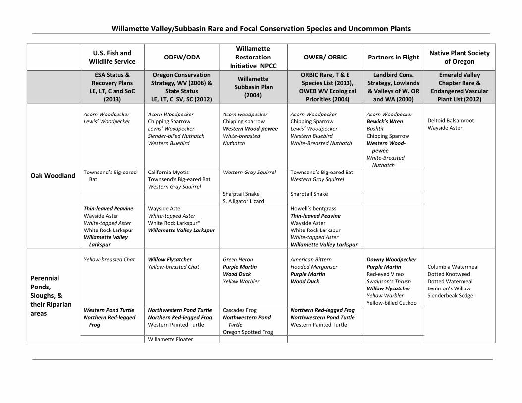
Willamette Valley/Subbasin Rare and Focal Conservation Species and Uncommon Plants
U.S. Fish and Wildlife Service ODFW/ODA
Willamette Restoration
Initiative NPCC OWEB/ ORBIC Partners in Flight Native Plant Society
of Oregon
ESA Status & Recovery Plans
LE, LT, C and SoC (2013)
Oregon Conservation Strategy, WV (2006) &
State Status LE, LT, C, SV, SC (2012)
Willamette Subbasin Plan
(2004)
ORBIC Rare, T & E Species List (2013),
OWEB WV Ecological Priorities (2004)
Landbird Cons. Strategy, Lowlands & Valleys of W. OR
and WA (2000)
Emerald Valley Chapter Rare &
Endangered Vascular Plant List (2012)
Oak Woodland
Acorn Woodpecker Lewis’ Woodpecker Townsend’s Big-eared
Bat Thin-leaved Peavine Wayside Aster White-topped Aster White Rock Larkspur Willamette Valley
Larkspur
Acorn Woodpecker Chipping Sparrow Lewis’ Woodpecker Slender-billed Nuthatch Western Bluebird California Myotis Townsend’s Big-eared Bat Western Gray Squirrel Wayside Aster White-topped Aster White Rock Larkspur* Willamette Valley Larkspur
Acorn woodpecker Chipping sparrow Western Wood-pewee White-breasted Nuthatch Western Gray Squirrel Sharptail Snake S. Alligator Lizard
Acorn Woodpecker Chipping Sparrow Lewis’ Woodpecker Western Bluebird White-Breasted Nuthatch Townsend’s Big-eared Bat Western Gray Squirrel Sharptail Snake Howell’s bentgrass Thin-leaved Peavine Wayside Aster White Rock Larkspur White-topped Aster Willamette Valley Larkspur
Acorn Woodpecker Bewick’s Wren Bushtit Chipping Sparrow Western Wood-
pewee White-Breasted
Nuthatch
Deltoid Balsamroot Wayside Aster
Perennial Ponds, Sloughs, & their Riparian areas
Yellow-breasted Chat Western Pond Turtle Northern Red-legged
Frog
Willow Flycatcher Yellow-breasted Chat Northwestern Pond Turtle Northern Red-legged Frog Western Painted Turtle Willamette Floater
Green Heron Purple Martin Wood Duck Yellow Warbler Cascades Frog Northwestern Pond
Turtle Oregon Spotted Frog
American Bittern Hooded Merganser Purple Martin Wood Duck Northern Red-legged Frog Northwestern Pond Turtle Western Painted Turtle
Downy Woodpecker Purple Martin Red-eyed Vireo Swainson’s Thrush Willow Flycatcher Yellow Warbler Yellow-billed Cuckoo
Columbia Watermeal Dotted Knotweed Dotted Watermeal Lemmon’s Willow Slenderbeak Sedge

APPENDIX 3
PROPERTY LEGAL DESCRIPTION
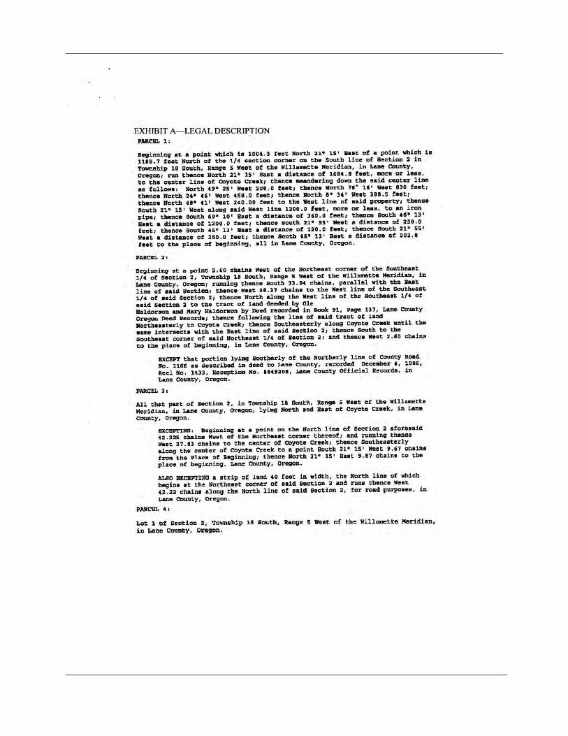
APPENDIX 4
HISTORICAL AERIAL PHOTOS
APPENDIX 5
PLANT AND WILDLIFE SPECIES INVENTORY
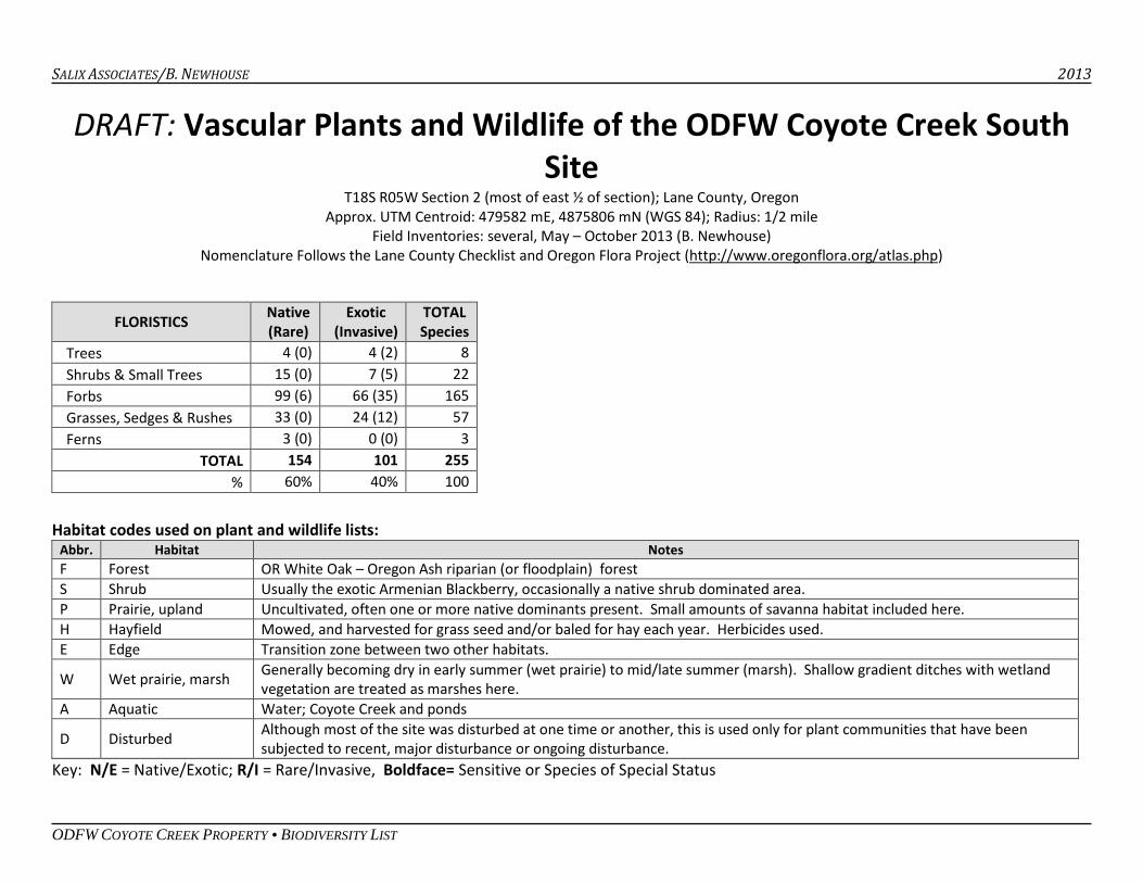
SALIX ASSOCIATES/B. NEWHOUSE 2013
ODFW COYOTE CREEK PROPERTY • BIODIVERSITY LIST
DRAFT: Vascular Plants and Wildlife of the ODFW Coyote Creek South Site
T18S R05W Section 2 (most of east ½ of section); Lane County, Oregon Approx. UTM Centroid: 479582 mE, 4875806 mN (WGS 84); Radius: 1/2 mile
Field Inventories: several, May – October 2013 (B. Newhouse) Nomenclature Follows the Lane County Checklist and Oregon Flora Project (http://www.oregonflora.org/atlas.php)
Habitat codes used on plant and wildlife lists:
Abbr. Habitat Notes F Forest OR White Oak – Oregon Ash riparian (or floodplain) forest S Shrub Usually the exotic Armenian Blackberry, occasionally a native shrub dominated area. P Prairie, upland Uncultivated, often one or more native dominants present. Small amounts of savanna habitat included here. H Hayfield Mowed, and harvested for grass seed and/or baled for hay each year. Herbicides used. E Edge Transition zone between two other habitats.
W Wet prairie, marsh Generally becoming dry in early summer (wet prairie) to mid/late summer (marsh). Shallow gradient ditches with wetland vegetation are treated as marshes here.
A Aquatic Water; Coyote Creek and ponds
D Disturbed Although most of the site was disturbed at one time or another, this is used only for plant communities that have been subjected to recent, major disturbance or ongoing disturbance.
Key: N/E = Native/Exotic; R/I = Rare/Invasive, Boldface= Sensitive or Species of Special Status
FLORISTICS Native (Rare)
Exotic (Invasive)
TOTAL Species
Trees 4 (0) 4 (2) 8 Shrubs & Small Trees 15 (0) 7 (5) 22 Forbs 99 (6) 66 (35) 165 Grasses, Sedges & Rushes 33 (0) 24 (12) 57 Ferns 3 (0) 0 (0) 3
TOTAL 154 101 255 % 60% 40% 100
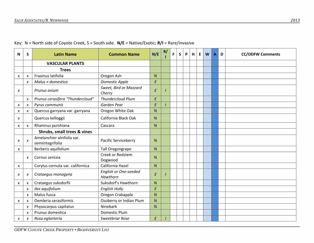
SALIX ASSOCIATES/B. NEWHOUSE 2013
ODFW COYOTE CREEK PROPERTY • BIODIVERSITY LIST
Key: N = North side of Coyote Creek, S = South side. N/E = Native/Exotic; R/I = Rare/Invasive
N S Latin Name Common Name N/E R/ I F S P H E W A D CC/ODFW Comments
VASCULAR PLANTS Trees x x Fraxinus latifolia Oregon Ash N x Malus × domestica Domestic Apple E
x Prunus avium Sweet, Bird or Mazzard Cherry E I
x Prunus cerasifera “Thundercloud” Thundercloud Plum E x x Pyrus communis Garden Pear E I x x Quercus garryana var. garryana Oregon White Oak N
x Quercus kelloggii California Black Oak N x x Rhamnus purshiana Cascara N Shrubs, small trees & vines
x x Amelanchier alnifolia var. semiintegrifolia Pacific Serviceberry N
x Berberis aquifolium Tall Oregongrape N
x Cornus sericea Creek or Redstem Dogwood N
x Corylus cornuta var. californica California Hazel N
x x Crataegus monogyna English or One-seeded Hawthorn E I
x x Crataegus suksdorfii Suksdorf’s Hawthorn N x Ilex aquifolium English Holly E x Malus fusca Oregon Crabapple N x x Oemleria cerasiformis Osoberry or Indian Plum N x Physocarpus capitatus Ninebark N x Prunus domestica Domestic Plum x x Rosa eglanteria Sweetbriar Rose E I
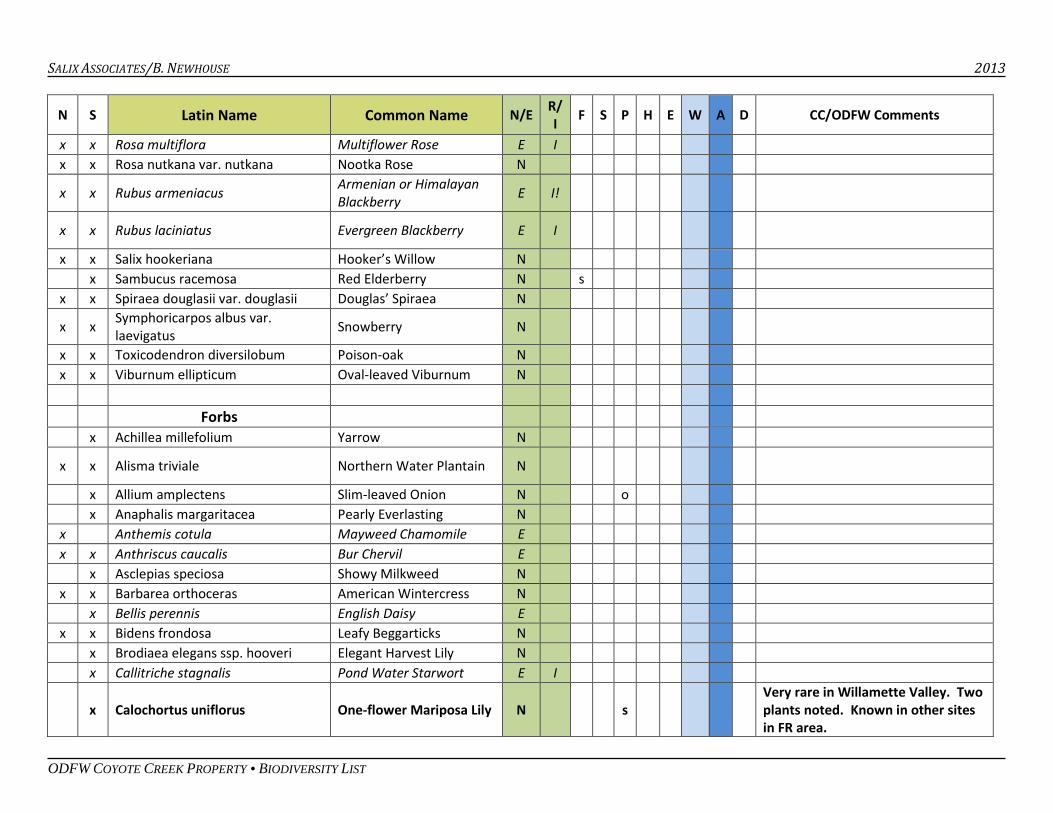
SALIX ASSOCIATES/B. NEWHOUSE 2013
ODFW COYOTE CREEK PROPERTY • BIODIVERSITY LIST
N S Latin Name Common Name N/E R/ I F S P H E W A D CC/ODFW Comments
x x Rosa multiflora Multiflower Rose E I x x Rosa nutkana var. nutkana Nootka Rose N
x x Rubus armeniacus Armenian or Himalayan Blackberry E I!
x x Rubus laciniatus Evergreen Blackberry E I
x x Salix hookeriana Hooker’s Willow N x Sambucus racemosa Red Elderberry N s x x Spiraea douglasii var. douglasii Douglas’ Spiraea N
x x Symphoricarpos albus var. laevigatus Snowberry N
x x Toxicodendron diversilobum Poison-oak N x x Viburnum ellipticum Oval-leaved Viburnum N Forbs x Achillea millefolium Yarrow N
x x Alisma triviale Northern Water Plantain N
x Allium amplectens Slim-leaved Onion N o x Anaphalis margaritacea Pearly Everlasting N x Anthemis cotula Mayweed Chamomile E x x Anthriscus caucalis Bur Chervil E x Asclepias speciosa Showy Milkweed N x x Barbarea orthoceras American Wintercress N x Bellis perennis English Daisy E x x Bidens frondosa Leafy Beggarticks N x Brodiaea elegans ssp. hooveri Elegant Harvest Lily N x Callitriche stagnalis Pond Water Starwort E I
x Calochortus uniflorus One-flower Mariposa Lily N s Very rare in Willamette Valley. Two plants noted. Known in other sites in FR area.
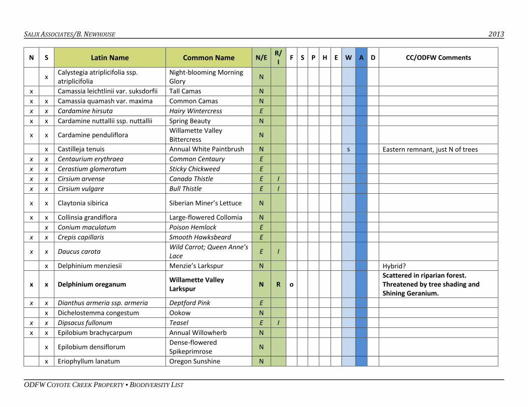
SALIX ASSOCIATES/B. NEWHOUSE 2013
ODFW COYOTE CREEK PROPERTY • BIODIVERSITY LIST
N S Latin Name Common Name N/E R/ I F S P H E W A D CC/ODFW Comments
x Calystegia atriplicifolia ssp. atriplicifolia
Night-blooming Morning Glory N
x Camassia leichtlinii var. suksdorfii Tall Camas N x x Camassia quamash var. maxima Common Camas N x x Cardamine hirsuta Hairy Wintercress E x x Cardamine nuttallii ssp. nuttallii Spring Beauty N
x x Cardamine penduliflora Willamette Valley Bittercress N
x Castilleja tenuis Annual White Paintbrush N s Eastern remnant, just N of trees x x Centaurium erythraea Common Centaury E x x Cerastium glomeratum Sticky Chickweed E x x Cirsium arvense Canada Thistle E I x x Cirsium vulgare Bull Thistle E I
x x Claytonia sibirica Siberian Miner’s Lettuce N
x x Collinsia grandiflora Large-flowered Collomia N x Conium maculatum Poison Hemlock E x x Crepis capillaris Smooth Hawksbeard E
x x Daucus carota Wild Carrot; Queen Anne’s Lace E I
x Delphinium menziesii Menzie’s Larkspur N Hybrid?
x x Delphinium oreganum Willamette Valley Larkspur N R o
Scattered in riparian forest. Threatened by tree shading and Shining Geranium.
x x Dianthus armeria ssp. armeria Deptford Pink E x Dichelostemma congestum Ookow N x x Dipsacus fullonum Teasel E I x x Epilobium brachycarpum Annual Willowherb N
x Epilobium densiflorum Dense-flowered Spikeprimrose N
x Eriophyllum lanatum Oregon Sunshine N
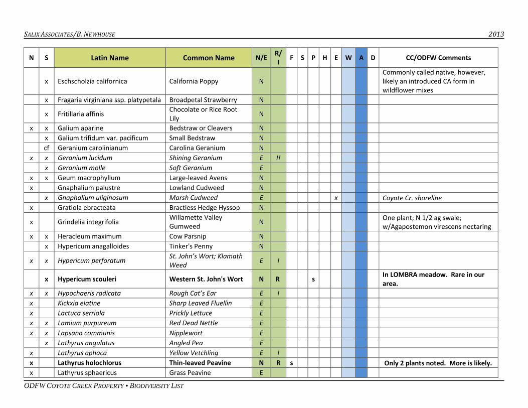
SALIX ASSOCIATES/B. NEWHOUSE 2013
ODFW COYOTE CREEK PROPERTY • BIODIVERSITY LIST
N S Latin Name Common Name N/E R/ I F S P H E W A D CC/ODFW Comments
x Eschscholzia californica California Poppy N Commonly called native, however, likely an introduced CA form in wildflower mixes
x Fragaria virginiana ssp. platypetala Broadpetal Strawberry N
x Fritillaria affinis Chocolate or Rice Root Lily N
x x Galium aparine Bedstraw or Cleavers N x Galium trifidum var. pacificum Small Bedstraw N cf Geranium carolinianum Carolina Geranium N x x Geranium lucidum Shining Geranium E I! x Geranium molle Soft Geranium E x x Geum macrophyllum Large-leaved Avens N x Gnaphalium palustre Lowland Cudweed N x Gnaphalium uliginosum Marsh Cudweed E x Coyote Cr. shoreline x Gratiola ebracteata Bractless Hedge Hyssop N
x Grindelia integrifolia Willamette Valley Gumweed N One plant; N 1/2 ag swale;
w/Agapostemon virescens nectaring x x Heracleum maximum Cow Parsnip N x Hypericum anagalloides Tinker's Penny N
x x Hypericum perforatum St. John’s Wort; Klamath Weed E I
x Hypericum scouleri Western St. John's Wort N R s In LOMBRA meadow. Rare in our area.
x x Hypochaeris radicata Rough Cat’s Ear E I x Kickxia elatine Sharp Leaved Fluellin E x Lactuca serriola Prickly Lettuce E x x Lamium purpureum Red Dead Nettle E x x Lapsana communis Nipplewort E x Lathyrus angulatus Angled Pea E x Lathyrus aphaca Yellow Vetchling E I x Lathyrus holochlorus Thin-leaved Peavine N R s Only 2 plants noted. More is likely. x Lathyrus sphaericus Grass Peavine E
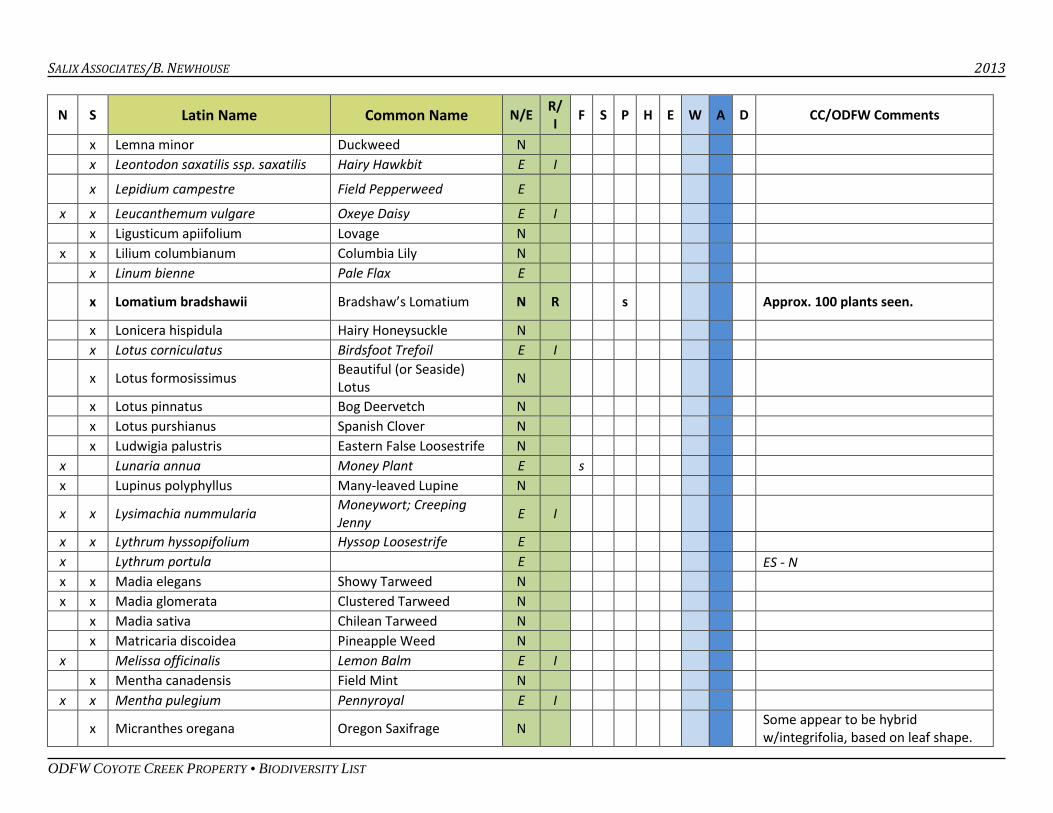
SALIX ASSOCIATES/B. NEWHOUSE 2013
ODFW COYOTE CREEK PROPERTY • BIODIVERSITY LIST
N S Latin Name Common Name N/E R/ I F S P H E W A D CC/ODFW Comments
x Lemna minor Duckweed N x Leontodon saxatilis ssp. saxatilis Hairy Hawkbit E I
x Lepidium campestre Field Pepperweed E x x Leucanthemum vulgare Oxeye Daisy E I x Ligusticum apiifolium Lovage N x x Lilium columbianum Columbia Lily N x Linum bienne Pale Flax E
x Lomatium bradshawii Bradshaw’s Lomatium N R s Approx. 100 plants seen.
x Lonicera hispidula Hairy Honeysuckle N x Lotus corniculatus Birdsfoot Trefoil E I
x Lotus formosissimus Beautiful (or Seaside) Lotus N
x Lotus pinnatus Bog Deervetch N x Lotus purshianus Spanish Clover N x Ludwigia palustris Eastern False Loosestrife N x Lunaria annua Money Plant E s x Lupinus polyphyllus Many-leaved Lupine N
x x Lysimachia nummularia Moneywort; Creeping Jenny E I
x x Lythrum hyssopifolium Hyssop Loosestrife E x Lythrum portula E ES - N x x Madia elegans Showy Tarweed N x x Madia glomerata Clustered Tarweed N x Madia sativa Chilean Tarweed N x Matricaria discoidea Pineapple Weed N x Melissa officinalis Lemon Balm E I x Mentha canadensis Field Mint N x x Mentha pulegium Pennyroyal E I
x Micranthes oregana Oregon Saxifrage N Some appear to be hybrid w/integrifolia, based on leaf shape.
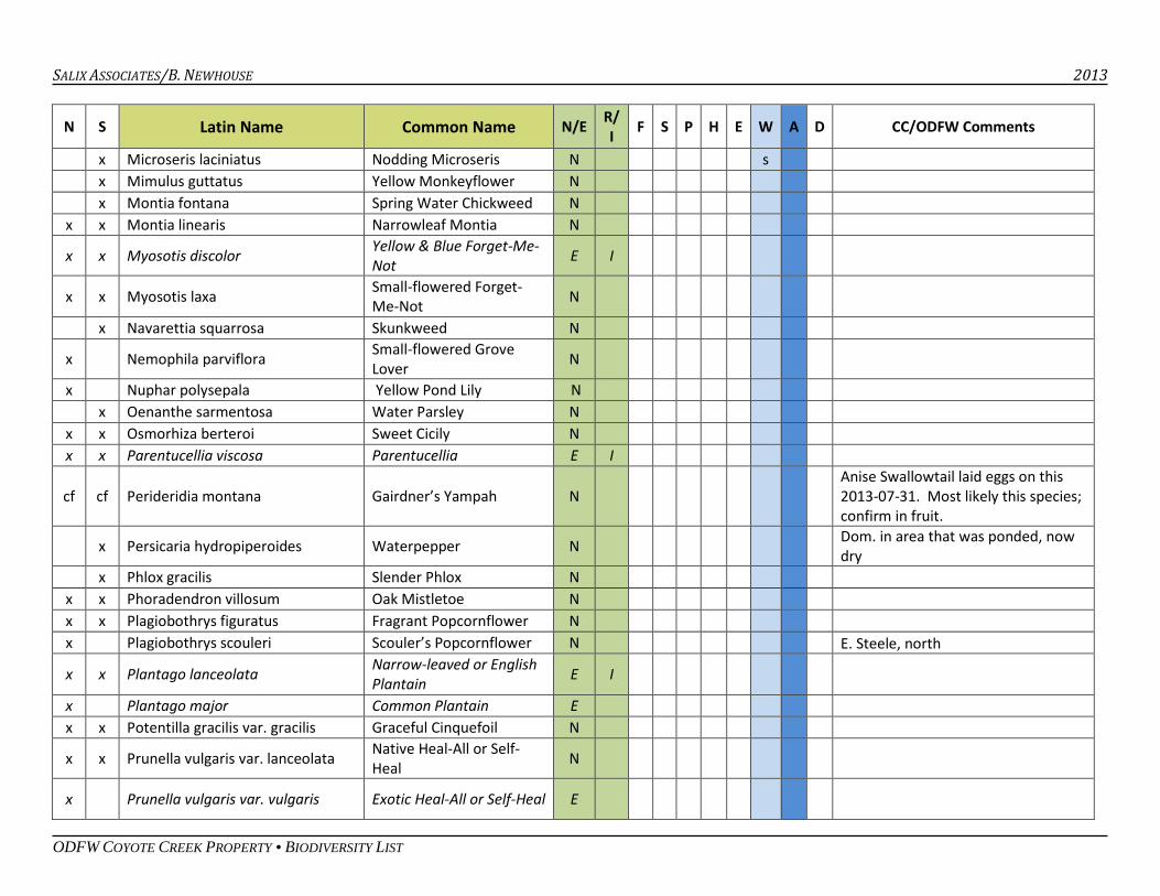
SALIX ASSOCIATES/B. NEWHOUSE 2013
ODFW COYOTE CREEK PROPERTY • BIODIVERSITY LIST
N S Latin Name Common Name N/E R/ I F S P H E W A D CC/ODFW Comments
x Microseris laciniatus Nodding Microseris N s x Mimulus guttatus Yellow Monkeyflower N x Montia fontana Spring Water Chickweed N x x Montia linearis Narrowleaf Montia N
x x Myosotis discolor Yellow & Blue Forget-Me-Not E I
x x Myosotis laxa Small-flowered Forget-Me-Not N
x Navarettia squarrosa Skunkweed N
x Nemophila parviflora Small-flowered Grove Lover N
x Nuphar polysepala Yellow Pond Lily N x Oenanthe sarmentosa Water Parsley N x x Osmorhiza berteroi Sweet Cicily N x x Parentucellia viscosa Parentucellia E I
cf cf Perideridia montana Gairdner’s Yampah N Anise Swallowtail laid eggs on this 2013-07-31. Most likely this species; confirm in fruit.
x Persicaria hydropiperoides Waterpepper N Dom. in area that was ponded, now dry
x Phlox gracilis Slender Phlox N x x Phoradendron villosum Oak Mistletoe N x x Plagiobothrys figuratus Fragrant Popcornflower N x Plagiobothrys scouleri Scouler’s Popcornflower N E. Steele, north
x x Plantago lanceolata Narrow-leaved or English Plantain E I
x Plantago major Common Plantain E x x Potentilla gracilis var. gracilis Graceful Cinquefoil N
x x Prunella vulgaris var. lanceolata Native Heal-All or Self-Heal N
x Prunella vulgaris var. vulgaris Exotic Heal-All or Self-Heal E
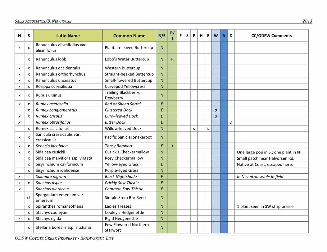
SALIX ASSOCIATES/B. NEWHOUSE 2013
ODFW COYOTE CREEK PROPERTY • BIODIVERSITY LIST
N S Latin Name Common Name N/E R/ I F S P H E W A D CC/ODFW Comments
x x Ranunculus alismifolius var. alismifolius Plantain-leaved Buttercup N
x Ranunculus lobbii Lobb’s Water Buttercup N R
x x Ranunculus occidentalis Western Buttercup N x x Ranunculus orthorhynchus Straight-beaked Buttercup N x x Ranunculus uncinatus Small-flowered Buttercup N x x Rorippa curvisiliqua Curvepod Yellowcress N
x x Rubus ursinus Trailing Blackberry; Dewberry N
x x Rumex acetosella Red or Sheep Sorrel E x Rumex conglomeratus Clustered Dock E o x x Rumex crispus Curly-leaved Dock E o x Rumex obtusifolius Bitter Dock E s x Rumex salicifolius Willow-leaved Dock N s s
x x Sanicula crassicaulis var. crassicaulis Pacific Sanicle; Snakeroot N
x x Senecio jacobaea Tansy Ragwort E I x x Sidalcea cusickii Cusick’s Checkermallow N One large pop in S.; one plant in N x Sidalcea malviflora ssp. virgata Rosy Checkermallow N Small patch near Halvorsen Rd. x Sisyrinchium californicum Yellow-eyed Grass E Native at Coast, escaped here. x Sisyrinchium idahoense Purple-eyed Grass N x Solanum nigrum Black Nightshade E In N central swale in field x x Sonchus asper Prickly Sow Thistle E x Sonchus oleraceus Common Sow Thistle E
cf Sparganium emersum var. emersum Simple Stem Bur Reed N
x Spiranthes romanzoffiana Ladies Tresses N 1 plant seen in SW strip prairie x Stachys cooleyae Cooley's Hedgenettle N x x Stachys rigida Rigid Hedgenettle N
x Stellaria borealis ssp. sitchana Few Flowered Northern Starwort N
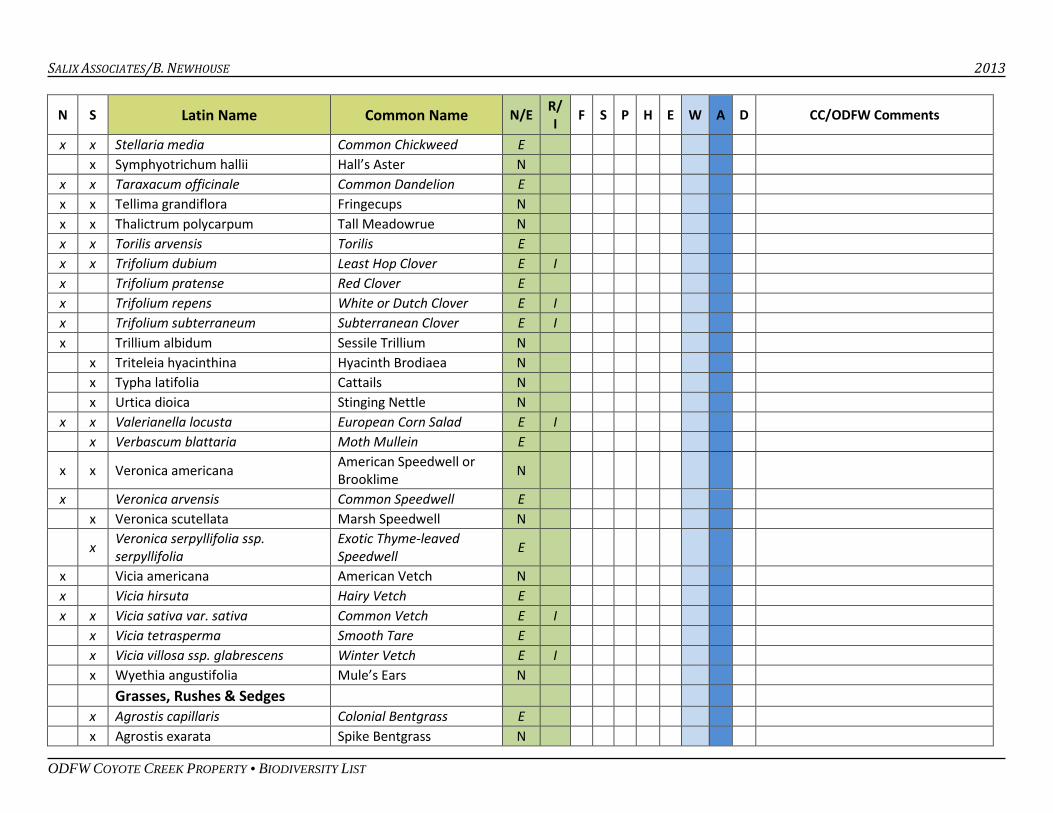
SALIX ASSOCIATES/B. NEWHOUSE 2013
ODFW COYOTE CREEK PROPERTY • BIODIVERSITY LIST
N S Latin Name Common Name N/E R/ I F S P H E W A D CC/ODFW Comments
x x Stellaria media Common Chickweed E x Symphyotrichum hallii Hall’s Aster N x x Taraxacum officinale Common Dandelion E x x Tellima grandiflora Fringecups N x x Thalictrum polycarpum Tall Meadowrue N x x Torilis arvensis Torilis E x x Trifolium dubium Least Hop Clover E I x Trifolium pratense Red Clover E x Trifolium repens White or Dutch Clover E I x Trifolium subterraneum Subterranean Clover E I x Trillium albidum Sessile Trillium N x Triteleia hyacinthina Hyacinth Brodiaea N x Typha latifolia Cattails N x Urtica dioica Stinging Nettle N x x Valerianella locusta European Corn Salad E I x Verbascum blattaria Moth Mullein E
x x Veronica americana American Speedwell or Brooklime N
x Veronica arvensis Common Speedwell E x Veronica scutellata Marsh Speedwell N
x Veronica serpyllifolia ssp. serpyllifolia
Exotic Thyme-leaved Speedwell E
x Vicia americana American Vetch N x Vicia hirsuta Hairy Vetch E x x Vicia sativa var. sativa Common Vetch E I x Vicia tetrasperma Smooth Tare E x Vicia villosa ssp. glabrescens Winter Vetch E I x Wyethia angustifolia Mule’s Ears N Grasses, Rushes & Sedges x Agrostis capillaris Colonial Bentgrass E x Agrostis exarata Spike Bentgrass N
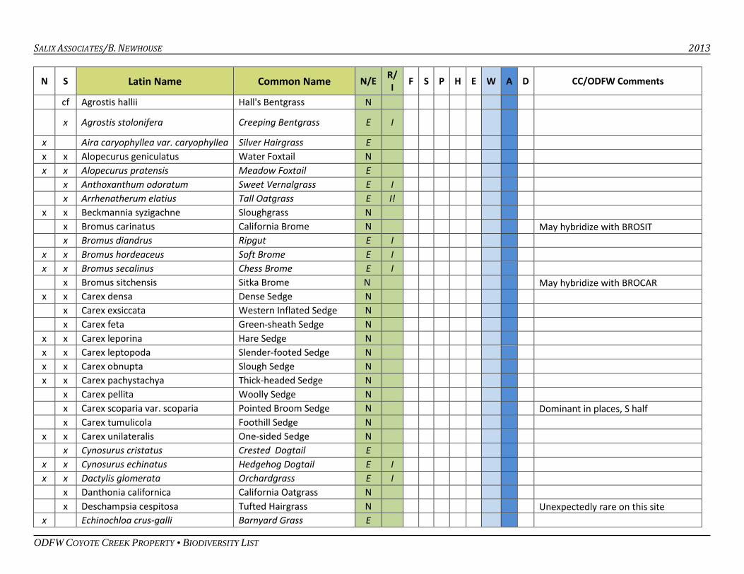
SALIX ASSOCIATES/B. NEWHOUSE 2013
ODFW COYOTE CREEK PROPERTY • BIODIVERSITY LIST
N S Latin Name Common Name N/E R/ I F S P H E W A D CC/ODFW Comments
cf Agrostis hallii Hall's Bentgrass N
x Agrostis stolonifera Creeping Bentgrass E I
x Aira caryophyllea var. caryophyllea Silver Hairgrass E x x Alopecurus geniculatus Water Foxtail N x x Alopecurus pratensis Meadow Foxtail E x Anthoxanthum odoratum Sweet Vernalgrass E I x Arrhenatherum elatius Tall Oatgrass E I! x x Beckmannia syzigachne Sloughgrass N x Bromus carinatus California Brome N May hybridize with BROSIT x Bromus diandrus Ripgut E I x x Bromus hordeaceus Soft Brome E I x x Bromus secalinus Chess Brome E I x Bromus sitchensis Sitka Brome N May hybridize with BROCAR x x Carex densa Dense Sedge N x Carex exsiccata Western Inflated Sedge N x Carex feta Green-sheath Sedge N x x Carex leporina Hare Sedge N x x Carex leptopoda Slender-footed Sedge N x x Carex obnupta Slough Sedge N x x Carex pachystachya Thick-headed Sedge N x Carex pellita Woolly Sedge N x Carex scoparia var. scoparia Pointed Broom Sedge N Dominant in places, S half x Carex tumulicola Foothill Sedge N x x Carex unilateralis One-sided Sedge N x Cynosurus cristatus Crested Dogtail E x x Cynosurus echinatus Hedgehog Dogtail E I x x Dactylis glomerata Orchardgrass E I x Danthonia californica California Oatgrass N x Deschampsia cespitosa Tufted Hairgrass N Unexpectedly rare on this site x Echinochloa crus-galli Barnyard Grass E
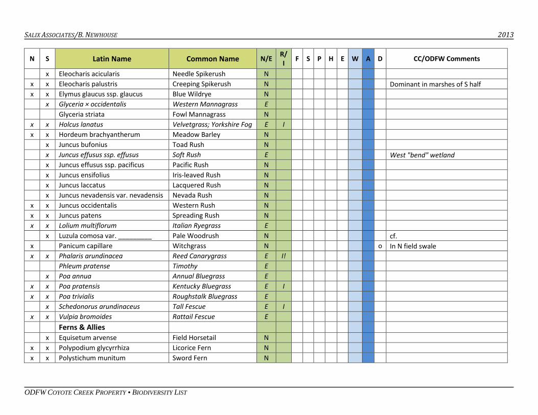
SALIX ASSOCIATES/B. NEWHOUSE 2013
ODFW COYOTE CREEK PROPERTY • BIODIVERSITY LIST
N S Latin Name Common Name N/E R/ I F S P H E W A D CC/ODFW Comments
x Eleocharis acicularis Needle Spikerush N x x Eleocharis palustris Creeping Spikerush N Dominant in marshes of S half x x Elymus glaucus ssp. glaucus Blue Wildrye N x Glyceria × occidentalis Western Mannagrass E Glyceria striata Fowl Mannagrass N x x Holcus lanatus Velvetgrass; Yorkshire Fog E I x x Hordeum brachyantherum Meadow Barley N x Juncus bufonius Toad Rush N x Juncus effusus ssp. effusus Soft Rush E West "bend" wetland x Juncus effusus ssp. pacificus Pacific Rush N x Juncus ensifolius Iris-leaved Rush N x Juncus laccatus Lacquered Rush N x Juncus nevadensis var. nevadensis Nevada Rush N x x Juncus occidentalis Western Rush N x x Juncus patens Spreading Rush N x x Lolium multiflorum Italian Ryegrass E x Luzula comosa var. _________ Pale Woodrush N cf. x Panicum capillare Witchgrass N o In N field swale x x Phalaris arundinacea Reed Canarygrass E I! Phleum pratense Timothy E x Poa annua Annual Bluegrass E x x Poa pratensis Kentucky Bluegrass E I x x Poa trivialis Roughstalk Bluegrass E x Schedonorus arundinaceus Tall Fescue E I x x Vulpia bromoides Rattail Fescue E Ferns & Allies x Equisetum arvense Field Horsetail N x x Polypodium glycyrrhiza Licorice Fern N x x Polystichum munitum Sword Fern N
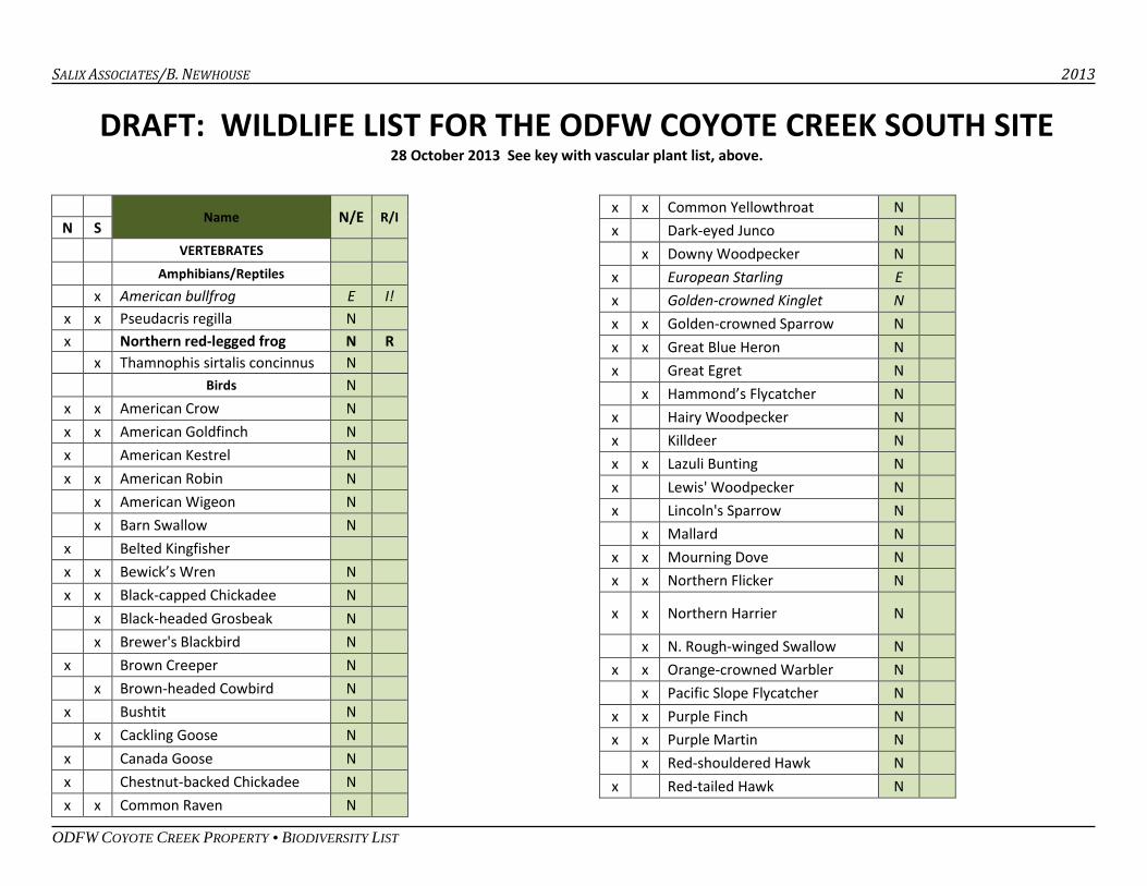
SALIX ASSOCIATES/B. NEWHOUSE 2013
ODFW COYOTE CREEK PROPERTY • BIODIVERSITY LIST
DRAFT: WILDLIFE LIST FOR THE ODFW COYOTE CREEK SOUTH SITE 28 October 2013 See key with vascular plant list, above.
Name N/E R/I N S VERTEBRATES
Amphibians/Reptiles x American bullfrog E I! x x Pseudacris regilla N x Northern red-legged frog N R x Thamnophis sirtalis concinnus N Birds N
x x American Crow N x x American Goldfinch N x American Kestrel N x x American Robin N x American Wigeon N x Barn Swallow N x Belted Kingfisher x x Bewick’s Wren N x x Black-capped Chickadee N x Black-headed Grosbeak N x Brewer's Blackbird N x Brown Creeper N x Brown-headed Cowbird N x Bushtit N x Cackling Goose N x Canada Goose N x Chestnut-backed Chickadee N x x Common Raven N
x x Common Yellowthroat N x Dark-eyed Junco N x Downy Woodpecker N x European Starling E x Golden-crowned Kinglet N x x Golden-crowned Sparrow N x x Great Blue Heron N x Great Egret N x Hammond’s Flycatcher N x Hairy Woodpecker N x Killdeer N x x Lazuli Bunting N x Lewis' Woodpecker N x Lincoln's Sparrow N x Mallard N x x Mourning Dove N x x Northern Flicker N
x x Northern Harrier N
x N. Rough-winged Swallow N x x Orange-crowned Warbler N x Pacific Slope Flycatcher N x x Purple Finch N x x Purple Martin N x Red-shouldered Hawk N x Red-tailed Hawk N
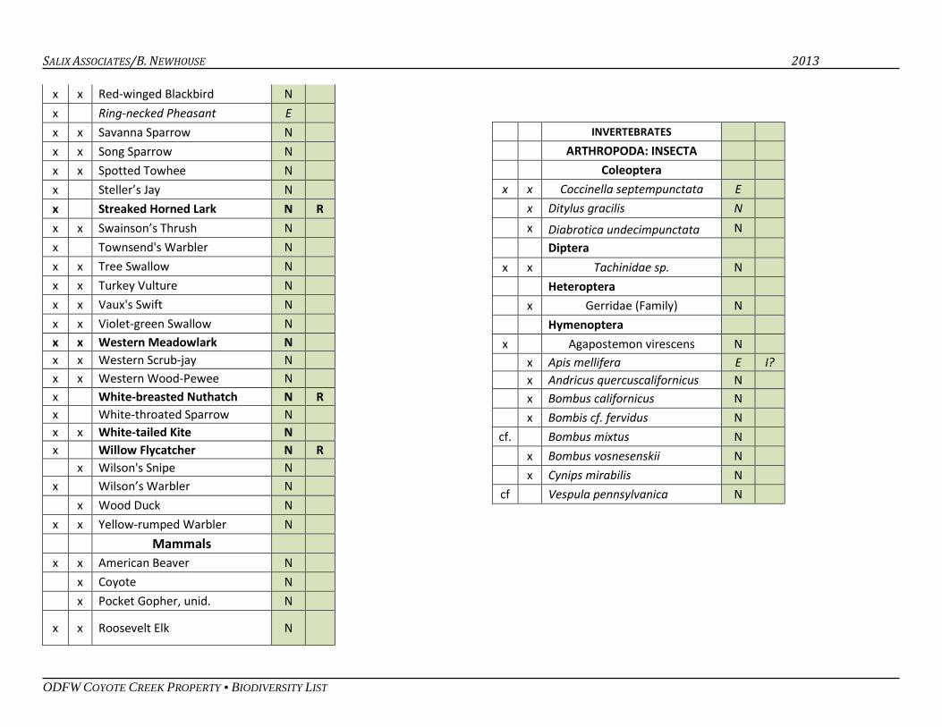
SALIX ASSOCIATES/B. NEWHOUSE 2013
ODFW COYOTE CREEK PROPERTY • BIODIVERSITY LIST
x x Red-winged Blackbird N x Ring-necked Pheasant E x x Savanna Sparrow N x x Song Sparrow N x x Spotted Towhee N x Steller’s Jay N x Streaked Horned Lark N R
x x Swainson’s Thrush N x Townsend's Warbler N x x Tree Swallow N x x Turkey Vulture N x x Vaux's Swift N x x Violet-green Swallow N x x Western Meadowlark N x x Western Scrub-jay N x x Western Wood-Pewee N x White-breasted Nuthatch N R x White-throated Sparrow N x x White-tailed Kite N x Willow Flycatcher N R x Wilson's Snipe N x Wilson’s Warbler N x Wood Duck N x x Yellow-rumped Warbler N Mammals x x American Beaver N x Coyote N x Pocket Gopher, unid. N
x x Roosevelt Elk N
INVERTEBRATES
ARTHROPODA: INSECTA Coleoptera x x Coccinella septempunctata E x Ditylus gracilis N x Diabrotica undecimpunctata N Diptera x x Tachinidae sp. N Heteroptera x Gerridae (Family) N Hymenoptera x Agapostemon virescens N x Apis mellifera E I? x Andricus quercuscalifornicus N x Bombus californicus N x Bombis cf. fervidus N
cf. Bombus mixtus N x Bombus vosnesenskii N x Cynips mirabilis N
cf Vespula pennsylvanica N
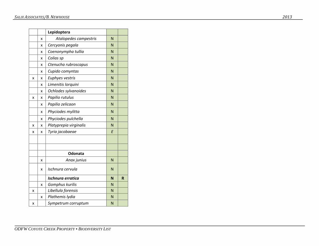
SALIX ASSOCIATES/B. NEWHOUSE 2013
ODFW COYOTE CREEK PROPERTY • BIODIVERSITY LIST
Lepidoptera x Atalopedes campestris N x Cercyonis pegala N x Coenonympha tullia N x Colias sp N x Ctenucha rubroscapus N x Cupido comyntas N x x Euphyes vestris N x Limenitis lorquini N x Ochlodes sylvanoides N x x Papilio rutulus N x Papilio zelicaon N x Phyciodes mylitta N x Phyciodes pulchella N x x Platyprepia virginalis N x x Tyria jacobaeae E
Odonata
x Anax junius N
x Ischnura cervula N
Ischnura erratica N R x Gomphus kurilis N x Libellula forensis N x Plathemis lydia N x Sympetrum corruptum N
APPENDIX 6
FOCAL CONSERVATION SPECIES DESCRIPTIONS AND CONSERVATION ACTIONS
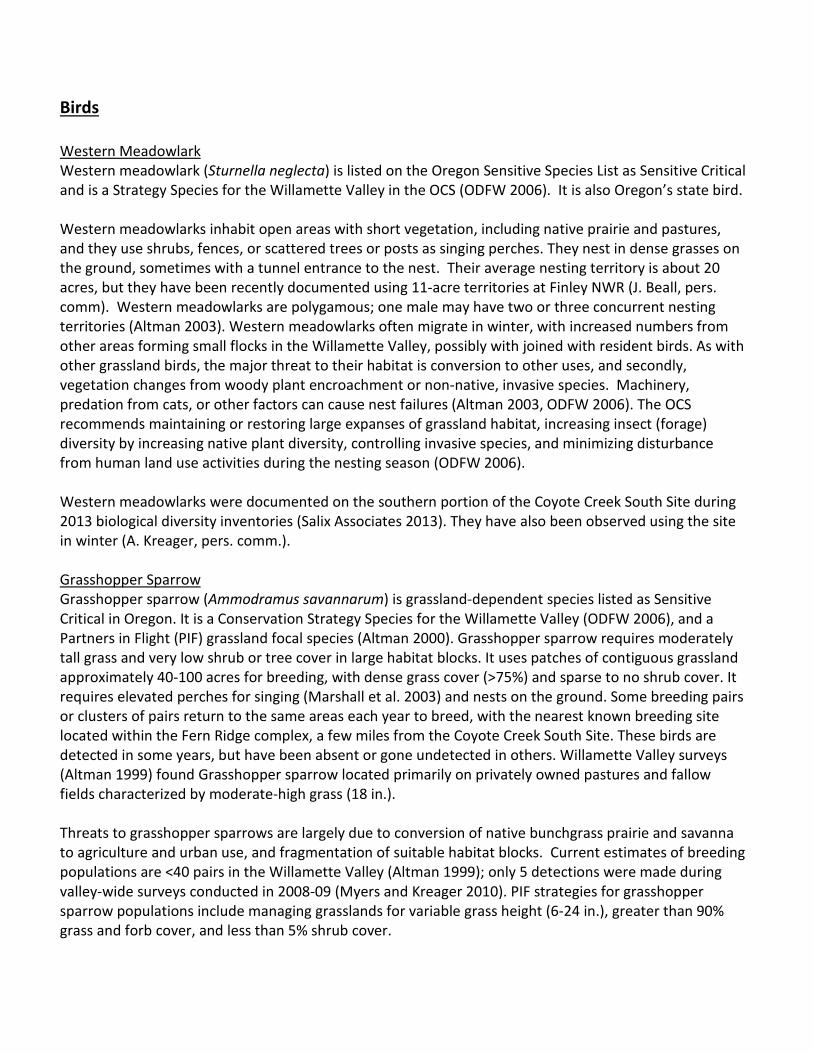
Birds Western Meadowlark Western meadowlark (Sturnella neglecta) is listed on the Oregon Sensitive Species List as Sensitive Critical and is a Strategy Species for the Willamette Valley in the OCS (ODFW 2006). It is also Oregon’s state bird. Western meadowlarks inhabit open areas with short vegetation, including native prairie and pastures, and they use shrubs, fences, or scattered trees or posts as singing perches. They nest in dense grasses on the ground, sometimes with a tunnel entrance to the nest. Their average nesting territory is about 20 acres, but they have been recently documented using 11-acre territories at Finley NWR (J. Beall, pers. comm). Western meadowlarks are polygamous; one male may have two or three concurrent nesting territories (Altman 2003). Western meadowlarks often migrate in winter, with increased numbers from other areas forming small flocks in the Willamette Valley, possibly with joined with resident birds. As with other grassland birds, the major threat to their habitat is conversion to other uses, and secondly, vegetation changes from woody plant encroachment or non-native, invasive species. Machinery, predation from cats, or other factors can cause nest failures (Altman 2003, ODFW 2006). The OCS recommends maintaining or restoring large expanses of grassland habitat, increasing insect (forage) diversity by increasing native plant diversity, controlling invasive species, and minimizing disturbance from human land use activities during the nesting season (ODFW 2006). Western meadowlarks were documented on the southern portion of the Coyote Creek South Site during 2013 biological diversity inventories (Salix Associates 2013). They have also been observed using the site in winter (A. Kreager, pers. comm.). Grasshopper Sparrow Grasshopper sparrow (Ammodramus savannarum) is grassland-dependent species listed as Sensitive Critical in Oregon. It is a Conservation Strategy Species for the Willamette Valley (ODFW 2006), and a Partners in Flight (PIF) grassland focal species (Altman 2000). Grasshopper sparrow requires moderately tall grass and very low shrub or tree cover in large habitat blocks. It uses patches of contiguous grassland approximately 40-100 acres for breeding, with dense grass cover (>75%) and sparse to no shrub cover. It requires elevated perches for singing (Marshall et al. 2003) and nests on the ground. Some breeding pairs or clusters of pairs return to the same areas each year to breed, with the nearest known breeding site located within the Fern Ridge complex, a few miles from the Coyote Creek South Site. These birds are detected in some years, but have been absent or gone undetected in others. Willamette Valley surveys (Altman 1999) found Grasshopper sparrow located primarily on privately owned pastures and fallow fields characterized by moderate-high grass (18 in.). Threats to grasshopper sparrows are largely due to conversion of native bunchgrass prairie and savanna to agriculture and urban use, and fragmentation of suitable habitat blocks. Current estimates of breeding populations are <40 pairs in the Willamette Valley (Altman 1999); only 5 detections were made during valley-wide surveys conducted in 2008-09 (Myers and Kreager 2010). PIF strategies for grasshopper sparrow populations include managing grasslands for variable grass height (6-24 in.), greater than 90% grass and forb cover, and less than 5% shrub cover.
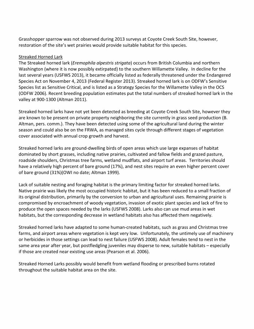
Grasshopper sparrow was not observed during 2013 surveys at Coyote Creek South Site, however, restoration of the site’s wet prairies would provide suitable habitat for this species. Streaked Horned Lark The Streaked horned lark (Eremophila alpestris strigata) occurs from British Columbia and northern Washington (where it is now possibly extirpated) to the southern Willamette Valley. In decline for the last several years (USFWS 2013), it became officially listed as federally threatened under the Endangered Species Act on November 4, 2013 (Federal Register 2013). Streaked horned lark is on ODFW’s Sensitive Species list as Sensitive Critical, and is listed as a Strategy Species for the Willamette Valley in the OCS (ODFW 2006). Recent breeding population estimates put the total numbers of streaked horned lark in the valley at 900-1300 (Altman 2011). Streaked horned larks have not yet been detected as breeding at Coyote Creek South Site, however they are known to be present on private property neighboring the site currently in grass seed production (B. Altman, pers. comm.). They have been detected using some of the agricultural land during the winter season and could also be on the FRWA, as managed sites cycle through different stages of vegetation cover associated with annual crop growth and harvest. Streaked horned larks are ground-dwelling birds of open areas which use large expanses of habitat dominated by short grasses, including native prairies, cultivated and fallow fields and grazed pasture, roadside shoulders, Christmas tree farms, wetland mudflats, and airport turf areas. Territories should have a relatively high percent of bare ground (17%), and nest sites require an even higher percent cover of bare ground (31%)(OWI no date; Altman 1999). Lack of suitable nesting and foraging habitat is the primary limiting factor for streaked horned larks. Native prairie was likely the most occupied historic habitat, but it has been reduced to a small fraction of its original distribution, primarily by the conversion to urban and agricultural uses. Remaining prairie is compromised by encroachment of woody vegetation, invasion of exotic plant species and lack of fire to produce the open spaces needed by the larks (USFWS 2008). Larks also can use mud areas in wet habitats, but the corresponding decrease in wetland habitats also has affected them negatively. Streaked horned larks have adapted to some human-created habitats, such as grass and Christmas tree farms, and airport areas where vegetation is kept very low. Unfortunately, the untimely use of machinery or herbicides in those settings can lead to nest failure (USFWS 2008). Adult females tend to nest in the same area year after year, but postfledgling juveniles may disperse to new, suitable habitats – especially if those are created near existing use areas (Pearson et al. 2006). Streaked Horned Larks possibly would benefit from wetland flooding or prescribed burns rotated throughout the suitable habitat area on the site.
Other habitat management recommendations modified slightly from OWI (no date; or sources cited therein) include:
• Delay mechanized activities in nesting habitats until after August 15 to avoid egg and juvenile mortality;
• Create and/or maintain habitat patches with bare ground or sparse, herbaceous vegetation that remain undisturbed during the nesting season;
• Horned larks are easily disturbed by foot traffic. Maintain a buffer around nesting areas during the nesting season that excludes humans and domestic dogs.
Purple Martin Purple martin (Progne subis) is a federal Species of Concern and an Oregon Sensitive Critical species. Although an uncommon species in the Willamette Valley, a local population uses Fern Ridge reservoir, and the Coyote Creek South Site is within the distance that this species will travel between nest sites and foraging locations. Purple martin were observed at the Coyote Creek South Site in June, although it has not been determined whether the bird was foraging or nesting. Historically, purple martin nested in cavities snags, and prefer nest sites that are at least 20 feet from other live trees, as would be found in a savanna setting. Today, they predominantly use human-made structures, including gourds, nest boxes, multi-compartment bird houses, and other cavities made from natural or artificial materials, and appear to favor nest sites over water but will also use areas far from water (Horvath 2003). Nesting begins in May, with eggs observed in nests through late July (Horvath 2003). Threats to purple martin stem mainly from the removal of snags and therefore loss of nesting habitat; retaining snags on the landscape could improve habitat availability for this species (Horvath 2003). Installation of nest boxes could also benefit purple martin by adding nest sites; as with other cavity-nesting birds, these structures would need to be sized appropriately so as to exclude European starlings (Horvath 2003). Dusky Canada Goose The dusky Canada goose (Branta canadensis occidentalis) is one of seven subspecies of Canada geese found on the FRWA. A flock of 10 – 25 dusky Canada geese have consistently been observed by ODFW staff feeding in the agricultural fields and seasonal vernal pools on the Coyote Creek South site throughout winter months. Once a predominant subspecies of Canada goose in the valley, habitat changes on its breeding grounds in Alaska and concurrent increase in wintering populations of other Canada goose subspecies in the Willamette Valley have greatly decreased the proportion of dusky geese encountered. The dusky Canada goose, while not federally or state listed in Oregon, is a strategy species for the Willamette Valley (ODFW 2006). The primary goal for the FRWA is to “Manage habitats to attract and support waterfowl in the southern Willamette Valley,” with a focus on required non-breeding habitat for migratory waterfowl during the non-breeding season, including areas of refuge (ODFW 2009). The Pacific Flyway Council updated its management plan for the dusky Canada goose in March 2008. All of the information that follows is summarized from that document.
The dusky Canada goose nests on the Copper River Delta in southcentral Alaska, and winters in the Willamette Valley, Lower Columbia River, and some small areas in western Washington. FRWA is at the southern end of their wintering range. Similar to other Canada goose species, the dusky was impacted by hunting harvests in the 1950s, but rebounded with creation of refuges and adoption of harvest management in Oregon and Washington. Its population increased significantly from lower than 10,000 in the early 1950s to over 26,000 in 1975. However, the 1964 earthquake in Alaska lifted up the Copper River Delta, and ensuing changes have caused loss of nesting habitat and an increase in predator populations, returning dusky geese numbers back down to approximately 15,000. The challenges on the breeding grounds remain the most significant threat to the species. Wintering habitat is largely provided on refuges in the Willamette Valley and along the lower Columbia River. The dusky geese also use private land for foraging habitat. The subspecies composition of the wintering Canada goose population has changed dramatically over the past 20 years. The dusky population has declined from historic levels while the total number of Canada geese has reached record highs. With the increase in geese numbers, winter crop depredation has become an issue, and protecting dusky geese during allowed hunting seasons for the more plentiful Canada geese is a complex and expensive endeavor. The flyway plan presents management suggestions for wintering habitat for dusky Canada geese (Pacific Flyway Council 2008), including continuing annual mid-winter surveys, and providing adequate and higher-value food plots. Short-eared Owl Short-eared owl (Asio flammeus) is an uncommon species in western Oregon and is an increasingly uncommon breeder (Scheuering 2003). Short-eared owls are a strategy species for the Willamette Valley (ODFW 2006), although they are not listed federally or by the state of Oregon. Limiting factors identified for this species in the OCS are habitat loss, small population size, and disturbance of nests and communal roost sites (ODFW 2006). Known to use the West Eugene Wetlands for foraging, short-eared owls have also been known to nest in large wet prairie sites in the last decade (T. Taylor, pers. comm.). Small groups of short-eared owls were observed within the last three years on the Coyote Prairie site roosting in winter in restored areas (P. Gordon, pers. comm.). Short-eared owls forage large expanses of wet prairies and grasslands. Prey consists of small mammals, in eastern Oregon preferentially centered on mice and less frequently, voles. Nest sites are on the ground, near bunchgrasses or the bases of shrubs for concealing nests, and nesting is initiated in April-May. Habitat loss has significantly reduced the breeding site availability of this species in the valley (Scheuering 2003).
Western Bluebird Western bluebird (Sialia mexicana) is listed as Sensitive Vulnerable on the Oregon Sensitive Species list, and is an OCS strategy species for Willamette Valley grasslands and oak savannas. Once common throughout the Willamette Valley and region (Eltzroth 2003, Altman and Stephens 2012), it experienced significant declines due to habitat loss as the valley floor was converted to agriculture and urban uses. Recent density estimates put Western bluebird at <0.01 birds/ha in the Willamette Valley (Altman and Stephens 2012). The OCS identifies habitat loss, degradation of grassland quality, and competition for
nest sites by non-native birds as limiting factors for this species (ODFW 2006). This species has not yet been documented at the Coyote Creek South Site. Western bluebird uses prairies and oak savannas for foraging and breeding, selecting open grasslands and preferring low shrub density and ground cover dominated by shorter vegetation (<12 in.); tall grasses may be an impediment to foraging (Altmand and Stephens 2012). They primarily forage on insects, but use fruits, including cascara berries, later in the season and their winter distribution in the Willamette Valley is thought to be tied to the availability of mistletoe berries (Eltzroth 2003). This species is a secondary cavity nester, using woodpecker holes or cavities formed from natural decay, in oak savanna or very open-canopied oak woodland habitat. Nesting in the Willamette Valley is generally late March-early July. Optimal tree density (highest nest abundance) is 1.6 trees/ac, declining to no nests at 8 trees/ac (Hansen 1995 cited by Eltzroth 2003). Non-native house sparrows and European starlings compete with western bluebirds for nest sites; nest boxes have been successful for bluebirds as they preclude use by starlings, however competition from swallows remains an issue (Eltzroth 2003). A literature review by Vesely and Rosenberg (2010) based largely on Guinan et al. (2008) recommends the following management for western bluebirds:
• In breeding areas, manage for >20% cover of short herbaceous vegetation and/or bare ground;
• Manage tree density to maintain open woodland and savanna canopy density; • Manage understory vegetation diversity to support an abundance of invertebrate prey;
Increase availability of nest cavities by retaining snags >10 in. dbh and live trees with large, dead branches (branch diameter >10 in.). Western bluebirds prefer groups of snags and nest trees as compared to a uniformly distributed pattern; and
• Add nest boxes to provide a short-term solution where there is limited availability of natural tree cavities for nesting.
At Coyote Creek South Site, the optimal breeding habitat for Western bluebird would likely be the northern prairie once it is restored, specifically capitalizing on vernal pool areas or places where shorter-statured native grasses are dominant. For nest sites, the large, savanna-form oaks in the northern prairie could provide nest sites, as would the oak savanna habitat. The oak woodland in the riparian forest could provide nest sites on its northernmost edge, but tree density is too high otherwise. However, the oaks in the riparian forest will be a source of mistletoe, providing winter foraging opportunities. White-breasted Nuthatch The slender-billed nuthatch (Sitta carolinensis aculeata) is a subspecies of the white-breasted nuthatch found in the Willamette Valley. It has no federal listing status, but is on the Oregon Sensitive Species list as Sensitive Vulnerable. It is a Willamette Valley Strategy Species in the Oregon Conservation Strategy (ODFW 2006). White-breasted nuthatches are year-round residents in the valley, but are uncommon and declining. They forage primarily along trunks of oaks, where they are known for often facing “upside-down,” or facing toward the ground. White-breasted nuthatches favor oak or mixed oak-conifer woodlands with a canopy cover of 40-97%. Nest trees are large in diameter, have an open-grown form, and have cavities in the
stem and larger branches (Viste-Sparkman 2005). White-breasted nuthatches are a secondary cavity-nester, usually using a tree cavity excavated by a woodpecker.
In addition to having more potential nesting cavities, larger oaks also may provide more food resources for the white-breasted nuthatch. A higher quantity and diversity of invertebrates occurs in older trees with furrowed bark compared to younger, smooth-barked trees. The furrows create habitat for insects and other invertebrates, which then are sought by the nuthatches (Jackson 1979). Threats to white-breasted nuthatches include loss or conversion of oak habitat to agriculture or urban use and encroachment of conifers into oak woodlands which then overwhelm the oaks (Hagar 2003), resulting in loss of cavity nesting habitat (ODFW 2006). In their literature review, Vesely and Rosenberg (2010) did not find home range or territory size estimates or natal dispersal descriptions for the white-breasted nuthatch. However, they did find studies on similar species that suggested territories were between 25 and 98 acres, tending toward smaller territories in closed-canopy forests and larger territories in open woodlands (Grubb and Pravosudov 2008). The OCS recommends maintaining oaks that are greater than 22 inches diameter at breast height, and developing nest box programs in the near term (ODFW 2006). White-breasted nuthatch has not been confirmed yet at the Coyote Creek South Site, but is known from within a few miles of the site and is anticipated to be detected at the site with restoration and release of the open-grown Oregon white oaks. Chipping Sparrow Chipping sparrow (Spizella passerina) is a neotropical migrant that is uncommon and declining in the Willamette Valley. They do not have federal or state listing status because they occur fairly commonly east of the Cascades. However, in the Willamette Valley they are identified as a Strategy Species in the OCS (ODFW 2006). Chipping sparrow has been detected at the Coyote Creek South Site. Chipping sparrows are most often found in open woodlands, savannas, and openings within conifer forests; closed-canopy forests are avoided (Granholm 1988; OWI no date; Scheuering 2003). Chipping sparrows nest in trees or shrubs 1–3m high, and they prefer nesting in conifer saplings when available (Reynolds and Knapton 1984, Swanson et al. 2004). Across their geographic range, the territory size of chipping sparrows varies between 0.5-2.5 ac. (Middleton 1998). Prescribed burning and availability of diverse, native, herbaceous plants and invertebrate prey may be beneficial (OWI no date). One study looked at breeding success in knapweed infested territories and determined that fewer offspring were produced there (Ortega et al. 2006). The Oregon Conservation Strategy lists limiting factors for chipping sparrow as loss of habitat due to oak woodland degradation and development, loss of natural fire regimes, invasive species in woodland understory, and possibly nest parasitism by cowbirds (ODFW 2006). It recommends maintaining areas of open herbaceous understory in oak woodland habitats, and controlling invasive species. Chipping sparrows could also benefit from land management that provides open woodlands and savanna habitats with a high diversity of native plants and insects, and which are close to occupied breeding territories (DeMars 2008; Gaines et al. 2007; Ortega et al. 2006).
Oregon Vesper Sparrow Oregon vesper sparrow (Pooecetes gramineus affinis) is a federal Species of Concern and a state Candidate Species in Oregon. Additionally, it is identified as a Strategy Species for the Willamette Valley in the OCS (ODFW 2006). Oregon vesper sparrows migrate to the southern US or Mexico in winter, and breed in the Willamette Valley in spring and summer. Although no research has been undertaken on Oregon vesper sparrows in the Willamette Valley, recent resurveys of grassland bird monitoring points in 2008 by ODFW found that this species has declined significantly in the Willamette Valley since 1997, dropping in total abundance, relative abundance, and unobserved in half of the areas it was found during the earlier survey (Myers and Kreager 2010).
Oregon vesper sparrows primarily use open habitats with sparse shrubs (<25% of total cover), grass cover height 12-24 inches (Myers and Kreager 2010), and perches above the herbaceous canopy used for singing (Altman 1997). They appear to be more responsive to differences in vegetation structure than the composition of plant communities (OWI no date), although diverse vegetation and native insects provide diverse food sources. Within suitable habitats, ground nests usually are constructed near a clump of vegetation (ODFW no date). Newly-created, suitable habitats are more likely to be used if they are created near currently occupied areas. The average territory size in the Willamette Valley is 3.1 acres, with a range in size from 1.1-13.0 ac (Altman 1999). Minimum habitat patch size required is 5 acres. The OCS lists limiting factors for Oregon vesper sparrows as small disjunct populations, impacts to grasslands from fire suppression and invasive species, nest failure due to human land management practices, and predation by house cats. It recommends maintaining and restoring grassland habitat, improving insect (forage) diversity by increasing native plant diversity, invasive species control, and land management practices that minimize disturbance during the nesting season (ODFW 2006). Oregon vesper sparrows have been observed at the Coyote Creek South Site, and feedback from a site tour suggested that the site’s location on the valley floor is too wet and also lower in elevation than nearby known occupied sites typically found on footslopes (B. Altman, pers. comm.). However, 2008 grassland bird surveys documented Oregon vesper sparrows at a Christmas tree farm (Myers and Kreager 2010) near the restorable upland prairie area of the Coyote Creek South Site, raising the possibility that this species may use the site when restored.
Amphibians and Reptiles Western Pond Turtle Western pond turtles (Actinemys marmorata marmorata) are known to use the Coyote Creek system and several management units within the FRWA, although none have yet been documented on the Coyote Creek South Site (ODFW 2009 and Salix Associates 2013). Western pond turtle is one of two freshwater turtle species native to Oregon. It is listed as a federal Species of Concern, an Oregon Sensitive Critical species, and is an ODFW Conservation Strategy Species. In recent years, a Native Turtle Working Group has formed in the Willamette Valley, due to concerns about declining western pond turtle populations. Biologists, land managers, and conservationists working across public and private land ownership convene regularly to share monitoring information, research, and habitat management strategies. Two recent publications focused on western pond turtle have compiled much of this information into a set of useful references; the Conservation Assessment of the Western Pond Turtle in Oregon, a comprehensive summary of western pond turtle research and management, authored by the Oregon Wildlife Institute along with several co-authors (Rosenberg et al. 2009), and an issue of Northwest Fauna titled Western Pond Turtle: Biology, Sampling Techniques, Inventory and Monitoring, Conservation and Management (Bury et al., eds., 2012). Western pond turtles use both aquatic and terrestrial habitats to complete their life cycle. Most of the year they occupy permanent or seasonal rivers, sloughs, lakes, and ponds, and then travel to uplands to lay eggs, overwinter, disperse, and bask (Rosenberg et al. 2009). Preferred nesting habitat receives good solar exposure and is sparsely vegetated with grass and forbs, with compact clayey or silty soils or sandy loams. Nesting typically occurs within close proximity (650 feet) of aquatic habitat, on south to southeast aspects, and little to no tree canopy cover is preferred to prevent shading of the nest site. The juxtaposition of suitable aquatic environments and nest sites is often limited (Holland 1994 in Rosenberg et al. 2009), especially in areas that have been modified. Hatchlings and juveniles select slow-moving, warmer, shallow bodies of water with emergent vegetation (Reese 1996 in Rosenberg et al. 2009), while adult pond turtles prefer muddy bottoms, and require basking sites for maintaining body temperature. They are frequently observed on logs in the water on sunny days, and will share basking sites with other turtles and birds. If disturbed when basking, western pond turtles will quickly re-enter the water; frequent disturbance may decrease habitat quality (Rosenberg et al. 2009). They also utilize large woody debris under the water surface as cover from aquatic predators, including river otter and mink (Reese and Welsh 1998 in Rosenberg et al. 2009). Western pond turtles opportunistically select overwintering sites in a variety of settings, including aquatic substrate, undercut stream banks, and terrestrial locations. They often emerge from terrestrial refugia to bask or to move to other locations during the winter. Solar radiation appears to be important and they prefer flat areas with open ground cover and duff and lacking dense grass, although they will use shrubby, open, and forested areas. Hatchling western pond turtles often overwinter in their natal nests (Rosenberg et al. 2009).
Western pond turtles are omnivorous, foraging opportunistically but exclusively in aquatic habitats (Ernst and Lovich 2009 in Rosenberg et al. 2009). They prey on aquatic insect larvae, mollusks, crustaceans, tadpoles, small fish, frogs, plankton, and occasionally also consume plant matter. Animal matter, and for juveniles aquatic insects, comprise the majority of their diet (several studies cited in Rosenberg et al. 2009). Pond turtles disperse along waterways and over land, but long distance movement patterns are still poorly understood. They may travel long distances (km) within one season for dispersal. However, they appear to have a home range of about 150 m of stream length, and usually do not travel far for overwintering sites (approximately 150 m). Western pond turtles are thought to be very long-lived (decades), but have delayed sexual maturation and may not reach breeding status for up to a decade. Shallow nests near the ground surface are frequently depredated, with a nest failure rate of 80-90% (Holland 1994 and Holte 1998 in Rosenberg et al. 2009). Raccoons, striped skunks, canids, and great blue herons are documented predators, with bullfrogs, smallmouth bass, largemouth bass, and small fossorial mammals also suspected of preying on young western pond turtle. Exclosures in nest areas and predator control have been very successful in protecting western pond turtle nests on the Kirk Pond unit of Fern Ridge, managed by the U.S. Corps of Engineers (ODFW 2009). Threats to western pond turtle stem primarily from several important habitat losses: wetlands, side channels, sloughs, oxbow lakes, deep pools in streams, coarse woody debris, and nesting habitat affected by invasive species and agricultural conversion. Another significant threat is predation on nests and juveniles, which has resulted in a lopsided age structure in Willamette Valley populations, and threatens the species’ longevity. A third critical threat to western pond turtles is competition from non-native turtle species sold in the pet trade and released into natural areas. Red-eared sliders (Trachemys scripta elegans) compete directly with western pond turtles at several life stages. Finally, roads have been cited as a factor in mortality, especially to females. Conservation actions recommended by the Native Turtle Working Group and the conservation assessment which apply to the Coyote Creek South Site include (reproduced from Rosenberg et al 2009): • On southern exposures, provide sparse vegetation structure adjacent to aquatic habitat for nesting
within 200 m of aquatic habitat; remove all woody plants in designated nesting areas if appropriate; • Increase area of nest habitat to increase the total number of hatchlings by increasing number of
females nesting and reduce nest density to potentially reduce predation rate; • Provide shallow water habitats with abundant aquatic vegetation for hatchling rearing habitat; • Provide open fields or open woodlands within 200 m of stream and river habitats for over-
wintering; • Consider juxtaposition of management actions in terrestrial and aquatic habitat in relation to roads
and recreation uses to minimize negative effects; • Avoid building roads in western pond turtle use areas; and
• Reduce human disturbance in areas where human activity may impede or prohibit use of suitable habitats by turtles, including redirecting areas used for recreational use away from turtle use areas as appropriate.
Northern red-legged frog Northern red-legged frog (Rana aurora aurora) is a federal Species of Concern, listed as Oregon Sensitive Vulnerable, and is an Oregon Conservation Strategy species. They have been documented on the north side of Coyote Creek in the riparian forest (Salix Associates 2013), and they are expected to use the riparian forest, marsh, and open water habitat on the south side of the creek as well. In the Willamette Valley this species is in decline due to habitat loss, particularly of wetlands and ephemeral wetlands, and the colonization of suitable habitats by non-native fish and bullfrogs (Hammerson 2008, Adams et al. 2004). Habitat in the Willamette Valley is among the most fragmented in the species’ range (Pearl in Lanoo 2005). Northern red-legged frogs use both aquatic and terrestrial systems to complete their life cycle and occur from sea level to nearly 5,000 feet west of the Cascades in Oregon. Their preferred habitat includes quiet streams, marshes, and ponds. Northern red-legged frogs often travel long distances to breeding sites from summer habitats (Pearl in Lanoo 2005), laying their eggs in wetlands from January-March and attaching them to submerged herbaceous vegetation and woody debris (Hammerson 2008). Eggs are usually deposited in areas with little or no flow, in the deepest water available (Pearl in Lanoo 2005). Red-legged frogs may use ephemeral pools for breeding if the water remains until late spring or early summer (Biosystems Analysis 1989 in Hammerson 2008). In the Willamette Valley, inundation is usually necessary into June for successful metamorphosis (Pearl in Lanoo 2005, Adams et al. 2004). Northern red-legged frogs often share breeding sites with Pacific chorus frogs (Hyla regilla), rough-skinned newts (Taricha granulosa), northwestern salamanders (Ambystoma gracile), long-toed salamanders (A. macrodactylum) and introduced American bullfrogs (Rana catesbeiana) (Pearl in Lanoo 2005). They hatch and develop through the tadpole stage into adults in the spring. Juveniles often spend their first days or weeks near the edges of their breeding ponds before dispersal. After dispersing up to a quarter of a mile from their breeding site, juveniles select relatively moist and densely vegetated riparian habitats for summer habitat (Pearl in Lanoo 2005). Northern red-legged frogs prey on primarily on invertebrates, although they also eat insects, arachnids, and mollusks, and larger individuals can also take salamanders and juvenile conspecifics (several citations in Pearl in Lanoo 2005). Threats to northern red-legged frogs in the Willamette Valley include habitat loss via conversion to urban or agricultural land uses, conversion of ephemeral wetlands to more permanent waters, and non-native fish, crayfish, and bullfrogs (Adams et al. 2004). In breeding ponds, native odonate larvae help protect northern red-legged frog egg masses by preying upon bullfrog tadpoles, however non-native fish that consume odonate larvae can remove this protection (Adams et al. 2004). Thus, conversion of shallow ephemeral habitat to more permanent ponds is an important threat as it allows breeding waters to be invaded by non-native predators.
Management recommendations for the Willamette Valley (Adams et al. 2004) for northern red-legged frogs include:
• Preventing the introduction and establishment of non-native fish by avoiding sites with seasonal or permanent connections to permanent waterbodies;
• Conservation and creation of wetlands with at least 50% of their surface area having depths between 0.2 and 0.75 m in the spring; and
• Conservation and creation of ephemeral and semi-permanent wetlands; these types tend to have more emergent vegetation and lack non-native vertebrate species, which benefits native amphibians.
Mammals Townsend’s Big-eared Bat Townsend’s big-eared bat (Corynorhinus townsendii) is a federal Species of Concern, an Oregon Sensitive Critical species, and an Oregon Conservation Strategy species. Little is known about most bat species in western Oregon (Ormsbee pers. comm.). Information on resident bats is limited and even less is known about migratory bat species. Surveys and life history studies are needed for all species, but especially for six species which have a federal Species of Concern status. Townsend’s big-eared bats prefer caves or structures for roosting. They are sensitive to disturbance, so some structures otherwise suitable for their use may have too much associated noise. They can use abandoned structures if they are dry and are accessible. The majority of bats in western Oregon use echolocation to feed aerially on insects over or near water, although there may be exceptions. Some species migrate south during the colder months, but most use winter roosts. Tree dwelling species may travel long distances before locating in a more stable-temperature roost (Verts & Carraway 1998). If temperatures are not stable enough, bats may move within the roost or to different roosts to achieve the preferred temperature for maintaining torpor during winter, and may also move to a colder roost site during warm winter periods. In addition to winter roosts, local bat species also use day roosts, night roosts and maternity roosts. Because bats are active at night, they use day roosts for long resting periods during daylight hours. These are protected sites that range from caves to structures to tree cavities to spots under loose shingles. Night roosting occurs during short periods between foraging, and in different and generally less protected places than day roosting (Verts & Carraway 1998). Maternity roosts are used by females to raise pups in spring. Depending on the species, some bats raise young individually, and some in small communal roosts. Because oak trees often form cavities, they are suitable for use by bats for roosting – especially if near water. In general, restoration of oak habitats, especially conserving existing cavities and promoting future cavity development, will benefit bats (Ormsbee pers. comm.). Restoration activities which cause disturbance should be conducted after annual rearing of pups and after any migrating species have moved through; fall is generally a good time for restoration activities that will meet these guidelines (Ormsbee pers. comm.).
Fish Cutthroat Trout Coastal cutthroat trout (Oncorhynchus clarkii) historically used the Long Tom River system, and since construction of the Fern Ridge reservoir have formed an adfluvial population. Fish present in the reservoir seasonally move upstream in the Long Tom River to spawn (ODFW 2009). They are also known from Ferguson and Bear Creeks, downstream of the Fern Ridge dam (LTWC 2013), but the stretch of Coyote Creek on the Coyote Creek South Site has not yet been surveyed. One of fourteen subspecies of cutthroat, coastal cutthroat trout have the widest distribution of any trout in the Willamette Basin. Adults move out of larger river systems from November-June (Fern Ridge reservoir in the case of the Coyote Creek South Site), spawning occurs in small tributaries and fry then move back downstream from June through November. Cutthroat trout prefer side channels, backwaters, and pools for rearing. They use large woody debris and instream vegetation for refuge, and will also use seasonal streams for rearing and forage. Although this species is widespread, several factors have affected Willamette Basin populations. Hydrologic modifications from dam installation and subsequent decrease in side channel availability and complexity, significant difficulty in crossing through road culverts for both adults and juveniles, and major alteration of valley bottom lowlands for agricultural and urban purposes have all contributed to changes in historic distribution and habitat. A Habitat Suitability Index (Baker et al. in Primozich and Bastasch 2004) determined that as compared to historic conditions, lowland streams have lost habitat for coastal cutthroat trout at twice the rate of streams higher in the watershed.
Invertebrates Fender’s blue butterfly The federally endangered Fender’s blue butterfly (Fender’s) is known from many sites in the West Eugene Wetlands, which host the largest known population in the valley. Small populations are distributed over numerous additional sites in the wetlands, some of which are fairly close in proximity to the Coyote Creek South Site. Neither the butterfly nor any of its host plants are present on the Coyote Creek South Site. Restoration of upland prairie at the site would benefit this species, but it would not be expected to colonize the site without introduction and successful establishment of Kincaid’s lupine and nectar species at the site. Recovery of both the butterfly and Kincaid’s lupine are addressed in a federal plan which identifies conservation and restoration of prairie and savanna habitat as a principal strategy (USFWS 2010). The Fender’s is considered endemic to the Willamette Valley, although its historic range was never well documented. Its current range is from Eugene in Lane County north through Yamhill County, southwest of the Portland area. It’s known to be present on approximately 30 sites, with a total population estimated at somewhere between 3,000-5,000 individuals (Schultz et al. 2003).
Fender’s require high quality prairie habitats for all life stages. Minimum habitat patch size for a healthy population of Fender's is considered 12-15 acres (5-6 ha) of high quality prairie (Crone and Schultz 2003, USFWS 2010). Fender’s exclusively use Kincaid’s lupine, spurred lupine (Lupinus arbustus) and in some locations, sickle-keeled lupine (Lupinus albicaulis) as larval host plants. Number of eggs laid per female correlates with the availability of ovipositing sites (leaf area of host lupine species) on a site. Approximately 40 m2 of lupine leaves are required to support a healthy population (Schultz & Dlugosch 1999). These lupine species are restricted to upland prairie and oak savanna habitats, both of which are extremely limited in the Willamette Valley. The other most critical component of Fender’s habitat is nectar availability, offered by flowering forbs in the months of May and June. Adults require at least 20 mg sugar/m2 from flowering forbs found in nearby wet and upland prairies. Although Fender's will use non-native nectar sources, population size has been found to vary directly with native nectar abundance, and not with overall nectar availability (Schultz et al. 2003). Most frequently used nectar species are slim-leaf onion (Allium amplectans), cat’s ear lily (Calochortus tolmei), rosy checkermallow (Sidalcea malviflora ssp. virgata), Oregon sunshine (Eriophyllum lanatum), and western geranium (Geranium oreganum). Lower quality nectar can also be found in frequently used non-native vetches (Vicia hirsuta and V. sativa) (Schultz and Dlugosch 1999). Fender’s have been shown to stay relatively close to natal lupine patches when foraging (Schultz 1998), further supporting the need for additional nectar in close proximity to existing populations. Of four critical habitat requirements for Fender’s, Coyote Creek meets the criteria of being within 1.2 miles of Fender’s natal lupine patches. Larval host plants, prairie and savanna with a mosaic of low-growing grasses and native forbs, and adult nectar sources, would need to be restored to the site.

American Grass Bug The American grass bug (Acetropis americana) is a Willamette Valley endemic species restricted to wet prairie habitats. A federal Species of Concern, the American grass bug is also an OCS strategy species for the Willamette Valley (ODFW 2006). Surveys by the Xerces Society in good conditions on a number of remnant wet prairies in the West Eugene Wetlands in 2011 did not result in any collections (Mazzacano 2011), leading the surveyors to suggest it is possible this species is extirpated from this area. Part of a group of grass-feeders comprising 25 genera, not much is known about this species. Known only from large, relatively undisturbed wetland sites near McMinnville, Corvallis (Jackson-Frazier Wetlands and Finley NWR), and Eugene (BLM property adjoining FRWA), this species appears to be associated with tufted hairgrass (Brenner 2005), but has also been collected from California oatgrass (Danthonia californica). Little information is known about the phenology of the species, other than adults have been collected in the period from May-July. The eggs hatch into first instar nymphs, becoming adults after five instars (Brenner 2005). Threats to American grass bug are identified as loss of wet prairies, invasive grasses, reduction in inflorescence density on tufted hairgrass from fire, and non-native predators or parasites (Brenner 2005). Habitat management suggestions from the Xerces Society included restoring native vegetation, and limiting the use of controlled ecological burning in April and May when juveniles are maturing into adults (Mazzacano 2011).
Plants Bradshaw’s lomatium Bradshaw’s lomatium was listed as federally endangered on September 30, 1988 (USFWS 1988), with no designated critical habitat. It is a perennial forb found in wet prairies, with the type specimen collected from Eugene, OR. The range of Bradshaw’s lomatium extends from Clark County, Washington through the southern Willamette Valley, near Creswell, OR, with most of the known populations located in Lane County. Recent surveys have documented approximately 60 occupied sites clustered in four major population centers throughout the range, with most populations small (10-1,000 individuals), although there are several populations of over 100,000 plants (USFWS 2010). Threats include direct loss of habitat, location of populations within or near urban areas, herbivory, woody vegetation encroachment, competition from non-native species (e.g. grasses) and mortality from pesticide drift. Bradshaw’s lomatium is a long-lived taprooted perennial that reproduces only from seed (Kaye 1992). It is pollinated by a variety of insect species, and populations often have many more vegetative than reproductive individuals. Seeds do not remain viable for longer than one season. Population growth rate seems to correlate positively with fall and winter (Sept.-Feb.) precipitation (Kaye, unpub. data). Damaging types of disturbance include heavy vole predation or suppression of germination by dense vegetative thatch. Management techniques such as prescribed burning or annual mowing have shown short- and long-term beneficial effects for Bradshaw’s lomatium. Fire is a useful tool to increase plant size, fecundity, and density, but effects last only a few years (Pendergrass et al. 1999), requiring that burns to be conducted on short intervals (every 3-5 years) to sustain benefits. Annual fall mowing at one large population has coincided with a five-fold increase in population size (T. Taylor, pers. comm.), despite the poor quality of the surrounding prairie.
Reintroduction efforts have demonstrated fairly high rates of establishment (around 30%) from seed, especially when surrounding vegetation is cleared (Kaye and Kuykendall 2001 as cited in USFWS 2010, Kaye et al. 2003). Transplants have fared well when competition from surrounding vegetation is low, and when planted into wet microsites with clayey substrates in the fall (Kaye and Brandt 2005).
A patch of Bradshaw’s lomatium was discovered during spring site visits to the Coyote Creek South Site (Salix Associates 2013). The plants are located at the edge of an area converting to ash forest. Subsequent visits yielded the discovery of more plants within the ash forest, persisting in moderate to heavy shade. The total number of plants at the site has not been quantitatively monitored, but qualitative estimates put the population at somewhere near or greater than 100 plants. Thin-leaved peavine Thin-leaved peavine (Lathyrus holochlorus) is a federal Species of Concern that occurred historically in the ecotone between prairie or savanna and oak woodland habitats, and today is also found along roadsides and in fencerows (NatureServe 2011). At Coyote Creek South Site, it was found on the north side of the creek near the edge of the riparian forest; only a handful of plants were present.
Its range is restricted to the Willamette and Umpqua valleys in Oregon, and its total Oregon population Oregon is estimated at approximately 8,000 individuals in 75 locations. Populations are very small and most average fewer than 50 individuals. Plant species often associated with thin-leaved peavine include Oregon white oak, bigleaf maple (Acer macrophyllum), Douglas fir, nootka rose (Rosa nutkana), poison oak, Hall’s aster (Aster hallii), and vetches (Vicia spp.). Threats to thin-leaved peavine include roadside mowing and herbicide applications, loss of habitat due to conversion to agricultural and urban use, woody vegetation encroachment, and invasive species including Himalayan blackberry and Scotch broom. Although thin-leaved peavine can spread rhizomatously, it is also thought to be an obligate outcrossing species, with very limited seed production observed in some populations. Isolation small populations from one another may limit available pollen for seed production (NatureServe 2011). The nearest known location of this species is north of Fern Ridge reservoir, and is limited to only a few plants. Willamette Daisy Willamette daisy was listed as federally endangered on January 25, 2000 (USFWS 2000); Critical Habitat for the Willamette daisy was designated on October 31, 2006 (USFWS 2006) with one primary constituent element identified: early seral upland prairie, wet prairie, or oak savanna habitat with a mosaic of low-growing grasses, forbs, and spaces to establish seedlings or new vegetative growth; absence of dense canopy vegetation; and undisturbed soils.
Willamette daisy is a perennial forb endemic to Oregon’s Willamette Valley. Its range extends from near Portland in Clackamas County south to the Eugene area, with many of the known populations concentrated in or near the West Eugene Wetlands. Recent surveys have documented over 30 occupied sites clustered in three population centers throughout the range (USFWS 2010), but many known sites are on private lands which are not protected. Threats include habitat loss due to urban and agricultural development, small population sizes, habitat degradation and competition from invasive herbaceous species and woody vegetation encroachment.
Willamette daisy is found in both upland and wet prairies. Plants commonly grow as clumps or genets, consisting of one to many flowering stems, or ramets. Willamette daisy reproduces primarily from seed, but partial dieback of large clumps with many ramets can result in a patch that appears to consist of several individuals but is actually a single genet. Willamette daisy is pollinated by a variety of insect species (USFWS 2010). Management techniques including mowing and prescribed burning have shown neutral to potentially negative effects on height and diameter (Thorpe and Kaye 2007) as compared to controls, although Willamette daisy does appear to benefit from a decrease in competition from surrounding vegetation. Reintroduction efforts have demonstrated that transplanting greenhouse starts is more effective than seeding, and that removing competition may improve survival (Kaye and Brandt 2005). White-topped Aster White-topped aster (Sericocarpus rigidus) is a late-flowering perennial forb found in prairies. It is a state-threatened species, a federal Species of Concern, and an OCS strategy species for the Willamette Valley. It occurs at several sites in the West Eugene Wetlands, including the largest known population which occurs on the Fern Ridge RNA and BLM’s adjoining See-sil property, both within just a few miles of the Coyote Creek South Site.
White-topped aster is found from the Willamette Valley northward, with most of the known sites (<100) found in western Washington (Gisler 2004). It is generally an upland prairie species, but is found in wet prairie habitats in the West Eugene Wetlands (Alverson 1991). White-topped aster flowers in July and August, and primarily spreads vegetatively, increasing its susceptibility to habitat loss or degradation at the patch level. Additionally, it has been suggested that inbreeding depression may be an issue for seed production in this species (USFWS 2010). White-topped aster is threatened by habitat loss, loss of fire, and competition from invasive species. Meadow Checkermallow Meadow checkermallow (Sidalcea campestris) is a perennial native forb found in low elevation prairies, woodland edges, and roadsides of the Willamette Valley. It is a candidate for listing in the state of Oregon. Threats to the species are continued habitat loss, roadside spray programs, and competition with invasive plants and encroaching wody vegetation (Young-Mathews 2012). Meadow checkermallow provides high-quality nectar for Fender’s blue butterfly. Flowering from June-August, it also provides nectar for many other native bees, wasps, butterflies, and flies. A native bee species (Diadasia nigrifrons), a checkermallow specialist, depends upon meadow checkermallow and the other checkermallow species in the valley, and it is also a possible host plant for several butterfly species (Young-Mathews 2012). Kincaid’s lupine Kincaid’s lupine (Lupinus oreganus) is the primary larval host of the federally endangered Fender’s blue butterfly, and is listed as federally and state-Threatened. Kincaid’s lupine is addressed in the U.S. Fish and Wildlife Service’s Recovery Plan for Prairie Species of Western Oregon and Southwest Washington (USFWS 2010), and is identified as a Strategy Species for the Willamette Valley in the OCS (ODFW 2006). Kincaid’s lupine is an herbaceous perennial, inhabiting drier soils found in upland prairie and savanna habitats. Typically found within a matrix of non-native grasses, lupines reproduce both vegetatively and by seed. Recruitment in settings such as these can be greatly affected by low seed production in hybrid lupines (Liston in Salix Associates 2005), low germination and/or germinant survival in the matrix of non-native grasses surrounding nearly all of the plants, absence of pollinators due to lack of pollinator habitat elements, or a combination of these factors. Several Rivers to Ridges partner organizations have been managing lupine populations in the area of Coyote Creek South Site for decades, and recent efforts at restoration of lupine plants by seed has been successful (M. Benotsch, pers. comm., W. Messinger, pers. comm.). The OCS lists limiting factors for Kincaid’s lupine as habitat loss from urbanization and agriculture, invasive plant species, elimination of disturbance regimes, inbreeding depression, and road construction and maintenance affecting remnant habitats. It recommends prairie restoration, limiting future road-related impacts, surveying for new populations, and long-term demographic studies as conservation actions.
APPENDIX 7
SUMMARY OF PERMITTED/PROHIBITED USES AND MANAGEMENT ACTION COMPLIANCE
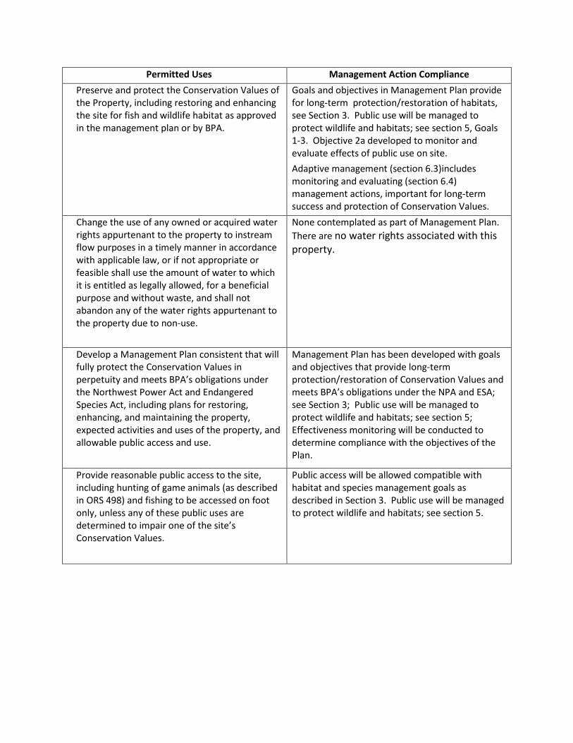
Permitted Uses Management Action Compliance Preserve and protect the Conservation Values of the Property, including restoring and enhancing the site for fish and wildlife habitat as approved in the management plan or by BPA.
Goals and objectives in Management Plan provide for long-term protection/restoration of habitats, see Section 3. Public use will be managed to protect wildlife and habitats; see section 5, Goals 1-3. Objective 2a developed to monitor and evaluate effects of public use on site. Adaptive management (section 6.3)includes monitoring and evaluating (section 6.4) management actions, important for long-term success and protection of Conservation Values.
Change the use of any owned or acquired water rights appurtenant to the property to instream flow purposes in a timely manner in accordance with applicable law, or if not appropriate or feasible shall use the amount of water to which it is entitled as legally allowed, for a beneficial purpose and without waste, and shall not abandon any of the water rights appurtenant to the property due to non-use.
None contemplated as part of Management Plan. There are no water rights associated with this property.
Develop a Management Plan consistent that will fully protect the Conservation Values in perpetuity and meets BPA’s obligations under the Northwest Power Act and Endangered Species Act, including plans for restoring, enhancing, and maintaining the property, expected activities and uses of the property, and allowable public access and use.
Management Plan has been developed with goals and objectives that provide long-term protection/restoration of Conservation Values and meets BPA’s obligations under the NPA and ESA; see Section 3; Public use will be managed to protect wildlife and habitats; see section 5; Effectiveness monitoring will be conducted to determine compliance with the objectives of the Plan.
Provide reasonable public access to the site, including hunting of game animals (as described in ORS 498) and fishing to be accessed on foot only, unless any of these public uses are determined to impair one of the site’s Conservation Values.
Public access will be allowed compatible with habitat and species management goals as described in Section 3. Public use will be managed to protect wildlife and habitats; see section 5.
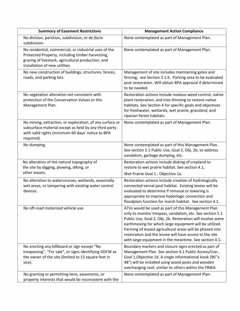
Summary of Easement Restrictions Management Action Compliance No division, partition, subdivision, or de facto subdivision.
None contemplated as part of Management Plan.
No residential, commercial, or industrial uses of the Protected Property, including timber harvesting, grazing of livestock, agricultural production, and installation of new utilities.
None contemplated as part of Management Plan.
No new construction of buildings, structures, fences, roads, and parking lots.
Management of site includes maintaining gates and fencing; see Section 2.1.6. Parking area to be evaluated post restoration. Will obtain BPA approval if determined to be needed.
No vegetation alteration not consistent with protection of the Conservation Values or this Management Plan.
Restoration actions include noxious weed control, native plant restoration, and tree thinning to restore native habitats. See Section 4 for specific goals and objectives for freshwater, wetlands, wet prairie, grassland, and riparian forest habitats.
No mining, extraction, or exploration, of any surface or subsurface material except as held by any third party with valid rights (minimum 60 days’ notice to BPA required).
None contemplated as part of Management Plan.
No dumping.
None contemplated as part of this Management Plan. See section 5.1 Public Use, Goal 2, Obj. 2b, to address vandalism, garbage dumping, etc.
No alteration of the natural topography of the site by digging, plowing, diking, or other means.
Restoration actions include disking of cropland to restore to wet prairie habitat. See section 4.1, Wet Prairie Goal 1 , Objective 1a.
No alteration to watercourses, wetlands, seasonally wet areas, or tampering with existing water control devices.
Restoration actions include creation of hydrologically connected vernal pool habitat. Existing levees will be evaluated to determine if removal or lowering is appropriate to improve hydorlogic connection and floodplain function for marsh habitat. See section 4.1.
No off-road motorized vehicle use.
ATVs would be used as part of this Management Plan only to monitor trespass, vandalism, etc. See section 5.1 Public Use, Goal 2, Obj. 2b. Restoration will involve some earthmoving for which large equipment will be utilized. Farming of leased agricultural areas will be phased into restoration and the lessee will have access to the site with large equipment in the meantime. See section 4.1.
No erecting any billboard or sign except “No trespassing”, “For sale”, or signs identifying ODFW as the owner of the site (limited to 15 square feet in size).
Boundary markers and closure signs erected as part of Management Plan. See section 4.1 Public Access/Use-, Goal 1,Objective 1d. A single informational kiosk (96’’x 48”) will be installed using wood posts and wooden overhanging roof, similar to others within the FRWA.
No granting or permitting liens, easements, or property interests that would be inconsistent with the
None contemplated as part of Management Plan.

protection of the Conservation Values.