countywide master plan chapter iv: trails, bikeways, …
TRANSCRIPT

Approved Countywide Master Plan of Transportation 7
IntroductionThevisionforbicycle,pedestrian,andequestrianfacilitiesistodevelopacomprehensivenetworkofpavedandnaturalsurfacetrails,sidewalks,neighborhoodtrailconnections,andon-roadbicyclefacilitiesfortransportationandrecreationuse.TrailsshouldbeincompliancewiththeAmericanswithDisabilitiesAct(ADA)anddesignedtoaccommodatehikers,bicyclists,equestrians,andmountainbikers.Communitiesandroadwaysshouldbedesignedtoaccommodatepedestriansandbicycles,aswellasautomobiles.Sidewalkandtrailconnectionsshouldbeprovidedtoschools,parks,activitycenters,andotherpublicfacilities.
Bike Facility Definitions1
1. BikeLanes—On-roaddedicatedone-waybicyclefacilities.Roadsaresignedandsignalizedforbicycleuse.
2. BufferedBikeLanes—On-roadandoff-roaddedicatedone-waybicyclefacilities.Roadsaresignedandsignalizedforbicycleuse.
3. BicycleBuffers—Acombinationofphysicalspaceandhorizontalelements,suchasstone,brick,concrete,berms,fencesorwalls,andon-roadstriping,establishedtomitigatetensionbetweenvehicles,bicycles,andpedestrians.
4. SidepathsandMultiusePathways—Off-roadbidirectionalmultiusefacilitiesadjacenttomajorroads.
5.SharedUseRoads—Roadsandsharedspaceusedbybicycleandvehicles.Shareduseroadscancontainpaintedmarkingsontravellanesorbicyclistscanutilizewideoutsidelanesandwideshouldersoron-roadsharedspacethatcanbesignedand/orsignalized).
6.HardSurfaceTrails—Recreationaltrailsandothermultiusebidirectionaltrails.
7.NaturalSurfaceTrails—Unpavedtrailsandfootpathsforhiker,biker,andequestrianuse.
8.EquestrianTrails—Trailsforequestriansandhikersonly(bicyclesprohibited).
9.WaterTrails—Kayak,boat,andcanoetrailsforwatercraft.
10.Bicycle-CompatibleRoads—Roadsthataredesignedtobecompatiblewithbicycleandpedestrianfacilitiesandthatfacilitatethesemodesoftransportation.A“bicyclecompatible”roadrecommendationmeansthattheroadshouldincorporatetheappropriateorfeasiblebicyclefacility.AppropriatenessisevaluatedbythePlanningBoardandtheimplementingagencyforeachspecificprojectdependingoncommunityneeds,environmentalconstraints,andright-of-wayconstraints,withfinaldeterminationbytheCountyCouncil.Duetosite-specificconstraints,theroadagenciesfrequentlyneedflexibilitywhendeterminingthemosteffectivewaytoaccommodatebikesalongaparticularroad.
11.WalkableNodes—Areasthatsupportadynamicmixofusesandthatserveasadestinationforpedestrians,bicyclists,anddriverswhowanttoparktheircarsonceandwalktotheirdestinations.Walkablenodescontain“completestreets”asdefinedinthisplan.
12.Bicycle(Bike)Route—Asegmentofasystemofbikewaysdesignatedbythejurisdictionoragencyhavingauthoritywithappropriatedirectionalandinformationalmarkersandsignage,withorwithoutaspecificbicycleroutenumber.
13.Bikeway—Athoroughfareortrailsuitableforbicyclesthatmayeitherexistwithintheright-of-wayofothermodesoftransportation,suchashighways,oralongseparateandindependentcorridors.
Chapter IV: Trails, Bikeways,and Pedestrian Mobility
Maryland State Highway AdministrationTheMarylandStateHighwayAdministration(SHA)hasdevelopedastatewidenetworkofbicycleroutesusingon-roadandoff-roadfacilities.TheroutesarecontainedinMaryland’sbicyclemapproducedbySHA.SHArecognizesbicyclingasalegitimatemodeoftransportationandrecreationandaddressestheneedsofcyclistsonallroadwayimprovementprojectswhereappropriateandfeasibletodoso.In2003,SHAdevelopedastatewidenetworkofbicycleroutes,andmanyoftheseroutesareinPrinceGeorge’sCounty.Thestatedpurposeoftheeffortwastoprovidelong-distancetouringcyclistsdirectionandguidancewhencrossingthestate.TheroutesweredevelopedincooperationwithMaryland’sBicycleandPedestrianAdvisoryCommitteeandwithinputfromlocalcyclingorganizationsandcitizenmembers.Thestate’seffortisbeingphasedinuntilalloftheroutesasindicatedonMaryland’sbicyclemaparecomplete.InMaryland,thebicycleisdefinedasavehicleandassuchisrequiredtooperateunderthesamerulesandregulationsasamotorizedvehicle.Cyclistsarerequiredtoobeyalltrafficsignalsandsigns.
Forsafety,theSHArecommends:
• Ridinginthesamedirectionasmotorizedtraffic.
• Stoppingforallpedestrians.
• Yieldingtoequestrians.
• Sharingtheroadandtrail.
• Beingcourteous.
• Wearinganapprovedbicyclehelmet.
• Usinglightsatnight.
AllpersonsinMarylandundertheageof16arerequiredbylawtowearabicyclehelmetwhenonpublicproperty.Somelocaljurisdictionscarrytheirownrestrictionsforhelmetuse.InPrinceGeorge’sCounty,statelawprevailsforbicyclehelmetuse.
Washington Metropolitan Area Transit Authority’s “Metro Bike ‘N Ride Bicycle Program”MetroofferscycliststheBike’NRideprogram.MetrorecognizesthatbicyclingcanbeaneasyandinexpensivewaytogettoaMetrostation,abusstop,orapark-and-ridelot.Metroisworkingtopromotebicyclingasahealthy,environmentallyfriendlywayofgettingaroundPrinceGeorge’sCounty.Itseffortsareanimportantpartoftheregion’scommitmenttoimprovingmobilityandprotectingtheenvironment.
ManyMetrostationshavefacilitiesforbicyclestorage.Thisfacilitatesridingabicycletoastation,storingitthere,andcontinuingthetriponMetrorailorMetrobus.Thestoragefacilitiesincludebicycleparkingracksforfreeandlockersforrentandareavailableonafirst-come,first-servebasis.TwotypesofrackscanbefoundatMetrorailstations,InvertedUracksandRallyIIIracks.MoreinformationisavailablefromMetroatthefollowingaddress:
WashingtonMetropolitanAreaTransitAuthorityBike’NRideProgramOfficeofMarketing,6thFloor6005thStreet,NW,Washington,DC20001202-962-1116
Goals:Provideacontinuousnetworkofsidewalks,bikeways,andtrailsthatprovidesopportunitiesforresidentstomakesometripsbywalkingorbicycling,particularlytomasstransit,schools,employmentcenters,andotheractivitycenters.
Developacomprehensiveandaccessibletrailnetworkdesignedtomeettherecreationalneedsofalltrailgroups,includingequestrians,mountainbikers,pedestrians,andbicyclists.
Policy 1:Incorporateappropriatepedestrian-orientedandTODfeatures,totheextentpracticalandfeasible,inallnewdevelopmentwithindesignatedcentersandcorridors.
1 Note:AllfacilitiesareevaluatedaccordingtothestandardsapprovedbythePlanningBoard,withfinaldeterminationbytheCountyCouncil.FacilitiesonroadsownedandmaintainedbytheMarylandStateHighwayAdministrationandthePrinceGeorge’sCountyDepartmentofPublicWorksandTransportationaresubjecttoreviewbytheirrespectiveagencyforconsistencywiththeiragencystandards.
Transportation
MASTER PLANCO
UNTYWID
E

8 Approved Countywide Master Plan of Transportation
Policy 2:Provideadequatepedestrianandbicyclelinkagestoschools,parks,recreationareas,commercialareas,andemploymentcenters.
Policy 3: Developbicycle-friendlyroadwaysinconformancewiththelateststandardsandguidelines,includingthe1999AASHTOGuide for the Development of Bicycle Facilities.
Policy 4: IdentifysidewalkretrofitopportunitiesforsmallareaplanswithintheDevelopedandDevelopingTiersinordertoprovidesaferoutestoschool,pedestrianaccesstomasstransit,andmorewalkablecommunities.
Policy 5: Plannewdevelopmenttohelpachievethegoalsofthismasterplan.
STRATEGIES:
1. Revisethesubdivisionregulationstoincorporateappropriatesetbacksformasterplantrailsonpublicorprivateland.
Policy 6: Ensurefundingtoachievethegoalsofthismasterplanandthestate’sprioritylist.
Policy 7: Increasetrailfundingbyonepercentofthetotalcountytransportationbudget(excludingdeveloperfunding).Giveprioritytotrailsthatfunctionastransportationfacilitiesoraslinkstoothertransportationfacilities.
Policy 8: Designandconstructmasterplanparktrailstoaccommodateallusergroups(pedestrians,bicyclists,equestrians,mountainbikers,anddisabledusers),totheextentfeasibleandpractical.
Policy 9: Providetrailconnectionswithinandbetweencommunitiesasdevelopmentoccurs,totheextentfeasibleandpractical.
Policy 10: Promotetheuseofwalkingandbicyclingforsometransportationtrips.
STRATEGIES:1. Increasetheawarenessofexistingtrailsthroughsignageatcross
streetsandtrailheads.
2. DeveloptrailusermapsformajortrailsandtrailnetworkswithinPrinceGeorge’sCounty.
3. Incorporatewayfindinganddirectionalsignagealongmajortrails.Signageshouldbeprovidedforspecificdestinations,thenamesofcrossstreets,andservices.
Policy 11:Developtheme-basedmarketingofmajorhiker/biker/equestriantrailsandbicyclecommutingroutes.
STRATEGIES:1. Incorporatethemesintonewtrailcorridormapsandbrochures,
signs,trailaccesslocations,andothermediaasameansofadvertisingandmarketingthemajortrailcorridors.
2. Applyforfederalfundingtoprepareamarketingandpromotionplan.
3. Determinedesiredleveloftouristandcommuteractivities.
4. Developcampaignstocreatetwopromotional/identificationlogos—oneforbikewaycommutersandoneforrecreationaltrails.
5. Developtoursofthefullrangeofcountyhistorical,cultural,andnaturalresourcesandothersignificantfeaturesalongandnearmajorcommutingandrecreationalstreets,roads,andhighwaysthroughoutPrinceGeorge’sCountythroughcooperativeeffortswithlocal,municipal,private,andfederalhistoricalandotheragencies.
6. Markettoexistinglocal,national,andinternationaltouroperators.
7. TranslateexistingandproposedEnglish-languagemediaintootherlanguages,includingSpanish,French,German,andJapanese.
8. Issuepressreleasesforfreemediacoverageandadvertiseinspecialtymagazines.
Policy 12:DevelopasafeschoolroutesstrategyasanintegralpartofacomprehensivePrinceGeorge’sCountycompletestreetspolicy.
STRATEGIES:1. Coordinatethecountycompletestreetspolicywithschoolroute
analysisandplanningbythePrinceGeorge’sCountyPlanningDepartment,thePrinceGeorge’sCountyBoardofEducation,andthePrinceGeorge’sCountyDepartmentofPublicWorksandTransportation.
Complete StreetsTheideaofcompletestreetsinvolvesadequatelyaccommodatingallmodesoftransportationalongroadways.Itplacesapriorityonensuringthatallusersaresafely,comfortably,andadequatelyaccommodatedalongarearoads.ThisconceptisevolvingthroughcongressionallegislationthatisgainingsupportandMarylandlegislationthatisintheprocessofbeingdraftedforpublicreview.Theprinciplesofcompletestreetsshouldbeincorporatedintolanduseplanningandurbandesignandalsoutilizedduringthereviewofdevelopmentapplications,roadfrontageimprovements,andformorecomprehensivemultimodalcapitalimprovementsforroadwaysorintersections.Itiscrucialthatallmodesoftransportationareincorporatedintoallphasesofplanning,design,andimplementation.
Theneedsofpedestriansandbicyclistsshouldbeconsideredthroughouttheentireplanningprocess,andnotonlyatthefinalphasesofdesignorimplementationaftermanyofthemajordecisionshavebeenmade.Manyjurisdictionsacrosstheregionaredecidingwhatconstitutesa“complete”streetandhowtobestensurethatcompletestreetprinciplesareincorporatedintothedesignofnewdevelopmentsandroadwayimprovements.
Newdevelopmentsshouldincluderoadwayimprovementsthataccommodateallusers.InPrinceGeorge’sCounty,thisisimportantinboththeDevelopedandDevelopingTierswherewalkablecommunitiesandpedestriansafetyarecommonlycitedasacommunityneedanddesire.Itismostcrucialnearmasstransit,withindesignatedcenters,andalongdesignatedcorridors,wherebicyclingandwalkingcanmosteffectivelybeutilizedasmodesforsometransportationtripsandtoreduceautomobiletrips.
Jurisdictionsinthemetropolitanregionareattemptingtoidentifystepstocodifyandimplementthecompletestreetspoliciesandprinciples.Tobeeffective,completestreetprincipleshavetobeincorporatedintonewroadconstruction,frontageimprovements,androadimprovementprojects.However,acriticalneedintheDevelopedTieristodeterminewaystoretrofitexistingfacilitiesforpedestriansandbicyclistsalongexistingroadsthroughalreadydevelopedneighborhoods.NeighborhoodsintheDevelopedTierfrequentlyneedpedestrianfacilitiestoprovidemultimodalaccesstoMetro,saferoutestoschools,andmorewalkableandlivablecommunities.Right-of-wayconstraintsandexistingdevelopment,however,canbeabarriertoprovidingtheneededretrofitimprovementsforbicyclistsandpedestrians.
ThroughtheNationalCapitalRegionTransportationPlanningBoard’sTransportationandLand-UseConnections(TLC)Program,consultantassistancewasobtainedtodevelopapedestrianplanforthePrinceGeorge’sPlazaTransitDistrict.Theareacurrentlyhasanextensivestreamvalleytrailnetwork,enhancedstreetscapesalongseveralroads,andapedestrianbridgeoverMD410.However,thesidewalknetworkremainsfragmentedandtherearemanypedestrianfacilityandsafetyneedsthathavetobeaddressed.Manyoftheneededimprovementsarealongexistingroadwaysbecausemuchoftheareahasexistingdevelopmentwithanestablishedroadnetwork.
Originallydevelopedaspartofapedestrianplanforaspecifictransitdistrict,thefollowingcompletestreetprinciplescanbeutilizedaroundothertransitstationsandinotherdesignatedcentersandcorridorswithinPrinceGeorge’sCounty.

Approved Countywide Master Plan of Transportation 9
Ten Complete Street Principles1. Encouragemediansaspedestrianrefugeislands.Frequently,
thesingle-mostimportantimprovementthatcanbemadetoincreasepedestriansafetyisapedestrianrefuge.Particularlyalongmultilaneroads,itisoftennotpossibleforpedestrianstocrossalllanesoftrafficatonce.Amedianorpedestrianrefugeprovidespedestriansasafeandattractiveplacetostandwhilewaitingtocrosstheremaininglanesoftraffic.
2. Designturningradiitoslowturningvehicles.Anotherrathercommonhazardforpedestriansinurbanandsuburbanenvironmentsisrelativelyfastmovingright-turningtraffic.Mostdifficultforpedestriansaremergelanesor“free”rightturns,wherethemotoristdoesnothavetostop.Alsoproblematicarerightturnsorintersectionswithwideturningradiithatallowmotoriststomaketheturningmovementatahighrateofspeed.Designingtheturningradiitoslowturningvehiclescanbeaveryeffectivemeansofreducingspeedandimprovingpedestriansafety.
3. Findwastedspaceandbetterutilizeit.Insomecases,spacecanbefoundwithinrights-of-waythatisnotnecessaryforthroughtrafficorspecificturningmovements.Thiscanbeseeninmanyintersectionswithwideturningradii,butmayalsobepresentalongroadswithcenterturnlaneswherenoingress/egresspointsexist.This“extra”spacewithintheright-of-waycanoftenbeutilizedtoimprovethepedestrianenvironmentthroughtheprovisionofsidewalkconnections,pedestrianrefuges,ortrafficcalming.Similarly,wideoutsidecurblanescanbestripedfordesignatedbikelanes.
4. Timetrafficsignalstofunctionforallmodes.Trafficsignalsshouldallowpedestriansadequatetimeforcomfortablycrossingalllanesoftraffic.
5. Reducecrossingdistances.Anotherfactorinpedestriansafetyisthetotaldistanceapedestrianmustcross.Wideroadswithmultipleturninglanesrequirethepedestriantocrossamuchlongerdistancewithsignificantlymore“exposure”timetooncomingtraffic.Crossingdistancescanbeminimizedwith
medians,pedestrianrefuges,reducedturningradii,curbextensions,andothermeasures.Thesefeaturesshouldbeutilizedwherefeasibletominimizethepedestrian’sexposuretotraffic.
6. Increasecrossingopportunities.Anothersignofapoorpedestrianenvironmentislargeblocksizes.Largeblocksprovidefewopportunitiesforpedestrianstosafelycrossbusyroadways.Althoughpedestriansmayprefertocrossatsignalizedintersections,thetotalspacebetweenintersectionsandcontrolledcrossingsmaydiscouragepedestriansfromutilizingtheselocations.Rather,pedestriansmaybeindirectlyencouragedtomakemid-blockcrossingsduetolargeblocksizesanddistancesbetweensignalizedintersections.Smallerblocksizesprovideadditionalopportunitiesforpedestrianstocrossroadwaysatcontrolledintersectionsandwithinadesignatedcrosswalkwithappropriatelighting,pavementmarkings,andsignage.
7. Encouragepedestrian-scaledlanduseandurbandesign.Similarly,pedestrian-scaleddevelopmentandamenitiescanbeusedtoenhancethepedestrianenvironment.Inmanywaysthisisrelatedtotheblocksizesnotedabove,butalsoinvolvesamixtureoflanduses;theprovisionofattractivestreetscapes,buildingfrontages,andpedestrianamenitiessuchasbenches,trashreceptacles,andlighting;safecrosswalks;andcomprehensivepedestrianfacilitiesandconnections.
8. Acknowledgethatpedestrianswilltakethemostdirectroute.Similartomotorists,pedestrianswillusethemostdirect,efficientconnectionorroutepossible.Itisimportantthatconnectionsaremadetoaccommodatepedestriansheadingtoavarietyofdestinations.Directroutesshouldbeprovided.Long,circuitouspedestrianroutesshouldbeavoided.Duetotheincreasedtimeandeffortrequiredtowalktheextradistance,pedestrianswillfrequentlyattempttheshortestconnectionorroadcrossingavailable,regardlessofwhetherithassafetyprovisions.Everyeffortshouldbemadetoaccommodatethesemovementsduringtheplanninganddesignofroadimprovementsanddevelopmentprojects.
9. Ensureuniversalaccessibility.Allagesandusergroupsshouldbeaccommodatedalongareasidewalksandintersections,includingtheelderly,children,anddisabledgroups.AllstreetcrossingsshouldincludeAmericanWithDisabilitiesAct(ADA)-compliantcurbcutsandramps,andallpedestriansignalbuttonsshouldbehandicapaccessible.Implementationofaccessibilityfeaturesshouldalsoincludetruncateddomesforthevisuallyimpairedonaccessrampsandincreasedcrossingtimesthataresufficientforelderly,disabled,orslowerpedestrians.Totheextentfeasibleandpractical,allpedestrianconnections(sidewalks,trails,plazas,etc.,shouldcomplywiththeU.S.AccessBoard’sproposedTrailAccessibilityGuidelines(currentlyunderreview),theADAAccessibilityGuidelines(ADAAG),andtheFederalHighwayAdministration’s“GuideforAccessibleSidewalksandTrails.”Ingeneral,theseguidelinesandstandardssupportthe“accessibleroutes”concept,whichinvolvesevaluatingdifferentsegmentsandtroublepointsalongapedestrianroutetodeterminewhereimprovementsforADAcompliancemaybenecessarytoincreasetheoverallusabilityofthefacilityorroute.Insummary,thecriteriathatshouldbeevaluatedwhenprovidinganaccessiblerouteincludethefollowing:
• Grade
• Cross-slope
• Width
• Passingspaceandpassingspaceinterval
• Verticalclearance
• Changesinlevel
• Gratesandgaps
• Obstaclesandprotrudingobjects
• Surface
• Signage
• Edgeprotection(whereappropriate)
TheentirefinalreportoftheRegulatoryNegotiationCommitteeonAccessibilityGuidelinesforOutdoorDevelopedAreascanbefoundon-lineat:http://www.access-board.gov/outdoor/status.htm.
TheADAAGcanbefoundonlineat:http://www.access-board.gov/adaag/html/adaag.htm.
10.Pursuetargetededucationandenforcementeffortstoreducebicycleandmotorvehiclecrashes.Manyareabicycleclubsandorganizationsoffersafebicyclingcoursesandseminars.TheWashingtonAreaBicyclistAssociation(WABA)offersmanycoursesaimedatsafebicycleoperationincludingbicyclerodeosforchildrenand“confidentcitycycling”coursesforadults.AdditionalinformationontheseandothercoursescanbefoundonWABA’swebsiteat:http://www.waba.org/events/education.php#ccc.
TheCouncilofGovernmentsalsohasanon-goingStreet-SmartPedestrianandBicycleSafetycampaignthatpromotessaferstreetsforbicyclingandpedestrians.Thiscampaignalsoincludesregionwideeducationprogramsregardingsaferstreetsforallusergroups.AdditionalinformationontheStreetSmartcampaigncanbefoundat:http://www.mwcog.org/transportation/activities/planning/safety.asp.
PrinceGeorge’sCountycontinuestoworktowardhavingroadsthataccommodateallmodesoftransportation.Recentplanshaverecommendedextensiveon-roadbicycleimprovementsandhaveidentifiedsidewalkretrofitopportunities.Thefollowingpoliciessupportthevisionofprovidingroadwaysthataccommodateallmodesoftransportation.
Policy 1: ProvidestandardsidewalksalongbothsidesofallnewroadconstructionwithintheDevelopedandDevelopingTiers.

10 Approved Countywide Master Plan of Transportation
Policy 2: AllroadfrontageimprovementsandroadcapitalimprovementprojectswithintheDevelopedandDevelopingTiersshallbedesignedtoaccommodateallmodesoftransportation.Continuoussidewalksandon-roadbicyclefacilitiesshouldbeincludedtotheextentfeasibleandpractical.
Policy 3: SmallareaplanswithintheDevelopedandDevelopingTiersshouldidentifysidewalkretrofitopportunitiesinordertoprovidesaferoutestoschool,pedestrianaccesstomasstransit,andmorewalkablecommunities.
Policy 4: Developbicycle-friendlyroadwaysinconformancewiththelateststandardsandguidelines,includingthe1999AASHTOGuide for the Development of Bicycle Facilities.
Policy 5: EvaluatenewdevelopmentproposalsintheDevelopedandDevelopingTiersforconformancewiththecompletestreetsprinciples.
Policy 6: WorkwiththeStateHighwayAdministrationandthePrinceGeorge’sCountyDepartmentofPublicWorksandTransportationtodevelopacompletestreetspolicytobetteraccommodatetheneedsofalluserswithintheright-of-way.
Policy 7:Konterrastreetsandtrailsystem:
1. Primaryroadsaretohavesidewalksanddesignatedbikelanes.
2. Towncenterstreetsshouldreflectthecounty’scompletestreetspolicy.
3. ThetrailsystemontheperimeterofthetowncentershouldconnecttoAmmendaleRoadasashared-usesidepathalongVanDusenRoadExtended(A-3).
Interpretative Trails and Long Distance Bicycle Routes in Prince George’s CountyInadditiontothePotomacHeritageTrail,severalothernationallysignificanttrailandbicycleroutesgothroughPrinceGeorge’sCounty.TheEastCoastGreenwayandtheAmericanDiscoveryTrailbothrunthroughPrinceGeorge’sCounty.Itisimportantthatroadimprovementsdonealongtheseroutesincludeaccommodationsforbicyclistsandthatnewoff-roadtrailsarebuilttofurtherimprovethesecorridors.Similarly,manyrecentplanningeffortshaveidentifiedinterpretativetrailsinmanyareasofthecounty.Interpretativetrailsbuilduponacommonthemeandprovideacontinuousrouteaccessingandinterpretingrelatedsites.Inparticular,the2001Approved Anacostia Trails Heritage Area Management Planandthe2009Approved Subregion 6 Master Plan and Sectional Map Amendmentidentifyavarietyofthematictrails,interpretivetours,andrecreationaltrailsbuiltuponacommontheme.
TheRuralTierofPrinceGeorge’sCountyincludesanabundanceofresourcesandfeaturesthatmakeituniquelysuitedforhistoricinterpretation,recreationalopportunities,andthematictrails.MuchofthePatuxentRivercorridorhasbeenacquiredbyM-NCPPCortheStateofMarylandandincludestrails,wateraccess,scenicvistas,andstunningnaturalareas.JugBayisauniquenaturalareaofferingmultipleopportunitiesforhistoricinterpretation,natureobservation,andtrailuse.Thisplanrecommendsbuildinguponthesemanyresourcestopromoterecreationalactivities,interpretation,preservation,andeco-tourism.
SeveraldifferentinterpretativetrailsmaybeappropriatefordevelopmentwithintheRuralTiertoemphasizeandconnectroutesorsitesrelatedtoaspecificthemeoridea.SeveralthematictrailsarerecommendedintheSubregion6MasterPlanthatcomplementthehistoric,cultural,andrecreationalresourcesoftheRuralTier.
PATUXENT RIVER BIRDING TRAILSomeoftheprimarybirdwatchingandnatureobservationsitesinthestatearealongthePatuxentRivercorridor.AsnotedintheEnvironmentChapteroftheSubregion6MasterPlan,JugBayNaturalAreahasbeendesignatedasanimportantbirdarea(IBA)by
theAmericanBirdConservancyduetoitssignificanceashabitatforbirdsandotherwildlife,notjustlocally,butonanationalscale.OtherattractiveandsignificantsitesexistalongthePatuxentRiverinPrinceGeorge’sCountythatincludenaturetrails,wateraccess,scenicvistas,andaccesstoawiderangeofhabitatsandwildlife.ThePatuxentRiverBirdingTrailwillmapandhighlightthesignificanceofthesesites,theirrelationshipstothePatuxentRiver,andthewiderangeofbirdlifeandotherwildlifethatthecorridorsupports.2
Eco-tourismisincreasinglypopularandmanysitesinSubregion6areappropriateforinclusioninasimilartrailalongthePatuxentRiver.Inadditiontomapping,thistrailshouldalsoinvolvewayfindingsignage,specificfacilityorsiteimprovements,andpossiblynaturalsurfacetrailconstructioninsomelocations.Sitesthatmaybeappropriateforinclusioninthistrailinclude:
• MountCalvert
• JugBayNaturalArea
• MerkleWildlifeManagementArea
• MilltownLandingWildlifeManagementArea
• MagrudersFerryPark
• AquascoFarmPark
• CedarHavenPark
Ifsufficientinterestexistsinthecountyforthistypeoftrail,itmaybeappropriatetoaddnaturetrailsinotherareasofPrinceGeorge’sCounty.AdditionalnaturalareasalongthePotomacRiverandplacessuchasLakeArtemesia,SchoolhousePond,GreenbeltPark,andBladensburgWaterfrontParkcouldbeincludedinthismorecomprehensivetrail.
PATUXENT RIVER RURAL LEGACY AREA BICYCLE ROUTERoadswithintheRuralTierarefrequentlyusedbyrecreationalandlongdistancecyclists.Thescenic,rural,andrelativelylowvolumeroadsareidealforlongdistancecyclingandcanbeusedasroutestoareaparks,naturalareas,andaspartoflongdistancetourssuchasthePatuxentRuralLegacyAreabicycleroute.However,asdevelopmentoccursandtrafficvolumesincrease,itisimportantthatbicycle-compatibleroadimprovementsareincorporatedintofrontageorroadconstructionprojects.Bicyclesignageandsafetyimprovements(ifnecessary)shouldbeincorporatedintoanyfrontageimprovementsalongdesignatedshared-useroadways.Appropriatebikewayimprovementsmayincludepavedshoulders,designatedbikelanes,signage,andwideoutsidecurblanes.
ManyoftheroadsintheRuralTierareidealforlongdistancebicyclingduetotheirrelativelylowvolumes,scenicnature,andaccesstoparksandhistoricsites.AreabicyclegroupsfrequentlyorganizelongdistancetoursinsouthernPrinceGeorge’sCounty.RidesfocusingonthePatuxentRuralLegacyAreahavebeenorganizedinthepast.ThismasterplanrecommendsthatthePatuxentRuralLegacyAreabicycleroutebeofficiallydesignatedandsigned.Thisbicyclerouteshouldidentifytheroadsandroutesmostsuitableforbicyclists,connecthistoric,scenic,andnaturalresources,provideaccessthroughoutthesubregion,andhighlighttheimportanceofthecontinuedpreservationofthefeaturesthatmaketherurallegacyareaunique.
MostoftheroadsinthefuturerurallegacyroutearealreadyidentifiedasmasterplanbikeroutesintheSubregion6MasterPlan.MajorroadsalongthisrouteareincludedinTable1.Bicycle-compatibleroadfrontageimprovementsshouldbemadeaspropertiesdeveloporroadimprovementsaremade.Designatinganofficialbikeroutecanfurtherhighlighttheresourcesalongthecorridorandprovideforalongdistancebicyclingroutethatisattractiveforbothareabicyclegroupsandbicyclistsvisitingfromotherareas.Inadditiontothemappingandbicycle-compatibleroadimprovementsthatmaybenecessaryalongtheroute,wayfindingsignagemayalsobeappropriate.
2 OnenationalexampleofthisconceptistheGreatTexasCoastalBirdingTrail.Thistrailincludesanattractiveandinformativemapwithinformationonsiteaccess,habitat,facilitiessuchastrailorvisitorcenters,andhabitatinformation.Thetrailalsohighlightsthevariousbirdlifeandotherwildlifethatcanbeseenateachsite.Thistrailhasattractedmillionsoftouristdollarstothestateandledtotheestablishmentofsimilartrailsacrossthecountry.

Approved Countywide Master Plan of Transportation 11
Table 1: Major Long-Distance Bicycle Routes in the Subregion 6 Portion of the Rural Tier
Bikeway Extent Description
MD 382 (Croom Road) Bikeway US 301 to MD 381 Primary route through Rural Tier, provides access to parkland and historic sites along the Patuxent River.
MD 381 (Aquasco Road) Bikeway US 301 to Swanson Creek at the Charles County line.
Heavily used corridor for long distance cyclists, provides access to Eagle Harbor, Aquasco, and destinations in Charles County.
Croom Station Road Bikeway Old Crain Highway to MD 382 Access from Upper Marlboro to the Rural Tier, important access point for cyclists traveling from the north.
Croom Airport Road BikewayMD 382 to the Chesapeake Bay Critical Area Driving Tour between Jug Bay Natural Area and Merkle Wildlife Management Area.
Access to the Jug Bay Visitor’s Center and surrounding natural areas. This route also provides access to the Chesapeake Bay Critical Area Driving Tour, which runs between Jug Bay and Merkle Wildlife Management Area.
St. Thomas Church Road Bikeway MD 382 to Fenno Road. Access to Merkle Wildlife Management Area and the southern part of the Chesapeake Bay Critical Area Driving Tour.
Nottingham Road Bikeway MD 382 to Watershed Drive Access to area historic sites and the Patuxent River.
Tanyard Road Bikeway MD 382 to Watershed Drive Access to area historic sites and the Patuxent River.
Fenno Road Bikeway St. Thomas Church Road to Nottingham Road
Important scenic connection for cyclists in the vicinity of Merkle Wildlife Management Area.
Candy Hill Road Bikeway Molly Berry Road to Nottingham Road. Access between Molly Berry and Nottingham Roads.
Baden–Naylor Road Bikeway MD 381 to MD 382 Access through the central portion of the subregion.
Baden–Westwood Road Bikeway MD 381 to MD 382 Access through the central portion of the subregion.
North Keys Road Bikeway MD 381 to Molly Berry Road Access through the central portion of the subregion.
Molly Berry Road Bikeway MD 382 to Baden–Naylor Road. Access through the central portion of the subregion.
Van Brady Road Bikeway Old Indian Head Road to Molly Berry Road.
Access through the central portion of the subregion south of Marlton.
Cedarville Road Bikeway US 301 to MD 381. Access to Brandywine and Cedarville State Forest.
Duley Station Road MD 382 to Wallace Lane. Access between the Southwest Branch area and Croom Road.
Policy 1: Promote and encourage cycling and walking as an alternative to the car for commuting and recreational purposes.
Strategies1. Incorporate bicycle-compatible road improvements with future
frontage improvements or road construction projects.
2. Provide bicycle signage and safety improvements (if necessary) concurrent with frontage improvements along designated shared-use roadways along the roads and bikeways as listed in Table 1: Major Long Distance Bicycle Routes in the Subregion 6 portion of the Rural Tier.
This plan also recommends enhancing existing trails through additional parkland acquisitions and creating unified thematic interpretation programs. These trails include:
PATUXENT RIVER WATER TRAILThe M-NCPPC Department of Parks and Recreation (DPR) and the Maryland Department of Natural Resources (DNR) have done significant work toward establishing a water trail or blueway along the Patuxent River for kayaks and canoes. Work on this trail should build upon improvements that have already been made. M-NCPPC has recently implemented improvements to the Mount Calvert site that include parking, interpretative signage, and a new boat ramp. Similar improvements may be necessary elsewhere. Sites that may be appropriate on this trail include, but are not limited to:
• Mount Calvert
• Selby Landing and Jackson Landing at Jug Bay Natural Area
• Magruders Ferry
• Milltown Landing
• Cedar Haven Park
• Mattaponi Creek
• Black Swamp Creek
PATUXENT RIVER HIKER/EQUESTRIAN TRAILSExtensive networks of natural surface trails exist at several M-NCPPC and DNR parks along the Patuxent River. These trails are utilized by hikers and equestrians, as well as those seeking to explore the natural environment or other historic or cultural resources. Jug Bay Natural Area, Merkle Wildlife Management Area, Milltown Landing Wildlife Management Area, and Aquasco Farms Park all include extensive systems of trails, paths, and farm lanes. These trails can be used for hiking and equestrian activity, but can also be utilized and enhanced as part of the proposed thematic trails by providing access to resources and features within the corridor.
Policy 2: Work with the state and other stakeholders to develop recreational and interpretative programs, facilities, and thematic trails that build upon the recreational, natural, historic, and scenic attributes of the Rural Tier.
STRATEGIES1. Convene a work group to study the feasibility of creating the
following thematic trails:
• Patuxent River Birding Trail
• Patuxent Rural Legacy Area Bicycle Route
2. Provide maps and other wayfinding guides for established corridors that include facility information (such as hours of operation, facilities, and trail access) where applicable, as well as information on natural, historic, scenic, and other resources along designated routes.
3. Build upon the on-going work of M-NCPPC and Maryland DNR to enhance the Patuxent River Water Trail.
• Create and market maps to show public land, water access points, facilities such as camping, water, or restrooms, and other scenic, historic, or natural features that can be explored from the river.
• Consider additional water access points.

12 Approved Countywide Master Plan of Transportation
• Provide water-resistant maps along the trail to highlight features along the corridor.
4. Expand the Patuxent River hiker/equestrian trails along the Patuxent River. If additional land is purchased or otherwise placed into public ownership from willing sellers, connectivity between parks and existing trails should be a priority for future land acquisition.
5. Develop implementation strategies for this policy under the Lower Patuxent Scenic Byway Corridor Management Plan.
Policy 3: Promote the equestrian heritage of Prince George’s County, focusing on trails that facilitate access to the Prince George’s Equestrian Center, Jug Bay Natural Area, and Rosaryville State Park.
Equestrian trails form a major component of the trails network in the Rural Tier, as well as many other areas of Prince George’s County. Many of the planned equestrian trail connections are proposed within M-NCPPC parkland or other public lands. Within the Rural Tier, another type of trail is important to the overall trail network. Walking, jogging, and riding trails need to be preserved that, although in public use, are not owned by the government and for which the trail users normally provide the maintenance.3 These types of trails are particularly important in the Rural Tier, where equestrian use is widespread and some trails are used by the community to reach nearby park facilities such as Jug Bay Natural Area and Rosaryville State Park. In some areas these trails can be accommodated on dedicated parkland, however, in areas of large lot development where dedication is not required, trail easements should be acquired to accommodate the equestrian and walking connection. Major trail corridors that need to be preserved or acquired include those listed below.
“Marlboro Country” Equestrian Trails—This master plan recommends the preservation of existing equestrian trails in the vicinity of the Prince George’s Equestrian Center and Rosaryville State Park. These proposed trail connections link the surrounding communities with the existing equestrian facilities located at the equestrian center and state park.
“Croom Country” Equestrian Trails—This master plan recommends the preservation of existing equestrian trails that link the Prince George’s Equestrian Center with Jug Bay Natural Area and Patuxent River Park. The Charles Branch Stream Valley will serve as the primary trail corridor between the extensive trail networks in both Rosaryville State Park and Jug Bay Natural Area.
Policy 4: Preserve existing equestrian trail corridors within the Rural Tier. The provision and preservation of equestrian trail connections to existing parkland and trail systems should be a priority.
STRATEGIES:1. Develop equestrian user maps for the Rosaryville and Croom
communities.
2. Preserve equestrian trail connections in the Rural Tier as development occurs.
Chesapeake Beach Rail TrailThis rail-trail project will utilize the former location of the Chesapeake Beach Railroad to provide a major east/west trail connection through central Prince George’s County. In Subregion 6, the trail has already been constructed through the Winshire, Kings Grant, and Fox Chase subdivisions. The City of Seat Pleasant has also completed initial planning work for the trail between MD 214 and MD 704. The trail will link residential communities in the Developed, Developing, and Rural Tiers with existing and planned trails in the Westphalia area and Jug Bay Natural Area. Additional right-of-way acquisition is required. This is a long-term trail project due to the extent of the right-of-way acquisition necessary.
Cross-County Trail ConnectionSeveral important stream valley trail corridors were identified in the 2009 Subregion 5 and Subregion 6 Master Plans, which cover much of southern Prince George’s County. These planned trails will connect to important recreational areas such as Jug Bay Natural Area, Rosaryville State Park, and Fort Washington National Park. They will also provide trail connections between residential communities. Several of these trails have been identified as potential cross-county routes upon their completion. These three stream valleys are Dower House Branch, Piscataway Creek, and Charles Branch.
Dower House Branch Stream Valley Trail—This trail will preserve equestrian access to Rosaryville State Park from surrounding residential communities.
Piscataway Creek Stream Valley Trail—This stream valley runs through the middle of a rapidly developing portion of southern Prince George’s County. It is one of the primary recommendations in this part of the county and crosses through both Subregions 5 and 6. Significant segments of the stream valley have been acquired by M-NCPPC as development has occurred. In conjunction with the Charles Branch Trail in Subregion 6, the Piscataway Creek Trail will provide part of a planned cross-county connection linking the Potomac River at Fort Washington with the Patuxent River Greenway near Jug Bay. This trail will also provide nonmotorized access to the extensive trail system and recreational facilities at Cosca Regional Park.
Charles Branch Stream Valley Trail—This trail will connect from Dower House Road and Rosaryville State Park to the Patuxent River. This is a long-term project where much land remains to be acquired. The trail will provide access to Rosaryville State Park and the Patuxent River, as well as serve as part of the cross-county connection with the Piscataway Creek Stream Valley Trail. The Charles Branch corridor serves as an important connection for equestrians to the state park.
Rhode Island Avenue Trolley TrailSeveral segments of this planned rail trail have been implemented by the City of College Park. This multiuse trail links surrounding neighborhoods with schools and parks and provides a safe and attractive alternative to US 1 for pedestrians and cyclists. The existing trail should be extended to the north into Subregion 1 at Quimby Avenue. To the south, the Town of Riverdale Park and the City of Hyattsville are actively pursuing the development of the Trolley Trail in their jurisdictions. In areas where the trolley right-of-way is undeveloped, a multiuse trail should be provided. In areas where the right-of-way is utilized for Rhode Island Avenue, wide sidewalks, bikeway signage, and/or designated bike lanes (or other bicycle-friendly road improvements) should be incorporated. This trail is a unique opportunity to connect various communities with parks, schools, the US 1 corridor, the Paint Branch Trail, and the Riverdale Park Town Center.
American Discovery Trail The American Discovery Trail (ADT) was designated as a National Millennium Trail in 2000 and traverses the United States from San Francisco, California, to Lewes, Delaware. It is a collection of hundreds of local and regional trails that connects more than 10,000 sites of historic, cultural, or national significance. It crosses a wide variety of urban, rural, and natural landscapes and is being designed to be as accessible as possible. The route is continually refined and expanded as new trail improvements are made. Information on the ADT in Prince George’s County and elsewhere can be found at www.discoverytrail.org . More specifically, information on the Maryland portion of the ADT can be found at http://www.discoverytrail.org/states/maryland/index.html.
East Coast Greenway The East Coast Greenway (ECG) runs from Maine to Key West, Florida. The ECG was also designated as a National Millennium Trail. It crosses Prince George’s County along a route very close to, and in many cases concurrent with, the ADT. The ECG route was officially designated through most of the county in 2000. This trail will ultimately connect cities, towns, and natural areas along the entire
3 Approved 2009 Subregion 6 Master Plan, page 109.

Approved Countywide Master Plan of Transportation 13
East Coast corridor. Additional information on the ECG in Prince George’s County and Maryland can be found at http://www.greenway.org/md.php. This site also contains the latest cue sheets and maps.
Little Paint Branch Trail ExtensionThe extension of the Anacostia Tributary Trail System outside the Capital Beltway has long been a goal of Prince George’s County. The need for and benefit of this extension was highlighted in the 2001 Approved Anacostia Trails Heritage Area Management Plan: A Functional Master Plan for Heritage Tourism. The Anacostia Tributary Trail System is one of the primary trail networks in the Washington metropolitan region. Although a trail directly along the stream valley of Little Paint Branch may not be feasible or practical at this time due to environmental and site access concerns, an on-road route has been identified that can be implemented to connect existing trail segments. This route will connect the Intercounty Connector corridor and the Beltsville community with the Anacostia Tributary Trail System. The proposed trail segments that complete this route are explained in detail below.
Several trail segments exist between Fairland Regional Park and the northern terminus of the Paint Branch Trail in College Park.
1. The Cross Creek subdivision has completed a trail north to Fairland Regional Park from Briggs Chaney Road.
2. The Virginia Manor/Ammendale Road project has provided a side path along Old Gunpowder Road from MD 212 to Denim Road.
3. M-NCPPC has constructed the Little Paint Branch Trail north of Sellman Road. This trail segment (with associated service roads) connects with MD 212 at Gunpowder Road.
4. The existing Paint Branch Trail in College Park begins at Cherry Hill Road and continues to the south and the Northeast Branch Trail and Bladensburg Waterfront Park.
Policy 5: Extend the Anacostia Tributary Trail System outside the Capital Beltway to connect to the existing Little Paint Branch Trail and provide the Laurel to Bladensburg trail connection envisioned in the ATHA Management Plan.
STRATEGIES: This master plan proposes side paths along several roads to provide connectivity between these existing trails and to accommodate a continuous trail connection from the ICC corridor to the Paint Branch Trail to the south. In order to complete the current gaps, this master plan proposes the following improvements (see Table 2: Trail and Bikeway Recommendations, at end of chapter):
1. Provide a side path along Old Gunpowder Road south of the taper off the bridge over I-95 to Denim Road.
2. Provide a new pedestrian bridge over the Beltway along but outside of the ultimate right-of-way for the Cherry Hill Road bridge over the Beltway.
3. Provide a side path along the south side of Sellman Road from the entrance to the Beltsville Community Center to Cherry Hill Road.
4. Provide a side path along the east side of Cherry Hill Road from Sellman Road to the bridge at I-495.
5. Provide a trail from Sellman Road to the Beltsville Community Center.
6. Provide a side path along the east/north side of Cherry Hill Road from the bridge over I-495 to the existing Paint Branch Trail.
This connection will link the Paint Branch Trail inside the Beltway with the Little Paint Branch Trail north of Sellman Road in Beltsville, thereby providing a significant addition to the trail system and complete a crucial gap in the Bladensburg to Laurel connection envisioned in the ATHA plan.
The Washington, Baltimore & Annapolis Recreational TrailThe 5.6-mile-long WB&A Trail is located on the site of the former Washington, Baltimore & Annapolis Railroad. This former electric railroad line served a commuter function, with trains running every half-hour between destinations. Long abandoned, the last train ran in 1935. Today, this beautiful semirural corridor provides an ideal site for a recreational trail.
The WB&A Trail currently extends from the Patuxent River near Bowie to the MD 450 side path in Seabrook. The M-NCPPC Department of Parks and Recreation is currently working with the State of Maryland and Anne Arundel County to extend the trail across the Patuxent River. Upon its completion, this trail connection will link Prince George’s County with Anne Arundel County, the existing Baltimore and Annapolis Trail, and the existing BWI Airport Trail.
West of MD 450, the former WB&A railroad right-of-way lies within the right-of-way of Martin Luther King, Jr., Highway (MD 704). This plan recommends that MD 704 be improved with a side path or wide sidewalk and designated bike lanes along MD 704. This will provide bicycle and pedestrian access to Washington Business Park and Bald Hill Branch, as well as a bicycle and pedestrian route to the west from the eastern terminus of the existing WB&A Trail. In conjunction with the WB&A Trail, comprehensive bicycle and pedestrian facilities along MD 704 will provide a continuous bicycle and pedestrian facility across central Prince George’s County.
Policy 6: Continue to work with the State of Maryland and Anne Arundel County to extend the existing WB&A Trail across the Patuxent River in order to provide an interjurisdictional trail connection and an important link in the regional trail network.
The Anacostia Tributary Trail SystemThe Anacostia Tributary Trail System provides miles of uninterrupted trails along the tributaries of the Anacostia River. The continuous greenway traverses a variety of natural environments from woodlands to open fields, including many wetlands. It is a wonderful place to experience nature, and it provides opportunities to make some trips by walking and bicycling. Recreational activities along the trails include fishing, bird watching, biking, jogging, walking, horseback riding, and in-line skating. Features along the trails include the College Park Airport and Aviation Museum, Linson Pool, Wells Ice Rink, Lake Artemesia, Bladensburg Waterfront Park, and Adelphi Mill. The system also accommodates segments of both the American Discovery Trail and East Coast Greenway.
The trails are designed to wend through the stream valley accentuating the natural environment. Although they do not necessarily provide the most direct route to various destinations, the trails serve a commuting function. The system links many neighborhoods to Metro stations, providing an alternative to transportation by automobile for some trips. Many local trail connections have also been planned or constructed to further the accessibility of the system and improve access to Metro and other destinations.
Anacostia Trails Heritage AreaThe 2001 Approved Anacostia Trails Heritage Area Management Plan promotes heritage tourism and the many cultural, historical, and recreational assets that the region has to offer. Even the name of the heritage area reinforces the importance of the many existing trails within the area and promotes the expansion of this network. Two basic approaches to the concept of trails were included in the ATHA plan: multiuse recreational trails and interpretative (or thematic) trails. Either kind of trail links historical sites, natural resources, or other places that have a story to tell or an experience to provide. These trails may either be on or along a road or off road in a dedicated park or easement.
As with the Rural Tier, the potential to attract and promote bicycling in ATHA is considerable. The stream valley trail network is already largely in place and the ATHA community is active in attempts to expand the trails system and make more walkable, livable communities. With the completion of a few key connections into Washington, D.C., and outside the Capital Beltway, ATHA could become one of the premier bicycling destinations in the Washington, D.C., region. Bicyclists can go where cars can go, within limits, so interpretive driving tours should also accommodate the needs of bicyclists to the maximum extent possible. In addition, combined recreational/interpretive tours designed exclusively for bicyclists can also be developed. The new trails supported here for the purposes of tourism can also improve opportunities to use bicycling as a transportation alternative for residents.

14 Approved Countywide Master Plan of Transportation
The concept of ATHA was inspired in part by the Anacostia Tributary Trail System. This trail system was built by M-NCPPC along numerous tributaries of the Anacostia River and encompasses over 25 miles of multiuse trails in both Prince George’s and Montgomery Counties. The potential exists to extend the Paint Branch Trail north through Beltsville to Laurel and south into Washington, D.C., along the Anacostia River and in West Hyattsville. The recently completed pedestrian bridge at Bladensburg Waterfront Park connects Bladensburg with the Anacostia Tributary Trail System and sets the stage for the extension of the ATHA system into Washington, D.C., along the east side of the Anacostia River. In order to promote the use of trails as linkages, this Master Plan of Transportation supports the following:
Policy 7: Produce an ATHA Trail Development Strategic Plan. This plan should be created through cooperation with a variety of constituency groups and community representatives and should build upon the trail planning already provided by M-NCPPC. The ATHA Trail Development Strategic Plan should be reviewed by the county’s Bicycle and Trails Advisory Group and integrated into county master plans, as appropriate.
STRATEGIES:1. Provide amenities to the ATHA trails system, either on the trail
or in nearby communities. Improvements can include trail head parking areas, restrooms, bicycle racks and lockers, drinking fountains, and public art. Interpretive panels and signs explaining the natural and historic features should be installed at appropriate points, similar to the recently installed signage along the Woodrow Wilson Bridge Trail.
2. Obtain national designation for a trail spur along the Anacostia River, starting from Bladensburg or Colmar Manor, to connect to the Potomac Heritage National Scenic Trail.
3. Support the construction of new trails that are environmentally sensitive. Alternative routes to trail alignments in stream valleys and other potentially sensitive areas should be explored wherever possible.
4. Implement the extension of the ATHA system into Washington, D.C., along the Anacostia River and the Prince George’s Connector Trail and outside the Capital Beltway.
5. Support the expansion of the Rhode Island Avenue Trolley Trail to both the north and south of College Park. Upon its completion, this trail will provide a continuous bike and pedestrian route from Armentrout Drive in Hyattsville to Beltsville.
Interpretive TrailsInterpretive trails can be used for walking tours, driving/biking tours, or actual off-road paths.
Paths, however, are often designed more with recreation and ease of alignment in mind than interpretation. The primary purpose of an interpretive trail is to educate (and entertain) its users, with some healthy recreation along the way.
The route chosen to link various interpretive sites and features in a given theme is less important than the stops along the way, but it is desirable that the route be attractive and easily traveled. When it is not possible to meet one or both of these tests, trail designers should incorporate explanations of the trail’s surroundings as part of the interpretation. For example, if US 1 through Beltsville is to be followed for a small towns theme, users could be advised to watch carefully for the beautiful red brick church at the corner of Powder Mill Road or aided in imagining how the road once appeared when it was the 1812 Baltimore Pike. Helping users know what to expect, or to understand the underlying causes of what they experience today, reduces their anxiety or impatience and increases their interest.
To be successful, an interpretive trail must be easy to follow (requiring good directional signs, maps, and explanatory brochures, as discussed below in the section on wayfinding), offer a variety of experiences, and make sense thematically, so that a story emerges along the way. Although the idea of making sense is important, it is also useful to remember that unusual combinations, rather than more obvious ones, may make a trail more interesting. For example, a science and environment theme here has some of the most varied possibilities—from dinosaurs to space flight to recycled lands to
stream restoration. Not every site on such a trail will capture everyone’s interest, but it can be an intriguing experience nevertheless.
A final ingredient in the success of these trails is the interpretation itself and the media chosen at each stop to convey the story and the strength of the story and exhibits themselves. Research, writing, and exhibit design will be required. All trail design should consider visitor comfort—guides and signs should direct visitors to places to eat, comfort facilities, connections to public transit, and other amenities.
A significant number of interpretative trails were proposed in the approved ATHA plan. The Boat Trail has been largely implemented as the Kingfisher Canoe Trail by the Anacostia Watershed Society. This trail provides maps and tours, as well as improvements by M-NCPPC, at the Bladensburg Waterfront Park. This scenic water trail goes from Bladensburg Waterfront Park to Washington, D.C., where it wends by the scenic Kenilworth Aquatic Gardens and the National Arboretum. The following are trail possibilities that were also recommended in the ATHA plan:
Research Trail—Develop and create an on-road bicycle route through federal research lands. Working in conjunction with the visitor centers at Beltsville Agricultural Research Center and Patuxent Research Refuge, the appropriate roadways (i.e., those with wide shoulders or low volume) will be designated for bicycle use, with interpretive signage installed along the entire length of the trail. This designated route could form a portion of at least three interpretive driving/biking trails: the Natural History Trail, the Science and Environment Trail, and the Agricultural History Trail.
African-American Heritage Trail—Develop and create a trail that focuses on African-American history and presence in ATHA. Features and highlights along this trail may include Abraham Hall, St. Mark’s United Methodist Church (in Laurel), the Town of North Brentwood, the community of Lakeland (in College Park), and other sites as appropriate (e.g., Montpelier Mansion, Bostwick, Riversdale). Later, any sites identified in studies of the Underground Railroad will be interpreted and included.
New Nation Trail—Develop and create a trail that includes Montpelier Mansion and Riversdale, as well as Bostwick and other sites in Bladensburg. Early industrial and commercial sites may also be identified (e.g., the Snowden family forge near Montpelier Mansion/Snow Hill, the site of the powder mill on Powder Mill Road, the Adelphi Mill (a gristmill), Brown’s Tavern, or the Rossborough Inn).
Agricultural History Trail—Develop and create a trail that includes the Beltsville Agricultural Research Center, the University of Maryland, Riversdale House Museum, and the Port of Bladensburg. A combination driving/biking trail, it would include (at a minimum) existing portions of the Paint Branch and Indian Creek stream valley trails, the proposed Trolley Trail, and the Research Trail. The octagonal barn to be constructed at Riversdale would be featured at one end of this trail, with the research center at the other end.
Natural History Trail—Develop and create a trail that connects the Kenilworth Aquatic Gardens and the National Arboretum in the District of Columbia to the National Wildlife Visitor Center, the Beltsville Agricultural Research Center, and Greenbelt Park. Although this trail would share some of the same interpretation as the proposed Science and Environment Trail described below, its interpretive focus would be on the appreciation and use of the educational resources of ATHA’s natural sites. As a component, develop a wetlands boardwalk for environmental education.
Science and Environment Trail—Develop and create a trail that connects sites illustrating science, discovery, and the use of technology to improve the environment. It would link the prehistoric (e.g., fossil-bearing site at the proposed Dinosaur Park) to the historic (e.g., all aviation sites, including NASA Goddard Space Flight Center, College Park Aviation Museum, Balloon Park, the Engineering and Research Corporation [ERCO] airplane factory,) to the present (e.g., Mount Rainier Nature/Recreation Center, Colmar Manor, and Brentwood Rain Gardens) to the future (e.g., the University of Maryland’s

Approved Countywide Master Plan of Transportation 15
proposed technology park). Where important to interpretation, the trail would include walks along the ATHA trail system. The trail would also closely relate to the Natural History Trail by sharing some of the interpretation.
Linking the Nation Trail—A walking/driving trail connecting sites such as the Bladensburg Waterfront Park, Bladensburg Balloon Park, Riversdale House Museum, College Park Aviation Museum, NASA Goddard Visitor Center and the Spacecraft Magnetic Test Facility, Brown’s Tavern, Rossborough Inn, B&O Railroad Station in Laurel, and Duvall Bridge.
Weary Traveler Trail—A trail linking remains of the early post road and turnpike system along the US 1 corridor and the 18th- and 19th-century taverns that developed along the way, such as Brown’s White House Tavern, the Rossborough Inn, and the George Washington House.
Main Street Trail—A trail celebrating the nation’s Main Street, US 1 from Maine to Florida, linking the sites that tell the story of US 1 and the main street communities along it, including the downtowns of Laurel, Vansville, College Park, Riverdale Park, Hyattsville, Mount Rainier, Brentwood, North Brentwood, and Bladensburg. Individual sites that illustrate 20th-century development relating to the automobile can be included, from the 1930s filling station in Mount Rainier to the Tastee Diner in Laurel.
Streetcar Suburbs Trail—A trail celebrating the beginning of the Washington, D.C., suburbs as a result of the construction of the Washington to Mount Rainier trolley line in 1897. The streetcar suburbs include Mount Rainier, Brentwood, and North Brentwood on one end and extend up US 1 to Laurel.
Balloon to the Moon Trail (Segment of the National History of Flight Trail)—The entire span of American aviation history is represented within ATHA, including the Bladensburg Balloon Park, College Park Airport and Aviation Museum, the ERCO plant in Riverdale Park, and the NASA Goddard Visitor Center.
Mail-Order Houses Trail—A trail featuring Victorian pattern book and mail-order houses built in the area, including the
O’Dea House, the Chlopicki House, the Kleiner Dillon House, the McEwen House, the Rizzo House, and the Holbrook House, among others. As mail-order houses are found throughout the area, this trail would include sites in Mount Rainier, Brentwood, Hyattsville, Bladensburg, Cottage City, College Park, Laurel, North Brentwood, Riverdale Park, and University Park.
Greenbelt Trail—This trail would feature the City of Greenbelt and its existing walking/biking trail system. Key sites include the Greenbelt Museum, the Greenbelt Center School, and the Roosevelt Center, which includes the historic movie theater, but it is possible to enjoy a large part of this National Historic Landmark planned community on foot. Outdoor interpretive signs have been installed.
Stones and Bones Trail—Tours of early church buildings and cemeteries could be offered throughout the Anacostia Trails Heritage Area, including St. Mary’s of the Mill, St. Phillip’s, First United Methodist, Abraham Hall, Queen’s Chapel, St. Joseph’s, St. James, Mount Rainier Methodist, North Brentwood AME Zion, St. Paul’s/Free Hope Baptist, Evergreen Cemetery, St. John’s, the College Park Woman’s Club, Ivy Hill Cemetery in Laurel, the Calvert Family Cemetery in Riverdale Park, and the George Washington Memorial Cemetery.
Champion Tree Trail—A trail linking the ten big-tree champions with the Anacostia Trails Heritage Area: a winged elm, a pig nut hickory, a star magnolia, a Bradford pear, a long-leafed pine, a pitch pine, a red pine, a London plane tree, a Caucasian zelkova (a member of the elm family), and a chestnut oak. Some of these trees are on private land; others, however, are readily accessible.
War of 1812 Trail (in Support of the Star Spangled Banner National Historic Trail)—A walking and driving trail interpreting the Battle of Bladensburg in Bladensburg, Colmar Manor, and Cottage City, and linking buildings that were present during the battle, including Bostwick, the George Washington House, the Market Master’s House, and the Magruder House.
Policy 8: Develop thematic or heritage trails that build upon the historic, cultural, and natural resources in the Port Towns area.
STRATEGIES:1. Develop the Battle of Bladensburg Trail in Port Towns.
2. Utilize streetscape improvements along US 1 and MD 450, existing trails at Bladensburg Waterfront Park, and sidewalk and trail improvements along 48th Street and to the Bostwick House.
3. Develop wayfinding and interpretative signage along all trails, as well as route maps and more detailed interpretative material.
Industry and Labor Trail—A trail to link sites related to the history of industry in the area, including Laurel Mills, Laurel Museum, Adelphi Mill, Bostwick House, Muirkirk Iron Furnace, and the ERCO plant.
Education and Research Trail—A trail expanding upon the Research Trail that would link such nationally recognized research sites as the University of Maryland at College Park, Archives II, the Beltsville Agricultural Research Center and Agricultural Library, the Patuxent Research Refuge and National Wildlife Visitor Center, and the NASA Goddard Space Flight Visitor Center.
Potomac Heritage National Scenic TrailBACKGROUNDThe Potomac River has long been recognized as a natural, historical, and cultural corridor of national significance. The Potomac Heritage National Scenic Trail (PHT) is the metropolitan area’s only congressionally designated long distance trail corridor. People use the trails and parks along the entire length of the Potomac River to recreate and relax, as well as to learn about the events that shaped our country. Many unique and scenic natural areas are preserved along the river that serve as valuable habitat for wildlife, green space for communities, and educational opportunities for residents.
The idea for PHT first arose in 1965, when President Johnson called for a national system of trails to promote public enjoyment of outdoor recreation. The idea has developed for a continuous trail
route along the Potomac River between the Chesapeake Bay and the Allegheny Highlands. Responding to this interest, a corridor for PHT was designated by Congress in 1983 as an amendment to the National Trails System Act. It was left to the local governments to determine the exact route and type of trail. However, the intent of the national trails system is summarized by the National Capital Planning Commission as,
“National trails are part of a federally designated system of trails incorporating recreational, scenic, and historic trails. The U.S. Congress established the system to incorporate existing trail systems and add connections between them” (Parks and Open Space Element, National Capital Planning Commission (NCPC), page 122).
REGIONAL FRAMEWORKThe National Capital Planning Commission adopted the Comprehensive Plan for the National Capital in August 2004. The Parks and Open Space Element provides background regarding the regional importance of the Potomac River and guidance regarding appropriate policies and recommendations along the entire Potomac River corridor. This element includes the following policies regarding rivers and waterways (Parks and Open Space Element, NCPC, page 121):
• Protect the scenic and ecological values of waterways and stream valleys.
• Restore the forested buffers along waterways and stream valleys.
• Protect, restore, and enhance the Anacostia and Potomac Rivers as great open space resources and as recreational amenities, including shorelines and waterfront areas along rivers.
• Improve the quality of water in the Anacostia and Potomac Rivers to allow for both restored natural habitats and increased recreational use.
• Manage all lands along the Anacostia and Potomac Rivers in a manner that encourages the enjoyment and recreational use of water resources while protecting the scenic and ecological values of the waterways.

16 Approved Countywide Master Plan of Transportation
• Encourage swimming, boating, and fishing facilities, as well as water-oriented tourist activities, on the Anacostia and Potomac Rivers.
• Ensure that the shorelines and waterfronts of the Anacostia and Potomac Rivers remain mostly publicly owned and that privately owned parks provide shoreline continuity through parks and promenades.
The Parks and Open Space Element also contains the following policies related to trails (Parks and Open Space Element, NCPC, page 124):
• Develop new trails and complete partial trails that connect to parks, schools, business, and other community amenities to provide a system of contiguous regional trails for extensive recreational and transportation use. Examples to be completed include the Potomac Heritage Trail.
• Develop a “blue trail” on Washington’s waterways.
These policies highlight the importance of the Potomac River corridor to the regional open space and trail network. They also provide guidance for future land use and trail implementation decisions to be made within the Potomac River corridor. The policies place a priority on the conservation of the natural features that make the Potomac River unique, as well as improving public access to the existing and planned recreational facilities along or near the river.
Planning Background Within Prince George’s CountySince 1975 the idea of a trail parallel to the Potomac River has been incorporated into various county trail plans and master plans in Prince George’s County. A study of the concept of the Potomac River Trail in Prince George’s County was evaluated in 1987. The study examined the feasibility of a trail along the Potomac River corridor and explored potential routes in Prince George’s County between the District of Columbia and Piscataway Park. In 1999 a subcommittee of the Prince George’s County Bicycle and Trails Advisory Group (BTAG) began to explore further routes for both an on-road bicycling route and potential trail alignments away from traffic to serve the
Existing trail along Oxon Cove, Oxon Cove Park.
Oxon Hill Farm, Oxon Cove Park.
needs of walkers, joggers, equestrians, and cyclists. The Potomac River is a corridor of historical, cultural, and natural significance. Prince George’s County includes many features and sites that contribute to the unique character and attributes of the stream valley. Natural resources, sensitive environmental features, historic and cultural sites, and recreational opportunities are found along the entire length of the Potomac River in Prince George’s County.
This plan recommends the provision of safe and convenient access to existing parkland via sidewalk and trail connections along public rights-of-ways and within existing parkland. Streets linking established communities with existing parkland should be upgraded to include continuous sidewalks to safely accommodate pedestrians. The plan also recommends bicycle-compatible improvements along the designated PHT on-road bicycle route. These may include designated bike lanes, bikeway signage, paved shoulders, and spot safety improvements if necessary. Necessary improvements to provide bicycle and pedestrian access along the corridor are discussed in relation to some of the major attractions. These improvements are also incorporated into the strategies listed under the recommended policies.
In fall 2000, the first PHT on-road bicycle route map was published. This route connects parks, public facilities, and existing multiuse trails. It provides access to various sites along the river and also provides scenic vistas of the Potomac along various sites along the Prince George’s County shoreline. In 2005, the on-road bicycle route was officially designated by the National Park Service as part of the Potomac Heritage National Scenic Trail. The existing bike route combines outdoor recreation, community-based heritage tourism, education, and conservation, all of which contribute to the county’s Livable Communities Initiative. The route highlights the many locations along the Potomac River such as Fort Foote and Fort Washington that make Prince George’s County unique. Significant natural, cultural, historical, and recreational resources along the corridor include:
Oxon Cove Park (Oxon Hill Children’s Farm): This site is owned by the National Park Service and includes a network of natural surface trails and a paved trail connection into the District of Columbia. Access to the waterfront is provided along Oxon Cove. Oxon Cove Park was purchased by the National Park Service as an example of a small, working farm that represents the time when farming was mostly nonmechanized and much of the work was completed using horses.
Planned connections or enhancements to improve access to Oxon Cove Park include:
• Continuous sidewalks and designated bike lanes along Oxon Hill Road.
• Safe accommodations for bicycles and pedestrians across MD 210 as improvements are made along the MD 210 corridor.
Woodrow Wilson Bridge Project: This new bridge includes a pedestrian trail along the north side of the westbound span. This trail will connect National Harbor with Alexandria and the existing Mount Vernon Trail. This trail, which opened in June 2009, provides views into Washington along the Potomac River. The bridge project will also include a “deckover” facility on Rosalie Island that will function as part of the trail connection across the river and as an urban park affording expansive views of Washington.
National Harbor: This new mixed-use development provides a waterfront promenade along the Potomac River, as well as land for a waterfront M-NCPPC park. Nonmotorized trips to National Harbor will be accommodated with:
• Continuous sidewalks and designated bike lanes along Oxon Hill Road.
• The trail along the Woodrow Wilson Bridge project.
• The planned trail through the Beltway parcel of National Harbor.

Approved Countywide Master Plan of Transportation 17
Oxon Hill Manor: Oxon Hill Manor, owned by M-NCPPC, is a significant historic site listed in the National Register of Historic Places. Built in 1929, it is a large, two-story, neo-Georgian brick mansion, with flanking wings and fine decorative detail. It is an outstanding example of 20th century estate-era architecture. It was designed by architect Jules Henri de Sibour for career diplomat Sumner Welles, Franklin Delano Roosevelt’s Secretary of State. It was built near the site of the 18th century Oxon Hill Manor, owned by John Addison. The Addison family, one of the most noted colonial families in Prince George’s County, played an important role in the history of the county and the state. Access to the site is from Oxon Hill Road, which currently includes minimal and fragmented provisions for pedestrians and bicyclists.
Oxon Hill Manor is another historic destination along the Potomac River in Prince George’s County.
Oxon Hill Road currently has fragmented and missing sidewalks in many areas.
There are existing natural surface trails at Fort Foote Park that provide access to the river.
Existing facilities for pedestrians and bicyclists are fragmented or missing in many areas. Continuous sidewalks and designated bike lanes are recommended.
Broad Creek Marsh.
Fort Foote National Park: Established in 1863, Fort Foote, owned by the National Park Service, consists today of the remains of a Civil War fort and its related earthworks, ten gun mounts, and two Rodman guns. It was the southernmost of 68 forts and batteries erected to defend the city of Washington during the Civil War. This park includes several internal trails that take visitors through the woodlands along the Potomac River, by the historic cannons, and to the Potomac River shoreline. This park provides access to the Potomac River for the Fort Foote community. Although this park is located directly off Fort Foote Road, community access is minimal due to limited on-site facilities and fragmented sidewalks and bike facilities from surrounding neighborhoods. Additional improvements have been discussed for the park such as a visitor’s center and interpretive features.
Improvements necessary to enhance access to Fort Foote include continuous sidewalks and designated bike lanes along Fort Foote Road.
Fort Washington Park includes the only lighthouse in Prince George’s County.
Broad Creek Marsh: Much of the marsh is currently owned by M-NCPPC and the National Park Service. Broad Creek Marsh is the largest marsh on the Potomac River within Prince George’s County. The parkland also includes a large amount of high quality riparian habitat surrounding the marsh and Broad Creek. The marsh supports a wide variety of wildlife, including several species of nesting marsh birds, nesting bald eagles, and a wide variety of wading birds and waterfowl.
Broad Creek Historic District: The historic district, an area on both sides of Livingston Road between Oxon Hill Road and Fort Washington Road, includes several properties listed as historic sites and/or in the National Register of Historic Places, including St. John’s Church, Piscataway House, Harmony Hall, and the ruins of Want Water. Much of the land is owned by M-NCPPC and the National Park Service. The district provides unique opportunities to explore and interpret the early settlement of the region. The M-NCPPC Department of Parks and Recreation has worked with the historic district advisory committee and other area residents to identify suitable trail alignments and surface types that complement the unique features in the district. Preliminary alignments have been identified, but further discussions, a feasibility analysis, and possibly additional land acquisition may be required.
Fort Washington Park: Constructed between 1814 and 1824, this site is owned by the National Park Service. After the original fort on the site was destroyed in 1814, the present fort was erected to protect the capital city. In addition to the restored fort and surrounding structures, this park also includes Prince George’s County’s only lighthouse, miles of natural surface trails, and expansive views of the Potomac River. Interpretive information is provided for the fort and a

18 Approved Countywide Master Plan of Transportation
visitor center is housed at one of the adjoining structures. Continuous accommodations for pedestrians and bicyclists are needed along Fort Washington Road and Old Fort Road to improve access to the park from surrounding communities. The portion of Fort Washington Road immediately outside the park lacks sidewalks. Nearby Fort Washington Marina also provides boat access to the north side of Piscataway Creek, as well as kayak rentals.
Necessary improvements to enhance access to Fort Washington Park include:
• Continuous sidewalks and designated bike lanes along Fort Washington Road.
• Continuous sidewalks and designated bike lanes along Old Fort Road. If segments of Old Fort Road remain as open section, safety enhancements for bicyclists may be appropriate.
Piscataway Creek: The National Park Service has acquired a large amount of the shoreline of Piscataway Creek. Most recently, the land along the north side of Piscataway Creek between Fort Washington Marina and Piscataway Drive was acquired. The National Park Service has made some improvements to a natural surface trail that follows an existing utility right-of-way, and M-NCPPC has funding to make boardwalk or bridge improvements along this trail.
Necessary access improvements along and around the north side of Piscataway Creek include:
• Continue to work with the National Park Service and DNR’s Critical Area Commission to implement the planned trail connection from King Charles Terrace to Piscataway Drive.
• Evaluate options for using existing M-NCPPC parkland and vacant WSSC land to provide a trail connection from Piscataway Drive to the MD 210 service road south of Piscataway Creek. Currently, the only crossing of Piscataway Creek is along MD 210. This will provide a safe trail connection for bicyclists and pedestrians around Piscataway Creek.
Existing trails provide access to the Potomac River and Piscataway Creek.
Wharf Road: The National Park Service owns land at the end of Wharf Road that allows parking and water access to Piscataway Creek.
Piscataway Park (south side of Piscataway Creek): The National Park Service owns much of the shoreline of the south side of Piscataway Creek as well. These lands include natural surface trails, a waterfront boardwalk, and the National Colonial Farm. Existing trails are extensive, but gaps exist in the overall network. Bicycle access to these parklands is provided along Farmington Road West and Bryan Point Road, which currently function as relatively low volume, shared use bikeways. Additional bikeway signage and some bicycle-compatible roadway improvements may be appropriate.
The items that are necessary to safely accommodate pedestrians and bicyclists to the existing parkland along the south side of Piscataway Creek include:
• Bikeway improvements along Farmington Road West.
• Bikeway improvements along Bryan Point Road.
• Natural surface trail connections between the existing trails along the south side of Piscataway Creek. A possible trail connection will link the National Colonial Farm with the existing trail to Mockley Point, and Mockley Point with Wharf Road to provide a continuous trail along the portion of the south side of Piscataway Creek owned by the National Park Service.
Policy 1:Provide bicycle-compatible road improvements along the Potomac Heritage National Scenic Trail on-road bicycle route.
STRATEGIES:1. Provide continuous sidewalks and designated bike lanes along
Oxon Hill Road.
2. Provide continuous sidewalks and designated bike lanes along Fort Foote Road.
3. Provide continuous sidewalks and designated bike lanes along Fort Washington Road.
4. Provide bikeway signage to designate the shared use bikeway portion of the trail along Holly Bank Drive, Arrow Park Drive, and Tantallon Drive.
5. Provide continuous sidewalks and designated bike lanes along Old Fort Road. If segments of Old Fort Road remain open section, safety enhancements and signage for bicyclists may be appropriate.
6. Provide bikeway improvements along Farmington Road West. This will involve bikeway signage and possibly safety enhancements where necessary. The segments of Farmington Road West that are completely within the Developing Tier should include sidewalk construction along both sides to improve access to the Accokeek town center. The segments requiring sidewalk improvements extend from Reserve Road to Livingston Road and from Wharf Road to MD 210.
7. Provide bikeway improvements along Bryan Point Road. This will involve bikeway signage and possibly safety enhancements where necessary.
8. Provide safe accommodations for bicycles and pedestrians across MD 210 as improvements are made along the MD 210 corridor. This may involve the provision of sidewalk and bikeway improvements across MD 210 as the planned interchanges are completed.
Existing natural surface trail along the north side of Piscataway Creek.
Boardwalk leading to Mockley Point.

Approved Countywide Master Plan of Transportation 19
Policy 2:Improve pedestrian and bicycle access to the existing parkland, natural features, historic sites, and recreational opportunities along the Potomac River corridor from surrounding communities.
STRATEGIES:1. Continue work with the National Park Service and DNR’s
Critical Area Commission to implement the planned trail connection from King Charles Terrace to Piscataway Drive.
2. Evaluate options for using existing M-NCPPC parkland and vacant WSSC land to provide a trail connection from Piscataway Drive to the MD 210 service road south of Piscataway Creek. Currently, the only crossing of Piscataway Creek is along MD 210. This trail connection will provide a safe connection for bicyclists and pedestrians around Piscataway Creek.
3. Work with the National Park Service to provide natural surface trail connections between the existing trails along the south side of Piscataway Creek. Possible trail connections will link the National Colonial Farm with the existing trail to Mockley Point, and Mockley Point with Wharf Road to provide a continuous trail along the portion of the south side of Piscataway Creek owned by the National Park Service.
4. Continue to work with the Broad Creek Historic District Advisory Committee and surrounding communities to identify suitable trail alignments and surface types that complement the unique natural, cultural, and historic features within the district.
Priority should be given to providing safe bicycle and pedestrian access through the historic district from Oxon Hill Road to Fort Washington Road. There will be no widening of the section of Livingston Road through the Broad Creek Historic District, thus upholding the historic district guidelines previously adopted by the council except in accordance with the county’s scenic and historic road design guidelines.
5. Incorporate equestrian usage into designs for the Potomac Heritage and Henson Valley trail extensions in the Broad Creek Historic District. Trail alignments should avoid impact to sensitive archeological and ecological areas.
Policy 3:Work with the National Park Service, Department of Public Works and Transportation, State Highway Administration, and the community to provide signage for the designated Potomac Heritage National Scenic Trail on-road bicycle route as part of the national trail system.
Policy 4:No construction of the PHT is recommended within public use trail easements on private residential lots. Trail connections within this corridor shall be accommodated on public parkland and within public road rights-of-way. Notwithstanding this, trail easements are still necessary for the preservation of equestrian trails in the Rural Tier and for some master plan trails implemented on private homeowner association land.
Table 2: Trail and Bikeway Recommendations
Facility Name (adjoining road,
where applicable)Facility Type Project Limits Owner
Master Plan Citation(s) (and year
of approval)Comments
1 Eastern Trail (Peppermill Drive and Karen Boulevard)
Sidepath (hiker/biker)
Peppermill Road (Seat Pleasant Drive to MD 214) Karen Boulevard (MD 214 to Walker Mill Road)
DPW&T4 Addison Road Metro Town Center (2000)
This trail will provide a continuous north/south trail for walkers and bikers, connecting Seat Pleasant Drive with Walker Mill Road. This trail will link Peppermill Village and proposed Glenwood Hills to Peppermill Community Center, Baynes Elementary School, and the Addison Road Town Center. A portion of this trail has been approved for construction as part of the Glenwood Hills development.
2 Addison Road Sidewalks and Bike Lanes
Continuous sidewalks and designated bike lanes
Eastern Avenue to Walker Mill Road
DPW&T Addison Road Metro Town Center (2000)
Designated bike lanes and continuous standard or wide sidewalks are needed to provide multimodal access to the Addison Road Metro Station south of MD 214. These facilities will accommodate safe and convenient multimodal access to the Addison Road Metro Station from the communities along Addison Road.
3 Chesapeake Beach Rail Trail
Multiuse trail (hiker/biker/ equestrian)
Seat Pleasant (near MD 704) to the Patuxent River (near Jug Bay)
M-NCPPC5 Addison Road Metro Town Center (2000)
1985 Equestrian Addendum
Westphalia (2007)
Subregion 6 (2009)
The rail trail project will utilize the former location of the Chesapeake Beach railroad to provide a major east/west trail connection through central Prince George’s County. There are no records of right-of-way acquisition for most of the track bed of the former Chesapeake Beach Railway in Prince George’s County. In the Seat Pleasant area, this trail will improve access to the Addison Road Metro, as well as several shopping areas. Inside the Beltway, the trail will also provide access to Walker Mill Regional Park. Outside the Beltway, the trail has already been constructed through the Winshire, Kings Grant, and Fox Chase subdivisions. The trail will link residential communities with existing and planned trails in the Westphalia area and Jug Bay. Additional right-of-way acquisition is required.
4 DPW&T: Prince George’s County Department of Public Works and Transportation.5 M-NCPPC: The Maryland-National Capital Park and Planning Commission.

20 Approved Countywide Master Plan of Transportation
Table 2: Trail and Bikeway Recommendations
Facility Name (adjoining road,
where applicable)Facility Type Project Limits Owner
Master Plan Citation(s) (and year
of approval)Comments
4 Old Gunpowder Road Shared-Use Sidepath and Bike Lanes
Shared-use side path and designated bike lanes
MD 198 to MD 212
DPW&T ATHA6 (2001)
Subregion I (1990)
An eight-foot-wide side path is recommended along the west side of Old Gunpowder Road. This trail will complement the park trail completed parallel to Old Gunpowder Road through the Cross Creek development, improve access to Fairland Regional Park, and provide a connection to the existing Little Paint Branch Trail and West Laurel. Designated bike lanes are also recommended to safely accommodate faster moving on-road bicycle traffic. This trail will also serve as a segment of the continuous trail from Bladensburg to Laurel that was envisioned in the Anacostia Trails Heritage Area Management Plan. This trail should connect to the existing HOA trails in the West Laurel community. The bike lanes should extend north on Bond Mill Road to Brooklyn Bridge Road. The bike lanes should then extend west to the Montgomery County line and east to the City of Laurel.
5 Anacostia River Trail Extension
Multiuse trail (hiker/biker/ equestrian)
Bladensburg Marina to DC Line
M-NCPPC Bladensburg Town Center Plan (2007)
Extend the Anacostia River Trail along the east side of the Anacostia River from Bladensburg Marina into the District of Columbia. This trail will extend the existing ATHA trails network, provide a future connection to the planned D.C. Riverwalk, and provide for improved trail connectivity between Prince George’s County and the existing and proposed trails in the District of Columbia. This project has been funded by the State of Maryland and is scheduled to begin construction in late 2008.
6 MD 450 Standard or Wide Sidewalks with On-Road Bicycle Facilities
Standard or wide sidewalks with on-road bicycle facilities
Capital Beltway to Alt. US 1
SHA7 Bladensburg- New Carrollton and Vicinity (1994)
Provide continuous sidewalks and on-road bicycle facilities along this heavily traveled corridor. These sidewalks will improve access to the New Carrollton Metro Station, as well as several commercial areas. Areas of high pedestrian traffic may warrant wide sidewalks. Pedestrian amenities and safety features are also warranted in some areas. On-road bicycle facilities should be provided. Although right-of-way constraints may not allow full bicycle lanes, wide outside curb lanes are recommended.
7 Riverdale Road Bikeway
On-road bicycle facilities
MD 450 to MD 410
DPW&T Bladensburg- New Carrollton and Vicinity (1994)
Signed bike routes provide bicyclists with access to major destinations in the area. This bikeway will improve access to the New Carrollton Metro and the planned trail facility along MD 450.
8 Finns Lane Bikeway
On-road bicycle facilities
Riverdale Road to MD 450
DPW&T Bladensburg- New Carrollton and Vicinity (1994)
Signed bike routes provide bicyclists with access to major destinations in the area. This bikeway will improve access to the New Carrollton Metro and the planned trail facility along MD 450.
9 Collington Branch Stream Valley Trail
Multiuse trail (hiker/biker/ equestrian)
MD 214 to Western Branch
M-NCPPC Bowie and Vicinity (2006)
Subregion 6 (2009)
This trail will extend from MD 214 south to Upper Marlboro. It will serve the developing residential communities on the west side of US 301. It will also connect to the Western Branch Trail near Upper Marlboro. Several segments of this trail have either been constructed or approved for construction through recent development proposals.
10 Jericho Park Road Shared-Use Side path and Designated Bike Lanes
Shared-use side path and designated bike lanes
Race Track Road to MD 197
DPW&T Bowie and Vicinity (2006)
Provide a side path or wide sidewalk for pedestrians and recreational cyclists, and wide curb lanes, bike lanes, or paved shoulders for on-road bicyclists if practical and feasible. These facilities will accommodate nonmotorized access to MARC and Bowie State University.
11 Race Track Road Shared-Use Side path and Designated Bike Lanes
Shared-use side path and designated bike lanes
MD 450 to MD 197
DPW&T Bowie and Vicinity (2006)
Provide a side path along Race Track Road for pedestrians and recreational cyclists, and wide curb lanes, bike lanes, or shoulders for on-road bicyclists. These facilities will accommodate nonmotorized access to MARC and Bowie State University, as well as the church, school and park facilities along these corridors. Segments of Race Track Road have been improved with sidewalk construction and wide curb lanes.
6 ATHA: Approved Anacostia Trails Heritage Area Management Plan: A Functional Master Plan for Heritage Tourism.7 SHA: Maryland State Highway Administration.

Approved Countywide Master Plan of Transportation 21
Table 2: Trail and Bikeway Recommendations
Facility Name (adjoining road,
where applicable)Facility Type Project Limits Owner
Master Plan Citation(s) (and year
of approval)Comments
12 Old Maryland 450 Shared-Use Side path and Designated Bike Lanes
Shared-use side path and designated bike lanes
MD 197 to MD 450
DPW&T Bowie and Vicinity (2006)
Develop trails and/or wide sidewalks and designated bike lanes along old MD 450 from Bowie to the West Bowie Village if practical and feasible.. This will provide for safe and convenient pedestrian and bicycle access to the West Bowie Village from Bowie Main Street. These facilities will also connect to the recently completed trail along the former MD 450 right-of-way east of MD 197.
13 Church Road Bikeway
Paved shoulders
MD 450 to MD 214
DPW&T Bowie and Vicinity (2006)
This bikeway will be accommodated with six-foot-wide asphalt shoulders with side path construction at major intersections.
14 Church Road Shared-Use Side path
Shared-use side path
MD 214 to Oak Grove Road
DPW&T Bowie and Vicinity (2006)
An eight-foot-wide side path will accommodate nonmotorized transportation along the portion of Church Road through the Oak Creek Club development.
15 Oak Grove Road Shared-Use Side path
Shared-use side path
MD 193 to Leeland Road
DPW&T Bowie and Vicinity (2006)
An eight-foot-wide side path will accommodate nonmotorized transportation along the north side of Oak Grove Road in the vicinity of the Oak Creek Club development.
16 Chestnut Avenue/Highbridge Road
Shared-use side path and on-road bicycle facilities
Old Town Bowie to MD 450
DPW&T Bowie and Vicinity (2006)
Bicycle and pedestrian accommodations are necessary along this road to improve pedestrian safety in Old Town Bowie and several park and school facilities. This road will also provide an important connection to the existing WB&A Trail. Due to existing steep slopes and right-of-way constraints, improvements may not be possible until the road is realigned.
17 Mitchellville Road Shared-Use Side path
Shared-use side path
Mount Oak Road to US 301
DPW&T Bowie and Vicinity (2006)
Extend the existing side path along the entire length of Mitchellville Road. This trail will link residential communities and provide access to several commercial areas.
18 Mount Oak Road Shared-Use Side path
Shared-use side path
Mitchellville Road to Church Road
DPW&T Bowie and Vicinity (2006)
This trail will link residential communities and connect the bikeway along Church Road with the side path along Mitchellville Road.
19 Governors Bridge Road Shared-Use Bikeway
Shared-use bikeway
US 301 to the Patuxent River
DPW&T Bowie and Vicinity (2006)
Bicycle signage and safety improvements (if necessary) should be incorporated into any frontage improvements along this shared-use roadway.
20 Mill Branch Road Shared-Use Bikeway
Shared-use bikeway
US 301 to Queen Anne Bridge Road
DPW&T Bowie and Vicinity (2006)
Bicycle signage and safety improvements (if necessary) should be incorporated into any frontage improvements along this shared-use roadway.
21 Queen Anne Bridge Road Shared-Use Bikeway
Shared-use bikeway
US 301 to MD 214
DPW&T Bowie and Vicinity (2006)
Bicycle signage and safety improvements (if necessary) should be incorporated into any frontage improvements along this shared-use roadway.
22 Queen Anne Road Shared-Use Bikeway
Shared-use bikeway
US 301 to MD 214
DPW&T Bowie and Vicinity (2006)
Bicycle signage and safety improvements (if necessary) should be incorporated into any frontage improvements along this shared-use roadway.
23 Pedestrian Bridge Feasibility Study
Feasibility study
Greenbelt Metro Station
M-NCPPC MPOT (new recommendation)
At the time of the detailed site plan for the Greenbelt Station development, conduct a feasibility study for a pedestrian bridge linking the Greenbelt Metro Station with the communities and master plan trails to the west of the railroad tracks. The study should determine if a pedestrian bridge is warranted and/or feasible, identify appropriate locations for the bridge (if necessary), or develop alternative recommendations for improving pedestrian access to the Greenbelt Metro Station from surrounding communities.
24 Old Chapel Road Sidewalks and Bikeway
Sidewalks and on-road bicycle facilities
MD 197 to Hillmeade Road
DPW&T Bowie and Vicinity (2006)
Continuous sidewalks are needed along this residential corridor to improve access to Bowie Plaza, High Bridge Elementary School, and Highbridge Park.
25 Woodmore Road Shared-Use Side path
Shared-use side path
Church Road to MD 193
DPW&T Bowie and Vicinity (2006)
This trail will link residential communities and connect the bikeways along Church Road and MD 193.
26 MD 564 Side path and On-Road Bicycle Facilities
Shared-use side path and designated bike lanes
MD 197 to MD 450
SHA Bowie and Vicinity (2006)
Glenn Dale-Lanham-Seabrook and Vicinity (1993)
Provide continuous bicycle and pedestrian improve-ments along MD 564 with either a wide sidewalk or side path for pedestrians and recreational cyclists, and wide curb lanes, bike lanes, or shoulders for on-road bicyclists if practical and feasible. These facilities are needed to improve pedestrian safety along this heavily traveled corridor. They will improve access to numerous commercial areas and MARC.
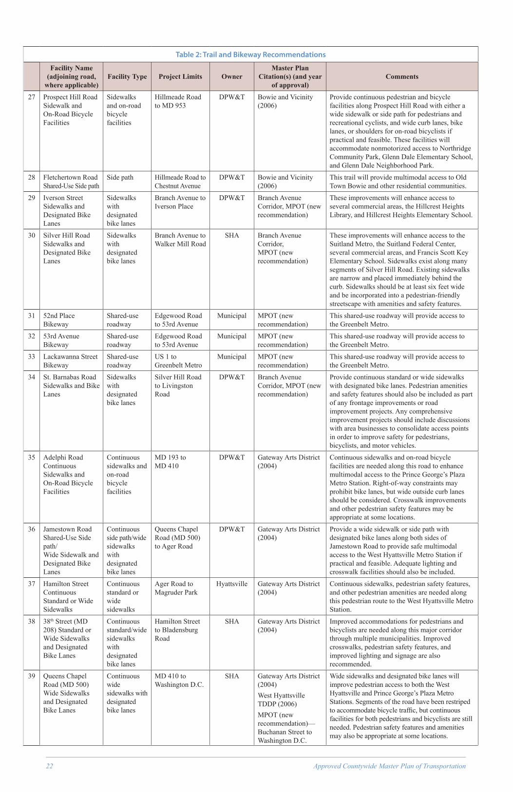
22 Approved Countywide Master Plan of Transportation
Table 2: Trail and Bikeway Recommendations
Facility Name (adjoining road,
where applicable)Facility Type Project Limits Owner
Master Plan Citation(s) (and year
of approval)Comments
27 Prospect Hill Road Sidewalk and On-Road Bicycle Facilities
Sidewalks and on-road bicycle facilities
Hillmeade Road to MD 953
DPW&T Bowie and Vicinity (2006)
Provide continuous pedestrian and bicycle facilities along Prospect Hill Road with either a wide sidewalk or side path for pedestrians and recreational cyclists, and wide curb lanes, bike lanes, or shoulders for on-road bicyclists if practical and feasible. These facilities will accommodate nonmotorized access to Northridge Community Park, Glenn Dale Elementary School, and Glenn Dale Neighborhood Park.
28 Fletchertown Road Shared-Use Side path
Side path Hillmeade Road to Chestnut Avenue
DPW&T Bowie and Vicinity (2006)
This trail will provide multimodal access to Old Town Bowie and other residential communities.
29 Iverson Street Sidewalks and Designated Bike Lanes
Sidewalks with designated bike lanes
Branch Avenue to Iverson Place
DPW&T Branch Avenue Corridor, MPOT (new recommendation)
These improvements will enhance access to several commercial areas, the Hillcrest Heights Library, and Hillcrest Heights Elementary School.
30 Silver Hill Road Sidewalks and Designated Bike Lanes
Sidewalks with designated bike lanes
Branch Avenue to Walker Mill Road
SHA Branch Avenue Corridor, MPOT (new recommendation)
These improvements will enhance access to the Suitland Metro, the Suitland Federal Center, several commercial areas, and Francis Scott Key Elementary School. Sidewalks exist along many segments of Silver Hill Road. Existing sidewalks are narrow and placed immediately behind the curb. Sidewalks should be at least six feet wide and be incorporated into a pedestrian-friendly streetscape with amenities and safety features.
31 52nd Place Bikeway
Shared-use roadway
Edgewood Road to 53rd Avenue
Municipal MPOT (new recommendation)
This shared-use roadway will provide access to the Greenbelt Metro.
32 53rd Avenue Bikeway
Shared-use roadway
Edgewood Road to 53rd Avenue
Municipal MPOT (new recommendation)
This shared-use roadway will provide access to the Greenbelt Metro.
33 Lackawanna Street Bikeway
Shared-use roadway
US 1 to Greenbelt Metro
Municipal MPOT (new recommendation)
This shared-use roadway will provide access to the Greenbelt Metro.
34 St. Barnabas Road Sidewalks and Bike Lanes
Sidewalks with designated bike lanes
Silver Hill Road to Livingston Road
DPW&T Branch Avenue Corridor, MPOT (new recommendation)
Provide continuous standard or wide sidewalks with designated bike lanes. Pedestrian amenities and safety features should also be included as part of any frontage improvements or road improvement projects. Any comprehensive improvement projects should include discussions with area businesses to consolidate access points in order to improve safety for pedestrians, bicyclists, and motor vehicles.
35 Adelphi Road Continuous Sidewalks and On-Road Bicycle Facilities
Continuous sidewalks and on-road bicycle facilities
MD 193 to MD 410
DPW&T Gateway Arts District (2004)
Continuous sidewalks and on-road bicycle facilities are needed along this road to enhance multimodal access to the Prince George’s Plaza Metro Station. Right-of-way constraints may prohibit bike lanes, but wide outside curb lanes should be considered. Crosswalk improvements and other pedestrian safety features may be appropriate at some locations.
36 Jamestown Road Shared-Use Side path/ Wide Sidewalk and Designated Bike Lanes
Continuous side path/wide sidewalks with designated bike lanes
Queens Chapel Road (MD 500) to Ager Road
DPW&T Gateway Arts District (2004)
Provide a wide sidewalk or side path with designated bike lanes along both sides of Jamestown Road to provide safe multimodal access to the West Hyattsville Metro Station if practical and feasible. Adequate lighting and crosswalk facilities should also be included.
37 Hamilton Street Continuous Standard or Wide Sidewalks
Continuous standard or wide sidewalks
Ager Road to Magruder Park
Hyattsville Gateway Arts District (2004)
Continuous sidewalks, pedestrian safety features, and other pedestrian amenities are needed along this pedestrian route to the West Hyattsville Metro Station.
38 38th Street (MD 208) Standard or Wide Sidewalks and Designated Bike Lanes
Continuous standard/wide sidewalks with designated bike lanes
Hamilton Street to Bladensburg Road
SHA Gateway Arts District (2004)
Improved accommodations for pedestrians and bicyclists are needed along this major corridor through multiple municipalities. Improved crosswalks, pedestrian safety features, and improved lighting and signage are also recommended.
39 Queens Chapel Road (MD 500) Wide Sidewalks and Designated Bike Lanes
Continuous wide sidewalks with designated bike lanes
MD 410 to Washington D.C.
SHA Gateway Arts District (2004)West Hyattsville TDDP (2006)MPOT (new recommendation)—Buchanan Street to Washington D.C.
Wide sidewalks and designated bike lanes will improve pedestrian access to both the West Hyattsville and Prince George’s Plaza Metro Stations. Segments of the road have been restriped to accommodate bicycle traffic, but continuous facilities for both pedestrians and bicyclists are still needed. Pedestrian safety features and amenities may also be appropriate at some locations.

Approved Countywide Master Plan of Transportation 23
Table 2: Trail and Bikeway Recommendations
Facility Name (adjoining road,
where applicable)Facility Type Project Limits Owner
Master Plan Citation(s) (and year
of approval)Comments
40 Good Luck Road Shared-Use Side path and Designated Bike Lanes
Shared-use side path and designated bike lanes
Springfield Road to MD 201
DPW&T Glenn Dale-Lanham-Seabrook (1993)
Bladensburg-New Carrollton (1994)
These facilities will accommodate nonmotorized access to Greenbelt National Park, Parkdale High School, Robert Frost Elementary School, Lamont Elementary School, Catherine T. Reed Elementary School, Robert Goddard Middle School, DuVal High School, Turner Recreation Park, and Good Luck Community Center. This is a major east/west connection through northern Prince George’s County.
41 Folly Branch Stream Valley Trail
Multiuse trail (hiker/biker/ equestrian)
Glenn Estates (south of MD 564) to Bald Hill Branch
M-NCPPC Glenn Dale-Seabrook-Lanham and Vicinity (1993)
Largo-Lottsford (1990)
Several segments of this trail have been implemented through development applications and M-NCPPC capital improvement projects. This trail provides a key connection in central Prince George’s County that links residential areas with shopping centers and office space. This trail will also improve access to the WB&A Trail and a planned trail along Bald Hill Branch.
42 Whitfield Chapel Road Sidewalks and On-Road Bicycle Facilities
Sidewalks and on-road bicycle facilities
MD 704 to MD 450
DPW&T Glenn Dale-Seabrook-Lanham and Vicinity (1993)
These sidewalk improvements will connect existing residential communities to MD 450, Whitfield Chapel Park, and MD 704.
43 Princess Garden Parkway Sidewalks and On-Road Bicycle Facilities
Sidewalks and on-road bicycle facilities
MD 450 to Good Luck Road
DPW&T Glenn Dale-Seabrook-Lanham and Vicinity (1993)
Current sidewalk facilities are fragmented. The sidewalks will connect existing residential communities with nearby commercial areas and the future Good Luck Road side path.
44 MD 450 Side path Shared-Use side path
Seabrook Road to the Capital Beltway
SHA Glenn Dale-Seabrook-Lanham and Vicinity (1993)
SHA has completed a side path along MD 450 as part of road improvement projects from Race Track Road in Bowie to Seabrook Road. This side path/wide sidewalk should be extended along MD 450 to the Capital Beltway. This facility, in conjunction with sidewalk construction inside the Beltway, will improve pedestrian access to the New Carrollton Metro. Where MD 450 has been reconstructed, wide outside curb lanes have been provided for on-road bicyclists.
45 Barnaby Run Stream Valley Trail
Multiuse trail (hiker/biker/ equestrian)
Southern Avenue to 28th Avenue
M-NCPPC Heights Master Plan (2000)
Provide a multiuse stream valley trail along Barnaby Run to provide a connection to the public facilities located in the area. Facilities include the North Barnaby Park and Aquatic Facility, Hillcrest Heights Elementary School, Hillcrest Heights Community Center, and the proposed Hillcrest Heights mixed-use development.
46 Henson Creek Trail Extension
Multiuse trail (hiker/biker/equestrian)
Temple Hill Road to Branch Avenue Metro
M-NCPPC Henson Creek-South Potomac (2006)
Heights Master Plan (2000)
Extend the existing trail to the Branch Avenue Metro. This trail will extend the existing five mile stream valley trail, provide access to the Branch Avenue Metro and Camp Springs Town Center, and connect to the planned trail along Suitland Parkway.
47 Tinkers Creek Stream Valley Trail
Multiuse trail (hiker/biker/equestrian)
Camp Springs Park at Coolridge Road to Piscataway Creek
M-NCPPC Henson Creek-South Potomac (2006)
Subregion 5 (2009)
This planned trail has been approved for construction through the Bevard North development. This trail will connect to the Pea Hill Branch and Piscataway Creek Trails, provide access to the Clinton area, and provide access between adjoining residential communities.
48 Temple Hill Road Sidewalks and Bike Lanes
Continuous sidewalks and striped and designated bike lanes
MD 414 to MD 223
DPW&T Henson Creek-South Potomac (2006)
These facilities will improve bicycle and pedestrian access to the Henson Creek Trail, Crossland High School, Clinton Grove Elementary School, Allenwood Elementary School, Temple Hills Park, and Henson Creek Neighborhood Park.
49 Tucker Road Sidewalks and Bike Lanes
Sidewalks with designated bike lanes
St. Barnabas Road to Allentown Road
DPW&T Henson Creek-South Potomac (2006)
Continuous sidewalks and designated bike lanes are recommended along this corridor. They will provide pedestrian and bike access from surrounding communities to the Tucker Road Community Center and Henson Creek Trail.
50 Bock Road Sidewalks and Designated Bike Lanes
Sidewalks and designated bike lanes
Livingston Road to Tucker Road
DPW&T Henson Creek-South Potomac (2006)
These facilities will provide pedestrian and bike access from surrounding communities to the Henson Creek Trail.
51 Brinkley Road Sidewalks and Designated Bike Lanes
Sidewalks and designated bike lanes
St. Barnabas Road to Allentown Road
DPW&T Henson Creek-South Potomac (2006)
These facilities will provide pedestrian and bike access from surrounding communities to schools, shopping centers, and the Henson Creek Trail.

24 Approved Countywide Master Plan of Transportation
Table 2: Trail and Bikeway Recommendations
Facility Name (adjoining road,
where applicable)Facility Type Project Limits Owner
Master Plan Citation(s) (and year
of approval)Comments
52 Allentown Road (MD 337) Sidewalks and Designated Bike Lanes
Sidewalks and designated bike lanes
Suitland Parkway to MD 5
SHA Henson Creek-South Potomac (2006)
These facilities will provide pedestrian and bike access to several commercial areas from surrounding residential communities.
53 Allentown Road (MD 337)Sidewalks and Designated Bike Lanes
Sidewalks and designated bike lanes
Steed Road to Old Fort Road
DPW&T Henson Creek-South Potomac (2006)
Subregion 5 (2009)
These facilities will link established residential communities with existing school and park facilities. Public facilities along the road include Tayac Elementary School, Isaac J. Gourdine Middle School, Friendly High School, and the Allentown Road Fitness and Aquatic Center.
54 Oxon Hill Road (MD 414)Sidewalks and Designated Bike Lanes
Sidewalks and designated bike lanes
MD 210 to Livingston Road West
DPW&T Henson Creek-South Potomac (2006)
These facilities will provide pedestrian and bike access to National Harbor, Oxon Hill Manor, Fort Foote Elementary School, and the Henson Creek Trail. A portion of these improvements are funded through a Department of Public Works and Transportation Capital Improvement Program project. These improvements will also serve as a segment of the Potomac Heritage Trail on-road bicycle route.
55 Oxon Hill Road (MD 414) Sidewalks, Designated Bike Lanes and Pedestrian Safety Improvements
Sidewalks and designated bike lanes
MD 210 to St. Barnabas Road
SHA Henson Creek-South Potomac (2006)
Continuous sidewalks and on-road bicycle facilities are needed along this heavily traveled commercial corridor. Pedestrian safety issues also need to be addressed and improved crosswalks, pedestrian refuges, and other features may be appropriate
56 Fort Foote Road Sidewalks and Designated Bike Lanes
Sidewalks and designated bike lanes
Oxon Hill Road (near Kirby Hill Road) to Oxon Hill Road (north of Livingston Road)
DPW&T Henson Creek-South Potomac (2006)
These facilities will provide pedestrian and bike access from surrounding communities to the Fort Foote Community Center, Fort Foote National Park, Fort Foote Elementary School, and Oxon Hill Middle School. These improvements will also serve as a segment of the Potomac Heritage Trail on-road bicycle route.
57 Palmer Road Sidewalks and Designated Bike Lanes
Sidewalks and designated bike lanes
Tucker Road to MD 210
DPW&T Henson Creek-South Potomac (2006)
These facilities will provide pedestrian and bike access from surrounding communities to the Lynnalan Neighborhood Park.
58 Fort Washington Road Sidewalks and Designated Bike Lanes
Sidewalks and designated bike lanes
MD 210 to Fort Washington Park
DPW&T Henson Creek-South Potomac (2006)
Provide continuous sidewalks and designated bike lane if practical and feasible. These facilities will provide pedestrian and bike access from surrounding communities to the Fort Washington National Park, Potomac Landing Elementary School, Potomac Landing Park, and Tantallon Shopping Center. These improvements will also serve as a segment of the Potomac Heritage Trail on-road bicycle route.
59 Old Fort Road Sidewalks and Designated Bike Lanes
Sidewalks and designated bike lanes
MD 210 to Fort Washington Road to MD 210 (at Oxon Hill Road)
DPW&T Henson Creek-South Potomac (2006)
Provide continuous sidewalks and designated bike lane if practical and feasible. These facilities will provide pedestrian and bike access from surrounding communities to the Fort Washington National Park. These improvements will also serve as a segment of the Potomac Heritage Trail on-road bicycle route.
60 Old Fort Road Sidewalks and Designated Bike Lanes
Sidewalks and designated bike lanes
MD 210 (at Forest Plaza) to MD 210 (at Livingston Square Shopping Center)
DPW&T Henson Creek-South Potomac (2006)
Provide continuous sidewalks and designated bike lane if practical and feasible. These facilities will serve residential communities along Old Fort Road and provide better pedestrian access to nearby park, school, and shopping facilities.
61 Riverview Road Sidewalks and designated bike lanes
Fort Washington Road to Swan Creek Road
DPW&T Henson Creek-South Potomac (2006)
Provide continuous sidewalks and designated bike lane if practical and feasible. These facilities will provide continuous accommodations for pedestrians and bicyclists and serve as a segment of the Potomac Heritage Trail On-Road Bicycle Route.
62 Swan Creek Road Sidewalks and designated bike lanes
Riverview Road to MD 210
DPW&T Henson Creek-South Potomac (2006)
These facilities will provide continuous accommodations for pedestrians and bicyclists and serve as a segment of the Potomac Heritage Trail on-road bicycle route. Swan Creek Road provides access from residential communities to Old Forte Village Shopping Center.

Approved Countywide Master Plan of Transportation 25
Table 2: Trail and Bikeway Recommendations
Facility Name (adjoining road,
where applicable)Facility Type Project Limits Owner
Master Plan Citation(s) (and year
of approval)Comments
63 Auth Road Sidewalk and Bikeway Improvements
Sidewalks and on-road bicycle improvements
MD 337 to MD 5 DPW&T Henson Creek-South Potomac (2006)—outside the Beltway
MPOT (new recommendation—inside the Beltway
Continuous sidewalks, on-road bicycle improvements, and pedestrian safety features are needed along this major road connection to the Branch Avenue Metro. Auth Road also serves as a connection to Metro from surrounding communities.
64 Livingston Road Sidewalks and Designated Bike Lanes
Sidewalks and designated bike lanes
MD 210 in Forest Heights to MD 210 at Kerby Hill Road
DPW&T Henson Creek-South Potomac (2006)—outside the Capital Beltway
MPOT (new recommendation)—inside the Capital Beltway
These facilities will provide pedestrian and bike access to Oxon Hill Plaza and Glassmanor Community Park.
65 Cattail Branch Stream Valley Trail
Multiuse trail (hiker/biker/equestrian)
Glenarden Parkway to Beaverdam Creek
M-NCPPC Landover and Vicinity (1993)
This trail can be implemented as a stream valley trail and a side path along Barlowe Road extended. Where the trail is implemented in conjunction with Barlowe Road extended, an attractive and inviting streetscape is recommended with appropriate pedestrian-and trail-related amenities that highlight the Cattail Branch and surrounding open space. This trail/greenway should include connections to surrounding schools and neighborhoods. Upon its completion along its entire length, this stream valley trail will provide access to Kenmoor Elementary School, Kenmoor Middle School, Matthew Henson Elementary School, the Palmer Park Community Center, and the Kentland Community Center.
66 Brightseat Road Sidewalks and Bike Lanes
Sidewalks and designated bike lanes
Ardwick-Ardmore Road to MD 214
DPW&T Landover and Vicinity (1993)
Provide continuous sidewalks/wide sidewalks and on-road bicycle accommodations along Brightseat Road. Brightseat Road is a major north-south connection through the Landover Gateway area, and currently facilities for pedestrians are fragmented. The road currently does not include striping for bicycle facilities. However, due to the speed and volume along the road, its connectivity through the sector plan area, and its connection to FedEx Field, designated bike lanes are recommended. Brightseat Road should also include accommodations for bicycles and pedestrians at the planned interchange with MD 202. These facilities will provide safe nonmotorized connectivity to the Landover civic center and commercial core from surrounding neighborhoods.
67 Sheriff Road Wide Sidewalks and Designated Bike Lanes
Sidewalks and designated bike lanes
Brightseat Road to Washington DC
DPW&T Landover and Vicinity (1993)
Extend the existing wide sidewalks along the entire length of Sheriff Road. Designated bike lanes are also recommended. These facilities will improve access to FedEx Field, Cabin Branch Trail, and Cedar Heights Community Center.
68 Cabin Branch Stream Valley Trail
Multiuse trail (hiker/biker/ equestrian)
MD 214 to Beaverdam Creek
M-NCPPC Landover and Vicinity (1993)
Addison Road Metro Area Sector Plan (2000)
This park trail will provide needed recreational opportunities in the Landover and Seat Pleasant areas. It will provide access to numerous park and school facilities, as well as to the Cheverly and Addison Road Metro Stations.
69 MD 202 Continuous Sidewalks and On-Road Bicycle Facilities
Standard or wide sidewalks with on-road bicycle facilities.
Barlowe Road to MD 450
SHA Landover and Vicinity (1993)
Bladensburg-New Carrollton and Vicinity (1994)
Road improvements along MD 202 should be consistent with the AASHTO Guide for the Development of Bicycle Facilities and improvements and pavement markings should preserve and enhance the existing state-designated Upper Marlboro to College Park Bikeway. If MD 202 is improved from an open to closed section roadway, a standard side path shall be provided along one side and bicycle-compatible pavement markings shall be provided on the outside curb lanes.

26 Approved Countywide Master Plan of Transportation
Table 2: Trail and Bikeway Recommendations
Facility Name (adjoining road,
where applicable)Facility Type Project Limits Owner
Master Plan Citation(s) (and year
of approval)Comments
70 Evarts Street Sidewalk and Bike Lanes
Sidewalks and designated bike lanes
Existing Evarts Street to the Woodmore Towne Centre
DPW&T MPOT (new recommendation)
Provide continuous sidewalks and on-road bicycle facilities on the Evarts Street extension. This extension will provide pedestrian access between the Woodmore Towne Centre and the Landover Gateway regional center and commercial core. In addition, this pedestrian connection across the Beltway will provide for a more unified, walkable study area by providing access across a major pedestrian barrier.
71 Adelphi Road Shared-Use Side path
Shared-use side path
MD 650 to MD 193
DPW&T Langley Park-College Park-Greenbelt (1989)
The extension of the existing wide sidewalk along Adelphi Road is recommended to improve access to the University of Maryland. On-road bicycle facilities are also recommended, with bike lanes being preferred along this high volume corridor if right-of-way constraints allow.
72 MD 193 Shared-Use Side path and Designated Bike Lanes
Wide sidewalk or shared-use side path and designated bike lanes
Watkins Regional Park to Montgomery County line
SHA Langley Park-College Park-Greenbelt (1989)—Soil Conservation Road to Paint Branch
MPOT (new recommendation)—Paint Branch to Montgomery County
Glenn Dale-Seabrook-Lanham and Vicinity (1993)—Cipriano Road to US 50
Largo-Lottsford (1990)—US 50 to Watkins Regional Park
Provide continuous pedestrian and bicycle accommodations along MD 193 with either a wide sidewalk or side path for pedestrians and recreational cyclists, and wide curb lanes, bike lanes, or shoulders for on-road bicyclists. MD 193 is a major east/west corridor in northern Prince George’s County and provides access to many schools, parks, and commercial areas. Pedestrian safety along the corridor is a concern and the provision of facilities to safely accommodate pedestrians and bicyclists is a priority.
73 Metzerott Road Sidewalks and Bike Lanes
Continuous sidewalks and designated bike lanes
MD 650 to MD 193
DPW&T MPOT (new recommendation)
Pedestrian safety needs to be evaluated as part of future improvements to the MD 193 and Metzerott Road intersection.
74 Bald Hill Branch Stream Valley Trail
Multiuse trail (hiker/biker/ equestrian)
MD 450 to Western Branch
M-NCPPC Largo Lottsford (1990)
Glenn Dale-Seabrook-Lanham (1993)
This stream valley trail will connect to the planned Folly Branch Trail and Western Branch Trail, as well as the existing trail along MD 450.
75 Western Branch Stream Valley Trail
Multiuse trail (hiker/biker/ equestrian)
Enterprise Golf Course to the Patuxent River
M-NCPPC Largo-Lottsford (1990)
Subregion 6 (2009)
This trail will provide access to Upper Marlboro and the Prince George’s Equestrian Center. It will also provide a nonmotorized connection between the Largo area and Upper Marlboro, link to the Folly Branch, Collington Branch, and Patuxent River trails, and connect to Watkins Regional Park.
76 Lottsford Branch Stream Valley Trail
Multiuse trail (hiker/biker/ equestrian)
Glenn Dale Community Center to Folly Branch
M-NCPPC Largo-Lottsford (1990)
The stream valley trail will connect existing park facilities such as the splash park and WB&A Trail with the planned stream valley trail network to the south.
77 Lottsford Road Shared-Use Side path
Shared-use side path/wide sidewalks and on-road bicycle facilities
MD 193 to Harry S Truman Drive
DPW&T Largo-Lottsford (1990)
This planned facility has been implemented as a wide sidewalk along some frontages. On-road bicycle facilities should be considered as road improvements occur.
78 Campus Way Side path/Wide Sidewalk with Designated Bike Lanes
Shared-use side path or wide sidewalk and designated bike lanes
Evarts Street to Harry S Truman Drive
DPW&T Largo-Lottsford (1990)
Extend the existing wide sidewalks along the entire length of both existing and planned Campus Way. This road will ultimately connect to the Evarts Street bridge over the Capital Beltway. Designated bike lanes should also be provided. These facilities will provide access between the Woodmore Towne Centre, Landover Gateway area, and the Largo Town Center.
79 Lake Arbor Way Bikeway
On-road bicycle improvements
MD 202 to MD 214
DPW&T Largo-Lottsford (1990)
Lake Arbor Way currently includes standard sidewalks along both sides of its entire length. Bicycle compatible road striping and signage is recommended.

Approved Countywide Master Plan of Transportation 27
Table 2: Trail and Bikeway Recommendations
Facility Name (adjoining road,
where applicable)Facility Type Project Limits Owner
Master Plan Citation(s) (and year
of approval)Comments
80 Lottsford Vista Road Sidewalks and On-Road Bicycle Facilities
Sidewalks and on-road bicycle facilities
Lottsford Road to MD 704
DPW&T Largo-Lottsford (1990)
Continuous accommodations for bicycles and pedestrians are needed. Sidewalks are currently fragmented. This will improve access to the Washington Business Park.
81 Ritchie Branch Trail
Multiuse trail (hiker/biker/ equestrian)
Marlboro Pike to Walker Mill Regional Park
M-NCPPC Marlboro Pike, MPOT (new recommendation)
This planned trail will provide access from the Forestville community to Walker Mill Regional Park. This is a long-term recommendation that will require the acquisition of land along the stream valley within a largely industrial corridor.
82 MD 4 Shared-Use Side path
Side path (hiker/biker)
Capital Beltway to the Washington, D.C. line
SHA Marlboro Pike, MPOT (new recommendation)
A side path has been recently completed along the north side of MD 4 from Walters Lane to Parkland Drive. It is recommended that this trail be completed along the entire length of MD 4 inside the Beltway. This trail will link adjacent residential communities, provide access to existing bus stops, and improve access to commercial areas. There is an existing need for this facility as residents currently walk along the shoulder or parallel to the road to reach nearby bus stops and commercial areas.
83 Marlboro Pike Sidewalk and Bikeway Improvements
Sidewalks and on-road bicycle improvements
Forestville Road to Washington, D.C. line
DPW&T Marlboro Pike, MPOT (new recommendation)
Planning for the Marlboro Pike Sector Plan has indicated the need for continuous sidewalks and streetscape improvements along this corridor. Pedestrian safety features should also be incorporated, where feasible. Due to right-of-way constraints, full bike lanes may not be feasible.
84 Dower House Road Sidewalks and Designated Bike Lanes
Sidewalks and designated bike lanes
MD 4 to Melwood Hills Community Park
DPW&T Melwood-Westphalia (1994)
Continuous sidewalks and designated bike lanes are needed to accommodate nonmotorized trips going to the Westphalia Town Center.
85 MD 223 Shared-Use Side path
Side path (hiker/biker)
MD 4 to Livingston Road
SHA Melwood-Westphalia (1994)—MD 4 to Rosaryville Road.
MPOT (new recommendation)—Rosaryville Road to Livingston Road
A shared-use side path or wide sidewalk is recommended along this rapidly developing corridor in southern Prince George’s County. There has been consistent feedback from the community that safe pedestrian facilities are needed along this heavily traveled and rapidly developing corridor. This trail will provide safe access to numerous schools and park facilities, as well as link adjoining residential communities. Currently, sidewalks are fragmented or missing in many areas and a side path is needed to improve pedestrian safety.
86 Arena Drive Shared-Use Side path
Wide sidewalk and on-road bicycle facilities
Brightseat Road to MD 202
DPW&T Morgan Boulevard and Largo Town Center Metro Areas (2004)
Largo-Lottsford (1990)
Extend the existing wide sidewalks along the entire length of Arena Drive. This facility will improve pedestrian access between FedEx Field and the Largo Town Center.
87 Hill Road Continuous Sidewalks and On-Road Bicycle Improvements
Sidewalks and on-road bicycle facilities
MD 214 to MD 704
DPW&T Morgan Boulevard and Largo Town Center Metro Areas (2004)
Provide continuous sidewalks and on-road bicycle facilities to improve access between communities and to Oakcrest Elementary School and Peppermill Village Park.
88 MD 214 Continuous Sidewalks
Sidewalks and on-road bicycle facilities
Capital Beltway to Washington, D.C.
SHA Morgan Boulevard and Largo Town Center Metro Areas (2004)
Addison Road Metro Town Center (2000)
Improved accommodations for pedestrians are recommended along MD 214. Gaps in the sidewalk network should be completed, and new sidewalk construction should provide a buffer between the travel lanes and pedestrian zone. Wide sidewalks are appropriate near Metro and in areas of high pedestrian traffic. Crosswalk improvements, safety enhancements, and on-road bicycle facilities should also be considered.
89 Oxon Run Trail Multiuse trail (hiker/biker/ equestrian)
Oxon Hill Farm (NPS) to Azalea Acres Park
M-NCPPC MPOT (new recommendation)
This trail will provide access to the existing National Park Service (NPS) Trail into the District. It will also provide access to Glassmanor Community Center.

28 Approved Countywide Master Plan of Transportation
Table 2: Trail and Bikeway Recommendations
Facility Name (adjoining road,
where applicable)Facility Type Project Limits Owner
Master Plan Citation(s) (and year
of approval)Comments
90 MD 704 Shared-Use Side path
Side path (hiker/biker)
MD 450 to the Washington, D.C. line
SHA MPOT (new recommendation)
A side path or wide sidewalk construction with designated bike lanes is recommended along MD 704 (District of Columbia to I-495). It may be appropriate to use excess capacity along MD 704 to accommodate improved bicycle and pedestrian facilities. MD 704 connects to the existing WB&A Trail outside I-495. Trail construction along MD 704 will provide an extension of the existing WB&A Trail to provide a continuous east/west trail connection through central Prince George’s County.
91 Ritchie Road Sidewalks and Bike Lanes
Sidewalks and designated bike lanes
MD 214 to Walker Mill Road
DPW&T MPOT (new recommendation)
Continuous sidewalks and designated bike lanes are needed to accommodate nonmotorized trips along this employment/industrial corridor. Ritchie Road connects to the wide sidewalks currently along Garrett A. Morgan Boulevard.
92 Contee Road Continuous Sidewalks and On-Road Bicycle Facilities
Sidewalks and on-road bicycle facilities
MD 197 to Cherry Lane
DPW&T MPOT (new recommendation)
These facilities will improve access to several shopping centers and James H. Harrison Elementary School. Designated bike lanes are recommended if right-of-way constraints allow. From US 1 west to Cherry Lane there shall be sidewalks and designated on-road bike lanes.
93 Odell Road Continuous Sidewalks and On-Road Bicycle Facilities
Sidewalks and on-road bicycle facilities
Old Baltimore Pike to Powder Mill Road (MD 212)
DPW&T MPOT (new recommendation)
Continuous sidewalks are needed along this major route through the Beltsville community. These planned facilities will begin on the east side of Old Baltimore Pike, which is east of the railroad tracks and industrial area.
94 Sellman Road Sidewalk or Shared-Use Side path and Bike Lanes
Standard sidewalks or shared-use side path (hiker/biker)
Rhode Island Avenue to Cherry Hill Road
DPW&T MPOT (new recommendation)
Provide a standard sidewalk or a side path along the north side of Sellman Road from Cherry Hill Road to US 1 if practical and feasible. This needed improvement will provide safe pedestrian access to the Beltsville Community Center from nearby residential communities. This sidewalk will also provide pedestrian access to nearby local businesses. Designated bike lanes should also be provided.
95 MD 197 Shared-Use Side path
Shared-use side path (hiker/biker)
Laurel to Bowie SHA MPOT (new recommendation)
Currently, much of the land between Laurel and Bowie is in federal ownership and is restricted from trails and other recreational uses. However, a side path within the MD 197 right-of-way will provide a trail connection from Bowie to Laurel without impacting the adjacent federal properties. A side path is necessary to safely accommodate pedestrians and bicyclists along this high volume, high speed roadway. This trail will also provide access to the existing WB&A Trail and serve as a segment of the nationally designated East Coast Greenway.
96 Beaverdam Road Designated Bike Lanes
Bike lanes MD 201 to Springfield Road
DPW&T MPOT (new recommendation)
Designated bike lanes shall be provided.
97 MD 201 Shared-Use Side path
Shared-use side path (hiker/biker)
US 50 to I-495 SHA MPOT (new recommendation)
This trail will improve bike and pedestrian safety along a high-volume and high-speed roadway.
98 Paint Branch Parkway Designated Bike Lanes
Designated bike lanes
US 1 to MD 201 DPW&T MPOT (new recommendation)
Provide designated bike lanes along the entire length of Paint Branch Parkway if feasible. This will improve access to the University of Maryland.
99 Baltimore-Washington Parkway Trail
Shared-use trail
Muirkirk Road to Pedestrian Bridge off Hanover Parkway (Greenbelt)
NPS MPOT (new recommendation)
This trail will provide north/south access through the Beltsville Agricultural Research Center from Laurel to Greenbelt in an area where there are no off-road trail options for bicyclists. This trail can tie into the existing pedestrian bridge over the Baltimore-Washington Parkway in the vicinity of Hanover Parkway and Gardenway Court. This trail may be similar to the trail currently under study along the Suitland Parkway.
100 MD 410 Continuous Standard or Wide Sidewalks with On-Road Bicycle Facilities
Sidewalks with on-road bicycle facilities
Montgomery County to the Baltimore-Washington Parkway
SHA MPOT (new recommendation)
Prince George’s Plaza TDDP (1998)
Continuous facilities for pedestrians and bicyclists are needed along this corridor. Wide sidewalks are recommended within the Prince George’s Plaza Transit District, and continuous sidewalk facilities are needed along the rest of the corridor. Bicycle compatible road striping should be considered, although right-of-way constraints may prohibit full bike lanes.

Approved Countywide Master Plan of Transportation 29
Table 2: Trail and Bikeway Recommendations
Facility Name (adjoining road,
where applicable)Facility Type Project Limits Owner
Master Plan Citation(s) (and year
of approval)Comments
101 Riggs Road (MD 212)
Sidewalks and on-road bicycle facilities
Powder Mill Road (MD 212) to Washington D.C.
SHA MPOT (new recommendation)
Continuous sidewalks and on-road bicycle accommodations are necessary along this corridor. Currently, sidewalks are fragmented or missing along some segments of the road. Right-of-way constraints may prohibit bike lanes, but wide outside curb lanes should be considered. Crosswalk improvements and other pedestrian safety features may be appropriate at some locations.
102 Steed Road Shared-Use Side path and On-Road Bicycle Facilities
Shared-use side path with on-road bicycle facilities
MD 223 to Allentown Road
DPW&T MPOT (new recommendation)
Steed Road connects two major corridors within the northern portion of Subregion 5. A shared-use side path with on-road bicycle accommodations are recommended if practical and feasible. Steed Road also links existing residential communities with the planned Tinkers Creek Trail.
103 Auth Way Wide Sidewalks
Wide sidewalks
Auth Road to MD 5
DPW&T MPOT (new recommendation)
Continuous wide sidewalks should be provided along both sides of Auth Way as road improvements are made to improve access to the Branch Avenue Metro. Seven-foot-wide sidewalks have been approved along segments of Auth Way through the Camp Springs Town Center.
104 Suitland Road Sidewalks and Designated Bike Lanes
Sidewalks with designated bike lanes
Allentown Road to the Washington, D.C. line
DPW&T MPOT (new recommendation)
An attractive streetscape with continuous sidewalks, on-road bicycle facilities, and pedestrian safety features are needed along Suitland Road. Suitland Road provides access to the Suitland Federal Center, Suitland Community Park, and several nearby school facilities.
105 Walker Mill Road Side path/Wide Sidewalk
Shared-use side path or wide sidewalk
Ritchie-Marlboro Road to Marlboro Pike
DPW&T MPOT (new recommendation)
This project should be implemented as a shared-use side path or wide sidewalk. This facility will connect to the existing wide sidewalk along Ritchie Marlboro Road at the Capital Beltway interchange. This facility will provide access to Walker Mill Regional Park, John H. Bayne Elementary School, and Walker Mill Business Park.
106 Ritchie Road/ Forestville Road
Sidewalks and designated bike lanes
MD 214 to MD 4 DPW&T MPOT (new recommendation)
Continuous sidewalks and designated bike lanes are needed to accommodate pedestrians and bicyclists along these roads. These facilities will improve access to Walker Mill Regional Park and multiple employment areas.
107 Cherry Tree Crossing Sidewalks and Bikeway
Sidewalks and bikeway improvements
US 301 to MD 381
DPW&T MPOT (new recommendation)
Accommodations for pedestrians are needed to link the residential community with the Brandywine Town Center. The road is also designated as a shared-use bikeway.
108 Mountain Bike Skills Park
Skills park Hyattsville vicinity
M-NCPPC MPOT (new recommendation)
Mountain bike users are an underserved user group in Prince George’s County. Many multiuse trails do not provide the variety of scenery or terrain necessary for a challenging mountain bike trail. Similarly, children need safe places to ride where they can improve their bicycling skills. A mountain bike skills park is proposed in north county that will provide a variety of trail experiences and challenges and will better serve the mountain bike users in the county. Similar parks have been constructed in other urban areas that provide for a variety of trail experiences, challenges, and obstacles in relatively small, confined space.
109 Dangerfield Road Sidewalks and Bikeway
Sidewalks and on-road bicycle facilities
MD 223 to Sonar Road
DPW&T MPOT (new recommendation)
Continuous facilities are needed for pedestrians along this mostly open section road if practical and feasible. Bicycle compatible road improvements and bikeway signage should also be provided.
110 Brown Station Road Shared-Use Side path
Side path or wide sidewalk with on-road bicycle facilities
Old Marlboro Pike to White House Road
DPW&T MPOT (new recommendation)
Provide a side path or wide sidewalk along Brown Station Road. Where an open section road is maintained, bicycle compatible road improvements such as paved shoulders and bikeway signage should be provided.
111 Surratts Road Sidewalks and Bikeway
Sidewalks and on-road bicycle facilities
Brandywine Road to Dangerfield Road
DPW&T MPOT (new recommendation)
Continuous facilities are needed for pedestrians along this mostly open section road if practical and feasible. Bicycle compatible road improvements and bikeway signage should also be provided.
112 South Osborne Road Bikeway
Sidewalks and on-road bicycle improvements
Marlboro Pike to US 301
DPW&T MPOT (new recommendation)
Provide bicycle compatible improvements and bikeway signage as improvements are made.

30 Approved Countywide Master Plan of Transportation
Table 2: Trail and Bikeway Recommendations
Facility Name (adjoining road,
where applicable)Facility Type Project Limits Owner
Master Plan Citation(s) (and year
of approval)Comments
113 Ardwick-Ardmore Road Sidewalks and On-Road Bicycle Facilities
Sidewalks and on-road bicycle facilities
Lottsford Vista Road to Pennsy Drive
DPW&T MPOT (new recommendation) outside the Capital Beltway
Landover and Vicinity (1993) inside the Capital Beltway
Continuous accommodations for bicycles and pedestrians are needed. Sidewalks are currently fragmented. This will improve access to the New Carrollton Transit District and Metro station.
114 Suitland Parkway Trail
Shared-use side path (hiker/biker)
Washington, D.C. line to MD 4
NPS MPOT, Branch Avenue Corridor (new recommendation)
This trail will extend the existing Suitland Parkway Trail in D.C. along the Suitland Parkway in Prince George’s County. This trail will provide access to the Naylor Road and Suitland Metro Stations.
115 Branch Avenue Bicycle and Pedestrian Improvements
Shared-use side path or sidewalks with designated bike lanes
Capital Beltway to the Washington, D.C. line
SHA MPOT, Branch Avenue Corridor (new recommendation)
The Branch Avenue Corridor Sector Plan highlights the importance of improving pedestrian safety along and across Branch Avenue inside the Capital Beltway. In conjunction with other streetscape improvements, a shared-use side path or standard/wide sidewalks should be provided in conjunction with designated bike lanes. Safety improvements for pedestrians should also be incorporated into future intersection improvements. There may also be opportunities to construct an urban linear park along some sections of the corridor, as discussed in the sector plan.
116 Harkins Road Wide Sidewalks
Wide sidewalks
MD 450 to Ellin Road
DPW&T New Carrollton TDDP (1989)
Provide minimum six-foot-wide sidewalks along Harkin Avenue to accommodate pedestrians walking to the New Carrollton Metro Station.
117 Ellin Road Wide Sidewalks
Wide sidewalks
MD 450 to MD 410
DPW&T New Carrollton TDDP (1989)
Provide minimum six-foot-wide sidewalks along Ellin Avenue and 85th Avenue to accommodate pedestrians walking to the New Carrollton Metro Station.
118 Muirkirk Road Sidewalks and Bike Lanes
Sidewalks and designated bike lanes
MD 197 to A-3 DPW&T Subregion I (1990)
MPOT (new recommendation)
Provide continuous sidewalks and designated bike lanes along Muirkirk Road to improve access to the Muirkirk MARC Station and to A-3 south of the Konterra Town Center.
119 Contee Road Extended (A-6)Shared-Use Side path and Designated Bike Lanes
Sidewalks with designated bicycle lanes
Old Gunpowder Road to City of Laurel
Old Gunpowder Road to Van Dusen Road.
DPW&T Subregion I (1990)
MPOT (new recommendation)
These facilities will improve access to Fairland Regional Park and the planned Konterra development.
120 Kenilworth Avenue Extended (A-56) Shared-Use Side path and Designated Bike Lanes
Shared-use side path/wide sidewalk with designated bicycle lanes
Van Dusen Road to Sunnyside Avenue
DPW&T Subregion I (1990)
MPOT (new recommendation)
These facilities will improve access to Fairland Regional Park and the planned Konterra development.
121 Old Baltimore Pike Shared-Use Side path
Shared-use side path
Muirkirk Road to Odell Road
DPW&T Subregion I (1990) This side path will provide safe pedestrian and bicycle movement along a heavily traveled industrial road with significant truck traffic.
122 Odell Road Bike Lanes
Bike lanes Muirkirk Road to Old Baltimore Pike
DPW&T Subregion I (1990) Designated bike lanes shall be added to this road.
123 US 1 Shared-Use Side path
Shared-use side path (hiker/biker)
Capital Beltway to Laurel
SHA Subregion I (1990) Provide a side path or wide sidewalk along the west side of US 1. This will extend the existing side path along US 1 between Quimby Avenue and Muirkirk Road. This wide sidewalk or side path should ultimately extend from I-495 to Laurel.
124 Powder Mill Road (MD 212)
Bike lanes MD 197 to MD 201
SHA Subregion I (1990) Provide designated bike lanes along MD 212 through the Beltsville Agricultural Research Center. Paved shoulders are currently provided along in most areas.
125 Van Dusen Road Realigned
Sidewalks and bike lanes
Old Gunpowder Road to Konterra Town Center
DPW&T MPOT (new recommendation)
The existing portion of Van Dusen Road across this area will be realigned as part of the planned Konterra project and is expected to connect directly to the town center over I-95. No alignment is set at this time. These facilities will improve access to Fairland Regional Park and the planned Konterra Town Center.

Approved Countywide Master Plan of Transportation 31
Table 2: Trail and Bikeway Recommendations
Facility Name (adjoining road,
where applicable)Facility Type Project Limits Owner
Master Plan Citation(s) (and year
of approval)Comments
126 Powder Mill Road (MD 212)
Sidewalks and designated bike lanes
MD 201 to Montgomery County
SHA Subregion I (1990) Continuous sidewalks and designated bike lanes are needed along MD 212 in the Beltsville and Calverton areas. Sidewalks are currently fragmented or missing in many areas.
127 Springfield Road Bike Lanes
Designated bike lanes
Odell Road to MD 564
DPW&T Subregion I (1990)
Glenn Dale-Seabrook-Lanham (1993)
Continuous sidewalks and designated bike lanes should be provided where a closed section road is utilized. Designated bike lanes shall be provided to open sections where feasible.
128 Cherry Hill Road Continuous Sidewalks and Designated Bike Lanes
Sidewalks and designated bike lanes
US 1 to Montgomery County
SHA Subregion I (1990)
MPOT (new recommendation inside the Capital Beltway)
Continuous sidewalks and designated bike lanes are needed along this heavily traveled road to improve neighborhood access to existing park facilities and shopping centers.
129 Paint Branch Stream Valley Trail
Multiuse trail (hiker/biker/ equestrian)
Cherry Hill Road to Sellman Road
M-NCPPC Subregion I (1990), ATHA (2001)
Extend the existing Paint Branch Trail from Cherry Hill Road Community Park to the Beltsville Community Center north of Sellman Road. This trail extension will connect the existing ATHA network inside the Beltway with the existing Little Paint Branch Trail north of Sellman Road and will be an important segment of the trail connection planned between Bladensburg and Laurel in the ATHA Management Plan.
130 Rhode Island Avenue Trolley Trail
Shared-use trail with designated bike lanes
Quimby Avenue to Armentrout Drive
Municipal, SHA, and DPW&T
Subregion I (1990), Langley Park-College Park-Greenbelt (1989) Gateway Arts District (2004)
Provide a shared-use trail along this former trolley right-of-way. Several segments of this trail have been implemented by the City of College Park. Planning work is also being done in Riverdale Park and Hyattsville. Where an existing roadway is within the former trolley right-of-way, bikeway and sidewalk improvements may be appropriate. Designated bike lanes shall be provided from Greenbelt Road north to Quimby Avenue.
131 Pea Hill Branch Stream Valley Trail
Multiuse trail (hiker/biker/ equestrian)
MD 5 to Tinkers Creek
M-NCPPC Subregion 5 (2009) This local stream valley trail will improve pedestrian access in the Clinton area and connect to the Tinkers Creek Trail. An extensive network of trail easements and open space parcels have been established as development has occurred in the stream valley.
132 Edgewood Road Bike Lanes
Designated bike lanes
US 1 to 53rd Avenue
Municipal US 1 College Park Sector Plan (2002)
This facility may be accommodated as a shared-use roadway east of 52nd Place.
133 Montgomery Road Bike Lanes
Designated bike lanes
US 1 to Powder Mill Road
DPW&T MPOT (new recommendation)
Provide designated bike lanes consistent with the existing CIP projects.
134 Piscataway Creek Stream Valley Trail
Multiuse trail (hiker/biker/ equestrian)
MD 223 (near Rosaryville Road) to the Potomac River
M-NCPPC and NPS
Subregion 5 (2009)
Subregion 6 (2009)
This is one of the primary stream valley trail recommendations in southern Prince George’s County. This stream valley runs through the middle of a rapidly developing portion of southern Prince George’s County. Significant segments of the stream valley have been acquired by the Department of Parks and Recreation as development has occurred. In conjunction with the Charles Branch Trail in Subregion 6, the Piscataway Creek Trail will provide part of a planned “cross-county” connection linking the Potomac River at Fort Washington with the Patuxent River Greenway near Jug Bay. This trail will also provide nonmotorized access to the extensive trail system and recreational facilities at Cosca Regional Park.
135 Butler Branch Stream Valley Trail
Multiuse trail (hiker/biker/ equestrian)
Piscataway Creek Stream Trail to Cosca Regional Park
M-NCPPC Subregion 5 (2009) This trail will provide trail access from the planned Piscataway Creek Trail to the extensive existing trails in Cosca Regional Park.
136 Cheltenham Woods Community Park Stream Valley Trail
Multiuse trail (hiker/biker/ equestrian)
Piscataway Creek to Cheltenham Community Park
M-NCPPC Subregion 5 (2009) This trail will utilize an existing M-NCPPC stream valley park. It will provide trail access through an established residential community and connect to Piscataway Creek Stream Valley Trail and Cheltenham Community Park.
137 Mattawoman Creek Stream Valley Trail
Multiuse trail (hiker/biker/ equestrian)
Water trail (canoes and kayaks)
Beginning at the Potomac River, the entire length of Mattawoman Creek in Prince George’s County
M-NCPPC Subregion 5 (2009) A segment of this trail and a trail head facility have been approved for construction through the Homeland subdivision. More land acquisition is necessary along the corridor before additional segments can be completed. Access to Mattawoman Creek should also be provided for canoes and kayaks as part of the development of a water trail.

32 Approved Countywide Master Plan of Transportation
Table 2: Trail and Bikeway Recommendations
Facility Name (adjoining road,
where applicable)Facility Type Project Limits Owner
Master Plan Citation(s) (and year
of approval)Comments
138 Timothy Branch Stream Valley Trail
Multiuse trail (hiker/biker/ equestrian)
Brandywine Community Park to Mattawoman Creek
M-NCPPC Subregion 5 (2009) Provide a stream valley trail along Timothy Branch between Dyson Road and Mattawoman Creek. This trail will provide access to the developing employment center in Brandywine. Public use trail easements have been acquired as commercial development has occurred.
139 Burch Branch Stream Valley Trail
Multiuse trail (hiker/biker/ equestrian)
MD 373 to Piscataway Creek
M-NCPPC Subregion 5 (2009) This planned trail will connect the bikeway along Floral Park Road with the planned stream valley trail along Piscataway Creek. It will also provide a trail connection through the open space network outside the Brandywine Special Study Area.
140 Brandywine Road Sidewalks and Bike Lanes
Sidewalks and striped and designated bike lanes
MD 223 to US 301
DPW&T Subregion 5 (2009) Currently, a variety of cross sections exist along Brandywine Road and sidewalks are missing along many segments. Continuous sidewalks will provide a safe pedestrian route between adjoining residential communities, to several shopping centers, and to both Tinkers Creek and Piscataway Creek Stream Valley Trails. Brandywine Road also provides a parallel route to MD 5 for pedestrians and bicyclists. Evaluate the need for sidewalks along MD 223 outside the segment within the Developing Tier.
141 A-65 Shared-Use Side path
Shared-use side path (hiker/biker) and bicycle lanes or shared-use roadway
Branch Avenue to C-518 (Old Fort Road)
DPW&T Subregion 5 (2009) This trail will provide nonmotorized access through a rapidly developing portion of southern Prince George’s County. Segments of the trail have been approved for construction as part of recent development applications. The trail will also provide connectivity with several planned stream valley trails.
142 Thrift Road Shared-Use Side path and on-road bicycle facilities
Shared-use side path with on-road bicycle facilities
Brandywine Road to Windbrook Drive
DPW&T Subregion 5 (2009) Thrift Road provides access to the existing trails and recreational facilities in Cosca Regional Park. This path will connect residents in surrounding communities with the park. Thrift Road also connects to planned trails along Piscataway Creek and Butler Branch.
143 Old Alexandria Ferry Road Sidewalks and Bikeway
Sidewalks and on-road bicycle facilities
MD 5 to MD 223 DPW&T Subregion 5 (2009) Continuous sidewalks and on-road bicycle accommodations are needed along this road to serve existing residential communities, as well as business in the corridor. Sidewalks are currently fragmented or missing in many areas.
144 Bryan Point Road Shared-use roadway
Farmington Road DPW&T Subregion 5 (2009) Signage and bicycle compatible road improvements should be incorporated into this shared-use bikeway. Bryan Point Road serves as a segment of the Potomac Heritage National Scenic Trail on-road bicycle route with connections to the parkland on Wharf Road, Mockley Point, and Accokeek Farm.
145 Farmington Road West
Shared-use side path/on-road bicycle facilities
MD 210 to Livingston Road
DPW&T Subregion 5 (2009) Farmington Road West serves as a segment of the Potomac Heritage National Scenic Trail on-road bicycle route.
146 Floral Park Road Shared-Use Side path
Shared-use side path
Piscataway Road to Brandywine Road
DPW&T Subregion 5 (2009) This facility will connect Brandywine with Accokeek.
147 Accokeek Road Bikeway or Shared-Use Side path
Shared-use side path (if closed section), bikeway improvements where the road remains open section.
Livingston Road to MD 5
SHA Subregion 5 (2009) This facility will connect Brandywine with Accokeek. Improvements will vary depending on the road cross section utilized. Where the road is closed section, a side path should be provided. Where the road remains open section, bikeway improvements and signage should be provided.
148 Livingston Road Shared-Use Bikeway and Sidewalks
Shared-use bikeway with sidewalk construction in Accokeek
MD 210 at MD 373 to MD 210 at Gabriel Drive
DPW&T Subregion 5 (2009) Bicycle signage and safety improvements (if necessary) should be incorporated into any frontage improvements along this shared-use roadway. A segment of this road serves as a portion of the Potomac Heritage National Scenic Trail on-road bicycle route. Where the road goes through the Accokeek Town Center, standard sidewalks should be provided along both sides.

Approved Countywide Master Plan of Transportation 33
Table 2: Trail and Bikeway Recommendations
Facility Name (adjoining road,
where applicable)Facility Type Project Limits Owner
Master Plan Citation(s) (and year
of approval)Comments
149 Dyson Road Shared-Use Side path
Shared-use side path/wide sidewalk
Brandywine Road to Cherry Tree Crossing Road
DPW&T Subregion 5 (2009) Several segments of this facility have been implemented as wide sidewalks. Sidewalk gaps remain along the corridor. This facility will improve access to Gwynn Park High School and Gwynn Park Middle School.
150 Farmington Road West Shared-Use Bikeway
Bikeway, with some sidewalk construction
MD 210 to Livingston Road
DPW&T Subregion 5 (2009) Bikeway signage and possibly safety enhancements should be implemented, where necessary. The segments of Farmington Road West that are completely within the Developing Tier should include sidewalk construction along both sides to improve access to the Accokeek Town Center. The segments requiring sidewalk improvements extend from Reserve Road to Livingston Road and Wharf Road to MD 210. Farmington Road West is a segment of the Potomac Heritage National Scenic Trail on-road bicycle route.
151 Charles Branch Stream Valley Trail
Multiuse trail (hiker/biker/ equestrian)
Dower House Road to the Patuxent River
M-NCPPC Subregion 6 (2009)
Melwood-Westphalia (1994)
This is a long-term project where much land remains to be acquired. The trail will provide access to Rosaryville State Park and the Patuxent River, as well as serve as part of the cross-county connection with the Piscataway Creek Stream Valley Trail. The Charles Branch corridor serves as an important connection for equestrians to the state park.
152 MD 382 (Croom Road) Bikeway
On-road bicycle improvements
US 301 to MD 381
SHA Subregion 6 (2009) MD 382 is a heavily used corridor for long distance cyclists. Road improvements should include bicycle accommodations. A study of the corridor has recently been initiated that will explore the needs of both motor vehicles and bicyclists, as well as the preservation of the scenic qualities of the roadway.
153 MD 381 (Aquasco Road and Brandywine Road) Bikeway
On-road bicycle improvements
US 301 to Swanson Creek (Charles County)
SHA Subregion 6 (2009) MD 381 is a heavily used corridor for long distance cyclists. Road improvements should include bicycle accommodations. Sidewalk construction is needed within the Brandywine and Aquasco communities.
154 Croom Station Road Bikeway
On-road bicycle improvements
US 301 to MD 382
DPW&T Subregion 6 (2009) Roads within the Rural Tier are used by recreational and long-distance cyclists. As frontage improvements or other road improvements are made, bicycle compatible striping or paved shoulders should be provided to safely accommodate bicycle movement.
155 Croom Airport Road Bikeway
On-road bicycle improvements
MD 382 to the Chesapeake Bay Critical Area Driving Tour
DPW&T Subregion 6 (2009) Roads within the Rural Tier are used by recreational and long-distance cyclists. As frontage improvements or other road improvements are made, bicycle compatible striping or paved shoulders should be provided to safely accommodate bicycle movement.
156 St. Thomas Church Road Bikeway
On-road bicycle improvements
MD 382 to Fenno Road
DPW&T Subregion 6 (2009) Roads within the Rural Tier are used by recreational and long-distance cyclists. Bicycle signage and safety improvements (if necessary) should be incorporated into any frontage improvements along this shared-use roadway.
157 Nottingham Road Bikeway
On-road bicycle improvements
MD 382 to Watershed Drive
DPW&T Subregion 6 (2009) Roads within the Rural Tier are used by recreational and long-distance cyclists. Bicycle signage and safety improvements (if necessary) should be incorporated into any frontage improvements along this shared-use roadway.
158 Tanyard Road Bikeway
On-road bicycle improvements
MD 382 to Watershed Drive
DPW&T Subregion 6 (2009) Roads within the Rural Tier are used by recreational and long-distance cyclists. Bicycle signage and safety improvements (if necessary) should be incorporated into any frontage improvements along this shared-use roadway.
159 Fenno Road Bikeway
On-road bicycle improvements
St. Thomas Church Road to Nottingham Road
DPW&T Subregion 6 (2009) Roads within the Rural Tier are used by recreational and long-distance cyclists. Bicycle signage and safety improvements (if necessary) should be incorporated into any frontage improvements along this shared-use roadway.
160 Candy Hill Road Bikeway
On-road bicycle improvements
Molly Berry Road to Nottingham Road
DPW&T Subregion 6 (2009) Roads within the Rural Tier are used by recreational and long-distance cyclists. Bicycle signage and safety improvements (if necessary) should be incorporated into any frontage improvements along this shared-use roadway.

34 Approved Countywide Master Plan of Transportation
Table 2: Trail and Bikeway Recommendations
Facility Name (adjoining road,
where applicable)Facility Type Project Limits Owner
Master Plan Citation(s) (and year
of approval)Comments
161 Baden–Naylor Road Bikeway
On-road bicycle improvements
MD 381 to MD 382
DPW&T Subregion 6 (2009) Roads within the Rural Tier are used by recreational and long-distance cyclists. Bicycle signage and safety improvements (if necessary) should be incorporated into any frontage improvements along this shared-use roadway.
162 Baden–Westwood Road Bikeway
On-road bicycle improvements
MD 381 to MD 382
DPW&T Subregion 6 (2009) Roads within the Rural Tier are used by recreational and long-distance cyclists. Bicycle signage and safety improvements (if necessary) should be incorporated into any frontage improvements along this shared-use roadway.
163 North Keys Road Bikeway
On-road bicycle improvements
MD 381 to Molly Berry Road
DPW&T Subregion 6 (2009) Roads within the Rural Tier are used by recreational and long-distance cyclists. Bicycle signage and safety improvements (if necessary) should be incorporated into any frontage improvements along this shared-use roadway.
164 Molly Berry Road Bikeway
On-road bicycle improvements
MD 382 to Baden-Naylor Road
DPW&T Subregion 6 (2009) Roads within the Rural Tier are used by recreational and long-distance cyclists. Bicycle signage and safety improvements (if necessary) should be incorporated into any frontage improvements along this shared-use roadway.
165 Van Brady Road Bikeway
On-road bicycle improvements
Old Indian Head Road to Molly Berry Road
DPW&T Subregion 6 (2009) Roads within the rural tier are used by recreational and long-distance cyclists. Bicycle signage and safety improvements (if necessary) should be incorporated into any frontage improvements along this shared-use roadway.
166 Cedarville Road Bikeway
On-road bicycle improvements
MD 381 to US 301
DPW&T Subregion 6 (2009) Roads within the Rural Tier are used by recreational and long-distance cyclists. Bicycle signage and safety improvements (if necessary) should be incorporated into any frontage improvements along this shared-use roadway.
167 Duley Station Road On-road bicycle improvements
Wallace Lane to MD 382
DPW&T Subregion 6 (2009) Roads within the Rural Tier are used by recreational and long-distance cyclists. Bicycle signage and safety improvements (if necessary) should be incorporated into any frontage improvements along this shared-use roadway.
168 Dower House Branch Stream Valley Trail
Multiuse Trail (hiker/biker/equestrian)
Piscataway Creek to Rosaryville State Park
M-NCPPC Subregion 6 (2009) This trail will preserve equestrian access to Rosaryville State Park from surrounding residential communities.
169 Mattaponi Hiker-Equestrian Trail
Natural surface trail (hiker/equestrian)
Old Indian Head Road to Merkle WMA
Privately owned and maintained
within a public use easement
(PUE)
Subregion 6 (2009) A natural surface hiker-equestrian trail is recommended along Mattaponi Creek. This trail will connect to the existing trails at Jug Bay and Merkle Wildlife Management Area, as well as provide a long equestrian trail route within the Rural Tier.
170 Black Swamp Creek Hiker-Equestrian Trail
Natural surface trail (hiker/equestrian)
Baden Elementary School to the Patuxent River
M-NCPPC, Privately
owned and maintained
within a PUE
Subregion 6 (2009) A natural surface hiker-equestrian trail is recommended along Black Swamp Creek. This trail will require additional parkland acquisition, as well as public use trail easements in some rural, low-density areas. This trail will provide access to parkland and trails along the Patuxent River and Baden Elementary School.
171 Tom Walls Branch Hiker-Equestrian Trail
Natural surface trail (hiker-equestrian)
MD 382 to Letcher Road
Privately owned and maintained
within a PUE
Subregion 6 (2009) This trail will preserve equestrian access along the stream valley to the Patuxent River greenway. It will also provide part of a long equestrian loop within the Rural Tier.
172 Rock Creek Hiker-Biker-Equestrian Trail
Multiuse Trail (hiker/biker/equestrian)
MD 381 to the Patuxent River
Privately owned and maintained
within a PUE
Subregion 6 (2009) This trail will preserve equestrian access along the stream valley to the Patuxent River greenway.
173 Rosaryville Road Sidewalks and On-Road Bicycle Improvements
Sidewalks and bikeway improvements
MD 223 to US 301
DPW&T Subregion 6 (2009) Continuous sidewalks and bicycle-compatible road improvements are needed along this corridor. Sidewalks are currently fragmented. Designated bike lanes or wide outside curb lanes should be considered at the time of road improvement.
174 Frank Tippett Road Sidewalks and On-Road Bicycle Improvements
Sidewalks and bikeway improvements
Rosaryville Road to US 301
DPW&T Subregion 6 (2009) Continuous sidewalks and bicycle-compatible road improvements are needed along this corridor. Sidewalks are currently fragmented. Designated bike lanes or wide outside curb lanes should be considered at the time of road improvement.

Approved Countywide Master Plan of Transportation 35
Table 2: Trail and Bikeway Recommendations
Facility Name (adjoining road,
where applicable)Facility Type Project Limits Owner
Master Plan Citation(s) (and year
of approval)Comments
175 Southwest Branch Stream Valley Trail
Multiuse trail (hiker/biker/ equestrian)
District Heights Parkway to MD 202
M-NCPPC Suitland-District Heights (1985)
Largo-Lottsford (1990)
This trail will provide access to Walker Mill Regional Park from surrounding residential communities. Upon its completion, it will also provide access to the larger trail network outside the Beltway.
176 Tuxedo Road/Arbor Street Continuous Sidewalks and On-Road Bicycle Facilities
Standard or wide sidewalks and on-road bicycle facilities
Kenilworth Avenue (MD 201) to Cheverly Avenue
DPW&T Tuxedo Road/Arbor Street/Cheverly Metro Area (2005)
Provide continuous facilities for pedestrians and bicyclists to improve access to the Cheverly Metro. Continuous standard or wide sidewalks should be provided, as well as accommodations for bicyclists.
177 Cheverly Metro Area Pedestrian Bridge
Pedestrian bridge
Arbor Street to Cheverly Metro
TBD Tuxedo Road/Arbor Street/Cheverly Metro Area (2005)
Provide a pedestrian bridge connecting the Cheverly Metro Station to the Arbor Street mixed-use area. This long-term recommendation will provide safe and convenient pedestrian access between a revitalized Arbor Street and the Cheverly Metro Station.
178 Cheverly Shared-Use Bikeways
Shared- use bikeways
Cheverly Avenue (MD 202 to US 50)
Crest Avenue (Cheverly Nature Park to Belmont Street)
Cheverly Tuxedo Road/Arbor Street/Cheverly Metro Area (2005)
Bladensburg-New Carrollton and Vicinity (1994)
These roads are recognized as important bicycle and pedestrian corridors through the Town of Cheverly.
179 Columbia Park Road Sidewalks and Designated Bike Lanes
Standard or wide sidewalks with designated bike lanes
MD 704 to US 50 DPW&T Tuxedo Road/Arbor Street/Cheverly Metro Area (2005)
Landover and Vicinity (1993)
Provide continuous standard or wide sidewalks with designated bike lanes. These facilities will improve access to the Cheverly Metro Station, Kentland Community Center, South Columbia Community Park, and Columbia Park Elementary School.
180 Cabin Branch Drive Shared-Use Side path or Wide Sidewalk
Shared-use side path or wide sidewalk
Columbia Park Road to Sheriff Road
DPW&T Tuxedo Road/Arbor Street/Cheverly Metro Area (2005)
This facility will provide better multimodal access through an employment area and to the Cheverly Metro Station. It may also serve as a segment of the trail facility planned along Cabin Branch.
181 Lower Beaverdam Creek Stream Valley Trail
Multiuse trail (hiker/biker/ equestrian)
Anacostia River Park to Pennsy Drive.
M-NCPPC Tuxedo Road/Arbor Street/Cheverly Metro Area (2005) for Anacostia River Park to Columbia Park Road.
MPOT (new recommendation) for Columbia Park Road to Pennsy Drive.
This trail will utilize a park trail corridor as well as some on-road improvements along Pennsy Drive to provide nonmotorized access to the Cheverly and Landover Metro stations. It will also provide access from Subregion 4 to the Anacostia Tributary Trails Network. This planned trail along the entire length of Lower Beaverdam Creek within Subregion 4 will be a substantial addition to the existing Anacostia Tributary Trails Network and will provide needed urban greenspace within an industrial corridor. This is a long-term recommendation as significant land acquisition and stream restoration will be required. Evaluate the feasibility of extending the Lower Beaverdam Creek to New Carrollton Metro.
182 Chillum Road (MD 501) Sidewalks and On-Road Bicycle Facilities
Sidewalks and on-road bicycle facilities
Queens Chapel Road (MD 500) to Riggs Road (MD 212)
SHA West Hyattsville TDDP (2006)
MPOT (new recommendation)—Ingraham Street to MD 212)
Continuous sidewalks and bicycle compatible roadway striping are needed along this corridor to improve access to the West Hyattsville Metro Station. Due to right-of-way constraints, full bike lanes may not be feasible, but wide outside curb lanes should still be considered. Pedestrian safety features may also be appropriate at some locations.
183 Ager Road Wide sidewalks and designated bike lanes
East West Highway (MD 410) to Queens Chapel Road (MD 500)
DPW&T West Hyattsville TDDP (2006)
These facilities will improve multimodal access to the West Hyattsville Metro Station. Other pedestrian safety features and amenities may also be appropriate.
184 Belmont Street Trail
Multiuse trail (hiker/biker)
Valley Way to Crest Avenue
Municipal Tuxedo Road/Arbor Street Cheverly Metro Area (2005)
Provide a trail within the linear park along the undeveloped portions of the Belmont Street corridor. This trail would provide a pedestrian connection along a paper street through a largely residential neighborhood to Arbor Street.
185 Magruder Spring Trail
Multiuse trail (hiker/biker)
Arbor Street to Cheverly Community Center
Municipal Tuxedo Road/Arbor Street Cheverly Metro Area (2005)
Provide a trail between Arbor Street and Cheverly Community Park. This trail would provide access to the Arbor Street and Cheverly Metro areas from the eastern portion of the Town of Cheverly.

36 Approved Countywide Master Plan of Transportation
Table 2: Trail and Bikeway Recommendations
Facility Name (adjoining road,
where applicable)Facility Type Project Limits Owner
Master Plan Citation(s) (and year
of approval)Comments
186 Melwood Road Legacy Trail
Trail and shared-use bikeway
MD 4 to Westphalia Road
DPW&T and M-NCPPC
Westphalia (2007) The facility will preserve segments of Melwood Road within a green buffer as part of the Westphalia trails network. Where feasible, the road alignment should be converted into a trail corridor. Where Melwood Road provides access to existing residences, Melwood Road should be designated as a shared-use bikeway.
187 MC-634 Side path Shared-use side path
A-52 to White House Road
DPW&T Westphalia (2007) The Westphalia Sector Plan recommends extending the existing side path along Presidential Parkway and along the entire length of MC-634 and A-66. This facility will provide access to the town center, Little Washington, and several park facilities. On-road bicycle facilities may also be appropriate.
188 Westphalia Road (C-626) Shared-Use Side path
Shared-use side path and on-road bicycle facilities
Ritchie-Marlboro Road to MC-634
DPW&T Westphalia (2007) A shared-use side path should be provided as part of the planned improvements to Westphalia Road if practical and feasible. On-road bicycle facilities may also be appropriate.
189 A-66 Shared-Use Side path
Shared-use side path and on-road bicycle facilities
MC-637 to MC-632
DPW&T Westphalia (2007) The Westphalia Sector Plan recommends extending the existing side path along Presidential Parkway along the entire length of MC-634 and A-66. Where A-66 goes through the Westphalia Town Center, wide sidewalks and designated bike lanes may be appropriate.
190 C-636 Shared-Use Side path
Shared-use side path and on-road bicycle facilities
MC-632 to P-615 DPW&T Westphalia (2007) Provide a shared-use side path along this collector road leading into the Westphalia Town Center. Where the road is part of the town center, wide sidewalks and designated bike lanes may be appropriate.
191 Ritchie Marlboro Road (A-39) Side path
Shared-use side path and on-road bicycle facilities
MD 4 to White House Road
DPW&T Westphalia (2007) The existing wide sidewalk along the Marlboro Ridge portion of Ritchie Marlboro Road should be extended along the entire length of the road. This trail will link adjacent residential communities and connect two stream valley trails. On-road bicycle facilities may also be appropriate.
192 MC-635 Shared-Use Side path
Shared-use side path and on-road bicycle Facilities
MC-637 to MC-631
DPW&T Westphalia (2007) Provide a shared-use side path along this major collector leading into the Westphalia Town Center. Where the road is part of the town center, wide sidewalks and designated bike lanes may be appropriate.
193 D’Arcy Road (C-627) Shared-Use Side path
Shared-use side path and on-road bicycle facilities
Westphalia Road (C-626) to the Capital Beltway
DPW&T Westphalia (2007) Provide a side path along D’Arcy Road in conjunction with bicycle compatible road striping if practical and feasible. This facility will provide nonmotorized access across the Capital Beltway.
194 Sansbury Road (C-630) Shared-Use Side path
Shared-use side path and on-road bicycle facilities
D’Arcy Road (C-627) to Ritchie Marlboro Road
DPW&T Westphalia (2007) Provide a side path along Sansbury Road in conjunction with bicycle compatible road striping if practical and feasible. This facility will provide nonmotorized access to Arrowhead Elementary School and the Little Washington community.
195 White House Road Shared-Use Side path
Shared-use side path and on-road bicycle facilities
Ritchie-Marlboro Road to MD 202
DPW&T Westphalia (2007) Provide a side path or wide sidewalk along the entire length of White House Road. This will connect to the existing wide sidewalk along Ritchie Marlboro Road at the Capital Beltway.
196 Marlboro Pike (C-604) Sidewalks and Designated Bike Lanes
Sidewalks and designated bike lanes
Main Street (Upper Marlboro) to MD 4
DPW&T Westphalia (2007)
MPOT (new recommendation)
Consistent with existing frontage improvements, continuous sidewalks should be provided along Marlboro Pike. On-road bicycle facilities should also be provided with bike lanes being preferable if right-of-way constraints allow.
197 MC-637 Shared-Use Side path or Wide Sidewalk with Designated Bike Lanes
Side path or wide sidewalk with designated bike lanes
MC-634 to MC-632
DPW&T Westphalia (2007) Provide a shared-use side path along this major collector leading into the Westphalia Town Center. Where the road is part of the town center, wide sidewalks and designated bike lanes may be appropriate.
198 A-52 Shared-Use Side path
Shared-use side path
MD 4 to A-66 DPW&T Westphalia (2007) This facility will provide multimodal access to the Westphalia Town Center from the existing Dower House Road corridor.

Approved Countywide Master Plan of Transportation 37
Table 2: Trail and Bikeway Recommendations
Facility Name (adjoining road,
where applicable)Facility Type Project Limits Owner
Master Plan Citation(s) (and year
of approval)Comments
199 Back Branch Stream Valley Trail
Multiuse trail (hiker/biker/ equestrian)
Western Branch to the Westphalia Town Center
M-NCPPC Westphalia (2007)
Melwood-Westphalia (1994)
This multiuse trail will accommodate trail users in the Westphalia area and will provide multimodal access to the town center and Melwood Community Park. A segment of this trail has been constructed through the Marlboro Ridge development.
200 Cabin Branch Stream Valley Trail (Westphalia area)
Multiuse trail (hiker/biker/ equestrian)
Western Branch to the Westphalia Town Center
M-NCPPC Westphalia (2007)
Melwood-Westphalia (1994)
Provide a multiuse stream valley trail along this main east/west park corridor to connect to existing and planned residential developments on both sides of the stream valley. Equestrians should be accommodated throughout the greenway. This trail will connect to the planned Marlboro Ridge equestrian center, the Westphalia central park and other area trails. A segment of this trail has been approved for construction through the Marlboro Ridge development.
201 Cheverly to Bladensburg Waterfront Park
a. Side path along MD 201 from Lydell Road to 52nd Avenue
b. Sidewalk and bikeway improvements along 52nd Avenue from MD 201 to Lloyd Street
c. Trail construction along (paper street) 52nd Avenue to MD 201
d. Sidewalk and bikeway improvements along Lloyd Street from MD 201 to WSSC Property
e. Trail construction from Lloyd Street to the Waterfront Park
Cheverly Euclid Park to Bladensburg Waterfront Park
Various agencies
Port Towns Sector Plan (2009)
This connection will provide access from the town of Cheverly and points to the south to the ATHA network. It will involve improvements along state, county and municipal roads, as well as some park trail construction. This recommendation is already incorporated into the Preliminary Port Towns Master Plan.
202 Pedestrian Bridge Feasibility Study (New Carrollton Metro)
Conduct a feasibility study for a pedestrian bridge over the Capital Beltway in the vicinity of Whitfield Chapel Park to Garden City Drive (new recommendation, draft Glenn Dale Sector Plan).
Over the Capital Beltway in the vicinity of the New Carrollton Metro
M-NCPPC MPOT (new recommendation)
A bridge in this area will provide direct pedestrian access and a nonmotorized trail connection to the New Carrollton Metro and link areas outside the beltway with the Metro station.
203 MD 202 at Kilmer Street
Pedestrian safety improvements and crosswalk enhancements
Intersection improvements
SHA MPOT (new recommendation)
Pedestrian safety improvements are needed at this intersection to safely accommodate pedestrians crossing from the existing apartments to the shopping center.
204 73rd Avenue Trail Eight-foot wide asphalt trail
Parkwood Street to Buchanan Street
M-NCPPC MPOT (new recommendation)
An eight-foot wide asphalt trail should be provided in the median of 73rd Avenue as part of the Cheverly to New Carrollton bicycle and pedestrian route. North of Upshur Street, this route may consist of sidewalks and bikeway signage.

38 Approved Countywide Master Plan of Transportation
Table 2: Trail and Bikeway Recommendations
Facility Name (adjoining road,
where applicable)Facility Type Project Limits Owner
Master Plan Citation(s) (and year
of approval)Comments
205 75th Avenue Sidewalks and Bikeway
Continuous sidewalks, bikeway signage and pavement markings
Ardwick-Ardmore Road to Parkwood Street
DPW&T MPOT (new recommendation)
These improvements will serve as a segment of the Cheverly to New Carrollton bicycle and pedestrian route.
206 Parkwood Street Trail
Eight-foot wide side path along the south side of Parkwood Street
75th Avenue to Warner Avenue
DPW&T MPOT (new recommendation)
These improvements will serve as a segment of the Cheverly to New Carrollton bicycle and pedestrian route.
207 Warner Avenue Provide bikeway and wayfinding signage
Parkwood Street to Old Landover Road
DPW&T MPOT (new recommendation)
These improvements will serve as a segment of the Cheverly to New Carrollton bicycle and pedestrian route.
208 Old Landover Road Continuous sidewalks and designated bike lanes
Warner Avenue to MD 202
DPW&T MPOT (new recommendation)
These improvements will serve as a segment of the Cheverly to New Carrollton bicycle and pedestrian route.
209 Purple Line Bicycle and Pedestrian Access Study
Evaluate bicycle and pedestrian access along and to the Purple Line
New Carrollton to Montgomery County
DPW&T MPOT (new recommendation)
Bike and pedestrian access needs to be incorporated into the planning and design of the Purple Line. Multimodal access should be preserved and enhanced along the entire corridor, and nonmotorized connections need to be provided to each station. This study will evaluate the best ways to accommodate nonmotorized trips along and to the Purple Line.
210 College Park Woods Trail
Trail Connector
De Pauw Place to Paint Branch Trail
M-NCPPC MPOT (new recommendation)
This will connect College Park Woods, University of Maryland office buildings, and student housing to the Paint Branch Trail
211 Nevada Street Spur Trail
Trail Connector
Nevada Street (Berwyn Heights)to Indian Creek Trail
M-NCPPC MPOT (new recommendation)
This trail will improve access from Berwyn Heights to the Indian Creek Trail.
212 Anacostia River to WB&A Trail Study
Feasibility Study to evaluate potential bike and pedestrian routes between the ATHA network and the WB&A Trail
Bladensburg Waterfront Park to WB&A Trail
M-NCPPC MPOT (new recommendation)
Conduct a detailed planning study for the area between the ATHA network and the WB&A Trail. The ATHA network and the WB&A Trail are the major trail systems in the northern portion of Prince George’s County, but access from the surrounding communities and between the two trails needs to be improved. This study will look at sidewalk, bikeway, and trail improvements necessary to 1) connect the WB&A Trail with the ATHA network, 2) improve access to the Bladensburg Waterfront Park from surrounding communities, 3) identify priority pedestrian safety needs (sidewalk retrofits, crosswalk improvements, etc.), and 4) improve nonmotorized access to the New Carrollton Metro. The planned connection between the trails may ultimately serve as a segment of the nationally significant East Coast Greenway route. The study should identify both short- and long-term needs and build upon existing master plan recommendations. For the key improvements that can be implemented in the short-term, the appropriate implementing agencies and approximate cost estimate should be identified for inclusion in future county capital improvement programs.
213 Martins Lane Sidewalks and Bikeway
Sidewalk and bikeway signage
Riverdale Road to Charles Carroll Middle School
DPW&T Bladensburg-New Carrollton and Vicinity Master Plan (1994)
Provide continuous sidewalks and bikeway signage.
214 Martins Lane Trail Bridge
Bridge and trail connector
End of Martin’s Lane to Charles Carroll Middle School
M-NCPPC Bladensburg-New Carrollton and Vicinity Master Plan (1994)
This pedestrian bridge will connect the end of Martins Lane with the middle school and the existing trails around the school.

Approved Countywide Master Plan of Transportation 39
Table 2: Trail and Bikeway Recommendations
Facility Name (adjoining road,
where applicable)Facility Type Project Limits Owner
Master Plan Citation(s) (and year
of approval)Comments
215 Westbrook Drive Trail
Trail or side path along median of Westbrook Drive
85th Avenue to Charles Carroll Middle School
DPW&T Bladensburg-New Carrollton and Vicinity Master Plan (1994)
This trail will utilize the existing median and improve access to the middle school.
216 85th Avenue Bikeway signage and pavement markings
Westbrook Drive to MD 450
DPW&T Bladensburg-New Carrollton and Vicinity Master Plan (1994)
Sidewalks exist along both sides of this segment of 85th Avenue. Bikeway signage and striping may be appropriate.
217 85th Avenue Wide Sidewalk
MD 450 to Harkins Road
DPW&T Bladensburg-New Carrollton and Vicinity Master Plan (1994)
This wide sidewalk will improve access between the planned side path along MD 450 and the New Carrollton Metro.
218 Buchanan Street Sidewalks and Bikeway
Standard sidewalks and bikeway signage
72nd Avenue to Chesapeake Road
DPW&T MPOT (new recommendation)
Complete the sidewalk network along Buchanan Street and provide bikeway signage.
219 Chesapeake Road Standard sidewalks and bikeway signage
Buchanan Street to MD 450
DPW&T MPOT (new recommendation)
Complete the sidewalk network along Chesapeake Road and provide bikeway signage.