cornelius and miné s. crane wildlife refuge management … · the planning process has sought to...
TRANSCRIPT

Cornelius and Miné S. Crane Wildlife Refuge Management Plan
November 2002
The Trustees of Reservations 572 Essex Street
Beverly, MA 01915-1530
©

Table of Contents
Introduction and Acknowledgments 1 Executive Summary 2 A History of the Crane Wildlife Refuge 3 Natural Resources 4 Scenic Resources 5 Cultural Resources 6 Visitor Experience 7 Overview of Current Management 8 Land Conservation 9 Recommended Actions and Implementation 10 Appendices 11

On the Cover:
Vista from Choate Island: Choate House in the foreground, Dilly Island in the background Photo by John Schmadeke
Photo Credits:
Figure(s) Photographer1, 10, 11, 12, 15, 16, 17, 18, 20, 21 2, 3
The Trustees of Reservations Photo Archives Roger Choate-Wonson
4 6, 7, 13, 14, 19
The Trustees of Reservations / Franz Ingelfinger John Schmadeke
5, 8, 9, 22, 23, 24
The Trustees of Reservations / Wayne Castonguay
About the Maps Included in the Plan:
The Trustees of Reservations’ Geographic Information System produces all maps. Production of these maps is made possible, in part, by generous donations from the Stratford Foundation, Environmental Systems Research Institute, Inc., Data General Corporation, and Hewlett Packard. Source data obtained from 1:24,000 scale USGS topographic maps, 1:5000 black & white digital orthophoto images, and the Massachusetts Executive Office of Environmental Affairs, Mass GIS. Feature boundaries and locations are approximate.

Section 1: Introduction & Acknowledgments ________________________________________________
Past the orange-bronze marshes I went today To an island I used to know. The sea gulls circled and curved above As they did in those years ago.
Passage from: “Return to an Island”
Agnes Choate Wonson Last Choate family member to live on Choate Island
Since 1891, The Trustees of Reservations has worked to protect special places in Massachusetts. These protection efforts have relied upon the generosity of private land owners and the collaborative efforts of volunteers, professionals, and other conservation organizations. This management plan for The Crane Wildlife Refuge is the product of just such a successful partnership. The Crane family and the legacy of their estate continue to be a hallmark of The Trustees of Reservations and a symbol of public-spirited conservation in Massachusetts. The Cranes’ conservation legacy began in 1945 with the family’s donation of 1,000 acres of beach and dunes to The Trustees of Reservations in memory of Richard T. Crane, Jr. Since then, the Crane family has bequeathed additional portions of the family’s estate, including Castle Hill in 1949 and the 700-acre Crane Wildlife Refuge in 1974, (protecting in total more than 2,100-acres of Castle Neck and Essex Bay Estuary). Upon her death in 1991, Miné S. Crane, widow of Cornelius Crane, bequeathed an endowment for the care of the seven-island Crane Wildlife Refuge, providing the capacity to manage and preserve this valuable ecological, scenic, and historical resource. The Cranes’ conservation efforts have been critical to the long-term protection of the Refuge as well as the adjacent beach and estate. However, their designation of the property as a “wildlife refuge” does not in itself guarantee the protection of its many significant features, nor does this step necessarily carry out Miné S. Crane’s wish of protecting the natural resources of this property. A program of careful planning and sound management is essential to fulfill these goals. The first management plan for the Crane Wildlife Refuge (the Refuge) was produced in 1984. While much of the background information and recommendations are still valid today, new management challenges, increased ecological understanding, and changing values warrant the creation of a new plan. Miné Crane’s donation of an endowment for the property’s care provides resources to create and implement a new plan. During the winter of 2000, The Trustees embarked on a process to develop a new comprehensive management plan for the Refuge with natural resource preservation as the primary goal, in accordance with Miné S. Crane’s vision for the property. The process began with the following activities: 1 - Introduction & Acknowledgments 1 - 1

• Formation of an advisory committee that met 14 times over the course of 24 months to bring together the opinions and expertise of staff, members, neighbors, and volunteers.
• Comprehensive surveys of the site’s ecological, scenic, and cultural resources. • Site visits and visioning sessions to frame the issues, identify opportunities, and put
forth various visions for the property. • In-depth consultation with numerous conservation, forestry, cultural, and agriculture
professionals. The planning process has sought to define the Refuge’s essential features and to articulate goals and guiding principles that will shape future decision-making. By outlining specific objectives, this framework is intended to guide preservation efforts at the Crane Wildlife Refuge. Many people contributed their valuable time, shared their expertise, and offered their advice and counsel during this lengthy process. Leading the way was our remarkable Crane Wildlife Refuge Planning Committee that consisted of volunteers from the local community and several Trustees’ staff members. They are: Volunteers: Staff: Priscilla Brooks, Chair Wayne Castonguay, Project Manager, Regional Ecologist Jean Busch Vin Antil, GIS Manager Larry Eliot Susan Hill Dolan, Regional Historic Resources Manager Martha Hoar Franz Ingelfinger, Wildlife Technician Eloise Hodges Wayne Mitton, Regional Director Laura Larson Peter Pinciaro, Superintendent-Ipswich/Newbury George G.Mathey Management Unit Richard Osborn Lisa Vernegaard, Director of Planning and Ecology ML Scudder Peg Wheeler, Land Protection Specialist Rue Sherwood Jim Younger, Director of Structural Resources David Standley Mimi Storey Susie Weld John Wigglesworth Fred Winthrop In turn, the committee drew upon the wisdom and experience of several other professional and community members. Special thanks go to: • Mary Choate-Wanson, Choate family member • Jack Edwards, Harvard Forest • Electa Tritsch, Historical Consultant, The Tritsch Group • Walter Prisby, Crane Wildlife Refuge Manager (1974-1993)
1 - Introduction & Acknowledgments 1 - 2

• Matt Jenson of Jenson Timber Logging for providing expertise regarding timber harvesting on the Refuge.
Many other staff members and volunteers also provided key assistance throughout the planning process. Special thanks go to Jim Berry, Jim Caffrey, Susan Edwards, Fred Goodwin, Russell Hopping, Don Paquin, and John Schmadeke. Thanks to the thoughtful participation of all of these individuals and to their many hours of work on behalf of the project, the Crane Wildlife Refuge will be a leading example of natural and cultural resource protection, reminding us of Massachusetts’ rich heritage, and providing seclusion in a landscape that is increasingly dominated by development. Andrew Kendall Executive Director November 2002
1 - Introduction & Acknowledgments 1 - 3

Section 2: Executive Summary ________________________________________________________________________
2.1 The Significance of the Crane Wildlife Refuge The Cornelius and Miné S. Crane Wildlife Refuge, located in Essex and Ipswich Massachusetts, protects 753 acres of salt marsh, barrier beach, and islands within the Essex Bay Estuary. The combination of its location, nestled in the middle of the Essex Bay Estuary, and the diversity of habitats it encompasses make the Crane Wildlife Refuge not only one of the state’s premier scenic resources, but also an area of great ecological wealth. When considering the Refuge’s rich cultural history, including pre-European settlements and its 200-year agricultural legacy, this property distinctly embodies The Trustees’ goal of exhibiting the interaction between people and the land. The Crane Wildlife Refuge protects close to one quarter of the Essex Bay Estuary and is dominated by one large island, Choate Island1. Salt marsh is by far the Refuge’s most abundant habitat. However, more conspicuous than the vast expanse of salt marsh are the Refuge’s upland habitats - the seven islands scattered throughout the Refuge and a portion of Castle Neck. These islands include small islands such as Dean, Dilly, and Patterson Islands, and the larger 8-acre Pine, 13-acre Round, and 33-acre Long islands. At the Refuge’s center, 135-acre Choate Island is the Refuge’s most prominent feature. Visible from almost any point within Ipswich and Essex Bays, Choate Island creates a commanding presence with its dark-green forested hill arching above the stretches of salt marsh and tidal flats. Part of the Crane family’s conservation legacy, the Crane Wildlife Refuge is many things: an archaeological account of indigenous cultures; a historical account of patterns of European settlement driven by the premium placed on open land; a designed landscape; and perhaps the inspiration behind the Crane Family’s conservation ethic. Above all, the Crane Wildlife Refuge is a jewel of open space in an increasingly congested world.
1 It is noteworthy that until recently Choate Island was commonly known as “Hog Island”. The exact origin of the name “Hog Island” is unknown, but it most likely refers to either the islands use as a pasture for hogs, its proximity to Hogtown, (a former suburb of Ipswich), or the island’s resemblance to the shape of a hog’s back. Because of the Choates’ long family history on Hog Island, the residents of Essex unanimously voted to rename it “Choate Island” in 1887. Although this new name was entered in the town records, the island’s name was not legally changed until a 1998 Choate family petition was accepted by the US Geological Survey. Despite the official name change, the public continues to refer to this island as both “Hog” and “Choate”. To respect the Choates’ wishes and maintain continuity throughout this plan, the legal name, “Choate Island” will be used exclusively.
2 – Executive Summary 2- 1

Ecological Treasure Habitat diversity and landscape context are the foundations of the Refuge’s ecological wealth. The Refuge is not a “wild landscape.” It has been managed for centuries: cleared for lumber, farmed, used as a summer resort, and preserved as an open landscape. This management has resulted in regionally rare habitats ranging from open fields to a spruce forest which support numerous species of plants, birds, and mammals. The world-class shellfishery sustained by the salt marshes and tidal flats of Essex Bay indicates the ecological importance of the lands protected by the Crane Wildlife Refuge. Contiguous with numerous protected areas in eastern Massachusetts including (1) the state-designated Parker River – Essex Bay Area of Critical Ecological Concern (ACEC), (2) the Parker River National Wildlife Refuge, (3) Castle Hill, and (4) Crane Beach, the Crane Wildlife Refuge enhances the region’s single largest conservation area. In a landscape where open space is quickly vanishing, the Crane Wildlife Refuge will forever provide wildlife and people a sanctuary from development. Scenic Beauty The Crane Wildlife Refuge is well known for its scenic resources and is considered one of the most dramatic features on Massachusetts’ northeastern coastline. From the summit of Choate Island, distinctly framed by the spruce woodlands planted by Cornelius Crane, the panorama takes in views of three states, including the Isles of Shoals in New Hampshire and Mt. Agamenticus in Maine. This is a dynamic landscape because of the tide. At flood, visitors will find themselves on an island surrounded by a vast expanse of water; while at low tide they will be encircled by a sea of salt marsh, tidal flats, and a network of tidal creeks. The most striking elements of the view include Ipswich Bay, seen across the pristine sand dunes of Castle Neck. All of these views are framed by the pastoral beauty of the fields with their stone walls and historic structures, quietly reminding visitors of an agricultural past. Historical Legacy The source of the Refuge’s ecological wealth – its productivity and landscape diversity – was also the underlying foundation of its rich history of human occupation. Archaeological evidence of numerous Paleo-Indian artifacts, dating back 10,000 years, places the Crane Wildlife Refuge as one of the oldest sites of human habitation in Massachusetts. Other important historical legacies served by the Refuge include its rich agricultural heritage, the homestead of the politically and economically prominent Choate family, a Victorian summer colony, a World War II era cottage, the Crane Gravesite, as well as the Crane conservation legacy. Combined, these histories serve to remind us of the close tie between culture and ecology.
2 – Executive Summary 2- 2

2.2 The Goal Three factors will guide The Trustees of Reservations in managing the Refuge. First, The Trustees’ mission, set forth by founder Charles Eliot in 1891:
The Trustees of Reservations preserves, for public use and enjoyment, properties of exceptional scenic, historic, and ecological value throughout Massachusetts and protects special places across the state.
Second, the vision held by Miné S. Crane for the property’s future: Mrs. Crane donated the Refuge to The Trustees for “the purpose of preserving the property in its natural state for the benefit, education, and enjoyment of the public in perpetuity.” Her donation of the property preceded her death by almost twenty years. Statements made prior to her death in 1991 provide additional insight into her vision. In deliberations made during the previous planning project, Mrs. Crane articulated her love for wildlife and the property. This has led to the recognition that natural resource preservation goals are paramount on the Refuge. Third, the sheer size and beauty of the Refuge, combined with its rich heritage shaped by its ecology and landscape context, present unique educational opportunities for the visitor. Conversely, the property’s island setting, its management as a refuge, and the precedence placed on wildlife over visitor use, inherently limit public access. The solitude and tranquility created by such a mandate is exactly the type of experience The Trustees wish to encourage at the property. The greatest visitor opportunity lies in The Trustees ability to share the natural, scenic, and historical assets of the Refuge while protecting the Refuge’s natural tranquility and solitude. Guided by The Trustees’ mission, the donor’s wishes, and a comprehensive study of the property’s unique qualities, The Trustees will base the management of the Refuge on the following goals:
1. Wildlife Management and Habitat Protection. To provide habitat for both indigenous
and migratory wildlife in the Ipswich-Essex coastal area. To study, interpret, and manage these wildlife species and their environment through sound wildlife management techniques and practices.
2. Preservation of Scenic Values. To preserve the beauty, greenspace, and diversity of
the landscape so that the unique visual qualities of the Refuge as seen from within the Refuge, as well as from the water and surrounding communities, are retained.
3. Historical Preservation. To preserve and maintain the historically significant
structures and features of the Refuge that characterize its rich human history, its rural past, and earlier uses of the land.
2 – Executive Summary 2- 3

4. Public Use, Enjoyment, and Understanding. To provide opportunities for both controlled visitation and interpretation of the Refuge so that the remarkable islands and tidal estuary can gain greater recognition and appreciation by the public, and to help demonstrate the interaction and interdependence of people, land, and ecology.
2.3 Guiding Principles In the pursuit of the property’s goals, The Trustees will scrutinize all management decisions to ensure that they are in compliance with the following guiding principles: 1. The preservation of natural resources shall have precedence over public use. Any use
must be compatible with resource protection. 2. Significant scenic, historic, and cultural resources shall be protected. 3. Visitor experience goals shall foster an appreciation of property resources and protect
the experience of solitude. 4. No significant management or other initiatives shall be undertaken until the full range
of potential impacts is understood, considered, and evaluated. 2.4 Vision for the Future Building on the organization’s mission and property goals, and in keeping with the guiding principles above, The Trustees’ vision for this property is that the care of the Cornelius and Miné S. Wildlife Refuge will continue to provide: Natural Resource Protection Protection of the Crane Wildlife Refuge requires active management. Currently the Refuge is beset by ecological challenges including a spruce plantation in decline, exotic species invasion, and succession of early-successional2 shrublands and grasslands. These challenges afford opportunity. In addressing these challenges, natural resource management will enhance the Refuge’s ecological assets by: • Improving and expanding habitat for grassland birds through mowing regimens,
grazing management, removal of hedgerows, and the gradual, targeted conversion of portions of the deteriorating forest into early-successional habitats;
• Protecting marsh and estuarine habitat; • Managing the forest by removing selected forest blocks for conversion into early-
succesional habitats, and improving the health of the remaining forest by selective
2 Early-successional communities in the northeastern United States are dominated by shrubs, young trees, and to varying degrees grasses and forbs (broad-leaf non-woody vegetation). These communities are referred to as ‘early-successional’ because they occur soon after disturbance. If left undisturbed by natural or human forces, early-successional communities will gradually succeed (revert) into woodlands and forest.
2 – Executive Summary 2- 4

thinning and invasive species control. Forest management, until it becomes impractical, will prepare for the inevitable forest demise while protecting the ecological and scenic values associated with the spruce plantation;
• Controlling invasive exotic plant species by using mechanical, grazing, and herbicide treatments to reduce invasive impact on Refuge diversity, function, and resilience.
Cultural Resource Protection From the historic structures on Choate and Long Islands to its meandering stone walls and numerous archeological sites, the cultural resources of the Crane Wildlife Refuge echo its agrarian past and demonstrate the interdependence of people, land, and ecology. Key aspects of the cultural resource protection program include: • Critical repairs and stabilization needs will be carried out by 2005 on the Proctor Barn
(a side entry English frame flail-threshing barn, ca. 1778) and Choate House (a first period timber-frame house, ca. 1725), providing unique educational opportunities to scholars, researchers, and members of the public;
• The White Cottage (a Royal Barry Wills designed 2,500 sf residence, ca. 1941) will continue to be rented from Memorial Day through Labor Day with the aim of establishing a long-term relationship with the tenants to foster property stewardship and occupancy ideals commensurate with Refuge objectives;
• The Longboat Barn (ca. 1950s) will be removed and alternative storage for Trustees’ watercraft will be established (ca. 2005);
• The Codman Cottage will be removed when it becomes the property of The Trustees and the maritime dune habitat will be restored;
• The 1,000-gallon underground gas tank adjacent to the tin garage will be removed, thus eliminating the threat of an underground fuel leak into the adjacent marsh and estuary (ca. 2003).
Scenic Resource Protection Centered in the Essex Bay viewshed, the scenic values of the Crane Wildlife Refuge are enjoyed both on site and from afar. As such, protection of the Refuge’s scenic assets require clearly defined management goals sensitive to the surrounding communities’ view of the property, and proactive protection of adjacent lands where development could significantly impact the viewshed. Strategies for scenic resource protection include: • Removing hedgerows that fragment grassland habitats; • Fostering communication with the public to inform and involve them in issues
regarding the deterioration and inevitable demise of the spruce plantation; • Implementing outreach programs to local landowners to encourage the preservation
of open space through conservation and deed restrictions; • Direct acquisition of lands deemed critical to the Refuge’s scenic assets; • Working with local communities on issues regarding the proliferation of power
watercraft use in the Essex Bay Estuary to ensure the protection of the Estuary’s scenic and natural resources.
2 – Executive Summary 2- 5

A Place of Enjoyment, Wonder, and Learning One of the Crane Wildlife Refuge’s greatest values will be realized if visitors are able to have an enjoyable informative experience in an area where sound natural resource management is paramount, and leave the property with a renewed connection to nature, the land, and our past. Indeed, inspiring the visitor with a sense of stewardship, ecological understanding, and appreciation for the interdependence of people and ecology is at the core of The Trustees’ goals for this property. At The Crane Wildlife Refuge, The Trustees will provide: • Passive interpretation such as self-guided trails; • Structured interpretation such as guided walks or educational programs highlighting
the property’s ecology, history, and unique cultural resources; • Special workshops for professionals interested in the unique assets of the property
including timber framing and wildlife management; • Special events like the former “Hog Island Day;” • Volunteer opportunities to encourage public involvement in natural resource
management and protection.
2 – Executive Summary 2- 6

Section 3: A History of the Crane Wildlife Refuge
3.1 Overview The Crane Wildlife Refuge preserves an area that is abundant in wildlife, extraordinary beauty, and historical significance. The dramatic topography of the Refuge reflects a landscape first crafted by glaciers and the ocean and then altered by human effort and design. This mix of natural and human forces has created a rich diversity of habitats: a coniferous forest plantation, tidal creeks and rivers, open fields and transitional wetlands, old apple orchards, salt marsh, and successional deciduous trees and shrubs. Birds, mammals, finfish, shellfish, and other animals exploit this rich assortment of food, protective cover, and nesting and breeding sites. The source of the Refuge’s ecological wealth – its productivity and landscape diversity – was also the foundation of its rich cultural legacy. This ecological wealth shaped the communities dependent on it, from the earliest inhabitants, the Agawam Indians, who harvested shellfish and finfish from the Essex Bay estuary; to the English settlers, who built their houses and barns with timber cut from Choate Island and Castle Neck; through the prominent Choate family, who lived on Choate Island for more than 200 years; to the Crane family, who were moved to preserve it as a wildlife refuge because of its beauty, solitude, and ecological wealth. 3.2 Pre-settlement and Archaeology The first inhabitants of the Refuge were Native Americans, the most recent of whom were members of the nomadic Agawam tribe, named for the rich source of fish for which the area was known. They set up summer camps on Castle Neck’s Wigwam Hill and harvested shellfish from the tidal flats surrounding the Refuge’s islands. It is believed that a burial ground may once have existed on the northern section of Long Island and that an earthen fort stood on the northern brow of Long Island. In 1616-1617 an unknown disease (most likely small pox spread from early European contact in the New World) wiped out much of the Agawam tribe and many of the Native Americans in New England, easing the way for European settlement. 3.3 Ipswich History The first European settlers, owners of the Plymouth Company, began to obtain land rights in Ipswich as early as 1623, but it was not until 1633 that the Court of Assistants of the Massachusetts Bay Company voted to “hasten the planting of Agawam, one of the most commodious places in the country for cattle and tillage.” John Winthrop, Jr., age 27, was elected to undertake the settlement, and he was assigned 12 men to assist him. There
3 - History 3 - 1

3 - History 3 - 2
were no roads, so the small band of settlers approached from the coast. They laid out sites for a mill, a meeting house, and a burial ground – three key elements in a Puritan community. The town was incorporated in 1634 and took its name after Ipswich, England. The majority of settlers in Ipswich came from the East Anglia region of England, specifically Suffolk and Essex. A major migration occurred in 1634 following a decline in both the English cloth industry and agriculture production. Ipswich settlers from East Anglia, who once supplied food for English urban centers including London, became a major supplier of beef for Boston. It was the vast acreage of salt marsh, the largest in New England, which most attracted early settlers to the area. In a landscape dominated by forests, salt marsh grasses provided a vital, ready made resource that served as fodder and bedding for the domestic animals upon which the early settlers’ economy depended, as well as the raw materials for bedding, thatching, weaving, and insulation. Early settlers built houses and barns out of timber cut from the ample forests of Castle Neck and Choate Island. They harvested salt marsh hay and used it for thatched roofs and animal bedding, and fished the estuary for sturgeon, flounder, and salmon. Some of the land they divided among themselves or granted to new settlers, but the rest they held as common land, primarily for pasture but also for fuel and timber supplies. Only those who owned a house and land within town boundaries —“ the commoners” — were allowed to use this common land. Choate Island, one of those lands held as common, soon became recognized as an excellent spot for grazing animals because it was naturally fenced by the tidal waters that surrounded it. Ipswich grew steadily, and in time the belief in commonly owned land gave way to the belief in permanent individual ownership. On February 14, 1665, the Town voted to divide the common lands of Castle Neck and Choate Island into three-and-one-half-acre lots to be distributed among the commoners.
One of those commoners was John Choate, who had arrived from England in 1645. He began purchasing many of the distributed lots as they were placed on the market until, by 1690, he owned nearly all of them. The earliest deed of conveyance on Choate Island, dated 1678, is for the present site of the Choate house. John's son Thomas and Thomas’ wife Mary Varney Choate were the first white settlers to make Choate Island their home. 3.4 Post Settlement: 200 Years of Farming, a Summer
Community, and Rural Landscape The post-settlement history of Choate Island and the surrounding islands and marshes comprising the Crane Wildlife Refuge was shaped by the uniqueness of living on an island and by the area’s rich natural resources. The “natural fencing” that made Choate Island ideal for pasturing livestock, also isolated the island community. (That isolation led to the creation of two roads and a bridge over the mud flats to ease access to the mainland. The serenity provided by seclusion became the impetus for the creation of a

summer community, and finally, inspired the Cranes to restore the rural landscape and preserve the area as a wildlife refuge.) Thomas and Mary Varney Choate, Choate Island’s first European inhabitants, lived on the island for 35 years. They built the first house in 1690 at a site near the present Choate house, and cleared a portion of the forest to raise sheep and plant an orchard. In 1719 they began farming the eastern end of Choate Island, and sometime between 1725, the year they moved to the mainland, and 1740, Thomas built the present Choate house for their son Francis and his wife Hannah Perkins. (Some sources say Francis built the house). The original c. 1690 house was torn down around 1780. Thomas and Mary's homestead launched Choate Island's 200-year history as a prosperous farming community. The island's natural resources provided a strong base for self-sufficiency: the drumlin for grazing and cultivation, the tidal marsh and estuary for hay and fish, the forest for timber, and wildlife for food.
Figure 1: Essex Bay Estuary viewed here from the Choate House. Over the next two centuries, the island community grew from one to three farms, and eighty descendants of the English immigrant John Choate were born here. Under their ownership Choate Island was celebrated for its mutton, butter, and cheese. They raised sheep and cattle which, at low tide, they drove across the creeks to graze on Corn, Cross, and Dilly Islands – all owned by the Choate family in the 1700s and early 1800s. They grew corn, potatoes, onions and other vegetables and harvested both upland and salt marsh hay, which they carted to town by wagon and sold. A stone pier was built in front of the present Proctor Barn for the loading of barges bound for Boston with salt marsh
3 - History 3 - 3

3 - History 3 - 4
hay, some of which was used as bedding for Boston police horses. At one time, the inhabitants cured fish on a wharf constructed on the western side of Choate Island. The history of the Choates on Choate Island reflects both the life of the times and uniqueness of living on an island. Thomas Choate, a Massachusetts legislator from 1723-1727, was only one of a long line of Choate Island-born Choates who distinguished themselves politically and economically in local, state and national affairs. He signed a petition, drafted by Reverend John Wise, that defended his wife's uncle John Proctor and Proctor's wife Elizabeth, both of whom were charged with witchcraft. Though Thomas risked execution for doing so, he witnessed Proctor's will three days before Proctor was executed on August 19, 1692; Elizabeth was later pardoned. In all, island-born Choates gave a total of 70 years of service to the Massachusetts legislature. Rufus Choate, the famous orator and once U.S. senator, was born in 1834 – the last Choate born on the island. He won national acclaim for his defense of actress Fanny Kemble in one of the most famous divorce suits of the early 19th century. A bronze statue of him by sculptor Daniel Chester French stands in the Suffolk County Courthouse in Boston. By 1700 Choate Island was almost entirely in the hands of two owners: Thomas Choate and Benjamin Proctor, and by 1727, three large farms existed on the island: Choate Farm (70 acres), Middle Farm (110 acres), and Proctor Farm (104 acres). By the early 1800s most of the original forest had been cut for timber or cleared for grazing and farming; the landscapes of Choate Island and Long Island were open, exposed, and nearly cleared of trees. These three farms were thriving, located at the present sites of the Choate house, Proctor Barn and White Cottage, respectively. The island residents were quite inventive as they searched for ways to travel to the mainland to visit friends and family, go to church, sell hay harvested from the islands, or purchase supplies. According to late nineteenth-century Choate Island summer resident, Miriam Choate Hobart, for most of the two hundred years they occupied Choate Island, residents traveled "by horseback and chaise, by hay rack and cart, by rowboat, sailboat and canoe, braving changing tides and heavy storms, cold and ice in winter, and heat in summer.” To travel across the mud at low tide, they fit their horses with special round wooden shoes. However, despite this modification, their wagon wheels often became stuck. In the 1800s, at least two gravel roads, usable from low to half-tide, were built across the marsh and estuary. Much of the gravel was dug from a gravel pit on Choate Island. One of the roads connected Choate Island to Cross Island, where animals were pastured; a second road extended from Choate Island to Dean Island and then continued along the creek into town. In total, the length of the two roads exceeded two miles. In 1884, island residents Rufus Choate and Nehemiah Marshall each paid Lamont Burnham $1,000 to construct a bridge between Dean and Choate Islands. He undertook the venture, which like many aspects of island life, proved quite challenging. For example, the first raft of spiles [pilings] ran aground on a sand spit near Dilly Island just before sundown and did not arrive at the cove until nearly midnight; on the night of September 29, 1885, two rafts of spiles broke away from their moorings and the spiles were scatted along Castle Neck. Even after completion, rushing tidal water washed away

the sand supporting the spiles, necessitating the addition of one hundred tons of additional rock and mud. Burnham, succeeding against great odds, finished the bridge in 1886. Burnham's bridge, until its destruction by the Portland storm of 1898, helped usher in a new era for Choate Island; it became a flourishing summer colony. "With the construction of the bridge," wrote Miriam Choate Hobart, "the building of a group [five] of summer cottages began," four of which were located on the Burnham farm.
Figure 2: Burnham Bridge connecting Choate to Dean Island.
3 - History 3 - 5
Figure 3: The summer cottages Bungalow, Binnacle, Barnacle, and Barber Pole remained on the island until removed as part of Richard T. Crane’s restoration plans.
Choate Island's festive summer colony had its complement on Castle Neck– at Woodbury's Boarding House located near Wigwam Hill. Known as Lakeman's Boarding House until it was purchased by Loring Woodbury in 1892, Woodbury's "was a great center for artists, nature-lovers, fishermen, and hunters. It was an ideal starting point for walks across dunes, beaches, and marshes, and landing point for canoe and sailboat parties." The boarding house occupied the former site, in the early 1800s, of the Wigwam Hill farm, where orchards and vegetable gardens were planted. When the Lakeman family acquired the property, they cleared the pine forest that protected the farm from the shifting sand dunes of Castle Neck. An archaelogical map from 1874 shows that wind-driven sand had, by then, buried the orchards and a remaining small pine grove. Woodbury's Boarding House burned down in 1915. As many Choate Island residents began living on the island only in summer, farm life slowly abated, and the great Choate era came to a close. In 1917, Richard T. Crane, Jr. purchased Choate Island and the surrounding salt marsh and islands except for the Proctor Farm. Crane, a Chicago plumbing manufacturer, had purchased Castle Neck and

3 - History 3 - 6
Castle Hill seven years earlier, creating a grand Italian-style summer estate complete with mansion, numerous outbuildings and extensive gardens. For Choate Island, his approach was quite different. In keeping with the early 20th century Colonial Revival Era – a time when Americans enjoyed a romanticized vision of the Colonial past – Crane devised plans to restore Choate Island to a more rural character. He removed the summer cottages and several shacks, and retained the Choate House, which he considered historically significant. Remaining in the hands of the Dodge family until 1927, the Proctor Farm and associated barn were beyond the scope of these renovations. For the Choate House, Mr. Crane hired New England antiquarian George Francis Dow to restore the house, reflecting his nostalgic vision of the house’s original colonial appearance. He removed several Victorian additions, such as a large front porch and paint from the woodwork, leaving the house with a true Colonial Revival pared-down look. This project took place in 1919 and included restoration to the interior as well as the exterior. To the best of our knowledge, however, the Cranes never lived in nor used this house, but instead created a rather romantic Colonial Revival fixture in the landscape (not unlike an English folly). The house currently exists in this form and essentially serves the same purpose, adding much to the scenic beauty of the landscape. Crane maintained a camp on Dilly Island which consisted of three stone buildings – a small house, a wood-and-coal shed, and an outhouse. These were demolished around 1975 due to vandalism. He also built a playhouse for his children, Cornelius and Florence, on Wigwam Hill; the stone chimney from the playhouse is still standing. The year after Richard T. Crane’s 1927 acquisition of the Proctor Farm, he gave Choate Island in its entirety to his son Cornelius, a young man of 22. Under Cornelius’ management, Choate Island was to be “conserved.” The Proctor Barn was rehabilitated, overgrown pastures were cleared, sheep were reintroduced, and a concrete sheep dip was set into the ground to the south of the Proctor Barn. In 1941, he built the cape-style white cottage for his shepherd; he used a small apartment in the building for himself, complete with a rooftop deck for viewing. In addition, Cornelius devised a plan to return much of the island to a forested landscape. With the assistance of friend and landscape architect, Sydney N. Shurcliff, a landscape was designed to, as some speculate, emulate the forested Maine coast with which Crane was enamored. Planted in the 1930s, the forest covers 60% of Choate Island and all of Round Island. Four species predominate: white spruce, Norway spruce, red pine, and Scotch pine. When Cornelius died in 1962, he was buried at his favorite spot at the summit of Choate Island. A simple gravesite designed by his wife, Miné S. Crane, marks his burial place. Mrs. Crane continued to visit Choate Island in early summer and mid-fall as she traveled between her homes in New York and Dark Harbor, Maine; she stayed at the White Cottage. She loved the open fields and forest, the ocean and wildlife, and she called the gentle swaying of the windblown grasses her "sea of grass.”

3 - History 3 - 7
In 1974, Mrs. Crane donated the five islands – Choate, Long, Round, Dean and Dilly – the Wigwam Hill portion of Castle Neck, and the surrounding salt marsh to The Trustees of Reservations. Her donation included a sixth island, Corn Island; however, unbeknownst to Mrs. Crane, Cornelius Crane had sold Corn Island prior to his death. Additional salt marsh has since been given by Mr. and Mrs. Walter A. Swan and Mrs. Mary E. Stavros. It was both Mr. and Mrs. Crane's desire that their magnificent property be “preserve[d] …in its natural state for the benefit, education and enjoyment of the public in perpetuity.” To emphasize the property's extraordinary wildlife resources and to differentiate its use and management policies from the neighboring Richard T. Crane, Jr. Memorial Reservation, The Trustees of Reservations, with the approval of Miné Crane, decided to name the property the Cornelius and Miné S. Crane Wildlife Refuge. 3.5 Conservation History: The Trustees Era Since The Trustees’ creation of the Cornelius and Miné S. Crane Wildlife Refuge in 1974, the area has been managed as a wildlife refuge with limited public access. Through the 1980s the Refuge was open to the public on weekends between Memorial Day and Columbus Day. Guided tours were provided, the public had access to the Choate House on a limited basis, and the White Cottage served as a modest visitor center. In the 1990s seasonal access was increased to seven days per week, but the tour and building access were no longer included in the visitor’s experience. Until 1996 the only means of visitor access to the islands was private watercraft. In 1996, following the filming of the movie The Crucible on the Refuge, a guided tour was begun, and Trustees staff provided seasonal transportation to the islands and interpretive hayrides. At inception, this program was offered daily, but by 2001 service had dropped to weekends due to low mid-week attendance. Ecological management has focused on the maintenance and preservation of the forest and grasslands. Management has included the provision of nesting boxes for tree swallows, bird banding, mowing programs to enhance breeding habitat for grassland birds, a deer management program, spruce forest thinning to enhance growth, and an experimental grazing program initiated to control invasive exotics. The forest thinning program has had the largest impact on the Refuge. Completed in 1982, the program focused on girdling the trunks of suppressed and intermediate sized trees to increase solar penetration of the forest canopy. The project’s goals were to increase the health of remaining trees, plant saplings of native species to replace the aging forest, and stimulate understory growth. Unfortunately, increased light combined with the deer herd reduction resulted in the proliferation of bittersweet and honeysuckle, two invasive exotic plant species. While thinning improved the health of the remaining trees, none of the planted saplings survived, and today the understory is dominated by bittersweet and honeysuckle, and forest regeneration is still absent. Isolated from the mainland via tidal flats and rivers, the Refuge’s setting has largely been responsible for limiting public visitation and keeping public use at a level commensurate with Wildlife Refuge objectives. Refuge parcels contiguous with the mainland, the

3 - History 3 - 8
Castle Neck parcel and Patterson Island, inherently receive higher levels of public use. Management of the Neck portion of the Refuge has historically been indistinguishable from that of Crane Beach, and Patterson Island has for years been used as a boat ramp by Ipswich’s commercial shellfishermen. Also of note is the successful public fundraising initiative that resulted in the 2000 acquisition and protection of Pine Island. The original management plan created in 1984 has guided Refuge management. Until now, however, due to the lack of an endowment, many of the recommendations made to address management issues were only partially implemented. In 1991, Miné Crane’s bequest of an endowment enabled The Trustees to address many Refuge management issues, and has been the impetus for re-evaluating The Trustees’ vision for this property through this Management Plan.

Section 4: Natural Resources 4.1 Introduction and Methods The Crane Wildlife Refuge’s outstanding natural features, combined with ambitious Refuge goals and complex management challenges, dictated that The Trustees undertake an extensive natural resources inventory of the property. The natural resources description and inventory was adapted from the 1984 Management Plan, a survey of the Flora and Fauna (Smith and Hopping, 1994), and various inventories and surveys performed by Trustees staff during 1999 and 2000 (Appendix A).
Figure 4: The Crane Wildlife Refuge viewed from the top of the Great House, Castle Hill.
Choate Island Round Island Dilly Island
Patterson’s Island
Dean Island
Pine Island
4.2 An Overview of the Natural Landscape
The Refuge’s most significant feature, Choate Island, creates a commanding presence with its dark-green forested hill arching above the vast stretches of salt marsh and the tidal rivers of the Essex Bay Estuary. From the hill's 177-foot summit one can view Castle Neck, Ipswich Bay, the Atlantic Ocean, Maine's Mt. Agamenticus, and New Hampshire's Isle of Shoals. The dramatic topography of the Refuge reflects a landscape first crafted by glaciers and the ocean and then altered by human effort and design. This mix of naturally-occurring forces and human management has created a diversity of habitats – a coniferous forest plantation, tidal creeks and rivers, open fields, transitional wetlands, beaches, old apple orchards, salt marsh, and early-successional shrublands. Birds, mammals, finfish, shellfish, and other animals exploit this rich assortment of food, nesting and breeding sites, and protective cover provided by this diverse landscape. Migratory birds, in particular, flock to these grounds since the Refuge lies along the Atlantic coastal flyway and is part of the extensive string of salt marshes, tidal estuaries, bays, rivers, islands, and sandy beaches that form the northern Massachusetts coastline.
4 – Natural Resources 4 - 1

4.3 Regional Context and Open Space Setting The Crane Wildlife Refuge is located within a region known as the Great Marsh. This 20,000-acre coastal system extends north from Cape Ann, Massachusetts to Hampton Bay, New Hampshire. It is the largest estuarine marsh system in New England and perhaps the most ecologically significant coastal area on the Massachusetts coast. The wetlands within this coastal complex are largely protected from degradation by a myriad of local, state and federal regulations. Large areas of upland within the system are protected through ownership by conservation organizations and through conservation restrictions on private land. In addition, large areas of undeveloped upland extend inland immediately to the west of the Refuge forming one of the only extensive rural areas on the northeast Massachusetts coast. The location of the Refuge within this larger system contributes tremendously to its ecological significance (Map 4.1).
Map 4.1: Regional context of the Crane Wildlife Refuge.
4.4 Watershed Setting
4 – Natural Resources 4 - 2

The Refuge is located entirely within the Essex Bay watershed. The watershed surrounding the bay extends well inland and is drained by several intermittent and perennial streams. The largest of these, the Essex and Castle Neck Rivers, discharge freshwater into the bay. The overall watershed is largely rural in nature, and water quality can be considered good. Significant threats to water quality within the watershed come from storm water runoff from the densely developed village of Essex along the Essex River, from present and future livestock operations along Route 133, from failing septic systems serving older cottages, homes, and businesses, and from heavy boat use within the estuary. Fortunately, local efforts are underway to reduce these sources of pollution which should decrease the threat to the resources of the Refuge. Refuge topography and soil infiltration rates limit the availability of fresh-water, and surface fresh-water is found at only two sites on Choate Island. One source is a spring that surfaces just inland from the indentation between the White Cottage and the Choate House and drains into the Choate Island Channel. The second source is a small stream that flows in an arc from the forest behind the White Cottage, across the fire road on the north side of the Island, and into Lee’s Creek. 4.5 Geology and Soils The landforms of the Crane Wildlife Refuge reflect a recent geologic history marked by regional glacial and marine forces. The distinctive streamlined shape of Choate Island is a geologic feature called a “drumlin”. Found throughout northeastern Massachusetts, drumlins are shaped like eggs cut lengthwise, oriented in the direction of glacial flow: S60 degrees East. Glacial forces also formed the other Refuge islands including Choate Island’s thumb-like projection – a kame terrace – upon which the White Cottage is located; Round Island – a kame; the moraine which forms Wigwam Hill; and Dean, Dilly, and Long Islands formed by continental rebound following glacial retreat. See Appendix A for complete details of the Refuge’s glacial origin. Over 300 acres of tidal marsh and beach surround the above-mentioned uplands. The marsh, which covers marine and glacial deposits, developed in a glacially scoured river valley flooded by sea-level rise during glacial retreat. Afforded protection by Castle Neck, salt marsh developed through the deposition of organic peat produced by salt-tolerant cordgrasses and the deposition of tide-borne inorganic material. The most recently formed landforms on the Refuge are the sand and cobble beaches of Castle Neck and Long Island, deposited by tidal and wave action. In general, the Refuge contains a variety of soil types typical of the recent glacial and marine forces that formed this landscape. Descriptions of the 17 soil types found on the property are provided in Appendix A.
4 – Natural Resources 4 - 3

4.6 Climate Located within the Northeast Massachusetts coastal plain, the climate of the Refuge is extremely variable. Summers are typically warm and humid; winters are usually cold and often wet. The climate is also buffered, especially in winter, by the property’s proximity to the coast. Fall frost dates are often weeks later than just a few miles inland, and snowfall is much less than that of interior Massachusetts. In summer, the average temperature is 70°F with an average daily maximum of 79°F. In winter, the average temperature is 32°F with an average daily minimum of 19°F. The first frost date usually occurs about October 17, and the last frost date averages April 26. Precipitation is moderate and averages 46 inches per year with 55 inches of snow during the typical winter season. Rainfall is evenly distributed throughout the year and can be extremely variable. The average growing season is 180 days. The climate limits visitation to the Crane Wildlife Refuge since boat access is confined to approximately an eight-month season. Castle Neck protects the Refuge from storms originating from the east-northeast. Yet due to the flatness of the surrounding salt marsh, the property is exposed to most storms. Vulnerable areas include the causeway between Choate and Long Islands, low lying areas susceptible to storm surges, and increasingly, the spruce forest to windthrow.
4.7 Plant Communities
When Richard T. Crane, Jr. acquired the property in 1917, all of the islands had been farmed, grazed, and logged for timber for over 200 years. Plant communities on the islands consisted of field grasses, shrubbery, vines, and brambles. His son, Cornelius, planted the spruce and pine forests on Choate and Round Islands and retained some of the fields. As a result, Choate, Long and Round Islands are managed landscapes; Dean, Dilly, Patterson, and Pine Islands have been left somewhat undisturbed, and natural successional regeneration has occurred. Despite this history of management, due to its large size, geographic location, and varied habitats including forest, grasslands, marshes, and coastal dunes, the Refuge supports many plant communities. When taken together, these communities provide ecological values of unusual magnitude. As time goes on, the ecological value of these communities will increase as lands surrounding the Refuge are developed. The following is a summary of the Crane Wildlife Refuge’s significant plant communities and their associated management challenges. See map 4.2 for location. A complete description of all the Refuge’s vegetative communities is provided in Appendix A.
4 – Natural Resources 4 - 4

Salt Marsh and Estuarine Intertidal Flats: Several hundred acres of salt marsh surround the seven islands. Comprising forty percent of the Refuge’s land area, salt marsh is the Refuge’s largest and ecologically most significant vegetative community. The salt marsh consists of three major vegetative zones determined by the relative frequency of saltwater inundation: low marsh, high marsh, and transition zone between the high marsh and upland. The low marsh, flooded regularly by tides, is dominated by saltwater cord-grass. Above the mean high tide line, the high marsh, the largest area of salt marsh, is flooded only during monthly high tides. Three grasses dominate the high marsh: salt meadow grass, spike grass, and black grass. In addition to grasses, several forbs are also found including seaside goldenrod, sea plantain, and sea lavender. The transition zone between the high marsh and surrounding uplands, where both upland and salt marsh plant species can be found, is the most diverse section of marsh. In addition, numerous salt pannes - saline pools that hold water after the tide recedes – are scattered throughout the marsh. These pannes provide valuable foraging opportunities for egrets, ibis, and shorebirds. Salt marshes are among the most productive systems on earth and primary production can exceed that of subsidized agriculture. In turn, this productivity is the basis for a complex food web that supports numerous aquatic and terrestrial invertebrates, a myriad of migratory song and shorebirds, most of our commercial fishery, and a world-class shellfishery. This great wealth of resources, founded on the region’s salt marsh productivity, attracted indigenous people and European colonists to the area. Today, the ecosystem services provided by the salt marsh, including protection from storm flooding, filtration and purification of storm water, and support of our commercial fish and shellfish industries, have led to a strong commitment to protect and restore salt marshes throughout the country. One marsh area of concern on the Refuge is along the causeway connecting Long and Choate Islands. This causeway is frequently damaged by storms and portions need to be rebuilt approximately once every five years. During reconstruction, the removal of overwashed fill from the adjacent marsh can cause marsh damage. It remains to be determined whether causeway removal and replacement with a shorter boardwalk version west of the current location would be feasible. While resource protection is paramount, potential benefits when weighed against current impacts, construction costs, and potential impacts from causeway removal may not warrant boardwalk construction. Estuarine intertidal flats, a relatively rare component of the salt marsh/estuarine community, form in areas sheltered from significant wave action. Three estuarine intertidal flats are found on the Refuge: on the bay-side of Castle Neck, along Long Island, and on the western side of Dilly Island. Fleshy plants such as Sea-blites and mudworts are sparsely distributed throughout these areas. Increases in boat traffic are likely to impact these areas negatively and compromise the flats’ benefit to wildlife. Maritime Dunes: The portion of Castle Neck within the boundaries of the Refuge includes Wigwam Hill. The vegetative community here and along the northern tip of Long Island is characterized by maritime dunes. Stands of wooly hudsonia and American beach grass delineate areas of sand deposition, while pitch pine, gray birch,
4 – Natural Resources 4 - 5

quaking aspen, and chokecherry are found in more protected, relatively stable areas. A few productive patches of the rare annual seabeach needlegrass, a Species of Special Concern in Massachusetts, are also scattered throughout these areas. The Refuge’s maritime dune community is exemplary in the state and supports a number of rare plant communities including Essex County’s and possibly the state’s largest maritime pitch pine forest. Maritime pitch pine communities have a community state rank of S1. Community state rank (SRANK) reflects the community’s rarity and vulnerability within Massachusetts. SRANKs range from S1: rare and threatened; community types with fewer than 5 occurrences or communities that are very susceptible to extirpation in Massachusetts; to S5: community types that are demonstrably secure in Massachusetts. Other SRANKed communities protected by the Refuge on Castle Neck include maritime shrubland-S3 and coastal interdunal swales-S1. Interdunal swales are low, shallow depressions that form between coastal dunes and these depressions range from unvegetated pools to graminoid and low shrub-dominated communities. Because of their rarity, these communities support a number of rare plants and animals. Spruce and Pine Forest Plantations: A total of 95.2 acres of the Refuge’s uplands are forest plantations, planted by Cornelius Crane in the 1930s to, as some speculate, emulate the forested Maine coastline. These forest plantations are the most conspicuous physical feature of the Refuge and cover 82 acres of Choate Island and all of the 13.2-acre Round Island. The spruce-dominated forest plantation on Choate Island is an even-aged stand comprised of four species: white spruce, Norway spruce, red pine, and Scotch pine. The first three species are well distributed throughout, while Scotch pine grows as a streak running through the west-southwestern section of the forest and at other scattered locations. Round Island on the other hand is dominated by two species of pine: red pine and Scotch pine. Planted in separate sections, the island is divided in half – Scotch pine to the east, red pine to the west.
Figure 5: The forest plantation on Round and Choate Islands is one of the most defining scenic features of the Cornelius and Miné S. Crane Wildlife Refuge.
4 – Natural Resources 4 - 6

The forest’s dense evergreen canopy is preventing significant forest regeneration: almost no native trees have become established within the forest since it was planted. The importance of these plantations to wildlife is qualified by their unnatural, unsustainable condition. Plantations such as these are subject to premature aging, disease, and windthrow. Several foresters have speculated that the forest will seriously decline and “fall apart” within 50 years without regular active management. To address some of these concerns, The Trustees undertook a Timber Stand Improvement project between 1979-1982. This program’s aim was to increase forest health, growth, and regeneration by thinning the forest canopy through selective girdling and planting native trees in the understory. While the program improved the health and growth rate of the remaining spruce forest, the native plantings ultimately failed due to a combination of three factors: insufisuint light, deer browse, and establishment of invasive exotic plants. Native trees transplanted to regenerate the senescing forest failed, first, due to insufficient light within the forest, and second, due to heavy deer browsing. Third, following successful initiation of a deer management program, exotic invasive plants released from heavy browsing pressure began to thrive in an understory brightened by forest thinning. Currently, Oriental bittersweet and Morrow’s honeysuckle dominate much of the forest understory, outcompeting native species that might otherwise establish and assist forest regeneration. Where light levels are sufficient, bittersweet vines have reached the canopy and are beginning to kill trees. Where the canopy is open, these exotic plants grow rapidly and outcompete nearly every other plant. On Round Island, the majority of the remaining red pines succumbed to windthrow. Likewise, the stand of Scotch pine, which served as an experimental control and was not thinned, also declined. Due to the increase in solar infiltration, honeysuckle and bittersweet have overtaken the understory on Round Island, and the island is completely impenetrable. It is widely accepted that exotic forest plantations are relative “biological deserts” due to their single species composition, and uniform age and structure. While species richness is low, the Refuge’s forest understory is more diverse than originally expected and supports some native herbaceous and woody plants including oak fern, which is uncommon in Essex County. However, these rare pockets of understory diversity are restricted to the forest’s densely shaded interior and are increasingly threatened by the spread of exotics. Overall, the Timber Improvement Program yielded mixed results. While the expected life span of the forest was increased, regeneration is absent, and the plantation’s understory is dominated by exotic species. If unmanaged, the aging forest will eventually succumb to windthrow, fire, or bittersweet encroachment. While fire and windstorms are both natural disturbances, it is likely that a monoculture of bittersweet and honeysuckle would replace the forest after such a disturbance, and the resulting community would provide little benefit to wildlife. Once the forest begins to degenerate, widespread treefall will hamper our ability to work within the forest. Therefore forest management needs to be proactive. Selective girdling of areas not thinned during the Timber Stand Improvement Program of the early-1980s will increase the health of the remaining trees. However, forest thinning is only a short-term solution. Invasive exotic plants, widespread throughout the understory, will only increase in dominance in
4 – Natural Resources 4 - 7

response to thinning and prevent any forest regeneration. Therefore, gradual forest removal and conversion to grassland would likely provide the greatest opportunity to increase the ecological value of the island. As the forest is the Refuge’s most prominent aesthetic feature, any forest plan also needs to consider the potential management impacts on the forest’s scenic function. Fields: Grassland fields cover approximately 30 acres on Choate Island and 20 acres of Long Island; formerly agricultural fields, these grasslands are maintained by mowing, usually with a single late summer cut. Because of the increasing rarity of field/grassland habitat in the region, these fields are an important ecological asset. Hedgerows that have overgrown the stone walls bordering these fields have compromised the fields’ ecological importance. As former agricultural land, cool-season European hay/pasture grasses dominate. Because the fields have not been intensely managed for agriculture, many herbaceous “weed” species and woody plants are common, but grasses continue to dominate and make up 50-80% of the plant community. In addition, various forbs (broad-leaf non-woody plants) such as butter-and-eggs, bull thistle, Canada thistle, bindweed, milkweed, and Cyprus spurge are present. While exotic species encroachment and fragmenting hedgerows currently compromise habitat quality, grassland habitats have the greatest potential of any Refuge habitat for improvement and expansion.
Figure 6: Former pastures, maintained as open fields by Trustees' staff, provide increasingly rare habitat for grassland species including bobolinks, eastern meadowlarks, and a variety of butterflies.
Abandoned Field/Shrubland: The 20-acre field along the forest margin behind the Choate House and the three-acre area adjacent to the gravesite were abandoned many years ago due to rocky conditions which prevented mowing. As such, an old, very well established early-successional1 shrubland has developed. These areas are diverse and consist of approximately a 50-50 ratio of exotic to native plants. Although exotic shrubs, honeysuckle, privet, and barberry predominate, there is a large component of native shrubs as well, such as bayberry, elderberry, shadbush, highbush blueberry, and arrowwood. Mixed among the woody plants, a well established, diverse herbaceous 1 Early-successional communities in the northeastern United States are dominated by shrubs, young trees, and to varying degrees grasses and forbs (broad-leaf non-woody vegetation). These communities are referred to as ‘early successional’ because they occur soon after disturbance. If left undisturbed by natural or human forces early, successional communities will gradually succeed (revert) into woodlands and forest.
4 – Natural Resources 4 - 8

community exists including meadowsweet, several species of goldenrod, and various grasses. A few larger trees including apple, black cherry, white birch and red maple have also become established. Bittersweet and Virginia creeper are well distributed throughout, and bittersweet and honeysuckle encroachment has been well-documented over the past 20 years. Like grasslands, the regional decline of shrubland habitats increases the ecological value of these two stands. The challenge for management is two-fold: preventing exotic species expansion, and slowing shrubland succession into a mix-hardwood forest. Other Significant Plant Communities: American basswood, unusual to the area, thrives on the coastal bank along the southern side of Choate Island and on Dilly and Dean Island. These stands are significant vegetative features, and on Choate Island well-documented in the historical descriptions. While not confirmed, the basswood stands may be the uncommon coastal basswood variety. Dean Island also supports a unique and diverse plant community. While many of the trees comprising the overstory are characteristic of the dry, acidic soil conditions typical of the islands in the area, the deposition of clamshells over the entire island, (likely by human activity), buffers the soil, providing richer, higher pH soils that support an understory community unique to this island. For example: while the overstory is dominated by the usual species of oak and hickory, the understory contains unusually large numbers of hop-hornbeam and basswood. Round-leaved dogwood, which is unusual for the area, iare unique to the island including trout lily, woodall uncommon in the area. A population of unideon the Refuge, is also present. The abundance osource of calcium from the clamshell midden, anhuman activity and its effect on soil chemistry.
Unfortunately, many species of exotics are also phoneysuckle, bittersweet, and barberry occur in lof phragmites is located on the northeastern shorof plants on Dean Island makes the island a stronexotic control program.
4 – Natural Resources
Figure 7: Dilly Island supports a numberof native plants and an intertidal estuarine flat.
s also present. Many forbs and grasses land sunflower, and bottlebrush-grass, ntified land snail, found nowhere else
f these snails may be due to the rich d again demonstrates the legacy of
resent on Dean Island. Buckthorn, arge numbers. In addition, a large patch e of the island. The unique assemblage g candidate for an aggressive invasive
4 - 9

Invasive Exotic Plants: Increasingly, wildlife managers are forced to focus resources on the management of invasive exotic species. The Crane Wildlife Refuge is no exception. While some of the Refuge’s habitats remain relatively unaffected, many areas are significantly impacted by invasive exotic plant dominance. Areas affected include the forest plantations where bittersweet and honeysuckle have encroached the understory after selective thinning and deer herd reduction; the small wetland behind the White Cottage where purple loosestrife has recently invaded; portions of the upland/marsh interface affected by phragmites invasion; the stone walls covered by honeysuckle; the early-successional shrubland degraded by honeysuckle and bittersweet, and the conversion of grasslands to fields dominated by Cyprus spurge and bittersweet. While exotic species provide some habitat structure, their invasive nature compromises ecosystem function by reducing species diversity, decreasing primary productivity, and can lead to reductions in nutrient retention. Active, aggressive management of these compromised habitats is vital to the preservation of the Crane Wildlife Refuge’s ecological values.
Figure 8: Oriental bittersweet invasion of the field behind the Choate House.
Figure 9: Bittersweet encroachment of the eastern red cedar canopy.
4.8 Wildlife
The variety of plant communities – tidal marsh/estuary, fields, woods, and thickets – provide ideal habitat for large numbers of birds, mammals, insects, and other animals. In addition, the landscape position of the Refuge within the greater Essex Bay/coastal area, part of the 20,000-acre Great Marsh, increases its importance to wildlife. The greatest number of species is found within mixed communities and along community edges including: woodland/field edges, successional fields with patches of shrubs and forbs, thickets along hedgerows, and the old apple orchards. However, because of their abundance in the landscape, these mixed communities support species that tend to be common. It is the regionally uncommon communities such as the spruce forest, grassland fields, and interdunal swales that support populations of locally rare species. The ecological value of these less common habitats, while compromised by exotic invasion, is important when placed in the context of landscape scarcity. Additionally, three communities: upland grasslands, early-successional habitat, and upland/salt marsh edge are declining within the region. Because these habitats and the wildlife that depend
4 – Natural Resources 4 - 10

on them are likely to become increasingly uncommon, these communities are some of the Refuge’s most significant ecological assets. Birds
Birds with their various foraging strategies utilize food resources from many different trophic levels2. Therefore, bird diversity, especially when examined over time, can often be used as an index of habitat quality. The correlation between bird diversity and habitat quality, coupled with their ease of observation, make birds great ecological indicators. Since the 1950s, birds have been monitored on the property and a species list has been developed (Appendix A). To date over 200 bird species, both resident and migratory, have been documented on the Crane Wildlife Refuge. Bird communities of special note include the forest species that utilize the regionally unique habitat provided by the spruce forest, grassland birds breeding in the fields of Choate and Long Islands, and the numerous shorebirds that feed and nest in the salt marsh and estuarine intertidal flats. A complete description of birds and their habitat associations is provided in Appendix A. The following is an account of ecologically significant bird communities supported by the Refuge. While rife with exotic plants, the spruce and pine forest provides a regionally rare habitat more typical of northern latitudes. Golden-crowned kinglets and red-breasted nuthatches breed here regularly. The forest also is nesting habitat for a pair of sharp-shinned hawks, a state listed Species of Special Concern, and home to a resident purple finch population, a species in decline. These coniferous forests may also provide wintering sites for many owl species as well. However, the forest plantations are an unnatural anomaly, locally rare because this community does not occur here naturally, and are not sustainable because of the absence of forest regeneration in the understory. These qualifications should be considered when evaluating its wildlife value. Refuge grasslands and early-successional shrublands support nesting species such as savannah sparrows, bobolinks, brown thrashers, and common yellowthroats, all in decline throughout the region. Until recently, eastern meadowlarks and American Kestrels nested on Choate Island. In addition, resident American kestrels and migrating and wintering northern harriers and rough-legged hawks can be seen hunting over the fields. Figure 10: A Great Egret hunts along the shore of
Choate Island. 2 One of the hierarchical strata of a food web characterized by organisms which are the same number of steps removed from the primary producers (plants) e.g.: primary consumers (herbivores), secondary consumers (insectivores and small predators), and top predators.
4 – Natural Resources 4 - 11

Because the creeks and channels of the tidal marsh are havens for fish and other marine animals, these areas attract an especially large variety of birds throughout the year. Due to the protection afforded by its landscape context, the section of marsh between Long, Choate, and Round Islands is sheltered from wave action and is particularly productive. Several species of long-billed shorebirds probe the muddy banks and flats during migration and include greater and lesser yellowlegs sandpipers, least sandpipers, semipalmated plovers, black-bellied plovers, dowitchers, and willets. Long-legged waterbirds that nest on coastal islands or inland marshes come to the marsh in large numbers to feed on the plentiful food supply including great blue herons, green herons, snowy egrets, glossy ibis, and black-crowned night herons. Historically, rare birds such as American bitterns and clapper rails were relatively common on the Refuge, but were absent from limited surveys conducted in 1984, 1993, and 2000. Mammals
The Crane Wildlife Refuge supports a diverse assemblage of mammals including small rodents, rabbits, bats, raccoons, weasels, skunks, otters, coyotes, deer, and seals. See Appendix A for complete listing and habitat associations.
Figure 11: White tailed-deer, at times abundant on the Refuge, have the potential to impact the ecology of the Crane Wildlife Refuge.
The largest mammal found on the Crane Wildlife Refuge is the white-tailed deer. Due to their numbers and size, deer have the ability to significantly affect the ecology of the Refuge. To help them survive winter, white-tailed deer pack down a network of trails both in the coniferous forest and protected open areas within it. This trail network, called a deer yard, ensures deer access to food and protects them from exposure. During snowy winters, Choate Island functions as a deer yard and attracts deer from Ipswich, Essex, and Gloucester.
Insects and Arachnids
4 – Natural Resources 4 - 12

Most of the 26 insect orders as well as many different types of spiders and ticks are found on the property. These insects and arachnids are as diverse in size and shape as the hundreds of niches they occupy. For example, over 15 species of butterfly are attracted to the wildflowers that grow in the fields, and several moth species have been documented on the Refuge. These insects provide many important ecological services including pollination, decomposition, and formation of an important food resource for many species in all habitats. Reptiles and Amphibians Due to the lack of freshwater, only one amphibian is known on the Refuge: the red backed salamander. In addition, three species of snakes are found on the Refuge: smooth-scaled green snake, garter snake, and ribbon snake. Fish and Shellfish The intertidal sand and mud flat habitats within and surrounding the Refuge contain some of the most productive and valuable populations of soft-shelled clams on the eastern seaboard. Due to the unique physical and biological characteristics of the Essex Bay Estuary, these clams are considered to be the highest quality in the world. Hundreds of commercial and recreational shellfishermen in the communities of Essex and Ipswich depend on this resource for their livelihood and recreation. Shellfish are filter feeders and have the propensity to concentrate pollutants in their tissues. Because they are human food, the water quality in shellfishing areas is highly regulated by strict government standards. These standards are based on the level of fecal bacteria in the overlying water where the shellfish grow. To impact shellfish beds, fecal bacteria, found in the wastes of all warm-blooded animals, must be either deposited directly into the water or flushed off of the land surface during rainfall. Due to the steep slopes and thin soils covering much of the Refuge, there is a considerable potential for runoff. Therefore, management activities must ensure that any source of human or animal waste generated on the property does not negatively impact coastal water quality.
4.9 Summary of Significant Ecological Features The Refuge’s landscape context – its proximity to additional protected lands and its isolation – enhances the ecological value of the wildlife and plant communities supported through the Refuge’s protection. Significant ecological features include: • Grasslands on Choate and Long Islands supporting significant populations of
grassland dependent birds: bobolinks and savannah sparrows. The diversity of forbs and grasses provide important habitat for invertebrates including butterflies.
• Marshland, creeks, subtidal areas, intertidal flats, and adjacent upland providing significant feeding, resting, and staging habitat for resident and migratory waterfowl and shorebirds.
4 – Natural Resources 4 - 13

• Spruce and pine forest plantations providing nesting habitat for red-tailed hawks and great-horned owls, and potential overwintering habitat for many owl species including long-eared owls. In addition, a number of regionally rare species nest within these forest plantations. Long-term use by nesting sharp-shinned hawks, a state-listed species of special concern, has been documented, as well as nesting golden-crowned kinglets. Both of these species are not known to nest anywhere else in Essex County.
• The 20-acre early-successional field behind the Choate House, particularly valuable wildlife habitat due to its plant diversity and the scarcity of this community type in the area.
• The basswood communities on Choate and Dean Islands, unique to this area. • The juxtaposition of marshland and grassland within the Refuge, providing a
particularly important feeding ground for migratory and over-wintering northern harriers, a state-listed species of special concern.
• In total, over 200 migratory, breeding, and resident bird species documented on the Refuge, the second highest avian species richness of any area in Essex County. Of those 200 species at least 37 are currently breeding on the Refuge.
4.10 Summary of Issues The two most important ecological challenges facing the Crane Wildlife Refuge are the need to address the decline in forest plantation health and the need to control invasive exotic plant encroachment into the Refuge’s forest, grassland, and shrubland habitats. Other significant issues include: • Fragmentation of grasslands by hedgerow formation along stone walls. • Grassland and shrubland succession caused by woody species encroachment into
grasslands and conversion of shrubland into mixed-hardwood forest. • Potential water quality impacts and salt marsh erosion associated with increased
motorized watercraft use within Essex Bay Estuary. • Degeneration of the pine plantation on Round Island. Due to significant forest
decadence and exotic species understory dominance, Round Island is inaccessible, so the island is currently unmanaged.
• Potential for salt marsh degradation adjacent to the causeway between Long and Choate Islands resulting from the causeway’s susceptibility to periodic storm damage.
• While currently not an issue, potential for deer overpopulation with decline in deer health and overbrowse of vegetation.
• The need for a complete botanical inventory of the Refuge. 4.11 Summary of Opportunities Grasslands adjacent to salt marshes provide greater benefits to breeding grassland birds than comparably sized inland grasslands. The former are surrounded by a similar vegetation type while the latter are frequently embedded in a matrix of upland habitats supporting nest predators and nest parasites. Due to the decline of grassland habitats and
4 – Natural Resources 4 - 14

species dependent on them, improving and expanding the Refuge’s grassland habitats would significantly enhance the ecological value of the Refuge. These ecological challenges, while serious, provide The Trustees the opportunity to increase grassland management, control exotic species, and conduct research. Opportunities include: • Gradual conversion of adjacent forests to grasslands, conducted in concert with a
forest management program focused on extending the life of large tracts of forest while recognizing that forest longevity is finite, and that within 50-100 years the forest will likely degenerate significantly. Such a plan would recommend the removal of certain blocks of trees to improve habitat and provide data on the feasibility of and issues associated with logging. The blocks selected will be designed to increase contiguous grassland habitat, reduce the chance of windthrow and erosion, and minimize the aesthetic impact.
• Grassland enhancement through a coordinated mowing regime, removal of fragmenting hedgerows, grassland expansion, and initiation of experimental grazing programs.
• Continued research and implementation of a comprehensive exotic invasive plant control program.
• Partnerships with University staff and forestry professionals to research issues pertaining to the management of degenerating forest plantations.
• Continued deer hunting on the Refuge to meet wildlife management objectives.
4 – Natural Resources 4 - 15

Section 5: Scenic Resources 5.1 Introduction The Crane Wildlife Refuge is considered one of the most picturesque features of the northeast Massachusetts coastline. From the 177-foot summit of Choate Island the dramatic panorama takes in views of three states, including New Hampshire’s Isles of Shoals and Maine’s Mt. Agamenticus. The most striking elements of the view include Ipswich Bay, seen across the pristine sand dunes of Castle Neck, and Essex Bay with its meandering tidal creeks, sand flats, and marsh islands. All of these views are framed by the pastoral beauty of the Refuge’s fields and stone walls, which quietly remind visitors of an agricultural past, and the distinctive outline of Choate Island enhanced by its spruce woodlands. The beauty of the refuge captured in the views along Argilla Road is a favorite among local painters and photographers.
An underecreatiocomplexmodern uprovidesactivities5.2 S 5 – Scenic
Figure 12: The western tip of Choate Island as viewed from Long Island. The juxtaposition of forest, grassland, salt marsh, and open water create the diverse scenic landscape of the Crane Wildlife Refuge.
veloped landscape has three significant functions: aesthetic, ecological, and nal. The aesthetic function focuses on human reaction to the attractiveness, ity, character, and sensory qualities of the landscape. At a time when our rban society places an increasing value on open space and the visual relief it
from the built-up landscape, a management plan must evaluate management according to their impact on aesthetic values. cenic Resources Inventory
Resources 5 - 1

Unusual and Expansive Views: The expansive views of the Crane Wildlife Refuge from afar and from Choate and Long Islands best characterize the visitor’s perception of the Refuge. Choate Island's imposing presence amid the flat stretches of the surrounding water and salt marsh has made it the most recognized landmark in Essex Bay Estuary. The coniferous forest, rich green-black in color, outlines the shape of the drumlin and deepens the scenic quality of both the property and the entire estuary. This forest, while not native to the area, is a distinct feature. Forestry projects should be measured partly by the degree to which they alter this visual impression. From Choate Island, the views are dynamic and tide-dependent. At flood, visitors find themselves on an island surrounded by a vast expanse of water; at low tide, encircled by a sea of salt marsh, brown tidal flats, a network of tidal creeks, and the white sands of the coastal dunes. Insularity: The property’s large size and isolation from the mainland immerses visitors in its scenery. The vast expanse of Essex Bay Estuary and the adjacent undeveloped uplands that surround the Refuge accentuate this sense of isolation. Pastoral/Open Character: The Crane Wildlife Refuge presents visitors with many scenes reminiscent of our agricultural past. Essential to these bucolic scenes are the acres of fields on Choate and Long Islands, the historic structures – Proctor Barn, Choate House, and White Cottage, and the many stone walls framing this setting.
Figure 13: The White Cottage, Castle Neck, and Ipswich Bay are just a few of the landscape elements that add to the open / pastoral quality of the Crane Wildlife Refuge.
5 – Scenic Resources 5 - 2

Diversity of Landscape Texture: The landscape of the Crane Wildlife Refuge is also visually intriguing because its elements are diverse, incorporating both natural and man-made landscapes: the flat brown-green salt marsh; the open, mowed, sloping fields; the dense, deep-hued forest plantation; the expansive water of the rivers and bay; the meandering creeks and channels; the varied topographical shapes and sizes of the seven islands. The edges between any two of the landscape elements such as the field/forest edge, the shoreline and the upland/marsh edge are well defined. These vivid edges not only help emphasize the contrast between the two elements but also cause them to enhance each other and merge into a larger visual setting. Designed Landscape: The spruce forest planted by Cornelius Crane is the property’s most defining feature. Planted, some speculate, to mimic Maine’s coast, the forest not only frames the Islands, but also the magnificent vista from Cornelius’ and Miné’s gravesite at the top of Choate Island. Current management focuses on preserving the existing scenic and aesthetic resources by maintaining the existing fields, forest, buildings, and designed elements. Work is now underway to restore the vista at the gravesite to its former grandeur. The removal of brush borders to improve field nesting habitat will also serve to improve the sweeping vistas across the islands’ open fields. 5.3 Significant Factors That Threaten or Could Diminish
the Scenic Resources at The Crane Wildlife Refuge As steward of the Crane Wildlife Refuge, The Trustees of Reservations has the ability to manage or control many of the variables that might threaten or diminish scenic resources within the property boundaries. Unfortunately, many of the issues threatening scenic values originate on or in the waterways surrounding the Refuge or in the communities adjacent to it. Environmental issues (both regional resource use and development) and Refuge-specific ecological challenges define the underlying threats to the scenic beauty of the Crane Wildlife Refuge. Critical issues now facing the Refuge include: • Extensive development, especially along the shores of West Gloucester and Essex,
could threaten the visitor’s feeling of immersion in an open landscape and impact the expansive views of the surrounding undeveloped uplands.
• Proliferation of boat traffic within Essex Bay Estuary. Frequently, on a busy summer weekend, several hundred boats anchor along the back bay side of Castle Neck. Noise associated with this activity significantly degrades visitor experience and feeling of isolation. At present, pollution by human wastes is also a possibility.
• Succession of fields and overgrowth of stone walls, fragmenting the vistas and detracting from the landscape’s pastoral quality.
5 – Scenic Resources 5 - 3

• Decline of the spruce forest, the Refuge’s most defining feature, will ultimately changing the scenic character of the Refuge. Forestry projects should therefore be measured partially by the abruptness with which they alter the visual impact of this scenic element.
• Significant increases in visitation, negatively affecting the feeling of seclusion that the Refuge’s scenic values evoke.
5.4 Summary of Opportunities Many initiatives aimed at preserving and enhancing the scenic values of the Refuge will concomitantly preserve and protect Refuge ecological assets. • Working with other local land trusts, town committees, groups, and individuals to
protect land already identified as critical to the preservation of the Essex Bay Estuary. • Enhancing the feeling of “openness” as well as landscape diversity through grassland
management and removal of hedgerows that have overgrown the stone walls. • Forest management aimed at addressing forest decline will enhance the open, pastoral
quality of the landscape. • Supporting individuals and groups working to control and better manage boating
activities in Essex Bay helping to protect the scenic resources of the Refuge.
5 – Scenic Resources 5 - 4

Section 6: Cultural Resources
6.1 Introduction The abundant and varied cultural resources associated with the Crane Wildlife Refuge are the product of human interaction with nature. The resources include buildings and structures, cultural landscape features, archival materials, a small object collection, as well as evidence of pre-history sites, all of which help tell the story of the property and the people who lived there. Therefore, these resources are critical to The Trustees’ statewide interpretive theme of people’s past and continuing interaction with the landscape. The following section provides a description of each of these cultural features. It should be noted that in an effort to better understand the evolution of the land use history at the Crane Wildlife Refuge, The Trustees contracted for a Cultural Landscape Report. Completed in May 2001 by Electa Tritsch, the report, “Groundswell,” provides a statement of historical significance for the property. This report will be used as the framework for creating a historic preservation plan to help guide management at the Refuge. “Groundswell” is contained in its entirety in Appendix B. 6.2 An Introduction to the Crane Wildlife Refuge
Buildings and Structures The existing collection of Crane Wildlife Refuge Buildings & Structures assists in illustrating the Refuge’s dynamic history. There is a variety of support structures, seasonal housing, historic structures, the burial site of Cornelius and Miné Crane, ruins of the past, as well as a simple network of roads and drainage structures providing access from Long Island to Choate Island. Structures range from the historically significant Proctor Barn, constructed circa 1778 as part of the Proctor family farm, to the 20-year-old plywood bunkhouse built in the dunes for a tenant of Mrs. Russell Codman. An understanding of the significance, condition, and existing use of this intriguing collection of buildings and structures will determine present and future management issues and opportunities on the Crane Wildlife Refuge.
6.3 Significant Structures
Three structures located on Choate and Long Island are the foundation of the property’s cultural legacy, ranging from the 18th century Proctor Barn and Choate house, to the White Cottage built in 1941 by Cornelius Crane. Brief descriptions of these buildings are provided here.
6 – Cultural Resources 6 - 1

Choate House (c. 1725-1740): The Choate House, which housed generations of politically active Choate family residents from Thomas Choate in 1690 to Rufus in 1903, underwent architectural modifications during the 19th century including a roof cornice and fenestrations (c. 1830-60) and a Victorian porch (c. 1870). In 1919, during the Colonial Revival period, Antiquarian George Francis Dow restored the Choate House for Mr. and Mrs. R.T. Crane, Jr. The restoration reflected Dow’s nostalgic vision of the original appearance of the house (Appendix C). Today, the Choate House remains, as it did during the Cranes’ tenure, a fixture in the landscape.
Figure 14: The Choate House.
Proctor Barn (c. 1778): The Proctor Barn on Long Island is a rare surviving example of a side-entry, English frame, flail-threshing barn constructed with two threshing floors. Having two floors permitted faster threshing and provided better access to mown hay, which occupied the bays between the threshing floors (Appendix C includes more information from the Proctor Barn report by Finch & Rose, March 1998). In 1942 the barn was restored/remodeled by Cornelius Crane to accommodate his shepherd.
Figure 15: The Proctor Barn.
6 – Cultural Resources 6 - 2

White Cottage (c. 1941): The White Cottage was customized from a stock design by architect Royal Barry Wills. Built by Cornelius Crane as both a home for his sheep herdsman as well as an apartment and rooftop lookout for himself, the cottage was constructed during World War II at a time when the government had begun limiting the use of scarce building materials to those structures already near completion. It was said that Cornelius rushed to meet the government’s deadline by hiring men to work round-the-clock (Appendix C). In 1977, the converted two-car garage attached to the White Cottage was fitted with a small visitor center, providing educational information to the public. In 1999, the visitor center was removed. For more than 18 years the Cottage has been rented during the summer. The long-term relationship cultivated with these tenants has provided income as well as summer stewardship for the property.
Figure 16: The White Cottage.
6.4 Other Buildings and Support Structures
Figure 17: Long Island dock system (c. 1996).
Figure 18: Mainland dock system (c. 1996).
A number of other buildings and structures, while not crucial to the property’s historical context, serve important maintenance and access functions, but also present significant liabilities. These structures include docks, roads, and causeways, sheds and garages, and a gas pump. Maintaining many of these structures will help support Refuge operation. However, the gas pump and associated underground storage tank, located within 50 feet of the Essex Bay Estuary, pose a significant liability that needs to be addressed. A complete description of these ancillary buildings is provided in Appendix C.
6 – Cultural Resources 6 - 3

6.5 Additional Cultural Resources
In addition to the Choate House and Proctor Barn, many other elements accentuate the property’s history and illustrate the relationship between the land and the people that lived there. These include numerous middens, artifacts, and burial sites of indigenous cultures, fields and stone walls that echo the agrarian past, remains of 19th and 20th century hunt camps on Dean, Dilly, and Patterson’s Islands, and the gravesite of the Refuge’s donors Cornelius and Miné Crane. Table 6.1 and Map 6.1 provide brief descriptions and locations for the Refuge’s many cultural resources. Preservation of these assets is imperative in accomplishing The Trustees’ mission of preserving areas of cultural significance.
Table 6.1: Crane Wildlife Refuge Cultural Re The following cultural resources inventory is divided, for conveniencwhere the resource is located. See map 6.1 for exact locations and El(Appendix B) for complete details. Note: to protect sensitive archeolare not illustrated in map 6.1. Castle Neck Cultural Resources 1. Shellheap; period unknown 2. Shellheap, burial?; period unknown 3. Shellheap, burial; period unknown 4. Shell heap, many artifacts; Late Archaic-
Woodland period 5. Shellheap; Paleoindian? 6. Shellheap, pottery, Great Auk Bones, Burial;
Contact Period 7. Shellheap; period unknown 8. Shellheap (mussel), ash, stone tools; period
unknown 9. Shellheap; period unknown 10. Dock 11. Tin garage 12. Shop building 13. Long boat barn 14. Chimney and foundation 15. Codman Cottage 16. Chimney from Crane playhouse 17. Site of Crane party pavilion
Corn Isla 20. Shellh21. Barn Dilly Isla 25. Outho26. Stone 27. Wood28. Fish h Dean Isla 30. Shell 31. Well 32. Roadb
Island33. Cottag
6 – Cultural Resources
Figure 19: The Choate House well.
sources Inventory
e, according to the landmass or island ecta Tritsch’s “Groundswell” ogical sites, certain cultural resources
nd Cultural Resources
eap
nd Cultural Resources
use, stone, ca. 1920 hunting camp, ca. 1920 – 1925 /coal shed, ca. 1920 – 1975 ouse, wharf, and fish flakes
nd
midden
ed from Lowe Island To Choate es
6 - 4

Table 6.1 Continued: Crane Wildlife Refuge Cultural Resources Inventory
Choate/Long/Round Island Cultural Resources 40. Ten burials; Late Archaic – Early Woodland
periods 41. Shellheap 42. Artifacts 43. Possible Native American earthworks 44. Indian burial ground Choate/Long/Round Standing Structures and Features 50. Dock and storage shed 51. Proctor Barn c. 1778 52. Sheep dip, 1940s 53. White Cottage, 1941 54. Well, White Cottage 55. Choate House, 1725-1740 56. Well, Choate House 57. Crane gravesite, 1962 58. Wellhead by Crane gravesite 59. Observation tower footings 60. Causeway road with dike 61. “The Channel” 62. Evergreen plantations, 1930s 63. Pier/boat ramp 64. Gravel pit 65. Apple orchard 66. Causeway over small creek
Choate/Long/Round Islands Historic Archaeological Sites 76. Proctor house and barn, c. 1700 77. Choate long barn, 1775 – ca. 1919 78. Bungalow, c. 1890 – 1920 79. Binnacle, c. 1890 – 1920 80. Barnacle, c. 1995 – 1920 81. Barber Pole, c. 1895 – 1920 82. Tower cottage, ca. 1903 – 1913 83. Well(s) for cottage row 84. Foundation by White Cottage 85. Barns, Out Housing 86. Gravesites, mid-1700s 87. Original Choate house, 1690 88. Wharf, part of Dean-to-Choate Island bridge 89. Choate long barn 90. Humphrey Choate house and outbuildings Miscellaneous 100. Duck camp, Round Island 101. Stone walls 102. Proctor Pasture 103. David Choate’s “new” field top of hill 104. Round field 105. Mosquito ditches
6.6 Buildings Structure and Assessment
In order to develop a meaningful management plan it was important to start with an understanding of the baseline condition of the property’s buildings and structures. Therefore, during the summer of 2001 the condition of the collection of structures was assessed. This assessment addressed the buildings’ physical condition and helped The Trustees identify their historical significance, costs associated with deferred maintenance, and capital funding needs. The details of this assessment, which include a brief description, statement of the historic use, condition summary, summary of issues and opportunities, and listing of budget estimates can be found in Appendix C. The highlights of the condition assessment are discussed here. Given the historical significance of many of the buildings and structures all recommendations follow guidelines that specify the appropriate treatment of historic structures. As an organization, The Trustees of Reservations has embraced the Preservation Guidelines of The Secretary of the Interior (Appendix D).
6 – Cultural Resources 6 - 5

6.6.1 Methodology Through the process of conducting the building assessment, The Trustees adopted national standards and well-tested tools to arrive at an objective methodology for quantifying the need for building repairs. The goal was to prioritize building needs, quantify the cost of repairs, and identify a time frame for corrective action to be performed. Each building was assessed per the components of the CSI (Construction Specification Institute) Format. Each repair need was assigned to a component of the building which includes the following: • 020 Demolition • 021 Sitework • 030 Concrete • 050 Masonry • 060 Carpentry • 070 Thermal/Moisture • 080 Doors & Windows • 090 Finishes • 150 Mechanical • 160 Electrical The repair needs were categorized by priority, defined as follows: Critical Repairs, Year 1 Critical repairs protect against possible safety concerns and/or uphold the integrity of the structure, preventing further deterioration. Examples of critical repairs include repairing leaking roofs, immediate action to clear blocked drainage and create positive drainage, and structural work such as the replacement of deteriorated sills and framing members. Stabilization Needs, Years 2-5 Stabilization repairs to uphold the integrity of the structure while restoring the building systems, maintaining and enhancing the longevity of a building system(s). Examples of stabilization needs include replacement of roofs that are reaching the end of their useful lives, painting of buildings, and extensive work to the building envelope. All the budget costs were derived using an electronic spreadsheet to tabulate market costs of building materials and expectations of associated labor rates/time. These budget estimates do not include soft costs (operational costs as well as associated project costs) or interior repairs. Examples of soft costs include architectural & engineering fees, permit costs, and other construction start-up costs if needed, which can add 30% to the project costs.
6 – Cultural Resources 6 - 6

Preservation Treatment – Ongoing Restoration, Long-Range Planning This category of costs represents physical improvements related to the preservation, rehabilitation, restoration, or reconstruction of any building or structure in accordance with the US Secretary of the Interior’s Guidelines. Although there can be a great deal of overlap between the funds spent for deferred maintenance or capital improvements, this category is reserved for repairs which add value by reinforcing or preserving the historic significance of the building or structure. One example of this kind of cost would be the replacement of the Proctor Barn roof with cedar shingles. Although the replacement of the roof is important to maintain the building integrity, historic preservation principles mandate replacing the roof with cedar shingles rather than asphalt shingles. Appendix C provides a report detailing several aspects of each building. Included is a brief description of the building, a description of its historic significance, a description of its condition, a summary of costs associated with critical repairs and stabilization needs, and recommended usage. This appendix also includes a list of referenced tools associated with this building assessment section. 6.6.2 Cost Summary (in 2002 dollars)
Buildings & Structures Square Footage
Critical Repairs, Year 1
Stabilization Needs, Years 2-5
Preservation Needs
Choate Island Proctor Barn 7,200sf $13,300 $64,700 $61,200 Road Behind Choate House Note1 Choate House 2,400sf $4,400 $39,100 $21,300 White Cottage 2,500sf $15,509 $33,409 $37,348 Gravesite Note1 Firetower Note1 Causeway Road Note2 Docks Note1
Mainland Boat Buildings Tin Garage 600sf $5,000 $5,0003 Mainland Shop 580sf $0 $0 Longboat Barn 1500 sf Note4 Codman Cottage 1,350 sf Note4 Misc. Roads Note1 Freestanding chimney Note1
Dilley Island Ruins Note1 Total in 2002 Dollars $38,209 $142,209 $119,848 1Requires no Critical, Stabilization, or Preservation Dollars; costs are covered by routine maintenance costs in operations budget. 2Budget estimate for feasibility study $5,000. 3Budget between $25,000 and $35,000 for a new fuel storage tank installed elsewhere on the mainland. 4Candidate for demolition. 6 – Cultural Resources 6 - 7

6 – Cultural Resources 6 - 8
6.7 Significant Factors That Threaten the Cultural Resources of the Crane Wildlife Refuge
• Critical projects identified for the Proctor Barn, Choate House, and White Cottage
should be requested as part of the FY 2003 budget process; if not performed, these projects could impact these significant building resources.
• The White Cottage cesspool will eventually need replacement with a septic system (within the next 15 years). Because of the ecologically sensitive location, alternative composting technologies should be considered.
• The causeway between Long Island and Choate Island has long been an environmental and maintenance problem. Members of the Natural Resource Committee have proposed removal of the causeway and replacement with a boardwalk type bridge at the narrowest point between the two islands. Cost would be a major issue. The feasibility of building a bridge and reclaiming the marsh will be investigated.
• In the early 1980s a 1,000-gallon underground gasoline tank was installed in a concrete vault adjacent to the tin garage. The tank removal will cost approximately $5,000 and should be budgeted for fiscal year 2004. Tank removal will eliminate any concern over potential contamination dangers associated with a possible underground fuel leak.
• The Longboat Barn is in poor condition and is located in an ecologically sensitive area at the edge of the marsh. For these two reasons, it has been suggested that this building be demolished. This building provides 1,500 sf of boat storage, and if demolished, that storage function should be secured at a new location, such as in the Proctor Barn.
• The Codman Cottage in the dunes of Castle Neck is in an ecologically sensitive area. Cottage removal at the end of Codman life tenancy will assist in restoring these dunes to their natural state.
• Although not a direct threat to the island’s significant cultural resources, the historic “ruins,” especially the open well on Dean Island, represent a potential danger to the visiting public. The Trustees must make sure the public is protected from any potential danger these ruins may represent.
• Significant archeological sites exist throughout the Refuge. The potential for disturbance during building and excavation operations exists, and precautions should be taken to avoid disturbing these archeologically significant areas.
6.8 Summary of Opportunities
• Preserving the Proctor Barn in its current context as a historically important example of one of the few remaining late 18th century double threshing timber frame barns, will provide a living laboratory that could be open to scholars, researchers, and members of the public. Possible educational opportunities suitable for the barn include timber framing workshops, ecological research, and other interpretive activities.

• Like the Proctor Barn, the Choate House is an integral part of the island’s cultural landscape. Although the Choate House is worthy of visitation from researchers, scholars, and “old-house” enthusiasts, its remote location presents an access challenge for visitors to the island. Without motorized access, it is unlikely that many visitors would arrive at the Choate House on foot. Currently the house is unoccupied, unconditioned (there is no electricity, water, or heat) and unfurnished. It is not recommended that exhibits (furnishings, collections, artifacts, etc.) be located in the Choate House without proper climate control and security. Exhibits could be installed on a seasonal basis, but new staff resources would be required to ensure proper seasonal care and security. Given these constraints, access to the Choate House should be restricted and allowed by appointment only. Like the Proctor Barn, as new educational opportunities are explored, the Choate House may host new programs that are sympathetic to the cultural resources of the island. The development of these programs may include the necessary resources to expand access to this historic house and provide scheduled motorized access.
• For the past 18 or more years, the White Cottage has been rented from Memorial Day through the end of October. The Trustees has benefited from the long-term relationship established with the tenants. The tenants’ willingness to protect and care for the property, and perform a variety of maintenance tasks translates into long-term and short-term cost savings and minimizes human impacts, which supports the preservation goals of the Crane Wildlife Refuge.
• The summit of Choate Island also includes a 350-380-foot well drilled by the Fox movie studio in 1995. This well would be an excellent pressurized source of water for the White Cottage, though the approximately 750-foot distance to the well and requisite wastewater treatment needs would require a significant investment in infrastructure.
• Cornelius Crane died in 1962 and was buried in accordance with his will at his favorite spot at the summit of Choate Island. Miné S. Crane died in 1991 and was buried beside Cornelius. Miné designed the gravesite to be planted with a border of rosa rugosa. During the early 1980s, when the island was overpopulated with deer, much of the border was eaten and replaced with a barberry border. Now that the deer population is under control, the barberry should be replaced with a shrub species in keeping with Mrs. Crane’s desire for the site.
• The small wooden structure located adjacent to the dock on Long Island should be removed and a new informational “kiosk” constructed in its place.
• Opportunities for scholarly archaeological digs, perhaps in cooperation with a university-related archaeology department, should be encouraged
• Archival material, such as Cornelius Crane’s “Choate Island” photo album, could be used as interpretive tools for visitors to the Wildlife Refuge and/or the Crane Estate.
6 – Cultural Resources 6 - 9

Section 7: The Visitor Experience
7.1 Introduction When visitors enjoy a memorable experience on an actively managed wildlife refuge and come away with a renewed connection with the land and deeper understanding of the environmental and cultural legacy created by past and current use, one of the Crane Wildlife Refuge’s greatest values is realized. Indeed, a visitor experience focused on understanding the Refuge’s unique resources is at the core of The Trustees’ goals for the property. The sheer size and beauty of the Crane Wildlife Refuge, combined with its rich heritage, ecology, and landscape, present unique educational opportunities for the visitor. While opportunities abound, so do challenges. Other management goals, such as natural and cultural resource protection, may at times be incompatible with some types of visitor use. Thus clear goals for the property are essential to create a framework in which the costs and benefits of any proposed property use or management objective can be weighed. Untrammeled by modern development, the Refuge evokes a sense of tranquility and seclusion, providing visitors with a wilderness-like experience that is rare in northeastern Massachusetts. Limited visitation inherent in the Refuge’s island setting protects both the wildlife that reside there and the ethos of the visitor experience. 7.2 Past and Current Use Prior to the property’s acquisition by The Trustees, much of the land contained within the refuge was closed to the public. Since 1974 the Refuge has been open to the public to varying degrees. The Trustees has provided visitor services on Choate and Long Islands, but visitor access to the smaller islands has been neither encouraged nor discouraged. Island access has almost always been reliant on private vessels. So visitation has generally been low and limited to a six-month season. Through the 1980s the refuge was open to the public on weekends between Memorial Day and Columbus Day. Guided tours were provided. The public had access to the Choate House, and the White Cottage served as a modest visitor center. In the 1990s seasonal access was increased to seven days per week, but the tour and access to buildings were no longer included. In recent years, two local tour operators have included the Refuge in their itinerary, but their visits are sporadic and generally for short periods of time. In 1996 The Trustees initiated a guided tour program that included transportation to the Refuge. At inception this program was offered daily, but by 2001 service had dropped to weekends and holidays due to low weekday attendance and logistical constraints. Approximately 1,500 people visit the Refuge annually. For example, during the 2000 season when guided tours ran twice a day, Friday-Monday, 1,000 people took advantage of the program. Additional visitation by private boaters was estimated at less than 500 individuals. Access challenges continue to be the major factor limiting public use of the property.
7 – Visitor Experience 7 - 1

Other refuge uses include the 1995 summer rental of the property for the production of the movie The Crucible, and the long-term rental of the White cottage. For the past 18 years, the White Cottage has been rented from Memorial Day through the end of October. The relationship created between The Trustees and the tenants has fostered property stewardship and occupancy ideals commensurate with Refuge objectives. Rental rates have reflected these stewardship services provided by the tenants.
Figure 20: Ipswich Middle School students prepare to cross the Castle Neck River and spend the day learning about the natural and cultural history of the Crane Wildlife Refuge.
In addition to guided tours, several volunteer work initiatives have become annual events at The Refuge and have contributed significantly to the Refuge’s management. Boston based Boston Cares, a volunteer corps of young professionals, has orchestrated two large-scale annual workdays on Choate Island. The primary focus of the group’s efforts has been invasive species control. In addition, The Trustees’ annual Conservation Works volunteer day has brought upwards of 50 people to the Refuge to assist with invasives control and vista reclamation. Two portions of the Refuge are accessible from the mainland: the southwestern end of Castle Neck and Pine Island. Abutting Crane Beach, the Refuge portion of Castle Neck is managed in concert with the beach. Trails through the dunes facilitate access and limit off-trail vegetation disturbance by pedestrians. Patterson’s Island has traditionally provided commercial Ipswich shellfishermen with access to the Castle Neck River.
7 – Visitor Experience 7 - 2
7.3 Future Use Creating a memorable and informative visitor experience is central to The Trustees’ vision for this property as well as to its mission. During the planning process, dozens of ideas emerged as to how this vision might be realized. The Refuge’s cultural legacy combined with its ecological highlights and potential for innovative natural resource management create a number of interpretive opportunities. However, challenges associated with access and wildlife sensitivity limit the Refuge’s capacity to provide visitor opportunities and necessitates that tours and events be carefully planned to maximize public benefit. As such, visitation would be structured around self-guided tours, a tour program similar to that offered on weekends, a few staffed tours for targeted audiences, and an event such as the former “Hog Island Day” to promote significant public visitation. As the type and variety of opportunities increase, the number and type of visitors will also increase. Herein may lie the greatest challenge for Refuge managers: to encourage public use and enjoyment of the property without harming the very fabric that makes the property so special. This challenge is not new to The Trustees, and is one that has been addressed in a number of ways, especially by using monitoring and feedback mechanisms that help managers evaluate the effect visitors are having on both the resource and visitor experience. Ongoing evaluation informs management, which must adapt to changing needs and conditions. Mindful of this, the Trustees will invite visitors to experience the property in a variety of ways:
• Outdoor recreation including hiking and nature study • Passive interpretation (following a self-guided trail) • Structured interpretation (walks, talks, and educational programs) • Special events (such as the former Hog Island Day) • Ecological research (done in collaboration with partnerships with local
schools, universities, and wildlife professionals). Central to The Trustees’ approach to managing the visitor experience is the idea that the property can best be appreciated and protected by emphasizing pedestrian use. Only essential Trustees’ vehicles and machinery, such as for management and tour programs will be permitted. Bicycles and horseback riding will be prohibited on the property. 7.3.1 Pedestrian Use Visitors will access Choate and Long Islands via the Long Island dock. A passive self-guided tour, more extensive trail network, and property map will be created. Visitation to
7 – Visitor Experience 7 - 3

Round, Dean, Dilly, Patterson’s and Pine Islands will not be actively promoted. The Trustees will encourage visitors to enjoy activities such as nature study and hiking along the trails. Visitors will be asked to practice a “carry-in, carry-out” policy, as trash receptacles will not be available. Dogs will be prohibited on the refuge. See map 7.1 for layout of significant Refuge roads, trails, and buildings. 7.3.2 Interpretation While non-guided visitors are infrequent, they will continue to enjoy the refuge without any formal introduction. Visitors whose experience of the refuge consists of relaxing walks in the outdoors and taking in a bit of the extraordinary scenery will certainly absorb some sense of the significance of the property. However, they will miss the engaging stories of the interaction between the ecology of the natural resource and the communities shaped by dependence on those resources. These stories speak of complex ecological inter-relationships, evolving cultural values, intriguing personal histories that led to the Refuge’s preservation, and The Trustees’ role as refuge manger. If visitors are to enjoy the property fully, The Trustees must create interpretive experiences that reveal and highlight these stories. Therefore, active interpretation in the form of guided tours will evolve over time to highlight the natural, cultural, and scenic resources of the Refuge and The Trustees’ active role in their protection and management. A successful interpretation program at the Crane Wildlife Refuge will also help instill visitors with a sense of stewardship for this special place. People cannot love what they do not know and will not protect what they do not understand and appreciate. It is The Trustees’ view that this sense of stewardship will, in fact, help promote a conservation ethic in general. While the breadth of impact is limited by access, we will fail as refuge managers if visitors leave the refuge without beginning to understand its ecological value and the rationale for its preservation. An interpretive program for the Crane Wildlife Refuge may utilize several tools including:
• orientation bulletin boards • property map and brochures • self-guided trail and accompanying interpretive booklet • topical guides (“A History and Ecology of the CWR”) • guided tours • informal discussions with visitors • lectures and workshops • school programs • information on The Trustees’ website
7 – Visitor Experience 7 - 4

Two principles will guide the development of the interpretive program:
1. Interpretation at the Crane Wildlife Refuge will revolve around a central theme (or message): The Crane Wildlife Refuge is a unique ecological wonder. The landscape we see today is an evolving product of hundreds of years of interaction between nature and people. Its fate as a wildlife refuge is dependant on our stewardship. The actual interpretive services, ranging from informational kiosks and booklets to guided tours, will present more specific messages, such as:
• The Crane Wildlife Refuge’s unique landscape is a product of natural forces,
agriculture, landscape design, and deliberate resource management. • Refuge management preserves diverse, important, and increasingly threatened
wildlife habitats. • The cultural legacy of the refuge is founded and dependent on the rich natural
resources of this area. • The historically prominent Choate family had a long and productive history as
owners and stewards of Choate and the surrounding Refuge islands. • One family (the Cranes) through their conservation efforts preserved a
significant part of Massachusetts’s coastal system; a generous gift that will be enjoyed and appreciated by future generations.
2. Collectively, interpretive programs will be designed to interest a broad range of
visitors; individual programs will be designed to convey a specific message and will target a particular audience. In general, The Trustees will focus its interpretive efforts at local and regional residents and school systems, families with children, nature and historical enthusiasts, and wildlife and historical professional.
7.3.3 Visitor Center Many of these interpretive services will be housed in the proposed Crane Visitor Center located on the mainland (an independent visitor center will not be created on the Refuge). Along with providing various visitor services such as restrooms, the visitor center will be designed to orient people to the property’s interpretive themes. For example, an exhibition on grassland birds will illustrate the ecology of this threatened system and highlight the refuge’s role in its preservation. 7.3.4 Other Signs and Information In addition to the interpretive tools described above, the Trustees will help the visitor navigate and understand the property by using a variety of other signs and visitor aids, such as:
7 – Visitor Experience 7 - 5

• On site signs (“Entrance”, “Welcome to”, etc) • Informational kiosks • Trail Markers
7.3.5 Educational Linkages and Opportunities To fully achieve visitor experience goals at the Crane Wildlife Refuge, The Trustees will work with numerous other organizations, volunteers, and agencies. Many groups have already expressed interest in the Refuge, and The Trustees will work to develop appropriate partnerships to benefit the visiting public while being mindful of the precedence placed on wildlife. Examples include:
• Partnerships with local schools and universities to create internships for students interested in ecology, wildlife management, and research.
• Partnerships with local K-12 educators and other education organizations to explore ways for teachers to incorporate the CWR into their curricula and expose young students to local conservation issues and management strategies.
• Partnerships with other conservation organizations to coordinate a variety of management and interpretation goals.
• Partnerships with historic preservationists interested in the Refuge's cultural resources.
• Partnerships with artists and artisans. • Partnerships with Ipswich and Essex Town Boards such as: Conservation
Commissions and Open Space Committees, to encourage citizen understanding and appreciation of local ecology and land use issues.
7 – Visitor Experience 7 - 6

Section 8: Overview of Current Management ________________________________________________________________________ 8.1 Introduction During the 27 years of Trustees’ ownership, Refuge management has gone through a number of transitions and structural changes. The Trustees retained the island manager employed by the Cranes to work as Refuge Manager, and he operated and was supervised independently of the Crane properties. However, over time, the Refuge responsibility was incorporated into the management of the Crane Estate, and the Refuge is now part of the Ipswich/Newbury Management Unit overseen by the Unit’s Superintendent. Currently the Management Unit Superintendent, after consulting with the Northeast Regional Director, as well as with ecology, building, and historical resources staff, formulates and implements the annual budget and develops workplans for staff. When formulating a management plan, a thorough understanding of the history of Trustees’ Refuge management is as important as our understanding of the natural, cultural, and scenic resource base. Therefore, the following section outlines some of the management objectives in place to protect natural resources, preserve historic structures, and provide a quality visitor experience. 8.2 Staffing The current Crane Wildlife Refuge operating budget includes funding for a full time maintenance position and two seasonal positions. Additional management unit staff is assigned to the Refuge on an as-needed basis. Most routine and non-routine maintenance activities take place from May through September when seasonal staff support is available and weather conditions are most favorable. Some examples of routine maintenance activities: weekly mowing and trimming of lawns, vegetation control along island roads and walls, miscellaneous painting, monitoring systems (pumps, generator, etc.) at the White Cottage, limited mechanical and manual control of invasives, and the mowing of island fields. Some examples of non-routine maintenance activities include: the barging of equipment to and from the island, annual installation, removal, and care of island barge and floats, regrading and erosion control on roadway adjacent to the Choate House, removal of hedgerows, logistical support for island contractors, restoration of Choate House windows, and work to restore the gravesite vista. These lists represent only a few of the many activities that occur at the Refuge on an annual basis.
8 – Management Overview 8 - 1

8.3 Overview of Building and Structure Use and Management
Management of the mainland and island structures at the Crane Wildlife Refuge is dictated by their historical importance, their ability to support maintenance operations, and the need for income generation and security. The White Cottage: The White Cottage on Choate Island has been rented on a seasonal basis since the mid-1980s. The rental term begins Memorial Day weekend and concludes at the end of October. At the present time the same tenants occupy the building for the entire rental term. Income derived from the rental more than offsets the cost of routine maintenance and staff support; however, some capital improvements will be necessary in the short-term to maintain the building. The presence of cottage tenants has been beneficial as they have assisted the staff in monitoring public use as well as providing a visual human presence at this remote location. The rental agreement stipulates that the tenants are responsible for boat transportation to and from the islands and that they provide their own transportation while on the islands. Other tenant responsibilities as defined in the lease have effectively limited the need for significant staff support and intervention. The Proctor Barn: Implementation of the Finch & Rose historic structures report recommendations is ongoing. Repair and restoration of the barn has not affected the staff’s ability to use the building for storage and maintenance activities. Tractors and other equipment are stored in the barn addition, and equipment maintenance generally takes place here. Hand tools are stored in the small shop at the end of the addition. The larger original portion of the barn is used for the storage of the hay wagon, tractor and tenant’s truck during winter months. Most of the year the original barn is unused. The Choate House: Implementation of the Finch & Rose historic structures report recommendations is nearly complete at the Choate House. The building, once open to the public every weekend, is now open by special appointment only. The Choate House contains no collections, but many signatures of the Choate’s notable guests are still visible on the chimney in the attic. Mainland Buildings: The “boathouse” area on the mainland portion of the Refuge contains a number of maintenance support structures. They include a tin garage used primarily for the storage and security of aluminum boats, and the long boat barn used for the storage of the pontoon boat and Seaway workboat. Also included is the shingled shop used for performing maintenance on boats, trailers, and other equipment, as well as offering secure storage for valuable tools. The tin garage and shingled shop require little maintenance; the long boat barn, however, has deteriorated and will need to be demolished provided that an alternative storage structure at a new location is identified. Infrastructure: The Refuge is a unique property that is supported by the following elements: roads, two causeways, docks, a barge, a generator, and three wells. Most of
8 – Management Overview 8 - 2

these systems are well maintained and several of them have been recently replaced. The mainland road is regraded once a year, and portions of the causeway between Long and Choate Island are rebuilt on average about every five years in response to storm erosion. Reconstruction of this causeway can cause significant impact to the adjacent marsh. Because of the potential for recurring salt marsh damage, there has been discussion of creating a crossing less susceptible to damage west of the causeway where Long and Choate Island are closer together. While the cost of the structure may be prohibitive, a feasibility study needs to be conducted. Erosion has also been a recurring problem on the road adjacent to the Choate House. The recent installation of large water bars as well as the application of processed gravel has alleviated the problem. This road however requires a small amount of grading each year. The water systems in the mainland shop and at the White Cottage are antiquated, but fully functional. The water supply on the mainland is used exclusively for rinsing boats. The White Cottage system provides potable water for cottage tenants and maintenance functions. Floats and the wooden barge are removed by private contractors in the fall. The barge is moved to Essex for storage and maintenance while the floats are removed and stored in the yard at the boathouse. Equipment: Many pieces of equipment are assigned specifically to the Refuge and others are assigned as necessary from the management unit. Boats are used on a daily basis by staff assigned to the Refuge. A 19-foot open fiberglass boat (Seaway) equipped with a 25 hp motor is used to move equipment across the river, the Seaway also pushes the loaded barge from dock to dock when heavier equipment is moved to the islands. The most frequently used boats are the 12-foot and 14-foot aluminum skimaintenance staff. The 12-foot skskiff utilizes the same 25 hp motopontoon boat was purchased to fac22-foot boat is equipped with a 90volunteer work crews, contractualmembers. A 1996 John Deere tractor is usedwith mowing activities for a total expedite road grading and brush bprogram to pull the 20 person capa
8 – Management Overview
Figure 21: The barge system is largely responsible for transporting all heavy maintenance equipment including trucks, tractors, and mowers to and from the Refuge.
ffs that provide day-to-day transportation for iff is equipped with a 9.9 hp motor while the 14-foot r used intermittently on the Seaway. In 1996 a used ilitate transporting visitors for the islands tour. The hp motor and is used to transport tour groups, labor, and equipment as well as multiple staff
for mowing fields, roads, and vistas. Staff is occupied of three weeks each year. The tractor is also used to order removal. It is also used as part of the tour city hay wagon. A circa 1960 bulldozer, purchased by
8 - 3

Mrs. Crane for repair of the causeway road, is used infrequently. A four-wheel drive pickup truck and an ATV provide transportation for Refuge staff and equipment. Mowers, trimmers, a small generator, compressor, and other miscellaneous tools are stored in the Proctor Barn. In addition to equipment described in the previous sections, Management Unit equipment such as a brush chipper, 1-ton dump truck, and a second tractor are barged to the island on a project specific basis. 8.4 Overview of Natural Resource Management During the last 27 years a series of wildlife management programs have been implemented, the most complex being the deer management program begun in 1979. Working with the Division of Fisheries and Wildlife, staff undertook a census and tagging program to monitor the health and range of individual animals. In 1985, in conjunction with the R.T. Crane Jr. Reservation hunt, a limited and controlled hunt was instituted on the Refuge to begin to reduce the population to its carrying capacity of approximately 15 animals. This program is ongoing and has been successful in eliminating the overbrowsing that characterized the habitat before controls were implemented. Fields on the islands have long been managed for nesting birds. Grassland nesting birds are monitored on an annual basis and cutting is scheduled only after young have fledged. Staff have begun to remove brush borders that fragment field habitat in an effort to attract larger numbers of field nesters such as bobolinks, meadowlarks, and savannah sparrows. For many years staff have placed nesting boxes around field and marsh edges as well as in selected trees. Tree swallows have used boxes (nearly 50) extensively and some past success with kestrels was realized. A bird-banding program between 1977 and 1983 has been discontinued. In 1982 a thinning program was completed in the spruce forest that focused on girdling the trunks of suppressed and intermediate sized trees. The thinning effort was intended to allow more sunlight into the understory for the benefit of other native plant species. A small nursery was constructed and native saplings were planted throughout the spruce forest. Unfortunately, the increased light combined with deer herd reduction resulted in the proliferation of bittersweet in the forest. None of the newly planted saplings survived. The thinning, however, was successful in improving the health of the remaining trees. During the summer and fall of 1999 and 2000 an experimental grazing program was undertaken in partnership with a local farm. A small number of sheep and goats was transported to Choate Island and placed in enclosures located in areas of heavy invasive species infestation. The animals successfully grazed the two areas, one located on the southeast side of the island, the other located on the hillside behind the Choate House. Due to the success of this pilot program, a larger flock of 500 sheep was transported to
8 – Management Overview 8 - 4

the island during the fall of 2000 to evaluate logistical issues associated with large scale grazing. Staff is currently exploring the feasibility of using grazing as a management tool on a much larger scale.
Figure 22: Trustees’ staff discusses the logistics of the experimental grazing program on Choate Island.
Figure 23: Highland cattle, one of the species of domestic livestock used during the experimental grazing program.
Increasingly, wildlife managers are forced to focus resources on the management of invasive exotic species. The Crane Wildlife Refuge is no exception. While most of the Refuge’s habitats remain relatively unaffected, invasive exotic plants significantly impact a few areas. All these areas share a common history of recent human disturbance. Problem areas include the bittersweet invasion of the spruce forest, honeysuckle growth along stone walls and field borders, and conversion of grassland into fields dominated by bittersweet and Cyprus spurge. Over the past five years The Trustees has conducted experimental research to determine what techniques are best suited to control and eradicate these invasive exotics. Techniques include frequent mowing to control herbaceous exotics, mechanical cutting of woody vegetation, experimental grazing programs, and herbicide treatments. To date a field has been restored, hedgerows have been cleared, and most of the bittersweet has been removed from the spruce forest canopy. Based on our experience and the study’s results, we have identified those tools that work best, and The Trustees is prepared to undertake a comprehensive exotic invasive plant control program.
Figure 24: An example of bittersweet defoliated by goats.
8 – Management Overview 8 - 5
One long-standing issue unique to Refuge management pertains to the use of Refuge parcels on the mainland. A large parcel of the Refuge, approximately 300 acres, is on Castle Neck. Current management of the Refuge portion of Castle Neck is consistent with the rules and regulations set forth for the rest of the Neck under Crane Beach management: public access to this area is permitted; however, visitors are encouraged to remain on designated trails. Public access and impacts on the Refuge’s more remote islands have been negligible with the exception of Patterson’s Island. Patterson’s has long been used by commercial shellfishermen as a boat launch for access to the shellfish beds of the estuary. Physical barriers have been installed at the site to separate users from critical resource areas and the staff works closely with the town of Ipswich and an abutter to insure that access is controlled.
8 – Management Overview 8 - 6

9 – Land Conservation 9 - 1
Section 9: Land Conservation ________________________________________________________________________ 9.1 Introduction and Goals When Miné S. Crane donated the Refuge to The Trustees of Reservations in 1974, the Essex Bay region was primarily a rural area. Although the neighboring communities of Ipswich, Essex, and Gloucester had populations similar to that of today’s, most development was concentrated in the central village and along major roadways. The outlying areas of these communities visible from the Refuge were still rural in nature and much of the adjacent land and land within the viewshed was undeveloped. The few older developments, consisting of estate and seasonal communities, within the estuary are largely invisible from within the Refuge. Since the early 70’s, the region has seen a significant increase in residential development as the demand for new house construction on large lots in rural areas has exploded. While much of the land surrounding the Refuge is protected, large areas of land remain unprotected, especially the area of west Gloucester which is readily visible from the Refuge. In addition, because much of the Refuge consists of estuarine habitats, consideration needs to be given to development in the Essex Bay watershed as a whole as it relates to the degradation of water quality within the waters surrounding the Refuge. Goals therefore include protecting lands in the immediate vicinity of the Refuge as well as more distant lands within the viewshed and interconnecting other protected lands inland from the Refuge. Because odds strongly favor eventual development and subdivision of unprotected parcels, The Trustees, in cooperation with local open space committees, land trusts, and private individuals must take an active role in the protection of lands critical to the preservation of the Refuge’s scenic and ecological assets. Community involvement is essential to the success of such an initiative, and strategies include dialogues with landowners to educate them regarding the conservation significance of their land, pursuit of conservation and deed restrictions, and direct purchasing of critical properties. Alone, the identification of unprotected properties critical to resource protection will not ensure their preservation. Without funds for land conservation initiatives many of the properties identified in the following section will be developed. 9.2 Description and Evaluation 9.2.1 Present Property Configuration and Description As can be seen in Map 9.1, the Crane Wildlife Refuge is located within the center of Essex Bay and includes over one-third of the land area within the bay. Except for nearby Corn and Cross Islands, much of the surrounding land in the immediate vicinity of the Refuge is protected. However, due to the high elevation and many vistas within the Refuge, development can be seen for many miles from the Refuge. Of particular concern

9 – Land Conservation 9 - 2
is the long forested ridgeline that extends from the Annisquam River in Gloucester into Essex and Manchester to the south and west of the Route 133 corridor. While much of this ridgeline is included in the protected watershed lands of the three towns, large areas in west Gloucester in particular remain unprotected. The impact of this development to the Refuge is exemplified by the large Castle View development in West Gloucester. This recent development of primarily large houses, constructed so the homes could take advantage of the viewshed that includes the Refuge and Castle Neck, detracts from the scenic vistas from the Refuge. Of equal concern is the continued development and urban sprawl within the larger Essex Bay watershed. Associated with this development is an increase in contaminated stormwater runoff that makes its way to the estuary via the many small freshwater tributaries to the bay. Stormwater typically contains high levels of contaminants including hydrocarbons, heavy metals, bacteria, and viruses. These contaminants can significantly impact water quality in waterways surrounding the Refuge and negatively affect the natural resources within the Refuge. Of most concern are the large areas of agricultural lands in Essex and Ipswich along the Route 133 corridor (John Wise Avenue). 9.2.2 Protected Lands Most of the land in the immediate vicinity of the Refuge is protected. In addition to the Refuge, The Trustees owns over a thousand additional acres comprised of Castle Neck, Castle Hill, and the Stavros Reservation. The Trustees also protects several hundred additional acres through conservation restrictions on private land along the Castle Neck River and Essex Bay adjacent to the Refuge. The Essex County Greenbelt Association protects several hundred acres of land adjacent to the Refuge through ownership or conservation restrictions. Finally, The Society for the Protection of New England Antiquities’ (SPNEA) Cogswell Grant property protects a large abutting parcel to the west of the Refuge (Map 9.1). In addition, the Crane Wildlife Refuge is part of one of the largest areas of protected coastal lands in New England. Designated the Parker River/Essex Bay Area of Critical Environmental Concern, over 25,500 acres within the Plum Island Sound/Essex Bay Estuaries, including 10,700 acres of high and low salt marsh are protected by The Trustees, other local land trusts, and by Federal, State, and local governments. Extending inland from this coastal complex are additional large areas of protected lands. Future protection strategies should focus on acquiring additional lands in these areas to create larger areas of protected lands and provide wildlife travel corridors.

9 – Land Conservation 9 - 3
9.2.3 Ecological and Landscape Considerations The Crane Wildlife Refuge is an integral part of a larger ecological system and a vital link in one of the few large greenways in all of Essex County. The various habitats within the Refuge are a critical component of the regional landscape but are also dependent on the larger system to function ecologically. As one of the largest concentrations of protected coastal lands in New England, the area is critical to regional wildlife populations, including migratory birds of the Atlantic flyway. As such, the Refuge is part of one of the most important ecological systems in the northeast.
9.3 Critical Lands Inventory, Assessment, and
Recommended Actions Critical lands include those that would have a negative impact on the Refuge if developed or a positive impact on the property if protected. These lands are grouped into three categories. High priority lands are key parcels in the immediate vicinity of the Refuge within the estuary. Medium priority lands are undeveloped parcels with direct frontage on the edge of the marsh surrounding the Refuge. Low priority lands include parcels more distant to the Refuge within the distant viewshed, within the tributary watershed, or parcels that serve to connect the protected lands in the region (Map 9.2). High Priority Parcel A: Corn Island, Essex: Map 24, Lot 47; Book 4049,Page 171; 47 acres Parcel B: Cross Island, Essex; Map 24, Lot 46; Book 3531, Page 116; 62.5 acres These two parcels are in common ownership.
Recommended Action: Continue the dialogue with the owners of these parcels to educate them on the significance of their lands to the Refuge and the larger ecosystem. Work with them to obtain protection of the parcels. Outright ownership by The Trustees of Corn Island should be pursued while a conservation restriction on the undeveloped portion of Cross Island would be adequate.
Medium Priority Parcels C: Open lands on John Wise Avenue, Essex Map 42, Lot 5; 143 John Wise Avenue; 30 acres; Book 10632, Page 325 Map 22, Lot 5; 143 John Wise Avenue; 52.50 acres; Book 10632, Page 325 (registered land)

9 – Land Conservation 9 - 4
Map 22, Lot 6C; 158 John Wise Avenue; 19.20 acres; Book 6555, Page 757 Map 22, Lot 8; 143 John Wise Avenue; 40.69 acres; Book 10632, Page 325 These parcels owned by three different parties
Recommended action: Support ongoing efforts by Essex County Greenbelt Association to achieve protection of these parcels.
Parcels D: Farm on Island Road, Essex: Map 22, Lot 16; 48 Island Road; 8.08 acres; Book 14002, Page 85 Map 23, Lot 17; 62 Island Road; 11.62 acres; Book 11765, page 156 These parcels are in common ownership
Recommended action: Support ongoing efforts by Essex County Greenbelt Association to achieve protection of these parcels.
Parcel E: Open parcel on John Wise Avenue, Essex. Map 18, Lot 8B; 59 John Wise Avenue; 68.81 acres; (Book and Page # N/A)
Recommended action: Coordinate with Essex County Greenbelt Association (to avoid duplication of effort) to develop strategy to open dialogue with owners.
Parcels F: Open Parcels on Spring Street adjacent to Cogswell's Grant, Essex: Map 18, Lot 1A; Spring Street; 3.25 acres; Book 8774, Page 488 Map 18, Lot 2; 54 Spring Street; 112.78 acres; Book 23672, Page 1000 (registered land) Map 18, Lot 2B; Off Spring Street; .23 acres; Book 23672, Page 1000 (registered land) Map 18, Lot 2C; Off Spring Street; 20 acres; Book 23672, Page 1000 (registered land) These parcels are owned by two different parties.
Recommended action: Coordinate with Essex County Greenbelt Association (to avoid duplication of effort) to develop strategy to open dialogue with owners.
Parcel G: Cole's Island, Gloucester: Map 252, Lots 18, 19, 40; Map 253, Lot 22; 84.45 acres in total (these lots are in common ownership); Book 11401, Page 515

9 – Land Conservation 9 - 5
Map 252, Lot 20; 2.75 acres upland, plus adjoining marsh; Book and Page # N/A
Recommended action: Open a dialogue with the individual owners of these parcels to educate them on the significance of their lands. Conservation or agricultural restrictions should be pursued.
Parcel H: (Lowe Island, Essex) Map 23, Lot 1; Lowe's Island Marsh; 4.5 acres, Book 86P24, Page 26E1 Map 23, Lot 2; 4 Lowe's Island; 13.4 acres; Book 13154, Page 371 Map 23, Lot 5; 1 Lowe's Island; 11.0 acres; Book 5802, Page 634
Recommended action: Coordinate with Essex County Greenbelt Association (to avoid duplication of effort) to develop strategy to open dialogue with owners.
Low Priority Parcel Group 1: Group of parcels along West Gloucester ridgeline. Some parcels are subject to Conservation Restrictions; others are owned by Essex County Greenbelt Association and by the City of Gloucester. Some larger parcels remain unprotected.
Recommended action: Contact individual landowners to educate them about the scenic and conservation value of their land. Pursue conservation restrictions. Coordination with Essex County Greenbelt desirable.
Parcel Group 2: Group of largely agricultural lands along the route 133 corridor in Essex and Ipswich)
Recommended action: Work with existing land protection efforts of Essex County Greenbelt, the Great Marsh Coalition, and local Open Space Committees on these projects.

9 –
Land Conservation 9 - 6
Map 9.2: Critical Lands Inventory.

9 – Land Conservation 9 - 7

Section 10: Recommended Actions and Implementation
10.1 Introduction The outstanding and highly significant resources of the Crane Wildlife Refuge, together with the daunting challenges facing the property, require an ambitious management program. The former planning committee, its 1984 plan, and ongoing management by The Trustees made significant strides towards addressing these issues and provide an excellent foundation to build upon with this plan. Indeed, recent management of the Refuge has to some degree addressed many of the recommendations made below. These recommendations therefore represent an improvement of, or simply a re-focus, on current management which has by and large contributed to the protection of the property’s substantial resources. Regarding the two primary challenges on the Refuge, the future of the spruce forest and invasive plant management, the recommendations take advantage of the research and experimentation conducted by The Trustees in recent years and for the first time, recommend an ambitious framework to address these long-standing issues. The significance of the property’s resources coupled with its designation as a wildlife refuge demand that natural resource protection take priority over other uses of the Crane Wildlife Refuge. This mandate coupled with the organization’s mission will challenge managers to pursue several different goals. The emphasis placed on natural resource protection might appear to restrict the implementation of other goals. However, the Refuge’s insularity and current and planned visitor amenities reduce visitation potential and thus the potential conflicts between the visitor experience and resource protection. With regard to the cultural resources on the Refuge, the significant capital needs of the structures have largely been addressed by Miné Crane’s gift of an endowment in 1991 thereby eliminating the potential conflict between using limited funds on historic preservation versus natural resource protection. The presence and ongoing maintenance of these cultural resources do not detract from natural resource protection goals, and their maintenance enhances the visitor experience and uniquely demonstrates the interdependence of people, the land, and ecology. 10.2 Natural Resource Management Due to the significant issues associated with natural resources on the Refuge, and the fact that maintenance of certain habitats requires human intervention, a comprehensive program of active management is required. In addition, the precedence placed on natural resource preservation over public use by the guiding principles for the property dictates that visitation be regulated and proposed uses be carefully considered. Because this plan recommends significant changes in resource management and creates new visitor opportunities, the first phase of implementation includes:
10 - Actions & Implementation 10 – 1

• Developing a process to evaluate commercial use proposals to ensure that any use does not compromise resource protection goals and guiding principles.
• Conducting a complete botanical inventory of the Refuge prior to forest, grassland, and shrubland habitat modification to help inform and guide management.
10.2.1 Forest Management Forest management on the Refuge will involve both active and passive programs primarily to provide wildlife habitat while being sensitive to the forest’s important scenic function. On Dilly, Pine, Patterson’s and Dean Islands, forest management will take a hands-off approach which will allow the current natural hardwood forest successional processes to occur. On Round Island, due to the overwhelming challenge of managing a forest already in significant decline and made inaccessible by understory dominance by exotic species, active management will not occur unless outside grant funds are secured. On Choate Island, management will attempt to enhance the natural stand of hardwoods and cedars on the southwestern slope. Management of the spruce forest will involve a multi-faceted approach that will seek to improve the health of the majority of the forest to maintain unique wildlife habitat and scenic values while beginning to prepare for its ultimate removal. In the short-term, an experimental project is recommended that will remove approximately nine acres of the forest and convert it to grassland. This initial step will increase the size and wildlife value of adjacent grasslands, will not impair the scenic value of the forest, and will provide critical data on the feasibility and logistics associated with logging and habitat conversion. This information will be used to inform the production of a long-term forest removal plan including setting the long-term harvest and habitat conversion schedule. Ultimately, The Trustees will proactively address forest decadence through the conversion of much of the Choate Island spruce forest into early-successional habitats. Recommendations for Crane Wildlife Refuge forest management are as follows: • Beginning in fall of 2004, remove spruce forest blocks 1 and 4 (Appendix A) totaling
9 acres and convert to grassland to help inform future forest removal planning and provide additional contiguous grassland habitat. Conduct ongoing management to ensure that grassland is maintained.
• Conduct a bittersweet control program within the spruce forest to prevent vines from negatively impacting trees.
• Undertake an invasives plant control program within the native hardwoods/red cedar forest on the southwest slope of Choate Island to maintain the native forest community.
• Once blocks 1 and 4 have been successfully converted to grassland, develop a forestry plan, budget, and schedule for the ultimate systematic gradual removal of the remaining spruce plantation. The Superintendent, Regional Ecologist, and Natural Resources Committee will develop this plan.
• Conduct a spruce forest assessment and implement a tree-girdling program when prescribed to improve the health of the remaining trees. Conduct an initial girdling of the section of the spruce forest that was used as a control during the previous girdle program.
10 - Actions & Implementation 10 – 2

• As blocks of spruce forest are removed, convert the land to grassland and other early-successional1 habitat that can be maintained to provide regionally uncommon wildlife habitat. Conversion to native forest is not recommended due to the abundance of this habitat type regionally and the proven difficulty of establishing forest in this setting.
• Pursue outside grant funds to conduct a large-scale demonstration project to convert the Round Island forest in its entirety to an as yet underdetermined native habitat.
• At a minimum, every five years assess the health of the spruce forest to help guide forest management
10.2.2 Grassland Management As one of the most imperiled habitat types regionally, a strong focus on grassland management is necessary to maintain and improve this habitat type for grassland-dependent wildlife. The type and frequency of management will be determined based on ongoing vegetation monitoring which is especially critical to control woody and exotic plant invasion. Two management strategies are recommended: restoration and ongoing maintenance. • At least one annual mowing of all grasslands on the Refuge will be conducted. In
general, the timing of this cut will occur immediately after the completion of the grassland bird-nesting season as determined by monitoring. Cuttings will remain on the fields to help maintain fertility and plant diversity.
• All hedgerows and trees between existing fields and between the salt marsh and the Long Island field will be removed mechanically and maintained as grassland.
• Fields containing high populations of exotic and/or woody plants will be restored by intensive mowing and/or grazing for up to two years. Once effective control is established and grasses become dominant, intensive management will cease until monitoring dictates additional management is needed.
10.2.3 Early-Successional Habitat Management Like grasslands, other early-successional habitats are declining rapidly in the region. These important habitats exist primarily along the saltmarsh borders, on the smaller islands, and include the 20-acre “early-successional” field behind the Choate House. Like grasslands, these habitats in our region require some kind of natural or human disturbance to prevent them from reverting into forest. However, unlike grasslands, these habitats require long intervals between disturbance events to fully develop. Due to the tremendous pressure on the Refuge by invasive plants, it is unclear if these areas can develop naturally once management occurs. Because natural disturbance appears to be maintaining these habitats on the marsh fringe and smaller islands, the only area recommended for active management is the 20-acre area behind the Choate House. 1 Early-successional communities in the northeastern United States are dominated by shrubs, young trees, and to varying degrees grasses and forbs (broad-leaf non-woody vegetation). These communities are referred to as ‘early-successional’ because they occur soon after disturbance. If left undisturbed by natural or human forces early, successional communities will gradually succeed (revert) into woodlands and forest.
10 - Actions & Implementation 10 – 3
• Contract with a land-clearing company to cut a 3-5 acre test plot within the early-
successional field during late fall/winter. Monitor the vegetative community following the treatment. Should growth of exotics exceed that of desirables over large areas, convert area to field by using intensive mowing or grazing. Should succession prove satisfactory, continue treatment on remainder of field. Repeat clearing at appropriate intervals as determined by monitoring.
10.2.4 Remote Island Management The smaller, remote islands within the Refuge: Dilly, Dean, Pine, and Patterson’s, provide important habitat values. Management should focus on intermittent mechanical and herbicide control of invasive plants with a special focus on Dean Island given the unique vegetation in its understory. Recommendations for remote island management include: • Implement a comprehensive exotic plant control program on Dean Island. Follow
initial treatment with periodic control consistent with other small islands. • On the other Islands implement a periodic exotic plant control program using
volunteers. • Patterson’s Island will be regularly monitored and annual discussions with the Town
of Ipswich will be conducted to continue property protection. 10.2.5 Mainland Parcel Management While this parcel on Castle Neck is technically part of the Refuge since it was donated to The Trustees at the same time as the Island parcels which make up the balance of the property, it functions ecologically as part of the larger Castle Neck system. However, the management of this area should be consistent with the guiding principles of the Refuge. Recommendations for management of the mainland parcels include: • The portion of the Refuge on Castle Neck should be managed under the guiding
principles of the Crane Wildlife Refuge. • The portion of the Green and Red Trail (dune trails on Castle Neck) within this parcel
should continue to be managed as low impact as defined by The Trustees trail use guidelines.
10.2.6 Wildlife Management Because natural resource management in this plan focuses on habitats, not individual species, active species-specific wildlife management activities will generally not be taken. Exceptions include nest box installation and maintenance and population monitoring for rare or declining species such as sharp-shinned hawks, bobolinks, and golden-crowned kinglets. Controlled hunting will be allowed, only as needed, to meet specific wildlife population objectives. Species-specific wildlife management recommendations include:
10 - Actions & Implementation 10 – 4

• The deer population will be controlled by hunting as needed to maintain the
population within the Refuge’s target carrying capacity of 15 animals. • Existing swallow, bluebird, and kestrel nest boxes will be maintained and monitored. 10.2.7 Research and Monitoring Needs Environmental monitoring is critical to provide necessary feedback to determine if management objectives are being met and to provide information on plant and animal population trends. Monitoring will be established prior to, during, and following any active management. Current monitoring needs on the Refuge include: • A complete botanical survey of the Refuge. • A butterfly survey in early-successional habitats. • Vegetation monitoring using The Trustees’ standard methodology. Plots will be
established as needed within the existing fields and in any area where active management is conducted and sampled as necessary.
In addition, the existing grassland bird-monitoring program will be continued and additional periodic wildlife monitoring will be conducted. Outside researchers will also be sought to supplement The Trustees’ ability to conduct environmental research on the Refuge. Such research will be conducted consistent with the guiding principles and will follow The Trustees’ research guidelines. 10.3 Scenic Resource Management The highly significant scenic function fulfilled by the Refuge on a landscape level necessitates the preservation, and where possible, enhancement of that role. The recommended actions in this plan should achieve this objective. Where active management has the potential to affect the scenic resources of the Refuge, the impact of that management must be taken into account and, where possible, avoided. In many cases, natural resource management goals such as grassland management recommendations complement scenic resource objectives. Spruce forest decline and requisite management has the greatest potential to affect the scenic resources of the Refuge. Specific recommendations for scenic resource management include: • Maintain the gravesite vista at the top of Choate Island to prevent forest succession
within the existing cleared area. • The forestry plan (recommended to be produced following the successful conversion
of the experimental blocks of spruce forest to grassland) must take into account the impact of future clearing on the scenic values associated with the spruce forest.
10 - Actions & Implementation 10 – 5

10.4 Cultural Resource and Structures Management The three highly significant historical structures on the Refuge will be preserved to protect their integrity, serve as part of the scenic landscape, and provide educational and interpretive opportunities for the public. The Secretary of the Interior’s Standards for the Treatment of Historic Structures (Appendix D) will be followed for the management of these structures. Cultural resource specific management recommendations follow: 10.4.1 White Cottage • The remaining critical repair needs as outlined in Appendix C should be addressed as
soon as possible. • The stabilization needs of the White Cottage as outlined in Appendix C, including
facility upgrades will be addressed after the invasives control and forestry programs are implemented in 2002-2003. If invasive and forestry program implementations are delayed, this timetable will be reevaluated.
• The renewal needs of the White Cottage outlined in Appendix C should be considered a lower priority to the natural resource protection goals in this plan and conducted after a cost/benefit analysis is performed.
The White Cottage will continue to be rented on a long-term basis and the rental agreement will be updated to reflect the following guidelines associated with its use: • The need to provide staff services (e.g. cleaning, repair, administration, maintenance,
etc.) should be minimized to the extent possible. • Occupancy and frequency restrictions should be imposed to minimize the number of
people occupying and visiting the cottage. • Restrictions should be imposed on the tenants to minimize vehicle use on the Refuge. • Activities inconsistent with the guiding principles and management and visitor
experience goals of the Refuge should be prohibited. • The keeping of pets is incongruous with Refuge guiding principles; tenants will not
be allowed to bring pets to the Refuge. • The rental agreement should include an understanding on behalf of the tenants that
their presence improves the security of the Refuge and that they should report to The Trustees any visitor activities that are inconsistent with Refuge regulations.
• The rental fee should be optimized to provide revenue to support the Refuge within the conditions specified.
10.4.2 Proctor Barn • The remaining critical repair needs of the Proctor Barn as outlined in Appendix C
should be conducted as soon as possible. • The stabilization needs of the Proctor Barn outlined in Appendix C will be conducted
after the invasives control and forestry programs are implemented. If invasive and forestry program implementations are delayed, this timetable will be reevaluated.
10 - Actions & Implementation 10 – 6

• The renewal needs of the Proctor Barn outlined in Appendix C should be considered a lower priority to the natural resource protection goals in this plan and conducted after a cost/benefit analysis is performed.
• The garage addition to the Proctor Barn will continue to be used to support maintenance needs on the Refuge and activities in the remainder of the barn will be conducted to protect the interpretive value of the barn for visitors.
10.4.3 Choate House • The remaining critical repair needs of the Choate House as outlined in Appendix C
should be conducted as soon as possible. • The stabilization needs of the Choate House outlined in Appendix C will be
conducted after the invasives control and forestry programs are implemented. • The renewal needs of the Choate House outlined in Appendix C should be considered
a lower priority to the natural resource protection goals in this plan and conducted after a cost/benefit analysis is performed.
10.4.4 Other Island Structures • The small green shed adjacent to the Long Island Dock will be removed. • A feasibility study will be conducted to evaluate replacing the causeway between
Long and Choate Islands with a bridge at the closest point between the islands. • The barberry hedgerow around the gravesite will be removed and replaced with a
native hedgerow and protected to control deer browsing. • The well on Dean Island will be covered immediately. 10.4.5 Mainland Structures • The Long Boat Barn will be removed. • The Codman Cottage and Bunkhouse will be removed as soon as practical following
expiration of the life tenancy. • The gas pump and tank will be relocated to a less environmentally sensitive area as
soon as practical. • The shop and tin garage will be used and maintained to support the maintenance
needs of the Refuge. The critical repair needs of the Tin Garage outlined in Appendix C will be conducted.
10.5 Visitor Experience The beautiful natural, scenic, and cultural resources, coupled with the wilderness-like setting created by the Refuge’s seclusion, offer unparalleled opportunities for an exceptional visitor experience. The visitor experience objectives, therefore, focus on protecting the Refuge’s experiential qualities. Visitors will be provided with a variety of passive interpretive materials and an improved trail network that will encourage people to
10 - Actions & Implementation 10 – 7

explore and appreciate more of the Refuge. For those unable to reach the Refuge on their own, a limited guided tour program will continue to be offered. Except for an annual special event, large-scale visitation or activities will be discouraged. Visitor experience recommendations focus on visitor access and services, tour programs, special events, and interpretation: 10.5.1 Visitor Access and Service • Visitors will continue to be required to access Choate and Long Islands by the dock
and landing area on Long Island. Landing on other parts of these islands will be prohibited.
• Visitation to the smaller islands will be neither discouraged nor encouraged. The remote islands will be monitored to evaluate visitation trends and visitor impact to determine if this policy needs to be re-visited.
• A weekend and holiday ranger will continue to be employed to provide security, promote membership opportunities, conduct maintenance, and service visitor needs.
• A visitor monitoring program will be instituted to monitor visitation trends. • The fire road that circumnavigates Choate Island will become part of the trail network
to provide visitors access to the unique spruce forest. A new trail should be constructed between the gravesite and the fire road on the north-west side of Choate Island to improve the network.
10.5.2 Interpretation • Small, appropriately placed interpretive signs will be placed at the Proctor Barn,
White Cottage, Choate House, and gravesite to provide passive public interpretation of these sites.
• A combination trail / property map and interpretive guide will be produced to allow visitors to learn independently about the Refuge and its significant resources.
• An unobtrusive Trustees’ bulletin board and brochure rack will be installed at the landing on Long Island and maintained to provide property information, materials and guidance for passive visitors to the Refuge.
• Active interpretation is the most efficient way to highlight the natural and cultural resources of the Refuge and provide wildlife and history enthusiasts and professionals an exceptional visitor experience. The seasonal interpreter hired to develop and lead interpretive programs in the Northeast Region will also be responsible for Refuge interpretation development.
10.5.3 Tour Program • The Trustees will continue to offer a limited guided tour program on a scheduled
basis. In addition to several tractor-drawn wagon tours, more specialized programs on historic structures and ecology will be offered.
10 - Actions & Implementation 10 – 8

10.5.4 Special Events • An annual public event modeled after the former “Hog Island Day” concept will be
instituted to increase public awareness, access, appreciation, and enjoyment of the Refuge.
10.6 Management Structure, Committees, and Volunteers The existing staff and volunteer committee structure is serving the management needs of the Refuge well, and no significant changes to these structure are recommended. However, with regard to the significant additional labor needed to implement the invasive plant control program as recommended, additional staff will be required. It is estimated that the equivalent of a full-time seasonal position and approximately one-quarter of a full-time regular maintenance position with the individual possessing a pesticide applicators license for herbicide treatments and the skills necessary to operate heavy equipment and power tools. Management recommendations include: • That annually, for the next five years, the Crane Wildlife Refuge Planning Committee
convenes to review and evaluate implementation progress. • That the equivalent of a full time seasonal and quarter time skilled year-round
employee be added to the Ipswich Management Unit to supplement existing staff to implement this plan.
• That the implementation of this plan and ongoing management of the Refuge remain within the existing Trustees Ipswich/Newbury Management Unit and Crane Committee structure.
• That a large structured volunteer program should be established to assist with the exotic invasive species control program.
10.7 Land Conservation Central to the preservation of the Refuge’s natural and scenic resources is the conservation of adjacent open space. While some development is inevitable, The Trustees will strive to preserve open space that is critical to the ecological and scenic integrity of the Refuge. A critical lands assessment and inventory, the first phase of a proactive conservation strategy, has already been accomplished. Critical lands are those lands that, if preserved, would have a positive impact on the Refuge or would have a negative impact on the property if they were developed. The next phase is securing protection of those critical parcels. Conservation strategies include: • Partnerships with local land trusts and Open Space Committees. • Opening dialogues with landowners to educate them regarding the conservation
significance of their property.
10 - Actions & Implementation 10 – 9

10 - Actions & Implementation 10 – 10
• Pursuit of conservation and deed restrictions. • Acquisition of funds for direct purchasing of critical lands. 10.8 Implementation The implementation schedule for recommendations is dependent on several factors. Chief among them are financial considerations. Since income to the Refuge is allocated on an annual basis, projects requiring significant expenditure must be spread out over time consistent with available funds. Assuming operational expenses remain level funded during the life of this plan, annual operation expenses required to implement this plan can be covered by the existing ongoing operational budgets. Capital funds are allocated as part of The Trustees’ annual budget that begins on April 1 each year. For the purposes of this plan, Year 1 is considered April 2002 – March 2003. Since the budget beginning April 2002 has already been established, new expenses associated with this plan will not be available until the fiscal year beginning April 2003. Current Refuge annual income from all sources: endowment, rentals, designated membership, and tours, is approximately $170,000. After annual operating expenses and overhead, this income allows for approximately $30 - 40K per year for capital expenditures. While annual allocation of capital expenditures are made organization-wide depending on need and thus cannot be guaranteed each year, the following implementation schedule assumes that a similar level of capital funds will be available for Refuge needs in the future. Due to the fact that the Refuge did not have a significant income stream prior to Miné Crane’s gift of an endowment in 1991, a large backlog of deferred maintenance had built up. Since the endowment has been in place, The Trustees has made significant progress towards addressing this backlog such that within the next two years, the most critical capital needs will have been addressed. Therefore, with regard to significant capital expenditures, the implementation schedule focuses on addressing the final phase of the critical deferred maintenance needs in year 1. Beginning in year 2, the focus of capital expenditures will be on forest/invasives management and other needs identified in this implementation plan.

Table 10.1: Recommendation Implementation Schedule Recommended Action Responsible Party Timeframe Estimated Cost
and Fund SourceNatural Resources Management • Develop a commercial use evaluation process to ensure
proposals are consistent with goals and guiding principles Regional Ecologist, Superintendent, Natural Resources Committee
Complete by end of 2002 Annual operating budget
• Develop and implement comprehensive vegetation and wildlife monitoring program
Regional Ecologist Develop in 2002, implement in fields and prior to any active management elsewhere
None in 2002, $2000/yr annual
• Conduct a complete botanical inventory of the Refuge. Regional Ecologist and contract biologist
2003 $4,000
• Replace Barberry hedgerow at gravesite with a native shrub species
Superintendent 2002 Annual operatingbudget
• Continue existing grassland management regime with focus on providing grassland bird habitat and nectar sources for invertebrates
Superintendent Ongoing Annual operatingbudget
• Continue invasives control in fields with rotational intensive mowing or grazing management
Superintendent Ongoing Annual operatingbudget
• Continue to remove woody hedgerows between fields and between fields and salt marsh
Superintendent and volunteers
2002-2006, monitoring and management ongoing thereafter
Annual operating budget
• Implement comprehensive invasives control program on Choate, Long, and Dean Islands
Superintendent and Regional Ecologist
Begin in 2002, increase effort in 2003 as additional staff are hired, ongoing thereafter
$16,500 annually beginning in 2003
• Implement annual invasives control program on other islands (except Round) with volunteers
Superintendent and Regional Ecologist
Begin in 2003, ongoing thereafter Annual operating budget
• Conduct spruce forest cutting and restoration plan (blocks 1+4), evaluate remainder of forest, develop long-term spruce management plan
Superintendent, Regional Ecologist, contract forester
2002-4 $3,500
• Clear-cut blocks 1 and 4 (9 acres) of spruce forest and convert to grassland habitat
Superintendent, Regional Ecologist, contract logger
Summer/fall 2004, grassland establishment/management ongoing thereafter
$20,000 in 2004, operating budget thereafter
• Implement spruce forest management plan including interim action items (e.g. girdling)
Superintendent and contract forester
Begin 2005, ongoing thereafter $5,000
• Seek outside assistance and grant funds to convert Round Island to as-yet undetermined native vegetative community
Regional Ecologist, Natural Resources Committee
Begin in 2002, ongoing None Additional
10 - Actions & Implementation 10 – 11

Recommended Action Responsible Party Timeframe Cost• Manage gravesite vista clearing as early-successional area Superintendent Ongoing Annual operating
budget • Cut 5 acres of early-successional area behind Choate
house with machine, keeping desirables Superintendent and contractor
Fall, 2004 during logging, monitoring and management ongoing thereafter
$6,000
• Evaluate clearing in early-successional area and clear remaining acres if successful
Superintendent and Regional Ecologist
Monitoring and evaluation in 2005-6, additional clearing in 2007 by staff
Annual operating budget
• Continue managed hunting only as required to meet wildlife management needs
Regional Ecologist Ongoing Annual operating budget
• Install and maintain swallow, bluebird, and kestrel nesting boxes
Superintendent and volunteers
Ongoing Annual operatingbudget
• Maintain native hardwood forest on south side of Choate Island, and Coastal Basswoods
Superintendent Ongoing Annual operatingbudget
Cultural Resources/Structures Management
• Remove gas tank and pump Superintendent 2003 $5,000• Update White Cottage rental agreement will be updated Superintendent New conditions developed in 2002, implemented
in 2003 None required
• Address critical repair needs of Proctor Barn (see appendix C)
Superintendent and Structures Manager
2002-3 $13,300
• Address stabilization needs of Proctor Barn in phases (see Appendix C)
Superintendent and Structures Manager
2006+ (project needs to be scheduled over several budget cycles)
$64,700
• Conduct a cost/benefit analysis of investing in preservation needs of Proctor Barn
Superintendent, Structures Manager
2003 None required
• Address critical repair needs of Choate House (see appendix C)
Superintendent and structures Manager
2002-3 $4,400
• Address stabilization needs of Choate House (see appendix C)
Superintendent and Structures Manager
2006+ (project needs to be scheduled over several budget cycles)
39,100
• Conduct a cost/benefit analysis of investing in preservation needs of Choate House
Superintendent and Structures Manager
2003 None required
• Address critical repair needs of White Cottage (see appendix C)
Superintendent and Structures Manager
2002-3 $15,509
• Address stabilization and renewal needs of White Cottage (see appendix C)
Superintendent and Structures Manager
2006+ (project needs to scheduled over several budget cycles)
$33.409
10 - Actions & Implementation 10 – 12

Recommended Action Responsible Party Timeframe Cost• Conduct a cost/benefit analysis of investing in
preservation needs of White Cottage Superintendent and Structures Manager
2003 None required
• Address critical repair needs of Tin Garage (see Appendix C)
Superintendent and Structures Manager
2003 $5,000
• Remove the mainland’s metal long boat barn Superintendent 2005 $4,000• Conduct a feasibility study of the replacement of the
causeway between Long and Choate Island with a bridge Regional Ecologist, Superintendent and Natural Resources Committee
2005 $5,000
• Remove the Codman Cottage when life tenancy expires Superintendent Unknown, depends when Codman life tenancy ends
$2,000
The Visitor Experience
• Erect a bulletin board informational kiosk at the landing on Long Island
Superintendent 2002 None Required
• Initiate a visitor use monitoring program to maintain visitation goals
Superintendent 2002 and ongoing thereafter Annual operating budget
• Establish the new trail system Superintendent 2002 None required• Conducted a series of 12-20 guided tour programs per-
year Superintendent and public program staff
2002 and ongoing thereafter Annual operating budget
• Develop a self-guided interpretive brochure and trail map Superintendent and C+M Department
Development in 2002-3, to be ready for 2003 season
$3,000 for printing
• Establish an annual Crane Refuge event to be conducted in early June
Superintendent and public program staff
2003 and ongoing thereafter Annual operating budget
General Recommendations
• Cover the well on Dean Island to prevent accidents Superintendent 2002 Annual Operatingbudget
• Conduct dialogs with other land trusts and local Open Space Committees to obtain protection of the critical lands identified in Chapter 7
Northeast Land Protection Specialist
2002 and ongoing None required
• Regularly monitor Patterson’s Island and conduct annual dialogs with the town to continue property protection
Superintendent 2002 and ongoing thereafter Annual operating budget
• Revisit the management plan annually for the next 5-years to evaluate progress
Staff, Natural Resource and Refuge Planning committee
2007 None additional
0 - Actions & Implementation 10 – 131

10 - Actions & Implementation 10 – 14
10.7.1 Implementation of Recommendations by Year (Expenses in addition to current annual operating expenses are included in parentheses).
Year 2002: • Commercial use evaluation process
complete • Natural resources monitoring program
plan developed • Spruce forest management planning
begins ($3,500) • Cover well on Dean Island • Current invasives control program
continues • Hedgerow removal continues • Bird nesting box program continues • Grant research for Round island project
begins • Barberry hedgerow replacement at
gravesite • Critical lands protection outreach
continues • Outreach to town regarding Patterson’s
Island management conducted • Critical repairs ongoing at Proctor Barn
($13,000), Choate House ($4,400), and White Cottage ($15,509).
• Informational bulletin board erected on long Island
• Self-guided interpretive brochure under development
• Visitor use program instituted • New trail system established • New guided tour program instituted
Total Additional Cost: $36,409 Year 2003: • Complete botanical inventory of the
Refuge is conducted ($4,000) • Invasives Control Program effort
increased dramatically ($16,500) • Invasives control program on outer
Islands initiated • Natural resource monitoring program
initiated ($2,000) • Spruce forest management plan finalized • Critical repairs completed on Proctor
Barn, Choate House, White Cottage • A cost/benefit analysis of undertaking
preservation projects on Choate House,
White Cottage, and Proctor Barn (versus other needs) is conducted
• New White Cottage Rental agreement instituted
• Critical repairs conducted on Tin Garage ($5,000)
• Gas pump is removed ($5,000) • Self-guided brochure and trail map is
completed and available ($3000) • Annual Crane Refuge day is instituted in
early June Total Additional Costs: $35,500
Year 2004: • Identified blocks of spruce forest are cut
and efforts begin to convert area to grassland ($20,000)
• Early-successional area is cut ($6,000) • Invasives Control Program continues
($16,500) • Natural resource monitoring program
continues ($2,000) Total Additional Costs: $46,500
Year 2005: • Spruce forest preservation management
program instituted ($5,000) • Longboat Barn removed ($4,000) • Causeway replacement feasibility
analysis conducted ($5,000) • Invasives Control Program continues
($16,500) • Natural resource monitoring program
continues ($2,000) Total Additional Costs: $32,500
Year 2006: • Invasives Control Program continues
($16,500) • Natural resource monitoring program
continues ($2,000) • Stabilization of Proctor Barn, White
Cottage, and Choate House initiated ($20,000)
Total Additional Costs: $38,500

10 - Actions & Implementation 10 – 15
Implementation of Recommendations by Year (Continued)
Year 2007: • Management Plan assessed and re-
evaluated • Decision is made on schedule of
additional spruce forest cutting and restoration.
• Additional early-successional area is cut if phase 1 was successful
• Invasives Control Program continues ($16,500)
• Natural resource monitoring program continues ($2,000)
• Stabilization of Proctor Barn, White Cottage, and Choate House continues ($20,000)
Total Additional Costs: $38,500
Year 2008-2011: • Invasives Control Program continues
($16,500) • Natural resource monitoring program
continues ($2,000) • Stabilization of Proctor Barn, White
Cottage, and Choate House continues ($20,000)
Total Additional Costs: $38,500

10 - Actions & Implementation 10 – 16

Appendix A Natural Resources Inventory and Description
Methods: The natural resources inventory and description was adapted from the 1984 Management Plan, A Study of the Flora and Fauna at the Cornelius and Miné S. Crane Wildlife Refuge (Smith and Hopping, 1994), and various inventories and surveys performed by Trustees’ staff and volunteers during 1999 and 2000.
NATURAL FEATURES/DESCRIPTION
A. GEOLOGY/SURFICIAL LANDFORMS The landforms of the Crane Wildlife Refuge reflect a recent geologic history marked by regional glacial and marine forces. No outcrops reveal evidence of its more ancient geologic past – the underlying granitic bedrock. The streamlined hill of Choate Island, set apart by the surrounding salt marsh, is the property's most distinctive physical characteristic. Part of a cluster of hills in and around Boston formed by similar glacial action, Choate Island is a geologic feature called a drumlin. As the glacier moved, it scraped the landscape and incorporated the rock debris, called till, into its load. Geologists theorize that drumlins formed beneath the margin of the ice sheet as clay-rich sediments in the till accumulated into sticky obstructions. The ice flowed up over these obstructions and molded the till into parallel hills shaped like eggs sliced lengthwise. Formed by the glacier’s motion, drumlins are elongated in the direction of glacial flow (S 60 degrees E). As the climate warmed, beginning 12,000-18,000 years ago, the ice melted, and heavy streams flowed from the glacier. One meltwater stream ran between the northeast corner of Choate Island and the ice mass lodged against it. The stream deposited sediments, sorted by grain size into layered beds, within this wedge-shaped area. When the supporting ice wall melted away, the beds slumped forming the terraced landform that remains. The White Cottage is built on the tip of this landform, called a kame terrace, which protrudes from Choate Island as a thumb-like projection that points southeast. Meltwater streams also deposited sorted sediments in depressions and holes within the ice sheet. The glacier's retreat left these sediments behind in the form of isolated, short, steep-sided knolls and hills, such as Round Island. Geologic features created in this manner are called kames, a word that refers to landforms deposited by water in contact with ice. Wigwam Hill is a moraine, a general term describing the overall hilly landscape created by the glacier as it spread its rock debris over the region. Castle Neck developed much later; a barrier spit – or sand ridge – attached to land at its northern end, protects the estuary behind it. Waves, currents, and wind formed Castle Neck through the deposition of sand, and these forces are still causing the dunes to shift and the shape of the beach to change. The sands of Castle Neck originated primarily from erosion of old glacial deposits and inland erosion in the Merrimack River watershed.
Appendix A A - 1

The sites of Long and Dean Island were once occupied by shallow coastal waters around 6,000 years ago, a time when the climate was warmer than today, sea level was higher, and the Castle Neck had not yet formed. In these shallow waters, waves and currents deposited clays, silts, and sands over the glacial till, which had been deposited there at an earlier time. Two other major forces were also at work: first, the land had been slowly rebounding following glacial melt and the release of the glacier's weight (isostatic rebound); second, the climate began cooling again, causing some sea water to freeze and sea level to drop. As a result, the land eventually rose relative to sea level, and the mounds of marine sediments forming Long Island and Dean Island emerged as topographical landforms. Dilly Island also appears to have been marine-deposited. Over 300 acres of tidal marsh surround the above-mentioned landforms. The marsh, which covers older marine and glacial deposits, developed in a glacially scoured river valley flooded by sea-level rise during glacial retreat. Afforded protection by Castle Neck, salt marsh developed through the deposition of organic peat produced by salt-tolerant (halophytic) cordgrasses and the deposition of tide-borne inorganic material. As the rate of sea-level rise diminished, the marsh extended into the estuary to occupy its current location.
B. SOILS (see Map A.1) Choate Island: Choate Island consists of several types of the fine sandy loam soils common to drumlins. These soil types differ in their degree of stoniness and steepness and thus in the types of uses they can support. The soils are all very acidic and quite permeable (transmit water readily). They all store a moderate amount of water that is available to plant roots. A firm impermeable layer exists 21-26 inches below the ground’s surface. The soil types present include
Woodbridge very stony fine sandy loam, Paxton extremely stony, fine sandy loam, Ridgebury extremely stony fine sandy loam
These soils are suitable for trees and woodland wildlife habitat. The steeper slopes may experience moderate erosion problems, and the extremely steep Paxton soil greatly limits the use of equipment for timber production. The stony surface makes these soils poorly suited to farming and, along with the steep slope in some areas, limits most types of recreational development. The susceptibility of the soils to frost action, their seasonal high water tables (November-March), and their slow permeability at lower depths severely limits their uses as sites for building construction and waste disposal.
Woodbridge fine sandy loam, Paxton fine sandy loam
These soils, when located on fairly gentle slopes, are well suited to cultivated crops, hay and pasture. Because of the seasonal high water table (November-March), drainage in the Woodbridge soil is a concern. The steeper slopes may experience moderately severe erosion problems; proper tilling and soil enrichment techniques must be used. These
Appendix A A - 2

soils are also suitable for trees and open land wildlife habitat. Their susceptibility to frost action, slow permeability at lower depths, and in some cases, steepness limits their uses for disposal, building construction, and some types of recreational development. Round Island: Round Island mostly consists of deep, well-drained, very permeable, and highly acidic fine sandy loams. The Canton, of the northern and eastern areas, is very stony and very steep. The Merrimack, of the western and southern areas, is not as steep and is much less stony – and is often associated with kames. The soils of Round Island include:
Canton very--stony fine sandy loam This well-drained, quite permeable soil is primarily suitable for woodland wildlife habitat. The steep slope limits the use of equipment for timber production. The slope, stony surface, instability of shallow excavations, and rapid permeability limit all other uses.
Merrimac fine sandy loam Except for its dryness, this somewhat excessively drained soil is well suited to cultivated crops, hay, and pasture. The steeper slopes may experience moderately severe erosion; proper cropping practices must be employed. It is also generally suited to trees and open land and woodland wildlife habitat. The steeper areas limit most types of recreational development. The rapid permeability limits the soil's use as a waste disposal site.
Scantic silt loam This deep, nearly level, poorly drained soil occupies a small depression on the northwestern side of Round Island. It can be used for open land and woodland wildlife habitat. A seasonal high water table, within 12 inches of the surface in winter and spring, limits many other uses – tree production, recreational development, building construction, and waste disposal. Though drainage is poor, the soil is still suitable for cultivated crops, hay, and pasture. Long Island: Long Islands is comprised of three soil types:
Udipsamments (sands) These dry, gently sloping sands are found on dunes bordering tidal marshes and coastal beaches. The soil is so permeable and excessively drained that little water can be stored for use by plants, though some shrubs and grasses are able to grow here. These grasses are fragile and can be destroyed by foot or vehicular traffic. The soil's excessive dryness and exposure to salt spray severely limit its use for farming or woodland. Its sandy texture, exposure to wind erosion, and instability limit its use for building construction or recreational development. The soil's rapid permeability limits its use as a waste disposal site.
Appendix A A - 3

Hinckley loamy sand This soil is rapidly permeable and excessively drained. The stored water available to plants is minimal. The soil, therefore, is not suitable for lawns, trees, or open land or woodland wildlife habitat. Slope and dryness make this soil poorly suited to cultivated crops, hay, and pasture. The sandy texture, instability, and slope limit its use for recreational development, building construction, and waste disposal.
Buxton silt loam This deep, gently sloping, moderately well-drained soil is well suited to cultivated crops, hay, and pasture. Two possible limitations are wetness and erosion. Installing surface drains and using proper management practices may help to alleviate these problems. Generally, this stone-free soil is suitable for trails, trees, and open land and woodland wildlife habitat. The seasonal high water table (November-May) and slow permeability at lower depths limit the soil for most other uses.
Merrimac fine sandy loam
See description for Round Island. Dean Island: Buxton silt loam comprises the soils of Dean Island and are described above.
Dilly Island: Dilly Island is composed of Udipsamments (sands). See description for Long Island. Castle Neck: Castle Neck soils are comprised of Udipsamments (sands). Tidal Marsh: The many acres refuge salt marsh are comprised of:
Ipswich mucky peat This deep, nearly-level, very poorly drained soil contains decaying marsh grasses mixed with marine-deposited sand, silt and clay. The organic material in the deeper layers is more highly decomposed than that in the surface layer, which also contains living roots. The soil supports salt-tolerant grasses. Daily tidal flooding limits all uses for this soil except as wetland wildlife habitat. SOURCE: Soil Survey of Essex County, Massachusetts, Northern Part. U.S. Department of Agriculture, Soil Conservation Service, in cooperation with the Massachusetts Agricultural experiment Station. February 1981.
Appendix A A - 4

SOILS KEY (see Map A.1) BuB Buxton silt loam, 3-8% slopes CbD Canton very stony fine sandy loam, 15-25% slopes HfC Hinckley loamy sand, 8-15% slopes Iw Ipswich mucky peat MmB Merrimac fine sandy loam, 3-8% slopes MmC Merrimac fine sandy loam, 8-15%. slopes PaB Paxton fine sandy loam, 3-8% slopes PaC Paxton fine sandy loam, 8-15% slopes PcE Paxton extremely stony fine sandy loam, 25-45% slopes RiB Ridgebury extremely stony fine sandy loam, 3-8% slopes ScA Scantic silt loam, 0-3% slopes UAC Udipsamments, rolling (sands) WrB Woodbridge fine sandy loam, 3-8% slopes WrC Woodbridge fine sandy loam, 8-15% slopes WsB Woodbridge very stony fine sandy loam, 3-8% slopes WsC Woodbridge very stony fine sandy loam, 8-15%. slopes WsD Woodbridge very, stony fine sandy loam, 15-25% slopes
C. HYDROLOGY/WATER MANAGEMENT Annual precipitation in the region averages 45.96 inches, and in general, precipitation is evenly distributed throughout the year. Approximately one-half of this amount evaporates or is transpired by vegetation (both processes together are called "evapotranspiration"). The remainder either flows over the ground surface to the estuary, seeps slowly into the estuary, or drains through the soil to replenish the groundwater. Groundwater levels fluctuate cyclically. Since evapotranspiration is highest during the summer, groundwater levels decrease during this season. They are normally at their lowest level by August or September. Recharge occurs slowly during the fall and winter, and the water table is at its highest in the spring. Fluctuations in groundwater levels are greater on the summit of Choate Island than in other soils of the Crane Wildlife Refuge. Choate Island: The soils of Choate Island have a slow precipitation infiltration rate. Some precipitation drains through the soils and some runs off over the surface. The island experiences no actual flooding but, seasonally, the water table is close to the surface in several areas. In the Woodbridge soils, the water table rises to 1.5-3.0 feet below the surface from November to March. In the Ridgebury soil, which occupies a small pocket on the north-central edge of the island, the water table rises to 0-1.5 feet below the surface from November to May. Most of Choate Island is unsuitable for any type of water control structure – reservoirs, runoff channels or aquifer-fed excavated ponds – although a pond reservoir can be built in the Paxton soil. Embankments, dikes and levees can be constructed only on the moderately sloping parts of the Woodbridge and Paxton fine sandy loams.
Appendix A A - 5

Surface water can be found on Choate Island in only two areas, and the amount of water is very small. One source is a spring that surfaces a bit inland from where the land indents near the road south of the White Cottage. The second source is a small stream that flows in an arc from the forest behind the White Cottage, across the fire road on the north side of the island, and into Lee's Creek. The stream dries up by the end of June or mid-July. Round Island: Except for the small section of Scantic silt loam soil, the soils of Round Island have a high infiltration rate. Most of the precipitation drains through the soils. The Scantic soil provides high runoff, and it contains the only seasonal high water table; from October through June, the water level is 0-1.0 feet below the surface. A low sunken area near the northern edge of the red pines (Pinus resinosa) is often partly filled in spring and then muddy until July. Embankments, dikes ponds, and levees should be constructed only on the Scantic soil. Long Island: Except for the Buxton silt loam soil, the soils of Long Island have a very high infiltration rate. Most precipitation drains through the soils. The Buxton soil produces high runoff, and it contains the only seasonal high water table; from November to May, the water level is 1.0-3.0 feet below the surface. Long Island is unsuitable for any type of water control structure. Dean Island: See the hydrologic description of the Buxton silt loam soil for Long Island. Dilly Island: See the hydrologic descriptions of the soils for Long Island except that of the Buxton silt loam soil. Castle Neck: See the hydrologic descriptions of the soils for Long Island except that of the Buxton silt loam soil.
D. CLIMATE The specific climatological data outlined below – temperature, rainfall, and snowfall – is derived from a weather summary entitled, "Climate of Rockport, Massachusetts" (1951-1973), published by the National Oceanic and Atmospheric Administration (NOAA). Rockport, a coastal town approximately 10 miles east of Essex, is the site of the nearest official weather station to the Crane Wildlife Refuge. The information on regional weather patterns and storms is taken from the climatological summary for the weather station at Logan International Airport in Boston. The weather of the region varies dramatically throughout the year, and at times, throughout the day. Its changeability results from the region's latitude, which places it in the path of both air from tropical and polar regions, and low pressure systems that bring storms. Yet compared with inland areas, the region's east coast location helps moderate the temperature extremes of summer and winter. The climate limits visitation to the Crane Wildlife Refuge since boat access is confined to approximately a six-month season.
Appendix A A - 6

The mean annual temperature for Rockport ranges from 41° F to 55.9° F. In July, the hottest month, the mean temperature ranges from 61.4° F to 77.5 °F, with a record daily high of 97° F in 1955. The mean number of days during the summer – June, July and August combined – when the temperature rises above 90° F is three days. Since the Crane Wildlife Refuge is somewhat more protected from the “sea breeze" than Rockport, the mean for the Crane Wildlife Refuge may actually be closer to 13 days, which is the mean for Haverhill, an inland town with the second nearest weather station to the property. In January, the coldest month, the mean temperature ranges from 20.7° F to 34.6° F, with a record daily low of -10° F in 1957. The temperature drops below freezing most days in winter, but it will rarely drop below 0° F. Freezing temperatures often occur as early as late October and as late as mid-April. The Castle Neck River may freeze over some years from mid-January to early March. The mean annual rainfall for Rockport is 45.96 inches, and it is evenly distributed throughout the year. Much of the rainfall from June to September comes from showers and thunderstorms. The mean annual snowfall for Rockport is 54.8 inches, with the snowiest month being February, with a mean of 16.6 inches, followed by January, with a mean of 14.2 inches. The Castle Neck spit protects the Crane Wildlife Refuge from some damage from storms that originate to the east. Yet the flatness of the surrounding salt marsh still exposes the property to most storms. Every few years, for example, a southeasterly storm destroys the causeway that connects Long Island to Choate Island. Winter coastal storms, called nor'easters, produce heavy snowfall and high wind-driven tides that can cause much Refuge damage. Major hurricanes are extremely rare events and only three have hit the Essex area during this century – two in 1954 and one in 1960.
E. VEGETATION When Richard T. Crane, Jr. acquired the property in 1916, all of the islands had been farmed, grazed and harvested for timber for over 200 years. The islands were relatively bare except for some shrubbery, vines and brambles. His son, Cornelius Crane planted the forest on Choate and Round Islands in early 1930 and retained some of the fields, but Cornelius’s landscaping still allowed little natural field succession to occur. As a result, Choate, Long and Round Islands are managed landscapes; Dean and Dilly Islands have been left somewhat undisturbed, and natural regeneration has occurred. Although a comprehensive vegetative inventory of the Refuge has not been completed, a list of the woody and herbaceous plants that have been found on the Crane Wildlife Refuge is located in Table A1. The vegetative communities on Choate, Long, and Round Island are described bellow and mapped (see Map 4.2). A summary of the communities on the three major islands is as follows: Vegetative Class Acres Forest-oak/cedar (FOR-OAK/CED) 7.9 Forest-Red Pine/Scotch Pine (FOR-RP/SP) 17.1 Forest-spruce (FOR-S) 81.4
Appendix A A - 7

Dune/sand (M-D) 9.2 Field/pasture-abandoned (NFU-ABF/P) 5.8 Field-mowed/hay (NFU-GR-F) 46.9 Shrubland (SHR-SL) 16.5 Emergent fresh marsh-cattail (WET-E-CAT) 0.6 Salt marsh (WET-SM) 159.4 Misc. fresh wetland (WET-UNK) 0.90 total acres 345.7 The only quantitative inventory conducted on the Refuge was performed by Smith and Hopping in 1993. During their study, 24, 20-meter diameter plots were established on Choate and Long Islands and in the salt marsh and plant species composition was determined. The areas near each of these plots were visited in 2000 to visually evaluate if significant changes in the plant community had occurred. Based on these observations it is apparent that a more rigorous vegetation-monitoring program is needed. Below is a brief description of the upland and estuarine plant communities of the Refuge. Salt Marsh Comprising forty percent of the Refuge’s land area, salt marsh is the Refuge’s largest and ecologically most significant vegetative community. The salt marsh consists of three major vegetative zones determined by the relative frequency of saltwater inundation: low marsh, high marsh, and transition zone between the high marsh and upland. The low marsh, flooded regularly by tides, is dominated by saltwater cord-grass (Spartina alterniflora). Other than various marine algae, few other plants exist within this zone. Above the low marsh is the largest area of salt marsh called the high marsh. This area exists above the mean high tide line and is only flooded during monthly high tides. The plant diversity on the high marsh increases over that of the low marsh and is dominated by three grasses: salt meadow grass (Spartina patens), spike grass (Distichlis spicata), and black grass (Juncus gerardii). In addition to grasses, several forbs are also found on the high marsh including seaside goldenrod (Solidago sempervirens), seaside plantain (Plantago juncoides), and sea lavender (Limonium carolinianum). Above the high marsh is the transitional area between the high marsh and the upland. Within the Refuge, this area is divided into two different vegetative communities: upland transition and estuarine intertidal flat. In addition, numerous salt pannes - saline pools that hold water as the tides recede – are scattered throughout the marsh. These pannes provide valuable foraging opportunities for numerous species of shorebird. Salt marshes are among the most productive systems on earth and primary production can exceed that of subsidized agriculture. In turn, this productivity is the basis for a complex food web that supports numerous aquatic and terrestrial invertebrates, a myriad of migratory song and shorebirds, much of our commercial fishery, and a world-class shellfishery. This great wealth of resources, founded on the region’s salt marsh productivity, attracted indigenous people and European colonists to the area. Today, the ecosystem services provided by the salt marsh, including protection from storm flooding,
Appendix A A - 8

filtration and purification of storm water, and support of our commercial fish and shellfish industries, have led to a strong commitment to protect and restore salt marshes throughout the country. Estuarine intertidal flats: Estuarine intertidal flats are a relatively rare component of salt marsh/estuarine communities, and form in areas sheltered from significant wave action. Three estuarine intertidal flats are found on the Refuge: on the bay-side of Castle Neck, along Long Island, and on the western side of Dilly Island. Fleshy plants such as sea-blites (Suaeda spp.) and Atlantic mudwort (Limosella australis) are sparsely distributed throughout these areas. Increases in boat traffic are likely to negatively impact these areas and affect the flats’ benefit to wildlife. Maritime Dunes The portion of Castle Neck within the boundaries of the Refuge includes Wigwam Hill. The vegetative community here and along the northern tip of Long Island is characterized by maritime dunes. Stands of wooly hudsonia (Hudsonia tomentosa) and American beach grass (Ammophillia breviligulata) delineate areas of sand deposition, while pitch pine (Pinus rigida), gray birch (Betula populifolial), quaking aspen (Populus tremuloides), and chokecherry (Prunus virginiana) are found in more protected, relatively stable areas. A few productive patches of the uncommon annual, seabeach needlegrass (Aristida tuberculosa), a Species of Special Concern in Massachusetts, are also scattered throughout these areas. The Refuge’s maritime dune community is exemplary in the state and supports a number of rare plant communities including Essex County’s and possibly the state’s largest maritime pitch pine forest. Maritime pitch pine communities have a community state rank of S1. Community state rank (SRANK) reflects the community’s rarity and vulnerability within Massachusetts. SRANKs range from S1: rare and threatened community types with fewer than five occurrences or that are very susceptible to extirpation in Massachusetts; to S5: community types that are demonstrably secure in Massachusetts. Other SRANKed communities protected by the Refuge on Castle Neck include maritime shrubland-S3 and coastal interdunal swales-S1. Interdunal swales are low, shallow depressions that form between coastal dunes and these depressions range from unvegetated pools to graminoid and low shrub-dominated communities. Because of their rarity, these communities support a number of rare plants and animals. Choate Island An even-aged softwood forest curves over the northern, western, and southwestern sections of Choate Island. This forest, planted by Cornelius Crane in the 1930s, covers a little over 82 acres, or 60 percent of Choate Island's 135 acres. The forest consists of 4 species: white spruce (Picea glauca), Norway spruce (Picea abies), red pine and Scotch pine (Pinus sylvestris). The first three species are well distributed throughout the forest, although the spruces predominate. The Scotch pine grows as a streak that runs through the west-southwestern section of the forest and at other scattered locations. An 8-acre stand of eastern red cedar (Juniperus virginiana) is located at the edge of the forest in the
Appendix A A - 9

south-southwestern portion of Choate Island. This stand has never been aged, and it is not known if it is natural or planted. Just north of the red cedar stand is a section of oak woodland. Behind the Choate House is a 20-acre old field which has reverted to an early to mid-successional shrubland. The remainder Choate Island is fields (35 acres) and roads (less than five acres). Currently, many of the fields are being overgrown as hedgerows establish along field edges and stone walls. Spruce forest: The spruce plantation on Choate Island is clearly the most significant physical feature on the Refuge and represents perhaps the most significant challenge facing The Trustees in the planning effort. As an even aged plantation, the forest represents an extremely unnatural forest community. The dense canopy prevents significant forest regeneration, and there are few native trees within the forest that were not there before the forest was planted. Surveys conducted in 1999 and 2000 documented only two spruce seedlings and almost no native tree seedlings. Planted plantations such as this are subject to premature aging, disease, and windthrow. While speculative, several foresters have indicated that the forest will likely begin to seriously decline and “fall apart” within 50 years without regular active management. To address some of these concerns, The Trustees conducted a Timber Stand Improvement Project between 1979 and 1982. The forest was divided into sections, and various percentages of trees were killed by girdling to reduce competition, improve forest health and remaining tree growth, and increase light levels in the forest understory to encourage forest regeneration (See Map A.2 for a plan of the forest thinning project). Coupled with the thinning program, a nursery was started on the island to produce native trees for the purposes of supplying a tree planting program within the spruce forest. While the program was successful at improving the health and growth rate of the spruce forest, the project had unforeseen side effects. First, the native trees planted within the forest did not survive due to lack of light and deer browsing. Second, due to the combination of the subsequent reduction of the deer herd following implementation of the deer management program and the increase in light levels reaching the forest floor, exotic invasive plants began to thrive. Currently, two plants, Oriental bittersweet (Celastrus orbiculatus) and Morrow honeysuckle (Lonicera morrowii) are located in large numbers throughout the forest. In some instances, dense monocultures of these exotics are beginning to form. Where light levels are sufficient, bittersweet vines have reached the spruce canopy and are beginning to kill the trees. Wherever the canopy is opened due to clearing or fallen trees, these exotic plants grow rapidly and outcompete nearly every other plant. It is widely accepted that exotic spruce plantations are relative “biological deserts” due to their low species composition, even-age, and homogeneous structure. While the spruce plantation on Choate Island certainly supports a less diverse ecological community when compared to a native woodland, several reconnaissance surveys conducted during 1999 and 2000 have provided a clearer picture of the forest. While little native tree regeneration is occurring, the understory and herbaceous community is more diverse than originally expected. Although significant areas consist of exotic monocultures, some native woody and herbaceous plants exist, including oak fern (Gymnocarpium dryopteris) which is very uncommon in Essex County. It is clear that the forest thinning and deer reduction have allowed an understory to develop over what was previously present,
Appendix A A - 10

although tree regeneration is still abcent. However, the diverse understory community is generally restricted to the densely shaded forest interior. Because of the distribution of exotic seedlings and their seed banks within the forest, exotics will clearly outcompete all other plants when light levels are increased if the canopy is removed by natural causes or management. When compared to the 1993 study, it appears that the herbaceous community within the forest has increased in vigor and diversity, although the distribution and quantity of exotics has increased as well. Although not delineated as a separate community, the edge of the spruce forest, especially along the salt marsh margin, is different from the interior. Due to increased sunlight, most of the forest margins consist of dense, almost impenetrable stands of bittersweet and honeysuckle. Where groundwater outbreaks occur, moderate stands of the common reed, phragmites (Phragmites australis) are developing. These exotics are most common along the upland margins of the forest where they form near monocultures. Although the problem is similar along much of the salt marsh, these marsh borders are more diverse. Many native species exist within the exotics, especially in the areas closest to the marsh. The herbaceous community within the spruce forest/salt marsh margin is probably the most diverse area on the island. This important habitat is clearly threatened by exotics. Oak/Cedar forest: The 8-acre red cedar/oak forest on the south side of the island represents one of the few “natural” vegetative communities on the island. Growth patterns of the larger trees suggest that this area was formerly pasture land. Within this community, a moderate size grove of native hophornbeam (Ostrya virginiana) exists, as do scattered apple (Pyrus spp.), black cherry (Prunus serotina), hickory (Carya ovata.), and basswood (Tilia amaericana var.) trees. However, due to light conditions and south facing slopes, this area is succumbing to exotic invasive plants. Bittersweet has covered much of the red cedar canopy and killed over 50% of the stand. Honeysuckle and privet shrubs (Ligustrum spp.) are densely established throughout the area. Due to lack of sunlight from the dense canopy of exotics, most of the soil is bare throughout the area. Where sunlight is available, the herbaceous community is dominated by a relatively recent exotic on the island, garlic mustard (Alliaria officinalis). When compared to the 1993 study, there appears to be fewer herbaceous plants in this area while the density and impact of exotics has increased dramatically. This area was one of the sites of the experimental grazing program conducted during 1999 and 2000.
Abandoned field/Shrubland: The 20-acre field along the forest margin behind the Choate House and a 3-acre area adjacent to the gravesite were abandoned many years ago due to rocky conditions which prevented mowing. Since then an old, well established mid-successional shrubland has developed. These areas are diverse and consist of an approximately 50-50 ratio of exotic and native plants. Although the predominant shrubs within the areas are exotic honeysuckle, privet, and barberry (Berberis spp.), there is a large component of native shrubs as well such as bayberry (Myrica pensylvanica), elderberry (Sambucus canadensis), shadbush (Amelanchier arborea), highbush blueberry (Vaccunium corymbosum), and arrowood (Viburnum dentatum). Mixed among the woody plants, a well established and diverse herbaceous community exists including
Appendix A A - 11

meadowsweet (Spiraea alba), several species of goldenrod (Solidago spp.), and various grasses. A few larger trees including apple, black cherry, white birch (Betula papyrifera), and red maple (Acer rubrum) have also become established. The nearly ubiquitous bittersweet and Virginia creeper (Parthenocissus quinquefolia), another vine, are well distributed throughout. There is fairly good documentation that the density of exotics in these areas has increased over the last 20 years. A 6-acre portion of this area was also included in the experimental grazing program. Fresh water wetlands: As was mentioned above, there is little freshwater on Choate Island. All of the freshwater wetlands are associated with the two major areas of groundwater outbreaks described in the hydrology section above. The vegetative communities associated with these two tiny wetlands are relatively diverse. Within the spruce forest, the small wetland surrounding the spring is dominated by shade-tolerant species such as marsh fern (Thelypteris palustris) and sphagnum moss (sphagnum spp.). Within the larger, open wetland behind the White Cottage, a stand of cattail (Typha spp.) predominates. Within this area are various native herbaceous plants such as swamp milkweed (Asclepias incarnata). In addition, the exotic purple lossestrife (Lythrum salicaria) is beginning to establish in this wetland. Fields: Besides the spruce forest, the largest plant community consists of the various fields located along the south and southeast portions of the island. These are former agricultural fields maintained by mowing by The Trustees, usually with a single late summer cut. As former agricultural land, cool-season European hay/pasture grasses dominate these fields. However, because the fields have not been intensely managed by agriculture for some time, many herbaceous “weed” species and woody plants are common throughout the fields. In addition, many of the fields on Choate Island were used for various purposes during the filming of the Crucible in 1995, plowed, and re-seeded with standard hay mixes (mostly European cool season grasses) which has altered the species composition. Grasses dominate the fields and comprise 50-80% of the plant community. In addition, various native and exotic forbs such as butter and eggs (Linaria vulgaris), bull thistle (Cirsium vulgare), Canada thistle (Cirsium arvense), bindweed (Polygonum spp.), milkweed (Asclepias spp.), and Cyprus spurge (Euphorbia cyparissias) add to the flora. However, the two southern fields between the Choate House and the red cedar stand have been consumed by dense stands of bittersweet and are no longer dominated by grasses. The lower southwest field was the site of an experimental mowing regime to evaluate the impacts of mowing on bittersweet. When compared to the 1993 study, the fields on Choate Island have changed dramatically. Overall, grass dominance has diminished, and exotic forbs and woody plants have encroached. Bittersweet, bull thistle, honeysuckle, and cyprus spurge, all exotics, have increased dramatically. Hedgerows, coastal banks, and miscellaneous communities: In addition to the areas described above, there are smaller communities scattered on the island. Scattered throughout the spruce forest, there are mature deciduous trees including oak, black cherry, and basswood especially west/northwest of the gravesite. An unusual stand of
Appendix A A - 12

native basswood thrives on the coastal bank along the southern side of the island. This community is a significant vegetative feature on the island and is well documented in the historical descriptions of the island. The basswood may also be an uncommon variety known as coastal basswood (tilia americana neglecta), although more work is needed to confirm this. Due to the difficulty in mowing, nearly all of the stonewalls in the open areas of the island have become overgrown with dense hedgerows of honeysuckle.
Long Island The vegetative communities on Long Island are diverse and variable. The west end of the island is a vegetated dune habitat. Typical dune vegetation, including beach plum (Prunus maritima), woolly hudsonia, bayberry (Myrica pensylvanica), and American beach grass have colonized this area. In addition, a population of sea-beach needlegrass, exists in this area. To the east of the dune area is a stand of planted Scotch pine with a thick understory of honeysuckle. Bordering the east side of this pine stand and stretching to the barn area is a 20-acre field dotted sparsely with cedar trees. Cool season grasses and various forbs such as milkweed, butter and eggs, bindweed, St. Johns’ wort (Hypericum spp.) and other wildflowers dominate this field. Unfortunately, a dense concentration of the exotic cyprus spurge (Euphorbia cyparissias) is located within the field and has increased in dominance since a 1993 survey. A portion of this field was plowed and planted as part of The Crucible set, and the plant diversity and structure is lower than the remaining parts of the field. Along the salt marsh border, adjacent to the western side of the Long Island field, a dense hedgerow dominated by honeysuckle has become well established. On the eastern side of the field, a dense stand of honeysuckle and privet shrub dominates the steep, almost cliff-like coastal bank that borders the lower road. In addition to the exotic shrubs in both of these areas, several native shrubs are located throughout including shadbush (Amelanchier spp.) and bayberry. A small row of Austrian pine (Pinus nigra) is located on the top edge of the coastal bank on the northeastern side of the field. Several small stands of phragmites exist along the marsh margin near the barn. It appears that these stands are increasing over time. Finally, due to the relative protection of this island setting, a high quality and relatively uncommon estuarine intertidal flat community is present at the upper tide line on the eastern, southeastern, and southern sides of the island along the causeway. Round Island Two species of softwoods – red pine and Scotch pine – cover the entire 13.2-acre island. They were planted in separate sections and nearly divide the island in half – Scotch pine to the east, red pine to the west. The division curves east and west, and a finger-like projection of Scotch pine extends into the red pine (Map: A.2). The red pine section was thinned about 30-40% in 1982 as part of the timber stand improvement program. Following the thinning, a majority of the remaining trees have succumbed to windthrow and other causes such that the red pine stand is nearly gone. A similar decline has occurred in the Scotch pine grove but not nearly to the same extent. Due to the increase
Appendix A A - 13

in light, the understory on Round Island is dominated by honeysuckle and bittersweet. The density of these plants is such that the island is completely impenetrable to any type of access. Dilly Island The vegetation of Dilly Island reflects more unmaintained conditions. The trees consist primarily of American basswood (possibly the coastal variety) and a small sampling of black cherry, pitch pine, and oak. The shrub growth is dominated first by honeysuckle and then by bayberry and poison ivy (Rhus radicans). Basswood prevalence makes the island unique in the area as no other land within Essex Bay has a similar stand. Surrounding the island are relatively large, low-lying upland areas, which are occasionally inundated by coastal storms. As such, no woody plants except salt marsh elder (Iva frutescens) are growing on these areas, and dense, diverse stands dominated by native forbs and grasses exist. In addition, due to the relative protection of this island setting, a relatively uncommon estuarine intertidal flat community is present on the western side of the island. Dean Island The vegetation on Dean Island is diverse and unique for the area. Much of the overstory is characteristic of the dry, acidic soil conditions typical of the islands within the area. Oak and several species of hickory dominate the overstory. However, the plant community is diverse and has characteristics of a more rich (higher pH) community. In fact, some plants found here have not been observed on the other islands. Large numbers of hophornbeam and basswood are present. Round dogwood (Cornus rugosa), which is unusual in the area, is present as are many species of forbs and grasses that typically are not seen on these islands. Flowers such as trout lily (Erythronium americanum) and woodland sunflower (Helianthus divaricatus), both uncommon for the area, are found. The island supports a population of unidentified land snail not observed elsewhere on the Refuge. The presence of this population and the rich plant community indicates that a good source of calcium is present on the island. This source could be the large numbers of old clamshells that were observed within the soil throughout the island. It is apparent that some cultural activity deposited this material on the island. Unfortunately, many species of exotics are also present on Dean Island. Buckthorn, honeysuckle, bittersweet, and barberry are present in large numbers. In addition, a large patch of phragmites is located on the northeastern shore of the island. To protect this unusual vegetative community, an invasives control program should be instituted on Dean Island as part of any overall invasives control plan developed for the Refuge. Invasive Exotic Species and Control A great deal of research has been recently conducted by The Trustees on different methods available to control the exotic species of concern on the Refuge in anticipation of this planning effort. These include grazing, mowing, clearing, and herbicide
Appendix A A - 14

application. Beginning in 1998, each of these methods have been extensively tested and evaluated within the various habitats and challenging situations on the Refuge to determine the effectiveness of each. Following this research, we are confident that there is a feasible, effective, and appropriate method for each invasives challenge facing the Refuge. Unfortunately, some of these involve potentially significant labor, cost, and landscape impacts.
F. WILDLIFE The variety of habitats – tidal marsh/estuary, fields, woods, and thickets – provide ideal nesting and feeding sites for a number of birds, mammals, insects, and other animals. In addition, the landscape position of the Refuge within the greater Essex Bay/coastal area, adds to its benefit to wildlife. The richest habitats in terms of overall species are those with mixed communities: woodland/field edges, successional fields with patches of shrubs and forbs, thickets along hedgerows, the old apple orchards, and the edge of the tidal marsh/estuary. Each habitat produces distinctive vegetation and conditions, and the transitional zone between two habitats greatly increases the variety of food and cover. Moisture, nutrients, and light are factors that regulate the productivity of food plants valuable to wildlife. However, perhaps even more important factor in terms of wildlife management today is habitat rarity. Due to human influence, certain types of habitat, and the species which depend on these habitats are becoming increasingly rare. Because of increasing rarity, managing for rare habitats and their species should be a strong consideration in management. Although various edge habitats typically support the highest species diversity and numbers of wildlife, they tend to support the more common types of wildlife because fragmented habitats are so common in the region. Three wildlife habitat types on the Refuge in particular can be considered regionally uncommon or declining: early-successional habitat, upland grasslands, and undeveloped upland/salt marsh edge. Because these habitats, and the wildlife that depend on them are likely to become increasingly uncommon throughout the region, management should seek to protect, improve, and increase these types of habitats in particular. Birds Because birds tend to be some of the best indicators of habitat quality and are so easily observed, they are often the ideal type of animal to monitor. As such, the largest amount of wildlife information on the Refuge is for birds. A species list of all the birds seen on the Refuge dating back to the Crane’s ownership has been developed (Table A.2). To date, over 200 species of resident and migratory birds have been documented on the Refuge. Because breeding birds are a strong indicator of habitat quality, inventories conducted during the breeding season are especially valuable. Point counts of breeding birds have been conducted by Smith and Hopping in 1993 and by Trustees’ staff each season since 1998. Most of the point counts concentrated on identifying field nesting
Appendix A A - 15

birds but the survey done in 2000 included all habitats on Long and Choate Islands. The results of these surveys are found in Tables A.3 and A.4. Because the creeks and channels of the tidal marsh are havens for fish and other marine animals these areas attract a large variety of birds for feeding throughout the year. Due to its position in the landscape the section of marsh between Long, Choate, and Round Islands is particularly productive. Several species of long-billed shorebirds probe the muddy banks and flats during migration to and from their northern breeding grounds including greater yellowlegs (Tringa malanoleuca) lesser yellowlegs (Tringa flavipes), least sandpipers (Calidris minutilla), semipalmated plovers (Calidris pusilla), black-bellied plovers (Pluvialis squatarola), and dowitchers (Limnodromus griseus). Long legged waterbirds that nest on coastal islands or inland marshes come to the marsh in large numbers to feed on the plentiful food supply. Such birds include great blue herons (Adrea herodias), green herons (Butorides virescens), snowy egrets (Egretta thula), glossy ibis (Plegadis falcinellus), and black-crowned night herons (Nycticorax nycticorax). Historically, increasingly rare birds such as American bitterns (Botaurus lentiginosus) and clapper rails (Rallus longirostris) were relatively common on the Refuge. In late summer and fall, Northern Harriers (Circus cyaneus) are routinely seen flying over the marsh hunting prey. Tree swallows (Tachycineta bicolor) are frequently seen over the marsh as they catch insects on the wing, and relatively large populations of these birds nest on the Refuge in the many bird boxes maintained by Trustees’ staff. Migratory waterfowl, loons (Gavia spp.), kingfishers (Ceryle alcyon), gulls (Larus spp.) and terns (Sterna spp.) feed in the open estuary bordering the marsh. In fall and winter, common loons (Gavia immer), common goldeneyes (Bucephala clangula), bufflehead (Bucephala albeola), Canada geese (Branta canadensis), brant (Branta bernicla), and mallards (Anas platyrhynchos) can be seen. Black ducks (Anas rubripes) come in large numbers until the ice freezes them out. Teals migrate through in the spring, and common (Sterna hirundo) and least terns (Sterna antillarum) feed in the area in spring and summer. Red-breasted mergansers (Mergus serrator) stay in the estuary from fall through spring, great black-backed (Larus marinus) and herring gulls (Larus argentatus) live here year-round, and double-crested cormorants (Phalacrocorax auritus) depart as the ice freezes the creeks and rivers. Bald eagles (Haliaeetus leucocephalus) are occasionally seen in the Crane Wildlife Refuge during winter when ice locks in rivers to the north and the eagles moves south in search of open water and food. Ospreys (Pandion haliaetus) nest on a platform on the marsh adjacent to the Refuge and use the Refuge for feeding and perching. The diverse upland terrain also creates valuable bird habitat. The great-horned owl (Bubo virginianus) nests and lives year-round in the coniferous forest on Choate and Round Island. These coniferous forests may be critical wintering sites for other species of owls including long-eared (Asio otus) and saw-whet owls (Aegolius acadicus) as well, but more data is needed. Red-tailed (Buteo jamaicensis) and Sharp-shinned hawks (Accipiter striatus) were confirmed to have bred in the spruce forest on Choate Island in 2000. The sharp-shinned hawk is the most significant since it is an increasingly rare nester in Massachusetts and a state listed Species of Special Concern. At least five previously
Appendix A A - 16

used sharp-shinned nests were found adjacent to the nest used in 2000 and indicate that these birds have regularly nested on Choate Island for some time. Another permanent resident, the purple finch (Carpodacus purpureus) is also in decline regionally. Golden-crowned kinglets (Regulas satrapa) and red-breasted nuthatchs (Sitta canadensis), common breeders to the north, are attracted to the coniferous forest plantation, and Choate Island may be one of the eastern seaboard’s southernmost nesting sites for these birds. In addition, chickadees (Poecile spp.), titmice (Baeolophus bicolor), woodpeckers, nuthatches nest throughout the woods, and rufous-sided towhees (Pipilo maculatus) and veerys (Catharus fuscescens) nest on or near the forest floor. Developing several stages of growth in the forest, and some diversity, would increase its value to wildlife. The many shrub thickets and woodland edges support such nesting species as brown thrashers (Toxostoma rufum), yellow warbler (Dendroica petechia), common yellowthroat (Geothlypis trichas), northern mockingbirds (Mimus polyglottos), gray catbirds (Dumetella carolinensis), robins (Turdus migratorius), and various sparrows. The open fields provide nesting habitat for Savannah sparrows (Passerculus sandwichensis), bobolinks (Dolichonyx oryzivorus), red-winged blackbirds (Agelaius phoeniceus), and song sparrows (Melospiza melodia). The American kestrel (Falco sparverius) can be seen hunting over the fields year-round, while the rough-legged hawk (Buteo lagopus) visits in winter. A large suite of bird species utilize the Refuge for feeding, nesting, and overwintering, and habitat changes occurring on the Refuge may be affecting some species. Comparisons with historical data and anecdotal information suggest that some species that utilize the Refuge are declining. While some of these declines are the result of population trends affected by factors outside the Refuge, habitat changes within the Refuge may be contributing to declines. Clearly the significant increase in invasive species and the development of large areas of invasive monocultures are of concern. In addition, as the quality and size of the field habitat continues to change, a general decline in grassland bird populations is occurring. For example, eastern meadowlark (Sturnella magna) used to be a common nester on the Refuge but has been absent since 1993. Mammals The meadow vole (Microtus pennsylvanicus), jumping meadow mouse (Zapus hudsonius), and masked shrew (Sorex cinereus) live in the fields and share a network of underground tunnels and similar nest sites. The white-footed mouse (peromyscus leucopus) inhabits the transition line shrub layer between field and forest. These small rodents are important prey and constitute a large percentage of the diet of fox (Vulpes fulva), coyote (canis latrans), hawks, and owls. The little brown bat (Myotis lucifugus) is common on the Refuge as are raccoon (Procyon lotor), striped skunk (Mephitis mephitis), mink (Mustela vison), and fisher (Martes pennanti). River otter (Lutra canadensis) are occasionally seen and muskrat (Ondatra zibethica) inhabit the few freshwater wetlands. Woodchucks (Marmota monax) are common in the fields and developed areas and are commonly visible along field edges and roadsides. Red fox are found in both woods and open areas. Gray squirrels (Sciurus griseus) inhabit the deciduous trees while red
Appendix A A - 17

squirrels (Tamiasciurus hudsonicus) and flying squirrels (Glaucomys volanx) prefer the coniferous forest where they feed on conifer seeds. The eastern cottontail (Sylvilagus floridanus), not well adapted to the mature forest, inhabits heavy brush, fields and woodland/field edges. In winter, the Refuge supports harp seals (pagophilus groenlandicus) and an increasingly large harbor seal (Phoca vitulina) population within the shallow waters surrounding the islands. A pair of coyotes, the newest Refuge residents, den within the early-successional field behind the Choate House and since 1998 have been confirmed to produce a litter of pups in 3 of the last 5 years. The white-tailed deer (Odocoileus virginianus) is the largest, most well known mammal found on the Crane Wildlife Refuge. Deer feed by browsing twigs, leaves, and buds from seedlings, saplings, shrubs, the lower branches of both coniferous and deciduous trees, poison ivy, bittersweet, and honeysuckle. The deer also graze meadow hay from the many acres of open fields on the property. The deer also frequent marsh edges, creeks and drainage ditches, and feed on the marsh grasses. The deer are particularly fond of fruit, such as apples, grapes, and cherries. Due to their numbers and size, deer have the ability to significantly affect the ecology of the Refuge. White-tailed deer have evolved adaptations to help them survive in winter. They pack down a network of trails called a deer yard in a concentrated area in the coniferous forest and the protected open areas within it. This ensures the deer access to food and protects them from exposure. During snowy winters, Choate Island functions as a deer yard and attracts deer from the surrounding areas in Ipswich, Essex, and Gloucester. Prior to the implementation of the deer management program on the Crane Properties, deer were tremendously overpopulated on the Refuge which negatively impacted the ecology of the area. Today, after a significant reduction in population, the herd is healthier. however, one ramification of deer reduction has been the significant increase in exotic invasive plants which historically were kept in check to some extent by deer browsing. Insects and Arachnids Most of the 26 orders of insects are found on the property as well as many different types of spiders and ticks. These insects and arachnids are as diverse in size and shape as the hundreds of niches they occupy. Populations of butterflies are attracted to the wildflowers that grow in the fields. Several moth species have also been documented on the Refuge. Insects are an important food source for most species in all habitats. Historically, the Refuge supported large populations of deer ticks (Iixodes dammini). However, due to the significant reduction in deer and the white-footed mouse (by coyotes) on the Refuge, it is expected that the population of deer ticks, and the threat of lyme disease has been reduced on the islands as has been confirmed on the mainland portion of the Refuge. Amphibians and Reptiles Due to the lack of freshwater, the red backed salamander is the only amphibian found on the Refuge. Three species of snakes are known on the Refuge: smooth-scaled green
Appendix A A - 18

snake (Opheodrys vernalis), garter snake (Thamnophis sirtalis), and ribbon snake (Thamnophis sauritus). Shellfish
The intertidal sand and mud flat habitat within and surrounding the Refuge contain some of the most productive and commercially valuable populations of soft-shelled clams on the eastern seaboard. Due to the unique physical and biological characteristics of the Essex Bay Estuary these clams are considered to be the highest quality in the world. Hundreds of commercial and recreational shellfishermen in the communities of Essex and Ipswich depend on this resource for their livelihoods and recreation. Even though private property in Massachusetts extends to the low water mark, state law gives full and legal access to these shellfishermen to harvest these shellfish on Refuge property. The same state law provides legal access to all Refuge property that is below the mean high tide line to any fishermen, hunter, or boater engaged in these activities. Shellfish are filter feeders and have the propensity to concentrate pollutants in their tissues. Because they are consumed by humans, the water quality in shellfishing areas is highly regulated by strict government standards. These standards are based on the level of fecal bacteria in the overlying water where the shellfish grow. Fecal bacteria are found in the wastes of all warm-blooded animals. To impact shellfishing beds, fecal bacteria must be either deposited directly into the water, or as is more common, flushed off of the land surface during rainfall. Due to the steep slopes and thin soils covering much of the property, there is a considerable potential for increased runoff should management call for any large-scale vegetation manipulation. Therefore, management activities on the Refuge must ensure that any source of human or domestic animal waste generated on the property does not negatively impact coastal water quality.
Appendix A A - 19

Appendix C
Crane Wildlife Refuge: Building and Structures Assessment
Proctor Barn Proctor Barn 2000 Date of Construction: Ca. 1778/1942
Approximate Square Footage: 6,000/1,200sf Description: Architecturally the barn was originally constructed ca. 1778 as a side entry English frame flail-threshing barn constructed with two threshing floors. The frame of the barn consists of hewn pine for the principal members, and sawn oak for the secondary braces. The overall dimensions are 84’ long by 36’ wide. There are nine bents in the frame, including the two end walls. Changes and alterations to the building are documented in the March 1, 1997, Architectural Development & Conditions Assessment as prepared by Bill Finch of Finch & Rose. In 1940’s, Cornelius Crane remodeled the barn and added five garage bays and a small workshop room to the west end of the barn, presumably to store vehicles and equipment. Historic Use: The Barn was part of the farm that was known as the “Proctor Farm” due to its ownership by the Proctor family from ca. 1690 to 1795. The framing connection between the top of the posts, rafters, and purlins illustrates techniques which date the barn in the late 18th century. The complete history is included in the Architectural Development & Conditions Assessment referenced above. It is interesting to note that in 1879 when the farm was purchased by Lamont Burnham to be used as his summer house, he constructed a large pier to the south of the barn remnants of which can still be seen today. Mr. Burnham also constructed a bridge from Dean’s Island to Choate Island in 1886, allowing several rental cottages to be constructed to form a summer colony. Following the purchase of the property by Richard Crane in 1916, all the buildings except the barn were demolished. Condition Assessment: Upon completion of Bill Finch’s condition assessment in 1997, The Trustees completed many of the deferred maintenance deficiencies. Currently David Webb, timber framer, has been working on the reconstruction of a post at the north side of bent #6, last year timber framing work was completed on the side barn door supports and bent five, David worked with assistance from Bill Paige our Regional Carpenter. Last year’s work also included boric acid treatments applied to the floor framing in the crawl space, replacement of windows and trim, and replacement of fir
Appendix C C – 1

gutters on the garage addition. In general, the buildings are in excellent condition and they will continue to remain in such condition as long as The Trustees continue to invest in the structure, replacing systems as they reach the end of their useful lives. The attached spreadsheet documents building deficiencies and funding needs. Issues and Opportunities: As with many of The Trustees’ collection of historically significant buildings, it is important to find a use for the barn in order to assist in the building’s preservation. Due to its seasonally isolated location, it may not be practical to impose an “active” reuse of the Proctor Barn, but its prominence in the physical and cultural landscape is worth noting as the refuge management team defines its plan. During September’s visit of the Crane Buildings and Grounds Committee to the Island, one member suggested that the five bay garage added by Cornelius Crane in 1944 be torn down. He felt that there were aesthetic as well as historic preservation reasons that could be used as justification for this action. Such a decision is worth a great deal of discussion since justification for demolition or preservation can be debated. The management team recommends that the Proctor Barn be preserved in its current context as an historically significant example of one of the few remaining late 18th century double threshing timber frame barns. The structure is a living laboratory and should be open to scholars, researchers, and members of the public. As a protected historic artifact, the access to the building is restricted and allowed by appointment only. As new “educational” opportunities are explored, the barn may host new programs that are sympathetic to the cultural resources of the island, examples include timber framing workshops, ecological research, and other interpretive activities. Budget Estimates Critical Repairs, year 1 $13,000 Stabilization needs , years 2-5 $65,000 Preservation – Ongoing Restoration, Long-Range $61,000
1Architectural Development & Conditions Assessment, The Proctor Barn, Finch & Rose, March 1997
Appendix C C – 2

Choate House Choate House 2000 Date of Construction: Ca. 1725 (1720-1740)
Approximate Square Footage: 2,400 sf Description: The 30’ x 40’ Choate House is excellent example of a first period timber-frame house. Bill Finch conducted a thorough condition assessment of the house in February of 1997. Bill reported that the house as originally constructed appears to conform in basic plan to its current central chimney plan and height of two full stories with a symmetrical gable roof. The existing pine frame, with oak and/or chestnut secondary members, is largely original. Historic Use: Depending on which theory you subscribe to, the Choate House was either built by Thomas Choate or Francis Choate. Although firm evidence of a house pre-dating the existing Choate House has not been confirmed, the 1727 deed conveying the property from Thomas Choate to Francis Choate identified only one house. Further evidence of the Choate family’s residence in the house is indicated by the carvings of the initials and birth years of Issac Choate’s children. Although the house did undergo some exterior changes during the Greek Revival period (ca. 1830-1860), a modest Victorian style porch was added by the 1870’s, evidence of many of the physical changes to the house were eliminated in 1919 by the antiquarian George Francis Dow. Dow was contracted by the Crane family to restore the house to its original appearance. The use of the house during the Crane’s tenure appears to have been limited. Condition Assessment: The Choate House remains basically sound but has been enduring chronic water penetration over the years. As a result of the major structural work performed by The Trustees in 1977 and the issues identified by Bill Finch in his condition assessment report, nearly all the windows have been replaced, and a new cedar roof was installed in 1995. The Trustees have been diligently performing routine and deferred maintenance over the years, including replacing damaged sheetrock with two coat plaster on galvanized lath, repointing chimneys and fireboxes with slaked lime mortar, stabilizing foundation cracks, and staining the exterior of the house. As long as funds and resources continue to be committed to this structure, its preservation will last. Issues and Opportunities: Like the Proctor Barn, the Choate House is an integral part of the island’s significant cultural landscape. Although the Choate House is worthy of visitation from researchers,
Appendix C C – 5

scholars, and “old-house” enthusiasts, its remote location presents an access challenge for visitors to the island. Without motorized access, it is unlikely that visitors would arrive at the Choate House on foot. Currently the house is unoccupied, unconditioned (there is no electricity, water, or heat) and unfurnished. It is not recommended that exhibits (furnishings, collections, artifacts, etc.) be located in the Choate House without proper climate control and security. Exhibits could be installed on a seasonal basis, but new staff resources would be required to ensure proper seasonal care and security. It is recommended that access to the Choate House be restricted and allowed by appointment only. Like the Proctor Barn, as new “educational” opportunities are explored, the House may host new programs that are sympathetic to the cultural resources of the island. The development of these programs may include the necessary resources to expand access to this historic house and provide scheduled motorized access. Budget Estimates Critical Repairs, year 1 $4,400 Stabilization needs, years 2-5 $32,800 Preservation – Ongoing Restoration, Long-Range $21,300
1Architectural Development & Conditions Assessment, The Choate House, Finch & Rose, February 1997
Appendix C C – 6

Road Behind Choate House 2001 Date of Construction: Ca. Late 19th century
Description: The road behind the Choate House runs up the summit of Hog Island to the gravesite, it is approximately 500’ long. The views driving down from the summit of Hog Island are spectacular, overlooking Castle Hill and Crane Beach to the northeast and Corn Island, Dilly Island, and Essex Bay to the south and southeast. Historic Use: Indicated in photos dating back to the late 19th century, when there were a series of cottages near the Choate House, the road behind the Choate House has been and continues to serve the visitor’s experience. Condition Assessment: In the past year, refuge staff has begun to bring gravel via barge to replenish this roadway. With the construction of three water bars and continued routine maintenance on an annual basis, this road and the associated drainage works well. Issues and Opportunities: This road continues to serve the visitor’s and the refuge staff well. The road and its drainage systems must be maintained and monitored on an annual basis.
Appendix C C – 10

White Cottage 2001 Date of Construction: Ca. 1941
Approximate Square Footage: 2,500sf Description: Sitting in a prominent location overlooking Essex Bay and the Atlantic Ocean, the white cottage is a 2,500 sf wood-framed residence. The complex was originally built with a two-car garage that was converted into living space and later into a visitor’s center for the Crane Wildlife Refuge. The complex includes one small shed that sits on the hillside housing a pump house covering the well and an exposed generator for limited electrical needs Historic Use: The white cottage was built from a customized stock design by architect Royal Barry Wills. Built by Cornelius Crane as both a home for his sheep herdsman and an apartment and rooftop lookout for himself, the cottage was constructed during World War II at a time when the government had begun limiting the use of scarce building materials to those structures already near completion. It was said that Cornelius rushed to meet the government’s deadline by hiring men to work round-the-clock. This researcher found a second floor plan prepared by Sidney Shurcliff, Boston landscape architect in the Castle Hill archives. It appears that Mr. Shurcliff was retained to design a house on Choate Island for Cornelius Crane, why Cornelius built the Royal Barry Wills design rather than the Shurcliff design is not known. In 1977, the converted two-car garage, attached to the white cottage, was fit with a small visitor center, providing educational information to the public. Condition Assessment: The White Cottage is in good condition but tired. The current capital campaign has been funding routine maintenance and the renewal of building systems. For example, this past year $5,600 was allocated from the FY 2002 budget to pay for clapboard repairs at the “visitor center” and approximately $11,000 was allocated to pay for a new propane generator. Although there is approximately $16,000 identified as critical repairs most of the funds to complete this work will be requested in FY 2003 budget process. Stabilization needs in the next 5 years include a continued campaign to renew building systems including the roof. It is important to note that two additional categories of summary costs have been added for the White Cottage assessment; they include Renewal Needs and Capital Improvements. The renewal needs costs include systems that will need to be replaced in the next 15 years, this includes the water heater, the furnace, and
Appendix C C – 11

the septic system. Because of the ecologically sensitive location of the White Cottage, when the time comes to replace the current cesspool alternative composting technologies should be considered. Capital Improvement costs include a nominal upgrade of the kitchen which would be necessary if the frequency of rental periods increases. Issues and Opportunities: For the past 18 or more years, the White Cottage has been rented from Memorial Day through the end of October. Although the existing tenants currently pay $1,800 a month, a rate which is below the rental market rate, The Trustees benefit from the long-term relationship established with the tenants. The tenants’ willingness to protect and care for the property, and perform a variety of maintenance tasks both routine and deferred over the course of a rental period has value for The Trustees. This value translates into long term and short term cost savings as well as minimizing human impacts, which support the preservation of the Crane Wildlife Refuge. A decision to manage the White Cottage in a different manner than the current longer-term rental property must be weighed carefully. While the short term economic gain may be greater when renting the white cottage more frequently, the increased cost of human and capital resources may offset any gain. Budget Estimates Critical Repairs, year 1 $16,000 Stabilization needs, years 2-5 $33,000 Preservation – Ongoing Restoration, Long-Range $37,000 Renewal Needs $35,000 Capital Improvements, Adaptation $4,830
Appendix C C – 12

Crane Gravesite 2001 Date of Construction: Ca. 1962
Description: The gravesite is located at the summit of Hog Island, both Cornelius and Miné S. Crane are buried here. Maintenance in this area is minimal and is performed in accordance with the historic wishes of Miné S. Crane. Current wildlife refuge staff has begun to remove a portion of the spruce trees to the north of the gravesite, revealing the spectacular vista to Castle Hill and Crane Beach. The summit of Hog Island also includes a 350’ to 380’ deep well drilled by the Fox movie studio in 1995. This well would be an excellent pressurized source of water for the white cottage, though the approximately 750’ distance between the well and white cottage would require a significant investment in infrastructure. Historic Use: Cornelius Crane died in 1962 and was buried in accordance with his will, at his favorite spot at the summit of Hog Island. Miné S. Crane died in 1991 and was buried along side Cornelius. Miné requested that the gravesite be planted with a border of rosa rugosa. During the early eighties, when the island was over populated with deer, much of the border was eaten and replaced with a barberry border. Now that the deer populated is under control, the barberry will be replaced and rosa ragosa will once again serve as the border. During the Christmas season the gravesite is decorated as Miné requested, a tradition carried out by the previous refuge manager Wally Prisby. Condition Assessment: The Gravesite is maintained by the current Crane Wildlife Staff. Occasionally, when some of the existing trees adjacent to the gravesite become overgrown, they are replaced with dwarf spruce trees. Issues and Opportunities: The Gravesite will continue to be maintained following the wishes of Miné Crane, costs for this work are minimal and routine, approximately $250 per year. Expected to be completed in two seasons, the vista improvement project consists of tree cutting performed through donated services by Dix Tree, followed by an annual Fall Conservation Works volunteer effort that limbs the fallen trees and chips the cleared material. These costs are managed and budgeted as part of the routine maintenance of the refuge. Along with the volunteer supported Conservation Works activities, two staff members dedicate approximately two weeks for this work.
Appendix C C – 16

Firetower 1952 Date of Construction: Ca. 1952
Description: Cornelius Crane constructed this firetower structure in 1952, the photo above shows the footing foundation for the bottom stair, possibly the metal supports for the firetower stair stringers, and the date of construction etched into the surface of the concrete. The tower was dismantled in the 70’s by Wally Prisby, refuge manager. It was reported that the deteriorated state of the firetower in the 70’s represented a significant safety hazard. Issues and Opportunities: Although there was some discussion in reviewing current management plan recommendations to recreate the firetower, it was determined that a firetower would not significantly enhance the current visitor’s experience. In fact, a new firetower may detract and significantly impact the environment of the wildlife refuge. You can imagine that during the 1950’s, the firetower served Cornelius to watch over his young spruce forest.
Appendix C C – 17

Causeway Road 2001 Date of Construction: Ca. 19th century
Description: The existing gravel road connecting Long Island with Choate Island supports the low volume of traffic, mainly maintenance vehicles, that provide access to the western side of Hog Island and the Choate House. Vehicular access is limited, and on some occasions emergency and security access must be done by boat or on foot if the tide is high. The area of the causeway road also includes a dike and old pier, c. late 19th century. Historic Use: As indicated in historic photographs, the causeway road served the visitors of the late 19th century. Lamont Burnham constructed the pier adjacent to the causeway in 1886; the remains of this can still be seen as a line of stone extending to the water. Condition Assessment: The existing causeway can continue to support traffic on the islands. Each year, however, a southeasterly storm can threaten or potentially destroy the causeway. In the past, refuge staff has used the bulldozer housed in the Proctor Barn to rebuild the causeway. No other routine maintenance is performed in this ecologically sensitive area. Issues and Opportunities: The causeway between Long Island and Choate Island has long been an environmental and maintenance problem. Members of the Natural Resource Committee have proposed removal of the causeway and replacement with a boardwalk type bridge at the narrowest point between the two islands. Cost would be a major issue. A feasibility study will be conducted to determine the cost of building a bridge and reclaiming the marsh. Budget Estimates Budget Cost for Feasibility Study $5,000
Appendix C C – 18

Docks 2001 Date of Construction: Ca. 1996
Description: In 1996, the mainland dock was replaced with stone rip rap. Oak piles were installed on the Ipswich side where pressure treated lumber was not allowed while pressure treated lumber was used on the Essex dock at Choate Island. The configuration of the docks and tidal conditions are such that the float can bottom out at Essex but not on the Ipswich side. The movie The Crucible was filmed on the island in 1995. During this time a tin garage was removed from the boat landing at Long Island and a small wooden building was erected. A wooden barge built by Dana Story in 1980 supports the transport of equipment and materials to the island. Historic Use: The stone piles under the existing pier on Long Island are remnants of the original pier. Condition Assessment: The docks and piers were rebuilt in 1996 with funds obtained from the Fox movie studio while filming The Crucible; they are in excellent condition. All costs associated with the seasonal installation and removal of docks as well as the storage of the barge at Essex Marina is covered in the operations budget. These annual routine costs are approximately $3,000. Refuge management would like to replace the wooden barge with a sectionalized steel barge that could be lifted out of the water each year and stored on the mainland rather than at the marina. This system would require less maintenance, though the initial capital costs for this equipment would be significant. Preliminary budgets suggest that an 8’x 40’ sectionalized steel barge would cost approximately $20,000, total estimate for two sections $40,000. Issues and Opportunities: While the movie crew removed a tin garage on Long Island, the small wooden building was left for The Trustees. Although the building is empty, it was thought that the structure may be used to shelter visitors while they wait for the Choate Island tour wagon. It is recommended that this structure be removed especially if a new informational “kiosk” is to be provided on Long Island.
Appendix C C – 19
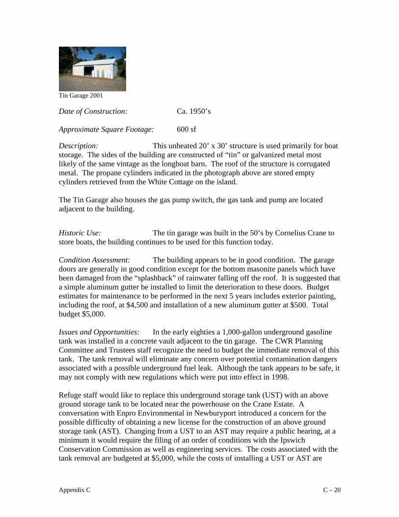
Tin Garage 2001 Date of Construction: Ca. 1950’s
Approximate Square Footage: 600 sf Description: This unheated 20’ x 30’ structure is used primarily for boat storage. The sides of the building are constructed of “tin” or galvanized metal most likely of the same vintage as the longboat barn. The roof of the structure is corrugated metal. The propane cylinders indicated in the photograph above are stored empty cylinders retrieved from the White Cottage on the island. The Tin Garage also houses the gas pump switch, the gas tank and pump are located adjacent to the building. Historic Use: The tin garage was built in the 50’s by Cornelius Crane to store boats, the building continues to be used for this function today. Condition Assessment: The building appears to be in good condition. The garage doors are generally in good condition except for the bottom masonite panels which have been damaged from the “splashback” of rainwater falling off the roof. It is suggested that a simple aluminum gutter be installed to limit the deterioration to these doors. Budget estimates for maintenance to be performed in the next 5 years includes exterior painting, including the roof, at $4,500 and installation of a new aluminum gutter at $500. Total budget $5,000. Issues and Opportunities: In the early eighties a 1,000-gallon underground gasoline tank was installed in a concrete vault adjacent to the tin garage. The CWR Planning Committee and Trustees staff recognize the need to budget the immediate removal of this tank. The tank removal will eliminate any concern over potential contamination dangers associated with a possible underground fuel leak. Although the tank appears to be safe, it may not comply with new regulations which were put into effect in 1998. Refuge staff would like to replace this underground storage tank (UST) with an above ground storage tank to be located near the powerhouse on the Crane Estate. A conversation with Enpro Environmental in Newburyport introduced a concern for the possible difficulty of obtaining a new license for the construction of an above ground storage tank (AST). Changing from a UST to an AST may require a public hearing, at a minimum it would require the filing of an order of conditions with the Ipswich Conservation Commission as well as engineering services. The costs associated with the tank removal are budgeted at $5,000, while the costs of installing a UST or AST are
Appendix C C – 20

$35,000 or $20,000 respectively. The costs associated with the installation of a new fuel storage system along with the necessary vapor recovery monitoring need to be weighed against the amount of time and resources lost if fuel storage was eliminated from the Crane properties. Budget Estimates Critical Repairs, year 1 $5,000 Stabilization needs, years 2-5 $5,000
Appendix C C – 21
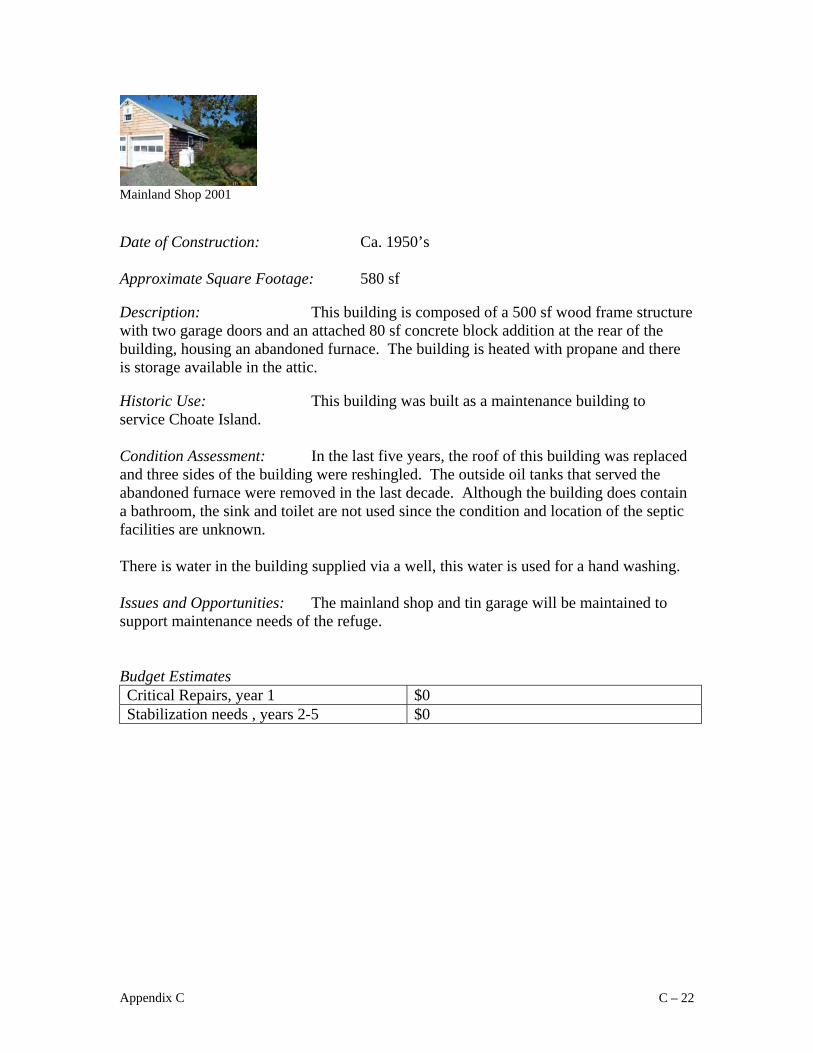
Mainland Shop 2001 Date of Construction: Ca. 1950’s
Approximate Square Footage: 580 sf Description: This building is composed of a 500 sf wood frame structure with two garage doors and an attached 80 sf concrete block addition at the rear of the building, housing an abandoned furnace. The building is heated with propane and there is storage available in the attic. Historic Use: This building was built as a maintenance building to service Choate Island. Condition Assessment: In the last five years, the roof of this building was replaced and three sides of the building were reshingled. The outside oil tanks that served the abandoned furnace were removed in the last decade. Although the building does contain a bathroom, the sink and toilet are not used since the condition and location of the septic facilities are unknown. There is water in the building supplied via a well, this water is used for a hand washing. Issues and Opportunities: The mainland shop and tin garage will be maintained to support maintenance needs of the refuge. Budget Estimates Critical Repairs, year 1 $0 Stabilization needs , years 2-5 $0
Appendix C C – 22

Longboat Barn 2000 Date of Construction: Ca. 1950’s
Approximate Square Footage: 1,500 sf Description: Constructed in the 1950’s for boat storage, this 18’ wide by 88’ long building is constructed of metal, possibly “tin” or galvanized sheet steel. The interiors of the panels are marked with the manufacturer or distributors seal: Whitt-edge garages – Broad Street, Lynn. The roof is constructed of corrugated metal and there are 6 framed metal windows, 3 on each side. The roof framing is constructed of steel trusses and the floor is constructed of heavy wooden planks. There is no electricity. Historic Use: The building was built for the intended purpose of storing boats by Cornelius Crane. Condition Assessment: The wooden piles that support this structure are deteriorating. A portion of the floor at the rear of the building has heaved significantly compromising the building’s anchorage to the system of piers. The roof is rusted and the front sliding door tracks are poorly secured making operation difficult. It is suggested that this building be demolished rather than repaired or renewed. Issues and Opportunities: The Longboat Barn is in poor condition and is located in a ecologically sensitive area at the edge of the marsh. For these two reasons, it is recommended that this building be demolished. If this building is demolished it is important to insure that the 1,500 sf boat storage be secured in another location. Budget Estimates Demolition $4,000
Appendix C C – 23

Codman Cottage 2000 Date of Construction: Ca.
Approximate Square Footage: 1,000sf Cottage & 350 sf Bunkhouse Description: This 1,000sf tin sided seasonal cottage sits in the dunes of Crane’s Beach. Historic Use: Russell Codman, who was a friend of Cornelius Crane, was given a life-tenancy with which he built this cottage in the dunes. About 20 years ago, Harry Mears built a small 350 sf. bunk house next to the cottage. Condition Assessment: Not much is known about the septic system serving this cottage. Although there is a well, the water is not potable. It is recommended that the cottage be demolished once the property comes to The Trustees. Issues and Opportunities: Although there was some discussion about the possibility of maintaining the Codman Cottage as seasonal housing for Trustees staff, it has been recommended that the cottage be demolished when the Codman life tenancy ends. Removal of the Codman Cottage will assist in restoring this area of the dunes to its natural state. Budget Estimates Demolition Costs estimated at $2,000
Appendix C C – 24

Mainland Road 2001 Date of Construction: Ca.
Approximate Square Footage: Approximately 2,000 lf Description: This gravel road connects Argilla Road with the mainland launch area. The road is secured with a locked metal bar gate and it has one galvanized metal culvert nearby. The gate is detachable so that large vehicles may have access to the launch area (i.e. The National Guard used this for access during the making of The Crucible). Historic Use: This road has historically provided access to the mainland launch site. Condition Assessment: Approximately $2,000 is spent on a yearly basis for routine grading of the road. The galvanized metal culvert located near the access gate was repaired 5 yrs ago. There are no immediate repair needs; all maintenance is addressed in annual operation budgets.
Appendix C C – 25

Freestanding Chimney Date of Construction: Late 19th century
Description: Sitting behind the tin garage at the mainland launch area, the freestanding brick chimney is a remnant of the Woodbury farm complex. Historic Use: In accordance with the conclusion brought forth in Electra Kane Tritsch’s report included as an appendix in this management plan, the freestanding chimney is a remnant of Woodbury farm. Early photos indicate that there were two houses with broad front porches facing the river, a smaller farm building, a 1 ½ story mixed-use barn and a separate out building which may have been an outhouse. This freestanding chimney may have been a remnant of the westernmost portion of this complex; its small, off-center chimney points to a construction date of mid- to late 19th century. Another source reports that this building was more likely the home of the Crane’s yacht captain. Condition Assessment: The freestanding chimney is stable but will require routine mortar pointing and brick replacement in the future to insure its survival as a “safe” ruin in the landscape. Funds to maintain this structure should be allocated in the operations budget. Issues and Opportunities: The freestanding chimney is the last remnant of the late 19th century structures and has some interpretive value as a ruin in the cultural landscape. As plans are developed to create an interpretive plan, this structure should be included, made inaccessible to the public, or demolished.
Appendix C C – 26

Dilly Island/Dean Island 2001 Date of Construction: Ca.
Description: Dilly Island is reported to contain partial ruins including the remnants of an old house, chimneys, partial walls, and an outhouse. Historic Use: Richard T. Crane maintained a camp on Dilly Island that consisted of three stone buildings – a small house, a wood-and-coal shed and an outhouse. These buildings were removed in 1975 because of vandalism. A few of the stone walls as well as clay tiles similar to those used in the construction of the Crane barn remain today. It was recently reported that there is an old stone well on Dean Island which could cause a potential safety problem. Condition Assessment: The structures are ruins but they must be examined to make sure they are safe. Issues and Opportunities: Like the freestanding chimney, the ruins on Dilly and Dean island are elements in a cultural landscape, representative of a past use. While these elements are important to the cultural landscape, The Trustees must make sure the public is protected from any potential danger these ruins may represent. In particular, the open well on Dean Island must be addressed immediately.
Appendix C C – 27

Appendix D
The Secretary of the Interior's Standards for the Treatment of Historic Properties 1995
U. S. Department of the Interior National Park Service National Center for Cultural Stewardship & Partnership Programs Heritage Preservation Services Washington, D.C. The Secretary of the Interior is responsible for establishing professional standards and providing advice on the preservation and protection of all cultural resources listed in or eligible for the National Register of Historic Places.
Treatments There are Standards for four distinct, but interrelated, approaches to the treatment of historic properties - Preservation, Rehabilitation, Restoration, and Reconstruction. Preservation focuses on the maintenance and repair of existing historic materials and retention of a property's form as it has evolved over time. (Protection and Stabilization have now been consolidated under this treatment.) Rehabilitation acknowledges the need to alter or add to a historic property to meet continuing or changing uses while, retaining the property's historic character. Restoration is undertaken to depict a property at a particular period of time in its history, while removing evidence of other periods. Reconstruction re-creates vanished or non-surviving portions of a property for interpretive purposes. In summary, the simplification and sharpened focus of these revised sets of treatment Standards is intended to assist users in making sound historic preservation decisions. Choosing an appropriate treatment for a historic property, whether preservation, rehabilitation, restoration, or reconstruction is critical. This choice always depends on a variety of factors, including the property's historical significance, physical condition, proposed use, and intended interpretation. Preservation is defined as the act or process of applying measures necessary to sustain the existing form, integrity, and materials of an historic property. Work, including preliminary measures to protect and stabilize the property, generally focuses upon the ongoing maintenance and repair of historic materials and features rather than extensive replacement and new construction. New exterior additions are not within the scope of this treatment; however, the limited and sensitive upgrading of mechanical, electrical, and plumbing systems and other code required work to make properties functional is appropriate within a preservation project.
Appendix D D - 1

Standards for Preservation 1. A property will be used as it was historically, or be given a new use that
maximizes the retention of distinctive materials, features, spaces, and spatial relationships. Where a treatment and use have not been identified, a property will be protected and, if necessary, stabilized until additional work may be undertaken.
2. The historic character of a property will be retained and preserved. The
replacement of intact or repairable historic materials or alteration of features, spaces, and spatial relationships that characterize a property will be avoided.
3. Each property will be recognized as a physical record of its time, place, and use.
Work needed to stabilize, consolidate, and conserve existing historic material and features will be physically and visually compatible, identifiable upon close inspection, and properly documented for future research.
4. Changes to a property that have acquired historic significance in their own right
shall be retained and preserved. 5. Distinctive materials, features, finishes, and construction techniques or examples
of craftsmanship that characterize a property will be preserved. 6. The existing condition of historic features will be evaluated to determine the
appropriate level of intervention needed. Where the severity of deterioration requires repair or limited replacement of a distinctive feature, the new material will match the old in composition, design, color, and texture.
7. Chemical or physical treatments, if appropriate, will be undertaken using the
gentlest means possible. Treatments that cause damage to historic materials will not be used.
8. Archeological resources will be protected and preserved in place. If such
resources must be disturbed, mitigation measures will be undertaken. Rehabilitation is defined as the act or process of making possible a compatible use for a property through repair, alterations, and additions while preserving those portions or features which convey its historical, cultural, or architectural values. Standards for Rehabilitation 1. A property will be used as it was historically or be given a new use that requires
minimal change to its distinctive materials, features, spaces, and spatial relationships.
2. The historic character of a property will be retained and preserved. The removal
of distinctive materials or alteration of features, spaces, and spatial relationships that characterize a property will be avoided.
Appendix D D - 2

3. Each property will be recognized as a physical record of its time, place, and use.
Changes that create a false sense of historical development, such as adding conjectural features or elements from other historic properties, will not be undertaken.
4. Changes to a property that have acquired historic significance in their own right
will be retained and preserved. 5. Distinctive materials, features, finishes, and construction techniques or examples
of craftsmanship that characterize a property will be preserved. 6. Deteriorated historic features will be repaired rather than replaced. Where the
severity of deterioration requires replacement of a distinctive feature, the new feature will match the old in design, color, texture, and, where possible, materials. Replacement of missing features will be substantiated by documentary and physical evidence.
7. Chemical or physical treatments, if appropriate, will be undertaken using the
gentlest means possible. Treatments that cause damage to historic materials will not be used.
8. Archeological resources will be protected and preserved in place. If such
resources must be disturbed, mitigation measures will be undertaken. 9. New additions, exterior alterations, or related new construction will not destroy
historic materials, features, and spatial relationships that characterize the property. The new work shall be differentiated from the old and will be compatible with the historic materials, features, size, scale and proportion, and massing to protect the integrity of the property and its environment.
1 0. New additions and adjacent or related new construction will be undertaken in
such a manner that, if removed in the future, the essential form and integrity of the historic property and its environment would be unimpaired.
Restoration is defined as the act or process of accurately depicting the form, features, and character of a property as it appeared at a particular period of time by means of the removal of features from other periods in its history and reconstruction of missing features from the restoration period. The limited and sensitive upgrading of mechanical-, electrical, and plumbing systems and other code-required work to make properties functional is appropriate within a restoration project. Standards for Restoration 1. A property will be used as it was historically or be given a new use which reflects
the property's restoration period.
Appendix D D - 3

2. Materials and features from the restoration period will be retained and preserved.
The removal of materials or alteration of features, spaces, and spatial relationships that characterize the period will not be undertaken.
3. Each property will be recognized as a physical record of its time, place, and use.
Work needed to stabilize, consolidate and conserve materials and features from the restoration period will be physically and visually compatible, identifiable upon close inspection, and properly documented for future research.
4. Materials, features, spaces, and finishes that characterize other historical periods will
be documented prior to their alteration or removal. 5. Distinctive materials, features, finishes, and construction techniques or examples of
craftsmanship that characterize the restoration period will be preserved. 6. Deteriorated features from the restoration period will be repaired rather than
replaced. Where the severity of deterioration requires replacement of a distinctive feature, the new feature will match the old in design, color, texture, and, where possible, materials.
7. Replacement of missing features from the restoration period will be substantiated by
documentary and physical evidence. A false sense of history will not be created by adding conjectural features, features from other properties, or by combining features that never existed together historically.
8. Chemical or physical treatments, if appropriate, will be undertaken using the gentlest
means possible. Treatments that cause damage to historic materials will not be used. 9. Archeological resources affected by a project will be protected and preserved in
place. If such resources must be disturbed, mitigation measures will be undertaken. 1 0. Designs that were never executed historically will not be constructed. Reconstruction is defined as the act or process of depicting, by means of new construction, the form, features, and detailing of a non-surviving site, landscape, building, structure, or object for the purpose of replicating its appearance at a specific period of time and in its historic location. Standards for Reconstruction 1. Reconstruction will be used to depict vanished or non-surviving portions of a
property when documentary and physical evidence is available to permit accurate reconstruction with minimal conjecture, and such reconstruction is essential to the public understanding of the property.
Appendix D D - 4

2. Reconstruction of a landscape, building, structure, or object in its historic location will be preceded by a thorough archeological investigation to identify and evaluate those features and artifacts that are essential to an accurate reconstruction. If such resources must be disturbed, mitigation measures will be undertaken.
3. Reconstruction will include measures to preserve any remaining historic
materials, features, and spatial relationships. 4. Reconstruction will be based on the accurate duplication of historic features and
elements substantiated by documentary or physical evidence rather than on conjectural designs or the availability of different features from other historic properties. A reconstructed property will re-create the appearance of the non-surviving historic property in materials, design, color, and texture.
5. A reconstruction will be clearly identified as a contemporary re-creation. 6. Designs that were never executed historically will not be constructed. Preservation as a Treatment. When the property's distinctive materials, features, and spaces are essentially intact and thus convey the historic significance without extensive repair or replacement; when depiction at a particular period of time is not appropriate; and when a continuing or new use does not require additions or extensive alterations, Preservation may be considered as a treatment. Prior to undertaking work, a documentation plan for Preservation should be developed Rehabilitation as a Treatment. When repair and replacement of deteriorated features are necessary; when alterations or additions to the property are planned for a new or continued use; and when its depiction at a particular period of time is not appropriate, Rehabilitation may be considered as a treatment. Prior to undertaking work, a documentation plan for Rehabilitation should be developed. Restoration as a Treatment. When the property's design, architectural, or historical significance during a particular period of time outweighs the potential loss of extant materials, features, spaces, and finishes that characterize other historical periods; when there is substantial physical and documentary evidence for the work; and when contemporary alterations and additions are not planned, Restoration may be considered as a treatment. Prior to undertaking work, a particular period of time, i.e., the restoration period, should be, selected and justified, and a documentation plan for Restoration developed. Reconstruction as a Treatment. When a contemporary depiction is required to understand and interpret a property's historic value (including the re-creation of missing components in a historic district or site); when no other property with the same associative value has survived; and when sufficient historical documentation exists to
Appendix D D - 5

ensure an accurate reproduction, Reconstruction may be considered as a treatment. Prior to undertaking work, a documentation plan for Reconstruction should be developed. The Secretary of the Interior's Standards for the Treatment of Historic Properties may be applied to one historic resource type or a variety of historic resource types; for example, a project may include a complex of buildings such as a house, garage, and barn; the site, with a designed landscape, natural features, and archeological components; structures such as a system of roadways and paths or a bridge; and objects such as fountains and statuary. Historic Resource Types & Examples Building: houses, barns, stables, sheds, garages, courthouses, city halls, social halls, commercial buildings, libraries, factories, mills, train depots, hotels, theaters, stationary mobile homes, schools, stores, and churches. Site: habitation sites, funerary sites, rock shelters, village sites, hunting and fishing sites, ceremonial sites, petroglyphs, rock carvings, ruins, gardens, grounds, battlefields, campsites, sites of treaty signings, trails, areas of land, shipwrecks, cemeteries, designed landscapes, and natural features, such as springs and rock formations, and land areas having cultural significance. Structure: bridges, tunnels, gold dredges, firetowers, canals, turbines, dams, power plants, corn-cribs, silos, roadways, shot towers, windmills, grain elevators, kilns, mounds, cairns, palisade fortifications, earthworks, railroad grades, systems of roadways and paths, boats and ships, railroad locomotives and cars, telescopes, carousels, handstands, gazebos, and aircraft. Object: sculpture, monuments, boundary markers, statuary, and fountains. District: college campuses, central business districts, residential areas, commercial areas, large forts, industrial complexes, civic centers, rural villages, canal systems, collections of habitation and limited activity sites, irrigation systems, large farms, ranches, estates, or plantations, transportation networks, and large landscaped parks.
Appendix D D - 6

Appendix E
Property Rules and Regulations
For the protection and enjoyment of the Refuge, visitors shall comply with the regulations listed below. REGULATIONS
1. Entering the property permitted only during the posted season and hours. 2. Visitors entering the property must use the designated boat landing at the
northwest end of Long Island. Entrance to the Refuge other than by the designated landing is prohibited.
3. Conduct which disturbs the tranquility of the Refuge or its enjoyment by others is prohibited.
4. Dogs and other pets are prohibited at all times for the protection of deer and other wildlife and livestock.
5. Disturbing, removing, defacing, cutting, or otherwise causing damage to a natural feature, sign, poster, barrier, building, or other property on the Refuge is prohibited.
6. All fires are prohibited. The density of surrounding woodlands and the expanse of wind-exposed fields make fires exceedingly hazardous.
7. Littering is prohibited. 8. Disturbing nesting birds or other wildlife is prohibited. The Refuge provides
rare habitat for many varieties of species. 9. Entering fenced or posted areas designed to protect wildlife or livestock is
prohibited. 10. The feeding of wildlife of the Refuge is prohibited. 11. Trapping is prohibited on the Refuge. 12. Hunting and firearms are prohibited on the Refuge except with prior written
permission of the Refuge manager. 13. All motorized vehicles are prohibited. 14. All federal, state, and local ordinances must be observed.
Appendix E E - 1

Appendix F
References:
Choate Wonson, M., and R. Choate Wonson, Downriver – A Memoir of Choate Island, Greenhills Books, 1983.
Hovey, A., Hog Island: Three Farms and a Pasture: A Listing of Real Estate Transactions
from 1665-1974, a report to The Trustees submitted by Finch and Rose, 1998. Muhl Davis, M. Archaeological Potential of the Crane Reservations Ipswich, MA, a
report submitted to The Trustees, 1996. Smith, K., and R. Hopping, Study of the Flora and Fauna at the Cornelius and Miné
Crane Wildlife Refuge Essex, MA, a report to The Trustees, 1993.
Appendix F F - 1