coral reef assessment and status …unesdoc.unesco.org/images/0011/001124/112476eo.pdf17 august 1995...
TRANSCRIPT
MEETING REPORT
by J. R. E. Harger
17 August 1995 UNESCO/Jakarta
CORAL REEF ASSESSMENT and STATUS EVALUATION WORKSHOP
27 November - 1 December 1994, Ambon and Banda Neira, Indonesia.
Sponsored by UNESCO-Jakarta (COMAR) and the Intergovernmental
Oceanographic Commission of UNESCO.
Organized by UNESCO, Jakarta and P30-LIPI, Center for Oceanological
Research and Development - Indonesian Institute of Sciences
in association with the “Year of the Reef”
Our sincere thanks go to:
Community and Local Government of Ambon and Banda, Indonesia
The John D. and Catherine T. MacArthur Foundation
Garuda Indonesia Airlines
Merpati Nusantara Airlines
Freeport Indonesia
M/V Cehili Diving Yacht
for all contributions, assistance and care which made this coral reef
workshop a remarkable forum for all participants
17 August 1995 UNESCO/Jakarta
MEETING REPORT
by J. R. E. Harger
CORAL REEF ASSESSMENT and STATUS EVALUATION WORKSHOP
27 November - 1 December 1994, Ambon and Banda Neira, Indonesia.
Sponsored by UNESCO-Jakarta (COMAR) and the Intergovernmental
Oceanographic Commission of UNESCO.
Organized by UNESCO, Jakarta and P30-LIPI, Center for Oceanological
Research and Development - Indonesian Institute of Sciences
in association with the “Year of the Reef”

Our sincere thanks go to :
Community and Local Government of Ambon and Banda. Indonesia
The John D. and Catherine T. MacArthur Foundation
Garuda Indonesia Airlines
Merpati Nusantara Airlines
Freepon Indonesia
M/V Cehili Diving Yacht
for all contribution, assistance and care which make this coral reef workshop
become a remarkable forum for all participants
Table of Contents
CORAL REEF ASSESSMENT and STATUS EVALUATION WORKSHOP
1.0 1.1 1.2 1.3 2.0 2.1 3.0 3.1 3.1.1 3.2 3.2.1 3.2.2 3.3 3.4 4.0 4.1 4.2 4.3 4.3.1 4.3.2 4.4 4.5 4.5.1 45.2 5.0 5.1 5.2 5.3 5.4 5.5 6.0 6.1 6.2 6.2.1 6.2.2 6.2.3 6.2.4 6.3 7.0 7.1
7.2 7.3
7.4 7.5
Introduction 1 Objectives 1 Participation 1 Venue 2 Background 2 Factors involved with natural maintenance of biodiversity 3 Introduction made by participants 5 Introductory Discussion 8 Ecosystem assessment 9 Coral reef assessment in Indonesia 10 Major questions regarding the status of coral-reef ecosystems 12 Generic Response for evaluating sustainable use 12 Report on snorkel survey team at Ambon bay Headland 13 Techniques for ensuring the “Sustainable Development” of coral-reefs 13 Working group reports 18 Information needed to promote sustainable use 18 Effective management approaches 18 Required assessment, generic response 19 Evaluate the status of coral-reef ecosystems 19 Evaluate the major ecological processes effecting organisms 20 Geology 20 Blast-fishing and bomb-damage to reefs 21 Blastdamage statement 21 Volcanic damage and reef-repair mechanisms 22 Analytic assessment for sustainable use of reef systems. 23 Information required for management 23 Ecological values 23 Relationships with human communities 25 Socio-political and legal aspects 25 Cultural relationships and community use-rights 25 Analysis of cultural aspects of sustainability in resource ecosystems. 25 Maintenance and promotion of biodiversity through “swidden” agriculture. 26 Resource management objectives 29 Analyze the resource management strategy (for instance: shifting cultivation) 29 Extract the spiritual basis of management 29 What ownership and ethnic rights and practices exist 30 How does the traditional system connect to the global economy 30 Major environmental variables and their effects? 31 Individual presentations 31 The Use of Satellite Remote Sensing for Mapping Coastal Marine Resources in Belize: a Case Study Summary. 31 Coral reefs from space 34 Preliminary description of the relationship between physical factors and coral assemblages on the Banda Islands. 35 Geographical features and coral disposition: some additional points. 35 The International “Year of the Reef” 37
7.6
7.7
8.0 8.1 8.2 8.3 8.4 8.5 8.6 8.7 9.0 10.0
Coral reef survey and monitoring techniques used at the Australian Institute of Marine Science Quaternary coastal evolution in Indonesian Maritime slands: tectonic and climatic infhrences on coral-reef limestone development. Workshop on Conservation Priorities in eastern Indonesia Requirements scientific research Marine conservation in eastern Indonesia Impact of fisheries activities in coral-reef buffer-zones. Existing laws and enforcement. Difftculties encountered in safeguarding coral-reefs. Possible solutions Management of conservation areas Opening Address Participants List
40
50 64 64 64 64 65 65 65 66 67 70

UNESCO/COMAR/IOC CORAL-REEF ASSESSMENT AND EVALUATION WORKSHOP (IN CONJUNCTION WITH “YEAR OF THE REEF”), AMBON, 27 NOVEMBER 1994 AND BANDA NEIRA, INDONESIA,
28 NOVEMBER - 1 DECEMBER 1994
1. INTRODUCTION
The meeting was opened by Dr. J. R. E. Harger, Director a.i. of UNESCO-Jakarta and Pro- gram Specialist in Marine Science. The activitity was attended by 26 participants and 13 observers from 11 countries, including seven female. Participants came from Australia (3), Malaysia (1), Philippines (2). USA (7) Indonesia (14), U.K. (2), Canada (3), Thailand (2), Hong Kong (I), Japan (1), UNESCO (1). One senior participating coral-reef scientist rated the activity as “the coral-reef field workshop of the century”. The Minister of Education (Indonesia) provided an opening speech and the Minister of Environment (Indonesia) attended the field activities.
1.1 Objectives
The objectives of the workshop were: 0 To evaluate the current interpretations of coral-reef assessment outputs. 0 To determine if suitable finer-scale protocols should be applied in a universal context to
detect, map and interpret marginal changes with the potential of leading into permanent decline.
0 To determine basis for comprehensive aerial or space-based assessment (aerial photog- raphy, UNESCO-BILKO).
0. To evaluate the extent to which reef-repair rates, dependencies and the disposition of larval recruitment potentials should be included in assessment programs.
0 To identify steps for management of coral-reefs on a sustainable basis. 0 To define the assessment protocols or requirements necessary to evaluate the sustain-
ability of reef management programs. 0 To lay the basis for a renewed international program for the global assessment of coral-
reefs.
1.2 Participation
The workshop was aimed at a combination of senior coral-reef specialists with global reputa- tions, coral-reef managers, as well as regional experts.
The Indonesian NGO “Yayasan Laut Lestari Indonesia-YLLI” (The Eternal Seas Organization) also participated in the activity by setting up a coast clean-up campaign in Ambon and Banda Naira in
UNESCO/ROSTSEA and COMAR together with “Year of the reef” 17/08/95 Page 1

Indonesia. The input involved creation of a display which was opened at a parallel activity entitled “Workshop on conservation priorities in eastern Indonesia” operated by a consortium of NGO’s in Ambon, on 26 November 1994 which was attended by the Indonesian Minister of Environment Mr. Sarwono Kusumaatmadja. Output from the workshop on conservation priorities workshop is presented in section 9.
Miss Elshinta Suyoso, president of YYLI presented an address concerning the activities of her organization to the participants of the UNESCO Coral Reef Assessment and Evaluation Workshop (November 27 - December 4th) in Banda Naira. The UNESCO activity was operated in parallel to a national campaign “Keep our coastline and beaches clean”. The following participants were supported by UNESCO in attending the activity: Ms. Elshinta Suyoso, Mr. Adi Parmadi and Mr. Lufti Zahar all of Indonesia.
1.3 Venue
The opening ceremony and first day session (considering theory and so forth) was held in Ambon. Participants then flew to Banda Neira and two days of intense field workshoping were held in Banda. The final action consisted of a cruise to the island of Run and from there back to Ambon.
2. BACKGROUND
UNESCO mounted a major assessment program to evaluate the state of reefs adjacent to popu- lation centers in May 1985 with the implementation of an international workshop in Pulau Seribu, Indonesia as part of the “Coastal Marine” (COMAR) program. Information arising from that activity subsequently provided a focus for the development of assessment programs world-wide.
The UNESCO session at the 7th International Coral Reef Symposium in Guam 21-26 June 1992 (Coral reef monitoring: what to do and how to do it) considered a number of assessment protocols for the determination of reef health. The method currently in general use, proposed by the Australian Insti- tute of Marine Science and first tested in an International Program in the 1985 Pulau Seribu activity for the evaluation of severe impact to coral-reefs, is known as the “growth-forms protocol”. It is associated with a line-intercept technique and is now used on a global scale. For further information see report of IOC, UNEP, WMO, IUCN session “A coordinated network of tropical marine labs to monitor reef at the 7th responses to global change” at the 7th International Coral Reef Symposium. The procedure has certain advantages in that the techniques are easily transmitted to students and the resulting data can be used to readily determine areas of gross damage, provided sampling transects are located strategically across degraded - structures.
There are however, a number of significant shortcomings associated with this method and two in particular often generate problems when the resulting data are interpreted:
UNESCO/ROSTSEA and COMAR together with “Year of the reef” 17/08/95 Page 2
(1) fine structure-changes associated with marginal effects cannot be detected or mapped. Species-sensitive shifts within a given-growth form across different geographical and physical niche- boundaries appear as constants in the resulting data;
(2) poor replication and transect representation leads to large errors of interpretation with respect to intermediate areas.
In summary, in its simplest form, the procedure fails at both the micro and macro levels while being adequate at the intermediate level.
In order to search for and determine a new and broader assessment paradigm, UNESCO- COMAR operated an assessment workshop in Indonesia during 1994. This is to be followed by a fur- ther activity in 1995 to check the extent to which changes may have taken place in Pulau Seribu since the original survey in 1985. The first element (reported herein) was a 4-day workshop in the high- species diversity region centered in the Banda Sea in east Indonesia. The second, to coincide with the 50th Anniversary of UNESCO’s foundation, will involve a repeat survey of the Pulau Seribu system in September of 1995. The following description deals with the first element of the program, implemented in the Banda Sea, Indonesia.
2.1 Factors involved with natural maintenance of biodiversity
The center of coral species diversity, from a global perspective, is found in eastern Indonesia. Among other attributes the region is characterized by very high growth rates for Scleractinia and, in specific circumstances, explosive settlement densities as well as a high number of species. Throughout the Indonesian and Philippines Archipelagos there may be perhaps as many as 400-500 species overall. In a relatively circumscribed region such as the Spermonde Archipelago of southwest Sulawesi (40 x 80 km) as many as 78 genera of Scleractinia have been recorded with 262 species. For the protean coral genus Acroporu, by far the largest of the reef-building genera Dr. Cardin Wallace of the Museum of Tropical Queensland, Australia, reports that the region of the Indonesian archipelago does indeed con- tain the highest recorded diversity for Acropora (90 species as compared with 73 in eastern and off- shore eastern Australia), but the distribution does not follow the concentric pattern predicted by a “center of origin and dispersal hypothesis” personal communication 1995). Dr. Wallace indicates that some species of Acroporu are endemic to contained regions such as the Red Sea and the Caribbean and others are endemic to broad regions ranging to either side of the Indo-Pacific center of diversity and still others have unusual patterns such as the subtropical Pacific and its boundaries or are endemic to smaller areas in the Indo-Pacific.
The region of eastern Indonesia is influenced directly by the “Western Pacific Warm Pool” characterized by periodically fluctuating sea-water temperature which apparently influences the strength of the “Western Pacific Dry Event” associated with the El Nino - Southern Oscillation. The temperature-pulse involved, coupled with the associated drought appears to spread globally from the region under particular circumstances. There is currently some concern that El Nino-associated warm events are increasing in frequency and intensity as global warming proceeds. In Indonesia the two warmest and driest of such events for over 100 years have occurred in the last 10 years or so. The current El-Nino dry event can with some justification be claimed to have started in 1990 and has lasted
UNESCOlROSTSEA and COMAR together with “Year of the reef” 17/08/95 Page 3

for some five years (to the beginning of 1995).
The main study-site was centered on reefs around Gunung Api in the Banda Island group. In 1989 the volcano erupted pouring two sets of larva around 800 meters in width into the sea and destroy- ing the coral reef. Since that time a spectacular recolonization event has occurred to the extent that up to 20 species of hard corals may be recorded on a single square meter of larva. Growth has also been extremely high by normal standards so that table-form corals have reached diameters of over 1 meter in around 4 years or so. In Jakarta Bay for instance such growth may be a mere 2-4 cm a year. Surround- ing undamaged reefs are dominated by relatively few species but the exact representation seems to change rapidly from one place to another in response to physical conditions. Over 200 species have so far been recovered from the recolonized area giving some hope that similar healing can be coaxed into play in damaged areas next to major population concentrations if the primary mortality factors can be reduced. It is not known what exact combination of conditions in the surrounding reefs leads to this “healing effect” although initial lack of predators and a complex substrate have something to do with it in terms of initial survival. It is perhaps not to be wondered at that the giant hump-head parrot fish (1.5- 2.0 meters in length), is also found in these “high diversity” waters.
The rapid reef-repair response noted in relation to the recolonization of the Gunung Api larva- flow of 1989 up to late 1994 when cover by hard-corals, dominated by tabulate Acropora, rated over 80%) shows that reefs in the natural state and in high-diversity areas, with no pollutant or over-fishing stress, posses very effective mechanisms for healing.
Some of the implications of this species-diversity-hot-spot were considered to be the following:
(1) In aggregate a11 other coral-reef areas on the globe are subject to continual low-level replenish- ment in.species from this location and its immediate surroundings. If local structural diversity is held constant, then species diversity, with some variation, declines progressively to the north south, east and west;
(2) The region in question represents a relict compliment of hard coral species which is now in decline but which was more widespread in the past;
(3) The high volcanic activity and constant flux of energy from the earth’s interior generates condi- tions (new sub-strata regimes etc.) favoring and indeed promoting primary speciation over comparatively short time intervals;
(4) The shifting sea-levels and currents over recent geological time have engendered speciation through isolation and rejoining in the surrounding complex of inner-sea basins and trenches;
(5) Fluctuating surface seawater temperatures due to the “Western Pacific Warm Pool”, in part associated with El Nino generation may change in such a way as to promote maintenance of somewhat higher species diversity than would otherwise be the case;
(6) Hot-spot features involve extremely high colonization and growth both of which are part of a damage-repair-mechanism promoted by a somewhat “unstable” locale.
(7) Species may also migrate towards the center from peripheral locations where particular condi- tions have resulted in selective survival of corals able to deal with unusual circumstances.
(8) The present concentration of hard-coral species as well as associated invertebrates may have resulted from an historical aggregation due to continental and island “drift”.
(9) The area represents the relict of an environment which stretches back to the Tethys sea and
UNESCO/ROSTSEA and COMAR together with “Year of the reef” 17/08/95 Page 4
perhaps to an evolutionary stage proceeding that. In simple terms it may now represent the closest geographical representation of the conditions which previously prevailed in the area where life began.
The coral-reef ecosystems around Banda Neira may be conveniently divided into three groups: 1) those inhabiting sheltered lagoon-like situations; 2) those on the west of Gunung Api, exposed to continual input of ash and rubble; 3) general reefs extending around the island forms as fringing asso- ciations in situations running from exposed to comparatively sheltered.
In brief, the sheltered systems are formed of continuous thickets of branching corals made up of comparatively few species. The major characteristic being very high surface cover of relatively delicate forms (branching and folios) with high dominance by individual species within patches stretching on the scale of tens of meters. These sheltered systems have apparently relatively low organization. The communities forming on rubble-fed substrates to west of Gunung Api are sparse and apparently subject to extensive abrasion because the coast is not sheltered. Loose aggregates are apparently continually fed into this area as the result of erosion acting on the volcanic aggregate of the mountain. The remaining complex of fringing communities, including those characterized by tabulate-Acropora resulting from resettlement of the larva-flows, can be understood in terms of a dominance assemblage which changes perceptibly as the degree of exposure shifts, but in very small increments.
A consideration of some interest in regard to the origin of species and community diversity may be encapsulated in the viewpoint arising from recovery of cultural knowledge concerning ecosystems and their management which is a strong UNESCO program. The Australian Aboriginal belief (arising from 60,000-150,000 years of pondering the issue) is that species arise as the result of “expressed local potential”. They arise directly from the alignments and energies generated by their particular locality. Humans, animals and plants are the “dream” of the landscape which in turn arises as an externalization of the essence generated and deposited by the “great ancestors”. By this notion, the magnetic, volcanic, inter-textural nature of the semi-enclosed and enclosed seas in the region of east Indonesia are the species-generating mechanisms. The earth itself is the dreamer and, among other things perhaps the geomagnetic field is the dreaming with animals, plants, humans the manifest results, themselves dream- ers within the greater dream. This is not exactly a strange idea if the Cichlid swarms of east Africa are considered and in particular the monophyletic and sympatric crater-lake associations in Cameroon.
3. INTRODUCTION MADE BY PARTICIPANTS
The meeting opened with a round of introductions and the following points of interest were raised by participants in order of presentation.
Dr. J. R. E. Harger, UNESCO-Jakarta, introduced the rationale for the meeting. In 1982 UNESCO operated a field exercise in Phuket, Thailand to evaluate coral-reef assessment procedures used in the region of southeast Asia and the Pacific. At that stage all parties concerned were using different methodologies. Subsequently, during a further international field action in Jakarta Bay, Indo-
UNESCOiROSTSEA and COMAR together with “Year of the reef” 17/08/95 Page 5
nesia, 1985, the “growth-forms protocol” developed by the Australian Institute of Marine Sciences (AIMS), was tested in the field. As a result of this activity, it was decided by the then UNESCO Divi- sion of Marine Sciences, to promote use of the growth-forms protocol in order to accomplish: 1) stan- dardization; and 2) widespread collection of data for reef assessment using a method that could be easily taught and subsequently applied. The problem to be faced is that now we have data obtained from various points over comparatively wide areas, using a common method, however, we cannot always agree on a systematic interpretation of resulting information.
Mr. Ono Kurnain, Chief, The Indonesian Institute of Sciences (P30-LIPI), Ambon, Indone- sia, indicated that there are more than 300 species of coral present in the area of Banda Sea and that at least one new species of Acropora has been found recently by Dr. Cardin Wallace (Museum of Tropical Queensland) on the Gunung Api larva-flow, (Acropora desalwii) at Banda Neira and also from Run Island.
Dr. Larry Dill, Simeon Fraser University, BC., Canada indicated that he was there to observe in order to see what he could learn that would be relevant to the teaching program he was operating in Indonesia.
Dr. Lyndon Devantier, The Australian Institute of Marine Science (AIMS), Townsville, indi- cated that his aim in attending the workshop was to take the growth forms assessment protocol further and to determine what was needed in addition to the outline that was already in place.
Dr. Terry Done, also of AIMS, indicated that he was interested in further working-out pro- cedures for assessment of coral-reefs.
Dr. R. Van Woesik of the Sesoko Marine Laboratory in Okinawa, Japanstated that he was interested in further working-out the meaning of biodiversity in the region of east Indonesia.
Dr. M. Hutomo of the P30-LIP1 laboratory in Jakarta, Indonesia, indicated that he was inter- ested in extending his seagrass productivity studies particularly in association with coral-reefs.
Dr. John Ogden from the University of South Florida, U.S.A. said that he wished to know what the major questions relating to coral-reefs were in a “global” sense.
Dr. Chuck Birkeland from the University of Guam, noted that in his opinion coral-reefs were not “made for export” of for instance, protein and that knowledge of this attribute should be integrated into reef assessment programs.
Mr. Chuck Cook from the Jakarta office of “The Nature Conservancy” (TNC), an NGO, indicated that the purpose behind his participation was to assist countries to promote the idea of main- taining biodiversity and sustainable management of life. He indicated that assessment protocols should take into account the promotion of sustainable use and conservation.
Mr. T. Yeemin, Dep. of Biology, Ramkhamhaeng University, Huamak, Thailand, indicated that he was attending the activity to learn more about methodologies that could be used to assess change
UNESCOlROSTSEA and COMAR together with “Year of the reef” 17/08/95 Page 6

in the character of coral-reefs.
Mr. Wahyu Hantoro of RDC LIPI, Bandung, Indonesia, indicated that he was geologist and a beginner in the study of coral-reefs but that he hoped to learn much about the ecology and development of reefs as the result of participating in the field studies.
Dr. Ken MacKay - Advisor in Marine Science, University of Pattimura, Ambon, indicated he was interested in research and development, particularly involving the investigation of monitoring techniques. He was currently concerned with rapid techniques. He felt that coral-reefs in east Indonesia were not in as good condition as some say.
Dr. R. Ginsburg from the University of Miami, Florida, U.S.A., stated that he was interested in the relationship between geology and coral-reef structure but that he was particularly concerned with linking the current activity with the program entitled “Year of the Reef”.
Dr. Hansa Chansang. The Marine Station, Phuket, Thailand, indicated that her interest lay in determining the best procedures to use in reef management for which assessment and long term moni- toring were necessary adjuncts.
Mr. Perry Alino - University of the Philippines, Manila, The Philippines, indicated he wished to advance his understanding of coral-reef assessment.
Dr. R. Abdulrahman, University of Pertanian, Kuala Lumpur, Malaysia, cited his interest in reef assessment and the development of protocols that could be used to map future changes in reef structure.
Dr. Suharsono - P30-LIPI, Jakarta stated that he was interested in evaluation of the results obtained by use of the “growth forms” protocol particularly in relation to the experience in Indonesia.
Dr. Bill Patzert of the Jet Propulsion Laboratory, Pasadena, California, NASA said that he was dealing with the long range planing of satellites, particularly the next 4 scheduled for construction. As such, the determination of variables to be monitored in assessing coral-reef structure from space was of some importance in order to generate baselines using remote sensing.
Dr. Tom Tomascik, EMDI - Indonesian Ministry of Environment/Dalhousie University Pro- ject, UNDIP, indicated that he was interested in the evaluation of anthropogenic impact to coral-reefs and related assessment methods.
Dr. Bob Johannes - introduced himself by saying that he used to be a conventional scientist but had now become involved in gathering traditional knowledge. He pointed out that long term data-bases already exist in the form of the knowledge already possessed by coastal communities. In general it was not a paucity of knowledge that inhibited management programs. The problem was that lip service is paid to management but no action. Students need information for socio/anthropology/aca-demic re- search and training. Dr. Johannes expressed the hope that he would meet NGO’s active in the region.
UNESCOlROSTSEA and COMAR together with “Year of the reef” 17/08/95 Page 7
Mr. Mark Vanweld stated that he had spent 2 years in Ambon as a fisheries biologist involved with coastal zone management and went on to observe that a lot of destruction had taken place in that time with no law enforcement. He felt that any research agenda and priority that might be set should involve coastal communities.
Dr. Barbara Brown of the University of New Castle, United Kingdom said that she was in- volved with marine training on long term basis. Her interests included man made and natural changes, El Nino-Southern Oscillation (ENSO) versus man made effects and so forth. Dr. Brown stated that we need to better define active variables and their biological responses. Studies on the responses of ecosys- tems such as coral-reefs to pollution gradients would help. In relation to assessment techniques Dr. Brown wondered what are the questions that should be addressed?
3.1 Introductory Discussion
A general discussion followed a further question raised by Dr. Barbara Brown who asked what has been done and what has been achieved as the result of the ASEAN-Australian program?
Lyndon Devantier answered by saying that the program had described a technique (the “growth forms” protocol) and used it as a procedure to collect data on coral-reefs in the region. He went on to say that the technique had been modified over the years and now deals with a “20-organic-form” clas- sification. It looks at trends at higher taxonomy levels but if biodiversity is to be considered, there are flaws. We should build correction into future data sets. We don’t use the procedure at AIMS anymore (laughter), although our current methods are to an extent compatible and the resultant data is compar- able with information obtained from the life-form protocol. Statistical analyses performed on these data, whether at life-form or at species level, are generally conducted on percentage cover of hard corals or major generic/growth-form groups. This facilitates comparisons.
Ridzwan Abdulrahman commented to the effect that the objective is to look at reefs quickly and use a fast and easy procedure. He said that his group in Malaysia was now bringing more people into the process with stronger taxonomic work. There is room to improve the technique and some of the original transect lines were set in inappropriate locations.
Hansa Chansang added that the technique is useful but that a larger scale and broader procedure is now required. The existing transect lines are adequate for time-base comparisons but they are not adequate for a wider coverage, but that at least we have data to use as a base-line. Dr. Hansa went on to say that more insight was needed for interpretation of the existing data. At an early stage several comments were made about percent cover and how to translate it into a management framework. This material needs to be revisited.
Rob Van Woesik drew attention to the fact that a line intercept transect can show a particular degree of cover (say 40% for instance) and he went on to say that we should still like to know if this figure is increasing or decreasing with the current history of the reef. He stated that we need to know if the reef is degrading or recruiting and he suggested that for this to be registered, some kind of activity- ratio might be required.
UNESCO/ROSTSEA and COMAR together with “Year of the reef” 17108195 Page 8

Perry Alino commented to the effect that the procedure involving use of the “growth-forms” protocol is the first stage for getting a handle on coral-reef structure and it is adequate for that purpose. We are currently looking at how the procedure can be applied over bays and we are cross-checking life- form assessments of the benthos with fish. The technique is not expected to provide complete informa- tion and other procedures are also being used now.
Hutomo noted that for Indonesia, the ASEAN - AIMS or “growth-forms” method as presented in the UNEP yellow book is now recommended by P30-LIP1 as an aid to private companies to advise them on how to carry out coral-reef surveys, along with manta-tows and taxonomic assessment. The service provided to date seems to be acceptable.
Suharsono agreed that in general the procedure appeared to be suitable for gathering data in order to provide input to managers and politicians in relation to the condition of coral-reefs in specific locations.
Tom Tomascik however, pointed out that a major presumption in interpreting the data is that high coral-cover equals good health. Some reefs, although in perfect health show only 5%-10% cover and are therefore the classified as being in poor condition. The technique is used for assessment but the interpretation of the resulting data can be tricky. There is no scientific basis for the recently published map showing extensive coral destruction in southeast Asia. Things are not as bad as suggested throughout the area addressed. We need to compare apples with apples not apples with oranges.
Bob Johannes agreed with this point saying that the use of coral cover as an assessment tech- nique by itself is not all together satisfactory. Some reefs have high coral cover but no fish.
Terry Done also agreed that the method does lead to problems in interpretation of the data but called on the group to build on current efforts.
Perry Alino also recognized that interpretation was a problem. He said that it was difficult to relate coral cover to other life forms as well as to the interactive environmental processes that were being assessed. Additional information was required and in the case of fish fauna, size class, population and growth indicators, and particular target species have to be considered.
3.1.1 Ecosystem assessment
The meeting determined that the following factors must be further examined in order to eval- uate the steps so far taken in dealing with coral-reef assessment and evaluation:
1) Interpretation of data derived from the use of indices and aggregate measurements must be done with care since it was known, for instance, that low percentage coral cover did not necessarily mean that a reef was damaged.
2) The assessment of biological process involved with ecosystem change and transformation was felt to be important. Thus questions should be asked and investigations carried out to
UNESCOlROSTSEA and COMAR together with “Year of the reef” 17/08/95 Page 9

determine if a particular reef was degrading, expanding or at least replacing itself. In particular such investigations should aim to determine if reefs were actively recruiting through the settlement and survival of larval forms.
3) Assessment procedures and strategies should be related to specific objectives. Since not every form of measurement will result in data that can be used to answer all questions. Measurements of diversity may not necessary help in the estimation of crude productivity under different management systems. The objectives themselves must be specified before field-work and evaluation commence.
4) It was recognized that bulk assessment is required to relate local measurements to an over- all pattern. In this regard care should be taken to avoid making assumptions concerning reef-health over large areas on the basis of limited spot-checks. Remote sensing using both satellite and air-borne cameras should be made operational in conjunction with field-sur- veys for ground-truth mapping.
5) It was felt that some expansion of the simple “growth forms” protocol, which uses a limited number of descriptive categories based on coral morphology (such as massive corals, branching, sub-massive, encrusting, folios etc.) as the basis for bulk-survey of coral-reefs in the field, is required. The questions of what should be added and how needed to be examined.
6) The responses shown by coral communities should be related to the environment including morphology, bottom-topography and variables such as depth, exposure, siltation, nutrient enrichment and so forth.
3.2 Coral reef assessment in Indonesia
Dr. Suharsono indicated that the Indonesian Institute of Sciences had divided the country into 7 areas for the purposes of conducting an assessment program for coral-reefs. Training had been provid- ed to a number of young experts. For instance, in 1992 a total of 46 people were trained, in 1993 (48 people), 1994 (27 people), for 1995- 1996 five different localities were to be addressed and 210 partic- ipants were envisaged to be involved.
The results to date are as follows:
Reef % cover of character hard coral
west Indonesia
mid Indonesia
east Indonesia
Total
Excellent 75-100 1.55 9.3 10.34 6.29 Good 50-75 14.73 29.07 28.89 23.18 Fair 25-50 25.58 40.07 22.99 29.14 Poor O-25 58.14 20.93 36.78 41.39
UNESCOlROSTSEA and COMAR together with “Year of the reef” 17/08/95 Page 10

A discussion followed and the first question was raised by Hansa Chansang who asked what percentage cover was taken to mean? The answer that was given indicated that the figures were calcu- lated in a standard manner from the transect data and presented in a simple way for the benefit of poli- ticians who were requested to react to the information. Tom Tomascik thereupon commented that too much simplification was not beneficial and that politicians should be encouraged to take in more data. He noted for instance that in a soft coral habitat high cover by hard coral would not be expected. He suggested that additional factors such as habitat diversity and substrate-type for instance, must also be incorporated into the assessment.
Robin Harger agreed and noted that in the Pulau Seribu area next to Jakarta, the influence of shelter as opposed to moderately exposed areas on the same island was often marked so that the same island-reef could shift from 70% cover to 35-40% cover. This was true even where the whole of the reef was protected by tourist-hotel development to the same extent so the difference in percentage cover was very likely entirely due to “physical aspects”.
Suharsono indicated that he was aware of this form of variation but he insisted that the problem faced by the scientist or technical person is to know how to how to pass the message into society that very low cover often related to a degraded reef. To try to differentiate between situations with say, low diversity and higher cover as opposed to lower cover high diversity generates problems in explaining the overall health of reefs to politicians.
Tom Tomascik agreed with this point but went on to say that one should not use the term “excellent” as description of reef-condition only. He noted that reef condition, reef health and coral cover are not necessary the same things at all. A point to which Susharsono readily agreed but at the same time he pointed out that the problem of providing a clear presentation to non-experts still existed.
Hansa Chansang commented on the state of development at which the problem was currently being addressed and said that there had definitely been an improvement because at least we have the data now and we can reassess it as necessary. She felt that there was a need to look more deeply into the existing data and asked if any of the participants could suggest ways to stratify the data in a more meaningful manner?
To this Suharsono said that his group had taken three communities and had then tried to meas- ure every thing in order to find a better way to split the information up but they had not introduced physical measurements such as Secci depths etc. as too much time was required to get such information while concentrating on the biological factors. In responding to the statement that percentage cover estimates were generated from the intercept data recorded on the transects Terry Done said that perhaps it might be better to refrain from using qualitative descriptors to interpret the results. Words such as “excellent” or “poor” were at the same time insufficient and could sometimes even be misleading. Terry went on to suggest that it might be better to look at time-series and trends and that integration should be carried out in a wider sense. The description of reef structure in time as well as space was the next step, a point that Suharsono readily agreed with.
Chuck Birkeland then pointed out that communities consisting of many very small corals usual- ly showed great diversity and that he could predict such responses as the result of heavy predation by
UNESCO/ROSTSEA and COMAR together with “Year of the reef” 17/08/95 Page 11

crown of thorns starfish. Reefs normally recovered through such responses in around seven years. A predominance of big corals over a transect can swamp the measurements and from time to time the whole reef can “look” as if it had stayed the same” with no recruits otherwise being apparent. Chuck felt that it was important to record size distribution of colonies. In fact, he said, data reflecting size distribution is better than information that just translates into straight cover.
Suharsono pointed up a parallel case in that 1983 Pari Island had been much like that imme- diately after the heavy mortality induced by the 1982 ENS0 event. However, he thought that size dis- tributions were sometimes difficult to interpret.
3.2.1 Major questions regarding the status of coral-reef ecosystems
The following summation identifies the major questions that should be asked concerning the status of global and regional coral-reef systems and summarizes the points emerging from the first day of discussions. It thus provided the background governing interpretive studies associated with the field- work on Banda Neira and adjacent islands. The questions were:
(1) Are the coral-reef ecosystems of concern dying? If so, where? What proportion or area of the reef is affected? How many reefs are involved and over what area?
(2) How long does it take for the coral-reef ecosystems under consideration to recover from damage such as that inflicted by: typhoons, ship- grounding, Oil spills, bleaching, dynamite damage, larva flows, drought, and various impacts otherwise induced by human action?
(3) What levels of disturbance can coral-reef ecosystems withstand resulting from excess: nutrients? fishing? sediments? exploitation etc.
(4) How can corals, fish, or any other desirable species which have been “reduced” by excessive exploitation or other forms of abuse be restored?
3.2.2 Generic Response for evaluating sustainable use
The workshop then identified subject-areas to be addressed by study-group analysis as follows:
(1) What is sustainable use for a coral-reef or similar “marine ecological system”? What are the: principal economic relationships and the major variables affecting the ecology: use-patterns and “demands” ; existing community relationships; manageable components or adjustment that can be made by the human community?
(2) What is the nature of the assessment required to answer the questions: are reefs dying? how long before coral-reefs can recover once the cause of the stress is removed? what degree of specific impact can reefs withstand? what manner of intervention is necessary to ensure repa- triation and recovery of reefs and fish?
(3) Can knowledge of geological and evolutionary processes help with the above questions?
UNESCOROSTSEA and COMAR together with “Year of the reef” 17/08/95 Page 12
3.3 Report on snorkel survey team at Ambon bay Headland
The group investigating the area reported that the coral were magnificent, there was not high cover (35%). The species representation was estimated at around 150 but there were very few fish.
3.4 Techniques for ensuring the “Sustainable Development” of coral-reefs
In order to provide a focus on a problem area, discussion commenced with a general overview of management plans and requirements for protected areas. This was presented by the Graeme Usher who then followed with a short description of the approach that had been taken in the Taka Bone Ratu marine park in the region of Sulawesi. In reviewing the presentation, John Ogden noted that there was an emphasis placed only on rapid assessment and interviews in order to gain the information base re- quired for management planning. He went on to observe that there appeared to be no overlap between the information needed and resulting action and in particular that science did seem to have a role! As a scientist, he wondered how the workshop could deal with such an approach.
In his reply Graeme stated that assessment data could of course be collected in a variety of ways such as by using dive-ships, divers and so forth but that there was a requirement for science to be involved in determining the minimum data-set required to generate a management plan and then to maintain some form of assessment.
At this point Robin Harger noted that 20 years ago there had been a tendency for the scientists to be in control of data and intellectual input but that now the social activists and planners appeared to have the dominant influence with ideas of talking to users and looking at traditional ideas etc.-but to assess and monitor impact we do need a list of the things to measure as well as an idea of the pro- cedures to be used.
Robert Ginsburg then asked exactly what procedure should be used to measure the impa.cts of various fishing-techniques such as those involving the use of dynamite, cyanide, and so forth.
Perry Alino observed that it would be possible to relate the procedures that might be involved to coastal zone management but the main question concerns the emphasis. How much for instance, does the use of dynamite affect a particular situation? In the Philippines he noted that it was suggested that 30% of the overall fish-catch was from blast-fishing. It had also been estimated that the Philippines could essentially stop over-fishing by removing 20% of the population. It therefore followed that if blast fishing could be stopped there would be a release of fishing pressure. He went on to say that it really depended on the management objective. It would not be possible to limit the scope of any partic- ular fishing technique unless a priority list were to be constructed?
Ken MacKay then pointed out that the line intercept methodology operated on too fine a scale for blast fishing assessment and that his group had therefore used Manta-tow surveys in order to count the number of bomb-scars. This also ended up with a requirement for assessing coral cover, but the difficulty of interpretation remained. If one took the figure of 25% in relation to coral cover one still had to ask what it meant. Dead coral, soft coral etc. might be incorporated in the remaining 75 % so
UNESCOlROSTSEA and COMAR together with “Year of the reef” 17/08/95 Page 13

how should this be interpreted? He went on to note that “good coral cover” was often found adjacent to villages etc. but as the survey moved away from such areas more old and recent bomb damage was usual.
Rob Van Woesik then asked if it was easy to assess bomb damage and Ken replied that it often was and that the recent bomb-holes have a particular character. At this point Bob Ginsburg stated that the important requirement was to assess the impact on fish not coral.
Robin Harger observed that fresh bomb craters were easily spotted. They were round, possibly 2-4 meters in diameter or sometimes more depending on the strength of the charge and depth of detona- tion. In any event, the center of the crater often contained pulverized corals, coral sand or even cleared coral bed-rock with progressively decreasing damage out to the periphery. He stated that the 1985 UNESCO assessment exercise in Pulau Seribu had followed a bomber onto Pulau Hantu. Before the survey started, Rod Salm had indicated that some of the best coral cover in the island chain was to be found at Pulau Hantu perhaps because its name meant “Ghost Island”. The survey-team however, found that bombing had destroyed much of the reef just before they arrived and the region was covered with round craters 3-4 meters in diameter with intervening smashed coral. That being said however, a resort was constructed on the island, now called Pulau Pantara, in 1988-1989 and the reef had so completely recovered by 1992 that the bomb craters could not be seen by a student survey-team from the Jakarta International School.
Ken MacKay however, stated that in the Mullucus, blast-fishermen usually go after pelagic fish but that this was not presently viewed as a practice that results in over fishing. The damage to the reef itself is a problem!
Tom Tomascik then drew attention to the fact that bombing is a social problem, that we know it is damaging to the environment and we know it is illegal. Ken MacKay agreed but he pointed out that it was the extent of the damage that was unknown, particularly by local policy makers and Graeme Usher added that no-one implements a law in Indonesia (or anywhere else for that matter) unless it is consid- ered socially wrong. He went on to say that we have to show it to be wrong and have to collect evi- dence on that!
Chuck Birkeland indicated that the captain of one of the visiting sail-boats in the Banda lagoon had said that he observed 20 sharks with no fins on reefs. This, he observed, was real and that direct counts of bomb holes and damaged corals should be used. Hansa Chansang however, raised a caution by saying that in the Andaman Sea she could not distinguish bomb-blast from storm, anchor or other damage. She pointed out that the extent of damage does not relate well to fish populations but that this was more closely related to the frequency of the events.
In discussing the factors driving the use of bomb-fishing, Perry Alino said that in some areas of the Philippines NGO’s do the required community work to try and educate people away from blast- fishing but that it was found that socio-economic conditions were an important determinant. Chuck Birkeland, while agreeing with the point, then reiterated the question as to the type of information needed to control blast-fishing.
UNESCOlROSTSEA and COMAR together with “Year of the reef” 17/08/95 Page 14
Robert Ginsburg asked if situations exposed to bomb-fishing were to be reviewed would it not be possible to say what the effects were? He stated it would be possible to verify effects through exper- imentation. Tom Tomascik added, at this point that he was not saying that experiments should not do be done but that users do not react to the results. Governments seem not to do anything so it is a social problem.
Barbara Brown pointed out that there were other pressures on government for not taking a strong line, one for instance is that the fishermen involved are often in the poorest category.
Dr. Hutomo added that in order to enforce legal regulations direct evidence was required such as that involved when perpetrators could be caught in the act. Within society he said, there is sometimes strong backing of bombers by important sections of the community. Government is aware that the activity is illegal. Additionally bombers sometimes come from outside the local community but look like officials.
Suharsono added that the level of proof required is extensive and the cost of obtaining this is high and when the value of 1 square meter coral is taken to be quite low it presents a confusing picture to enforcement officials. Judges therefore release the presumed vandals because the assessed damage is low.
Rob Van Woesik then asked if a a more appropriate value should be placed on reefs in each location? Ridzwan Abdulrahman indicated that this can be done but that it would take time and cannot in any event be done quickly. The places where such damage is executed must be visited and attempts made to properly inform people of the consequences.
Hansa Chansang pointed out that this was not a subject of research. An ex-bomber known by her group indicated that he stopped the practice because he was convinced of error. She said that it is recognized that bombing is destructive but that society must provide other options for livelihood.
Bob Johannes observed that monitoring is good but in a situation where extensive bombing is involved a scientific program is not required. The only solution possible is one that involves villagers policing their own territories. He observed that even rough justice can sometimes be of value.
Tom Tomascik then indicated that the subject of bombing and its control should be in the NGO court but Bob Johannes said that such organizations were often powerless to deal with the situation.
Miss C. P. S. Cheung then observed that the reason that bombing was continued is because of the economic incentive. She felt therefore, that control must exercised the at the demand end since in themselves, economic forces are very strong and would overwhelm casual attempts at control.
Graeme Usher said that economic value was a significant driver, but that use-rights versus resources was the issue. People reason that if they cam-rot harvest an item today someone else will get it tomorrow. Management is required to prevent this sort of thing from happening. Graeme went on to say that in this connection he needed to make maps of resources and their “state” at this time. The questions to be answered in that connection were: Where are the reefs? What state are they in? What
UNESCO/ROSTSEA and COMAR together with “Year of the reef” 17108195 Page 15

dive tourism developments and options are involved? and so forth.
Terry Done then reverted to an earlier point and indicated that in the case of Indonesian reefs some form of assessment was required to provide an answer to the question: Are reefs dying? How long before they recover if cause removed. What impact can reefs withstand? The manner of recov- ery/repatriation of reef and fish.
Tom Tomascik stated that a simple question such as “are reefs dying?” might not be sufficient. He went on to say that the answer was not black and white and some more professional judgment in terms of what is said and the basis for the statements issued was required. He pointed out that a simple statement would not work since all of Indonesia is not black, that a map-based approach was required to deal with the complexity. The question of how spatial heterogeneity should be dealt with at a small scale must be faced. In the region of Banda Neira for instance, some parts are great but some do not look good but, for different reasons (not involving humans). Hansa Chansang then asked how one would map the islands of the Banda Neira group?
Terry Done stated that he would have to use his own experience. In general however, it is important to know where you are even on a reef. The flat may look like a grave-yard but the crest may be very healthy. He went on to say that size/frequency distributions were more important than estimates of % cover. The reef may be “bare” but supporting lots of small corals - perhaps it turns over quickly and other parts may regress or progress. He pointed out that there were difficulties in making such judgments?
John Ogden commented that places and problems are the issue. Local people sometimes know well enough their own localities. If invited into a community to assess the situation - very experienced people can produce a map-product for a community and put up “warning flags”. He noted that the information must get into the community. In the islands of Palau for instance, Bob Johannes, through common sense suggestions, managed to change laws. In general John felt that it was important to do “rapid” assessment and then to “monitor” specific situations.
Perry Alino asked Hansa Chansung if the propose of her question was to generate a tool? He went on to say that the objectives of the mapping exercise should be defined and that what one should be doing and why should be clearly understood?
Graeme Usher then introduced a map of Taka Bone Rate (Sulawesi, Indonesia). He pointed out that in the area covered, the coral-reefs are on all islands and that around 6000 ha of reefs were in- volved. On land kassava and coconut crops were the main products. One major river flowed through the area at Manado (Tondano R.) but that otherwise no huge fresh water influxes were involved. He furthermore indicated that 20,000 people live in the park which had been started in late 1991. No conti- nental shelf existed to the edge of the reef but the bottom goes straight down to around 400 m. In general, currents move along coast and complex eddys exist. Knowledge concerning the outer limit of usable reef was available together with the disposition of, mangrove areas, flats etc. Rob Van Woesik added that the southern section is a fringing reef but the north is something like an atoll. He stated that the power of the case study approach was very high and should be used in this instance. Graeme then asked the session to provide input in the form of suggestions as to how to manage the reef and assess it.
UNESCOiROSTSEA and COMAR together with “Year of the reef” 17/08/95 Page 16
Lyndon Devantier asked what size budget should be assumed and the answer provided was that an attempt should be first made to design an appropriate program. Terry Done asked what relationship existed among the main systems and pointed out that the major dangers should be identified.
Graeme replied that at present such information was only available in a “generic” format but that only “lip-service attention” is paid to these. He added that managers want simple answers but that they could not be provided.
Ingrid Consing asked what local communities contributed to the management concept and how had they been involved. She was particularly interested to know what role women might have played? In reply Graeme Usher indicated that the “core zone concept” had been dropped but sanctuary-saving zones had been inserted instead. Size and condition of spawning grounds had been noted but these were so far away that people could not “mind them”. Women had attended community meetings and perhaps they might emerge as “key leaders”.
Robin Harger then noted that it had been earlier suggested that individuals might appeal to experience as the basis for evaluating reef structure but that no objective details as to how this might be done for wider use, such as might be required in this exercise, had been presented. He asked if this approach might just the return the scientist to the role of priest-interpreter.
Graeme Usher asked for the case of the Bunaken Park if the participants could design a re- search and management program to involve: (1) Rapid assessment in order to evaluate the status of the area in time; (2) A long term monitoring program coupled with long term research to yield useful re- sults from the viewpoint of management? Tom Tomascik noted that the first step would be to assemble all available background information.
Graeme noted that a l/100,000 scale map existed as did one at l/10,000. Community input had been obtained to make additional information available and that furthermore all background resources required to implement a plan were in place. The process required for management was also in place. Existing use patterns are known, offshore fishing, dive tourism, gleaning, reef fishing etc.
Barbara Brown observed that people have been trained in reef assessment techniques and are available through LIP1 (The Indonesian Institute of Science). Graeme Usher noted that the priority set by the Indonesian Ministry of Forestry (in charge of parks) was to get a management plan in place now. Terry Done indicated that he understood that point but asked what was required now? Graeme Usher said that he needed to know about the reef state? Was it dying or expanding? He also needed to know what damage had been sustained together with its cause and the sustainability thereof. What are the catch rates and fishing methods used ? What diving impact was involved? What numbers of dive tour- ists could be sustained?
Rob Van Woesik indicated that it would be desirable to put values on specific areas of the reef since the northern and southern sectors were quite different.
Robin Harger noted that the situation has not yet jelled sufficiently to enable us to do that. He noted that the group had coherence of intent but as yet no concrete methods for different circumstances
UNESCOlROSTSEA and COMAR together with “Year of the reef” 17/08/95 Page 17

or objectives. He proposed that the group split into working groups and perhaps they could consider Taka Bone Rate as the example.
Rob Van Woesik suggested that it might be better to use Banda Islands as the object of study since it was the only situation that all participants now knew. Graeme Usher. Yes - that would be fine - the results can just as easily be applied to Taka Bone Rate later.
Robin Harger agreed that this would be a good approach.
4. WORKING GROUP REPORTS
The working groups delivered the following reports.
4.1 Information needed to promote sustainable use
1)
2)
3) 4)
5) 6)
7)
Critical sites and times of replenishment, e.g., location of serranid (a form of coral-reef fish) spawning grounds (breeding grounds), closed season for dredging (coral recruitment), close season for tourists (mating cues and sequences), multi species ecosystem channels used for spawning, migration routes, current patterns and drainage influences etc. What is the sustainable yield for the prevalent species being exploited? What are the existing use patterns? Learn from the older people - How have things changed? Has the potential for natural resource use been exceeded? What are long-term trends? What are the problems with resource management? (political, social, ecological). Document areas of interest in the coastal environment and interactions among neighboring habitats. What are the relevant aspects of the sociopolitical and economic systems in relation to prevalent use patterns? What boundaries are recognized by local people?
4.2 Effective management approaches
1) Demonstrate with successful examples obtained from the region under consideration. For instance, Moses Amos advised local villages in Vanuatu on management of Trochus, (a shell-fish harvested and used to make buttons and ornamental in-lay). Where some villages showed improved result, on heeding advice, other villages in the region began to follow these methods and management procedures (Johannes in press). The catch per unit effort as well as absolute amounts caught were greater on a Philippines coral-reef ecosystem when a village protected 25% of the ecosystem. Note the example of Karen village highland ecosystem management in the designation of protected area, use-forest and swidden area in the Northwest of Thailand. The observation that 75% of a ecosystem can yield more than 100% over time might be meaningful (Alcala and Russ).
2) Demonstrate the need to conserve by documenting or referencing local site-specific over-use and
UNESCO/ROSTSEA and COMAR together with “Year of the reef” 17/08/95 Page 18

resource depletion. 3) Emphasize the methods of community-based or village-based decentralized resource management
(communities may need government enforcement assistance to deal with strong outsiders). 4) Document the: diversification of resources used; alternative livelihoods; latent resource items not
being used at present. 5) Define aquiculture and agriculture as practiced locally particularly as these practices interact with
ecological systems.
4.3 Required assessment, generic response
What assessment protocol is required to answer each of the following questions:? Are coral- reef ecosystems dying? How long will it take before they can recover if the cause of damage is re- moved. What impact can coral-reef ecosystems withstand? In what manner can the repatriation/recov- ery that might be indicated for such ecosystems and useful organisms be assured?
Some required strategies to enable overall assessment.
4.3.1 Evaluate the status of coral-reef ecosystems
1) 2)
3)
4)
5)
6)
7)
8)
9)
Biophysical assessment of local resource (e.g. algae, corals, fish, other) levels and trends Assessment of current use levels and perceptions of extent and rate of loss of resource utilized by human communities. Classification of coral-reef ecosystems in terms of their types (e.g. inshore vs offshore, etc), physi- cal conditions (habitat types, successional stages etc.). Identification and quantification of the context in which natural disturbances and stresses are active (i.e. frequency, duration, intensity of natural destruction). Uses by local people e.g. collectors of for “grow out”, (this kind of information depends on local knowledge of stocks and environment features), medicinal and food-organisms use of specific areas. Assess regional distributions of fauna and flora as an indication of underlying evolutionary/bio- graphic linkages in order to understand mechanisms of replenishment and other aspects of coral- reef ecosystem connectivity. Search for ecosystem history, look for “founder effects” - include these in classification of ecosys- tem types. Place emphasis on traditional placement of particular organisms, take this into account during ecosystem assessment. Consider fashions as dictated by passing human interest. There is more to coral-reef ecosystems than corals, fish, and birds. Be sure to take all aspects of the ecosystem into account including the interactions with humans. Look at relations involving heterotrophy/autotrophy, abundance of bioeroders, algae, grazing animals and so forth.
10) Assess ecosystems and species used by local human communities in terms of classification adopt- ed.
11) Identify and characterize sources of stress, determine of they are manageable or unmanageable. 12) Identify the additive effects of human actions on top of natural impacts.
UNESCO/ROSTSEA and COMAR together with “Year of the reef” 17/08/95 Page 19

4.3.2 Evaluate the major ecological processes effecting organisms
1)
2)
3) 4) 5)
6)
7)
8)
Explicit attention should be devoted to identifying to replenishment sources on which local resourc- es depend (i.e. upstream or out-of-region refugia). Assessment must be established in a regional context. Undertake assessment in a predictive sense - project or model resource trajectories under different scenarios,(present use, modified use etc). Define fertility periods, spawning, settlement etc. for a region or coral-reef ecosystem elements. Identify the physical context, weather, physiographic conditions, hydrographic regime etc. Assess age and size classes of organisms, fish etc. in relation to reproduction and stock replenish- ment . Ecosystem assessment should include size frequency under different conditions, classification of health of individuals and colonies to give predictive power. Assess the following questions: will stress be removed once human activity is stopped (e.g. sedi- ments clogging ecosystems); Are there alternate stable states for the system in question? Determine the impact that can be sustained by ecosystems. - use natural gradient to determine expected responses - use experiments to determine thresholds for “indicator species” or other important organisms.
4.4 Geology
Can knowledge of geological and evolutionary processes help with the above questions?
The following are: examples of how pre-existing depositional topography can determine the location and forms of natural resource systems. Just as volcanoes and karsted limestones provide the foundations for fringing coral-reefs and the nuclei of atolls, so other non-volcanic land forms offer templates for ecosystem development on various scales.
In South Florida and in the Great Barrier Reef Ecosystem, the million-year-old reef systems and carbonate deposits are less than 30 to 50 meters thick and over-lie much thicker successions of land-derived siliceous sands and clays. In Florida, the arc of bank reefs and carbonate sediments, some 150 km long, are positioned over the edge of the pile of land-derived sediments deposited some two million years ago. This structure effects eco-system response. The most abundant and flourishing bank ecosystems are found seaward of islands of Pleistocene limestone. Reefs are absent or poorly devel- oped where the islands are discontinuous with channels between them, these channels allow water from the shallow, lagoonal Florida Bay to flow out across the shelf and inhibit recruitment and growth of reef-building organisms. The lagoonal waters are inimical to reef builders because they are often hot- ter, colder and more or less saline than normal sea waters. In effect, the continuous islands act as shields to protect areas seaward of themselves from unfavorable lagoonal waters. In principle, this kind of control of ecosystem development will operate in atolls, on carbonate platforms that have interior areas with restricted water circulation and pre-existing topography, regardless of the origin. Similar situations exist in terrestrial systems.
Belize in Central America has the largest, most luxuriant and most varied reef ecosystems in
UNESCO/ROSTSEA and COMAR together with “Year of the reef” 17/08/95 Page 20

the western Atlantic. In its broad southern lagoon, some of the linear and diamond-shaped reefs, kilometers long, are positioned over Pleistocene limestone. The reef limestones in turn, overlie sili- ceous, land-derived sediments deposited by rivers on a coastal plain during the early glacial period when sea level was tens of meters below its present position. The riverine topography of sinuous channel banks provided local elevations that were the nuclei for initial reefs developments when the rising sea flooded the coastal plain. The riverine topography, twice removed, determines the unusual shapes and the locations of the modern ecosystem.
4.5 Blast-fishing and bomb-damage to reefs
Blast-fishing and associated bomb-damage to coral-reefs was identified as an apparently major factor in the degradation of coastal systems in east Indonesia. Accordingly a workshop-decision was taken by participants to attempt an investigation of a damaged reef. Subsequently a statement was generated by the participants after viewing the reef at Run Island. This island was visited en-route to Ambon after leaving Banda Neira. This dive-site was deliberately chosen as word-of-mouth reports indicated that the reef had been recently “devastated” by blast fishing. The statement was issued by the workshop participants as a whole following both a three-hour stop-over dive and several hours of ana- lytical discussion in which all participated. As a conclusion to this event, an attempt was made by Mr. Des Alwi of Banda Neira to determine from the inhabitants of Run Island if any direct reports of blast- fishing had been surfaced recently within that community. The result of this enquiry was negative with the head of the community indicating no such reports had been received.
The results of the exercise, if anything, further illustrates the difficulties in damage assessment and causality analysis identified by Dr. Hansa Chansung in the course of earlier discussions. The causal agent of reef damage can only be suggested with significant uncertainty if the effective action is not observed “in process”.
A further dive-team later (December 2-3) then investigated the reefs around Ambon. While no suggestive craters were observed in that location, significant cracks to large and somewhat massive Parvona colonies were seen. Coupled with those observations, it was also noted that much of the reef appeared to have been reduced to a rather bare limestone pavement. This was hypothesizes to be due to a rather constant exposure to blast-fishing as there appeared otherwise to be no readily apparent reason why the reef structures should not have been as diverse as those of Run Island and the Banda group.
4.5.1 Blast-damage statement
Scientists from 11 countries last week attended a week-long UNESCO workshop on reef as- sessment and management. Half of each day was spent snorkeling and diving on the Banda Islands coral-reefs, the other half reviewing their observations and discussing what needed to be done to best care for Indonesian reefs and their rich resources. The report card for the Banda Island reefs was ‘good’. Spectacular corals and fish, and profuse creatures of weird shapes impressed the scientists. Among them, they could put Latin scientific names on almost everything they saw. All of them, in- cluding experts with years of coral-reef experience in all parts of the world, were impressed by what
UNESCOlROSTSEA and COMAR together with “Year of the reef” 17/08/95 Page 21

they saw. There was just one blemish on the coral-reef report card. This came out of their brief visit to Pulau Run, the most northerly of the Banda Island group.
Acting on reports from a visiting live-aboard dive boat, 20 diving and snorkeling scientists carried out a brief inspection of the reef. All rated their dive as among the best one or two of their visit, but many of the group saw ugly evidence of human disturbance to otherwise pristine areas.
One group covering the western section reported back that the reef was in good condition, and that any damage they saw was due to natural causes, such as wave impact or destruction caused by coconut trees falling from the shore and being dragged by currents across the reef and down the slope.
Another group who surveyed the eastern section put a different interpretation on what they saw. Some of the group saw only natural wave damage, in the form of long furrows bare of coral, through otherwise luxuriant coral about l-2 m tall. Others saw patches of damage of irregular shape, and ranging from 2 to 8 meters across. These patches occurred in 3-8 m depth on a gentle slope adjacent to a steep drop-off. The corals had been flattened, as if by a strong impact from above. The damage, sometimes in the form of living corals lying on their sides, or tile-sized pieces scattered along the bottom, was consistent with effects caused by bomb-fishing. This technique is illegal and is not known to be practiced this part of Indonesia.
However, bomb-fishing has been observed in other parts of Indonesia, at islands as close to Pulau Run as Ambon. Run is a key dive site on the itinerary of some live-aboard dive boats. Their operators are now reluctant to visit this part of Pulau Run and if the damage areas extend beyond their present position (wick currently spreads over about 1 km), Pulau Run may no longer be on the dive- tourism itinerary.
Today’s globe-trotting scuba divers are wealthy and discriminating travelers. They plan their trips to exotic destinations based on word of mouth reports and articles in glossy books and dive maga- zines in all languages. The Banda group, with its unspoiled cultural heritage, and its world class coral- reefs, offers an exceptionally good destination for divers. However, they will stay away in their thou- sands if the reefs that might have lured them there are allowed to degrade under uncaring or unknowing human hands.
4.5.2 Volcanic damage and reef-repair mechanisms
Participants agreed that the extensive recolonization of the 1989 larva-flow originating from Gunung Api constituted a stunning example of reef-repair. The short time-frame involved in this re- sponse showed that contrary to popular belief, reefs in relatively clean waters, which were otherwise unexposed to the operation of heavy “stressors” such as overfishing, impact of sediments or sewage etc. were capable of effectively repairing significant areas which had sustained incidental damage in a comparatively short time. Observational records tended to suggest that the initial settlement on the larva-flow took place around one year after the eruption and that this response was undoubtedly de- pendent on the health and diversity of surrounding coral-reef communities.
UNESCOlROSTSEA and COMAR together with “Year of the reef” 17/08/95 Page 22
5. ANALYTIC ASSESSMENT FOR SUSTAINABLE USE OF REEF SYSTEMS
The group felt that a specific effort had to be made to develop and implement techniques to assess the degree to which reef-systems were being used and managed in relation to some measure of sustainability.
Objective: Sustainable use of coral-reef ecosystems or other natural-resource-systems
Criteria for success:
1. 2. 3. 4.
Traditional uses and opportunities for economic development are sustained Ecological values (biodiversity, productivity, biomass) are sustained. Community ownership and implementation is maintained. Socio-political/legal aspects are satisfied or changed to permit sustainable natural re- source exploitation
Methods for achieving objectives:
Management should be focussed at a scale of islands, naturally bounded systems, island-groups (e.g. Banda Naira, Ambon, north Sulawesi), etc. using ecologically significant units and appropriate spatial scales.
5.1 Information required for management
Resource uses by humans should be determined and the effects of human verses natural in- fluences on ecosystem structure and function should be evaluated.
1) The total organisms captured or harvested (biomass) should be assessed. 2) Market catch assessment should be practiced at the local market - 20 (say) of the most abundant
ecosystem species (key fish groups) should be counted. Key economic species, or pre-defined taxonomic categories should be prioritized and monitored.
3) Evaluate the ratio of local use vs export market demand. Assess subsistence/household use of a fishery or other productive unit. Check landing and transfer points for harvest estimates.
4) Assess existing and potential income from tourism. Calculate cost/person involved and evaluate tourism/ecotourism leakage to the capital source. Account for different tourism options. Gather immigration data, count hotels, conduct personal expenditure interviews and so forth.
5) Asses and evaluate non-renewable resources
6) Evaluate: blast damage, pollution impact and other human induced and natural damage using census techniques.
5.2 Ecological values
1) Evaluate the area, extent and distribution of natural resource systems or other natural resources of
UNESCOlROSTSEA and COMAR together with “Year of the reef” 17/08/95 Page 23

interest. Map through use of aerial photography, remote sensing. Consult existing charts and evaluate local knowledge.
2) Assess condition of coral-reef ecosystems and ecosystem communities (e.g., fish, invertebrates, others). Map existing uses and impacts, land use patterns (run off, pollution, land, sea), key fish, trees or other useful organisms. Conduct ecosystem and video surveys use reef-crest as focus of survey. Assess damage, size frequency of organisms (midpoint to suitable distance towards beach and towards sea, down reef slopes). Take into account exposure, angle of slope, aspect, weather, currents etc. as appropriate.
3) Conduct rapid assessment and causal analysis, considering the following elements: - size distributions and abundances of the main organisms as well as edible and useful life-
forms together with identification of probable causes of observed distribution patterns (key species).
- size frequency distributions and patterns of damage in the ecological community and identi- fication of causes (e.g., disease, anchor-damage, log-impact. etc)
- quality of the physical environment (sediment, substratum, water quality etc). For aquatic environments visibility (secci disk extinction depth) total suspended solids, light-transmis- sion, salinity, oxygen, temperature and so forth.
- opinions obtained from users of the ecosystem (e.g. talk to divers, fisher-people, traditional people) concerning longer term status and trends.
- identification of critical sites and times of stock replenishment e.g., location of serranid (a kind of fish) spawning grounds, closed season for dredging (coral recruitment), closed season for tourists (mating cues and sequences), multi-species ecosystem channels used for spawning, migration routes, current patterns, closed season for other sensitive areas etc.
4) Longer term status and trends. Assessment over longer time-frames should take into account the following:
- learning from the elders: How have things changed? Has the potential for resource use been exceeded? What are long-term trends?
- monitoring: Is the situation getting better or worse? (e.g. harvest of useful organisms, catch per unit effort, changes in abundance, size, and damage levels in ecosystems). The method used will depend on question asked. Permanent transects or observation sites should be established, replicate comparisons should be used to establish differences, use physical environmental gradients to investigate trends and influences from specific locations such as sewage etc. Use settlement plates or follow recovery of naturally damaged areas to estimate capabilities for “ecosystem healing”.
- estimate possible yield for important exploited species. Look at trends shown by census techniques, size distribution, landings, recruitment (in 20 major species). Back-off the recommended use-rate from what might be calculated as the exploitation plateau. Do not lump species in such assessments.
- calculate thresholds beyond which ecosystem populations do not recover, and recovery times for those which can. Research will often be required to answer such questions.
- develop a shared definition of terminology to enable information transfer among scientists, managers, policy makers and community leaders. Workshops are required i.e. the term “marine park” in Japan/Australia has a different meaning. Determine the meaning of % cover of living organisms for particular areas. Remove jargon from descriptive accounts but not the ideas. Run workshops for managers, scientists and anthropologists.
UNESCO/ROSTSEA and COMAR together with “Year of the reef” 17/08/95 Page 24
5.3 Relationships with human communities
1) Ownership - consultation with ‘stake-holders’ is required - involvement of stake-holders and representatives is required for the formulation of “in draft”
development plans - information sharing requires the evolution of a common terminology - Council of community leaders should be involved
2) Implementation - Community use rights should be established - Community leaders and environment managers should be in charge of any “plan” - Public education concerning goals and rationale for achieving sustainable use is required - Enforcement should be considered and evaluated
5.4 Socio-political and legal aspects
- identify all relevant institutions - identify legal framework for management - involve all relevant agencies and stake-holders in planning.
5.5 Cultural relationships and community use-rights
The “ownership” of management plans and input of cultural resource-based knowledge were also considered as important elements to be taken into account. Considerations relating to the types of questions that might be asked of communities and their representatives were taken up at a following UNESCO activity and are reported in Section 5.0 (below). The output was identified as a “toolbox” of questions that could be asked to gain insights into the cultural aspects of resource management and use.
6. ANALYSIS OF CULTURAL ASPECTS OF SUSTAINABILITY IN RESOURCE ECOSYSTEMS
A “cultural-analysis toolbox” was elaborated by the UNESCO Sub-Regional Workshop on the Cultural Context of Natural Resource Management, January 5-12, Chang Mai, Thailand,to bring elements of scientific environmental analysis into contact with essential anthropological procedures. The primary focus of this analysis involved both terrestrial and mangrove-forest ecosystems.
The question of shifting cultivation or “slash-and-burn” practice was predominant. Although coral-reefs are not exposed to slash-and-burn, it is clear that many systems of use and closure are prac- ticed in relation to reefs. Blast-fishing, for instance, although not by any means a “traditional” practice
UNESCOlROSTSEA and COMAR together with “Year of the reef” 17/08/95 Page 25
may be thought of as having certain parallels to slash-and-burn. Whereas the Karen hill-people of northern Thailand actually manage the expression of maximized biodiversity in staged succession-plots by slash-and-burn procedures together with management-closure and enrichment-planting to force succession, it is doubtful that this sort of practice can be found in relation to coral-reefs and blast-fish- ing. That being said, the following cultural-analysis approach may well have relevance to the analysis of sustainability in coral-reef systems.
A point to note here is that the Karen hill-people were confined to the highlands in response to pressures developing from low-land people. The restricted areas of high-lands then played an active role in promoting the observed slash-and-burn agricultural practices. Broad management systems evolved under intense oversight by local committees. In form, the situation is not unlike many maritime locations where land-based human populations are increasingly forced into a subsistence relationship with coral reefs. The following analysis of the cultural basis of resource management under shifting cultivation may well have important implications for coral-reefs and the use of potentially damaging practices such as blast-fishing.
The following section describes something of the cultural practices associated with the Karen people in northern Thailand.
6.1 Maintenance and promotion of biodiversity through “swidden” agriculture.
The Mae Chaem District, Chang Mai in Thailand is on the rain-shadow (western side) of a mountain range reaching over 2000 meters in height (8514 feet, Doi Inthanon). The geology of the system throughout is a rather “old” weathered and oxidized (clay) top-soil overlaying a fine-grained rock-substrate. The forest cover is essentially a dry open teak-dominated structure on the lower and mid-slopes with a very gradual transition to a semi-wet structure at the top of the range. The top-most eastern slopes are much wetter and in places of almost rain-forest character with large trees covered by epiphytes and a significant under story. This section is a National Forest Park and although containing some “fixed” Karen villages cultivating vegetables and cut flowers, the system is mainly represented by a “climax vegetation” assemblage of large trees with a limited admixture of plantation pine trees as well as natural pines.
The Mae Loo village is situated around 200-300 meters below the summit of the mountain range on the western slope. Consisting of 5 hamlets of around 400 people in total this settlement is relatively isolated. The village observed was bereft of most of the infrastructure normally associated with “modern living” with the exception of some very elemental communal water-taps and simple toilet facilities. Cooking is done on open fires supported by the collection of “dead branches”. The houses are substantial constructions on elevated pilings but are altogether “unlined”. The ground section is used for pig-raising, weaving projects and incidental living. Limited livestock raising is also undertaken (water- buffalo).
The principal agricultural practice involves a “slash-and-burn” or “swidden” procedure. The village headman, a recently ordained Buddhist Monk, in association with the head Shaman, kindly consented to be questioned in detail concerning the ecological basis of the highly complex resource
UNESCO/ROSTSEA and COMAR together with “Year of the reef” 17/08/95 Page 26
management practices in use. Before doing so, it was stated that in their terms, and in terms of a fundamental ideological precept “the Karen were the forest” and “the forest depended on the Karen”.
From a western biological and resource management perspective. this statement, on the face of it, was difficult to interpret at first and the major “lesson learned” consisted of realizing the biological basis of the claim. The difficulty involved a perceptive interpretation of succession theory. From the normal western outlook a forest is quite simply a structure associated with “climax vegetation”. Put simply, a forest, in western terms, is expected to be a continuum of “big trees” somewhat similar to the ecosystem on the eastern slopes of the mountain under control of the parks administration. Thus in traveling to the Ban Mae Loo area from Chiang Mai the observer meets first “a forest” or climax asso- ciation on the eastern side of the range, and then is exposed to the Karen-controlled landscape which does not present a continuous array of large trees and thus seems to the unsuspecting eye. to be “de- graded”, that is, in a significant structural sense, to be “not forest”. The mosaic of cut-over vegetational expression controlled by the Karen is thus readily “interpreted” as “degraded forest”.
To put this in perspective, the following account of the High-Karen ecological resource man- agement practice is presented. It must be noted that the description is a summary constructed from a series of very precise, complicated and inherently mathematically-based questions. When the Karen were asked general questions of the form “do you practice sustainable management?” the answer was just “yes”. Each atomic element of the account was thus extracted in relation to a specific and highly focused question. It is also pertinent to note that all such questions were answered immediately without hesitation of any sort. The underlying reality of the resulting analysis and comprehension depended fundamentally on the interaction between the “anthropological interview tool” and the “scientific deduc- tive and reductionist mode”. The anthropological approach continually “believes” and therefore inte- grates and the scientific, while temporarily suspending belief, continually isolates and seeks tests of veracity. Verification of points, procedures and results was obtained by the Karen simply pointing out examples of the resulting ecological state, itself an unequivocal reality, within the surrounding system. In practice, some rough edges protruded as the result of this two pronged approach but given universal “good will” in the consistent application of both methods in seeking some coherent interpretation of both the external reality and that assumed by the informants “world view”, a consistent picture emerged.
In brief, the Karen divide the ecosystem/environment under their control into three “elements”: 1) protected forest associated intimately with the origin of the major drainage system and water-source. In this regard the source of a major stream is regarded as the sum of minor rivulets and the forest asso- ciated with this area is maintained in “climax” state. The villages in question claimed around 10,000 hectares in this category. 2) the use-forest, of 2 thousand hectares; 3) the shifting-cultivation area subdivided by family-plot each of approximately 80-100 hectares. The “spirit of the forest” was appar- ently associated in its root-state with the protected forest as it was this area that was subject to worship mediated through simple alters on which food offerings were placed and where simple (chicken) sacri- fices were made. It is significant that all alters (they were open frames of sticks and bamboo strips less than a foot square and about 2 feet high) were connected with the forest-floor by a further sloping twig to permit access by the forest-spirit. This presumably implies that there is something quite important associated with the food-items and the earth-humus-productivity life-force. Situated near the village, the alters obliged all to enter the protected forests to observe the rites. All large trees were assumed to
UNESCO/ROSTSEA and COMAR together with “Year of the reef” 17/08/95 Page 27

be the repository of individual tree-spirits and as such were protected and highly regarded (worshiped?) by the Karen. Small trees inside the village area were specifically regarded as not being associated with resident spirits. The use-forests were subject to selective harvest but only in accord with necessity and by community permission in association with appropriate spiritual ritual. The long-term aim was to maintain productivity of this category without allowing it to degrade beyond its sub-climax status. All individual harvest forays had therefore to be debated and approved by community representatives before action could be taken. It would seem that the life-power of the mother earth surfaces through the trees and plants and the Karen, by proper spiritual and agricultural management practice, are the ultimate beneficiaries.
It appeared that the allocation of agricultural land was determined in part by the prior existence of poppy fields. Beyond that however, the primary consideration was potential productivity. High- production rice fields within range of a water-course were being transformed into permanent terraces under irrigation. At first (after gross clearing/burning) living tree-stumps were allowed to sprout in order to help stabilize the terrain. As terracing became more stable these were slated for removal because of the nutrient-competition involved vis-a-vis the rice crop. The water course itself, even if flowing past a rice field was shielded by a forested buffer-zone of around 10 meters on flat areas and much more if a steep slope was involved. Rain-fed swidden upper-slope upland rice fields were strictly limited in size and surrounded by deep buffer-zones. It was stated that the original fallow period (optimal) under strictly nomadic considerations was about 20-30 years. The pressure arising from their current fixed circumstances had reduced this to somewhat less than 10 years. A given family assign- ment would thus maintain about 4 zones under that rotation schedule. Trees on the oldest fallow-as- signments appeared to be about lo-15 meters in height. The phased application of the swiddening thus maintained all stages of succession up to 10 years or so, the more advanced use-forest and the climax protected areas.
Overall, the Karen defined the forest as the sum total of all succession stages represented. This was said to not only maintain biodiversity but to significantly elevate it because of the large array of successional-intermediate states involved. By maintenance of these successional states a great many plants and animals not found in climax associations were provided with habitat. Birds were specifically mentioned as being significantly involved. Since the Karen manage fire in the first stage of their slash- and-burn they pay particular attention to this potential transformation in the overall forest management. Swiddening is overtly designed to provide fire-breaks so that the forest as a whole is not then threatened by run-away wild-fire.
Since the fallow was now shorter than the Karen regarded as optimal, the villages were cultivat- ing tree-nurseries in order to enrich and force the intermediate states into higher levels of succession than could otherwise be maintained under the time-cycles currently used. Active family-planning pro- grams were in force by the villages subject to continued discussion. The headman and his wife stated they had decided to have only one child. The village was barely sustainable under current practice and relied on fabric weaving (a group of 30 women) to buy rice which could be sold at cost to families facing difficulties under severe conditions. Natural forest products were managed to ensure continual production of vegetational dye-products for the weaving project (women in development).
UNESCO/ROSTSEA and COMAR together with “Year of the reef” 17/08/95 Page 28
6.2 Resource management objectives
In order to analyze the cultural context of resource management practices it is first necessary to define the apparent objectives postulated by the people involved with the system under investigation.
6.2.1 Analyze the resource management strategy (for instance: shifting cultivation)
- Define/describe the major patterns/types of shifting cultivation and rationale behind use of indi- vidual scenarios.
- Find out what local people claim the length of fallow periods should be in order to prevent “environmental degradation” and ensure sustainability.
- Define the time --space -- path of the major types of shifting cultivation circuit. How do these patterns conserve forest? degraded forest?
- Calculate the population carrying capacity that can be assigned to natural area (watersheds?) in terms of the shifting cultivation strategies employed, other management strategies, proposed changes etc.
- By direct observation on experimentally, verify the effects of reduction in fallow periods --de- fine/verify the lengths required to ensure overall sustainability - to convince techno-elites, primarily.
- Elaborate the complete philosophy and rationale for the shifting cultivation practices used from the viewpoint of undertaking the procedures.
- Evaluate the overall species diversity maintained under the complete time and space path of the shifting cultivation practice.
- Analyze the cultural conflict leading to the use of “harsh characterizations” of various resource use practices. Likewise the counter use of culturally “positive” characterizations. Assess the social reality behind the characterizations.
- Assess the actual procedure used in the slashing (clear-cut ?, chop-off and leave stump to sprout again-sprout etc.). Look at recovering sequence. Tillage or non-tillage involved? Determine if carrying capacity can be upgraded by marginal input i.e. forcing fallow-recovery by enrichment planting.
- Assess varieties/diversity within crops (species) used. - Question social practice and proposed interventions in terms of “sustainability”. - is it sustain-
ability? for how long, for whom ? What/which group benefits overall? Assume behavior that contributes towards ensuring sustainability is ethically appropriate etc.
6.2.2 Extract the spiritual basis of management
- Extract local folk-tales and legends related to natural resource use and cultural pro- cedures/management .
- Use of spiritual appeals, prayers and conditions involving restraint in various social practices to appease Gods/spirits etc.
- Sacred groves, forests or other ecosystem types (ie coral-reefs): do they exist? What is their role, if any, in preserving biodiversity?
UNESCO/ROSTSEA and COMAR together with “Year of the reef” 17/08/95 Page 29

- Identify gods/spirits involved in local resource use. Determine the equivalent secular function or change-state indicated as an expression of the god’s will etc.
- Mediation between spirit and human world; human responsibility for maintaining harmony between human and spiritual worlds; examples of human destruction and gains related to natu- ral world.
- What is the relationship between forest (or reefs) and culture, between culture and forest. The forest is not just the trees, nor the reef just corals! What spiritual meta-state exists?
6.2.3 What ownership and ethnic rights and practices exist
- Identify tribal or ethnic groups involved with various practices and evaluate people involved -- check demographics and asses implications.
- Land ownership or control system used? - What are the major resource-use conflicts? i.e. as between traditional people’s claims and busi-
ness orientation on part of local people, or external agents, acting to link into the global economy.
- How are these conflicts being resolved? What is the trend in terms of changes in the character of the local environment and its resource base, biodiversity, productivity etc? Improving -- degrading -- no trend? What period of data or observation has been involved in the assessment?
- What traditional management systems exist. Describe them and assess the ecology and social basis of the practice involved.
- What if any major resource conflicts exist between and among differing ethnic groupings? What are the resource-elements underlying these conflicts. 7 Distribution, abundance and so forth? how might they be resolved?
- Ecology and use of medicinal plants? A forest is not just trees. - Gender orientation and roles in environmental management. Focus on implementation but
examine the gender-role in connection between ideology and application. For example women involved in weaving can argue to sustain natural sources of organic dyes etc.
- Intellectual property rights, do they exist? How can they be assured?
6.2.4 How does the traditional system connect to the global economy
- Can cultural, ecological or other interest-oriented tourism provide income from the global economy to encourage preservation of local values, ecology and environment?
- If tourism based on environment/ecology or on traditional work or cultures exists, what is the degree of “leakage” back to the capital source ? How can “containment” be improved?
- How or in what way, does the central government policy of the nation-state, part of the com- munity of nations, relate to local cultural practices in relation to sustainable use of natural resources?
- What is the relationship between the state and common property? Management of state- common property? How does this relate to the nation of global common property (The at- mosphere)?
- How do or can traditional people cope with connecting to the global economy?
UNESCO/ROSTSEA and COMAR together with “Year of the reef” 17/08/95 Page 30
6.3 Major environmental variables and their effects?
- What are the major environmental variables impacting on local, national and regional food security? (i.e. drought) and how do they operate and affect productivity’?
- Make specific attempts to evaluate the objective reasons for particular resource management practices in terms of cultural experience--why do particular cultures practice one or another form of management and what environmental variables are involved?
- Evaluate the degree of perceptual evidence which must be accumulated by traditional cultures before they will affect “responsive adjustments” to presumed environmental change. How is this done? by reference to internal mortality ? assessment of conditions pointing towards ex- pected increased mortality if management is not changed? Recourse to overt conflict etc.
- What adjustments to environmental change are suggested by the local communities and cultural groups?
7. INDIVIDUAL PRESENTATIONS
The following presentations were made to the group before the final recommendations were elaborated. In the main the areas covered dealt with coral-reef assessment and management.
7.1 The Use of Satellite Remote Sensing for Mapping Coastal
Marine Resources in Belize: a Case Study Summary.
by Andrew B. Gill
Summarized here is a case study on the practical application of satellite remote sensing to the mapping of marine resources around the coral-reefs of Belize in Central America, and the ground truthing of the satellite imagery through marine surveying.
7.1.1 The need for Marine Surveys in Belize
Belize has the largest barrier reef in the western hemisphere and three out of four atolls found in th Caribbean. These significant marine resources have been described as “unique in the western hemisphere on account of their size, the array of reef types and the luxuriance of corals thriving in such a pristine condition (Dahl et al, 1974). Unfortunately these resources are coming under increasing threat from tourism, fishing and human development. Aware of the growing conflict between the con- servation and human exploitation of the reef environment, in 1990 the Government of Belize (GOB)
UNESCO/ROSTSEA and COMAR together with “Year of the reef” 17108195 Page 31

established a Coastal Zone Management Unit (CZMU) within the Ministry of Agriculture and Fisher- ies, with the remit to develop management initiatives for the protection and sustainable use of the coun- try’s coastal marine resources.
7.1.2 Coral Cay Conservation
Belize is a developing country with little financial resources and technical expertise with which to assess their coastal resources. Coral Cay Conservation have been able to assist the GOB in the process of developing coastal zone management initiatives by collecting baseline data for the CZMU. Coral Cay Conservation are a non-profit making non-governmental organization which uses teams of volunteer divers to collect baseline information on the marine resources of the different habitats around the coastal waters of developing countries, such as Belize.
7.1.3 Coral Cay Conservation Survey Technique
On the reef, the survey technique used is a line transect which is swam from a depth of 30 m up the reef profile to the reef crest, perpendicular to the line of the reef (Rains et al, 1993). The surveys thus cover the physically distinct zones of the reef and record each life form, genus or species encoun- tered and their relative abundance. In lagoon habitats, line transect surveys are oriented to cross areas of maximum habitat heterogeneity. Every survey transect has its geographic coordinates determined by a global positioning system (GPS).
The data recorded during a survey are transferred to standardized survey forms and then into a database compatible with a geographic information system (GIS). A validation exercise on the data collected by volunteers has found the data to be accurate and consistent for the purposes of marine resource description (Mumby et al, 1995).
7.1.4 Locating Surveys via Aerial Imagery
In order to direct the surveying program, Coral Cay Conservation utilizes both aerial photo- graphs and satellite remote sensed images of the area to be surveyed. The basic idea is that these aerial images show up distinct geomorphological zones either by colors or shading apparent in the image. The transects are then located in order that the divers conduct surveys of the zones apparent.
7.1.5 Satellite Imagery
The advantage of using a satellite image over an aerial photograph is that it represents a rapid technique which is cost effective as it collects uniform information in both space and time and the area covered, which is extremely useful for management programs. Also, a satellite image is in digital format which can be easily accessed via a computerized GIS for image analysis.
Coral Cay Conservation has investigated the use of SPOT Pancromatic satellite imagery as a primary mapping tool for the reefs in the south of Belize (Mumby et al, 1994). Spot Pancromatic
UNESCO/ROSTSEA and COMAR together with “Year of the reef” 17/08/95 Page 32
imagery has relatively high resolution (10 m pixel width) but is restricted to a single band of reflec- tance. The digital imagery obtained during this study was georeferenced through a “Differentiated Global Positioning System” (DGPS) ground-trothed coordinates, which lead to the production of an accurate base-map of the area (Mumby et al, 1994).
As all the survey data which was collected by the marine survey technique outlined above, were geographically located using the GPS, we were then able through the GIS to overlay the actual biologi- cal and physical data onto the georeferenced base-map. This allowed us to classify the colors/shades shown in the image and hence produce a marine resource description map. This map was then available for analysis along with the local socio-economic factors present to reconcile conflicting demands on the resources and hence produce a zoning scheme for effective management.
7.1.6 Findings
Satellite imagery was found to be a successful tool for the production of a georeferenced map of the section of reef surveyed. Conventional aerial photographs are difficult to use for the production of base-maps particularly over a featureless sea, due to lack of ground control points. The satellite image was able to penetrate to around 15m and so provide bathymetric information as the image differentiated between deep water, shallow reef and carbonate pavement. However. these general zones included a number of biologically distinct habitats. The major habitats identified from the surveying were therefore not distinguishable on the satellite image, so accurate habitat classification using a satellite spectral classification was not possible. Another limitation was that the SPOT Pancromatic image was unable to differentiate between terrestrial and marine habitats. When this was the case aerial photographs were used to assist in the interpretation of zone classification.
The base-map with the general zones delineated, produced from the satellite image, proved to be a useful tool for directing where the ground truthing information was to be collected from for the classification. Via the GIS, the baseline information collected was able to be incorporated into the base- map to produce a main-habitats description map. which gave a simple yet useful biological picture for managers to assess with respect to the conflicting demands on these resources.
7.1.7 Conclusion
The combination of disciplines (marine surveying and remote sensing) resulted in a product which was obtained with comparative ease and which could be used by the CZMU for initiating man- agement planning for the existing resources. The future is extremely optimistic for those involved with the technology of remote sensing as the accuracy of the images is constantly improving and becoming more accessible,
7.1.8 References
Dahl. A. L., MacIntyre, I. G. and Antonius, A. (1974). A comparative study of coral-reef research sites. Atoll Res. Bull. 172: 32-120.
Mumby, P. J., Baker, A. T., Phillips, A. T., Raines, P. S. and Ridley, J. M. (1994) The potential of
UNESCO/ROSTSEA and COMAR together with “Year of the reef” 17/08/95 Page 33

SPOT Pancromatic imagery as a tool for mapping coral-reefs. Proc. 2nd Thematic Conf. Remote Sensing Mar. Coast. Environ., New Orleans 1: 259-267.
Mumby. P. J.. Harborne, A. R.. Raines, P. S. and Ridley, J. M. (1995). A critical assessment of data derived from Coral Cay Conservation volunteers. Bull. Mar. Sci. 56(3): 742-756.
Raines, P. S., McCorry, D., Mumby, P. J. and Ridley, J. M. (1993). Coral Cay Conservation survey techniques and their application in Belize. Proc. 7th int. Coral Reef Symp., Guam.
7.2 Coral reefs from space
by William C. Patzert
For coral-reef scientists, the news for the 1990’s is good - we will be inundated with a variety of satellite data. Satellite oceanography was pioneered in the late 1970’s through the 1980’s by the United States with the flight of Seasat, Nimbus-7, Geosat, as well as the passive microwave SSM/I sensor on the continuing DMSP satellites, the almost 17-year time series of infra-red (IR) Advanced Very High Resolution Radiometer (AVHRR) global sea-surface temperature data from the NOAA polar-orbiting operational space-birds, and the medium to high resolution Landsat and French Spot series. Although Landsat and SPOT satellites have been flying since 1972 and 1986, respectively, the use of these quasi-resolution data (-20 to 80m pixel size) has not been widely applied to coral-reef studies.
This is about to change. Looking to the future, the major development in satellite oceanography is that the United States is no longer the only nation sponsoring ocean sensing spacecraft and sensors. The space agencies of Canada, Europe, India, Japan and the United States of America will coordinate their launches of a constellation of ocean-related satellite missions. Many of these new missions will be bi- or even multi-laterally sponsored. These spacecraft will carry a variety of improved, already prov- en, ocean-measuring instruments - altimeters, (ALTs), scatterometers (SCATS). synthetic aperture radars (SARs), ocean color radiometers (OC), passive microwave radiometers (MR), infra-red (IR) and visible (VS) radiometers, much-higher-resolution visible/infrared radiometers, and other complimentary sensors.
Fortunately for coral-reef scientists, the next generation of visible/infrared radiometer sensors will have higher and higher resolution, and more spectral bands. This enhanced capability should be the turning point which will bring coral-reef science into the space age. These new, more-capable remote sensing data can potentially help coral-reef managers update their maps of the vast global reef network much more quickly and economically than with traditional mapping methods. These remote sensing data can also be a cost-effective way to pinpoint areas suspected of habitat change prior to intensive on- site surveys. For researchers, these data will help provide not only water depth information, but may also aid in distinguishing underwater features such as vegetation and bottom types, which tend to be small patches of bare sand, sea grasses, and coral-reefs.
Complimentary to these data, will be ocean color data to assess ocean productivity over the reefs, sea-surface temperatures that are needed to understand bleaching episodes, and ocean circulation
UNESCO/ROSTSEA and COMAR together with “Year of the reef” 17/08/95 Page 34
on the local- and large-scales to fully exploit these data. Together, these many satellite missions and the traditional in-situ reef experiments will provide the international community of coral-reef managers and scientists with a bonanza of new, unique data. The resulting scientific studies are sure to provide a revolutionary new understanding of coral-reef ecology, and how changes in reef systems are related to not only the local natural and human-induced conditions; but also to the larger interannual, as well as long-term, variations of the Earth’s ocean-atmosphere-cryosphere-biogeochemical climate system.
7.3 Preliminary description of the relationship between physical factors
and coral assemblages on the Banda Islands.
by J. R. E. Harger
Undamaged reefs surrounding the larva-flow reefs were dominated by relatively few species in any one location but the exact representation often changed rapidly from one place to another in re- sponse to physical conditions. For instance, exposed regions tended to be dominated by sub-massive growth-forms represented by Heliopora sp. Quieter regions by tabulate Acropora, particularly where water movement in the form of currents parallel to the shore was observed. Intermediate situations, for instance those where some kind of shelter was provided by protruding headlands and so forth, by large Porites boulders. In locations between these situations, there appeared to be a constant adjustment of different species representation over scales of just a few meters. Because of this, it was possible to observe a very large array of characteristic formats in stretches of reef measuring only a few tens or hundreds of meters in extent.
Quiet lagoons, on the other hand, were dominated entirely by dense thickets of branching and folios forms represented by comparatively few species (4-6) .each occupying patches of tens of meters in extent and covering up to 90% of the substrate.
7.4 Geographical features and coral disposition: some additional points.
by Perry Alino
Concerning coral recovery from larva flows, some consideration might also be given to the scale and type of extrusion involved. For example, in the Philippines, the Mt. Pinatubo eruption in 1991 produced around 14 billion tons of mud (lahar) which volcanologists estimate will take 5-10 years to wash off the mountain slopes into the sea. This has already provided siltation problems to a radius of around 10 km from the point of origin. In the Philippines, siltation has been viewed as a major, if not
UNESCO/ROSTSEA and COMAR together with “Year of the reef” 17/08/95 Page 35
the major, problem facing coral-reefs. In terms of the implications for evaluating reef stress, the life-form attributes “SILT” or
“ABIOTIC” as proportionality indices which the ASEAN-Australia results have recommended provide various ways to evaluate potential impacts and indicators for possible recovery or successional devel- opment .
For areas of consideration in terms of geological and evolutionary (e.g. types of reproductive mode shown by species in a community, for instance in the current situation, it would seem that the corals have spawned possibly a month or two ago based on secondary egg remains for soft corals) development of corals and fish in relation to coral-reefs, these various scales would be uplift and inter- glaciation which appears to be evident in Banda Neira based on map-analysis and geological compari- sons of Gunung (Mt) Api and Banda Neira. This suggests that geomorphological factors may have affected the ecological development of the reef biogenesis.In the context of the exposure to the SE and NW monsoons (in the southern hemphisphere, while the NE and SW monsoons in the northern hemphisphere). In the embayment, the morphological position of the reef corals possibly may result from this forcing as seen by the table-Acropora on the headland which may be associated with leeward entrainment and inner embayment (e.g. the back-reef lagoon features seen in Porites asteroidea). This may result also in increased nutrient accumulation and increased gradient diffusion in the inner portion which promotes growth of soft corals (e.g. Briareum stechii which appears to have better utilization of nutrients on Pandora Reef on the inner shelf of the Great Barrier Reef). In the Philippines, we have monitored the “diurnal tidal pumps” in conjunction with oceanographic circulation and tidal flushing. We have found good correlations of tidal ammonia concentrations at either side of an island-plug on the mouth of a bay. A similar geographical unit is presented by the island between Gunung Api and Banda Neira at the mouth of the bay. The interactions of local forcing as in leeward entrainment and remote forcing by for instance, the monsoons, can provide testable predictions. The recruitment implications can be modeled using wind (obtainable from airport weather-stations) forcing and geostropic conditions. Lagrangian elements can affect a dispersal model based on larval and reproductive characteristics. This would be most likely in the quieter turn of the monsoon shifts. Experimentally, affinities of selective life-history features can be evaluated based on various population-genetic affinities.
The presentations concerning satellite imagery showed the power of the technique. In the two most recent symposia of the ASEAN-Australian LCR project, remote sensing applications have been reviewed, especially with the ASPEN Reef Studies experience. Work with “MICROBRIAN” has shown that with semi-supervised classification, various reef features can be enhanced. For instance, major reef morphogenetic features, sedimentary cay build-up). But most importantly in the SST option, various relative sediment induced turbidity features can be used to help elucidate the effects of siltation plumes, erosional and depositional areas on the reefs and so forth. On a regional scale, the remote forcing of the Pacific ocean and the South China Sea may affect the east to west flow on the northwestern coast of the Philippines. This idea can be tested in one sense, by looking at the timing of the major reproductive events in the areas affected. There is apparently a similar effect on the western coast of Australia, af- fected by the Leewin Current and the eastern coast affinity of the Great Barrier Reef with some of the eastern sections of Indonesia as well as north-south in the eastern sector of the South China Sea.
UNESCO/ROSTSEA and COMAR together with “Year of the reef” 17/08/95 Page 36

7.5 The International “Year of the Re@”
by R. N. Ginsburg
The International Year of the Reef (IYOR) is to be a major effort to assess the condition of reefs worldwide. to document patterns of degradation and seek their causes, to educate users and the public on the values of reef and to assist in the development of strategies to advance their recovery and promote their sustainable management. It will provide a global context for national and regional efforts and a handle for publicity and fund-raising activities, stimulating organizations and institutions with common interests and aims. It will be complementary to activities such as the International Coral Reef Initiative (ICRI) and other national, regional or international programs.
At the 1993 colloquium in Miami on the Global Status of Coral Reefs (Global Aspects of Coral Reefs, health, hazards, and history, June 10 and 11, 1993) a clear consensus emerged among scientists that many reefs are in decline worldwide, notably in areas adjacent to human population centers. It was also clear from a region-by-region review of what is known of the world’s reefs that basic information on their condition is inadequate. It was therefore decided to declare 1996 as the Year of the Reef and has since been renamed the International Year of the Reef. During this year, a number of activities will be initiated, with the likely extension into an international decade of reef studies. The program will be launched at the 8th International Coral Reef Symposium to be held in Panama, 24-29 June 1996.
A number of activities that are being seen as contributions to the IYOR have already taken place or are underway through a variety of organizations. These include:
(1) The formation of an international Organizing Committee. (2) The initiation of several pilot projects of rapid assessment of reefs.
(3) A workshop, sponsored by UNESCO, in Indonesia in November 1994, on coral-reef assessment and status evaluation.
(4) The development of Reef Base, the global database on coral-reefs. (5) Production of a Directory of NGOs involved in coral-reef management, for distribution in
April 1995. (6) Preparation of guidelines for the development of participatory and volunteer programs
involved with reef
7.5.1 Program of proposed activities
The list of proposed activities in assessment, education and outreach is still being finalized and the following ideas are preliminary and open to modifications and additions as the program develops. The composition of the Organizing Committee is also still being worked on, but positive responses have been received from many of the people that have been approached.
UNESCOlROSTSEA and COMAR together with “Year of the reef” 17/08/95 Page 37
-- -----
7.5.1.1 Assessment
Specific activities to be encouraged during IYOR are:
(1) Development and application of Rapid Assessment Programs (RAP) for both reefs known or suspected to be degraded and for those considered to be pristine. Pilot projects are underway in several parts of the world and funds have recently become available from a private foundation for pilot assessments in the Western Atlantic and the Pacific. A grant from the US State Department as part of the ICRI will be used to compile existing informa- tion on the status of reefs in the Western Pacific and prepare a report for the Panama Symposium. This activity will be a joint effort with the Pacific Science Association’s Committee on Coral Reefs.
(2) Re-surveys (re-visits) of reef areas that were studied earlier this century to assess long-term changes. Funds are available to initiate two re-visits in the Atlantic during 1995: Puerto Rico, and Abaco Island in the Bahamas. Other candidate areas in the Pacific and Indian oceans are under consideration.
(3) Re-surveys of reefs that have become damaged through known causes to evaluate impacts and recovery. Among the sites that should be considered are Florida (ship groundings), Panama (oil spill), Caribbean (over-fishing).
(4) Research on tolerances of reef organisms to specific impacts through experiments and studies.
7.5.1.2 Monitoring
Encouragement and support of national, regional, and international monitoring programs that have been and are being established.
7.5.1.3 Education of user groups, students, and the general public
Activities that are being planned or considered include:
(1) A training course for dive masters and SCUBA instructors designed to provide them with basic information and concepts on the biology and geology of coral-reefs that they can pass on to their clients and students. Funds are expected to be available to prepare the first version of this course and to try it out in Florida under the auspices of the Atlantic Reef Committee, headquartered at the University of Miami’s Rosenstiel School of Marine and Atmospheric Science.
(2) Involvement of SCUBA divers and snorkelers in providing early warnings of damaged or degraded reefs and in assisting in rapid assessments.
(3) Field trips to reefs for students and the public led by reef scientists. (4) Promoting the development of curriculum materials on reefs for primary and secondary
schools.
UNESCO/ROSTSEA and COMAR together with “Year of the reef” 17/08/95 Page 38
-
7.5.1.4 Outreach and collaboration.
Outreach to and collaboration with managers and administrators of reef protected areas, the ICRI and the community of non-governmental organizations.
(1) Organizing dialogues with all three groups to develop lines of communication and uncover needs for information.
(2) Establishment of a coral-reef information network and distribution of a newsletter focussing on management and NGO activities.
7.5.1.5 Implementation.
The emphasis during implementation of IYOR plans will be on promoting collaboration and co- ordination between existing organizations and programs involved in reef research and management, especially NGOs and university groups. The problems on reefs, both natural and anthropogenic, are region-specific as are socio-economic factors; all these are best addressed by those intimately involved with them. In a few regions. it may be appropriate to establish new groups to effect IYOR activities. The International Year of the Reef will have a two pronged approach, one through the scientific community, and one through the NGO community. The former will be responsible for research relevant to the mission and the latter will lead the education and publicity activities, as well as many of the management initiatives. Both approaches will complement each other however: methods developed for reef assessment can be used by the NGO community; and publicity and education campaigns carried out by NGOs will lead to wider support for scientific work and to the release of funds necessary for re- search.
7.5.1.6 Funding
An encouraging start has been made on funding initial activities of the IYOR. The US State Department is providing start-up funds that can help to initiate activities of assessment and education. The contribution of a private foundation will seed efforts on rapid assessment in the Atlantic and Pacific oceans. A fund-raising event sponsored by Showboats International, a magazine for owners of mega- yachts has raised funds for the assessment of Florida reefs and for matching support to develop the diver-master training course.
Two approaches to fund-raising deserve consideration. For some parts of the developed world, a regional focus may be appropriate as the pool of prospective donors with regional or local interests is large and responsive to concerns that are in their neighborhoods. The Organizing Committee may be able to provide background information and suggestions to regional groups on fund-raising ideas. For other regions of the world, international banks and multi-national corporations are among the potential sources of funds. Any approaches to these organizations much be well planned and coordinated.
UNESCOlROSTSEA and COMAR together with “Year of the reef” 17/08/95 Page 39
---
7.6 Coral reef survey and monitoring techniques used
at the Australian Institute of Marine Science
by Lyndon DeVantier and Terry Done
7.6.1 Abstract
Over the past two decades. the Australian Institute of Marine Science has developed and implemented a range of survey and monitoring methods for use on coral reefs. The techniques can be grouped into 3 broad categories dealing with coral communities, fish communities and water quality. This paper briefly outlines some of the methods employed in the study of coral communities. This presentation was given initially in response to requests for information made during the UNESCO workshop by representatives of organizations responsible for management of coastal living resources of Indonesia and the South-east Asian region. The survey techniques include manta- towing, survey- swims, line-intercept transects, belt-transects, stereo-photo quadrats, mapping with trilateration and coral settlement plates. In most studies, several of the methods are used in combination, to suit particu- lar research questions, logistic and monetary constraints.
7.6.2 Introduction
Since its inception in the mid-1970’s, the Australian Institute of Marine Science (AIMS) has conducted research into the structure and dynamics of coral communities of the Great Barrier Reef (GBR) and other Indo-Pacific reef systems. During this period, AIMS has developed a variety of tech- niques for reef survey and monitoring. Some of the techniques were adapted or modified from methods developed originally for other purposes. Others were developed specifically for survey and monitoring. Most of the methods are also used by workers from other reef areas, many of whom have contributed to their development (see e.g. Loya 1972, Goodwin et al. 1976, Stoddart & Johannes 1978, Dahl 1981, Weinberg 1981, Dodge et al. 1982, Hatcher et al. 1989, Uychiaoco et al. 1992, Aronson et al. 1994).
Most of the reef survey and monitoring activities at AIMS are conducted under 2 projects funded in part by the CRC Reef Research Center (Program 1: Regional Environmental Status). The projects, Living System Response and Long Term Monitoring Program, are designed to develop the understanding of events and processes associated with increasing use and impacts on the GBR (CRC 1994).
7.6.3 Main survey methods
From the broad scale to the fine scale, the main survey methods used in these projects can be grouped into 7 categories:
1) Manta-towing; 2) Survey-swims - visual or video;
UNESCOlROSTSEA and COMAR together with “Year of the reef” 17/08/95 Page 40
3) Line-intercept transects; 4) Belt-transects - visual or video; 5) Stereo-photo quadrats; 6) Mapping with trilateration; 7) Coral settlement plates.
Each of these methods is designed for a specific purpose and has various advantages and disad- vantages. Generally, several of the methods are used in combination, to suit particular research ques- tions and logistic and monetary constraints.
Aerial photographs, charts and Global Positioning System units (GPS) are used to identify loca- tions of sites. Remote sensing using satellite imagery and/or aerial data has yet to be proven for moni- toring benthic communities on reefs, and remains in the developmental phase (Reichelt & Bainbridge 1988). Remote sensing is widely used in oceanography however, facilitating interpretation of surface oceanographic processes and their influence on larval dispersal (Burrage 1988). The uses, merits and disadvantages of each technique are described briefly below. Detailed explanations of most of the methods are provided in English et al. (1994) and Carleton and Done (in press).
7.6.3.1 Manta-towing .
This technique is used for counts of organisms, estimates of coral cover and for the reconnais- sance of reef bottom types and condition (English et al. 1994). A manta board is a small aquaplane (approximately. 80cm x 40cm) towed at a distance of about 30m behind a small boat traveling at about lm s-l. The boat stops at regular intervals and the observer records ‘semi-quantitative’ data on benthic composition and cover of the shallow reef slopes, and as counts of particular reef organisms such as crown-of-thorns starfish or clams. Manta-towing is also useful in determining appropriate locations for research. The principal advantage of the method is that large areas of reef can be surveyed by a small team (2-3 personnel) in a cost-effective manner in a short period. The method is simple to carry out following preliminary training, in contrast to other techniques which require specialized personnel. This is particularly so when research is focused at 1 or a small number of reef attributes allowing the ob- server to concentrate on only a few variables (English et al. 1994).
Manta-towing requires little technical field support, making it ideal for isolated locations. The method requires good water clarity to be most effective, and is of only limited use in turbid near-shore environments. Additionally, maintenance of appropriate survey position can prove difficult in patch- reefs or other indistinct areas of slope, because the manta-tow path and thus section of reef slope under observation is determined by the vessel operator. This difficulty can be minimized by a simple signaling system between the observer and boat operator. The potential for bias introduced by inter-observer variability in recording data (Fernandez et al. 1990) can be minimized with appropriate training.
Initially used on the GBR in the early 1970’s (Endean & Stablum 1975, Done et al. 1981), manta-towing has been used to assess the distribution and abundance of crown-of-thorns starfish and their impact on coral communities (Crown-of-thorns study 1987, Moran et al. 1988. Moran & Death 1992). The method is also used in the South-east Asian region, as part of the ASEAN-Australia Marine Science Project (Dartnall & Jones 1986, English et al. 1994).
UNESCOlROSTSEA and COMAR together with “Year of the reef” 17/08/95 Page 41

7.6.3.2 Survey-swims
(1) Visual. This technique is used for ‘semi-quantitative’ faunistic surveys of coral community composition. The observer records a comprehensive species list (Veron 1986. 1988, 1993) of the area surveyed and scores each coral species into a ranked category based on relative abundance of each taxon. Other information may also be obtained, as required for a particular task (e.g. estimates of benthic cover, distribution and abundance of fish, clams or other benthos, or levels of injury or mortali- ty of corals). It is important that surveys are conducted within homogeneous areas, wherein estimates of species- richness can provide ‘species-depletion curves’ for the particular biotope or assemblage type. The resulting data are compatible with a variety of multivariate analyses, allowing statistical compari- sons of community structure within and among reefs and reef tracts. Advantages of the method are that the data are of high taxonomic resolution (usually to species or genus for corals), providing infor- mation on species-richness and community structure. Also, the observers gain a comprehensive view of the area, an important initial step in most survey and monitoring exercises. Disadvantages include the need for specialized personnel, between-observer variability or subjectivity, the relatively small areas that can be surveyed in comparison with manta-towing or remote sensing, and the ‘semi-quantitative’ nature of the data.
Variations of this method have been employed since 1980 on the GBR (Done 1982. Done et al. 1986, Van Woesik & DeVantier 1992) and North- West Shelf of Western Australia (AIMS 1995), facil- itating comparisons of coral community structure among regions.
(2) Video profiles. This technique uses video to provide crude estimates of benthic cover and community structure along profiles across sections of reefs. Profiles are usually filmed perpendicular to the reef edge and zones, from the reef flat to lower slope. The camera has a depth gauge mounted in the field of view to indicate position down the slope. The resulting profile is analyzed for percent cover of the major benthic attributes. The method requires the video tape to be stopped at regular or random intervals, at which time the analyst records the benthos located under a point (Carleton & Done in press) or points (e.g. 5 ‘face-centered’ points, Christie & Neale in press) on the monitor. The data are entered into a spreadsheet program. This procedure is repeated a given number of times for a particular profile length (time of tape), with number of stops dependent on the required level of precision prior to over-sampling (i.e. repeated sampling of the same section of tape). When expressed as ‘running-means’ along the profile length, the data provide an estimate of cover and changes in community composition across reef zones. The technique provides a rapid means of obtaining quantitative data on benthic cover, and also provides a permanent video record of the composition of the community along the profile (usually at the level of genus for hard and soft corals and macro-algae). It is particularly useful in studies of changes in coral zonation with depth.
Disadvantages include the initial cost of the equipment, and ongoing costs for video tapes and archiving. Although the equipment is fairly robust, care is necessary in handling and maintenance. The method is reliant on a reliable electrical supply, a limiting factor in some remote localities. The method has been used in surveys of reefs on the GBR over the past few years (Done 1989, AIMS 1995) and forms part of ongoing research at AIMS.
7.6.3.3 Line-intercept transects.
This technique uses transects to obtain quantitative estimates of benthic cover and composition.
UNESCOlROSTSEA and COMAR together with “Year of the reef” 17/08/95 Page 42
Initially used in terrestrial ecology, the method was adapted for reef studies (Loya 1972, 1978). During the mid-1980’s, the method was modified with the introduction of ‘life-form’ categories (DeVantier et al. 1985. Bradbury et al. 1986). an innovation that was itself based on analogies in terrestrial rain-forest ecology (Webb et al. 1970, 1976). This removed the necessity for expert taxonomic knowledge.
The method is useful in spatial and temporal comparisons of coral cover and community struc- ture. In appropriate sampling designs, the data are suitable for both univariate (Mundy 1991) and multivariate analysis (Reichelt & Bradbury 1984). Transects have been located randomly or haphazard- ly within study sites (Harger 1986), or marked permanently (DeVantier et al. 1985). Exact relocation of transects for temporal comparisons in permanently-marked sites can prove difficult and small changes in the relocation of the line can produce large differences in the estimates of cover (Mundy 1991). This difficulty is minimized with the use of stakes for attachment of the tape along the transect, and by within-site replication of transects in homogeneous reef areas. In the case of permanently-marked tran- sects, temporal comparisons using repeated measures analyses are appropriate.
The principal advantage of the life-form method is that it enables non- specialist field workers to collect quantitative data on benthic composition, relative abundances and cover. Experts can incorpo- rate data of higher taxonomic resolution into the data-base while maintaining compatibility with the life- form categories.
The method requires no specialized field equipment and therefore is suitable for use in remote locations. Although the method is limited largely to questions dealing with percentage cover and rela- tive abundances (English et al. 1994), it also provides an indication of colony sizes (Marsh et al. 1984). Inter-observer variability in the recording of life-form categories can be minimized with appropriate training.
The method has been used in monitoring and impact assessment studies on the GBR (Crown-of- Thorns Study 1987. Mapstone et al. 1989) and forms part of the ASEAN-Australia Marine Science Project (Amir 1992. Goh & Chou 1992. Sudara et al. 1992, Suharsono 1992, Uychiaoco et al. 1992, English et al. 1994).
7.6.3.4 Belt-transects
(1) Video. This technique uses video to provide quantitative data on benthic cover and composi- tion in a belt-transect of known length (e.g. 50m) and width (e.g. 40cm) within homogeneous reef biotopes (Carleton & Done in press, Christie & Neale in press). Initial video-analysis is similar to that outlined for video-profiles, with the tape stopped at regular or random intervals and composition of the benthos under fixed point(s) recorded into a spread-sheet or database (Christie & Mapstone 1994). For a 50m long belt-transect, 70-100 sampling stops of the video tape are appropriate, depending on pilot study results (J. Davidson AIMS, pers. comm.), resulting in up to 500 point-records of benthic cover per transect. The relative proportions of the different attributes provides an unbiased estimate of their percent cover (Christie & Mapstone 1994). In contrast to the video-profiles, cover of each attribute is expressed over the whole transect, rather than as ‘running means’. Taxonomic level of analysis depends on the expertise of the technician and the image quality, itself dependent on water clarity. Generally, hard corals are identified to genus and life-form, although for some taxa, species-level identification is possible.
The method is rapid underwater, enabling relatively large numbers of transects to be recorded in a short period, in comparison with line- intercept transects. The method is also cost-effective in
UNESCO/ROSTSEA and COMAR together with “Year of the reef” 17/08/95 Page 43
laboratory analysis. The video data are compatible with line-intercept transect data, enabling temporal comparison with earlier data-sets. Because the method provides a permanent visual record of the area surveyed, it is being used increasingly in monitoring and impact assessment studies. Disadvantages of the method include the lack of data on species composition, colony sizes and population densities. Although cost- effective in the field and laboratory, the method is reliant on expensive equipment which requires careful maintenance, and ongoing costs for archiving tapes. The method also requires skilled technicians for the laboratory analysis. Video-transects form part of the AIMS Long-Term Monitoring Program (Christie & Mapstone 1994, Christie & Neale in press) and have been used in a variety of studies on the GBR (AIMS 1995, DeVantier et al. in press, Done 1989) and other reef regions (Uychiaoco et al. 1992, Aronson et al. 1994).
(2) Visual. This technique provides quantitative data on species composition, population densi- ties, sizes and levels of injury of benthos in belt-transects delimited by a metric tape or series of tapes laid within homogeneous reef biotopes. The method requires specialist observers with extensive taxo- riomic knowledge to be most effective. The chief advantage of the method, in contrast to line-intercept and video-transects, is that it provides quantitative demographic information on coral population densi- ties and size structures. These data are useful in simulation modeling of coral population and communi- ty dynamics (e.g. rates of recovery after disturbance, Done 1987, Done et al. 1988).
This technique requires specialist observers and is labor-intensive and time-consuming, both in the field and laboratory. It is of little use in areas supporting large monospecific stands of coral, where discrimination of individual colonies becomes difficult. The method has been used in studies of recov- ery following crown-of-thorns starfish outbreaks on reefs of the GBR (Done 1985, Done et al. 1988. 1992, Endean et al. 1988, DeVantier 1994).
7.6.3.5 Stereo-photo quadrats.
This technique provides quantitative data on the fate (recruitment, growth, competition, injury and mortality) of individual corals in permanently-marked quadrats or belt-transects (Done 1981). A pair of frame-mounted underwater cameras is used to take near-simultaneous (C 0.5 set) photographs (stereo-pair) of the same quadrat. The photos are viewed through a stereoscope and the outline of each colony is digitized into a computer program for analysis of percent cover, species composition and colony sizes. Sites are repeatedly sampled through time (e.g. annually).
Advantages of the method include the fine detail achieved from repeated observation of the same areas of reef. Photogrammetry provides a good visual record, in the form of scaled maps, of individual corals. Sampling is non-destructive and the photographs provide a long-term record of the site. Disadvantages of the method are that it requires considerable effort in the field to record small areas of reef (usually < 40m2), it is unsuitable in areas of high rugosity (e.g. spur and groove systems, massive coral fields or small patch-reefs), and the equipment is costly and cumbersome in some situa- tions (e.g. wave- and/or current-prone areas) (English et al. 1994). Analysis of the photographic images is a costly process, requiring skilled personnel with specialist knowledge of reef biota and computing. Analysis can produce substantial data-sets requiring considerable computing power for effective han- dling .
The method has been used in temporal studies on the GBR since 1979, providing data on dis- turbance and recovery of reefs from cyclones and crown-of-thorns starfish (Done 1981, Done 1992, Turak 1993).
UNESCO/ROSTSEA and COMAR together with “Year of the reef” 17/08/95 Page 44
7.6.3.6 Mapping with trilateration.
This technique is used to produce maps of the positions, sizes and levels of injury of corals and
other benthos. Mapping is achieved using trilateration, a surveying method adapted for coral reefs from traditional terrestrial applications (Fryer & Done 1982). Locations of corals within the sites are calcu- lated by measuring the distance of each colony from 2 or more datum points, usually corner pegs of square or rectangular areas of reef. An accurate depth measurement provides the third spatial dimension for each colony. Sizes of corals are measured accurately using metric tapes and estimates of levels of injury are made visually or from photographs. Distances to nearest neighbors can also be measured.
When used as part of a monitoring program, growth, injury, mortality and recruitment in the site can be determined from comparison of temporal series of colony measurements. The technique provides demographic data at a scale (100 - 1000 m2) greater than that achieved from stereo-photogra- phy (10 - 100 m2). The method is particularly useful in reef communities dominated by large corals, where most of the other techniques are difficult to apply. The method can be very time-consuming in the field, depending on the size of the area to be mapped, the number of colonies present and types of data required. Mapping with trilateration has been used on the GBR since the mid- 1980’s, in studies of the demography, population genetics and community structure of massive corals (Potts et al. 1985, Done & Potts 1992, DeVantier 1994).
7.6.3.7 Coral settlement plates.
This technique assesses the availability of coral larvae (‘spat’) to a part of a reef. The plates. approximately 200cm’ in area and lcm thick, are made from natural reef substrata (e.g. slabs of coral) or are ‘artificial’ (usually terracotta tiles). They are attached securely to the reef in racks or with drilled bolts prior to the coral reproductive season (late spring - early summer on the GBR) and are collected several months subsequently for analysis. Each plate is inspected for coral spat using a binocular micro- scope. The spat are identified using reference works (ASEAN-Australia Marine Science Project: Report #7 1992, English et al. 1994), to genus for some taxa and to family for most taxa. The method is useful in providing an indication of larval availability and coral recruitment to the areas of interest, in comparisons of different areas and in comparisons of adult community structure with the recruiting community. The plates provide an indication of the available pool of potential recruits, prior to the selective effects of post-settlement processes on community structure.
The plates are easily established in the field, requiring little time to position securely to the reef, and are sufficiently robust to withstand moderate levels of physical disturbance. The main draw- backs of the method are taxonomic difficulties of identification of spat at species level. When high levels of settlement has occurred, analysis of plates can be a slow process, particularly when hundreds of plates have been deployed. Coral settlement plates have been used widely on the GBR and other reef areas since the early 1980’s (Wallace & Bull 1981, Harriott & Fisk 1987, Babcock 1988, Sammarco & Andrews 1988).
7.6.4 Conclusions
The development of several of these methods has benefited greatly from collaboration with
UNESCO/ROSTSEA and COMAR together with “Year of the reef” 17/08/95 Page 45
researchers from other reef areas, notably from within the South-east Asian region since the mid- 1980’s. For example, the life-form line-transect protocol outlined above was demonstrated initially during a 1985 UNESCO (COMAR) workshop in the Pulau Seribu Islands of Indonesia (Brown 1986, DeVantier 1986, Harger 1986). Following extensive consultation and field testing with South-east Asian reef ecologists, the method has been used extensively in the ASEAN-AIMS Cooperative Program - Living Coastal Resources (Dartnall & Jones 1986, Chou & Wilkinson 1992. English et al. 1994). More recently, AIMS has developed video survey and monitoring techniques (Carleton & Done in press, Christie & Neale in press). The data generated using these methods are compatible with those produced using the life-form protocol, and the method holds great promise as one of the next generation of survey and monitoring tools used in the region.
As noted above, each method has advantages and disadvantages that determine its suitability for particular research questions. We refer interested readers to the papers cited herein for more detailed descriptions of the methods. For further information, please contact the authors, Dr. J. Oliver, Dr. C. Wilkinson or the Director. AIMS.
7.6.5 Acknowledgements
The authors gratefully acknowledge the support of UNESCO (COMAR), AIMS and the CRC Reef Research Center in supporting our participation in the Coral Reef Assessment and Status Evalua- tion Workshop. Dr. Jamie Oliver, Sue English, Johnston Davidson and Emre Turak (AIMS) provided useful comments on the manuscript. This is AIMS publication no. # 739.
7.6.6 References
AIMS (1995) Western Australia Research Activities 1993 - 1994 Australian Institute of Marine Science pub. 52~.
Amir, I. (1992) Sponge fauna of coral reef ecosystems in the Seribu Islands and Ujung Kulon. In: Chou, L.M. and C.R. Wilkinson (eds) Third ASEAN Science and Technology Week Con- ference Proceedings, Marine Science: Living Coastal Resources. National University of Singapore and National Science and Technology Board, Singapore, Vol. 6: 77-86.
Aronson, R.B., Edmunds, P.J., Precht, W.F., Swanson, D.W. and D.R. Levitan (1994) Large-scale, long-term monitoring of Caribbean coral reefs: simple. quick, inexpensive techniques. Atoll Res. Bull. 421: I-19.
ASEAN-Australia Marine Science Project Report number 7 (1992) Workshop on Coral and Fish Re- cruitment. Bolinao Marine Laboratory Marine Science Institute University of the Phillipines, 9op. Babcock. R. (1988) Fine-scale spatial and temporal patterns in coral recruitment. Proc. 6th Int. Coral Reef Symp., Townsville, 2: 635-641.
Bradbury, R.H., Loya, Y., Reichelt, R.E. and W.T. Williams (1986) Patterns in the structural typol- ogy of benthic communities on two coral reefs of the central Great Barrier Reef. Coral Reefs 4: 161-167.
Brown, B.E. (ed.) (1986) Human induced damage to coral reefs Results of a regional Unesco (COMAR) workshop with advanced training Diponegoro University, Jepara and National Institute of Oceanology, Jakarta, Indonesia. Unesco Reports in Marine Science 40, 180~.
UNESCOlROSTSEA and COMAR together with “Year of the reef” 17/08/95 Page 46

Burrage, D.M. (1988) Remote sensing of mesoscale oceanographic processes in the Coral Sea. In: McCracken, K.G. and J. Kingwell (eds) Marine and Coastal Remote Sensing in the Aus- tralian Tropics, Canberra: CSIRO office of space science and applications, pp. 3 l-34.
Carleton, J.H. and T.J. Done (in press) Quantitative video sampling of coral reef benthos: large scale application. Coral Reefs.
Christie, C. and B. Mapstone (1994) Use of high resolution video for estimation of percent cover of sessile reef benthos. Joint Scientific Conference on Science, Management and Sustainabili- ty of Marine Habitats in the 21st Century, Townsville, Abstracts Booklet, p Il.
Christie, C. and S. Neale (in press) Surveys of sessile benthic communities using the video technique. Australian Institute of Marine Science Standard Operational Procedures Manual.
Chou. L.M. and C.R. Wilkinson (eds) (1992) Third ASEAN Science and Technology Week Confer- ence Proceedings, Marine Science: Living Coastal Resources. National University of Singa- pore and National Science and Technology Board, Singapore.
CRC (1994) Cooperative Research Centre for Ecologically Sustainable Development of the Great Barrier Reef Annual Report 1993/94. CRC pub. 40~.
Crown-of-thorns study (1987) An assessment of the distribution and effects of Acanthaster planci (L.) on the Great Barrier Reef, 13 Volumes. Australian Institute of Marine Science, Townsville. Volume 1, Methods, 30~. Volume 2, Massive Coral Study, 29~.
Dahl, A.L. (1981) Monitoring coral reefs for urban impact. Bull. Mar. Sci. 31: 544-551 Dartnall, A.J. and M. Jones (1986) A Manual of Survey Methods for Living Resources in Coastal
Areas. ASEAN-Australia Cooperative Program on Marine Science Handbook. Australian Institute of Marine Science pub., Townsville, 167~.
DeVantier, L.M. (1986) Studies in the assessment of coral reef ecosystems. In: Brown, B.E. (ed.) Human induced damage to coral reefs Results of a regional Unesco (COMAR) workshop with advanced training Diponegoro University, Jepara and National Institute of Oceanol- ogy, Jakarta, Indonesia. UNESCO Reports in Marine Science 40: 99-l 11.
DeVantier, L.M. (1994) The structure of assemblages of massive corals in the central Great Barrier Reef: An assessment of the effects of predation by Acanthaster planci. Report to the Great Barrier Reef Marine Park Authority, Townsville, 450~.
DeVantier, L.M.. Barnes, G.R., Daniel. P.A.. Johnson, D.B. (1985) Studies in the Assessment of Coral Reef Ecosystems 1. Assessment Protocol, Australian Institute of Marine Science, Townsville, 23~.
DeVantier, L.M., Turak, E.. Done, T.J. and J. Davidson (in press) The effects of Cyclone Sadie on coral communities of nearshore reefs in the central Great Barrier Reef. In: Brodie. J (ed.) Proceedings of the Cyclone Sadie Workshop, Australian Institute of Marine Science, November 1994, Great Barrier Reef Marine Park Authority Workshop Series.
Dodge, R.E., Logan, A. and A. Antonius (1982) Quantitative reef assessment studies in Bermuda: a comparison of methods and preliminary results. Bull. Mar. Sci. 32: 745-760.
Done, T.J. (1981) Photogrammetry in coral ecology: a technique for studying change in coral commu- nities. Proc. 4th Int. Coral Reef Symp. 2: 315-320.
Done, T.J. (1982) Patterns in the distribution of coral communities across the central Great Barrier Reef. Coral Reefs 1: 95-107.
Done, T.J. (1985) Effects of two Acanthaster outbreaks on coral community structure: the meaning of devastation. In: Harmelin Vivien, M. & B. Salvat (eds) Proc. 5th Int. Coral Reef Congr. Tahiti, 5: 315-320.
UNESCOlROSTSEA and COMAR together with “Year of the reef” 17/08/95 Page 47
Done, T.J. (1987) Simulation of the effects of Acanthaster planci on the population structure of massive corals in the genus Porites: evidence of population resilience? Coral Reefs 6: 75-90.
Done, T.J. (1989) An interpretation of the current status of Florence Bay Reef. In: Done, T.J. (ed.) Marine habitats of Florence Bay. Report of a survey conducted in April 1989. Consultancy report of the Australian Institute of Marine Science, pp. 40-42.
Done, T.J. (1992) Constancy and change in some Great Barrier Reef communities: 1980-1990. Amer. Zool. 32: 655-662.
Done T.J., DeVantier L.M., Fisk, D.A., van Woesik, R. (1992) Regional and local patterns of coral recovery on reefs affected by crown-of-thorns starfish: central Great Barrier Reef. Final report to the Crown-Of-Thorns Starfish Review Committee, Great Barrier Reef Marine Park Authority pub., Townsville. Done, T.J., Kenchington, R.A. and L.D. Zell (1981) Rapid. large area, reef resources surveys using a manta board. Proc. 4th Int. Coral Reef Symp. 2: 597-600.
Done, T.J., Moran, P.J., DeVantier, L.M. (1986) Cyclone Winifred - observations of some ecologi- cal and geomorphological effects. In: Dutton, I.M. (ed.) The Offshore Effects of Cyclone Winifred. Great Barrier Reef Marine Park Authority Workshop Series 7: 50-5 1. Done, T.J., Osborne, K. and K.F. Navin (1988) Recovery of corals post-Acanthaster: progress and prospects. In: Choat, J.H. et al. (eds) Proc. 6th Int. Coral Reef Symp., Townsville 2: 138- 142.
Done, T.J. and D.C. Potts (1992) Influences of habitat and natural disturbances on contributions of massive Porites corals to reef communities. Mar. Biol. 114: 479-493.
Endean, R. and W. Stablum (1975) Population explosions of Acanthaster planci and associated destruc- tion of the hard coral cover of reefs of the Great Barrier Reef. Environ. Conserv. 2: 247- 256.
Endean, R., Cameron, A.M. and L.M. DeVantier (1988) Acanthaster planci predation on massive corals: The myth of rapid recovery of devastated reefs, Proc. 6th Int. Coral Reef Symp., Townsville 2: 143-148.
English, S., Wilkinson, C. and V. Baker (eds) (1994) Survey Manual for Tropical Marine Resources, ASEAN-Australia Marine Science Project: Living Coastal Resources, AIMS pub., 368~.
Fernandez, L., Marsh, H., Moran, P.J. and D. Sinclair (1990) Bias in manta-tow surveys of Acanthaster planci. Coral Reefs 9: 155-160.
Fryer, J.G. and T.J. Done (1982) An underwater trilateration. The Australian Surveyor 3 1: 7-12. Goh, N.K.C. and L.M. Chou (1992) A comparison of benthic lifeform characteristics of a reef
(Cyrene) nearest to and a reef (Raffles Lighthouse) furthest from Mainland Singapore. In: Chou, L.M. and C.R. Wilkinson (eds) Third ASEAN Science and Technology Week Conference Proceedings, Marine Science: Living Coastal Resources. National University of Singapore and National Science and Technology Board, Singapore 6: 55-62.
Goodwin, M.H.. Cole, M.J., Stewart, W.E. and B.L. Zimmerman (1976) Species density and associa- tions in Carribean reef corals. J. Exp. Mar. Biol. Ecol. 24: 19-31.
Harger, J.R.E. (1986) Responses of coral reef communities to environmental variables in the Kepu- lauan Seribu Island Chain. In: Brown, B.E. (ed.) Human induced damage to coral reefs Results of a regional Unesco (COMAR) workshop with advanced training Diponegoro University, Jepara and National Institute of Oceanology, Jakarta, Indonesia. Unesco Reports in Marine Science 40, pp. 164-173.
Harriott, V. and D. Fisk (1987) A comparison of settlement plate types for experiments on the recruit-
UNESCO/ROSTSEA and COMAR together with “Year of the reef” 17/08/95 Page 48

ment of scleractinian corals. Mar. Ecol. Prog. Ser. 37: 201-208. Hatcher, B.G., Johannes, R.E. and A.I. Robertson (1989) Review of research relevant to the conservation of shallow tropical marine ecosystems. Oceanog. Mar. Biol. Ann. Rev. 27: 337-414.
Loya, Y. (1972) Community structure and species diversity of hermatypic corals at Eilat, Red Sea. Mar. Biol. 13: 100-123.
Loya, Y. (1978) Plotless and transect methods. In: Stoddart, D.R. and R.F. Johannes (eds) Coral Reefs: research methods. UNESCO, Paris, pp. 197-217.
Mapstone, B.D, Choat, J.H., Cumming, R.L. and W.G. Oxley (1989) The fringing reefs of Magnetic Island: benthic biota and sedimentation. A baseline study. A report to the Great Barrier Reef Marine Park Authority. 88~.
Marsh, L.M., Bradbury, R.H. and R.E. Reichelt (1984) Determination of the physical parameters of coral distributions using line transect data. Coral Reefs 2: 175-180.
Moran, P.J., R.H. Bradbury and R.E. Reichelt (1988) Distribution of recent outbreaks of the crown- of-thorns starfish (Acanthaster planci) along the Great Barrier Reef: 1985-1986. Coral Reefs 7: 125- 137.
Moran, P.J. and G. De’ath (1992) Suitability of the manta-tow method for estimating the relative and absolute abundance of crown-of- thorns starfish and corals. Aust. J. Mar. Fresh Water Res. 43: 357- 378.
Mundy, C. N. ( 1991) A critical evaluation of the line intercept transect methodology for surveying sessile coral reef benthos. MSc. Thesis, James Cook University, 127~.
Potts, D.C., T.J. Done, P.J.Isdale and D.A. Fisk (1985) Dominance of a coral community by the genus Porites (Scleractinia). Mar. Ecol. Prog. Ser. 23: 79-84.
Reichelt, R. and S.J. Bainbridge (1988) Shallow water mapping of coral reef habitats: a case study from the Great Barrier Reef. In: 16th Congr. Int. Sot. Photogrammetry and Remote Sensing, Kyoto, Japan, Vol. 27 (Part B), Suppl: 375-383.
Reichelt, R.E. and R.H. Bradbury (1984) Spatial patterns in coral reef benthos: multiscale analysis of sites from three oceans. Mar. Ecol. Prog. Ser. 17: 251-257.
Sammarco, P.W. and J.C. Andrews (1988) Localized dispersal and recruitment in Great Barrier Reef corals: The Helix experiment. Science 239: 1422-1424.
Stoddart, D.R. and R. E. Johannes (1978) Coral Reefs: research methods. UNESCO, Paris, Page Bros. pub., 581~.
Sudara, S., Yeemin, T., Nateekanjanalarp, S., Satumanatpan, S., Chamapun, A. and S. Amorn- sakchai (1992) The impact of Typhoon Gay on coral communities of Koh Tao, Gulf of Thailand. In: Chou, L.M. and C.R. Wilkinson (eds) Third ASEAN Science and Technolo- gy Week Conference Proceedings, Marine Science: Living Coastal Resources. National University of Singapore and National Science and Technology Board, Singapore, 6: 69-76.
Suharsono (1992) Coral assemblages around Pulau Genteng Besar, Seribu Islands, Indonesia. In: Chou, L.M. and C.R. Wilkinson (eds) Third ASEAN Science and Technology Week Conference Proceedings, Marine Science: Living Coastal Resources. National University of Singapore and National Science and Technology Board, Singapore, 6: 41-54.
Turak, E. (1993) Sampling from stereophotographs to estimate changes in the condition of coral reefs. P.G.Dip. Mar. Sci.. University of Queensland, Brisbane, 86~. Uychiaoco, A.J.. Alino. P.M. and M.P. Atrigenio (1992) Video and other monitoring techniques for coral reef communities. In: Chou, L.M. and C.R. Wilkinson (eds) Third ASEAN Science and Technology Week Conference Proceedings, Marine Science: Living Coastal Resources.
UNESCO/ROSTSEA and COMAR together with “Year of the reef” 17/08/95 Page 49

National University of Singapore and National Science and Technology Board, Singapore, 6: 35-40.
Van Woesik R. and L.M. DeVantier (1992) Resource assessment of nearshore coral assemblages in the Whitsunday region. Report to the Queensland Department of Environment and Herit- age, 107p.
Veron, J.E.N. (1986) Corals of Australia and the Indo-Pacific. Angus and Robertson, Australia, 6448. Veron, J.E.N. (1988) Comparison between the hermatypic corals of the southern Ryukyu Islands of Japan and the Great Barrier Reef of Australia. Galaxea 7: 21 l-23 1.
Veron, J.E.N. (1993) A biogeographic database of hermatypic corals: Species of the Central Indo- Pacific genera of the world. Australian Institute of Marine Science Monograph Series 10, 433p.
Wallace, C. and G. Bull (1981) Patterns of juvenile coral recruitment on a reef front during a spring- summer spawning period. Proc. 4th Int. Coral Reef Symp., Manila, 2: 345-350.
Webb, L.J., Tracey, J.G. and W.T. Williams (1976) The value of structural features in tropical forest typology. Aust. J. Ecol. 1: 2-38.
Webb, L.J., Tracey, J.G., Williams, W.T. and G.N. Lance (1970) Studies in the numerical analysis of complex rainforest communities. V. A comparison of the properties of floristic and physiognomic- structural data. J. Ecol. 58: 203-232.
Weinberg, S. (1981) A comparison of coral reef survey methods. Bijdrgen tot de Dierkunde 51: 199- 218.
7.7 Quaternary coastal evolution in Indonesian Maritime islands:
tectonic and climatic influences on coral-reef limestone development.
by M? S. Hantoro, L. Handayani, I Narulita and Y. Kumoro
7.7.1 Abstract
The Indonesian Island physiographically consists of a stable cratonic island, inner volcanic island arc and outer non volcanic ridge, whose coastal evolution patterns are slightly different. Situated between two continents and oceans, these islands may be called “the maritime continent”. It has the largest coastal plain in the world with extensive lowland area’s subject to eustatic and tectonic sea level change, as well as two large, shallow and stable continental platforms (Sunda and Sahul) that cover more than one third of the archipelago.
Owing to the geological setting of the junction of three plate movements, Indonesian island arc shows a unique geodynamic evolution. Convergence of the Indian Australian crust to north produces the subduction plate to the west part and collision in the east part of the Asian epicontinental island arc. Vertical deformation in subduction zone is mainly marked by the subsidence of the outer arc before the uplift while the uplift process is found in the collision zone. The Quaternary vertical deformation along the collision zone had produced the marine terraces sequence. The warm tropical sea that’s rich in
UNESCOlROSTSEA and COMAR together with “Year of the reef” 17/08/95 Page 50

nutrient allows to coral reef develops intensively and fringes along the sea side in the littoral zone, then the reef caps the coast following the uplift of the island.
Large and low coastal plain of the stable area (cratonic island) is mainly covered by the man- grove, reveals that the high stand eustatic sea level of the interglacial periods may control the peneplain process, and producing the flat shallow littoral zone by an extensive sedimentation due to the intensive land erosion during the dense rainfall of the warm climate. This large and shallow littoral zone is the most probable environment for the development of the large coral reef platform in Indonesia East where the tectonic uplift is the main control to the coastal development.
7.7.2 Introduction
Both on its tectonic and climatic setting, Indonesia is in specific position as a junction of the influences coming from the continents and the oceans surrounding the island arc. Under the influence of the plate convergence (Figure. 7.7.1. l), its geological evolution must reflex to the environmental change that then has been recorded in the geological formation. The geological process it self differ from place to the other, subduction in the west segment Sumatra-Java) and collision in the south east segment (Sabu-Timor) and lateral slip in the north east part.
Indonesia consists of big and small islands, and some of them are still immersed, Indonesia may be one whose coastal plain is the largest one and its evolution is sensitive to the natural process and anthropogenic impact. The present coastal evolution is then important since there is influence from the man activity. The change of land cover due to anthropogenic impact may induce the increase of sus- pended material in water river, flow to the sea induce the coastal accretion and forming the new land. The missing mangrove zone may also induce the marine erosion causing retreat of coastal line and deterioration on fresh water balance in shallow aquifer.
Since East Indonesia is the suitable environment for the reef growth, the excellent development of large carbonate platform in this area may contribute to the development of large coastal area follow- ing the uplift of the island during the Quaternary period.
It can be considered that coastal evolution is mainly under the tectonic and climatic influence but its recent dynamic can not be far from the man activities. The paleo-evolution is necessary to know as the key to the present changes. Some data concerning the existence of differential rate of uplift had been obtained from Indonesia East (Figure 7.7.1.2), it may give the pattern of the tectonic control to the island evolution. Eustatic sea level variation curve had been also figured out for Indonesian region (Figure 7.7.1.3), it may give the reference to the changes of coastal line since Middle Pleistocene for Indonesian Maritime Island.
7.7.3 Climatic and Oceanographic setting
The Indonesian island arc situated in the special geographical setting related to the regional and the global climate changes. The tropical monsoon climate system between Asia and Australia prevails in this area. The changes of wind direction is followed by changes of the sea surface current direction in the Indonesian Maritime Island. It may modulate a change of local sea surface temperature.
The sea surface temperature data shows that the hot spot is situated in the north of Irian (Yan et al, 1992), may be assumed due to the limit of the lateral heat transfer to the Indian Ocean. The global
UNESCOROSTSEA and COMAR together with “Year of the reef” 17/08/95 Page 51
current system of the Pacific and Indian ocean passes through the strait corridor and rises to the (Sunda- Sahul) continental platform (Figure 7.7.2. 1) brings the nutrient rich supporting the reef development. This system might be disturbed due to the change of island arc bathymetric features’ during the glacial low sea level. However the deep passage Indian-Pacific Ocean Gateways remained open, allowed the global deep ocean current pattern to flow continuously, passing through the corridor that exists between the emerged Sunda and Sahul platforms.
7.7.4 Geological setting
The Indonesian Maritime Island lies in the junction of plate movement; Indian Ocean-Australian continental plate, Pacific ocean plate and Eurasian continental plate. It produces the specific evolution of the plate boundary by forming the island arc type. To the West, the Indo-Australian oceanic lithosphere underthrusts northwards the southwestern island arc along the Java Trench (Moore et al. 1980) (Figure. 7.7.1.1).
This subduction is estimated to have been active from the upper Eocene to early Miocene and since the middle Miocene to Recent time with rate of 77,5 cm yr-’ (McCaffrey 1991). The climax started 2 My ago inducing the pulse of vertical deformation in large part of the island.
The slab is in oblique to the Sumatra island and has a shallower plunging than to the East, under the Java Island. The Eastern Indian Ocean crust is markedly older, therefore denser to the East (Newcomb and McCann 1987). The volcanic activity takes place in the inner arc, where the thickening of magmatic crustal happens, due to the subduction process (Hamilton 1988). Vertical deformation occurs across the entire slope in the fore arc. The front slope and the ridge of South Java Trench are under the subsidence. In the deep sea trench, some seamounts are being subducted (Masson et al. 1990). The differential vertical movement produces the uplift and the immersed tectonic segment of the non volcanic outer arc and fore arc basin in the West of Sumatra. The Iandwards dips and numerous onlapping relationships in the basins indicate that the seaward margins of the basins are being relatively uplifted with respect to the basin strata (Stevens and Moore 1985). Local recent subsidence is observed in the outer island arc, deduced from the Porites sp. micro atolls that shows an architectural form of outside stepping (Hantoro et al 1993e). The thick marine sediment accumulation producing the oil basins in the back arc is favored by a subsidence. The shallow marine sequence is usually outcropped in the back arc, probably is the trace of the vertical deformation or as the witness of high sea stand in the stable area.
The tectonic setting differs from west to east part of the Indonesian Island arc, showing the geological transitional change. The alter subduction system is marked by the shallow and intermediate seismicity north of East Timor (McCaffrey et al. 1985), the change of ratio of isotopic Helium and the ceased volcanic activity in the segment Alor to the East since the Middle Pliocene. The subduction system in East Sunda Arc and South Banda Arc segment seems to have been perturbed since the mid Pliocene when the northern edge of Australian continental plate approached the trench and started to plunge beneath the island arc. The shallow water deposit of the Australian continental shelf is over- thrusted and imbricated forming the Timor accretionnary wedge. The buoyancy effect due to the subducted crust of the lesser density beneath the denser oceanic crust induced the vertical deformation in the ceased volcanic arc and the collided zone in the fore arc ridge. This vertical movement produced a series of high limestone terrace capping the volcanomarine sediments or the tectonized rocks in this zone, had been documented since the Pliocene to Recent. The differential uplift rate in the area is
UNESCOlROSTSEA and COMAR together with “Year of the reef” 17108195 Page 52
probably due to the different tectonic development in the area related to the different convergence system (Hantoro 1992).
The northwestward moving Pacific Plate, whose westward component pushes ahead parts of New Guinean segment producing the left lateral transform fault, brings an unusual U shape of the plate junction in the eastern tip of Banda Arc (Hamilton 1988). Sula platform is a detached fragment of continental crust resulting from the collision with the eastern Sulawesi island arc. Oceanic crust under- lies the Weber Through and the south Banda basin (Bowin et al. 1980). The inner volcanic activity from Damar to Banda is a young feature, possibly from Lower Pleistocene to Recent. Vertical defor- mation is observed in the convergence area, starting from the Pliocene and still be observed in some area. Vertical movement produces the uplifted coral reef limestone. The young emerge reef in this area to be estimated as the trace of the high stand sealevel rather than the uplifted reef platform (Han- toro et al. 1993b).
7.7.5 Carbonate platform and coastal development
Under the warm tropical climate, the reefs grow intensively in the suitable environment by forming a large platform that fringes the islands. The modern reef is commonly found in interinfra tidal zone of the shallow and large littoral zone. The intensive growth of reef is found in the East Indonesia, to be believe is under the clean and less turbidity of the open sea. The reef is not found in the coastal plain that is being under the influence of the heavy sediments transport coming from the big river. That is why there is no important reef development in the East coast of Sumatra, West, South to East coast of Kalimantan and South coast of Irian Jaya (Hantoro, et al. 1994 ). Important reef develop- ment is still observed in the North coast of Java.
The carbonate bank of Halimeda is found in the-East Java Sea, forming small submerged is- lands of the East flank of Sunda platform. The rich of Halimeda bank is reported also in the Makassar Strait (Figure 7.7.4. 1). The intensive development of the turn on Halimeda bank (Robert & Phipps 1988) is supported by the rich nutrient of the Pacific deep current system that passes throughout the Indonesian Maritime corridor. When it enters the rims of the Sunda platform, the deep current rises up to the surface to be influenced by the East - West surface current generated by the monsoon system. This setting brings the intensive development to the reef growth in the littoral side of the island where the rich nutrient water influences.
Instead the rich nutrient, the large reef platform may develop on the flat littoral zone of the island that had been influenced by intensive denudation and sedimentation of soft geological formation. Steep front slope that is opened to the high wave energy is not suitable for the reef growth. It is common to find in East Indonesia, that the mangrove develops on the back side of the sandy reef plat- form.
Rate of reef accretion however is less intensive than the coastal progradation, produced by the rapid sedimentation around the river mouth, but the emerged reef is usually more stable to the sea erosion since the platform had been uplifted following the vertical movement of the island.
Small reefal island with low attitude about 2-3 m is believed as the remnant of the ancient reef that had been developed during the (relative) high sea level stand of Mid Holocene times (Hantoro et al., in press). Reefal limestone that caps the stepping coastal area is the remnant of a narrow and discontinuous fringing paleo reef, it had been uplifted to more than 1000 m high, forming the terrace and enlarging the coastal plain by some hundreds’ meters.
UNESCO/ROSTSEA and COMAR together with “Year of the reef” 17/08/95 Page 53
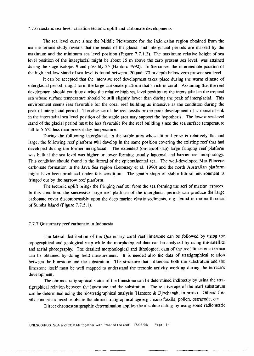
7.7.6 Eustatic sea level variation tectonic uplift and carbonate developments
The sea level curve since the Middle Pleistocene for the Indonesian region obtained from the marine terrace study reveals that the peaks of the glacial and interglacial periods are marked by the maximum and the minimum sea level position (Figure 7.7.1.3). The maximum relative height of sea level position of the interglacial might be about 15 m above the zero present sea level, was attained during the stage isotopic 9 and possibly 25 (Hantoro 1992). In the curve, the intermediate position of the high and low stand of sea level is found between -20 and -70 m depth below zero present sea level.
It can be accepted that the intensive reef development takes place during the warm climate of interglacial period, might form the large carbonate platform that’s rich in coral. Assuming that the reef development should continue during the relative high sea level position of the interstadial in the tropical sea whose surface temperature should be still slightly lower than during the peak of interglacial. This environment seems less favorable for the coral reef building as intensive as the condition during the peak of interglacial period. The absence of the reef fossils or the poor development of carbonate bank in the interstadial sea level position of the stable area may support the hypothesis. The lowest sea-level stand of the glacial period must be less favorable for the reef building since the sea surface temperature fall to 5-6’C less than present day temperature.
During the following interglacial, in the stable area whose littoral zone is relatively flat and large, the following reef platform will develop in the same position covering the existing reef that had developed during the former interglacial. The extended (on-lap/off-lap) large fringing reef platform was built if the sea level was higher or lower forming usually lagoonal and barrier reef morphology. This condition should found in the littoral of the epicontinental sea. The well-developed Mio-Pliocene carbonate formation in the Java Sea region (Letouzey et al. 1990) and the north Australian platform might have been produced under this condition. The gentle slope of stable littoral environment is
’ fringed out by the narrow reef platform. The tectonic uplift brings the fringing reef out from the sea forming the seri of marine terraces.
In this condition, the successive large reef platform of the interglacial periods can produce the large carbonate cover disconformably upon the deep marine elastic sediments, e.g. found in the north coast of Sumba island (Figure 7.7.5.1).
7.7.7 Quaternary reef carbonate in Indonesia
The lateral distribution of the Quaternary coral reef limestone can be followed by using the topographical and geological map while the morphological data can be analyzed by using the satellite and aerial photography. The detailed morphological and lithological data of the reef limestone terrace can be obtained by doing field measurement. It is needed also the data of stratigraphical relation between the limestone and the substratum. The structure that influences both the substratum and the limestone itself must be well mapped to understand the tectonic activity working during the terrace’s development.
The chronostratigraphical status of the limestone can be determined indirectly by using the stra- tigraphical relation between the limestone and the substratum. The relative age of the marl substratum
can be determined using the biostratigraphical analysis (Hantoro & Djoehanah, in press). Others’ fos- sils content are used to obtain the chronostratigraphical age e.g.: nano fossils, pollen, ostracode, etc.
Direct chronostratigraphic determination applies the absolute dating by using some radiometric
UNESCO/ROSTSEA and COMAR together with “Year of the reef” 17/08/95 Page 54

methods that are recently available for the coral and carbonate samples. The method used are 14C, 210 Th/234 U and ESR (Causse & Hillaire Marcel 1989; Lalou & Hoang, 1979; Lalou, 1985; Grun, 1989; Grun et al. 1992; Radtke et aL 1988a; Radtke & Grun, 1988b; Evin J. 1990). Correlation between of the date’s results of 230 Th/234 U and ESR method show a good linearity (Hantoro 1993f).
The status of Quaternary limestone in Indonesia had been described including; the absolute chronology, terrace sequence in the isotopic oxygen curve and the eustatic sea-level variations (Han- toro, in press). This carbonate sequence, together with the volcanic product, dominate the outcrop of the Quaternary sequence. The thickness of the limestone varies from ten to hundreds’ meters. The well developed and preserved terrace limestone is found mainly in Indonesia East where the tectonic and climatic component play an important role as the control to the reef building and its conservation.
7.7.8 Discussion and Conclusion
The Quaternary limestone is widely outcropped in the Indonesia East where the uplift had been more active following the tectonic collision of the Australian continental plate to the North overriding the Eurasian and Pacific plate. This limestone has been developed in the environment of quite shallow and large littoral zone of the volcanic islands belong to the warm tropical climate of the interglacial period (Hantoro 1992). The shallow coring in the epicontinental platform reveals that there is no signif- icant reef fossils left and found. It may be due to the lack of reef development during the maximum glacial period or the reef that has been developed during the low stand sea level was subject to the marine erosion.
The large and very common Quaternary reefal limestone development in Indonesia East should be initiated mainly by the conditions: - sea level fluctuations - tectonic uplift - large substratum of the reef platform in the littoral zone - warm and clear sea water environment - nutrient rich supply
The scarcely observed and less extensive development of the Holocene reef than the Recent and the Middle or Upper Pleistocene may be due to some reason, e.g., (Hantoro, 1993a in press):
- Problem of the reef preservation soon after the reef was emerged and opened to the marine erosion. - Climatic influence to the carbonate production and reef development - Tectonic subsidence that brings the reef immersed under the sea then buried by the recent reef.
The Mio-Pliocene reefal limestone found in the Java Sea Basin might develop in the enough shallow open sea under the warm tropical climate that was quite far from the fluvial sediment influx.
7.7.9 Acknowledgment
We would like to thank to my colleagues who give the advice during preparation of this manu- script, Also to Ii Sumantri who help to finish the figures.
UNESCOiROSTSEA and COMAR together with “Year of the reef” 17/08/95 Page 55

‘, -
E 100 I E 110 ,,-' E 120 '.a. CL,- " ' ;<...,\ E 130 E 140
0 km 1000
s 10
E 100 E 110
I a -.
Rig 1.1 Geological setting of Indonesian Maritime Island in the junction of mega plates in South East Asia. Adapted from Tapponier, 1984

. . .* . .
---__--_- . -Floras thw., , .-.L. -
* uplIft ‘mm/yr c sw
Fig. 1.2 Differential uplift in Indonesia East deduced from limestone terrace in Indonesia
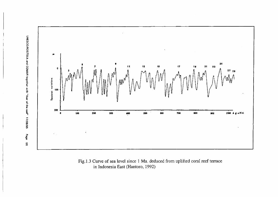
3
~
Iv
I
I
9 25 7 11 13 15 17 21 23
0 100 200 300 400 so0 600 700 500 500 loa0 AgrlW
Fig.l.3 Curve of sea level since 1 Ma. deduced from uplifted coral reef terrace in Indonesia East (Hantoro, 1992)

PACIFIC OCEAN
INDIAN OCEAN
.
Fig. 2.1 Indonesian Island Maritime and Gateways of the global oceanic current. Ocean current setting’s during East monsoon. (Soekarno, 1989; World current map 1990, Hantoro, 1992)
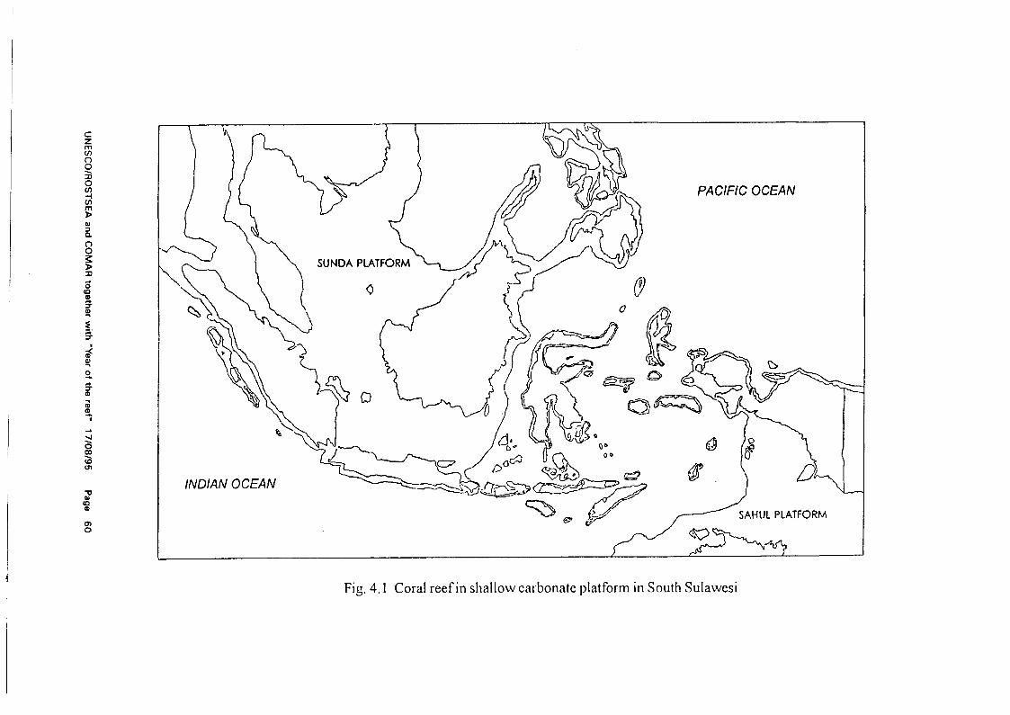
PACIFIC OCEAN
INDIAN OCEAN
Fig. 4.1 Coral reef in shallow carbonate platform in South Sulawesi

r I n. \
.
wuwo..lu .
Fig 5.1 Map of Sumba Island showing the large caps ofQuarternary limestone alon, (7 the north coast that formed the terrace
7.7.10 References
Bowin C., Purdy G.M., Johnston C., Shor G., Lawner L., Hartono H.M.S., Jezek P., 1980. Arc continent collision in Banda Sea region. American Association of Petroleum Geologists Bulletin, 64/6: 868915.
Causse C., Hillaire Marcel C., 1989. Th and U isotopes in Upper Pleistocene sediments of ODP Site 645 (Baffin Bay) and 646, 647 (Labrador Sea). Initial Report of ODP, B, US Printing Office, Washington, pp. 551-560.
Evin, J., 1990. Validity of the radiocarbon dates beyond 35 000 years B.P. Paleogeography, Paleocli- matology, Paleoecology, 80: 71-78.
Grun R., 1989. Electron Spin Resonance (ESR) dating. Quat. Int. 1: 66-109. Grun R., Radtke U, Omura A., 1992. ESR and Useries analyses on corals from Huon Peninsula, New
Guinea. Quat Sci Rev II: 197-202. Hamilton W., 1988. Plate tectonics and island arc. Geological Society of America Bulletin, 100:
1503-1527. Hantoro W. S., 1992: Etude des terrasses recifales quatemaires soulevees entre le detroit de la Sonde et
1’ isle de Timor, Indonesie Mouvements Verticaux de la Croute teffestre et variations du niveau de la mer. Ph.D Thesis Univ. d’ Aix Marseille 11. France. Vol I, 761~ et Vol.11, 225~. Published.
Hantoro, W.S. 1993b. Environment and climate changes record since the last interglacial obtained from the study of the modem and uplifted coral reef in Indonesian Island Arc: Background and strategy of the program. In: Proceeding the IAEA consultants Meeting of the Retro- spective Studies on Coral Reefs, Townsville, Australia, 17-21 May 1993.
Hantoro, W.S. (1993e). Status neotektonik dan variasi permukaan air laut: Studi teras terumbu koral di Pulau Alor, Nuasa Tenggara Timur. Berita ITB, Jurusan Teknik Geologi ITB (Indonesian version).
Hantoro W.S., 1994. Sea level variations, carbonate development and carbon budget In: Proceedings of the XIX HAG1 Annual Meeting, October 9-13, 1994, Bandung Indonesia.changes in epicontinental platform of Indonesian Maritime Islands.
Hantoro, W.S. in press a. Uplifted Quaternary coral reef limestone formation: Onoff reef building. In: Proceeding of the IGCP Seminar: Project 296 on Quaternary Stratigraphy of the West Pacif- ic and South East Asia Region, Kong Khaen 17-22 October 1993, Thailand.
Hantoro, WS. (in press). Emerged coral reef Limestone: Carbonate Formnation of Holocene High Sea Stand In Indonesia. In: Proceeding of the IGCP Seminar: Project 296 on Quaternary Stratigraphy of the West Pacific and South East Asia Region, Khon Khaen 17-22 October 1993, Thailand.
Hantoro W.S., Lafont R., Bieda S. & Jouannic C., in press. Holocene vertical defon-nation in East Sunda - West Banda Arc Based on the Emerged Coral Reef Study (submitted for Tecto- nophysics) Ext.abs. on Proceedings of International Symposium on Geodynamics of Indone- sia within the context of National Resources Development and the mitigation of Geological Hazards, June 3-4, 1994, Bandung, Indonesia.
Hantoro and Djoehanah, (in press). Planctonic foraminifers age of The Plio-Pleistocene marine Ter- race in Ambon, East Indonesia. In: Proceeding of the IGCP Seminar: Project 296 on Quatematy Stratigraphy of the West Pacific and South East Asia Region, Kong Khaen 17-22 October 1993, Thailand.
UNESCO/ROSTSEA and COMAR together with “Year of the reef” 17/08/95 Page 62

Lalou C., and Hoang CT., 1979. Les methode de datation par les descendants de l’uranium. Bulletin de 1’Association francaise pour 1’Etude du Quaternaire, 1979-1, 2: 3 -14.
Lalou L., 1985. Methode de datation par les phenomenes nucleaires naturels applications. In: Roth. Poty, 1985. Paris: Masson. pp. 177-198.
Letouzey J., Werner P. Marty A., 1990. Fault reactivation and structural inversion. Back arc and intraplate compressive deformations. Example of the eastern Sunda Shelf (Indonesia). Tectonophysics, 193: 341-362.
MC Caffrey R., Molnar P., Roecker S.W., Joyodiwiryo Y.S., 1985. Microearthquacke seismicity and fault plane solution related to arccontinent collision in the eastern Sunda Arc. Journal of Geophysical Research, 90: 45 114528.
McCaffrey R., 1991. Slip vectors and stretching of Sumatran fore arc. Geology 19, 881-884. Moore G.F., Curray J.R.. Moore D.G.. Karig D.E., 1980. Variations in geologic structure along the
Sunda forearc, northern Indian Ocean. In: D.E. Hayes (Editor), The Tectonics and Geolog- ic Evolution of the Southeast, Asian Seas and Basins. Geophys. Monographs, 23, Am. Geophys. Union, Washington, D.C., pp. 145-160.
Newcomb K., and McCann W, 1987. Seismic history and seismotectonics of the Sunda arc, J. Geo- phys. Res., 92, 421-439, 1987.
Radtke U., Grun R., Schwarz P., 1988a. Electron spin resonance dating of the Pleistocene coral reef tracts of Barbados. Quat. Res 29: 197-215.
Radtke U., Grun R., 1988b. ESR dating corals. Quaternary Science Reviews, 7: 467-470. Roberts H.H., Phipps C.V., 1988. Proposed oceanographic controls on modem Indonesian reef. a
turnoffjturnon mechanism in monsoonal setting. Proceeding of the 6th International Coral Reef Symposium, Australia, 1988, 3: 455-460.
Stevens S.H., and Moore G.F., 1985. Deforinational and sedimentary processes in trench slope basins of the Western Sunda Arc, Indonesia. Marine Geology, 69 (1985) 93-l 12.
Yan X.H., Klemas V.V., Chen D., 1992. The western Pacific Warm pool Observed from space. Eos, 7314: p.1 & 3.
UNESCO/ROSTSEA and COMAR together with “Year of the reef” 17/08/95 Page 63

8. WORKSHOP ON CONSERVATION PRIORITIES IN EASTERN INDONESIA
The following are the major factors identified by the NGO communities as being relevant to the conservation and management of coral-reefs in eastern Indonesia.
8.1 Requirements scientific research
(1) Biology: - experimental analysis in vitro of direct impact of “cyanide” on live coral; - analysis of impacts due to mortality of “non-target” reef-fish subject to cyanide-exposure; - analysis of impacts from cyanide on “other” reef organisms.
(2) Fisheries: - impact of small mesh-size nets on fish populations; - economic aspects arising from use of different mash sizes;
(3) Aquaculture: - farming of juvenile clams (e.g. Tridacna SD.) in sheltered and protected (Guarded?) areas; - mariculture of marine tropical fish (food-fish and aquarium).
(4) Medical: - long-term effects of the consumption of fish caught with cyanide; - effects of cyanide due to direct exposure in sea-water (fishermen and divers).
8.2 Marine conservation in eastern Indonesia
Determination of “use-rights in relation to coral-reefs.
(1) What are the multiple uses of coral reefs? (2) What role do “outsiders” play in relation to impact on coral-reefs? (3) What is the relative contribution bade by subsistence use as opposed to export of
reef products?
8.3 Impact of fisheries activities in coral-reef buffer-zones.
Where multiple-use management systems are involved, scope of the exploitation patterns must still be subject to a degree of control in order that particular species or species-groups will not be sub- ject to over-use. Particular attention must be paid towards the definition and acceptance by local communities of “core-areas”
UNESCOlROSTSEA and COMAR together with “Year of the reef” 17/08/95 Page 64

8.4 Existing laws and enforcement.
A clarification of the way in which the new “SISKAMLA” (Sistem Keamanan Laut) or “System for safeguarding the sea” will operate is required.
8.5 Difficulties encountered in safeguarding coral-reefs,
(1) Geographical range and logistics: - remote areas; - vast distances; - lack of equipment.
(2) Institutional: - more than one decision-maker for marine resources; - co-ordination not effective; - poor distribution and use of data and other information.
(3) Legal: - confusion in application of laws and regulations at national and provincial levels.
8.6 Possible solutions
(1) SISKAMLA: - strong community involvement; - integration of local officials into reporting procedures (Kepala adat and Kapala kewang); - provision of financial and technical support to local officials; - training of villages in laws and institutional responsibilities.
(2) Tenure rights (Hak Pertuanan). This initiative involves the promulgation of regional regulations officially recognizing the rights
of communities to obtain exclusive use and management of traditional fishing grounds. Assistance can be provided by:
- working with villages to produce maps of traditional resource areas; - formalizing maps and boundaries with specialist input; - obtaining official approval by the “Bupati” or local district chief; - public distribution of approved maps; - enforcement of traditional use-patterns through “SISKAMELA” with the aid of local - report-
ing.
UNESCO/ROSTSEA and COMAR together with “Year of the reef” 17/08/95 Page 65
_-.__--__----- __-~---

8.7 Management of conservation areas
Marine conservation areas require an overall management approach which is based on the concept of multiple-use particularly in developing countries. The following outline summarizes some of the major points which have to be taken into account.
(1) Inventory of natural resources and their ecosystems. Target: to systematize the availability of information (including remotely-sensed) and develop-
ment of a data-base covering natural resources and associated ecosystems (including flora, fauna and associated habitats). Elements included are:
- methods of inventory survey (terrestrial and marine); - implementation of surveys; - analysis of survey results; - analysis of the ways in which resources are utilized; - evaluation of potential.
(2) Planning of conservation areas. Target: the creation of a conservation plan for biodiversity. Elements included are:
- creation of a management plan governing future activities in the conservation area; - adjustment in relation to ecosystem types, geographic area etc.; - community input.
(3) Development, planning and management of conservation areas. Target: conservation areas are to be managed on a general definition which includes existing uses. Elements included are:
- many types of conservation areas; - careful construction of management plans; - provision of reasonable data for support.
(4) Development of specific conservation Target: to restore populations of threatened species. Elements included are:
- preservation of species by culture and re-introduction; - increasing the value of resources for community benefit; - control of access and distribution through permits.
(5) Development of protected areas. Target: creation and management of defined protected areas according to predetermined criteria for optimal utilization. Elements included are:
- improvement of protected areas; - evaluation of conditions;
UNESCOlROSTSEA and COMAR together with “Year of the reef” 17108195 Page 66

- rehabilitation: - boundary markers; - management plans; - controlled use.
9. OPENING ADDRESS
by H. E. Dr. Wardiman Djodjonegoro, Minister of Education, Indonesia.
Field-studies in education programs and development.
Please allow me to welcome you all to this part of Indonesia which as you may know has played an extremely important role in development strategy since the time of its identification with the global spice trade. The “Spice Islands” were formerly the source of a unique product in the form of nutmeg and to a lesser extent cloves.
Today the coral-reef systems of eastern Indonesia, which are particularly well represented here, are known to be diverse and are currently thought to be comparatively undamaged. Together with the role played by these resources in provision of food and useful products for human populations in the coastal zones, it is increasingly realized that coral-reefs can be important in attracting tourist interest. The phenomenon of eco-tourism is now a rapidly expanding force in the field of international finance but it is one that is driven by a sophisticated and demanding clientele. Eco-tourists quite simply are not satisfied with viewing damaged or partly-damaged reefs, they want to see nature in all her glory and will pay well for that privilege.
Many of the reef systems in Indonesia adjacent to large urban populations have already been extensively damaged by urban pollution and over-use If Indonesia is to make the best of the remaining reef-systems it is an urgent priority to both describe them and at the same time to start a monitoring system in order to detect any unwanted changes.
In the United States, Vice President Al Gore has recently started a school-based system called “Globe” for both education and monitoring of environmental change. In Indonesia we are also experi- menting with the development of local-area curricula. In this regard we are beginning to see that the involvement of school children in important activities like the assessment and monitoring of ecological systems such as coral-reefs can both contribute to our goal of nation-building, and at the same time provide us with on-going reports of reef health and well-being. Reports of this nature can help us to both maintain our natural environment and at the same time provide us with the guidance required for environmentally sound tourist expansion in order to assist us with our overall development programs.
A local-content field-studies curriculum for high-school use could bring together elements within the existing syllabus to:
(1) make advanced knowledge of marine terrestrial and associated systems accessible to teachers and
UNESCO/ROSTSEA and COMAR together with “Year of the reef” 17/08/95 Page 67
students; (2) catalyze interaction among high schools and established research and education systems to ensure
that activities significantly contribute towards required educational goals and are accepted as cred- its towards qualification in different programs where appropriate.
(3) encourage sharing of knowledge, resources and facilities and to selectively enhance facilities to maximize the capability of all participating institutions;
(4) encourage the collection, recording and dissemination of information relating to the environment as the result of the accumulation of class data over the years;
(5) encourage implementation of standardized monitoring and testing protocols to enable consistent utilization of data over a wide front;
(6) progressively establish educated communities throughout Indonesia to understand factors associated with environmental change and the resultant impacts, thereby encouraging “ecologically sound and sustainable development” in a changing world.
Field studies will require special training for teachers and will involve data processing skills using micro-computers and so forth. Particular practical experience can also include training in naviga- tion, basic and advanced outboard boating skills, snorkeling, basic SCUBA practices (where such equipment is available and where at least one of the teaching staff is properly certified), as well as direct environmental monitoring using techniques such as shoreline debris calculations, resource as- sessment strategies and so forth.
It is to be hoped that the current workshop will be able to extract some general principals to assist in the development of global and national coral-reef monitoring programs. I wish you all well in your important deliberations.
Environmental field courses are still a novelty in high schools of today. Less than ten years ago education in this area was confined to relatively simple nature-study walks. Awareness and concern about the environment have now been heightened by such factors as: the prospects for change induced by warming; population growth; concentration of population in coastal areas; establishment of the Exclusive Economic Zone; exhaustion of resources; inadequate management of growth and develop- ment; pollution; over-fishing; excessive siltation, build-up of greenhouse gases and anthropogenic constituents in run-off.
Human-induced local and global environmental change such as destruction of tropical forest, species extinction, loss of stratospheric ozone and changes in the atmospheric composition, as well as the chemistry of precipitation, is already a fact. Worse, it is expected that additional and more serious changes loom in the future. Global and environmental change in general, whether natural or anthropo- genie, has economic and social consequences, since it has impact on resource use strategies and the biological and physical environment in which resources are embedded. Global, regional and local environmental change implies that educational systems must evolve to meet the occasion by providing an informed population to modify development philosophies in general. Future strategies must be ad- justed to compensate for past change, as well as to anticipate and either obviate or ameliorate predicted future responses.
Lack of understanding about the influences operating in the modern environment, is wide- spread. Societies in many countries have evolved through substantial periods of dependence on ocean or land-based economies operating under balanced ecological conditions. For many, the effects induced by global industrialization and global economic processes are new phenomena, ones which often cannot be understood by the direct transfer of practices which were formerly adequate to deal with local
UNESCO/ROSTSEA and COMAR together with “Year of the reef” 17/08/95 Page 68

causes and effects. In the face of advances in technology and changes of scale, owing to the operation of the global economy, traditional practices such as those involved in fishing and ocean management for instance, often prove inadequate to guide further development.
Problems associated with environmental management options will increasingly require the attention of an educated population to render solutions compatible with the emerging environmental ethic. Educational institutions will face new pressures to provide adequate training in this regard and the best way of ensuring an appropriate response is to expose students to field situations requiring their attention to observation and detail at an early stage. Indeed examples drawn from environmental studies can be used to illustrate almost all facets of a modern scientific education and the increasing use of the phrase “environmental education across the curriculum” is an indication of the extent to which serious environmental studies are now required at all educational levels and most importantly, in high schools. The graduating student and citizen of the world will be increasingly faced with environmental decisions which will have direct and immediate affects on life-styles and careers.
There is wide-spread agreement that the principal of “ecolopicallv sound and sustainable devel- onment” should be adhered to in both developed and developing countries. An important step in ensur- ing that this will be undertaken on a broad front involves engaging high-school students with the reali- ties of environmental analysis so they may contribute to the definition of what future generations will mean by this phrase.
UNESCOlROSTSEA and COMAR together with “Year of the reef” 17/08/95 Page 69
---- - -

10. PARTICIPANTS LIST
The UNESCO-LIP1 CORAL REEF ASSESSMENT AND STATUS EVALUATION WORKSHOP, Ambon (27 November 1994) and Banda Neira, Indonesia, 28 November, 1994 - 01 December 1994.
1. R. ABDUL RAHMAN Faculty of Fisheries and Marine SC. Univ. Pertanian Malaysia 43400 UPM Serdang, Selangor Malaysia FAX 03-94882697 TEL. 03-9486101
2. P. ALINO Marine SC. Institute Univ. of the Philippines Diliman, Quezon City Philippines FAX 632-9243735
3. C. BIRKELAND Marine Laboratory, Univ. of Guam, Mangilao GUAM 96923 - USA FAX (671) 734-6767. EM: <birkelan@uog9edu>
4. J. P. BISSON USAID/Indonesia American Embassy, Jl. Merdeka Selatan No. 4 Jakarta 10 110 Indonesia FAX 62 21 380 6694 TEL. 360-260 ext 2392
5. B. E. BROWN Depr. Marine Sciand Coastal Management Univ. of Newcastle Upon ‘I)ne Newcastle upon ‘I)ne NE17RU UK FAX 091 222 7891 TEL. 091 222 6653
6. H. CHANSANG Phuket Marine Biological Center. P.O. Box 60 Phuket 83000 Thailand FAX 66-76-391-127 TEL. 66-76-391-128
7.
8.
9.
C. COOK TNC, The Nature Conservancy Jl. Radio IV/5 Kebayoran Baru Jakarta Indonesia FAX 62 21 7245092 TEL. 62 21 7206484
L. DEVANTIER AIMS, PMB 3, Townsville Qld. AUSTRALIA FAX 061-77-725852 TEL 789344, EM: < L.DEVANTIERQAIMS.GOV.AU >
T. DONE AIMS, PMB 3, Townsville Qld. AUSTRALIA FAX 061-77-725852 TEL 789344, EM: <[email protected]>
UNESCO/ROSTSEA and COMAR together with “Year of the reef” 17/08/95 Page 70

10.
11.
12.
13.
14.
15.
16.
17.
18.
A. GILL Coral Cay Conservation Ltd. 154 Clapham Park road London SW4 7DE U.K. FAX 071 498 8447 TEL. 071 498 6248
R. N. GINSBURG Univ. of Miami, RSMAS 4600 Rickenbacker Cswy. Miami, Florida 33 149 U.S.A FAX 3053614094 TEL. 305-361-4875 EM: < [email protected]>
WAHYU SUPRI HANTORO Research and Development Centre for Geotechnology-LIP1 Jl. Cisitu No. 21/154 D Bandung Indonesia FAX 022-2504593 TEL. 022-2503654
J. R. E. HARGER Programme Specialist, Marine Sc/Env. UNESCO Jakarta Jl. MH Thamrin 14, Tromolpos 1273/JKT Jakarta 10012 Indonesia FAX 62 21 3150382 TEL. 62 21 3141308 EM: < [email protected] >
M. HUTOMO P30-LIPI, Research and Dev.Center for Oceanology Jl. Pasir Putih 1, Ancol Jakarta Indonesia FAX 62 21 681948 TEL. 62 21 683850
R. JOHANNES. 8 Tyndall Court Bonnet Hill 7053 Tasmania Australia FAX 61-02 298066 TEL. 61-02-298-064
0. KURNAIN Chief, P30-LIP1 Ambon Poka, Ambon Indonesia FAX 62 0911 69281 TEL. 62 0911 69352
K. MACKAY IDRC, P.O. Box 8500, Ottawa Canada KlG 3H9
Environmental Studies Centre, UNPATTI. Ambon 97001 Indonesia
J. C. OGDEN Florida Institute of Oceanography 830 First St.!% St. Petersburg FL 33701 U.S.A. FAX 813-893-9109 TEL. 813-893-9100 EM: < [email protected] >
UNESCOlROSTSEA and COMAR together with “Year of the reef” 17108195 Page 71

19. W. C. PATZERT NOAA/Jet Propulsion Laboratory SSMC 4, 8402 1305 East-West Highway Silver Spring, MD 20910 U.S.A.
20.
FAX 301/713 4475
H. SANGER TNC, The Nature Conservancy Jl. Radio IV/5 Kebayoran Baru Jakarta Indonesia FAX 62 21 724 5092 TEL 62 21 7206484
21. T. YEEMIN Dep. of Biology, Ramkhamhaeng University, Huamak Thailand FAX 66-2-3 180934 TEL. 66-2 3 180934
22. SUHARSONO P30-LIPI, Research and Dev.Center for Oceanology Jl. Pasir Putih 1, Ancol Jakarta Indonesia FAX 62 21 681948 TEL. 62 21 683850
23. T. TGMASCIK School of Resource and Environmental Studies Dalhousie University 1312 Rossie St. Halifax, N.S. Canada Mailing address: c/o EMDI Project, Arthaloka, 31d-12 Jakarta, Indonesia, Tel. 6 1285 11
24. G. F. USHER USAID/Indonesia American Embassy, Jl. Merdeka Sel. No. 4 Jakarta 10110 Indonesia FAX 62 21 380-6694 TEL. 62 21 360-260 ext 2392
NRMP, P.O.BOX 1375, Manado, Sulut
25. R. VAN WOESIK 1 I-505 Maeda-Tutaku, Maeda Urasoe City, 902-01, Okinawa Japan FAX 098-895-24 14 TEL. 098-845-2221 ext 2683
26. L. DILL (Ambon Workshop) Dept. of Bioscience, Simon Fraser Univ. Prof. and Dir. Behavioral Ecology Research Group Bumaby Canada 5A 156 B.C. FAX 604-291 3496 TEL 604-291-3664 EM: <[email protected]>
TEL. 3011713 1193, EM: <omnet/w.patzert >
Observers:
1. R. DJOHANI Roland Hoist Laan 115 2624 KM Delft The Netherlands FAX 31-15-159218 TEL. 31 15 566092
UNESCO/ROSTSEA and COMAR together with “Year of the reef” 17KWg5 Page 72
2.
3.
4.
5.
6.
7.
8.
9.
10.
11.
C. P. S. CHEUNG 339 Hennesy Road G/F Wanchai Hong Kong FAX/TEL. 852-8342 189
INGRID P. CONSING Haguma Foundation, Room 8 Maya Bldg. 678 Edsa Cubao, Quezon City Philippines
A. TOMASCIK EMDI Ecology of Indonesian Seas Co-author EMDI Project, Arthaloka Bldg. 12th Fl. Jl. Jend. Sudirman 2 Jakarta Indonesia
C. RAYMAKERS WWF, Jl. Pela 3, Gandaria Utara Jakarta Sel. 12140 Indonesia TEL. 02 l/7695907
S. VAN WOESIK same address as R. Van Woesik
A. M. HATTA (Ambon Workshop) BPSDL-LIP1 Guru-guru, Poka, Ambon Indonesia
C. SOT0 (Ambon Workshop) PSL, Jl. Martha Alfons, Poka 97233 Ambon Indonesia
SUSETIONO (Ambon Workshop) BPSDL, P30-LIP1 Guru-guru, Poka, Ambon 97233 Indonesia FAX (0911),69352 TEL. (0911) 69281
M. VAN DER WAL PSL-UNPATTI EPM Kotak Pos 22 1, Ambon 97001 FAX 0911-61453 TEL. 61337
WAHYU BUD1 SETYONO (Ambon Workshop) P30-LIP1 Ambon Poka, Ambon
Underwater Cameramen :
1. A. IBRAHIM P30-LIP1 Jl. Pasir Putih 1, Ancol Jakarta Indonesia
2. F. LEATEMIA P30-LIP1 Ambon Poka, Ambon
UNESCOlROSTSEA and COMAR together with “Year of the reef” 17/08/95 Page 73
Indonesia FAX 62 0911 69281 TEL. 62 0911 69352
Organizing Committee :
M. AZUMA UNV Marine SC. UNESCO Jakarta Jl. MH Thamrin 14, Tromolpos 1273/JKT Jakarta 10012 Indonesia FAX 62 21 3150382 TEL. 62 21 3141308, EM: <[email protected]>
NUNING WIRJOATMODJO Secretary to Dr. J.R.E. Harger UNESCO Jakarta Jl. MH Thamrin 14, Jakarta Indonesia FAX 62 21 3150382 TEL 62 21 3141308
In cooperation with Ms. Tanya Des Alwi, Banda Cultural Heritage, Maulana Hotel, Banda Naira.
UNESCO/ROSTSEA and COMAR together with “Year of the reef” 17/08/95 Page 74
--
2

-
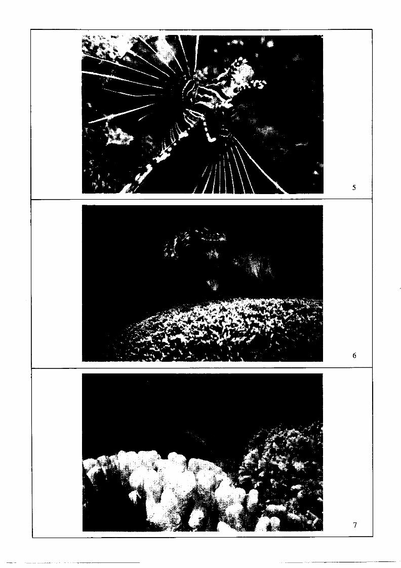
5
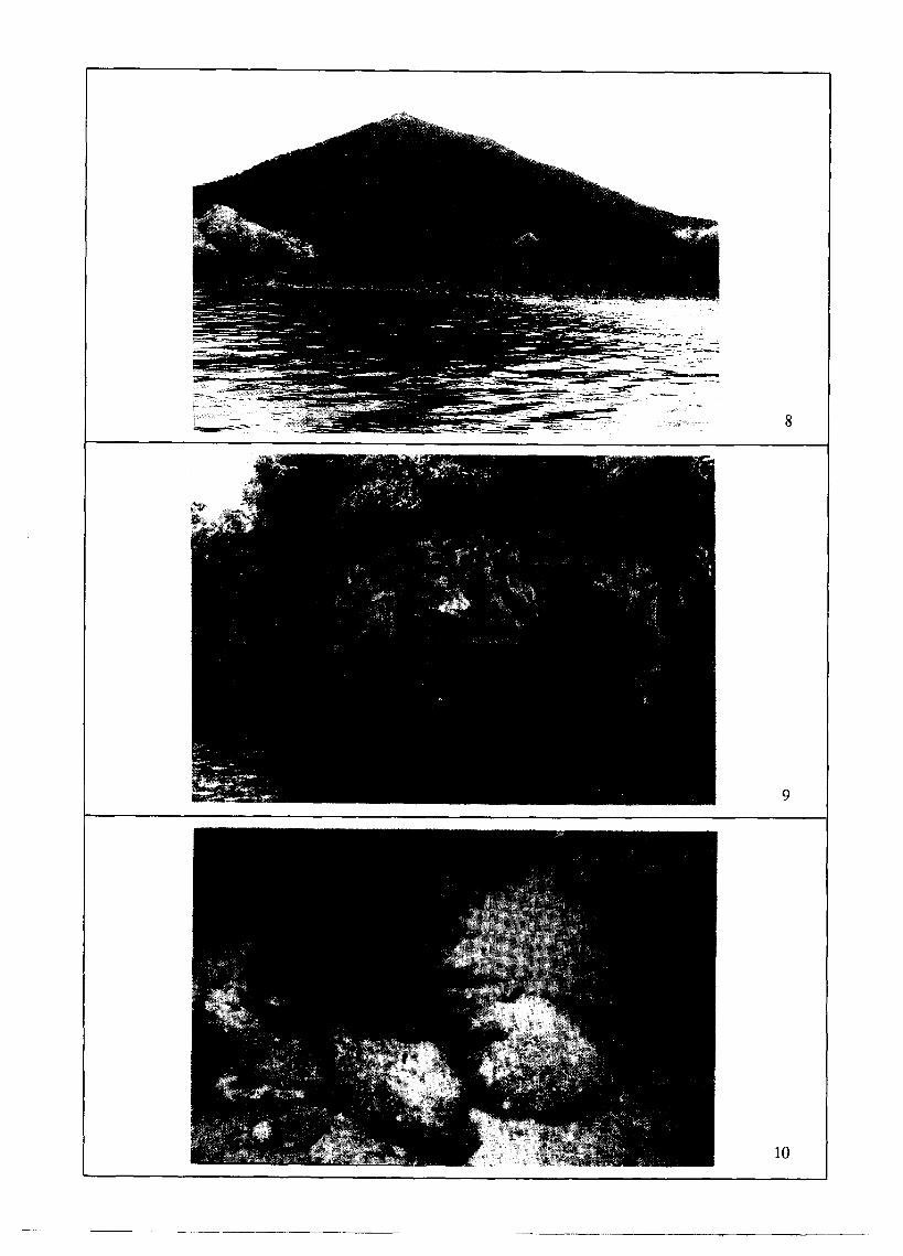
8
9
10


14
15
17
18
19
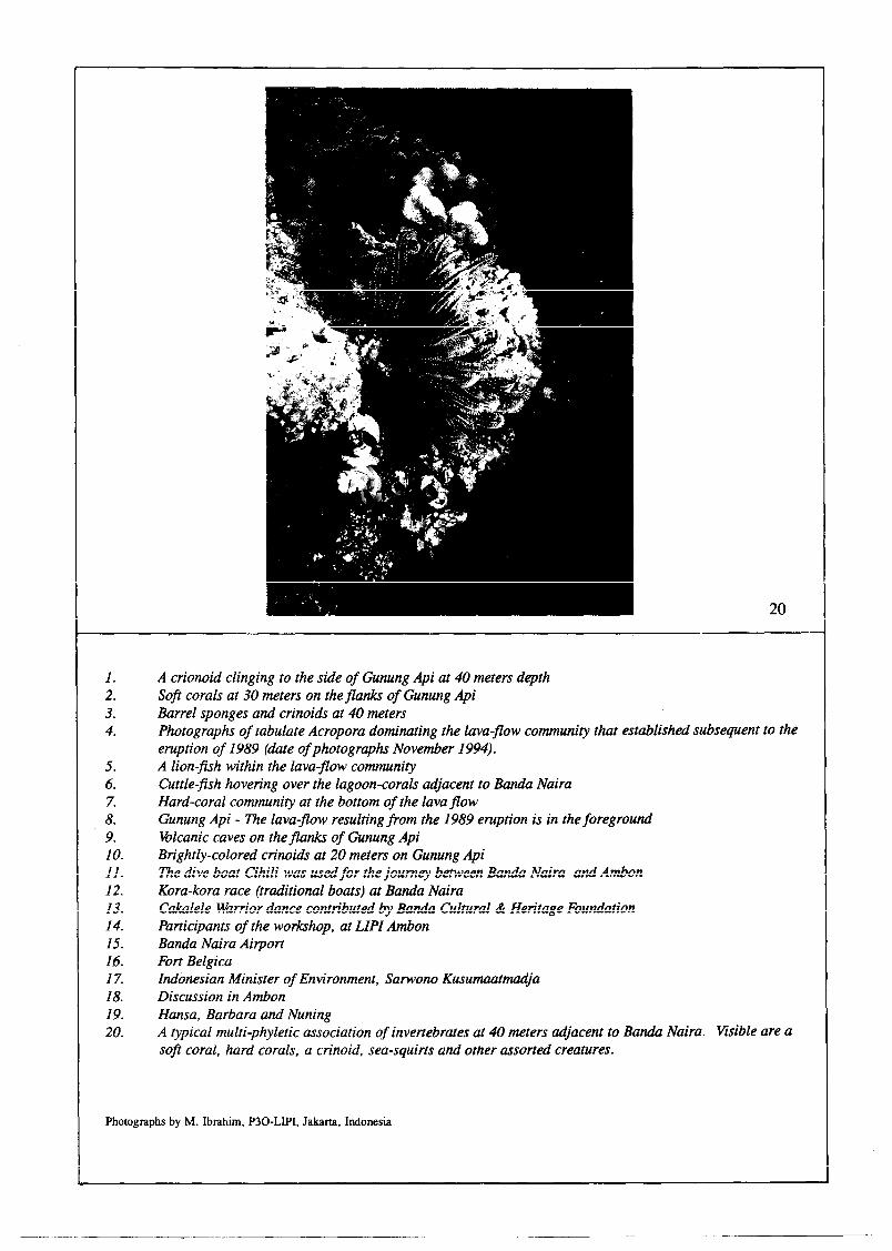
20
1. 2. 3. 4.
5. 6. 7. 8. 9. IO. 11. 12. 13. 14. 15. 16. 17. 18. 19. 20.
Photogl raphs by M. Ibrahim, P30-LIPI, Jakarta, Indonesia
A crionoid clinging to the side of Gunung Api at 40 meters depth Soft corals at 30 meters on the flanks of Gunung Api Barrel sponges and crinoids at 40 meters Photographs of tabulate Acropora dominating the lava-flow community that established subsequent to the eruption of 1989 (date of photographs November 1994). A lion-fish within the lava-flow community Cuttle-fish hovering over the lagoon-corals tijacent to Banda Naira Hard-coral community at the bottom of the lava flow Gunung Api - lhe lava-flow resulting from the 1989 eruption is in the foreground Volcanic caves on the flanks of Gunung Api Brightly-colored crinoids at 20 meters on Gunung Api The dive boat Cihili was used for the journey between Banda Naira and Ambon Kora-kora race (traditional boats) at Banda Naira Cakalele Warrior dance contributed by Banda Cultural & Heritage Foundation Participants of the workshop, at LIPI Ambon Banda Naira Airport Fort Belgica Indonesian Minister of Environment, Sarwono Kusumaatnuuija Discussion in Ambon Hansa, Barbara and Nuning A typical multi-phyletic association of invertebrates at 40 meters adjacent to Banda Naira. Visible are a soft coral, hard corals, a crinoid, sea-squirts and other assorted creatures.
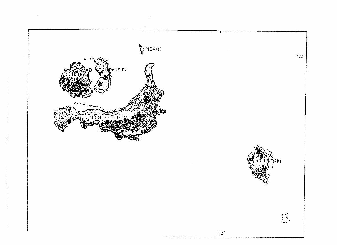
, I
b .:..: PISANG