continuity and change in the urban network of hungary … · · 2018-03-03continuity and change...
TRANSCRIPT

B A N AT I C A , 2 6 | 2 0 1 6
CONTINUITY AND CHANGE IN THE URBAN NETWORK OF HUNGARY IN
THE EARLY ANGEVIN PERIOD
Katalin Szende*
Keywords: urban development, Angevins, trade, mining, privilegesCuvinte cheie: dezvoltare urbană, Angevini, comerţ, minerit, privilegii
Urban centres, old and newThe ascent of a new ruling dynasty, the Angevins, to the Hungarian throne,
brought with it first and foremost political and administrative changes and then in consequence and more gradually, social and economic ones.1 Urban develop-ment has not until recently been regarded as a field where a change of dynasties would have brought with it conspicuously new trends. During the last few years, however, new studies scrutinizing the reign of Charles I (1301–1342) and his urban policy (or the lack of it) have raised a set of related questions about the nature of urban growth in the Carpathian Basin and the driving forces behind it in the first half of the fourteenth century.2
* Department of Medieval Studies, Central European University, Budapest. PI of the NKFI-funded project “Hungarian Atlas of Historic Towns” (K 116594) and member of the “Lendület” Research Group on Hungarian Economic History (LP2015–4/2015), e-mail: [email protected] See in general: Pál Engel, The Realm of St Stephen. A History of Medieval Hungary, 895–1526 (London: I.B: Tauris, 2001), 124–194; on particular innovations in governance: Enikő Csukovits, “Az Anjou-kori intézményi újítások nápolyi párhuzamai,” [Neapolitan parallels of institutional innovations in the Angevin period], in Tibor Neumann, György Rácz, eds, Honoris causa. Tanulmányok Engel Pál tiszteletére [Studies in honour of Pál Engel] (Budapest and Piliscsaba: MTA-TTI – PPKE, 2009) (Társadalom és művelődéstörténeti tanulmányok 40. / Analecta medievalia III), 19–62; and the special thematic issue 2013/2 of the journal Hungarian Historical Review on the Angevin period: http://www.hunghist.org/index.php/forth-coming/79-hhr-issue/150-volume–2-issue–2–2013 (last accessed 8 June 2016).2 Attila Zsoldos, “Károly és a városok,” [Charles and the towns] in Boglárka Weisz, ed., Pénz, posztó, piac. Gazdaságtörténeti tanulmányok a magyar középkorról [Coins, cloth, commerce. Studies on the economy of medieval Hungary], (Budapest: MTK BTK TTI, 2016), 265–283;

54
Archaeological and historical research on the towns that served as Charles’s residences in various periods of his reign have added much new material and inspiration to this discussion. Timişoara (Temesvár), his first “purpose-built” seat, was chosen after a period of hesitation between Szeged, Lipova (Lippa) and Timişoara. Along with the publication of a thorough monographic overview of the town’s medieval history, the discovery of Charles’ fortified residential tower has shed new light on the built environment surrounding the monarch, and hopefully further research will reveal even more about the standards of living and the presence of his retinue there.3 At Visegrád, his new choice of a seat in the Medium regni after the consolidation of his reign from 1323 onwards, both the Upper Castle and the first period of the urban palace as well as the settle-ment surrounding the latter have been investigated,4 and a recent study also partly discussed Nagymaros, a town whose growth on the other bank of the Danube was almost like an extension to Visegrád.5 Finally, regarding Buda, which was not an “official” royal residence but where the king often sojourned and held important summits, a new monograph clarifies the way in which it gradually became the financial and commercial capital city of the kingdom.6
Katalin Szende, “Mennyit ér a kiváltság? Városprivilégiumok kibocsátása és rendelkezéseik betartása I. Károly alatt,” [What is the privilege worth? Issuing and (dis)regarding town privileges in Hungary during Charles I’s reign], in Ibid, 285–339. In this article I give an extensive account of Charles measures concerning cities and towns, with detailed source references which I will not repeat here due to limitations of space. 3 István Petrovics, “The Fading Glory of a Former Royal Seat: the case of medieval Temesvár,” in Balázs Nagy and Marcell Sebők, eds, ‘The Man of Many Devices, Who Wandered Full Many Ways…’, Festschrift in Honor of János M. Bak (Budapest: CEU Press, 1999), 527–538; István Petrovics, A középkori Temesvár. Fejezetek a Bega-parti város 1552 előtti történetéből [Medieval Timişoara. Chapters from the history of the town by the Bega before 1552] (Capitulum IV.) (Szeged: JATE Press, 2008); Zsuzsanna Kopeczny, “Reşedinţa regală medievală de la Timişoara,” [The medieval royal residence at Timişoara], Analele Banatului, Serie Nouă, Arheologie–Istorie, XXI (2013): 211–231.4 Gergely Buzás and József Laszlovszky (eds), The Medieval Royal Palace at Visegrád (Budapest: Archaeolingua, 2013); László Iván, A visegrádi vár története a kezdetektől 1685-ig [The history of Visegrád castle up to 1685] (Visegrád: MNM Mátyás Király Múzeuma, 2004); Gergely Buzás, József Laszlovszky and Orsolya Mészáros, eds, The Medieval Royal Town at Visegrád. Royal Centre, Urban Settlement, Churches (Budapest: Archaeolingua, 2014).5 Orsolya Mészáros, Gábor Serlegi, “The impact of environmental change on medieval settlement structure in Transdanubia,” Acta Archaeologica Academiae Scientiarum Hungaricae 62 (2011): 199–219. 6 Enikő Spekner, Hogyan lett Buda a középkori Magyarország fővárosa? A budai királyi székhely története a 12. század végétől a 14. század közepéig [How did Buda become the capital of medieval Hungary? The history of the medieval royal seat from the late twelfth to the mid-fourteenth century] (Budapest: BTM, 2015), shorter English version: Enikő Spekner, “Buda before Buda: Óbuda and Pest as Early Centres,” in Balázs Nagy, Martyn Rady, Katalin Szende, András Vadas,

55
The same monograph also offers a detailed itinerary of Charles and his queen,7 which makes it possible to relate his decisions concerning the cities and towns of his realm to his movements and to political events, particularly his struggles for the “re-unification of the country,” in Pál Engel’s term.
All these new materials, as well as the growing international interest in the relationship between seigneurial power and the development of towns in various polities of medieval Europe8 make it even more timely to reassess royal urban policy in the light of the new political and economic circumstances in Hungary in the Angevin period. This overview will concentrate on two interrelated sets of questions. First, what new elements did this period add to the already existing number of cities in the Carpathian Basin, including the range of “new towns” that emerged in the course of the great social changes of the thirteenth century, and how did they consolidate the already existing urban network? And second, how much can the processes we observe be considered as a logical continuation of the preceding decades, or to what extent were they due to the accession of a new ruling dynasty and its hard-fought but ultimately successful struggle to centralize royal power?Besides analysing the developments in the Kingdom of Hungary, wherever possible, I will point to parallel developments and possible analogies in other parts of contemporary Central Europe.
A comparison between the thirteenth-century urban network of the Carpathian Basin and the modern one demonstrates that the backbone of the settlement system was already in place before 1300.9 The rulers of the indige-nous Árpádian dynasty had issued between 1201 and 1299 altogether 87 priv-ileges to 52 settlements (including confirmations or extensions of previously granted charters).10 The thirteenth century was an equally decisive period for town foundation in other polities of Central Europe as well – in the lands of the Czech crown, in Silesia and in the various provinces of the politically frag-mented Polish territories. The similarities also apply to the legal aspect of urban
eds, Medieval Buda in Context (Leiden: Brill, 2016), 71–91; András Végh, “Urban Development and Royal Initiative in the Central Part of the Kingdom of Hungary in the 13th–14th centuries: Comparative Analysis of the Development of the Towns of Buda and Visegrád,” in Ferdinand Opll, ed., Stadtgründung und Stadtwerdung. Beiträge von Archäologie und Stadtgeschichtsforschung (Linz: Österreichischer Arbeitskreis für Stadtgeschichtsforschung, 2011), 431–446.7 Spekner, Hogyan lett Buda, 139–183.8 See e.g. Anngret Simms, Howard Clarke, eds, Lords and Towns in Medieval Europe. The European Historic Towns Atlas Project (Farnham: Ashgate, 2015).9 Jenő Szűcs, Az utolsó Árpádok [The last Árpádians] (Budapest: MTA TTI, 1993), 50–60, 223–230.10 Katalin Szende, “Power and Identity: Royal privileges to the towns of medieval Hungary in the thirteenth century,” in Michel Pauly, Alexander Lee, eds, Urban Liberties and Civic Participation from the Middle Ages to Modern Times (Trier: Porta Alba, 2015), 27–67.

56
development, namely that the rulers were ready to charter their towns, i.e. to grant them privileges to promote new sites and attract more settlers (termed hospites in the sources, i.e. guests) to them as well as to acknowledge and consol-idate existing developments by legal means.11
It is important to note that the geographical distribution of privileged settle-ments covers the entire kingdom. Contrary to what might be presumed, namely that royal measures spread from the centre to the periphery, the chronolog-ical sequence of the privileges shows in fact that the royal charters were issued particularly to promote settlement of peripheral regions such as central and southern Transylvania, north-eastern Hungary and Slavonia. In the middle and second half of the thirteenth century towns in the central part of the kingdom followed suit.12 Therefore, when assessing Charles’s activity in this respect, one needs to take into account that most of the strategically important places had already received their charters before his arrival. He also “inherited” entire areas for which collective privileges had been granted, such as the Andreanum for the Saxons of Transylvania, issued in 1224, and the charter of the Saxons of Spiš (Szepes/ Zips), issued in 1271 and reconfirmed in 1317, which made it unnecessary to promote individual settlements within these regions.13
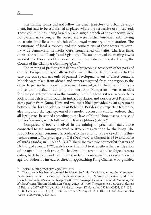
Royal seatsIn order to obtain a systematic overview of the additions and changes to
the urban network in the period we are examining, it seems to be useful to proceed according to a functional typology of the various centres. The most prestigious centres were undoubtedly the royal seats, the successive importance of which was already mentioned in the introduction of this essay. Charles I’s reign was indeed varied in his choice of residences, but it did not follow the pattern of the old-style itinerant kingship any longer. His alternation between seats followed political and strategic considerations, and each of his seats were considered “stable” to the extent that he made his retainers and chief dignitaries of the kingdom settle beside him.
Security was a major consideration in Charles’s selection of seats. In 1317
11 Eduard Mühle, ed., Rechtsstadtgründungen im mittelalterlichen Polen (Städteforschung, A 81) (Cologne–Vienna: Böhlau, 2011); Jiři Kejř, Die mittelalterliche Städte in den Böhmischen Ländern (Städteforschung, A 78) (Cologne–Vienna: Böhlau, 2010).12 Szende, “Power and Identity,” 39–45. The classic study by Erik Fügedi, “Középkori magyar városprivilégiumok,” [Medieval Hungarian towns privileges] Tanulmányok Budapest Múltjából 14 (1961), 17–107 (Reprinted in his Kolduló barátok, polgárok, nemesek [Mendicant friars, burghers, nobles] (Budapest, 1981), 238–311, 493–509, did not include Transylvania and Slavonia in its scope, which left Fügedi unaware of the patterns mentioned here.13 Zsoldos, “Károly és a városok,” 269.
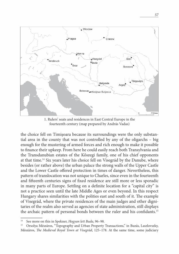
57
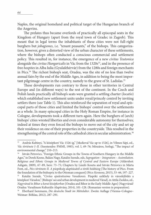
the choice fell on Timişoara because its surroundings were the only substan-tial area in the county that was not controlled by any of the oligarchs – big enough for the mustering of armed forces and rich enough to make it possible to finance their upkeep. From here he could easily reach both Transylvania and the Transdanubian estates of the Kőszegi family, one of his chief opponents at that time.14 Six years later his choice fell on Visegrád by the Danube, where besides (or rather above) the urban palace the strong walls of the Upper Castle and the Lower Castle offered protection in times of danger. Nevertheless, this pattern of translocation was not unique to Charles, since even in the fourteenth and fifteenth centuries signs of fixed residence are still more or less sporadic in many parts of Europe. Settling on a definite location for a “capital city” is not a practice seen until the late Middle Ages or even beyond. In this respect Hungary shares similarities with the polities east and south of it. The example of Visegrád, where the private residences of the main judges and other digni-taries of the realm also served as agencies of state administration, still displays the archaic pattern of personal bonds between the ruler and his confidants.15
14 See more on this in Spekner, Hogyan lett Buda, 96–98.15 Orsolya Mészáros, “Topography and Urban Property Transactions,” in Buzás, Laszlovszky, Mészáros, The Medieval Royal Town at Visegrád, 125–178. At the same time, some judiciary
1. Rulers’ seats and residences in East Central Europe in the fourteenth century (map prepared by András Vadas)
58
This was apparently also the model that prevailed in the case of the seats of the Serbian, Bosnian, Moldavian and Wallachian rulers. For example, when the Moldavian princely court was transferred from Siret to Suceava, the great boyars and the high clergy also moved to the vicinity of the new seat.16 Likewise the seats of the French monarchs and their retinues changed time and again during the Hundred Years’ War, and even as late as the second half of the fifteenth century the Habsburgs switched the sites of their courts between Vienna, Wiener Neustadt, Graz and Innsbruck.17
A peculiarity of Visegrád was, however, that Charles apparently realized that neither its surrounding area and layout nor its networking potentials were adequate for a stand-alone royal seat – far from being able to play the role of the economic and commercial centre of the country it could barely even provision itself. To make up for the latter drawback, he granted extensive privileges to Nagymaros, the hospes-community on the opposite bank of the Danube. Thus Nagymaros became a town under direct royal control, with rights including freedom of movement for its settlers; judicial autonomy with the free election of judges and a right of appeal to the king; free election of the priest of their own parish that was directly subordinated to the archbishop of Esztergom; right to fishing, the gathering of firewood and the harvesting of timber from the royal forest of Pilis; and country-wide exemption from tolls. This enabled Nagymaros, one of the few settlements that received their very first privileges from Charles, to both produce and procure food and other services for the royal court and the magnates of the realm.18
At the same time, it is worth noting that no evidence survives that either Timişora or Visegrád was granted an urban charter by Charles. Historical research so far has mostly explained this fact as being due to the large-scale destruction of written documents, which indeed happened, particularly in the Ottoman period and its aftermath. Nevertheless, the lack of privilegial charters can be ascribed in my view rather to the intentions of the king. Extensive liberties and civic autonomy may not have been desirable in a settlement that housed the royal
activity, especially the court of the vice-palatine, was located at Óbuda, see Spekner, Hogyan lett Buda, 112–119 and her extensive gazetteer on the locations of the various courts, Ibid., 253–369.16 Laurenţiu Rădvan, At Europe’s Borders: Medieval Towns in the Romanian Principalities (Leiden: Brill, 2010), 257–258; on Serbia and Bosnia: 87–103. On this pattern see also Katalin Szende, “Buda and the urban development of East Central Europe,” in Medieval Buda in Context, 526–553.17 Peter Moraw, “Zur Mittelpunktfunktion Prags im Zeitalter Karls IV,” in Klaus-Detlev Grothusen, Klaus Zernack, eds, Europa slavica – Europa orientalis. Festschrift für Herbert Ludat zum 70. Geburtstag (Berlin: Duncker & Humblot, 1980), 445–489, here 446–447.18 1324. május 22: Georgius Fejér, ed., Codex diplomaticus Hungariae ecclesiasticus ac civilis I–XI (henceforth: CD) (Buda, 1829–1844), vol. VIII/2, 514–517.

59
court and the highest-ranking dignitaries, and in areas restricted by swamps in case of Timişora and by steep slopes and the Danube in case of Visegrád it did not make sense to offer inducements to attract high numbers of new settlers. Finally, the town charters included not only rights but also duties and obligations that would not have been generally applicable to the population of these places most of whom were noblemen and not citizens in the legal sense.19
However, in economic terms—and this refers back to the other deficiency of Visegrád – the real centre of the country was undoubtedly Buda. The city became ever more attractive under Charles I’s and Louis I’s reigns for settlers from other parts of the realm or abroad: from Vienna and particularly from Regensburg, which was the commercial capital of the entire Danube basin in the fourteenth century.20 In 1331 Charles granted Buda the right to hold a second annual fair, which testifies to the growing volume of commercial exchange. This increase in wealth and population provided the background for the topo-graphic development of the city and its suburbs.21 Buda’s leading role is reflected by the fact that the “rights of Buda” became the most widespread and favoured points of reference for bigger and smaller settlements alike. Of course, this did not mean that all the rights and exemptions of Buda granted already by the Árpádian rulers, such as the staple right or the grants of annual fairs, automati-cally applied to these other places. It depended on the local circumstances how much of the broad framework offered by the ‘rights of Buda’ could be put into practice in specific contexts.22
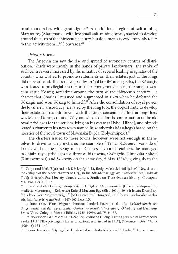
Diocesan seesThe second important group of cities to be considered besides the royal
seats are the bishops’ sees. As far as the Carpathian Basin itself is concerned, the process of founding bishoprics that commenced simultaneously with the establishment of royal power from the beginning of the eleventh century had been concluded and consolidated by the early twelfth century. King Ladislas I (1077–1095) “corrected” those choices among the ten early seats that did not stand the test of time by moving the bishopric of Bihor (Bihar) to Oradea
19 Mészáros, Royal Town of Visegrád, 90–92 offers a detailed survey of the privileges of Nagymaros, and assumes that Visegrád also had a similar charter; I elaborate my argumentation why this was not necessarily the case in Szende, “Mennyit ér a kiváltság?” 287–288.20 István Draskóczy, “Commercial Contacts of Buda along the Danube and beyond,” in Medieval Buda in Context, 278–299.21 CD VIII/7. 229, see also Boglárka Weisz, Vásárok és lerakatok a középkori Magyar Királyságban [Markets, fairs and staples in the medieval Kingdom of Hungary] (Budapest: MTA BTK TTI), 31–32; Spekner, Hogyan lett Buda, 75.22 Fügedi, “Középkori magyar városprivilégiumok,” 290–292.

60
(Várad) and adding a secondary seat to Kalocsa at Bač (Bács), and he founded a new bishopric at Zagreb; his successor Koloman (1095–1116) revived the old Moravian seat of Nitra (Nyitra). The network of twelve bishoprics thus estab-lished was denser and more evenly spread than in the other Central European polities, and served the needs of the Kingdom of Hungary adequately until the end of the Middle Ages.23
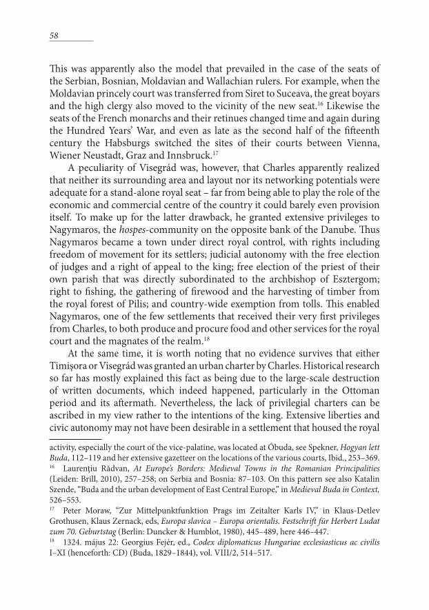
The changes in the late Árpádian and the Angevin period were twofold. First, a southward expansion can be observed, in step with the rulers’ polit-ical and military goals.24 The archbishopric of Kalocsa with its second seat at Bač served as a convenient point of departure for missionary activities into the Balkans, as approved by the Papacy and promoted by the kings of Hungary in their own interests. In the course of this process, first the bishopric of Srijem (Szerém) was established in Banoštor (Bánmonostor/ Kő) by Ugrin, archbishop of Kalocsa, in 1229 and revived after the Mongol invasion of 1241/42 with a second seat at Sremska Mitrovica (Szávaszentdemeter). Next, the bishopric of Bosnia was founded in 1233/34; the difficulties of this mission are clearly shown by the fact that its seat was outside the target area, namely at Đakovo (Diakovár), north of Bosnia itself. The next foundation, the archbishopric of Belgrade, existed briefly between 1290 and 1295 and was revived by Charles I in 1322 after he recaptured the Banate of Mačva. The missionary activities of these bishoprics were often carried out by the mendicant orders, and the bishops themselves were also often appointed from the ranks of the friars.25 The southernmost such bishopric was that of Vidin, created in 1365 with the aim to convert the Orthodox population of Bulgaria parallel to Louis I’s military expansion into that area; however, it ceased to exist in 1369 after the defeat of the king’s army.26 Due to the missionary nature of these bishoprics they did not serve as focal points of urban development unless other factors of urbanization, such as strategic importance and commercial activity, were also present.
Louis I also made attempts, supported by Popes Gregory IX and Urban VI, to expand his influence through the spreading of the Catholic faith in Wallachia, 23 Katalin Szende, András Végh, “Royal Power and Urban Space in Medieval Hungary,” in Simms and Clarke, eds, Lords and Towns in Medieval Europe, 255–286, here: 258–260.24 Here I am not discussing the bishoprics and archbishoprics of Dalmatia which need to be considered in the full complexity on power-relations in the Eastern Adriatic. Ongoing research by Judit Gál and Mišo Petrović will shed new light on their development in this period.25 László Koszta, “Missziós püspökségek” [Missionary bishoprics], in Gyula Kristó, gen. ed., Korai magyar történeti lexikon (Budapest: Akadémiai, 1994), 458–460; Péter Rokay, “Die Rolle Ungarns in der Verbreitung des westlichen Christentums (Katholizismus) in den südlichen Nachbarländern,” in Klára Papp, János Barta, eds, The First Millennium of Hungary in Europe (Debrecen: Debrecen University Press, 2002), 119–121.26 Engel, Realm of St Stephen, 164–165.

61
by establishing bishoprics in Severin (Szörény) in 1376, attached to the Banate of Severin, and in Curtea de Argeş to be in charge of the territory between the rivers Olt and Siret in 1382. These bishoprics, although set up seemingly with the approval of the voivode of Wallachia, did not outlive the death of Louis and were discontinued after the end of 1382.27
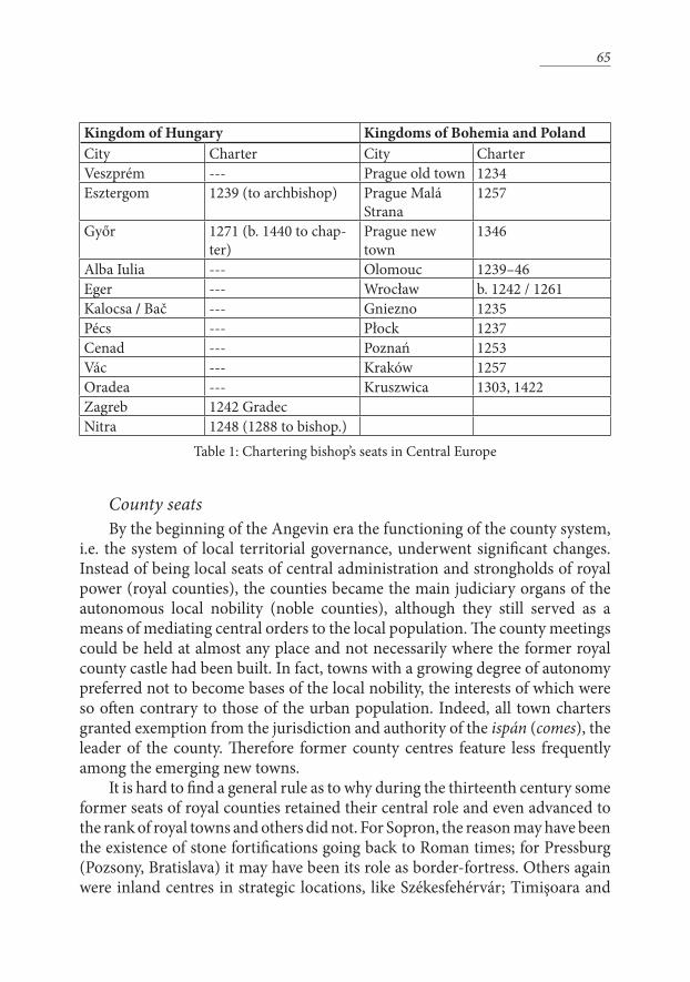
The second important new trend in the Angevin period concerning the seats of bishoprics as urban centres was the increasing control over these cities exerted by the bishops. This was in clear contrast with the situation at the time of foundation, when the bishops owned only those parts of their towns that were directly connected to ecclesiastical functions. In nine cases out of the first twelve sees mentioned above, the bishop’s seats were at the same time centres of secular administration, that is, seats of royal counties (comitatus). It was the kings’ good will that decided how much of the settlements and their usufructs (tolls, customs, fishing rights, etc.) were donated to the church to complement
27 Rădvan, At Europe’s Borders, 244–245.
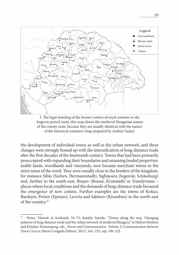
2. Bishop’s seats existing or established by the kings of Hungary in the Angevin period, without the Dalmatian dioceses (note: the archbishopric of Kalocsa had two
seats simultaneously: Kalocsa and Bač / Bács) (map prepared by András Vadas)
62
their extensive landed possessions. The ecclesiastical possessions were also usually divided between the bishop and one or more chapters.
The withdrawal of Hungarian royal authority from the bishops’ seats started from the top, namely in the archbishop’s seat of Esztergom, the head of the eccle-siastical organization in Hungary. In 1198, King Emeric (1196–1204) formally donated the still unfinished royal palace to the archbishop. In the 1250s the king and his retinue moved out for good, and the royal town was gradually taken over by the cathedral chapter. In 1239 King Béla IV even granted a charter to the archbishop of Esztergom that endowed the prelate with the right of establishing a new urban quarter by the Danube under the Cathedral Hill. The coexistence of separate parts under the jurisdiction—and most importantly, taxation—of the archbishop, the chapter and the king led to many conflicts especially in the first decades of the Angevin period.28
Conversely, privilegial charters granting civic rights to the royally-owned parts of bishops’ towns are very few and far between. One of these is the privi-legial charter granted in 1248 to the civic settlement of Nitra as a reward for its burghers having provided the military retinue to King Béla IV on his flight from the Mongols to the Dalmatian coast. The autonomy and jurisdiction following the liberties of Fehérvár granted by this charter, however, was revoked in 1288 when the entire settlement including the landed properties donated to the city by the 1248 charter was ceded to the bishop’s authority. Legal matters aside, the successful development of the civic settlement was impeded by topographical constraints, namely that the crossing over the River Nitra remained under the bishop’s control. The transition was completed in 1336 when the entire county of Nitra was transferred from royal to episcopal overlordship.29
Győr was another bishop’s seat where royal and episcopal seigniorial power coexisted for a while. Here, on a strategic point overlooking the confluence of the Rába River and the Danube, Béla’s son, Stephen V, initiated in 1271 the concentration of the previously dispersed settlement units into a city with a denser and more regulated ground plan, centred on a spacious oblong-shaped 28 On the historical geography of Esztergom see in detail: György Györffy, Az Árpád-kori Magyarország történeti földrajza, 4 vols [Historical geography of Hungary in the Árpád period] (Budapest: Akadémiai, 1963–1998), vol. 2, 245–249; The 1239 privilege: András Kubinyi, ed., Elenchus fontium historiae urbanae, vol. III/2 (Budapest: Balassi, 1997), 32–34; Boglárka Weisz, “Az esztergomi vám Árpád-kori története” [The history of the Esztergom toll station in the Árpádian period], Századok 137 (2003): 973–981. Conflict over jurisdictional authority and tax collection: 1315: Ferdinandus Knauz, Ludovicus Crescens Dedek, eds, Monumenta ecclesiae Strigoniensis I–III (Strigonii, 1874–1924), vol. II. 712–714; Act of violent trespass, 1324: Ibid., III, 48–49. 29 1248: Richard Marsina, ed., Codex diplomaticus et epistolaris Slovaciae I–II (Bratislava: Obzor, 1970–1987), vol. II, 208–209; 1288: CD V/3, 417–419; 1336: CD VIII/4, 187–188.
63
market square. The turn of the thirteenth century was a period of transfor-mation for Győr, when it turned from an administrative-military centre to a commercial one, becoming a hub of trade conveniently located on the Danube approximately half-way between Vienna and Buda. Here royal ownership lasted relatively long, indeed throughout the Angevin period, but by the end of the fourteenth century, and conclusively by 1440, the cathedral chapter took over the former royal suburbium with its river port and marketplace.30
Zagreb was the only exception to this trend. There the royal town of Gradec that received its first charter from King Béla IV in 1242, immediately in the aftermath of the Mongol invasion, remained in royal hands (apart from short periods of pledging) throughout the Middle Ages. Gradec, walled as the result of its charter, was situated on the hilltop overlooking the episcopal city (the Kaptol) founded in the late eleventh century. The “twin cities” were in almost constant conflict with each other in the Angevin period, the largest bone of contention being the customs revenues to be collected at the bridge of the Sava River, outside both towns, and also after the wares deposited in the city.31 The hostil-ities even led from time to time to armed fights and bloodshed. Nevertheless, the Hungarian kings who gradually surrendered their presence in all other epis-copal sees could not afford to leave Gradec to the bishops, because this was the place from where the entire province of Slavonia was governed and where their local governors, the bans (or occasionally princes) resided and held court. King Charles had a palace built on the hilltop, and so did his son, Prince Stephen, when he became prince of Slavonia in 1350.32 Furthermore, the town was a crucial stopover on the way to Dalmatia, the Adriatic and to Italy—including
30 Györffy, Az Árpád-kori, vol. II, 595–600; Dénes Gabler, Eszter Szőnyi, Péter Tomka, “The settlement history of Győr (Arrabona) in the Roman period and in the Middle Ages,” in László Gerevich, ed., Towns in Medieval Hungary (Budapest: Akadémiai, 1990), 9–25, esp. 22–25.; Lajos Gecsényi, “Győr középkori helyrajzához. Adatok és kérdőjelek” [The medieval topography of Győr. Data and question marks], Győri Tanulmányok 5 (1983): 29–45.31 Klaus-Detlev Grothusen, Entstehung und Geschichte Zagrebs bis zum Ausgang des 14. Jahrhunderts: ein Beitrag zum Städtewesen Südosteuropas im Mittelalter (Wiesbaden: Harrasowitz, 1967); Ludwig Steindorff, Das mittelalterliche Zagreb – ein Paradigma der mitteleuropäischen Stadtgeschichte,” Südosteuropa Mitteilungen 35 (1995): 135–145; Boglárka Weisz, A királyketteje és is ispán harmada. Vámok és vámszedés Magyarországon a középkor első felében [Two parts to the king and one to the count. Customs and toll collection in Hungary up to the middle of the fourteenth century] (Budapest: MTA BTK TTI, 2013), 437–438.32 Bruno Škreblin, “Ethnic groups in Zagreb’s Gradec in the Late Middle Ages,” Review of Croatian History 9 (2013:1): 25–59; Škreblin, “Urban Elites and Real Estate in Medieval Town: Owners of Palaces in Medieval Gradec (Zagreb),” in Irena Benyovsky Latin, Zrinka Pešorda Vardić, eds, Towns and Cities in the Croatian Middle Ages. Authority and Property (Zagreb: Croatian Institute of History, 2015), 399–438.
64
Naples, the original homeland and political target of the Hungarian branch of the Angevins.
The prelates thus became overlords of practically all episcopal seats in the Kingdom of Hungary (apart from the royal town of Gradec in Zagreb). This meant that in legal terms the inhabitants of these cities were not full-right burghers but jobagiones, i.e. “tenant peasants,” of the bishops. This categoriza-tion, however, gives a distorted view of the urban character of these settlements, where the bishops often conducted a conscious commercial and settlement policy. This resulted in, for instance, the emergence of a new civitas Teutonica alongside the civitas Hungaricalis in Vác from the 1320s33, and in the presence of free hospites in Alba Iulia (Gyulafehérvár) from the 1280s and foreign merchants in Pécs.34 The richest bishop’s seat, Oradea, was the site of no less than twelve annual fairs by the end of the Middle Ages, in addition to being the most impor-tant pilgrimage centre in the country, namely to the grave of St. Ladislas.35
These developments run contrary to those in other territories in Central Europe and (in different ways) to the rest of the continent. In the Czech and Polish lands practically all bishop’s seats were granted a settling charter (locatio) which established new settlement units under royal/princely control by inviting settlers there (see Table 1). This also reinforced the separation of royal and epis-copal parts of those cities and limited the bishops’ control over the settlements as a whole. In many episcopal cities in the Holy Roman Empire, for instance in Cologne, developments took a different turn again. Here the burghers of (arch)bishops’ cities wrested liberties and even considerable autonomy for themselves; indeed at times they even forced the bishops to move out of the city and set up their residence on one of their properties in the countryside. This resulted in the strengthening of the central role of the cathedral cities in secular administration.36
33 András Kubinyi, “A középkori Vác 1526-ig,” [Medieval Vác up to 1526], in Vilmos Sápi, ed., Vác története I–II. (Szentendre: PMMI, 1983), vol. I, 49–76; Mészáros, Serlegi, “The impact of environmental change,” 210–213. 34 István Petrovics, “Foreign Ethnic Groups in the Towns of Southern Hungary in the Middle Ages,” in Derek Keene, Balázs Nagy, Katalin Szende, eds, Segregation – Integration – Assimilation. Religious and Ethnic Groups in Medieval Towns of Central and Eastern Europe (Aldershot: Ashgate, 2009), 67–89, here: 73–75; Chapters by László Koszta and István Petrovics in Márta Font, ed., Pécs története II. A püspökség alapításától a török hódításig [The history of Pécs. From the foundation of the bishopric to the Ottoman conquest] (Pécs: Kronosz, 2015), 53–66, 197–227. 35 Katalin Szende, “Civitas opulentissima Varadiensis. Püspöki székhely és városfejlődés a középkori Váradon,” [Bishops’ see and urban development in medieval Várad], in Attila Zsoldos, ed., Nagyvárad és Bihar a korai középkorban [Oradea and Bihor in the Early Middle Ages] (Nagyvárad/Oradea: Varadinum Kulturális Alapítvány, 2014), 101–128. (Romanian version in preparation).36 Eberhard Isenmann, Die deutsche Stadt im Mittelalter. Zweite Auflage (Vienna–Cologne–Weimar: Böhlau, 2012), 287–291.
65
Kingdom of Hungary Kingdoms of Bohemia and PolandCity Charter City CharterVeszprém --- Prague old town 1234Esztergom 1239 (to archbishop) Prague Malá
Strana1257
Győr 1271 (b. 1440 to chap-ter)
Prague new town
1346
Alba Iulia --- Olomouc 1239–46Eger --- Wrocław b. 1242 / 1261Kalocsa / Bač --- Gniezno 1235Pécs --- Płock 1237Cenad --- Poznań 1253Vác --- Kraków 1257Oradea --- Kruszwica 1303, 1422Zagreb 1242 GradecNitra 1248 (1288 to bishop.)
Table 1: Chartering bishop’s seats in Central Europe
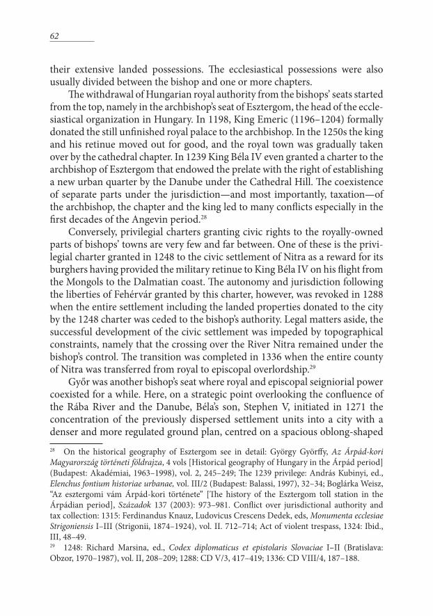
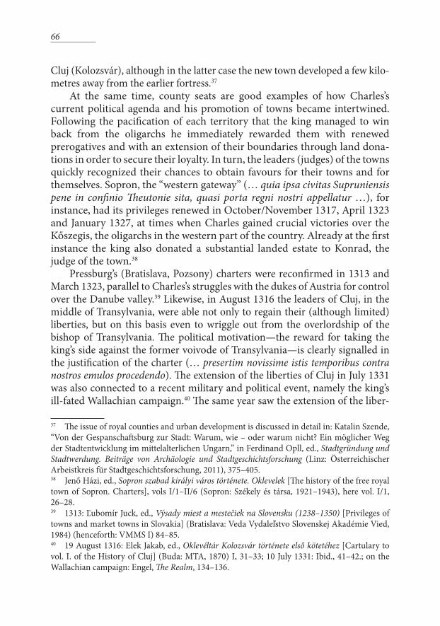
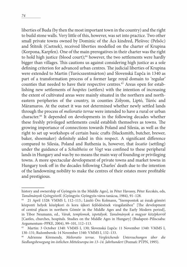
County seats By the beginning of the Angevin era the functioning of the county system,
i.e. the system of local territorial governance, underwent significant changes. Instead of being local seats of central administration and strongholds of royal power (royal counties), the counties became the main judiciary organs of the autonomous local nobility (noble counties), although they still served as a means of mediating central orders to the local population. The county meetings could be held at almost any place and not necessarily where the former royal county castle had been built. In fact, towns with a growing degree of autonomy preferred not to become bases of the local nobility, the interests of which were so often contrary to those of the urban population. Indeed, all town charters granted exemption from the jurisdiction and authority of the ispán (comes), the leader of the county. Therefore former county centres feature less frequently among the emerging new towns.
It is hard to find a general rule as to why during the thirteenth century some former seats of royal counties retained their central role and even advanced to the rank of royal towns and others did not. For Sopron, the reason may have been the existence of stone fortifications going back to Roman times; for Pressburg (Pozsony, Bratislava) it may have been its role as border-fortress. Others again were inland centres in strategic locations, like Székesfehérvár; Timişoara and
66
Cluj (Kolozsvár), although in the latter case the new town developed a few kilo-metres away from the earlier fortress.37
At the same time, county seats are good examples of how Charles’s current political agenda and his promotion of towns became intertwined. Following the pacification of each territory that the king managed to win back from the oligarchs he immediately rewarded them with renewed prerogatives and with an extension of their boundaries through land dona-tions in order to secure their loyalty. In turn, the leaders (judges) of the towns quickly recognized their chances to obtain favours for their towns and for themselves. Sopron, the “western gateway” (… quia ipsa civitas Supruniensis pene in confinio Theutonie sita, quasi porta regni nostri appellatur …), for instance, had its privileges renewed in October/November 1317, April 1323 and January 1327, at times when Charles gained crucial victories over the Kőszegis, the oligarchs in the western part of the country. Already at the first instance the king also donated a substantial landed estate to Konrad, the judge of the town.38
Pressburg’s (Bratislava, Pozsony) charters were reconfirmed in 1313 and March 1323, parallel to Charles’s struggles with the dukes of Austria for control over the Danube valley.39 Likewise, in August 1316 the leaders of Cluj, in the middle of Transylvania, were able not only to regain their (although limited) liberties, but on this basis even to wriggle out from the overlordship of the bishop of Transylvania. The political motivation—the reward for taking the king’s side against the former voivode of Transylvania—is clearly signalled in the justification of the charter (… presertim novissime istis temporibus contra nostros emulos procedendo). The extension of the liberties of Cluj in July 1331 was also connected to a recent military and political event, namely the king’s ill-fated Wallachian campaign.40 The same year saw the extension of the liber-
37 The issue of royal counties and urban development is discussed in detail in: Katalin Szende, “Von der Gespanschaftsburg zur Stadt: Warum, wie – oder warum nicht? Ein möglicher Weg der Stadtentwicklung im mittelalterlichen Ungarn,” in Ferdinand Opll, ed., Stadtgründung und Stadtwerdung. Beiträge von Archäologie und Stadtgeschichtsforschung (Linz: Österreichischer Arbeistkreis für Stadtgeschichtsforschung, 2011), 375–405.38 Jenő Házi, ed., Sopron szabad királyi város története. Oklevelek [The history of the free royal town of Sopron. Charters], vols I/1–II/6 (Sopron: Székely és társa, 1921–1943), here vol. I/1, 26–28. 39 1313: Ľubomír Juck, ed., Výsady miest a mestečiek na Slovensku (1238–1350) [Privileges of towns and market towns in Slovakia] (Bratislava: Veda Vydaleľstvo Slovenskej Akadémie Vied, 1984) (henceforth: VMMS I) 84–85. 40 19 August 1316: Elek Jakab, ed., Oklevéltár Kolozsvár története első kötetéhez [Cartulary to vol. I. of the History of Cluj] (Buda: MTA, 1870) I, 31–33; 10 July 1331: Ibid., 41–42.; on the Wallachian campaign: Engel, The Realm, 134–136.
67
ties of Stary Tekov (Bars), in the central part of northern Hungary, following the consolidation of this region. The king even ordered two formerly separate satellite villages of the former county centre, Csütörtökhely and Szombathely, to be attached to Stary Tekov; but this union did not prove successful in the long run.41
These notable examples, however, should not overshadow the fact that most county seats had lost their significance by the end of the thirteenth century. The considerations that lead to their site selection in the tenth and eleventh centu-ries—first and foremost defensibility and local prestige—in most cases did not fit the criteria for commercially oriented towns of the thirteenth century and later. Some county centres retained their roles as local marketplaces and later developed into market towns, others carried on as villages, while a few became completely abandoned in the course of the Middle Ages. Although no system-atic comparative research has been conducted, the example of the territory of Poland shows that there was a considerable reorganization during the thirteenth century (earlier in Silesia, later in the principalities further east). This, however, did not mean the degradation of the former Kastellaneiburgen to insignificant settlements, but rather their functional, spatial and legal reorganization, as well as the addition of further new towns in-between the former centres in order to consolidate the network of central places.42
Merchant towns‘Merchant towns’ is not such a clear-cut category as any of the previously
discussed groups of towns. Commercial activity was much too flexible and mobile to be confined within the centres of lay and church administration discussed above. To be sure, the exchange of commodities took place in specif-ically designated locations already in the Árpádian period. There were markets beside each county seat, and the bishop’s seats often included more than one marketplace and/or fairground where commodities could be exchanged. The main venues of commercial activity were still the weekly markets, the growing number of which was coupled by the increase in the number of toll stations set up along the roads between these markets. Besides, villages named after the days of the week clearly indicate that their most distinctive function was to hold weekly markets.43 The only such place that joined the rank of free royal towns 41 Reissuing Béla IV’s charter from 1240 on 3 February 1324: VMMS I, 101; new charter on 24 April 1331: VMMS I, 118; see also Fügedi, Középkori magyar városprivilégiumok, 262–263.42 Sławomir Możdzioch, “Zur Genese der Lokationsstädte in Polen in stadtgeschichtlicher Sicht,” in Hansjürgen Brachmann, ed., Burg – Burgstadt – Stadt. Zur Genese mittelalterlicher nichtagrarischer Zentren in Ostmitteleuropa (Berlin: Akademie Verlag, 1995), 149–160.43 See the detailed gazetteer of these places in Weisz, Vásárok és lerakatok, 133–176.
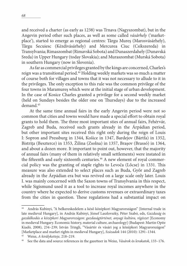
68
and received a charter (as early as 1238) was Trnava (Nagyszombat), but in the Angevin period other such places, as well as some called vásárhely (‘market-place’), started to emerge as regional centres: Târgu Mureş (Marosvásárhely), Târgu Secuiesc (Kézdivásárhely) and Mercurea Ciuc (Csíkszereda) in Transylvania; Rimaszombat (Rimavská Sobota) and Dunaszerdahely (Dunavská Sreda) in Upper Hungary (today Slovakia); and Muraszombat (Murská Sobota) in southern Hungary (now in Slovenia).
As far as commercial privileges granted by the kings are concerned, Charles’s reign was a transitional period.44 Holding weekly markets was so much a matter of course both for villages and towns that it was not necessary to allude to it in the privileges. The only exception to this rule was the common privilege of the four towns in Maramureş which were at the initial stage of urban development. In the case of Kosice Charles granted a privilege for a second weekly market (held on Sundays besides the older one on Thursdays) due to the increased demand.45
At the same time annual fairs in the early Angevin period were not so common that cities and towns would have made a special effort to obtain royal grants to hold them. The three most important sties of annual fairs, Fehérvár, Zagreb and Buda, received such grants already in the Árpádian period, but other important sites received this right only during the reign of Louis I: Sopron and Pressburg in 1344, Košice in 1347, Bardejov (Bártfa) in 1352, Bistriţa (Beszterce) in 1353, Žilina (Zsolna) in 1357, Braşov (Brassó) in 1364, and about a dozen more. It important to point out, however, that the majority of annual fairs (many of them in relatively small settlements) were instated in the fifteenth and early sixteenth centuries.46 A new element of royal commer-cial policy was the granting of staple rights to Levoča (Lőcse) in 1331. This measure was also extended to select places such as Buda, Győr and Zagreb already in the Árpádian era but was revived on a large scale only later. Louis I. was mainly concerned with the Saxon towns of Transylvania in this respect, while Sigismund used it as a tool to increase royal incomes anywhere in the country where he expected to derive customs revenues or extraordinary taxes from the cities in question. These regulations had a substantial impact on
44 András Kubinyi, “A belkereskedelem a késő középkori Magyarországon” [Internal trade in late medieval Hungary], in András Kubinyi, József Laszlovszky, Péter Szabó, eds, Gazdaság és gazdálkodás a középkori Magyarországon: gazdaságtörténet, anyagi kultúra, régészet [Economy in medieval Hungary. Economic history, material culture, archaeology] (Budapest: Martin Opitz Kiadó, 2008), 234–239; István Tringli, “Vásártér és vásári jog a középkori Magyarországon” [Marketplace and market rights in medieval Hungary], Századok 144 (2010): 1291–1344.45 Weisz, A királyketteje, 218–219.46 See the data and source references in the gazetteer in Weisz, Vásárok és lerakatok, 133–176.
69
the development of individual towns as well as the urban network, and these changes were strongly bound up with the intensification of long-distance trade after the first decades of the fourteenth century. Towns that had been primarily preoccupied with expanding their boundaries and amassing landed properties: arable lands, woodlands and vineyards, now became merchant towns in the strict sense of the word. They were usually close to the borders of the kingdom, for instance Sibiu (Szeben, Hermannstadt), Sighişoara (Segesvár, Schässburg) and, further to the south-east, Braşov (Brassó, Kronstadt) in Translyvania – places where local conditions and the demands of long-distance trade favoured the emergence of new centres. Further examples are the towns of Košice, Bardejov, Prešov (Eperjes), Levoča and Sabinov (Kisszeben) in the north-east of the country.47
47 Weisz, Vásárok és lerakatok, 54–75; Katalin Szende, “Towns along the way. Changing patterns of long-distance trade and the urban network of medieval Hungary,” in Hubert Houben and Kristjan Toomaspoeg, eds., Towns and Communication. Volume 2: Communication between Towns (Lecce: Mario Congedo Editore, 2011), 161–225, esp. 196–221.
3. The legal standing of the former centres of royal counties in the Angevin period (note: this map shows the medieval Hungarian names of the county seats, because they are usually identical with the names
of the historical counties) (map prepared by András Vadas)
70
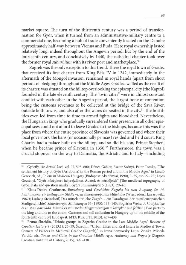
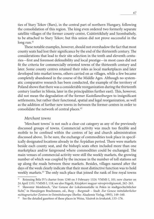
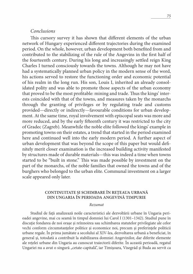
Mining townsNotwithstanding all the changes discussed above, the most important
achievement of the Angevin period in terms of urban development was the conscious promotion of mining towns. With Hungary providing about one-third of Europe’s silver production and at least 80 per cent of its gold until the Age of Discovery, the importance of the mining towns and their contribution to the wealth of their respective regions can hardly be overestimated. The exploitation of these resources necessitated the establishment of several new settlements in Upper Hungary and Transylvania, practically all with an urban character. These were not an unprecedented phenomenon in Charles’s period. The most important deposits of silver and copper at Rodna (Radna), Banska Štiavnica (Selmecbánya), Banská Bystrica (Bsztercebánya), Spisšká Nova Ves (Igló), Rožnava (Rozsnyó), Rimavska Bana (Rimabánya) had already been discovered during the thirteenth century or even before, and the Árpádian kings had issued a number of privileges to attract skilled workforces to these places;48 Charles did not neglect these towns either. He confirmed the 1287 privileges of Gelnica (Gölnicbánya) in 1318, and had the 1255 charter of Banská Bystrica transcribed in 1340.49 Prospecting for ores was also included in the charters of those settlements which had not been known for mining before, both on royal properties and on private lands.50
By the end of Charles’s reign the concept of civitas montana became a sepa-rate urban category from the legal, administrative and economic points of view alike. His monetary reform necessitated the promotion and conscious support of gold mining towns in particular. This shift in emphasis comes through in the issuing of grants: the mining towns privileged for the first time by Charles were first and foremost centres of gold mining and production (aurifodina) chartered simultaneously with or shortly after the introduction of gold coinage in 1325.
48 Oszkár Paulinyi, “Tézisek Magyarország bányagazdálkodásáról” [Theses on the economy of mining in Hungary], in his Gazdag föld – szegény ország. Tanulmányok a magyarországi bányaművelés múltjából [Rich soil – poor country. Studies the past of mining in Hungary] (Budapest: Budapesti Corvinus Egyetem, 2005), 335–350, with the list of the main mining settlements: 343–344; Boglárka Weisz, “Mining Town Privileges in Angevin Hungary,” Hungarian Historical Review 2 (2013:2): 288–312. For further studies see Balázs Nagy, “The Study of Medieval Foreign Trade of Hungary: A Historiographical Overview,” in Philipp Robinson Rössner, ed., Cities – Coins – Commerce. Essays presented to Ian Blanchard on the occasion of his 70th birthday (Stuttgart: Franz Steiner, 2012), 65–76.49 29 August 1318: VMMS I, 91; 11 November 1340: VMMS I, 130; on Banská Bystrica see Martin Štefánik, “Die Anfänge der Slowakischen Bergstädte. Das Beispiel Neusohl,” in Karl Heinrich Kaufhold, Wilfried Reininghaus, ed., Stadt und Bergbau (Cologne, Vienna, Weimar: Böhlau, 2004), 295–312.50 See some examples in CD VIII/1, 259–260 (24 July 1308); the charter of Ružomberok (Rózsahegy), 14 November 1340: VMMS I, 132–133.; Weisz, “Mining town privileges,” 292–293.
71
These included Baia de Arieş (Aranyosbánya or Offenbánya, Ouumberg) in Transylvania in 132551, and Smolník (Szomolnokbánya) that received the rights of Banská Štiavnica, perhaps in order to prepare the place for one of the royal minting chambers.52 Most likely Baia Mare (Nagybánya) also received its first privileges in the late 1320s, which were confirmed by Louis I in 1347 after the original perished in a fire.53 Smaller gold mines also operated at smaller, privately owned towns, Telkibánya (1341) and Vyšná Boca (Bocabánya).54 The most signif-icant new mining town endowed with privileges by Charles in 1328 was beyond doubt Kremnica (Körmöcbánya), which was to play a key role in the minting and monetary administration of the country for several centuries to come. The royal contribution to the development of the settlement was best expressed by the device of its seal: +S·CIVITATIS·REGIS·KAROLI·DE·CREMNICIA, preserved on a charter from 1331.55 51 14 June 1325: Franz Zimmermann et al., eds, Urkundenbuch zur Geschichte der Deutschen in Siebenbürgen, 7 vols. (Hermannstadt–Cologne–Vienna–Bucharest, 1892–1991) (henceforth: UGDS), vol. 1, 395–396.52 21 May 1327: VMMS I. 110–111, donation of forest property, before 3 July 1338: VMMS I, 127–128.53 29 May 1329: Gusztáv Wenzel, Magyarország bányászatának kritikai története [The critical history of mining in Hungary] (Budapest: MTA, 1880), 410; renewed in 1347: CD IX/1, 497–503.54 19 July1341: Wenzel, Magyarország bányászatának, 346, 5 and 27 August 1341: Ibid., 348–349; Weisz, A királyketteje, 88.55 17 July 1331: National Archives of Hungary, Budapest, Collection of Diplomatic Photographs (MNL OL DF) 250 152, reproduced in Szende, “Mennyit ér a kiváltság,” 306.
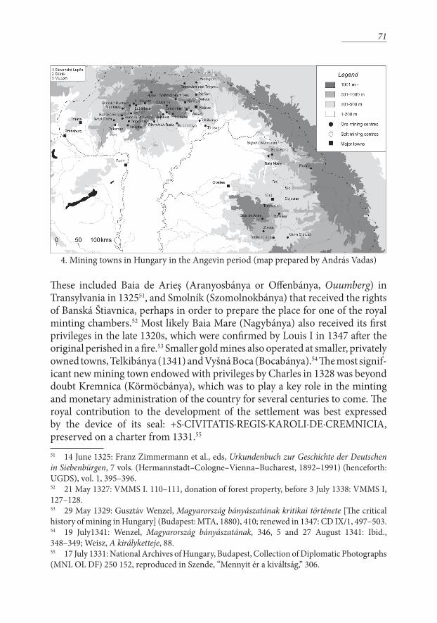
4. Mining towns in Hungary in the Angevin period (map prepared by András Vadas)
72
The mining towns did not follow the usual trajectory of urban develop-ment, but had to be established at places where the respective ores occurred. These communities, being based on one single branch of the economy, were not particularly strong at the outset and were further burdened with having to sustain the offices and officials of the royal monetary administration. The institutions of local autonomy and the connections of these towns to coun-try-wide commercial networks were strengthened only after Charles’s time, during the reigns of Louis I and Sigismund. The autonomy of the mining towns was restricted because of the presence of representatives of royal authority, the Counts of the Chamber (Kammergrafen).56
The mining of precious metals was a burgeoning activity in other parts of Central Europe, too, especially in Bohemia in the fourteenth century. In this case one can speak not only of parallel developments but of direct contacts. Models were taken from abroad and miners migrated from one region to the other. Expertise from abroad was even acknowledged by the king: contrary to the general practice of adopting the liberties of Hungarian towns as models for newly chartered towns in the country, in mining towns it was acceptable to look for models from abroad. The initial population and workforce of Kremnica came partly from Kutná Hora and was most likely provided by an agreement between Charles and John, King of Bohemia. Besides such expertise Kremnica also imported the legal system of its model, because its charter ordered that all legal issues be settled according to the laws of Kutná Hora, just as in case of Banská Štiavnica, which followed the laws of Jihlava (Iglau).57
Compared to towns involved in the mining of precious metals, those connected to salt-mining received relatively less attention by the kings. The production of salt continued according to the conditions developed in the thir-teenth century. The privileges of Dej (Dés) were confirmed in 1310 and those of Turda (Torda) in 1315 and 1331.58 There are even two counterfeit charters of Dej, forged around 1322, which were intended to strengthen the participation of the town in the salt trade. The leaders of the town decided to forge charters dating back to 1236 and 1261 respectively, thus imbuing the documents with age-old authority, instead of directly approaching King Charles who guarded
56 Weisz, “Mining town privileges,” 296–297.57 This concept has been elaborated by Martin Štefánik, “Die Pivilegierung der Kremnitzer Bevölkerung unter besonderer Berücksichtigung der Münzer-Privilegien und ihre sozioökonomischen Zusammenhänge (1328–1526),” in Angelika Westermann, ed., Montanregion als Sozialregion (Husum: Matthiesen Verlag, 2012), 437–456. The agreement between the kings: 13 February 1327: CD VIII/3, 192–198; the privileges: 17 November 1328: VMMS I, 115–116.58 8 December 1310: UGDS I, 297–29; 27 and 28 August 1331: UGDS I, 446–447; see also Weisz, A királyketteje, 124–125.
73
royal monopolies with great rigour.59 An additional region of salt-mining, Maramureş (Máramaros) with five small salt-mining towns, started to develop around the turn of the thirteenth century, but documentary evidence only refers to this activity from 1355 onwards.60
Private townsThe Angevin era saw the rise and spread of secondary centres of distri-
bution, which were mostly in the hands of private landowners. The ranks of such centres were increased by the initiative of several leading magnates of the country who wished to promote settlements on their estates, just as the kings did on royal land. The trend was set by an ‘old family’ of oligarchs, the Kőszegis, who issued a privilegial charter to their eponymous centre, the small-town-cum-castle Kőszeg sometime around the turn of the thirteenth century – a charter that Charles I reissued and augmented in 1328 when he defeated the Kőszegis and won Kőszeg to himself.61 After the consolidation of royal power, the loyal ‘new aristocracy’ elevated by the king took the opportunity to develop their estate centres into towns with the king’s consent. The first among these was Master Doncs, count of Zólyom, who asked for the confirmation of the old royal privileges for the settlers living on his estate at Hybe (Hibbe), and himself issued a charter to his new town named Ružomberok (Rózsahegy) based on the liberties of the royal town of Slovenská Ľupča (Zólyomlipcse).62
The charters issued to these towns, however, were not enough in them-selves to drive urban growth, as the example of Tamás Szécsényi, voivode of Transylvania, shows. Being one of Charles’ favoured retainers, he managed to obtain royal privileges for three of his towns, Gyöngyös, Rimavská Sobota (Rimaszombat) and Szécsény on the same day, 5 May 133463, giving them the
59 Zsigmond Jakó, “Újabb adatok Dés legrégibb kiváltságleveleinek kritikájához” [New data on the critique of the oldest charters of Dej], in his Társadalom, egyház, művelődés. Tanulmányok Erdély történelméhez [Society, church, culture. Studies on Transylvanian history] (Budapest: METEM, 1997), 9–27.60 László Szabolcs Gulyás, Városfejlődés a középkori Máramarosban [Urban development in medieval Maramureş] (Kolozsvár: Erdélyi Múzeum Egyesület, 2014), 60–61; István Draskóczy, “Só a középkori Magyarországon” [Salt in medieval Hungary], in Kubinyi, Laszlovszky, Szabó, eds, Gazdaság és gazdálkodás, 147–162, here: 150.61 3 June 1328: Hans Wagner, Irmtraut Lindeck-Pozza et al., eds, Urkundenbuch des Burgenlandes und der angrenzenden Gebiete der Komitate Wieselburg, Ödenburg und Eisenburg, 5 vols (Graz–Cologne–Vienna: Böhlau, 1955–1999), vol. IV, 34–37.62 26 November 1318: VMMS I, 91–92, see Ferdinand Uličný, “Listina prav mesta Ružomberka z roku 1318” [The privilegial charter of Ružomberok issued in 1318], Slovenska archivistika 19 (1984: 2): 134–140.63 István Draskóczy, “Gyöngyös település- és birtoklástörténete a középkorban” [The settlement
74
liberties of Buda (by then the most important town in the country) and the right to build stone walls. Very little of this, however, was set into practice. Two other small private towns owned by Dominic of the Ács kindred, Plešivec (Pelsőc) and Štítnik (Csetnek), received liberties modelled on the charter of Krupina (Korpona, Karpfen). One of the main prerogatives in their charter was the right to hold high justice (blood court);64 however, the two settlements were hardly bigger than villages. This cautions us against considering high justice as a sole defining criterion for advanced urban centres. The judicial liberties of Krupina were extended to Martin (Turócszentmárton) and Slovenská Ľupča in 1340 as part of a transformation process of a former large royal domain to ‘regular’ counties that needed to have their respective centres.65 Areas open for estab-lishing new settlements of hospites (settlers) with the intention of increasing the extent of cultivated areas were mainly situated in the northern and north-eastern peripheries of the country, in counties Zólyom, Liptó, Túróc and Máramaros. At the outset it was not determined whether newly settled lands through the process of melioratio terrae were intended to have a rural or urban character.66 It depended on developments in the following decades whether these freshly privileged settlements could establish themselves as towns. The growing importance of connections towards Poland and Silesia, as well as the right to set up workshops of certain basic crafts (blacksmith, butcher, brewer, baker, shoemaker) definitely aided in this respect. A significant difference compared to Silesia, Poland and Ruthenia is, however, that locatio (settling) under the guidance of a Schultheiss or Vogt was confined to these peripheral lands in Hungary and was by no means the main way of founding or privileging towns. A more spectacular development of private towns and market towns in Hungary took off in the decades following Charles’ death due to the intention of the landowning nobility to make the centres of their estates more profitable and prestigious.
history and ownership of Gyöngyös in the Middle Ages], in Péter Havassy, Péter Kecskés, eds, Tanulmányok Gyöngyösről. (Gyöngyös: Gyöngyös város tanácsa, 1984), 91–128.64 21 April 1328: VMMS I, 112–113.; László Örs Kolmann, “Szempontok az észak-gömöri központi helyek középkori és kora újkori fejlődésének vizsgálatához” [The development of central places in northern Gömör in the Middle Ages and the Early Modern period], in Tibor Neumann, ed., Várak, templomok, ispotályok. Tanulmányok a magyar középkorról [Castles, churches, hospitals. Studies on the Middle Ages in Hungary] (Budapest–Piliscsaba: Argumentum–PPKE, 2004), 99–101, 112–113.65 Martin: 3 October 1340: VMMS I, 130; Slovenská Ľupča: 11 November 1340: VMMS I, 130–131; Ružomberok: 14 November 1340: VMMS I, 132–133. 66 Adrienne Körmendy, Melioratio terrae. Vergleichende Untersuchungen über die Siedlungsbewegung im östlichen Mitteleuropa im 13–14. Jahrhundert (Poznań: PTPN, 1995).
75
ConclusionsThis cursory survey it has shown that different elements of the urban
network of Hungary experienced different trajectories during the examined period. On the whole, however, urban development both benefited from and contributed to the stabilizing of the rule of the Angevins in the first half of the fourteenth century. During his long and increasingly settled reign King Charles I turned consciously towards the towns. Although he may not have had a systematically planned urban policy in the modern sense of the word, his actions served to restore the functioning order and economic potential of his realm in the long run. His son, Louis I, inherited an already consol-idated polity and was able to promote those aspects of the urban economy that proved to be the most profitable: mining and trade. Thus the kings’ inter-ests coincided with that of the towns, and measures taken by the monarchs through the granting of privileges or by regulating trade and customs provided—directly or indirectly—favourable conditions for urban develop-ment. At the same time, royal involvement with episcopal seats was more and more reduced, and by the early fifteenth century it was restricted to the city of Gradec (Zagreb). Meanwhile the noble elite followed the kings’ example in promoting towns on their estates, a trend that started in the period examined here and continued well into the early modern period. A further aspect of urban development that was beyond the scope of this paper but would defi-nitely merit closer examination is the increased building activity manifested by structures made of durable materials—this was indeed a time when towns started to be “built in stone.” This was made possible by investment on the part of the monarchs, of the noble families that owned the towns and of the burghers who belonged to the urban elite. Communal investment on a larger scale appeared only later.
CONTINUITATE ŞI SCHIMBARE ÎN REŢEAUA URBANĂ DIN UNGARIA ÎN PERIOADA ANGEVINĂ TIMPURIE
Rezumat
Studiul de faţă analizează noile caracteristici ale dezvoltării urbane în Ungaria peri-oadei angevine, mai cu seamă în timpul domniei lui Carol I (1301–1342). Studiul pune în discuţie fondarea de noi oraşe şi reînnoirea sau schimbarea statutelor privilegiate ale celor vechi conform circumstanţelor politice şi economice noi, precum şi preferinţele politicii urbane regale. În prima jumătate a secolului al XIV-lea, dezvoltarea urbană a beneficiat, în general şi, totodată a contribuit la stabilizarea domniei Angevinilor, dar diferite elemente ale reţelei urbane din Ungaria au cunoscut traiectorii diferite. În această perioadă, regatul Ungariei nu a avut o singură „cetate-capitală”, iar Timişoara, Visegrád şi Buda au servit ca