considerations and effects of changing elevations and sea
TRANSCRIPT

Considerations and Effects of Changing Elevations and Sea Level Rise on the Northern Gulf- Coastal Louisiana
Tim Osborn – NOAA Office of Coast Survey

1897—”The effects of the withholding by the levees from the great areas of the delta of the annual contribution of sedimentary matters and the steady, though slow, subsidence of the theses areas, is one which should be taken in account in deciding the important question of how to protect the people from the flood waters of the river….No doubt the great benefit to the present and two or three following generations accruing from a complete system of absolutely protective levees…far outweighs the disadvantages to future generations from the subsidence of the Gulf delta lands below the level of the sea and their gradual abandonment due to this cause…”

We Are Now the Future Generations Facing a Rising Sea Level R Rate Coupled with One of the Highest Subsidence Rates in the World---A Living Classroom of the Impacts to Coastal Population nfrastructure, and the Economy---The Leading Edge to the Wha he Rest of the Coastal U.S. will be Facing

New Orleans And Surrounding Water and Sea Levels
New Orleans a Passing Cru Mississippi R
A Cross Section of New Orleans- A City Below Sea Level and Subsiding Daily

Morganza Reach J-2 Alignment
The Loss of Wetlands From the Effects of Sea Level Rise and Subsidence- A Loss Described in National Geographic in 1897 that We- the Future Generations- Would See and Live With—A Wetlands Area in Terrebonne Parish South and West of New Orleans

Morganza Reach J-2 Alignment
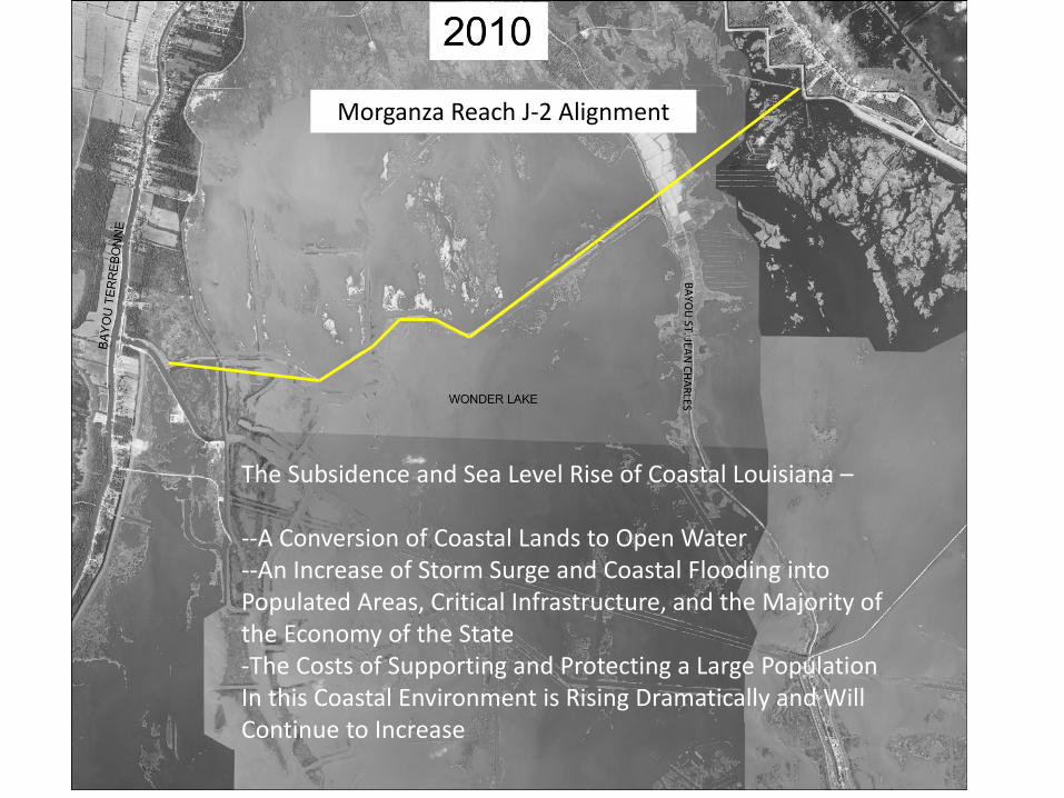
Morganza Reach J-2 Alignment
The Subsidence and Sea Level Rise of Coastal Louisiana – --A Conversion of Coastal Lands to Open Water --An Increase of Storm Surge and Coastal Flooding into Populated Areas, Critical Infrastructure, and the Majority of the Economy of the State -The Costs of Supporting and Protecting a Large Population In this Coastal Environment is Rising Dramatically and Will Continue to Increase

Our Coast Today--Interior of the Caminada Headland and Open Water that is Growing Yearly Threatening Infrastructure as Port Fourchon and Grand Isle

The Same Caminada Headland Inundated by a Minimal Tropical System Far Away from the Coast of Louisiana-- July 2010

Hurricane Ike Flooding Eastern Louisiana- A Category 2 Storm that Made Landfall in Texas but Flooded Every Costal Parish in
Louisiana

South Lafourche Levee District Levee Southern Extent During Hurricane Ike
South Lafourche Flood Gate now converted to a Lock
Flooded Homes outside South Lafourche Levee District Levees and Flooded Highway LA-1 to Port Fourchon and Grand Isle Hurricane Ike Inundation South Lafourche Parish

Sea Level in Lousiana is Rising Relative to the Land at a Rapid Rate
Note: The tide gauge record at Grand Isle contains components of global sea level rise, regional oceanographic change, and regional local vertical land motion.
A Rate Amongst the Highest in the World on a Coastal Landscape with an Average Elevation of 3 Feet or Less Today Across 12,000 Square Miles of Coastal Zone


Climate models project acceleration in Sea Level Rise starting before 2100 due to climate change—A Growing Rise Rate Accelerates the Conversion of the Coast to
Open Water and a Great Impact on Populations, Infrastructure and the Economy
Note: this an example only, as exact rates and timing of the accelerations are unknown

Source- LSU Center for Coastal Studies
Acting on the Future Landscape Changes Now is Critical- But Do the Resources and Consensus Exist Today At All?

Source- LSU Center for GeoInformatics
Looking At Our Populated Coastal Parishes Now and to the Year 2100- A Rapidly Growing Impact on the Majority of the Population of the State and the Large Majority of It’s Economyvels

In Summary Important Resources Can Now Be Applied to Coastal Resources in Louisiana to Monitor and Forecast the Movement of Elevations Downward and the Rise of Sea Levels Project Specific Efforts Have Been Implemented With Various Scenarios Described in the National Climate Assessment and Other Documentation, Forecasted Sea Level Rise Can be Assessed and Monitored Along the Northern Gulf With Very Low Elevations Today and High Rates of Relative Sea Level Rise, Active Collaboration and Application of the High Rates of Change Need to Protection Coastal Populations and Management of our Natural Resources will be Very Important
In Summary- -The Processes and Rates of Change Have Been Described for Over 100 Years as Well As Their Impacts -Our Own Development Activities Have Made the Coast, Our Populations and Infrastructure Even More Vulnerable to Present and Future Relative Sea Level Rise (SLR and Subsidence) -An Open Question Exists On the Affordability of Being Able to Continue to Live and Work in A Landscape Changing More Quickly Than Almost Anyplace on the Planet