conceptual designs and cost estimates: a critical … · • develop an unstable slope ranking...
TRANSCRIPT
Conceptual Designs And Cost Estimates: A Critical Step In Managing Unstable Slopes Along Washington State Highways
By
Steve Lowell1, William Gates2, Lynn Moses3, Chad Lukkarila4, Brendan Fisher5, Tom Badger6, Norman Norrish7
ABSTRACT The Washington State Department of Transportation (WSDOT) has developed a proactive and rational approach for identifying, categorizing, and prioritizing for mitigating unstable slopes along their 6,835-mile highway system. Early evaluation and scoping of unstable slopes as it relates to the geologic problem, mitigation and cost issues are critical in planning, budgeting and prioritizing unstable slopes for mitigation. In 1993, WSDOT developed the Unstable Slope Management System (USMS) to address known slope hazards adjacent to WSDOT’s highway system. The objectives of the program are to (1) rationally evaluate more than 2500 unstable slopes, (2) perform early scoping, conceptual designs and cost estimation, (3) conduct cost-benefit analysis of unstable slopes, and, (4) prioritize the mitigation of known unstable slopes according to the expected benefits. Utilizing a matrix-based numerical rating system, the USMS includes not only rockfall hazards but also landslide, settlement, and erosion problems. Most of the 2,500 unstable slopes have been rated and entered into the USMS. Presently WSDOT Geotechnical Division and their consultants are performing early scoping of the slopes by developing conceptual designs and preliminary cost estimates for mitigation. Because of the large number of sites, WSDOT based prioritization of the slopes for evaluation on (1) highway functional class, (2) USMS numerical rating, and (3) average daily traffic (ADT). Senior-level engineering geologists field inspect the unstable slope and develop a problem definition and conceptual design for each slope. Each unstable slope conceptual design slated for mitigation includes location, problem definition, problem correction and cost estimate supported by detailed field notes. Once the conceptual design has been completed, cost estimates for the work are developed. Unit costs are based on average construction bid tabulations for similar type work in the last five years. The conceptual designs and cost estimates to mitigate the slope hazard are then entered into the USMS and become a permanent record in the database. The WSDOT Geotechnical Division uses the cost estimate for each unstable slope in the cost-benefit analysis for mitigation of the slope hazard. Cost-benefit analysis for slope stabilization considers anticipated cost of traffic impacts resulting from a slope failure and the annual maintenance costs over 20 years divided by the cost to mitigate the slope hazard. Because of limited funding, only those slopes with cost-benefit ratios above 1.0 are considered for mitigation. Since the USMS program has begun, WSDOT can demonstrate accurate and conservative results between the conceptual design, engineer’s estimate and the contractor’s low bid. Typically, cost estimates in the conceptual design have been accurate and conservative, and higher than the Engineer’s estimate and the Contactors low bid. The results of the USMS are a rational and proactive program for mitigating geologic hazards along the Washington State highway system.
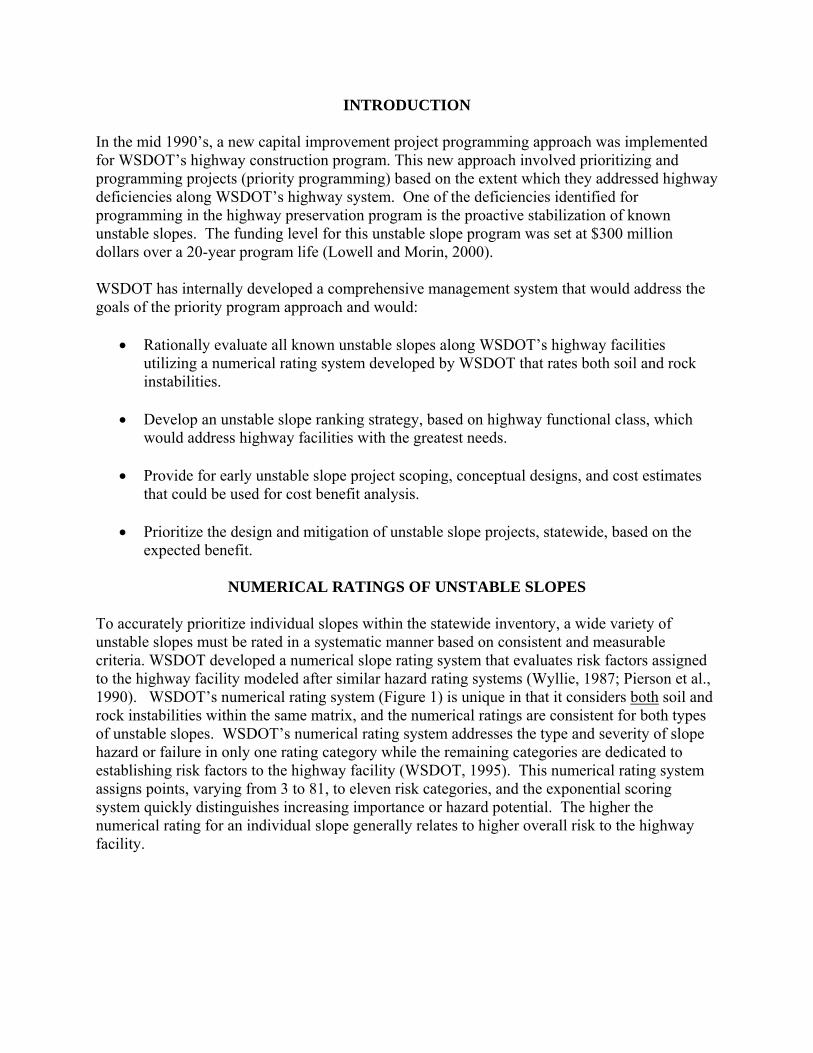
INTRODUCTION In the mid 1990’s, a new capital improvement project programming approach was implemented for WSDOT’s highway construction program. This new approach involved prioritizing and programming projects (priority programming) based on the extent which they addressed highway deficiencies along WSDOT’s highway system. One of the deficiencies identified for programming in the highway preservation program is the proactive stabilization of known unstable slopes. The funding level for this unstable slope program was set at $300 million dollars over a 20-year program life (Lowell and Morin, 2000). WSDOT has internally developed a comprehensive management system that would address the goals of the priority program approach and would:
• Rationally evaluate all known unstable slopes along WSDOT’s highway facilities utilizing a numerical rating system developed by WSDOT that rates both soil and rock instabilities.
• Develop an unstable slope ranking strategy, based on highway functional class, which
would address highway facilities with the greatest needs.
• Provide for early unstable slope project scoping, conceptual designs, and cost estimates that could be used for cost benefit analysis.
• Prioritize the design and mitigation of unstable slope projects, statewide, based on the
expected benefit.
NUMERICAL RATINGS OF UNSTABLE SLOPES To accurately prioritize individual slopes within the statewide inventory, a wide variety of unstable slopes must be rated in a systematic manner based on consistent and measurable criteria. WSDOT developed a numerical slope rating system that evaluates risk factors assigned to the highway facility modeled after similar hazard rating systems (Wyllie, 1987; Pierson et al., 1990). WSDOT’s numerical rating system (Figure 1) is unique in that it considers both soil and rock instabilities within the same matrix, and the numerical ratings are consistent for both types of unstable slopes. WSDOT’s numerical rating system addresses the type and severity of slope hazard or failure in only one rating category while the remaining categories are dedicated to establishing risk factors to the highway facility (WSDOT, 1995). This numerical rating system assigns points, varying from 3 to 81, to eleven risk categories, and the exponential scoring system quickly distinguishes increasing importance or hazard potential. The higher the numerical rating for an individual slope generally relates to higher overall risk to the highway facility.
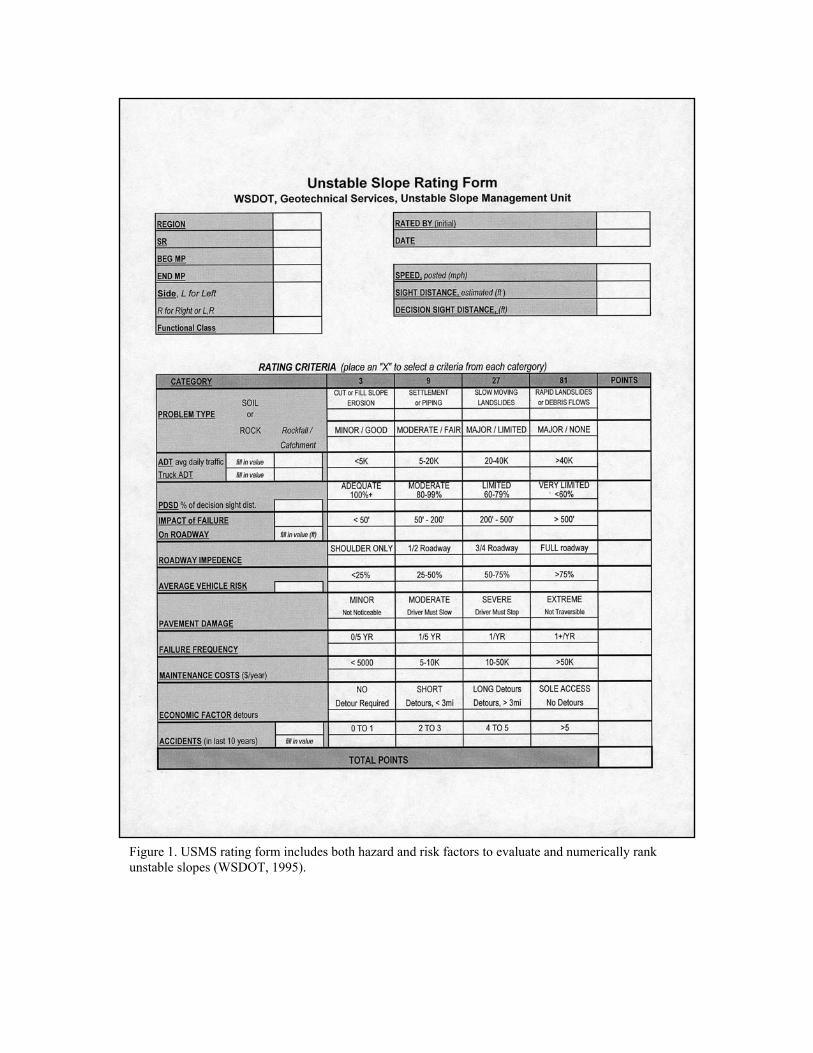
Figure 1. USMS rating form includes both hazard and risk factors to evaluate and numerically rank unstable slopes (WSDOT, 1995).

A primary goal of priority programming is to address transportation deficiencies or needs in those areas that have the highest investment. Early in the development of the USMS, it was recognized that the “worst first” approach by total inventory would not maximize the investment of limited construction dollars. To ensure, to the greatest extent possible, that construction dollars were being spent in those areas that had the highest return on the investment, the unstable slope inventory was grouped based on highway functional class. Under this programming scenario unstable slopes along interstate, and principle arterials are being mitigated first, followed by lower volume facilities. Within each highway functional class, the slopes are ranked in descending numerical order, so that the highest risk slopes within the functional class are considered first. Based on this ranked list of unstable slopes problem definitions, conceptual mitigation design, and cost estimates are developed.
CONCEPTUAL DESIGN PROCESS As part of the process, WSDOT senior-level geotechnical staff or their consultants conducts a field review of the unstable slope to collect information associated with the slope problem and to develop a conceptual slope mitigation design. The Conceptual Design process includes a detailed problem definition of the unstable slope, a conceptual design for mitigation, and the geotechnical cost estimates for the conceptual mitigation. Problem Definitions Defining the geotechnical problem for each unstable slope is critical in the USMS. Figures 2a and 2b are examples of WSDOT’s consultant team (Kleinfelder) defining some unstable slope problems along SR 97 near Blewett Pass, Washington. As part of the process, WSDOT incorporates field information and other pertinent data associated with the slope problem to develop a conceptual slope mitigation design. Figure 3 is an example of the level of detail required in the field notes that support the conceptual design.
Figure 2a: Kleinfelder team employing a laser range finder to define the size of the unstable slope problem on SR 97 near Blewett Pass, Washington.
Figure 2b: Kleinfelder team mapping fractures on a rock face on SR 97 near Ruby Creek.
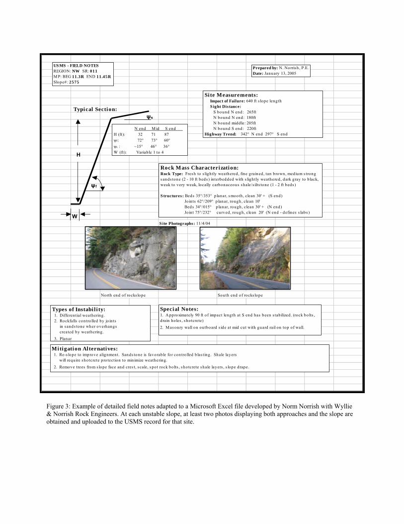
S ite Photographs : 11/4/04
North end of rocks lope South end of rocks lope
US MS - FIELD NOTESREGION: NW SR: 011M P: BEG 11.3R END 11.45RSlope#: 2575
ψf
H
W
Typical Section:
N end M id S end H (ft): 32 71 87 ψf : 72° 73° 60°ψs : ~15° 46° 36°W (ft): Variable 1 to 4
Si te Measurements: Impact of Failure: 640 ft s lope leng th S ight Dis tance: S bound N end: 265ft N bound N end: 180ft N bound middle: 205ft N bound S end: 220ftHighway Trend: 342° N end 297° S end
Rock Mass Characterization:Rock Type: Fres h to s lightly weathered, fine grained, tan brown, medium s trong s ands tone (2 - 10 ft beds ) in terbedded with s lightly weathered, dark gray to b lack, weak to very weak, locally carbonaceous s hale/s ilts tone (1 - 2 ft beds ) S tructures : Beds 35°/353° p lanar, s mooth , clean 30' + (S end) Jo ints 62°/209° p lanar, rough , clean 10' Beds 34°/015° p lanar, rough, clean 30' + (N end) Jo int 75°/232° curved, rough, clean 20' (N end - defines s labs )
Types of Instabi l i ty: 1. Differential weathering . 2. Rockfalls controlled by jo in ts in s ands tone wher overhangs created by weathering . 3. Planar
Mitigation Al ternati ves: 1. Re-s lope to improve alignment. Sands tone is favorable for con tro lled b las ting. Shale layers will requ ire s hotcrete pro tection to min imize weathering. 2. Remove trees from s lope face and cres t, s cale, s po t rock bolts , s ho tcrete s hale layers , s lope drape.
Special Notes:1. A pproximately 90 ft of impact length at S end has been s tabilized . (rock bolts , drain ho les , s hotcrete)2. M as onry wall on ou tboard s ide at mid cu t with guard rail on top of wall.
ψs
Prepared by: N. Norris h , P.E.Date: January 13, 2005
Figure 3: Example of detailed field notes adapted to a Microsoft Excel file developed by Norm Norrish with Wyllie & Norrish Rock Engineers. At each unstable slope, at least two photos displaying both approaches and the slope are obtained and uploaded to the USMS record for that site.

Depending on the complexity of the problem, the field review may take several hours per site, typically, WSDOT budgets about four hours per site. Typical information collected during the field review includes:
• Problem type – Verify the problem type identified in the unstable slope rating. Is the slope a soil or rock slope problem? If it is a soil slope problem? Is it a slow-moving landslide or fast-moving debris flow? If it is a rockslope problem, is it a case of erosion and raveling or major rockfall?
• Problem extent and size – Outline in detail the extent of the problem area, including
slope length, height, inclination of slope face and backslope, and impact on the highway facility etcetera.
• Identification of the factors that are the major contributing factors to the slope
instability; for example, weak foundation soils, inadequate drainage, structurally controlled rockmass, etc.
• Catchment area adequacy – If
the unstable slope is a rock slope, identify if the existing catchment area is adequate based on the slope height, inclination and rock block size. The ODOT/FHWA “Rockfall Catchment Area Design Guide,” (Pierson, et al, 2001) is often used to evaluate the adequacy of the catchment area. Figure 4 is an extreme example where the catchment ditch was inadequate to contain a large rockslide along SR 20 near Falls Creek in the North Cascades, Washington.
Figure 4: Rockslide at Falls Creek overtopping catchment area and highway along SR 20 North Cascades, Washington.
• Maintenance concerns and slope history – Maintenance personnel often have worked in the same area many years. Coordination with the local maintenance crews to discuss the slope stability problem that has occurred at the site is invaluable. Maintenance personnel often know the failure frequency of the slope, the extent of the clean up, and the estimated annual cost for maintenance.
• Identification of environmental constraints at the slope location that may influence the
conceptual design and/or the design’s feasibility. These could include endangered species, wetlands, anadromous fish windows, etc.

Conceptual Designs By defining the slope problem in detail, an appropriate conceptual slope mitigation design can be developed. Mitigation strategies focus on avoidance, containment or stabilization. The conceptual design supported by the field notes outlines the mitigation strategies for the unstable slope. Based on the extent of the unstable slope problem, quantities of engineering materials (e.g. landslide buttresses, debris flow barriers, rock bolts, wire mesh slope protection, retaining walls, etc) can be estimated. The key components of the conceptual design include a geotechnical investigation and design, the mitigation/stabilization strategy, and other concerns (such as traffic control), during construction. The conceptual design recommendations include a cost estimate for the geotechnical investigation and the geotechnical stabilization elements of the conceptual design. The costing factors are based on actual bid histories that have been compiled by the WSDOT Geotechnical Division. Figure 5 is a photo from WSDOT’s SR View (an external web-based video log of Washington State highways) displaying an unstable rockslope located on SR 2 at MP 91.38 in Tumwater Canyon, Washington. Figure 6 is an example of the conceptual design developed for this unstable rockslope after it was uploaded to the USMS database.
Figure 5: Photo from WSDOT SR View at MP 91.38 SR 2 displaying location of conceptual design (WSDOT, SRweb, 2002)
Cost Estimating The conceptual design and the geotechnical estimating factors are entered into the WSDOT USMS database where the WSDOT regional program managers can access this information and complete the project cost estimate. Additional costs that are not necessarily associated with the geotechnical aspects of the slope mitigation/stabilization are incorporated into the estimate for each individual unstable slope. The Regions consider the following items:
• Conceptual design geotechnical recommendation costs • Mobilization • Traffic control • Right-of-way • Surfacing and paving • Preliminary engineering

Figure 6: Conceptual design for an unstable slope along SR 2 in the Tumwater Canyon, Washington that has been uploaded to the USMS database (WSDOT, 2001). Figure 6: Conceptual design for an unstable slope along SR 2 in the Tumwater Canyon, Washington that has been uploaded to the USMS database (WSDOT, 2001).

• Construction engineering • Sales tax • Contingencies
With the addition of these costing factors the Region completes a scoping estimate for each identified unstable slope, and enters the estimate into the USMS. Once entered into the USMS, the Geotechnical Division completes the process by conducting a benefit cost analysis. Figure 7 is an example of a scoping estimate developed by the North Central Region for the unstable rockslope based on the unstable slope reflected on Figure 5 and the conceptual design described on Figure 6 along SR 2, MP 91.2 to 91.5 in Tumwater Canyon, Washington.
BENEFIT COST ANALYSIS The two most reliable and easily determinable impacts resulting from a slope failure along a highway facility are the cost associated with traffic delays, and the annual maintenance costs factored over the life of the program (20 years). Several simplifying assumptions were made to estimate costs associated with traffic delays. First, based on experience, a typical traffic delay in the event of a slope failure was assumed to be 24 hours. Secondly, a factor needed to be considered in terms of the amount of the roadway that would be impacted, since this has a bearing on traffic flow through the area. The roadway impedance rating addresses this factor and then applies reduction factors in the calculation of traffic delay costs. For example, if the roadway impedance rating indicated that only the highway shoulder would be impacted, then only 25 % of the total calculated traffic delay cost is used. If the roadway impedance rating indicated that all lanes of the highway facility would be impacted, then the total cost of the delay (100%) was used. Similar reduction factors were developed for other roadway impedance ratings. Life-cycle maintenance costs are established based on the estimated annual costs that have been generated by the regional maintenance personnel, and multiplied by the 20-year program life. These two factors (traffic delay and maintenance costs) are evaluated against the cost of mitigating the unstable slope to establish a benefit-cost ratio. In special cases, consideration of other known and quantifiable economic impact costs can be included in the benefit-cost analysis. Typically, this is done for lower volume highway facilities or high cost slope mitigations, where the ramifications of a slope failure can have severe socio-economic impacts. Based on the benefit-cost analysis, the unstable slopes are sorted by descending benefit-cost to form a prioritized list of slope stabilization projects. Because of funding limitations, only those unstable slopes that have a benefit-cost ratio of one or larger are considered for funding within the Unstable Slope program.
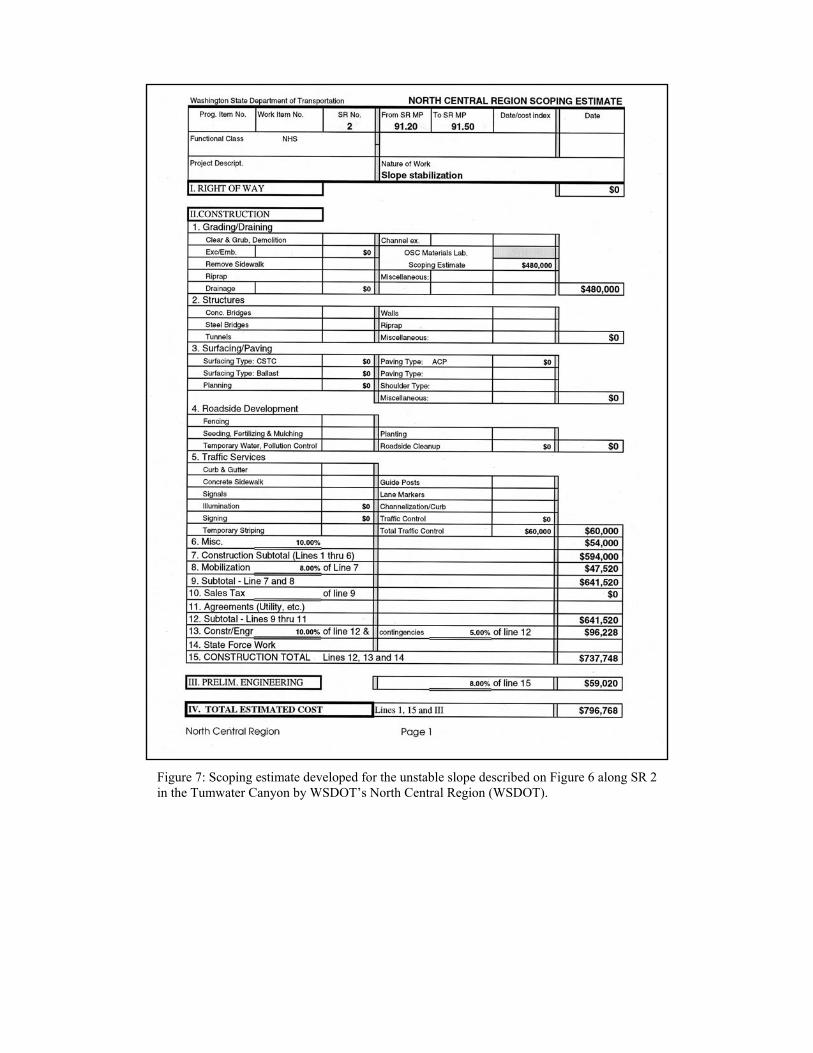
Figure 7: Scoping estimate developed for the unstable slope described on Figure 6 along SR 2in the Tumwater Canyon by WSDOT’s North Central Region (WSDOT).
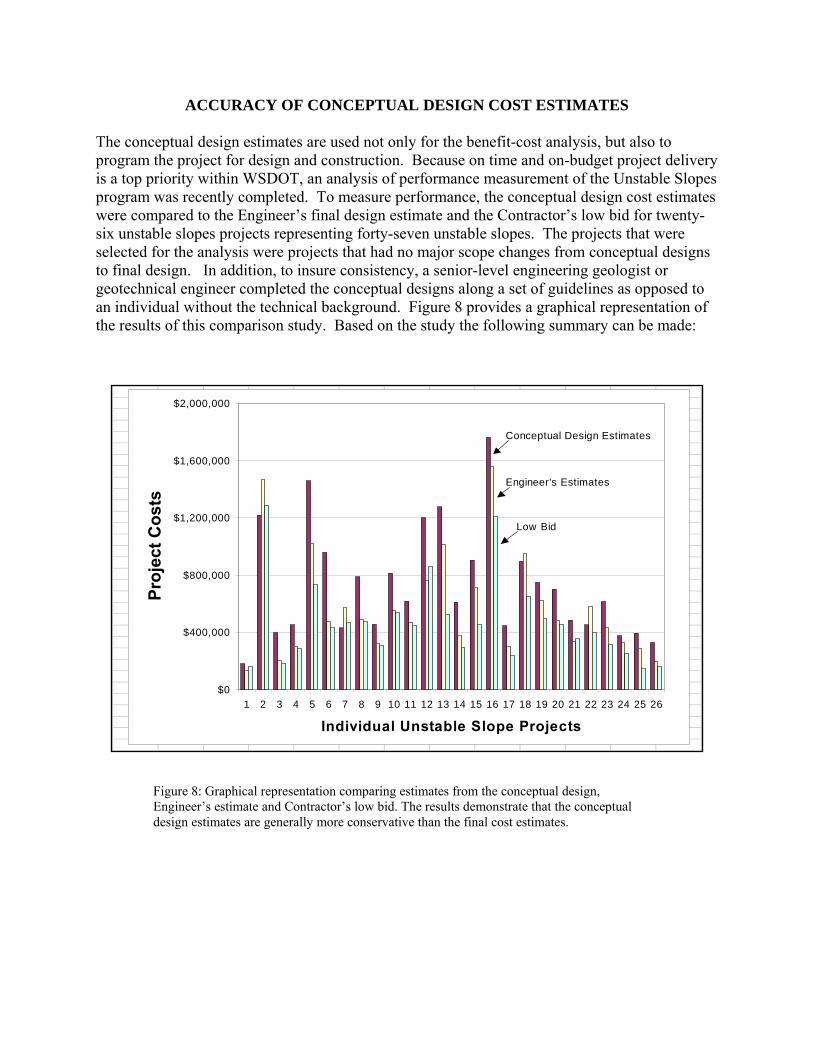
ACCURACY OF CONCEPTUAL DESIGN COST ESTIMATES The conceptual design estimates are used not only for the benefit-cost analysis, but also to program the project for design and construction. Because on time and on-budget project delivery is a top priority within WSDOT, an analysis of performance measurement of the Unstable Slopes program was recently completed. To measure performance, the conceptual design cost estimates were compared to the Engineer’s final design estimate and the Contractor’s low bid for twenty-six unstable slopes projects representing forty-seven unstable slopes. The projects that were selected for the analysis were projects that had no major scope changes from conceptual designs to final design. In addition, to insure consistency, a senior-level engineering geologist or geotechnical engineer completed the conceptual designs along a set of guidelines as opposed to an individual without the technical background. Figure 8 provides a graphical representation of the results of this comparison study. Based on the study the following summary can be made:
$0
$400,000
$800,000
$1,200,000
$1,600,000
$2,000,000
1 2 3 4 5 6 7 8 9 10 11 12 13 14 15 16 17 18 19 20 21 22 23 24 25 26
Individual Unstable Slope Projects
Proj
ect C
osts
Conceptual Design Estimates
Engineer's Estimates
Low Bid
Figure 8: Graphical representation comparing estimates from the conceptual design, Engineer’s estimate and Contractor’s low bid. The results demonstrate that the conceptual design estimates are generally more conservative than the final cost estimates.
• Out of the twenty-six projects analyzed, twenty-two of the conceptual design estimates overestimated the actual construction costs. It should be noted that the conceptual design estimates also contain the cost for the engineering design.
• Four project conceptual design estimates underestimated the Engineer’s estimate.
• Two project conceptual design estimates underestimated the first low bid from a
competitive bidding process. The results of this comparative study demonstrate that the conceptual design estimates are reasonably accurate and appropriately conservative. Photos displayed on Figure 9a, 9b and 9c are examples of recently completed Unstable Slope projects throughout the State of Washington.
SUMMARY AND CONCLUSIONS The approach that WSDOT has developed for identifying, categorizing, and prioritizing unstable slope mitigation is a proactive and rational approach to address a variety of geologic (slope) hazards along state highways. WSDOT has established that early evaluation and scoping of unstable slopes are critical to plan, budget and prioritize mitigation work on a statewide basis. When WSDOT developed the USMS, they had four objectives in the program: (1) rationally evaluate more than 2500 unstable slopes, (2) perform early scoping, conceptual designs and cost estimation, (3) conduct cost-benefit analysis of unstable slopes, and, (4) prioritize the mitigation of known unstable slopes according to the expected benefits. Most of the 2,500 unstable slopes have been rated and entered into the USMS. Presently, WSDOT’s consultants are reviewing these slopes, developing conceptual designs and uploading them to the USMS database as a permanent record. WSDOT maintains an updated database of construction bid tabs for conceptual design estimating. The WSDOT Geotechnical Division uses the cost estimate for each unstable slope in the cost-benefit analysis to select and prioritize slopes for mitigation. The benefit-cost analysis compares the maintenance and delay costs over a 20-year program life to the cost of mitigating the slope hazard. Because of limited funding, WSDOT considers only those slopes with cost-benefit ratios above 1.0 for programming. Since the USMS program has begun, WSDOT can demonstrate accurate and conservative results between the conceptual design, Engineer’s estimate and the Contractor’s low bid, meeting one of WSDOT’s strategic objectives of delivering projects on-time and on-budget.

Figure 9a: WSDOT conducting an emergency repair of an unstable slope problem along SR 11 Chuckanut Drive in south Whatcom County, Washington.
Figure 9b: Kleinfelder team member preparing to map a rockslope using rappelling techniques on SR 97 north of Wenatchee, Washington.
Figure 9c: Installation of horizontal drains and recently completed soldier-pile wall on an unstable slope above the Bogachiel River along SR 101on the Olympic Peninsula.
AUTHORS 1. Steve M. Lowell, Washington State Department of Transportation (WSDOT), Geotechnical Division, PO Box
47365, Olympia, WA 98504-7365, 360-709-5460, [email protected] 2. William C.B. Gates, Kleinfelder, 2405 140th Ave NE, Suite A101, Bellevue, WA 98005, 425-562-4200,
[email protected] 3. Lynn Moses, WSDOT, Geotechnical Division, PO Box 47365, Olympia, WA 98504-7365, 360-709-5460,
[email protected] 4. Chad Lukkarila, Kleinfelder, 2405 140th Ave NE, Suite A101, Bellevue, WA 98005, 425-562-4200,
[email protected] 5. Brendan Fisher, Kleinfelder, 2405 140th Ave NE, Suite A101, Bellevue, WA 98005, 425-562-4200,
[email protected] 6. Tom Badger, WSDOT, Geotechnical Division, PO Box 47365, Olympia, WA 98504-7365, 360-709-5461,
[email protected] 7. Norman L. Norrish, Wyllie & Norrish Rock Engineers, 17918 NE 27th St. Redmond, WA 98052, 425-861-7327,
REFERENCES Lowell, S.M., & Morin, P. 2000. Unstable slope management in Washington State. TR News 207: 11-15. Pierson, L.A., Davis, S.A., & Van Vickle, R. 1990. The rockfall hazard rating system: implementation manual.
Technical Report FHWA-OR-EG-90-01. FHWA, U.S. Department of Transportation. Pierson, Lawrence A.; Gullixson Fred C.; Chassie, Ronald G; Landslide Technology (Portland, OR); Oregon
Department of Transportation. 2001, Rockfall Catchment Area Design Guide (Final Report SPR-3 (032) and Rockfall Catchment Area Design Guide: Final Report (Metric Edition)
http://www.odot.state.or.us/tddresearch/reports/rckfall%20_metric.pdf Washington State Department of Transportation. 1995. Guidelines for the P-3 Unstable slope inventory and
prioritization process (www.wsdot.wa.gov/biz/geotech/guidelines.pdf) Washington State Department of Transportation. 2001, Unstable Slopes Management System, Conceptual Design,
SR 002, MP 91.2 – MP 91.5 Washington State Department of Transportation, no date, North Central Region Scoping Estimate, Slope
Stabilization, SR 002, MP 91.2 – MP 91.5. Washington State Department of Transportation, 2002, SRweb, http://srview.wsdot.wa.gov/ Wyllie, D.C., 1987. Rock slope inventory system. Federal Highway Administration Rockfall Mitigation Seminar.
Portland, OR: FHWA Region 10.