concept overview - cloudinary
TRANSCRIPT

Concept 1 - The Fine Grain Grid
Concept Overview
The fine grain creates a flexible frame work of streets and parcels that can be combined or subdivided easily. Wayfinding is intuitive and connections are effective and efficient. The regular geometry of the parcels allow for cost effective buildings and parking solutions.
The bookends concept organizes the street geometry and connectivity based on influences such as the Mokelumne Trail angle, and the curve of Highway 4. The angled streets then position building as the focus for the view corridors in the dynamic and distinct districts.
Concept 4 combines aspects of Concepts 1 and 2 creating a grid that naturally adapts to the Mokelumne Trail angle. At the north end of the gentle curve the signature public open space creates a destination for both the Innovation Center and Mokelumne Trail building off bike and pedestrian activity already there. At the south end of the curve a public square opens views toward Sand Creek Park and Trail district.
Freeway visibility is often a sought after but rarely available amenity. This scheme uses a horizontal grid to maximize the number of office sites with freeway visibility. The view from the freeway is further inhanced by a expanded greenway buffering the impact of traffic at the pedestrian level and creating a attractive visual foreground and recreation amenity.
Concept 2 - Bookends Concept 3 - The Freeway Promenade Concept 4 - The Mokelumne Curve

Concept 1 Summary1

Concept 2 Summary2

Concept 3 Summary3

Concept 4 Summary4
Concept 1 - The Fine Grain Grid
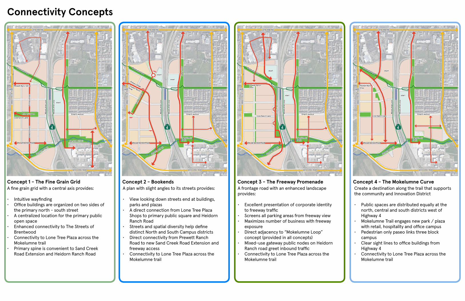
Connectivity Concepts
A fine grain grid with a central axis provides:
• Intuitive wayfinding • Office buildings are organized on two sides of
the primary north - south street• A centralized location for the primary public
open space• Enhanced connectivity to The Streets of
Brentwood • Connectivity to Lone Tree Plaza across the
Mokelumne trail • Primary spine is convenient to Sand Creek
Road Extension and Heidorn Ranch Road
A plan with slight angles to its streets provides:
• View looking down streets end at buildings, parks and plazas
• A direct connection from Lone Tree Plaza Shops to primary public square and Heidorn Ranch Road
• Streets and spatial diversity help define distinct North and South Campus districts
• Direct connectivity from Prewett Ranch Road to new Sand Creek Road Extension and freeway access
• Connectivity to Lone Tree Plaza across the Mokelumne trail
A frontage road with an enhanced landscape provides:
• Excellent presentation of corporate identity to freeway traffic
• Screens all parking areas from freeway view• Maximizes number of business with freeway
exposure • Direct adjacency to “Mokelumne Loop”
concept (provided in all concepts)• Mixed-use gateway public nodes on Heidorn
Ranch road greet inbound traffic • Connectivity to Lone Tree Plaza across the
Mokelumne trail
Create a destination along the trail that supports the community and Innovation District
• Public spaces are distributed equally at the north, central and south districts west of Highway 4
• Mokelumne Trail engages new park / plaza with retail, hospitality and office campus
• Pedestrian only paseo links three block campus
• Clear sight lines to office buildings from Highway 4
• Connectivity to Lone Tree Plaza across the Mokelumne trail
Concept 2 - Bookends Concept 3 - The Freeway Promenade Concept 4 - The Mokelumne Curve
Concept 1 - The Fine Grain Grid
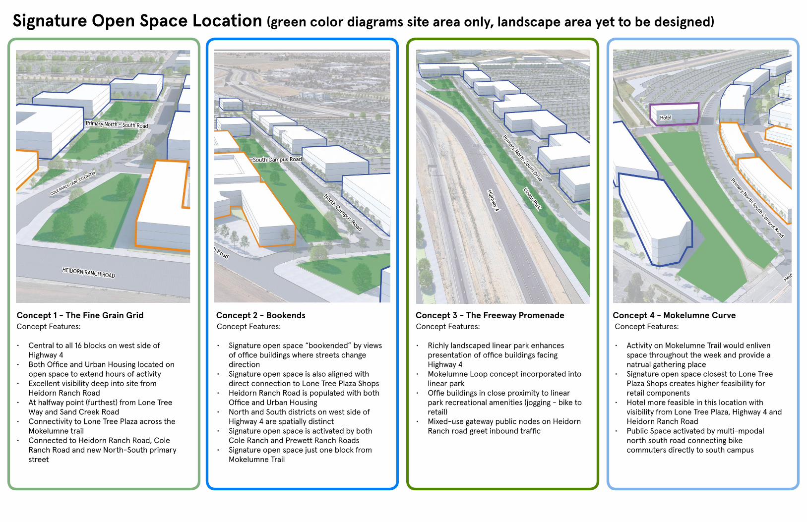
Signature Open Space Location (green color diagrams site area only, landscape area yet to be designed)
Concept Features:
• Central to all 16 blocks on west side of Highway 4
• Both Office and Urban Housing located on open space to extend hours of activity
• Excellent visibility deep into site from Heidorn Ranch Road
• At halfway point (furthest) from Lone Tree Way and Sand Creek Road
• Connectivity to Lone Tree Plaza across the Mokelumne trail
• Connected to Heidorn Ranch Road, Cole Ranch Road and new North-South primary street
Concept Features:
• Signature open space “bookended” by views of office buildings where streets change direction
• Signature open space is also aligned with direct connection to Lone Tree Plaza Shops
• Heidorn Ranch Road is populated with both Office and Urban Housing
• North and South districts on west side of Highway 4 are spatially distinct
• Signature open space is activated by both Cole Ranch and Prewett Ranch Roads
• Signature open space just one block from Mokelumne Trail
Concept Features:
• Richly landscaped linear park enhances presentation of office buildings facing Highway 4
• Mokelumne Loop concept incorporated into linear park
• Offie buildings in close proximity to linear park recreational amenities (jogging - bike to retail)
• Mixed-use gateway public nodes on Heidorn Ranch road greet inbound traffic
Concept Features:
• Activity on Mokelumne Trail would enliven space throughout the week and provide a natrual gathering place
• Signature open space closest to Lone Tree Plaza Shops creates higher feasibility for retail components
• Hotel more feasible in this location with visibility from Lone Tree Plaza, Highway 4 and Heidorn Ranch Road
• Public Space activated by multi-mpodal north south road connecting bike commuters directly to south campus
Concept 2 - Bookends Concept 3 - The Freeway Promenade Concept 4 - Mokelumne Curve

Concept 1 - The Fine Grain Grid
Planning for phase 1 and the future (areas shaded blue with dashed outlines indicate future expansion areas)
Concept Features:
• Phase 1 buildings and public open space concentrated on the Cole Ranch Lane signature open space
• Future expansion is concentrated along the Highway 4 frontage
Concept Features:
• Phase 1 buildings and public open space focused on split North and South campus districts
• Future expansion is distributed throughout the site
Concept Features:
• Phase 1 buildings and public open space are focused on the Highway 4 exposure
• Future expansion is central to the site
Concept Features:
• Phase 1 buildings focused on Mokelumne Square and pedestrian green connecting Prewett Ranch Road to Cole Ranch Road
• Future Expansion is largely focused on the Highway 4 frontage
Concept 2 - Bookends Concept 3 - The Freeway Promenade Concept 4 - The Mokelumne Curve

Future EBart and Bus Transfer Station Location
Concept Features:
• Convenient to Brentwood housing for outbound commuters
• Sites station in land least attractive to retail or office uses
Concept Features:
• Sites are convenient to retail properties on Lone Tree Way
• Fractured sites are difficult to expand in the future
Concept Features:
• Preserves Jeffery Way property north of Mokelumne trail for office, retail or hospitality uses
• Parking lot is tucked behind hotel and retail uses at Lone Tree Plaza
Concept 1 - Single Parking Lot Concept 2 - Split Parking Lot Concept 3 - Split Parking Lot alternate

Innovation Center Trail Regional and Local Trail System
Concept Features:
• A north - south trail system on both sides of Highway 4 will allow workers and residents who commute by bike or foot to reach their place of work with minimal interaction with motor vehicles
• The trail system provides employees a safe trail for exercise or general wellness
• The trail system would encourage workers to walk, bike or scoot to the retail and dining opportunities at the Streets of Brentwood and Lone Treel Plaza Shops
• The trail system is a unique wellness amenity not often found in office parks
The Innovation Center Trail System (indicated in yellow)