comprehensive plan - plan rapid cityplanrapidcity.com/images/uploads/documents/rapid_city... ·...
TRANSCRIPT

Comprehensive Plan REVISED DRAFT – MARCH 2014


Rapid City Comprehensive Plan – Revised Draft: March 2014 i
AcknowledgementsMayor
Sam Kooiker
City Council
William "Bill" Clayton, Ward 1 Charity Doyle, Ward 1
Steve Laurenti, Ward 2 Ritchie Nordstrom, Ward 2
Chad Lewis, Ward 3 Jerry Wright, President, Ward 3
Amanda Scott, Vice President, Ward 4 John B. Roberts, Ward 4 Bonny Peterson, Ward 5
Brad Estes, Ward 5
Statutory Planning Commission
Erik Braun John Brewer
Steve Rolinger Dennis Popp
Linda Marchand Jan Swank Tim R. Rose
Andrew Scull Kay Rippentrop Karen Bulman
Brett Monson (Alternate 1) Walt Swan, Jr. (Alternate 2)
Amanda Scott, Council Liaison
Department Directors
Steve Allender, Police Chief Jeff Biegler, Parks and Recreation Director
Terri Davis, Interim Library Director Cameron Humphries, Airport Director
Joel P. Landeen, City Attorney Brett Limbaugh, Community Planning and
Development Services Director Mike Maltaverne, Fire Chief
Brian Maliske, General Manager, Civic Center Pauline Sumption, Finance Director
Terry Wolterstollf, Public Works Director
Advisory Committee
Dan Senftner, Downtown Rapid City Jeff Lage, Black Hills Homebuilder Association
John Brewer, Planning Commission Gary Brown, Community Representative
Bonny Petersen, City Council Mutch Usera, Black Hills Corporation
Scott Engmann, Black Hills Area Habitat for Humanity
Ben Snow, Rapid City Economic Development Corporation
Jerry Wright, City Council Linda Rabe, Rapid City Chamber of Commerce
Pepper Massey, Rapid City Arts Council Fred Eisenbraun, Lakota Community Homes Brett Limbaugh, Community Planning and
Development Services Director
Staff and Consultant Team
Brett Limbaugh, Community Planning and Development Services Director
Patsy Horton, Long Range Planning Division Manager
Brad Solon, Building Services Division Manager Vicki Fisher, Current Planning Division Manager
Darcie White, Clarion Associates Shelby Sommer, Clarion Associates
Andy Knudtsen, Economic and Planning Systems Matt Prosser, Economic and Planning Systems
Lyle DeVries, Felsburg Holt and Ullevig Shea Suski, Felsburg Holt and Ullevig
ii Rapid City Comprehensive Plan – Revised Draft: March 2014
The preparation of this report has been financed in part through grant[s] from the Federal Highway Administration and Federal Transit Administration, U.S. Department of Transportation, under State Planning and Research Program, Section 104(f) of Title 23, U.S. Code. The contents of this report do not necessarily reflect the official views or policy of the U.S. Department of Transportation.
Rapid City Area Metropolitan Planning Organization provides services without regard to race, color gender, religion, national origin, age or disability, according to the provisions contained in SDCL 20-13, Title VI of the Civil Rights Act of 1964, the Rehabilitation Act of 1973, as amended, the Americans With Disabilities Act of 1990 and Executive Order 12898, Federal Actions to Address Environmental Justice in Minority Populations and Low-Income Populations, 1994.
Any person who has questions concerning this policy or who believes they have been discriminated against should contact the Rapid City Area Metropolitan Planning Organization Title VI Coordinator, Patsy Horton, at 394-4120.
Rapid City Comprehensive Plan – Revised Draft: March 2014 iii
Contents 1. INTRODUCTION ............................................................................................................................ 5
Background ..................................................................................................................................................... 1 Plan Development ............................................................................................................................................ 5 Using the Plan .................................................................................................................................................. 7
2. COMMUNITY VISION & CORE VALUES .............................................................................................. 9 Our Vision: Seven Core Values ......................................................................................................................... 11
3. A BALANCED PATTERN OF GROWTH .............................................................................................. 13 Overview ....................................................................................................................................................... 15 Principles, Goals, and Policies (BPG) ............................................................................................................... 16 Principle BPG-1: Encouraging a Compact and Efficient Pattern of Growth ........................................................................ 16 Principle BPG-2: Facilitating Coordinated Growth .............................................................................................................. 18 Principle BPG-3: Promoting a Balanced Mix of Land Uses ................................................................................................... 19
4. A VIBRANT LIVABLE COMMUNITY .................................................................................................. 21 Overview ....................................................................................................................................................... 23 Principles, Goals, and Policies (LC) .................................................................................................................. 24 Principle LC-1: Elevating the Quality of Development ......................................................................................................... 24 Principle LC-2: Building Diverse and Livable New Neighborhoods ..................................................................................... 26 Principle LC-3: Maintaining the Character and Livability of Existing Neighborhoods ........................................................ 27 Principle LC-4: Sustaining a Vibrant Downtown Center ....................................................................................................... 29 Principle LC-5: Developing Vibrant Activity Centers and Corridors ..................................................................................... 30 Principle LC-6: Protecting the City’s Environmental, Cultural, and Historic Resources ..................................................... 32
5. A SAFE, HEALTHY, INCLUSIVE & SKILLED COMMUNITY .................................................................... 35 Overview ....................................................................................................................................................... 37 Principles, Goals, and Policies (SHIS) .............................................................................................................. 38 Principle SHIS-1: Ensuring Safe and Secure Public Spaces, Neighborhoods, and Business Districts ................................ 38 Principle SHIS-2: Minimizing Hazard Risks and Supporting Disaster Resiliency ................................................................. 39 Principle SHIS-3: Supporting Community Health and Well-Being ...................................................................................... 41 Principle SHIS-4: Fostering a Caring and Inclusive Community .......................................................................................... 42 Principle SHIS-5: Placing a Strong Focus on Lifelong Learning ........................................................................................... 42
6. EFFICIENT TRANSPORTATION & INFRASTRUCTURE SYSTEMS .......................................................... 45 Overview ....................................................................................................................................................... 47 Principles, Goals, and Policies (TI) .................................................................................................................. 48 Principle TI-1: Planning for the Efficient Provision and Maintenance of Infrastructure ..................................................... 48 Principle TI-2: Providing a Safe and Efficient Multi-Modal Transportation System ............................................................ 49 Principle TI-3: Supporting an Integrated Intermodal Network............................................................................................ 52
7. ECONOMIC STABILITY & GROWTH ................................................................................................. 55 Overview ....................................................................................................................................................... 57 Principles, Goals, and Policies (EC).................................................................................................................. 59 Principle EC-1: Expanding Economic Diversity .................................................................................................................... 59 Principle EC-2: Strengthening Rapid City’s Role as a Regional Economic Hub ................................................................... 60 Principle EC-3: Coordinating to Support Economic Growth and Stability .......................................................................... 61
8. OUTSTANDING RECREATIONAL & CULTURAL OPPORTUNITIES ........................................................ 63 Overview ....................................................................................................................................................... 65 Principles, Goals, and Policies (RC) ................................................................................................................. 66 Principle RC-1: Providing Safe, Accessible, and Interconnected Parks and Trails .............................................................. 66 Principle RC-2: Enhancing Community and Recreation Facilities ....................................................................................... 67 Principle RC-3: Expanding Arts and Cultural Opportunities ................................................................................................ 68
Parks and Recreational Facilities .................................................................................................................... 70 9. RESPONSIVE, ACCESSIBLE & EFFECTIVE GOVERNANCE ................................................................... 77
Overview ....................................................................................................................................................... 79 Principles, Goals, and Policies (GOV) ............................................................................................................... 80 Principle GOV-1: Maintaining Fiscal Stability ....................................................................................................................... 80

iv Rapid City Comprehensive Plan – Revised Draft: March 2014
Principle GOV-2: Ensuring Opportunities for Public Involvement in Government .............................................................. 81 Principle GOV-3: Providing Leadership, Continuity and Transparency ............................................................................... 82 Principle GOV 4: Investigating Options to Improve the Efficiency of City Facilities and Administration............................ 83
10. GROWTH & REINVESTMENT FRAMEWORK ...................................................................................... 85 Overview ....................................................................................................................................................... 87 Future Land Use Plan ..................................................................................................................................... 87 Design Principles............................................................................................................................................ 88 Major Street Plan ........................................................................................................................................... 91 Neighborhoods .............................................................................................................................................. 92 Mixed-Use Activity Centers, Corridors, and Opportunity Areas ......................................................................... 97 Employment Areas ....................................................................................................................................... 103 Gateways and Entrance Corridors ................................................................................................................. 107 Parks and Recreation Opportunities ............................................................................................................. 111 Land Conservation and Reserve .................................................................................................................... 113 Public/Institutional and Other Land Uses ...................................................................................................... 117
11. NEIGHBORHOOD AREA POLICIES ................................................................................................ 119 Overview ..................................................................................................................................................... 121 Airport Neighborhood Area (AP-NA) .............................................................................................................. 123 Black Hawk Neighborhood Area (BH-NA) ....................................................................................................... 127 Deadwood Avenue Neighborhood Area (DA-NA) ............................................................................................. 129 Downtown/ Skyline Drive Neighborhood Area (DSD-NA) ................................................................................. 133 Elk Vale Neighborhood Area (EV-NA) ............................................................................................................. 137 Ellsworth Neighborhood Area (EW-NA) .......................................................................................................... 141 Nemo Road Neighborhood Area (NRD-NA) ..................................................................................................... 143 North Rapid Neighborhood Area (NR-NA) ...................................................................................................... 145 Northeast Neighborhood Area (NE-NA) .......................................................................................................... 149 Piedmont Valley Neighborhood Area (PV-NA) ................................................................................................ 153 Sheridan Lake Road Neighborhood Area (SLR-NA) ......................................................................................... 155 South Robbinsdale Neighborhood Area (SR-NA) ............................................................................................. 159 Southeast Connector Neighborhood Area (SEC-NA) ........................................................................................ 163 Spring Creek Neighborhood Area (SC-NA) ...................................................................................................... 167 US Highway 16 Neighborhood Area (US16-NA) ............................................................................................... 171 West Rapid Neighborhood Area (WR-NA) ....................................................................................................... 175
12. IMPLEMENTATION ..................................................................................................................... 179 Overview ..................................................................................................................................................... 181 Priority Initiatives ........................................................................................................................................ 181 Action Plan .................................................................................................................................................. 183 Monitoring & Reporting ................................................................................................................................ 213 Plan Updates & Amendments ........................................................................................................................ 213 Implementation Toolbox .............................................................................................................................. 215
13. APPENDICES Overview A. Community Profile B. Retail Demand Memorandum C. Zoning Diagnosis D. Authentic Youth Engagement Strategic Plan E. Public Participation Summaries
1. Introduction
1

1. Introduction
Rapid City Comprehensive Plan – Revised Draft: March 2014 1
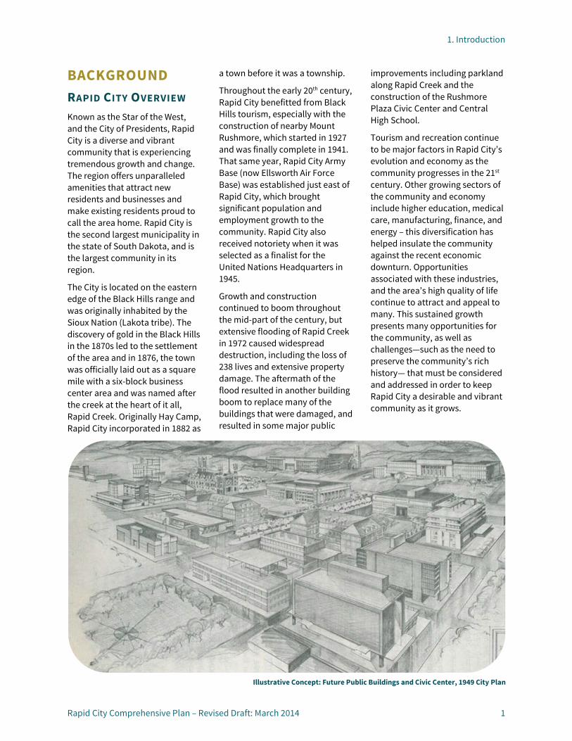
BACKGROUND RAPID CITY OVERVIEW Known as the Star of the West, and the City of Presidents, Rapid City is a diverse and vibrant community that is experiencing tremendous growth and change. The region offers unparalleled amenities that attract new residents and businesses and make existing residents proud to call the area home. Rapid City is the second largest municipality in the state of South Dakota, and is the largest community in its region.
The City is located on the eastern edge of the Black Hills range and was originally inhabited by the Sioux Nation (Lakota tribe). The discovery of gold in the Black Hills in the 1870s led to the settlement of the area and in 1876, the town was officially laid out as a square mile with a six-block business center area and was named after the creek at the heart of it all, Rapid Creek. Originally Hay Camp, Rapid City incorporated in 1882 as
a town before it was a township.
Throughout the early 20th century, Rapid City benefitted from Black Hills tourism, especially with the construction of nearby Mount Rushmore, which started in 1927 and was finally complete in 1941. That same year, Rapid City Army Base (now Ellsworth Air Force Base) was established just east of Rapid City, which brought significant population and employment growth to the community. Rapid City also received notoriety when it was selected as a finalist for the United Nations Headquarters in 1945.
Growth and construction continued to boom throughout the mid-part of the century, but extensive flooding of Rapid Creek in 1972 caused widespread destruction, including the loss of 238 lives and extensive property damage. The aftermath of the flood resulted in another building boom to replace many of the buildings that were damaged, and resulted in some major public
improvements including parkland along Rapid Creek and the construction of the Rushmore Plaza Civic Center and Central High School.
Tourism and recreation continue to be major factors in Rapid City’s evolution and economy as the community progresses in the 21st century. Other growing sectors of the community and economy include higher education, medical care, manufacturing, finance, and energy – this diversification has helped insulate the community against the recent economic downturn. Opportunities associated with these industries, and the area’s high quality of life continue to attract and appeal to many. This sustained growth presents many opportunities for the community, as well as challenges—such as the need to preserve the community’s rich history— that must be considered and addressed in order to keep Rapid City a desirable and vibrant community as it grows.
Illustrative Concept: Future Public Buildings and Civic Center, 1949 City Plan
1. Introduction
2 Rapid City Comprehensive Plan – Revised Draft: March 2014
MAJOR TRENDS, ISSUES, AND OPPORTUNITIES INFLUENCING THE PLAN UPDATE In the early stages of the planning process, interviews were conducted with a diverse group of community stakeholders, elected and appointed officials, and City staff focused on the identification of planning-related issues, opportunities, and challenges facing the community. In addition, an in-depth analysis of trends and existing conditions was prepared to help inform the planning process. The results of this technical analysis and input received as part of the stakeholder interviews were combined into the Community Profile document contained in Appendix A. (See page 223.) This document was used throughout the planning process to help inform the development of this Comprehensive Plan. A brief overview of major trends, issues, and opportunities is provided below.
Growth and Development
In 2010, Rapid City’s population was 67,956. The City’s population is forecasted to reach between 85,000 and 97,000 by 2035. Coordination with adjacent counties, municipalities, and utility and service providers will be important as the City continues to grow. Balancing opportunities for inward vs. outward growth will be a key consideration.
While some amount of Greenfield development is anticipated to occur, opportunities for infill and revitalization of underutilized commercial corridors and activity
centers and reinvestment in established neighborhoods must also be considered.
Changing Demographics
Rapid City’s population becoming increasingly diverse ethnically as the American Indian, Hispanic/Latino, and international student segment of the population grows. The community is also economically diverse, with a range of income levels and household types, such as single-person and single parent households. Another growing component of the population is seniors. Existing residents are aging and more and more people are moving to the community as a retirement destination. Additionally, many young people in the community leave Rapid City following graduation to pursue other opportunities. Meeting the varied needs of these diverse groups and increasing numbers of young people who want to return to Rapid City to raise their families are key considerations with respect to housing and economic diversity.
Housing and Neighborhoods
While multi-family housing options have increased in recent years, the majority of housing units in Rapid City are single-family detached homes. As the City becomes increasingly diverse in terms of its household composition and age, a wider array of housing options—in terms of price, configuration, and location—will be needed. In addition, aging housing stock in core areas of the community
Economic Vitality
Rapid City is a regional hub for economic activity in a 200-mile area. Currently, Rapid City’s economy been heavily weighted towards tourism, health care, retail, and the military. Diversifying the economic base to help offset potential fluctuations in public sector jobs, such as those supported by Ellsworth Air Force Base, and attracting new industries that offer higher paying jobs have been a key focus of regional economic development initiatives in recent years. In addition, exploring new fiscal, economic, and community development tools, continuing Downtown revitalization, and addressing housing quality, affordability, and diversity are all key factors in supporting the economic vitality of the community.
Community Appearance and Amenities
The character of Rapid City is enhanced by the area’s unique natural features, parks, and other community amenities. Protecting the character of these features as the community grows will be an important consideration. In addition, opportunities to strengthen the community’s image through the revitalization of established areas, emphasis on community gateways, and consideration of tools to enhance the character and quality of future development will need to be explored.

1. Introduction
Rapid City Comprehensive Plan – Revised Draft: March 2014 3
Transportation and Utility Infrastructure
Funding new roadways and infrastructure, while also addressing maintenance and deficiencies of existing infrastructure is an ongoing challenge for the community. In addition, continuing to expand multi-modal transportation options such as transit, walking, and bicycling and improving connectivity are key considerations as the community continues to grow. Exploring new tools to support short-term and long-term needs will be essential to support future growth and revitalization.
Communication and Coordination
The Comprehensive Plan builds upon recent community planning efforts to help set a clear vision for the community with a realistic implementation roadmap. The Community Profile document contained in Appendix A identifies related efforts, organizations, and studies by topic. The goals and policies contained in this Plan build on these related efforts.
ROLE OF THE COMPREHENSIVE PLAN The Comprehensive Plan is a tool for ensuring orderly, efficient, and resourceful growth and development in the community. It establishes the long-term vision for Rapid City and provides guidance for decision-making to support and advance the vision.
Rapid City adopted its first City Comprehensive Plan in 1949, shortly after the annexation of the
Canyon Lake neighborhood. The Comprehensive Plan was updated once in 1964, and most recently in 1981 – more than 30 years ago. However, since that time, the City separately updated numerous elements of the Comprehensive Plan, including a Parks and Recreation Master Plan, a Bicycle and Pedestrian Master Plan, the Long Range Transportation Plan, the Utility Master Plan, Drainage Basin Plans, the Comprehensive Preservation Plan, and numerous Neighborhood Area Future Land Use Plans.
Beyond these separate pieces, one unified plan is necessary to address future opportunities, mobilization of assets, and challenges in a coordinated and comprehensive manner. This Comprehensive Plan weaves together many of the previous planning efforts, and also addresses emerging trends and new ideas to encourage community involvement to shape a positive future for the community.
Proposed Land Use Plan, 1949 City Plan

1. Introduction
4 Rapid City Comprehensive Plan – Revised Draft: March 2014
PREVIOUS AND RELATED EFFORTS In addition to the 1949 City Plan, the 1964 update, and 1981 update, the City has led and participated in many planning and other related efforts that address growth, development, and the long-term vision. A short description of some of these related efforts are provided in the following sections.
Rapid City Area 2008 Future Land Use Plan and Neighborhood Plans
The Future Land Use Plan was a compilation of 16 neighborhood plans that cover the City limits, the City’s three mile platting jurisdiction, and the Metropolitan Planning Organization (MPO) area. A set of common goals unites the plan for all separate neighborhood areas. Many of the ideas and land use concepts established in these neighborhood areas are carried forward and reflected in this Comprehensive Plan.
County Comprehensive Plans
In addition to providing guidance for incorporated areas of Rapid City, this Comprehensive Plan draws on plans developed by Pennington and Meade Counties to help inform future land uses and policies in unincorporated portions of City’s planning area. Pennington County’s Comprehensive Plan was adopted in 2003 and Meade County’s Comprehensive Plan was revised and adopted in 2010.
2020 Strategic Plan
The 2020 Strategic Plan, last updated in 2013, establishes a vision for the City and helps guide City government in preparing for the future. The Plan includes five strategic goals, as follows:
By 2020 Rapid City will…
• Be recognized as a leader in attracting, expanding, and retaining diverse businesses that offer higher skilled positions and higher total compensation employment opportunities.
• Develop and implement a beautification program beginning with the appearance of its entrances and expanding to the overall community that embodies a consistent theme which is welcoming, aesthetically pleasing, and pedestrian friendly.
• Be nationally recognized by industry trade measures as a premier regional hub for healthcare, education, entertainment, tourism, retirement, business, technology, agriculture, and transportation.
• Develop an interconnected parks, arts, and recreation system that provides diverse opportunities for enjoyment and adds to our family friendly quality of life.
• Have in place an accessible, affordable, convenient, and safe transportation system that addresses community needs.
Initial work focused on implementing goals one and two. Next steps include creating strategies to implement the remaining goals. This Comprehensive Plan draws extensively on the goals and strategies established in this Strategic Plan, and helps provide more detail for implementation, linking them to the many growth-related opportunities and challenges facing Rapid City.
Priority-Based Budgeting
Rapid City’s 2013 budget marked a new process and framework for City budgeting that focuses on the value of services, encourages new ideas, innovations, cooperation, and improvement to achieve the best results to match community priorities.
The Rapid City 2013 Budget identified the following priorities:
• Good Government: Rapid City will have a government that is fiscally responsible, accessible and responsive to its residents and businesses.
• Safety: Rapid City will provide a safe place to live, learn, work and play.
• Infrastructure and Transportation: Rapid City will have a well maintained city whose infrastructure keeps pace with growth and offers transportation systems that address community needs.
• Economic Stability and Growth: Rapid City will be recognized as a leader in attracting, expanding and retaining diverse businesses and services.

1. Introduction
Rapid City Comprehensive Plan – Revised Draft: March 2014 5
• Strong and Vibrant Community: Rapid City will be a strong, vibrant and culturally diverse community that encourages a sense of health and wellness. This 2013 budget will be a collaborative effort between citizens, mayor’s office, council members, and city staff.
As with the 2020 Strategic Plan Goals, the City’s budgeting goals are strongly linked to the vision and framework of this Comprehensive Plan. Moving forward, it is intended for the City’s budgeting process to closely align with the Comprehensive Plan to improve consistency and continuity between the community’s vision and priorities and City budgeting, spending, and decision-making.
PLAN DEVELOPMENT COMPLIANCE WITH STATE STATUTES The Rapid City Comprehensive Plan was prepared in compliance with the South Dakota Codified Laws (SDCL 11-6) which guide comprehensive city planning. Per 11-6-15, the Plan was made with the purpose of guiding and accomplishing a coordinated, adjusted, and harmonious development of the municipality, which will, in accordance with existing and future needs, best promote health, safety, morals, order, convenience, prosperity or the general welfare, as well as efficiency and economy in the process of development.
In addition, the Plan was prepared in conformance with the guidance for the preparation and contents of a comprehensive plan for municipal development (11-6-14 through 16). The public hearing and adoption requirements (11-6-17 through 18) govern the public hearings, adoption, and filing of this Plan.
PUBLIC ENGAGEMENT Ensuring fair and equal representation of a diverse community and providing adequate opportunities for public involvement are important to the success of a Plan. Public officials, Rapid City staff, the consultant team, and community members collaborated for nine months to develop Plan Rapid City. Project information was available in a variety of formats for the public to review and participate at each stage of the planning process. Over the course of the project, four rounds of community outreach events were conducted in July, September, and November 2013, as well as in January 2014. A more detailed summary of community input can be found in the appendix.
The following types of activities and engagement tools were conducted during the community outreach series:
Stakeholder Interviews and Group Meetings
Early in the process, members of the planning team conducted dozens of stakeholder interviews with representatives from a variety of sectors to help identify key issues and opportunities to be addressed by the Plan.
Community Input Events
Numerous public events were held to inform and gather feedback from the community at large during the different phases of the planning process. Input events included community workshops, a photovoice booth at the Movies under the Stars event, a senior citizen update, and forums with community thought-leaders.
Youth Engagement
Two teen events were also held at key points in the process, in collaboration with Lifeways, Inc. and the Rapid City School Foundation. Participants included teens who are authentically engaged in three different types of work, volunteerism, group advisory capacities and shared leadership positions as they serve with equal voice on several boards. Rapid City recognizes that its young people are one of the community’s greatest resources—the end user of many city projects and services, as well as future taxpayers and City leaders. Over 60 teens participated in the two events.

1. Introduction
6 Rapid City Comprehensive Plan – Revised Draft: March 2014
Advisory Committee Meetings
The Advisory Committee was comprised of a diverse group of community leaders who provided strategic direction and leadership to the planning process. The Committee reviewed draft work products and provided comments and insight to the planning team. One Advisory Committee meeting was held during each community outreach series.
Joint Leadership Worksessions
Updates with City Council, Planning Commission, Department Directors, and key staff members were held during each outreach series to provide progress updates, present preliminary findings and alternative solutions, and receive policy direction.
Project Website
A project website, www.planrapidcity.com, served as the main hub for information about Rapid City’s efforts to update the Comprehensive Plan. The website included an overview of the planning process, contact information, draft work products for review, and links to project surveys. The City’s Twitter account was also used to connect followers to the project website and to announce public events and project news.
Online Surveys
Online surveys were used as another opportunity for community feedback. Four online surveys were posted online throughout the planning process to garner additional feedback regarding topics like the vision, community preferences, Future Land Use Plan map, goals and policies, and the Draft Comprehensive Plan. Over fifty people participated in the surveys.

1. Introduction
Rapid City Comprehensive Plan – Revised Draft: March 2014 7
USING THE PLAN ORGANIZATION This Comprehensive Plan is organized in a unique way that reflects the vision for Rapid City’s future and aligns with the City’s priority-based budgeting goals. This organization adds consistency between City goals, policies, decision-making, and budgeting. This Plan includes the following chapters:
INTRODUCTION
Chapter 1 provides a summary of planning issues and opportunities and addresses the purpose, planning process, and use of the Comprehensive Plan.
COMMUNITY VISION
Chapter 2 defines the Community Vision, which is comprised of seven “Core Values” that also serve as key chapters of the Plan.
PRINCIPLES, GOALS, AND POLICIES TO
SUPPORT THE CORE VALUES
Chapters 3 to 9 establish the Principles, Goals, and Policies to achieve each Core Value.
GROWTH AND REINVESTMENT
FRAMEWORK
Chapter 10 includes the Future Land Use Plan map, descriptions and policies for each of the map components, and design principles to guide the character and form of future development.
NEIGHBORHOOD AREA POLICIES
Chapter 11 contains principles, goals, and policies specific to different neighborhood areas, as well as Future Land Use Plan maps for each neighborhood area.
IMPLEMENTATION
Chapter 12 details the actions required to implement the Plan, establishes the procedures for monitoring and amending the Plan, and provides a toolbox of potential strategies to support specific initiatives.
APPENDICES
Five appendices are provided for reference: A. Community Profile B. Retail Demand Memorandum C. Zoning Diagnosis D. Authentic Youth Civic Engagement Strategic Plan E. Public Participation Summaries
1. Introduction
8 Rapid City Comprehensive Plan – Revised Draft: March 2014
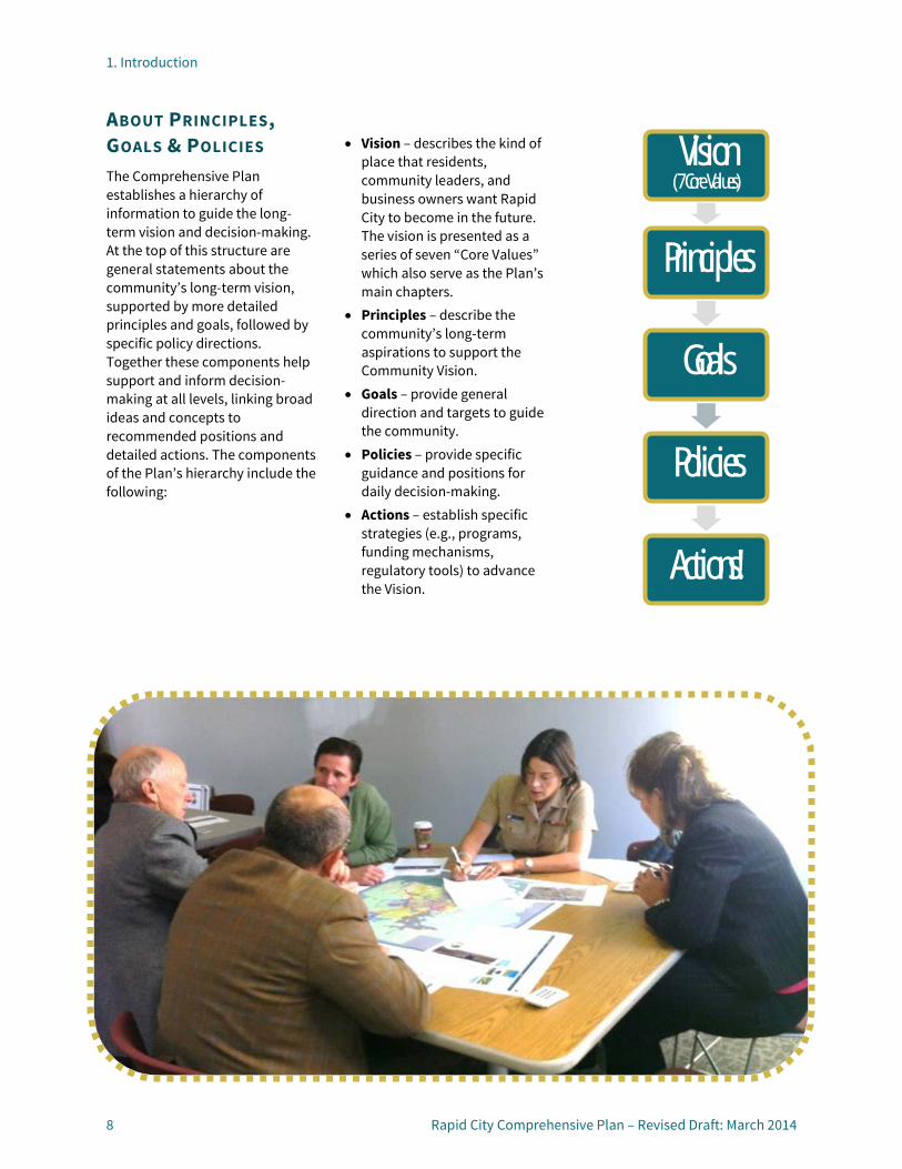
ABOUT PRINCIPLES, GOALS & POLICIES The Comprehensive Plan establishes a hierarchy of information to guide the long-term vision and decision-making. At the top of this structure are general statements about the community’s long-term vision, supported by more detailed principles and goals, followed by specific policy directions. Together these components help support and inform decision-making at all levels, linking broad ideas and concepts to recommended positions and detailed actions. The components of the Plan’s hierarchy include the following:
• Vision – describes the kind of place that residents, community leaders, and business owners want Rapid City to become in the future. The vision is presented as a series of seven “Core Values” which also serve as the Plan’s main chapters.
• Principles – describe the community’s long-term aspirations to support the Community Vision.
• Goals – provide general direction and targets to guide the community.
• Policies – provide specific guidance and positions for daily decision-making.
• Actions – establish specific strategies (e.g., programs, funding mechanisms, regulatory tools) to advance the Vision.
Vision (7 Core Values)
Principles
Goals
Policies
Actions!

2. Community Vision & Core Values
2


2. Community Vision & Core Values
Rapid City Comprehensive Plan – Revised Draft: March 2014 11
OUR VISION: SEVEN CORE VALUES Seven “Core Values” serve as the basic tenets behind both the community’s vision and the basic organizing structure of this Comprehensive Plan. The Core Values coordinate with and build on several recent City efforts, including the recent priority-based budgeting process and the Vision 2020 Strategic Plan. Both of these efforts establish long-term goals for the community, and as such, the Core Values mirror their structure and carry forward many of their key ideas. The Core Values define our long-term vision at a broad level and describe the kind of community we want Rapid City to become. While the term “quality of life” means different things to different people, the Core Values are based on the premise that the health of City and the quality of life enjoyed by its residents are dependent upon the balancing of multiple factors—economic, environmental, and community considerations Each of the Core Values embodies key aspects of what the community values about Rapid City today, as well as aspects that will be important to improve and/or maintain in the future.
The Plan’s chapters align with the Core Values, listed below. Each Core Value chapter also contains a series of related principles, which describe the community’s aspirations, and specific goals and policies to achieve those aspirations.
A BALANCED PATTERN OF GROWTH Rapid City is dynamic community with a rich history and unique natural setting that continues to experience strong growth and development pressures. In order to preserve our area’s high quality of life, and at the same time continue to attract new business and investment to the community, we must be proactive in our efforts to ensure orderly and efficient growth.
A VIBRANT, LIVABLE COMMUNITY Rapid City will continue to become a more livable, vibrant, and desirable community in which to live, work, contribute, and play. We value the quality, character, and diversity of our City’s neighborhoods and the accessibility of parks, schools, and services. We are committed to addressing infrastructure and other needs in our established neighborhoods and historic districts and will ensure our new neighborhoods are attractively designed and include a range of housing types to meet the needs of our growing and changing population. We value Downtown as the vital center of our community, and we will continue to work to ensure its long-term success and vitality.
A SAFE, HEALTHY, INCLUSIVE, AND SKILLED COMMUNITY We rely on the City’s police and fire departments to keep us safe and protect our property from harm for safety and protection, yet understand we all need to value our community and care for our families, homes, and neighbors. Careful planning is necessary to ensure that our future safety needs will be met as the City continues to grow. In addition to ensuring the safety of our community, we envision a community that supports our health and well-being; one that provides access to health care services, enables active and healthy lifestyles, provides educational opportunities for our youth and workforce to develop the skills needed to succeed, and recognizes that everyone must play a role in the betterment of our neighborhoods and our community. Likewise, we will strive to be a community that is recognized as being welcoming and inclusive to people of all ages, ethnic groups, family type, and economic standing.
2. Community Vision & Core Values
12 Rapid City Comprehensive Plan – Revised Draft: March 2014
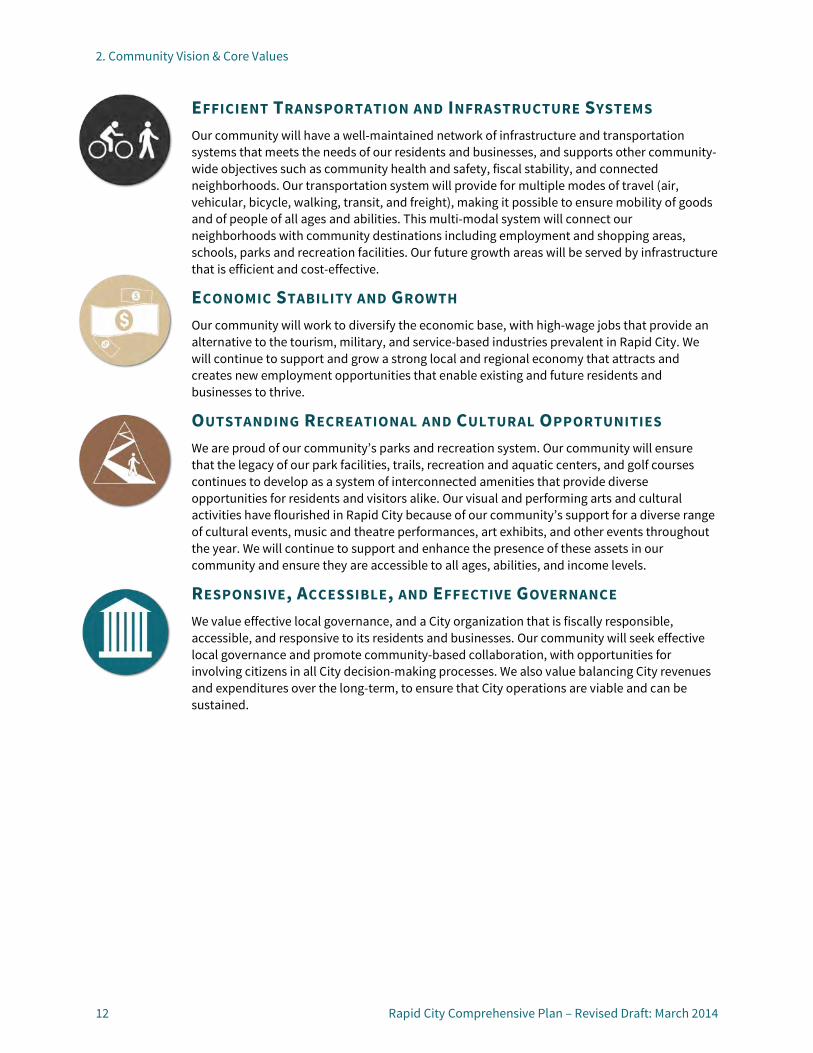
EFFICIENT TRANSPORTATION AND INFRASTRUCTURE SYSTEMS Our community will have a well-maintained network of infrastructure and transportation systems that meets the needs of our residents and businesses, and supports other community-wide objectives such as community health and safety, fiscal stability, and connected neighborhoods. Our transportation system will provide for multiple modes of travel (air, vehicular, bicycle, walking, transit, and freight), making it possible to ensure mobility of goods and of people of all ages and abilities. This multi-modal system will connect our neighborhoods with community destinations including employment and shopping areas, schools, parks and recreation facilities. Our future growth areas will be served by infrastructure that is efficient and cost-effective.
ECONOMIC STABILITY AND GROWTH Our community will work to diversify the economic base, with high-wage jobs that provide an alternative to the tourism, military, and service-based industries prevalent in Rapid City. We will continue to support and grow a strong local and regional economy that attracts and creates new employment opportunities that enable existing and future residents and businesses to thrive.
OUTSTANDING RECREATIONAL AND CULTURAL OPPORTUNITIES We are proud of our community’s parks and recreation system. Our community will ensure that the legacy of our park facilities, trails, recreation and aquatic centers, and golf courses continues to develop as a system of interconnected amenities that provide diverse opportunities for residents and visitors alike. Our visual and performing arts and cultural activities have flourished in Rapid City because of our community’s support for a diverse range of cultural events, music and theatre performances, art exhibits, and other events throughout the year. We will continue to support and enhance the presence of these assets in our community and ensure they are accessible to all ages, abilities, and income levels.
RESPONSIVE, ACCESSIBLE, AND EFFECTIVE GOVERNANCE We value effective local governance, and a City organization that is fiscally responsible, accessible, and responsive to its residents and businesses. Our community will seek effective local governance and promote community-based collaboration, with opportunities for involving citizens in all City decision-making processes. We also value balancing City revenues and expenditures over the long-term, to ensure that City operations are viable and can be sustained.
3. A Balanced Pattern of Growth3


3. A Balanced Pattern of Growth
Rapid City Comprehensive Plan – Revised Draft: March 2014 15
OVERVIEW Due to tremendous population growth and attraction of residents from across the country, Rapid City is quickly evolving from a mid-sized town to a bustling regional center. An estimated steady 1 to 2 percent annual population growth rate has led to growth pressures and development within the community, as well as outward expansion of the City’s corporate limits.
Looking forward, the City’s population could grow from approximately 68,000 people in 2010 to more than 85,000 people by 2035. Factors such as household sizes, vacancy rates, and housing and employment opportunities will influence exactly how much future
population growth will occur, but in a high-growth scenario, Rapid City’s population could inch towards 100,000 people in the next 30 years. Based on the City’s existing water rights, a population of 170,000 could ultimately be accommodated. However, careful management of these resources will be needed.
In terms of housing, this projected population growth could create demand for an additional 364 to 559 dwelling units per year in Rapid City, for a total of 46,000 to 51,000 dwelling units by 2035. While much of the City’s recent residential growth has occurred in the north and southwest quadrants of the community, outlying unincorporated areas have also grown considerably. Housing forecasts across the City’s 3-mile platting jurisdiction
area estimate between 58,000 and 63,000 housing units by 2035. The amount of land necessary to accommodate this projected residential growth to 2035 is approximately 2 to 4 square miles, based on typical area development patterns and densities.
Employment in the larger Rapid City area could grow by 456 to 1,291 jobs per year, with total employment ranging from 75,000 to 98,000 by 2035. As with residential growth, many factors will determine the amount of job and employment growth, including market demand, land supply, development densities, infrastructure needs, availability of services, and other development constraints.
Rapid City and its surrounding area have ample room for
Rapid City is a dynamic community with a rich history and unique natural setting that continues to experience strong growth and development pressures. In order to preserve our area’s high quality of life, and at the same time continue to attract new business and investment to the community, we must be proactive in our efforts to ensure orderly and efficient growth.
Rapid City Main Street, 1902. South Dakota State Historical Society.

3. A Balanced Pattern of Growth
16 Rapid City Comprehensive Plan – Revised Draft: March 2014
outward expansion, although constraints such as steep slopes, flood hazards, and availability of water and sewer services do limit some of this overall development potential. (See the Community Profile in the Appendix for a full discussion of projections and land capacity.)
Not all of the City’s growth is likely to push outward; however. Due to natural and physical development constraints, extensive costs associated with extending new infrastructure, difficulties in providing services to new areas, and changing preferences, an increasing portion of the area’s growth will likely occur through infill development, redevelopment, and intensification in certain portions of the community. For example, expansion of the Rushmore Plaza Civic Center facility and campus will likely spawn infill and redevelopment within walking distance of the facility, particularly to the north and east. Encouraging infill and redevelopment in targeted areas like this will require a comprehensive toolbox of incentives.
Proactive planning is necessary to ensure orderly and efficient growth and to retain the community’s high quality of life as change occurs. In order to support the vision for a balanced pattern of growth focus, principles, goals, and policies in this chapter emphasize:
• Encouraging a compact and efficient pattern of growth;
• Facilitating coordinated growth within the City and surrounding region; and
• Promoting a balanced mix of uses.
PRINCIPLES, GOALS, AND POLICIES (BPG) Principle BPG-1: Encouraging a Compact and Efficient Pattern of Growth
The City will increase its efforts to stimulate infill development on undeveloped lands that are already within the City limits, as well as promote reinvestment in underutilized properties. Outward growth beyond the current City limits will be encouraged only in areas that could be reasonably served by City infrastructure and services.
Goal BPG-1.1: Use available land and resources efficiently.
BPG-1.1A: COMPACT GROWTH
Encourage compact growth and infill development within and adjacent to established city limits. Discourage outward leapfrog development and limit the extension of newly developed urban services beyond the City’s Urban Services Boundary. Require development outside the Urban Services Boundary to pay its own way with respect to service extensions and oversizing.
BPG-1.1B: TARGETED INFRASTRUCTURE INVESTMENTS
Prioritize and invest in infrastructure maintenance and improvements within the
established portions of the community before investing in new infrastructure to serve outward growth areas.
BPG-1.1C: ANNEXATION CRITERIA
Coordinate with counties and adjacent jurisdictions to develop and follow criteria and procedures for the annexation of contiguous land within 3-mile platting jurisdictions.
BPG-1.1D: SUSTAINABLE DEVELOPMENT
Permit and encourage the use of sustainable development practices (e.g., renewable energy systems, water-conserving fixtures and landscaping, and stormwater management techniques) in all public and private development projects.
Goal BPG-1.2: Target infill and redevelopment in key areas.
BPG-1.2A: PRIORITY INFILL AREAS
Prioritize and encourage infill development in close-in areas that have been skipped over due to property constraints, ownership patterns, or other reasons, as a means to maximize infrastructure investments and add vibrancy to existing areas. High priority areas for infill development include any vacant or undeveloped properties located within Regional and Community Activity Centers, or along Reinvestment Corridors, as shown on the Future Land Use Plan map (see page 87). Other highly desirable areas for infill development include Downtown, Mixed-use Commercial and Employment areas, and Urban
3. A Balanced Pattern of Growth
Rapid City Comprehensive Plan – Revised Draft: March 2014 17
Neighborhoods, as identified on the Future Land Use Plan map.
BPG-1.2B: PRIORITY ACTIVITY CENTERS FOR REINVESTMENT
Encourage reinvestment in underutilized and/or aging activity centers. Support redevelopment when existing uses and/or structures are no longer economically viable. The Future Land Use Plan map identifies various types of existing and future Activity Centers. Regional and Community Activity Centers where reinvestment and/or redevelopment are a priority include the following:
Regional Activity Centers
• Downtown: this area is the primary regional destination and is the hub for many community activities and land uses. Reinvestment and redevelopment in this area is already well underway, and future efforts should continue to expand the variety of uses while also retaining the historic character of the buildings and area.
• Rushmore Mall: this area is the City’s major retail destination and home of the only traditional department stores in the community. Competition with nearby Rushmore Crossing is impacting the vitality of this center. The introduction of non-retail uses in the underdeveloped areas surrounding the mall could help generate increased activity levels to support existing retail uses and spur reinvestment into the mall itself.
Community Activity Centers
• Baken Park: this shopping center, located at the intersection of West Main Street and Mountain View Road, is anchored by the Family Thrift Center grocery store. The center was developed in the late 1950s, and despite some recent investment in some outlying pad retail buildings, it is beginning to show its age. The center is in a great location to serve the western portion of the community, and future improvements to enhance its vitality could include façade improvements, circulation and access improvements, landscaping, and the addition of public spaces.
• Northgate Shopping Center: located at the intersection of Cambell Street and East North Street, this center is anchored by a Kmart store. The center’s unique topography, expansive parking lot, and lack of recent improvements make it a priority for future reinvestment or redevelopment. To increase vitality, future improvements could be similar to those recommended for Baken Park, or the integration of multi-family and more service-oriented retail could help transform this center into a true mixed-use destination.
• Family Thrift Center: this center, located at the intersection of Cambell Street at East Saint Patrick, is anchored by a Family Thrift supermarket. Like the Northgate Center, it features an expansive parking lot, minimal landscaping, and somewhat outdated retail space. Future reinvestment activities could
include circulation and access improvements, façade enhancements, and landscaping.
• FTC Express Center: this area, located along Sturgis Road, near West Chicago Street, is a smaller strip-oriented commercial center located along a long, aging commercial corridor. It is part of the larger Sturgis Road Corridor, discussed below.
• Regional Health Area: the area around the Regional Health Hospital, specifically along Mount Rushmore Road near Cathedral Drive/Fairmont Boulevard features a broad mix of auto-oriented commercial and employment uses. The concentration of medical uses in the area mean that it is a primary destination for employees and visitors to the community. While much of this established area is thriving, focus on pedestrian improvements, infill development, and a broader mix of uses will help this area remain a vibrant community destination.
The Future Retail Development Memorandum in Appendix B provides additional background and recommendations for many of these priority reinvestment Activity Centers, and Chapter 10 establishes design guidance and policies for all Activity Centers.
3. A Balanced Pattern of Growth
18 Rapid City Comprehensive Plan – Revised Draft: March 2014
BPG-1.2C: PRIORITY REVITALIZATION CORRIDORS
Support reinvestment, infill development, and targeted redevelopment along Priority Revitalization Corridors, as identified on the Future Land Use Plan and listed as follows.
• East Boulevard/East North Street: this corridor extends from East Omaha Street to North Cambell Street and is predominantly characterized by strip commercial development.
• East Saint Patrick Street: this corridor includes the segment between Mount Rushmore Road and Highway 44, and features predominantly established, aging residential development on the western end and strip commercial development on the eastern end.
• Main and Saint Joseph Streets: these corridors provide one-way connections from 5th Street east to the South Dakota School of Mines and Technology (SDSMT). They feature a broad mix of uses and are instrumental in enhancing connections and synergy between Downtown and the SDSMT campus.
• North La Crosse Street: this corridor includes the segment from East Omaha Street to Eglin Street, and is mostly strip commercial development.
• Mount Rushmore Road: this corridor includes the portion from Cleveland Street to Omaha Street. The adopted Mount Rushmore Road Corridor Study provides details about the vision and future
reinvestment strategies for this area.
• Sturgis Road (Highway 79)/West Omaha Street/West Chicago Street: this corridor extends from Deadwood Avenue on the east to the Rapid City limits on the west/north. It includes an array of strip commercial and industrial uses, as well as mining and extraction activities.
Encourage improvements such as access consolidation, circulation improvements, bicycle and pedestrian amenities, landscaping, coordinated signage, lighting, and adaptive reuse of historic structures along these corridors. Refer to the Growth and Reinvestment Framework Chapter for more design guidance and policies for all Revitalization Corridors.
BPG-1.2D: PUBLIC INFRASTRUCTURE COORDINATION
Target and coordinate public infrastructure improvements (e.g., roadway enhancements, bicycle/pedestrian connections, water/sewer repairs, electric line undergrounding, and construction of municipal facilities) with desired infill, reinvestment and redevelopment areas to encourage and stimulate private development.
BPG-1.2E: PUBLIC-PRIVATE PARTNERSHIPS
Consider the use of public-private partnerships to expand infill, reinvestment, and redevelopment approaches and opportunities.
BPG-1.2F: INFILL AND REDEVELOPMENT INCENTIVES
Explore aligning existing and/or offering additional development incentives (e.g., Tax Increment Financing, priority application processing, fee reductions, design assistance) to reduce barriers and encourage infill and redevelopment in priority areas.
Principle BPG-2: Facilitating Coordinated Growth
Rapid City will have a development pattern that makes efficient use of the limited land area and resources it has available for urban growth, that fosters the provision of infrastructure and services in a cost-effective manner. The City will work closely with Pennington and Meade Counties, adjacent communities, and service providers to ensure that growth at the community’s edges will occur in an orderly and efficient manner.
Goal BPG-2.1: Foster a cooperative approach to planning and growth-related issues.
BPG-2.1A: SERVICE PROVIDER COORDINATION
Collaborate with other local service providers such as the school district, social and human services providers, utility companies, and others in planning for growth and supporting the expansion of existing facilities or the construction of new facilities to

3. A Balanced Pattern of Growth
Rapid City Comprehensive Plan – Revised Draft: March 2014 19
serve existing and future development areas.
BPG-2.1B: CITY /COUNTY COORDINATION
Enhance planning and growth-related coordination with Meade and Pennington Counties by establishing agreements, formalizing procedures, and communicating regularly.
BPG-2.1C: NEIGHBORING COMMUNITIES
Improve communication and collaboration with adjacent and nearby communities (Box Elder, Summerset, and Piedmont) on planning and growth-related issues and opportunities of mutual interest or concern.
BPG-2.1D: ELLSWORTH COLLABORATION
Involve and collaborate with Ellsworth Air Force Base and Ellsworth Development Authority on City and base-related opportunities and challenges, including but not limited to aircraft impacts, housing and transportation needs, and
potential long-term base contraction or closure.
BPG-2.1E: COORDINATION WITH RESERVATIONS
Extend opportunities for coordination with and involvement from members of area Indian reservations—Pine Ridge, Rosebud, and Cheyenne River Sioux—in identifying and addressing City planning and growth-related issues.
BPG-2.1F: STATE AND FEDERAL COORDINATION
Establish regular communication and coordination with state and federal agencies such as the National Forest Service, South Dakota Departments of Environment and Natural Resources, Transportation, and Tourism, and others to proactively plan for and address development-related opportunities and challenges.
BPG-2.1G: CITY DEPARTMENT COORDINATION
Promote regular communication and coordination among City of Rapid City departments about short and long-term planning and development-related issues and opportunities.
Principle BPG-3: Promoting a Balanced Mix of Land Uses
As growth continues, the City will support the development of new residential areas and neighborhoods, parks, and commercial and employment areas to serve the region and meet the daily needs of residents. A diverse mix of uses, concentrated within activity centers, will help ensure that residents have housing, shopping, and employment opportunities across the City, and will provide options for future investment and growth.
Goal BPG-3.1: Support a diverse mix of uses citywide.
BPG-3.1A: BALANCED USES
Support a balanced mix of residential, commercial, employment, public uses, parks, and green space throughout the community. Encourage the geographic distribution of uses across the City’s different neighborhood areas, balancing the need to accommodate growth with the preservation of historic resources, where applicable.
Aerial view of Rapid City, 1949 City Plan.

3. A Balanced Pattern of Growth
20 Rapid City Comprehensive Plan – Revised Draft: March 2014
BPG-3.1B: FUTURE LAND USE FLEXIBILITY
Provide flexibility in applying the Future Land Use categories by encouraging a range of densities and mix of land uses (as specified by the Future Land Use Plan), and by allowing administrative interpretation when the map does not perfectly align with parcels of land or planned roadways or a proposed use is not specified.
BPG-3.1C: LAND USE CAPACITY VS. DEMAND
Monitor projected growth for residential and non-residential development to understand land demand needs and align the Future Land Use Plan map and policies to accommodate these needs. Avoid “over planning” extensively beyond projected needs since the Plan is intended to provide focus and prioritization for growth, development, and investment. Balance the need for new growth with opportunities for infill and revitalization and the adaptive reuse of existing buildings within the community—both historic and non-historic.
Goal BPG-3.2: Expand housing variety to meet the community’s changing needs.
BPG-3.2A: MIX OF HOUSING TYPES
Encourage the development of a range of housing types, sizes, prices, and densities within individual neighborhoods and throughout the community to satisfy current demand and future needs.
BPG-3.2B: HOUSING TO ENHANCE VIBRANCY
Support the addition and incorporation of a range of housing types to enhance the mix of uses and vibrancy of Downtown, designated mixed-use activity centers, and revitalization corridors. (See Chapter 10.)

4. A Vibrant Livable Community
4


4. A Vibrant Livable Community
Rapid City Comprehensive Plan – Revised Draft: March 2014 23
OVERVIEW Rapid City provides an appealing mix of historic charm and modern development and amenities. Downtown is the community’s thriving, historic core, and serves as a regional center of activity for residents and visitors alike. Recent efforts, such as the construction of Main Street Square, and hosting of community events such as Summer Nights and Movies Under the Stars, have helped revive Downtown, building momentum for continued investment and activity. As Downtown revitalization efforts continue, it will be important to retain the area’s historic character and buildings – important elements
that add authenticity and appeal to both visitors and residents alike.
Beyond Downtown, Rapid City features a wide range of diverse and distinct neighborhoods, some of which are established and others that are newly emerging. Single-family, detached housing remains the predominant option in most neighborhoods, but future population and cultural trends indicate growing demand for expanded housing alternatives. In addition to changing housing product preferences, it is challenging for many in the local workforce—particularly in the tourism and retail services industries—to find quality housing that is attainable. Looking
forward, increasing quality housing options for Rapid City residents is a key objective of this Plan. High priority housing needs that have been identified are primarily focused on increasing the amount and quality of housing affordable and available to low and moderate income residents. Priority housing needs include increasing the number of affordable rental units for singles and families, rehabilitating the existing housing stock in older neighborhoods, and reducing barriers to homeownership.
Many of Rapid City’s established neighborhoods, activity centers, and corridors are beginning to show their age, and some are neglected or in decline.
Rapid City will continue to become a more livable, vibrant, and desirable community in which to live, work, contribute, and play. We value the quality, character, and diversity of our City’s neighborhoods and the accessibility of parks, schools, and services. We are committed to addressing infrastructure and other needs in our established neighborhoods and historic districts and will ensure our new neighborhoods are attractively designed and include a range of housing types to meet the needs of our growing and changing population. We value Downtown as the vital center of our community, and we will continue to work to ensure its long-term success and vitality.

4. A Vibrant Livable Community
24 Rapid City Comprehensive Plan – Revised Draft: March 2014
Maintenance and reinvestment could help stabilize and reestablish these areas as desirable portions of the community. Moreover, infill and targeted redevelopment may help reenergize some of these areas, providing a catalyst for additional change and investment.
At all stages of community development, including expansion into new growth areas and refocusing inward through infill and redevelopment, it is important to consider overarching community expectations for development quality, community appearance, and resource protection. Growth and development should not detract from the community, but rather help enhance community vibrancy, livability, and desirability. To support this vision, the principles, goals, and policies in this chapter focus on:
• Elevating the quality of development and community appearance;
• Building diverse and livable new neighborhoods;
• Maintaining the character and livability of existing neighborhoods and historic districts;
• Continuing revitalization of Downtown Rapid City;
• Developing vibrant activity centers and corridors;
• Creating community partnerships within neighborhoods; and
• Protecting and preserving environmental, cultural, and historic resources.
Principles, Goals, and Policies (LC) Principle LC-1: Elevating the Quality of Development
Rapid City will project a positive image for the community by promoting variety and visual interest and the use of durable, long-lasting materials in all new development. Particular attention will be placed on strengthening the community’s image at major gateways to the community.
Goal LC-1.1: Encourage variety, visual interest, and durability in the design of all new development.
LC-1.1A: INNOVATIVE DESIGN
Encourage creativity, flexibility, and innovation in the design of new developments and neighborhoods.
LC-1.1B: DURABLE MATERIALS
Ensure that buildings are designed and constructed with materials that will remain durable in Rapid City’s climate.
LC-1.1C: SUSTAINABLE BUILDINGS AND SITES
Permit and encourage the use of sustainable site planning and building design techniques such as drought-tolerant landscaping, recycled materials, energy efficient design, and the integration of alternative energy sources.
LC-1.1D: CONNECTED AMENITIES
Integrate public and private amenities such as parks, trails, and public gathering spaces throughout new development areas.
LC-1.1E: CONTEXT-SENSITIVE DESIGN
Ensure the design of new development is compatible with adjacent buildings and the surrounding neighborhood context in terms of height, scale, and the overall mix of uses.
4. A Vibrant Livable Community
Rapid City Comprehensive Plan – Revised Draft: March 2014 25
Goal LC-1.2: Maintain and enforce standards that address property upkeep and appearance.
LC-1.2A: CODE ENFORCEMENT
Administer, enforce, and periodically review and update City ordinances related to public health, safety, signage, and property maintenance issues.
LC-1.2B: REINVESTMENT PROGRAMS
Explore offering City-led programs and support other organizations’ efforts and programs to encourage property maintenance and/or rehabilitation such as debris removal events, paint-a-thons, energy efficiency improvements, emergency repairs, and adopt-a-neighbor partnerships. Consider partnerships with the private sector and non-profits as a way to further support reinvestment.
Goal LC-1.3: Project a positive community image along Rapid City’s entrance corridors and at City gateways.
LC-1.3A: GATEWAY AND ENTRANCE CORRIDOR STANDARDS
Establish standards to guide the design and appearance of the community’s gateways and entrance corridors (as identified on the Future Land Use map). Standards may address topics such as landscaping, lighting, signage, and other streetscape or urban design elements. (See Design Principles for Gateways and Entrance Corridors, page 109.)
LC-1.3B: ENTRANCE CORRIDOR COORDINATION
Coordinate with South Dakota Department of Transportation (SDDOT), adjacent communities, and Pennington and Meade Counties, to develop coordinated visions, standards, and plans for improvements along major entryway corridors into Rapid City. Major entryways into the City are identified on the Future Land Use Map and include the following:
• Elk Vale Road: traversing the southeastern section of the community from Interstate 90 to the north to Mount Rushmore Road to the south. This corridor provides multiple points of entry into the community and is a primary route across the City as well. Access control, signage, and landscaping are all important considerations as growth and development occur along this corridor.
• Haines Avenue: stretching north from Interstate 90 to beyond the County line, this corridor is located in a high-growth area. Coordination with Meade and Pennington Counties will help ensure that this corridor remains an inviting entrance into the northern portion of Rapid City.
• SD Highway 44: extending from the City’s core near East Omaha Street east to the Rapid City Regional Airport. Coordination is needed to ensure that this entryway projects a positive image of the City as growth and development spread east of the community.
• SD Highway 79: extending south of Elk Vale, this corridor is envisioned as the community’s industrial corridor, but considerations should be given to limit the visual impacts of heavy industry.
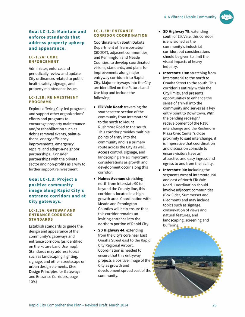
• Interstate 190: stretching from Interstate 90 to the north to Omaha Street to the south. This corridor is entirely within the City limits, and presents opportunities to enhance the sense of arrival into the community and serves as a key entry point to Downtown. With the pending redesign/ redevelopment of the I-190 interchange and the Rushmore Plaza Civic Center’s close proximity to said interchange, it is imperative that coordination and discussion coincide to ensure visitors have an attractive and easy ingress and egress to and from the facility.
• Interstate 90: including the segments west of Interstate 190 and east of North Elk Vale Road. Coordination should involve adjacent communities (Box Elder, Summerset and Piedmont) and may include topics such as signage, conservation of views and natural features, and landscaping, screening and buffering.

4. A Vibrant Livable Community
26 Rapid City Comprehensive Plan – Revised Draft: March 2014
• Jackson Boulevard (SD Highway 44): extending west of Canyon Lake, is a setting for conservation of scenic views and forested lands.
• Sturgis Road: stretching north of the Rapid City limits. Issues and opportunities include coordination with Summerset, Piedmont, and the mining/extraction industries, and conservation of open lands and views.
• US Highway 16: extending south from Cleveland Street to beyond the Rapid City limits. Issues and opportunities along this corridor include conserving views and natural features and coordination with the tourism industry.
LC-1.3C: GATEWAY IMPROVEMENTS
Integrate design improvements (e.g., lighting, landscaping, bridges, and signage) as development, redevelopment, and/or capital projects occur at key gateways to the City (as identified on the Future Land Use map). Key community gateways include interchanges and other noteworthy landmarks (such as crossing into the City limits) are identified on the Future Land Use map and include the following:
Interchanges
• East Highway 44 at North Elk Vale Road
• Interstate 90 at North Elk Vale Road
• Interstate 90 at North Deadwood Ave
• Highway 79 (Cambell Street) at Elk Vale Road
• Interstate 90 at Interstate 190 • Interstate 190 at Omaha Street
Landmarks
• Mount Rushmore Road at Tower Road (near Regional Health center)
• US Highway 16 at the City’s southern limits (near Fort Hayes Drive)
• Jackson Boulevard at Canyon Lake Park (near Chapel Lane)
• Sturgis Road at the City’s northern limits (north of Hidden Valley Road)
Principle LC-2: Building Diverse and Livable New Neighborhoods
Rapid City will encourage the development of new neighborhoods that contain a mix of land uses, including a range of housing types to meet the varying needs of its residents. The City will support the development of new neighborhoods that maximize investments in existing parks, trails, roadways, and utility services, and that enhance connections between neighborhoods and community destinations.
Goal LC-2.1: Establish new neighborhoods that meet the community’s varied needs.
LC-2.1A: TARGETED RESIDENTIAL GROWTH AREAS
Support residential development within the Urban Services Boundary in areas that maximize available infrastructure and community amenities.
LC-2.1B: COMPREHENSIVE HOUSING STRATEGY
Establish a comprehensive housing strategy to ensure that quality and affordable housing options are accessible to all income levels and household types. Create definitions and targeted strategies for a variety of household types. Encourage the development of housing that aligns with the needs of each targeted group in terms of price, size, type, and location. Expand City’s purview and approach to housing beyond programs and housing groups currently in place using community development block group funds.

4. A Vibrant Livable Community
Rapid City Comprehensive Plan – Revised Draft: March 2014 27
LC-2.1C: VARIETY OF HOUSING TYPES
Encourage new neighborhoods that contain a mix of housing types, such as various sizes of single-family detached, attached, townhomes, apartments, lofts, and housing for special populations (e.g., elderly or disabled residents). Support a mix of lot sizes, densities, and housing prices and styles. Locate high-density and multi-family housing near collector and arterial streets, transit, shopping, and services, particularly when intended for elderly or disabled residents or for affordable or workforce housing.
LC-2.1D: NEIGHBORHOOD CHARACTER
Promote variety and visual interest in the design of new neighborhoods through means such as multiple home models, varied garage orientations, different façade designs, and mixed materials and color schemes.
LC-2.1E: NEIGHBORHOOD-SERVING USES
Support the incorporation of small-scale retail and service uses and home-based occupations to meet the daily needs of neighborhood residents.
LC-2.1F: PHASED DEVELOPMENT
Establish phasing plans for larger developments to address the timing of infrastructure improvements and the construction of amenities such as parks and trails.
Goal LC-2.2: Connect new neighborhoods to the larger community.
LC-2.2A: NEIGHBORHOOD CONNECTIONS
Connect new and existing neighborhoods together with features such as sidewalks, trails, parks, schools, and other gathering spaces to provide opportunities for interaction and strengthen sense of community.
LC-2.2B: INFRASTRUCTURE CONNECTIONS
Provide opportunities for additional infrastructure linkages—such as roadway stubs and water mains—as new neighborhoods develop to maximize investments in infrastructure and enhance connectivity of neighborhoods.
Principle LC-3: Maintaining the Character and Livability of Existing Neighborhoods
Rapid City will encourage reinvestment in and the revitalization of the many diverse existing neighborhoods across the community. Rapid City will work to maintain the quality and character of established neighborhoods and historic districts ensure that infill and redevelopment is designed in a manner that minimized impacts on existing neighborhoods. The City will also support ongoing investment in parks, recreation facilities, schools, libraries, and multi-modal connections to reinforce the stability and livability of established neighborhoods and historic districts.
Goal LC-3.1: Retain and improve the community’s unique established neighborhoods.
LC-3.1A: RETAIN AND ENHANCE EXISTING HOUSING STOCK
Support the retention of existing housing and neighborhoods. Encourage ongoing maintenance and promote reinvestment and improvements in declining areas and targeted redevelopment of blighted properties. Work with property owners, neighborhoods, and non-profit organizations as appropriate to bring substandard units into compliance with City codes and improve overall housing conditions.
LC-3.1B: PROACTIVE CODE ENFORCEMENT
Proactively monitor neighborhoods for public health, code enforcement, and safety violations in accordance with the International Property Maintenance Code and other codes and ordinances as adopted by the City. Respond to complaints registered by residents in a timely manner and coordinate tracking of violations between code enforcement officers and building officials to identify and address issues such as substandard housing.
LC-3.1C: COMPATIBLE INFILL AND REDEVELOPMENT
Support compatible infill development and targeted redevelopment in existing neighborhoods and historic districts to take advantage of existing infrastructure and to encourage additional upkeep and reinvestment.
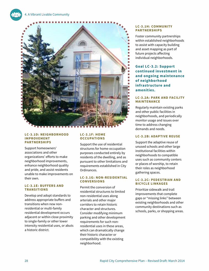
4. A Vibrant Livable Community
28 Rapid City Comprehensive Plan – Revised Draft: March 2014
LC-3.1D: NEIGHBORHOOD IMPROVEMENT PARTNERSHIPS
Support homeowners’ associations and other organizations’ efforts to make neighborhood improvements, enhance neighborhood quality and pride, and assist residents unable to make improvements on their own.
LC-3.1E: BUFFERS AND TRANSITIONS
Develop and adopt standards to address appropriate buffers and transitions when new non-residential or multi-family residential development occurs adjacent or within close proximity to single-family or other lower intensity residential uses, or abuts a historic district.
LC-3.1F: HOME OCCUPATIONS
Support the use of residential structures for home-occupation purposes conducted entirely by residents of the dwelling, and as pursuant to other limitations and requirements established in City Ordinances.
LC-3.1G: NON-RESIDENTIAL CONVERSIONS
Permit the conversion of residential structures to limited non-residential uses along arterials and other major corridors to retain historic character and structures. Consider modifying minimum parking and other development requirements for such non-residential uses in these areas, which can dramatically change their historic character or compatibility with the existing neighborhood.
LC-3.1H: COMMUNITY PARTNERSHIPS
Foster community partnerships within established neighborhoods to assist with capacity building and asset mapping as part of future projects affecting individual neighborhoods.
Goal LC-3.2: Support continued investment in and ongoing maintenance of neighborhood infrastructure and amenities.
LC-3.2A: PARK AND FACILITY MAINTENANCE
Regularly maintain existing parks and other public facilities in neighborhoods, and periodically monitor usage and issues over time to address changing demands and needs.
LC-3.2B: ADAPTIVE REUSE
Support the adaptive reuse of unused schools and other large institutional facilities within neighborhoods to compatible uses such as community centers or places of worship, to retain their roles as neighborhood gathering spaces.
LC-3.2C: PEDESTRIAN AND BICYCLE LINKAGES
Prioritize sidewalk and trail improvements that complete gaps or “missing links” between existing neighborhoods and other community destinations such as schools, parks, or shopping areas.

4. A Vibrant Livable Community
Rapid City Comprehensive Plan – Revised Draft: March 2014 29
Principle LC-4: Sustaining a Vibrant Downtown Center
Downtown Rapid City continues to function as the primary, historic center of the community and the hub of cultural, tourism, and government activities for the region. Ongoing revitalization efforts by the City and its partners will ensure the vitality of Downtown continues to flourish. Opportunities for infill and redevelopment within and adjacent to the Downtown Core will be balanced with the preservation of the historic character that is valued by residents and visitors alike. Linkages between Downtown and other centers of activity within the community, such as the Civic Center, South Dakota School of Mines and Technology, and others will continue to be strengthened.
Goal LC-4.1: Reinforce the role of the Downtown as a Regional Activity Center.
LC-4.1B: DIVERSE MIX OF USES
Encourage a diverse mix of uses Downtown including residential, retail, services, employment, entertainment, and public uses, to support the needs of both local residents and visitors, and to encourage round-the-clock vibrancy and activity levels. Integrate a mix of residential housing types within the Downtown Core, as well as in surrounding neighborhoods.
LC-4.1C: PUBLIC ART
Encourage a range of temporary and permanent arts and cultural installations and exhibits Downtown to enhance, activate, and add interest to public spaces.
LC-4.1D: PROGRAMMING AND EVENTS
Support a range of regional, State, and international programming and events that enliven downtown and support business, and cater to diverse audiences including Downtown and City residents, families, students, and visitors.
LC-4.1E: EFFECTIVE PARKING STRATEGY
Explore ways to maximize the effectiveness of downtown parking, including free and metered on-street spaces, and public and private parking lots and structures.
LC-4.1F: NEIGHBORHOOD TRANSITIONS
Establish transitions between more intense Downtown uses and
adjacent residential neighborhoods by buffering them with careful site design, building placement and landscaping, and ensuring appropriate heights, setbacks, step-downs, and massing when new development or redevelopment occurs in transitional areas.
Goal LC-4.2: Promote increased synergy between the Downtown Core and nearby centers of activity.
LC-4.1A: DOWNTOWN AREA MASTER PLAN
Develop a plan and accompanying strategy for the areas east and north of the Downtown Core, building on the recommendations of the Downtown Master Plan and south Dakota School of Mines and Technology (SDSMT) Master Plan, and the planned expansion of the Rushmore Plaza Civic Center.
LC-4.2A: DIVERSIFICATION OF USES
Encourage intensification and diversification of uses east and north of Downtown, with an emphasis on expanding housing options for students and the local workforce, and shops and services to support tourism and complement the growing SDSMT campus and Rushmore Plaza Civic Center expansion. Establish locations and opportunities to facilitate growth of start-up businesses generated by SDSMT and the Black Hills Business Development Center. Explore opportunities to move the City Streets Shop out of the Downtown area.
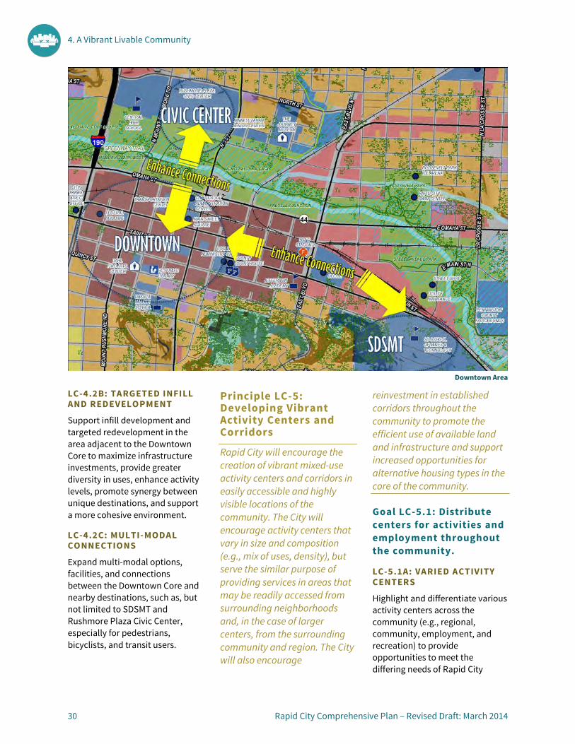
4. A Vibrant Livable Community
30 Rapid City Comprehensive Plan – Revised Draft: March 2014
LC-4.2B: TARGETED INFILL AND REDEVELOPMENT
Support infill development and targeted redevelopment in the area adjacent to the Downtown Core to maximize infrastructure investments, provide greater diversity in uses, enhance activity levels, promote synergy between unique destinations, and support a more cohesive environment.
LC-4.2C: MULTI-MODAL CONNECTIONS
Expand multi-modal options, facilities, and connections between the Downtown Core and nearby destinations, such as, but not limited to SDSMT and Rushmore Plaza Civic Center, especially for pedestrians, bicyclists, and transit users.
Principle LC-5: Developing Vibrant Activity Centers and Corridors
Rapid City will encourage the creation of vibrant mixed-use activity centers and corridors in easily accessible and highly visible locations of the community. The City will encourage activity centers that vary in size and composition (e.g., mix of uses, density), but serve the similar purpose of providing services in areas that may be readily accessed from surrounding neighborhoods and, in the case of larger centers, from the surrounding community and region. The City will also encourage
reinvestment in established corridors throughout the community to promote the efficient use of available land and infrastructure and support increased opportunities for alternative housing types in the core of the community.
Goal LC-5.1: Distribute centers for activities and employment throughout the community.
LC-5.1A: VARIED ACTIVITY CENTERS
Highlight and differentiate various activity centers across the community (e.g., regional, community, employment, and recreation) to provide opportunities to meet the differing needs of Rapid City
Downtown Area
4. A Vibrant Livable Community
Rapid City Comprehensive Plan – Revised Draft: March 2014 31
residents, workers, employers, and visitors. The Future Land Use Plan map identifies the following Activity Centers:
Regional Activity Centers
• Downtown (includes Rushmore Plaza Civic Center, SDSMT, and other major destinations)
• Rushmore Mall • Rushmore Crossing
Community Activity Centers
• Baken Park • Catron Boulevard at Sheridan
Lake Road • Civic Center • East Highway 44 at East 53rd
Street • East Highway 44 at Radar Hill
Road • Elk Vale at South Valley Drive • FTC Express Center • Mount Rushmore Road at Moon
Meadows Road • New Safeway Area • Northgate Shopping Center • Family Thrift Center at St.
Patrick and Cambell Street • University Center Area • US 16 Tourism Area • Wal-Mart Supercenter Area • Rapid Valley Area • Regional Health Center • Mount Rushmore Road Office
Park • North Rapid Light Industrial
Area
LC-5.1B: DIVERSE MIX OF USES
Support a diverse mix of uses in activity centers to add variety and economic resiliency. Encourage residential uses in new and emerging regional and
community activity centers and explore integrating residential uses to add vibrancy to existing, underutilized activity centers.
LC-5.1C: MULTI-MODAL CONNECTIONS
Encourage multi-modal connections and improvements such as direct bicycle, pedestrian, transit, and vehicular routes that link activity centers and other key community destinations like schools and public facilities.
LC-5.1D: PUBLIC SPACE AND AMENITIES
Incorporate public spaces, libraries, and other amenities such as plazas, patios, and greenspaces into the design of new activity centers and explore opportunities to enhance amenities and public spaces in existing activity centers.
LC-5.1E: NEIGHBORHOOD CONNECTIONS
Enhance pedestrian and bicycle connections between neighborhoods and nearby activity centers to provide safe and convenient access for all residents without needing to rely upon a personal automobile.
Goal LC-5.2: Support reinvestment and revitalization in underutilized activity centers and along the community’s key corridors.
LC-5.2A: PRIORITY REVITALIZATION CORRIDORS
Prioritize corridors for reinvestment and align infrastructure investments and other public improvements with
these areas to encourage private investment and rehabilitation.
LC-5.2B: REDUCE BARRIERS
Encourage a broader mix of uses (including residential) along corridors and within activity centers in need of reinvestment and revitalization through infill, redevelopment, and adaptive reuse of existing structures. Explore options to reduce barriers to property reuse and reinvestment, such as minimum parking standards and building code requirements.
LC-5.2C: PROPERTY ASSEMBLAGE
Encourage and consider facilitating the consolidation and assemblage of properties to improve and coordinate the redevelopment of blocks or segments of activity centers or corridors, rather than employing a property-by-property approach.
LC-5.2D: MULTI-MODAL CONNECTIONS
Support reinvestment and revitalization of activity centers by encouraging and investing in sidewalk, bicycle, and transit improvements to enhance connectivity to activity centers and along major corridors.

4. A Vibrant Livable Community
32 Rapid City Comprehensive Plan – Revised Draft: March 2014
Principle LC-6: Protecting the City’s Environmental, Cultural, and Historic Resources
Rapid City will strive to protect its character-defining natural features and the natural environment as the community grows over time. In addition, Rapid City will continue to promote and strengthen the protection of historically and culturally significant resources that contribute to the community’s unique identity and history and its marketability as a tourism destination.
Goal LC-6.1: Conserve Rapid City’s unique cultural and historic assets.
LC-6.1A: COMPREHENSIVE PRESERVATION PLAN
Periodically update the City’s Comprehensive Preservation Plan to reflect changes in City regulations, the addition of new historic districts, and planning objectives.
LC-6.1B: HISTORIC LANDMARKS AND AREAS
Promote the preservation of historic buildings, signs, districts, and sites of local, regional, and national significance. Update existing historic districts (as shown below) as necessary and identify potentially eligible districts and individual resources.
LC-6.1C: SURVEY AND INVENTORY EFFORTS Continue to expand survey and inventory efforts:
• Identifying and prioritizing geographic areas and specific resource types to be surveyed;
• Developing and implementing evaluation standards for surveyed resources;
• Updating outdated surveys as needed; and
• Developing and maintaining a list of threatened resources.
LC-6.1D: EDUCATION AND OUTREACH Continue to support the efforts of the Historic Preservation Commission (HPC) and efforts to increase awareness in the community regarding the City’s historic resources, and resources available to support property owners interested in preserving historic resources.

4. A Vibrant Livable Community
Rapid City Comprehensive Plan – Revised Draft: March 2014 33
LC-6.1E: CULTURAL ASSETS
Retain and protect community traditions, historic landscapes, libraries, and other cultural assets to retain the City’s authenticity and appeal. Such assets include, but are not limited to, the annual Black Hills Pow Wow, presidential sculptures Downtown, Storybook Island, Dinosaur Park, Founders Park, Memorial Park and Civic Center, Canyon Lake Park, and the Game Fish and Parks Outdoor Campus. Coordinate with members of area Indian reservations—Pine Ridge, Rosebud, and Cheyenne River Sioux—and other groups to support these efforts.
LC-6.1F: REINVESTMENT AND REHABILITATION
Support efforts to restore and rehabilitate historic properties, and support the development and adoption of City historic district design guidelines to tailor the Secretary of the Interior’s standards to unique local conditions.
LC-6.1G: COMPATIBLE INFILL
Ensure new infill development and redevelopment is compatible with historic properties and districts through application of historic review processes and/or design guidelines.
Goal LC-6.2: Conserve and protect Rapid City’s natural resources and environment.
LC-6.2A: AIR QUALITY
Protect air quality by encouraging the development of land use patterns that reduce vehicle trips, support transportation alternatives that decrease dependence on single-occupancy vehicles, establishing targets for and monitoring greenhouse gas emissions, and promoting energy efficiency in existing and new buildings.
LC-6.2B: WATER QUALITY
Protect water quality by limiting development in floodplain areas, investing in repairs and improvements to drainage and water treatment infrastructure, and monitoring and ensuring compliance with local, state, and federal water requirements.
LC-6.2C: NATURAL FEATURES
Protect the natural and scenic character of key areas such as the Skyline Drive Wilderness Area, greenway tracts, and Jackson Boulevard/Highway 44 corridor to the west by avoiding extensive development, signage, and lighting in these areas.
LC-6.2D: AGRICULTURAL CONSERVATION
Support existing agriculture operations and retain existing agricultural zoning outside of the Urban Services Boundary. Avoid rezoning agricultural land for speculative purposes, and encourage the submittal of development plans when agricultural land is proposed to be rezoned.
LC-6.2E: WILDLIFE CORRIDORS
Explore guidelines or standards to protect and limit new development in established wildlife corridors.
LC-6.2F: SUSTAINABLE DEVELOPMENT
Encourage the use of sustainable development practices in public facilities, private development, and the design of parks, landscaping, and stormwater management facilities to reduce water and energy consumption, protect water and air quality, and minimize impacts on natural features and wildlife habitat.

5. A Safe, Healthy, Inclusive & Skilled Community
5


5. A Safe, Healthy, Inclusive & Skilled Community
Rapid City Comprehensive Plan – Revised Draft: March 2014 37
OVERVIEW Many different City departments, service providers, agencies, and community groups work together to protect the lives and properties of Rapid City residents. Overall, Rapid City is generally a safe community; however this does not mean that properties and residents are not without risks. Natural hazards such as flooding, severe winter storms, and wildfires have all occurred in recent years, and the City is vulnerable to future natural hazard events as well. Human activities, such as crime, engaging
in unhealthy behaviors, and building in unsuitable areas also present long-term risks to the population. Emphasis on reducing these natural and human-induced risks, as well as promoting preparedness will help increase resiliency when hazards arise.
Physical activity and access to food and services also play important roles in community wellness. Rapid City is fortunate to have an extensive parks and greenway system that supports recreation, as well as numerous recreational facilities and offerings. However, gaps and missing connections in the
sidewalk, trails, and bicycle systems limit the community’s full potential to engage in active transportation modes such as walking and bicycling. In terms of food and nutrition, the Rapid City area has higher rates of obesity than national averages, and some portions of the community have limited access to healthy foods. Increasing opportunities for convenient, affordable, and healthy foods to all populations is critical to improve overall health and nutrition.
Rapid City features numerous health and social service providers, which serve the local
We rely on the City’s police and fire departments to keep us safe and protect our property from harm for safety and protection, yet understand we all need to value our community and care for our families, homes, and neighbors. Careful planning is necessary to ensure that our future safety needs will be met as the City continues to grow. In addition to ensuring the safety of our community, we envision a community that supports our health and well-being; one that provides access to health care services, enables active and healthy lifestyles, provides educational opportunities for our youth and workforce to develop the skills needed to succeed, and recognizes that everyone must play a role in the betterment of our neighborhoods and our community.. Likewise, we will strive to be a community that is recognized as being welcoming and inclusive to people of all ages, ethnic groups, family type, and economic standing.

5. A Safe, Healthy, Inclusive & Skilled Community
38 Rapid City Comprehensive Plan – Revised Draft: March 2014
community and the broader region. Improved access and transportation to these health and social services is a key need, especially for residents who do not drive. As the population ages, many residents will likely find themselves in need of these services, but lacking the ability to drive themselves.
Like its broad network of health and social service providers, Rapid City also is home to an array of educational providers including a large public school system, five higher education institutions, and many other learning resources and opportunities. Continued coordination with these institutions and providers will support numerous community objectives including workforce development, resource sharing and maximization, and attracting and retaining youth and families.
To support the vision for a safe, healthy, inclusive, and skilled community, the principles, goals, and policies in this chapter address the following:
• Ensuring secure, safe public spaces, neighborhoods, and business districts;
• Minimizing hazard risks and enhancing resiliency;
• Supporting community health and well-being;
• Fostering a caring and inclusive community; and
• Focusing on lifelong learning.
PRINCIPLES, GOALS, AND POLICIES (SHIS) Principle SHIS-1: Ensuring Safe and Secure Public Spaces, Neighborhoods, and Business Districts
Rapid City will be a safe and secure community by continuing to provide high quality services for policing and law enforcement, fire protection, and life safety. Increased emphasis will be placed on enhancing perceptions of public safety through design of buildings, parking areas, pathways, landscaping, and roadways. Collaboration between safety providers and residents and businesses will promote open lines of communication and strengthen our sense of safety and community.
Goal SHIS-1.1: Continue to provide high quality community safety services.
SHIS-1.1A: LEVELS OF SERVICE
Determine and monitor appropriate levels of service and response times for police, fire, and emergency medical services. Explore options to maintain levels of safety service as the community grows, such as increased service fees, impact fees on new development, and land dedications in major subdivisions.
SHIS-1.1B: GROWTH COORDINATION
Align future expansions and improvements to address existing needs and support future growth. Explore options to maintain levels of service as the community grows, such as impact fees, land dedications, and payments in lieu of land dedications.
SHIS-1.1C: TAILORED APPROACH
Tailor patrol methods, station locations, and response approaches to different needs and areas of the community, such as police foot patrols Downtown, bicycle patrols along the greenway, and coordination with County, Federal, and volunteer service providers at the community’s fringe.
Goal SHIS-1.2: Employ a proactive, collaborative approach to enhance community safety.
SHIS-1.2A: CRIME PREVENTION THROUGH DESIGN
Integrate crime prevention through environmental design principles into the design of public spaces and development areas to reduce opportunities for criminal activity and increase safety for all users.
SHIS-1.2B: ACTIVE COMMUNITY INVOLVEMENT
Encourage proactive community involvement in neighborhood and City safety matters, including cooperation with law enforcement and safety personnel, neighborhood watches, home/business security and monitoring, and other grassroots efforts.
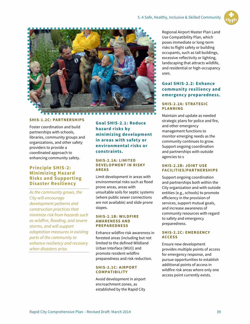
5. A Safe, Healthy, Inclusive & Skilled Community
Rapid City Comprehensive Plan – Revised Draft: March 2014 39
SHIS-1.2C: PARTNERSHIPS
Foster coordination and build partnerships with schools, libraries, community groups and organizations, and other safety providers to provide a coordinated approach to enhancing community safety.
Principle SHIS-2: Minimizing Hazard Risks and Supporting Disaster Resiliency
As the community grows, the City will encourage development patterns and construction practices that minimize risk from hazards such as wildfire, flooding, and severe storms, and will support adaptation measures in existing parts of the community to enhance resiliency and recovery when disasters arise.
Goal SHIS-2.1: Reduce hazard risks by minimizing development in areas with safety or environmental risks or constraints.
SHIS-2.1A: LIMITED DEVELOPMENT IN RISKY AREAS
Limit development in areas with environmental risks such as flood prone areas, areas with unsuitable soils for septic systems (where public sewer connections are not available) and slide prone slopes.
SHIS-2.1B: WILDFIRE AWARENESS AND PREPAREDNESS
Enhance wildfire risk awareness in forested areas (including but not limited to the defined Wildland Urban Interface (WUI)) and promote resident wildfire preparedness and risk reduction.
SHIS-2.1C: AIRPORT COMPATIBILITY
Avoid development in airport encroachment zones, as established by the Rapid City
Regional Airport Master Plan Land Use Compatibility Plan, which poses immediate or long-term risks to flight safety or building occupants, such as tall buildings, excessive reflectivity or lighting, landscaping that attracts wildlife, and residential or high-occupancy uses.
Goal SHIS-2.2: Enhance community resiliency and emergency preparedness.
SHIS-2.2A: STRATEGIC PLANNING
Maintain and update as needed strategic plans for police and fire, and other emergency management functions to monitor emerging needs as the community continues to grow. Support ongoing coordination and partnerships with outside agencies to s
SHIS-2.2B: JOINT USE FACILITIES/PARTNERSHIPS
Support ongoing coordination and partnerships both within the City organization and with outside entities (e.g., schools) to promote efficiency in the provision of services, support mutual goals, and increase awareness of community resources with regard to safety and emergency preparedness.
SHIS-2.2C: EMERGENCY ACCESS
Ensure new development provides multiple points of access for emergency response, and pursue opportunities to establish additional points of access in wildfire risk areas where only one access point currently exists.
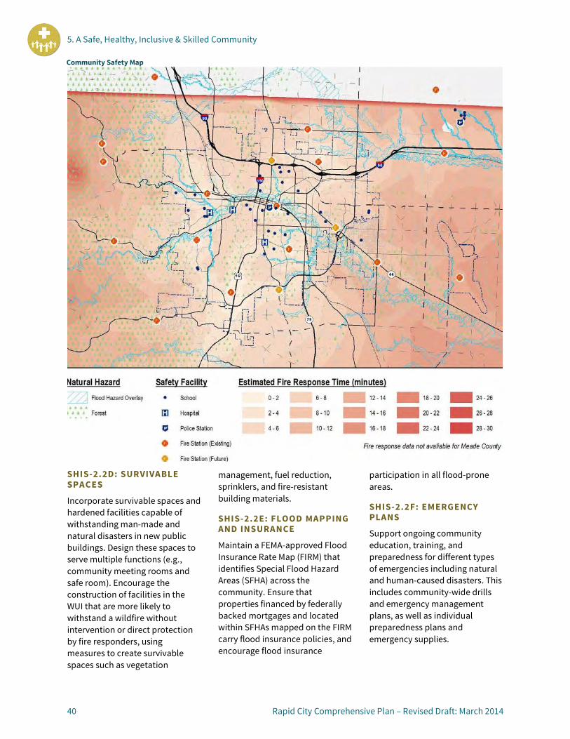
5. A Safe, Healthy, Inclusive & Skilled Community
40 Rapid City Comprehensive Plan – Revised Draft: March 2014
SHIS-2.2D: SURVIVABLE SPACES
Incorporate survivable spaces and hardened facilities capable of withstanding man-made and natural disasters in new public buildings. Design these spaces to serve multiple functions (e.g., community meeting rooms and safe room). Encourage the construction of facilities in the WUI that are more likely to withstand a wildfire without intervention or direct protection by fire responders, using measures to create survivable spaces such as vegetation
management, fuel reduction, sprinklers, and fire-resistant building materials.
SHIS-2.2E: FLOOD MAPPING AND INSURANCE
Maintain a FEMA-approved Flood Insurance Rate Map (FIRM) that identifies Special Flood Hazard Areas (SFHA) across the community. Ensure that properties financed by federally backed mortgages and located within SFHAs mapped on the FIRM carry flood insurance policies, and encourage flood insurance
participation in all flood-prone areas.
SHIS-2.2F: EMERGENCY PLANS
Support ongoing community education, training, and preparedness for different types of emergencies including natural and human-caused disasters. This includes community-wide drills and emergency management plans, as well as individual preparedness plans and emergency supplies.
Community Safety Map

5. A Safe, Healthy, Inclusive & Skilled Community
Rapid City Comprehensive Plan – Revised Draft: March 2014 41
Principle SHIS-3: Supporting Community Health and Well-Being
Rapid City aims to be a healthy community, enabling its residents to pursue meaningful and fulfilling lives. The City will seek opportunities to increase the health and well-being of residents by supporting healthy living and lifestyle choices, and by providing opportunities for active recreation and transportation, such as walking and bicycling. The City will encourage and support local food production and distribution systems to improve the availability of and accessibility to healthy foods.
Goal SHIS-3.1: Expand opportunities for fitness and active living.
SHIS-3.1A: PEDESTRIAN AND BICYCLE NETWORKS
Enhance options for active transportation, such as pedestrian and bicycle travel. Ensure that sidewalks, trails, and bicycle lanes are provided as development occurs, and prioritize the construction of missing links to connect bicycle and pedestrian facilities and traffic calming mechanisms in high-traffic areas.
SHIS-3.1B: INDOOR AND OUTDOOR RECREATION
Encourage a variety of publicly and privately run indoor and outdoor recreation facilities across the community to provide opportunities for physical activity and support healthy lifestyles.
SHIS-3.1C: RECREATION OPTIONS
Support a wide variety of public and private recreational offerings to satisfy the needs and demands of all ages and abilities of Rapid City’s residents.
SHIS-3.1D: ACTIVE LIFESTYLE COLLABORATION
Collaborate with schools, community health and wellness organizations, and the medical community to encourage active lifestyles, to expand recreation options, and to increase awareness about fitness options and the benefits of healthy living.
Goal SHIS-3.2: Enhance options for food that is healthy, affordable, and convenient.
SHIS-3.2A: LOCAL FOOD SYSTEMS
Support existing agricultural operations and the development of personal gardening and local food systems (such as community gardens, farmers’ markets, shared commercial kitchens, and food cooperatives/retailers) to expand access to healthy food options.
SHIS-3.2B: NUTRITION COORDINATION
Coordinate with schools, food banks, food retailers, health and social services providers, and others to address community nutrition needs and to expand access to healthy and affordable foods.
SHIS-3.2C: FOOD RETAILER DEVELOPMENT
Support the development and geographic distribution of food retailers across the community. Encourage food retailers that
provide healthy and nutritious products, and consider health impacts when reviewing proposals for convenience stores and/or fast food retailers in neighborhoods or areas with few other food options.
Goal SHIS-3.3: Increase the accessibility of health and social services.
SHIS-3.3A: FACILITY COORDINATION
Coordinate and collaborate with health and social service providers on the siting of new facilities. Encourage locations that are convenient for clients, and explore options for shared-use facilities to maximize efficiency and client access.
SHIS-3.3B: MULTI-MODAL ACCESSIBILITY
Support improvements that increase opportunities for community members to access health and social services, such as transit service adjustments and bicycle and pedestrian linkages.

5. A Safe, Healthy, Inclusive & Skilled Community
42 Rapid City Comprehensive Plan – Revised Draft: March 2014
SHIS-3.3C: NEARBY HOUSING
Encourage housing (especially for the elderly, disabled, low-income and other special populations) in close proximity to health and social service facilities to enhance convenience and provide opportunities for access without needing to drive.
Goal SHIS-3.4: Encourage wellness through education and prevention.
SHIS-3.4A: COMMUNITY AWARENESS Participate in school and agency programs that increase awareness and educate citizens on the importance of making healthy choices in regards to their mind and body—such as programs to combat tobacco, alcohol, and drug dependency and raise awareness on suicide prevention resources.
SHIS-3.4B: PREVENTION WORKFORCE EDUCATION
Support skilled prevention workforce education and skill development by encouraging the continuation and expansion of educational programs that match the skills and needs of existing prevention and health promotion providers.
Principle SHIS-4: Fostering a Caring and Inclusive Community
Rapid City strives to be a community that is free from discrimination and is welcoming and inclusive to people of all ages, ethnic groups, family type, and economic standing. The City will embrace diversity, and encourage and promote opportunities for all residents to be as self-sufficient as their abilities allow. The City will continue to collaborate with social, health, and human service providers to seek ways to effectively engage underserved and vulnerable populations in community discussions, events, and activities.
Goal SHIS-4.1: Eliminate discrimination and support opportunities for residents of all abilities, ethnicities, and income levels.
SHIS-4.1A: GOVERNMENT INCLUSIVENESS
Provide a welcoming environment and encourage participation in
City government at all levels by residents of all abilities, ages, gender, ethnicities, income levels, and family types.
SHIS-4.1B: DIVERSITY COLLABORATION
Pursue partnerships and opportunities to collaborate with community groups and organizations to support diversity, reduce discrimination, and engage special populations.
Principle SHIS-5: Placing a Strong Focus on Lifelong Learning
Rapid City residents value the community’s first-rate schools and libraries, and will continue to support the maintenance and enhancement of facilities needed to provide quality educational opportunities for the community. Continuing support will be provided for our higher learning institutions, with a particular emphasis on matching workforce training to local employment opportunities that will allow the community to retain talented students as they begin their careers and providing continuing education opportunities for the older adult population.
Goal SHIS-5.1: Support a citywide network of strong and successful schools.
SHIS-5.1A: EDUCATION COORDINATION
Coordinate with the school district, area colleges, and other workforce development and training institutions on short and

5. A Safe, Healthy, Inclusive & Skilled Community
Rapid City Comprehensive Plan – Revised Draft: March 2014 43
long-range planning issues, including but not limited to campus plans, facility needs, transportation, and housing.
SHIS-5.1B: FACILITY SHARING AND REUSE
Encourage shared City/school facilities, such as community centers and parks, to maximize investments and available resources. Explore options for repurposing or reuse if existing school facilities close, to retain activity levels and prevent neighborhood degradation.
Goal SHIS-5.2: Develop and retain a skilled workforce and enhance opportunities for lifelong learning.
SHIS-5.2A: LINKING TRAINING AND JOBS
Support ongoing coordination among local colleges, training facilities, economic development organizations, and employers to match workforce training with local industries and employment opportunities.
SHIS-5.2B: LIFELONG LEARNING
Encourage the growth of educational institutions that provide opportunities for learning throughout all stages of life, including but not limited to early childhood education, primary and secondary institutions, vocational programs, enrichment classes, and online opportunities.

6. Efficient Transportation & Infrastructure Systems 6

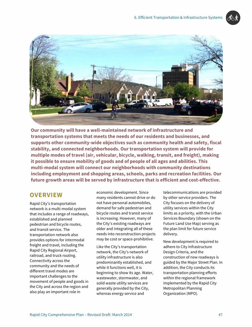
6. Efficient Transportation & Infrastructure Systems
Rapid City Comprehensive Plan – Revised Draft: March 2014 47
OVERVIEW Rapid City’s transportation network is a multi-modal system that includes a range of roadways, established and planned pedestrian and bicycle routes, and transit service. The transportation network also provides options for intermodal freight and travel, including the Rapid City Regional Airport, railroad, and truck routing. Connectivity across the community and the needs of different travel modes are important challenges to the movement of people and goods in the City and across the region and also play an important role in
economic development. Since many residents cannot drive or do not have personal automobiles, demand for safe pedestrian and bicycle routes and transit service is increasing. However, many of the City’s existing roadways are older and integrating all of these needs into reconstruction projects may be cost or space-prohibitive.
Like the City’s transportation network, the City’s network of utility infrastructure is also predominantly established, and while it functions well, it is beginning to show its age. Water, wastewater, stormwater, and solid waste utility services are generally provided by the City, whereas energy service and
telecommunications are provided by other service providers. The City focuses on the delivery of utility services within the City limits as a priority, with the Urban Services Boundary (shown on the Future Land Use Map) serving as the plan limit for future service delivery.
New development is required to adhere to City Infrastructure Design Criteria, and the construction of new roadways is guided by the Major Street Plan. In addition, the City conducts its transportation planning efforts within the regional framework implemented by the Rapid City Metropolitan Planning Organization (MPO).
Our community will have a well-maintained network of infrastructure and transportation systems that meets the needs of our residents and businesses, and supports other community-wide objectives such as community health and safety, fiscal stability, and connected neighborhoods. Our transportation system will provide for multiple modes of travel (air, vehicular, bicycle, walking, transit, and freight), making it possible to ensure mobility of goods and of people of all ages and abilities. This multi-modal system will connect our neighborhoods with community destinations including employment and shopping areas, schools, parks and recreation facilities. Our future growth areas will be served by infrastructure that is efficient and cost-effective.

6. Efficient Transportation & Infrastructure Systems
48 Rapid City Comprehensive Plan – Revised Draft: March 2014
Because much of Rapid City’s transportation and utility infrastructure is mature, maintenance and repair needs usually outpace available funding. Due to these fiscal constraints, careful planning is needed to ensure that future growth is served by infrastructure that is efficient and cost effective, while also balancing the ongoing maintenance, repair, and upgrading of existing systems.
In order to support the vision for efficient transportation and infrastructure systems, the principles, goals, and policies in this chapter address the following:
• Planning for the efficient provision and maintenance of infrastructure;
• Providing a safe and efficient multi-modal transportation system; and
• Supporting an integrated intermodal network.
PRINCIPLES, GOALS, AND POLICIES (TI) Principle TI-1: Planning for the Efficient Provision and Maintenance of Infrastructure
Public infrastructure facilities and services needed to serve the community, such as potable water, sanitary sewer, and storm drainage, will be provided for, maintained, and expanded efficiently. The City will make efforts to improve the linkage between infrastructure planning and land use planning to ensure that infrastructure is used as a tool to help manage growth, not as a service that is provided in reaction to growth pressures.
Goal TI-1.1: Coordinate the planning, construction, and maintenance of utility and transportation infrastructure projects to maximize benefits and efficiency.
TI-1.1A: PROJECT ALIGNMENT AND PRIORITIZATION
Coordinate infrastructure-planning efforts between Public Works, Transportation Planning, and Community Planning to align the prioritization horizons of projects that use the same right-of-way.
TI-1.1B: INTEGRATED MAPPING SYSTEMS
Coordinate utility, transportation, and land use mapping and database systems.
TI-1.1C: UTILITY UNDERGROUNDING
Pursue opportunities to underground existing overhead utility lines during the construction or reconstruction of public infrastructure projects to increase service quality and enhance aesthetics.
TI-1.1D: SEWER DISTRICTS Coordinate with local Sewer Districts as needed to promote efficiency in the provision of sanitary sewer service and support necessary transitions to City service, where applicable, for existing development.
Goal TI-1.2: Proactively plan for utility and transportation infrastructure construction, maintenance, and improvements.
TI-1.2A: ASSET MANAGEMENT
Employ asset management practices to prolong the remaining service life of existing infrastructure and deploy funds in an efficient and effective manner.
TI-1.2B: INFRASTRUCTURE PROJECTS INFORMED BY PLANS
Use the land use and transportation plans (including, but not limited to the Future Land Use Plan and Major Street Plan) to inform and help prioritize infrastructure projects.

6. Efficient Transportation & Infrastructure Systems
Rapid City Comprehensive Plan – Revised Draft: March 2014 49
TI-1.2C: DOCUMENT NEEDS
Maintain thorough documentation of existing and anticipated future infrastructure needs and priorities, including maintenance, repair, replacement, upgrades, reconstruction, and new construction.
TI-1.2D: AIRPORT INFRASTRUCTURE
Invest in additional infrastructure to include the Rapid City Regional Airport in the City’s water and wastewater systems.
Principle TI-2: Providing a Safe and Efficient Multi-Modal Transportation System
Rapid City will maintain a safe transportation system that provides for efficient travel within and through the community for all motorized and non-motorized modes. This will include linking the City’s many neighborhoods, employment areas, parks, schools, and recreational facilities with a comprehensive system of roadways, multi-use pathways, bicycle facilities, and sidewalks. Additionally, the City will seek opportunities to expand existing transit services to increase travel choices for the community.
Goal TI- 2.1: Synchronize the transportation system with land use needs.
TI-2.1A: MAJOR STREET PLAN INTEGRATION
Integrate the Major Street Plan into land use planning and the development review process in order to ensure the development and maintenance of a complete roadway network.
TI-2.1B: MULTI-MODAL REVIEW
Consider and address all travel modes (including automobile, pedestrian, bicycle, and transit) in the development review process.
TI-2.1C: CONTEXT SENSITIVE SOLUTIONS
Provide context sensitive transportation improvements, as defined by the Federal Highway Administration, to balance roadway classification and land use needs, provide network efficiency, and establish desired character.
TI-2.1D: COORDINATED LAND USE AND TRANSPORTATION PLANNING
Coordinate land use planning and transportation planning, addressing topics such as the provision of sidewalks when developing land use plans and reviewing development proposals.
TI-2.1E: ACCESS MANAGEMENT PLANNING
Apply access management techniques to major corridors, including developing access management plans for key development areas along arterial roadways and/or corridors demonstrating higher frequencies of access-related crashes.
T1-2.1F: TRANSPORTATION STANDARDS AND PLANS
Ensure all development and redevelopment projects conform to the City’s adopted engineering standards and criteria, and help to implement all adopted transportation plans.
6. Efficient Transportation & Infrastructure Systems
50 Rapid City Comprehensive Plan – Revised Draft: March 2014
TI-2.1G: ACTIVITY CENTER ACCESS
Establish multi-modal transportation access to and between the community’s Activity Centers (as identified on the Future Land Use Plan), including vehicular, pedestrian, and bicycle connections and transit service.
TI-2.1H: INFILL AND REDEVELOPMENT COORDINATION
Pursue opportunities to enhance vehicular circulation, pedestrian and bicycle connections and amenities, and transit service as reinvestment, infill development, and redevelopment occur across the community, especially in the Activity Centers and Revitalization Corridors identified on the Future Land Use Plan.
Goal TI-2.2: Develop a network of complete streets to enable safe mobility for all users, including pedestrians, bicyclists, motorists, and transit riders of all ages and abilities.
TI-2.2A: BALANCED MODES
Consider and strive to balance the needs of all transportation modes in improvement project review and decision-making.
TI-2.2B: COMPARABLE ALTERNATIVE ROUTES
Establish comparable or parallel alternative routes for travel modes that cannot be accommodated along or are incompatible with major arterial routes. For example, if a major roadway cannot accommodate on-street bicycle lanes, explore opportunities to accommodate
bicycle travel on a parallel local street or multi-modal pathway.
TI-2.2C: CROSS-SECTION ENHANCEMENTS
Expand and enhance standard street cross-sections to provide more options for various contexts and multi-modal needs using design guidelines provided in the Bicycle and Pedestrian Master Plan.
TI-2.2D: COMPLETE STREETS GUIDE
Adopt Complete Streets guidelines and integrate them into transportation planning and implementation to ensure all users—motorists, pedestrians, bicyclists, and transit riders are accommodated.
Goal TI-2.3: Enhance connectivity and safety for pedestrians of all abilities.
TI-2.3A: SIDEWALK INVENTORY
Monitor, analyze, and document City sidewalk locations, conditions, and gaps, including level of compliance with Americans with Disabilities Act (ADA) requirements.
TI-2.3B: PRIORITY SIDEWALK IMPROVEMENTS
Maintain a prioritized list of necessary sidewalk improvements, including building new connections, maintaining current facilities, and upgrades to existing sidewalks. Prioritize improvements that enhance pedestrian accessibility to and within Activity Centers (as defined on the Future Land Use plan), and as recommended in the City’s
Bicycle and Pedestrian Master Plan.
TI-2.3C: PEDESTRIAN CROSSINGS
Prioritize improvements to pedestrian crossings in areas that enhance the safety of crossing major thoroughfares, especially in high-accident areas and high-activity areas such as Activity Centers and schools.
TI-2.3D: ADA ACCESSIBILITY
Prioritize the replacement of non-ADA compliant sidewalks in areas with high levels of pedestrian activity and around schools.
TI-2.4E: PEDESTRIAN LINKS TO ACTIVITY CENTERS
Preserve and pursue opportunities to establish sidewalks and trails that provide pedestrian connections from neighborhoods to nearby activity centers.
Goal TI-2.4: Develop a comprehensive and connected network for bicycle travel and recreation.
TI-2.4A: MULTI-USER BICYCLE NETWORK
Develop a bicycle network that accommodates and supports all types of bicycling, including paved and unpaved recreational trails and commuter routes.
TI-2.4B: CONNECTED ROUTES
Grow the bicycle network in a manner that provides direct connections between destinations and enhances links between existing bicycle facilities.

6. Efficient Transportation & Infrastructure Systems
Rapid City Comprehensive Plan – Revised Draft: March 2014 51
TI-2.4C: ON AND OFF STREET LINKAGES
Enhance signage, visibility, and other connections between on-street and off-street bicycle facilities.
TI-2.4D: BICYCLIST AMENITIES
Accommodate and encourage bicycling by integrating amenities such as secure bicycle parking, shower facilities, bus racks, ramps, and lighting into the design of new development, and as reinvestment and redevelopment occur.
Goal TI-2.5: Expand transit participation, service, and coordination.
TI-2.5A: BUS STOP AMENITIES
Pursue opportunities to enhance bus stops, especially those that are highly used and/or located within or near Activity Centers (as shown on the Future Land Use Plan). Focus on improvements that enhance safety and functionality for users such as elderly or disabled residents, including ramps, shelters, benches, trash receptacles, lighting, and route information/signage.
TI-2.5B: MULTI-MODAL CONNECTIONS TO TRANSIT
Enhance the connections to transit from other travel modes such as pedestrians, bicyclists, and motorists, and air service. Coordinate transit stops and routes with sidewalk and trail locations, and park-n-ride opportunities.
TI-2.5C: ACCESS TO ACTIVITY CENTERS AND SERVICES
Improve direct transit access to and connectivity between key community destinations including Regional, Community, and Employment areas, as well as to health and social service providers such as City and County offices, Food Bank, and South Dakota Job Services.
TI-2.5D: PROVIDER COORDINATION
Facilitate and support ongoing collaboration and communication between transit service providers to provide cohesive transit services and maximize available resources.
TI-2.5F: SERVICE EXPANSION
Explore opportunities to enhance and expand service hours, coverage, and frequency to better serve and connect the Rapid City community and greater region, especially for the underserved and transit dependent.
Goal TI-2.6: Build a culture of multi-modal transportation awareness and use.
TI-2.6A: TRAVEL DEMAND MANAGEMENT EFFORT CHAMPIONS
Develop and empower resident and agency champions for Travel Demand Management efforts.
TI-2.6B: MULTI-MODAL MARKETING
Market and advertise various travel modes and transportation options to local residents and visitors.
TI-2.6C: REGIONAL COLLABORATION
Develop and nurture regional transportation relationships, and champion collaborative regional planning efforts and activities.
TI-2.6D: LAST MILE CONNECTIONS
Increase multi-modal travel options and transit accessibility by including bicycle racks at bus stops and on buses and enhancing pedestrian and bicycle connections between neighborhoods, activity centers, employment areas, and other community destinations and existing or planned transit stops.
Goal TI-2.7: Enhance regional roadway connectivity.
TI-2.7A: MULTI-STATE CORRIDOR PLANNING
Participate in multi-state corridor planning efforts and support improvements that align with Rapid City’s vision, principles, and goals.
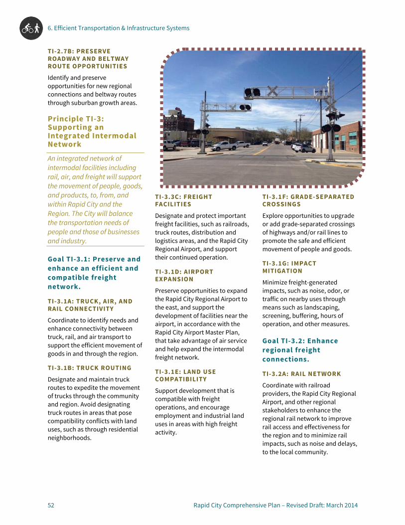
6. Efficient Transportation & Infrastructure Systems
52 Rapid City Comprehensive Plan – Revised Draft: March 2014
TI-2.7B: PRESERVE ROADWAY AND BELTWAY ROUTE OPPORTUNITIES
Identify and preserve opportunities for new regional connections and beltway routes through suburban growth areas.
Principle TI-3: Supporting an Integrated Intermodal Network
An integrated network of intermodal facilities including rail, air, and freight will support the movement of people, goods, and products, to, from, and within Rapid City and the Region. The City will balance the transportation needs of people and those of businesses and industry.
Goal TI-3.1: Preserve and enhance an efficient and compatible freight network.
TI-3.1A: TRUCK, AIR, AND RAIL CONNECTIVITY
Coordinate to identify needs and enhance connectivity between truck, rail, and air transport to support the efficient movement of goods in and through the region.
TI-3.1B: TRUCK ROUTING
Designate and maintain truck routes to expedite the movement of trucks through the community and region. Avoid designating truck routes in areas that pose compatibility conflicts with land uses, such as through residential neighborhoods.
TI-3.3C: FREIGHT FACILITIES
Designate and protect important freight facilities, such as railroads, truck routes, distribution and logistics areas, and the Rapid City Regional Airport, and support their continued operation.
TI-3.1D: AIRPORT EXPANSION
Preserve opportunities to expand the Rapid City Regional Airport to the east, and support the development of facilities near the airport, in accordance with the Rapid City Airport Master Plan, that take advantage of air service and help expand the intermodal freight network.
TI-3.1E: LAND USE COMPATIBILITY
Support development that is compatible with freight operations, and encourage employment and industrial land uses in areas with high freight activity.
TI-3.1F: GRADE-SEPARATED CROSSINGS
Explore opportunities to upgrade or add grade-separated crossings of highways and/or rail lines to promote the safe and efficient movement of people and goods.
TI-3.1G: IMPACT MITIGATION
Minimize freight-generated impacts, such as noise, odor, or traffic on nearby uses through means such as landscaping, screening, buffering, hours of operation, and other measures.
Goal TI-3.2: Enhance regional freight connections.
TI-3.2A: RAIL NETWORK
Coordinate with railroad providers, the Rapid City Regional Airport, and other regional stakeholders to enhance the regional rail network to improve rail access and effectiveness for the region and to minimize rail impacts, such as noise and delays, to the local community.

6. Efficient Transportation & Infrastructure Systems
Rapid City Comprehensive Plan – Revised Draft: March 2014 53
TI-3.2B: PORTS TO PLAINS
Support and participate in planning efforts to connect Rapid City to the Ports to Plains highway corridor.
TI-3.2C: REGIONAL CORRIDORS
Collaborate with regional entities including Pennington and Meade Counties and the Metropolitan Planning Organization to extend and prioritize major corridors to improve regional mobility.
TI-3.2D: SHIPPING COSTS
Coordinate with local businesses and economic development organizations to understand the reasons behind high shipping costs to the City and to explore opportunities to reduce shipping costs and barriers.

7. Economic Stability & Growth7

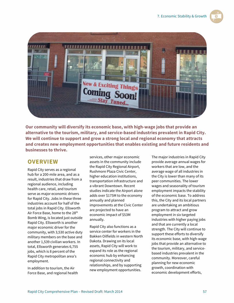
7. Economic Stability & Growth
Rapid City Comprehensive Plan – Revised Draft: March 2014 57
OVERVIEW Rapid City serves as a regional hub for a 200-mile area, and as a result, industries that draw from a regional audience, including health care, retail, and tourism serve as major economic drivers for Rapid City. Jobs in these three industries account for half of the total jobs in Rapid City. Ellsworth Air Force Base, home to the 28th Bomb Wing, is located just outside Rapid City. Ellsworth is another major economic driver for the community, with 3,530 active duty military members on the base and another 1,539 civilian workers. In total, Ellsworth generates 6,755 jobs, which is 8 percent of the Rapid City metropolitan area’s employment.
In addition to tourism, the Air Force Base, and regional health
services, other major economic assets in the community include the Rapid City Regional Airport, Rushmore Plaza Civic Center, higher education institutions, transportation infrastructure and a vibrant Downtown. Recent studies indicate the Airport alone adds over $175M to the economy annually and planned improvements at the Civic Center are projected to have an economic impact of $53M annually.
Rapid City also functions as a service center for workers in the Bakken Oilfields in western North Dakota. Drawing on its local assets, Rapid City will work to expand its role as the regional economic hub by enhancing regional connectivity and relationships, and by supporting new employment opportunities.
The major industries in Rapid City provide average annual wages for workers that are low, and the average wage of all industries in the City is lower than many of its peer communities. The lower wages and seasonality of tourism employment impacts the stability of the economic base. To address this, the City and its local partners are undertaking an ambitious program to attract and grow employment in six targeted industries with higher paying jobs and that are currently a local strength. The City will continue to support these efforts to diversify its economic base, with high-wage jobs that provide an alternative to the tourism, military, and service-based industries prevalent in the community. Moreover, careful planning for new economic growth, coordination with economic development efforts,
Our community will diversify its economic base, with high-wage jobs that provide an alternative to the tourism, military, and service-based industries prevalent in Rapid City. We will continue to support and grow a strong local and regional economy that attracts and creates new employment opportunities that enables existing and future residents and businesses to thrive.
7. Economic Stability & Growth
58 Rapid City Comprehensive Plan – Revised Draft: March 2014
and strategic investments in infrastructure will help bolster the expansion of existing and new industries helping residents and businesses to thrive.
Downtown has become a vibrant community gathering point for residents and a base for tourist activity in the region. The City is committed to fostering development opportunities in and around Downtown to increase economic activity. As the City grows, Downtown needs to remain the focal point of the region and continuing investments in infrastructure and amenities will help ensure Downtown’s ongoing vitality.
A more diverse economic and fiscal tool kit is needed to foster economic activity and support the City’s economic vision and development goals. A comprehensive, strategic approach to investing in public amenities and infrastructure will help maximize existing assets and take advantage of market opportunities. To accomplish this, the City will pursue development of more tools for spurring economic growth and providing public services and amenities, while ensuring that private development is an equal partner in paying for the costs of growth.
To support the vision for economic stability and growth, the principles, goals, and policies in this chapter address:
• Expanding economic diversity; • Strengthening Rapid City’s role
as the regional economic hub; and
• Coordinating to support economic growth.
RELATED EFFORTS Related efforts, organizations, and studies focusing on the Rapid City economy and economic development include the following:
• Rapid City Economic Development Partnership – A 501 (c) (6) non-profit corporation dedicated to the economic growth and development of the Rapid City area that helps facilitate a public-private approach to economic development.
• Black Hills Vision - A regional alliance formed to build a stronger economy in the four county Black Hills region.
• Rapid City Vision 2020 - A strategic vision plan that contains five strategic goals for the City to be achieved by 2020. The goals include being recognized as a leader in retaining, attracting and growing unique businesses, and becoming a premier regional hub.
• Strategic Employment Opportunities Study - A study commissioned by the Rapid City Economic Development Partnership and Black Hills Vision for input on the creation of a new economic development plan for the region to identify economic opportunities and strategies increasing the presence of higher paying jobs. The six target industries are business and professional services, energy-extraction sector, healthcare and life sciences, finance and insurance, metal work manufacturing, and processed foods manufacturing.
• Rapid City Regional Jobs Program - A regional jobs program focused on creating jobs with higher paying wages and growing employment in the six targeted industries identified in the Strategic Employment Opportunities Study.
• Regional Rail Authority - In a partnership with Box Elder and Pennington County, Rapid City is exploring a regional rail authority to gain access to the State Rail Trust Fund, which provides low interest loans for rail oriented infrastructure projects. The effort will create a tool that will make it easier for build rail projects that will benefit the manufacturing and energy sectors.
• Foreign Trade Zone - The City is exploring creating a foreign trade zone that will be used to allow local companies to avoid or defer duties paid on imported goods that are exported internationally or sold domestically. The hope is the zone will attract new businesses, lower costs for local business, and could lead to an international airport designation.
• South Dakota School of Mines - The school’s economic development office works to assist with the start-up companies emerging from research occurring at the school and aid in the creation and registration of patients for technology developed at the school. The school has generated 16 start-up companies coming mainly from efforts of the faculty and alumni of the school.
• Black Hills Knowledge Network – A project of the Black Hills Community Foundation, this organization assembles a wealth of timely information about efforts and events in the region.
7. Economic Stability & Growth
Rapid City Comprehensive Plan – Revised Draft: March 2014 59
PRINCIPLES, GOALS, AND POLICIES (EC) Principle EC-1: Expanding Economic Diversity
Rapid City seeks to foster a strong and diverse economy through activities that are directly targeted at economic development, as well as supporting activities that make the City an attractive place for attracting both employers and those seeking jobs by maintaining a high quality of life. The City will approach economic development activities using a collaborative approach between the public and private sector, as well as through regional economic partnerships.
Goal EC-1.1: Attract and create new businesses within targeted growth industries that will expand the existing economic base.
EC-1.1A: ECONOMIC DEVELOPMENT COORDINATION
Coordinate with the Economic Development Foundation and other economic development entities to create an integrated plan to align the City’s capital improvement program, public financing tools (e.g. tax increment financing) and development incentives.
EC-1.1B: PUBLIC IMPROVEMENTS
Identify, prioritize, and assist with targeted public improvements to support new business development and attraction in Rapid City.
EC-1.1C: INCENTIVE POLICIES AND STRATEGIES
Explore and establish policies and strategies to incentivize new business development within the target industries or that supports growth of Rapid City as a regional service hub.
Goal EC-1.2: Sustain a high quality of life in Rapid City to attract and retain employers and employees.
EC-1.2A: HOUSING STOCK
Maintain diverse and attractive housing options close to employment areas. Support the development of workforce and affordable housing, encourage the development of a diverse set of housing types, and encourage new residential development, infill and redevelopment near major employment centers.
EC-1.2B: DOWNTOWN AS ENTERTAINMENT CENTER
Establish and grow Downtown as the main entertainment center in Rapid City by encouraging arts and entertainment uses, supporting the growth of restaurant and hospitality businesses, and providing and supporting diverse services, events, and programing, such as those offered by the Rapid City Public Library Downtown, Rushmore Plaza Civic Center, Dahl Arts Center, and others.
EC-1.2C: QUALITY SCHOOLS AND LIBRARIES
Coordinate with public and private educational and service providers, including the Rapid City Area School District, secondary education institutions, and Rapid City Public Libraries to ensure educational and lifelong learning needs are met for families in the local workforce.
EC-1.2D: SKILLED WORKFORCE ATTRACTION AND CULTIVATION
Cultivate and attract a skilled workforce by supporting the growth of higher and technical educational institutions in Rapid City, ensuring quality and attainable housing options, and maximizing community amenities like parks, recreation, and cultural facilities and Activity Centers.
Goal EC-1.3: Support the growth and creation of local, small businesses.
EC-1.3A: LOCAL BUSINESS SUPPORT
Support the creation of local businesses by reducing barriers to opening businesses, leveraging existing programs, providing information and business resources through local libraries, and exploring potential incentives and financial tools to assist in new business establishment.
EC-1.3B: BUSINESS EXPANSION RESOURCES
Explore and offer resources to encourage the expansion of existing businesses, and reach out to existing businesses to assess their future expansion needs.

7. Economic Stability & Growth
60 Rapid City Comprehensive Plan – Revised Draft: March 2014
EC-1.3C: BALANCE NEW AND EXISTING BUSINESSES
Ensure that economic development efforts to attract new businesses do not negatively impact existing businesses by evaluating the impact on existing businesses of any potential businesses attracted before providing public funds or incentives.
Principle EC-2: Strengthening Rapid City’s Role as a Regional Economic Hub
Rapid City serves as the economic hub of a region serving portions of 5 states, with an economy based on tourism, agriculture, commercial services, education, medical services, and energy. The City will continue to strengthen its role as a regional center by focusing on the economic health of those sectors that serve a broader market beyond the City boundaries.
Goal EC-2.1: Attract additional retail and service commercial development and redevelopment to enhance the City’s role as a regional commercial hub.
EC-2.1A: DOWNTOWN AREA RETAIL AND ENTERTAINMENT
Support the expansion of retail and entertainment uses in Downtown and the surrounding area by ensuring there are adequate retail space and
development sites available, marketing Downtown a regional destination, offering incentives to overcome barriers for new or expanding businesses, and supporting efforts to enhance and improve connections between the Downtown Core, the Rushmore Plaza Civic Center, and SDSMT.
EC-2.1B: TARGETED REGIONAL RETAIL
Concentrate regional retail areas along Interstate 90 from Haines Avenue to Elk Vale Road to take advantage of the interstate frontage. Ensure that retail centers and areas are well-connected to each other to facilitate and maximize exposure of different retail areas, and encourage the clustering of retailers to encourage shoppers to visit multiple stores per trip.
EC-2.1C: REINVESTMENT INCENTIVES
Explore and offer incentives for reinvestment in existing retail areas and Regional and Community Activity Centers, and areas to allow these areas to adapt to attract new retailers and decrease the need for expanding infrastructure to support new outward growth and development.
EC-2.1D: SERVICE COMMERCIAL
Encourage the expansion of service commercial offerings that serve regional employment activities related to oil, gas, and agriculture by identifying the needs of the industry and workforce and developing a marketing and attraction strategy.
Goal EC-2.2: Enhance the quality of health care services in the City to ensure Rapid City is the regional destination for health care.
EC-2.2A: ADDITIONAL HEALTH CARE SERVICES AND PROVIDERS
Attract additional medical services and providers that are not currently present or are under-represented in Rapid City. Identify strategies to enhance and expand the medical services offered in Rapid City, support the expansion of existing health care services and facilities, and market the medical services available the City.
EC-2.2B: ATTRACT MEDICAL WORKERS
Ensure Rapid City is an attractive community for medical workers to live in by ensuring access to attainable and high quality housing options, supporting vibrant neighborhoods and amenities, and ensuring high quality schools for medical workers’ families. Market the quality of life in Rapid City to potential medical service providers and workers.
EC-2.2C: SKILLED MEDICAL WORKFORCE
Support medical workforce education and skill development by encouraging the continuation and expansion of educational programs that match the skills and needs of existing medical providers. Identify potential opportunities for the City to support educational institutions in providing programs that align with needed medical skills.
7. Economic Stability & Growth
Rapid City Comprehensive Plan – Revised Draft: March 2014 61
Goal EC-2.3: Provide support to Rapid City colleges to allow them to expand and attract students.
EC-2.3A: STUDENT HOUSING AND ENTERTAINMENT
Encourage quality housing, entertainment, and services for students near Downtown and the educational institutions. Prioritize the redevelopment of the area between Downtown and the South Dakota School of Mines as an appealing area for college students, young professionals, and school faculty to reside.
EC-2.3B: COLLEGE PARTNERSHIPS
Partner with colleges to market Rapid City and its secondary education opportunities. Work with the colleges to incorporate their marketing materials within Rapid City promotional materials. Explore and identify amenities that may attract students.
EC-2.3C: PRIVATE SECTOR PARTNERSHIPS
Support and encourage partnerships between colleges and the private sector to expand employment opportunities for students and recent graduates.
EC-2.3D: STUDENT RETENTION
Explore options to encourage recent graduates to remain in Rapid City to start their careers.
Goal EC-2.4: Increase connectivity to Rapid City by providing and enhancing regional transportation connections and related transportation support industries.
EC-2.4A: AIRPORT-CENTERED ECONOMIC DEVELOPMENT
Identify ways to leverage the Rapid City Regional Airport as way to provide more air transportation connections to Rapid City for residents, visitors, and the movement of goods. Identify uses and businesses that could be attracted to the airport area that can benefit from location next the airport and can increase the usage of airport facilities.
EC-2.4B: REGIONAL TRADE AND CONNECTIVITY
Identify potential tools and approaches to increasing regional trade activities in Rapid City. Explore potential regulatory changes, infrastructure improvements and designations that can facilitate improved connectivity for goods and services.
Principle EC-3: Coordinating to Support Economic Growth and Stability
Rapid City will efficiently invest its resources to stimulate economic growth and stability by coordinating land use planning, infrastructure investments, and economic development efforts. The City will aim to align infrastructure investments with economic
development efforts in areas identified for growth or redevelopment. The City will ensure an adequate land supply in locations that further catalyze economic development.
Goal EC-3.1: Encourage employment growth in targeted community locations.
EC-3.1A: EMPLOYMENT AREAS
Support the expansion of existing and established employment areas including the South Dakota School of Mines and Technology, Regional Health Center, Ellsworth Air Force Base, and the National Guard Training Camp. Prioritize the development of emerging employment areas and business parks, as identified below:
• East Anamosa Street/North Elk Vale Road Area Technology Park
• Old Folsom Road Industrial Area
• Rapid City Regional Airport Area
• Mount Rushmore Road Corridor • North Rapid Light Industrial
Area
EC-3.1B: TARGET INDUSTRY ALIGNMENT
Align priority employment areas with targeted industry efforts to support economic development officials in marketing real estate opportunities and amenities to prospective employers. Target industries include: business services, energy/extraction, health care and life sciences, finance and insurance, metalwork
7. Economic Stability & Growth
62 Rapid City Comprehensive Plan – Revised Draft: March 2014
manufacturing, and processed food manufacturing.
EC-3.1C: OTHER EMPLOYMENT AREAS
Encourage the development, redevelopment, and reinvestment in an array of retail, service, office, and other employment uses in all Regional and Community Activity Centers, Mixed-use Commercial, Employment, Light Industrial, and Heavy Industrial areas, as shown on the Future Land Use Plan. Support home occupations and limited, neighborhood-serving commercial and employment uses in Urban and Low Density Neighborhoods.
EC-3.1D: PRIORITY INFRASTRUCTURE IMPROVEMENTS Identify infrastructure improvements needed to support target industry growth and development in employment areas and prioritize the completion of these improvements.
EC-3.1E: REGULATORY ALIGNMENT
Ensure land use regulations align with target industry needs in priority employment areas.
EC-3.1F: EMPLOYMENT AREA INCENTIVES Explore and offer incentives only in priority employment areas. Develop a set of consistent criteria to consider for the use of incentives and public financing tools that reinforce the goals and policies of this Plan.
Goal E 3.2: Ensure an adequate supply of developable land for employment and housing growth.
EC-3.2A: PRIORITY AREA MASTER PLANS Create master plans for priority employment areas where needed to illustrate desired uses, planned improvements, and distinctive characteristics. Use the master plans to market employment areas and to help identify and support the implementation of improvements needed.
EC-3.2B: EXPAND PUBLIC FINANCING TOOLS AND INCENTIVES Explore options to expand the set of public financing tools and incentives that the City can use to support employment growth and development.
EC-3.2C: INFRASTRUCTURE IMPROVEMENT COORDINATION Coordinate priority residential and employment growth areas with public infrastructure improvements to maximize investments and economic returns.
EC-3.2D: RESIDENTIAL DEVELOPMENT IN EXISTING INFRASTRUCTURE AND SERVICE AREAS Support residential development in areas where infrastructure and services exist as a first priority, and allow expansion into the Urban Services Boundary when necessary infrastructure improvements are provided by the developer.
8. Outstanding Recreational & Cultural Opportunities8


8. Outstanding Recreational & Cultural Opportunities
Rapid City Comprehensive Plan – Revised Draft: March 2014 65
OVERVIEW Recreational and cultural opportunities play an important role in the quality of life for residents, as well as in the City’s ability to attract and retain visitors, employers, and future residents. Rapid City currently has approximately 22 acres of parks, open space, and public grounds per 1,000 people—well exceeding the national standard of 10 acres per 1,000 people. In addition, Rapid City has an extensive trail system of more than 25 miles that connects several regional parks and major cultural facilities throughout the community. While these statistics confirm that Rapid City is well-served today on the whole, some areas of the
community are underserved, particularly with regards to neighborhood parks. Additional parks and recreation facilities will be necessary to address current gaps in the system as well as new demand in emerging growth areas. In addition, certain areas will need enhancement of greenway and trail connections to improve access to these assets.
A five-year Parks and Recreation Plan for the City was prepared in 2007 and consisted of an inventory of existing facilities, issue identification, and recommendations regarding all aspects of parks and recreation in Rapid City. (See Community Profile in the Appendix for a detailed inventory of the City’s parks and recreational facilities.)
Recommendations from the 2007 plan are reflected in the principles, goals, and policies contained in this chapter as well as the Future Land Use Plan contained in Chapter 10.
Rapid City also features a number of arts and cultural facilities, events, and attractions that appeal to both residents and visitors. These diverse amenities include: the historic Downtown, Art Alley, the Dahl Arts Center, Rushmore Plaza Civic Center, and others too numerous to mention. The community’s economy, tourism industry, and sense of place are heavily influenced by the quality of these amenities.
We are proud of our community’s parks and recreation system. Our community will ensure that the legacy of our park facilities, trails, recreation and aquatic centers, and golf courses continues to develop as a system of interconnected amenities that provide diverse opportunities for residents and visitors alike. Additionally, our visual and performing arts and cultural activities have flourished in Rapid City because of our community’s support for a diverse range of cultural events, music and theatre performances, art exhibits, and other events throughout the year. We will continue to support and enhance the presence of these assets in our community and ensure they are accessible to all ages, abilities, and income levels.
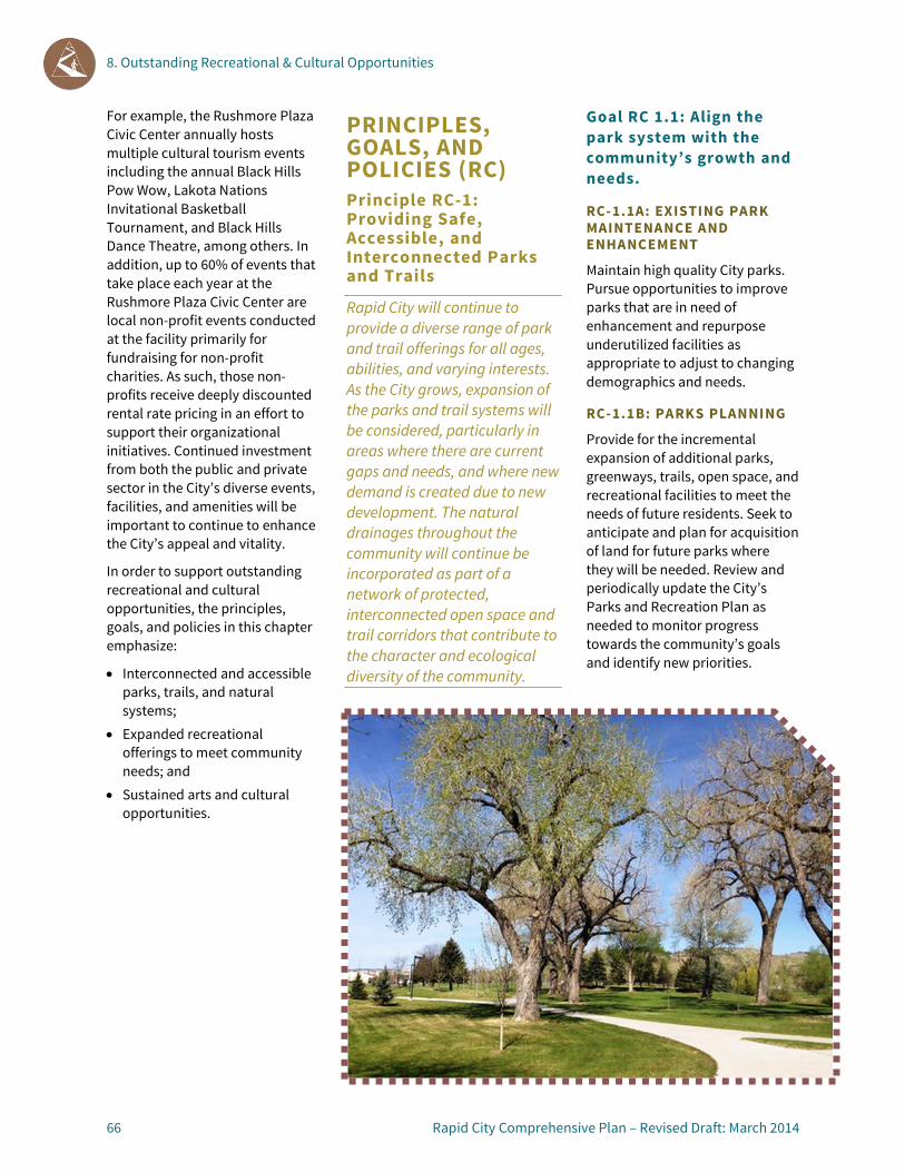
8. Outstanding Recreational & Cultural Opportunities
66 Rapid City Comprehensive Plan – Revised Draft: March 2014
For example, the Rushmore Plaza Civic Center annually hosts multiple cultural tourism events including the annual Black Hills Pow Wow, Lakota Nations Invitational Basketball Tournament, and Black Hills Dance Theatre, among others. In addition, up to 60% of events that take place each year at the Rushmore Plaza Civic Center are local non-profit events conducted at the facility primarily for fundraising for non-profit charities. As such, those non-profits receive deeply discounted rental rate pricing in an effort to support their organizational initiatives. Continued investment from both the public and private sector in the City’s diverse events, facilities, and amenities will be important to continue to enhance the City’s appeal and vitality.
In order to support outstanding recreational and cultural opportunities, the principles, goals, and policies in this chapter emphasize:
• Interconnected and accessible parks, trails, and natural systems;
• Expanded recreational offerings to meet community needs; and
• Sustained arts and cultural opportunities.
PRINCIPLES, GOALS, AND POLICIES (RC) Principle RC-1: Providing Safe, Accessible, and Interconnected Parks and Trails
Rapid City will continue to provide a diverse range of park and trail offerings for all ages, abilities, and varying interests. As the City grows, expansion of the parks and trail systems will be considered, particularly in areas where there are current gaps and needs, and where new demand is created due to new development. The natural drainages throughout the community will continue be incorporated as part of a network of protected, interconnected open space and trail corridors that contribute to the character and ecological diversity of the community.
Goal RC 1.1: Align the park system with the community’s growth and needs.
RC-1.1A: EXISTING PARK MAINTENANCE AND ENHANCEMENT
Maintain high quality City parks. Pursue opportunities to improve parks that are in need of enhancement and repurpose underutilized facilities as appropriate to adjust to changing demographics and needs.
RC-1.1B: PARKS PLANNING
Provide for the incremental expansion of additional parks, greenways, trails, open space, and recreational facilities to meet the needs of future residents. Seek to anticipate and plan for acquisition of land for future parks where they will be needed. Review and periodically update the City’s Parks and Recreation Plan as needed to monitor progress towards the community’s goals and identify new priorities.

8. Outstanding Recreational & Cultural Opportunities
Rapid City Comprehensive Plan – Revised Draft: March 2014 67
RC-1.1C: LEVEL OF SERVICE TARGETS
Seek to achieve and/or maintain level of service targets established by this Plan for different types of parks and recreational facilities as growth occurs over time. Support incremental improvements needed to improve levels of service in underserved areas of the community. (See page 70 for discussion of level of service targets by facility types.)
RC-1.1D: DISTRIBUTION OF PARKS AND FACILITIES
Identify opportunities to balance the amount and types of parks or recreational facilities within existing and future neighborhoods by prioritizing new parks in areas that are currently underserved and in new neighborhoods. Proactively identify potential park sites in areas of the City that are anticipated to grow significantly.
RC-1.1E: JOINT-USE FACILITIES
Coordinate with the Rapid City Area School District to co-locate new parks and school facilities where feasible to maximize resources and reduce duplication in the provision of parks.
RC-1.1F: PARKLAND DEDICATION FOR NEW DEVELOPMENT
Establish parkland dedication requirements for new development to help meet the needs of immediate residents and supplement public investment in the incremental expansion of Rapid City’s parks and recreation system. Provide a range of ways in which parkland dedication requirements could be satisfied (e.g., pocket parks, greenway and
natural area conservation, or fee-in-lieu).
RC-1.1F: DEDICATED FUNDING FOR PARKS
Identify and allocate additional funding for acquisition, capital improvements, and maintenance of parks and recreational facilities.
Goal RC-1.2: Expand and enhance greenway, open space, and trail connections.
RC-1.2A: PRIORITIZE IMPROVEMENTS IN UNDERSERVED AREAS
Prioritize improvements and linkages to greenways, open space, and trails in underserved areas, with a particular emphasis on areas where “missing links” can be readily addressed.
RC-1.2B: OPEN SPACE AND NATURAL RESOURCE CONSERVATION
Pursue opportunities to expand or enhance the community’s open space network and areas of natural resource conservation like greenways, forested hills, and drainages. Seek opportunities to achieve conservation objectives as development occurs, such as through land set-asides or cluster development.
RC-1.2C: NEIGHBORHOOD DESIGN
Encourage the protection of unique natural features and the incorporation of linkages to the overall system of trails in the design of new neighborhoods. (See also: Neighborhood Design Principles, page 94.)
RC-1.2D: LIGHTING AND SAFETY ENHANCEMENTS
Enhance lighting and safety features along greenways and trails in areas with high pedestrian and bicycle traffic in order to increase user comfort and security and expand usage opportunities beyond daylight hours.
RC-1.2E: COORDINATED IMPROVEMENTS
Coordinate planning and development of greenways and trails with the development of stormwater facilities to identify opportunities to maximize available resources.
Principle RC-2: Enhancing Community and Recreation Facilities
Rapid City will continue to provide a broad range of community and recreational facilities and programming for all ages, abilities, and varying interests. As the City grows, Rapid City will explore enhancements or new additions to its offerings to meet the needs of existing and future residents.
Goal RC-2.1: Provide a variety of community and recreational facilities and offerings.

8. Outstanding Recreational & Cultural Opportunities
68 Rapid City Comprehensive Plan – Revised Draft: March 2014
RC-2.1A: CIVIC CENTER
Support and expand existing programming and move forward with expansion of the Rushmore Plaza Civic Center by means of a new arena, with continued efforts in improving the overall facility and campus, as Rapid City’s primary entertainment, convention, and exhibition complex.
RC-2.1B: MULTI-PURPOSE FACILITIES
Seek opportunities to develop and maintain multi-purpose and/or shared-use facilities (e.g., school recreational facilities, community meeting space, libraries) in order to efficiently locate community and recreational facilities and programs and leverage available funding.
RC-2.1C: COMMUNITY CENTERS
Support existing public and private community, recreation, and senior centers and facilities and libraries throughout the community. Encourage the establishment of new multi-purpose community centers and libraries in growing or underserved areas.
RC-2.1D: AGE-SPECIFIC OPPORTUNITIES
Provide community and recreational opportunities for Rapid City residents of all ages, with age-specific opportunities for youth, seniors, or other groups.
Goal RC-2.2: Promote recreational equity at a neighborhood level.
RC-2.2A: MAINTAIN AND ENHANCE EXISTING FACILITIES
Maintain existing recreational facilities and pursue opportunities to improve facilities that are in need of updating or expansion.
RC-2.2B: BALANCE FACILITY DISPARITY
Balance the disparity in recreational facilities to the extent possible, regarding the types and conditions of the facility, their location, and their access from surrounding neighborhoods. Distribute future facilities to provide facilities convenient to all neighborhoods in Rapid City.
Principle RC-3: Expanding Arts and Cultural Opportunities
Rapid City and its residents will continue to support and sustain the presence of visual and performing arts as important elements that connect our residents and cultures, and add vitality to our public spaces, schools, neighborhoods, and the economy.
Goal RC-3.1: Recognize and strengthen the role of arts and culture in contributing to Rapid City’s sense of community.

8. Outstanding Recreational & Cultural Opportunities
Rapid City Comprehensive Plan – Revised Draft: March 2014 69
RC-3.1A: PUBLIC ART AND PUBLIC SPACES
Incorporate art into public projects, such as buildings, parks, recreation facilities, and public works facilities, as well as at bus stops, in parking garages, inside buses, within traffic circles, at City gateways, and at other transportation facilities. Develop incentives that encourage the incorporation of art amenities in private projects and the involvement of artists early in the design process.
RC-3.1B: VARIETY OF ART FORMS
Expand opportunities for a wide range of artists to participate in Rapid City’s cultural life, including visual, musical, textile artists, or other types.
RC-3.1C: ARTISTIC AND CULTURAL LITERACY
Enhance and support expanded arts and cultural opportunities throughout Rapid City with facilities and programs available to all residents. Develop knowledge and awareness throughout the community about the important contribution of arts and culture to Rapid City.
RC-3.1D: COLLABORATION
Work with the Rapid City Arts Council and other groups to establish and maintain a diverse range of programs throughout the community in support of both public and private arts and cultural ventures.
RC-3.1E: YOUTH ENGAGEMENT AND EDUCATIONAL PROGRAMS
Establish creative partnerships to engage youth through school-based art and music education, non-profit arts and cultural organizations, public and private sector collaborations, and Parks and Recreation programs and facilities.
Goal RC-3.2: Promote tourism activities, programs, and amenities that highlight the City’s history and culture. RC-3.2A: HISTORIC AND CULTURAL RESOURCE MARKETING
Market and enhance the presence of historic and cultural events, amenities, and activities throughout Rapid City.
RC-3.2B: ACTIVITIES AND EVENTS
Support public art, music, and cultural displays, activities and events Downtown and in other gathering places, such as public libraries, throughout Rapid City.
RC-3.2C: CULTURAL TOURISM PLAN
Work with the Rapid City Arts Council, the Rapid City Convention and Visitors Bureau, the Rapid City Economic Development Partnership, the Rapid City Area Chamber of Commerce, and other public and private entities to develop and implement a long-range plan to promote cultural tourism.

8. Outstanding Recreational & Cultural Opportunities
70 Rapid City Comprehensive Plan – Revised Draft: March 2014
PARKS AND RECREATIONAL FACILITIES Parks and recreational facilities in Rapid City are organized into the following categories: Pocket Parks, Neighborhood Parks, Community Parks, Special Use Areas/Facilities, and Greenways and Open Space. A description of each facility type, typical size, service area, locational criteria, and level of service target is provided in the table below.
The diversity of existing parks and recreational facilities found in Rapid City, along with the community’s varied topography and landscapes make the application of a “one-size-fits-all” approach to determining level of service targets challenging. As noted earlier in this chapter, when levels of service are considered at a community-wide level using traditional population-based comparisons, Rapid City’s current level of service far exceeds the national average. While this is comparison is a helpful reference for larger parks, it does not reflect the fact that the distribution of facilities throughout the community is imbalanced and that many residents must drive a significant distance from their neighborhood to access a park, recreation, or trail facility.
The level of service targets established by this Plan (as supported by the principles, goals, and policies in this chapter) are intended to help establish a more predictable path forward for the maintenance and incremental expansion of parks and recreational facilities in Rapid City over time and for improved access to these facilities. In addition, these targets may be more easily monitored by staff over time. The table below is intended to be used in conjunction with the Parks and Recreation Map on page 73.

8. Outstanding Recreational & Cultural Opportunities
Rapid City Comprehensive Plan – Revised Draft: March 2014 71
Facility Type/Description Typical Size Service Area Locational Criteria Level of Service Target
POCKET PARK
Design and programming varies greatly by location, ranging from active “tot lots” or dog parks to more passive gathering spaces, such as a community garden or an urban plaza with seating, landscaping, and other features. Pocket parks are typically privately-owned and maintained by a homeowners or business association; however, some publicly-owned pocket parks do exist.
Typically less than 1 acre; however some may be as large as 4 acres.
Intended to serve a concentrated population within walking distance (¼ mile radius)
Pocket parks should be located within neighborhoods, activity centers (e.g., Downtown) or employment centers where they are readily accessible to concentrated populations on foot.
Most residents shall be located within one-quarter mile of either a public park (pocket park or greater in size), elementary school, or a privately owned park or central gathering place.
NEIGHBORHOOD PARK
An area for recreational activities such as field games, court games, playgrounds, skating, picnicking, wading pools, ball fields, adult areas with benches, shelters, and game tables. Neighborhood parks vary in character from manicured fields to naturalized areas distinguished by mature trees and native vegetation.
1 to 10 acres ¼ to ½ mile radius
Centrally located within neighborhoods with safe pedestrian and bicycle access. May be developed in conjunction with schools as a joint-use facility.
Most residents shall be located within one-half mile of either a public park (neighborhood park or greater in size) or a privately owned park or central gathering place.
COMMUNITY PARK
A community park may include areas suited for intense recreational facilities such as athletic complexes and large swimming pools. They may also include opportunities for outdoor recreation such as walking, viewing, sitting, and picnicking. A community park may be any combination of the above, depending on the site and needs of the community.
Typically 10 or more acres with 15 to 40 acres being most common.
1 to 2 miles radius; accessible to several neighborhoods via bicycle and pedestrian routes/trails
Should be located on or near major thoroughfares to accommodate higher traffic volumes generated by group activities; but also be served by bicycle and pedestrian routes/trails. May be developed in conjunction with schools as a joint-use facility.
At least 5 acres of community parks for every 1,000 residents.

8. Outstanding Recreational & Cultural Opportunities
72 Rapid City Comprehensive Plan – Revised Draft: March 2014
Facility Type/Description Typical Size Service Area Locational Criteria Level of Service Target
SPECIAL USE AREAS/FACILITIES
Special use areas/facilities include single-purpose recreational activities such as golf courses, nature centers, zoos, conservatories, arboreta, display gardens, arenas, outdoor theaters, gun ranges, or areas that preserve, maintain, and interpret buildings, sites, and objects of archeological significance.
Varies Serves entire community, and in some cases the broader region
Varies None
GREENWAYS, OPEN SPACE, AND NATURAL AREAS
Greenways and natural areas preserve the special natural and environmental character of a particular location. These are typically important habitat conservation areas, environmentally sensitive areas, or historical areas. Passive recreational uses such as walking, bird watching, interpretive educational programs and signage, and non-motorized trail systems are appropriate in these locations.
Varies Serve entire community and in some cases the broader region
Areas of preservation include floodplains along Rapid Creek and Box Elder Creek, riparian and upland wooded areas, and wildlife corridors.
At least 2 acres of greenways, open space or natural areas for every 1,000 residents.
8. Outstanding Recreational & Cultural Opportunities
Rapid City Comprehensive Plan – Revised Draft: March 2014 73
PARKS AND RECREATION MAP The Parks and Recreation Map provides an inventory of existing parks, recreation, and bicycle facilities, and it also identifies future alignments of planned bicycle routes. The Parks and Recreation Map also highlights potential opportunities for future community parks, greenway conservation, and bicycle facilities.
Buffers are shown around existing public parks to help inform future park planning and decision-making. The smaller quarter-mile buffer represents a typical 5 minute-walk and it is ideal for most households to have at least a pocket park within such a distance. Elementary schools are also included in this quarter-mile buffer due to the fact that many elementary schools function as central gathering spaces in neighborhoods and feature play areas that can be used by neighborhood residents during off-hours. The larger half-mile buffer represents a typical 10-minute walk, and it is ideal for most households to be within that distance of a larger neighborhood park.
Overall accessibility to parks recreation facilities of various neighborhoods and segments of the community is evident by examining all of the quarter and half-mile buffers of existing public parks. This map shows that most neighborhoods near the central core of the community have abundant access to existing parks facilities; however, many of the neighborhoods in the eastern, southwestern, and northwestern portions of the City lack convenient access to nearby parks.
As development and redevelopment continue in these currently underserved areas, it will be important to work with developers to reserve opportunities and to provide various levels of park facilities to serve these neighborhoods. Topography, access, and other constraints will ultimately help shape where future parks may be developed, but increasing park access for underserved areas is a primary objective.
In addition to showing gaps in park accessibility, the Parks and Recreation Map identifies several major Regional Recreation Destinations, as well as some potential opportunities for Community Park sites. The Regional Recreation Destinations are major public parks or recreation facilities that draw visitors from across the community and region. Potential Community Park Opportunity areas are located in areas lacking access to parks, and are co-located with existing or planned public schools. Collaboration with the school district on the development and maintenance of parks on adjacent or shared school grounds could help maximize resources and amenities.
Greenway preservation is another major focus of the Parks and Recreation Map. Much of the floodplain in the core of the community is already conserved as public greenway space. All remaining floodplain areas are shown as opportunities for Future Greenway Conservation. Because of the threat of potential flooding in these areas, minimal new development should occur. As development occurs adjacent to these areas, the City should collaborate with developers to conserve floodplain areas as public greenways, and to extend trails and passive recreation opportunities in these areas.

8. Outstanding Recreational & Cultural Opportunities
74 Rapid City Comprehensive Plan – Revised Draft: March 2014
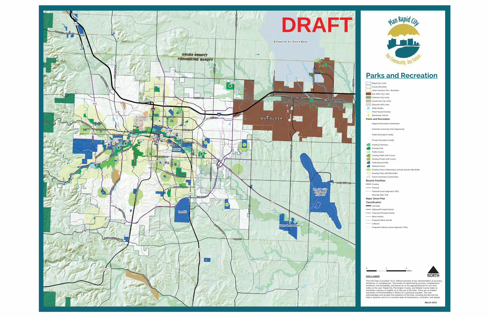
0 1 2Miles
This GIS Data is provided "as is" without warranty of any representation of accuracy, timeliness, or completeness. The burden for determining accuracy, completeness,timeliness, merchantability, and fitness for or the appropriateness for use rests solely on the user. Rapid City, Pennington County, and Meade County make no warranties, express or implied, as to the use of the Data. There are no implied warranties of merchantability or fitness for a particular purpose. The user acknowledges and accepts the limitations of the Data, including the fact that the Data is dynamic and is in a constant state of maintenance, correction, and update.
DISCLAIMER
Rapid City Limits
County Boundary
Urban Services Tier 1 Boundary
Box Elder City Limits
Piedmont City Limits
Summerset City Limits
Ellsworth AFB Limits
Water Bodies
Flood Hazard Overlay
Elementary School
Parks and Recreation
Regional Recreation Destlination
Potential Community Park Opportunity
Public Recreation Facility
Private Recreation Facility
Existing Greenway
Existing Park
Public Access
Existing Public Golf Course
Existing Private Golf Course
Public/Quasi-Public
National Forest
Existing Parks & Elementary Schools Quarter Mile Buffer
Existing Parks Half Mile Buffer
Future Greenway Conservation
Bicycle FacilitiesExisting
Planned
Potential (exact alignment TBD)
Mountain Bike Trail
Major Street PlanClassification
Interstate
Highway/Principal Arterial
Proposed Principal Arterial
Minor Arterial
Proposed Minor Arterial
Collector
Proposed Collector (exact alignment TBD)
32N
DS
T
NORTH ST
LAMB RD
ST PATRICK ST
S CANYON RD
WE
ST
GA
TE
RD
CENTRE ST
N E
LL
SW
OR
TH
RD
E MINNESOTA ST
SEGER DR
CATRONBLVD
UNIVERSALDR
DEA
DW
OO
DAV
E
FAIRMONT BLVD
ANAMOSA ST
PEACEFUL PIN ES RD
E NORTH STW CHICAGO ST
EGLIN ST
MOON MEADOWS DR
LIB
ER
TY
BLV
D
CANYONLAKE DR
OLD HWY 230
W MAIN ST
ST JOSEPH ST
DY
ES
S R
D
SPRINGCREEK
RD
E 5
3RD
ST
OLD FOLSOMRD
RA
DA
R H
ILL
RD
LONG VIEW RD
CA
MB
EL
L S
T
44T
HS
T
S V
AL
LE
Y D
R
151
AV
E
EL
M A
VE
LA
CR
OS
SE
ST
SK
YL
INE
DR
HA
INE
S A
VE
5TH
ST
EL
K V
AL
E R
D
SH
ER
IDAN
LAKE
RD
190
90
16
16
79
79
44
44
231
445
231
44
ELK VA L E R D
JACK SO N B LVD
MT
RU
SH
MO
RE
RD
B O X E L D E R
Ellswor th A i r Force Base
M E A D E C O U N T YP E N N I N G T O N C O U N T Y
Rapid C i tyRegiona lA irpor t
Landfill
Water Reclamation
SDSMT
SOCCERCOMPLEX
CANYONLAKE PARK
DINOSAURPARK
FOUNDERSPARK/MHILL
STAR OFTHE WESTCOMPLEX
BALLFIELDS
SIOUXPARK
ROOSEVELTPARK
ROOSEVELTPARK ICEARENA
RAPID CITYSWIM CENTER
SOUTHCOMMUNITY
GYM
WESTCOMMUNITY
GYM
CANYON LAKESENIORCENTER
MINNELUZAHANSENIORCENTER
YMCA
March 2014
DRAFT
Parks and Recreation


9. Responsive, Accessible & Effective Governance
9

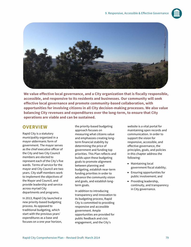
9. Responsive, Accessible & Effective Governance
Rapid City Comprehensive Plan – Revised Draft: March 2014 79
OVERVIEW Rapid City is a statutory municipality organized in a mayor-aldermanic form of government. The mayor serves as the chief executive officer of the City and two City Council members are elected to represent each of the City’s five wards. Terms of service for the mayor and City Council are two years. City staff members work to implement the objectives of the Mayor and Council, and provide leadership and service across myriad City departments and programs.
In 2013, Rapid City launched a new priority-based budgeting process. As opposed to traditional budgeting, which start with the previous years’ expenditures as a base and focuses on a one year horizon,
the priority-based budgeting approach focuses on measuring what citizens value and emphasizes creating long-term financial stability by determining the price of government and funding top priorities. This Plan reflects and builds upon these budgeting goals to promote alignment between planning and budgeting, establish near-term funding priorities in order to advance the community vision and goals, and establish long-term goals.
In addition to introducing transparency and innovation to its budgeting process, Rapid City is committed to providing responsive and accessible government. Ample opportunities are provided for public feedback and civic engagement, and the City’s
website is a vital portal for maintaining open records and communication. In order to support the vision for responsive, accessible, and effective governance, the principles, goals, and policies in this chapter address the following:
• Maintaining local government fiscal stability;
• Ensuring opportunities for public involvement; and
• Providing leadership, continuity, and transparency in City governance.
We value effective local governance, and a City organization that is fiscally responsible, accessible, and responsive to its residents and businesses. Our community will seek effective local governance and promote community-based collaboration, with opportunities for involving citizens in all City decision-making processes. We also value balancing City revenues and expenditures over the long-term, to ensure that City operations are viable and can be sustained.

9. Responsive, Accessible & Effective Governance
80 Rapid City Comprehensive Plan – Revised Draft: March 2014
PRINCIPLES, GOALS, AND POLICIES (GOV) Principle GOV-1: Maintaining Fiscal Stability
Rapid City will maintain fiscal stability by balancing desired service levels against changing costs and revenues. The City will provide clear and transparent information about the municipal budgeting process.
Goal GOV-1.1: Align community priorities with budget allocations.
GOV-1.1A: PRIORITY-BASED BUDGETING
Employ and enhance the budgeting process to deliver City services and improvements in a manner that reflects priorities, emphasizes results, and advances the community vision. Maintain strong connections between the Comprehensive Plan and budgeting priorities to ensure alignment between plan implementation and City budgeting.
GOV-1.1B: CAPITAL IMPROVEMENTS PLANNING
Monitor capital improvement needs and requests and proactively plan for and prioritize capital improvement
projects. Enhance awareness of the fiscal constraints of the City and clearly communicate high priority capital improvement needs and plans.
GOV-1.1C: STRATEGIC PLANNING
Advance community strategic planning and visioning efforts by integrating them into the Comprehensive Plan’s vision and action plan, and by allocating resources to these efforts during the budgeting process.
Goal GOV-1.2: Promote an open and transparent budgeting process.
Growth Map, City Plan, 1949

9. Responsive, Accessible & Effective Governance
Rapid City Comprehensive Plan – Revised Draft: March 2014 81
GOV-1.2A: BUDGETING COLLABORATION
Maintain a collaborative budgeting process that reflects broad community feedback (including residents, City staff, elected and appointed officials) and focuses on continuous improvement and achieving results.
GOV-1.2B: BUDGETING MONITORING
Monitor and share information regarding the status of the City’s budget, including projected versus actual revenues and expenses, gaps, and current and future priorities.
Goal GOV-1.3: Collaborate on means to explore efficiencies and promote cooperation.
GOV-1.3A: REGIONAL COLLABORATION
Foster relationships with regional stakeholders and organizations, including but not limited to County governments, area municipalities, tribal governments, state and federal agencies, service providers and organizations, and the public at-large, to address issues and opportunities collaboratively and efficiently.
GOV-1.3B: SERVICE PROVIDER COLLABORATION
Engage local service providers, such as utilities and health and safety services, to maximize benefits to Rapid City residents and identify opportunities to
collaborate with the City and maximize efficiency.
GOV-1.3C: PUBLIC/PRIVATE PARTNERSHIPS
Consider opportunities to partner with private organizations or developers to maximize benefits and leverage City resources.
GOV-1.4D: DEVELOPMENT REVIEW PROCESSES
Continue to improve and streamline Development Review Team (DRT) processes in accordance with recommendations outlined in the 2010-2013 Progress Report and Assessment.
GOV-1.3E: AIRPORT GOVERNANCE STRUCTURE
Consider establishing an Airport Authority, as authorized by South Dakota law, to govern the Rapid City Regional Airport as a means of providing:
• More focused governance; • Enhanced flexibility with
respect to economic development opportunities; and
• Increased efficiency.
GOV-1.3F: SUSTAINABILITY INITIATIVES Integrate awareness and knowledge of sustainability concepts into City practices. Explore opportunities to expand current sustainability initiatives:
• Extend opportunities to share best practices and ideas related to sustainability;
• Support the implementation of Sustainability Committee goals;
• Meet a base level LEED standard and/or adopt the current national energy standards for new Civic Structures;
• Consider adopting the STAR Community Rating System to measure progress in strengthening environmental, economic, and social systems; and
• Consider establishing a full-time sustainability coordinator position to advance the City’s efforts over time.
Principle GOV-2: Ensuring Opportunities for Public Involvement in Government
Rapid City will use a range of public involvement methods to engage and involve citizens in all aspects of governance, in order to work collaboratively with citizens to address issues and resolve problems. The City will continue to forge partnerships with public, private, and non-profit organizations to leverage available resources and promote innovation.
Goal GOV-2.1: Encourage civic engagement.
GOV-2.1A: PUBLIC INPUT OPPORTUNITIES
Provide a range of opportunities for the public to

9. Responsive, Accessible & Effective Governance
82 Rapid City Comprehensive Plan – Revised Draft: March 2014
provide feedback to decision-makers, including in person meetings, workshops, and online forums to cater to the needs of different populations and comfort levels.
GOV-2.1B: CIVIC ENGAGEMENT
Foster civic engagement and community involvement by supporting volunteer committees and commissions, providing volunteer opportunities and internships, and maintaining open meetings and records.
GOV- 2.1C: YOUTH ENGAGEMENT
Encourage involvement of youth in civic matters by collaborating with the school district, and pursuing opportunities to include youth in community planning and decision-making.
Goal GOV-2.2: Develop and support leadership that reflects the diversity of Rapid City.
GOV-2.2A: COMMITTEE, BOARD, AND COMMISSION RECRUITMENT
Seek diverse and qualified candidates in the recruitment and appointment of members to serve on City committees, commissions, and boards.
GOV-2.2B: MENTORSHIP PROGRAMS
Mentor and support emerging community leaders through support for volunteer committees and commissions and by providing volunteer opportunities and internships within the City organization.
Principle GOV-3: Providing Leadership, Continuity and Transparency
Rapid City staff and elected officials will continue to provide leadership in the planning and governance of the community, and will ensure that local government business is open, accessible, and transparent to all. Opportunities to promote greater stability in leadership
positions will be explored as a way to enhance efficiency and provide greater continuity in the implementation of the City’s core programs and policies.
Goal GOV-3.1: Improve continuity in City governance between election cycles.
GOV-3.1A: INSTITUTIONALIZE THE COMPREHENSIVE PLAN
Integrate the Comprehensive Plan’s vision, principles, goals, and policies into City meetings and decision-making in order to enhance clarity and continuity as elected officials change.
GOV-3.1B: CITY STAFF RECOMMENDATIONS
Consider City staff’s assessment of conformity and alignment with the Comprehensive Plan as a critical element in ensuring decision-making that is transparent and fair.

9. Responsive, Accessible & Effective Governance
Rapid City Comprehensive Plan – Revised Draft: March 2014 83
GOV-3.1C: ELECTED OFFICIALS TRAINING
Develop and facilitate a training course for incoming elected officials in order to enhance productivity and help alleviate the steep learning curve. The training course should clarify roles, outline procedures and expectations, and provide orientation to the Comprehensive Plan and Budgeting for Outcome process.
GOV-3.1D: PLAN MONITORING
Provide ongoing monitoring and periodic reporting of the Plan’s progress and implementation.
Goal GOV-3.2: Explore opportunities to enhance the City’s effectiveness as a governmental organization.
GOV-3.2A: FORM OF GOVERNMENT
Study the requirements and potential benefits and disadvantages of home rule (rather than statutory) local government status. Consider the initiation of a home rule charter if such status would help advance the community vision.
GOV-3.2B: LEADERSHIP STRUCTURE
Explore options to enhance stability of City leadership through changes to the governmental structure, such as reducing or removing term lengths, extending terms of
service, and/or appointing a City manager or administrator.
GOV-3.2C: STATE LEGISLATION AND FINANCIAL TOOLS
Engage with state representatives and advocate for legislation that provides more opportunities for municipalities to employ new or different financial tools to support development.
Principle GOV 4: Investigating Options to Improve the Efficiency of City Facilities and Administration
Rapid City will explore opportunities to promote greater efficiency in providing government services, distributing information, and performing other administrative tasks.
Goal GOV-4.1: Consider cost-effectiveness of fleet improvements.
GOV-4.1A: VEHICLE AND EQUIPMENT REPLACEMENT
Analyze replacement strategies for vehicles and equipment to determine cost-effectiveness of leasing or purchasing in the long-term.
GOV-4.1B: FUEL PURCHASING
Explore the benefits and potential drawbacks of advanced and consolidated fuel purchasing, and the use of alternative fuels for the City’s fleet.
GOV-4.1C: FLEET MAINTENANCE
Evaluate costs and benefits of consolidating fleet maintenance.
Goal GOV-4.2: Improve facilities management and operations
GOV-4.2A: FACILITIES MANAGEMENT
Explore opportunities to consolidate facilities management.
GOV-4.2B: ENERGY EFFICIENCY
Explore cost-effective ways to improve the energy efficiency of City facilities.
Goal GOV-4.3: Evaluate opportunities to improve administrative efficiency.
GOV-4.3A: BUSINESS ANALYSTS
Consider hiring business analysts to assist City departments in projecting revenues, developing cost projections for new or proposed programs and purchases, and preparation of the City budget expenditures.
GOV-4.3B: HARDWARE AND SOFTWARE INFORMATION TECHNOLOGY
Explore opportunities for consolidated hardware and software replacement, repair, and maintenance within the Information Technology Division.

9. Responsive, Accessible & Effective Governance
84 Rapid City Comprehensive Plan – Revised Draft: March 2014
GOV-4.3C: FINANCE AND ACCOUNTING SOFTWARE
Conduct regular updates to financial and accounting software and replace as necessary to promote increased efficiency.
GOV-4.3D: CONTRACT SERVICES
Consider the use of consolidated contract services, such as a city contracting officer, that could negotiate city-wide bulk purchase agreements, electricity rates, fuel rates, professional service contracts, and other shared supplies and services.
GOV-4.3D: RECORDS MANAGEMENT
Create a City Clerk’s Office to facilitate consolidated records management.
GOV-4.3E: PUBLIC INFORMATION OFFICE
Consider establishing a Public Information Office to coordinate matters of public information.
GOV-4.3F: GRANT MANAGEMENT
Hire a professional to manage grant applications and distributions.
GOV-4.3G: RECORDS MANAGEMENT
Investigate opportunities to facilitate consolidated records management through the creation of a City Clerk’s Office or similar means.

10. Growth & Reinvestment Framework 10

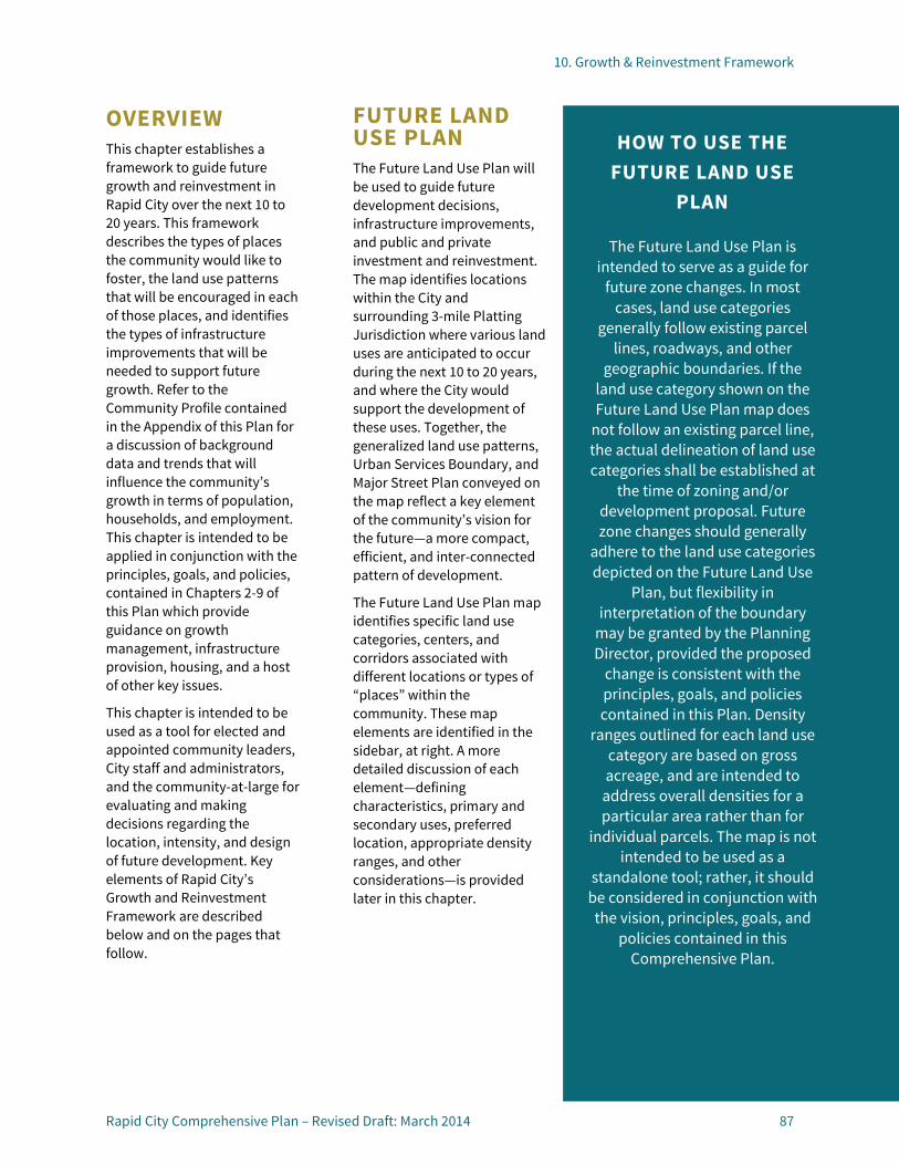
10. Growth & Reinvestment Framework
Rapid City Comprehensive Plan – Revised Draft: March 2014 87
OVERVIEW This chapter establishes a framework to guide future growth and reinvestment in Rapid City over the next 10 to 20 years. This framework describes the types of places the community would like to foster, the land use patterns that will be encouraged in each of those places, and identifies the types of infrastructure improvements that will be needed to support future growth. Refer to the Community Profile contained in the Appendix of this Plan for a discussion of background data and trends that will influence the community’s growth in terms of population, households, and employment. This chapter is intended to be applied in conjunction with the principles, goals, and policies, contained in Chapters 2-9 of this Plan which provide guidance on growth management, infrastructure provision, housing, and a host of other key issues.
This chapter is intended to be used as a tool for elected and appointed community leaders, City staff and administrators, and the community-at-large for evaluating and making decisions regarding the location, intensity, and design of future development. Key elements of Rapid City’s Growth and Reinvestment Framework are described below and on the pages that follow.
FUTURE LAND USE PLAN The Future Land Use Plan will be used to guide future development decisions, infrastructure improvements, and public and private investment and reinvestment. The map identifies locations within the City and surrounding 3-mile Platting Jurisdiction where various land uses are anticipated to occur during the next 10 to 20 years, and where the City would support the development of these uses. Together, the generalized land use patterns, Urban Services Boundary, and Major Street Plan conveyed on the map reflect a key element of the community’s vision for the future—a more compact, efficient, and inter-connected pattern of development.
The Future Land Use Plan map identifies specific land use categories, centers, and corridors associated with different locations or types of “places” within the community. These map elements are identified in the sidebar, at right. A more detailed discussion of each element—defining characteristics, primary and secondary uses, preferred location, appropriate density ranges, and other considerations—is provided later in this chapter.
HOW TO USE THE FUTURE LAND USE
PLAN
The Future Land Use Plan is intended to serve as a guide for
future zone changes. In most cases, land use categories
generally follow existing parcel lines, roadways, and other
geographic boundaries. If the land use category shown on the Future Land Use Plan map does
not follow an existing parcel line, the actual delineation of land use categories shall be established at
the time of zoning and/or development proposal. Future zone changes should generally
adhere to the land use categories depicted on the Future Land Use
Plan, but flexibility in interpretation of the boundary
may be granted by the Planning Director, provided the proposed
change is consistent with the principles, goals, and policies contained in this Plan. Density
ranges outlined for each land use category are based on gross acreage, and are intended to
address overall densities for a particular area rather than for
individual parcels. The map is not intended to be used as a
standalone tool; rather, it should be considered in conjunction with the vision, principles, goals, and
policies contained in this Comprehensive Plan.

10. Growth & Reinvestment Framework
88 Rapid City Comprehensive Plan – Revised Draft: March 2014
DESIGN PRINCIPLES In addition to the Future Land Use Plan elements, this chapter establishes a series of design principles to guide the character and form of future development. The design principles are intended to reflect community preferences expressed during the planning process with respect to different types and intensities of development. The principles build on the features the community viewed as favorable and discourages those features that were viewed as undesirable. The design principles are intended to serve as the foundation for targeted amendments to the City’s zoning code in the future. Design principles are provided for neighborhoods, mixed-use opportunity areas, employment centers, gateways and entrance corridors, and forest conservation areas.
FUTURE LAND USE PLAN ELEMENTS
The Future Land Use Plan includes layers of several different elements, including future land use categories, places, corridors, and major streets, as follows:
• Future Land Use Categories
• Rural Residential Neighborhoods • Low Density Neighborhoods • Urban Neighborhoods • Employment • Light Industrial • Heavy Industrial • Mining and Extraction • Downtown • Mixed-use Commercial • Parks and Greenways • Agriculture • Forest Conservation • Buffer/Reserved • Flood Hazard Overlay • Public/Quasi-Public • National Forest Places
• Places
• Regional Activity Centers • Community Activity Centers • Regional Recreation Destinations • Gateways
• Corridors
• Reinvestment Corridors • Entrance Corridors
• Major Streets
• Interstate • Principal Arterial • Minor Arterial • Collector • Local/Other
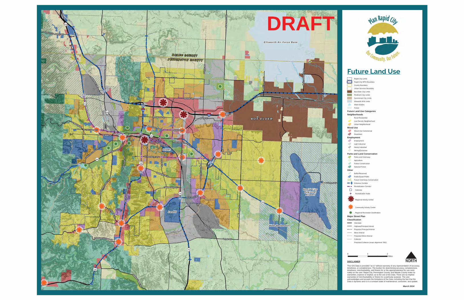
0 1 2Miles
This GIS Data is provided "as is" without warranty of any representation of accuracy, timeliness, or completeness. The burden for determining accuracy, completeness,timeliness, merchantability, and fitness for or the appropriateness for use rests solely on the user. Rapid City, Pennington County, and Meade County make no warranties, express or implied, as to the use of the Data. There are no implied warranties of merchantability or fitness for a particular purpose. The user acknowledges and accepts the limitations of the Data, including the fact that the Data is dynamic and is in a constant state of maintenance, correction, and update.
DISCLAIMER
Future Land UseRapid City Limits
Rapid City MPO Boundary
County Boundary
Urban Services Boundary
Box Elder City Limits
Piedmont City Limits
Summerset City Limits
Ellsworth AFB Limits
Water Bodies
Forest
Future Land Use CategoriesNeighborhoods
Rural Residential
Low Density Neighborhood
Urban Neighborhood
Mixed UseMixed Use Commercial
Downtown
EmploymentEmployment
Light Industrial
Heavy Industrial
Mining/Extraction
Parks and Land ConservationParks and Greenway
Agriculture
Forest Conservation
National Forest
OtherBuffer/Reserved
Public/Quasi-Public
Future Greenway Conservation
Entrance Corridor
Revitalization Corridor
Gateway
Revitalization Node
Regional Activity Center
Community Activity Center
Regional Recreation Destlination
Major Street PlanClassification
Interstate
Highway/Principal Arterial
Proposed Principal Arterial
Minor Arterial
Proposed Minor Arterial
Collector
Proposed Collector (exact alignment TBD)
3 2N
DS
T
NORTH ST
LAMB RD
ST PATRICK ST
S CANYON RD
WE
ST
GA
TE
RD
CENTRE ST
N E
LL
SW
OR
TH
RD
E MINNESOTA ST
SEGER DR
CATRONB
LVD
UNIVERSALDR
DEA
DW
OO
DAV
E
FAIRMONT BLVD
ANAMOSA ST
PEACE FUL PINES RD
E NORTH STW CHICAGO ST
EGLIN ST
MOON MEADOWS DR
LIB
ER
TY
BLV
D
CANYONLAKE DR
OLD HWY 230
W MAIN ST
ST JOSEPH ST
DY
ES
S R
D
SPRINGCREEK
RD
E 5
3RD
ST
OLD FOLSOMRD
RA
DA
R H
ILL
RD
LONG VIEWC
AM
BE
LL
ST
44T
HS
T
S V
AL
LE
Y D
R
EL
M A
VE
LA
CR
OS
SE
ST
SK
YL
INE
DR
HA
INE
S A
VE
5TH
ST
EL
K V
AL
E R
D
SH
ER
IDAN
LAKERD
190
90
16
16
79
79
44
44
231
445
231
44
ELK VA L E R D
JACK SO N B LVD
MT
RU
SH
MO
RE
RD
B O X E L D E R
Ellsworth Ai r Force Base
M E A D E C O U N T YP E N N I N G T O N C O U N T Y
Rapid C i tyRegionalAirpor t
Landfill
Water Reclamation
SDSMT
March 2014
DRAFT
10. Growth & Reinvestment Framework
90 Rapid City Comprehensive Plan – Revised Draft: March 2014

10. Growth & Reinvestment Framework
Rapid City Comprehensive Plan – Revised Draft: March 2014 91
MAJOR STREET PLAN To promote integrated decision-making with respect to land use and transportation as Rapid City grows over the next 10 to 20 years, the Major Street Plan is depicted on the Future Land Use Plan map. Street types and classifications identified on the map are described below.
MAJOR STREET PLAN CLASSIFICATIONS Type Characteristics STREET CLASSIFICATIONS
Interstate Freeways provide for mobility and long distance travel at high speed. Full access control is provided, with no direct property access. Grade-separated interchanges are provided as-needed, typically no less than 1 mile apart
in urban areas.
Principal Arterial Principal Arterial roadways carry longer-distance trips for regional, inter-community and major commuting purposes. Arterials have a limited number of at-grade intersections and only provide direct property
access when lower classification road access does not exist. Arterials can carry significant traffic volumes at higher speeds for longer distances and are
seldom spaced at closer than one-mile intervals.
Minor Arterial Minor Arterials are similar to Principal Arterials, but tend to serve moderate trip lengths and provide and/or carry fewer vehicles. May provide some additional direct property access, but primary function is mobility
Collector Collector roadways serve a combination of mobility and access functions. They gather traffic from Local Roads and funnel trips to the Arterial network. Collectors provide for moderate trip lengths and travel speeds. Access is provided via moderately spaced at-grade signalized and stop controlled intersections. Alignments are subject to change based on development master plans, City priorities, and
environmental considerations. Alignment variations from what is depicted shall not require amendment of the City’s Comprehensive Plan or Major Street Plan. In general, collectors should be placed between arterials at approximately ½ mile spacing,
where topography and other site considerations allow.
Local/Other Local roads typically comprise the largest percentage of all roadways in terms of mileage. They are not intended for long distance trips. Local roads provide direct access to
adjacent properties.

10. Growth & Reinvestment Framework
92 Rapid City Comprehensive Plan – Revised Draft: March 2014
NEIGHBORHOODS Three neighborhood designations are identified on the Future Land Use Plan map:
• Rural Residential • Low Density Neighborhood • Urban Neighborhood The broad range of densities and housing types accommodated by these designations are intended to support increased diversity in Rapid City’s housing options to meet the community’s changing needs. Neighborhood design principles are intended to enhance the character, accessibility, and livability of the City’s existing and future neighborhoods and to promote compatible infill and redevelopment in core area neighborhoods.
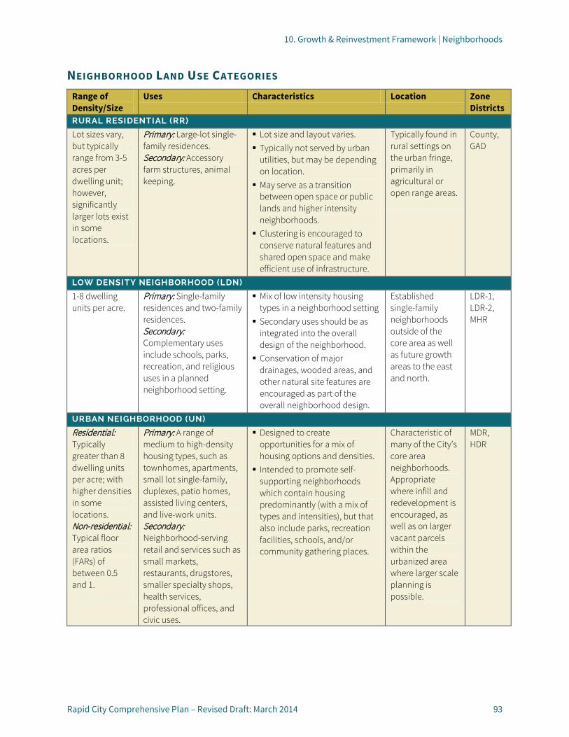
10. Growth & Reinvestment Framework | Neighborhoods
Rapid City Comprehensive Plan – Revised Draft: March 2014 93
NEIGHBORHOOD LAND USE CATEGORIES Range of Density/Size
Uses Characteristics Location Zone Districts
RURAL RESIDENTIAL (RR)
Lot sizes vary, but typically range from 3-5 acres per dwelling unit; however, significantly larger lots exist in some locations.
Primary: Large-lot single-family residences. Secondary: Accessory farm structures, animal keeping.
Lot size and layout varies. Typically not served by urban
utilities, but may be depending on location. May serve as a transition
between open space or public lands and higher intensity neighborhoods. Clustering is encouraged to
conserve natural features and shared open space and make efficient use of infrastructure.
Typically found in rural settings on the urban fringe, primarily in agricultural or open range areas.
County, GAD
LOW DENSITY NEIGHBORHOOD (LDN)
1-8 dwelling units per acre.
Primary: Single-family residences and two-family residences. Secondary: Complementary uses include schools, parks, recreation, and religious uses in a planned neighborhood setting.
Mix of low intensity housing types in a neighborhood setting Secondary uses should be as
integrated into the overall design of the neighborhood. Conservation of major
drainages, wooded areas, and other natural site features are encouraged as part of the overall neighborhood design.
Established single-family neighborhoods outside of the core area as well as future growth areas to the east and north.
LDR-1, LDR-2, MHR
URBAN NEIGHBORHOOD (UN)
Residential: Typically greater than 8 dwelling units per acre; with higher densities in some locations. Non-residential: Typical floor area ratios (FARs) of between 0.5 and 1.
Primary: A range of medium to high-density housing types, such as townhomes, apartments, small lot single-family, duplexes, patio homes, assisted living centers, and live-work units. Secondary: Neighborhood-serving retail and services such as small markets, restaurants, drugstores, smaller specialty shops, health services, professional offices, and civic uses.
Designed to create opportunities for a mix of housing options and densities. Intended to promote self-
supporting neighborhoods which contain housing predominantly (with a mix of types and intensities), but that also include parks, recreation facilities, schools, and/or community gathering places.
Characteristic of many of the City’s core area neighborhoods. Appropriate where infill and redevelopment is encouraged, as well as on larger vacant parcels within the urbanized area where larger scale planning is possible.
MDR, HDR

10. Growth & Reinvestment Framework | Neighborhoods
94 Rapid City Comprehensive Plan – Revised Draft: March 2014
NEIGHBORHOOD DESIGN PRINCIPLES Two types of Neighborhood Design Principles apply based on the underlying land use category: General Design Principles for Neighborhoods (all Neighborhood categories) and Supplemental Design Principles for Low Density and Urban Neighborhoods.
General Design Principles for Neighborhoods (GDP-N)
General Neighborhood Design Principles provide guidance on a range of site planning, resource conservation, and connectivity issues. They are intended to enhance the character and livability of future neighborhoods as well as to promote a more compact and sustainable pattern of development that complements Rapid City’s unique natural setting.
GDP-N1: PRESERVATION OF NATURAL FEATURES Incorporate innovative site planning into the design of new neighborhoods to maximize the preservation of natural features, such as:
• Floodplains, drainages, and wetlands;
• Forested areas or other areas with significant native vegetation or mature shade trees;
• Documented wildlife habitat; and/or
• Steep slopes and other unique or environmentally sensitive features.
Integrate protected natural features as active and passive open space and/or trail corridors to serve and enhance connections between the neighborhood and broader community, where appropriate. In addition, seek opportunities to integrate stormwater management functions with existing or planned open space and trail corridors.
GDP-N2: CONNECTIVITY Provide a continuous network of sidewalks, bicycle, and pedestrian paths, and roadways within and between neighborhoods:
• Establish linkages from neighborhoods to adjacent activity centers and corridors , transit stops, and the surrounding community;
• Avoid isolating neighborhoods with walls and gates that hinder pedestrian, bicycle, and vehicular connectivity; and
• Work with neighborhood residents to improve connectivity in established neighborhoods where sidewalks are absent or incomplete, as documented by the Rapid City Area Bicycle and Pedestrian Master Plan.
GDP-N3: CLUSTER DEVELOPMENT Use cluster development patterns as a tool to achieve one or more of the following objectives:
• Preserve scenic view corridors or natural features;
• Create transitions between areas of different development intensity;
• Achieve higher densities on unconstrained portions of significantly constrained sites;
• Provide open space for the common use and enjoyment of residents and the broader community;
• Preserve cohesive blocks of agricultural land or forest; and/or
• Reduce risk of property damage and loss of life within the Wildland Urban Interface.
GDP-N4: PARKS AND RECREATION • Integrate or provide access
to parks and recreation amenities in neighborhoods that appeal to and are accessible to residents of all ages and abilities. Tailor new parks and amenities to help fill specific needs identified as part of Neighborhood Area Policies contained in this Comprehensive Plan.
• Encourage alternatives to traditional parks, such as pocket-parks, and public squares in Urban Neighborhoods and established areas of the community, as well as in neighborhoods where topography or other limiting factors exist.
• Maximize efficiency by seeking opportunities to develop multi-purpose recreational facilities and/or to partner with other organizations to share an existing facility (e.g., school meeting rooms, ballfields).
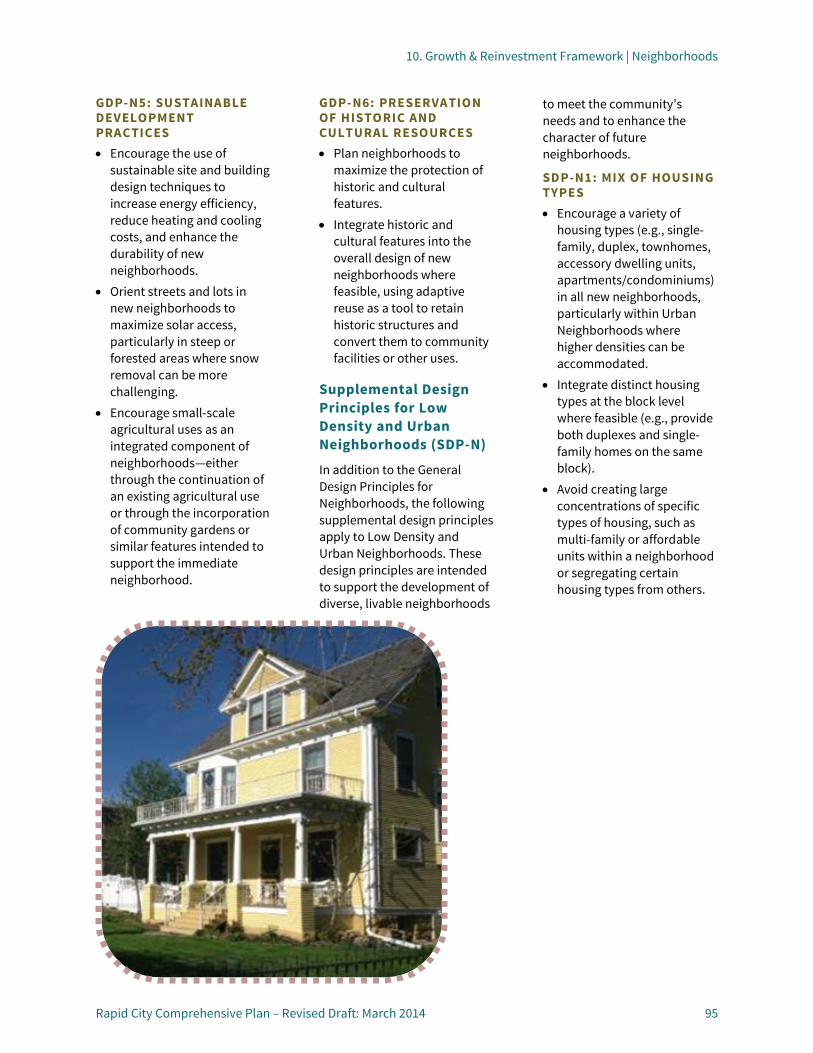
10. Growth & Reinvestment Framework | Neighborhoods
Rapid City Comprehensive Plan – Revised Draft: March 2014 95
GDP-N5: SUSTAINABLE DEVELOPMENT PRACTICES • Encourage the use of
sustainable site and building design techniques to increase energy efficiency, reduce heating and cooling costs, and enhance the durability of new neighborhoods.
• Orient streets and lots in new neighborhoods to maximize solar access, particularly in steep or forested areas where snow removal can be more challenging.
• Encourage small-scale agricultural uses as an integrated component of neighborhoods—either through the continuation of an existing agricultural use or through the incorporation of community gardens or similar features intended to support the immediate neighborhood.
GDP-N6: PRESERVATION OF HISTORIC AND CULTURAL RESOURCES • Plan neighborhoods to
maximize the protection of historic and cultural features.
• Integrate historic and cultural features into the overall design of new neighborhoods where feasible, using adaptive reuse as a tool to retain historic structures and convert them to community facilities or other uses.
Supplemental Design Principles for Low Density and Urban Neighborhoods (SDP-N)
In addition to the General Design Principles for Neighborhoods, the following supplemental design principles apply to Low Density and Urban Neighborhoods. These design principles are intended to support the development of diverse, livable neighborhoods
to meet the community’s needs and to enhance the character of future neighborhoods.
SDP-N1: MIX OF HOUSING TYPES • Encourage a variety of
housing types (e.g., single-family, duplex, townhomes, accessory dwelling units, apartments/condominiums) in all new neighborhoods, particularly within Urban Neighborhoods where higher densities can be accommodated.
• Integrate distinct housing types at the block level where feasible (e.g., provide both duplexes and single-family homes on the same block).
• Avoid creating large concentrations of specific types of housing, such as multi-family or affordable units within a neighborhood or segregating certain housing types from others.
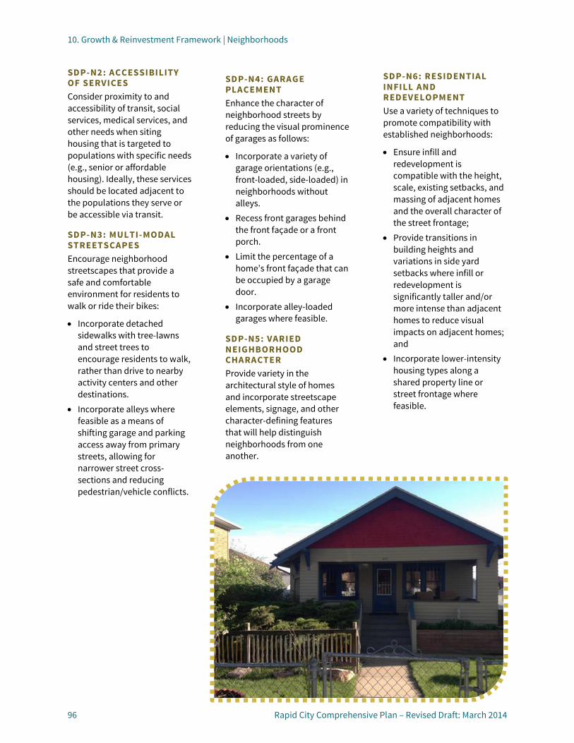
10. Growth & Reinvestment Framework | Neighborhoods
96 Rapid City Comprehensive Plan – Revised Draft: March 2014
SDP-N2: ACCESSIBILITY OF SERVICES Consider proximity to and accessibility of transit, social services, medical services, and other needs when siting housing that is targeted to populations with specific needs (e.g., senior or affordable housing). Ideally, these services should be located adjacent to the populations they serve or be accessible via transit.
SDP-N3: MULTI-MODAL STREETSCAPES Encourage neighborhood streetscapes that provide a safe and comfortable environment for residents to walk or ride their bikes:
• Incorporate detached sidewalks with tree-lawns and street trees to encourage residents to walk, rather than drive to nearby activity centers and other destinations.
• Incorporate alleys where feasible as a means of shifting garage and parking access away from primary streets, allowing for narrower street cross-sections and reducing pedestrian/vehicle conflicts.
SDP-N4: GARAGE PLACEMENT Enhance the character of neighborhood streets by reducing the visual prominence of garages as follows:
• Incorporate a variety of garage orientations (e.g., front-loaded, side-loaded) in neighborhoods without alleys.
• Recess front garages behind the front façade or a front porch.
• Limit the percentage of a home’s front façade that can be occupied by a garage door.
• Incorporate alley-loaded garages where feasible.
SDP-N5: VARIED NEIGHBORHOOD CHARACTER Provide variety in the architectural style of homes and incorporate streetscape elements, signage, and other character-defining features that will help distinguish neighborhoods from one another.
SDP-N6: RESIDENTIAL INFILL AND REDEVELOPMENT Use a variety of techniques to promote compatibility with established neighborhoods:
• Ensure infill and redevelopment is compatible with the height, scale, existing setbacks, and massing of adjacent homes and the overall character of the street frontage;
• Provide transitions in building heights and variations in side yard setbacks where infill or redevelopment is significantly taller and/or more intense than adjacent homes to reduce visual impacts on adjacent homes; and
• Incorporate lower-intensity housing types along a shared property line or street frontage where feasible.
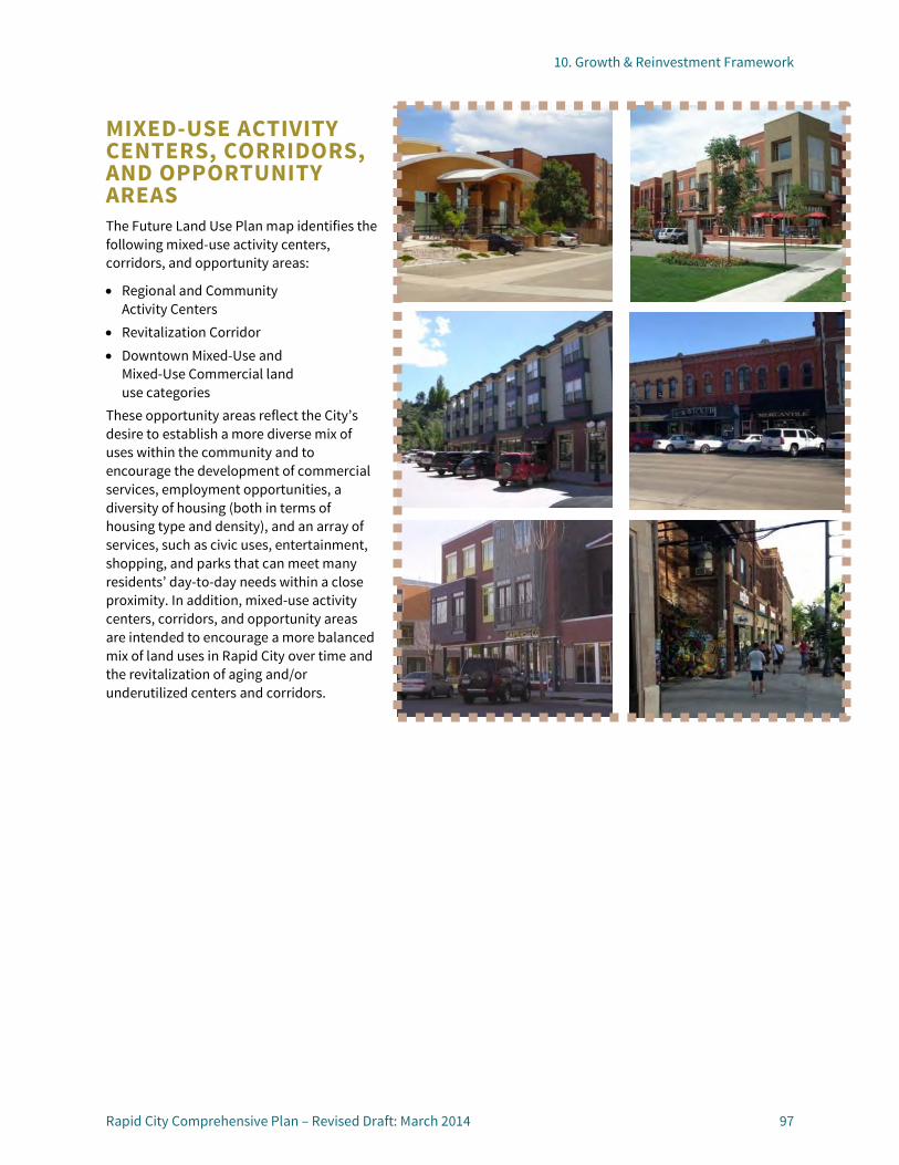
10. Growth & Reinvestment Framework
Rapid City Comprehensive Plan – Revised Draft: March 2014 97
MIXED-USE ACTIVITY CENTERS, CORRIDORS, AND OPPORTUNITY AREAS The Future Land Use Plan map identifies the following mixed-use activity centers, corridors, and opportunity areas:
• Regional and Community Activity Centers
• Revitalization Corridor • Downtown Mixed-Use and
Mixed-Use Commercial land use categories
These opportunity areas reflect the City’s desire to establish a more diverse mix of uses within the community and to encourage the development of commercial services, employment opportunities, a diversity of housing (both in terms of housing type and density), and an array of services, such as civic uses, entertainment, shopping, and parks that can meet many residents’ day-to-day needs within a close proximity. In addition, mixed-use activity centers, corridors, and opportunity areas are intended to encourage a more balanced mix of land uses in Rapid City over time and the revitalization of aging and/or underutilized centers and corridors.
10. Growth & Reinvestment Framework | Mixed-Use Activity Centers, Corridors, and Opportunity Areas
98 Rapid City Comprehensive Plan – Revised Draft: March 2014
MIXED-USE ACTIVITY CENTERS AND CORRIDORS Note: Mixed-use activity centers and corridors vary in size, composition of uses, and location within the community. As such, specific boundaries for these uses are not identified on the Future Land Use Plan map.
Existing Characteristics Desired Characteristics/Opportunities Examples REGIONAL ACTIVITY CENTERS
Serve Rapid City residents as well as residents of the surrounding region. Each regional center is unique in its
age, scale, intensity, and mix of uses. Typically include large scale retail
uses, supported by other service and employment uses. Typically low intensity development
with large surface parking lots
Reinvestment likely needed in older centers in order to remain competitive with newer activity centers. Targeted infill development and/or
redevelopment may help enhance the mix of uses and take advantage of underutilized areas such as large surface parking lots. Integration of other uses and multi-family
housing may be appropriate over time to take advantage of existing infrastructure investments and increase housing options.
Downtown Rushmore Mall Rushmore Crossing
COMMUNITY ACTIVITY CENTERS
Intended to meet the shopping and gathering needs of the surrounding neighborhoods and the entire community. Each activity center is unique in its
age, scale, intensity and mix of uses. Typically include anchors such as
major grocery stores, plus a mix of other uses, typically in a low intensity setting. May currently contain a somewhat
homogenous mix of uses (retail, restaurant and lodging)
May start to incorporate a broader mix of uses including service, office, and other employment and civic uses to remain economically resilient. Reinvestment needed in older centers in
order to remain competitive with newer activity centers. Targeted infill development and/or
redevelopment within portions of these areas may help enhance the mix of uses and take advantage of underutilized areas such as large surface parking lots.
Super Wal-Mart Center Baken Park Cambell @ St Patrick
REVITALIZATION CORRIDORS
Significant vehicular corridor within the community. Includes both the streets themselves,
plus the first tier of parcels fronting these roadways. Historical focus has been on the
movement of vehicles; increasing focus on balancing the needs of motorists and pedestrians, bicyclists, transit users, and freight traffic.
Contain a diverse mix of uses and types of structures, some of which are in need of reinvestment and revitalization. Need to balance retaining historic
character and the need for targeted redevelopment in some areas.
East Blvd/East North Street from East Omaha Street to North Cambell Street East Saint Patrick
Street (mostly aging residential on west half, strip commercial on eastern half) Refer to Policy BPG-
1.2C for a complete list of corridors and additional discussion. (See page 16.)

10. Growth & Reinvestment Framework | Mixed-Use Activity Centers, Corridors, and Opportunity Areas
Rapid City Comprehensive Plan – Revised Draft: March 2014 99
MIXED-USE OPPORTUNITY AREAS Range of Density/Size
Uses Characteristics Location Zone Districts
DOWNTOWN MIXED-USE (DT)
Typical floor area ratios (FARs) of between 0. 5 and 3; however may be higher in some parts of Downtown.
Primary: Variety of civic, cultural, retail, commercial, restaurant, business, lodging, professional offices, and financial institutions. Secondary: Variety of medium/high density housing types; plazas, squares, and pocket parks.
Traditional Downtown urban fabric with a compact, pedestrian-friendly scale. Intended to allow for and
encourage a broader mix of uses than exist today, including high-density residential. District has significant historic
character and importance to the broader community and region
Downtown Core CB
MIXED-USE COMMERCIAL (MUC)
Typical floor area ratios (FARs) of between 0.5 and 2, although they may be significantly higher within designated activity centers, or along major gateway corridors.
Primary: Supermarkets, hotels, restaurants, smaller specialty shops, retail and health services, and business and professional offices. Secondary: Higher density residential, including senior housing, is encouraged, including live-work units. Pocket parks, plazas, schools, civic uses, and other supporting uses are also appropriate.
Intended to provide a range of services to meet the daily needs of the surrounding neighborhoods and larger community. To allow for vertical or
horizontal mix of uses on sites, including some higher-density residential. Will vary in scale and character.
Smaller, limited use centers may be fully integrated into the surrounding neighborhood and be accessed primarily by pedestrian or bicycle. Larger centers will function more independently, providing ample parking and numerous stores.
Generally located along major gateway corridors, within designated activity centers, and along collector or arterial streets. Should be located
where it may be readily served by existing or future transit and should be designed with clear pedestrian connections to transit stops and surrounding development.
NC, GC, HM, SC-1, SC-2
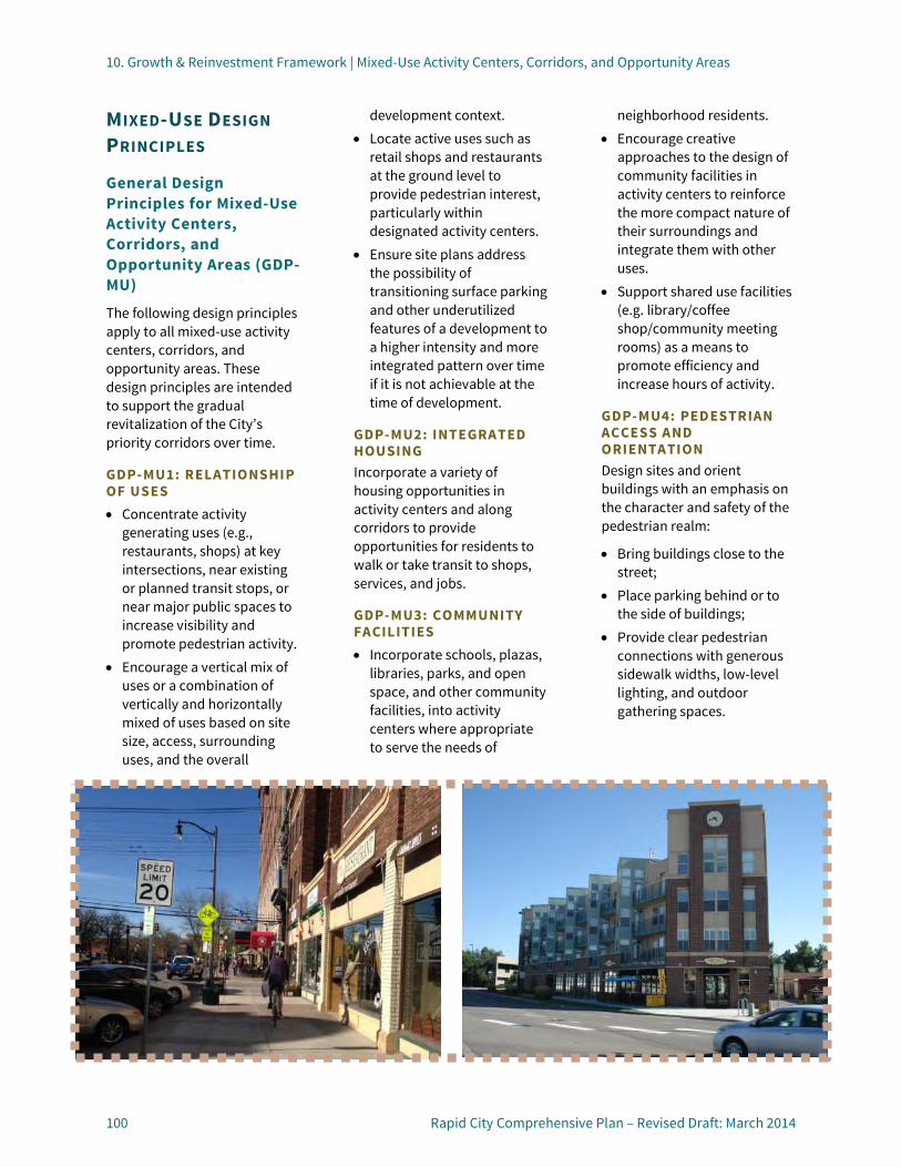
10. Growth & Reinvestment Framework | Mixed-Use Activity Centers, Corridors, and Opportunity Areas
100 Rapid City Comprehensive Plan – Revised Draft: March 2014
MIXED-USE DESIGN PRINCIPLES
General Design Principles for Mixed-Use Activity Centers, Corridors, and Opportunity Areas (GDP-MU)
The following design principles apply to all mixed-use activity centers, corridors, and opportunity areas. These design principles are intended to support the gradual revitalization of the City’s priority corridors over time.
GDP-MU1: RELATIONSHIP OF USES • Concentrate activity
generating uses (e.g., restaurants, shops) at key intersections, near existing or planned transit stops, or near major public spaces to increase visibility and promote pedestrian activity.
• Encourage a vertical mix of uses or a combination of vertically and horizontally mixed of uses based on site size, access, surrounding uses, and the overall
development context. • Locate active uses such as
retail shops and restaurants at the ground level to provide pedestrian interest, particularly within designated activity centers.
• Ensure site plans address the possibility of transitioning surface parking and other underutilized features of a development to a higher intensity and more integrated pattern over time if it is not achievable at the time of development.
GDP-MU2: INTEGRATED HOUSING Incorporate a variety of housing opportunities in activity centers and along corridors to provide opportunities for residents to walk or take transit to shops, services, and jobs.
GDP-MU3: COMMUNITY FACILITIES • Incorporate schools, plazas,
libraries, parks, and open space, and other community facilities, into activity centers where appropriate to serve the needs of
neighborhood residents. • Encourage creative
approaches to the design of community facilities in activity centers to reinforce the more compact nature of their surroundings and integrate them with other uses.
• Support shared use facilities (e.g. library/coffee shop/community meeting rooms) as a means to promote efficiency and increase hours of activity.
GDP-MU4: PEDESTRIAN ACCESS AND ORIENTATION Design sites and orient buildings with an emphasis on the character and safety of the pedestrian realm:
• Bring buildings close to the street;
• Place parking behind or to the side of buildings;
• Provide clear pedestrian connections with generous sidewalk widths, low-level lighting, and outdoor gathering spaces.

10. Growth & Reinvestment Framework | Mixed-Use Activity Centers, Corridors, and Opportunity Areas
Rapid City Comprehensive Plan – Revised Draft: March 2014 101
GDP-MU5: WALKABLE BLOCKS
Incorporate a pattern of walkable blocks in new or redeveloping activity centers, with frequent and clear pedestrian connections to surrounding neighborhoods, transit stops and nearby parks and greenways.
GDP-MU6: SUSTAINABLE DEVELOPMENT PRACTICES
Encourage the use of energy-efficient construction techniques, materials, designs, and other strategies where feasible.
GDP-MU7: REHABILITATION OF EXISTING ACTIVITY CENTERS AND CORRIDORS
Enhance the character and function of existing centers and corridors in need of revitalization using a combination of the following techniques, as appropriate to site and market conditions:
• Incorporate pad site buildings at the street edge to break up existing surface parking and help “frame” the street and the center’s entrance where sufficient space is available.
• Provide landscaping in combination with low walls to screen surface parking from the street.
• Incorporate upper floors of housing or offices above existing strip centers where structurally and economically feasible.
• Provide pedestrian linkages between the center and
adjacent neighborhoods as part of a major rehabilitation effort where they do not already exist.
GDP-MU8: RELATIONSHIP TO SURROUNDING NEIGHBORHOODS
Use the following techniques to promote compatibility between higher density development desired in mixed-use opportunity areas and adjacent neighborhoods:
• Concentrate tallest buildings at the center of the site or along primary street frontages;
• Provide gradual decreases in building height and mass so that new structures have a comparable scale as adjacent homes along the shared lot line or street frontage; and
• Incorporate lower-intensity housing types (e.g., townhomes, duplexes, etc.) along a shared street frontage.
GDP-MU9: ADAPTIVE REUSE Support the adaptive reuse of existing buildings when full-scale redevelopment is not feasible. Provide increased flexibility in standard parking and landscaping requirements to help revitalize challenging sites that would otherwise remain vacant for an extended period of time.
GDP-MU10: LOT CONSOLIDATION
Encourage the consolidation of smaller parcels along corridors and in activity centers for the purposes of redevelopment to
accommodate a more pedestrian and transit-oriented pattern of development over time and facilitate improved site design, circulation, and access.


10. Growth & Reinvestment Framework
Rapid City Comprehensive Plan – Revised Draft: March 2014 103
EMPLOYMENT AREAS The Future Land Use Plan map identifies the following employment areas:
• Employment • Light Industrial • Heavy Industrial • Mining/Extraction Employment areas vary in their size, characteristics, and mix of uses, as described on the pages that follow. Employment areas identified on the Future Land Use Plan map are intended to promote economic stability and growth by providing increased certainty for businesses and employers about where opportunities exist and where certain types of uses will be supported by the community. In addition, map designations illustrate the community’s desire to promote consolidated centers of employment activity in areas with suitable access and minimal potential for conflicts with adjacent uses as opposed to a more site-driven approach. This consolidated approach also supports the creation of more concentrated jobs, which may be more readily served by existing or future transit.
Finally, design principles for employment areas are intended to promote compatibility between uses of varying intensities and to enhance the character of employment focused gateways and corridors.

10. Growth & Reinvestment Framework | Employment Areas
104 Rapid City Comprehensive Plan – Revised Draft: March 2014
EMPLOYMENT AREAS Range of Density/Size
Uses Characteristics Location Zone Districts
EMPLOYMENT (E)
Varies Primary: Office buildings, medical facilities and clinics, research and development, educational campuses, flex space, and indoor storage. Secondary: Supporting commercial/retail uses are encouraged. Airport supportive uses, institutional uses, open space, parks, schools, public uses, and assisted living facilities are also appropriate.
Intended to provide concentrated areas of employment, combined with a mix of complementary commercial uses. May be stand-alone buildings
or incorporated into a master planned campus. Buffering and screening
important when facilities abut residential uses.
Opportunity areas include emerging employment campuses west of Elk Vale Road (north of 44), along Mt. Rushmore Road and future opportunity areas west of Rapid City Regional Airport and along Elk Vale Road (south of 44 and east of Old Folsom Rd.)
OC, BP
LIGHT INDUSTRIAL (LI )
Varies Primary: Light manufacturing, processing, wholesaling, warehousing and distribution, indoor and screened outdoor storage, and a wide range of other industrial services and operations. Secondary: Airport supportive uses and commercial uses.
Operations are conducted so that noise, odor, dust, and glare are completely confined within an enclosed building. Screening and buffering of
industrial uses is important when abutting or in close proximity to non-industrial uses.
Major opportunity areas include: Highway 79 corridor adjacent to and surrounding the Landfill; north of I-90 between Dyess and Elk Vale Roads and south of I-90 along Eglin Street. Other pockets exist along Centre St south of Highway 44 and along Deadwood Avenue north and west of Downtown.
LI

10. Growth & Reinvestment Framework | Employment Areas
Rapid City Comprehensive Plan – Revised Draft: March 2014 105
Range of Density/Size
Uses Characteristics Location Zone Districts
HEAVY INDUSTRIAL (HI )
Varies Heavy manufacturing, fabricating, warehousing and distribution, outdoor storage, and a wide range of other industrial services and operations as well as mining and resource extraction where permitted by underlying zoning.
Uses typically involve more intensive work processes and do not depend on frequent person visits of customers or clients. Typically located in areas with
direct access to major transportation routes (rail and roadway). Screening and buffering of
industrial uses is important when abutting or in close proximity to non-industrial uses.
Southeast of downtown, adjacent to Old Folsom Road and rail corridor. While pockets of heavy industry exist in other parts of Rapid City, the transition of these sites to less impactful uses over time is desirable. New industry should be concentrated in locations described above and specified on the Future Land Use Plan map.
HI, ME
MINING AND EXTRACTION (ME)
Varies Active and current AG properties with future mining and extraction uses, processing facilities, and related storage areas and structures.
Future reclamation will return land to agriculture/ conservation uses after mining/extraction operations are complete. Conversion to uses other than
agriculture will require a Future Land Use Plan map amendment. Uses other than mining and
extraction on properties zoned ME are subject to state law.
Primarily along Sturgis Road Corridor and south of I-90 northwest of Rapid City
ME

10. Growth & Reinvestment Framework | Employment Areas
106 Rapid City Comprehensive Plan – Revised Draft: March 2014
DESIGN PRINCIPLES FOR EMPLOYMENT AREAS Design principles for employment areas are intended to promote compatibility between uses of varying intensities and to enhance the character of employment focused gateways and corridors.
General Design Principles for Employment Areas (GDP-EA)
The following design principles are intended to apply to only to Employment and Light Industrial land use categories.
GDP-EA1: BUILDING ORGANIZATION Organize buildings to enclose and frame streets, parking lots, pedestrian walkways, outdoor gathering spaces, transit stops, and other site features.
GDP-EA1: BUILDING DESIGN AND CHARACTER Use a variety of techniques to reduce visual scale of large buildings and promote compatibility with adjacent neighborhoods as follows:
• Avoid blank walls or walls with limited architectural detailing on the side or rear of structures;
• Break larger structures into multiple building volumes and masses;
• Incorporate a variety of architectural elements,
including recessed and protruding building elements to articulate building facades;
• Use architectural elements to clearly define primary building entrances; and
• Incorporate roofline or height variations to visually differentiate the building massing, and incorporating recesses and setbacks on any elevation on upper floors of multi-floor buildings.
GDP-EA1: RELATIONSHIP TO SURROUNDING DEVELOPMENT Promote compatibility between Employment and Light Industrial uses and adjacent uses as follows:
• Limit building heights to those of the adjacent neighborhood unless increased heights can be mitigated through use of buffer yards or architectural treatments.
• Mitigate noise, odor, lighting and other impacts minimize impacts on surrounding uses.
GDP-EA1: PARKING LOCATION AND SCREENING Minimize the visual impacts of parking as follows:
• Locate parking to the side or rear of buildings and away from primary street frontages.
• Use landscaping to screen surface parking from the street, soften the
appearance of surface parking lots, and enhance the overall character of the development.
• Ensure parking structures are visually integrated with the building(s) they are intended to serve.
Particular care should be taken to minimize visual impacts of parking along Entrance or Revitalization Corridors and in areas visible from or adjacent to residential neighborhoods.
GDP-EA1: LOADING AND STORAGE Locate storage areas and loading areas away from street frontages and conceal them with decorative screening or walls.
GDP-EA1: SIGNAGE Provide a hierarchy of signs that is integrated with the overall character of the development, including informational signs for pedestrians.
GDP-EA1: PEDESTRIAN CONNECTIONS AND AMENITIES Provide direct pedestrian and bicycle connections to adjacent uses, including surrounding neighborhoods.
GDP-EC1: OUTDOOR GATHERING SPACES Encourage the integration of outdoor seating, plazas, and other public gathering spaces for employees as part of employment centers.
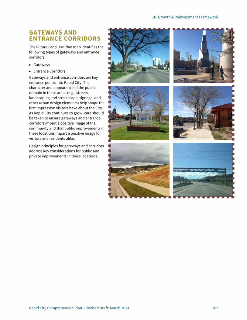
10. Growth & Reinvestment Framework
Rapid City Comprehensive Plan – Revised Draft: March 2014 107
GATEWAYS AND ENTRANCE CORRIDORS The Future Land Use Plan map identifies the following types of gateways and entrance corridors:
• Gateways • Entrance Corridors Gateways and entrance corridors are key entrance points into Rapid City. The character and appearance of the public domain in these areas (e.g., streets, landscaping and streetscape, signage, and other urban design elements) help shape the first impression visitors have about the City. As Rapid City continues to grow, care should be taken to ensure gateways and entrance corridors impart a positive image of the community and that public improvements in these locations impart a positive image for visitors and residents alike.
Design principles for gateways and corridors address key considerations for public and private improvements in these locations.

10. Growth & Reinvestment Framework | Gateways and Entrance Corridors
108 Rapid City Comprehensive Plan – Revised Draft: March 2014
GATEWAYS Characteristics Locations GATEWAYS
Marks the entry or passage into the City. Usually corresponds with a
major interchange or community point of interest (landmark). Potential to incorporate
unique and attractive design elements, landscaping, and signage to enhance the sense of arrival and project a positive and welcoming community image.
Interchanges East Highway 44 at North Elk Vale Road (corresponds with primary route from
Rapid City Airport into Downtown) Interstate 90 at North Elk Vale Road Interstate 90 at North Deadwood Ave Highway 79 (Cambell Street) at Elk Vale Road Interstate 90 at Interstate 190 Interstate 190 at Omaha Street Landmarks Mount Rushmore Road at Tower Road (near Regional Health center) US Highway 16 at the City’s southern limits (near Fort Hayes Drive) Jackson Boulevard at Canyon Lake Park (near Chapel Lane) Sturgis Road at the City’s northern limits (north of Hidden Valley Road)
ENTRANCE CORRIDORS Characteristics Locations ENTRANCE CORRIDORS
A primary route into the City, usually corresponding with a gateway. Typically extend beyond the
City limits, but the appearance of these corridors creates an impression about the City. Coordination with adjacent
counties and communities, and the South Dakota Department of Transportation necessary to create welcoming, attractive corridors that elevate the area’s appeal as a regional destination. Potential to incorporate
landscaping, coordinated signage and lighting, and other design elements to enhance positive impressions. Focus should be protection of
scenic views, landscaping, and natural character rather than intense development along some entrance corridors.
Elk Vale Road traversing the southeastern section of the community from Interstate 90 to the north to Mount Rushmore Road to the south. Haines Avenue stretching north from Interstate 90 to beyond the County line. Highway 44 extending from the City’s core near East Omaha Street east to the
Rapid City Regional Airport. Highway 79 extending south of Elk Vale. Interstate 190 stretching from Interstate 90 to the north to Omaha Street to
the south. Interstate 90 including the segments west of Interstate 190 and east of North
Elk Vale Road. Jackson Boulevard (Highway 44) extending west of Canyon Lake. Sturgis Road stretching north of the Rapid City limits. US 16 extending south from the Rapid City limits.

10. Growth & Reinvestment Framework | Gateways and Entrance Corridors
Rapid City Comprehensive Plan – Revised Draft: March 2014 109
DESIGN PRINCIPLES FOR GATEWAYS AND ENTRANCE CORRIDORS
General Design Principles for Gateways and Entrance Corridors (GDP-GEC)
The following design principles apply to all gateways and entrance corridors identified on the Future Land Use Plan map.
GDP-GEC1: DIRECTIONAL SIGNAGE
Establish a consistent and well-designed program of directional signage to orient visitors and reinforce the character of Rapid City’s gateways and entrance corridors.
GDP-GEC2: STREETSCAPE CHARACTER
Enhance the character of designated gateways and entrance corridors as part of future development or revitalization efforts and/or planned utility or roadway improvements as follows:
• Incorporate street trees, sidewalk furniture, special paving, public art, shade structures, median landscaping and monument signage, and a range of landscape treatments in development setbacks;
• Establish a consistent design theme and/or landscape design character that reflects the unique qualities of each gateway or entrance corridor; and
• Underground existing utilities where feasible.
GDP-GEC3: MULTI-MODAL CONNECTIVITY
Plan new development along entrance corridors to encourage pedestrian and bicycle activity and facilitate access to existing and planned transit:
• Incorporate detached or wider sidewalks (where right-of-way width allows) and outdoor gathering spaces with seating and other amenities;
• Include parking and storage facilities for bicycles;
• Locate surface parking behind buildings and away from street frontages or using structured parking;
• Provide direct connections between buildings, parking areas, transit stops, and surrounding neighborhoods.
GDP-GEC4: ACCESS MANAGEMENT
Establish centralized access points as appropriate when development occurs to manage traffic circulation and protect the character of the City’s gateways and entrance corridors. Pursue joint access agreements or alternative access plans at time of development entitlement for parcels with frontage on a designated gateway or entrance corridor.
GDP-GEC5: BUILDING ORIENTATION
Orient development towards entrance corridors and gateways, providing a high level of architectural detailing
and clearly defined entrances for pedestrians. Bring buildings located at major intersections closer to the street to anchor corners and to help form a gateway into adjoining neighborhoods.
GDP-GEC6: PARKING DESIGN AND LOCATION
Locate surface parking and loading areas away from the gateways and entrance corridors and screen these features using a combination of landscaping, berming, and/or ornamental fencing.
GDP-GEC7: SIGNAGE
Reduce existing—or avoid creating new— visual clutter associated with signage in designated gateways and entrance corridors as follows:
• Limit new development signage to low profile monument signs designed as part of a larger development scheme;
• Use consolidated signage for larger developments to minimize visual clutter; and
• Prohibit pole signs and billboards in these locations.
GDP-GEC8: INTERSECTIONS AND CROSSINGS
Design intersections and crossings along entrance corridors with the accessibility and safety of multiple modes in mind, including bikes, pedestrians, and transit.


10. Growth & Reinvestment Framework
Rapid City Comprehensive Plan – Revised Draft: March 2014 111
PARKS AND RECREATION OPPORTUNITIES Two types of parks and recreation opportunities are identified on the Future Land Use Plan map:
• Parks and Greenways; and • Regional Recreational
Destinations Uses and characteristics are described on the following pages. Refer to the Outstanding Recreational and Cultural Opportunities chapter (See page 63) for more detailed guidance regarding specific types of parks and recreational facilities, their desired distribution within the community, and target levels of service for different types of facilities.
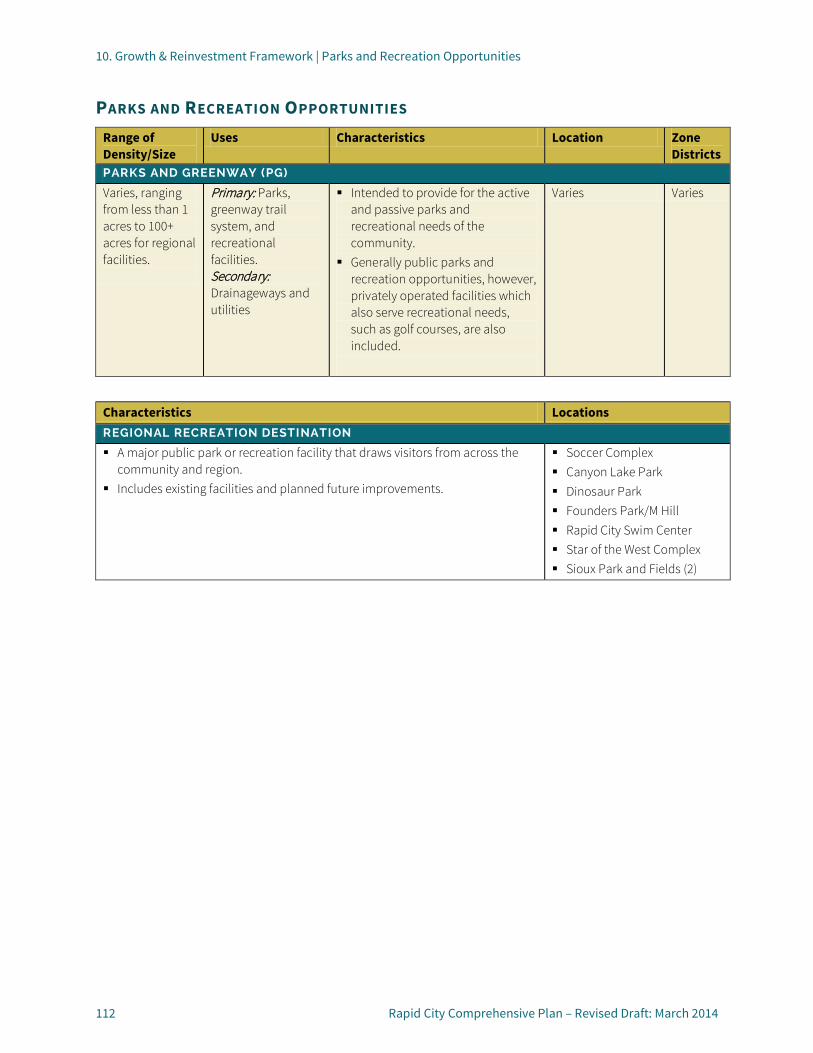
10. Growth & Reinvestment Framework | Parks and Recreation Opportunities
112 Rapid City Comprehensive Plan – Revised Draft: March 2014
PARKS AND RECREATION OPPORTUNITIES Range of Density/Size
Uses Characteristics Location Zone Districts
PARKS AND GREENWAY (PG)
Varies, ranging from less than 1 acres to 100+ acres for regional facilities.
Primary: Parks, greenway trail system, and recreational facilities. Secondary: Drainageways and utilities
Intended to provide for the active and passive parks and recreational needs of the community.
Generally public parks and recreation opportunities, however, privately operated facilities which also serve recreational needs, such as golf courses, are also included.
Varies Varies
Characteristics Locations REGIONAL RECREATION DESTINATION
A major public park or recreation facility that draws visitors from across the community and region.
Includes existing facilities and planned future improvements.
Soccer Complex Canyon Lake Park Dinosaur Park Founders Park/M Hill Rapid City Swim Center Star of the West Complex Sioux Park and Fields (2)

10. Growth & Reinvestment Framework
Rapid City Comprehensive Plan – Revised Draft: March 2014 113
LAND CONSERVATION AND RESERVE Five categories of land conservation uses are identified on the Future Land Use Plan map:
• Agriculture • Buffer/Reserve • Flood Hazard Overlay • Forest Conservation • Future Greenway Conservation Uses and characteristics for each category vary significantly and are described on the following pages. This section also includes supporting design principles.
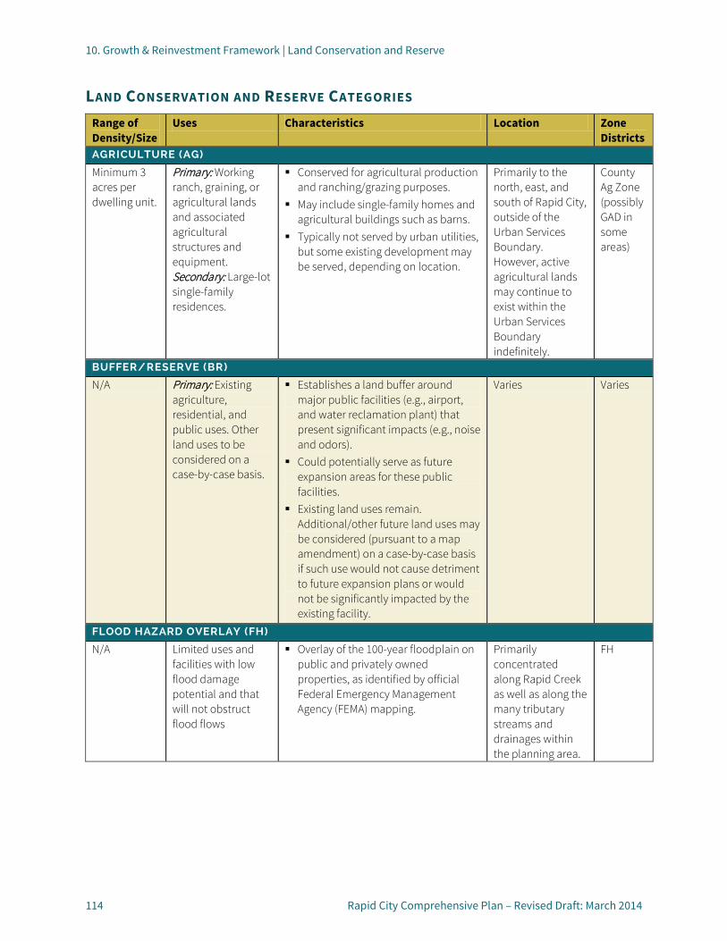
10. Growth & Reinvestment Framework | Land Conservation and Reserve
114 Rapid City Comprehensive Plan – Revised Draft: March 2014
LAND CONSERVATION AND RESERVE CATEGORIES Range of Density/Size
Uses Characteristics Location Zone Districts
AGRICULTURE (AG)
Minimum 3 acres per dwelling unit.
Primary: Working ranch, graining, or agricultural lands and associated agricultural structures and equipment. Secondary: Large-lot single-family residences.
Conserved for agricultural production and ranching/grazing purposes.
May include single-family homes and agricultural buildings such as barns.
Typically not served by urban utilities, but some existing development may be served, depending on location.
Primarily to the north, east, and south of Rapid City, outside of the Urban Services Boundary. However, active agricultural lands may continue to exist within the Urban Services Boundary indefinitely.
County Ag Zone (possibly GAD in some areas)
BUFFER/RESERVE (BR)
N/A Primary: Existing agriculture, residential, and public uses. Other land uses to be considered on a case-by-case basis.
Establishes a land buffer around major public facilities (e.g., airport, and water reclamation plant) that present significant impacts (e.g., noise and odors).
Could potentially serve as future expansion areas for these public facilities.
Existing land uses remain. Additional/other future land uses may be considered (pursuant to a map amendment) on a case-by-case basis if such use would not cause detriment to future expansion plans or would not be significantly impacted by the existing facility.
Varies Varies
FLOOD HAZARD OVERLAY (FH)
N/A Limited uses and facilities with low flood damage potential and that will not obstruct flood flows
Overlay of the 100-year floodplain on public and privately owned properties, as identified by official Federal Emergency Management Agency (FEMA) mapping.
Primarily concentrated along Rapid Creek as well as along the many tributary streams and drainages within the planning area.
FH

10. Growth & Reinvestment Framework | Land Conservation and Reserve
Rapid City Comprehensive Plan – Revised Draft: March 2014 115
Range of Density/Size
Uses Characteristics Location Zone Districts
FOREST CONSERVATION (FC)
Minimum 3 acres per dwelling unit.
Primary: Open lands preserved by the City or other government agencies, or as part of a private development (e.g. planned unit development) for conservation, resource protection, recreational, or utility use. Secondary: Large-lot single-family residences.
Emphasis on conservation for natural beauty, open character, and recreational access.
May be publicly or privately owned. Public access may be provided with
designated trails or bicycle facilities; however, in other areas lands may be left intact as visual buffers or to protect significant ridgelines visible from various areas of the community.
Single-family homes on large lots in a forested or mountainous rural setting.
Clustering is encouraged to conserve natural features and make efficient use of infrastructure. Smaller lots may be provided when development is clustered.
Typically not served by urban utilities, but some existing development may be served, depending on location.
Primarily in rugged forested areas to the west of Rapid City Limits; as well central locations along Skyline Drive and north of M Hill.
PF, varies
FUTURE GREENWAY CONSERVATION (FG)
N/A Parks, recreation, open space, and other limited uses and facilities with low flood damage potential and that will not obstruct flood flows
Identifies areas within the 100-year floodplain (as identified by official FEMA mapping) that are not currently reserved as public greenway but are good candidates for future public or private greenway conservation.
Primarily concentrated along Rapid Creek as well as along the many tributary streams and drainages within the planning area.
FH
10. Growth & Reinvestment Framework | Land Conservation and Reserve
116 Rapid City Comprehensive Plan – Revised Draft: March 2014
LAND CONSERVATION DESIGN PRINCIPLES:
General Design Principles for Forest Conservation Areas
General Design Principles for Forest Conservation Areas provide guidance on a range of site planning, resource conservation, and connectivity issues for development in these visually and environmentally sensitive areas of the community. These design principles also intended to address considerations to promote increased awareness of potential risks and responsibilities associated with development in the Wildland Urban Interface (WUI).
GDP-FC1: PRESERVATION OF NATURAL FEATURES Limit overlot grading for driveways and homes sites to minimize erosion, stormwater runoff, and other site disturbances. Incorporate innovative site planning techniques to maximize the preservation of natural features and expand community greenways over time, such as:
• Floodplains, drainages, and wetlands;
• Forested areas or other areas with significant native vegetation or mature shade trees;
• Documented wildlife habitat; and/or
• Steep slopes and other unique or environmentally sensitive features.
GDP-FC2: CONNECTIVITY • Integrate protected natural
features as active and passive open space, greenways, and/or trail corridors to serve and enhance connections between groups of homes and established areas of the community or publicly accessible lands, where appropriate.
• Provide multiple vehicular access points to new subdivisions for emergency access and safe evacuation routes in high-risk wildfire areas.
GDP-FC3: CLUSTER DEVELOPMENT Use cluster development patterns as a tool to achieve one or more of the following objectives:
• Preserve scenic view corridors or natural features;
• Create transitions between areas of different development intensity;
• Accommodate smaller lots on portions of the site located outside of wildfire hazard areas;
• Provide open space for the common use and enjoyment of residents and the broader community; and/or
• Preserve cohesive blocks of forest.
GDP-FC4: VEGETATION MANAGEMENT
Educate land owners regarding their responsibility to manage vegetation on their property to reduce wildfire risk to not only themselves, but their neighbors as well. Provide
information regarding defensible space parameters, guidelines for site-specific wildfire hazard assessments, and other steps that can be taken by property owners to reduce risk.
GDP-FC4: FIRE RESISTANT BUILDING MATERIALS Educate land owners as part of the building permit process about the range of fire-resistant building materials that are available on the market and the potential benefits they provide.
GDP-FC5: SOURCE WATER PROTECTION
Consider recommendations provided by the City’s Source Water Protection report in future development plans as appropriate.
http://archive.rcgov.org/pw20090714/PW071409-01.pdf
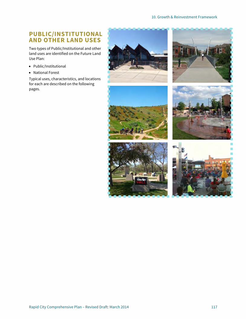
10. Growth & Reinvestment Framework
Rapid City Comprehensive Plan – Revised Draft: March 2014 117
PUBLIC/INSTITUTIONAL AND OTHER LAND USES Two types of Public/Institutional and other land uses are identified on the Future Land Use Plan:
• Public/Institutional • National Forest Typical uses, characteristics, and locations for each are described on the following pages.
10. Growth & Reinvestment Framework | Public/Institutional and Other Land Uses
118 Rapid City Comprehensive Plan – Revised Draft: March 2014
PUBLIC/INSTITUTIONAL AND OTHER LAND USE CATEGORIES Range of Density/Size
Uses Characteristics Location Zone Districts
PUBLIC/QUASI-PUBLIC (P/QP)
N/A Primary: Schools, government offices, airport, community/senior centers, fire stations, libraries, hospitals, cemeteries, and places of worship. Also includes facilities needed for essential public services such as electrical substations, water and wastewater facilities, and other similar uses.
Provided by the City, special districts, or by a quasi-public organization.
Places of worship are also an acceptable use in residential and some commercial areas and may not be designated as Public/Quasi-Public.
Varies P, CC, Airport
NATIONAL FOREST (NF)
N/A Publicly owned and accessible lands preserved by the U.S. Forest Service for conservation, resource protection, or recreational use.
Provides wildlife habitat, resource conservation, and recreational opportunities.
Proposed land use changes occurring adjacent to National Forest properties will require coordination with a designated planning representative.
N/A N/A

11. Neighborhood Area Policies
11

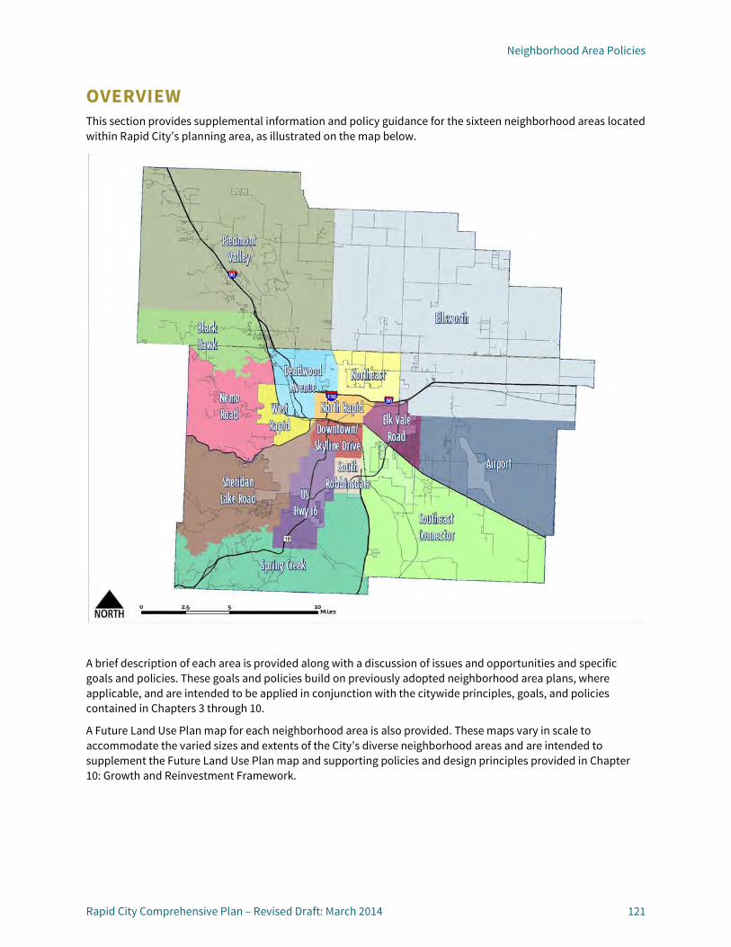
Neighborhood Area Policies
Rapid City Comprehensive Plan – Revised Draft: March 2014 121
OVERVIEW This section provides supplemental information and policy guidance for the sixteen neighborhood areas located within Rapid City’s planning area, as illustrated on the map below.
A brief description of each area is provided along with a discussion of issues and opportunities and specific goals and policies. These goals and policies build on previously adopted neighborhood area plans, where applicable, and are intended to be applied in conjunction with the citywide principles, goals, and policies contained in Chapters 3 through 10.
A Future Land Use Plan map for each neighborhood area is also provided. These maps vary in scale to accommodate the varied sizes and extents of the City’s diverse neighborhood areas and are intended to supplement the Future Land Use Plan map and supporting policies and design principles provided in Chapter 10: Growth and Reinvestment Framework.


11. Neighborhood Area Policies
123 Rapid City Comprehensive Plan – Revised Draft: March 2014
AIRPORT NEIGHBORHOOD AREA (AP-NA) DESCRIPTION The Airport Neighborhood Area is located on the eastern side of Rapid City, directly south of Box Elder. It is bounded by Highway 44 to the south, Box Elder to the north, approximately East 53rd Street to the west, and 154th Avenue to the east. This area is predominantly outside of the current Rapid City limits except for the Rapid City Regional Airport. The western two-thirds of the Airport Neighborhood Area fall within the Urban Services Boundary.
ISSUES AND OPPORTUNITIES This Neighborhood Area is influenced by the Rapid City Regional Airport, which presents opportunities and challenges for development in this area. The Rapid City Regional Airport Master Plan Land Use Compatibility Plan details the airport vision and growth plans, and also identifies land use and compatibility requirements for development in the surrounding environs. Future expansion of the airport will likely occur to the east, and therefore it is important to reserve opportunities for this future growth.
The area south of the airport, along Highway 44, presents opportunities for future development and activities related to the airport, including logistics, distribution, and office uses. Recent extension of City utilities to the airport will help
support the growth of this Community Activity Center and employment area.
Highway 44 is an important entryway corridor into the community, as visitors arrive from the southeast or via the airport. To preserve the rural character of this corridor, mixed-use commercial development along this corridor should be concentrated at major intersections, rather than “stripped out” along the corridor.
Residential growth is expected to continue to push east from the City into this area, yet airport regulations limit residential development beyond Radar Hill Road. Annexation into the City is a key issue as properties develop in this area.
To the north, neighboring Box Elder is also growing, and coordination is necessary to limit airport-related conflicts. East of the airport, the lack of utility services will limit urban growth and the area will likely remain predominantly agricultural or undeveloped over the course of the planning horizon.
The entire Rapid City Regional Airport Master Plan Land Use Compatibility Plan, including the land use maps and airport safety zones can be reviewed online at: http://www.rcgov.org/pdfs/TransportationPlanning/Neighborhood%20Plans/RAP_LUP_Oct2010_Pg_1_47.pdf
GOALS AND POLICIES
Goal AP-NA1.1: Support expansion of the Rapid City Regional Airport and promote airport-compatible growth and development.
AP-NA1.1A: AIRPORT RESERVE
Reserve opportunities for the future expansion of the Rapid City Regional Airport to the north and east, and limit development that conflicts with current or future airport operations or expansion.
AP-NA1.1B: AIRPORT SAFETY
Consider additional zoning and land use regulations, as recommended in the Airport Land Use Compatibility Plan to enhance aircraft safety and sustain long-term operations and growth opportunities at the Rapid City Regional Airport. These include but are not limited to runway protection, inner approach/departure zones, circling traffic patterns, precision flight corridor, and aviation hazard safety zones.
AP-NA1.1C: AIRPORT COMPATIBILITY
Pursue opportunities to relocate existing roadways (e.g., Longview Road) and land uses that currently conflict with runway protection and other airport safety zones. Encourage compatible uses and development within runway protection zones and concentrate future development away from areas with potential safety risks.

11. Neighborhood Area Policies | Airport Neighborhood Area (AP-NA)
124 Rapid City Comprehensive Plan – Revised Draft: March 2014
AP-NA1.D: AIRPORT INFRASTRUCTURE
Invest in additional infrastructure to include the Rapid City Regional Airport in the City’s water and wastewater systems.
AP-NA1.1E: EMPLOYMENT
Encourage airport-related employment growth south and west of the airport, near the Highway 44 corridor to maximize recent infrastructure investments in the area, and take advantage of airport proximity.
AP-NA1.1F: ENTRANCE CORRIDOR
Recognize Highway 44 as an important Entrance Corridor into the City, and encourage coordinated signage, landscaping, and development planning to enhance the corridor’s appearance. Apply Design Principles for Gateways and Entrance Corridors in the review of future development along the corridor. (See page 109)
AP-NA1.1G: COMMERCIAL INTERSECTIONS
Focus commercial development and Community Activity Centers at the intersections of Highway 44 and major arterial roadways (East 53rd Street and Radar Hill Road) to avoid strip development and to retain the rural character of the Entrance Corridor.
AP-NA1.1H: RESIDENTIAL GROWTH
Support residential development west of Radar Hill Road that does not encroach or conflict with airport safety or noise zones. Support the development of a new mixed-use Community Activity Center within this area, preferably at a key intersection
such as the future extensions of Twilight Drive at Anderson Road).
AP-NA1.1I: ANNEXATION
Require the annexation of contiguous properties when development occurs, and require an annexation agreement for noncontiguous properties (stating that they agree to be annexed into Rapid City when eligible).
AP-NA1.1J: URBAN SERVICES
Allow the extension of City infrastructure within the Urban Services Boundary to serve new and existing development.
AP-NA1.1K: INTERJURISDICTIONAL COORDINATION
Coordinate planning and development review activities with the City of Box Elder, Pennington County, and airport authorities.

LONG VIEW RD
RADA
R HI
LL R
D
44
Rapid CityRegionalAirport
BOX ELDER
Airport Neighborhood AreaFuture Land Use Plan
This GIS Data is provided "as is" without warranty of any representation of accuracy, timeliness, or completeness. Theburden for determining accuracy, completeness, timeliness, merchantability, and fitness for or the appropriateness for use rests solely on the user. Rapid City, Pennington County, and Meade County make no warranties, express or implied, as to the use of the Data. There are no implied warranties of merchantability or fitnessfor a particular purpose. The user acknowledges and accepts the limitations of the Data, including the fact that the Data is dynamic and is in a constant state of maintenance, correction, and update.
Overview Map
March 2014DRAFT
0 1.5 30.75Miles
LegendNeighborhood Area
Rapid City Limits
County Boundary
Urban Service Boundary
Cemetery
Fire station
Hospital
Police station
School
Railroad
Water Bodies
Future Land UseRural Residential
Low Density Neighborhood
Urban Neighborhood
Mixed Use Commercial
Downtown
Employment
Light Industrial
Heavy Industrial
Mining/Extraction
Parks and Greenway
Agriculture
Forest Conservation
National Forest
Buffer/Reserved
Public/Quasi-Public
Entrance Corridor
Revitalization Corridor
Gateway
Revitalization Node
Regional Activity Center
Community Activity Center
Regional Recreation Destlination
Major Street PlanInterstate Highway
Principal Arterial
Proposed Principal Arterial
Minor Arterial
Proposed Minor Arterial
Collector
Proposed Collector (exact alignment TBD)
OverlaysForest
Flood Hazard Overlay
Future Greenway Conservation
Sensitive Geologic Area
Ellsworth 65 Ldn Noise Contours
Circling traffic patterns
Inner approach/departure
Precision flight corridor
Runway protection zone

11. Neighborhood Area Policies
127 Rapid City Comprehensive Plan – Revised Draft: March 2014
BLACK HAWK NEIGHBORHOOD AREA (BH-NA) DESCRIPTION The Black Hawk Neighborhood Area is located northwest of Rapid City and includes portions of Pennington and Meade Counties. It is bounded on the north by the southern boundary of Summerset extending westward, Nemo Road and Box Elder Creek on the south, Sturgis Road to the east, and the Metropolitan Planning Organization boundary to the west.
ISSUES AND OPPORTUNITIES This Neighborhood Area includes large tracts of National Forest land and existing and future mining and extraction activities. Pockets of rural residential development exist within the hilly and forested areas, but most development in this Neighborhood Area is clustered near Sturgis Road.
The southeast portion of this Neighborhood Area is located within Rapid City’s Urban Services Boundary, but due to topographic constraints and the heavily forested character of this area, future development is likely to be more rural in nature, with large lots and focus on the conservation of natural features.
Opportunities do exist for continued residential and mixed-use development along and near the Sturgis Road corridor, but as an important Entrance Corridor into the community, careful planning is needed to balance the demand for new development
and resource extraction with the preservation of the natural qualities that make this a pleasant and attractive route into the City.
GOALS AND POLICIES
Goal BH-NA1.1: Retain the scenic and natural qualities of the Black Hawk Neighborhood Area and focus new development in existing activity areas.
BH-NA1.1A: FOREST CONSERVATION
Coordinate with the Forest Service and adjacent property owners and residents to support the preservation of natural features and minimize risks associated with development in the Wildland Urban Interface (WUI). Apply General Design Principles for Forest Conservation Areas to future development in the area. (See page 116.)
BH-NA1.1B: RESIDENTIAL GROWTH
Encourage the clustering of rural residential development to conserve natural features, limit impacts on the natural environment, and maximize infrastructure such as roads.
BH-NA1.1C: MIXED-USE DEVELOPMENT Support intensification of existing mixed-use and nonresidential developments to increase the variety of uses and maximize infrastructure investments. Discourage new, isolated pockets of mixed-use or non-residential development.
BH-NA1.1D: RESOURCE EXTRACTION Coordinate with the mining industry to establish long-term plans for extraction and reclamation.
BH-NA1.1E: ENTRANCE CORRIDOR Recognize Sturgis Road as an important Entrance Corridor into the City, and encourage coordinated signage, landscaping, and development planning to retain the corridor’s rural character and scenic qualities. Apply Design Principles for Gateways and Entrance Corridors in the review of future development along the corridor. (See page 109.)
BH-NA1.1F: URBAN SERVICES Allow the extension of City infrastructure within the Urban Services Boundary to serve new and existing development.
BH-NA1.1G: INTERJURISDICTIONAL COORDINATION Coordinate planning and development review activities with Summerset, the National Forest Service, and Meade and Pennington Counties.

STU R G IS RD
PEACEFUL PI NES RD
NEMO RD
231
90
SUMMERSET
M E A D E C O U N T YP E N N I N G T O N C O U N T Y
Black Hawk Neighborhood AreaFuture Land Use Plan
This GIS Data is provided "as is" without warranty of any representation of accuracy, timeliness, or completeness. Theburden for determining accuracy, completeness, timeliness, merchantability, and fitness for or the appropriateness for use rests solely on the user. Rapid City, Pennington County, and Meade County make no warranties, express or implied, as to the use of the Data. There are no implied warranties of merchantability or fitnessfor a particular purpose. The user acknowledges and accepts the limitations of the Data, including the fact that the Data is dynamic and is in a constant state of maintenance, correction, and update.
Overview Map
March 2014DRAFT
0 1 20.5Miles
LegendNeighborhood Area
Rapid City Limits
County Boundary
Urban Service Boundary
Cemetery
Fire station
Hospital
Police station
School
Railroad
Water Bodies
Future Land UseRural Residential
Low Density Neighborhood
Urban Neighborhood
Mixed Use Commercial
Downtown
Employment
Light Industrial
Heavy Industrial
Mining/Extraction
Parks and Greenway
Agriculture
Forest Conservation
National Forest
Buffer/Reserved
Public/Quasi-Public
Entrance Corridor
Revitalization Corridor
Gateway
Revitalization Node
Regional Activity Center
Community Activity Center
Regional Recreation Destlination
Major Street PlanInterstate Highway
Principal Arterial
Proposed Principal Arterial
Minor Arterial
Proposed Minor Arterial
Collector
Proposed Collector (exact alignment TBD)
OverlaysForest
Flood Hazard Overlay
Future Greenway Conservation
Sensitive Geologic Area
Ellsworth 65 Ldn Noise Contours
Circling traffic patterns
Inner approach/departure
Precision flight corridor
Runway protection zone

11. Neighborhood Area Policies
129 Rapid City Comprehensive Plan – Revised Draft: March 2014
DEADWOOD AVENUE NEIGHBORHOOD AREA (DA-NA) DESCRIPTION The Deadwood Avenue Neighborhood Area is located in the northwestern portion of the community, and includes land within the City limits, as well as unincorporated portions of Pennington County. It is bounded by Omaha Street/ West Chicago Street to the south, the Pennington County line to the north, Sturgis Road to the west, and North Haines Avenue to the east. Box Elder Creek passes through the northern portion of the area and Rapid Creek passes through the southern portion.
ISSUES AND OPPORTUNITIES This Neighborhood Area is one of the fastest growing areas in the community. It is readily accessible to several major transportation routes including Interstate 90, Deadwood Avenue and Haines Avenue. The north-south ridgeline crossing this area will present some challenges to development and infrastructure in this area, but the entire area falls within the Urban Services Boundary. East of the ridgeline, increased residential growth will necessitate infrastructure expansion and extension.
West of the ridgeline, rural residential, light industrial, and mining and extraction activities are expected to continue, with mixed-use commercial activities focused east of Deadwood Avenue, north of the Interstate.
South of Interstate 90, a mix of uses currently exist, including residential, commercial, employment, industrial, parks, and mining. Future opportunities include reinvestment and mixed-use infill and redevelopment along the West Chicago Street/Sturgis Road corridor. Because of the diversity of land uses in this area, considerations will need to be given to buffering, screening and providing transitions between industrial and residential areas, and making sure that the northern Gateways and Entrance Corridors into the community project a positive and inviting image.
GOALS AND POLICIES
Goal DA-NA1.1: Reinvest in established areas and expand housing, employment, and service options as new growth occurs throughout the Deadwood Neighborhood Area.
DA-NA1.1A: RESIDENTIAL GROWTH
Support expansion and development of new residential neighborhoods west of Haines Avenue.
DA-NA1.1B: MIXED-USE DEVELOPMENT
Encourage mixed-use development, redevelopment, and redevelopment at major intersections including Interstate 90 at Deadwood Avenue and Haines Avenue.
DA-NA1.1C: EMPLOYMENT ACTIVITIES
Support the continuation and expansion of existing employment and light industrial uses in these areas, to take advantage of the rail and highway transportation network. Ensure adequate buffering of heavy industrial uses to minimize conflicts with other land uses.
DA-NA1.1D: REINVESTMENT CORRIDOR
Support mixed-use reinvestment and redevelopment along the West Chicago Street/Sturgis Road Corridor.
DA-NA1.1E: ENTRANCE CORRIDORS
Recognize Sturgis Road, Interstate 90, Interstate 190, and Haines Avenue as an important Entrance Corridor into the City, and encourage coordinated signage, landscaping, and development planning to project a positive image of the community and reflect each corridor’s unique qualities. Apply Design Principles for Entrance Corridors in the review of future development along the corridor. (See page 109.)
DA-NA1.1F: GATEWAYS
Explore and pursue opportunities to enhance and highlight City gateways along Sturgis Road and Interstate 90, and at the intersection of Interstates 90 and 190. Apply Design Principles for Gateways and Entrance Corridors to future public improvements in these locations.

11. Neighborhood Area Policies | Deadwood Avenue Neighborhood Area (DA-NA)
130 Rapid City Comprehensive Plan – Revised Draft: March 2014
DA-NA1.1G: PARKS AND GREENWAYS
Promote the development of parks and conservation of greenways in this area to increase recreation opportunities for existing and future residents of this Neighborhood Area.
DA-NA1.1H: RESOURCE EXTRACTION
Coordinate with the mining industry to establish long-term plans for extraction and reclamation.
DA-NA1.1I: NATURAL FEATURES
Support and encourage the conservation of natural features in this area, including floodplains, forested areas, and hillsides.
DA-NA1.1J: REGIONAL RECREATION
Promote and support M Hill and Founders Park as a regional recreation destination well known for mountain biking, hiking, and an extensive trail network.
DA-NA1.1K: URBAN SERVICES
Allow the extension of City infrastructure within the Urban Services Boundary to serve new and existing development.
DA-NA1.1L: INTERJURISDICTIONAL COORDINATION
Coordinate planning and development review activities in this area with Meade County.
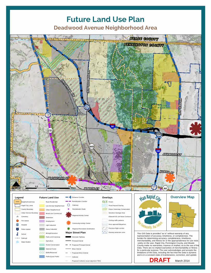
DEADWOOD AVE
UNIVERSAL DR
HAINES AVE
ANAMOSA ST
NORTH STW CHICAGO ST
W MAIN ST
231
445
44
190
90
P E N N I N G T O N C O U N T Y
M E A D E C O U N T Y
FOUNDERSPARK
CHUCKLIEN FAMILY
PARK
VICKIE POWERSMEMORIAL PARK
Deadwood Avenue Neighborhood AreaFuture Land Use Plan
This GIS Data is provided "as is" without warranty of any representation of accuracy, timeliness, or completeness. Theburden for determining accuracy, completeness, timeliness, merchantability, and fitness for or the appropriateness for use rests solely on the user. Rapid City, Pennington County, and Meade County make no warranties, express or implied, as to the use of the Data. There are no implied warranties of merchantability or fitnessfor a particular purpose. The user acknowledges and accepts the limitations of the Data, including the fact that the Data is dynamic and is in a constant state of maintenance, correction, and update.
Overview Map
March 2014DRAFT
0 0.6 1.20.3Miles
LegendNeighborhood Area
Rapid City Limits
County Boundary
Urban Service Boundary
Cemetery
Fire station
Hospital
Police station
School
Railroad
Water Bodies
Future Land UseRural Residential
Low Density Neighborhood
Urban Neighborhood
Mixed Use Commercial
Downtown
Employment
Light Industrial
Heavy Industrial
Mining/Extraction
Parks and Greenway
Agriculture
Forest Conservation
National Forest
Buffer/Reserved
Public/Quasi-Public
Entrance Corridor
Revitalization Corridor
Gateway
Revitalization Node
Regional Activity Center
Community Activity Center
Regional Recreation Destlination
Major Street PlanInterstate Highway
Principal Arterial
Proposed Principal Arterial
Minor Arterial
Proposed Minor Arterial
Collector
Proposed Collector (exact alignment TBD)
OverlaysForest
Flood Hazard Overlay
Future Greenway Conservation
Sensitive Geologic Area
Ellsworth 65 Ldn Noise Contours
Circling traffic patterns
Inner approach/departure
Precision flight corridor
Runway protection zone


11. Neighborhood Area Policies
133 Rapid City Comprehensive Plan – Revised Draft: March 2014
DOWNTOWN/ SKYLINE DRIVE NEIGHBORHOOD AREA (DSD-NA) DESCRIPTION The Downtown/Skyline Drive Neighborhood Area is located in the heart of the Rapid City community. It is bounded by Omaha Street to the north, Skyline Drive to the west, Cambell Street to the east, and near Fairmont Boulevard to the south. The area is entirely within Rapid City limits.
ISSUES AND OPPORTUNITIES This Neighborhood Area encompasses the City’s historic core, and includes the central business district and a mix of established neighborhoods. Within and near the central business district, historic buildings feature an array of commercial, service, office, and employment uses. Some residential uses are also present, both above commercial uses and in standalone apartment and condominium buildings. Recent public improvements in the central business district have helped catalyze additional interest and investment in the core area, and reinvestment, infill development and redevelopment are expected to continue in this high-activity area. Preservation of the area’s historic character is important as development continues, in order to retain the area’s authenticity and appeal.
Parking is another issue to address as development and activity levels continue to intensify within and near
Downtown. Structured parking, parking management, and increasing multi-modal options are all opportunities that may help address the parking issue.
A mix of residential and non-residential uses surround the Downtown Core, and many of these areas also have historic qualities and structures that are important to preserve. There are many opportunities for revitalization, infill development and redevelopment in these fringe areas, yet compatibility with adjacent neighborhoods is a growing concern. Moreover, the conversion of residential structures to non-residential uses is an increasing trend in this area, especially along major corridors such as Mount Rushmore Road and Saint Patrick Street. Balancing the preservation and reuse of historic structures, neighborhood compatibility, and the parking, access, and other requirements of non-residential uses is a delicate issue along these corridors.
These aging corridors also have competing demands on the roadways themselves. Both are physically constrained due to development on both sides of the street, and there are increasing demands for pedestrian, bicycle, and transit accommodations, in addition to automobile traffic on the narrow roadways. As reinvestment and revitalization occur along these corridors, improving access management, providing multi-modal opportunities or alternative routes, and land use coordination are all important considerations.
Another priority area for reinvestment and development activity is the set of paired one-
way corridors connecting the central business district and the SDSMT campus. East Main Street and East Saint Joseph Street both feature a mix of uses, but in general, these corridors are somewhat underutilized and present opportunities for the incorporation of housing and services to meet the needs of the growing SDSMT campus.
Beyond the core and fringe areas, the Neighborhood Area includes a varied mix of established residential neighborhoods, including the West Boulevard Historic District and Robbinsdale neighborhoods. Many are designed as traditional neighborhoods with alley-loaded lots and a grid network of streets, but others are more suburban in nature with curvilinear streets, cul-de-sacs, and street-fronting garages. Limited opportunities for infill development exist in most of these neighborhoods, although there are some pockets where new higher density housing may be appropriate, especially along or near major corridors and near SDSMT. Otherwise, existing neighborhoods in this area could benefit from continued emphasis on historic preservation, property maintenance, and ongoing investment in schools, parks and recreation amenities.

11. Neighborhood Area Policies | Downtown/ Skyline Drive Neighborhood Area (DSD-NA)
134 Rapid City Comprehensive Plan – Revised Draft: March 2014
GOALS AND POLICIES
Goal DSD-NA1.1: Continue revitalization of the Downtown area’s historic core and primary corridors and reinvest in the Downtown/Skyline Drive area neighborhoods.
DSD-NA1.1A: RESIDENTIAL NEIGHBORHOODS
Encourage reinvestment and promote targeted infill development redevelopment to add vitality to the area’s established neighborhoods. Support the compatible infill residential development that increases the variety of housing options.
DSD-NA1.1B: REGIONAL ACTIVITY CENTER
Support the ongoing revitalization of Downtown as the region’s premier destination for shopping, business, dining, arts, and entertainment.
DSD-NA1.1C: MIXED-USE DEVELOPMENT
Encourage adaptive reuse and mixed-uses along the area’s primary corridors and within and surrounding the central business district.
DSD-NA1.1D: REINVESTMENT CORRIDORS
Emphasize reinvestment and targeted redevelopment along the area’s Reinvestment Corridors (Mount Rushmore Road and Saint Patrick Street).
DSD-NA1.1E: SOUTH DAKOTA SCHOOL OF MINES AND TECHNOLOGY
Support expansion of the SDSMT Campus and encourage coordination and intensification of uses along the East Main Street and Saint Joseph Street Reinvestment Corridors to improve connections between Downtown and the campus. (See Goal LC-4.2 for additional policies related to SDSMT.)
DSD-NA1.1F: PARKS AND GREENWAYS Maintain the established parks and greenways in this area for safety, conservation, and recreation purposes.
DSD-NA1.1G: NATURAL FEATURES Support and encourage the conservation of natural features in this area, including floodplains, hillsides, and Skyline Drive Wilderness Area.
DSD-NA1.1H: INTERJURISDICTIONAL COORDINATION Coordinate planning and development review activities in this area with SDSMT and Pennington County.
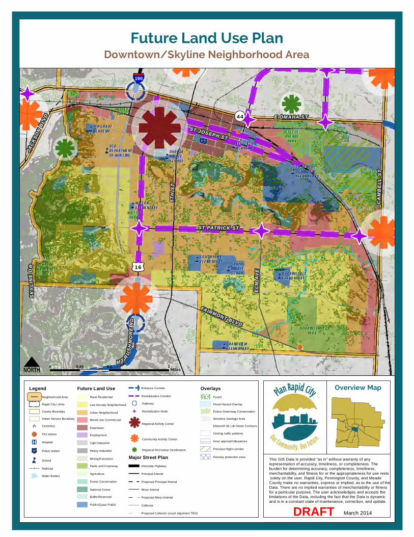
FAIRMONT BLVD
ST PATRICK ST
5TH
ST
SKYL
INE
D R
CAMB
ELL
ST
ST JOSEPH ST
JACK
SON
BLVD
M T R USHM
ORE
RD
ELM
AVE
44
16
E OMAHA ST
190
HALLEYPARK
STEELEAVENUE
PARK
WILSONPARK
ROBBINSDALEPARK
SKYLINEWILDERNESS
AREA
GRANDVIEWELEMENTARY
SOUTH PARKELEMENTARY SOUTH
MIDDLESCHOOL ROBBINSDALE
ELEMENTARY
SD SCHOOLOF MINES &TECHNOLOGY
JEFFERSONACADEMYDAKOTA
MIDDLESCHOOL
9TH GRADEACADEMY
USDDEPARTMENTOF NURSING
WILSONELEMENTARY
Downtown/Skyline Neighborhood AreaFuture Land Use Plan
This GIS Data is provided "as is" without warranty of any representation of accuracy, timeliness, or completeness. Theburden for determining accuracy, completeness, timeliness, merchantability, and fitness for or the appropriateness for use rests solely on the user. Rapid City, Pennington County, and Meade County make no warranties, express or implied, as to the use of the Data. There are no implied warranties of merchantability or fitnessfor a particular purpose. The user acknowledges and accepts the limitations of the Data, including the fact that the Data is dynamic and is in a constant state of maintenance, correction, and update.
Overview Map
March 2014DRAFT
0 0.5 10.25Miles
LegendNeighborhood Area
Rapid City Limits
County Boundary
Urban Service Boundary
Cemetery
Fire station
Hospital
Police station
School
Railroad
Water Bodies
Future Land UseRural Residential
Low Density Neighborhood
Urban Neighborhood
Mixed Use Commercial
Downtown
Employment
Light Industrial
Heavy Industrial
Mining/Extraction
Parks and Greenway
Agriculture
Forest Conservation
National Forest
Buffer/Reserved
Public/Quasi-Public
Entrance Corridor
Revitalization Corridor
Gateway
Revitalization Node
Regional Activity Center
Community Activity Center
Regional Recreation Destlination
Major Street PlanInterstate Highway
Principal Arterial
Proposed Principal Arterial
Minor Arterial
Proposed Minor Arterial
Collector
Proposed Collector (exact alignment TBD)
OverlaysForest
Flood Hazard Overlay
Future Greenway Conservation
Sensitive Geologic Area
Ellsworth 65 Ldn Noise Contours
Circling traffic patterns
Inner approach/departure
Precision flight corridor
Runway protection zone


11. Neighborhood Area Policies
137 Rapid City Comprehensive Plan – Revised Draft: March 2014
ELK VALE NEIGHBORHOOD AREA (EV-NA) DESCRIPTION The Elk Vale Neighborhood Area establishes the eastern edge of Rapid City, and is bisected by Elk Vale Road. It is bounded by Highway 44 to the south, Interstate 90 to the north, Cambell Street to the west, and just beyond Reservoir Road to the east. Most of the Neighborhood Area is within the City limits, but the eastern portion of the area is predominantly unincorporated land within Pennington County.
ISSUES AND OPPORTUNITIES This Neighborhood Area includes a diverse mix of established, unincorporated residential uses on the eastern edge, and a range of established and developing neighborhood, commercial, and employment uses. Presence of the railroad and an east-west ridgeline on the northern segment of the area limit options for residential development, but present opportunities for light industry and employment uses. Further south, along Elk Vale Road, an emerging business park provides opportunities for the development of new office and employment uses.
Community Activity Centers along Elk Vale Road provide opportunities for mixed use commercial development near the University Campus at the Interstate 90 interchange, as well as near the future Safeway store just north of Twilight Drive.
At the center of the Neighborhood Area, opportunities exist for urban residential development that is conveniently located near Downtown and the future extension of Anamosa Street will help connect future neighborhoods to the area’s primary transportation routes: Highway 44, Elk Vale Road, Interstate 90, and Cambell Street.
On the western edge of the Neighborhood Area, existing commercial development within and surrounding the Northgate Activity Center is aging and starting to decline, so revitalization and redevelopment are important issues for the future. The diversification of uses and possible introduction of residential uses could help revitalize the area.
GOALS AND POLICIES
Goal EV-NA1.1: Establish the Elk Vale Neighborhood Area as one of the City’s high priority urban growth and reinvestment areas.
EV-NA1.1A: RESIDENTIAL GROWTH
Support expansion and development of new residential neighborhoods between Cambell Street and Elk Vale Road, and in the Rapid Valley area.
EV-NA1.1B: ANNEXATION
Require the annexation of contiguous properties when development occurs, and require an annexation agreement for noncontiguous properties (stating that they agree to be annexed into Rapid City when eligible).
EV-NA1.1C: MIXED-USE DEVELOPMENT
Encourage mixed-use development and redevelopment at major intersections including Elk Vale Road at Interstate 90 and north of Twilight Drive, Cambell Street between Highway 44 and East Anamosa Street, and along Highway 44 near Reservoir Road.
EV-NA1.1D: EMPLOYMENT ACTIVITIES
Support the continuation and expansion of employment and light industrial activities along the rail line and on the western side of Old Folsom Road.
EV-NA1.1E: ENTRANCE CORRIDORS
Recognize Elk Vale Road and Highway 44 as an important Entrance Corridors into the City, and encourage coordinated signage, landscaping, and development planning to project a positive image of the community and reflect each corridor’s unique qualities. Apply Design Principles for Gateways and Entrance Corridors in the review of future development along these corridors. (See page 109.)
EV-NA1.1F: GATEWAYS
Explore and pursue opportunities to enhance and highlight key interchanges that serve as gateways into the City: Elk Vale Road at Interstate 90 and at Highway 44. Apply Design Principles for Gateways and Entrance Corridors to future public improvements in these locations.
11. Neighborhood Area Policies | Elk Vale Neighborhood Area (EV-NA)
138 Rapid City Comprehensive Plan – Revised Draft: March 2014
EV-NA1.1G: PARKS AND GREENWAYS
Promote the development of parks and conservation of greenways in this area as development occurs to provide recreation opportunities for existing and future residents of this Neighborhood Area.
EV-NA1.1H: URBAN SERVICES
Allow the extension of City infrastructure within the Urban Services Boundary to serve new and existing development.
EV-NA1.1I: INTERJURISDICTIONAL COORDINATION
Coordinate planning and development review activities in this area with Box Elder, Rapid Valley residents, and Pennington County.

90
EGLIN ST
N LA
CROS
SE S
T
E NORTH ST
CAMB
ELL
ST
S VA
LLEY
DR
E ST JOSEPHST
ELK
VALE
RD
LONG VIEW RD
RESE
RVOI
R RD
E ANAMOSA ST
44
TWILIGHT DR
BOX ELDER
WESTERN DAKOTATECHNICALINSTITUTE
RAPIDVALLEYELEMENTARY
VALLEYVIEW ELEMENTARY
EASTMIDDLE SCHOOL
Elk Vale Road Neighborhood AreaFuture Land Use Plan
This GIS Data is provided "as is" without warranty of any representation of accuracy, timeliness, or completeness. Theburden for determining accuracy, completeness, timeliness, merchantability, and fitness for or the appropriateness for use rests solely on the user. Rapid City, Pennington County, and Meade County make no warranties, express or implied, as to the use of the Data. There are no implied warranties of merchantability or fitnessfor a particular purpose. The user acknowledges and accepts the limitations of the Data, including the fact that the Data is dynamic and is in a constant state of maintenance, correction, and update.
Overview Map
March 2014DRAFT
0 1 20.5Miles
LegendNeighborhood Area
Rapid City Limits
County Boundary
Urban Service Boundary
Cemetery
Fire station
Hospital
Police station
School
Railroad
Water Bodies
Future Land UseRural Residential
Low Density Neighborhood
Urban Neighborhood
Mixed Use Commercial
Downtown
Employment
Light Industrial
Heavy Industrial
Mining/Extraction
Parks and Greenway
Agriculture
Forest Conservation
National Forest
Buffer/Reserved
Public/Quasi-Public
Entrance Corridor
Revitalization Corridor
Gateway
Revitalization Node
Regional Activity Center
Community Activity Center
Regional Recreation Destlination
Major Street PlanInterstate Highway
Principal Arterial
Proposed Principal Arterial
Minor Arterial
Proposed Minor Arterial
Collector
Proposed Collector (exact alignment TBD)
OverlaysForest
Flood Hazard Overlay
Future Greenway Conservation
Sensitive Geologic Area
Ellsworth 65 Ldn Noise Contours
Circling traffic patterns
Inner approach/departure
Precision flight corridor
Runway protection zone


11. Neighborhood Area Policies
141 Rapid City Comprehensive Plan – Revised Draft: March 2014
ELLSWORTH NEIGHBORHOOD AREA (EW-NA) DESCRIPTION The Ellsworth Neighborhood Area surrounds Ellsworth Air Force Base and is bounded by North Haines Avenue and Elk Vale Road on the west, approximately Cheyenne Boulevard extending eastward to the south, Elk Creek to the North, and approximately 156th Avenue to the east. The entire Neighborhood Area is located outside of the Rapid City limits in unincorporated Meade and Pennington Counties, and also includes the majority of the City of Box Elder.
ISSUES AND OPPORTUNITIES The Ellsworth Air Force Base is one of the primary employers in the Rapid City region. Aircraft operations on the Base, as well as at nearby Rapid City Regional Airport to the south, mean that much of the Neighborhood Area is already or potentially impacted by air traffic and noise. Minimal new development in the area surrounding the Air Force Base will help limit conflicts between Base operations and other land uses. In addition to planning for the ongoing operation of the Base, Rapid City and its regional partners also need to prepare for the possibility of Base closure, should it occur at some point in the future. Diversification of the economy in other portions of the community is a key part of the strategy to minimize the potential impacts of Base closure, as is proactive coordination and cooperation with Ellsworth Air
Force Base and Ellsworth Economic Development Authority. Additional information regarding the role of Ellsworth Air Force Base and its impact on the area economy is provided in the Community Profile located in the Appendix of this Plan. (See Economy, page 11.)
South of Ellsworth Air Force Base, the community of Box Elder has a growing presence in the region. Coordination with Box Elder is necessary to ensure compatible land uses and an attractive corridor as motorists enter Rapid City from the east along Interstate 90. Moreover, improved communication and dialogues about annexation strategies and the provision of urban services in the areas between the two communities are necessary to ensure that future development enhances the overall region.
GOALS AND POLICIES
Goal EW-NA1.1: Support the operation of Ellsworth Air Force base and enhance coordination with Box Elder to proactively plan for the area’s future.
EW-NA1.1A: ELLSWORTH ACTIVITY
Support Ellsworth Air Force Base as one of the region’s key Employment areas. Discourage development that could conflict with aircraft or other military operations in areas surrounding the Base.
EW-NA1.1B: ENTRANCE CORRIDOR
Recognize Interstate 90 as an important Entrance Corridor into
Rapid City, and work with Box Elder to encourage coordinated signage, landscaping, and development planning to enhance the corridor’s appearance. Apply Design Principles for Gateways and Entrance Corridors in the review of future development along the corridor. (See page 109.)
EW-NA1.1C: ANNEXATION
Require the annexation of contiguous properties within the City’s Urban Services Boundary when development occurs, and coordinate with Box Elder to establish annexation strategies and agreements for unincorporated pockets between the two communities.
EW-NA1.1E: URBAN SERVICES
Allow the extension of City infrastructure within the Urban Services Boundary to serve new and existing development.
EW-NA1.1F: FLOODPLAIN AND GREENWAYS
Pursue the detailed mapping and studying of the Box Elder floodplain and encourage conservation of these areas as greenways for natural, safety, and recreation purposes.
EW-NA1.1F: INTERJURISDICTIONAL COORDINATION
Coordinate planning and development review activities with the City of Box Elder, Pennington County, Ellsworth Air Force Base, and the Ellsworth Economic Development Authority.

ELK
VALE
RD
N HA
INES
AVE
90
Ellsworth AirForce Base
BOX ELDER
M E A D E C O U N T YP E N N I N G T O N C O U N T Y
COUNTRY RDDOUGLAS HIGH SCHOOL
VANDENBURG ELEMENTARY
Ellsworth Neighborhood AreaFuture Land Use Plan
This GIS Data is provided "as is" without warranty of any representation of accuracy, timeliness, or completeness. Theburden for determining accuracy, completeness, timeliness, merchantability, and fitness for or the appropriateness for use rests solely on the user. Rapid City, Pennington County, and Meade County make no warranties, express or implied, as to the use of the Data. There are no implied warranties of merchantability or fitnessfor a particular purpose. The user acknowledges and accepts the limitations of the Data, including the fact that the Data is dynamic and is in a constant state of maintenance, correction, and update.
Overview Map
March 2014DRAFT
0 2.5 51.25Miles
LegendNeighborhood Area
Rapid City Limits
County Boundary
Urban Service Boundary
Cemetery
Fire station
Hospital
Police station
School
Railroad
Water Bodies
Future Land UseRural Residential
Low Density Neighborhood
Urban Neighborhood
Mixed Use Commercial
Downtown
Employment
Light Industrial
Heavy Industrial
Mining/Extraction
Parks and Greenway
Agriculture
Forest Conservation
National Forest
Buffer/Reserved
Public/Quasi-Public
Entrance Corridor
Revitalization Corridor
Gateway
Revitalization Node
Regional Activity Center
Community Activity Center
Regional Recreation Destlination
Major Street PlanInterstate Highway
Principal Arterial
Proposed Principal Arterial
Minor Arterial
Proposed Minor Arterial
Collector
Proposed Collector (exact alignment TBD)
OverlaysForest
Flood Hazard Overlay
Future Greenway Conservation
Sensitive Geologic Area
Ellsworth 65 Ldn Noise Contours
Circling traffic patterns
Inner approach/departure
Precision flight corridor
Runway protection zone
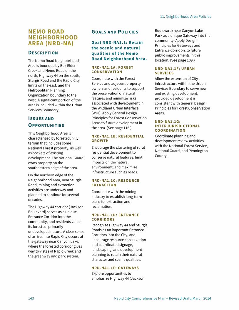
11. Neighborhood Area Policies
143 Rapid City Comprehensive Plan – Revised Draft: March 2014
NEMO ROAD NEIGHBORHOOD AREA (NRD-NA) DESCRIPTION The Nemo Road Neighborhood Area is bounded by Box Elder Creek and Nemo Road on the north, Highway 44 on the south, Sturgis Road and the Rapid City limits on the east, and the Metropolitan Planning Organization boundary to the west. A significant portion of the area is included within the Urban Services Boundary.
ISSUES AND OPPORTUNITIES This Neighborhood Area is characterized by forested, hilly terrain that includes some National Forest property, as well as pockets of existing development. The National Guard owns property on the southeastern edge of the area.
On the northern edge of the Neighborhood Area, near Sturgis Road, mining and extraction activities are underway and planned to continue for several decades.
The Highway 44 corridor (Jackson Boulevard) serves as a unique Entrance Corridor into the community, and residents value its forested, primarily undeveloped nature. A clear sense of arrival into Rapid City occurs at the gateway near Canyon Lake, where the forested corridor gives way to vistas of Rapid Creek and the greenway and park system.
GOALS AND POLICIES
Goal NRD-NA1.1: Retain the scenic and natural qualities of the Nemo Road Neighborhood Area.
NRD-NA1.1A: FOREST CONSERVATION
Coordinate with the Forest Service and adjacent property owners and residents to support the preservation of natural features and minimize risks associated with development in the Wildland Urban Interface (WUI). Apply General Design Principles for Forest Conservation Areas to future development in the area. (See page 116.)
NRD-NA1.1B: RESIDENTIAL GROWTH
Encourage the clustering of rural residential development to conserve natural features, limit impacts on the natural environment, and maximize infrastructure such as roads.
NRD-NA1.1C: RESOURCE EXTRACTION
Coordinate with the mining industry to establish long-term plans for extraction and reclamation.
NRD-NA1.1D: ENTRANCE CORRIDORS Recognize Highway 44 and Sturgis Roads as an important Entrance Corridors into the City, and encourage resource conservation and coordinated signage, landscaping, and development planning to retain their natural character and scenic qualities.
NRD-NA1.1F: GATEWAYS Explore opportunities to emphasize Highway 44 (Jackson
Boulevard) near Canyon Lake Park as a unique Gateway into the community. Apply Design Principles for Gateways and Entrance Corridors to future public improvements in this location. (See page 109.)
NRD-NA1.1F: URBAN SERVICES Allow the extension of City infrastructure within the Urban Services Boundary to serve new and existing development, provided development is consistent with General Design Principles for Forest Conservation Areas.
NRD-NA1.1G: INTERJURISDICTIONAL COORDINATION Coordinate planning and development review activities with the National Forest Service, National Guard, and Pennington County.
NEM ORD
UN IVERSAL DR
DEAD
WOO
D AV
E
W MAIN ST
W CHICAGO ST
S CANYON RD
CANYON LAKE DR
44
445
231
44
SH ERID
ANLA
KERD
90
CANYON LAKEPARK
CLIFFSIDEPARK
BRAEBURNPARK
Nemo Road Neighborhood AreaFuture Land Use Plan
This GIS Data is provided "as is" without warranty of any representation of accuracy, timeliness, or completeness. Theburden for determining accuracy, completeness, timeliness, merchantability, and fitness for or the appropriateness for use rests solely on the user. Rapid City, Pennington County, and Meade County make no warranties, express or implied, as to the use of the Data. There are no implied warranties of merchantability or fitnessfor a particular purpose. The user acknowledges and accepts the limitations of the Data, including the fact that the Data is dynamic and is in a constant state of maintenance, correction, and update.
Overview Map
March 2014DRAFT
0 1 20.5Miles
LegendNeighborhood Area
Rapid City Limits
County Boundary
Urban Service Boundary
Cemetery
Fire station
Hospital
Police station
School
Railroad
Water Bodies
Future Land UseRural Residential
Low Density Neighborhood
Urban Neighborhood
Mixed Use Commercial
Downtown
Employment
Light Industrial
Heavy Industrial
Mining/Extraction
Parks and Greenway
Agriculture
Forest Conservation
National Forest
Buffer/Reserved
Public/Quasi-Public
Entrance Corridor
Revitalization Corridor
Gateway
Revitalization Node
Regional Activity Center
Community Activity Center
Regional Recreation Destlination
Major Street PlanInterstate Highway
Principal Arterial
Proposed Principal Arterial
Minor Arterial
Proposed Minor Arterial
Collector
Proposed Collector (exact alignment TBD)
OverlaysForest
Flood Hazard Overlay
Future Greenway Conservation
Sensitive Geologic Area
Ellsworth 65 Ldn Noise Contours
Circling traffic patterns
Inner approach/departure
Precision flight corridor
Runway protection zone

11. Neighborhood Area Policies
145 Rapid City Comprehensive Plan – Revised Draft: March 2014
NORTH RAPID NEIGHBORHOOD AREA (NR-NA) DESCRIPTION The North Rapid Neighborhood Area is located in the north-central portion of the community and is entirely within the Rapid City limits. It is bounded by Omaha Street to the south, Interstate 90 to the north, M Hill to the west, and East North Street to the east. Rapid Creek passes through the southern portion of the area. This area includes many schools of various levels within walking distance to neighborhood residents.
ISSUES AND OPPORTUNITIES This Neighborhood Area is predominantly established, with urban neighborhoods at the core and mixed-use commercial activities along Interstate 90 and other major corridors. Residential growth patterns are fairly well established in this area, which includes the Lakota Homes and Sioux Addition neighborhoods. Small pockets of undeveloped land present opportunities for infill development. Many of the area’s homes are aging, and reinvestment and some targeted redevelopment may be necessary to promote stabilization.
The area includes several outdated strip commercial corridors along East North Street and La Crosse Street, and the Northgate Shopping Center at the intersection of East North Street and Cambell Street is a prime candidate for revitalization. The nearby Rushmore Crossing development serves as the
community’s newest Regional Activity Center. In order to remain successful, aging retail areas may need to reintroduce residential and other office and service uses in order to be viable in the future.
As the Rushmore Crossing Center continues to develop and build-out, it will be important to establish a unique character and mix of uses to differentiate it from the other Regional Activity Centers. Enhancing multi-modal transportation connections to this area is another future opportunity.
Flood hazard designation along Rapid Creek influences development in the southern portion of this Neighborhood Area, and the preservation of the greenway and M Hill provide excellent opportunities for area residents to recreate and experience nature. The Rapid City Civic Center is another important feature in this area, offering opportunities for arts and cultural activities and entertainment.
Interstate 190 provides an important connection from Interstate 90 to Highway 44 and the Downtown area, and opportunities exist to elevate the appearance this Entrance Corridor and important City Gateway.
GOALS AND POLICIES
Goal NR-NA-1.1: Reinvest in the North Rapid Neighborhood Area neighborhoods and support continued expansion of the Rushmore Crossing Regional Activity Center.
NR-NA1.1A: RESIDENTIAL NEIGHBORHOODS
Encourage reinvestment and promote targeted infill development redevelopment to add vitality to the area’s established neighborhoods. Support the development of new residential neighborhoods that increase the variety of housing options.
NR-NA1.1A: REINVESTMENT AREAS
Emphasize reinvestment and redevelopment in and near the Northgate Community Activity Center, and along the area’s Reinvestment Corridors (East North Street and La Crosse Street). Refer to Policy BPG-1.2C for additional discussion regarding Priority Revitalization Corridors.
NR-NA1.1A: REGIONAL ACTIVITY CENTER
Support the ongoing development and expansion of the Rushmore Crossing Center as one of the region’s premier shopping destinations.
NR-NA1.1B: CIVIC CENTER
Support the expansion of the Rushmore Plaza Civic Center by means of a new arena, with continued efforts in improving the overall facility and campus, as the
11. Neighborhood Area Policies | North Rapid Neighborhood Area (NR-NA)
146 Rapid City Comprehensive Plan – Revised Draft: March 2014
City of Rapid City’s primary entertainment, convention, and exhibition complex.
NR-NA1.1C: ENTRANCE CORRIDOR
Recognize the Interstate 190 connection as an important Entrance Corridor and encourage coordinated signage, landscaping, and development planning to enhance the sense of arrival into the Downtown area. Apply Design Principles for Gateways and Entrance Corridors in the review of future development along the corridor. (See page 109.)
NR-NA1.1D: GATEWAYS
Explore and pursue opportunities to highlight the areas where Interstate 190 intersects with Interstate 90 and Highway 44 (Omaha Street) as important community Gateways. Apply Design Principles for Gateways and Entrance Corridors to future public improvements in these locations.
NR-NA1.1E: PARKS AND GREENWAYS
Maintain the established parks and greenways in this area for safety, conservation, and recreation purposes. Work with area neighborhoods to improve connections to existing parks and ensure a safe environment.
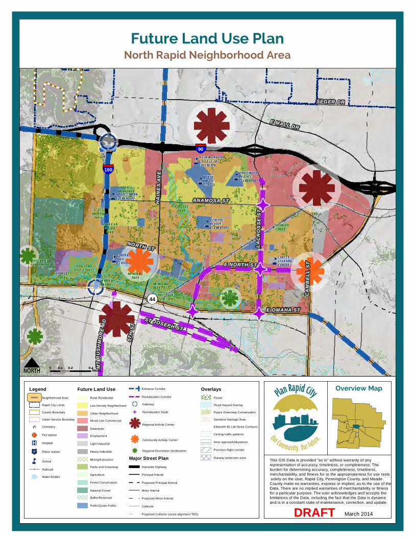
190
90
44
E MALL DR
SEGER DR
HAIN
ES A
VE
ANAMOSA ST
LACR
OSSE
ST
E NORTH ST
NORTH ST
ST JOSEPH ST
5TH
ST
E OMAHA STCA
MBEL
L ST
MTRU
S HMO
RERD
CENTRALHIGHSCHOOL
HORACE MANNELEMENTARY
OGLALA LAKOTACOLLEGE - RCEXTENSION
NORTHMIDDLESCHOOL
KNOLLWOODHEIGHTSELEMENTARY
CAREERLEARNINGCENTER
GENERALBEADLEELEMENTARY
COLLEGEPARK
THOMSONPARK
AMERICANLEGION
PARK
EXECUTIVEGOLF COURSE
MEMORIALPARK
FOUNDERSPARK
ROOSEVELTPARK
CHUCK LIENFAMILY PARK
HORACEMANN PARK
MEMORIALPARK WEST MEMORIAL
PARK EASTPRESSLERJUNCTION
SCOTTMALLOW
PARK
North Rapid Neighborhood AreaFuture Land Use Plan
This GIS Data is provided "as is" without warranty of any representation of accuracy, timeliness, or completeness. Theburden for determining accuracy, completeness, timeliness, merchantability, and fitness for or the appropriateness for use rests solely on the user. Rapid City, Pennington County, and Meade County make no warranties, express or implied, as to the use of the Data. There are no implied warranties of merchantability or fitnessfor a particular purpose. The user acknowledges and accepts the limitations of the Data, including the fact that the Data is dynamic and is in a constant state of maintenance, correction, and update.
Overview Map
March 2014DRAFT
0 0.2 0.40.1Miles
LegendNeighborhood Area
Rapid City Limits
County Boundary
Urban Service Boundary
Cemetery
Fire station
Hospital
Police station
School
Railroad
Water Bodies
Future Land UseRural Residential
Low Density Neighborhood
Urban Neighborhood
Mixed Use Commercial
Downtown
Employment
Light Industrial
Heavy Industrial
Mining/Extraction
Parks and Greenway
Agriculture
Forest Conservation
National Forest
Buffer/Reserved
Public/Quasi-Public
Entrance Corridor
Revitalization Corridor
Gateway
Revitalization Node
Regional Activity Center
Community Activity Center
Regional Recreation Destlination
Major Street PlanInterstate Highway
Principal Arterial
Proposed Principal Arterial
Minor Arterial
Proposed Minor Arterial
Collector
Proposed Collector (exact alignment TBD)
OverlaysForest
Flood Hazard Overlay
Future Greenway Conservation
Sensitive Geologic Area
Ellsworth 65 Ldn Noise Contours
Circling traffic patterns
Inner approach/departure
Precision flight corridor
Runway protection zone

11. Neighborhood Area Policies
149 Rapid City Comprehensive Plan – Revised Draft: March 2014
NORTHEAST NEIGHBORHOOD AREA (NE-NA) DESCRIPTION The Northeast Neighborhood Area is located in the north-central portion of the community and includes property within the Rapid City limits, as well as some unincorporated portions of Pennington County. The area is bounded by Interstate 90 to the south, the Pennington County line to the north, Haines Avenue to the west, and Elk Vale Road to the east. Box Elder Creek passes through the eastern portion of this area.
ISSUES AND OPPORTUNITIES This Neighborhood Area includes a mix of developed commercial, industrial, and residential uses, and also presents opportunities for new development. Rushmore Mall, one of the community’s Regional Activity Centers, is an established retail destination that is beginning to decline due to the center’s age and competition with other retail centers, including the newer Rushmore Crossing and Downtown. Reinvestment in the mall and surrounding area will be necessary in order to retain the mall’s appeal and vitality. The introduction of more commercial service uses, as well as residential uses, may help generate additional activity to support the mall retailers.
North of Seger Drive, the area has potential for additional residential development, and combined with the Deadwood Avenue Neighborhood Area, these northern areas present significant
opportunities for the development of new neighborhoods. The integration of parks and recreation opportunities into these emerging neighborhoods, and the conservation of floodplain and greenway areas will be important as these areas develop.
Nearby, along North Elk Vale Road, a new soccer complex is planned to enhance sporting opportunities for the region. The surrounding land presents opportunities for future employment and light industrial uses, with Dyess Avenue serving as a boundary to buffer future residential development to the west from the impacts of industry to the east. An employment area east of the mall, near Dyess Avenue at Seger Drive, is conveniently located close to Interstate 90, and also presents opportunities to diversify the mix of uses in the area to support revitalization of the mall.
GOALS AND POLICIES
Goal NE-NA1.1: Support reinvestment and revitalization of the Rushmore Mall area and expand housing, employment, and service options as new growth occurs throughout the Northeast Neighborhood Area.
NE-NA1.1A: RESIDENTIAL GROWTH
Support expansion and development of new residential neighborhoods north of Seger Drive, between Haines Avenue and Dyess Road.
NE-NA1.1B: MIXED-USE DEVELOPMENT
Encourage mixed-use development, redevelopment, and redevelopment of the Rushmore Mall and surrounding area along Interstate 90.
NE-NA1.1C: EMPLOYMENT ACTIVITIES
Support the continuation and expansion of existing employment and light industrial uses in the area west of Dyess Avenue and south of Seger Drive, to take advantage of the nearby highway transportation network. Ensure adequate buffering of heavy industrial uses to minimize conflicts with other land uses.
NE-NA1.1D: ENTRANCE CORRIDORS
Recognize Haines Avenue as an important Entrance Corridor into the City, and encourage coordinated signage, landscaping, and development planning to project a positive image of the community and reflect each corridor’s unique qualities. Apply Design Principles for Gateways and Entrance Corridors in the review of future development along the corridor. (See page 109.)
NE-NA1.1E: GATEWAYS
Explore and pursue opportunities to enhance and highlight the City gateway at the intersection of Interstate 90 and Elk Vale Road. Apply Design Principles for Gateways and Entrance Corridors to future public improvements in this location.
NE-NA1.1F: PARKS AND GREENWAYS
Promote the development of new parks, and encourage the conservation of greenways in this

11. Neighborhood Area Policies | Northeast Neighborhood Area (NE-NA)
150 Rapid City Comprehensive Plan – Revised Draft: March 2014
area to increase recreation opportunities for existing and future residents of this Neighborhood Area.
NE-NA1.1G: NATURAL FEATURES
Support and encourage the conservation of natural features in this area, including floodplains and hillsides.
NE-NA1.1H: REGIONAL RECREATION
Promote and support the development of the soccer complex, as a regional recreation destination.
NE-NA1.1I: URBAN SERVICES
Allow the extension of City infrastructure within the Urban Services Boundary to serve new and existing development.
NE-NA1.1J: INTERJURISDICTIONAL COORDINATION
Coordinate planning and development review activities in this area with Pennington and Meade Counties.
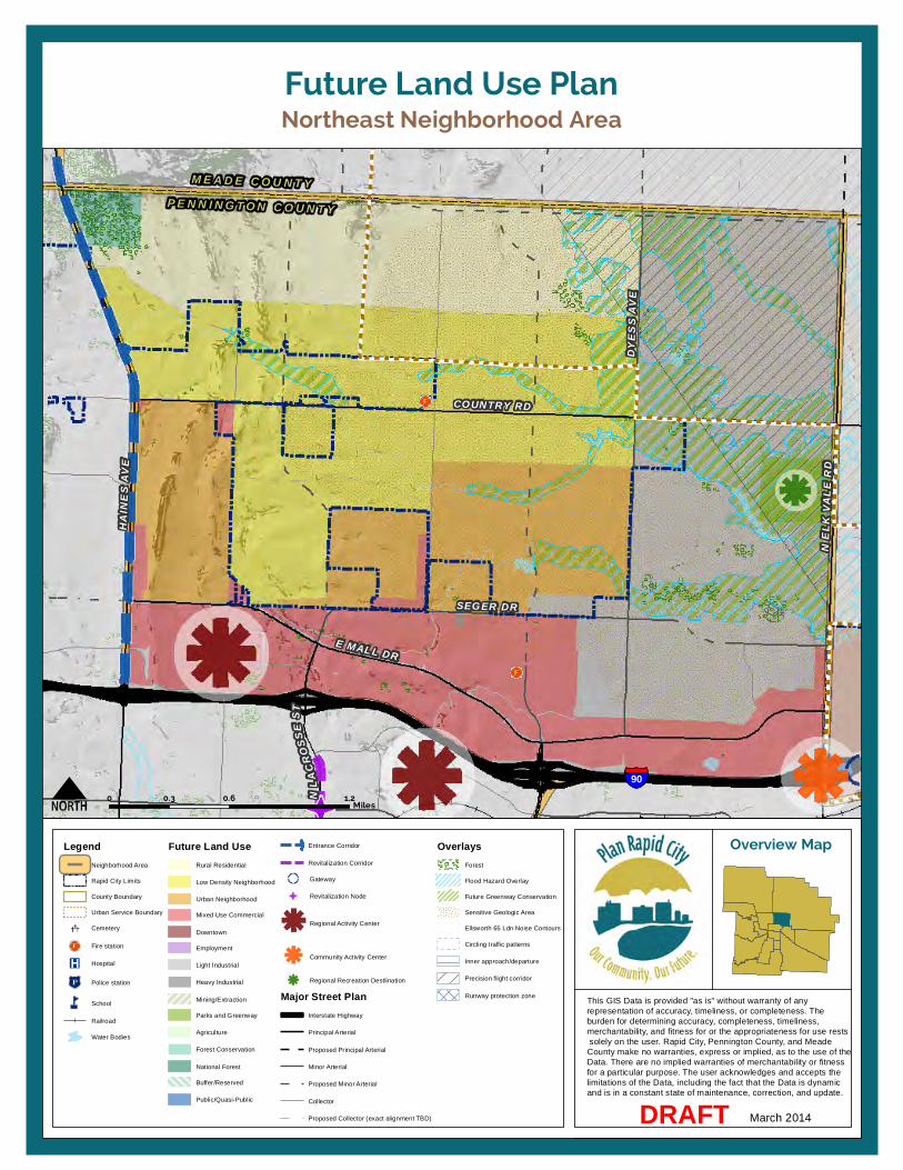
HAIN
ES A
VE
SEGER DRDY
ESS
AVE
COUNTRY RD
E MALL DR
N EL
K VA
LE R
D
NLA
CROS
SEST
90
M E A D E C O U N T YP E N N I N G T O N C O U N T Y
Northeast Neighborhood AreaFuture Land Use Plan
This GIS Data is provided "as is" without warranty of any representation of accuracy, timeliness, or completeness. Theburden for determining accuracy, completeness, timeliness, merchantability, and fitness for or the appropriateness for use rests solely on the user. Rapid City, Pennington County, and Meade County make no warranties, express or implied, as to the use of the Data. There are no implied warranties of merchantability or fitnessfor a particular purpose. The user acknowledges and accepts the limitations of the Data, including the fact that the Data is dynamic and is in a constant state of maintenance, correction, and update.
Overview Map
March 2014DRAFT
0 0.6 1.20.3Miles
LegendNeighborhood Area
Rapid City Limits
County Boundary
Urban Service Boundary
Cemetery
Fire station
Hospital
Police station
School
Railroad
Water Bodies
Future Land UseRural Residential
Low Density Neighborhood
Urban Neighborhood
Mixed Use Commercial
Downtown
Employment
Light Industrial
Heavy Industrial
Mining/Extraction
Parks and Greenway
Agriculture
Forest Conservation
National Forest
Buffer/Reserved
Public/Quasi-Public
Entrance Corridor
Revitalization Corridor
Gateway
Revitalization Node
Regional Activity Center
Community Activity Center
Regional Recreation Destlination
Major Street PlanInterstate Highway
Principal Arterial
Proposed Principal Arterial
Minor Arterial
Proposed Minor Arterial
Collector
Proposed Collector (exact alignment TBD)
OverlaysForest
Flood Hazard Overlay
Future Greenway Conservation
Sensitive Geologic Area
Ellsworth 65 Ldn Noise Contours
Circling traffic patterns
Inner approach/departure
Precision flight corridor
Runway protection zone


11. Neighborhood Area Policies
153 Rapid City Comprehensive Plan – Revised Draft: March 2014
PIEDMONT VALLEY NEIGHBORHOOD AREA (PV-NA) DESCRIPTION The Piedmont Valley Neighborhood Area is located in the southern portion of Meade County. It includes land in the incorporated communities of Piedmont and Summerset and unincorporated portions of Meade County. It is bounded by the county border to the south, the MPO Boundary/Elk Creek to the north, Township 3 North 6 East to the west, and North Haines Avenue to the east. Elk Creek passes through the area.
ISSUES AND OPPORTUNITIES Portions of this Neighborhood Area are heavily forested with rugged topography and are vulnerable to wildland fires. About a third of this area is owned by the U.S. Forest Service and recreational opportunities are abundant.
Most development in the area is located along Interstate 90 and Sturgis Road, within or near the towns of Piedmont and Summerset. Additional large lot rural development can be found along Erickson Ranch Road, Elk Creek Road, and North Haines Avenue. Interstate 90, Sturgis Road, and North Haines Avenue are all prominent Entrance Corridors into the community.
Throughout the Neighborhood Area, large lot residential growth will likely continue to occur, but conservation of large tracts of forested and agricultural land are
also important considerations in this area.
GOALS AND POLICIES
Goal PV-NA1.1: Retain the natural and agricultural qualities of the Piedmont Valley Neighborhood Area and focus new development in existing communities.
PV-NA1.1A: FOREST CONSERVATION
Coordinate with the Forest Service and adjacent property owners and residents to support the preservation of natural features and minimize risks associated with development in the Wildland Urban Interface (WUI). Apply General Design Principles for Forest Conservation Areas to future development in the area. (See page 116.)
PV-NA1.1B: RESIDENTIAL GROWTH
Encourage the clustering of rural residential development to conserve natural features, limit impacts on the natural environment, and maximize infrastructure such as roads.
PV-NA1.1C: MIXED-USE DEVELOPMENT
Support intensification of existing mixed-use and nonresidential developments to increase the variety of uses and maximize infrastructure investments. Discourage new, isolated pockets of mixed-use or non-residential development.
PV-NA1.1D: ENTRANCE CORRIDORS
Recognize Interstate 90, Sturgis Road, and Haines Avenue as an important Entrance Corridor into the City, and encourage coordinated signage, landscaping, and development planning to retain their rural character and scenic qualities. Apply Design Principles for Gateways and Entrance Corridors in the review of future development along the corridor. (See page 109.)
PV-NA1.1E: INTERJURISDICTIONAL COORDINATION
Coordinate planning and development review activities with Piedmont, Summerset, the National Forest Service, and Meade County.

PIEDMONT
SUMMERSET
231
90
STURGIS RD
PEACEFUL PINES RD
ERICKSONRANCH
RD
ELK CREEK RD
N HA
INES
AVE
MEADE COUNTYPENNINGTON COUNTY
Piedmont Valley Neighborhood AreaFuture Land Use Plan
This GIS Data is provided "as is" without warranty of any representation of accuracy, timeliness, or completeness. Theburden for determining accuracy, completeness, timeliness, merchantability, and fitness for or the appropriateness for use rests solely on the user. Rapid City, Pennington County, and Meade County make no warranties, express or implied, as to the use of the Data. There are no implied warranties of merchantability or fitnessfor a particular purpose. The user acknowledges and accepts the limitations of the Data, including the fact that the Data is dynamic and is in a constant state of maintenance, correction, and update.
Overview Map
March 2014DRAFT
0 2 41Miles
LegendNeighborhood Area
Rapid City Limits
County Boundary
Urban Service Boundary
Cemetery
Fire station
Hospital
Police station
School
Railroad
Water Bodies
Future Land UseRural Residential
Low Density Neighborhood
Urban Neighborhood
Mixed Use Commercial
Downtown
Employment
Light Industrial
Heavy Industrial
Mining/Extraction
Parks and Greenway
Agriculture
Forest Conservation
National Forest
Buffer/Reserved
Public/Quasi-Public
Entrance Corridor
Revitalization Corridor
Gateway
Revitalization Node
Regional Activity Center
Community Activity Center
Regional Recreation Destlination
Major Street PlanInterstate Highway
Principal Arterial
Proposed Principal Arterial
Minor Arterial
Proposed Minor Arterial
Collector
Proposed Collector (exact alignment TBD)
OverlaysForest
Flood Hazard Overlay
Future Greenway Conservation
Sensitive Geologic Area
Ellsworth 65 Ldn Noise Contours
Circling traffic patterns
Inner approach/departure
Precision flight corridor
Runway protection zone
11. Neighborhood Area Policies
155 Rapid City Comprehensive Plan – Revised Draft: March 2014
SHERIDAN LAKE ROAD NEIGHBORHOOD AREA (SLR-NA) DESCRIPTION The Sheridan Lake Road Neighborhood Area is located in the southwestern portion of the community and includes properties within Rapid City limits as well as unincorporated portions of Pennington County. The area is bounded by Spring Creek to the south, Jackson Boulevard to the north, the section line east of Hisega Road extending to Burgess Road to the west, and Skyline Drive to the east. Rapid Creek and Spring Creek are both within this area.
ISSUES AND OPPORTUNITIES This Neighborhood Area is characterized by National Forest properties on the western side, and a mix of established and developing neighborhoods and mixed-use commercial areas on the eastern portion. A range of residential development will likely continue in this area, and will require the extension of infrastructure to support this growth. The introduction of some non-residential uses, including retail, service, and employment in Community Activity Centers will be important to continue to develop in this area, to serve the surrounding neighborhoods, including Chapel Valley.
In addition to the large forested areas, the area also includes two Regional Recreation Destinations: Canyon Lake Park and Dinosaur Park. Continued maintenance and conservation of these community
amenities will be important to retain the City’s unique character. Moreover, continued conservation of the Highway 44 corridor, and potential enhancements of the City’s Gateway at Canyon Lake Park are future opportunities in this Neighborhood Area.
GOALS AND POLICIES
Goal SLR-NA1.1: Continue neighborhood development near the City limits and retain the scenic and natural qualities of the Sheridan Lake Road Neighborhood Area.
SLR-NA1.1A: FOREST CONSERVATION Coordinate with the Forest Service and adjacent property owners and residents to support the preservation of natural features and minimize risks associated with development in the Wildland Urban Interface (WUI). Apply General Design Principles for Forest Conservation Areas to future development in the area. (See page 116.)
SLR-NA1.1B: RESIDENTIAL GROWTH Support the build out of existing neighborhoods and encourage the clustering of future residential development to conserve natural features, limit impacts on the natural environment, and maximize infrastructure such as roads.
SLR-NA1.1C: COMMUNITY ACTIVITY CENTERS Support the continued development and diversification of uses within the Community Activity Centers located along
Sheridan Lake Road at the intersections with Moon Meadows Drive and Catron Boulevard, to provide convenient shopping and service options to area neighborhoods.
SLR-NA1.1D: REGIONAL RECREATION Conserve and promote Canyon Lake Park and Dinosaur Park as unique community amenities and Regional Recreation Destinations.
SLR-NA1.1E: ENTRANCE CORRIDOR Recognize Highway 44 as an important Entrance Corridors into the City, and encourage resource conservation and coordinated signage, landscaping, and development planning to retain its natural character and scenic qualities. Apply Design Principles for Gateways and Entrance Corridors in the review of future development along the corridor. (See page 109.)
SLR-NA1.1F: GATEWAY Explore opportunities to emphasize Highway 44 (Jackson Boulevard) near Canyon Lake Park as a unique Gateway into the community. Apply Design Principles for Gateways and Entrance Corridors to future public improvements in this location.
SLR-NA1.1G: URBAN SERVICES Allow the extension of City infrastructure within the Urban Services Boundary to serve new and existing development, provided development is consistent with General Design Principles for Forest Conservation Areas
11. Neighborhood Area Policies | Sheridan Lake Road Neighborhood Area (SLR-NA)
156 Rapid City Comprehensive Plan – Revised Draft: March 2014
SLR-NA1.1H: INTERJURISDICTIONAL COORDINATION Coordinate planning and development review activities with the National Forest Service and Pennington County.

SHERIDAN LAKE R D
M
O O N MEADOWS DR
CATRON BLVD
MT R
USHM
ORE
RDSK
YLIN
E DR
JACK SON B LVD
CANYON LAKE DR
44
44
16
16
SOUTHWEST MIDDLE SCHOOL
CORRAL DRIVE ELEMENTARY
MEADOWBROOKELEMENTARY
JACKSONPARK
MEADOWBROOKGOLF COURSE
RED ROCKMEADOWS
PARK
RUSHMORELIONS PARK
Sheridan Lake Road Neighborhood AreaFuture Land Use Plan
This GIS Data is provided "as is" without warranty of any representation of accuracy, timeliness, or completeness. Theburden for determining accuracy, completeness, timeliness, merchantability, and fitness for or the appropriateness for use rests solely on the user. Rapid City, Pennington County, and Meade County make no warranties, express or implied, as to the use of the Data. There are no implied warranties of merchantability or fitnessfor a particular purpose. The user acknowledges and accepts the limitations of the Data, including the fact that the Data is dynamic and is in a constant state of maintenance, correction, and update.
Overview Map
Marcn 2014DRAFT
0 1 20.5Miles
LegendNeighborhood Area
Rapid City Limits
County Boundary
Urban Service Boundary
Cemetery
Fire station
Hospital
Police station
School
Railroad
Water Bodies
Future Land UseRural Residential
Low Density Neighborhood
Urban Neighborhood
Mixed Use Commercial
Downtown
Employment
Light Industrial
Heavy Industrial
Mining/Extraction
Parks and Greenway
Agriculture
Forest Conservation
National Forest
Buffer/Reserved
Public/Quasi-Public
Entrance Corridor
Revitalization Corridor
Gateway
Revitalization Node
Regional Activity Center
Community Activity Center
Regional Recreation Destlination
Major Street PlanInterstate Highway
Principal Arterial
Proposed Principal Arterial
Minor Arterial
Proposed Minor Arterial
Collector
Proposed Collector (exact alignment TBD)
OverlaysForest
Flood Hazard Overlay
Future Greenway Conservation
Sensitive Geologic Area
Ellsworth 65 Ldn Noise Contours
Circling traffic patterns
Inner approach/departure
Precision flight corridor
Runway protection zone


11. Neighborhood Area Policies
159 Rapid City Comprehensive Plan – Revised Draft: March 2014
SOUTH ROBBINSDALE NEIGHBORHOOD AREA (SR-NA) DESCRIPTION The South Robbinsdale Neighborhood Area is located in the south-central portion of the community and is predominantly located within the City limits. It is bounded by approximately Catron Boulevard to the south, approximately Fairmont Boulevard to the north, Highway 16 to the west, and Highway 79 to the east.
ISSUES AND OPPORTUNITIES This Neighborhood Area is a diverse area characterized by a mix of established and developing residential neighborhoods, plus an assortment of nonresidential uses. The landfill, located in the southeastern quadrant of the area, is a necessary public facility, yet potential noise, visual, and odor impacts to the surrounding area are significant. Careful siting of residential development in this area is necessary to minimize future conflicts with the landfill activities.
To the west, a newer Community Activity Center is emerging with the recent development of a Super Wal-Mart and surrounding retailers. As the East Catron Boulevard continues to develop, it will be important to consider landscaping, signage, and design along this emerging community Entrance Corridor.
GOALS AND POLICIES
Goal SR-NA1.1: Support continued residential and non-residential growth in the South Robbinsdale Neighborhood Area, while also maintaining adequate buffering and distance from the landfill to minimize future impacts or conflicts.
SR-NA1.1A: RESIDENTIAL GROWTH
Support expansion and development of new residential neighborhoods in the area, though not adjacent to the landfill property. Buffer residential development in potential odor impact area through use of landscaping, careful building placement, and addition of non-residential uses.
SR-NA1.1B: MIXED-USE DEVELOPMENT
Encourage mixed-use development, at major intersections including East Catron Boulevard at 5th Street and Highway 79 to build a critical mass of activities to support retailers and to avoid stripping out the entire East Catron Boulevard corridor.
SR-NA1.1C: EMPLOYMENT ACTIVITIES
Support the continuation and expansion of employment activities along the East Catron Boulevard Corridor and at the intersection of 5th Street and Minnesota Street. Encourage light industrial uses to locate directly west of the landfill and/or near existing light industry along
Highway 79 near East Fairmont Boulevard.
SR-NA1.1D: ENTRANCE CORRIDORS
Recognize East Catron Boulevard and Highway 79 as an important Entrance Corridors into the City, and encourage coordinated signage, landscaping, and development planning to project a positive image of the community and reflect each corridor’s unique qualities. Apply Design Principles for Gateways and Entrance Corridors in the review of future development along these corridors. (See page 109.)
SR-NA1.1E: GATEWAY
Explore and pursue opportunities to enhance and highlight the interchange at Highway 79 and Elk Vale Road/East Catron Boulevard as a unique community gateway. Apply Design Principles for Gateways and Entrance Corridors to future public improvements in this location.
SR-NA1.1F: PARKS AND GREENWAYS
Promote the development of parks and conservation of greenways in this area to increase recreation opportunities for existing and future residents of this Neighborhood Area.
SR-NA1.1G: URBAN SERVICES
Allow the extension of City infrastructure within the Urban Services Boundary to serve new and existing development.
11. Neighborhood Area Policies | South Robbinsdale Neighborhood Area (SR-NA)
160 Rapid City Comprehensive Plan – Revised Draft: March 2014
SR-NA1.1H: INTERJURISDICTIONAL COORDINATION
Coordinate planning and development review activities in this area with Pennington County.

79
E CATRON BLVD
ELK VALE RD
MINNESOTA ST
5TH ST
E FAIRMONT BLVD
Landfill
LA CROIXLINKS GOLF
COURSE
CENTENNIALPARK
MINNESOTASTREET
PARK
PARKVIEWPARK
South Robbinsdale Neighborhood AreaFuture Land Use Plan
This GIS Data is provided "as is" without warranty of any representation of accuracy, timeliness, or completeness. Theburden for determining accuracy, completeness, timeliness, merchantability, and fitness for or the appropriateness for use rests solely on the user. Rapid City, Pennington County, and Meade County make no warranties, express or implied, as to the use of the Data. There are no implied warranties of merchantability or fitnessfor a particular purpose. The user acknowledges and accepts the limitations of the Data, including the fact that the Data is dynamic and is in a constant state of maintenance, correction, and update.
Overview Map
March 2014DRAFT
0 0.5 10.25Miles
LegendNeighborhood Area
Rapid City Limits
County Boundary
Urban Service Boundary
Cemetery
Fire station
Hospital
Police station
School
Railroad
Water Bodies
Future Land UseRural Residential
Low Density Neighborhood
Urban Neighborhood
Mixed Use Commercial
Downtown
Employment
Light Industrial
Heavy Industrial
Mining/Extraction
Parks and Greenway
Agriculture
Forest Conservation
National Forest
Buffer/Reserved
Public/Quasi-Public
Entrance Corridor
Revitalization Corridor
Gateway
Revitalization Node
Regional Activity Center
Community Activity Center
Regional Recreation Destlination
Major Street PlanInterstate Highway
Principal Arterial
Proposed Principal Arterial
Minor Arterial
Proposed Minor Arterial
Collector
Proposed Collector (exact alignment TBD)
OverlaysForest
Flood Hazard Overlay
Future Greenway Conservation
Sensitive Geologic Area
Ellsworth 65 Ldn Noise Contours
Circling traffic patterns
Inner approach/departure
Precision flight corridor
Runway protection zone

11. Neighborhood Area Policies
163 Rapid City Comprehensive Plan – Revised Draft: March 2014
SOUTHEAST CONNECTOR NEIGHBORHOOD AREA (SEC-NA) DESCRIPTION The Southeast Connector Neighborhood Area is located in the southeastern portion of the community and includes property within Rapid City limits and unincorporated portions of Pennington County, including the area commonly referred to as Rapid Valley. The area is bounded by the Highway 44 to the north, the range line between Range 9 East and Range 10 East to the east, and Highway 79 to the west. The area’s southern limit is the southern boundaries of Township 1 South, Range 9 East, Sections 13-18, Township 1 South, Range 8 East, Sections 13-16 and a portion of Section 17. Rapid Creek passes through the Neighborhood Area.
ISSUES AND OPPORTUNITIES This Neighborhood Area is characterized by agricultural land and scattered rural residential development across the southern half. A range of industrial and employment activities are existing in the area north of Lamb Road, following the Old Folsom Road corridor and nearby railroad tracks, and it is envisioned that this area will continue to develop as one of the City’s primary locations for industry and employment.
To the north, existing development includes a variety of uses, and Saint Patrick Street corridor presents opportunities for revitalization and reinvestment, especially near the
Family Thrift Center shopping center at Cambell Street. The nearby Star of the West Complex is a Regional Recreation Destination along Rapid Creek that attracts residents and visitors to this portion of the community.
The Rapid Creek floodplain follows along the south side of the Highway 44 corridor, presenting additional opportunities for future greenway conservation as residential growth continues in this area. Existing enclaves of unincorporated County residential developments in the Rapid Valley area present challenges to the provision of urban services to existing and new growth areas. Access to parks, recreation, and retail and commercial services are also needs of this area as development continues.
The Water Reclamation Facility, just south of Highway 44, is a necessary community utility, but presents challenges for compatible land uses in this area due to potential odors, noise, and visual impacts. Buffering this facility from incompatible development will help minimize future conflicts. Beyond the Water Reclamation Facility, conservation of agricultural uses in this area is important because the land is suitable for agriculture and development is limited by the floodplain.
This area includes significant entryways into the community along Highway 79, Highway 44, and Elk Vale Road, and opportunities exist to enhance the gateways at the major interchanges at Elk Vale Road.
GOALS AND POLICIES
Goal SEC-NA1.1: Support continued industry and employment along the Old Folsom Road corridor and expand neighborhoods and coordination in the Rapid Valley area.
SEC-NA1.1A: WATER RECLAMATION RESERVE
Maintain operations and reserve opportunities for the future expansion of the Water Reclamation Facility. Limit development that conflicts with current or future operations or expansion.
SEC-NA1.1B: EMPLOYMENT AREA
Encourage continued and additional employment and industrial activities in the Old Folsom Road area. Buffer heavy industry from nearby residential areas by encouraging lighter industrial or employment as a transition between uses.
SEC-NA1.1C: REINVESTMENT CORRIDOR
Emphasize reinvestment and redevelopment along the Saint Patrick Street corridor. Refer to Policy BPG-1.2C for additional discussion regarding Priority Revitalization Corridors.
SEC-NA1.1D: MIXED-USE DEVELOPMENT
Encourage mixed-use development, infill, and redevelopment near the Family Thrift Center shopping area at Cambell Street and Saint Patrick Street, along Elk Vale Road near South Valley Drive, and along

11. Neighborhood Area Policies | Southeast Connector Neighborhood Area (SEC-NA)
164 Rapid City Comprehensive Plan – Revised Draft: March 2014
Highway 44 near East 53rd Street and Radar Hill Road.
SEC-NA1.1E: ENTRANCE CORRIDORS
Recognize Highway 44, Highway 79, and Elk Vale Roads as an important Entrance Corridors into the City, and encourage coordinated signage, landscaping, and development planning to enhance each corridor’s unique characteristics and appearance. Apply Design Principles for Gateways and Entrance Corridors in the review of future development along these corridors. (See page 109.)
SEC-NA1.1F: GATEWAYS
Explore and pursue opportunities to enhance and highlight the interchanges along Elk Vale Road at Highway 44 and Highway 79 as unique community gateways. Apply Design Principles for Gateways and Entrance Corridors to future public improvements in these locations.
SEC-NA1.1G: RESIDENTIAL GROWTH
Support existing and additional residential development in the Rapid Valley area west of East 53rd Street.
SEC-NA1.1H: PARKS AND GREENWAYS
Promote the development of parks and conservation of greenways in this area to increase recreation opportunities for existing and future residents of this Neighborhood Area. Support the implementation of the proposed Rails-to-Trails project and East Greenway Master Plan.
SEC-NA1.1I: ANNEXATION
Require the annexation of contiguous properties when development occurs, and require an annexation agreement for noncontiguous properties (stating that they agree to be annexed into Rapid City when eligible).
SEC-NA1.1J: URBAN SERVICES
Allow the extension of City infrastructure within the Urban Services Boundary to serve new and existing development.
SEC-NA1.1K: INTERJURISDICTIONAL COORDINATION
Coordinate planning and development review activities with the City of Box Elder, Pennington County, and airport authorities.

LONG VIEW RD
RADA
R HI
LL R
D
E 53
RD S
T
S VA
LLEY
DR
CAMB
ELL
ST
LAMB RD
OLD FOLSOM RD
ELK V A L E RD
44
79
ANTELOPE CREEK RD
Rapid CityRegional Airport
STAR OF THE WEST SPORTS COMPLEX
Southeast Connector Neighborhood AreaFuture Land Use Plan
This GIS Data is provided "as is" without warranty of any representation of accuracy, timeliness, or completeness. Theburden for determining accuracy, completeness, timeliness, merchantability, and fitness for or the appropriateness for use rests solely on the user. Rapid City, Pennington County, and Meade County make no warranties, express or implied, as to the use of the Data. There are no implied warranties of merchantability or fitnessfor a particular purpose. The user acknowledges and accepts the limitations of the Data, including the fact that the Data is dynamic and is in a constant state of maintenance, correction, and update.
Overview Map
March 2014DRAFT
0 1.5 30.75Miles
WESTERNDAKOTA
TECHNICALINSTITUTE
LegendNeighborhood Area
Rapid City Limits
County Boundary
Urban Service Boundary
Cemetery
Fire station
Hospital
Police station
School
Railroad
Water Bodies
Future Land UseRural Residential
Low Density Neighborhood
Urban Neighborhood
Mixed Use Commercial
Downtown
Employment
Light Industrial
Heavy Industrial
Mining/Extraction
Parks and Greenway
Agriculture
Forest Conservation
National Forest
Buffer/Reserved
Public/Quasi-Public
Entrance Corridor
Revitalization Corridor
Gateway
Revitalization Node
Regional Activity Center
Community Activity Center
Regional Recreation Destlination
Major Street PlanInterstate Highway
Principal Arterial
Proposed Principal Arterial
Minor Arterial
Proposed Minor Arterial
Collector
Proposed Collector (exact alignment TBD)
OverlaysForest
Flood Hazard Overlay
Future Greenway Conservation
Sensitive Geologic Area
Ellsworth 65 Ldn Noise Contours
Circling traffic patterns
Inner approach/departure
Precision flight corridor
Runway protection zone


11. Neighborhood Area Policies
167 Rapid City Comprehensive Plan – Revised Draft: March 2014
SPRING CREEK NEIGHBORHOOD AREA (SC-NA) DESCRIPTION The Spring Creek Neighborhood Area is located southwest of the Rapid City limits. The area is bounded by the section line north of Knotty Pine Lane extending from Teepee Gulch Road to Highway 79 to the south, Spring Creek to the north, the section line west of Burgess Road extending south to Teepee Gulch Road, and Highway 79 to the east. Spring Creek passes through the area.
ISSUES AND OPPORTUNITIES This Neighborhood Area is characterized by the US Highway 16 corridor, which serves as the primary route between the City and Mount Rushmore. Development along and near this corridor includes an array of visitor attractions, tourism-related services, and scattered residential uses. Continuation and limited expansion of this tourism-oriented Community Activity Center is expected to occur over time.
The Highway 79 corridor is another major influence in this Neighborhood Area. The landfill, located on the west side of the corridor, just south of the City limits, is a necessary community service, yet does present some impacts to neighboring properties, including odors and noise. Careful consideration and mitigation of these impacts are important when development occurs on properties near the
landfill. Moreover, balancing the demands for industrial development and visual quality along the corridor are important since it is a major community entryway.
Residential development has already occurred in some areas along Spring Creek and Spring Creek Road. However, the topography between the current City limits and the Spring Creek drainage will be a limiting factor future development in this area, and most urban development will most likely be located closer in near the landfill and existing urban services, or near the existing development in the Spring Creek drainage area.
The remainder of the Neighborhood Area is predominantly forested, with hilly topography and pockets of National Forest land. Protection of natural resources is a key objective in this part of the Neighborhood Area.
GOALS AND POLICIES
Goal SC-NA1.1: Support continued tourism development in key locations along the US 16 corridor and encourage residential development in strategic areas near existing development.
SC-NA1.1A: LANDFILL COMPATIBILITY
Continue operation of the landfill, and limit development that conflicts with current or future operations or expansion. Adjacent to the landfill property, support light industrial uses, which may
not be as impacted by the landfill operations as other uses.
SC-NA1.1B: COMMUNITY ACTIVITY CENTER
Support continued and additional mixed-use and tourism-related businesses and attractions in a clustered location along the US 16 corridor. Encourage coordination of access points, signage, and landscaping to create an attractive and functional destination for visitors.
SC-NA1.1C: ENTRANCE CORRIDORS
Recognize US Highway 16 and Highway 79 as important Entrance Corridors into the City, and encourage coordinated signage, landscaping, and development planning to enhance each corridor’s unique characteristics and appearance. Apply Design Principles for Gateways and Entrance Corridors in the review of future development along these corridors. (See page 109.)
SC-NA1.1D: RESIDENTIAL GROWTH
Support new residential development in the area west of the landfill, provided it is adequately buffered and screened from landfill operations. Support limited, additional low density and rural residential development in the Spring Creek Road area, provided it is not located within the floodplain.

11. Neighborhood Area Policies | Spring Creek Neighborhood Area (SC-NA)
168 Rapid City Comprehensive Plan – Revised Draft: March 2014
SC-NA1.1E: FOREST CONSERVATION
Coordinate with the Forest Service and adjacent property owners and residents to support the preservation of natural features and minimize risks associated with development in the Wildland Urban Interface (WUI). Apply General Design Principles for Forest Conservation Areas to future development in the area. (See page 116.)
SC-NA1.1F: PARKS AND GREENWAYS
Promote the development of parks and conservation of greenways in the northeast portion of this Neighborhood Area to increase recreation opportunities for existing and future residents.
SC-NA1.1G: ANNEXATION
Require the annexation of contiguous properties when development occurs, and require an annexation agreement for noncontiguous properties (stating that they agree to be annexed into Rapid City when eligible).
SC-NA1.1H: URBAN SERVICES
Allow the extension of City infrastructure within the Urban Services Boundary to serve new and existing development.
SC-NA1.1I: INTERJURISDICTIONAL COORDINATION
Coordinate planning and development review activities with the National Forest Service and Pennington County.

S ROC
KERV
ILLE R
D
NECK Y OKE RD
SPRING CREEK RD
MOON MEADOWS DR
CATRON BLVDSHERIDAN LAKE RD
16
79
Spring Creek Neighborhood AreaFuture Land Use Plan
This GIS Data is provided "as is" without warranty of any representation of accuracy, timeliness, or completeness. Theburden for determining accuracy, completeness, timeliness, merchantability, and fitness for or the appropriateness for use rests solely on the user. Rapid City, Pennington County, and Meade County make no warranties, express or implied, as to the use of the Data. There are no implied warranties of merchantability or fitnessfor a particular purpose. The user acknowledges and accepts the limitations of the Data, including the fact that the Data is dynamic and is in a constant state of maintenance, correction, and update.
Overview Map
March 2014DRAFT
0 1.5 30.75Miles
LegendNeighborhood Area
Rapid City Limits
County Boundary
Urban Service Boundary
Cemetery
Fire station
Hospital
Police station
School
Railroad
Water Bodies
Future Land UseRural Residential
Low Density Neighborhood
Urban Neighborhood
Mixed Use Commercial
Downtown
Employment
Light Industrial
Heavy Industrial
Mining/Extraction
Parks and Greenway
Agriculture
Forest Conservation
National Forest
Buffer/Reserved
Public/Quasi-Public
Entrance Corridor
Revitalization Corridor
Gateway
Revitalization Node
Regional Activity Center
Community Activity Center
Regional Recreation Destlination
Major Street PlanInterstate Highway
Principal Arterial
Proposed Principal Arterial
Minor Arterial
Proposed Minor Arterial
Collector
Proposed Collector (exact alignment TBD)
OverlaysForest
Flood Hazard Overlay
Future Greenway Conservation
Sensitive Geologic Area
Ellsworth 65 Ldn Noise Contours
Circling traffic patterns
Inner approach/departure
Precision flight corridor
Runway protection zone


11. Neighborhood Area Policies
171 Rapid City Comprehensive Plan – Revised Draft: March 2014
US HIGHWAY 16 NEIGHBORHOOD AREA (US16-NA) DESCRIPTION The US Highway 16 Neighborhood Area is located in the southwestern portion of the community and includes properties within the City limits and incorporated areas in Pennington County. It is bounded by the Reptile Gardens/Neck Yoke Road intersection on the south and Cathedral Drive/Fairmont Boulevard to the north. Spring Creek passes through the area.
ISSUES AND OPPORTUNITIES This Neighborhood Area is set along one of the community’s major corridors, US 16. This corridor serves as a primary route for visitors traveling between the City and Mount Rushmore, but also as an important local thoroughfare. The area includes a diverse mix of existing and emerging residential neighborhoods, commercial areas, and employment centers.
South of Moon Meadows Road, the Neighborhood Area features pockets of existing residential development along Spring Creek Road, and clusters of mixed-use commercial development along US 16 could serve these neighborhood areas. Future residential development east and west of the Moon Meadows Road intersection with US 16 will likely increase demand for more commercial uses and services, providing opportunity for a Community Commercial Activity Center in this area.
Further north, along US 16 north of Catron Boulevard, opportunities exist for additional mixed-use commercial, and employment development. This future mixed-use area is envisioned as a setting for high-quality office space, and is located to take advantage of the area’s scenic views.
At the northern edge of the Neighborhood Area, the Regional Health area provides existing employment activities, and opportunities exist to further extend and intensify medical and supporting services in this area.
Throughout the Neighborhood Area, topography presents constraints to development, but the area is predominantly located within the Urban Services Boundary and urban development is likely to continue, especially within and adjacent to the existing City limits.
GOALS AND POLICIES
Goal US16-NA1.1: Encourage targeted residential and non-residential growth in the US 16 Neighborhood Area to increase options for housing and services, and to support economic development.
US16-NA1.1A: RESIDENTIAL GROWTH
Support expansion and development of new residential neighborhoods in areas within and adjacent to existing City limits. Discourage residential growth south of Moon Meadows Road.
US16-NA1.1B: MIXED-USE DEVELOPMENT
Encourage mixed-use development in clusters of activity along US 16 to serve nearby neighborhoods and build a critical mass of activities to support retailers and to avoid stripping out the entire US 16 corridor.
US16-NA1.1C: COMMUNITY ACTIVITY CENTERS
Support the development of Community Activity Centers along US 16 at Fairmont Boulevard, Catron Boulevard and near Moon Meadows Road to provide convenient shopping and service options to area neighborhoods. Discourage stripped-out commercial development along the entire corridor.
US16-NA1.1C: EMPLOYMENT AREAS
Support the continuation and expansion of mixed-use employment and supporting activities around the Regional Health Center. Encourage office parks and other supporting employment uses to locate along the US 16 corridor, north of Catron Boulevard.
US16-NA1.1D: ENTRANCE CORRIDORS
Recognize US 16 and Catron Boulevard as important Entrance Corridors into the City, and encourage coordinated signage, landscaping, and development planning to project a positive image of the community and reflect each corridor’s unique qualities. Apply Design Principles for Gateways and Entrance Corridors in the review of future development along these corridors. (See page 109.)
11. Neighborhood Area Policies | US Highway 16 Neighborhood Area (US16-NA)
172 Rapid City Comprehensive Plan – Revised Draft: March 2014
US16-NA1.1E: GATEWAYS
Explore and pursue opportunities to enhance and highlight the US 16 intersections near Tower Road and Fort Hayes Drive as unique community gateways. Apply Design Principles for Gateways and Corridors to future public improvements in these locations.
US16-NA1.1F: PARKS AND GREENWAYS
Promote the development of parks and conservation of greenways in this area to increase recreation opportunities for existing and future residents of this Neighborhood Area.
US16-NA1.1G: FOREST CONSERVATION
Coordinate with the Forest Service and adjacent property owners and residents to support the preservation of natural features and minimize risks associated with development in the Wildland Urban Interface (WUI). Apply General Design Principles for Forest Conservation Areas to future development in the area. (See page 116.)
US16-NA1.1H: URBAN SERVICES
Allow the extension of City infrastructure within the Urban Services Boundary to serve new and existing development.
US16-NA1.1I: INTERJURISDICTIONAL COORDINATION
Coordinate planning and development review activities in this area with Pennington County.

FAIRMONT BLVDELM AVE
MINNESOTA ST
SHER
IDAN
LAK
E RD
MOON MEADOWS DR
SPRING CREEK RD
CATRON BLVD
E CATRON BLVD
79
16
SKYLINE WILDERNESSAREA
US Highway 16 Neighborhood AreaFuture Land Use Plan
This GIS Data is provided "as is" without warranty of any representation of accuracy, timeliness, or completeness. Theburden for determining accuracy, completeness, timeliness, merchantability, and fitness for or the appropriateness for use rests solely on the user. Rapid City, Pennington County, and Meade County make no warranties, express or implied, as to the use of the Data. There are no implied warranties of merchantability or fitnessfor a particular purpose. The user acknowledges and accepts the limitations of the Data, including the fact that the Data is dynamic and is in a constant state of maintenance, correction, and update.
Overvi ew Map
March 2014DRAFT
0 1 20.5Miles
LegendNeighborhood Area
Rapid City Limits
County Boundary
Urban Service Boundary
Cemetery
Fire station
Hospital
Police station
School
Railroad
Water Bodies
Future Land UseRural Residential
Low Density Neighborhood
Urban Neighborhood
Mixed Use Commercial
Downtown
Employment
Light Industrial
Heavy Industrial
Mining/Extraction
Parks and Greenway
Agriculture
Forest Conservation
National Forest
Buffer/Reserved
Public/Quasi-Public
Entrance Corridor
Revitalization Corridor
Gateway
Revitalization Node
Regional Activity Center
Community Activity Center
Regional Recreation Destlination
Major Street PlanInterstate Highway
Principal Arterial
Proposed Principal Arterial
Minor Arterial
Proposed Minor Arterial
Collector
Proposed Collector (exact alignment TBD)
OverlaysForest
Flood Hazard Overlay
Future Greenway Conservation
Sensitive Geologic Area
Ellsworth 65 Ldn Noise Contours
Circling traffic patterns
Inner approach/departure
Precision flight corridor
Runway protection zone


11. Neighborhood Area Policies
175 Rapid City Comprehensive Plan – Revised Draft: March 2014
WEST RAPID NEIGHBORHOOD AREA (WR-NA) DESCRIPTION The West Rapid Neighborhood Area includes properties within the City limits in the northwestern portion of the community. It is bounded by West Chicago and Omaha Streets on the north, Jackson Boulevard on the south, the City limits to the west, and Sturgis Road to the northeast. Lime Creek and Rapid Creek pass through the area.
ISSUES AND OPPORTUNITIES This Neighborhood Area is characterized by large tracts of public and quasi-public uses at the core, including the National Guard Training Camp, Sioux Park, ballfields, Camp Rapid, numerous medical facilities, and several schools. Some of the property in this core area is important historic tribal land and is therefore subject to restrictions on development and land uses.
Surrounding this core area are established neighborhoods that are predominantly single-family, including the Canyon Lake neighborhood. Supporting existing residential uses and ongoing floodplain management area are key issues in these neighborhoods.
North of South Canyon Road and west of Sturgis Road, significant opportunities exist for new residential development, and the entire area is located within the Urban Services Boundary. Forest conservation and wildfire mitigation will be important
considerations as growth extends to this area.
At the center of the Neighborhood Area, existing commercial development is conveniently located near neighborhoods along the Sturgis Road/ West Omaha Street corridor. However, this corridor and many of the strip commercial centers lining it are outdated and in need of reinvestment and revitalization.
Closer to the Downtown Core and at the eastern edge of the Neighborhood Area, the Baken Park Community Activity Center is another convenient commercial destination serving the West Rapid area. Like the Sturgis Road Corridor, this center is outdated and despite recent investment in pad sites within the center, future opportunities include reinvestment and revitalization, and the addition of some additional service, office and possibly residential uses.
GOALS AND POLICIES
Goal WR-NA1.1: Support existing neighborhoods, encourage revitalization of commercial centers and corridors, and expand housing options as new growth occurs throughout the West Rapid Neighborhood Area.
WR-NA1.1A: RESIDENTIAL GROWTH
Encourage reinvestment and promote targeted infill development redevelopment to add vitality to the area’s established neighborhoods. Support the development of new
residential neighborhoods that increase the variety of housing options north of South Canyon Road and west of Sturgis Road.
WR-NA1.1B: REINVESTMENT CORRIDOR
Emphasize reinvestment and redevelopment along the Sturgis Road/West Omaha Street Corridor. Refer to Policy BPG-1.2C for additional discussion regarding Priority Revitalization Corridors.
WR-NA1.1C: NATIONAL GUARD TRAINING CAMP
Support the National Guard Training Camp as an important employment area and discourage development that could conflict with existing or planned Training Camp activities.
WR-NA1.1D: MIXED-USE DEVELOPMENT
Encourage diversification of uses, reinvestment, and targeted redevelopment of the Baken Park and FTC Express Community Activity Centers.
WR-NA1.1E: REGIONAL RECREATION Conserve and promote Sioux Park and the area’s ball fields as unique community amenities and Regional Recreation Destinations.
WR-NA1.1F: PARKS AND GREENWAYS
Continue to maintain existing parks and the conservation of greenways in this area. Promote the development of new parks as new residential development occurs, to increase recreation opportunities for existing and future residents of this Neighborhood Area.
11. Neighborhood Area Policies | West Rapid Neighborhood Area (WR-NA)
176 Rapid City Comprehensive Plan – Revised Draft: March 2014
WR-NA1.1G: FOREST CONSERVATION
Coordinate with the Forest Service and adjacent property owners and residents to support the preservation of natural features and minimize risks associated with development in the Wildland Urban Interface (WUI). Apply General Design Principles for Forest Conservation Areas to future development in the area. (See page 116.)
WR-NA1.1H: NATURAL FEATURES
Support and encourage the conservation of natural features in this area, including floodplains and hillsides.
WR-NA1.1I: URBAN SERVICES
Allow the extension of City infrastructure within the Urban Services Boundary to serve new and existing development.
WR-NA1.1J: INTERJURISDICTIONAL COORDINATION
Coordinate planning and development review activities in this area with tribal representatives and Pennington County.
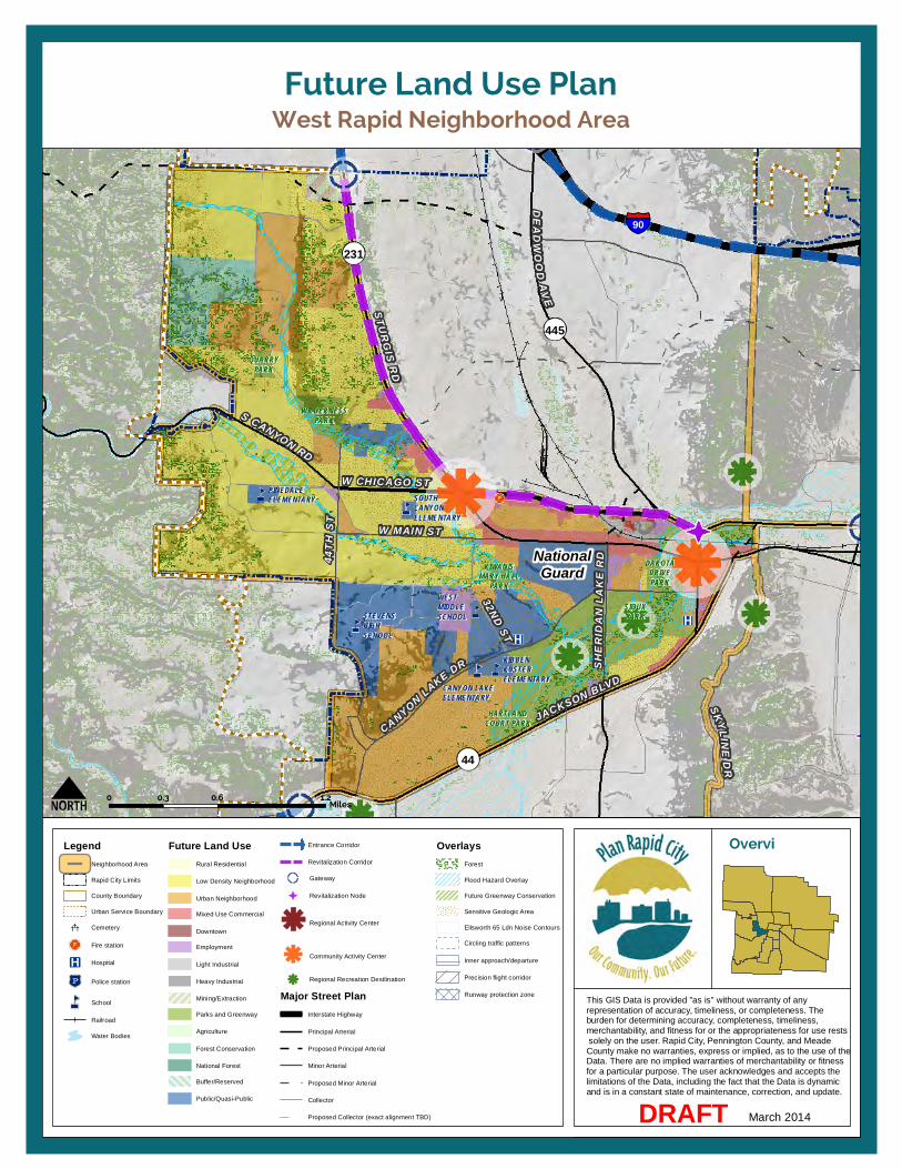
S CANYON RD
W CHICAGO ST
W MAIN ST
JACKSON BLVD
CA NYON LAKE DR
32ND ST
44TH
ST
SK YLINEDR44
445
231
DEADWO OD
AVE
STURGIS RD
90
SHER
IDAN
LAK
E RDNational
Guard
CANYON LAKEELEMENTARY
STEVENSHIGHSCHOOL
PINEDALEELEMENTARY SOUTH
CANYONELEMENTARY
KIBBENKUSTERELEMENTARY
WESTMIDDLESCHOOL
QUARRYPARK
SIOUXPARK
WILDERNESSPARK
HARTLANDCOURT PARK
KIWANISMARY HALL
PARK
DAKOTADRIVEPARK
West Rapid Neighborhood AreaFuture Land Use Plan
This GIS Data is provided "as is" without warranty of any representation of accuracy, timeliness, or completeness. Theburden for determining accuracy, completeness, timeliness, merchantability, and fitness for or the appropriateness for use rests solely on the user. Rapid City, Pennington County, and Meade County make no warranties, express or implied, as to the use of the Data. There are no implied warranties of merchantability or fitnessfor a particular purpose. The user acknowledges and accepts the limitations of the Data, including the fact that the Data is dynamic and is in a constant state of maintenance, correction, and update.
Overvi ew Map
March 2014DRAFT
0 0.6 1.20.3Miles
LegendNeighborhood Area
Rapid City Limits
County Boundary
Urban Service Boundary
Cemetery
Fire station
Hospital
Police station
School
Railroad
Water Bodies
Future Land UseRural Residential
Low Density Neighborhood
Urban Neighborhood
Mixed Use Commercial
Downtown
Employment
Light Industrial
Heavy Industrial
Mining/Extraction
Parks and Greenway
Agriculture
Forest Conservation
National Forest
Buffer/Reserved
Public/Quasi-Public
Entrance Corridor
Revitalization Corridor
Gateway
Revitalization Node
Regional Activity Center
Community Activity Center
Regional Recreation Destlination
Major Street PlanInterstate Highway
Principal Arterial
Proposed Principal Arterial
Minor Arterial
Proposed Minor Arterial
Collector
Proposed Collector (exact alignment TBD)
OverlaysForest
Flood Hazard Overlay
Future Greenway Conservation
Sensitive Geologic Area
Ellsworth 65 Ldn Noise Contours
Circling traffic patterns
Inner approach/departure
Precision flight corridor
Runway protection zone


12. Implementation 12

12. Implementation
Rapid City Comprehensive Plan – Revised Draft: March 2014 181
OVERVIEW A key aspect of this Comprehensive Plan is how the overarching Core Values, goals, and policies will be carried out after it is adopted. To effectively implement the goals and policies of the Plan, it is important to define a set of recommended actions and priority initiatives to pursue and develop a deeper understanding of the potential tools and options that could be employed to advance the vision. Moreover, routine monitoring and periodic amendments will help ensure that the Plan remains relevant. This implementation chapter includes the following components:
• Priority Initiatives: this section outlines key priorities to help advance the community’s vision in the immediate future and focus Plan implementation efforts.
• Action Plan: this section contains a comprehensive list of recommended actions to help support the implementation of each of the seven Core Values. Plan Monitoring and Amendments: this section establishes a framework for monitoring efforts to implement the Plan over time and procedures for conducting periodic Plan Amendments.
• Implementation Toolbox: this section identifies potential actions the City could take to expand its set of public finance tools and new approaches to infrastructure financing.
PRIORITY INITIATIVES Seven initiatives have been identified as key priorities to help advance the community’s vision in the immediate future (1-2 years) and to focus Plan implementation efforts. Efforts to advance these initiatives are already underway in several cases and several of the initiatives are overlapping in their scope and intent. A brief explanation of each priority initiative is provided below. Additional detail regarding each initiative is provided in this Action Plan.
ALIGNING ZONING AND DEVELOPMENT REGULATIONS WITH THE PLAN In order for the Growth and Development Framework outlined in this Plan to be effective, the City’s development regulations must be consistent with the goals and policies of the Plan. Concurrent with the development of this Plan, a “diagnosis” of the City’s existing zoning regulations was prepared to identify key issues and inconsistencies to be addressed and to help remove potential barriers to the implementation of key Plan concepts (e.g., diverse housing types, mixed-use development) within the City’s existing regulations. (See Appendix C.) The Action Plan identifies a series of strategies to help address these issues. Central to these recommendations is the integration of the City’s zoning, subdivision, and associated land development ordinances into a Unified Development Code. This
priority initiative will serve as a springboard for the numerous other recommendations outlined in the Action Plan.
RELEVANT ACTION PLAN STRATEGIES Primary: BPG-A3: Unified Development Code and GOV-A3: Development Review Team Processes.
Secondary: BPG-A2: Infill and Redevelopment Incentives Program, LC-A9: Residential Design Standards, LC-A12: Non-Residential Design Guidelines, LC-A1: Landscape Ordinance, and EC-A2: Public Financing and Development Incentive Toolbox.
AFFORDABLE AND WORKFORCE HOUSING INITIATIVES The availability of affordable and workforce housing plays a critical role in Rapid City’s quality of life and economic vitality. The Action Plan identifies a series of strategies to help advance housing discussions and develop a clear strategy to move forward. For the purposes of this priority initiative, immediate action should be taken to initiate discussions to develop and adopt formal definitions of “target affordable” and “workforce housing” for Rapid City and to identify specific housing needs for each group.
In conjunction with this initial strategy, focus should be placed on supporting further collaboration among all active housing organizations in the Rapid City area and developing a coordinated strategic plan to address specific housing needs for
12. Implementation
182 Rapid City Comprehensive Plan – Revised Draft: March 2014
each target housing group (e.g., homeless/transitional, very low/low income, workforce). They should also work to identify potential funding sources and programs that can be implemented beyond use of CDBG funds. Possible tools for consideration are identified in the Implementation Toolbox (See page 210.) and the Zoning Diagnosis (See Appendix C.).
RELEVANT ACTION PLAN STRATEGIES Primary: LC-A2: Affordable and Workforce Housing Definition, LC-A3: Affordable and Workforce Housing Collaboration, and LC-A5: Affordable and Workforce Housing Strategy.
Secondary: LC-A6: Activity Center Pilot Project, LC-A10: Mixed-Income Housing Development, LC-A14: Downtown Housing Catalyst Project.
DOWNTOWN AREA MASTER PLAN Downtown has become a vibrant community gathering place and a base for tourist activity in the region. Likewise, the SDSMT and Civic Center are major assets to the community, serving as eastern and northern anchors to Downtown, respectively. This priority initiative recommends that the City partner with SDSMT, Rushmore Plaza Civic Center, and other stakeholders to create a master plan for the area immediately surrounding the Downtown Core. It is envisioned that this effort would build on the SDSMT Campus Master Plan, the Downtown Master Plan and plans for expansion of the Civic Center and would identify opportunities
to enhance connections between two destinations, promote infill and revitalization, and accommodate a mixture of housing, employment space, and retail/entertainment to help attract and retain students, recent graduates, and young professionals and support continued growth of the City’s tourism industry. This effort would provide an opportunity to engage a wide range of stakeholders in the Downtown area on a range of topics essential to the long-term success of this Plan—housing, infill and redevelopment, multi-modal transportation, education, and economic development among others.
RELEVANT ACTION PLAN STRATEGIES
Primary: LC-A4: Downtown Area Master Plan
Secondary: BPG-A1: Planning Coordination, LC-A7: Infill and Redevelopment Standards, and LC-A10: Mixed-Income Housing Development.
DEVELOPMENT REVIEW FOR ALTERNATIVE MODES AND ACCESSIBILITY Although opportunities for alternative modes of travel—walking, bicycling, and riding transit—have increased in recent years, continued improvement is needed to support the types of land use patterns contemplated by this Plan and to increase the mobility and independence of seniors, persons with disabilities, and residents without the financial means to own a vehicle.
This priority initiative involves the use of a formal checklist tool to assess how alternate modes and accessibility will be accommodated with proposed developments and public improvements. The intent of this initiative is to promote consistency in the implementation of sidewalks, bicycle lanes, and other features that support the use of alternative modes of travel and provide increased mobility for citizens of all ages, means, and abilities.
RELEVANT ACTION PLAN STRATEGIES Primary: TI-A2: Development Review for Alternative Modes and TI-A14: Development Review for Accessibility.
Secondary: TI-A5: Multi-modal Balance, TI-A27: Sidewalk Improvements, TI-A28: Transit Accessibility, TI-A26: Pedestrian Links, and TI-A30: Transit System Usability.
PUBLIC FINANCING AND DEVELOPMENT INCENTIVE TOOLBOX Rapid City currently funds infrastructure capital projects through a variety of fund sources, with funds provided mainly through property and sales tax revenues. The City’s revenues streams for funding capital projects have not been sufficient to cover needed improvements, and conflicts between funding existing infrastructure improvements and new infrastructure improvements exist. The need to fund infrastructure to facilitate growth and the general lack of revenue for improvements to existing

12. Implementation
Rapid City Comprehensive Plan – Revised Draft: March 2014 183
infrastructure has caused the City to leave many needs unfunded and unimproved. This initiative supports the development of an expanded set of public financing tools and development incentives the City could use to address infrastructure needs and support development. A range of potential tools for consideration are identified in the Implementation Toolbox (See page 210.).
RELEVANT ACTION PLAN STRATEGIES Primary: EC-A2: Public Financing and Development Toolbox
Also supports: EC-A5: Modify Water and Sewer Infrastructure System Expansion Approach, EC-A6: Growth the Tax Base, BPG-A2: Infill and Redevelopment Incentives Program, LC-A5: Affordable and Workforce Housing Strategy, LC-A6: Activity Center Pilot Program, and LC-A8: Reinvestment Program.
URBANIZATION STRATEGY A coordinated approach to development at Rapid City’s edges will support the efficient use of land and infrastructure and increase predictability for property owners, developers, residents, and others regarding future development type, intensity, regulations, and jurisdiction. This priority initiative involves exploration of establishing intergovernmental agreements (IGAs) with Pennington and Meade Counties, and adjacent municipalities (to the extent possible) to formalize development review requirements (e.g., Joint Powers Agreement) and annexation policies within the 3-mile platting
jurisdiction (e.g., no new enclaves created, annexation agreements for development in noncontiguous areas).
RELEVANT ACTION PLAN STRATEGIES
Primary: BPG-A4: Urbanization Strategy and BPG-A5: Enclave Annexation Strategy
Secondary: BPG-A1: Planning Coordination.
PARKLAND DEDICATION Recreational and cultural opportunities play an important role in the quality of life for residents, as well as in the City’s ability to attract and retain visitors, employers, and future residents. While Rapid City is well-served today by the park system as a whole, some areas of the community are underserved, particularly with regards to neighborhood parks. Additional parks and recreation facilities will be necessary to address current gaps in the system as well as new demand in emerging growth areas. This priority initiative involves exploration and identification of a more predictable means of acquiring and maintaining the City’s parks and recreation system. As a first step, the possibility of requiring the dedication of land (or cash-in-lieu) for parks and open space purposes for larger developments should be considered. As part of this effort, size thresholds for specific projects, types of development to which dedication would apply, and variations in requirements by location as applicable (e.g., infill vs. greenfield) should all be defined.
RELEVANT ACTION PLAN STRATEGIES
Primary: RC-A3: Parkland Dedication
ACTION PLAN This section identifies a comprehensive list of recommended actions to support the implementation of the Plan and help advance the community vision over the next five years. Actions are organized in tables that correspond with the Plan’s seven Core Values. Action Plan strategies should be reviewed annually and amended as needed. Components of the Action Plan are summarized below.
TYPES OF ACTION STRATEGIES
Policy Decisions
The Plan identifies many policies that will be achieved through day-to-day decision-making made by Rapid City planning and engineering staff, the Planning Commission, and the City Council. The City Council will make decisions regarding development proposals and Plan amendments and will use the Plan to guide policy-related decisions as they occur. Decision-making related to annexation policies and the provision of Urban Services is one example of this type of action strategy.
Programs
The Plan sets up a foundation for new programs necessary to support or achieve the goals and policies. For example, some policies emphasize incentivizing infill and redevelopment practices, which would be
12. Implementation
184 Rapid City Comprehensive Plan – Revised Draft: March 2014
implemented through a new incentive program.
Public Improvement Projects
Some goals and policies may be best implemented through a specific public improvement project or series of projects. For example, construction of a new utility line to serve a priority employment area is a public improvement project that could help advance the goals of this Plan.
Regulatory Revisions
In order for the Comprehensive Plan to be effective, the City’s development regulations will need to be consistent with the goals and policies of the Plan. Rapid City may need to revise the development regulations and standards in the Rapid City Municipal Code in order to achieve these goals and policies.
Regional and Agency Coordination
Some goals and policies involve planning efforts with other jurisdictions and inviting other agencies and jurisdictions in the region to participate in Rapid City planning efforts. Ongoing collaboration with Meade and Pennington Counties; the communities of Box Elder, Summerset, and Piedmont; Ellsworth Air Force Base and Ellsworth Development Authority, South Dakota Department of Transportation (SDDOT), and others will be imperative to support the implementation of the Plan. Some regional coordination may even involve working with other municipalities
in South Dakota to encourage changes to state legislation.
Funding Mechanisms
The Plan identifies some goals and policies that will need new or expanded funding mechanisms in order to be implemented.
PARTNERS For each of the items listed in the Action Plan, a lead department or organization is identified to initiate the action. A supporting list of other departments, organizations, and groups to involve in the implementation is also provided.
ACTION TIMING The action strategies identified in this chapter are organized by Core Value into three key time frames:
• Immediate Actions – concurrent and ongoing with the adoption of this Plan. This only includes strategies that can be implemented with current funding by the City or another organization.
• Near-term Actions – following plan adoption, over the next 2 years. This includes actions that could be achieved with current funding, as well as strategies that would need new funding, through the priority-based budgeting process or a new funding source.
• Longer-term Actions – 2 to 5 years following plan adoption. This also includes actions that could be implemented with current funding or may require additional resources or funding sources.
FUNDING REQUIREMENTS To inform the priority-based budgeting process, and to help identify current and future budget needs, the Action Plan identifies general funding needs to implement each strategy. The intent of this information is to highlight actions that will require new City investment to achieve, beyond current staffing levels. This may occur through increased departmental funding or consulting support, or could be achieved through new funding sources or by seeking outside funding support or partnerships with other organizations. The categories to highlight major funding needs include the following:
• N/A – can likely be added to existing work plan/load without additional funding.
• Funding Needed– will likely require new or increased City funding through priority-based budgeting process, and might include new programs, projects, or efforts needing consulting assistance.
• Outside– requires outside (non-City) funding.
• New Source – requires a new funding mechanism (e.g., impact fee or tax).
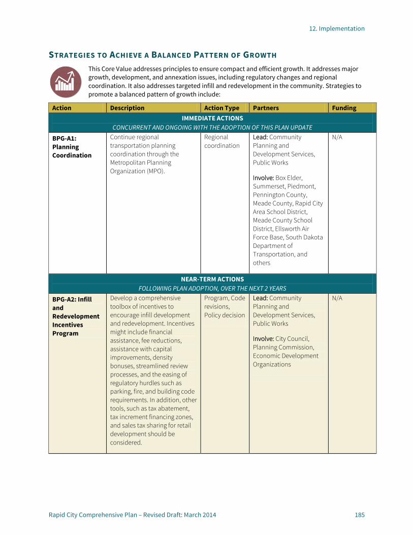
12. Implementation
Rapid City Comprehensive Plan – Revised Draft: March 2014 185
STRATEGIES TO ACHIEVE A BALANCED PATTERN OF GROWTH This Core Value addresses principles to ensure compact and efficient growth. It addresses major growth, development, and annexation issues, including regulatory changes and regional coordination. It also addresses targeted infill and redevelopment in the community. Strategies to promote a balanced pattern of growth include:
Action Description Action Type Partners Funding IMMEDIATE ACTIONS
CONCURRENT AND ONGOING WITH THE ADOPTION OF THIS PLAN UPDATE
BPG-A1: Planning Coordination
Continue regional transportation planning coordination through the Metropolitan Planning Organization (MPO).
Regional coordination
Lead: Community Planning and Development Services, Public Works
Involve: Box Elder, Summerset, Piedmont, Pennington County, Meade County, Rapid City Area School District, Meade County School District, Ellsworth Air Force Base, South Dakota Department of Transportation, and others
N/A
NEAR-TERM ACTIONS FOLLOWING PLAN ADOPTION, OVER THE NEXT 2 YEARS
BPG-A2: Infill and Redevelopment Incentives Program
Develop a comprehensive toolbox of incentives to encourage infill development and redevelopment. Incentives might include financial assistance, fee reductions, assistance with capital improvements, density bonuses, streamlined review processes, and the easing of regulatory hurdles such as parking, fire, and building code requirements. In addition, other tools, such as tax abatement, tax increment financing zones, and sales tax sharing for retail development should be considered.
Program, Code revisions, Policy decision
Lead: Community Planning and Development Services, Public Works
Involve: City Council, Planning Commission, Economic Development Organizations
N/A

12. Implementation
186 Rapid City Comprehensive Plan – Revised Draft: March 2014
Action Description Action Type Partners Funding BPG-A3: Unified Development Code
Update the zoning ordinance in accordance with the goals and policies of this Plan, and integrate zoning, subdivision, and associated land development ordinances into a Unified Development Code. Major objectives to be considered as part of this process include:
Reorganization and clean-up of existing provisions to reduce inconsistencies, improve clarity, and increase user-friendliness; Consideration of new zone
districts to encourage a more diverse mix of uses and housing types in targeted areas; Improved development
standards; and Updates to zoning map to
align with the Future Land Use Plan map and categories.
Refer to the Code Diagnosis provided in the Appendix for a more in-depth discussion of recommended updates.
Regulatory revisions
Lead: Community Planning and Development Services, Public Works
Involve: City Council, Planning Commission
N/A
BPG-A4: Urbanization Strategy
Establish Intergovernmental Agreements (IGAs) with Pennington and Meade Counties, and adjacent municipalities (to the extent possible) to formalize development review requirements (e.g., Joint Powers Agreement) and annexation policies within the 3-mile platting jurisdiction (e.g., no new enclaves created, annexation agreements for development in noncontiguous areas, annexation criteria).
Policy decision, Regional coordination
Lead: Community Planning and Development Services, Public Works
Involve: City Council, Planning Commission, Utility Providers, County Planning, County Commissioners
N/A

12. Implementation
Rapid City Comprehensive Plan – Revised Draft: March 2014 187
Action Description Action Type Partners Funding LONGER-TERM ACTIONS
2 TO 5 YEARS, FOLLOWING PLAN ADOPTION
BPG-A5: Enclave Annexation Strategy
Explore options for annexing all or portions of existing County enclaves within the City limits. Possible strategies might include a phased approach, tiered service costs, development regulation waivers, and/or coordinating public improvements with annexation timing.
Policy decision, Regional coordination
Lead: Community Planning and Development Services, Public Works
Involve: City Council, Planning Commission, Utility Providers, County Planning, County Commissioners
N/A

12. Implementation
188 Rapid City Comprehensive Plan – Revised Draft: March 2014
STRATEGIES TO CREATE A VIBRANT, LIVABLE COMMUNITY This Core Value addresses “quality of life” initiatives, including quality of development, property maintenance, and overall positive community image. It also addresses the creation of high-quality, connected new neighborhoods as well as maintained character and livability in established neighborhoods. The vitality of Downtown is recognized as having an important role as the center of the community. Finally, this Core Value addresses vibrant activity centers and corridors. Strategies to promote a vibrant, livable community include:
Action Description Action Type Partners Funding IMMEDIATE ACTIONS
CONCURRENT AND ONGOING WITH THE ADOPTION OF THIS PLAN UPDATE
LC-A 1: Landscaping Ordinance
Prepare and consider adoption of a landscaping ordinance to enhance the visual interest and appearance of development, building on previous efforts in this area. Consider including standards to address landscaping and appearance of City gateways and entry corridors.
Regulatory revisions
Lead: Community Planning and Development Services, Public Works
Involve: City Council, Planning Commission
N/A
LC-A2: Affordable and Workforce Housing Definition
Adopt a formal definition of target affordable and workforce housing groups. Identify specific housing needs for each group.
Policy decision, Regulatory revisions
Lead: Community Planning and Development Services, Community Development Division, Public Works
Involve: City Council, Planning Commission
N/A
LC-A3: Affordable and Workforce Housing Collaboration
Support the further collaboration of all active housing organizations in the Rapid City area by facilitating the creation of a housing efforts coordination position by an active non-profit housing entity. The purpose of the position is to better organize the active housing organizations and identify collaborative efforts and programs that can be created. Ensure that the City is an active participant in these efforts.
Regional coordination
Lead: Community Development Division
Involve: Housing organizations
N/A

12. Implementation
Rapid City Comprehensive Plan – Revised Draft: March 2014 189
Action Description Action Type Partners Funding NEAR-TERM ACTIONS
FOLLOWING PLAN ADOPTION, OVER THE NEXT 2 YEARS
LC-A4: Downtown Area Master Plan
Partner with Downtown area stakeholders to create a master plan for the area surrounding the Downtown Core with an emphasis on enhancing connections to and between major destinations, such as the SDSMT campus and Rushmore Plaza Civic Center and planning for a mixture of housing, housing, employment space, and retail/entertainment to help promote tourism, and attract students, recent graduates, and young professionals.
Program, Improvement Project
Lead: Community Planning and Development Services, Public Works
Involve: City Council, Planning Commission, Public Works, Community Development, Economic Development Organizations, SDSMT staff and student body, Rushmore Plaza Civic Center, private sector, and community.
Funding Needed (consultant assistance may be needed
LC-A5: Affordable and Workforce Housing Strategy
Develop and consider adoption of a strategic plan to address specific housing needs for each target housing group (e.g., homeless/transitional, very low/low income, workforce). Identify potential funding sources and programs that can be implemented beyond program operated using CDBG funds. Strategies might include inclusionary zoning, establishment of a land bank program, mobile home park stabilization, and/or development incentives.
Policy decision, Program, Regulatory revisions
Lead: Community Development Division
Involve: Community Planning and Development Services, City Council, Planning Commission, Housing Organizations
Funding Needed (new program)

12. Implementation
190 Rapid City Comprehensive Plan – Revised Draft: March 2014
Action Description Action Type Partners Funding LC-A6: Activity Center Pilot Project
Develop a comprehensive strategy to spur reinvestment in one of the City’s waning activity centers as a pilot project. Consider strategies such as targeted public improvements, regulatory amendments, financial tools, and public-private partnerships to focus efforts in one activity center. Monitor progress over time and if successful, consider expanding the pilot program to other sites.
Public improvement project, Program
Lead: Community Development Division
Involve: Community Planning and Development Services, Public Works, City Council, Planning Commission, property owners, business groups
Funding Needed (new project)
LC-A7: Infill and Redevelopment Standards
Develop and consider adoption of standards to encourage and enhance compatibility of infill development and redevelopment with existing development. Standards should address buffers and transitions between different intensities of development and development in historic districts.
Regulatory revisions
Lead: Community Planning and Development Services, Public Works
Involve: City Council, Planning Commission, Historic Preservation Commission
Funding Needed (consultant assistance may be needed)
LC-A8: Reinvestment Program
Explore options and develop a new program to encourage and assist private property maintenance and rehabilitation. Program elements might include activities such as waste and graffiti clean-up events, paint-a-thons, weatherization workshops, and adopt-a-neighbor coordination.
Program Lead: Community Development Division
Involve: Community Planning and Development Services, City Council, Planning Commission, neighborhood and business groups
Funding Needed (new program)

12. Implementation
Rapid City Comprehensive Plan – Revised Draft: March 2014 191
Action Description Action Type Partners Funding LC-A9: Residential Design Standards
Develop and consider adoption of design standards to encourage variety, visual interest, and durability in the design of new residential development. Standards should offer a menu of options for compliance, rather than a one-size-fits-all approach. Standards should address single and multi-family housing, and encourage a diverse mix of housing types and styles.
Regulatory revisions
Lead: Community Planning and Development Services, Public Works
Involve: City Council, Planning Commission
Funding Needed (consultant assistance may be needed)
LC-A10: Mixed Income Housing Development
Expand TIF incentives for affordable housing to allow for use on workforce housing developments and in areas where a more diverse mix of housing types is desired (e.g., mixed-use activity centers).
Program, Regulatory revisions, Policy decision
Lead: Community Development Division
Involve: City Planning, City Council, Planning Commission,
N/A
LONGER-TERM ACTIONS 2 TO 5 YEARS, FOLLOWING PLAN ADOPTION
LC-A11: Entryway Improvements Plan
Coordinate with South Dakota Department of Transportation, adjacent communities, Pennington and Meade Counties, and private property owners to define visions for the various City gateways and entry corridors. Identify priority projects and establish guidelines to guide future development in these areas.
Program, Improvement project
Lead: C Community Planning and Development Services, Public Works
Involve: Box Elder, Summerset, Piedmont, Pennington County, Meade County, National Forest Service, South Dakota Department of Transportation, and private property owners, and others
Funding Needed (consultant assistance may be needed)

12. Implementation
192 Rapid City Comprehensive Plan – Revised Draft: March 2014
Action Description Action Type Partners Funding LC-A12: Non-Residential Design Guidelines
Develop and consider adoption of guidelines and standards to elevate the quality of non-residential development. Topics to address might include building massing, site design, lighting, signage, and sustainable development practices.
Regulatory revisions
Lead: Community Planning and Development Services
Involve: City Council, Planning Commission
Funding Needed (consultant assistance may be needed)
LC-A13: Wildlife-Friendly Design
Develop and consider adoption of standards to protect established wildlife corridors and to address appropriate landscaping, lighting, and other design considerations in areas with high wildlife activity.
Regulatory revisions
Lead: Community Planning and Development Services, Public Works
Involve: Parks and Recreation, City Council, Planning Commission, National Forest Service
Funding Needed (consultant assistance may be needed)
LC-A14: Downtown Housing Catalyst Projects
Identify potential catalyst sites for housing in the Downtown area. Solicit or partner with a developer to build a multi-family housing project to generate an expanded housing supply in Downtown and to help momentum for additional projects.
Public Improvement Project
Lead: Community Planning and Development Services, Public Works
Involve: Community Development Division, Public Works, Economic Development Organizations, Development Community
Funding Needed (consultant assistance may be needed)
LC-A15: Historic District Guidelines
Support the development and adoption of City historic district design guidelines to tailor the Secretary of the Interior’s standards to unique local conditions.
Regulatory revisions
Lead: Community Planning and Development Services, Historic Preservation Commission
Involve: Public Works, Development Community
Funding Needed (consultant assistance may be needed)

12. Implementation
Rapid City Comprehensive Plan – Revised Draft: March 2014 193
STRATEGIES TO ENSURE A SAFE, HEALTHY, INCLUSIVE, AND SKILLED COMMUNITY This Core Value addresses the safety, health, and well-being of the community. It also addresses educational opportunities in the city with a strong focus on life-long learning. It focuses on Rapid City as a diverse, caring, and inclusive community. Additionally, it addresses hazard and disaster risk reduction, public safety, and community resiliency. Access to food, opportunities for fitness, and accessibility of health and social services are also addressed in this Core Value. Strategies to ensure a safe, healthy, inclusive, and skilled community include:
Action Description Action Type Partners Funding IMMEDIATE ACTIONS
CONCURRENT AND ONGOING WITH THE ADOPTION OF THIS PLAN UPDATE
SHIS-A1: Education Coordination
Facilitate a routine (e.g., quarterly) coordination meeting between City leadership and educational providers. Coordination topics should include facility planning, community educational needs/issues, and opportunities for collaboration.
Regional coordination
Lead: Community Planning and Development Services and City Leadership
Involve: Rapid City Area School District, South Dakota School of Mines and Technology, University Center, Western Dakota Technical Institute, Oglala Lakota College, National American University, Career Learning Center, Rapid City Libraries, and others
N/A
SHIS-A2: Fire Department Long-Range Deployment Plan
Support implementation of the Rapid City Fire Department’s Long-Range Deployment Plan. Focus on completion of a Downtown fire station and implementation of Phase 1 recommendations.
Program Lead: Fire Department
Involve: City Council, Planning Commission, County Emergency Management, National Forest Service
N/A
SHIS-A2: Fire Hazard Awareness and Risk Reduction
Continue education programs focused on establishing survivable spaces and promoting emergency preparedness.
Program Lead: Fire Department
Involve: City Council, Planning Commission, County Emergency Management, National Forest Service
N/A

12. Implementation
194 Rapid City Comprehensive Plan – Revised Draft: March 2014
Action Description Action Type Partners Funding SHIS-A4: Local Food Access
Coordinate transit service, where practical and efficient, with Farmers Market location and schedule and other places where local and/or healthy food is sold or distributed (e.g., food bank, grocery stores).
Program, Agency coordination
Lead: Rapid Ride
Involve: Community Planning and Development Services, Social Service Organizations
N/A
NEAR-TERM ACTIONS FOLLOWING PLAN ADOPTION, OVER THE NEXT 2 YEARS
SHIS-A5: Service Provider Shared Facility Study
Study the facility programming needs of community health and social service providers, and explore feasibility of creating a centralized, shared facility to maximize efficiency and establish one-stop-shop approach to service delivery.
Program, Agency coordination
Lead: Community Development Division
Involve: Community Planning and Development Services, Social Service Organizations
Funding Needed (new program)
LONGER-TERM ACTIONS 2 TO 5 YEARS, FOLLOWING PLAN ADOPTION
SHIS-A6: Safety & Lighting Improvements
Engage the public in a dialogue about safety and lighting needs in the community, building on the successes of the Light the Night project. Consider the installation of additional lighting, security cameras, and/or emergency call boxes in high-needs areas, such as along greenway trails, alleys, and parking structures.
Program,
Public improvements
Lead: Police Department
Involve: Community Planning and Development Services, County Sheriffs, Parks and Recreation, Code Enforcement, and others.
Funding Needed (new program)

12. Implementation
Rapid City Comprehensive Plan – Revised Draft: March 2014 195
STRATEGIES FOR EFFICIENT TRANSPORTATION AND INFRASTRUCTURE SYSTEMS This Core Value addresses ways to achieve a well-maintained network of infrastructure and transportation systems that meets the needs of residents and businesses. It addresses the provision of infrastructure like water, wastewater, and storm drainage. It also aims for a safe and efficient multi-modal transportation system. Finally, it addresses an integrated network of intermodal facilities. Strategies to achieve efficient transportation and infrastructure systems include:
Action Description Action Type Partners Funding IMMEDIATE ACTIONS
CONCURRENT AND ONGOING WITH THE ADOPTION OF THIS PLAN UPDATE
TI-A1: Transportation and Infrastructure Coordination
Continue coordination of street projects within the same ROW as infrastructure projects, and begin using land use and transportation to help prioritize infrastructure projects
Agency coordination, Public Improvements
Lead: Public Works
Involve: Community Planning and Development Services, Metropolitan Planning Organization (MPO)
N/A
TI-A2: Development Review for Alternate Modes
Implement a formal checklist tool that identifies how alternate modes will be accommodated with the proposed development activity.
Policy decision, Regulatory revisions
Lead: Community Planning and Development Services
Involve: Public Works, Parks and Recreation
N/A
TI-A3: Major Street Plan Implementation and Integration
Coordinate land use plans and development review with the major street plan. Ensure that development activities preserve ROW for future roadways. Variances should be granted only when proper conditions are satisfied.
Policy decision, Regulatory revisions
Lead: Community Planning and Development Services
Involve: Public Works, MPO
N/A
TI-A4: Development Exceptions and Variances
Continue a development exception and variance process that includes specific, objective and clear criteria by which a variance from standards will be evaluated. Implement a method for tracking such requests and responses.
Policy decision, Regulatory revisions
Lead: Community Planning and Development Services
Involve: Public Works, MPO
N/A
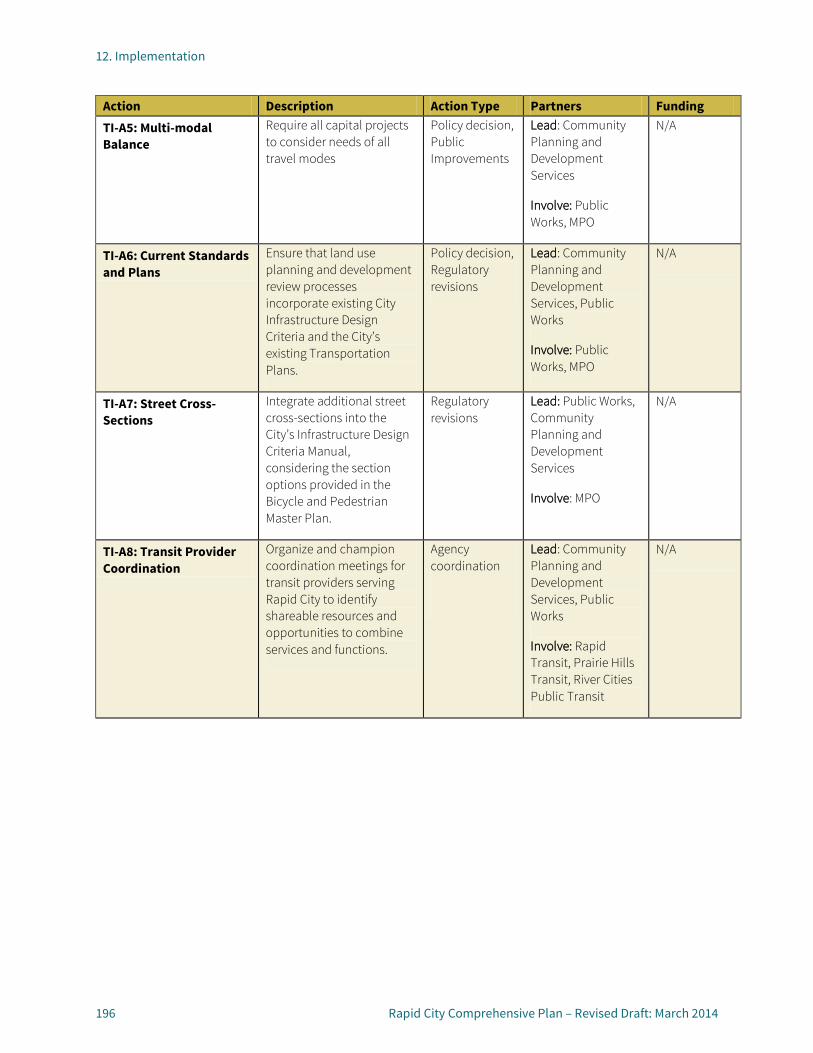
12. Implementation
196 Rapid City Comprehensive Plan – Revised Draft: March 2014
Action Description Action Type Partners Funding TI-A5: Multi-modal Balance
Require all capital projects to consider needs of all travel modes
Policy decision, Public Improvements
Lead: Community Planning and Development Services
Involve: Public Works, MPO
N/A
TI-A6: Current Standards and Plans
Ensure that land use planning and development review processes incorporate existing City Infrastructure Design Criteria and the City’s existing Transportation Plans.
Policy decision, Regulatory revisions
Lead: Community Planning and Development Services, Public Works
Involve: Public Works, MPO
N/A
TI-A7: Street Cross-Sections
Integrate additional street cross-sections into the City’s Infrastructure Design Criteria Manual, considering the section options provided in the Bicycle and Pedestrian Master Plan.
Regulatory revisions
Lead: Public Works, Community Planning and Development Services
Involve: MPO
N/A
TI-A8: Transit Provider Coordination
Organize and champion coordination meetings for transit providers serving Rapid City to identify shareable resources and opportunities to combine services and functions.
Agency coordination
Lead: Community Planning and Development Services, Public Works
Involve: Rapid Transit, Prairie Hills Transit, River Cities Public Transit
N/A
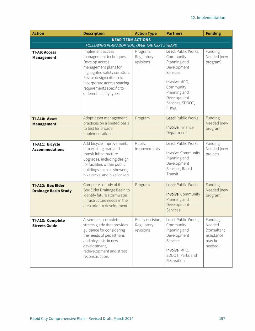
12. Implementation
Rapid City Comprehensive Plan – Revised Draft: March 2014 197
Action Description Action Type Partners Funding NEAR-TERM ACTIONS
FOLLOWING PLAN ADOPTION, OVER THE NEXT 2 YEARS
TI-A9: Access Management
Implement access management techniques, Develop access management plans for highlighted safety corridors. Revise design criteria to incorporate access spacing requirements specific to different facility types
Program, Regulatory revisions
Lead: Public Works, Community Planning and Development Services
Involve: MPO, Community Planning and Development Services, SDDOT, FHWA
Funding Needed (new program)
TI-A10: Asset Management
Adopt asset management practices on a limited basis to test for broader implementation.
Program
Lead: Public Works
Involve: Finance Department
Funding Needed (new program)
TI-A11: Bicycle Accommodations
Add bicycle improvements into existing road and transit infrastructure upgrades, including design for facilities within public buildings such as showers, bike racks, and bike lockers
Public Improvements
Lead: Public Works
Involve: Community Planning and Development Services, Rapid Transit
Funding Needed (new project)
TI-A12: Box Elder Drainage Basin Study
Complete a study of the Box Elder Drainage Basin to identify future stormwater infrastructure needs in the area prior to development.
Program Lead: Public Works
Involve: Community Planning and Development Services
Funding Needed (new program)
TI-A13: Complete Streets Guide
Assemble a complete streets guide that provides guidance for considering the needs of pedestrians and bicyclists in new development, redevelopment and street reconstruction.
Policy decision, Regulatory revisions
Lead: Public Works, Community Planning and Development Services
Involve: MPO, SDDOT, Parks and Recreation
Funding Needed (consultant assistance may be needed)

12. Implementation
198 Rapid City Comprehensive Plan – Revised Draft: March 2014
Action Description Action Type Partners Funding TI-A14: Development Review for Accessibility
Incorporate into the development review process considerations of transportation and transit accessibility such as proximity to population of users, clients, etc.
Policy decision, Regulatory revisions
Lead: Community Planning and Development Services
Involve: Public Works, Parks and Recreation
N/A
TI-A15: Multi-Modal Marketing
Coordinate and develop marketing campaigns to promote the use of alternative modes, both individually and together. Include basic information about transit amenities provided, such as bike racks on buses.
Program Lead: Rapid Transit
Involve: MPO, City of Rapid City
Funding Needed (new program)
TI-A16: Regional Corridors
Prioritize corridors that enhance regional mobility within the transportation planning process
Policy decision Lead: Public Works
Involve: MPO
N/A
TI-A17: Quiet Zones Evaluate potential implementation of quiet zones at high rail traffic locations through populated areas
Program Lead: Public Works
Involve: Railroads, SDDOT, FHWA, FRA
Funding Needed (consultant assistance may be needed)
TI-A18: Sidewalk Condition Analysis
Create sidewalk condition performance measures and implement an ongoing sidewalk conditions documentation process.
Program Lead: Public Works
Involve: Parks and Recreation, Code Enforcement
Funding Needed (new program)

12. Implementation
Rapid City Comprehensive Plan – Revised Draft: March 2014 199
Action Description Action Type Partners Funding TI-A19: Regional Collaboration
Identify regional stakeholders and their relationship status with the City. Meet regularly with key regional partners and champion efforts to bring together stakeholders. Hold regional events to promote transportation goals, such as an annual bike-to-work-day. Proactively participate in regional transportation corridor planning efforts, such as the Ports-to-Plains corridor. Participate in and/or organize multi-state planning projects to advance projects that improve regional mobility.
Regional coordination, Program
Lead: Public Works
Involve: Community Planning and Development Services, MPO, Box Elder, Summerset, and Piedmont
N/A
TI-A20: Transportation Management Organization (TMO)
Commission an organization dedicated to developing and implementing Travel Demand Management strategies in Rapid City. Organize groups/individuals to champion TDM strategies, and provide data support for these efforts.
Program
Lead: Community Planning and Development Services
Involve: Public Works, MPO, SDDOT, FHWA
Funding Needed (new program)
LONGER-TERM ACTIONS 2 TO 5 YEARS, FOLLOWING PLAN ADOPTION
TI-A21: Bus Stop Improvements
Enhance bus stop amenities beginning with higher-use bus stops and stops more utilized by senior populations. Amenities may include shelters, benches, lighting, and ADA measures. Improve access facilities such as sidewalk ramps
Program, Public Improvements
Lead: Public Works
Involve: Rapid Transit, Community Planning and Development Services
Funding Needed (new projects)
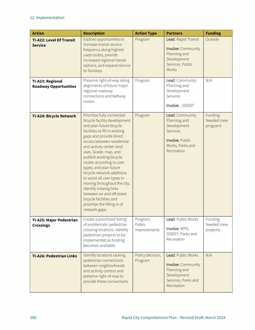
12. Implementation
200 Rapid City Comprehensive Plan – Revised Draft: March 2014
Action Description Action Type Partners Funding TI-A22: Level Of Transit Service
Explore opportunities to increase transit service frequency along highest used routes, provide increased regional transit options, and expand service to Sundays
Program Lead: Rapid Transit
Involve: Community Planning and Development Services, Public Works
Outside
TI-A23: Regional Roadway Opportunities
Preserve right-of-way along alignments of future major regional roadway connections and beltway routes.
Program Lead: Community Planning and Development Services
Involve: , SDDOT
N/A
TI-A24: Bicycle Network Prioritize fully connected bicycle facility development and plan future bicycle facilities to fill in existing gaps and provide direct access between residential and activity center land uses. Grade, map, and publish existing bicycle routes according to user types, and plan future bicycle network additions to assist all user types in moving throughout the city. Identify missing links between on and off street bicycle facilities and prioritize the filling in of network gaps.
Program Lead: Community Planning and Development Services
Involve: Public Works, Parks and Recreation
Funding Needed (new program)
TI-A25: Major Pedestrian Crossings
Create a prioritized listing of problematic pedestrian crossing locations. Identify pedestrian projects to be implemented as funding becomes available.
Program, Public Improvements
Lead: Public Works
Involve: MPO, SDDOT, Parks and Recreation
Funding Needed (new projects)
TI-A26: Pedestrian Links Identify locations lacking pedestrian connections between neighborhoods and activity centers and preserve right-of-way to provide these connections
Policy decision, Program
Lead: Public Works
Involve: Community Planning and Development Services, Parks and Recreation
N/A

12. Implementation
Rapid City Comprehensive Plan – Revised Draft: March 2014 201
Action Description Action Type Partners Funding TI-A27: Sidewalk Improvements
Implement important sidewalk improvements as a priority within the CIP utilizing the City’s Bicycle and Pedestrian Master Plan and the sidewalk conditions analysis process.
Public improvements, Program
Lead: Public Works
Involve: MPO, Parks and Recreation
Funding Needed (new projects)
TI-A28: Transit Accessibility
Make necessary adjustments to bus routing to ensure high level of accessibility for major employers and social services.
Program
Lead: Rapid Transit
Involve: Community Planning and Development Services, Public Works
Outside
TI-A29: Regional Intermodal Freight Plan
Work with the MPO to develop a regional intermodal freight plan to initiate freight planning in the region and enable the prioritization of freight projects within the overall transportation planning process. The plan would prioritize intermodal connectivity improvements, identify freight facilities to preserve, develop regional rail improvements, prioritize highway grade crossings, identify mitigation strategies for existing impacts from freight facilities, formalize a truck routing system, and identify strategies to reduce shipping costs for the region. Incorporate action items from the regional intermodal freight plan into the land use planning, transportation planning, development review, and CIP processes.
Program
Lead: Public Works, Community Planning and Development Services
Involve: MPO, Rapid City Regional Airport FHWA, SDDOT, Federal Railroad Administration, local business interests
Funding Needed (may require consultant assistance)
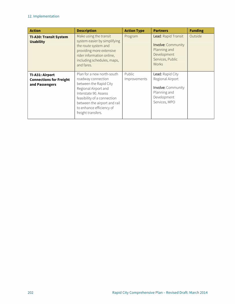
12. Implementation
202 Rapid City Comprehensive Plan – Revised Draft: March 2014
Action Description Action Type Partners Funding TI-A30: Transit System Usability
Make using the transit system easier by simplifying the route system and providing more extensive rider information online, including schedules, maps, and fares.
Program Lead: Rapid Transit
Involve: Community Planning and Development Services, Public Works
Outside
TI-A31: Airport Connections for Freight and Passengers
Plan for a new north-south roadway connection between the Rapid City Regional Airport and Interstate 90. Assess feasibility of a connection between the airport and rail to enhance efficiency of freight transfers.
Public Improvements
Lead: Rapid City Regional Airport
Involve: Community Planning and Development Services, MPO
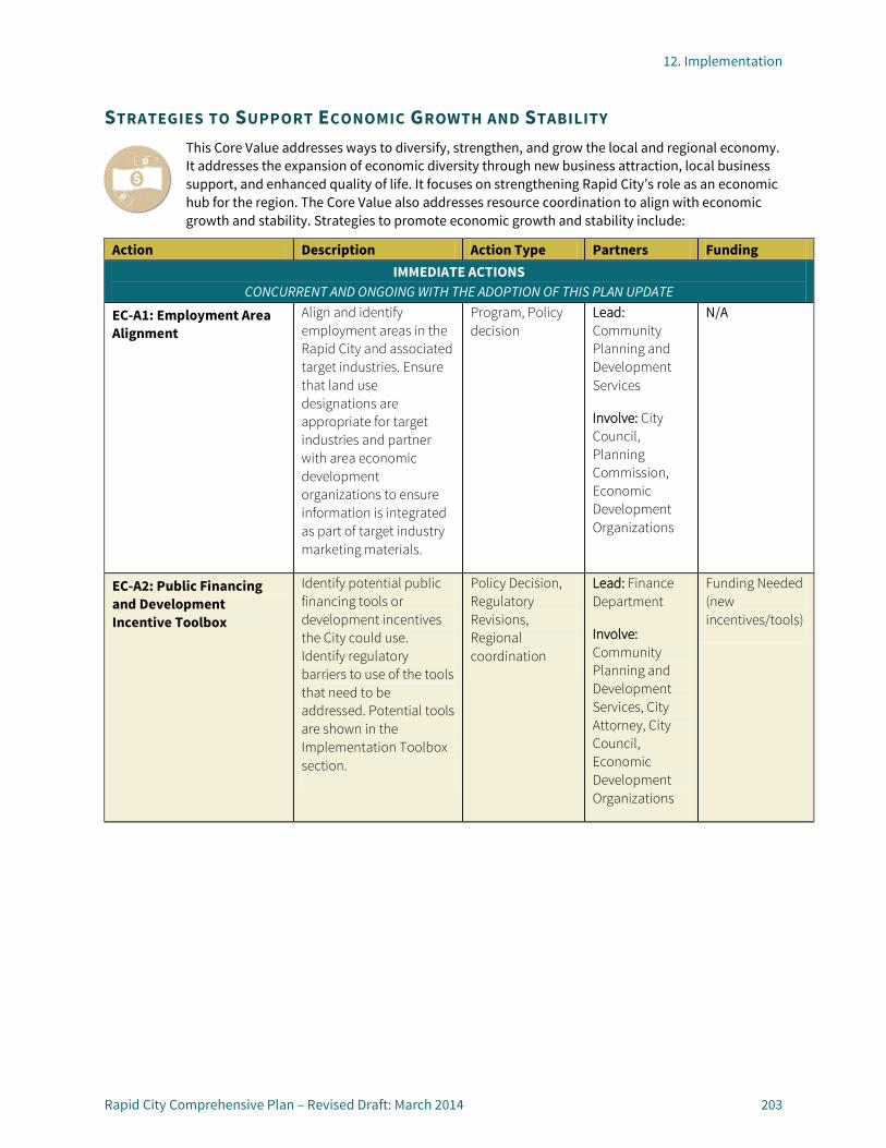
12. Implementation
Rapid City Comprehensive Plan – Revised Draft: March 2014 203
STRATEGIES TO SUPPORT ECONOMIC GROWTH AND STABILITY This Core Value addresses ways to diversify, strengthen, and grow the local and regional economy. It addresses the expansion of economic diversity through new business attraction, local business support, and enhanced quality of life. It focuses on strengthening Rapid City’s role as an economic hub for the region. The Core Value also addresses resource coordination to align with economic growth and stability. Strategies to promote economic growth and stability include:
Action Description Action Type Partners Funding IMMEDIATE ACTIONS
CONCURRENT AND ONGOING WITH THE ADOPTION OF THIS PLAN UPDATE
EC-A1: Employment Area Alignment
Align and identify employment areas in the Rapid City and associated target industries. Ensure that land use designations are appropriate for target industries and partner with area economic development organizations to ensure information is integrated as part of target industry marketing materials.
Program, Policy decision
Lead: Community Planning and Development Services
Involve: City Council, Planning Commission, Economic Development Organizations
N/A
EC-A2: Public Financing and Development Incentive Toolbox
Identify potential public financing tools or development incentives the City could use. Identify regulatory barriers to use of the tools that need to be addressed. Potential tools are shown in the Implementation Toolbox section.
Policy Decision, Regulatory Revisions, Regional coordination
Lead: Finance Department
Involve: Community Planning and Development Services, City Attorney, City Council, Economic Development Organizations
Funding Needed (new incentives/tools)

12. Implementation
204 Rapid City Comprehensive Plan – Revised Draft: March 2014
Action Description Action Type Partners Funding NEAR-TERM ACTIONS
FOLLOWING PLAN ADOPTION, OVER THE NEXT 2 YEARS
EC-A3: Economic Development Incentive Strategy
Develop an economic development incentive use strategy that ties use of incentives to target industries and employment areas.
Policy decision, Regulatory revisions, Program
Lead: Finance Department
Involve: Community Planning and Development Services, City Attorney, City Council, Economic Development Organizations
Funding Needed (consultant assistance may be needed)
EC-A4: Pilot Employment Area Master Plan
Develop a master plan for one of the employment areas to use as a guide and pilot master plan effort. Consider strategies such as targeted public improvements, regulatory amendments, financial tools, and public-private partnerships to focus economic development efforts in priority area.
Public improvement project, Program
Lead: Community Planning and Development Services
Involve:, Public Works, City Council, City Planning Commission, Economic development organizations, property owners, business groups
Funding Needed (consultant assistance may be needed)

12. Implementation
Rapid City Comprehensive Plan – Revised Draft: March 2014 205
Action Description Action Type Partners Funding LONGER-TERM ACTIONS
2 TO 5 YEARS, FOLLOWING PLAN ADOPTION
EC-A5: Modify Water and Sewer Infrastructure System Expansion Approach
Explore changing the City’s water and sewer enterprise funds fees to increase connection fees to provide revenue for system expansions and to create a formalized program to create a public-private infrastructure expansion program. Complete an analysis of the full cost of system expansion and service provision to better align fees with costs and provide as a basis for changes to the current fees and the creation of new programs. Potential programs and strategies are shown in the Implementation Plan Toolbox section.
Policy Decision Lead: Public Works
Involve: City Council, Community Planning and Development Services, Finance Department, Planning Commission
Funding Needed (consultant assistance may be needed)
EC-A6: Grow the Tax Base Consider establishing a set policy for allowing the tax base to grow by CPI or 3 percent annually while keeping the effective tax rate constant for property owners as way to provide more stability to tax rates for residents and businesses, and to make budget forecasting more reliable and reducing political barriers to consistent revenue generation.
Policy Decision Lead: City Council
Involve: Finance Department, City Attorney
New
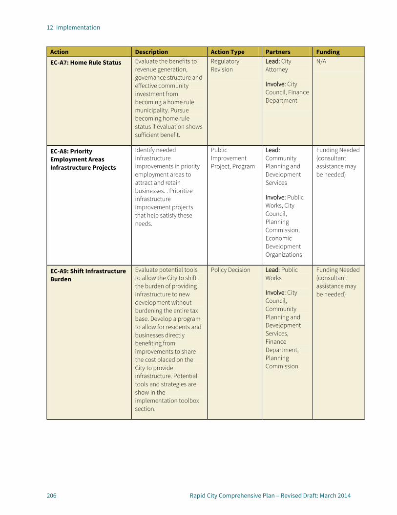
12. Implementation
206 Rapid City Comprehensive Plan – Revised Draft: March 2014
Action Description Action Type Partners Funding EC-A7: Home Rule Status Evaluate the benefits to
revenue generation, governance structure and effective community investment from becoming a home rule municipality. Pursue becoming home rule status if evaluation shows sufficient benefit.
Regulatory Revision
Lead: City Attorney
Involve: City Council, Finance Department
N/A
EC-A8: Priority Employment Areas Infrastructure Projects
Identify needed infrastructure improvements in priority employment areas to attract and retain businesses. . Prioritize infrastructure improvement projects that help satisfy these needs.
Public Improvement Project, Program
Lead: Community Planning and Development Services
Involve: Public Works, City Council, Planning Commission, Economic Development Organizations
Funding Needed (consultant assistance may be needed)
EC-A9: Shift Infrastructure Burden
Evaluate potential tools to allow the City to shift the burden of providing infrastructure to new development without burdening the entire tax base. Develop a program to allow for residents and businesses directly benefiting from improvements to share the cost placed on the City to provide infrastructure. Potential tools and strategies are show in the implementation toolbox section.
Policy Decision Lead: Public Works
Involve: City Council, Community Planning and Development Services, Finance Department, Planning Commission
Funding Needed (consultant assistance may be needed)
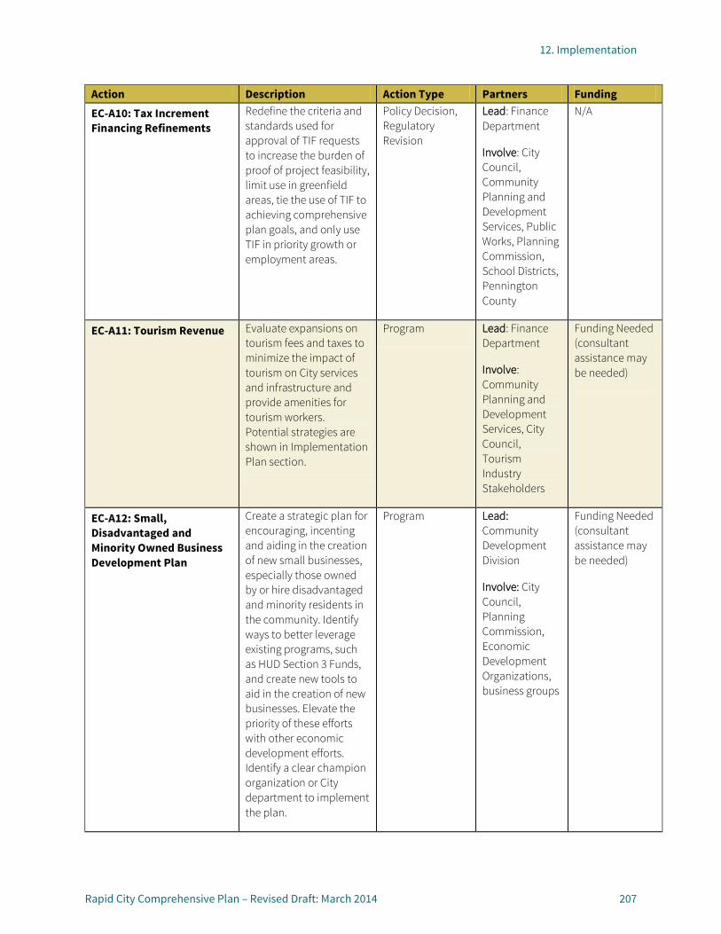
12. Implementation
Rapid City Comprehensive Plan – Revised Draft: March 2014 207
Action Description Action Type Partners Funding EC-A10: Tax Increment Financing Refinements
Redefine the criteria and standards used for approval of TIF requests to increase the burden of proof of project feasibility, limit use in greenfield areas, tie the use of TIF to achieving comprehensive plan goals, and only use TIF in priority growth or employment areas.
Policy Decision, Regulatory Revision
Lead: Finance Department
Involve: City Council, Community Planning and Development Services, Public Works, Planning Commission, School Districts, Pennington County
N/A
EC-A11: Tourism Revenue Evaluate expansions on tourism fees and taxes to minimize the impact of tourism on City services and infrastructure and provide amenities for tourism workers. Potential strategies are shown in Implementation Plan section.
Program Lead: Finance Department
Involve: Community Planning and Development Services, City Council, Tourism Industry Stakeholders
Funding Needed (consultant assistance may be needed)
EC-A12: Small, Disadvantaged and Minority Owned Business Development Plan
Create a strategic plan for encouraging, incenting and aiding in the creation of new small businesses, especially those owned by or hire disadvantaged and minority residents in the community. Identify ways to better leverage existing programs, such as HUD Section 3 Funds, and create new tools to aid in the creation of new businesses. Elevate the priority of these efforts with other economic development efforts. Identify a clear champion organization or City department to implement the plan.
Program Lead: Community Development Division
Involve: City Council, Planning Commission, Economic Development Organizations, business groups
Funding Needed (consultant assistance may be needed)

12. Implementation
208 Rapid City Comprehensive Plan – Revised Draft: March 2014
STRATEGIES TO PROVIDE OUTSTANDING RECREATIONAL AND CULTURAL OPPORTUNITIES
This Core Value provides ways to ensure that the community’s parks and recreation facilities continue to develop as a system of interconnected amenities. It also addresses the expansion of arts and cultural opportunities in the community. It emphasizes the enhancement of community and recreation facilities, including expanding the greenway system and providing trail connections. Finally, it addresses supporting and sustaining arts and cultural activities in the community. Strategies to provide outstanding recreational and cultural opportunities include:
Action Description Action Type Partners Funding IMMEDIATE ACTIONS
CONCURRENT AND ONGOING WITH THE ADOPTION OF THIS PLAN UPDATE
RC-A1: Institutionalize Parks and Recreation Map as a Tool for Internal Planning and Development Review
Institutionalize the Parks and Recreation map provided in this Plan as a tool to help evaluate parks and recreation needs for proposed Planned Development projects, as well as to identify opportunities to implement capital improvements or other projects that support multiple objectives. (e.g., stormwater improvements and trail connections)
Policy Decision Lead: Community Planning and Development Services
Involve: Public Works, Parks and Recreation, City Council, Planning Commission
N/A
RC-A2: Support for Local Arts and Cultural Initiatives
Support local arts and cultural organizations in their efforts to:
Identify dedicated funding sources to ensure ongoing support for existing facilities and programs; Provide ongoing support
for events that showcase the arts and cultural resources unique to the community and region; and Expand the role of arts and
culture in community activities and the built environment.
Policy Decision, Regulatory Revisions
Lead: City Council
Involve: Planning Commission, Community Planning and Development Services, Parks and Recreation, Arts and Cultural Organizations, tribal representatives, School District
N/A

12. Implementation
Rapid City Comprehensive Plan – Revised Draft: March 2014 209
Action Description Action Type Partners Funding NEAR-TERM ACTIONS
FOLLOWING PLAN ADOPTION, OVER THE NEXT 2 YEARS
RC-A3: Parkland Dedication
Consider requiring the dedication of land (or cash-in-lieu) for parks and open space purposes for larger developments. Clearly define size thresholds for specific projects, types of development to which dedication would apply, and variations in requirements by location as applicable (e.g., infill vs. greenfield).
Policy Decision, Regulatory
Lead: Community Planning and Development Services/Parks and Recreation
Involve: City Council, Planning Commission
N/A
LONGER-TERM ACTIONS 2 TO 5 YEARS, FOLLOWING PLAN ADOPTION
RC-A4: Parks and Recreation Plan Update
Update the 2007 Parks and Recreation Plan to establish an updated inventory of facilities (aligned with categories and targets established by this Plan), reflect the availability of new tools for acquisition and funding (as applicable), and identify updated 5-year priorities.
Policy Decision Lead: Community Planning and Development Services/Parks and Recreation
Involve: City Council, Planning Commission
Funding Needed (consultant assistance may be needed)
RC-A5: Cultural Tourism Plan
Work with local and regional partners to develop a long-range plan to promote cultural tourism in Rapid City.
Policy Decision Lead: Community Planning and Development Services
Involve: City Council, Planning Commission, Rapid City Arts Council, the Rapid City Convention and Visitors Bureau, the Rapid City Economic Development Partnership, the Rapid City Chamber of Commerce, tribal representatives, and other public and private entities.
Funding Needed (consultant assistance may be needed)
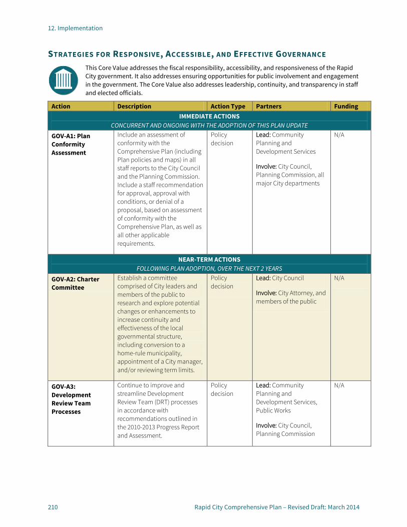
12. Implementation
210 Rapid City Comprehensive Plan – Revised Draft: March 2014
STRATEGIES FOR RESPONSIVE, ACCESSIBLE, AND EFFECTIVE GOVERNANCE This Core Value addresses the fiscal responsibility, accessibility, and responsiveness of the Rapid City government. It also addresses ensuring opportunities for public involvement and engagement in the government. The Core Value also addresses leadership, continuity, and transparency in staff and elected officials.
Action Description Action Type Partners Funding IMMEDIATE ACTIONS
CONCURRENT AND ONGOING WITH THE ADOPTION OF THIS PLAN UPDATE
GOV-A1: Plan Conformity Assessment
Include an assessment of conformity with the Comprehensive Plan (including Plan policies and maps) in all staff reports to the City Council and the Planning Commission. Include a staff recommendation for approval, approval with conditions, or denial of a proposal, based on assessment of conformity with the Comprehensive Plan, as well as all other applicable requirements.
Policy decision
Lead: Community Planning and Development Services
Involve: City Council, Planning Commission, all major City departments
N/A
NEAR-TERM ACTIONS FOLLOWING PLAN ADOPTION, OVER THE NEXT 2 YEARS
GOV-A2: Charter Committee
Establish a committee comprised of City leaders and members of the public to research and explore potential changes or enhancements to increase continuity and effectiveness of the local governmental structure, including conversion to a home-rule municipality, appointment of a City manager, and/or reviewing term limits.
Policy decision
Lead: City Council
Involve: City Attorney, and members of the public
N/A
GOV-A3: Development Review Team Processes
Continue to improve and streamline Development Review Team (DRT) processes in accordance with recommendations outlined in the 2010-2013 Progress Report and Assessment.
Policy decision
Lead: Community Planning and Development Services, Public Works
Involve: City Council, Planning Commission
N/A

12. Implementation
Rapid City Comprehensive Plan – Revised Draft: March 2014 211
Action Description Action Type Partners Funding GOV-A4: Leadership Training
Develop and facilitate a training course for incoming elected officials and appointed officials in order to enhance productivity and help alleviate the steep learning curve. The training course should clarify roles for boards, commissions, and committees, outline procedures and expectations, and provide an orientation to the Comprehensive Plan and Priority- Based Budgeting process.
Program Lead: Community Resources
Involve: City Council, Planning Commission, City Attorney, City Department Heads
N/A
GOV-A5: Plan Monitoring Report
Provide ongoing monitoring of the goals and implementation of the Comprehensive Plan. Produce, publish, and present an annual Plan monitoring report that summarizes completed action strategies, and updates key indicators, such as permit activity, population and job growth, and fiscal information.
Program Lead: Community Planning and Development Services
Involve: Department Heads, City Council, Planning Commission
N/A
GOV-A6: Sustainability Liaisons
Establish a network of City department liaisons to coordinate with the Sustainability Committee on an ongoing basis for inward and outward City sustainability issues.
Agency coordination
Lead: Mayor’s Office and Sustainability Committee
Involve: All major City departments
N/A
GOV-A7: Sustainability Education
Build and promote an education program about the benefits of sustainability and a clearinghouse of information about sustainable practices and programs. Pursue opportunities to organize and host a sustainability conference or educational sessions. Potential topics include gardening, composting, landscaping, and energy efficiency improvements.
Program Lead: Mayor’s Office and Sustainability Committee
Involve: City Council, Planning Commission, Community Planning and Development Services, Public Works
Funding Needed (new program)

12. Implementation
212 Rapid City Comprehensive Plan – Revised Draft: March 2014
Action Description Action Type Partners Funding LONGER-TERM ACTIONS
2 TO 5 YEARS, FOLLOWING PLAN ADOPTION
GOV-A8: Sustainability Coordinator
Consider establishing a Sustainability Coordinator position, with dedicated leadership, to monitor, support, and implement the City’s sustainability efforts programs
Program Lead: Mayor’s Office and Sustainability Committee
Involve: City Council, Planning Commission, Community Planning and Development Services, Public Works
Funding Needed (new program)
GOV-A9: Sustainable community Rating System
Consider adopting the STAR Community Rating System to measure progress in strengthening environmental, economic, and social systems. Utilizing such a program could lead to Rapid City becoming nationally recognized as a STAR city.
Program Lead: Mayor’s Office and Sustainability Committee
Involve: City Council, Planning Commission, Community Planning and Development Services, Public Works
Funding Needed (new program)

12. Implementation
Rapid City Comprehensive Plan – Revised Draft: March 2014 213
MONITORING & REPORTING Ongoing monitoring of the Comprehensive Plan will help measure progress and ensure that it remains a valid and useful tool to guide growth and decision-making. This section addresses monitoring and reporting at two levels: quarterly (to coincide with the Rapid City Progress Report issued through the Mayor’s Office) and annually (to inform the City’s budgeting process).
QUARTERLY PROGRESS REPORT The Rapid City Progress Report, issued quarterly through the Mayor’s Office, provides an update of projects in progress, long-term goals, and actions taken. Members of the public may subscribe to receive the Progress Report via email, a valuable service that keeps residents and the business community up-to-speed on City indicators and achievements.
In order to enhance alignment between the Progress Report and the Comprehensive Plan, it would be valuable to organize the Progress Report in a manner that mirrors the seven Core Values established in this Comprehensive Plan. Each of those sections would include notes about progress, achievements, actions taken and current efforts. Information about building permit trends and public works infrastructure spending should remain as an attachment to the Progress Report.
The Progress Report should be available on the City’s website, both under the Mayor’s Office
page, as well as on the Comprehensive Plan page.
ANNUAL REPORT Beyond the quarterly Progress Reports, an Annual Report would be a beneficial tool to monitor the Comprehensive Plan’s implementation and to track achievements. The Annual Report should include a summary of all of the actions from the Priority Action Plan that were completed during the year or are in progress. This exercise will also help inform future amendments and updates to the Plan.
Annual indicators, such as permit totals, infrastructure spending, and population and employment growth would also be beneficial to include in the Annual Report. Lastly, new trends, issues and opportunities facing the City should be identified in the Annual Report–especially those that may lead to changes or updates to the Comprehensive Plan. The Annual Report should be made available to all City departments and should be posted on the Comprehensive Plan page.
PLAN UPDATES & AMENDMENTS The life of the Comprehensive Plan is ongoing and does not stop when the Plan is adopted. Additions and subsequent planning studies may be necessary to address new opportunities and emerging issues. Moreover, revisions will be necessary to keep the Plan relevant and in-line with current conditions. This section outlines the timelines and procedures for Major Updates to the
Comprehensive Plan, as well as Minor Amendments.
MAJOR UPDATE For this Comprehensive Plan to effectively serve the community over time, the City must periodically review and amend it to reflect changes in the community. A comprehensive Major Update to the Plan completed will enable the City to check in with the community and to assess changes in economic conditions, development trends, and community values. The Major Update will also provide an opportunity to revisit and confirm or adjust the Core Values, goals, and policies, and to identify new implementation strategies to include in the Priority Action Plan.
The City can determine when to initiate a Major Update, but at a minimum, an update should occur at least every five to six years. A Major Update should include opportunities for involvement by the public, City staff, elected and appointed officials, and other affected interests. It should also include an updated or new Community Profile, an updated Priority Action Plan, and new or revised Core Values, goals, and policies.
MINOR UPDATES A separate process should be established for Minor Amendments to the Comprehensive Plan for targeted text or map adjustments that do not significantly affect other parts of the Plan. Routine Minor Amendments should be performed on a yearly basis (following the Annual Report) or periodically as-needed. Minor Amendments may include

12. Implementation
214 Rapid City Comprehensive Plan – Revised Draft: March 2014
changes to the Future Land Use Plan map, text corrections, or adjustments to one or more sections of the Comprehensive Plan as the result of adoption of newer plans or policies.
Minor Amendments may also be initiated by the public, as stand-alone text or map amendment requests, or concurrently in conjunction with a rezoning application. A Comprehensive Plan Minor Amendment application and schedule of submittal and hearing dates for publicly initiated Minor Amendments should be maintained and posted for public notification. When considering a Minor Amendment, the City and decision-makers should consider whether:
• The proposed amendment is consistent with the overall intent of the Comprehensive Plan;
• The proposed amendment is compatible with the surrounding area and/or the vision, goals, and policies of the Comprehensive Plan;
• Strict adherence to the Comprehensive Plan would result in a situation neither intended nor in keeping with other Core Values, goals, and policies of the Plan;
• The proposed amendment will not have a negative effect on the immediate areas or on transportation services and facilities;
• The proposed amendment will have minimal effect on service provision and/or is compatible with existing and planned service provision and future development of the area; and
• The proposed amendment will not cause detriment to the public health, safety, and general welfare of the people of the City.

12. Implementation
Rapid City Comprehensive Plan – Revised Draft: March 2014 215
IMPLEMENTATION TOOLBOX To help inform the planning process, Economic and Planning Systems prepared an interim memorandum that included an overview of how the City has used public financing tools, summarized tools used in surrounding western states, and identified a set of potential actions the City could take to expand its set of public finance tools and new approaches to infrastructure financing. Recommendations contained in this interim memorandum are summarized here as a reference for City staff, elected officials, and others.
This section identifies potential tools and approaches to implement some of the multi-faceted concepts and strategies identified in the Action Plan. This toolbox is intended to provide a summary of ideas as a starting point for discussions about implementation, and is not intended to limit other opportunities or ideas.
HOUSING TOOLS
Reinvestment Program
In order to bolster and increase property reinvestment, the following tools could be considered as part of a potential reinvestment program:
• Revolving loan fund for homebuyer assistance (expand beyond CDBG income limits and identify additional funding sources).
• “Soft” Second Mortgage program for homebuyers and existing homeowners to create funds for rehabilitation of
homes in targeted neighborhoods (expand beyond CDBG income limits and identify additional funding sources).
Homeowner Assistance. Possible homeowner assistance efforts could include:
• Waste and graffiti clean-up events;
• Paint-a-thons; • Weatherization workshops; and • Adopt-a-neighbor coordination.
Housing Diversification
Tools that could be considered in order to diversify the housing stock and expand housing options include the following:
Regulatory updates. Possible code updates to support housing diversity include: • Minimum density requirements
for large subdivisions to ensure a mixture of housing types.
• Rezone mobile home parks to residential zones and limiting rezoning and/or redevelopment to nonresidential uses.
Land Dedication/Land Banking. • Affordable or workforce
housing land dedication requirements for major subdivisions or projects using incentives or TIF.
• Establishment of a land bank program to identify and obtain key sites for housing diversification.
Tax Credits. Petition the South Dakota Housing Finance Authority to require a certain percentage of tax credits allocated for low income tax credit housing rental developments to be for mixed income projects that have a
mixture of market rate and affordable units, or require tax credit projects to have a mixture of affordable and market rate units for approval. Consider setting requirements by specific areas of the City.
TIF Expansion. Expansion and further clarification of the use of TIF for workforce and affordable housing.
Housing Pilot Projects. Housing diversity expansion pilot projects in which the City partners with private developer to identify a site and develop a housing project in a targeted area to address needs or serve as a catalyst for demand for similar housing in the area. Use public financing tools, such as TIF, to reduce cost to make projects feasible for developer or provide amenities above and beyond what is feasible or typically included in projects.
Affordable and Workforce Housing Options
To increase affordable and workforce housing options, see the Housing Diversification strategies, above, and also consider the following potential tools:
• Housing goals. Create long term target housing goals based on annual action plan goals.
• Inclusionary housing ordinance. An inclusionary housing ordinance would require a percent of housing in new developments of a certain size or certain area be sold or rented at defined affordable rates. When coupled with density bonuses (to offset the cost of below market housing) and a fee-in-lieu program,
12. Implementation
216 Rapid City Comprehensive Plan – Revised Draft: March 2014
inclusionary zoning is an effective tool for building and funding workforce housing.
• Real estate transfer tax/fee. Most often used in tourism driven communities where home prices are driven up by second home owners and overnight visitors. Revenue is used to build or purchase units to that are made permanently affordable.
• Tourism Fees. Expansion of tourism fees (i.e. lodging tax/fees, sales tax) to pay for housing to serve tourism workers.
• Developer Loan Fund. A fund to provide gap financing for affordable housing projects.
• Development Fee Waivers. The City will need the ability to waive development fees for affordable housing; however development fees in Rapid City are relatively low and may not have a significant impact.
• Tourism and Regional Commercial Linkage Fees. Regional retail and tourism development linkage fees are impact fees placed on commercial development that link the employees and wage levels generated by development to the housing needed to mitigate its impact. Other communities have used these programs in conjunction with a fee-in-lieu program as part of inclusionary housing ordinances to develop and fund additional workforce housing. Linkage fees are most often applied to retail, accommodations, and recreation/resort developments.
• Rental Rehabilitation. A rental rehabilitation program (low/no
interest loan program) to assist landlords in renovating and upgrading substandard rental housing.
• Purchase and Rehabilitate Aging Rental Properties. Identify opportunities to purchase and rehabilitate aging rental properties as new workforce housing. The Low Income Housing Tax Credit program can be used to help finance acquisition and rehabilitation projects.
• Accessory Dwelling Units. Allow for Accessory Dwelling Units (granny flats) specifically in areas with high demand from students or seasonal tourism workers. These units can provide an income source for home owners and contribute to the supply of rental housing. They also provide an opportunity for elderly residents to live close to family members and age in place.
• Renter Down Payment Programs. Renter down payment savings programs are sometimes used by developers and builders who are involved in both the rental and for-sale markets. These programs give renters the option to place a portion of their rent into a savings account towards a down payment for a home built by the same developer or builder. Encourage the development community to implement this type of program.
• Down payment assistance. Provides additional down payment funds, in form of a zero or low interest loan, for home buyers with annual incomes under specific amounts. Rapid City currently
provides this service using CDBG funds but with a limited pool of funds and under income restrictions that are too low to reach all in need.
PUBLIC IMPROVEMENT FINANCING IN RAPID CITY Rapid City funds infrastructure capital projects through a variety of fund sources, with funds provided mainly through property and sales tax revenues. Three main infrastructure related funds are provided using sales tax revenues, shown below:
• Vision Fund: this fund is geared toward economic development that provides funds based on a five year plan for infrastructure, economic development or civic center improvements.
• Capital Improvement Fund: this fund is the City’s main capital improvement program (CIP). The program is a five year plan that is somewhat fluid to allow for project timing to be revised based on pressing needs. CIP funds can be used on streets, parks, civic buildings, and IT needs.
• Utility Support Fund: this fund was created to support the City’s utility enterprise funds, such as water and sewer, by providing capital dollars for expansion of these services. The Utility Support Fund has been expanded to include streets. The City has five separate enterprise funds which include water, sewer, solid waste, the airport, and the Civic Center, which are funded through service fees primarily, with the exception of the Civic Center.

12. Implementation
Rapid City Comprehensive Plan – Revised Draft: March 2014 217
Revenue Generation
The largest revenue sources for the City are property tax and sales/use tax. Property tax rate for the City has been at or around $3 per $1,000 of assessed value for the past 10 years. The total amount of property tax revenue generated by the City is controlled by previous year’s revenue and changes in assessed valuation; therefore the rate can change from year to year. The annual incremental increase available to the City is restricted to the existing tax base plus new growth in property (i.e. new property through annexation, subdivision, changes in uses, etc.) plus either an increase of 3 percent of the base or an increase tied to the consumer price index (CPI). The City Council has elected not to take the allowed three percent/CPI increase in recent years.
The City sales tax rate is 2 percent for general retail purchases or 3 percent total (with an additional 1 percent) hotel rooms, prepared foods, and alcohol purchases. The sales tax rate for the City is controlled by the State and cannot be increased without new legislation. The ability of the City to raise more revenue is limited and therefore incentivizes the City to expand its tax base.
The revenues streams provided to the City to pay for capital improvements have not been sufficient enough to cover needed improvements. The decisions made on improvements are balanced between existing infrastructure and new infrastructure. The need to fund infrastructure to facilitate growth and the general lack of revenue for improvements to existing
infrastructure, has caused the City to have unfunded improvements.
New development on the edges of the City has been predominately dependent on infrastructure improvements made by the City or developers to facilitate this growth. Improvements needed to facilitate new development that are not paid for by the City, in turn need to be paid for by developers to allow for new growth. In order to encourage and facilitate development in certain areas, the City has used tax increment financing (TIF) as a tool to allow developers to pay for new infrastructure. TIF is one of the few public financing tools available to the City currently.
Recent Tax Increment Districts (TIDs)
The majority of the recent Tax Increment Districts (TIDs) approved have been to finance infrastructure improvements to allow for greenfield development, including improvements that are sub-regional and serve primarily new uses in that area. Developers most commonly request TIF districts to pay for public infrastructure to service their new developments. TIDs are setup to provide a revenue stream for the developer to pay for infrastructure improvements. When the City uses TIDS, it will not issue debt using TIF as repayment source for any project, unlike developers who use TIF funds to obtain loans to pay for infrastructure with the loan repaid by annual TIF funds.. For projects the City builds, the upfront funds come from other City revenue sources which are paid back through the proceeds from a TID. This practice greatly reduces risk of default on debt for
the City and places the risk onto the developer to generate enough incremental taxes to service debt.
TID Criteria
The criteria for establishing a TID in South Dakota are stipulated by State Statute. Generally provisions for the use of TIF are restricted to economic development or removing blight. However, these general purposes allow for broad interpretations and therefore most projects meet the state standards.
The City has a clear set of criteria for using TIF, which includes encouraging redevelopment, to stimulate economic development, to stimulate increased private investment in areas that would have otherwise remained undeveloped or under-developed, to stimulate the construction of affordable housing for low and moderate income residents, and to facilitate the reconstruction, maintenance and completion of the City’s existing infrastructure network to support the existing growth and guide the future growth. Applications for a TID require the applicant to meet provisions for project purposes, criteria for use, and eligible costs, much of which are based on the State statute allowing the use of TIF and City standards. The City has a TIF District Project Review Committee, which consists of members of the City Council, Planning Commission, Pennington County, the School District and economic development staff. This committee reviews projects and make recommendations to the Planning Commission and City Council. City Council has final approval of the districts.

12. Implementation
218 Rapid City Comprehensive Plan – Revised Draft: March 2014
Rapid City has created 73 Tax Increment Districts since 1983, with the most recent TID approved in May of 2012. Twelve of the TIDS were approved but never formally adopted and 24 of the districts are still active. TIDs have a maximum length of 20 years and most expire before 20 years. The City currently generates approximately $13.5 million in property tax annually, of which approximately 8 percent or $1.1 million is being used by TIDs.
Other Tools and Funding Mechanisms
Rapid City also uses and has tried to use a variety of other tools or mechanisms to fund new infrastructure. The City’s water and sewer enterprise funds charge connection fees to connect to city water and sewer, but these fees are relatively small and do not adequately address the cost associated with new connects. The City has allowed some developers to provide connections for a new development area and be repaid by subsequent developers in the area with their connections fees once they develop. This practice is generally not encouraged and creates complications for the City and developers. The City enacted a water impact fee in 2002, via a special election, which was repealed in 2003.
Advantages and Disadvantages of the Current Approach
The current approach to the use of TIF in Rapid City has both positives and negatives.
ADVANTAGES Some of the positives to the use of TIF are that it:
• Facilitates new development within the City;
• Generates increased tax revenue once the TID expires and increases the value of the City;
• Allows for investment in City with no increase in taxes; and
• Is one of limited set of tools available to the City.
DISADVANTAGES Some of the negatives to the current use of TIF in Rapid City are that:
• It places a disproportionate burden on all residents and business owners for improvements that often benefit only a narrow section of the community; and
• Widespread use of TIF in the City with approval based on a diluted interpretation of criteria.
Many cities in the country are unable to use existing city-wide revenue to pay for all new infrastructure and therefore have turned to other methods and tools. The City has a relatively limited number of financial tools available to pay for new infrastructure compared to other cities in the western US. This is largely due to State statutes.
The lack of revenue tools hampers the City’s ability to provide public facilities for new and existing residents and has led to the routine use of TIF. The use of TIF has become more politically sensitive in recent years, as well. The City needs to identify new approaches and methods for providing public infrastructure and amenities.
DEVELOPMENT INCENTIVE TOOLS To help inform the City in its expansion of its public financing toolbox, a set of potential actions the City could take to expand its set of public finance tools and new approaches to infrastructure financing are suggested below. Potential tools to finance public improvements and incentivize development include the following:
• Property Tax Abatement. The use of tax abatement is allowed in South Dakota. The barrier to use in Rapid City is the willingness of Pennington County to allow it. The use of the tool should be targeted to specific purposes and have clearly defined and stringent criteria for us. Potential uses include aiding in economic development, business recruitment and expansion efforts and to incentivize infill development, redevelopment, and development of workforce and affordable housing.
• Sales Tax Sharing. Explore the legality of using a sales tax sharing program. Typically used for attracting retailers or larger retail developments. Sales tax sharing programs are typically tied to the creation of

12. Implementation
Rapid City Comprehensive Plan – Revised Draft: March 2014 219
public infrastructure and are limited to a specified amount and/or time period. The amount of tax revenue shared is typically tied to net new tax generated.
• Public Improvement Fee. Additional sales fee on retail purchases, enforced through development covenants or lease agreements, used for public improvements. Legality in South Dakota needs to be explored. Needs to be initiated by business owners, property owner or developer. Potential tool to aid in activity center redevelopment.
• Small Business Loan Fund A revolving loan fund that provides zero or low interest loans to new or existing small businesses to fund the purchase of operating space, improvements to potential locations, equipment for operation, and others.
• Small Business Grant Program Provide one-time grants to small businesses to help fill any financing gaps for the creation of new business creation or expansion of existing business.
SHIFTING THE TAX BURDEN To help shift the tax burden to residents and businesses that directly benefit from new public infrastructure, the following approaches and tools could be considered:
• Improvement Districts. Improvement Districts charge an additional property tax to a specific geographic area to provide public improvements. The use of improvement
districts is most direct way to tie infrastructure costs with direct users. The most effective use of improvement districts is for projects that provide a specific improvement to an area and are limited in scope, cost and time frame. The use of improvement districts can replace the current use of TIF to build expansion of infrastructure improvements to serve new development on the City’s fringe. The City should identify the barriers to implementing improvement districts in South Dakota. Improvement districts are generally controlled by the local municipality.
• Special districts. Special districts are quasi-municipal corporations, which act like municipalities or utility enterprises, to provide specific services to areas in lieu of a city or county providing them. These types of entities are more popular in unincorporated areas where municipal services do not exist. This type of entity could potentially be a way to work around the state regulations regarding cities and counties in South Dakota. These districts charge fees and taxes that are directly related to the improvements and services they provide, and allow for a direct linkage between improvements/services and fee/tax charges for them, which is more politically palatable. There may be State regulations that prevent the use of these districts that may need to be overcome to implement.
• System Expansion Fees. A one-time development fee program should be considered
in order to fund capital improvements needed to serve new development. These one-time fees can be used to pay for regional improvements needed to serve new development that are not directly tied to a specific development site or subdivision. They can also be used to allow for the City to pay for oversizing of improvements implemented by the developer upfront and then collect the funds to repay the City as additional development occurs. Sewer system expansion was identified as the most expensive and biggest barrier to new development. A system expansion fee program could be created for specific improvements that serve multiple developments or for larger areas of the City that need trunk infrastructure improvements to serve new growth.
ENTERPRISE FUND RESTRUCTURING Potential tools to help revamp existing enterprise funds include the following:
• Increase connection fees to generate revenue to repay the cost of system expansions needed to serve new development to the City or developer.
• Developer Improvement Program that repays the developer who creates upfront infrastructure improvements with funds from subsequent developments. This can work similar or the same way a system expansion fee works.

12. Implementation
220 Rapid City Comprehensive Plan – Revised Draft: March 2014
TOURISM REVENUE To leverage tourism and create revenue for City services, the following tools could be considered:
• Expansion of tourism fees (i.e. lodging tax/fee, sales tax).
• Additional tourism generated revenue sources such as car rental tax/fee, service fee on entertainment services (i.e. tickets for performances, tickets for shuttles to attractions, attraction entrance fees).
OTHER POTENTIAL ECONOMIC DEVELOPMENT TOOLS To grow Rapid City as a regional hub for trade the City can consider apply for or creating certain designations, authorities or districts. Potential options include:
• Creation of a Foreign Trade Zone to allow local companies to avoid or defer duties paid on imported goods that are exported internationally or sold domestically. The zone could attract new businesses, lower costs for local business, and could lead to an international airport designation.
• Attracting a Customs and Border Protection officer to Rapid City to serve western South Dakota.
• Creation of Regional Rail Authority in Rapid City to leverage potential funding opportunities to enhance rail infrastructure.