composite freehold estates of the postmedieval … · composite freehold estates of the...
TRANSCRIPT

Proc. Hampshire Field Club Archaeol. Soc. 56, 2001, 229-245 (Hampshire Studies 2001)
COMPOSITE FREEHOLD ESTATES OF THE POSTMEDIEVAL PERIOD IN HAMPSHIRE
By STAN WAIGHT
ABSTRACT
The examination of a set qfearly-17th century maps among the archives of an Oxford college, followed by in-depth research of the corresponding endowments, has suggested that composite or widely-scattered freehold estates were quite common in Hampshire during the later middle ages, and that a substantial number of them had been created by engrossment. These suggestions have been confirmed by the extension of the research to other repositories.
While the poor survival rate of maps and series of old title deeds for lay estates impedes research into the subject, the inability qfpostmedieval religious corporations to alienate their lands is the key. Through the continuity of landholding by such perpetual corporations, later evidence can be read back into the more distant past, even into the 13th century, as this article demonstrates.
INTRODUCTION
The principal income of Corpus Christi College in Oxford, founded by Richard Fox, Bishop of Winchester, in 1517, was initially derived from a number of early-16th-century land endowments, mainly in Hampshire. This estate was held by freehold, and progressive research into individual, scattered holdings gradually disclosed that each had been created in the same way as the others.
The elements of leaseholds and, particularly, copyholds of the post-medieval period were also often scattered, but they were always appurtenant to a freehold that may not itself have been put together in the same way. The extended research mentioned in the Abstract was therefore concerned specifically with freehold estates, not copyhold or leasehold, and not with the estates
that individuals farmed, which could be an amalgam of all three. Note. Roman numerals in brackets, e.g. (XVII), refer to entries in the gazetteer.
THE INABILITY OF RELIGIOUS CORPORATIONS TO ALIENATE THEIR LANDS
It is well known that medieval religious corporations - whether cathedrals, monasteries or colleges - could not alienate their lands, which they held in mortmain as sacred trusts, and that their cartularies preserve evidence of estates much earlier than their date of compilation. These strict rules were relaxed after the Reformation, but operated in practice, except in exceptional circumstances, the principal predator being the crown. They were reinforced by measures particular to specific institutions. Thus, when Richard Fox founded his college, one of the Statutes he laid upon it was that none of his agrarian endowments should be alienated (Ward 1843, 46).
This overall ban, which lasted until the advent of the Ecclesiastical Commission in the second half of the 19th century, could only be revoked by act of parliament - for the colleges, the ultimate legislation was the Universities and College Estates Act of 1858 which gave them the power to sell, enfranchise and exchange their lands (Pub Gen Stat). Among other things, it meant that, in strictness, the religious corporations could not participate in non-parliamentary enclosure, a circumstance that could not have been envisaged when the ban was introduced: 'in strictness' because there was a known case of non-compliance, at Longstock, in the late 18th century (XVII).

230 HAMPSHIRE FIELD CLUB AND ARCHAEOLOGICAL SOCIETY
THE PRESERVATION OF ESTATE STRUCTURES
Since consolidation was a desired effect of enclosure, earlier estate structures were dismantled during the process, and evidence of their existence disappeared over time. Although cartography was well established by the time the main stream of parliamentary enclosure began, relatively few early estate maps exist; most of the estate maps in the Hampshire Record Office date from about 1765 onwards. Of those drawn before that time, only about 20 are preserved, and only 16 are fit for production; these are dealt with in more detail below. It is a reasonable presumption that many other estate maps once existed. A major reason for this scarcity may be that, of those that were drawn before the legally certain provisions of enclosure were applied, only a small number would continue to hold any real value afterwards. Enclosure maps only show the position when the process was complete, not before it began.
Enclosure by act of parliament was quite expensive, and many lay proprietors preferred formal or informal agreement. This created a problem for the religious corporations because the method did not override the ban on alienation in the way that parliamentary enclosure did. As a result, the corporations were unable to participate if the majority opted to proceed by it, and the early
-" structure of some of their estates was frozen. Cartographic evidence of scatter is therefore
only likely to be found where early maps have - survived, or where enclosure was delayed until
large-scale surveying had taken place. Apart from fresh estate maps commissioned by the landowners themselves, such an exercise did not occur until the 19th century, when the Tithe Commissioners began their work.
THE FOUNDATION ENDOWMENTS OF CORPUS CHRISTI COLLEGE, OXFORD
The endowments for Corpus Christi College were purchased in the early 16th century by its founder, Richard Fox, Bishop of Winchester. Fox was not only the son of a yeoman farmer, and therefore familiar with estate management, but
also had access to the best advice available by virtue of his office (Milne 1946, 3-4); it is improbable, therefore, that he would have bought land that was unsuitable for investment purposes in his time. Nevertheless, of the freehold estates he bought in Hampshire, more than half were scattered, and several others comprised closes that were loosely strung together.
Disputes over land were common, and Thomas Langdon was commissioned to produce surveys following a lawsuit over the College's land in Kent. These surveys were accompanied by a set of maps, those for Hampshire being drawn principally in 1615 and 1616 (LM II, 2, 5-25 & 28). They contain a wealth of finely-drawn detail, and their accuracy compares very well with those of the tithe commutation exercise and the 6" Ordnance Survey series drawn over 200 years later. Fields, both enclosed and open, are named, as are their occupiers and the occupiers of adjoining land; land use is indicated by a colour code and houses appear to be representative of their actual structure. The atlas in which the maps are bound provides an immediate indication of the degree of scatter in the College estates.
More importantly, for the key reason mentioned in the Abstract, the maps show the estates as they were when acquired around a century before. The precise extent of scatter in the early 16th century is therefore known, and there is evidence to suggest that much had remained unchanged since long before that (see next paragraph). A high proportion of the land was already fully enclosed, and a combination of the ban on alienation and Langdon's great accuracy enables ready identification on the later maps mentioned above.
In addition to the maps, each estate is represented in the archives by a section of the Twyne Transcripts. Copied from the originals in 1627 by scholars under the supervision of Bryan Twyne, the College's reader in Greek, these contain full transcripts of the title deeds conveyed to the College with its endowments. The original deeds included charters, indentures, quitclaims, copies of final concords and various other documents. Each transcript is headed by Twyne's own summary of the contents, and the date of the original document, either actual or attributed, is given prominence. The transcripts, sorted into chrono-

WAIGHT: COMPOSITE FREEHOLD ESTATES OF THE POSTMEDIEVAL PERIOD 2 3 1
Table 1 The tide deeds of Corpus Christi's Walters estate in Odiham (11 11,12)
Ev Tear Date Grantor Grantee
11 Couper, Robert le Lyngcwode,John
This entry was undated, but attributed to the reign of Henry III [1216 - 1272]
1 Copere, Robert le Lyngwode,John
2 Cach, John, son of Walter Lynwode, Geoffrey de
3 Cach, John, son of Walter Lyngwode, Geoffrey de
These three entries were undated, but attributed to the reign of Edward I [1272 - 1307]
Detaib
Grant. lk acre in Snateshangre.
Grant. lk acre in the field called Hordhulle.
Grant. 1 acre in Hordhulle. John also confirmed the 4 acres which Geoffrey had from Walter Cach.
Grant. 2 acres in Hordhulle.
5
6
7
8
9
10
Sturme, Henry, son of Geoffrey
Ralph of Odiham
Alice la Lass
Portir, Robert le
Plot, Robert
Ploth,John, son of Robert
Ralph of Odiham
Lyngwode, Geoffrey de
Lyngwode,John de
Lyngwode.John de
Lyngwode,John de
Lingewode,John de
Grant. A messuage in Odiham, a croft called Wodecroft, 4 acres in Snateshangre, 2 acres in le Hamme 8c 2 acres in la Byrifeld.
Grant. 8 acres 8c croft in Odiham.
Grant. *h acre in Buryfeld, in the furlong called la Cumbe.
Grant. 3 acres in Buryfeld.
Grant. 1 acre in Odiham.
Grant. A tenement & 1 acre in Odiham.
Ruffi, Robert, son of John William of Odiham & his wife Grant. 7 acres in Snateshanger &
Agnes Burifelds.
These seven entries were undated, but attributed to the reign of Edward II [1307-1327]
12 u/d Lingwode, Gilbert de, son of Wiggehale, William de, his son Grant. 7 acres in Snateshanger, 2 Adam
13 1338 14 Feb Pig, Lucia, widow ofjohn le Minne,John
Lyngwood, Peter de, his son 14 1339 31 Jan Lyngwoodjohn de
15 1345 16 Oct Lyngwodejohn de
16 u/d Boteler,John le
20 u/d Tailour, William le
Lyngwood, Peter de, his son
Hatch, Hugo atte, his wife Amicia 8c their son John
Holewell, Roger de
acres in Longefurlonge & 1 acre in Burifeld.
Quitclaim. 1 acre in Snateshangre.
Grant. The land he received from Robert Plot.
Grant. V2 acre in Burifeld, in the furlong called le Combe.
Grant. A piece of meadow in Combemed.
Grant. 3 acres in the furlong called Kingspound.
17 1351 8 Dec Agnes, daughter of William le John, son of Joan atte Mufie of Grant. A piece of ground with a Taylour of Berkelegh Fulltreschamele house built on it in the kings
highway.
21 u/d Absolum, Richard Hoke, Hugo de la
22 1368 30 Jul Houke, Hugo atte of Berkeley Fairescharnelejohn
Grant. A certain pasture in Wameburne.
Grant. The meadow which Hugo's father, Hugo, had acquired from Richard Absolum.

232 HAMPSHIRE FIELD CLUB AND ARCHAEOLOGICAL SOCIETY
Table 1 {cent) The title deeds of Corpus Christi's Walters estate in Odiham
Ev
18
19
23
24
28
29
30
31
32
Year Date Grantor
1380 9 Oct Warner, Adam
1382 15 Apr Wyfletjohn
Grantee Details
Walters, John, & his wife Joan Quitclaim. An annual rent of 2 shillings & 2 days harvest work.
Walters, John, 8c his wife Joan Quitclaim. An annual rent of 2 shillings 8c 2 days harvest work.
1382 30 Sep Hudde, John, 8c his wife Agnes Cramborne, Robert, chaplain Demise. All the lands that had been Peter de Meone's, Agnes' father.
27 This undated evidence is a summary of the deeds relating to lands of John Hudde & his wife Agnes. It includes details of Evs. 1-4 8c 6-13 above 8c two other acquisitions, 8c proves that the lands had once been the de Lyngewodes'. Peter de Meone 8c Peter de Lyngewode were possibly one 8c the same person.
26 1383 27Jun Hudde, John, of Winchester, 8c Walters, John, of Odiham, 8c his Grant. All the lands in Odiham wife Joan which descended to them after the
death of Peter Meene. his wife Agnes
1384 6 Mar Damveles.John Styward,John Grant. 2'/2 acres in Estonfeld in Pylesdell furlong. The transaction was confirmed in Ev. 25.
Walters, John, 8c his wife Joan Grant. 1 acre in la Suthfeld. 1384 26 May FischwereJohnofN. Warnborough
1385 10 May Cramborne, Robert 8c Portir, Hudde, John, 8c his wife Agnes Quitclaim. All rights in the lands that Roger
1388 31 Dec Stywardejohn
1389 Hatherinton, William
1391 6 Apr FychwereJohnleofN. Wamborough
33 1394 IMay Fultherschamellejohn
35 1394 6 Nov Philip of Odiham
The relevance of Ev. 36 is not known
37 1408 10 May Walters,John
40 1460 15 Aug Walter, John
had been Peter de Meone's.
Walters, John 8c his wife Joan Grant. 2 acres in Estnefeld in
Pylesdelle furlong.
Walters,John 8c his wife Joan Grant. 1 acre called la Merkakett.
Waltrys.John 8c his wife Joan Grant. lh acre.
Waltres,John 8c his wife Joan
WaltrySjJohn 8c his wife Joan
Walters, Thomas, his son
Grant. A meadow abutting Roughemore 8c a litde meadow in Combemede. Confirmed in Ev. 34.
Grant. A messuage 8c 12 acres which had been Walter Busch's.
Grant. All his goods, chattels, wine 8c corn in Odiham.
The trustees of Edward Cooke Grant. All his lands etc. in Odiham which descended to him on the death of his father Thomas.
Evs. 38 8c 41-2 are a bond and quitclaims relating to Ev. 40. Ev. 43 shows that the estate passed to trustees for Edward Coke 6 Oct 1465 Evs. 44-49 relate to the sale of the Walters estate by John Coke to the President of Corpus Christi College in Nov 1542, and Final Concords for the same in 1544. The final extent was shown as a messuage, 36 acres of land, '/2 acre of meadow, 4 acres of pasture, V2 acre of wood and 22d of rent.

WAIGHT: COMPOSITE FREEHOLD ESTATES OF THE POSTMEDIEVAL PERIOD 233
logical order and bound into volumes, provide histories of the properties up to and including the date of conveyance. These histories vary according to the number of original documents, many of which also survive, and some are comprehensive enough to confirm that there had been no further additions to an estate since the College's predecessors had created it many years before. Although hundreds of documents are represented in the seven volumes relating to the Hampshire estates, there are many gaps and they are clearly far from exhaustive of the total numbers that were originally drawn up (TT, Vols. 6-12).
Langdon and Twyne are a rare combination, possibly unique for Hampshire.
CORPUS CHRISTTS HAMPSHIRE ESTATES
The Hampshire estates of Corpus Christi College have all been researched in depth as individual, but largely unpublished, surveys (FLAG 1993; Waight 1994-2000). The examples most relevant to this study are those at Eling, Hursley, Kilmeston, Kingsclere, Braishfield in Michelmersh, Newtown, Odiham (three estates), Overton and Warnford
(vm, xi, xm, xrv-xv, xvm-xx, xxn & XXV). In each of these, the appropriate Langdon Map provides direct evidence of scattered elements. There were no Langdon Maps for Hurstbourne Tarrant or Longstock (XII & XVH), but scatter survived here to be identified in a later period. In addition to these sub-manorial estates, Corpus Christi's endowments included the manors of Mapledurwell and Marwell Woodlock.
The original manor of Mapledurwell had been much larger than that conveyed to Corpus Christi by William Frost in 1518, and included the modern parishes of Newnham and UpNately (VCH TV, 149). It appears to be a fairly extreme example of fragmentation, for it is known that three hides in Newnham were granted away by the lord in 1198. Other information about disposals is lacking, but Corpus Christi's manor was itself discrete, retaining outliers in Newnham and UpNately, including open-field strips. Its core was the complete and very compact parish of Mapledurwell, however, and Langdon's map of the manor and the associated court records show
that this core contained several freeholds in 1616, including John Canner's scattered holding of a messuage and 60 acres. The earliest surviving mention of Canner's freehold is in William Frost's rental of 1513. The tithe map and award show that it was still in existence in 1839 (Waight Jun 1998; HRO 21M65/F7/132/1-2).
The history of the widely-scattered, reputed manor of Marwell Woodlock was somewhat different. It was created by engrossment in the parishes of Owslebury, Twyford and Upham in die 13th and 14th centuries, largely by the nepotism of Bishop Henry Woodlock [1305-1316] towards his family, and had an extent of around 1000 acres. It was already fully enclosed when purchased for Corpus Christi in two parts in 1516 and 1520, and, although the demesne lands were in substantial blocks, the whole estate was dispersed over an area roughly 7km from east to west and 4.5km from north to south. The creation of this estate is the subject of a paper in an earlier volume of Hampshire Studies (Waight 1998; LM 21-23).
Engrossment is a factor common to many of the sub-manorial estates, and the Twyne Transcripts show that much of it had taken place during the 13th and 14th centuries. Walters in Odiham is a particular example. Here the evidences record that the major engrossers were clearly families of the yeoman class - the Lingwoods in the late 13th century, and the Walters from the late 14th to the late 15th centuries - but almost all of the individuals from whom the elements had been acquired were of much more humble status. With the exception of one grant of eight acres and a close and another of three acres, all the early charters were for an acre or less (Waight Sep 1994; Tab 1).
The amalgamation of composite estates, sometimes by purchase but often by intermarriage, was a further part of the engrossment process, and evidence of this is common where whole series of charters survive. That sizeable holdings could be built up in consequence is typified by the union of the Gorges and the Warburtons in Hurstbourne Tarrant, where their estate had grown to over 200 acres by 1517, but the same estate is also testimony to the fact that amalgamation and consolidation were not necessarily coincident (Waight Aug 1999; Fig. 1).
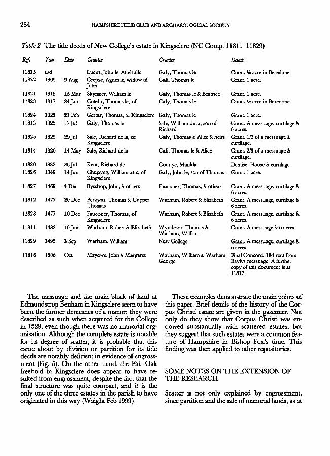
234 HAMPSHIRE FIELD CLUB AND ARCHAEOLOGICAL SOCIETY
Table 2
Ref.
11815
11822
11821
11823
11824
11813
11825
11814
11820
11826
11827
11812
11828
11811
11829
11816
The title deeds of New College's estate in Kingsclere (NC Comp. 11811-11829)
Year Date Grantor Grantee Details
u/d Luent, John le, Attehulle Galy, Thomas le
1309 9 Aug Crepse, Agnes le, widow of Gali, Thomas le John
1315 15 Mar Skynner, William le
1317 24 Jan Cotelir, Thomas le, of Kingsclere
1322 21 Feb Gertar, Thomas, of Kingsclere Galy, Thomas le
1325 17Jul Galy, Thomas le
1325 29 Jul Sale, Richard de la, of Kingsclere
1326 14 May Sale, Richard de la
1332 26 Jul Kent, Richard de
1349 14Jun Chupyng, William atte, of Kingsclere
1469 4 Dec Bysshop, John, 8c others
Grant. lh acre in Beredone
Grant. 1 acre.
Galy, Thomas le 8t Beatrice Grant. 1 acre.
Galy, Thomas le Grant. lh acre in Beredone.
Grant. 1 acre.
Sale, William de la, son of Grant. A messuage, curtilage k Richard 6 acres. Galy, Thomas & Alice 8c heirs Grant. 1/3 of a messuage 8c
curtilage.
Gali, Thomas le k Alice Grant. 2/3 of a messuage k curtilage.
Counye, Matilda Demise. House k curtilage.
Galy, John le, son of Thomas Grant. 1 acre.
Fauconer, Thomas, k others Grant. A messuage, curtilage k 6 acres.
1477 20 Dec Perkyns, Thomas k Cupper, Warham, Robert k Elizabeth Grant. A messuage, curtilage k Thomas 6 acres.
1477 10 Dec Fauconer, Thomas, of Warham, Robert k Elizabeth Grant. A messuage, curtilage k Kingsclere 6 acres.
1482 lOJun Warham, Robert k Elizabeth Wyndesor, Thomas k Grant. A messuage k 6 acres. Warham, William
1495 3 Sep Warham, William New College Grant. A messuage, curtilage k 6 acres.
1506 Oct Mayewe, John & Margaret Warham, William k Warham, Final Concord. 18d rent from George Baylys messuage. A further
copy of this document is at 11817.
The messuage and the main block of land at Edmundstrop Benham in Kingsclere seem to have been the former demesnes of a manor; they were described as such when acquired for the College in 1529, even though there was no manorial organisation. Although the complete estate is notable for its degree of scatter, it is probable that this came about by division or partition for its tide deeds are notably deficient in evidence of engrossment (Fig. 5). On the other hand, the Fair Oak freehold in Kingsclere does appear to have resulted from engrossment, despite the fact that the final structure was quite compact, and it is the only one of the three estates in the parish to have originated in this way (Waight Feb 1999).
These examples demonstrate the main points of this paper. Brief details of the history of the Corpus Christi estate are given in the gazetteer. Not only do they show that Corpus Christi was endowed substantially with scattered estates, but they suggest that such estates were a common feature of Hampshire in Bishop Fox's time. This finding was then applied to other repositories.
SOME NOTES ON THE EXTENSION OF THE RESEARCH
Scatter is not only explained by engrossment, since partition and the sale of manorial lands, as at

WAIGHT: COMPOSITE FREEHOLD ESTATES OF THE POSTMEDIEVAL PERIOD 235
Mapledurwell and Marwell Woodlock, were other factors. Nevertheless, it was a major reason, and many of Corpus Christi's properties were clearly the result of it. Any series of tide deeds similar to those in the Twyne Transcripts are therefore important pointers to other composite estates.
In the broadest of terms, a common feature in the enclosure process was that tide to one assemblage of land was surrendered in order to receive an equivalent but more compact estate that could then be enclosed and cultivated at the owner's will. It has already been noted that individual elements of scattered estates could lose their identity during the course of consolidation; at the same time, tide deeds to the surrendered land, like the earlier estate maps mentioned above, could become redundant and it would no longer be necessary to preserve them. Evidence of engrossment, and hence, possibly, scatter, is therefore most likely to survive in institutional archives where series of early charters have never been thrown away. Among others, the deeds of Winchester, Magdalen and New Colleges have all been formally calendared, and can be used in this way (Himsworth 1976 8c 1984; Macray u/d; NC Comp; and Tab 2).
The estates of the bishops of Winchester have not been researched for this paper. While there must have been many islands of free land within them, such as Corpus Christi's reputed manor of Marwell Woodlock, most were essentially manorial and unlikely to provide better evidence than any uncovered by other means; much work is being done on early land transactions in the county using such sources as the bishops' pipe rolls, but it is based upon customary tenancies (J. Hare and M. Page pers. comm.) and is not pertinent to this study. While the catalogues of ancient deeds held by the Public Record Office demonstrate how religious corporations often benefitted by donations of small pieces of land (Anc. Deeds, passim), this was incidental engrossment and is also inappropriate [the same catalogues appear to contain no clues to scatter in lay estates].
A combination of the formal enclosure agreements listed in Chapman and Seeliger (1997, App.) and the relative awards and maps of the
tithe commutation exercise is another practical source for research into composite estates.
THE EXTENDED RESEARCH
Among the Oxford colleges, Christ Church had no real interests in Hampshire (Mrs. J . Curthoys pers. comm.), and the calendars for Queen's show that its lands in the county were all manorial or formerly ecclesiastical (Denholm Young u/d, passim). Also at Oxford, the archives of New College and Magdalen College include evidences for scattered estates at Kingsclere, East Meon and Rotherwick, but no others of relevance. Many of Winchester College's extensive estates in Hampshire were also manorial, but Himsworth's catalogues of its muniments (1976 and 1984) provide pointers to others; there is clear evidence of engrossment at East Worldham, Ellisfield, Odiham and in the combined parishes of Priors Dean, Hawkley and Newton Valence (VII, IX, XXI & XXIII). A calendar of New College's Kingsclere deeds is given in Table 2 as a further example of engrossment leading to the creation of a scattered estate. The maps for East Meon and East Worldham at Figs 1-2 are typical illustrations of this kind of formation. No other college archive has been researched, and there may be others where additional evidence is to be found.
The unfortunate effects of non-participation in enclosure by agreement are particularly well illustrated in Magdalen College's estate in East Meon, where the Oxenboume tithing was enclosed in 1661. Corpus Christi was similarly affected when the Ibthrop tithing of Hurstbourne Tarrant was enclosed by agreement in 1706. These misfortunes appear to have had a salutary effect, for the ban was not permitted to interfere when Corpus Christi and Magdalen were both offered an agreement at Longstock over 80 years later [Figs 1 & 4 and Cbl8/6-7].
For lay estates, the Guide to Medieval Sources in Hampshire Record Office, which lists the more important accessions among which suitable early series of documents might be found, gives few clues to pertinent survivals (HCC 1998, passim). The charters in the great Jervoise collection and
236 HAMPSHIRE FIELD CLUB AND ARCHAEOLOGICAL SOCIETY
among the Kingsmill papers relate mainly to complete manors, although the latter does include a short series showing that John Amy alias John Mulward was engrossing closes in Newtown between 1414 and 1423; there can be little doubt that Mulward was the John Muleward mentioned in Corpus Christi's charters for the same parish at the same time (see the gazetteer XIX; HRO 44M69C; HRO 19M61, 372-381). The Calthorpe collection similarly contains evidence of engrossment by the Poughele family at Elvetham between 1297 and 1449 (HRO 26M62/T1), but in neither of these cases can the land be identified on any map.
Of the 16 pre-1765 maps mentioned above, seven are of substantial blocks of land and four show a number of loosely connected blocks. These two groups are inconclusive; the first may have been of estates that had already been consolidated, or perhaps the former demesnes of manorial estates, while the second was probably of partial consolidations. Five other maps, of estates in Binsted [1682 - I], Christchurch [1764 - II], Crawley [1733 - HI], Greatham [1764 - X] and St. Mary Bourne [1751 - XXV], reveal substantial scatter, however. The Greatham estate is illustrated at Fig. 3. In each case the composition was preserved because enclosure had not yet taken place in the parish (Chapman and Seeliger 1997, App.), but no early charters relating to them appear to have survived.
The tithe awards and maps for eight parishes listed by Chapman and Seeliger as enclosed after 1840 have been examined. Five were extended examinations of parishes already known to contain scattered estates (I, VI, IX-X & XXTV), and three more were selections at random (TV-V & XVI).
CONCLUSION
Many of Corpus Christi College's estates were widely scattered in composition, and much of the scatter was clearly the result of piecemeal engross
ment in the late medieval period. Amalgamation by purchase or intermarriage further resulted in estates that, although they remained scattered, were quite large for their time, often as much as 200 acres in extent. There was a sufficient proportion of this kind of estate in the College's freehold to suggest that it had not been alone in possessing this kind of property. Evidence of scatter and its connection with engrossment is deficient elsewhere, however, because earlier maps and tide deeds became redundant following the enclosure movement of the 18th and 19th centuries. Generally speaking, those in institutional repositories might be preserved, but those in lay hands were not.
The key to the survival of evidence of scatter is in the estates of religious corporations, who were unable to alienate land, and thus to participate in non-parliamentary enclosure. At the same time, the most convincing evidence of engrossment as a clue to the existence of scattered estates is to be found in the archives of the same corporations, where title deeds still survive centuries after the transactions took place.
In the Hampshire Record Office, a very few collections of family papers illustrate engrossment, but the survival of series of lay documents is otherwise sparse and there are comparatively few early maps representing scattered estates. Nevertheless, evidence of scatter is to be found in the tithe awards and maps of parishes that had not been fully enclosed by die 1840s - this line of enquiry is capable of considerable extension.
Taken together, the estates detailed in the gazetteer are sufficient to draw the conclusion that composite freeholds of small or modest size were quite commonplace in Hampshire in the late medieval period. For lay landowners, an early end to the problem might be possible through exchange, but their real opportunity to consolidate came when enclosure by act or agreement swept the county. For the religious corporations, however, only parliamentary enclosure would do, otherwise medieval ties that had disappeared elsewhere often endured until well into the 19th century, their scattered estates providing the core material for this paper.

WAIGHT: COMPOSITE FREEHOLD ESTATES OF THE POSTMEDIEVAL PERIOD 237
A GAZETTEER OF THE COMPOSITE ESTATES IN HAMPSHIRE THAT WERE RESEARCHED FOR THIS PAPER
It is stressed that this gazetteer contains detail only of the estates mentioned in the text; it is by no means exhaustive of all the scattered estates in Hampshire. The repository of the principal evidence for each estate is included in the heading, together with the accession numbers of the document or series of documents; for the sake of clarity, individual reference numbers have been omitted where they are part of the series, and surnames have been standardised.
I. Binsted - HRO (3M51/309/1). The map of West Court Farm was drawn in 1682. The core of the farm was the house with 12 adjoining closes, and five others loosely connected. In addition there was a block of four closes about l ^km to the south of the house, two separate closes about lkm to the east and at least eight strips in the open fields of Binsted. Part of the map is missing, but the key indicates another isolated close. There is no supporting charter evidence for this estate. Enclosed in 1849, this parish was one of those whose tithe map and award were examined (HRO 21M65/F7/20/1-2 - 1841); the open fields still existed and a number of other composite estates were recorded, including those of Daniel Inwood (156 acres), Ann Keep (85 acres) and The Hon. Henry Legge (about 1180 acres).
H. Christckurch - HRO (25M65/3/38). The map of Sir John Webb's 'compleat manor of Avon near Christchurch' was drawn in 1764, and shows the open-field layout in great detail. Within the manor, several freeholders, including Sir Richard Glyn, Richard Amy and 'Strong', held numerous and widely separated strips. There is no supporting charter evidence for this estate.
HI. Crawley - HRO (2M52/66). An enclosure map of Hunton in Crawley, drawn in 1733, shows that allotments were made to eight freeholders. Although two major landowners received substantial blocks, each of the other allotments comprised much smaller and widely dispersed elements. The clear indication here is that the pre-enclosure pattern was of even greater fragmentation. There is no supporting charter evidence for this estate.
IV. Crondall. Enclosed in 1847, this parish was
one of those whose tithe map and award were examined in the HRO (21M65/F7/57/1-2 - 1844); there was no evidence of extensive fragmentation.
V. Droxford. Enclosed in 1851, this parish was one of those whose tithe map and award were examined in the HRO (21M65/F7/63/1-2 - 1840); consolidation was well advanced, and the estates of Mary Aburrow (170 acres), Peter Barfoot (598 acres), J.G. Boucher (660 acres), James Colson (157 acres) and Richard Goodlad (256 acres), among others, comprised loosely connected blocks of land. The smaller estates included an 18 acre estate of New College that was fully consolidated.
VI. East Meon - Purchased for Magdalen College in 1479 (Macray, Hilhampton 1 - 41). Hilhampton, in the Oxenboume tithing of East Meon, is similar to Corpus Christi's estate in Hurstbourne Tarrant in that it is a striking example of fragmentation that remained in a college estate after a tithing had been enclosed by early local agreement. There are 41 charter evidences. The first significant transactions appear at around the end of the 13th century, when grants of land in East Meon were made to Nicholas of Oxenbourne by Richard Gultoppe and Nicholas of Langrish. By 1409, an estate dispersed in Oxenbourne, Ramsdean and Langrish [all tithings of the parish] had descended through linked families before being granted to John Tybenham of Liss, squire to bishop Beaufort of Winchester. The estate was further engrossed when the bishop himself granted Tybenham more land in the neighbourhood, both in closes and in the open fields; it then passed down through Tybenham's descendants until it was sold to bishop Waynflete for his college. In a fine of 1454, the extent given was considerable, namely, a messuage, 211 acres of land, 12 acres of meadow, 60 acres of pasture and 18 acres of wood in 'Estmeone', with commons of pasture for 12 oxen. There was no formal enclosure of open-field land in either Langrish or Ramsdean, and the ban on alienation precluded Hilhampton from being included in the agreement in Oxenbourne in 1661 (Seeliger and Chapman, 52). The tithe award lists closes totalling 383 acres

238 HAMPSHIRE FIELD CLUB AND
Fig. 1 Magdalen College's Hilhampton estate in East Meon. Note that Blagden Copse lay about 3km south of the farmstead.
under the name of the College's tenant and the map reveals that a widely dispersed farm still existed in 1853, when over a dozen single closes or irregular blocks of closes extended in a broken line for nearly 5km from north to south across the parish (see Fig. 1). Although it was not uncommon for a lessee to describe himself as the landowner, it appears that he had freehold land in addition to his leasehold from Magdalen. The tithe award and map (HRO 21M65/F7/66/1-2 - 1851) show that other estates in the parish had been largely consolidated.
VII. East Worldham - Purchased for Winchester College in 1484 (Himsworth, WCM 19757-19798). Although leased by the College under one indenture, its Old House Farm was itself an amalgamation of three estates. Among a total of 42 evidences, the earliest dated document is a freehold grant of 1255 comprising 17 acres in six different open fields or furlongs, some of which may have been isolated strips. Other documents refer to grants of one, two or three acres, including pieces already enclosed by hedge and ditch,
ARCHAEOLOGICAL SOCIETY
Fig. 2 Winchester College's Old House Farm estate in East Worldham.
and possible first time grants by the lord of the manor. The tide deeds show that the Frere family was actively engaged in engrossment from the late 13th through to the middle of the 15th century. There appears to have been no formal enclosure in the parish, and the tithe map shows that East Worldham still included a major proportion of open-field strips or old enclosures in strip-like form. The tithe award itself reveals the full extent of the fragmentation of the College's estate in 1842 (HRO 21M65/F7/73/1-2 - see Fig. 2); the Warden and Scholars, with their lessee William Christmas, are recorded as the owners of almost 290 acres in more than 30 pieces or blocks. It is clear that there had been some consolidation, but there is no indication as to when this may have taken place.
VOL Eling. There were three Corpus Christi College holdings in Eling, including Shelley Farm, which appears to have been the core element of an ancient manor, Shelveley, and was not fragmented. The other two appear to have been elements of another ancient and dismantled manor and were quite complex in their administration. The first, bought in 1517 and known as Baldoxfee or Baldetsfee, was possibly the lordship of the old manor of Rombridge, since its only value was in quit rents from freeholds in the Rombridge area; it had no land of its own. The second, a small scattered estate in and around Rombridge was purchased three years later, and appears already to have been occupied as a copyhold. The manorial court of the manor or reputed

WAIGHT: COMPOSITE FREEHOLD ESTATES OF THE POSTMEDffiVAL PERIOD 239
Fig. 3 Francis Beckford's estate at Greatham.
manor of Rombridge was then set up for the administration of the quit rents and the copyhold. The Langdon Map (LM II, 17) shows the Rombridge land to have been divided into seven blocks, two of which were about 3kms from the 'Scite of the Mannor'. There were also two 'doles' that had not been mapped.
DC. Ellisfield - Purchased for Winchester College in 1482 (Himsworth, WCM 8154-8179). There are only 26 evidences of tide for the College's lands in Ellisfield St. Martin, but they are sufficient to show an early pattern of engrossment. In charters attributed to the reign of Edward I, the newly-acquired freehold lands of John Reynold and his daughter Agnes were already 'lying dispersed' in the parish of Ellisfield, and the Langerude family were beginning to build up an estate there. The Langerudes continued to acquire land in the parish, including the Reynold holdings, into the early 15th century, and the estate ultimately exceeded 140 acres in extent; among their individual purchases were a curtilage, six crofts, a grove and a meadow, the enclosed lands of Roger le Somonour. Enclosure
did not take place in Ellisfield until 1848, and the tithe award and map of 1841 shows an estate comprising separate closes, blocks of closes and coppices (HRO 21M65/F7/78/1-2). The Smith family had been the tenants at least from 1728, and also had their own freehold land; the problems of fragmentation were therefore reduced by the intermixing of the two kinds of holding. The tithe award and map show that other estates in the parish were all in varying degrees of consolidation; apart from Winchester College's estate (147 acres) and John Smith's own freehold (253 acres), it included those of the Earl of Portsmouth (lord of the manor with 820 acres), Lord Bolton (510 acres), Lady Churchill (35 acres), Thomas Hampton (56 acres) and Hayes & White (42 acres).
X. Greatham - HRO (26M64/68). The map of Francis Beckford's estate was drawn in 1764; the estate was itself, according to the text, the engrossment of three smaller units. It contained a total of 176 acres, and the arrangement is illustrated at Fig. 3. Since the north eastern part of the map is missing, there may have been other closes. There is no supporting charter evidence for this estate, nor any general indication of fragmentation remaining in Greatham in 1848 according to its tithe award and map (HRO 21M65/F7/100/1-2).
XI. Hursley - The Pelican estate was in two parts when purchased for Corpus Christi College, in 1517 and 1527 fTT Vol. 8, Ch. 6). The Langdon Map (LM II, 16) shows 16 closes connected or loosely-connected along a 21/2km strip roughly north/south across the centre of Hursley. The Twyne Transcripts are discontinuous, and there is only a little evidence of engrossment.
XII. Hurstbourne Tarrant - Purchased for Corpus Christi College in 1517 (TT Vol. 9, Ch. 8, Fasc. 3). This purchase included scattered lands in neighbouring Upton. A long-running dispute existed among freeholders in Hurstboume Tarrant at the time that Thomas Langdon was making his maps in Hampshire (VCHIV, 320), and is possibly why he did not map the College lands there. However, a rental of cl540 shows mat the estates comprised parcels in the open fields of the Ibthrop tithing, numerous named closes and other 'severals' (CCC CI 4/1); 107 evidences among the Twyne Transcripts support this picture. Engrossment by the Gorges

240 HAMPSHIRE FIELD CLUB AND ARCHAEOLOGICAL SOCIETY
Fig. 4 The Corpus Christi College estates in Hurstbourne Tarrant.
family in the 14th century, followed by their close kin die Warburtons, included land 'in diverse closes' in addition to the dispersion of open-field strips that might be expected. By the mid-1400s, these families had given way to the Ankers, who continued to engross until the turn of the century. By 1517 their freehold had extended to two messuages, four tofts, 200 acres of land, 14 acres of meadow, 14 acres of pasture and seven acres of wood; the arable, meadow and pasture were all scattered, and it was this estate that was acquired for the College. The ban on alienation prevented Corpus Christi's involvement in the enclosure of Ibthrop in 1706, and the college is not mentioned in the agreement [a copy of the agreement in its archive was presumably preserved for reference purposes (CCC CI 6/5), but there is no accompanying map]. Accurate surveys taken in the 1820s show that the estate comprised 40 isolated closes or blocks of closes, suggesting that some consolidation had taken place under the Ankers or their predecessors (CCC Maps 118 8c 129 - see Fig. 4). In this estate, the problems of fragmentation were partially overcome in Corpus's early years by letting the land under several leases, and, at least from the early 19th century onwards, by the intermixing of its land with the tenants' own freeholds. This intermixing did bring its own problems of identification,
however, and there were extensive exchanges between landlord and tenant as late as 1891. Even so, a high degree of dispersion remained, and still existed when the land was bought out by the tenant in a final act of engrossment in 1921.
XIH. Kilmeston - Purchased for Corpus Christi College in 1517 (TT Vol. 9, Ch. 8, Fasc. 2). During the late 13th century at Kilmeston, where there are examples of first-time freehold grants by the lord of the manor of Kilmeston Plunkenet, small parcels of land passed through the hands of Hugo Brown of Kilmeston, William the Smith of Kilmeston and Peter of the Mill of Cheriton, among others. By 1313 two virgates of land and some named closes had been engrossed into the freehold of Richard, son of Peter of the Mill, and by 1349 the same estate was held by the atte Oke family. The atte Okes retained it for almost 200 years, and Langdon's two maps of Kilmeston in 1615 record that the freehold estate ultimately purchased for the College included all the named closes and over 50 strips widely dispersed within the open fields (CCC LMII, 9 8c 10). Enclosure at Kilmeston was by act of parliament, and the outcome for the College was ideal; in the allotment and exchange that followed the award of 1803 (HRO Q23/2/72), its estate was concentrated into a compact unit that comprised a nucleus of old enclosures with one large allotment abutting onto them. The farm that resulted from this very successful exercise was retained by the College until 1920, long after other dispersed estates had been sold piecemeal.
XTV. Kingsclere - Purchased for Corpus Christi College in 1529 (TT Vol. 12, Ch. 16, Fasc. 1-3). The title deeds for Edmundstrop Benham in Kingsclere are not comprehensive, but, since separate elements of it had earlier been held by Richard Merryvale and John Iremonger, the estate sold by yeoman William Wigmore in 1529 must have been engrossed. The main interest in this holding is that, in addition to the core of an ancient manor, it included 11 closes or small blocks of closes dispersed over an area 4km long and over 2 km wide. Furthermore, Corpus Christi's acquisition of about 100 acres of other freehold land at Fair Oak and Ashford Hill in the same parish at around this time, in two compact estates and a single, isolated close, was in itself a further example of engrossment.

WAIGHT: COMPOSITE FREEHOLD ESTATES OF THE POSTMEDIEVAL PERIOD 241
T 1 Aahfbrd Hill
Site of Via manor jk / ff \ . ^ of Edmundfltrop Jt^J \J/ ^~~-/
Appose*.**, • * • — . 0 1 2 /
Fig. 5 The Corpus Christi estates in Kingsclere. Note the 'College Piddle' of less than half an acre approximately 1km northwest of the village.
While the boundaries of the individual pieces are accurately portrayed in the insets of the Langdon Maps of 1606, it is not until they are identified in the 6" Ordnance Survey maps that the broad scatter of the three estates becomes apparent (CCC LM E, 2,5 & 6; OS 1st Series, 6", Sheets 3 & 9. - see Fig. 5). The enclosure award for the commons in Kingsclere was of late date - 1845 - and included specific provision for exchanges (HRO Q23/2/73). Nevertheless, ownership of the isolated Corpus Christi closes remained precisely as it had been before enclosure, the only advantage being that the College's allotments were attached to some of them. Edmundstrop Benham and Fair Oak were among the early, piecemeal, disposals by the College following the 1858 legislation. Ashford Hill, being compact and of moderate size, was retained until 1958.
XV. Kingsclere - Purchased for New College in 1495 (N/Nos.11811-11829). Of six small estates in Hampshire owned by New College, Oxford, only one, in Kingsclere, is relevant to this research; the others have too few old deeds to be significant, and no estate maps. Although it was no more than a messuage and six acres in extent, it was supported by 19 evidences showing that it had been built up from half- or one-acre strips by Thomas le Galy and his son John between 1309 and 1349. A complete calendar of the tide deeds for this estate are given at Table 2. There were still open fields in Kingsclere in 1841, when the tithe award and map record the extent of the Col
lege land merely as two-and-three quarter acres, comprising a vacant plot in Kingsclere's street and four dispersed strips in the fields. The award shows that the College estate was now in the occupation of John Curtis, and intermixed with his own considerable freeholding (HRO 21M65/F7/ 133/1-2). The reduction in the extent implies the loss of title to a number of strips over the centuries since acquisition.
XVI. Kingsworthy - Enclosed in 1845, this parish was one of those whose tithe map and award were examined in the HRO (21M65/F7/136/1-2 -1838). There was no valid evidence of fragmentation.
XVII. Longstock - Purchased for Corpus Christi College in 1520 (TT Vol. 11, Ch. 14). There was no Langdon map for the estate at Longstock, where loosely-connected closes of pasture were evi-dendy associated with about 30 open-field acres and where Magdalen College also held land. The Twyne Transcripts contain 47 evidences for this estate. Here the Lymsey family were actively engrossing in the short period from 1315 to 1325, and mere appears to have been little or no addition to the estate thereafter. It was acquired by Corpus Christi in 1520, after passing through die linked families of the Saunders, Pophams and Barantines. Enclosure in the parish was by an agreement of 1790/1, of which no detail survives, and correspondence shows that the president of Corpus Christi had some reservations about proceeding 'without the authority of an Act of Parliament to support us'. Nevertheless, he reasoned, '[If] the Society of Magdalen College throw no impediment in the way there may be perhaps no need of keeping back on these Scruples' (CCC Cb 18/6-7), and a satisfactory setdement was achieved.
XVIII. Michehnersh - Purchased for Corpus Christi College in 1518 (TT Vol. 8, Ch. 7, Fasc. 2). The Kitegate estate at Braishfield in Michelmersh was already fully enclosed when purchased in two parts in 1518 and 1522, and Langdon shows a number of loosely-connected closes strung out across the parish (CCC LM II, 19). Unusually, there were only two early charters, and these give no clue as to the pattern of engrossment. In this case, however, two small closes of meadow at some distance from the farmhouse demonstrate one of the dangers of

242 HAMPSHIRE FIELD CLUB AND ARCHAEOLOGICAL SOCIETY
fragmentation. Lying in a detached portion of Michelmersh, they were sub-let by the tenants over many decades, and their true ownership was ultimately compromised. Although one was recovered during the tithe commutation exercise (CCC LB 36/437), the other was lost forever.
XIX. Newtown - Purchased for Corpus Christi College in 1511 and 1516 ( I T Vol. 7, Chs. 4 and 5). Newtown was one of the newly-created towns of the 13th century where small plots were allocated to the burgages (Beresford, 1959), and Corpus Christi's lands there were already totally enclosed when bought by the Founder. The Twyne Transcripts for the estate comprise 106 documents. Since two different vendors were in-volvedjohn Gubbard alias Cuthbert in 1511, and Richard Sweet in 1516, the College was effectively continuing the process of engrossment. Among Gubbard's acquisitions had been individual closes called Stoutts, Southchurchcroft and Charnelles Mead, whose earlier freeholders had included John Chassynke, William Hall and Richard Smith. Another close, Pericroft, had been held by John Taylor, John Clemens, Richard at the Bridge and John Muleward between 1382 and 1430, before being bought by Richard Sweet. Similarly, the freehold site of the Swan Inn had passed through the hands of John Harding and William Bennett, before being purchased by John Sweet in 1482. These elements, and some others for which charter evidence is uncertain, are to be identified in the Langdon Map of 1606, and in the Ordnance Survey series already mentioned (LMII, 5; OS Sheet 3). They remained dispersed throughout the College's landlordship, being sold between 1874 and 1878.
XX. Odiham - Purchased for Corpus Christi College in 1512 and 1542 (TT Vol. 11, Ch. 12, & Vol. 10, Ch. 11). Evidences relating to Walters and Wassells in Odiham total 99 documents, the earliest of which is attributed to the reign of Henry m [1216 - 1272]. Walters comprised a house and a shamhouse [butcher's shop] in the market place of Odiham, a two-acre croft, a small copse, half an acre of meadow and 30 separate acres of arable lying in the common fields. A full calendar of the tide deeds of this estate is given at Table 1. Wassells, which was associated with two other holdings in the area, finally comprised 35
acres of enclosed land, a small copse and four acres in the common fields. The engrossers were the Warcetdes, although the aggregated property passed through other hands before acquisition for Corpus Christi. Here the early charters mention rather more small parcels of open-field land than were contained in the final estate, suggesting that piecemeal enclosure was already taking place; one late 13th-century document includes a reference to a quickset hedge. Once again, many different grantors of small parcels are recorded, and there is also evidence of consolidation by exchange. Odiham was covered by two Langdon Maps of 1616, both of which illustrate the wide dispersion of closes and strips (LM II, 14-15). The enclosure award was made in 1789 (HRO Q23/2/103), when the College received separate, but compact, allotments in place of its old open-field land. There was no house in Wassells, and the land was an early disposal, being sold in 1874 (LB 40, 5); the Walters estate, now much more convenient, was retained for somewhat longer, and was sold in 1891 (LB 41,171).
XXI. Odiham - Purchased for Winchester College in 1624 (WCM 19248-19381). Winchester College's estate at North Warnborough in Odiham was based upon a tenement in the main street. The tide documents are numerous - well over 100 evidences spanning the period from the late 13th century until acquisition for the College in 1624. The principal engrossers were the Searle family, who were actively acquiring land for over 200 years, and the transactions were frequendy for parcels of open-field land as small as half an acre. The royal manor of Odiham would have required many specialists, and the vendors included such artisans as Ralph the Baker, John son of Thomas the Turner, Philip the Tanner and Gilbert the Tiler. Although there was no map, there was an enclosure award in 1791 (HRO Q23/ 2/103), and some consolidation may have taken place before the tithe commutation exercise in 1843; whether or not the College was involved, the tithe map shows that a considerable degree of fragmentation remained (HRO 21M65/F7/177/ 1-2). Three pieces of meadow were at some distance from the farmhouse, one of them almost 4km away, while the major part of the arable was separated from it by about V2km. There are signif-

WAIGHT: COMPOSITE FREEHOLD ESTATES OF THE POSTMEDIEVAL PERIOD 243
icant similarities between Winchester College's estate in Odiham and that of Corpus Christi in the same parish.
XXII. Overton - Corpus Christi College's freehold in Overton and the adjoining manors of Polhampton and Quidhampton was very complex; it was the subject of five purchases between 1510 and 1527, and was evidenced by over 240 documents (TT Vol. 6, Ch. 1; Vol. 7, Chs. 2 & 3). During the period of the College's landlordship, it was divided and subdivided into some 24 leaseholds. The Langdon Maps (LMII, 25 & 28) show that the major leasehold was made up of a number of important buildings together with numerous strips in the open fields, while the minor ones comprised burgages with one or more pieces of enclosed or unenclosed land. The College's 300 or so acres of open-field land ultimately reverted to the lord of the manor, the major landowner in Overton, when two other Langdon Maps accompanied the sale (LM II, 26 k 27). By 1840, the indentures for the major lease were referring to 'the ancient maps', implying that they still provided the only true definition of the College lands.
XXIII. Priors Dean, Hawkley and Newton Valence -Purchased for Winchester College in 1470 (Himsworth, WCM 11666-11694 & 11507-11556). The estates that lay dispersed among these parishes, about 27km to the east of Winchester, were ultimately leased as Goleigh Farm and Hawkley Farm. In Priors Dean, five small estates were covered by 29 evidences dated between 1368 and 1471, while the Hawkley and Newton Valence lands were together covered by 50 evidences ranging from the early 13th century to 1471. In each case, the charters show the gradual engrossment of land by individual families, including the de Bradshotts, the Balons of Hawkley and the Gollyes of Priors Dean. Some of the land was in open-field acres and half-acres, but a great deal was already enclosed; French's lands in Priors Dean included 48 small crofts containing '16 acres and 4 acres of land'. Winchester College formed the last link in a chain of engrossment by combining the five Priors Dean estates into a single freehold. Priors Dean was enclosed by an act of 1808 but no award or map survives, enclosure at Hawkley had taken place informally before the
tithe award was made and in the Newton Valence tithe award the land occupied by the College's tenant could not be distinguished from land that he occupied by freehold or other leasehold. The charters proved engrossment beyond doubt, and carried implications of extensive fragmentation, but there was no cartographical evidence to support it; the relative tithe award and map show that consolidation was complete by the 1840s (HRO 21M65/F7/192/1-2; 111/1-2).
XXTV. Rotherwkk - Purchased for Magdalen College in 1481 (Macray, Cowfold 1 - 35). The 35 deeds for Magdalen's 192-acre Cowfold estate in Rotherwick do not commence until 1402, and there is little direct evidence of early engrossment. A quitclaim of 1468 suggests a high degree of fragmentation, however:
A messuage, a dovecote, 100 acres of land, and 50 acres of pasture called Cowfold 'enclosed with hedges and ditches', 6 acres of meadow, and a croft and a garden containing 3 acres formerly Wheler's,
A messuage and 6 crofts containing 12 acres formerly Stonyer's,
A messuage and 11 crofts containing 40 acres, A messuage and garden called Pypers, A messuage and 2 crofts containing 6 acres for
merly Thomas Harmwode's, A croft containing 5 acres and a garden for
merly Thomas Harmwode's, and one toft, 9 acres of land and 2 acres of moor formerly occupied by Richard Crody.
There were also several quit rents associated with the holding. It is clear from this document that Cowfold already included a large number of small, dispersed parcels of enclosed land before it passed to the College in 1481, but the award and map show that it had been fully consolidated when the tithe commutation exercise took place in 1841 (HRO 21M65/F7/199/1-2). Seeliger and Chapman record neither formal nor informal enclosure for Rotherwick, and the date of consolidation is not known. The tithe award and map disclose no evidence of fragmentation elsewhere in the parish.
XXV. St. Mary Bourne - HRO (46M84). The core of the 244-acre Wadwick's estate extended about 2.5km from north to south, and was itself very irregular. The map was drawn in 1751, and

244 HAMPSHIRE FIELD CLUB AND ARCHAEOLOGICAL SOCIETY
shows that there were two other closes 'at some distance to the south east'; more significantly, the key also refers to 28 acres in one- or two-acre open-field strips that were not mapped. There is no supporting charter evidence for this estate. XXVI. Warnford- In addition to the very compact Bere Farm, Corpus Christi College, held two small tenements and 20 dispersed acres in closes and strips in Warnford. They appear on a Langdon Map (LM II, 8). and the major close is identifiable in a map in the later Ordnance Survey series. It is not known how they came into the College's possession, or why the College's tenants
Abbreviations
Anc. Deeds, The Catalogues of Ancient Deeds. CCC, Corpus Christi College, Oxford. NC Comp., The database of New College's title deeds,
held on computer at the College. FLAG, The Fareham Landscape and Archaeology Group. HCC, Hampshire County Council. HRO, Hampshire Record Office. LB, Lease Books. LM, Langdon Maps of Corpus Christi College estates. MC, Magdalen College, Oxford. OS, Ordnance Survey 1st Edition 6" maps of Hamp
shire. Pub Gen Stat, Public General Statutes. TT, Twyne Transcripts at Corpus Christi College. VCH, Victoria County Histories WCM, Winchester College Muniments.
Unpublished manuscripts
Corpus Christi College, Oxford Cb 18/6-7 Bundles of correspondence concerning en
closure at Longstock, 1789/90. CI 4/1 A rental of ground in Hurstbourne Tarrant be
longing to Corpus Christi College, Oxford, cl540.
CI 6/5 A copy of the enclosure agreement for Ibthrop in Hurstbourne Tarrant, 1706.
T T Twync Transcripts: Vol. 6, Ch. 1; Vol. 7, Chs. 2 & 3 Overton, Polhampton and Quidhampton. Vol. 7. Chs. 4 & 5 Newtown. Vol. 8, Ch. 6 Hursley. Vol. 8, Ch. 7, Fasc. 2 Braishfield in
should have held by copyhold in the court of Marwell Woodlock.
ACKNOWLEDGMENTS
I am grateful to the archivists in the Oxford colleges for their guidance around the material there, especially to Christine Butler for her patience over several years at Corpus Christi. Also to the staff at the Hampshire Record Office for their cheerful production of so many documents, and particularly to Suzanne Foster for her assistance with the Winchester College records. And finally to Edward Roberts, who has always been prepared to offer help and encouragement.
Michelmersh. Vol. 9, Ch. 8, Fasc 2 Kilmeston. Vol. 9, Ch. 8, Fasc 3 Hurstbourne Tarrant. Vol. 10, Ch. 11 Wassells in Odiham. Vol. 11, Ch. 12 Walters in Odiham. Vol. 11, Ch. 14 Longstock. Vol. 12, Ch. 16 Edmundstrop Benham in Kingsclere.
Hampshire Record Office 19M61 The Kingsmill collection of charters and other
papers. 26M62/T1 The Calthorpe collection of charters; those
relevant to the Poughele family are numbered 14, 21, 24, 54, 56, 65-6 and 67.
44M69C Thejervoise of Herriard collection of charters and other papers.
Q23/ Enclosure Awards 2/72 1803 Kilmeston. 2/73 1845 Kingsclere. 2/103 1789 Odiham.
Mew College, Oxford NC Comp. 11811-11829, Evidences for New College's
freehold in Kingsclere.
Magdalen College, Oxford Macray, W.D. Undated typescript calendars of
Magdalen College's medieval deeds.
Unpublished Maps
Corpus Christi College, Oxford LMII Langdon Maps:
2 1606 Fair Oak in Kingsclere.
REFERENCES

WAIGHT: COMPOSITE FREEHOLD ESTATES OF THE POSTMEDIEVAL PERIOD 245
5 1606 Newtown and Ashford Hill in Kingsclere. 6 1606 Edmundstrop Benham in Kingsclere. 8 1615 Warnford. 14-15 1616 Odiham. 16 1615 Hursley. 17 1615 Rombridge in Eling. 19 1615 Braishfield in Michelmersh. 21-23 1615 the manor of Marwell Woodlock. 25 & 28 1615 Overton, Polhampton and Quidhampton.
Maps 118 and 129 1825 Ibthorpe and Upton in Hurst-bourne Tarrant.
Hampshire Record Office 2M52/66 1733 An enclosure map of Hunton in Craw
ley. 21M65/F7/ Tithe Apportionment Awards and Maps:
20/1-2 1841 and 1840 Binsted. 57/1-2 1844 Crondall. 63/1-2 1840 Droxford. 66/1-2 u/d and 1853 East Meon. 73/1-2 1842 and u/d East Worldham. 78/1-2 1842 and 1841 Ellisfield. 100/1-2 1848 Greatham. 111/1-2 1851 and 1846 Hawkley. 126/1-2 1842 and 1838 Hurstboume Tarrant. 132/1-2 1839 Mapledurwell. 133/1-2 1843 and u/d Kingsclere. 136/1-2 1838 Kingsworthy. 177/1-2 1843 and u/d Odiham. 192/1-2 1842 and 1840 the united parishes of Colemore and Priors Dean. 199/1-2 1844 and 1841 Rotherwick.
25M65/3/38 1764 The map of Sir John Webb's 'comp-leat manor of Avon near Christchurch'.
26M64/68 1764 The map of Francis Beckford's estate in Greatham.
3M51/309/1 1682 A map of West Court Farm in Binsted.
46M84 1751 A map of Wadwick's estate in St. Mary Bourne.
Printed Primary Sources
"The Catalogues of Ancient Deeds, 6 vols. HMSO London, 1890-1916 .
Public General Statutes, 21° & 22° Vict, C. 44, 1858. An Act to give to the Universities of Oxford etc. ... Power to sell, enfranchise and exclumge Lcuuh etc. ...
Ward, G R M 1843 The Statutes of Bishop Fox for Corpus Christi College, London.
Secondary Sources
Beresford, M 1959 The Six New Towns of the Bishops of Winchester, 1200 - 55 Medieval Arcliaeol 3187-215.
Chapman, J, & Seeliger, S 1997 Formal and Informal Enclosure in Hampshire 1700-1900 Hampshire Papers, 12,1997.
Denholm Young, N Undated photocopies of Calendars of the Hampshire Estate of Queen's College, Oxford, I - IV, National Register of Archives.
Hampshire County Council 1998 Guide to Medieval Sources in Hampshire Record Office.
Himsworth, S 1976 and 1984 Winchester Collegs Muniments, 3 vols, Chichester.
Milne, J G 1946 The Early History of Corpus Christi College, Oxford, Oxford.
Waight, S W J 1998 Marwell Woodlock: The Creation of the Manor and its Descent, c. 1300-1920 Proc Hampshire Fid Club Archaeol Soc 53 201-17.
Unpublished Secondary Sources
Fareham Landscape and Archaeology Group 1993 An unpublished survey of the Corpus Christi estate in Kilmeston.
Waight, S WJ 1994-2000 Unpublished surveys of Corpus Christi College's estates in Braishfield (Feb 2000), Eling (Jan 2000), Hursley (fun 1994). Hurstboume Tarrant (Aug 1999), Kilmeston (Aug 1993), Kingsclere (Feb 1999), Longstock (Feb 2000), Mapledurwell Jun 1998), Newtown (Mar 1995), Odiham (Sep 1994), Overton (May 1996) and Warnford (Dec 1993).
Author. Stan Waight, 19 Coopers Close, West End, Southampton, SO!8 3DE
© Hampshire Field Club and Archaeological Society