combining two approaches of integrated scenario...
TRANSCRIPT

1 Scenarios to combat desertificationOver the past decades the causes and consequences of land degradation and desertifi-cation in the Mediterranean region have been identified, monitored, and modelled in alarge number of different studies (see eg Brandt and Thornes, 1997; Geeson et al, 2002;and Van der Leeuw, 2000, for an overview of recent efforts). In recent years theemphasis has shifted from analysing direct and proximate causes and consequencesof land degradation to adaptive management approaches. This calls for a much moreactive role of decision makers and other (local) stakeholders during all phases of theprocess, also because it is increasingly realised that desertification can be reversed onlythrough profound changes in local and (inter)national behaviour. Awareness raising,education, and training are important additional goals of the involvement of stake-holders. Such a participatory approach creates a sweep of new challenges and a needfor development of new methods and the novel application of existing ones.
1.1 Definition, concepts, and key scenario development methodsIn the context of this paper we will discuss the potential of scenarios as a tool forcombating desertification. A scenario is defined as a storyöthat can be told in bothwords and numbersöoffering an internally consistent and plausible explanation ofhow events unfold over time (Gallop|n et al, 1997; Raskin et al, 2002). Scenariosare about envisioning future pathways and accounting for critical uncertainties. Theprocess of building scenarios is about asking questions, as well as providing answersand guidance for action, and as such is a promising tool to combat desertification.The intention of scenario development is to consider a variety of possible futuresthat include important uncertainties, rather than to focus on the accurate prediction
Combining two approaches of integrated scenario developmentto combat desertification in the Guadalent|n watershed, Spain
Kasper KokDepartment of Environmental Sciences, Wageningen University, Wageningen, The Netherlands;e-mail: [email protected]
Hedwig van DeldenResearch Institute for Knowledge Systems (RIKS), Maastricht, The Netherlands;e-mail: [email protected] 1 September 2005; in revised form 21 August 2007; published online 6 October 2008
Environment and Planning B: Planning and Design 2009, volume 36, pages 49 ^ 66
Abstract. Desertification in Spain is a largely society-driven process, which can be managed effectivelyonly through an understanding of environmental, sociocultural, and economic driving forces. Thiscalls for a more active role of decision makers and other stakeholders. We present two promisingapproachesöparticipatory stakeholder workshops and a spatial policy support system (PoSS)ötodevelop future scenarios of land-use change for a watershed in Spain. We furthermore discuss theefforts involved and the added values of combining both methods. Based on two local workshops,three scenarios were constructed, which were subsequently formalised, parameterised, and quantified.We conclude that there are large advantages of linking narrative storylines and a spatial PoSS.Storylines ensure an active participation of a large range of stakeholders, additionally offering thepossibility to develop highly integrated scenarios. The PoSS provides a spatially detailed and quanti-tative output, that can also be used to check the internal consistency of the qualitative scenarios.Linking stories and models can thus open the way for more successful management strategies tocombat land degradation.
doi:10.1068/b32137

of a single possible future (Peterson et al, 2003). Kahn (Kahn and Weiner, 1967) andothers were pioneers in developing scenarios for strategic planning applications.Scenarios were refined at Royal Dutch/Shell by Wack in the 1970s and 1980s, and Shellbecame a leader in the scenario approach to business planning (Wack, 1985). Todayscenario development is used in a variety of different contexts ranging from politicaldecision making, to business planning (Schwartz, 1996; Wack, 1985), to local commu-nity management (Peterson et al, 2003; Wollenberg et al, 2000) and understandingglobal-scale environmental patterns and processes (Gallop|n et al, 1997). This varietyof applications has spawned a broad variety of methods that have been employed.In the context of land use, spatial models have traditionally been used frequently.Increasingly, decision makers and other stakeholders are being involved in the pro-cess in different ways (see Van Asselt and Rijkens-Klomp, 2002). The combination ofquantitative models and more qualitative participatory methods to develop scenariosis currently being advocated as a promising way forward (Alcamo, 2001; Kok et al,2007).
Therefore, the focus in this paper is on two distinct scenario development methods:the development and use of decision, planning, or policy support systems (here abbre-viated as DSS) and the organisation of stakeholder scenario workshops; thus we includea qualitative and a quantitative method.
1.2 Decision, planning, and policy support systemsIn the broadest sense, land-use-related DSSs are usually developed to communicate theresults of land use and land degradation to politicians and decision makers as well asmembers of the public at large, to visualise the consequences of implementing differentpolicies, and to aid complex decision making (see eg De la Rosa et al, 2004; Shimet al, 2002). DSSs are often developed in an iterative process in which end users,scientists, and IT-specialists are involved. The emphasis of stakeholder involvementis normally during the first and the final stages of the processöthat is, during theproblem formulation and first design phases, and when using the final product. Theactual development of the DSS is largely in the hands of scientists and programmers,although stakeholders are usually consulted to discuss the formal system description.The primary goal is to develop an interactive tool that can be used for policy support.Once the tool has been developed, it can be used by consultants or technicianssupporting policy makers in individual or workshop sessions. The product is a quanti-tative, for land-use-related questions often spatially explicit, tool that can generatedetailed maps and time graphs of the consequences of external impacts, autonomousdevelopments, and certain (policy) actions.
1.3 Participatory storyline developmentParticipatory approaches range from in-depth interviews and questionnaires to work-shop settings in which a group of stakeholders meet regularly (see Van Asselt andRijkens-Klomp, 2002). Besides communication of the consequences of managementon land use, the engaging of stakeholders in a process of long-term participation,mutual learning, and conflict resolving is often an important additional key issue.Qualitative approaches are often employed, especially when stakeholders include laypeople.Within the earth sciences, participatory scenario development has recently beengaining support. Excellent overviews of the state of the art of scenarios in land-useplanning have been given by Xiang and Clarke (2003) and Shearer (2005) in thisjournal. The participatory approach described here is aimed at the development ofqualitative scenarios, based on methods similar to those described in these papers.
50 K Kok, H van Delden

1.4 Combined strengthScenario development using (spatial) DSSs and during stakeholder workshops bothhave their own focus and their own potential specific strengths. The main advantage ofusing a DSS is that relationships are quantified and documented. The modellingframework within the DSS, and thus the resulting scenarios, is internally consistent,transparent, and can always be reproduced. Additionally, the system is usually anintegration of modules that cover a number of different disciplines. It is thus wellsuited to tackle complex interactions between, for example, climate, price change, soilerosion, and the impacts on desertification. Finally, the type of DSS presented hereproduces highly detailed spatial results. On the other hand, during stakeholder work-shops, a wider range of stakeholders, from laymen to students to computer experts,can be involved in the actual scenario development. The scenarios are qualitative andtherefore very flexible, because they do not depend on data availability or computinglimitations. The complementarity between both methods is potentially high, particu-larly in the setting of the rural Mediterranean, where stakeholders and decision makersare not very familiar with spatial models.
There are more examples of linking qualitative and quantitative scenarios, ata variety of scales. Worth mentioning are the Millennium Ecosystem Assessment(Carpenter et al, 2005; Lebel et al, 2006); and EURURALIS (Westhoek et al, 2006).What distinguishes MedAction from these examples is that both the spatial model andthe qualitative scenarios were developed in parallel during the course of the projectand therefore had the same aim of combating desertification. A second distinguishingfactor is the strong influence of laymen during the qualitative scenario developmentand the large flexibility that they were given while developing storylines. The addedvalue of this paper is a critical presentation and evaluation of the methods that wereused when linking qualitative and quantitative scenarios. Special attention is given tothe (differences in) underlying perceptions, worldviews, and key assumptions.
2 Background2.1 The Guadalent|n watershedThe Guadelent|n is a small watershed in southeastern Spain (see figure 1). The climateis semiarid with an annual precipitation of 200 ^ 300 mm/year. The area is rela-tively sparsely populated, although urbanisation and industrialisation rates are high.Immigration from Morocco and Ecuador has had a severe social impact. Tourismhas recently become more important with the construction of residential areas andlarge-scale development plans for a number of golf courses. Because of its long land-use history, large parts of the region are already severely degraded. The top map infigure 4 shows the land-use map with current land usesöthe most important beingirrigated agriculture along the valley bottom, extensive areas of dryland agriculture
Spain
Figure 1. Location of the Guadalent|n watershed.
Desertification in the Guadalent|n watershed, Spain 51

on the less steep slopes to the northwest, and natural vegetation on the steeper slopes.The main roads, as well as the major population centres, are located in the valleybottom.
2.2 Institutional setting and methods employedThe work described in this paper was part of a larger EC-funded project, MedAction(De Groot and Rotmans, 2004). The methodology to construct scenarios in this projectbuilt on its predecessor, the VISIONS project (Rotmans et al, 2000; Van Asselt et al,2005), and was executed by the same institutes, the International Centre of IntegrativeStudies (ICIS) and the Research Institute for Knowledge Systems (RIKS). There are afew small but significant differences between the methodology employed in VISIONSand in MedAction. Most importantly, rather than having scientists in the projectcombining a number of storylines into scenarios and `visions', local stakeholders withinMedAction constructed the scenarios completely themselves. This created a greatersense of ownership and maximised the incorporation of stakeholders' perception inthe scenarios. Secondly, MedAction scenario development aimed at a discussion ofshort-term, concrete actions, besides the construction of long-term visions. And finally,the policy support system (PoSS) developed in MedAction is far more comprehen-sive; the land-use model used in VISIONS is only one out of fifteen modules in theintegrated MedAction PoSS.
The overall aim of MedAction was to develop an information and decision-supportbase on land degradation to assist decision makers from the local to the Europeanlevel in the formal and informal decision-making and policy-making process to combatdesertification in the northern Mediterranean region. The specific problems of deserti-fication and mitigation measures were addressed at the European, Mediterranean, andlocal scales, with the ultimate goal to aid sustainable land management at the locallevel.Work was carried out in four local case studies. Only the result of the work in theSpanish case study (Guadelent|n) is reported here. A simplified flowchart of the mainactivities within MedAction is given in figure 2, highlighting the components importantin this paper.
Module 3:decisionsupportsystems
Module 1:multiscalescenarios
Cost ± benefitanalysis
Impact ofpast policies
Desertification policy support framework
Stakeholders infour local regions
Figure 2. Simplified flowchart of main activities within MedAction. The grey shading indicatescomponents important to this paper.
52 K Kok, H van Delden

The final goal of module 1, coordinated by ICIS, was to develop multiscale (land-usechange) scenarios, focusing on land degradation and desertification, using participatorymethods. Within module 3, policy and decision support systems were constructed thatwere used to develop guidelines on, and to contribute towards, policy formulation forland use in the four case studies. At RIKS, a PoSS for the Guadalent|n watershed inSpain was developed.
2.3 Participatory scenariosNarrative storylines were developed at European (Kok et al, 2003), Mediterranean(Kok and Rothman, 2003), and local (Kok and Patel, 2003) levels, following a primar-ily top-down approach. First, the three European scenarios developed within VISIONSwere enriched with information on a variety of factors and sectors relevant to the ruralMediterranean. These were subsequently downscaled to the Mediterranean level andserved as a main input during local scenario development. The three scenarios werenamed convulsive change (focus on climate change); knowledge is king (focus on tech-nology); and big is beautiful (focus on an expanded EU and multinationals and theconsequences thereof).
2.3.1 Local scenario developmentöpurpose and methodsThe process of local scenario development set out to actively engage key local stake-holders in a dialogue process in which they could discuss and create a series of differentfutures, as well as to propose a series of short-term actions and policy options inaccordance with each of the respective scenarios. As such, the primary goals wereboth to provide conditions for an active learning environment and to encourageparticipants to reach common ground as to the causes and realities of desertificationin their region, resulting in stories of the future of their region. A vital step in theprocess was the selection of stakeholders (see Wollenberg et al, 2000). We aimed at avery broad selection, involving, among others, policy makers and farmers, but alsolaymen, such as poets and other free thinkers. A first selection of about forty-fivestakeholders was made, out of which around thirty five were invited to the first work-shop and around twenty five participated. As the stakeholders themselves also noted,the main group that did not show up at the first workshop were the farmers. Thelocation of the first workshop was too far away from the study area, and not enoughattention was paid to the cropping calendar and to other farmers' activities. Thesefactors were successfully taken into account and increased farmers' participation duringthe second workshop. From questionnaires that were handed out immediately after eachworkshop it was concluded that the participants valued the discussion time that theyhad (Patel et al, 2007) and that they were eager to continue the discussion (Kok et al,2006b), although they criticised the limited time that was available. Patel et al (2007)provide a detailed analysis of the participatory process that was undertaken.
2.3.2 Local scenario developmentöproductsIn the Guadalent|n three workshops were organised in 2002 ^ 03, which resulted ina small number of largely qualitative scenarios, in the form of storylines, collages,and cognitive maps. The workshops yielded four main products, which are summarisedin table 1. During `the story of the present' stakeholders individually noted down anumber of main factors, the connection between which was discussed afterwards. Theend product was a flowchart that characterises the perception of the local stakeholderson the situation in their region and the current drivers of (land-use) change. A set of`stories of the future' was obtained during a forecasting (see Kasemir et al, 2000)session, during which the stakeholders discussed possible future pathways of changebased on a number of Mediterranean scenarios. The main product was a number
Desertification in the Guadalent|n watershed, Spain 53

of collages portraying the situation in 2030. During `the extension of the present',stakeholders were asked to extrapolate current trends in agriculture, tourism, wateravailability, and environmental resources five years into the future. The discussionsresulted in detailed descriptions of the main trends in agriculture and tourism. Thedesirable futures were obtained by means of a backcasting exercise (Dreborg, 1996;Robinson, 2003), reasoning back from a desirable end point in 2030 to short-termmeasurements that are necessary to realise this future. The stakeholders focusedon desirable futures that can be typified as sustainable, multifunctional agricultureintegrated with ecotourism. The diversity of methods provides a good overview of theperception of stakeholders on the present situation, short-term fears, long-term hopes,and long-term expectations.
Details of the methods employed and results obtained can be found in Kok et al(2006a; 2006b) and on the MedAction websiteöhttp://www.icis.unimaas.nl/medaction/download.html.
2.4 Policy support systemSpatial DSSs are all explicitly designed to support a decision process for complexspatial problems. Decision support systems are generally designed to support short-term policy making by isolated individuals and business organisations (Clarke, 1990).Planning support systems and PoSSs on the other hand, focus more on strategic issuesand group discussions. The system developed within MedAction is termed a PoSS, andis similar to planning support systems as defined by Geertman and Stillwell (2003).They describe them as being designed to provide support to ill-structured problems,playing particular attention to long-range problems and strategic issues and beingexplicitly aimed to facilitate group interaction and discussion (for examples of goodrecent discussions see Klosterman and Pettit, 2005; Pettit, 2005). The PoSS differs,however, in its practical application. The PoSS is not a task specific system; rather,it is intended to provide support in the integrated design and implementation of awide range of policies targeted to water resources, sustainable farming, land degrada-tion, and desertification. In addition, the PoSS aims to be applicable in a diversity ofsituations: detailed analyses by scientists or technicians; support during participatorysessions with stakeholders; and communication with the larger public.
The PoSS is implemented with the GEONAMICAÕ application framework,(1)
which is specifically designed to build PoSSs featuring complexly linked multiscalespatially dynamic models of the kind discussed here (for software specifications see
(1) GEONAMICAÕ is a product developed and commercialised by RIKS bv.
Table 1. Main results and methods employed during stakeholder scenario workshops withinmodule 1 of MedAction.
Present Short term Long term Long term(2003) (2008) (2008 ± 30) (2030)
Workshop number 1 2 2 1Date October/ June/July 2003 June/July 2003 October/
November 2002 November2002
Grouping individual and all groups and all groups groupsMain method Post-itsÕ and discussion backcasting collage and
discussion forecastingResults current situation major current desirable `visions'
trends futures
54 K Kok, H van Delden

appendix A). Its user interface features a system diagram (figure 3) graphically repre-senting the interacting processes and enabling interactive access to the individualmodels representing the processes. Thus, the user may enter and change parametervalues to specify his inputs, can invoke tools for the analysis and visualisation of themodel outputs, and can access the online help system which clarifies the underlyingassumptions and formal definitions of the models and the data used.
The core of the system consists of a number of submodels, integrated into a singlemodel that simulates the developments in the region up to thirty years into the future.Driving forces in the MedAction PoSS are demographic and economic growth as wellas climate change. The socioeconomic growth is translated into demands for the differ-ent land-use functions in the region. The demands are allocated dynamically in theland-use submodels, based on the spatial dynamics caused by the detailed interactionsamong land-use functions, their dependencies on access to infrastructure, the zoningregulations restricting or facilitating particular land uses, and the physical suitability ofthe land to sustain the functions. For two of the land-use functionsöagriculture andnatural vegetationöa dynamic suitability map is used, which changes as a result of thecombined physical processes represented in the system: soil moisture, soil salinity,fertile soil depth, slope, and temperature. These aspects are in turn calculated in theclimate and weather and hydrology and soil modules, and are influenced by socialprocesses such as water use and land management practices. Dynamic suitabilitymaps are also used in the vegetation module and one of the farmers' decisions sub-models in which crop choices are calculated based on physical characteristics, cropprice, water price and use, and social aspects influencing farmers' decision making.The availability of water is calculated in the water management module and is one ofthe main variables in the policy options of the system. All impacts can be measured bymeans of a number of policy-relevant indicators, which change dynamically duringthe run of a simulation. More information on the MedAction PoSS can be found inVan Delden et al (2007).
3 Selecting the qualitative scenarios3.1 European and Mediterranean developmentsThe selection of local scenarios was limited to those linked to the Mediterranean andEuropean developments, as described within convulsive change:
Figure 3. Simplified structure of the policy support system as developed in module 3 of MedAction.
Desertification in the Guadalent|n watershed, Spain 55

Climate change accelerates and many regions in northern Europe are overwhelmedby floods, while the south experiences severe droughts, leading to permanent deserts.In the Mediterranean an extensive network of new water pipelines eventually increaseswater availability, while rainfed agriculture increasingly suffers from lack of water.Eventually, there is a slow but fundamental change in general attitude towards a muchmore sustainable way of living.
Details on the developments within the convulsive change scenario can be found inKok and Rothman (2003) and Kok et al, (2006a).
3.2 Local scenariosThe resulting scenario after the forecasting exercise was a pessimistic view of theGuadalent|n in 2030, in which the tourist industry and rich farmers profit most fromthe new water transport network, and agricultural smallholders progressively sufferfrom drought and gradually disappear. The first scenario (scenario 1: multiple threats)is based on this long-term vision. The desirable futures developed in the backcastingscenarios can be characterised as `sustainable agriculture and sustainable tourism'. Partici-pants envisioned a strong tourist sector, but with ecotourists rather than golf coursesand apartment buildings. This would stimulate demand for local, artisan products andboost a local, high-quality, small-scale agriculture. The second scenario (scenario 2: localsustainability) is based on the backcasting exercise. A third scenario (scenario 3: runningdry) was added, omitting one of the key assumptions in the first two scenariosötheconstruction of a canal from the Ebro Riveröthus strongly limiting water availabilityand the effects thereof. The third scenario was not directly formulated by the stakeholders,although the possibility was discussed during the workshops. This selection of qualitativescenarios maximises the variety present in the narrative stories.
4 From qualitative stories to quantitative model input4.1 Key assumptions in the qualitative scenariosThe final products of the scenario workshops contained a wealth of information onprojected factual developments, but were rather poor on the underlying assumptionson which some of the key developments were based. Essential to the successfulquantification was therefore making these assumptions more concrete. Much of theinformation below was based on the observations of the facilitators of the variousscenario development groups.
4.1.1 Quantifiable assumptionsLocal stakeholders were very specific on changes in a number of categories. The maindevelopments and assumptions, grouped by main factors, actors, and sectors (see Koket al, 2006a) are summarised in table 2. Although the PoSS required more detailedinformation on many aspects, the translation of the key assumptions regarding water(availability and distribution), tourism, agriculture, and migration was feasible. Interest-ingly, the issues that were discussed in most detail overlapped only partly with theexpertise of the stakeholders that were present. For example, developments in the touristsector will only for a very small part depend on local stakeholders. Local changes werethus partly based on assumed (inter)national developments as projected in the higherlevel scenarios. A wealth of detailed and often quantified information was extractedfrom the stakeholder workshops on the majority of the important drivers that influencethe Guadalent|n watershed.
4.1.2 Nonquantifiable assumptionsIn the workshop process we opted to give considerable freedom to the participants,which led them to discuss the sociocultural factors in great length, perceiving them as
56 K Kok, H van Delden

essential for the understanding of land-use change and land degradation. This is alsobecause social processes change more rapidly and have a stronger short-term impactthan long-term processes, such as soil erosion. For many of those processes it wasdifficult to translate a quantitative input for the PoSS:. The projected strong immigration is assumed to cause a loss of cultural identity,which enhances out-migration of the local population, which in turn negativelyinfluences cultural identity. In all scenarios this is projected to be an importantprocess.
. Local farmers strongly argued that `farming' has lost its attractiveness and standingas a profession. Changes in the agricultural sector were strongly linked to this lowsocial status.
. Many of the actions of the local population were linked to (un)happiness, of whichstatus and cultural identity are two aspects. The starting point of many of thediscussions was a decreasing feeling of happiness.
Through discussions with local partners on how these sociocultural changes were tobe interpreted, all the factors above were eventually linked to quantifiable parametersin the PoSS.
4.2 Quantification of assumptionsThe three qualitative scenarios were then quantified to the extent possible. For allparameters common to the scenarios and the PoSS, it was indicated what the expectedchange was in each of the three scenarios. Change was semiquantitative, ranging from��� (very strong increase) to ÿÿÿ (very strong decrease). This methodology wasearlier applied in the VISIONS project (White et al, 2004).
We used a baseline scenario for all parameters that had no relation with thenarrative storylines. For example, there are detailed modules for hydrology, soil erosion,salinisation, and plant growth, for which not much information could be extractedfrom the qualitative scenarios. The output of these modules is, however, influencedby the impacts of the different scenarios. The possible futures in turn are alsoinfluenced by the output of the modules, since the core of the PoSS is an integrated
Table 2. Main developments and key assumptions in the three selected narrative storylines,grouped by main factors, actors, and sectors.
Scenario 1: Scenario 2: Scenario 3:multiple threats local sustainability running dry
FactorsWater Increasingly limited Limited, distribution Strongly limited,availability due to drought favours agriculture no `Ebro water'
Migration Rural ± urban Fewer permanent Strong rural ± urbanmigration tourists migration, fewer immigrantsEuropean sunbelt from Morocco
SectorsAgriculture Increasingly difficult Multifunctional, Lack of water, although
position favoured for water still favouredTourism Booming Ecotourism, less in Lack of water stops
numbers expansion
ActorsBusinesses Large-scale, mass Small scale favoured, Lack of water limits
tourism, smallholders industry under developmentsdisappear. Industry pressureimportant
Desertification in the Guadalent|n watershed, Spain 57

dynamic model with strong feedback loops between the processes represented. In theparameterisation process, we were as consistent as possible. Yet, many small additionalassumptions were necessary, given the amount of parameters in the PoSS that were notexplicitly referred to in the narrative stories. All scenarios make use of the sameclimate scenario (ECHAM, see Roeckner et al, 1996), with a manually imposed extrarainfall shortage in order to approximate the assumptions of the European convulsivechange scenario (see also appendix B).
5 Output of the PoSSIn figure 4 some of the resulting maps of the PoSS are presented. Figure 4(a) showsthe land-use patterns in 2000, as discussed in section 2.1. The two other maps give thesituation in 2030 as projected by scenario 1 [figure 4(b)] and scenario 3 [figure 4(c)].The resulting map of scenario 2 is not presented, as it highly resembles land-usepatterns in 2000.
(a)
(b)
(c)
rural and urban residential
tourism and expatriotsirrigated agriculturedryland agriculturenatural vegetation
Figure 4. Input and output maps from the policy support system for the Guadalent|n watershed.(a) land-use patterns in 2000; (b) land-use patterns in 2030 under scenario 1; (c) land-use patternsin 2030 under scenario 3. Only five classes out of more than thirty are shown.
58 K Kok, H van Delden

Under scenarios 1 and 3 large areas of dryland agriculture in the northwest areabandoned, and various types of natural vegetation expand. Irrigated areas remainlimited to the valley bottom; the areas of dryland agriculture in the centre of theGuadalent|n are also largely maintained. These similarities between land-use changeunder both scenarios mostly result from similar assumptions, based on the Mediterra-nean convulsive change scenario. The effects of a strongly decreasing precipitation havea disproportionally large influence on land-use patterns. Under scenario 1 a largenumber of golf courses and additional residential areas for tourists are developed,replacing irrigated agriculture. The overall irrigated area shrinks only marginally.In scenario 3 the Guadalent|n becomes a region without many prospects. Low pre-cipitation and discontinuation of the water transport plans induce a strong ruraloutmigration. The entire northern part of the Guadalent|n watershed is abandoned,while the irrigated area shrinks. Scenario 2öthe desired scenario of the local andregional stakeholdersöenvisions changes that are mostly related to market structures,and social and cultural change, resulting in small-scale spatial changes.
The output of scenario 2 indicates a potential limitation of translating qualitativeto quantitative assumptions. Inherently, a spatial representation will emphasise spatialchanges, and as those are small the output as presented here could give the inaccurateimpression that nothing will change in the Guadalent|n. Focusing on the spatiallyexplicit output might obscure part of the processes that are viewed as important bythe stakeholders. On the other hand, the fact that spatial changes are small is animportant conclusion in view of the overall aim to combat desertification. In linewith the hopes and desires of the stakeholders that formed the foundation of thisscenario, the output of the PoSS demonstrates that the desired sustainable balancebetween economy (tourists), environment (no large changes), and society might bepossible.
5.1 Comparing model results and narrative scenarios5.1.1 Overall comparisonThe maps generated by the PoSS depict a future for the Guadalent|n as the stake-holders sketched in their scenarios, especially for factors that are strongly linked to thenarratives. The output maps, however, also serve to highlight key differences betweenthe assumptions of the stakeholders of the PoSS. Most importantly, stakeholders weremore negative about the prospects of water supply for the agricultural sector than theresults of the PoSS indicate. In particular, local farmers claimed that `the Guadalent|nwould be doomed' without extra water supply from the new water transport canals.Yet the results of the PoSS for scenario 3 indicated that more than 75% of irrigatedagriculture could remain profitable. Similarly, although the assumption of the inputnarrative for scenario 3 was that little of the extra water supply would become avail-able for agriculture, the PoSS calculated that water can and will be used for agriculture,even though tourist activities are highly favoured (see appendix B, division of water).Another example is the assumed total domination of tourists in scenario 1. As canbe seen in figure 4, golf courses are projected to occupy a small percentage of theirrigated area only. In the model urban areas do grow substantially, but this is likelyto be insufficient to trigger the assumed loss of cultural identity described in thestorylines.
5.1.2 Spatial comparisonDuring the first stakeholder meeting, a map of the Guadalent|n was created whiledrafting scenario 1. Stakeholders depicted general areas where land-use changes wouldtake place by 2030. This provided the opportunity to compare directly the output of thePoSS and the results of the workshops. In figure 5 a schematised version of the map
Desertification in the Guadalent|n watershed, Spain 59
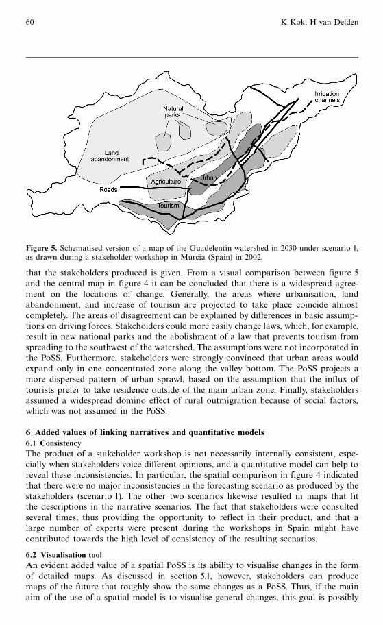
that the stakeholders produced is given. From a visual comparison between figure 5and the central map in figure 4 it can be concluded that there is a widespread agree-ment on the locations of change. Generally, the areas where urbanisation, landabandonment, and increase of tourism are projected to take place coincide almostcompletely. The areas of disagreement can be explained by differences in basic assump-tions on driving forces. Stakeholders could more easily change laws, which, for example,result in new national parks and the abolishment of a law that prevents tourism fromspreading to the southwest of the watershed. The assumptions were not incorporated inthe PoSS. Furthermore, stakeholders were strongly convinced that urban areas wouldexpand only in one concentrated zone along the valley bottom. The PoSS projects amore dispersed pattern of urban sprawl, based on the assumption that the influx oftourists prefer to take residence outside of the main urban zone. Finally, stakeholdersassumed a widespread domino effect of rural outmigration because of social factors,which was not assumed in the PoSS.
6 Added values of linking narratives and quantitative models6.1 ConsistencyThe product of a stakeholder workshop is not necessarily internally consistent, espe-cially when stakeholders voice different opinions, and a quantitative model can help toreveal these inconsistencies. In particular, the spatial comparison in figure 4 indicatedthat there were no major inconsistencies in the forecasting scenario as produced by thestakeholders (scenario 1). The other two scenarios likewise resulted in maps that fitthe descriptions in the narrative scenarios. The fact that stakeholders were consultedseveral times, thus providing the opportunity to reflect in their product, and that alarge number of experts were present during the workshops in Spain might havecontributed towards the high level of consistency of the resulting scenarios.
6.2 Visualisation toolAn evident added value of a spatial PoSS is its ability to visualise changes in the formof detailed maps. As discussed in section 5.1, however, stakeholders can producemaps of the future that roughly show the same changes as a PoSS. Thus, if the mainaim of the use of a spatial model is to visualise general changes, this goal is possibly
Figure 5. Schematised version of a map of the Guadelent|n watershed in 2030 under scenario 1,as drawn during a stakeholder workshop in Murcia (Spain) in 2002.
60 K Kok, H van Delden

reached more cheaply and more effectively by also inviting stakeholders with the capacityto think spatially to the workshops.
6.3 Integrated scenariosWithin a PoSS it is not uncommon to use `scenario generators' to deal with the sheerendless number of possible combinations of parameter values to detect communalitiesbetween scenarios (see eg Pomerol, 2001), while the product of stakeholder workshopsis a small number of highly integrated scenarios. We hope to have demonstrated that,by using such a scenario as the input of the PoSS, clusters of (related) parameters canbe changed simultaneously. Given the large number of dynamic parameters, groupingcan be an important guidance for end users of the PoSS, provided that the modelintegrates socioeconomic as well as biophysical processes.
6.4 Involving stakeholdersNarrative scenarios open the possibility to involve, for example, laymen, children, orlocal farmers besides experts and policy makers. Patel et al (2007) provide a detailedanalysis of the process-related merits of involving stakeholders in MedAction concern-ing stakeholder dialogue, social learning, and understanding of different perspectives.This wider involvement of nonscientists by combining the two tools can open the wayfor more successful management strategies and the combating of land degradation.
6.5 To combat desertificationThe largest added value of linking narratives and the PoSS is the ability of spatialmodels to project the consequences of land-use changes for land degradation anddesertification. As an example, figure 6 shows a map of the environmentally sensitiveareas as produced by the PoSS. The risk of becoming degraded illustrates how a spatialmodel can provide information on the impact of spatially explicit land-use changes.With narrative storylines it would be close to impossible to project with this level ofspatial detail.
6.6 Practical considerationsThere are practical considerations that could hamper the successful linkage betweena PoSS and narrative storylines. First of all, it cannot be stressed enough that the
Figure 6. Environmentally sensitive areas under scenario 1. Light shades indicate fragile areas;dark shades indicate critical areas.
Desertification in the Guadalent|n watershed, Spain 61

development of participatory narrative storylines and the construction of a PoSS arevery resource demanding. Both are expensive and, in the case of MedAction, tookyears to complete. As more readily accessible models become available and methodsfor carrying out a participatory process become more standardised, resource demandsmight decrease but will remain high. Second, in the participatory process as it wascarried out here, success is not guaranteed (see Steelman and Ascher, 1997). The aimof stimulating an open discussion to enhance mutual understanding and initiating alonger term participation has the drawback that the second aim of developing actualfuture scenarios might be jeopardised. In fact, the series of stakeholder workshops wascompleted in only two out of four local case studies (Spain and Italy). And finally, wehope to have made it clear that the process of linking narratives to a PoSS is notstraightforward and mostly only a partial link can be established.We wish to stress thatin MedAction the narrative storylines and the PoSS were developed simultaneously forthe same goal. This facilitated linking both projects, at least regarding the main drivers,processes, and indicators. Despite this precaution, underlying assumptions neverthelessdiffer; the PoSS demands detailed quantitative information on a range of parameters thatcan be distilled only partly from the narratives, while not all elements from the qualitativestorylines can be quantified. However, this should by no means be considered a draw-back, but, rather, should be considered as an essential first step. Only by attemptinga link as described here, and applying a more iterative procedure, can the problemsas identified above be made explicit. This will open the way to future improvementsof the PoSS, as well as providing guidance to future stakeholder workshops.
7 Conclusions and recommendationsWe hope to have made it clear that there are specific advantages of using eithernarrative scenarios or a spatial PoSS, and that linking the two methods has hadimportant added values in the context of the issue of combating desertification in theMediterranean region. Based on the experiences in MedAction, we conclude that thereare large advantages of linking narrative storylines and a spatial PoSS. Storylinesensure an active participation of a large range of stakeholders, additionally offeringthe possibility to develop highly integrated scenarios. The PoSS provides a spatiallydetailed and quantitative output that can also be used to check the internal consistencyof the qualitative scenarios. Linking stories and models can thus open the way formore successful management strategies to combat land degradation. However, combin-ing these two methods is very resource demanding and success is not guaranteed.There are several possibilities of improving the link between narrative storylines andspatial PoSSs, some of which are currently being explored. The most promising in thefield of land use and land degradation are:. Group model building (see Vennix, 1999). This approach has recently been taken upin the context of land use by those developing agent-based models (Parker et al,2002), that can be directly parameterised by stakeholders. At present, successfulapplications are mostly found in local systems involving a relatively small numberof stakeholders.
. Constructing models that are less complicated and more flexible. There are severalconcepts that seem promising, including transition management (Rotmans, 2003);the syndrome's approach (Schellnhuber et al, 2003); and the work of the resiliencealliance (eg Gunderson and Holling, 2002).
. Structuring stakeholder workshops such that a more quantitative output is obtainedthat can directly be used as an input in a PoSS (see Carmichael et al, 2004). Althoughthis might limit the stakeholders that can participate, as expert knowledge is needed,it would increase the usefulness for a PoSS.
62 K Kok, H van Delden

. Using a highly iterative procedure. Alcamo (2001) proposes a so-called storyline-and-simulation approach, in which storylines and models are improved in an iterativemanner during a number of stakeholder meetings.
In short, there are a number of promising novel methods available that merit furtherexploration in the field of land use (change), and which have opened possibilities tomove from involving stakeholders to fully integrating them in the process. The effortsdescribed in this paper are but a step in that direction.
ReferencesAlcamo J, 2001, ` Scenarios as tools for international assessments'', Prospects and Scenarios
Number 5, European Environment Agency, Copenhagen, http://www.usf.uos.de/IA/Scenarios Report.pdf
Brandt C J, Thornes J B (Eds), 1997, ` Mediterranean desertification and land use'' Journal ofHydrology 201 1 ^ 389
Carmichael J, Tansey J, Robinson J, 2004, ` Georgia Basin Quest: an integrated assessmentmodelling tool'' Global Environmental Change 14 171 ^ 183
Carpenter S R, Pingali P L, Bennett E M, Zurek M B (Eds), 2005 Ecosystems and HumanWell-being (Volume 2): Scenarios. Findings of the ScenariosWorking Group of the MillenniumEcosystem Assessment (Island Press,Washington, DC)
Clarke M, 1990, ` Geographical information systems and model-based analysis: towards effectivedecision support systems'', in Geographical Information Systems for Urban and RegionalPlanning Eds H Scholten, J Stillwell (Kluwer, Dordrecht) pp 165 ^ 175
De Groot D, Rotmans J, 2004, ` MedAction. Final Report'', submitted to the Research andDevelopment Directorate, European Commission EVK2-2000-00085, Maastricht
De la Rosa D, Mayol F, Diaz-Pereira E, Fernandez M, De la Rosa D Jr, 2004, `A land evaluationdecision support system (MicroLEISDSS) for agricultural soil protectionwith special referenceto the Mediterranean region'' Environmental Modelling and Software 19 929 ^ 942
Dreborg K H, 1996, ` Essence of backcasting'' Futures 28 813 ^ 828Gallop|n G, Hammond A, Raskin P, Swart R, 1997, ` Branch points: global scenarios and
human choice'', Pole Star Series Report 7, Stockholm Environment Institute, Boston, MAGeertman S, Stillwell J, 2003, ` Planning support systems: an introduction'', in Planning Support
Systems in Practice Eds S Geertman, J Stillwell (Springer, Berlin) pp 3 ^ 22Geeson N A, Brandt C J, Thornes J B (Eds), 2002 Mediterranean Desertification: A Mosaic of
Processes and Responses (JohnWiley, NewYork)Gunderson L, Holling C S (Eds), 2002 Panarchy: Understanding Transformation in Human and
Natural Systems (Island Press,Washington, DC)Kahn H,Weiner A, 1967 TheYear 2000: A Framework for Speculation on the Next Thirty-three
Years (Macmillan, NewYork)Kasemir B, Dahinden U, Swartling Ð G, Schu« le R, Tabara D, Jaeger C C, 2000, ` Citizens'
perspectives on climate change and energy use'' Global Environmental Change 10 169 ^ 184Klosterman R E, Pettit C J, 2005, `An update on planning support systems'' Environment and
Planning B: Planning and Design 32 477 ^ 484Kok K, Patel M (Eds), 2003, ` MedAction deliverable 7. Target area scenarios: first sketch'',
Report I03-E003, ICIS, Maastricht, http://www.icis.unimaas.nl/medaction/download.htmlKok K, Rothman D S, 2003, ``MedAction deliverable 3. Mediterranean scenarios: first draft'',
Report I03-E001, ICIS, Maastricht, http://www.icis.unimaas.nl/medaction/download.htmlKok K, Rothman D S, Greeuw S C H, Patel M, 2003, ` MedAction deliverable 2. European
scenarios. FromVISIONS to MedAction'', Report I03-E004, ICIS, Maastricht,http://www.icis.unimaas.nl/medaction/download.html
Kok K, Rothman D S, Patel M, 2006a, ` Multi-scale narratives from an IA perspective: part I.European and Mediterranean scenario development'' Futures 38 261 ^ 284
KokK, Patel M, RothmanD S, Quaranta G, 2006b, ` Multi-scale narratives from an IA perspective:part II. Participatory local scenario development'' Futures 38 285 ^ 311
Kok K,Verburg P H,Veldkamp A, 2007, ` Integrated assessment of the land system: the futureof land use'' Land Use Policy 24 517 ^ 520
Lebel L,Thongbai P, KokK, Bennett E,MalaW,Agard J, Biggs O, RumseyC, GokhaleY, Zurek M,Filer C,Velarde S J, Ferreira M, Blanco H,Yue T X, Lynam T, 2006, ` Sub-global scenarios'',in Ecosystems and HumanWell-being (Volume 4): Multiscale Assessments. Findings of the Sub-global AssessmentsWorking Group of theMillennium Ecosystem Assessment Eds D Capistrano,C K Samper, M J Lee, C Rauseppe-Hearne (Island Press,Washington, DC) pp 229 ^ 259
Desertification in the Guadalent|n watershed, Spain 63

Patel M, Kok K, Rothman D S, 2007, ` Participatory planning in land use analysis. An insightinto the experiences and opportunities created by stakeholder involvement in scenarioconstruction in the Northern Mediterranean'' Land Use Policy 24 546 ^ 561
Parker D C, Berger T, Manson S M, McConnell W J (Eds), 2002 Agent-based Models of Land-use and Land-cover Change report and review of an international workshop, 4 ^ 7 October,Land Use and Cover Change Report Series number 6, http://www.indiana.edu/�act/focus1/
Peterson G D, Cumming G S, Carpenter S R, 2003, ` Scenario planning: a tool for conservationin an uncertain world'' Conservation Biology 17 358 ^ 366
Pettit C, 2005, ` Use of a collaborative GIS-based planning-support system to assist in formulatinga sustainable-development scenario for Hervey Bay, Australia'' Environment and Planning B:Planning and Design 32 523 ^ 545
Pomerol J-C, 2001, ``Scenario development and practical decision making under uncertainty''Decision Support Systems 31 197 ^ 204
Raskin P, Banuri T, Gallop|n G, Gutman P, Hammond A, Kates R, Swart R, 2002, ` Greattransitions: the promise and lure of the times ahead'', Pole Start Series Report 10, StockholmEnvironment Institute, Boston, MA
Robinson J, 2003, ` Future subjunctive: backcasting as social learning'' Futures 35 839 ^ 856Roeckner E, Arpe K, Bengtsson L, Christoph M, Claussen M, Du« menil L, Esch M, Giorgetta M,
Schlese U, Schulzweida U, 1996, ` The atmospheric general circulation model ECHAM-4:model description and simulation of present-day climate'', Report 218, Max-Planck Institutefor Meteorology, Hamburg
Rotmans J, 2003, ` Scaling in integrated assessment: problem or challenge?'', in Scaling in IntegratedAssessment Eds J Rotmans, D S Rothman (Swets & Zeitlinger, Lisse) pp 329 ^ 354
Rotmans J,Van Asselt M B A, Anastasi C, Greeuw S C H, Mellors J, Peters S, Rothman D S,Rijkens-Klomp N, 2000, ` Visions for a sustainable Europe'' Futures 32 809 ^ 831
Schellnhuber H-J, Lu« deke M K B, Petschel-Held G, 2003, ` The syndrome's approach to scaling''Integrated Assessment 3 201 ^ 219
Schwartz P,1996TheArt of the LongView: Planning for the Future in anUncertainWorld (Doubleday,NewYork)
Shearer AW, 2005, `Approaching scenario-based studies: three perceptions about the future andconsiderations for landscape planning'' Environment and Planning B: Planning and Design32 67 ^ 87
Shim J P,Warkentin M, Courtney J F, Power D J, Sharda R, Carlsson C, 2002, ` Past, present,and future of decision support technology'' Decision Support Systems 33 111 ^ 126
Steelman TA, Ascher W, 1997, ``Public involvement methods in natural resource policy making:advantages, disadvantages and trade-offs'' Policy Sciences 30 71 ^ 90
Van Asselt M B A, Rijkens-Klomp N, 2002, `A look in the mirror: reflection on participationin integrated assessment from a methodological perspective'' Global Environmental Change12 167 ^ 184
Van Asselt M B A, Rotmans J, Rothman D S (Eds), 2005 Scenario Innovation. Experiences froma European Experimental Garden (Taylor and Francis, London)
Van Delden H, Luja P, Engelen G, 2007, ` Integration of multi-scale dynamic spatial models ofsocio-economic and physical processes for river basin management'' Environmental Modellingand Software 22 223 ^ 238
Van der Leeuw S E, 2000, ` Drylands present and past: searching for the causes and consequencesof desertification, land degradation and land abandonment on the northern Mediterraneanshores', in The Archaeology of Drylands: Living on the Margins Eds G Barker, D Gilbertson(Routledge, London) pp 336 ^ 353
Vennix J A M, 1999, ` Group-model building: tackling messy problems'' System Dynamics Review15 379 ^ 401
Wack P, 1985, ` Scenarios: uncharted waters ahead''Harvard Business Review 63 73 ^ 89Westhoek H J,Van den Berg M, Bakkes J A, 2006, ` Scenario development to explore the future
of Europe's rural areas''Agriculture, Ecosystems, and Environment 114 7 ^ 20White R, Straatman B, Engelen G, 2004, ` Planning scenario visualization and assessment: a cellular
automata based integrated spatial decision support system'', in Spatially Integrated SocialScience Eds M F Goodchild, D Janelle (Oxford University Press, Oxford) pp 420 ^ 442
Wollenberg E, Edmunds D, Buck L, 2000, ` Using scenarios to make decisions about the future:anticipatory learning for the adaptive co-management of community forests'' Landscape andUrban Planning 47 65 ^ 77
XiangW-N, Clarke K C, 2003, ` The use of scenarios in land-use planning'' Environment andPlanning B: Planning and Design 30 885 ^ 909
64 K Kok, H van Delden

Appendix ASoftware availabilityProgram title: MedAction PoSS.Developers: RIKS.Contact address: Hedwig van Delden, Research Institute for Knowledge Systems,PO Box 463, 6200 AL Maastricht, The Netherlands.Version: demonstration only.Software required: Windows 98/2000/NT/XP.Hardware requirements: 512 MB RAM.Programming language: C��
Appendix BParameter setting and key assumptionsClimateAll scenarios made use of the same climate scenario (ECHAM; see Roeckner et al,1996) with a manually imposed extra rainfall shortage of 40 mm per year to mimicassumptions in convulsive change.
Cellular automata rules: attraction between land usesTourism ^ tourism: stronger attraction in scenario 1 (as compared to standard param-eter setting) to mimic the clustering of golf courses and residential areas. Strongertendency to spread out in scenario 2, assuming that ecotourists will not cluster together.Tourism^ expatriots: some attraction because of communal facilities in scenarios 1 and 3.Tourism ^ natural vegetation: stronger attraction from natural vegetation in scenario 2,assuming that ecotourists prefer scenic landscapes.Urban ^ urban: stronger attraction in all scenarios. The key assumption is that, becauseof land abandonment and out-migration, urban dwellers will concentrate in largercentres.
SuitabilityTourism: under the standard scenario: flat areas, current tourism locations, agricul-ture, and residential areas are very suitable. Scenarios 1 and 3 make use of thesuitability map of the standard scenario; a zoning map is added, stating that newtourist areas are restricted to the valley bottom. Under scenario 2, the vicinity ofnature is important, therefore the suitability map indicates that natural areas havea high suitability; no policy restrictions are imposed on the areas for tourism in thisscenario.
Table B1. Total area changes.
Agriculturea Industry Tourism Expatriots Urban
2000 0 0 0 0 0Standard 0 � � � �Scenario 1 ÿÿ �� ��� ��� ��Scenario 2 0 �=�� � �� �Scenario 3 ÿÿÿ ÿ 0 0 ÿa The changes given for agriculture are a maximum. The land-use model determines wherethese cells are allocated and afterwards the farmer's decision model determines if cells areoccupied with dryland or agriculture or if they will be abandoned.
Desertification in the Guadalent|n watershed, Spain 65

Table B2.Water distribution.
Division of Capacity of Capacity Water use Water usewater in times desalinisationa Tajo water by tourists by expatriotsof shortage (m3/month) (m3/month) (m3/month/ (m3/month/Agriculture: person) person)tourism
Standard 1000:1 0 0 0 0Scenario 1 50:1000 0 0 �� ��Scenario 2 1000:1 0 0 0 0Scenario 3 1000:1 ÿÿÿ 0 0 0
a Water from the water transport network from the Ebro River is included here.
ß 2008 Pion Ltd and its Licensors
66 K Kok, H van Delden

Conditions of use. This article may be downloaded from the E&P website for personal researchby members of subscribing organisations. This PDF may not be placed on any website (or otheronline distribution system) without permission of the publisher.