columbia plateau windblown dust natural events … · columbia plateau windblown dust . natural...
TRANSCRIPT

Columbia Plateau Windblown Dust Natural Events Action Plan
Washington Department of Ecology Air Quality Program
2003


Table of Contents
Executive Summary ................................................................................................. 5
Preface ...................................................................................................................... 9
Columbia Plateau Natural Events ......................................................................... 11
Introduction ......................................................................................................... 11
History ................................................................................................................. 11
Overview of EPA Natural Events Policy .............................................................. 12
Washington State Natural Events Action Plan .................................................... 14
Other Washington State Environmental Programs .............................................. 14
Washington State Air Quality Priorities for the Columbia Plateau ....................... 15
2003 Natural Events Action Plan ........................................................................... 17
Stakeholder Involvement ..................................................................................... 17
Definition of Natural Events ................................................................................. 17
Documenting a Natural Event ............................................................................. 18
NEAP Element 1: Public notification and education ............................................ 20
NEAP Element 2: Minimize public exposure to high concentration of PM10 due to future natural events................................................................................. 21
NEAP Element 3: Minimize appropriate contributing controllable sources of PM10 .................................................................................................................... 22
NEAP Element 4: Identify, Study and Implement mitigating measures .............. 25
NEAP Element 5: Re-evaluation ......................................................................... 27
APPENDIX-A: NEAP Evaluation ......................................................................... A-1
APPENDIX-B: BACM Implementation Analysis ................................................ B-1
APPENDIX-C: 1998 NEAP ................................................................................... C-1
APPENDIX-D: EPA Review of 1998 NEAP ......................................................... D-1
APPENDIX-E: First Year Evaluation 1999 .......................................................... E-1


Executive Summary
In 1996, the Environmental Protection Agency (EPA) released the Natural Events Policy for particulate matter 10 microns or less (PM10). The Natural Events Policy outlines the requirements states must follow to claim that air quality standards are exceeded due to natural events. States fulfill the policy requirements by submitting to EPA a Natural Events Action Plan, which specifies the required processes to qualify under the policy. The Washington State Department of Ecology completed the development of a Natural Events Action Plan for High Wind Events in the Columbia Plateau (NEAP) in March 1998 and submitted it to the U. S. Environmental Protection Agency, Region 10 (EPA). The NEAP made commitments for a status report at the end of 1998 and a re-evaluation at the end of 2001. This document provides the 2001 evaluation and presents the 2003 Natural Events Action Plan (NEAP). Based on the evaluation results, several changes were incorporated into the 2003 NEAP. Significant changes include: a more refined definition for high wind event; a process for documenting natural events due to high winds; a description of the best available control measures (BACM) program for
implementation of conservation practices; a finding that BACM is in place throughout the Columbia Plateau; a commitment to coordinate with agricultural agencies, such as conservation
districts, and the U. S. Department of Agriculture on tracking and documentation of conservation practices to control windblown dust from agricultural fields.
Refined High Wind Event Definition The Natural Events Policy allows states to define a high wind event. Washington State bases the refined definition on specific "wind" research for the Columbia Plateau area. In doing so, the definition is expanded from the previous definition. The high wind definition now describes not only the conditions for a high wind event, but also describes when a high wind event becomes a natural event. The definition Washington State will operate with is as follows:
A high wind event occurs when the wind entrains and suspends dust to the extent that concentrations of PM10 are elevated. This occurs when the average hourly wind speed at 10 m is 18 miles per hour or greater for two or more hours; or in excess of 13 miles per hour for two or more hours when conditions of higher susceptibility to wind erosion exist (see attachment A1). A high wind event that exceeds the PM10 standard is a natural event.
Process for Documenting Natural Events Due to High Winds The 2003 NEAP establishes the process for documenting a high wind natural event. The process is three steps, which describe when BACM is overwhelmed.
Step 1 Examine the PM10 and meteorological data. PM10 data from the monitoring station of interest is analyzed to verify that an exceedance of the PM10 NAAQS occurred. Where the meteorological data supports a natural event (i.e. meets the "uncontrollable" threshold identified in the Natural Events Policy), Washington State then proceeds with either step 2 or step 3 documentation. Step 2 When winds are 18 mph or over, documentation includes the following information: 1) PM10 data; 2) wind speed, direction, and duration pertaining to the event; 3) precipitation in the area prior to the date the exceedance was recorded; 4) average precipitation for the given area and time of year. Step 3 The write-up for natural events where wind speeds are at least 13 mph will include the information in Step 2 and a determination of the additional factors leading to higher susceptibility and how these factors interact to reach the “uncontrollable” threshold. Washington State may use dispersion modeling, fire reports, filter analysis etc. if the information is deemed helpful and resources are available. For the most part, documentation will be written by local air authorities within their respective jurisdictions. Ecology will write up the documentation for the remaining counties of the Columbia Plateau. Ecology will also write the documentation when the natural event is deemed a regional event that affects several counties. Best Available Control Measure Program The 2003 NEAP defines Best Available Control Measures (BACM) for agricultural fields as USDA Conservation Title Programs, supplemented by incentive based implementation of wind-erosion conservation practices or best management practices (BMPs). The USDA Conservation Title is the name given to a specific group of conservation programs. Each program is slightly different in focus. The most pertinent Conservation Title Program for the Columbia Plateau Region is the Conservation Reserve Program (CRP). A second program, the new Conservation Security Program, may also be available at some point in the future. The second element of BACM is incentive based use of wind erosion conservation practices. The Natural Resources Conservation Service (NRCS) publishes a Field Office Technical Guide, which lists air resource management as a focus area and identifies wind erosion conservation practices to maximize this resource. In addition, the Columbia Plateau Wind Erosion/Air Quality Research Project identifies and refines conservation practice use and research reflected through the publication "Farming with the Wind". Taken together, the two provide both a fundamental source for well proven conservation practices and region specific best management practices for reducing wind erosion.
Washington State tracks conservation practice implementation primarily from the Core 4 data (see Appendix B). Core 4 is an information sharing and management system integration project designed for farmers. The project is sponsored by private and public sector organizations. The Core 4 project provides the most comprehensive information on minimum tillage practices available and includes residue on the field estimations that represent a collection of conservation practices. BACM Finding Washington State determines BACM is implemented throughout the Columbia Plateau. Washington State evaluated BACM implementation for agricultural fields using Core 4 data. The Core 4 data shows 68% of total farmable acres of the Columbia Plateau are part of a USDA conservation program, use one of the minimum till practices, or contain 15-30% residue. Based on this evaluation, Washington State views these levels as sufficient to fulfill BACM criteria. Commitment to Coordinate with Agricultural Agencies on Conservation Practices Tracking and Documentation The Washington State Department of Ecology coordinates with agricultural agencies on issues affecting the Columbia Plateau and commits to continuing the efforts already in progress. The primary agencies include agencies directly reporting to USDA (NRCS, FSA, and ARS), the Washington State Conservation Commission, local Conservation Districts, and various agriculture related departments of the Washington State University (i.e. the Cooperative Extension Service and various research programs). The various agricultural agencies often work together on large issues, such as wind erosion on the Columbia Plateau to combine expertise in both research and implementation. Discussion topics between the Department of Ecology Air Quality Program and the various agricultural agencies include practical methods to improve the use and tracking of conservation practices.

Preface
This document is a plan to explain natural events throughout the Columbia Plateau and describe actions Washington State is taking to control anthropogenic sources of windblown dust in this area. The Environmental Protection Agency (EPA) has established a Natural Events Policy which outlines requirements states must follow to claim that air quality standards are exceeded due to natural events. States fulfill the policy requirements by submitting to EPA a Natural Events Action Plan. The Natural Events Action Plan for the Columbia Plateau is the result of staff efforts from the Spokane County Air Pollution Control Authority (SCAPCA), the Benton Clean Air Agency (BCAA), EPA, and the Washington State Department of Ecology. I would like to take the opportunity to recognize several individuals for their assistance and insight in preparing this plan: Ron Edgar, SCAPCA Dr. David Lauer and John St. Clair, BCAA Doug Schneider, Brett Rude, and Kary Peterson, Department of Ecology I would also like to acknowledge the efforts of researchers involved with the Columbia Plateau Wind Erosion/Air Quality Research Project. Portions of this Natural Events Action Plan rely heavily on the information, evaluation, and recommendations derived from this mammoth research project. Sincerely, Melissa McEachron Air Quality Program Department of Ecology
Columbia Plateau Natural Events
Introduction During the late 1980s and early 1990s, a large number of exceedances of the 24-hour National Ambient Air Quality Standard (NAAQS) for particulate matter ten microns or less ( PM10 ) were recorded in Spokane, Kennewick and Wallula Washington. (Wallula is approximately 20 miles southeast of Kennewick). A detailed examination of these exceedances shows a close correlation to high wind events. The exceedances are attributable predominantly to activity on agricultural fields, although other sources have the potential to contribute. The Columbia Plateau is subject to frequent high winds, particularly during the spring, summer and fall months. The Columbia Plateau principally exhibits a winter precipitation pattern. Topography also plays a role, since the area of the Plateau closest to the Cascade Mountain range have a very low annual precipitation. Low precipitation coupled with high temperatures causes the evaporation of soil moisture far in excess of incoming precipitation. An additional factor that increases soil susceptibility to wind erosion is soil type. The Columbia Plateau soils are characterized as silty to fine sandy textured, which is a reference to dominant particle size, and low clay and organic matter content. These soil characteristics are manifested in very weak soil structure, (lack of the ability to form clods) which results in break down of the soil into individual particles when mechanically disturbed from tillage, planting operations, or traffic. Maximum susceptibility to wind erosion results when the soil surface is dry, with no surface vegetative cover, and has been mechanically disturbed. EPA developed its Natural Events Policy to deal with particulate matter exceedances (PM10) "attributable to uncontrollable natural events." The State of Washington documented a number of these events and more are expected to be documented in the future. This document reviews the Natural Events Policy and implementation, evaluates the current Natural Events Action Plan (NEAP) completed in 1998, and presents a revised NEAP.
History With the link between air quality and wind erosion established, a research project was specifically designed to improve the understanding of wind-blown dust and wind erosion reduction methods. Washington State, the Environmental Protection Agency (EPA), and the United States Department of Agriculture (USDA) partnered to sponsor the Columbia Plateau Wind Erosion/Air Quality Research Project (otherwise known as CP3). Research

from this project is referenced throughout this document. The CP3 received funding through approximately 2004 and is expected to end at that point. Independent of CP3, USDA Programs influence agriculture on the Columbia Plateau through policy decisions and recommendations of the Agricultural Air Quality Task Force and through implementation of USDA Conservation Programs. Congress authorized the Agricultural Air Quality Task Force (AAQTF) as a federal advisory committee in 1996 to provide states guidance on air quality issues related to agriculture. Congress also designated USDA as chair for this Task Force. An example of the type of guidance issued from the AAQTF is the Production Agriculture Voluntary (incentive based) Air Quality Compliance Program, which recommends EPA and states use a voluntary compliance/incentive based approach when dealing with agricultural sources. USDA is also responsible for implementing federally funded Conservation Title Programs nationwide. The new Farm Security and Rural Investment Act of 2002 authorizes several types of conservation programs and allocates funding levels. The two programs which most closely align with the goal of reducing agricultural dust emissions are the Conservation Reserve Program and the new Conservation Security Program. In addition to Conservation Title Programs, USDA and conservation districts promote the use of conservation practices. As a practical matter, conservation practices are implemented on the ground through local conservation district wind erosion reduction projects.
Overview of EPA Natural Events Policy The Clean Air Act Amendments of 1990 added a new section to the Clean Air Act - Section 188(f) - address waivers of PM10 nonattainment areas. EPA initially interpreted this provision as nullifying EPA's ability to exclude uncontrollable events caused by natural sources or an event that was not expected to recur at a given location from determinations of the attainment status of an area. (See Serious Area Guidance, 59 FR41998, August 16, 1994) Several state and local air pollution control agencies questioned this interpretation and pointed out that it was not the only possible interpretation of the statutory language of Section 188(f). This led to western and national attention to the issues and, ultimately, EPA reconsideration. The reconsideration resulted in the Natural Events Policy, which was issued on May 30, 1996. Briefly, this policy allows the exclusion of ambient air quality data collected on days when natural events cause exceedances of the National Ambient Air Quality Standards (NAAQS), provided certain conditions are met. It recognizes that natural events may cause exceedances of the NAAQS for PM10 for which neither the state nor the regulated community should be held responsible. The policy recognizes three types of natural events: volcanic and seismic activities, wildland fires, and high winds. This document specifically deals with natural events due to high winds on the Columbia Plateau.

EPA's Natural Events Policy identifies the guiding principles for decisions made under the policy. The following is a list of the guiding principles:
• Protection of public health is the highest priority of Federal, State, and local air pollution control agencies.
• The public must be informed whenever the air quality in an area is unhealthy. • All valid ambient air quality data should be submitted to EPA's Aerometric
Information Retrieval system (AIRS). • State and local agencies must take appropriate reasonable measures to
safeguard public health, regardless of the source of PM10 emissions. • Emission controls should be applied to sources that contribute to exceedances
of the PM10 standard when those controls will result in fewer violations of the standards.
The Natural Events Policy also identifies the criteria states are expected to address in the form of a Natural Events Action Plan (NEAP). A NEAP should be developed to address future events and should include commitments to:
1. Establish public notification and education programs. Such programs may be designed to educate the public about the short- and long-term effects of PM10, and to inform them about the nature and impact of the natural events with respect to air quality and public health. In addition, warnings that a natural event which could result in unhealthy air quality is imminent, are required. Finally, a plan should include a means of informing the public as to the specific actions being taken to minimize the health impacts of high-wind events.
2. Minimize public exposure to high concentration of PM 10 due to future natural events. Populations at risk must be identified and notified that a natural event which could lead to unhealthful air is taking place. The plan should provide a means of suggesting actions that the public and the at-risk populations could take to minimize exposure and to mitigate the impacts if exposure cannot be avoided.
3. Abate or minimize appropriate contributing controllable sources of PM10. For high wind events, this includes the application of BACM to any sources of soil which have been disturbed by anthropogenic activities, and should include measures to prevent reentrainment of wind-blown dust.
4. Identify, study and implement practical mitigating measures as necessary. A
timely schedule for testing new control measures and implementing those which prove technologically and economically feasible.
5. Periodically reevaluate both the causes of violations and the status and effects
of the NEAP. At a minimum, the NEAP must be reevaluated every five years.

Washington State Natural Events Action Plan Washington State developed and submitted to EPA a Natural Events Action Plan for windblown dust on the Columbia Plateau in 1998. This NEAP was one of the first in the country. The 1998 NEAP incorporated, to the extent practical, research from the Columbia Plateau PM10 Wind Erosion/Air Quality Project. The majority of the effort was concentrated on identifying, developing and defining applicability for many of the elements. However, not all elements were fully implemented at the time of submittal. Given the circumstances, Washington State agreed to a one year update and a three year NEAP review. EPA reviewed and provided suggestions on the 1998 NEAP. Ecology provided a First Year Evaluation in 1999 and an Activity Status Report for the years 1999-2001. (Appendix C through E)
Other Washington State Environmental Programs The Department of Ecology also oversees many environmental programs throughout eastern Washington and the Columbia Plateau. Programs designed to reduce pollution also benefit air quality. The Washington State Water Quality Management Plan to Control Non-point Source Pollution and the Washington State Agricultural Burning Permit Program are two such programs. The Washington State Water Quality Management Plan incorporates agricultural wind erosion conservation practices in order to protect water quality from soil deposition (See Appendix A). Moreover, many additional water quality conservation practices in the plan benefit air quality, secondarily. This is because the objectives of both water and wind erosion control are to prevent or minimize soil particle detachment and entrainment by the medium (air or water). Therefore, the conservation practices to reduce the effects from both types of erosion are substantially similar. These practices reduce the velocity of the medium across the soil surface and decrease the energy available to detach, entrain, and transport the soil particles. Ultimately, air quality is improved when conservation measures to reduce water erosion are increased. The Washington State Agricultural Burning Permit Program also reduces windblown dust emissions. While agricultural field burning removes crop residue or cover and increases susceptibility for wind erosion during the time between the burn and “green-up” period, the burn program requirements substantially limit the extent of field burning. For example, agricultural burning must be considered necessary and be considered a best management practice as established by a state task force. The effect of the burn permit requirements is that a grower must balance the use of burning as a tool with probable impacts of increased erosion problems. As a result, more and more growers are choosing not to burn or burn less, which in turn reduces soil susceptibility during vulnerable periods. The result of the burn permit program is a reduction in acreage susceptible to soil erosion during vulnerable periods. Washington’s burn permit program accounted for 109,254 acres of cereal grains burned in 2002 compared with 177,345 acres burned in 2001.
Although field burning increases wind erosion susceptibility, both the Washington State Legislature and the Agricultural Air Quality Task Force (AAQTF) recognize it as a viable practice. As a result, some amount of field burning will continue. Washington State burn permit requirements follow the guidance provided in the Agricultural Burning Policy established by the Agricultural Air Quality Task Force (AAQTF).
Washington State Air Quality Priorities for the Columbia Plateau Both EPA and Washington State are concerned about health effects from particulate matter air pollution coming from wind events related to conditions found with agriculture. In balancing air quality priorities for the Columbia Plateau, Washington reviewed available health studies related to both combustion sources and for dust exposure. A multi-faceted health study was conducted as part of the Columbia Plateau Wind Erosion and Air Quality Research Project (CP3). One portion of the study looked at the effects of coarse particulate matter related to dust storms. Researchers identified dust storms in Spokane between the years 1989 and 1995 to determine whether coarse particles from windblown dust are associated with mortality. The researchers concluded there is no association with mortality. [Joel Schwartz, Garry Norris, Tim Larson, Lianne Sheppard, Candis Claiborne, and Jane Koenig. Episodes of High Coarse Particle Concentrations Are Not Associated with Increased Mortality. Environmental Health Perspectives Volume 107, Number 5, 339-342 (1999).] Another recent study focused on determining the health effects of exposure to agricultural dust for farm workers and farmers. The study focused on determining connections between respiratory illnesses and inorganic agricultural dust. The article reports the study conclusion that a causal association is plausible between inorganic dusts and several respiratory diseases such as chronic bronchitis and chronic obstructive pulmonary disease. [Marc Schenkar. Exposures and Health Effects from Inorganic Agricultural Dusts Exposures. Environmental Health Perspectives Volume 108, Supplement 4, 661-664 (2000).] In contrast, several studies and other types of analyses are now available linking health effects to combustion products (smoke). Given the status of knowledge on health effects from coarse and fine particulate matter, Washington State identified agricultural burning as the priority health and environmental issue in eastern Washington. Over the last few years, the state of Washington placed considerable resources toward reducing emissions from agricultural burning and expects this trend to continue. These efforts also complement the objectives of the Columbia Plateau Windblown Dust Natural Events Action Plan, since vegetation not burned retains soil surface cover that helps prevent wind erosion.


2003 Natural Events Action Plan
Stakeholder Involvement Natural Events Policy The Natural Events Policy states:
The NEAP should be developed by the State air pollution control agency in conjunction with stakeholders affected by the plan. (p.10)
The policy goes on to say:
Development of a NEAP for high-wind events should include input from Federal, State and private managers of open desert lands, rangelands, agricultural lands; the construction industry; and organizations promoting the use of recreational off-road vehicles…The plan should include documented agreements among the stakeholders as to planned actions, the implementation schedule, and the parties responsible for carrying out those actions. (p.10)
Stakeholder Opportunities Washington State identifies agricultural fields as the primary source of windblown dust. The stakeholder list and the process for seeking input reflect interest in the subject. The primary opportunity for stakeholder involvement given the identified source is during the evaluation and drafting phase. Ecology sought and received consensus on the approach to the various components of this plan from the local air agencies located within the Columbia Plateau. In addition, courtesy copies were distributed to various agricultural agencies. Ongoing activities provide the best source of input from the various agricultural agencies in Washington State. To this end, Ecology will continue to participate as a member of the Columbia Plateau Particulate Matter Wind Erosion/Air Quality Research Project and continue to work with NRCS and Conservation Districts to encourage BMP use.
Definition of Natural Events Natural Events Policy Guidance
The Natural Events Policy (NEP) provides guidance in at least two separate areas. The first is an excerpt:
Ambient PM10 concentration due to dust raised by unusually high winds will be treated as due to uncontrollable natural events under the following conditions:
(1) the dust originated from nonanthropogenic sources, or

(2) the dust originated from anthropogenic sources controlled with best available control measures (BACM). (p.7)
The second is simply an acknowledgment. The Natural Events Policy acknowledges that the conditions leading to high wind events vary and are influenced by several factors including soil type, precipitation, and wind gusts. The Policy further directs states to determine the conditions under which high winds conditions are sufficient to overcome control measures and can be considered natural events. Washington State Definition As noted in the Evaluation (Appendix A), Washington State spent considerable energy and effort refining a definition that reflects the wind event conditions found throughout the Columbia Plateau. The definition Ecology believes most accurately characterizes wind events on the Columbia Plateau is the following:
A high wind event occurs when the wind entrains and suspends dust to the extent that concentrations of PM10 are elevated. This occurs when the average hourly wind speed at 10 m is 18 miles per hour or greater for two or more hours; or in excess of 13 miles per hour for two or more hours when conditions of higher susceptibility to wind erosion exist (see attachment A1). A high wind event that exceeds the PM10 standard is a natural event.
The state of Washington believes this updated definition meets the Natural Events Policy criteria while allowing flexibility for the numerous soil susceptibility conditions and factors prevalent throughout the Columbia Plateau. These factors include threshold velocity, gusts, previous moisture levels, soil types, crusts and moisture, transport of previously lofted material into a monitored area and drought.
Documenting a Natural Event Natural Events Policy The Natural Events Policy provides guidance on documenting a natural event in several places. The applicable sections are listed below:
In circumstances where a State has reason to believe that natural events have caused measured exceedances of the NAAQS, the State is responsible for establishing a clear causal relationship between the measured exceedance and the natural event. The type and amount of documentation provided for each event should be sufficient to demonstrate that a natural event occurred, and that it impacted a particular monitoring site in such a way as to cause the PM10 concentrations measured. This documentation should also provide evidence that, absent the emissions from the natural event, concentrations of PM10 at the monitoring site under consideration would not cause a PM10 exceedance. (p.10)
The Policy also acknowledges that some public review level for documentation is desirable. Washington State High Wind Natural Event Documentation When documenting a natural event, the state of Washington generally considers PM10 and meteorological data from stations within the area of the event. Meteorological data sources include:
o Meteorological equipment co-located with the PM10 monitor, o National Weather Service stations, o Public Agricultural Weather Stations (PAWS), o Agrimet stations, or o the Hanford Meteorological Station (HMS).
The Washington State University Cooperative Extension Office at Prosser, Washington, operates the PAWS network; the United States Bureau of Reclamation, Pacific Northwest Region, operates the Agrimet network; the HMS is operated by the Pacific Northwest National Laboratory (PNNL) in Richland, Washington.
Step 1 Examine the PM10 and meteorological data. PM10 data from the monitoring station of interest is analyzed to verify that an exceedance of the PM10 NAAQS occurred. The meteorological data is further examined to identify representative conditions, near the monitored area, that likely contributed to the exceedance. The meteorological data parameter of most interest starts at the 8:00 pm observation on the day before the event and ends at the 12:00 am observation the following day. When wind speeds are 18 mph or over, the state of Washington typically limits the examination to the following: 1) PM10 data from the monitor where the exceedance occurs and 2) meteorological data from the nearest met site and/or the nearest National Weather Service site. When winds are at least 13 mph or greater, the state of Washington will provide a more extensive evaluation. At the meteorology evaluation phase, the state of Washington will examine data from a wider network of meteorological stations. If several observation sites report conditions sufficient for windblown dust to impact the monitor of interest, further investigation will ensue to determine whether transport of PM10 into the monitored area is a factor. Where the meteorological data supports a natural event, Washington State then proceeds with either step 2 or step 3.

Step 2 When winds are 18 mph or over, documentation includes the following information: 1) PM10 data; 2) wind speed, direction, and duration pertaining to the event; 3) precipitation in the area prior to the date the exceedance was recorded; 4) average precipitation for the given area and time of year. Step 3 The write-up for natural events where wind speeds are at least 13 mph will include the information in Step 2, a determination of the additional factors leading to higher susceptibility, and how these factors interact to reach the “uncontrollable” threshold. In step 3, Washington State may also make use of dispersion modeling, fire reports, filter analysis, etc. if the information is deemed helpful and resources are available.
Submitting Documentation to EPA For the most part, documentation will be written by local air authorities within their respective jurisdictions. The Department of Ecology (Ecology) will write up the documentation for the remaining counties of the Columbia Plateau. There may be situations when natural events affect several monitors. In these situations, Ecology after consultation with the local air agencies, may write the documentation for the entire Columbia Plateau. However to ensure consistency, Ecology will review and submit all documentation to EPA for natural events due to high winds.
Public Review In addition to the published reports currently available containing air quality data, Washington State will post Natural Event Documentation on the Department of Ecology Air Quality Program website. The Air Quality Program website appears to be the most cost effective and least burdensome method to provide the public access.
NEAP Element 1: Public notification and education Natural Events Policy States are to address public notification and education in the following manner: Establish public notification and education programs. Such programs may be designed to educate the public about the short- and long-term harmful effects that high concentrations of PM10 could have on their health and inform them that (a) certain types of natural events affect the air quality of the area periodically, (b) a natural event is imminent, and (c) specific actions are being taken to minimize the health impacts of events. (p.8)

Washington State Actions For the period of the 2003 NEAP, Washington State commits to the following activities to fulfill this NEAP element:
1. Prepare an annual media release that combines wind erosion conditions throughout the Columbia Plateau with a health message and precautions.
2. Post the media release on the Department of Ecology Air Quality Program website.
3. Continue to make monitoring data available through the Air Quality Program website.
4. Develop a section of the Air Quality Program website devoted to windblown dust natural events.
5. Post in this new section both the Natural Events Action Plan and Natural Event Documentation.
NEAP Element 2: Minimize public exposure to high concentrations of PM10 due to future natural events
Natural Event Policy Minimize public exposure to high concentrations of PM 10 due to future natural events. Programs to minimize public exposure should: (a) identify people most at risk, (b) notify the at risk population that a natural event is imminent or currently taking place, (c) suggest actions to be taken by the public to minimize their exposure to high concentrations of PM10, and (d) suggest precautions to take if exposure cannot be avoided. (p. 8) Washington State Actions As mentioned in the Evaluation section, Washington State previously identified the categories of people most at risk and believes this listing is accurate today. This group consists of children, the elderly, and those with respiratory diseases. Washington State prepared a brochure which describes wind events on the Columbia Plateau and suggests actions to take to minimize exposure if possible, and precautions to take if exposure cannot be avoided. Washington State commits to posting this brochure on the Department of Ecology Air Quality Program website. Early notification of wind events typically occurs through two methods. The first is through the National Weather Service reporting system. In addition to website information or regional weather related conditions, this information system is likely to be the first report to reach media when conditions reach "dust storm" levels. Often radio stations will feature these reports as part of the news, particularly when wind speeds elevate quickly. The second method is through the Washington State monitoring network system website. The Department of Ecology Air Quality

Program website can be accessed by interested members of the public and features monitors with "real -time" data for a number of monitoring sites throughout the state. The "real-time" data is displayed in the Air Quality Index format, which clearly marks color coded ranges for specific monitors. Washington State commits to preparing Public Service Announcements (PSAs) with a sound health message and evaluating the most efficient means of media distribution. As described in the Evaluation Section, in Spokane County, PSA segments are broadcast on radio stations as part of the National Weather Service advisories for high winds. Ecology and Benton County Clean Air Authority will also prepare alert message PSAs and evaluate effective distribution methods.
NEAP Element 3: Minimize appropriate contributing controllable sources of PM10
Natural Event Policy The policy requires states to: Abate or minimize appropriate contributing controllable sources of PM10 … (c) High winds-application of BACM to any sources of soil which have been disturbed by anthropogenic activities. The BACM application criteria require analysis of the technological and economic feasibility of individual control measures on a case-by-case basis. The NEAP should include analyses of BACM for contributing sources. The BACM for windblown dust include, but are not limited to …use of conservation farming practices on agricultural lands; tree rows and other physical wind breaks;…and use of surface coverings. If BACM are not defined for the anthropogenic sources in question, step 4 below is required. (p 10) [Step 4 is the NEAP Element 4- Identify, study, and implement practical mitigating measures as necessary.]
State of Washington's BACM Program for the Columbia Plateau Source Identification The State of Washington finds that windblown dust from agricultural fields is still the significant contributing source of PM10 exceedances throughout the Columbia Plateau. The soil is very fine with low organic matter content. This coupled with low precipitation weather patterns means very dry soil that is highly susceptible to wind erosion. BACM Definition BACM for agricultural fields is conservation programs and practices that reduce or minimize wind erosion. The USDA Conservation Title Programs supplemented by incentive based implementation of wind-erosion conservation practices or best management practices (BMPs). Congress, via the Farm Bill, directs the U.S. Department of Agriculture to implement many programs that affect agriculture in the United States. One of the major sections

of each Farm Bill is devoted to conservation, hence the name Conservation Title Programs. USDA Conservation Title Programs of most interest include the Conservation Reserve Program (CRP) and the Conservation Security Program. The CRP contracts with growers to remove the most vulnerable land from agricultural production and require establishment of permanent vegetative cover for the duration of the contract. The Conservation Security Program is a new national incentive payment program for maintaining and increasing farm stewardship practices. There are many unknowns regarding this new program, not the least of which is whether additional resources for conservation efforts from this particular program will be available for Columbia Plateau counties. In relation to conservation practices, the Natural Resources Conservation Service (NRCS) also encourages use of specific conservation practices for reducing wind erosion (BMPs). Several of these practices are described in the NRCS Field Office Technical Guide (Appendix A-3). Another source for BMPs is the "Farming with the Wind" publication, which describes BMPs specific to the Columbia Plateau and is part of the body of research from the Columbia Plateau Wind Erosion/Air Quality Research Project. The BMPs featured encompass a variety of conservation options from vegetative buffers and wind breaks to conservation tillage practices to residue management practices. Both the NRCS Field Office Technical Guide and "Farming with the Wind" provide a fundamental source for well-proven conservation practices and region specific best management practices for reducing wind erosion. BACM Tracking Mechanisms to track conservation practice implementation are available primarily from two sources: USDA and Core 4. USDA tracks implementation of the USDA Conservation Title Programs. The Farm Service Agency (FSA) prepares reports on the monetary components, while the Natural Resources Conservation Service (NRCS) provides reports on implementation. Core 4 is, in essence, a data compilation project, sponsored by the Conservation Technology Information Center (CTIC). The CTIC is a national non-profit public-private partnership working to promote soil and water quality and provide farmers with information on and access to affordable, integrated management systems. The CTIC was established in 1982 as a special project of the National Association of Conservation Districts (NACD) with participation and assistance from governmental agencies and agribusiness. Core 4 is one of the Center's premiere projects. The Core 4 project provides the most comprehensive information on minimum tillage practices (ridge till and no till) and categories that represent a collection of practices that leave residue on the field. In addition, CRP acreage is also included. Core 4 data is collected yearly, which means the statistics likely reflect dynamic changes in levels of conservation practice use in conjunction with other environmental factors such as drought. BACM Determination for the Columbia Plateau

Washington State determines that BACM is implemented for agricultural fields throughout the Columbia Plateau. This determination is based on an evaluation of the elements contained in the Core 4 data (Appendix B). The evaluation includes data on CRP, minimum tillage, and residue remaining on the field for the entire Columbia Plateau with particular emphasis on the counties of most concern (lowest rainfall counties). The Core 4 data shows 68% of total farmable acres of the Columbia Plateau are part of a USDA conservation program, use one of the minimum till practices, or contain 15-30% residue. Based on this evaluation, Washington State views the levels of CRP and BMP use as sufficient to fulfill BACM criteria. Additionally, due to the complexity of the evaluation and data sources, Washington State will review and report annually implementation statistics, but will not attempt to evaluate BACM implementation on a sub area level (e.g. county) as part of the natural event documentation process.
The Washington State Department of Ecology coordinates with agricultural agencies on issues affecting the Columbia Plateau and commits to continuing the efforts already in progress. The primary agencies include agencies directly reporting to USDA (NRCS, FSA, and ARS), the Washington State Conservation Commission, local Conservation Districts, and various agriculture related departments of the Washington State University (i.e. the Cooperative Extension Service and various research programs).
Ecology faces certain challenges working within the existing framework of these agricultural agencies and farm support groups. Most notably, implementation of incentive programs is carried out by USDA and Ecology’s ability to affect the operation of these programs is limited. Moreover, for agricultural agencies, windblown dust does not rise to the same level as other natural resource concerns such as water quality, water resources, salmon restoration, etc. Farmers and farm support agencies are continually challenged with balancing funding support, natural resource needs and maintaining economically viable operations.
Nevertheless, the various agricultural agencies often work together on large issues, such as wind erosion on the Columbia Plateau to combine expertise in both research and implementation. Ecology commits to support and encourage these efforts. Discussion topics between the Department of Ecology Air Quality Program and the various agricultural agencies include practical methods to improve the use and tracking of conservation practices. Washington State Actions Washington State commits to the following activities as part of this NEAP: Evaluate the impacts (or likely impacts) the of the Farm Service and Rural
Investment Act of 2002 on conservation programs and practices by 2005 Review and report annual implementation statistics as developed by
agricultural agencies. If the measures tracked decline, Washington State will work with USDA and farm support agencies toward the goal of reversing this trend. The report will be provided to EPA in the fall of each year.
Work with agricultural agencies and other Department of Ecology programs to improve priority funding opportunities for projects that reduce wind erosion.
NEAP Element 4: Identify, study and implement mitigating measures
Natural Events Policy The Natural Events Policy allows states to identify study and implement practical control mitigating measures as necessary:
The NEAP may include commitments to conduct pilot tests of new emission reduction techniques. For example, it may be desirable to test the feasibility and effectiveness of new strategies for minimizing sources of windblown dust through pilot programs. The plan must include a timely schedule for conducting studies and implementing measures that are technologically and economically feasible. (p 10)
Projects Evaluating "Practical" BMPs Evaluating the economic components of the various conservation practices is gaining more prominence as part of the Columbia Plateau Wind Erosion/Air Quality Project (CP3). While there are many demonstration projects found as part of CP3, the Washington State Department of Ecology Air Quality Program participates directly in two: the Direct Seeding Demonstration Project and a 2001 Priority Project teaming Whitman Conservation District and the Pacific Northwest Direct Seeding Association. These special projects are designed to both educate growers on how to implement certain practices, to road test specific BMPs for certain rainfall zones, and evaluate the economic components involved in switching to a direct seeding cropping system. Ecology is also involved in another project designed to demonstrate conservation practice implementation on the Horse Heaven Hills. Initiated in 2002, this project focuses on conservation practice(s) for the conventional cropping system, which is the primary cropping system of this extremely dry portion of the Columbia Plateau. Direct Seeding Demonstration Project One of the management systems incorporating these BMPs is “no-till/minimum till.” No-till management systems are flexible and made up of several interchangeable options that are then adapted to each grower’s land. A crucial component of the “no-till” management system is direct seeding. Direct seeding requires specialized management skills and specialized equipment. In order for a farmer to convert to direct seeding from conventional tilled wheat fallow rotation to a continuous cropping rotation there is significant educational need for the
farmer in order for them to be successful. Direct seeding also requires specialized equipment, particularly drills, which are expensive and continuously improving. Drills are improving at such a fast pace that a no-till drill may be completely outmoded in a span of 2-3 years. As a result of the equipment turnover rate, growers are turning to companies that specialize in direct seeding to plant the crop on custom contracts. Some growers have already converted to direct seeding and “no-till” farming. However, these producers have the financial resources and education to make the transition to direct seeding (money and grit). There are many producers that are willing to convert to direct seeding. Unfortunately, their financial resources and educational needs are insufficient to make a successful conversion. Low crop prices and a bumpy transition to the “free market” concept (traditional price supports occur now on a year by year basis) further add to growers’ trepidation. There is also considerable apprehension about how direct seeding can be economically viable in low precipitation zones. The project establishes demonstration sites that will: 1. Demonstrate that direct seeding is both economically and technically feasible in
the 12 inch or less precipitation zone from an application standpoint rather than a research stand point.
2. Provide an opportunity for selected growers to make the conversion to direct seeding.
3. Provide an opportunity to gather additional research data relating to the conversion to direct seeding.
4. This project is to provide financial assistance to 10 growers at $20.00 per acre per year for six consecutive years on a maximum of 80 acres per grower for expenses associated with the demonstration sites such as drill rental, fertilizer test, labor, pesticide scouting and other associated costs.
2001 Priority Project Ecology teamed with the Whitman Conservation District and the Pacific Northwest Direct Seeding Association on a project - one of the tasks is to produce a video for educational seminars. The Pacific Northwest Direct Seeding Association is very active in providing educational seminars and advising growers that are converting to these practices about cultivation methods, specialized equipment, weed control, pest control, disease control, rotations, and anticipated benefits. 2002 Priority Project Ecology developed a project to enhance wind erosion conservation practices in the low-precipitation, dryland farming areas of the Columbia Basin. The goal of the project is twofold: to provide immediate, temporary treatment to critical areas and to promote other options for longer-term or permanent wind erosion control measures identified in the CP3. The options of most interest are straw mulching and the use of low disturbance tillage implements. Ecology is working via contract with the Benton Conservation District to carry out specific tasks associated with the project.
NEAP Element 5: Re-evaluation Natural Events Policy Guidance The Natural Events Policy requires states to periodically re-evaluate the action plan for the following:
(a) the conditions causing the violations of the PM-10 NAAQS in the area, (b) the status of implementation of the NEAP, and (c) the adequacy of the actions being implemented. The State should reevaluate the NEAP for an area every 5 years at a minimum and make appropriate changes to the plan. (p. 10)
Re-evaluation Washington State will re-evaluate the provisions of the Natural Events Action Plan for the Columbia Plateau beginning in 2007.


APPENDIX-A: NEAP Evaluation
Introduction The state of Washington gained valuable experience over the last few years "road-testing" the Natural Events Policy. When the Natural Events Policy became effective in 1996, Washington State was among the first to prepare and submit a Natural Events Action Plan for wind events. This chapter describes Washington State's experience using this new federal policy in relation to the wind driven natural events experienced throughout the Columbia Plateau. The sections that follow detail Ecology's progress, discuss challenges and outline the future direction.
Definition of Natural Events Natural Events Policy The Natural Events Policy (NEP) provides guidance in at least two separate areas. The following are relevant excerpts:
Ambient PM10 concentration due to dust raised by unusually high winds will be treated as due to uncontrollable natural events under the following conditions: (1) the dust originated from nonanthropogenic sources, or (2) the dust originated from anthropogenic sources controlled with best available control measures (BACM). (p.7) The BACM must be implemented at contributing anthropogenic sources of dust in order for PM10 NAAQS exceedances to be treated as due to uncontrollable natural events under this policy. Therefore, BACM must be implemented for anthropogenic dust sources contributing to NAAQS exceedances in attainment and unclassifiable areas and in moderate PM10 nonattainment areas. In unclassifiable and attainment areas, BACM must be implemented for those contributing sources for which it has been defined within 3 years after the first NAAQS violation attributed to high wind events or from the date of this policy. In these same areas, implementation should be as expeditious as practicable for sources for which BACM are undefined. (p. 7)
The conditions that create high wind events vary from area to area with soil type, precipitation and the speed of the wind gusts. Therefore, the State must determine the unusually high wind conditions that will overcome BACM in each region or sub-region of the State. (p.7)
1998 Natural Events Action Plan Washington State identified the source of the dust as windblown dust from agricultural fields. Ecology provided a detailed examination of exceedances in the late 1980's and
early1990's. Results of the examination showed a close correlation to wind related natural events, with upwind agricultural fields the chief source of the wind-blown dust.
Washington State defined a "high wind event" in the following manner:
While in general a "high wind event” can be said to consist of above-average wind
speeds and duration of several hours over soils that have relatively low moisture content, a specific definition for an area as large as the Columbia Plateau is very difficult, if not impossible, to articulate. The Columbia Plateau includes a wide variation of soil types and conditions, as well as meteorological conditions, vegetation, and anthropogenic activities. Under these different conditions, there is a range of situations which can lead to “high wind events.” Thus although several elements must be present for a wind-blown dust exceedance to occur, specific numerical values for each element cannot be assigned, since a variation in one may cause a change in the threshold of another. For example, the lower the soil moisture value, the lower the wind speed necessary to entrain fine particles from agricultural fields. These relationships, the causes and frequency of occurrence of wind-blown dust events have been extensively studied over the past three years through a large scale, multi-agency project; the Columbia Plateau Particulate Matter Project.
Therefore, since defining such a multi-variant event by the conditions is unfeasible, this NEAP defines as high wind event as follows. A high wind event occurs when wind, soil and other conditions are sufficient to cause an exceedance of the PM-24 hour NAAQS and a program to define and implement BACM for contributing anthropogenic sources is in place. The conditions that contribute to BACM being overcome will be evaluated when the state documents an event. Conditions can include: wind speed; direction and duration; precipitation levels; soil moisture; soil types and soil cover.
EPA Review The EPA Region X reviewed the 1998 submittal and relayed the following comments:
EPA recognizes that unusually high wind events on the Plateau can result from a unique confluence of variables- wind speed, direction, and duration; soil type, condition, and cover; precipitation; etc. A rigid definition tied to a particular wind speed may not be feasible for the entire area. However, the NEP requires criteria to define wind that is unusually high. Accordingly, further development of this definition is essential and additional criteria for flagging exceedences is needed to strengthen the plan. EPA will continue to evaluate the documentation for each flagged exceedence to ensure that the event warrants special consideration under the NEP.
Recommendation(s): Add wording that offers an approximation of unusually high wind speeds along with a caveat allowing for lower wind speeds if other conditions conspire to cause wind driven exceedences. For example:
A high wind occurs when: 1. winds exceed XX mph for XX hours; or 2. winds exceed the seasonal average by XX mph for XX hours and soil
conditions are sufficient to cause an exceedence of the PM-24 Hours NAAQS while a program to define or implement BACM for contributing anthropogenic sources is in place.
Under the second definition, it is Ecology's responsibility to prove that the exceedence was uncontrollable and resulting from unusually high wind, even though it did not meet the threshold in the definition. As a result, additional documentation requirements are necessary for future events and should be incorporated in the plan.
Evaluation and Findings Source Identification Washington State identified agricultural windblown dust as the source of the exceedances. The 1998 NEAP explained the correlation of exceedances to upwind agricultural fields. Washington State believes the information provided in the 1998 NEAP is valid. With this determination, the focus over the last three years shifted from source identification to defining a high wind event. Current Wind Event Research The two sources of research that provide the essential building blocks for a Columbia Plateau high wind event definition are the NRCS soil erosion definition and the definition of a wind event as described in Farming with the Wind. In Farming with the Wind, a wind event is defined as: any period when the hourly wind speed at a height of 10 m (32.8 ft) exceeds threshold value of 18 miles per hour for three hours or more, and where a one-hour period below threshold is followed by at least two hours above threshold. This wind event definition references the NRCS erosion threshold wind speed in defining a wind event while adding a temporal factor.
In addition to a wind speed element, EPA also recommends adding an element to address seasonal conditions as compared to normal conditions. Farming with the Wind analyzed wind records throughout several years in order to determine if conditions exist to identify differences between "normal" winds, "high" winds and "unusually high" winds. Exceedances and seasonal averages were analyzed and no correlation established between the two. Consequently, Washington State finds this area warrants no further investigation.
Updated Wind Event Definition The Natural Events Policy references a per mile an hour wind speed that is considered adequate for wind events to be considered uncontrollable. However, wind speed as

the sole factor ignores the interaction of several factors which result in conditions sufficient to loft the dust into the air. Fortunately, the Natural Events Policy provides flexibility by allowing states to define wind event conditions.
In the 1998 NEAP, Washington State chose to describe a high wind event, rather than adopting a wind speed driven definition. Even so, as EPA points out in the 1998 review, the definition needs further development. Washington State staff prepared a report (A1) which analyzes the soil, meteorology, and air quality exceedance data, integrated with current wind erosion research from the Northwest Columbia Plateau Wind Erosion/Air Quality Project. The analysis provides the basis for the updated definition.
The definition Washington State believes most accurately characterizes wind events on the Columbia Plateau is the following:
A high wind event occurs when the wind entrains and suspends dust to the extent that concentrations of PM10 are elevated. This occurs when the average hourly wind speed at 10 m is 18 miles per hour or greater for two or more hours; or in excess of 13 miles per hour for two or more hours when conditions of higher susceptibility to wind erosion exist (see attachment A1). A high wind event that exceeds the PM10 standard is a natural event.
Direction for 2003 Natural Events Action Plan Washington State's direction on determining wind events over the next five years is to continue to incorporate Columbia Plateau Research results.
Documenting a Natural Event
Natural Events Policy The Natural Events Policy provides guidance on documentation in several places. The applicable sections are listed below:
In circumstances where a State has reason to believe that natural events have caused measured exceedances of the NAAQS, the State is responsible for establishing a clear causal relationship between the measured exceedance and the natural event. Supporting documentation concerning the natural event could include filter analysis, meteorological data (e.g. wind speed and wind direction to support a source receptor relationship), modeling and receptor analyses, videos and/or photographs of the event and the resulting emissions, maps of the area showing sources of emissions and the area affected by the event, and news of the accounts of the event. (p.10) In the case of high-wind events where the sources of dust are anthropogenic, the state must document that BACM were required for those sources, and the sources were in compliance at the time of the high wind event. If BACM are not required for some dust sources, the NEAP must include agreements with the appropriate stakeholders to minimize future emissions from such sources using BACM. (p.10)

The type and amount of documentation provided for each event should be sufficient to demonstrate that a natural event occurred, and that it impacted a particular monitoring site in such a way as to cause the PM10 concentrations measured. This documentation should also provide evidence that, absent the emissions from the natural event, concentrations of PM10 at the monitoring site under consideration would not cause a PM10 exceedance. (p.10) The State should also make the documentation of natural events and their impact on measured air quality available to the public for review. This may be accomplished through a number of means such as the publishing newspaper announcements, periodic reports on air quality in the area, and through public hearings. This would serve to allow the public an opportunity to comment on whether the causal relationship between the natural event and the air quality measurement is convincing. (p.10)
1998- Natural Events Action Plan The 1998 NEAP addressed documenting a natural event in the following manner:
The EPA Natural Events Policy requires that states flag values they consider are caused by a natural event and lists several requirements in order for PM10 exceedances to be treated as having resulted from a natural event. These are:
• analysis and documentation of the event; • flagging of the relevant data in the national EPA database; • submittal of documentation to the EPA regional office; and, • public notification that the state considers the exceedance as being due
to a natural event.
As noted above, analysis and documentation of specific exceedances resulting from high wind events have been submitted to EPA. These data were entered into the EPA Aerometric Information Retrieval System (AIRS) database and flagged as natural events.
EPA Review Reporting Requirements for Flagged Events The plan states that exceedences will be handled on a case by case basis and that the conditions that contribute to overcoming BACM will be evaluated when the state documents an event. Specific guidelines for documentation need to be added to the NEAP for future events. This is particularly important because the definition of an unusually high wind event is not tied to an absolute wind speed. The level of detail provided in the supporting documentation must be sufficient to withstand public scrutiny and legal challenge. Recommendation(s):

Add an additional section after the definition of unusually high wind events that details how each flagged event will be justified. The following reporting requirements are suggested: 1) Provide wind speed, direction, and duration data for the event; compare these
conditions with average wind conditions at the same time of year. 2) Provide data on each of the following contributing factors and compare these
conditions with average conditions at the same time of year: Precipitation levels; Soil moisture; Soil type(s); Soil cover.
3) In a case of lower wind speeds, document how the variables interact to cause a natural event due to unusually high wind.
4) Document Best Management Practices (BMP) in place for an area and document how they are implemented (number of acres with BMP implemented out of total acres in the originating area, degree of implementation, etc).
5) Specify which anthropogenic sources contribute PM to an exceedance.
Evaluation and Findings As indicated in the 1998 NEAP and EPA review, the documentation process is currently determined on a case-by-case basis. In retrospect, this approach worked well when recorded wind gusts reached higher than twenty miles per hour. However, only some of the exceedances over the last five years fall into this category. For all the other wind events, the documenting process became extremely labor intensive. On the whole, the flexibility Washington State gained by using a definition without a wind speed component was overshadowed by the amount of time and energy expended in the documenting process.
In reviewing potential changes to the documenting procedure, Washington State drew on both the level of experience documenting natural events and on the type and nature of the windblown dust events found throughout the Columbia Plateau. As a result, Washington State is instituting a procedure for submitting documentation in addition to describing documentation contents.
Procedure The first portion is writing the documentation. For the most part, local air authorities will be responsible for writing documentation for natural event in their respective jurisdictions. There may be exceptions, however, such as natural events that affect several monitors, where Ecology, after consultation with the local air authorities, may write the documentation for the entire Columbia Plateau. The second part is submittal to EPA. To ensure consistency, Ecology will review and submit the documentation for all wind events.
Documentation Natural event documentation for wind events is most easily described in three steps:
Step 1 Examine the PM10 and meteorological data. PM10 data from the monitoring station of interest is analyzed to verify that an exceedance of the PM10 NAAQS occurred. The meteorological data is further examined to identify representative conditions, near the monitored area, that likely contributed to the exceedance. The meteorological data parameter of most interest starts at 8:00 pm observation on the day before the event and ends at the 12:00 am observation the following day. When wind speeds are 18 mph or over, Washington State typically limits the examination to the following: 1) PM10 data from the monitor where the exceedance occurs and 2) meteorological data from the nearest met site and/or the nearest National Weather Service site. When winds are at least 13 mph or greater, Washington State will provide a more extensive evaluation. At the meteorology evaluation phase, Washington State will examine data from a wider network of meteorological stations. If several observation sites report conditions sufficient for windblown dust to impact the monitor of interest, further investigation will ensue to determine whether transport of PM10 into the monitored area is a factor. Where the meteorological data supports a natural event, Washington State then proceeds with either step 2 or step 3 documentation. Step 2 When winds are 18 mph or over, documentation includes the following information: 1) PM10 data; 2) wind speed, direction, and duration pertaining to the event; 3) precipitation in the area prior to the date the exceedance was recorded; 4) average precipitation for the given area and time of year. Step 3 The write-up for natural events where wind speeds are at least 13 mph will include the information in step 2 and a determination of the additional factors leading to higher susceptibility and how these factors interact to reach the “uncontrollable” threshold. In step 3, Washington State may also make use of dispersion modeling, fire reports, filter analysis etc. if the information is deemed helpful and resources are available. Public Review Another issue is public review process for event documentation. The Natural Events Policy does not specifically address the process for documenting individual events. During the time-frame of this evaluation, air quality monitoring data is and has been available from the Department of Ecology Air Quality Program website and is incorporated yearly into a monitoring data report for the entire state. This approach worked sufficiently.
In addition to the published reports currently available, Washington State will continue to use the Department of Ecology website and to a greater extent, incorporate the type of public review contemplated in the memorandum. At this time,

the website appears to be the most cost effective and least burdensome method to provide the public access to the Natural Events Action Plan and Natural Event Documentation.
Direction for 2003 Natural Events Action Plan Washington State's direction is: Document events using a three-step process with wind speed and duration as
the thresholds factors.
Continue to make available air quality monitoring data via the web based data system.
Post natural event documentation on the Air Quality Program website.
NEAP Element 1: Public notification and education Natural Events Policy
States will address public notification and education in the following manner: Establish public notification and education programs. Such programs may be designed to educate the public about the short- and long-term harmful effects that high concentrations of PM10, could have on their health and inform them that (a) certain types of natural events affect the air quality of the area periodically, (b) a natural event is imminent, and (c) specific actions are being taken to minimize the health impacts of events. (p.8)
1998 NEAP Public Education The 1998 NEAP public education component is described as: A. Public Notification and Education
The purpose of the education component is: to inform the public about the causes and effects of windblown dust; what they can expect when high wind events occur; what steps are in place and will be taken to control or reduce levels of windblown dust; and what periods are most likely to produce such events.
Under the 1998 NEAP, several agencies were considered "primary contributors" to the public education component. The agencies identified were Ecology, local air pollution control authorities, Natural Resources Conservation Service (NRCS), Cooperative Extension Agency, Washington State University, and citizen public interest groups. When the Columbia Plateau Air Quality/Wind Erosion Project began, increasing public understanding and awareness of windblown dust issues was identified as a goal. A public outreach and education goal was created. Activities under this goal included: news releases and articles in general interest publications; articles in specialized publications; field days and tours; public conferences; development and

maintenance of a web site; and the preparation of educational materials for use by county extension agents and NRCS staff. A publication list was included with the 1998 NEAP. The 1998 NEAP also described the types of ongoing efforts expected through the duration of the NEAP. First, the current phase of the CP3 study was due to end in 1998. The expectation at the time was that the project and outreach effort would continue with funding from the NRCS and the Cooperative States Research Education and Extension Service (CSREES). Second, Ecology anticipated publishing a final report of the Columbia Plateau PM Project and committed to monitoring any ongoing research and consulting with project sponsors. Third, the 1998 NEAP outlined the types of ongoing outreach and education efforts: preparing exhibits for local fairs and other community events; preparing and disseminating materials for libraries, schools, and local organizations; and continuing media exposure through interviews, news releases and display ads. The 1998 NEAP sums up the CP3 education and outreach effort with this observation:
The result of this effort has been a high level of awareness and understanding of the problem of windblown dust in the affected areas. Surveys conducted in Spokane County and in the Tri-Cities area indicate a very high level of awareness, with nearly sixty percent of the respondents agreeing that control or mitigation of the problem would benefit them personally. In addition, there have been opportunities for public involvement in the CP3 at a number of stages and events. These have been publicized in newspaper advertisements, conference announcements, and outreach through county and agency offices.
Public Notification Ecology acknowledged the necessity of enacting a method to notify the public of the possibility of dust events, beyond the established monitoring alert system identified in Washington State statue. In the early 1990s, Ecology and Local Air Pollution Control Agencies informed the public and increased awareness of windblown dust primarily when monitoring results triggered air quality warnings for specific incidents. General focus sheets on windblown dust events and precautions were developed and published. A seasonal media release was also developed to notify the public of the likelihood of dust events for the upcoming season and precautions.
Ecology and the local APCAs will, as appropriate, issue a notice through media releases as the probability that dust storms may occur that year. This notice will be based on general rainfall levels, the previous year’s agricultural crop size, and other relevant conditions. Ecology and the APCAs will consult with agricultural agencies in writing these notices.

Evaluation and Findings
Public Education The 1999 One Year Review reported that Farming with the Wind was published and distributed to growers and Conservation Districts. In addition, the 1999 review noted that the Columbia Plateau Project continued to be an effective education and outreach tool, particularly among growers. Through the education component of the project, researchers and cooperators published articles, conducted field tours of the demonstration crop trials and plots, and organized public conferences on reducing wind-erosion. One item of note is that USDA is now the sole funding source for the CP3 project. As such, funding for the CP3 project came into question in 2001. Fortunately, the CP3 project survived and received additional USDA funding for the next two years. With this additional funding, the education component is expected to continue allowing growers to benefit from a number of opportunities to view a variety of techniques to conserve resources and to reduce wind erosion. The types of opportunities include several farm tours and conferences. Once the Columbia Plateau Project is completed, the education component for growers is likely to remain with the agricultural agencies. Public Notification For each of the years 1999, 2000, and 2001, Washington State released information on dust storms and dust storm event preparedness. The Department of Ecology prepared a seasonal press release for general distribution early in the "dust" season. The press releases were distributed to local air agencies and the media. In addition, the press release was available on the Department of Ecology Air Quality Program web site. Washington State intends to continue with this method. Direction for 2003 Natural Events Action Plan
Continue to prepare an annual media release that combines wind erosion
conditions with a health message and precautions. Continue to post this media release on the Air Quality Program web site.
NEAP Element 2: Minimize public exposure to high concentration of PM10 due to future natural events.
Natural Events Policy The policy guidance requires that states:
Minimize public exposure to high concentration of PM10 due to future natural events. Programs to minimize public exposure should: (a)identify people most at risk, (b) notify the at risk population that a natural event is imminent or currently

taking place, (c) suggest actions to be taken by the public to minimize their exposure to high concentrations of PM10, and (d) suggest precautions to take if exposure cannot be avoided. (p. 8)
1998 NEAP The 1998 NEAP addressed this requirement in two components: Health Advisory Programs and Event Notification. Health Advisory Programs The purpose of the health advisory programs was to provide additional effort to educate sensitive segments of the population. The 1998 NEAP identified three populations segments with an elevated health risk from exposure to high levels of windblown dust. Three segments noted are children, the elderly, and those with respiratory diseases. The 1998 NEAP also described the rationale:
Children are susceptible because their lungs are still in the formative stages; the elderly because their lung capacity has been diminished by the natural aging process; and those with respiratory diseases because their lungs have been compromised either by chronic conditions such as asthma or by respiratory infection.
The 1998 NEAP then described the methods Washington State would use to educate and alert these sensitive populations:
1. Fact sheets will be prepared by Ecology, local APCAs and local health districts, and distributed through the APCAs and Ecology to appropriate locations, such as schools, senior centers, nursing homes, hospitals, and doctors' offices. These fact sheets will explain the health effects of windblown dust, and will outline steps to take to mitigate the effects. They will also provide a means of obtaining further information. 2. Materials will be provided to teachers, senior center and nursing home staff, and other locations as appropriate, explaining the health effects of windblown dust to sensitive populations, citing sources for alert notices, and outlining steps to be taken in the event of a high-risk situation.
Event Notification Washington State also committed to following up the "general advisories" described in the public notification section with instructions or suggestions for how individuals can mitigate the impacts of windblown dust events. Ecology and the Local Air Agencies recognized the value of warning citizens of an impending dust event if time and information was available.

Evaluation and Findings
Health Advisory Programs Ecology completed a draft of a dust brochure, which explains health effects of windblown dust, suggests actions to minimize exposure where possible, and recommends precautions to take if exposure cannot be avoided. Unfortunately, program financial resources were severely limited, which prevented printing copies of the brochure. However, the brochure has been adapted to web site use and will be placed on the Ecology web site. Event Notification Local air authorities add an enhanced event notification component as appropriate. The Spokane Air Pollution Control Agency issued a release that was picked up by local radio stations that relayed information during a recent "dust storm" in Spokane. For other parts of the Columbia Plateau, the National Weather Service wind warning messages provide the most accurate information on the likelihood of a wind event. Unfortunately, the wind events of the Columbia Plateau are not always predictable. The topography, landscape stability, and the nature of the meteorological conditions throughout the Columbia Plateau are such that notification is not always possible. Recorded wind events occur in as little as two or three hours. Also, wind events occur during the night.
Direction for 2003 Natural Events Action Plan Post the brochure on the Ecology web site. Prepare Public Service Announcements with a strong health message. To the extent practicable, distribute PSAs to the local media as events take
place or are imminent.
NEAP Element 3: Minimize appropriate contributing controllable sources of PM10
Natural Events Policy The policy requires states to: Abate or minimize appropriate contributing controllable sources of PM 10 … (c) High winds-application of BACM to any sources of soil which have been disturbed by anthropogenic activities. The BACM application criteria require analysis of the technological and economic feasibility of individual control measures on a case-by-case basis. The NEAP should include analyses of BACM for contributing sources. The BACM for windblown dust include, but are not limited to …use of conservation farming practices on agricultural lands; tree rows and other physical wind breaks;…and use of surface coverings. If BACM are not defined for the anthropogenic sources in question, step 4 below is required. (p 10) [ Step 4 is the NEAP Element 4- Identify, study, and implement practical mitigating measures as necessary.]

1998 NEAP The 1998 NEAP addressed several areas relating to controlling contributing sources of PM10 including source identification, BACM program development and timeline, BMPs as BACM, BACM identification and implementation, and prevention of re-entrainment. The NEAP begins by recognizing an anthropogenic component to the wind blown dust situation. The report then discusses the methodology and analysis CP3 researchers used to determine that the major source of windblown dust on the Columbia Plateau is from wind erosion on agricultural acreage. Next, the 1998 NEAP summarized the two most likely scenarios for wind erosion for dryland and irrigated acreage and briefly described the practices to prevent or mitigate wind erosion. This became the basis for the determination that BMPs are the equivalent of BACM.
The agriculture community uses the term Best Management Practices for control measures that offer the greatest level of control given available technology and economic considerations. For purposes of this NEAP, Ecology believes that BMP are equivalent to Best Available Control Measures. Therefore, for agricultural practices, Ecology uses the terms Best Management Practices (BMPs) and Best Available Control Measures interchangeable.
The 1998 NEAP summarized BMP identification in the following manner: A number of soil management practices are in use on the Columbia Plateau today. Farmers make choices concerning these practices based on a number of factors. Surveys of dryland conducted during the CP3 show that most are using at least one management practice to reduce erosion, while about one-third are using four. Only four percent were not using any. Outreach efforts, through the NRCS, the local APCAs, Washington State University, and others will continue to make agricultural practitioners aware of the benefits of such practices. In addition to the practices already in use, research on alternative methods will continue to occur as part of the CP3 research.
Washington State also acknowledged that BACM/BMPs had not yet been fully identified or implemented. In order to meet the "expeditiously as practicable" requirement, Ecology agreed to a 1999 - First Year Evaluation to report on progress to more fully define BACM and describe the implementation status and plans. At the time, the Farming with the Wind handbook was due to be published, survey information from the most susceptible, lowest rainfall counties was analyzed, and the overall focus for the Columbia Plateau Air Quality/Wind Erosion Project shifted toward further BMP implementation rather than BMP identification.

We believe that setting up a process for the coordinated testing, identification and implementation of BACM will aid in timely implementation of BACM. Education and implementation efforts will be concentrated in the area identified through CP3 as the most susceptible to wind erosion of PM10. These counties are Douglas, Lincoln, Grant, Adams and Franklin.
Washington State's approach to implementation focused on developing a Memorandum of Agreement (MOA) for an ongoing BACM program that extended beyond the priority areas (most susceptible, lowest rainfall) with the Agricultural Research Service, NRCS, and conservation districts. The MOA would outline specific responsibilities for the program, and anticipate an appropriate rate-of-progress for implementing BMPs. In addition, the MOA would provide the forum for follow-up on these core activities:
• continue research into the Best Management Practices, as well as their impacts, efficiencies, and costs on a site or location-specific basis;
• identify new techniques and research as to their efficacy in mitigating the problem of windblown dust;
• assess the impacts of combining two or more methods or practices; and, • identify developed techniques as Best Management Practices for agriculture in
the area. The 1998 NEAP also noted that ultimately, BMPs are implemented by agricultural agencies through a variety of methods. Conservation District and NRCS field staff work with growers on an individual farm basis to identify specific conservation practices to control erosion and protect the environment. The 1998 NEAP also discussed the role of farm plans in implementing conservation measures and practices. Through the 1990 amendments to the Food Security Act (FSA), growers receiving crop subsidies, loans or other assistance through US Department of Agriculture were required to develop conservation farm plans. Farm plans provided agronomically viable BMPs to minimize erosion and environmental impacts. The 1998 NEAP points out, however, that the 1996 amendments to the FSA phased out most subsidy programs by 2001. This also meant that the role of farm plans as a tool to implement control measures was unknown, but would likely diminish.
Once the subsidy program is phased out, development of farm plans will be voluntary. However, growers that effectively implement BMPs adopted by their CD are considered to be using reasonable and appropriate controls. If emissions occur under this circumstance, either the conditions at the time overwhelmed the BMP or the BMP is not implemented correctly. Growers that are not correctly implementing adopted BMPs can be held responsible for erosion or discharges from their lands.

Finally, the 1998 NEAP defined reentrainment and described how it likely occurs throughout the Columbia Plateau. The 1998 NEAP noted that Nonattainment Area have programs in place to mitigate the effects of locally generated particulates, such as street sweeping, control of dust at construction sites, road paving, and controls on stationary sources as appropriate. These types of prevention options are generally believed to be sufficient to prevent reentrainment that may be the result of high wind events. EPA Review EPA reviewed the 1998 NEAP and provided recommendations related to defining BACM and developing a program to implement BACM:
EPA acknowledges that the BMPs for the Columbia Plateau are still under development and were included in the NEAP in draft form. Because the definition and implementation of the BMPs as BACM is essential to controlling anthropogenic sources on the Plateau, the NEAP should include target dates by which the BMPs will be defined and adopted and by which BACM will be implemented. Firm commitments and schedules for BACM implementation are critical. Recommendation(s): Add provisions to the NEAP that: • identify significant anthropogenic sources or source categories to be
covered by BMP/BACM; • specify target dates for BMP definition; • require the BMPs to be formally integrated into the NEAP once defined as
a regulation in the SIP or MOAs with responsible agencies; • specify target dates and areas for implementation of BACM; • specify methods, procedures, and criteria for making a determination that
BMP/BACM are being implemented for all source categories identified as significant;
• specify measures to be taken if BMP/BACM are not implemented.
1999-First Year Evaluation The First Year evaluation (Appendix E) provided EPA with the BACM identification and implementation activities update. Between 1998 and 1999, the evaluation reported on the following activities: Farming with the Wind handbook was published and distributed; statistical information was gathered from the Conservation Technology Information Center; and CP3 research projects continued. The First Year Evaluation also described the results of efforts to find methods to implement BMPs effectively and to establish a Memorandum of Agreement. The effort resulted in consensus among the agricultural agencies. Unfortunately, as reported, the consensus reached concluded that BMP implementation would be most effective if BMPs appropriate for a conservation district were adopted by the district.

Ecology committed to working with Adams and Lincoln county conservation districts, two of the "wind erosion susceptible" counties, to determine the possibility of specifically adopting wind erosion BMPs. In the end, the First Year Evaluation concluded that a large amount of work had been accomplished to implement BMPs and that the 3.39% increase in conservation tillage represented substantial evidence of implementation of conservation practices. This report also included a discussion of further activities in education, research, implementing control measures, local adoption of BMPs, and direct seeding.
Evaluation and Findings Source Identification The Natural Events Policy splits wind event source discussion into two categories: non-anthropogenic and anthropogenic. Winds acting on landscapes with minimal or no human activity are non-anthropogenic sources and exist in various forms on the Columbia Plateau. Other areas are also well suited for crop production, especially where irrigation development has taken place. What makes this distinction important is that crop production is considered an anthropogenic activity. The difficulty is that almost all areas affected by wind events have a human activity component, even in areas considered as traditional deserts, such as the sand blow area of the Cochoella Valley in California. In regards to the Columbia Plateau area, even with available "fingerprinting" research, it is virtually impossible to determine what percentage of dust to attribute to anthropogenic activities or non-anthropogenic sources. This being the case, there is no choice but to focus attention to the second part of the equation, anthropogenic sources. The natural events policy directs states to determine whether the anthropogenic source is significant. This directive only appears in the wind event category. The guidelines for the other natural event categories are framed differently. Nevertheless, for wind events, the anthropogenic versus non-anthropogenic issue must be addressed. In the 1998 NEAP, Ecology broaches this dilemma by beginning with the observation that to the extent anthropogenic sources are involved, windblown dust from agricultural fields is the contributing source. Under the circumstances, Ecology finds this solution appropriate for this 2003 NEAP as well. Preventing/Mitigating Re-entrainment
Downwind population centers may be impacted when dust is entrained by high winds. The winds do not stop at the population centers but continue to carry and disperse the particles further downwind. It is possible that particulates deposited within the population centers from upwind sources could be reentrained. Urban areas have programs in place to mitigate the emissions of locally generated particulates such as street sweeping and control of dust at construction sites. These programs are generally sufficient to mitigate reentrainment of any particulate matter deposit as a result of high wind events. This is supported by monitoring data that shows for most high wind events, the monitor peaks during the hours of high winds and then

returns to levels under the standard without application of specific mitigation measures. For example, peak traffic that follows dust storms does not increase particulate levels. In addition, Ecology and local APCAs continue to monitor particulate levels, and, if determined necessary, take additional steps, such as additional street sweeping, to mitigate reentrainment.
The BACM Program In the 1998 NEAP, Washington State committed to establishing an MOA with NRCS, ARS, and Conservation Districts. Unfortunately, the attempt to establish an MOA was unsuccessful. Moreover, the 1999 - First Year Evaluation reports Ecology's efforts to work with conservation districts to adopt BMPs specific to the district. Again, none chose to move forward. While there are numerous reasons given, the bottom line is that Ecology's working relationship with the agricultural agencies is based on mutual interests. Ecology is a regulatory agency, while agricultural agencies, particularly conservation districts, function on more of a technical assistance and voluntary compliance basis. As a result conservation districts are reluctant to sign agreements requiring air quality components to local BMP use. Many conservation districts view this alignment as a first step toward a regulatory stance. Given this dynamic, it is unlikely Ecology will be able to use "agreements" for BMP adoption as a measurement of cooperation or performance. On a national level, the Agricultural Air Quality Task Force (AAQTF) reinforces this less regulatory stance through their recommendations on Production Agriculture Voluntary (Incentive Based) Air Quality Compliance Program. Best Available Control Measures Definition One of the challenges Washington State faced in the 1998 NEAP was to determine and then describe Best Available Control Measures for preventing dust from agricultural fields. On the surface this task seems simple, except that agricultural agencies use the term wind erosion as a benchmark rather than wind blown dust emissions to describe wind lifting and moving dust from fields. In end, the two terms appear to be interchangeable, since soil remaining on the field when the wind blows stays out of the air. By shifting focus slightly in terminology, a method for describing best available control measures emerged. The common denominator is conservation practices to reduce wind erosion, since these practices strive to keep soil on the ground and out of the air. As such, Conservation Practices that reduce wind erosion impacts are Best Available Control Measures for agricultural fields.
Conservation practices that reduce wind erosion in eastern Washington are varied and often complicated. Two approaches most accurately characterize the conservation practice spectrum at this time. The first is implementation of USDA Conservation Programs, which either base the specific program on conservation practices or incorporate conservation practices as a program component. The second is the use of

voluntary implementation of wind erosion conservation practices or Best Management Practices recognized by the USDA Natural Resources Conservation Service (NRCS) and/or the Columbia Plateau Wind Erosion/Air Quality Project. USDA Conservation Title Programs Generally speaking, USDA conservation programs provide technical and/or financial support to install or implement structural and management conservation practices on eligible agricultural land. One program, the Conservation Reserve Program (CRP), is especially pertinent as it establishes a contractual program that pays growers to remove the most vulnerable land from agricultural production and replant and maintain the space with specified native species, typically grasses. These Conservation Program contracts focus on land that is deemed highly erodible or highly sensitive and meets other USDA criteria. Companion programs also enhance conservation efforts. The companion programs are the Continuing Conservation Reserve Program (Cont. CRP) and the Conservation Reserve Enhancement Program (CREP). The second program of note is the Conservation Security Program. This is a new national incentive payment program for growers and ranchers. The program provides $2 billion dollars nationwide to maintain and increase "stewardship" practices. There are some unknowns about this program, but this program has the potential to bring additional resources for conservation efforts throughout the Columbia Plateau.
Conservation Practices for Reducing Wind Erosion Specific conservation practices (BMPs), are compiled and described in the NRCS Field Office Technical Guide (FOTG). The USDA Agricultural Research Service (ARS), which contributes both funding and technical assistance for the Columbia Plateau Wind Erosion/Air Quality Project (CP3), focused on conservation practices for controlling wind erosion from vulnerable areas of the Columbia Plateau. Taken together, the two form a foundation for conservation practices as BACM. The NRCS FOTG provides an established source for fundamental, well - proven conservation practices, while the CP3 effort seeks to fine tune these practices and identifies combinations adapted to reduce wind erosion on the Columbia Plateau.
As an example, both the NRCS and the CP3 researchers identify the importance of appropriate tillage practices in terms of reducing wind erosion technological feasibility or economic viability. The CP3 researchers report that methods of wind erosion control on the Columbia Plateau are based on two principles: 1) reducing the direct force of wind on erodible soil particles, and 2) modifying the soil surface to resist wind action or particle movement. Certain tillage practices are consistent with these principles in that they increase crop residue and/or surface roughness. The same can be said for enrolling highly erodible land (HEL) in the CRP. The CRP allows growers who qualify to retire highly erodible fields from crop production and establish either a grass or tree cover on the land to control wind and/or water erosion.

In addition, wind erosion elements are often part of other environmental efforts including the Washington State Management Plan to Control Nonpoint Source Pollution and agricultural burning Best Management Practices. BACM Tracking Mechanisms It is clear from the 1998 NEAP that Ecology intended to rely on the MOAs as a primary mechanism for showing BACM implementation. Now that the MOA pathway is closed, Ecology is focusing in a slightly different direction. USDA Conservation Programs are tracked by both the Farm Service Agency and the Natural Resources Conservation Service. However, direct tracking is limited to the corresponding Conservation Title Program. Recognizing that conservation practices and certain residue information was helpful, the Conservation Technology Information Center (CTIC) established the Core 4 program to fill in some of the gaps. The Conservation Technology Information Center (CTIC), established in 1982, is a national nonprofit public-private partnership working to promote soil and water quality and equip agriculture with affordable, integrated management systems. The CTIC was founded by a group of agribusiness, governmental agency and association partners, as a special project of the National Association of Conservation Districts (NACD). Funded by both private and pubic sources, the Center serves numerous corporate, academic, nonprofit, federal, state and multi-state partners.
The CTIC’s Core 4 program tracks conservation (No-Till, Ridge-Till, Mulch-Till) and conventional (0-15% and 15-30% residue) tillage practices and CRP enrollment on a county by county basis. The Core 4 data, however, is limited in that it does not fully account for implementation of all conservation programs and practices in the Columbia Plateau and reflects voluntary conservation practices (BMP) use. As a result, the statistics are likely to be dynamic and may change year to year based on drought and economic viability. Also, the residue categories do not specify the exact mix of conservation practices in use. Even with the limitations, the elements of the Core 4 data incorporate USDA data and to a certain extent Conservation District Data in a convenient and consistent format. Washington State will use the Core 4 as the primary resource for tracking BACM implementation on the Columbia Plateau. BACM Determination for the Columbia Plateau Core 4 includes data on CRP, minimum tillage, and residue remaining on the field for the entire Columbia Plateau. The BACM analysis shows ranges for both CRP program implementation and for a variety of wind erosion practices that increase residue on the field. The Core 4 data shows that 68% of total farmable acres of Columbia Plateau are in a USDA conservation program, use one of the minimum till practices, or contain 15-30% residue on them. County specific break-outs are also provided. Washington State views these levels as sufficient to determine BACM is implemented for agricultural fields throughout the Columbia Plateau.

Direction for 2003 Natural Events Action Plan Washington State's plans over the next five years include: Continue working with NRCS to ensure wind erosion conservation practices
receive priority. Coordinate with the Water Quality Program to ensure wind erosion BMPs
continue to receive attention. Expand the priority areas.
NEAP Element 4: Identify, study and implement mitigating measures
Natural Events Policy The Natural Events Policy allows states to identify, study, and implement practical control mitigating measures as necessary:
The NEAP may include commitments to conduct pilot tests of new emission reduction techniques. For example, it may be desirable to test the feasibility and effectiveness of new strategies for minimizing sources of windblown dust through pilot programs. The plan must include a timely schedule for conducting studies and implementing measures that are technologically and economically feasible. (p 10)
1998 NEAP The 1998 NEAP summarized the work completed in the early 1990s to analyze the exceedances in the Columbia Plateau. The analysis showed that the exceedances were often accompanied by high winds. More importantly, upwind agricultural fields were the cause of the dust. The result of the analysis was the formulation of a multi-agency project to conduct a comprehensive study of the problem of wind-blown dust on the Columbia Plateau. Eleven major objectives were established to address a number of areas of interest such as: determine source-receptor relationships; assess existing measures for controlling or reducing wind erosion; and develop and appraise the efficiency of new control measures. The eleven elements are described in full in the 1998 NEAP found in Appendix D. The Columbia Plateau Wind Erosion/Air Quality Project (CP3) started to receive funding in September 1993. 1999- First Year Evaluation The First Year Evaluation reported that the research project was nearing completion. The 1998 Natural Events Acton Plan has benefited from the findings and conclusions of the CP3. The report included an attachment listing research papers, publications and articles.
Evaluation and Findings

In 1998 and 1999, the focus was on BMP identification and use. With that objective accomplished, the 2003 focus is shifting toward economic analysis of the BMPs thus far identified and the implementation barriers. Although there is arguably a continuous need for further study to find "new" agricultural wind erosion reduction methods, there is more emphasis now on evaluating the short and long term economic effects of various methods. One tool available to determine BMP practicality is economic analysis. Washington State University conducted an economic analysis to identify barriers to additional BMP use and assess methods to overcome these barriers. The analysis points to incentive programs as the most accepted method of overcoming barriers, even though the success rate of incentive programs is not always predictable. The analysis also summarizes round table discussions which provide many examples of failed incentive programs and gives some helpful ideas on creating a successful incentive program. An incentive program is also in keeping with the Agricultural Air Quality Task Force direction. The Columbia Plateau Research project is again the most appropriate way to evaluate BMP practicality for the various farming systems. Direction for 2003 Action Plan
Continue participating on the advisory group for the Columbia Plateau Wind Erosion/Air Quality Research Project.
A1-Natural Event Definition Prepared by Brett Rude, Air Quality Program
Evaluation of the Wind Erosion Process This paper summarizes Washington State’s evaluation of the wind erosion process. Ecology evaluated the literature in order to refine a workable high wind event definition for the Columbia Plateau Natural Event Action Plan (NEAP). The purpose of the evaluation was to determine wind speeds sufficient to loft dust into the air (threshold velocity). In this context, the term “high wind event” means winds high enough to have created an exceedance of the PM10 standard. In other words, the term denotes both high winds and exceedances. First, a general discussion is provided regarding the many variables associated with the wind erosion process. Particular emphasis is placed on the complexity of using a single variable - wind speed – to define such a dynamic process as a high wind event. This is followed with information on the primary factors Ecology considers most important for defining a high wind event on the Columbia Plateau. These include wind speeds, previous moisture levels, soil types, crusts and moisture, and transport of previously lofted soil. Finally, Ecology’s intended direction for defining a high wind event on the Columbia Plateau is summarized, in light of requirements for meeting the Natural Events Policy (NEP). Variables Influencing Dust Events Threshold friction velocity… Horizontal mass flux of dust... Vertical mass flux of dust... Terminal velocity…Transport velocity…Atmospheric precipitation… Solar radiation… Soil composition…Modulus of rupture…Surface crust thickness…Aerodynamic roughness... These terms represent just some of the variables associated with windblown dust. The variables fall into two broad categories which constitute the environmental conditions that control the frequency and intensity of dust storms: these categories are atmospheric conditions and land cover conditions. (Middleton,1984; Jauregi,1989). In most cases, the exact influence of each factor on atmospheric dust loading is not well understood. Even less is understood about the combined effects of multiple environmental factors (Stout 1998). This is because many of the variables have properties that change over time. Thus, although several elements must be present for a wind-blown dust event to occur, specific numerical values cannot be assigned, since a variation in one may cause a change in the threshold of another. For example, the lower the soil moisture level, the lower the wind speed necessary to entrain fine particles. Ecology finds there are several important factors to consider regarding a high wind event definition for the Columbia Plateau. These include threshold velocity, gusts, previous

moisture levels, soil types, crusts and moisture, and transport of previously lofted material into a monitored area. Threshold Velocity Ecology decided to rely heavily on two primary sources of information to identify wind speeds sufficient to loft dust into the air (threshold velocity). They are the United States Department of Agriculture’s (USDA) Natural Resources Conservation Service (NRCS) and Washington State University’s Columbia Plateau Wind Erosion/Air Quality Project (CP3). Both sources represent a significant body of knowledge regarding agricultural windblown dust. The NRCS (previously known as the Soil Conservation Service) has a 70 year history of dealing with wind erosion. Relating wind velocity to wind erosive potential, the NRCS identifies winds erosive (threshold velocity) for agricultural fields when they reach 13 mph at one (1) foot above the ground or about 18 mph at 30 feet. Specific to our area of interest, the CP3 relates threshold velocity to dust production on the Columbia Plateau. Farming with the Wind is one of many products that present their findings. In addition to identifying a threshold velocity, their work incorporates a time duration factor. A high wind event is defined as: any period when the hourly wind speed at a height of 10 m (32.8 ft) exceeds a threshold value (e.g., 18 miles per hour) for three hours or more where a one-hour period below threshold is allowed, followed by at least two consecutive hours above threshold. Ecology finds the time duration factor essentially amounts to two consecutive hours. The research clearly shows that dust suspension can occur at even lower winds, under vulnerable conditions. Findings of the CP3 show that the specific threshold velocity required for dust suspension varies with soil surface stability. With respect to historical windblown dust events, Claiborn et al (1998) report meteorological conditions that led to high PM10 concentrations in Spokane and Kennewick, WA from 1990 to 1993. The 24-hour wind speeds for these events ranged from nine – 24 mph measured at about 10 feet. A significant difference was reported for wind speeds associated with September events versus November events. The variability in threshold velocity relates to accumulated precipitation and change in surface cover. In September, PM10 concentrations increased exponentially above 11 mph; in November there was a slow linear increase as wind speeds approached 22 mph. Under highly vulnerable soil conditions, such as drought, Newvine (1995) reports that winds as low as 8 mph have been implicated in entrainment of highly disturbed soils. Research conducted near Las Vegas, NV further shows that threshold velocities are subject to soil surface stability. PM10 measurements taken at an undisturbed, non-urban desert site show a slight increase in PM10 for wind speeds above 18 mph, measured at 23 feet. A significant increase in emissions is seen at wind speeds exceeding 25 mph. On the other hand, the same research shows that for disturbed soils, PM10 levels begin to

increase at nine – 11 mph. However, large increments of PM10 are not seen until wind speeds exceed 16 mph (Watson and Chow, 2000). This is consistent with research conducted in Texas which shows higher concentrations of PM10 (>80µg/m3) when wind speed exceeds 13 mph, at seven feet (Stout, 2000). Stout also reports, however, a positive correlation with dust concentration and daily wind speeds above nine mph. Gusts Short-term fluctuations contain significant amounts of wind energy not reflected when using long-term (hourly) averages (Stetler and Gaylord, 1999; Watson and Chow, 2001). The long-term mean wind speeds are generally much lower than the intermittent short-period gusts which actually produce the dust. This is particularly evident when considering wind speeds associated with meteorological events such as thunderstorms, microbursts and fast moving fronts. Wind speeds measured in five-minute increments may show 30-40+ mph gusts. However, the corresponding hourly average wind speed may be as low as 10 mph due to winds calming after the storm passes. Precipitation and Soil Surface Stability Ecology finds precipitation prior to high winds to be an important operational variable regarding soil vulnerability and wind erosion. This is because soil moisture is directly related to formation of surface crusts and surface crust strengths are related to wind erosion vulnerability. The phenomenon of surface crust formation is directly related to variations in soil composition and moisture. A soil’s texture is determined by the relative amounts of sand, silt or clay in the soil. Generally, soils with high clay content tend to develop a stronger surface crust than soils with low clay content. Sandy textured soils such as loamy sands, and sandy loam soils can produce dust virtually regardless of moisture content because they do not form strong surface crusts (Gillette, 1978). There are numerous soil types, including sandy soils, and precipitation zones on the Columbia Plateau. Portions of the Columbia Plateau periodically exhibit drought conditions that result in soils being vulnerable to wind erosion. Soil vulnerability to wind erosion is increased by any disturbance of the soil surface, such as: agricultural operations, driving on dirt roads, construction, wildfire, or high winds. Once disturbed, there is a window of vulnerability to wind erosion until moisture or surface cover is sufficient to re-stabilize the soil. As a result, soil surface stability on the Columbia Plateau periodically ranges from poor to fairly strong. Ecology recognizes that conservation practices can increase soil surface stability and thus minimize the erosive effect of the wind. However, even with excellent application of
conservation practices, periods remain when some fields have recently been disturbed; a time of vulnerability follows. For example, residue breaks down with time; it gets plowed under even with minimum tillage approaches. Soils remain vulnerable to wind erosion until it is restabilzed by sufficient land cover and/or moisture. For this reason, Ecology finds that conservation practices will not achieve total control of wind erosion. Transport of Previously Lofted Soil The long-range transport of small grains in suspension has been studied since at least the early 1940s. However, quantitative understanding of specific dust events, e.g., the dust emission locations and rates, as well as details of long-range transport and removal, are still incomplete. In general, factors used to determine such transport include the nature of the eroding surface, ejection rate of grains into the air stream, particle size distribution, shape characteristics of the ejected particles, and the turbulent structure of the wind. The presence of strong winds with large vertical components (thunderstorms, dust devils, or significant diurnal solar heating or cooling of the ground) provide the continuing source of energy to sustain vertical motion and transport of particulate emissions from the source. For winds accompanied by gusty conditions or high turbulence, windblown dust emissions may be lofted vertically to great heights above the ground and transported great distances. Once entrained and suspended, a quantity of the dust is transported. In an average 11 mph wind, 10 percent of the PM10 particles uniformly mixed throughout a 33 ft layer will travel 22 miles from the source; similarly, 10 percent of the 2.5 micron particles can achieve a distance of nearly 373 miles (Countess et al., 2001). Saxton et al (2000) developed a regional, windblown dust modeling system for the Columbia Plateau in order to simulate a dust storm that occurred during Sept 23-25, 1999. This work shows that during high wind speeds accompanying a dust storm, emissions affecting urban receptors are within approximately 25 miles of the receptor. Indeed, simulations of numerous windblown dust events have been conducted in the course of the CP3. A widespread plume of PM10 extending across the Columbia Plateau is shown in all cases (Claiborn et al., 1998; Lee, 1999). Conclusion Ecology evaluated the wind erosion process in order to define a high wind event definition for the Columbia Plateau. The purpose of the evaluation was to determine wind speeds sufficient to loft dust into the air (threshold velocity). The literature shows that wind erosion is a dynamic and highly complex process. For this reason, Ecology finds that defining a high wind event is not feasible for the Columbia Plateau. Nevertheless, a definition is needed in order to fulfill the requirements of the Natural Events Policy. Therefore, Ecology has determined that a high wind event definition must

incorporate sufficient flexibility to describe the range of conditions that converge to result in an exceedance of the PM10 NAAQS due to wind blown dust. Ecology believes a two part definition allows the necessary flexibility. The first part of the definition should be based on the NRCS soil erosion definition and the CP3 definition of a wind event. The literature supports the need for a lower threshold velocity, under vulnerable conditions. The second part of the definition should be developed accordingly. Ecology believes a lower threshold velocity of 13 mph is appropriate, under vulnerable conditions. This is roughly mid-way between the lowest threshold velocities identified and the threshold velocity identified at which large increments of PM10 begin. Precipitation, soil surface stability, gusts and nearby transport of windblown dust are factors that should be considered when evaluating a wind erosion event at a lower threshold velocity.

A2- The Water Quality Connection Prepared by Brett Rude, Air Quality Program
The Department of Ecology (Ecology) oversees many environmental programs throughout eastern Washington and the Columbia Plateau. In many cases, programs designed to address one natural resource concern secondarily benefit another. For this reason, Air Quality Program staff reviewed Washington State’s Water Quality Management Plan to Control Nonpoint Source Pollution (the Plan). The following summary identifies or addresses areas where the Plan benefits air quality – particularly as it is impacted by windblown dust from agricultural fields. The summary is organized into the following sections: Background, Specific Plan Elements, and Specific Ecology Programs. The background provides information regarding the relationship between air quality and nonpoint source pollution, in the context of the Plan. A summary follows of the Plan’s Management Measure Number IIA: Erosion and Sediment Control. Several programs to control nonpoint sources of pollution are then briefly described, including Ecology’s water quality funding programs. I. BACKGROUND: Section 319 of the Federal Clean Water Act requires each state to develop water quality management plans for controlling nonpoint sources of pollution. In order to fulfill the federal mandate of section 319, a list of nine key elements for an effective program were identified by the Association of State and Interstate Water Pollution Control Administrators and adopted by the Environmental Protection Agency. One of the elements requires states to identify: • waters and their watersheds impaired by nonpoint pollution; • the primary categories and subcategories causing the water quality impairment; • land uses; and • water quality programs to abate pollution. For this reason, the Plan addresses water-based and land-use activities that contribute to nonpoint pollution. Nonpoint source water pollution defined includes atmospheric deposition:
RCW 70.146.020(8): “Nonpoint source water pollution” means pollution that enters any waters of the state from any dispersed water-based or land-use activities, including, but not limited to, atmospheric deposition, surface water runoff from agricultural lands, urban areas, and forest lands, subsurface or underground sources, and discharge from boats or other marine vessels.

Certain agricultural (land-use) activities contribute to nonpoint pollution via atmospheric deposition. Therefore, by addressing these activities the Plan reduces erosion impacts and thus benefits air quality. II. EFFORTS TO IMPROVE AGRICULTURAL PROGRAMS IN WASHINGTON Agriculture Identified as Nonpoint Source of Pollution The Plan identifies agriculture (livestock, dryland, irrigated and non-commercial) as one of six category types of nonpoint source pollution. The Plan further identifies future agricultural program development focusing on:
• Erosion and sediment control • Grazing management, and • Irrigation water management
The Plan identifies measures for improving programs, called management measures, for each category of nonpoint pollution. The management measure which most directly benefits air quality is Management Measure IIA: Erosion and Sediment Control. Management Measure Number IIA: Erosion and Sediment Control Description from Federal Guidance – States are requested to apply the erosion component of a Conservation Management System (CMS) as defined in the Field Office Technical Guide (FOTG) of the U.S. Department of Agriculture - Soil Conservation Service. The purpose of the erosion component is to minimize the delivery of sediment from agricultural lands to surface waters. Description of Current Programs in Washington - This management measure is designed to address erosion and sediment control. It is addressed through voluntary efforts by conservation districts, cooperative extension and the Natural Resources Conservation Service (NRCS). The primary focus is on getting farmers to apply BMPs as defined in the NRCS field office technical guides (FOTG). Each management measure (MM) component is compared to the FOTG:

MM Component Standard Numbers / Description Apply the erosion component of a Conservation Management System (CMS) to minimize the delivery of sediment from agricultural lands to surface waters.
329 - Conservation tillage (reduce sheet or rill erosion, reduce transport of contaminants. Includes no-till, ridge-till, strip-till, mulch-till, and reduced till) 332 - Contour buffer strips (reduce sheet or rill erosion, reduce transport of contaminants) 330 - Contour farming (reduce erosion and control water) 335 - Controlled drainage (increase infiltration & reduce runoff, reduce nitrates) 342 - Critical area planting (control erosion in highly erodible areas) 393 - Filter strip (removing sediment, organic matter and other pollutants from runoff and waste water) 310 - Bedding (improve surface drainage, minimize water ponding) 386 - Field border (reduce water erosion) 423 - Hillside ditch ( minimize sediment in runoff waters, control flow of water from non-cultivated areas) 460 - Land clearing (control soil erosion) 462 - Precision land forming (improve drainage and reduce erosion) 607 - Field ditch (collecting excess water & reducing erosion) 608 - Surface drainage on main or lateral (collecting excess water & reducing erosion) 329A - Residue Management (reduce sheet or rill erosion) 344 - Residue Management, seasonal (reduce sheet or rill erosion) 391A - Riparian forest buffer (create shade to lower stream temperatures and improve habitat, provide a source of wood and organic material, and reduce sediment, organic material, nutrients and pesticides in surface runoff) 612 - Tree/shrub establishment (provides erosion control, supports riparian forest buffer establishment) 555 - Rock barrier (check erosion on sloping land) 557 - Row arrangement (prevent erosion) 580 - Streambank and shoreline protection (vegetation or structures to stabilize and protect banks of streams, lakes estuaries and excavated channels from scour and erosion) 585 - Contour strip cropping (reduce soil erosion on sloping cropland) 586 Strip cropping - controls erosion and runoff on sloping croplands. 588 - Buffer strip cropping (reduce soil erosion) 606 - Subsurface drain (reduce erosion and improve water quality) 600 - Terrace (reduce soil erosion) 412 - Grassed waterway (convey runoff without degrading water quality) 210 - Irrigation erosion control (polyacrylamide) (use of PAM to control erosion in irrigation systems) 484 - Mulching (reduces runoff and erosion)
Implementation of wind erosion BMPs is voluntary.
335 - Controlled drainage (reduce wind erosion) 589 - Cross wind stripcropping (reduce wind erosion) 392 - Field wind break (reduce wind erosion) 386 - Field border (reduce wind erosion) 329A - Residue Management (reduce wind erosion) 344 - Residue Management, seasonal (reduce wind erosion) 589 - Wind strip cropping (reduce wind erosion and soil creep) 609 - Surface roughening (reduce wind erosion) 380 - Windbreak/shelterbelt establishment (reduce wind erosion) 422 - Herbaceous wind barriers (reduces soil erosion from wind)

The Plan further describes implementation of Management Measure IIA through education and technical assistance, incentives and enforcement. Education and Technical Assistance: Local conservation districts, the NRCS, and Cooperative Extension provide education and technical assistance to growers in implementing BMPs in agriculture. Incentives: Financial assistance for implementing farm plans and BMPs is provided through the NRCS EQIP program. The CREP program will also assist in reducing erosion and sediment through the lease or purchase of riparian buffer areas. Enforcement: Ecology enforces the general prohibition in the State’s Water Pollution Control Act (Chapter 90.48 RCW). Erosion and sediment problems are directed to Ecology through complaints. Ecology responds to complaints and works with conservation districts via the Agricultural MOA. III. FUNDING NONPOINT ACTIVITIES FOR WATER QUALITY IMPROVEMENT AND PROTECTION Many entities fund projects that address water quality in Washington. Several of the key federal programs to implement conservation measures are listed below, along with a brief description. Federal Programs: 1) The Public Law 566 - Small Watershed Program is based on a watershed plan that identifies problems and proposes alternatives. Individual contracts lasting five to ten years are developed and implemented by individual landowners. Cost share or saving is provided to install conservation practices to solve problems identified in the plan. 2) The Environmental Quality Incentive Program (EQIP) improves resource conditions on agricultural lands (livestock impacts) by offering cost share and technical assistance to the landowners. 3) The Conservation Reserve Program (CRP) reduces soil erosion by converting highly erodible cropland or other environmentally sensitive acreage to vegetable cover. 4) The Conservation Reserve Enhancement Program (CREP) offers farmers increased incentives to voluntarily convert environmentally-sensitive cropland into riparian forest or vegetative buffers and wetlands.

Ecology’s Water Quality Funding Programs: Ecology’s Water Quality Program administers several state and federal financial and technical assistance programs to improve and protect water quality. Key programs to implement conservation measures are listed below, along with a brief description. The State Revolving Fund (SRF) provides low-interest loans to public bodies for water pollution control projects. These loans are administered by Ecology.
• Provides low-cost financing or refinancing of eligible costs for projects including publicly owned wastewater treatment facilities, nonpoint source pollution control projects, and comprehensive estuary conservation and management projects.
Under the Section 319 Nonpoint Source Management Program, state and Indian tribes receive grant money to support activities such as technical assistance, financial assistance, educational training, technology transfer, demonstration projects and monitoring projects to assess the success of specific nonpoint source implementation projects.
• Provides grant funding to local governments, tribes and other agencies for projects that improve and protect the State's water quality.
• Projects must implement nonpoint source pollution control strategies and demonstrate direct or indirect water quality benefits through preventing or controlling nonpoint sources of pollution.
• Examples of projects that are funded include use of agricultural BMPs. IV. Conclusion: The Plan incorporates agricultural wind erosion conservation practices in order to protect water quality from soil deposition. Moreover, many additional water quality conservations practices in the plan benefit air quality, secondarily. This is because the objectives of both water and wind erosion control are to prevent or minimize soil particle detachment and entrainment by the medium (air or water). Therefore, the conservation practices to reduce the effects from both types of erosion are substantially similar. Ultimately, air quality is improved when conservation measures to reduce water erosion are increased.
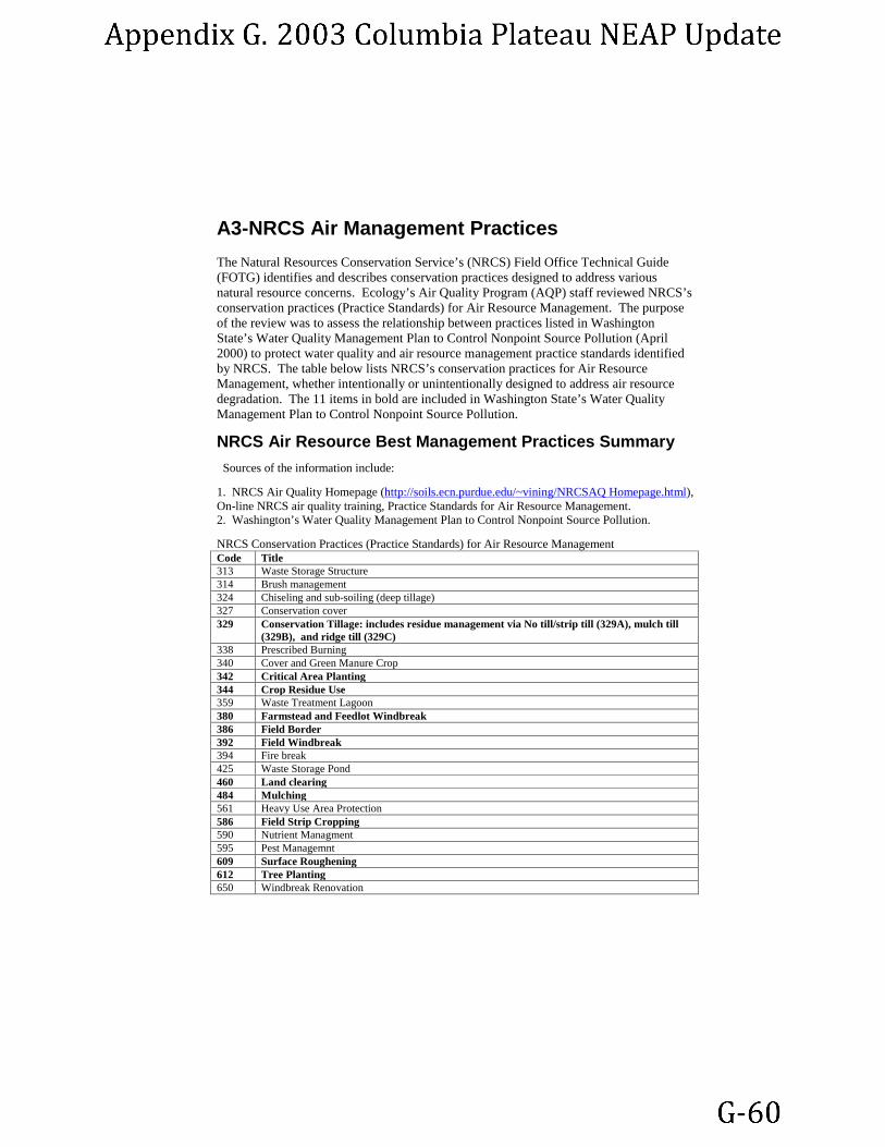
A3-NRCS Air Management Practices
The Natural Resources Conservation Service’s (NRCS) Field Office Technical Guide (FOTG) identifies and describes conservation practices designed to address various natural resource concerns. Ecology’s Air Quality Program (AQP) staff reviewed NRCS’s conservation practices (Practice Standards) for Air Resource Management. The purpose of the review was to assess the relationship between practices listed in Washington State’s Water Quality Management Plan to Control Nonpoint Source Pollution (April 2000) to protect water quality and air resource management practice standards identified by NRCS. The table below lists NRCS’s conservation practices for Air Resource Management, whether intentionally or unintentionally designed to address air resource degradation. The 11 items in bold are included in Washington State’s Water Quality Management Plan to Control Nonpoint Source Pollution.
NRCS Air Resource Best Management Practices Summary Sources of the information include: 1. NRCS Air Quality Homepage (http://soils.ecn.purdue.edu/~vining/NRCSAQ Homepage.html), On-line NRCS air quality training, Practice Standards for Air Resource Management. 2. Washington’s Water Quality Management Plan to Control Nonpoint Source Pollution. NRCS Conservation Practices (Practice Standards) for Air Resource Management Code Title 313 Waste Storage Structure 314 Brush management 324 Chiseling and sub-soiling (deep tillage) 327 Conservation cover 329 Conservation Tillage: includes residue management via No till/strip till (329A), mulch till
(329B), and ridge till (329C) 338 Prescribed Burning 340 Cover and Green Manure Crop 342 Critical Area Planting 344 Crop Residue Use 359 Waste Treatment Lagoon 380 Farmstead and Feedlot Windbreak 386 Field Border 392 Field Windbreak 394 Fire break 425 Waste Storage Pond 460 Land clearing 484 Mulching 561 Heavy Use Area Protection 586 Field Strip Cropping 590 Nutrient Managment 595 Pest Managemnt 609 Surface Roughening 612 Tree Planting 650 Windbreak Renovation

APPENDIX-B: BACM Implementation Analysis
Prepared by Brett Rude, Air Quality Program Ecology relies on the federal, state and local agricultural agencies that are responsible for working with farmers regarding implementation of wind erosion conservation practices (BMPs). The USDA Natural Resources Conservation Service (NRCS), Farm Service Agency (FSA), Agricultural Research Service (ARS) and local conservation districts lead this effort. For this reason, Ecology’s Air Quality Program (AQP) staff evaluated data from 1) the Conservation Technology Information Center’s (CTIC), National Crop Residue Management Survey, and 2) Natural Resources Conservation Service’s (NRCS) compliance reports for fulfilling Food Security Act Requirements. Established in 1982, the CTIC is a national nonprofit public-private partnership working to promote soil and water quality and equip agriculture with affordable, integrated management systems. The CTIC was founded by a group of agribusiness, governmental agency and association partners, as a special project of the National Association of Conservation Districts (NACD). The CTIC annually conducts a National Crop Residue Management Survey. County level data from the survey is available through the CTIC’s Core 4 program. Core 4 tracks conservation (No-Till, Ridge-Till, Mulch-Till) and conventional (0-15% and 15-30% residue) tillage practices and enrollment in the CRP on a county by county basis. Data evaluated is for the year 2000, the most recent year for which data is available. USDA program tracking typically consists of implementation and compliance reports from agencies it directs such as the Farm Service Agency (FSA) reports (monetary components), Natural Resources Conservation Service (NRCS), and the Agriculture Research Service (ARS). In both cases, data was reviewed for the entire Columbia Plateau in order to assess implementation of conservation measures. Ecology determined that the Core 4 data is the best way to track BACM implementation because it provides the most comprehensive information on minimum tillage practices available and includes residue on the field estimations that represent a collection of conservation practices. Table 1 shows Core 4 results for Adams, Grant, Benton, Franklin, Douglas, Walla Walla and Lincoln counties. These are the seven counties that the AQP find to be the most susceptible to wind erosion of PM10.

TABLE 1
Washington State Department of Ecology, Air Quality Program
BACM Assessment: Adams, Grant, Benton, Franklin, Douglas, Walla Walla and Lincoln counties
BACM Component 1
BACM Component 2 Additional Conservation Measures Applied
BACM Total
1 - Adams CRP No-Till Ridge-Till Mulch-Till 15-30% Residue. acres % acres HEL withdrawn from production 192,710 192,710 192,710 100.00%
Fallow acres 237,562 11,878 0 11,878 23,756 47,512 20.00% Planted acres 586,956 51,246 2,053 44,118 53,645 151,062 25.74%
Total farmable acres 1,017,228 19% 63,124 2,053 55,996 77,401 391,284 38.47%
2 - Grant CRP No-Till Ridge-Till Mulch-Till 15-30% Residue. acres % acres HEL withdrawn from production 61,148 61,148 61,148 100.00%
Fallow acres 100,000 1,000 0 24,000 59,000 84,000 84.00%
Total farmable acres 522,498 12% 7,440 0 88,570 157,580 314,738 60.24%
3 - Benton CRP No-Till Ridge-Till Mulch-Till 15-30% Residue. Acres % acres HEL withdrawn from production 75,132 75,132 75,132 100.00%
Fallow acres 131,488 3,550 0 0 67,979 71,529 54.40% Total planted acres 232,100 2,488 0 2,212 124,202 128,902 55.54%
Total farmable acres 438,720 17% 6,038 0 2,212 192,181 275,563 62.81%
BACM (component
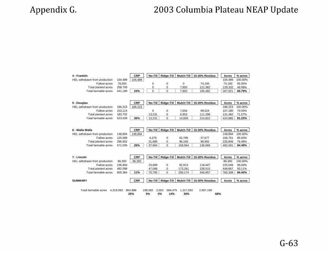
4 - Franklin CRP No-Till Ridge-Till Mulch-Till 15-30% Residue. Acres % acres HEL withdrawn from production 104,489 104,489 104,489 100.00%
Fallow acres 78,000 0 0 0 74,100 74,100 95.00% Total planted acres 258,700 0 0 7,950 121,382 129,332 49.99%
Total farmable acres 441,189 24% 0 0 7,950 195,482 307,921 69.79%
5 - Douglas CRP No-Till Ridge-Till Mulch-Till 15-30% Residue. Acres % acres HEL withdrawn from production 186,223 186,223 186,223 100.00%
Fallow acres 153,114 0 0 7,656 99,524 107,180 70.00% Total planted acres 183,702 13,231 0 6,953 111,298 131,482 71.57%
Total farmable acres 523,039 36% 13,231 0 14,609 210,822 424,885 81.23%
6 - Walla Walla CRP No-Till Ridge-Till Mulch-Till 15-30% Residue. Acres % acres HEL withdrawn from production 148,894 148,894 148,894 100.00%
Fallow acres 125,589 6,279 0 62,795 37,677 106,751 85.00% Total planted acres 296,552 31,685 0 96,169 98,992 226,846 76.49%
Total farmable acres 571,035 26% 37,964 0 158,964 136,669 482,491 84.49%
7 - Lincoln CRP No-Till Ridge-Till Mulch-Till 15-30% Residue. Acres % acres HEL withdrawn from production 86,392 86,392 86,392 100.00%
Fallow acres 236,894 23,689 0 82,913 118,447 225,049 95.00% Total planted acres 482,098 47,096 0 173,261 228,510 448,867 93.11%
Total farmable acres 805,384 11% 70,785 0 256,174 346,957 760,308 94.40%
SUMMARY CRP No-Till Ridge-Till Mulch-Till 15-30% Residue. Acres % acres
Total farmable acres 4,319,093 854,988 198,582 2,053 584,475 1,317,092 2,957,190 20% 5% 0% 14% 30% 68%

APPENDIX-C: 1998 NEAP
Natural Events Action Plan for High Wind Events in the Columbia Plateau
March 1998 Publication No. ??


Natural Events Action Plan for High Wind Events in the Columbia Plateau
Prepared by:
Washington State Department of Ecology Air Quality Program
March 1998
Publication No. ???

The Department of Ecology is an equal opportunity agency and does not discriminate on the basis of race, creed, color, disability, age, religion, national origin, sex, marital status, disabled veteran's status, Vietnam Era veteran's status or sexual orientation.

Table of Contents Executive Summary .............................................................................................. 1 Introduction ........................................................................................................... 2 Purpose ................................................................................................................ 2
Natural Events Policy ..............................................................................................2
Natural Events Action Plan ......................................................................................3
Scope ........................................................................................................................3
Background ........................................................................................................... 5 History of High Wind Events ..................................................................................5
Natural Event Documentation..................................................................................5
Definition of High Wind Events ..............................................................................6
Columbia Plateau Particulate Matter Project ........................................................ 6 EPA Requirements for a Natural Events Exclusion............................................... 7 Public Involvement in Plan Development .............................................................. 8 Natural Events Action Plan for Windblown Dust ................................................... 9
Public Notification and Education ...........................................................................9
Health Advisory Programs .....................................................................................10
Prevention/Mitigation of Reentrainment ...............................................................11
Best Available Control Measures ..........................................................................11 Public Involvement ................................................................................................13
NEAP Reevaluation ............................................................................................ 14 Summary of Activities and Target Dates ............................................................. 15
Appendices APPENDIX A List of Public Education Materials and Examples APPENDIX B Final Draft of Best Management Practices Document


Executive Summary The Columbia Plateau area is an approximately 50,000 square mile tableland that covers much of eastern Washington, northeastern Oregon and part of northern Idaho. Much of the plateau is devoted to agriculture. The combination of seasonal high winds; low precipitation; and fine, wind deposited soil make much of the area highly susceptible to wind erosion. Recognizing that certain uncontrollable natural events, including high wind events, can cause exceedances of the federal National Ambient Air Quality Standard (NAAQS) for PM10, the Environmental Protection Agency (EPA) issued a Natural Events Policy (NEP) on May 30, 1996. The NEP sets forth procedures through the development of a Natural Events Action Plans (NEAP) for protecting public health in areas where the PM10 (particulate matter with an aerodynamic diameter equal to or less than 10 micrometers) NAAQS may be violated due to these uncontrollable natural events. The guiding principles of the policy are:
1. Protection of public health is the highest priority of federal, state, and local air pollution control officials.
2. The public must be informed whenever the air quality in an area is unhealthy. (The air quality is considered unhealthy whenever the 24-hour PM10 standard is exceeded.)
3. All ambient air quality data should be submitted to EPA’s Aerometric Information Retrieval System (AIRS) database and made available to the public.
4. State and local agencies must take appropriate reasonable measures to safeguard public health, regardless of the source of the PM10 emissions.
5. Emission controls should be applied to sources that contribute to exceedances of the PM10 standard when those controls will result in fewer exceedances.
This Natural Events Action Plan is written for the Washington State portion of the Columbia Plateau. It presents out a plan by which involved agencies will:
1. Notify citizens when air quality is likely to be impaired due to high wind events.
2. Advise citizens of steps they can take to minimize their exposure.
3. Develop a program to identify and implement controls for anthropogenic sources of windblown dust in the area
Based on this plan, the US Environmental Protection Agency should exercise their discretion under 170(d)(e) to discount data due to high wind event when evaluating the status of areas in regards to the federal 24-hour PM10 standard. The Washington State Department of Ecology will carry out the commitments made in the plan and will continue to identify and document PM10 exceedances due to high wind events.

Introduction Much of eastern Washington, as well as part of northeastern Oregon and the Idaho panhandle, make up what is known as the Columbia River Plateau. Roughly centered around the Tri-Cities area, where the Snake and Columbia Rivers meet, this plateau extends west to the Cascades, north to the Okanogan Highlands and the Selkirk Mountains of Idaho, east to the Bitterroot Range, and south to the Wallowa Mountains of Oregon - a vast area of about 50,000 square miles. The Columbia Plateau was first visited by European Americans in the early 1800s, and was gradually settled during the mid-19th Century, chiefly by cattle ranchers. By the 1880s, cattle, sheep, and horses had overgrazed the land, and livestock ranching began to give way to farming. Today, wheat and other cereals, potatoes and root crops, and hay and grasses are grown, depending on local conditions. One condition that is fairly consistent over the entire plateau is the lack of rainfall. Although the climate is mild for most of the year, due to the Pacific Ocean, the Cascade Range keeps most of the moisture to the west of the mountains. Rainfall in western Washington averages 70-150 inches per year, while on the Plateau it is limited to less than 20 inches per year - in some areas, less than 10 inches annually. While the presence of rivers means that some fields may be irrigated, water is precious throughout the Plateau, and a dry year can mean a crop failure. It can also produce severe dust storms. The same factors that give the region its mild climate also contribute to the occurrence of high winds at certain times of the year, generally early spring and fall. These periods of transition often generate winds with speeds in excess of 50 miles per hour, lasting for several hours. Since these winds usually occur when agricultural fields are likely to be bare, the potential for soil erosion is significant, and dust storms often result. To address the public health issues surrounding these dust storms, and to comply with EPA’s Natural Events Policy, the Washington State Department of Ecology has prepared this Natural Events Action Plan for high wind events in the Columbia Plateau.
Purpose 1.2 Natural Events Policy The Clean Air Act Amendments of 1990 added a new section to the Clean Air Act – Section 188(f) – which addressed the problem of PM10 (particulate matter with an aerodynamic diameter equal to or less than 10 micrometers) exceedances caused by natural events. Section 188(f) grants the United State Environmental Protection Agency (EPA) the discretionary authority to waive either a specific attainment date or certain planning requirements for PM10 Nonattainment Areas affected significantly by natural events, including wildfires, volcanic activity, and high winds. In June of 1996, the EPA issued its Natural Events Policy, based on Section 188(f). Briefly, this policy allows the exclusion of ambient air quality data collected on days when natural events cause exceedances of the National Ambient Air Quality Standards, provided certain conditions are met.
The purpose of EPA’s Natural Events Policy is to continue and enhance the protection of public health while allowing the exclusion of certain data from the regulatory framework. It recognizes that, while natural events may cause exceedances of the NAAQS for which neither the state nor the regulated community should be held responsible, public health may be compromised regardless of the cause of the exceedances. Thus, to qualify for an exclusion, certain requirements must be met:
• Documentation or demonstration that the exceedances were caused by natural events;
• A plan for the protection of the public, including notification, identification of sensitive populations, and public education; and
• A plan for prevention of the reentrainment of the particulates caused or created by the natural events and the application of Best Available Control Measures to significant, anthropogenic sources.
1.2 Natural Events Action Plan The purpose of this Natural Events Action Plan (NEAP) is to meet the requirements of the EPA’s Natural Events Policy for exclusion of certain data from the regulatory framework. This plan addresses the specific problem of wind-blown dust on and from the Columbia Plateau, and its impact on PM10 Nonattainment Areas, as well as unclassifiable or attainment areas. Briefly, it outlines the steps, which will be taken to protect public health during these episodes, to provide adequate notice to the general public and to identify sensitive populations, to prevent the reentrainment of wind-blown dust, and to identify and implement BACM in significant, anthropogenic source areas. 1.2 Scope This plan applies to the Washington State portion of the Columbia Plateau. Table 1 presents the coordinates and describes the area; Figure 1 provides an area map.

Figure 1. The Area

Table 1 Projection: Universal Transverse Mercator Zone 11 Upper Left Corner 187488.000 E 5379387.000 N Upper Right Corner Intersection of the Washington and Idaho Borders 5379387.000 N Lower Left Corner Intersection of the Washington and Oregon Borders 187488.000 E Lower Right Corner Intersection of the Washington, Oregon and Idaho Borders
Area Description Starting at the intersection of the Washington, Idaho and Oregon borders north following the Washington and Idaho border to 5379387.000 N. Then west along 5379387.000 N to 187488,000 E. South along 187488,000 to the intersection of the Washington and Oregon borders. Then east along the border back to the intersection of the Washington, Idaho and Oregon borders.
Background 1.2 History of High Wind Events During the late 1980s and early 1990s, a large number of exceedances of the 24-hour PM10 National Ambient Air Quality Standard (NAAQS) were recorded in Spokane, Kennewick and Wallula (20 miles northeast of Kennewick), Washington. A detailed examination of these exceedances shows a close correlation to high wind events, with upwind agricultural fields the chief source of the wind-blown dust. (See “Documentation of Natural Event Due To High Winds, June 13, 1994, Wallula, Washington,” Washington State Department of Ecology, December 18, 1996.) The Columbia Plateau is subject to periodic high winds, particularly during the spring, late summer and fall months. Low precipitation coupled with high temperatures causes the evaporation of soil moisture, and the dry soil is more susceptible to wind erosion. Research in the area indicates that much of the soil is very fine, with a low clay content, further contributing to the ease of erosion. Several of these events have been documented and submitted to EPA. 1.2 Natural Event Documentation The EPA Natural Events Policy requires that states flag values they consider are caused by a natural event and document the lists several requirements in order for PM10 exceedances to be treated as having resulted from a natural event. These are:
• Analysis and documentation of the event;
• Flagging of the relevant data in the national EPA database;
• Submittal of documentation to the EPA regional office; and,
• Public notification that the state considers the exceedance as being due to a natural event.
As noted above, analysis and documentation of specific exceedances resulting from high wind events have been submitted to EPA. These data were entered into the EPA Aerometric Information Retrieval System (AIRS) database and flagged as natural events.
1.2 Definition of High Wind Events While in general a “high wind event” can be said to consist of above-average wind speeds and duration of several hours over soils that have relatively low moisture content, a specific definition for an area as large as the Columbia Plateau is very difficult, if not impossible, to articulate. The Columbia Plateau includes a wide variation of soil types and conditions, as well as meteorological conditions, vegetation, and anthropogenic activities. Under these different conditions, there is a range of situations which can lead to “high wind events.” Thus, although several elements must be present for a wind-blown dust exceedance to occur, specific numerical values for each element cannot be assigned, since a variation in one may cause a change in the threshold of another. For example, the lower the soil moisture value, the lower the wind speed necessary to entrain fine particles from agricultural fields. These relationships, and the causes and frequency of occurrence of wind-blown dust events have been extensively studied over the past three years through a large scale, multi-agency project; the Columbia Plateau Particulate Matter Project (see the following discussion). Therefore, since defining such a multi-variant event by the conditions is unfeasible, this NEAP defines as high wind event as follows. A high wind event occurs when wind, soil and other conditions are sufficient to cause an exceedance of the PM-24 hour NAAQS and a program to define and implement BACM for contributing anthropogenic sources is in place. The conditions that contribute to BACM being overcome will be evaluated when the state documents an event. Conditions can include: wind speed, direction and duration; precipitation levels; soil moisture; soil types and soil cover. This definition of high wind events will be reevaluated when the NEAP is reviewed and reevaluated.
Columbia Plateau Particulate Matter Project During the late 1980s and early 1990s, a number of exceedances of the 24-hour PM10 standard were recorded on and downwind of the Columbia Plateau. An analysis of these exceedances showed that they were often accompanied by high winds, and that the exceedances were caused by wind-blown dust from upwind agricultural fields. The recognition of wind-blown dust as a chronic problem led to the application for, and subsequent granting of a three-year waiver of the PM10 attainment date of December 1994, for Wallula. The purpose of the waiver is to allow Ecology, in conjunction with the EPA, the US Department of Agriculture, Washington State University, and other entities to conduct a comprehensive study of the problem of wind-blown dust on the Columbia Plateau; determine source-receptor relationships; assess existing measures for controlling or reducing wind erosion; and to develop and appraise the efficiency of new control measures. The first funding for this research, the Columbia Plateau Particulate Matter Project (CP3) (also known as the Columbia Plateau Wind Erosion/Air Quality Project) was received in September 1993. The Project had eleven major objectives:
1. To develop a base data on climate, soils, vegetation, and farming practices in GIS format;
2. To develop PM10 emission factors for Plateau soils using ambient data and wind tunnel experiments;

3. To develop an air quality inventory for wind erosion events on the Plateau and their impacts on downwind urban areas;
4. To test dispersion models to determine their ability to predict PM10 concentrations from agricultural sources on the Plateau;
5. To identify and test wind erosion control methods for agricultural sources;
6. To use research data to accurately classify areas as Highly Erodable Lands;
7. To determine the relative impact of human activity on erosion rates and suspended dust;
8. To improve public understanding of the problem of wind erosion and PM10;
9. To improve understanding of the health impacts of PM10 from wind erosion;
10. To develop Best Management Practices for agricultural sources of wind-blown dust; and
11. To develop an area-wide plan for high wind events to achieve solutions to PM10 problems throughout the Columbia Plateau.
Much of this research is nearing completion. This Natural Events Action Plan has benefited from the findings and conclusions of the CP3. As future reviews of the NEAP are conducted further research results will be taken into account. Relevant findings regarding public awareness and best available control methods have been incorporated into this NEAP. A summary of the research done as part of the Columbia Plateau PM Project is being finalized and will be forward to EPA upon completion. The Spokane Health Effects Study is being conducted to meet objectives 9 – to improve understanding for the health impacts of soil dust. This study will be concluded in the summer of 1998 and the resulting report will be forwarded to EPA. Summary materials from the Columbia Plateau PM Project are included as Appendix B.
EPA Requirements for a Natural Events Exclusion The EPA has identified five guiding principles that were followed in developing the Natural Events Policy.
1. Protection of public health is the highest priority of federal, state, and local air pollution control officials.
2. The public must be informed whenever the air quality in an area is unhealthy. (The air quality is considered unhealthy whenever the 24-hour PM10 standard is exceeded.)
3. All ambient air quality data should be submitted to EPA’s Aerometric Information Retrieval System (AIRS) database and made available to the public.
4. State and local agencies must take appropriate reasonable measures to safeguard public health, regardless of the source of the PM10 emissions.
5. Emission controls should be applied to sources that contribute to exceedances of the PM10 standard when those controls will result in fewer exceedances.
In order to discount data from natural events, a NEAP should be developed to address future events. The NEAP should include commitments to:
1. Establish public notification and education programs. Such programs may be designed to educate the public about the short- and long-term effects of PM10, and to inform them about the nature and impact of the natural events with respect to air quality and public health. In addition, warnings that a natural event, which could result in unhealthy air quality is imminent, are required. Finally, a plan should include a means of informing the public as to the specific actions being taken to minimize the health impacts of high-wind events.
2. Minimize public exposure to high concentration of PM10 due to future natural events. Populations at risk must be identified and notified that a natural event which could lead to unhealthful air could occur is taking place. The plan should provide a means of suggesting actions that the public and the at-risk populations could take to minimize exposure and to mitigate the impacts if exposure cannot be avoided.
3. Abate or minimize appropriate contributing controllable sources of PM10. For high wind events, this includes the application of BACM to any sources of soil which have been disturbed by anthropogenic activities, and should include measures to prevent reentrainment of wind-blown dust.
4. Identify, study, and implement practical mitigating measures as necessary. A timely schedule for testing new control measures and implementing those which prove technologically and economically feasible.
5. Periodically reevaluate both the causes of violations and the status and effects of the NEAP. At a minimum, the NEAP must be reevaluated every five years.
Public Involvement in Plan Development A draft of this Natural Events Action Plan was prepared by the Washington Department of Ecology, and was reviewed by local Air Pollution Control Agencies (APCAs), EPA and representatives of other federal agencies. The plan was then revised to reflect their comments and suggestions. Ecology will continue to seek input and advice from stakeholders, representatives of other public agencies, and interested parties as commitments made in the plan are completed. In addition to the iterative process described above, the plan will be made available for public comment and review.

Natural Events Action Plan for Windblown Dust 1.2 Public Notification and Education Public Education. The purpose of the education component is to inform the public about the causes and effects of windblown dust; what they can expect when high wind events occur; what steps are in place and will be taken to control or reduce levels of windblown dust; and what periods are most likely to produce such events. The following parties are the primary contributors to the education program: Ecology, local APCAs, Natural Resources Conservation Service (NRCS), Cooperative Extension, Washington State University, and citizen public interest groups. A significant effort has already been expended to make the public aware of the problem of windblown dust on and downwind of the Columbia Plateau. Ecology and the local Air Pollution Control Agencies have published fact sheets, conducted monitoring, and issued warnings concerning specific incidents, when appropriate, an effort that has been ongoing for a number of years. Over the past four years, the Columbia Plateau Particulate Matter Project has focused a great deal of attention on this issue, and one of the goals of the project has been to increase public understanding and awareness of the issue of windblown dust. The public outreach and educational component of the project includes news releases and articles in general-interest publications; articles in specialized publications; field days and tours; public conferences; development and maintenance of a web site; and the preparation of educational materials for use by County extension agents and NRCS staff. A list of articles and publications may be found in Appendix A along with some examples. The result of this effort has been a high level of awareness and understanding of the problem of windblown dust in the affected areas. Surveys conducted in Spokane County and in the Tri-Cities area indicate a very high level of awareness, with nearly sixty percent of the respondents agreeing that control or mitigation of the problem would benefit them personally. In addition, there have been opportunities for public involvement in the CP3 at a number of stages and events. These have been publicized in newspaper advertisements, conference announcements, and outreach through county and agency offices. This public outreach and education effort will continue. Although the current phase of the CP3 study will end in June 1998, the project is expected to continue with funding from the NRCS and the Cooperative States Research Education and Extension Service (CSREES). A number of specific components will be continued, and new elements may be added. The Final Report of the Columbia Plateau PM Project will be published in early 1998 by Ecology. An Executive Summary will be prepared and widely disseminated. In addition, Ecology and the local APCAs will continue to monitor ongoing research on control measures and practices, and will continue to consult with project participants and sponsors on a regular basis.

Both Ecology and the local APCAS will continue their outreach and educational efforts to raise the level of awareness of the problem of windblown dust; and will continue their collaboration with other federal agencies, Washington State University, and stakeholders to explore solutions to the problem. All parties will continue their outreach efforts by preparing exhibits for local fairs and other community events, by preparing and disseminating materials for libraries, schools, and local organizations, and by the continuation of radio interviews, personal appearances, news releases, and display ads in appropriate locations. Public Notification. In addition to general and ongoing educational and awareness efforts described in the previous section, there must be a system or methods in place to notify the public of the possibility that dust storms may occur. To accomplish this, the following steps will be taken. At the beginning of the spring or summer, as appropriate, Ecology and the local APCAs will, as appropriate, issue a notice through media releases as the probability that dust storms may occur that year. This notice will be based on general rainfall levels, the previous year’s agricultural crop size, and other relevant conditions. Ecology and the APCAs will consult with agricultural agencies in writing these notices. These general advisories will be coupled with instructions for mitigating the impacts of windblown dust events on individuals. Insofar as possible, Ecology and the local APCAs will monitor meteorological indicators, and will issue warnings of high wind events to local APCAs and the media, if sufficient time and information are available. 1.2 Health Advisory Programs In addition to general public education and notice programs, additional steps will be taken to educate segments of the population who are more sensitive to the effects of windblown dust, and to notify and assist them in the event of specific episodes. Three segments of the population have been identified as having a higher health risk from exposure to high levels of windblown dust: children, the elderly, and those with respiratory diseases. Children are susceptible because their lungs are still in the formative stages; the elderly because their lung capacity has been diminished by the natural aging process; and those with respiratory diseases because their lungs have been compromised either by chronic conditions such as asthma or by respiratory infection. To educate and alert these sensitive populations, the following steps will be taken:
1. Fact sheets will be prepared by Ecology, local APCAs and local health districts, and distributed through the APCAs and Ecology to appropriate locations, such as schools, senior centers, nursing homes, hospitals, and doctors’ offices. These fact sheets will explain the health effects of windblown dust, and will outline steps to take to mitigate the effects. They will also provide a means of obtaining further information.
2. Materials will be provided to teachers, senior center and nursing home staff, and other locations, as appropriate, explaining the health effects of windblown dust to

sensitive populations, citing sources for alert notices, and outlining steps to be taken in the event of a high-risk situation.
1.2 Prevention/Mitigation of Reentrainment High wind events entrain dust from upwind sources, and carry the dust downwind to population centers. Usually the winds do not stop at the population centers but continue to carry and disperse the particles further downwind. It is possible, however, that particulates from upwind sources could be deposited within the high population centers, posing the risk of reentrainment at any time. Nonattainment Areas have programs in place to mitigate the effects of locally generated particulates. These include street sweeping, control of dust at construction sites, road paving, and controls on stationary sources as appropriate. These programs are generally believed to be sufficient to prevent reentrainment of any particulate matter deposit as a result of high wind events. In addition, Ecology and local APCAs will continue to monitor particulate levels, and, if determined necessary, will take additional steps, such as additional street sweeping, to prevent reentrainment. 1.2 Best Available Control Measures Existing Measures and Applications. To the extent that windblown dust is derived from anthropogenic sources, Best Available Control Measures will be applied to these sources to mitigate the impacts of high wind events. The CP3 has conducted extensive dispersion modeling, wind tunnel experiments, and other research and analysis, and has determined that the major source of the windblown dust is agricultural acreage on the Columbia Plateau. In addition, an experimental process using analysis of specific proteins and other indicators to “fingerprint” particulate matter is being developed and assessed. In general, wind erosion from agricultural acreage is most likely to occur under two scenarios. For dry-land farming, fields are particularly vulnerable to erosion during late summer and early fall. Crops are commonly harvested in the late summer. After harvest, fields are vulnerable if the remaining plant material has been removed and either the field is left fallow or before the winter crop has emerged and the first snows have covered the fields. Dry-land agriculture, since it relies on natural precipitation, is especially susceptible to erosion during period of drought. Irrigated lands are particularly vulnerable during two periods. In the spring, fields can erode while they are being tilled in preparation for seeding or have been seeded but before crops have sufficiently developed to protect the soils. Fields are also vulnerable in the fall, especially when crops are harvested too late to establish a new crop. To prevent or mitigate wind erosion, a number of practices are used. These measures either reduce the direct force of the wind on the soil, or modify the soil surface to make the soil more resistant to wind action. Some measures are appropriate for dry-land farms, some for irrigated farms, and some for both categories. The agriculture community uses the term Best Management Practices (BMPs) for control measures that offer the greatest level of control given available technology and economic considerations. For purposes of this NEAP, Ecology believes that BMPs are equivalent to Best Available Control

Measures (BACM). Therefore, for agricultural practices, Ecology uses the terms Best Management Practices (BMPs) and Best Available Control Measures interchangeable. A number of soil management practices are in use on the Columbia Plateau today. Farmers make choices concerning these practices based on a number of factors. Surveys of dry-land conducted during the CP3 show that most are using at least one management practice to reduce erosion, while about one-third are using four. Only four percent were not using any. Outreach efforts, through the NRCS, the local APCAs, Washington State University, and others will continue to make agricultural practitioners aware of the benefits of such practices. Further BACM Identification. In addition to the practices already in use, research on alternative methods will continue to occur as part of the CP3 research. One of the results of this project has been the preparation of a handbook entitled “Farming with the Wind: Best Management Practices for Controlling Wind Erosion and Air Quality on Columbia Plateau Croplands.” A final draft copy is attached as Appendix C; the final document will be published this summer and distributed to growers. This booklet describes many of the options available to farmers, as well as possible actions that are under study. While one or more of the methods described in this booklet may be appropriate for certain farms or areas, they may not for others. Indeed, BMPs developed should be viewed as components of a “toolbox,” rather than a set of prescribed activities. Once techniques or measures have been evaluated and identified as BMPs, an appropriate technique or set of techniques can be recommended for individual farms. BACM Implementation. Ultimately, control measures will be implemented by agricultural agencies. This is done by conservation districts (CD) and NRCS field staff working with farmers to identify specific conservation practices a grower will use their farm to control erosion and protect the environment. The practices are chosen from either BMPs adopted by the CD and/or identified by NRCS. Under the 1990 amendments to the Food Security Act (FSA) growers who received crop subsidies, loans or other assistance through US Department of Agriculture program were required to develop conservation farm plans. A farm plan is a comprehensive plan for the “mix” of BMPs a grower will use on their farm in order to minimize erosion and environmental impacts. However, the 1996 amendments to the FSA phase out most subsidy programs by 2002. Once the subsidy program is phased out, development of farm plans will be voluntary. However, growers that effectively implement BMPs adopted by their CD are considered to be using reasonable and appropriate controls. If emissions occur under this circumstance, either the conditions at the time overwhelmed the BMP or the BMP is not implemented correctly. Growers that are not correctly implementing adopted BMPs can be held responsible for erosion or discharges from their lands. Development of BACM Program. To assure that identification and implementation of BMPs, it is the intent of Ecology to work with the Agricultural Research Service, NRCS,
the CDs, and other agencies to develop a Memorandum of Agreement for an ongoing BACM program, with the following elements:
1. Continuing research into the Best Management Practices identified above, as well as their impacts, efficiencies, and costs on a site- or location-specific basis;
2. Identification of new techniques and research as to their efficacy in mitigating the problem of windblown dust;
3. Assessment of the impacts of combining two or more methods or practices; and,
4. Identification of developed techniques as Best Management Practices for agriculture in the area.
The state NRCS has indicated that they are updating their technical specification for wind erosion and would like to use the results from the CP3 effort to update and enlarge their adopted practices. Ecology will also pursue the possibility of CDs adopting identify measures as BMPs. This effort will also include continued education and outreach efforts to promote the use of BMPs by growers. The Natural Events Policy states that for high wind events, BACM that is not yet identified is to be implemented as “expeditiously as practicable.” We believe that setting up a process for the coordinated testing, identification, and implementation of BACM will aid in timely implementation of BACM. Education and implementation efforts will be concentrated in the area identified through CP3 as the most susceptible to wind erosion of PM10. These counties are Douglas, Lincoln, Grant, Adams and Franklin. When PM10 values above the 24-hour NAAQS are recorded, Ecology will work with agricultural agencies and others to ensure that growers understand the implication if the area violates the standard and progress toward implementing BACM is not being made. Timeline for BACM Program Development. Ecology is meeting in March 1998, with representatives of the NRCS, CDs, and other agricultural agencies to begin the development of a Memorandum of Agreement to develop a program for the identification and implementation of BMPs in the region. This MOA will be revised as necessary and will be finalized by summer 1998. The MOA will outline specific responsibilities for the program and an anticipated rate-of-progress for BACM implementation. Ecology will conduct a full review of this NEAP in three years (2001). By this time, the final report of the CP3 will have been disseminated and reviewed, the next phase of research will have been completed, and monitors for the new PM2.5 standard will have been put in place. 1.2 Public Involvement In order for this plan to be most effective, the public must be widely aware of its existence and purpose, and must accept it as the most appropriate means of treating a recognized problem. Survey research in Spokane County and other parts of the Columbia Plateau has shown a widespread awareness of the problem of windblown dust among the

public. At the same time, however, there has been a concern that mitigation methods not hurt agricultural practitioners economically. For this reason, in addition to the fact that acceptance of best available control methods by the farmers themselves is contingent upon a demonstration that changes will not be harmful, the CP3 research has been very effective in demonstrating that new methods can be beneficial in a number of ways, and in educating and informing the public of this. Public involvement can and will take many forms, from seeking input on plan revisions to conducting workshops and providing information at County fairs. It is the intent of Ecology that all phases of this process benefit from involvement of a broad spectrum of stakeholders and the public. All public involvement will be documented and reported to EPA. In addition to ongoing public involvement, a more focused effort will be undertake when high levels of PM10 from dust storms are experienced in the area. In this circumstance, an effort will be made to identify the major source area of the dust and a public involvement effort will be undertaken to assure that growers there understand the health effect of PM10 and the possible regulatory impact if exceedances occur and BACM is not being implemented. Ecology will work with the appropriate agricultural agencies to undertake this effort.
NEAP Reevaluation The NEP contains the following language in regards to reevaluation of a NEAP. States should “Periodically reevaluate both the causes of violations and the status and effects of the NEAP. At a minimum, the NEAP must be reevaluated every five years.” Ecology will reevaluate the NEAP and report on progress on a more frequent basis during the next few years. Because the NEAP contains several activities to be completed during 1998, we will be completing a report on the status of these activities and the status and effects of the NEAP at the end of 1998. We will do a second reevaluation three years later at the end of 2001. Ecology believes however, that the frequency of further reevaluations should be dependent on the frequency at which high wind events occur in the Columbia Plateau. If we experience a high frequency of events as we did during the late 1980s and early 1990s, Ecology will evaluate and report on the NEAP at a greater frequency than every five years. However, if high events occur infrequently, Ecology will do a reevaluation every five years as per the NEP.
Summary of Activities and Target Dates For Implementation of the Natural Events Action Plan
Activity Target Date Natural Events Action Plan completed and copy forwarded to EPA March 1998 DOE, NRCS, CDs, and other parties meet to begin negotiation of a March 1998 Memorandum of Agreement for Plan implementation DOE and local APCAs meet with health officials and others to begin April 1998 drafting specific health advisory materials DOE and APCAs meet with local APCAs and others to begin developing April 1998 public education materials Review/revise MOA; develop timeline for identification and May 1998 implementation of BACM Finalize MOA and timeline June1998 Begin review of existing BACM implementation September 1998 Complete review of existing BACM implementation November 1998 First year’s progress and NEAP evaluation December 1998 First reevaluation done

December 2001
APPENDIX-D: EPA Review of 1998 NEAP


APPENDIX-E: First Year Evaluation 1999
1999 Activity Review 1. Identification and Implementation of Best Available Control Measures The identification and implementation of Best Available Control Measurers (BACM) is a major component of the NEAP. Growers and agricultural agencies use the term Best Management Practices (BMPs) in referring to the same level of control. In keeping with this convention, the term BMPs is used here in referring to the equivalent level of control. Farming with the Wind, a Manual of Best Management Practices for Controlling Wind Erosion and Air Quality on Columbia Plateau Croplands was published in 1998. This seventy-two page manual was financed primarily by funds from EPA, Ecology and the Washington Wheat Commission. It was written by staff from US Department of Agriculture, the Agricultural Extension Service, Washington State University and other agencies. The manual is the product of many years of work done through the Columbia Plateau PM Project. Information on emission rates and major sources areas of emissions and the dispersion of PM during high wind events that were develop through CP3 are presented in the manual. It also relies on research into control measures and on the experience of innovative growers in identifying effective and feasible control measures. Three thousand copies of the manual were printed and are being distributed to growers through out the area. A copy of the manual is enclosed with this letter. Direct Seeding Other the past several years there has been increased interest in direct seeding (or no-till) farming. Direct seeding involves leaving residue from the previous crop on the field instead of plowing it into the soil. Crops are seeded directly through the residue concurrent with an application of fertilizer. The plant residue covers the soil and deters evaporation of moisture, an important consideration in low precipitation areas such as the plateau. The increased soil moistures allows growers to crop fields every year instead of every other year as is presently done in much of the area. Direct seeding is used in many area of the world and has increased growers’ yield and profitability. Local growers’ interest is based on their awareness of the need to increase profitability to stay competitive in an increasing global market. From pollution prevention stand point, direct seeding is an excellent cropping practices for controlling wind and water erosion because it provides an excellent layer of residue.
2. Educational Efforts During 1998 there continued to be an extensive public information and education effort throughout the plateau supporting the advantages of conservation measures. Efforts included: tours, and conferences; fact sheets and articles in Wheat Life (publication of the Washington Association of Wheat Growers) and other local periodicals; and on farm testing which promotes communication between growers. Enclosed is a list of some of the major efforts.
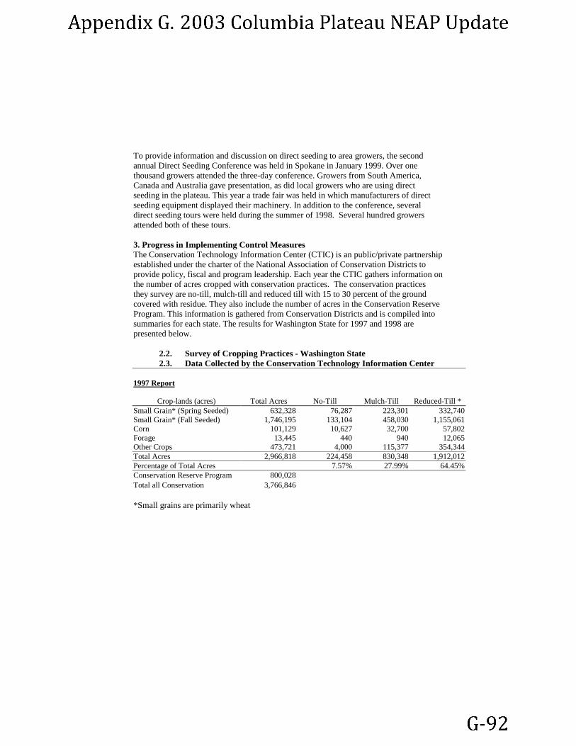
To provide information and discussion on direct seeding to area growers, the second annual Direct Seeding Conference was held in Spokane in January 1999. Over one thousand growers attended the three-day conference. Growers from South America, Canada and Australia gave presentation, as did local growers who are using direct seeding in the plateau. This year a trade fair was held in which manufacturers of direct seeding equipment displayed their machinery. In addition to the conference, several direct seeding tours were held during the summer of 1998. Several hundred growers attended both of these tours. 3. Progress in Implementing Control Measures The Conservation Technology Information Center (CTIC) is an public/private partnership established under the charter of the National Association of Conservation Districts to provide policy, fiscal and program leadership. Each year the CTIC gathers information on the number of acres cropped with conservation practices. The conservation practices they survey are no-till, mulch-till and reduced till with 15 to 30 percent of the ground covered with residue. They also include the number of acres in the Conservation Reserve Program. This information is gathered from Conservation Districts and is compiled into summaries for each state. The results for Washington State for 1997 and 1998 are presented below.
2.2. Survey of Cropping Practices - Washington State 2.3. Data Collected by the Conservation Technology Information Center
1997 Report
Crop-lands (acres) Total Acres No-Till Mulch-Till Reduced-Till * Small Grain* (Spring Seeded) 632,328 76,287 223,301 332,740 Small Grain* (Fall Seeded) 1,746,195 133,104 458,030 1,155,061 Corn 101,129 10,627 32,700 57,802 Forage 13,445 440 940 12,065 Other Crops 473,721 4,000 115,377 354,344 Total Acres 2,966,818 224,458 830,348 1,912,012 Percentage of Total Acres 7.57% 27.99% 64.45% Conservation Reserve Program 800,028 Total all Conservation 3,766,846 *Small grains are primarily wheat

1998 Report
Crop-lands (acres) Total Acres No-Till Mulch-Till Reduced-Till
Small Grain (Spring Seeded) 631,347 86,828 191,278 353,241 Small Grain (Fall Seeded) 1,733,571 163,886 424,436 1,145,249 Corn 101,083 9,944 33,900 57,239 Forage 15,225 340 740 14,145 Other Crops 510,810 6,029 120,100 384,681 Total Planted Acres 2,992,036 267,027 770,454 1,954,555 Percentage of Total Acres 8.92% 25.75% 65.33% Conservation Reserve Program 902,311 Total all Conservation 3,894,347
The following table compares the change between 1997 and 1998 in acreage planted in each conservation practice. The largest percentage of increase was in no-till cropping while mulch-till decreased by seven percent. This decrease is likely due to mulch-til lands being converted to no-till. The overall increase in conservation tillage was 3.39 percent. Change in Acreage
Total Acres No-Till Mulch-Till Reduced-Till CRP Acres -1997 3,766,846 224,458 830,348 1,912,012 800,028 Acres -1998 3,894,347 267,027 770,454 1,954,555 902,311 Increase in Acreage 127,501 42,569 -59,894 42,543 102,283 Percentage Increase 03.39% 18.97% -7.21% 2.23% 12.78% 4. Review of Activities and Target Dates The NEAP written in 1998 included a summary of activities and target dates for several actions. Some of these target dates have been revised based on further discussions with growers and cooperating agencies. In April 1998, a meetings was held in Ritzville with staff from the EPA, the Natural Resources Conservation Service (NRCS), air pollution authorities and two conservation districts (CD). Agricultural agency staff were united in the opinion that to effectively implement BMPs, the CDs should adopt them at the local level. Since CDs are composed of local growers, BMPs adopts by the districts are more acceptable to a majority of growers. Whereas, BMPs adopted by Ecology or even NRSC are viewed being imposed from the outside. While this is excellent advice, there are approximately thirty CDs in the Columbia Plateau. Developing MOAs with the individual CDs would take time and effort. Many of the CD are distrustful of regulatory agencies especially with the recent controls imposed on the burning of grass seed stubble. Ecology plans to work with the Adams and Lincoln CDs to explore the possibility of developing agreements. These two districts include a large portion of the most erodible land in the plateau.

Another activity identified was the development of public education materials. A pamphlet describing the health effects of dust and what steps people can take to mitigate these impacts has been developed by Ecology public information staff. This pamphlet is being reviewed by air authority staff and will be published and distributed throughout the plateau. A copy of the pamphlet’s text is included as an attachment to this document. 5. Conclusions A large quantity of work has been undertaken during 1998 to implement the NEAP. The principle achieve was the publication and distribution of the BMP Manual, Farming in the Wind. Also, an enormous public information campaign has been on going primarily through the Columbia Plateau PM Project There is an obvious interest by growers in direct seeding and other conservation practices, particularly those that can increase yield and profitability. This is evidenced by the large attendance at the direct seeding conference in December. The more concrete evidence however, is the increase in the number of acres that were converted into conservation tillage between 1997 and 1998. 6. Further Activities
Education Education will continue at the same level. Growers tours and field days are planned for next summer. WSU Extension Service will continue to produce fact sheets and other written materials for growers on research results and recommendations for practices. Staff will also continue to write articles for publications that reach growers. Continued Research Research staff with ARS and WSU continues to receive approximately $400,000 annually from the US Department of Agriculture to fund research in the Columbia Plateau. About one half is used to fund research into control practices. Many of these projects are entering their third year. Having three years of data will give more accurate results on the long-term viable of investigated control measures. Implementing Control Measures/Overcoming Barriers Ecology and EPA have contracted with the Department of Agriculture Economics at WSU to conduct a survey of existing economic incentive programs. They are writing a report evaluating programs and identifying those applicable to Eastern Washington. Also under this contract, they will coordinate focus group meetings in early spring with growers and agricultural agency staff to discuss barriers to implementing BMPs and possibilities for economic incentives. Local Adoption of BMPs During 1999, Ecology will explore the possibility of working with the Adams and Lincoln Conservation Districts on adopting BMPs at the local level. These districts include the largest proportion of highly erodible lands and have shown some guarded interest in working with Ecology on adoption of BMPs and education for growers.
Direct Seeding Many of these activities will focus on direct seeding. Direct seeding is potentially the most promising BMP for controlling soil erosion from wind and water. Because it can also increase farm yield and profitability, growers are very interested in the system. However, changing to direct seeding involves the purchase of new tillage equipment at a cost of approximately $100,000. Direct seeding also involves an approximately five year transitional period during which crop yields can decrease. This and the risk involved in transitioning to a different cropping system can mean a real or perceived decreased in income for growers.