columbia county planning and zoning board january 28, …
TRANSCRIPT

___________________
COLUMBIA COUNTY
PLANNING AND ZONING BOARD
January 28, 2016 MEETING AGENDA COLUMBIA COUNTY SCHOOL BOARD ADMINISTRATIVE COMPLEX
372 WEST DUVAL STREET, LAKE CITY, FLORIDA
7:15 P.M.
Public Hearings
SDP 15 11 – A request by Mark Magstadt, agent for MTM Capital Holdings, Inc., owner, for
site and development plan approval for the addition of a ±6,300 square foot
cafeteria for a Public Elementary and Middles School use located in the
AGRICULTURE - 3 (“A-3”) and ENVIRONMENTALLY SENSITIVE AREA -2
(“ESA-2”) Zone Districts (Tax Parcel Number 03568-004)
Staff Matters
Adoption of the December 16, 2015 meeting minutes.
Discussion Items
None
NOTE: All persons are advised that if they decide to appeal any decision made at the above referenced public
hearings, they may need a record of the proceedings, and that, for such purpose, they may need to ensure
that a verbatim record of the proceedings is made, which record includes the testimony and evidence upon
which the appeal is to be based.

District No. 1 - Ronald Williams
District No. 2 - Rusty DePratter
District No. 3 - Bucky Nash
District No. 4 - Everett Phillips
District No. 5 - Scarlet Parnell Frisina
Planning & Zoning Board Hearing Date: January 28, 2015
SUBJECT: SDP 15 05 - A request for Site Plan approval for a proposed
expansion for a Charter School as permitted in accordance with
Section 4.5.5 of the Land Development Regulations (“LDRs”). The
proposed expansion consists a ±6,300 square foot cafeteria
building.
APPLICANT/AGENT: Mark Magstadt
MTM Capital Holdings, Inc. PROPERTY
OWNER(S):
North of Meade Ministries and SW County Road 240; South of LOCATION: Rose Creek and Single Family Residences; West of Single Family
Residences; and East of SW Walter Little Avenue and Rose Creek
Plantation; Columbia County, Florida.
11-5s-16-03568-004 PARCEL ID
NUMBER(S):
±24.56 acres ACREAGE:
Environmentally Sensitive Area (“ESA”) & EXISTING FLUM Agriculture
Environmentally Sensitive Area - 2 (“ESA-2”) & EXISTING ZONING Agriculture – 3 (“A-3)
Brandon M. Stubbs PROJECT PLANNER:
BOARD MEETS THE FIRST THURSDAY AT 5:30 P.M.
AND THIRD THURSDAY AT 5:30 P.M.
P.O. BOX 1529 ⧩ LAKE CITY, FLORIDA 32056-1529 ⧩ PHONE: (386) 755-4100

SUMMARY
The subject property is currently utilized by Belmont Academy Charter School. The school has an
existing school-house and seventeen (17) modular buildings that are utilized as classrooms. The
applicant proposes to add a ±6,300 square foot cafeteria building.
Map 1. Existing Official Zoning Atlas with Subject Property
Page 2 of 12

The Environmentally Sensitive Area ("ESA") Zone District is described as follows in Section 4.4.1 of the Land Development Regulations (“LDRs”):
“The "ESA" environmentally sensitive area category includes three zone districts: ESA-1, 2, 3. Lands in
these districts are considered in need of special planning and treatment regarding land development
regulation. These are not preservation districts, but land uses permitted within these districts are to
provide mitigating measures to protect the natural functions of areas which are limited to the planning
and treatment of land development within the 100-year floodplain of the Ichetucknee Springs State Park,
O'Leno State Park, Osceola National Forest, Pinhook Swamp, Suwannee River Corridor, Santa Fe River
Corridor and Ichetucknee Trace, as designated within the Federal Emergency Management [Agency] flood
insurance rate map for the county, as amended. These regulations prohibit intensive residential, intensive
recreational and intensive agricultural uses and prohibit industrial and commercial development within
the 100-year floodplain of the areas designated as environmentally sensitive areas.”
The Agriculture - 3 ("A-3") Zone District is described as follows in Section 4.5.1 of the Land
Development Regulations (“LDRs”):
“The "A" Agricultural category includes three zone districts: A-1, A-2 and A-3. Lands in these districts are
intended to provide for areas primarily consisting of agricultural and residential uses consistent with the
areas as designated agricultural within the county's comprehensive plan.”
ZONING DISTRICT COMPARISON
Zoning District: Environmentally Sensitive Area - 2
("ESA - 2")
Agriculture - 3
("A - 3")
Max. Gross Density: One (1) Dwelling Unit per Ten (10)
Acres
One (1) Dwelling Unit per Five (5)
Acres
Minimum Lot Area 10 Acres 5 Acres
Floor Area Ratio: 0.20 0.20
Typical Uses*:
Non-Intensive Agriculture, Single-
Family Dwellings, Mobile Homes,
Homes of six or fewer residents
which otherwise meet the definition
of a “Community Residential
Facility”, Public Resource-Based
Recreation Facilities, and Churches
and other Houses of Worship
All Agriculture Activities, The
Processing, Storage, and Sale of
Agricultural Products, Single-Family
Dwellings, Mobile Homes, Plant
Nurseries and Greenhouses, Homes
of six or fewer residents which
otherwise meet the definition of a
“Community Residential Facility”,
Public Elementary and Middle
Schools, and Churches and other
Houses of Worship
Page 3 of 12

SURROUNDING USES
North of the subject property are Single Family Residences and Rose Creek; south of the subject property
is Meade Ministries and SW County Road 240; west of the subject property is Single Family Residences;
and east of the subject property are SW Walter Drive and Rose Creek Plantation.
The existing uses, Future Land Use Map (“FLUM”) Designations, and zone districts of the surrounding
area are identified in Table 1. Map 2 provides an overview of the vicinity of the subject property.
Table 1. Surrounding Land Uses
North
Direction
Rose Creek/Single Family
Residences
Existing Use(s)
Meade Ministries/
Agriculture
/Environmentally
Sensitive Area
FLUM
Designation(s)
Agriculture – 3 (“A-
3”)/Environmentally
Sensitive Area - 2 (“ESA-2”)
Zoning District(s)
East
South
SW Walter Avenue/Rose Creek
Plantation
SW County Road 240
Agriculture
/Environmentally
Sensitive Area
Agriculture
Agriculture – 3 (“A-
3”)/Environmentally
Sensitive Area - 2 (“ESA-2”)
Agriculture – 3 (“A-3”)
West Single Family Residences
Agriculture
/Environmentally
Sensitive Area
Agriculture – 3 (“A-
3”)/Environmentally
Sensitive Area - 2 (“ESA-2”)
Map 2. Vicinity Map
Page 4 of 12

CONSISTENCY WITH THE COMPREHENSIVE PLAN
The zoning designation is consistent with the underlying Future Land Use Map (“FLUM”) Designation.
Below is a chart of the existing FLUM Designation and the existing zoning designation.
Table 2. Zoning Consistency with Underlying Future Land Use Map Designation
FLUM Designation Zoning Designation Consistent
Environmentally Sensitive
Area & Agriculture
Environmentally Sensitive Area – 2
(“ESA-2”) & Agriculture – 3 (“A-3”)
The following Comprehensive Plan Elements have Goals, Objectives, and Policies (GOPs) that support the
proposed Site Specific Amendment to the Official Zoning Atlas:
• Future Land Use Element
• Transportation Element
• Sanitary Sewer, Solid Waste, Drainage,
Potable Water, and Natural Groundwater
Aquifer Recharge Element
Map 3. Existing Future Land Use Map Designation
Page 5 of 12

Staff has reviewed the application for Site Plan Approval for consistency with the Comprehensive Plan
and finds the application consistent with the Comprehensive Plan and the Goals, Objectives, and Policies
(GOPs) therein.
ENVIRONMENTAL CONDITIONS ANALYSIS
Wetlands
According to Illustration A-VI of the Comprehensive Plan, entitled Wetlands Areas, which is based upon
the National Wetlands Inventory, dated 1987, and the National Wetlands Reconnaissance Survey, dated
1981, there are no wetlands located on the subject property.
Evaluation: Even though the National Wetland Inventory does not indicate any wetlands on the subject
property, the subject property is located along Rose Creek and could potentially have wetlands located on
the subject property; however, the site plan does not propose any development within any wetland areas.
The Land Development Regulations has buffer requirements from all wetland areas. Give the preceding
information, there are no issues related to wetland protection.
Map 4. Wetlands Map
Page 6 of 12

Soil Survey
Each soil type found on the subject property is identified below. The hydrologic soil group is an indicator
of potential soil limitations. The hydrologic soil group, as defined for each specific soil, refers to a group
of soils which have been categorized according to their runoff-producing characteristics. These
hydrologic groups are defined by the Soil Survey of Columbia County, Florida, dated October 1984. The
chief consideration with respect to runoff potential is the capacity of each soil to permit infiltration (the
slope and kind of plant cover are not considered, but are separate factors in predicting runoff). There are
four hydrologic groups: A, B, C, and D. “Group A” soils have a higher infiltration rate when thoroughly wet
and therefore have a lower runoff potential. “Group D” soils have very lower infiltration rates and
therefore a higher runoff potential.
There are three (3) soil types found on the subject property:
1) Albany fine sand soils (0 to 5 percent slope) are somewhat poorly drained, nearly level to gently
sloping soils on broad flats bordering poorly defined drainageways and in undulating areas. The
surface and subsurface layers are comprised of fine sand to a depth of 55 inches. The subsoil layer is
comprised of sandy clay loam to a depth of 80 inches or more. Albany fine sand soils (0 to 5 percent
slope) have severe limitations for building site development and for septic tank absorption fields.
2) The Blanton-Bonneau-Ichetucknee soil complex (5 to 8 percent slopes) is on undulating landscapes.
The Blanton soil comprises approximately 30 percent of the soil complex. Typically the surface and
subsurface layers are comprised of fine sand to a depth of 49 inches. The subsoil layer is comprised
of sandy loam to a depth of 80 inches or more. The Bonneau soil comprises approximately 25 percent
of the soil complex. Typically the surface and subsurface layers are comprised of fine sand to a depth
of 24 inches. The subsoil layer is comprised of fine sandy loam and sandy clay loam to a depth of 68
inches. The Ichetucknee soil comprises approximately 20 percent of the soil complex. Typically the
surface and subsurface layers are comprised of fine sand to a depth of 7 inches. The subsoil layer is
comprised of clay to a depth of 80 inches or more. The Blanton-Bonneau-Ichetucknee soil complex (5
to 8 percent slopes) has slight to moderate limitations for building site development and moderate to
severe limitations for septic tank absorption fields.
3) Ichetucknee fine sand soils (5 to 8 percent slopes) are somewhat poorly drained, sloping soils on
upland hillsides. The surface and subsurface layers are comprised of fine sand to a depth of 7 inches.
The subsoil layer is comprised of clay to a depth of 75 inches. Ichetucknee fine sand soils (5 to 8
percent slopes) have moderate limitations for building site development and severe limitations for
septic tank absorption fields.
Evaluation: The predominant soil type on the subject property is Albany Fine Sand. Albany Fine Sand
poses severe limitations for septic tank absorption fields and building site development. Given the site is
already developed, there are no issues related to soil suitability. If the applicant expands the school in the
future, the applicant will be required to install a package plant to process sanitary sewer.
Page 7 of 12

Map 5. Soils Map
Flood Potential
Panel 0383C of the Federal Emergency Management Agency (FEMA) Flood Insurance Rate Map (FIRM)
Series, dated February 4, 2009, indicates that the subject property is in Flood Zone "AE" (areas where a
base flood elevation is determined) and Flood Zone “X” (areas outside the 500 year flood) The Flood Zone
“AE” has a Base Flood Elevation of 58 feet.
Evaluation: Even though the subject property is partially located in Flood Zone "AE", the proposed
structures are to be located in the Flood Zone “X” portion of the subject property; therefore, there is no
concern of flood on the subject property.
Page 8 of 12

Map 6. FEMA FIRM Map (Flood Map)
Stream to Sink
According to the Stream to Sink Watersheds, prepared by the Suwannee River Water Management District
and adopted by the Board of County Commissioners, dated June 2, 2001, the subject property is located
within a stream to sink area.
Evaluation: Section 4.2.38 of the County’s LDRs regulates Stream to Sink watershed areas. Section 4.2.38
requires all development not otherwise prohibited to comply with the following:
1. All new development, redevelopment and expansion of existing development shall
provide stormwater detention or retention and treatment for development within a
stream to sink watershed consistent with the rules of the Suwannee River Water
Management District, as contained in chapter 40B, Florida Administrative Code.
2. All new development not connected to a central sanitary sewer system shall be limited to
densities that prevent degradation of groundwater quality. Where the installation, use
and proper maintenance of technologically advanced wastewater treatment or septic
systems are shown to be effective in maintaining groundwater quality, higher densities
may be permitted in stream to sink watershed areas.
3 All new development, redevelopment and expansion of existing development shall
ensure that post development water runoff rate does not exceed pre-development runoff
rate and that water quality is not degraded within stream to sink watershed areas.
4. All new development shall comply with all other applicable requirements of these land
development regulations.
Page 9 of 12

The applicant has complied with the above standards; therefore, there is no concern related to Stream to
Sink Watersheds.
Minerals
According to Illustration A-VII of the Comprehensive Plan, entitled Minerals, which is based upon Natural
Resources, prepared by the Florida Department of Environmental Protection, 2012, the subject property
is within an area known to contain Clayey Sand.
Evaluation: There are no issues related to minerals.
Historic Resources
According to Illustration A-II of the Comprehensive Plan, entitled Historic Resources, which is based upon
the Florida Division of Historical Resources, Master Site File, dated 2013, there are no known historic
resources located on the subject property.
Evaluation: There are no issues related to historic Resources.
Aquifer Vulnerability
According to the Columbia County Floridan Aquifer System Protection Zone Map, prepared by the Advance
GeoSpacial Inc., dated September 29, 2009, the subject property is located in a more vulnerable area.
Evaluation: While the subject property is located in a more vulnerable area, there is no issue related to
aquifer vulnerability.
Vegetative Communities/Wildlife
According to Illustration V-I of the Data and Analysis Report, entitled Vegetative Communities, the subject
property is located within a non-vegetative community.
Evaluation: There is no known wildlife habitats associated with a non-vegetative community; therefore,
there is no issue related to vegetative communities or wildlife.
COMPLIANCE WITH THE LAND DEVELOPMENT REGULATIONS
Section 14.13 of the Land Development Regulations (“LDRs”) regulates Site and Development Plans.
County Staff has reviewed the proposed Site Plan and has found the Site Plan to be in compliance with
Section 14.13.
Page 10 of 12
PUBLIC FACILITIES IMPACT
Traffic Impact
Evaluation: The proposed use of a cafeteria does not increase the staff or student population of the
school; therefore, no increase in traffic is anticipated. The impacts generated by the development will not
adversely affect the Level of Service (LOS) of the adjacent roadway segment; therefore, the demand
generated by the development is acceptable.
Potable Water Impacts
The subject property is not located within a community potable water system service area. The subject
property is served via a private potable water treatment facility with a permit capacity of 264,000 Gallon
Per Day (“GPD”). The potable water treatment facility is anticipated to meet or exceed the adopted level
of service standard for potable water established within the Comprehensive Plan. Note: Calculations are based upon Chapter 64E-6.003,F.S.
The proposed development will result in approximately 6,300 square foot cafeteria for a charter school.
The proposed use does not propose an increase in staff or student population. The proposed addition will
be covered within the existing permitted capacity for the existing school.
Evaluation: The subject property is served potable water via a private water system that is permitted by
the Florida Department of Environmental Protection (Permit #WC12-301360). The private potable water
system has a 264,000 GPD capacity. The impacts generated by the development will not adversely affect
the Level of Service (LOS) for potable water facilities; therefore, the demand generated by the
development is acceptable.
Sanitary Sewer Impacts
The site is not located within a community centralized sanitary sewer system. The subject property is
served via two septic tanks permitted by the Columbia County Environmental Health Department
(Permit #’s 91-284 & 14-0116). Permit # 91-284 has a permitted capacity of 3,960 GPD. Permit # 15-
0116 has a permitted capacity of 3,475 GPD. Together, the total permitted capacity is 7,435 GPD. Note: Calculations are based upon Chapter 64E-6.003,F.S.
The proposed development will result in approximately 6,300 square foot cafeteria for a charter school.
The proposed use does not propose an increase in staff or student population. The proposed addition will
be covered within the existing permitted capacity for the existing school.
Evaluation: The subject property is served via private septic tanks permitted by the Columbia County
Environmental Health Department with a total permitting capacity of 7,435 GPD. The impacts generated
by the development will not adversely affect the Level of Service (LOS) for sanitary sewer facilities;
therefore, the demand generated by the development is acceptable.
Solid Waste Impacts
Solid waste facilities for uses to be located on the site are provided at the sanitary landfill. The level of
service standard established within the Comprehensive Plan for the provision of solid waste disposal is
currently being met or exceeded.
The proposed development will result in approximately 6,300 square foot cafeteria for a charter school.
Page 11 of 12

Based upon 5.5 pounds of solid waste per 1,000 square foot gross floor area per day:
6.3 (6,300 square foot gross floor area) x 5.5 (pounds of solid waste 1,000 square foot gross floor area
per day) = 34.65 pounds of solid waste generated per day.
Total County average solid waste disposal per day (including municipalities) = 471,300 pounds per day.
Based upon the annual projections of solid waste disposal at the landfill for 2015, solid waste facilities
are anticipated to continue to meet or exceed the adopted level of service standard for solid waste
facilities, as provided in the Comprehensive Plan, after adding the solid waste demand generated by a
charter public school.
Evaluation: The impacts generated by the development will not adversely affect the Level of Service
(LOS) of solid waste facilities; therefore, the demand generated by the development is acceptable.
Recreation Facilities
The proposed development is nonresidential in nature; therefore, there are no impacts to recreation
facilities. The development will have no impact to the Level of Service (LOS) of recreation facilities.
Public School Facilities
The proposed development is nonresidential in nature; therefore, there are no impacts to public school
facilities. The development will have no impact to the Level of Service (LOS) of public school facilities.
Page 12 of 12
RESOLUTION NO. PZ SDP 15-11
A RESOLUTION OF THE PLANNING AND ZONING BOARD OF COLUMBIA
COUNTY, FLORIDA, APPROVING A SITE AND DEVELOPMENT PLAN WITH
APPROPRIATE CONDITIONS AND SAFEGUARDS FOR A PUBLIC ELEMENTARY
AND MIDDLE SCHOOL USE LOCATED IN THE AGRICULTURE - 3 (“A-3”) AND
ENVIRONMENTALLY SENSITIVE AREA – 2 (“ESA-2”) ZONING DISTRICTS ON
CERTAIN LANDS WITHIN THE UNINCORPORATED AREA OF COLUMBIA
COUNTY, FLORIDA; REPEALING RESOLUTIONS IN CONFLICT; AND PROVIDING
AN EFFECTIVE DATE.
WHEREAS, Ordinance No. 98-1, as amended, entitled Columbia County Land Development
Regulations, hereinafter referred to as the Land Development Regulations, empowers the Planning
and Zoning Board of Columbia County, Florida, hereinafter referred to as the Planning and Zoning
Board, to approve, to approve with conditions, or to deny site and development plans in accordance
with the Land Development Regulations;
WHEREAS, an application for a site development plan, as described below, has been filed
with the County;
WHEREAS, the Planning and Zoning Board, has determined and found that approval of said
site and development plan, as described below, would promote the public health, safety, morals,
order, comfort, convenience, appearance, prosperity or general welfare; and
WHEREAS, the Planning and Zoning Board, has studied and considered the items
enumerated in Section 14.13 of the Land Development Regulations and based upon said study and
consideration has determined and found that:
1. A site and development plan was prepared and submitted to the County in accordance with
the provisions of Section 14.13.1 of the Land Development Regulations;
2. Statements on ownership and control of the development and of conditions of ownership or
control, use, and permanent maintenance of common open space, common facilities, or
common lands to ensure preservation of such lands and facilities for their intended purpose
and to ensure that such common facilities will not become a future liability for the Board of
County Commissioners are sufficient;
3. Density and/or the intended use of the proposed development with particular attention to
its relationship to adjacent and nearby properties and effect on those properties and
relationship to the Comprehensive Plan are in accordance with the Comprehensive Plan and
Land Development Regulations;
4. Ingress and egress to the development and proposed structures on the development
provide for automotive and pedestrian safety, minimization of marginal friction with free
movement of traffic on adjacent streets, separation of automotive traffic and pedestrian and
other traffic, traffic flow and control, provision of services and servicing of utilities and
refuse collection, and access in case of fire, catastrophe, or emergency;
5. Location and relationship of off-street parking and off-street loading facilities to
thoroughfares and internal traffic patterns within the proposed development, with
particular reference to automotive and pedestrian safety, traffic flow and control, access in
case of fire or catastrophe, and screening and landscape are adequate;
Page 1 of 3

6. Proposed screens and buffers sufficiently provide for the preservation of internal and
external harmony and compatibility with uses inside and outside the proposed
development;
7. Manner of stormwater management will not adversely affect the provisions for stormwater
management on adjacent and nearby properties and overall public stormwater
management capacities;
8. Provision for sanitary sewers is adequate in relationship to overall sanitary sewer
availability and capacities;
9. Utilities, with reference to hook-in locations and availability and capacity for the uses
projected are adequate;
10. Recreation facilities and open spaces, with attention to the size, location, and development
of the areas as to adequacy, effect on privacy of adjacent and nearby properties and uses
within the proposed development, and relationship to community open spaces and
recreational facilities are adequate;
11. General amenities and convenience, with particular reference to appearance and general
layout of the proposed development will be compatible and harmonious with properties in
the general area and will not be in conflict with other development in the area as to cause
substantial depreciation of property values; and
12. Said site and development plan conforms to all other standards imposed by the Land
Development Regulations.
NOW, THEREFORE, BE IT RESOLVED BY THE PLANNING AND ZONING BOARD OF COLUMBIA
COUNTY, FLORIDA, THAT:
Section 1. Pursuant to an application, SDP 15-11, an application by Mark Magstadt, agent for MTM
Capital Holdings, Inc., owner, for site and development plan approval for the addition of a ±6,300
square foot cafeteria for a Public Elementary and Middles School use located in the AGRICULTURE -
3 (“A-3”) and ENVIRONMENTALLY SENSITIVE AREA -2 (“ESA-2”) Zone Districts in accordance with
a site plan dated December 18, 2015, subject to conditions, and submitted as part of an application
dated December 21, 2015 to be located on property described, as follows:
A PART OF THE E 1/2 OF NE 1/4 OF SECTION 11, TOWNSHIP 5 SOUTH, RANGE 16 EAST, COLUMBIA COUNTY, FLORIDA, MORE PARTICULARLY DESCRIBED AS FOLLOWS:
COMMENCE AT THE INTERSECTION OF THE WEST LINE OF THE E 1/2 OF THE NE 1/4 OF SAID
SECTION 11 WITH THE NORTH RIGHT-OF-WAY LINE OF STATE ROAD 240, AND RUN THENCE N
01°28'33" W, ALONG THE WEST LINE THEREOF, 955.13 FEET TO THE POINT OF BEGINNING;
THENCE CONTINUE N 01°28'33" W, ALONG SAID WEST LINE, 723.57 FEET TO THE NORTHWEST
CORNER OF NE 1/4 OF NE 1/4 OF SAID SECTION 11; THENCE N 87°10'04" E ALONG NORTH LINE
OF SAID SECTION 11, 347.40 FEET; THENCE S 84°10'04" E, 770.03 FEET; THENCE N 87°14'14" E,
122.71 FEET TO THE WEST RIGHT OF WAY LINE OF SW WALTER AVENUE; THENCE
SOUTHERLY ALONG SAID WEST RIGHT OF WAY THE FOLLOWING COURSES: S 00°25'22" E,
31.92 FEET TO A POINT OF CURVATURE; SAID CURVE BEING CONCAVE TO THE EAST, HAVING
A RADIUS OF 1137.77, A CENTRAL ANGLE OF 02°57'43", A CHORD BEARING AND DISTANCE OF
S 01°41'23"E -58.81 FEET, AN ARC DISTANCE OF 58.82 FEET; S 03°14'41"E, 94.20 FEET TO A
Page 2 of 3

POINT OF CURVATURE; SAID CURVE BEING CONCAVE TO THE WEST, HAYING A RADIUS OF
8267.76, A CENTRAL ANGLE OF 00°55'56", A CHORD BEARING AND DISTANCE OF S 02°50'51" E
- 134.53 FEET, AN ARC DISTANCE OF 134.53 FEET; S 02°16'35" E, 210.59 FEET; S 50°48'33" W,
99.93 FEET; S 02°25'58" E, 160.99 FEET; S 55°48'31" E, 100.34 FEET; S 03°17'54" E, 223.20
FEET TO THE END OF SAID COURSES; THENCE S 85°00'15" W, 264.58 FEET; THENCE N
01°28'21" E, 90.85 FEET; THENCE N 39°47'04" W, 79.58 FEET TO A POINT OF A NON-TANGENT
CURVE; THENCE NORTHWESTERLY ALONG SAID CURVE CONCAVE TO THE SOUTHWEST,
HAYING A RADIUS OF 151.44 FEET, A CENTRAL ANGLE OF 55°47'38", A CHORD BEARING AND
DISTANCE OF N 59°12'27" W - 141.71 FEET, AN ARC DISTANCE OF 147.47 FEET TO THE END
OF SAID CURVE; THENCE N 86°53'31" W, 524.99 FEET TO A POINT OF A NON-TANGENT CURVE;
THENCE NORTHERLY ALONG SAID CURVE CONCAVE TO THE NORTHEAST, HAYING A RADIUS
OF 75.41 FEET, A CENTRAL ANGLE OF 90°41'44", A CHORD BEARING AND DISTANCE OF N
40°33'27" W - 107.30 FEET, AN ARC DISTANCE OF 119.38 FEET TO THE END OF SAID CURVE;
THENCE N 01°13'05" W, 44.40 FEET; THENCE S 89°21'58" W, 236.78 FEET TO THE POINT OF
BEGINNING. CONATINING 24.56 ACRES, MORE OR LESS.
Tax Parcel 03568-004
Section 2. The Planning and Zoning Board, hereby approves the above referenced site and
development plan subject to any conditions and safeguards, if any, hereinafter attached in Exhibit
“A”.
Section 3. A site and development plan made a part of this resolution by reference, shall govern the
development of the above described property. Any deviation determined to be a major variation
from the site and development plan submitted as part of this application shall be deemed a
violation of the Land Development Regulations.
Section 4. The Land Development Regulation Administrator is hereby authorized to issue building
permits pursuant to this resolution approving with conditions said site and development plan.
Section 5. The use of land approved by this site plan approval shall be in place, or a valid building
permit shall be in force for the commencement of such land use within twelve (12) months of the
granting of the site plan approval. If such land use is not in place or if a valid permit for the
construction of such land use is not in effect, within twelve (12) months of the approval of the site
plan, this resolution granting such site plan approval is thereby revoked and of no force and effect.
Section 6. All resolutions in conflict with this resolution are hereby repealed to the extent of such
conflict.
DULY ADOPTED in regular session with a quorum present and voting, by the Planning
and Zoning Board, this 28th day of January 2016.
PLANNING AND ZONING BOARD OF
COLUMBIA COUNTY, FLORIDA,
Attest:
Brandon M. Stubbs, Secretary to the Robert F. Jordan, Vice-chairman
Planning and Zoning Board
Page 3 of 3

FOR PLANNING USE ONLY Application# SPD~/.--'~'--- / _/_____·Columbia County Application Fee $500.00 Receipt No. 4'.S-S-'i Filing Date J2 - 2. I -1 S-Gateway to Florida Completeness Date ________
Site Plan Application A. PROJECT INFORMATION
1. Project Name: Belmont Academy Charter School 2. Address ofSubject Property: 1476 SW Walter Avenue, Lake City, FL 32024 3. Parcel ID Number(s):_1_1-_5S_-_16_-_03_5_68_-_oo_4__________________ 4. Future Land Use Map Designation:.______________________ 5. Zoning Designation:_A..;ag_ric_u_lt_ur_al_3_______________________ 6. Acreage:._2_4_.5_6_____________________________ 7. Existing Use of Property:_B_e_lm_o_n_tA_ca_de_m"""'y'-C_h_a_rt_e_rS_c_h_o_ol_______________ 8. Proposed use of Property:_B_e_lm_o_n_tA_c_a_de_m"""'y'-C_h_a_rt_e_rS_c_h_oo_l______________ 9. Type of Development (Check All That Apply):
O Increase offloor area to an existing structure: Tota increase ofsquare footage____ 0 New construction: Total square footage 6,912 f,J b D Relocation of an existing structure: Total square footage------------
B. APPLICANT INFORMATION 1. Applicant Status !!!!I Owner (title holder) D Agent 2. Name ofApplicant(s): Luke Sparks or Charlie Sparks Title: Corporate Officer
Company name (ifapplicable): M___,-a~p..., . ---TMC ita_l_H_ol_d_in"""gs_,_ln_c_-------- ---Mailing Address: lfJ~ :6W g./M:::,. Cet;,Z:T City: Lake City State: FL Zip:_3_20_2_4_____,._ Telephone:_~) 753~mq Fax:_~ 4-57-am, Email: C./fHu.1€ e K(f1 Ww, CIJJ{_
PLEASE NOTE: Florida has a very broad public records law. Most written communications to or from government officials regarding government business is subject to public records requests. Your e-mail address and communications may be subject to public disclosure.
3. Ifthe applicant is agent for the property owner*. Property Owner Name (title holder):.____________________ Mailing Address:___________________ _________ City:____________ State:_________ Zip:________ Telephone:_(_) Fax:_(_)_____Email:__________
PLEASE NOTE: Florida has a very broad public records law. Most written communications to or from government officials regarding government business is subject to public records requests. Your e-mail address and communications may be subject to public disclosure. *Must provide an executed Property Owner Affidavit Form authorizing the agent to act on behalfofthe property owner.

I
'
C. ADDITIONAL INFORMATION 1. Is there any additional contract for the sale of, or options to purchase, the subject property?
Ifyes, list the names ofall parties involved:, __________________ Ifyes, is the contract/option contingent or absolute: o Contingent oAbsolute
2. Has a previous application been made on all or part of the subject property: Future Land Use Map Amendment: oYes !!!!No ______ Future Land Use Map Amendment Application No. CPA______________ Site Specific Amendment to the Official Zoning Atlas (Rezoning): oYes l!!!!No ___ Site Specific Amendment to the Official Zoning Atlas (Rezoning) Application No. Z._____ Variance:oYes ____________ l!!!!No _______________ Variance Application No. V________________________ Special Exception: oYes _________ Special Exception Application No. SE._____________________
D. ATTACHMENT/SUBMITTAL REQUIREMENTS
1. Vicinity Map - Indicating general location of the site, abutting streets, existing utilities, complete legal description of the property in question, and adjacent land use.
2. Site Plan - Including, but not limited to the following: a. Name, location, owner, and designer of the proposed development. b. Present zoning for subject site. c. Location of the site in relation to surrounding properties, including the means of ingress
and egress to such properties and any screening or buffers on such properties. d. Date, north arrow, and graphic scale not less than one inch equal to 50 feet. e. Area and dimensions of site (Survey). f. Location of all property lines, existing right-of-way approaches, sidewalks, curbs, and
gutters. g. Access to utilities and points ofutility hook-up. h. Location and dimensions ofall existing and proposed parking areas and loading areas. i. Location, size, and design of proposed landscaped areas (including existing trees and
required landscaped buffer areas). j. Location and size of any lakes, ponds, canals, or other waters and waterways. k. Structures and major features fully dimensioned including setbacks, distances between
structures, floor area, width of driveways, parking spaces, property or lot lines, and percent of property covered by structures.
l. Location of trash receptacles. m. For multiple-family, hotel, motel, and mobile home park site plans:
i. Tabulation of gross acreage. ii. Tabulation of density.
iii. Number of dwelling units proposed. iv. Location and percent of total open space and recreation areas. v. Percent of lot covered by buildings.
Columbia County - Building and Zoning Department P.O. Box 1529, Lake City, Fl 32056-1529 + (386) 758-1008
Page 2 of4

vi. Floor area of dwelling units. vii. Number of proposed parking spaces.
viii. Street layout. ix. Layout of mobile home stands (for mobile home parks only).
3. Stormwater Management Plan-Including the following: a. Existing contours at one foot intervals based on U.S. Coast and Geodetic Datum. b. Proposed finished elevation of each building site and first floor level. c. Existing and proposed stormwater management facilities with size and grades. d. Proposed orderly disposal of surface water runoff. e. Centerline elevations along adjacent streets. f. Water management district surface water management permit.
4. Fire Department Access and Water Supply Plan: The Fire Department Access and Water Supply Plan must demonstrate compliance with Chapter 18 of the Florida Fire Prevention Code, be located on a separate signed and sealed plan sheet, and must be prepared by a professional fire engineer licensed in the State of Florida. The Fire Department Access and Water Supply Plan must contain fire flow calculations in accordance with the Guide for Determination of Required Fire Flow, latest edition, as published by the Insurance Service Office ("ISO") and/or Chapter 18, Section 18.4 of the Florida Fire Prevention Code, whichever is greater.
5. Concurrency Impact Analysis: Concurrency Impact Analysis of impacts to public facilities. For commercial and industrial developments, an analysis of the impacts to Transportation, Potable Water, Sanitary Sewer, and Solid Waste impacts are required.
6. Comprehensive Plan Consistency Analysis: An analysis of the application's consistency with the Comprehensive Plan (analysis must identify specific Goals, Objectives, and Policies of the Comprehensive Plan and detail how the application complies with said Goals, Objectives, and Policies).
7. Legal Description with Tax Parcel Number.
8. Proof of Ownership (i.e. deed).
9. Agent Authorization Form (signed and notarized).
10. Proof of Payment of Taxes (can be obtained online via the Columbia County Tax Collector's Office).
11. Fee. The application fee for a Site and Development Plan Application is $500. No application shall be accepted or processed until the required application fee has been paid.
Columbia County - Building and Zoning Department P.O. Box 1529, Lake City, Fl 32056-1529 + (386) 758-1008
Page 3 of4
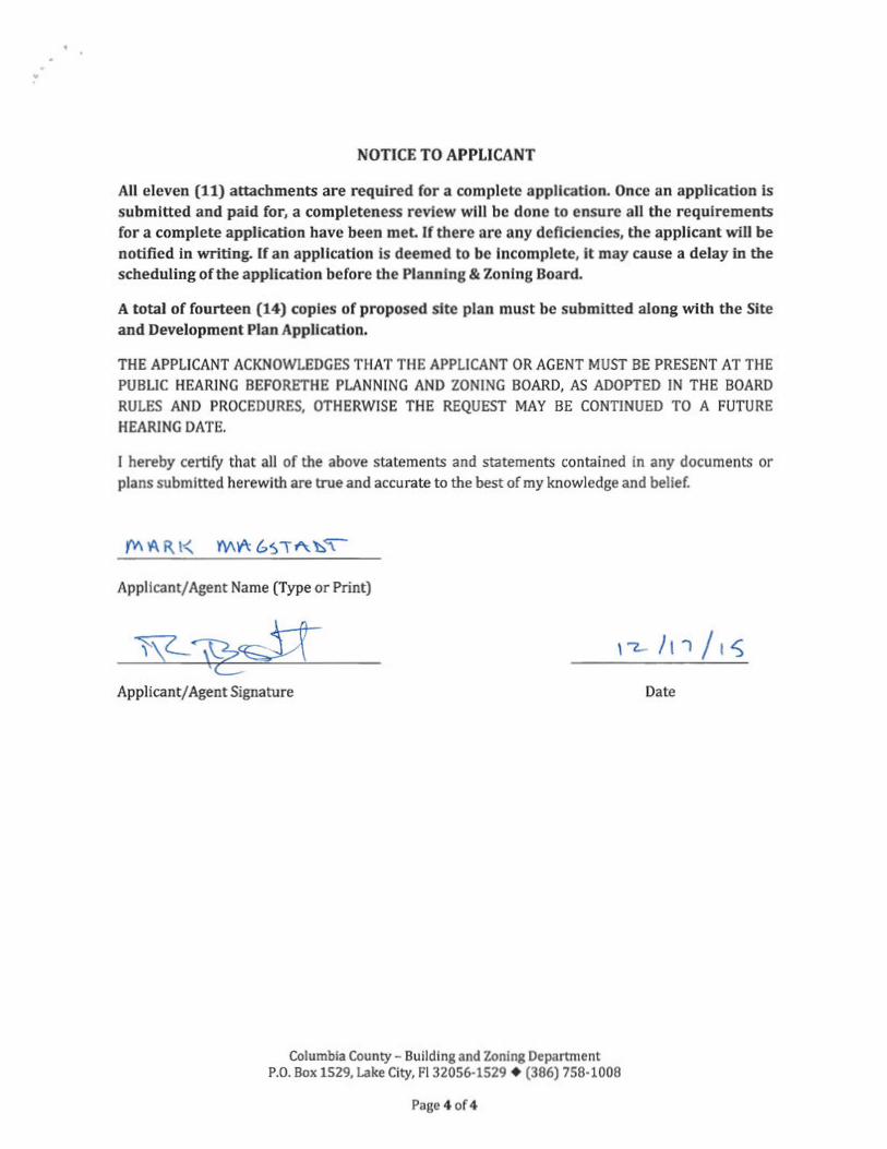
NOTICE TO APPLICANT
All eleven (11) attachments are required for a complete application. Once an application is submitted and paid for, a completeness review will be done to ensure all the requirements for a complete application have been met. If there are any deficiencies, the applicant will be notified in writing. If an application is deemed to be incomplete, it may cause a delay in the scheduling of the application before the Planning & Zoning Board.
A total of fourteen (14) copies of proposed site plan must be submitted along with the Site and Development Plan Application.
THE APPLICANT ACKNOWLEDGES THAT THE APPLICANT OR AGENT MUST BE PRESENT AT THE PUBLIC HEARING BEFORETHE PLANNING AND ZONING BOARD, AS ADOPTED IN THE BOARD RULES AND PROCEDURES, OTHERWISE THE REQUEST MAY BE CONTINUED TO A FUTURE HEARING DATE.
I hereby certify that all of the above statements and statements contained in any documents or plans submitted herewith are true and accurate to the best of my knowledge and belief.
Applicant/ Agent Name (Type or Print)
Applicant/ Agent Signature Date
Columbia County - Building and Zoning Department P.O. Box 1529, Lake City, Fl 32056-1529 + (386) 758-1008
Page 4 of4

D_ SearchResults http://g2.co lumbia. floridapa.com/G IS/D _ SearchResu Its.as·
Columbia County Property Appraiser 2015 Tax Year updated: 12/15/2015
Tax Collector Tax Estimator Property card
Parcel List GeneratorParcel: 11-SS-16-03568-004 << Next LO'Ner Parcel Next Higher Parcel>> Interactive GIS Map Print
Owner & Property Info "'"' Prev Search Result: 6 of 7 Next>>
Owner's Name MTM CAPITAL HOLDINGS INC
C/0 BELMONT ACADEMY CHARTER Mailing SCHOOL Address 1476 SW WALTER AVE
LAKE CITY, FL 32024
Site Address 1476 SW WALTER AVE
Use Desc. (code) PRVT SCHL/ (007200)
Tax District 3 (County) INeighborhood 11516
Land Area 124.560 ACRES [Market Area 01
NOTE: This description is not to be used as the Legal Description Description for this parcel in any legal transaction.
COMM AT INTER OF W LINE OF E1/2 OF NE1/4 OF SEC WITH N R/W OF SR 240, N ALONG W LINE 955 13 FT FOR POB, CONT N 723.57 FT, E ALONG N LINE Of SEC 347.40 FT, SE 770.03 FT, NE 122.71 FT TOW RNV OF WALTER AVE, S ALONG R/W 530.06 FT. SW 99.93 FT, S 160.99 FT, SE 100 34 FT, S 223.20 FT. SW 264.58 FT. N 90.85 FT, NW 79.58 FT TO CURVE, NW ALONG CURVE 147 47 FT. NW 524.99 FT TO CURVE, N ALONG CURVE 119.38 ... more>>>
Property & Assessment Values
I201s Certified Values 2016 Working Values (. Hide Values) IMkt Land Value ~nt: (O) $189,726.00 IMkt Land Value ~nl: (0) $189,725.00 jAg Land Value ~nt: (1) $0.00 Ag Land Value cnt: (1) $0.00 Building Value cnt: (1) $1,438,961.00 Building value cnt (1) $1,438,961.00 D<FOB Value cnt: (9) $194,234.00 XFOB Value nt: (9) $194,234.00 !Total Appraised Value $1,822,921.00 Total Appraised Value $1,822,921.00 UustValue $1,822,921.00 Just Value $1,822,921.00 Class Value $0.00 ~ass Value $0 .00 ~essed Value $1,822,921.00 sessed Value I $1,822,921.00 Exe1T1>t Value code: 08) $1,822,921.00 IExe1T1>t Value !(code: 08) $1,822,921.00
Cnty: $0 Cnty: $0Total Taxable Value !Total Taxable ValueOther: $0 I SChl: $0 Other: $0 I Sehl: $0I
NOTE: 2016 Working Values are NOT certified values and therefore are subject to change before being finalized for ad valorem assessment purposes.
Sales History Show Similar Sales within 1/2 mile
I Sale Date I OR Book/Page IOR Code I Vacant / Improved I Qualified Sale Sale RCode Sale Price 4/14/2014 I 1274/1920 WD I l u 17 $100.00
12/28/2011 1229/1245 WD I u 17 $100.00
1/15/2004 1004/2137 WD I u 06 $175,000.00
10/5/1997 846/2334 WD V u 01 $40,000.00
1/19/1996 815/975 WD I u I 02 $0.00
1/6/1995 800/455 WD I Q $109,900 .00
8/5/1993 778/554 WD V u I 12 I $26,000.00
2/1/1993 770/1558 WD V Q $12,500 .00I I I I I
1 of2 12/ 18/2015 12:19 PM
U1::tw1 uy .cuuiy Name http://search.sunbiz.<>tg/lnquicy/CorporationSearcb/SearchResultDetail
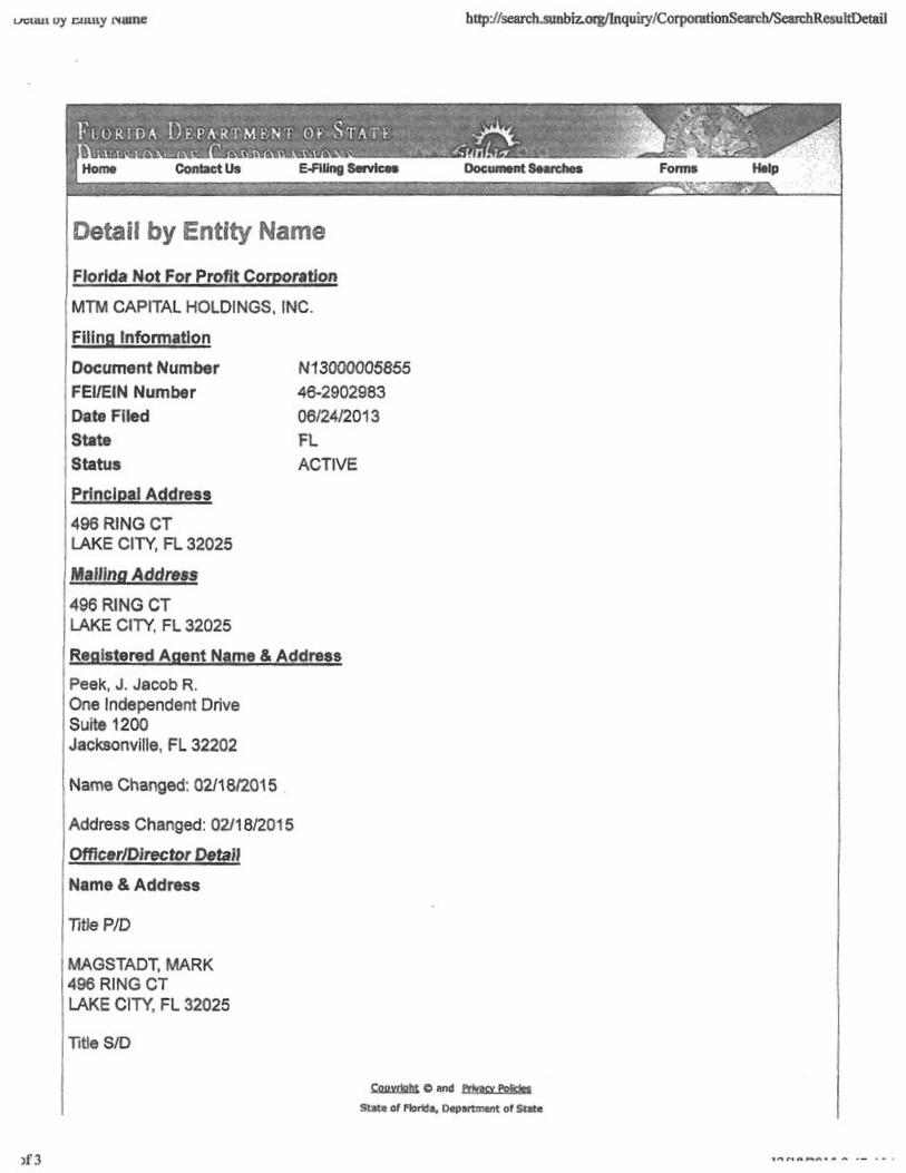
Detail by Entity Name Florida Not For Profit Corporation MTM CAPITAL HOLDINGS. INC.
Filing Information Document Number N13000005855 FEI/EIN Number 46-2902983 Date Filed 06/24/2013 State FL Status ACTIVE
Principal Address 496 RING CT LAKE CITY, FL 32025
Malling Address 496 RING CT LAKE CITY, FL 32025
Registered Agent Name & Address Peek, J. Jacob R. One Independent Drive Suite 1200 Jacksonville, FL 32202
Name Changed: 02/18/2015 .
Address Changed: 02/18/2015
Officer/Director Detail Name &Address
Title PID
MAGSTADT, MARK 496 RING CT LAKE CITY, FL 32025
Title S/D
Copynght e and privacy Policles State of Florida, Department of State
"1"1 11 ft,,.... l\4 • - ,,_ " - •>f3

http://search.sunbiz.org/Inquiry/CorporationSearch/SearchResuJtDetailDetail by Entity Name
LAKE CITY, FL 32025
Title V/D
KENNEDY, PHILLIP 496 RING CT LAKE CITY, FL 32025
Title VP, Director
Kennedy, Philip 496R\NGCT LAKE CITY, FL 32025
Title Treasurer, Director
Sparks, Charles 496RINGCT LAKE CITY, FL 32025
Title Secretary, Director
Linton, John 496 RING CT LAKE CITY, FL 32025
Annual Reports Report Year Filed Date 2014 02/13/2014 2015 02/18/2015 2015 10/07/2015
Document Images
10/07/2015 - AMENDED ANNUAL REPORT View image in PDF format I 02/18/2015--ANNUAL REPORT VlfNI image In PDF format j 02/13/2014 - ANNUAL REPORT View image in PDF format \
06/24/2013 -- Domestic Non-Profit View image in PDF format · 1
1 'l/1 onn,,: n, A.., • ,. " :of3

Inst. Number: 201412007366 Book: 1274 Page: 1920 Date: 5/15/2014 Time: 3:49:12 PM Page 1 of 2 Doc Deed: 0.70 P.DeWitt Cason Clerk of Courts, Columbia County, Florida
Prepared by: . Branden L Suicklaml. Esq.Strickland Law Firm, P.L P.O. Bo, 'Jl'JS lnet 201412007366 !laLake City, FL 3205} . le·5/15/2014 Time·J '9 PMCleed:O. 70 . ·" )4-0269
Dew~ Gawn Q,/umbla County Pog• 1 0/2 B 1274 P 1920 PIThe prc,pon,r ofthis instn1mcnl hi, pcrnmncd no title
examinacion norhas the prepareJ issued any title irwunmccor furnished any opinion n,garding the title, names, oddn:sses, tax identification nwnber and legal dcsc;:ription furnished by parties.
Warranty Deed Individual to Individual
IBIS W ARRANIY DEED made the \~ day of ~ A.D., 2014, Mountaintop Ministries Worldwide, Inc., a Florida Coiporation, hereinafter callcdegnmtor, to MTM Capital Holdings, Inc., whose post office address is: 498 SW Ring Court, Lake City, FL 32025 hereinafter called the grantee:
(Wherever used herein lhc term• "grontor" and ·'gnintee" include all the panics to this insttumcnt and the heirs, legal n,pmicntativcsand 11SSig11S or indi \liduals. and lhe successo1'S and iissigns orcorporation)
Witnesseth: That the grantor, for and in consideration ofthe sum ofSl0.00 and other valuable considerations, receipt whereof is hereby acknowledged, hereby grants, bargains, sells, aliens, rernises, releases, conveys, and confirms unto the grantee, all that certain land situate in·COLUMBIA County, Florida, viz:
See Exhibit "A" Attached Hereto And By This Reference Made A Part Hereof.
TOGEI'HER with all tenements, hereditaments and appurtenances thereto belonging or in anywise appertaining.
TO HAVE AND TO HOLD, the same in fee simple forever.
AND the grantor hereby covenants with said grantee that the grantor is lawfully seized ofsaid land in fee simple; that the grantor has good right and lawful authority to sell and convey said land; that the grantor hereby fully warrants the title to said land and will defend the same agains~ the lawful claims ofall persons whomsoever; and that said land is free ofall encumbrances, except taxes accruing subsequent to December 31,2013.
IN WITNESS WHEREOF, the said grantor has signed and sealed these presents the day and year first above written.
Signed, scaled and delivered in our presence:
Mountaintop Minisirlcs Worldwide, Inc.
STATE OF FLORIDA COUNTY OF COLUMBIA I J4,,.._ The foregoing imitrument was acknowledged before me this K day of. j n,'. 0 2014, by James M. Burbach, as PresidentofMountaintop Ministries Worldwide, Inc., perso~me or, ifnot personally known to me, who produced a Driver's License for identification and who did not take an oath.
(Notary Seal)
,.f.~~. MARIBEL T FLORIS ;": •*: MYCOMMISSION# EEf26142 •,,, , EXPIRES Augult 31, 2015W
IMG713164163 ....,

Inst. Number: 201412007366 Book: 1274 Page: 1921 Date: 5/15/2014 Time: 3:49:12 PM Page 2 of 2 Doc Deed: 0.70 P.DeWitt cason Clerk of Courts, Columbia County, Florida
14-0269
EXHIBIT"A"
Parcct'i°:. ·.
A part of those lanjls desqribed in Official Records Book 1229, Page 1246, of the Public Records of Columbia County, Florida, less and exe<:pl those lands descnbed in Official Records Book 1052, Page 887, ofthe Public Records of Colwnbia County, Florida, being more particularly descn"bed as follows:
That part ofthe E Y, ofNE 'A ofSection l I, Township 5 South, Range 16 East, Columbia County, Florida, being more particularly described as follows: Begin at the inter:i;ection ofthe West line of the E Y, ofNE 'A ofsaid Section 11, with the North Right ofWay of County Road No. 240 and run thence N 01"28'33" W, along said West line, 1678.70 feet to the Northwest comer of the NE 'A ,;ifNE 'A; thence N 87°10'04" E, along the North line of said Section l l, 347.40 feet; thence S 85°00'58" E, 770.03 feet; thence N 87°14'14" E, 122.71 feet to the West Right of Way ofSW Walter Avenue; thence run, along the West Right ofWay ofSW Walter Avenue, the following courses: S 00°25'22" E, 31.92 feet to the point of curvature of a curve, concave to the F.a.st, having a radius of 1137.77 feet, a central angle of02"57'43", a chord bearing and distance ofS 01°41 'Zr E, 58.81 feet; thence run Southerly along the arc ofsaid curve, an arc distance of58.82 feet to the Point ofTangency; thence S 03°14'41" E, 94.20 feet to the Poinlof Curvature ofa curve, concave lo the West, hllving a radius of8267.76 feet, a central angle of00°55'56", a chord bearing and distance ofS 02°50'51" E, 134.53 feet; thence run Southerly along the arc ofsaid curve, an arc distance of 134.53 feet to the Point ofTangency; thence S 02° 16 '35" E, 210.59 feet; thence S 50°48 '33" W, 99.93 feet; thence S 02°25'58" E, 160.99 feet; thence S 55°48'31" E, 100.34fect; thence S 03°17'54" E, 223.20 feet; thenceN 86°32'27" E. 18.00 feet; thence S 03°09'07" E, 44.33 feet; thence S 03°31 '38" E, 145. lS feet lo a point on the South line ofthe NE~ ofNE 'A; thence continue, along the West Right of Way ofsaid SW Waller Avenue, S 02°30'54" E, 414.77 feet to the North Right ofWay of CoW1ty Road No. 240 and the tenninus of said courses, said point being on a curve, concave to the South, having a radius of 622.96 feet, a central angle of04°02'42", a chord bearing and distance of N 86°56'08" W, 43.97 feet; thence run Westerly along the an: of said curve, along the North Right of Way ofsaid County Road No. 240, an arc distance of43.98 feet to the Point ofTangency; thence S 89°55'5 l" W, still along said North Right ofWay, 1244.63 feet to the Point ofBeginning. ·
Parcel 2:
All that part of thc NE 'A ofNE 'A, Section 11, Township 5 South, Range i6 East, lying North ofthe above Parcel 1 and lying West ofSW Walter Avenue.

http://tl-columbia-tax.collector.governmax.com/collectmax/tab_printbi ..
Ronnie Brannon Ad Valorem Taxes and Non-Ad Valorem Assessments
Columbia County Tax Collector REAL ESTATE 2015 14406
Account Number \ Payor Exemptions Taxable Val.ue I Millage CodeI I R03568-004 I See Below See Below I 003
MTM CAPITAL HOLDINGS INC ll-SS-16 7200/7200 24.56 Acres COMM C/0 BELMONT ACADEMY CHARTER AT INTER OF W LINE OF El/2 OF NEl/4 SCHOOL OF SEC WITH N R/W OF SR 240, N 1476 SW WALTER AVE ALONG W LINE 955.13 FT FOR POB, LAKE CITY FL 32024 CONT N 723.57 FT, E ALONG N LINE OF
SEC 347.40 FT, SE 770.03 FT, NE 122.71 FT TOW R/W OF WALTER AVE, S ALONG R/W 530.06 See Tax Roll For Extra Legal
Ad Val.orem. Taxes
Taxing Authority IRate I AssessedJExemptionI Taxable! Taxes Value Amount Value Levied
BOARD OF COUNTY COMMISSIONERS S.0150 1,822,921 1,822,921 $0.00 COLUl-!BIA COUNTY SCHOOL BO.iLJm DISCRE:TIOlll\RY 0.7480 1,822,921 1,922,921 $0.00
LOCAL 4.8510 1,622,921 1,822,921 $0.00 CAPITAL OUTLAY 1. 5000 1,822,921 1,822,921 $0.00 SUWANNEE RIVER WATER MGT DIST 0.410q l, 822,921 1,822,921 $0.IJO
LAKE SHORE HOSPITAL AUTHORITY 0 .9620 1,822,921 1,1322,921 $0.00
I Total Millage 16.4864 I Total Taxes I $0.00I I Non-Ad Valorem Assessments
Code I Levying Authority l Amount FFIR FIRE ASSESSMENTS $ 0 .00
I Total Assessments I $0.00
Taxes & Assessments $0.00
. of 1 12/18/2015 9:44 AM

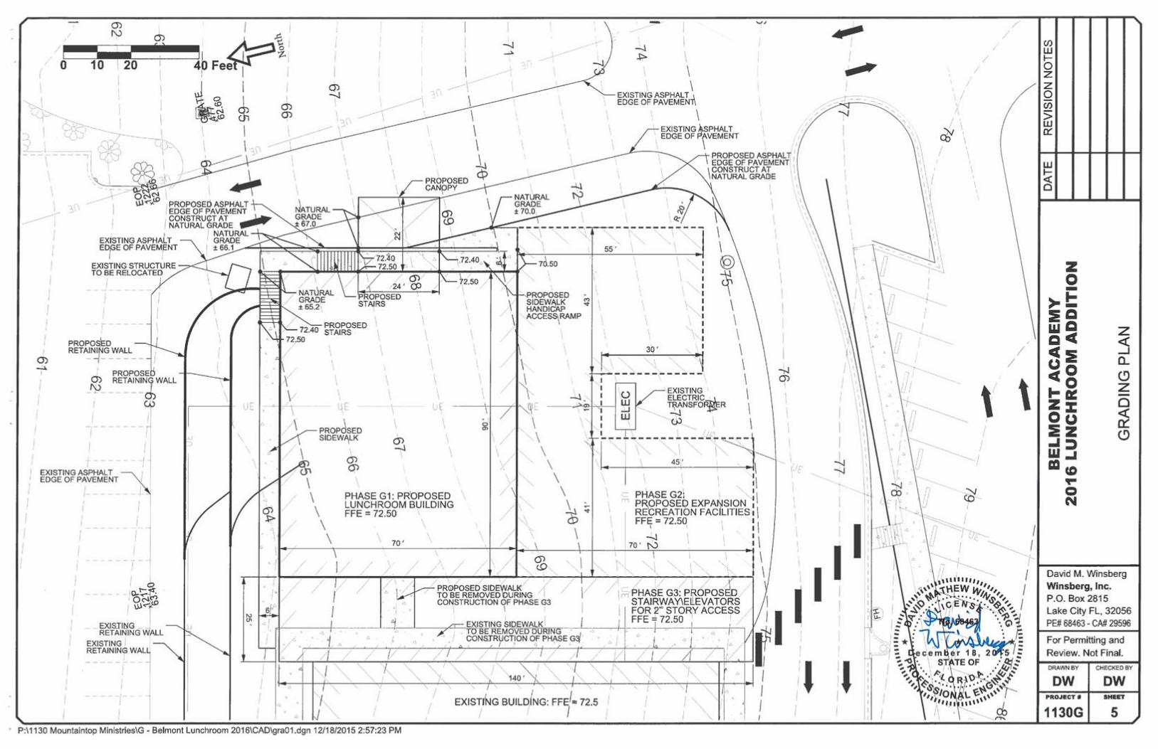
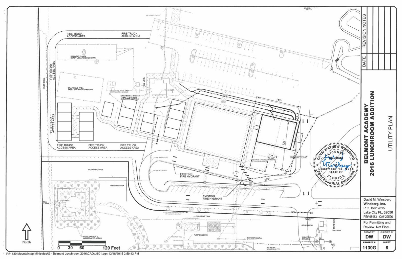
OVERVIEW OF BELMONT ACADEMY LUNCHROOM EXPANSION - (12-16-15)
This proposed new 70'x90' facility is designed to be used as a lunch room eating area and multipurpose area for the existing Belmont Academy facility. The 6,300sf of space allows for additional office space, dedicated faculty bathrooms and an open space for a lunch room and other activities needing assembly space. It is conveniently located adjacent to the school just 25' East connected by a walkway canopy and a vehicle unloading canopy on the East side. This building location was generically part of the original application site plan marked "Future expansion" and was graded with compacted clean fill during original site work. It is important to note that the structure works within limits of all existing utilities including water, septic, fire protection, electric, and parking.
FIRE PROTECTION-The existing fire system servicing the school is designed for additional capacity and will be connected to the main fire main and the new space will be fully sprinkled and alarmed per current code. Current fire hydrants on the front (South side) will allow for less than the required 500' maximum path for hoses and is easily accessed by 3 sides with firetrucks.
STORMWATER-Current approved storm water permit on file allows for this impact and the storm water impact will be connected to existing piping and retention basins
SANITARY-Sally Ford with Columbia county Health has reviewed the new expansion plan with the existing system originally permitted. Sally has approved this expansion for connection to the current system as it does not represent a new increased population of students and faculty. This configuration of new bathrooms fits within the current permitting of 11.5 gallons per student per day and is designed to provide better facilities for the faculty.
PARKING/TRAFFIC-The lower North parking lot allows for a surplus of required parking spaces in the existing configuration.
ELECTRIC AND POTABLE WATER-New structure will be connected to existing systems with ample room for additional capacity for the electric and water. The water system is a regulated PWS water system currently monitored and tested for full compliance with the State of Florida Department of Environmental Health requirements.
LAND USE-This new structure continues in the same approved use as a part of the Belmont Academy facility.

7 0 ..... ~ u 0....J
M, 1-
0 (l0..
A,•
@
·i~·C1
Broo~.v.ood D.-
CL <( ~
.:_- ~ t'Iw .. r... .. u ':,a:~r- _, «,s- ::Cl)

SCHOOL! /
/ PROPOSED LUNCHROOM
I
11'-1"
I
21'-5" 22 6" , --I -J
90'-0"
! I
22'-6"
/\~ I
I
21'-5"
!
1'-1"
-
/ I
1
I
+ LJ I I 1 l ~ Cl) LAWTON
22'-8• A
I 3'-3" 64'-1"
' ' '
bI
N..... I
: ( ~ I
I
!
'
. 9 Cl) OFFICE
<D
"'
~ g I>
.---.---9;;....
;
OFFICE
!
I
-~ "'1' ~
'
.,:gC')
~ s f. ~ «? ir w .....J r-- >
~ (") 9 w
~
w t-w 0:: ()z 0 () 9
b.... ~-
---------------.,:::::: --------------- -- ::::::::fi::::::: ------------ .. _____________ -- -- - ---- ------- -~ .,.
><><
~
~~ COVERf
WALK-W y_
!
I
!
I I-
'? (0.,...
fyio
0 M
<Db ~ .. • M '<t
HALL
<D 9:g -"' .... TEAQl:lER'S ~!TOR.
LOUNGE
JANITOR
( ~ ~<1 MI'--
5'-4 5' 1" rr==i"11'-6" "\: I[ 01
1:!~!,LWAY
i ! i ~
' 1 i ~
: 4'-0" : ; 3068 CAFEGYMATORIUM
'
I
I
b I
b....
: I :
.
'
' I
: I
i
15'-0"
- C cc -- - cc CCC - CCCCCCCCCCCC CC C~'--
~ :: ;
I:: ,
JN - ..-
~ :: ,:: :DRIVE-TH RU I
CANOPY !!v~ il :/.,,.
- 9 :: , jj '.N .....
9 ~
)()(
$:
-· ~==== ----------------- ::-:-::-:g:-:::::::::::-:::--: ---------------..... ______ ---- ----- - --- - -------
..... 25'-11"-I ~, /\ / \... /)./
;~ :~,f' .t. I L ~ b. I
~V\. I b , )
1 , I I , I
), / D:-~ci,r-~ L> (Q) ~
0 WQMEN'S ~ : '
ffi
!
'
I
! '
!
i
i I
: I
-
-
~ '<t ~ .,...
====
ii'.:: 1
- ~=============== -==== =L~ i
0 ;,<]~0 3'-0" .J1{;1 '\;). I ,I I
' ' I
i !WI - g
('.. V\ 3'-0" 3'-0"
~ ~
1~!.,.....
~-I ' 0I .t, \ I
I 'O, I I
I I,
' Ifr--' T T
I
T I
1 -
9N..-
'
G vv i I
1'-1" b

BELMONT ACADEMY 2016 LUNCHROOM ADDITION
SHEET INDEX 1 COVERSHEETWINSBERG, INC. 2 LEGEND AND GENERAL NOTESP.O. Box 2815 3 EXISTING CONDITIONSLake City FL, 32056 4 OVERALL SITE PLAN
Phone: (386) 755-7449 5 GRADING PLAN Fax: (888)-522-0030 6 UTILITY PLAN [email protected]
David M. Winsberg, PE PE License # 68463 Cert. Auth. # 29596
LOCATION MAP
PROJECT LOCATION PROJECT LOCATION
SUBJECT PROPERTY IS LOCATED AT SECTION 11, TOWNSHIP 5 SOUTH, RANGE 16 EAST
COLUMBIA COUNTY, FLORIDA ,,,,,....,,,, ,,,, :-'0-\EW £1,: ,,,,
...., ~po. ......... l,\,t~,,, ,:-'~<;)_:;:_;)C ~ ~.S/·.~i'-:.~~ ..~ ·.~,:,
: Q; . 63 ·. Q,;- . . ----u~·--. .:*: :*: : tf.e c ember 1 8, 201-"5 : - .,0 • . -,:, ~·· STATE OF :tt.;~ ~ , . . ' .. 0. ~ h. • h: .. ,, ~... I. 0 R \0 ..-... ~v,'
, ·~ .. ..· r§°',, ,~.s,8........ ~~ ,,.. ,,,,, IONA\..~,,,,,
,,,,,111111\
For Permitting - Columbia County 1st Submittal
0 3 6 Miles WINSBERG, INC. PROJECT NUMBER: 1130G
· P:\1130 Mountaintop Ministries\G - Belmont Lunchroom 2016\CAD\cov01.dgn 12/18/2015 2:51 :46 PM
DEVELOPERS Jim Zuber, Constr'uction Manager Phone: (386)-755-3608
Luke Carrendar, Corporate Officer MTM Capital Holdings, Inc. Phone: (386)-752-0219
Lawton Unrau, CEO Belmont Academy Phone: (386)-269-04 76
1476 SW Walter Avenue Lake City, FL 32024
VICINITY MAP
1 3
Nautilus
0 1/2 1 Mile
7

- -
LEGENDGENERAL NOTES EROSION CONTROL NOTES en w1. The contractor shall verify all conditions and dimensions at the job site to ensure 1. Contractor shall adhere to the Erosion Control Plan and all erosion and sediment ITEM SYMBOL ITEM SYMBOL l-that all work will fit in the manner intended on the plans. Should any conditions control regulations as set by SRWMD and other governing authorities, and use exist that are contrary to those shown on the plans, the contractor shall notify the (as a minimum) the erosion measures control described and shown in these plans. METER OR oCONCRETE MONUMENT ~~~CONTROLSengineer of difference immediately and prior to proceeding with the work. • z-2. This project shall comply with all applicable water quality standards.
IRON PIPE VALVE z2. The contractor shall maintain the construction site at all times in a secure ~~!>.SJ manner. All open trenches and excavated areas shall be protected from access 3. Sediment and erosion control measures and stormwater management facilities • 0 by the general public. shall be installed prior to any other construction. BENCH MARK REDUCER~ ~ en
3. Site contractor shall coordinate all work with other contractors within 4. Contractor is responsible for implementing additional measures as required >project limits. for proper erosion and sediment control. The contractor should use BMP's in SOIL BORING LOCATION -$- BACKFLOW PREVENTER !HoHI w
the Florida Erosion and Sediment Control Inspector's manual to implement a c:::4. The contractor shall waste all excess earth on site as directed by the engineer. plan that will work and meet actual field conditions. POWER POLE -<>- FIRE HYDRANT ® 5. Any public land corner within the limits of construction is to be protected. 5. Sediment and erosion control measures shall not be removed until all TELEPHONE POLE WATER so· BEND-0-- LIf a corner monument is in danger of being destroyed and has not been properly construction is complete and a permanent ground cover has been established.
referenced, the contractor should notify the engineer. w SHARED POWER POLE WATER TEE 6. During construction and after construction is complete, all structures shall -+- .L
6. Boundary and topographical information is constantly changing, and thus may be cleaned of all debris and excess sediment. ~ be approximate or out-of-date. ANCHOR PIN ~ 0SINGLE WATER SERVICE B7. All waste generated on the project shall be disposed of by the contractor in
7. All existing utilities shall be located (horizontal and vertical) prior to areas provided by contractor. LIGHT o-0 DOUBLE WATER SERVICE beginning work. Any existing utilities shown in these plans are approximate ~
onfy and shall be verified in the field by non-destructive methods. The 8. Loaded haul trucks shall be covered with tarps and excess dirt removed daily. SANITARY SINGLE engineer shall be notified immediately of any discrepancies. SIGN &POST --t<:HWATER SERVICE 9. Silt fences shall be located on site to prevent sediment and erosion from -
8. The design of all utility service connections fdefined as the conduit connecting the leaving project limits. Silt fence shall be cleaned or replaced when silt SANITARY DOUBLE TOWERutility from the building to the point it enters/ eaves the collection/distribution builds up to within one foot of top of silt fence. 0 WATER SERVICE ~ system) is the responsibility of the contractor and/or his structural engineer or architect. Such utility service connections shall have equivalent or greater capacity 10. The retention basin(s) shall be constructed initially to serve as a sediment trap FENCE SANITARY MANHOLE 0than the conduit inside such building(s) serviced, and shall be designed according to during construction. all building codes and all other applicable regulations. The site engineer shall be SILT FENCE STORMWATER MANHOLE @ z Cl)notified immediately if a conflict arises between any proposed service connections 11. A pad of rubble riprap shall be placed at the bottom of all collection flumes • • and these plans. and collection pipe outlets. 0 w
STORMWATER~ [ii] r.J I-VEGETATION9. All site construction shall be in accordance with the Columbia County Land 12. All open drainage swales shall be grassed immediately and riprap shall be OR LANDSCAPING ..... DRAINAGE INLET Development Regulations. placed as required to control erosion. ..... ..... @ 0~8 >- !: -
10. Contractor shall contact the Columbia County Building and Zoning department to 13. All disturbed areas shall be stabilized immediately to prevent erosion. All TREE 0 @ STORMWATER PIPE :E Cl z
perform the following site inspections: slopes greater then 4h:1 v shall be stabilized with sod. Staple sod shall wCI .....J Al Erosion and sediment control - prior to beginning construction. be used on slopes greater than 2h:1v. B Site compliance - once building foundation is poured and improvements GRAVEL ~m MITERED END SECTION @ aC <(
ORRIPRAPare staked out. 14. All disturbed areas not sodded shall be seeded with a mixture of long-term 0:: C) Final site compliance - once all improvements are finalized. vegetation and quick-growing short-term vegetation for the following CONCRETE PAVEMENT I: •:··. ·-~ ;--.1 ENERGY DISSIPATION PAD C:t
conditions. For the months from September through March, the mix shall !!!ill w 11. All proposed construction shall conform to the latest edition of the Florida consist of 70 pounds per acre of long-term seed and 20 pounds per acre of Uo z
Department of Transportation Standard Specifications for Road and Bridge winter rye. For the months of April through August, the mix shall consist HANDICAP PARKING DITCH BLOCK Construction and the Florida Department of Transportation Design Stancfards. of 70 pounds per acre of long-term seed and 20 pounds per acre of millet. ~ ~ Co w
FLOW ARROW (SHEET) ....J\./'-+ FLOW ARROW (GUTTER) 1111+ (912. All new traffic signage and pavement markings shall conform to the current manual 15. All stabilization practices shall be initiated as soon as practicable in areas I- a=:
on Uniform Traffic Control Devices and the current FOOT design standards. of the job where construction activities have temporarily or permanently GROUND CONTOUR GROUND CONTOUR ,,,- - 15- - /stopped, but in no case shall the disturbed area be left unprotected for more (EXISTING) (PROPOSED) .,. ---~ ' Zz 0
13. All storm sewer pipes shall have a minimum cover of 6". Limerock backfill shall be than three (3) days. Ou zSPOT ELEVATION SPOT ELEVATION r79.56used if pipe under pavement has less than 12" cover. .96.22 <((EXISTING) (PROPOSED)16. Qualified personnel shall inspect the stockpile areas, silt fence, construction :tz 14. Existing drainage structures within the construction limits shall not be removed, entrance, and all disturbed areas that have not been finally stabilized, at ..I ::, 0unless otherwise specified in the plans. least once every seven (7) calendar days and within 24 hours of the end of a
storm of 0.5 inches or greater. Corrective actions shall be taken immediately. w ..I z 15. All swales, depression areas and retention ponds shall be inspected monthly for
sinkhole occurrence. Should a sinkhole occur, the area should be repaired as soon 17. Contractor is responsible for the construction and maintenance of all erosion mco w as possible. If a solution pipe sinkhole forms within the storm water srstem, the and sediment controls during proposed construction. (9sinkhole shall be repaired by backfilling with a low permeability material. A ~ 2-foot cap that extends 2 feet beyond the perimeter of the sinl<:hole shall be Q w constructed with clayey soils. The clayey soil should have at least 20% passing the .....J number 200 sieve, compacted to 95% of standard proctor, and compacted in a wet N condition with moisture 2%-4% above optimum. The clay soil cap shall be re-graded to prevent ponding and re-vegetated.
ABBREVIATIONS 16. Contractor shall provide an as-built survey meeting the requirements of Chapter
61G17 F.A.C. for the stormwater management systems. Include horizontal and I I OVER I UNDER I TYPE OF 0 DIAMETER INV INVERTvertical dimensional data so that improvements are located and delineated relative HEAD I GROUND1 UTILITYto the boundary. Provide sufficient detailed data to determine whether the 1-------~----1 DBI DITCH BOTTOM INLET EL ELEVATION
improvements were constructed in accordance with the plans. OHC I UC I C : CABLE 1•----+-----+1------1 MH MANHOLE LF LINEAR FEET ,,,,.... .,,,,17. Contractor shall contact the engineer of record 48 hours prior to OHE I UE I E : ELECTRIC David M. Winsberg
beginning construction. 1----+-----+-~-----1 CO CLEANOUT NTS NOTTO SCALE ,,,, '.'{HEW w. '1,, OHT I, UT I T I TELEPHONE >-----~------t-------~-• .. .. .. \t-p,.. . . . . . . . . ,."'\$',,, Winsberg, Inc.
SAN SANITARY SEWER PROPERTY LINE It P.O. Box 2815 RCP REINFORCED CONCRETE PIPE ~..~~·i '~z:t··.~;,~ss STORM SEWER It. CENTER LINE .., .. ~. . N . . ~Q .. .. Lake City FL, 32056CMP CORRUGATED METAL PIPE :Q: ·. ,:.
w WATER LINE It BASE LINE PE# 68463 - CA# 29596 HOPE HIGH DENSITY :*: :*:POLYETHYLENE PIPE G GAS R RADIUS OF CURVE : '-U:~' : For Permitting and :. O.ecember 18, 01-"5 : BCCMP BITUMINOUS COATED MES MITERED END EDP EDGE OF PAVEMENT - -o· . -
CORRUGATED METAL PIPE SECTION ,:. ~ ·. STATE OF :,t:: Review. Not Final. . . BM BENCH MARK
~ ~
'O" ~ t- "f<t"' DRAWN BY CHECKED BYBCCSP BITUMINOUS COATED WSWT WET SEASON ', ~··. {QR\tl ···~ ,"', ~ .. .. 0~ ..CORRUGATED STEEL PIPE WATER TABLE IP IRON PIPE ,, ~ ·········~ ....
' 1,,, 810NA\.. ~ ,,,,' DW DW ,,,,,. ....,,, PROJECT# SHEET
1130G ~
· P:\1130 Mountaintop Ministries\G - Belmont Lunchroom 2016\CAD\gen01.dgn 12/18/2015 2:55:13 PM
2

----
(fJ w }-0z
r ----- z I 0_J I / (fJI
II
I >
I ~ J w 0::BFE • 55.&4I
/ NGVD 1929 , · - •-I \ ~~;- ~ 1 SCA \I . /
I ~ / / // "'- \I wI I \\ I ~"' \ ~ ""'~trll 0
11,J\LDr,,aG /
"\ \ \ .,..
I \ I I
\ \ \ l~f:J-S~J',.,~vI \ I "" 'I
I \ ' '-,, ' -..__I \
' " "' I I I
~r \C§N"t:J-S~J',.,p.v I
\ "-Cl)z 0 l-o z 0 (...)
~ c.,z I-C/)\ Xi
\ wI
i I ·, ·1
\ Ii
~I
David M. Winsberg
1f Wlnsberg, Inc. P.O. Box 2815 Lake City FL, 32056 PE# 68463 - CA# 29596
For Permitting and North Review. Not Final. DRAWN BY CHECKED BY
DW DW PROJl!CT# SHEET
0 50 1130G 3 P:\1130 Mountaintop Ministries\G - Belmont Lunchroom 2016\CAD\exc01.dgn 12/18/2015 2:56:12 PM

-- -
WATER & SEWER FLOW RATES THERE IS NO AUDITORIUM, GYMNASIUM,
CAFETERIA, OR KITCHEN 10 GPO PER STUDENT 15 GPO PER FACUL TY\STAFF
TOTAL FLOW (EXISTING CONDITIONS) +/- 450 K-12, 50 PRE-K, 35 FACUL TY\S1AFF -TOTAL FLOW= 500 * 10 + 35 * 15 = 5,525 GPO
SANITARY SEWER CAPACITY HEAL TH DEPARTMENT PERMIT# 91-284 3,960 GPO ON-SITE SEPTIC SYSTEM
CAPACITY FOR EXISTING BATHROOMS HEALTH DEPARTMENT PERMIT# 14-0116 3,475 GPO ON-SITE SEPTIC SYSTEM CAPACITY FOR EXISTING PORTABLES
POTABLE WATER CAPACITY FDEP PERMIT# WC12-301360 264,000 GPO ON-SITE POTABLE
WATER SYSTEM CAPACITY 4,568 GPO IS ALLOCATED TO THE CHURCH
BUILDING (WEEKENDS\EVENINGS) THERE ARE NO OTHER ALLOCATIONS
* 2ssw/ev
/ WG\o~i~/ r-·--~~~~/
t \ \\ ~ 11~oZ II ,_., \
BfE • 56.114 r,1GVD 1929
- ~·------·,i i
RV l'JIIIMGW.-1..l -.., \
NI\SCELL.N"EOU!i~ --- 5C,ATTERED TREES
/ -. --'1I
I \
I I I I
...~,}?"~ /\ ~~ES \ /
/
EXISTING DUMPSTER PAD
EXISi!NG- PARKIN.G'AREA I I I ' I
'
0 ·,a±~~ty.t.¢'9 , CONSTRUCTION
AREA
0 0 0 0 0 0 0 0O 0
1_ - ....
\ \
ZONING AGRICUL TURAL-3, ESA-2
PERMITTED IMPERVIOUS AREA - BASIN 2b (AS OF JULY 2012- SEE ERP92-0155M2, SRWMD)
75,900 SF EXISTING IMPERVIOUS 50,480 SF NEW PAVEMENT & BUILDING
300,000 SF FUTURE IMPERVIOUS
IMPERVIOUS AREA CONSTRUCTED SO FAR 18,000 SF MAIN BUILDING 14,688 SF PORTABLE BUILDINGS 68,000 SF PAVEMENT & SIDEWALKS
PROPOSED NEW IMPERVIOUS AREA 15,510 SF NEW BUILDINGS
Cl) w l-o z z 0 Cl)
(ija::
1,700 SF NEW PAVEMENT &SIDEWALKS 230,000 SF FUTURE IMPERVIOUS IS STILL AVAILABE .._....__..._.....,~~-----I REQUIRED PARKING 2 SPACES PER CLASS OR OFFICE ROOM 28 CLASSROOMS AND 6 OFFICE ROOMS REQUIRED SPACES= 2 * 34 = 68 SPACES
w ~ Cl
AVAILABLE PARKING 5 HANDICAP (EXISTING)
141 REGULAR (EXISTING) 0 PROPOSED NEW SPACES
146 TOTAL
\ IAIS~~EOUSSCA RED TREES
fl/
\
z <t:_J a.. wI-C/) _J _J
<t: ~ w>0
0 0 0 0 0
David M. Winsberg Winsberg, Inc. P.O. Box 2815 Lake City FL, 32056 PE# 68463 - CA# 29596
For Permitting and Review. Not Final. DRAWN BY CHECKED BY
DW DW I I I I I I I I I PROJECT # SHEET\\\ "1 I I\~0 50 200 Feet 1130G 4
• , , 1 1\ I I I I I I I I I I I I I f _el\ P:\1130 Mountaintop Ministries\G - Belmont Lunchroom 2016\CAO\sit01.dgn 12/18/2015 2:58:19 PM
---------
T 0) /I I _r ~ - IN.) I /
/ 0) / I
I
j (j')I I o l t \ / w
I 't< I ~ \ I / I-0 10 I 20 ~ 04p Fe I I I\ \ I z
I I \ \ \ z EXISTING ASPHALT ..I I 0I
I J 0 \ / I
EDGE OF, PAVEMEN I\ (j')I Xts:> \ \ \ >~ '\ JI \ EXISTING A.SPHALT \ ; w \ EDGE OF P(WEMENT 1
\ \ \ ;, Ct'.
~-- PROPOSED ASPHAL i I EDGE OF PAVBMENT \ wCONSTRUCT AT I-\ \ NATURAL GRAD)E 1 <C
\ \ 0
\ \ \ \ \ \
' - ' -~ ~ -~ ~ -----.-- \---- \ \I I EXISTING ASPHALT
', ' " ~\ ~ \~ \ \EDfE OF PAVEM/ENT --~==~~~==l====::::::=~==::::i::::±::::::::=::::::~·:....... ~ \ \ 55' ~
f81i11~~L~[_.klPETJ!RE \ \ ~ · @ \ z
\ \' \ \ : ~ \I /
/ \ - \ \ \"" ·. I 0
" PROPOSED "" \/ SIDEWALK ~ \ \ ~ I \ >- !: -'\ HANDIC'AP I II / :E Cl\ \ ~ CES8\ RAMP \ \ \ : \ I--1----- / 'PROPOSED / "I wCI z72 40
, / 72.50 · STAIRS \ "" \ \ \ "': \ I Cl cc <( • . a / \ \ I "" \ \' 3Q ' \ I \ I I _Jct> cc :E a...·' \/ I I / \"' I '"~1_:~-4~~~\ \ ~ UoI i' PROPOSEDCf' RETAINING WALL cc 0
4
I -"?------J "' . /\ \ \ / ~\ ' "
\ \
"'' 1 ' ~ \ EXISTING I
\ \
er Ji t /
... Di: z(9
\ / \ \ ...!.,l "' I (.) ELECTRIC ' \I I .1 0 ---4-..,/-'-'/--- ~ E \ U~ / ~ E --~~-+-- ~ ~ TZ'NSFO~R \ \ Z:c <(I / " \ I w \ I Ou-i------- I
. ~ \ °i:,\ \ "'" I \ ----- \ 0::c,. \ Jr-~ /I PROPOSED I a, / "" . " I \ I /J \ :tz... ::::,w ..II I
i 1 ------ I
I SIDEW; ~ \ \/;:\ \j·"" \"-~\'"" ~\ ~ \~[ ,/~~/ m(O
(9
le . J I EXISTING ASPHALT II EDGE OF PPIVEMENT \ \ \/ ~ \ \ I 1 \ \ :1
QI I -- - - - - ! _I \ • ' \ PHASE G1: PROPOSED \ / " \ \ C PHASE G21 \ ~ ·1 \ ""' I I I 1 . / LUNCHROOM BUILDING \' \ - \ rn P~OPOSEE> EXPANSION : \ I N
6:1 \ FFE ::!: 72.50 \ / ' ...:..l ~ RECREATIDN FACl1LITIES 1 \ \ / _______ /_ ·~ / \ \ \ / '\ ~ \ FF~ = 72.501 \ : \ \I
I I I : . \\ , \ \ 10 , \ \ / ~ \ \ 10 , t \ \ " : I
I II I I / \ ' ' ' I I \ \ II ------T-
!
I • !' / / I/ / ) . / /)\ / / \/ '~~ ""' ",."'\ "'"", I""' """I, "'"" I"",," '"'k \ I David M. Winsbergl I b 1 1 Winsberg, In~. • / / // / / .~ / PR~iS0sE6s1D~ALt< ~/ / / /;c/ V /\ / X 1\ I ~I ------/~ . 1· I ' c,. ' / TO' BE REMOVED'OURING / I I \rr1PHA&E G3: PRIOPOS~ I P.O. Box 2815 ' I" · / " CONSTRUCTION G>F PHASE G3 I STAIRWAY\Ell.EVATOK.SI I u.1~"'c.o IN 6 ' / / ' • I \ I I FOR 2"' STORrv' ACCESS / / I Lake City FL, 32056
- J C11 "I I 1 cc:: EXISTING k1DEWALK I FFE :!: 72.50 I ! / I PE# 68463 - CA# 29596I - EXI.STlciG. -RETAII\/ING W LL 1
( "'· " - t · " .x ./ ·t&~§r~Tl~9[6~6W~Wt-iE~~· "· ~ - -- • - • ~ I For Permitting and • J c,. I c,. " " · II EXISTING / 7 . / /. Ii 1
I/ "' / ' / /. / / / / I / 't ' / / / • / /. / / 1I RETAININf WAL I I Review. Not Final. I -----/-- DRAWN BY CHECKED BY
-'------,---1 . 1~~,<,{,<,<,<,~~</{<,<,,<("',1,~,~( r. I / If If / : DW DW/ II -- - --1--- I I PROJECT # SHEET/ " "1"" / II EXISTtNG BUILq{NG: FFE/= 72.5 / / / ~~ /"" / / I I ,., J "" I I .' I I I 1 ~ , ·. I I 1130G 5
• P:\1130 Mountaintop Ministries\G - Belmont Lunchroom 2016\CAD\gra01.dgn 12/18/2015 2:57:23 PM
J ~-::ff--,, __ j 1Jfi:,WATERLINE-',
f >->·! JI
~t II _:·:>:-:·1
f, I Ill : _...-------------------------:i· --- I~ I / FIRE TRUCK FIRE TRUCK / _ ~ ACCESS AREA ACCESS AREA ------------; ~---------
L______ L p
I I I I
I <(I W l ~C::: l g<( IC::: Cl)11-fB lwu ["'--- ... --- ..
-; c I ~~ J 0 --- ... /iiJ I ~ . I z < I rn I / DRAINFIELD AREA ;'EXACT LOCATION UNKNOWN
I
I I
r I
I I I I I I <(~w (.)er:::::)<(
0::"'lrf3WuQ;;uU.<(I
'I I
S ' I I
? FIRE TRUCK FIRE TRUCK FIRETRUCK s_ · ACCESS AREA ACCESS AREA ACCESS AREA ~: t'. I
{1 ( I
r:, I )1
RETAINING WALL )1 '-, I ) I
1'., I
WEDDING AREA
' t --TA KS z
:J UJ
GENE ATOR UJ ~ t-
TRANSFORMER
ROSE GARDEN & LANDSCAPED AREAS
North Er0 PVC ARE0 30 60 120 Feet DELUGE DRAIN PlPE
• P:\1130 Mountaintop Ministries\G - Belmont Lunchroom 2016\CAD\util01.dgn 12/18/2015 2:59:43 PM
Cl) w l-o z z 0 Cl)
>wa::
w ~ C
z <(....J a.. ~ ....J 1-:::J
David M. Winsberg Winsberg, Inc .. P.O. Box 2815 Lake City FL, 32056 PE# 68463 - CA# 29596
For Permitting and Review. Not Final. DRAWN BY CHECKED BY
DW DW PROJECT# SHEET
i-- 1130G 6
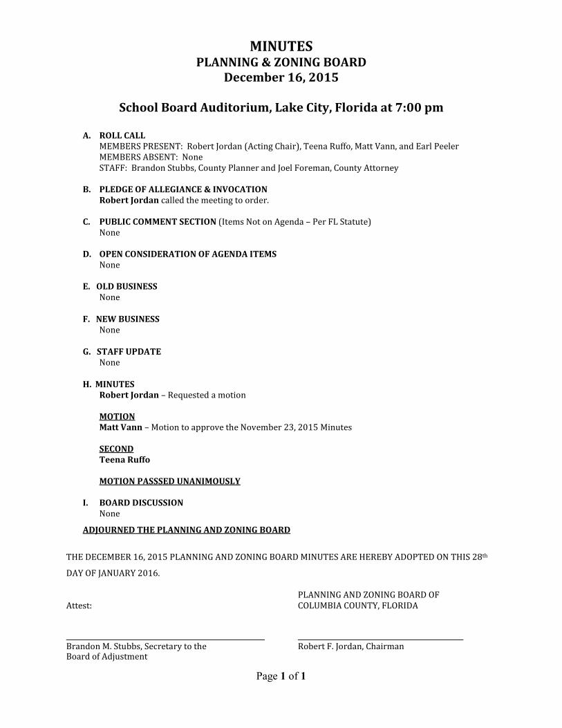
MINUTES PLANNING & ZONING BOARD
December 16, 2015
School Board Auditorium, Lake City, Florida at 7:00 pm
A. ROLL CALL
MEMBERS PRESENT: Robert Jordan (Acting Chair), Teena Ruffo, Matt Vann, and Earl Peeler
MEMBERS ABSENT: None
STAFF: Brandon Stubbs, County Planner and Joel Foreman, County Attorney
B. PLEDGE OF ALLEGIANCE & INVOCATION
Robert Jordan called the meeting to order.
C. PUBLIC COMMENT SECTION (Items Not on Agenda – Per FL Statute)
None
D. OPEN CONSIDERATION OF AGENDA ITEMS
None
E. OLD BUSINESS
None
F. NEW BUSINESS
None
G. STAFF UPDATE
None
H. MINUTES
Robert Jordan – Requested a motion
MOTION
Matt Vann – Motion to approve the November 23, 2015 Minutes
SECOND
Teena Ruffo
MOTION PASSSED UNANIMOUSLY
I. BOARD DISCUSSION
None
ADJOURNED THE PLANNING AND ZONING BOARD
THE DECEMBER 16, 2015 PLANNING AND ZONING BOARD MINUTES ARE HEREBY ADOPTED ON THIS 28th
DAY OF JANUARY 2016.
PLANNING AND ZONING BOARD OF
Attest: COLUMBIA COUNTY, FLORIDA
Brandon M. Stubbs, Secretary to the Robert F. Jordan, Chairman Board of Adjustment
Page 1 of 1