cold water inflow into a reservoir: a field and modeling … · cold water inflow into a reservoir:...
TRANSCRIPT

Cold Water Inflow into a Reservoir:A Field and Modeling Study
Rachel D. SimonsEast Bay Municipal Utility District
February 28, 2007

EBMUD Distribution System
San Francisco
Lower Mokelumne River

The Reservoir System
Camanche ReservoirPardee Reservoir
Upper Mokelumne River
Lower Mokelumne River
1 mile
Water not sent to EBMUD customers is released from Pardee to Camanche via the river
River

Pardee ReservoirMaximum Depth: 300 ftSurface Area: 2,400 acresStorage: 200 TAF
Camanche ReservoirMaximum Depth: 160 ft Surface Area: 8,300 acresStorage: 400 TAF
depth (ft)
Reservoir Background

Temperature Patterns
1 mile
Sample sites at deepest point near dam
Camanche Pardee
2006 Temperature (°C)

Minimum Reservoir Temperature
In general, Pardee stays colder than Camanche.
PardeeCamanche
2006

Questions ExploredWhat happens to the cold water released from Pardee before it reaches Camanche?
In particular, what is the influence of:• Warming in river• Stratification in Camanche• Unsteady flow (peaking for power generation)
To address these questions, we needed to:- Collect temperature field data (Part 1)- Develop a river model (Part 2)

Study Area1 - Water released from Pardee Dam2 - Water travels down river (~ 2 miles)3 - River plume plunges below surface of Camanche
Camanche Reservoir
Pardee Dam
River
Study Area
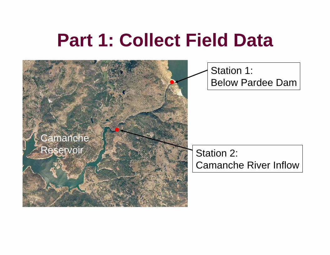
Part 1: Collect Field DataStation 1:Below Pardee Dam
Station 2:Camanche River Inflow
CamancheReservoir

Station 1: Below Pardee DamTemperatureProbe (4 in.)
Cable
Weight Stake

Station 2: Camanche River InflowPardee Dam Outflow
River Reservoir Surface
Station 2
Plunge Point
Camanche
* River length and plunge point location varies depending on the surface water elevation of Camanche

Station 2: Camanche River InflowMultiple probes needed to capture stratification
July 26, 2006
Station 2

Station 2: Temperature Probes
Weight
Changing Elevation
5 ft
Buoy on Line
7 Temperature Probes Probes attached to buoy

Part 2: Develop River ModelModel: River Modeling System (RMS4)Author: Tennessee Valley Authority
One-Dimensional Horizontal Model- ADYN: Hydrodynamics- RQUAL: Water Quality (Temperature)
Open Source Code
Main Advantages:• Incorporates river geometry with cross-sections• Can run at an hourly time step• Handles unsteady flow

River Geometry
Cross-Section Location
elevation (ft)
1
2
3
45
7
Pardee Dam
¼ mile
6
Digital Map from Aerial Topographic Survey

River Model Summary
Input: Pardee Dam Flow Rate & Temperature
Meteorological data:- Solar radiation- Cloud cover- Air temperature- Dew point- Wind speed
Output: River Temperature
River Geometry

Questions Explored
What happens to the cold water released from Pardee before it reaches Camanche?
In particular, what is the influence of:• Warming in river• Stratification in Camanche• Unsteady flow (peaking for power generation)

Pardee Dam Releases (River Flow)Temperature data collected: June 28 – December 13, 2006
Peaking for PowerGeneration

Temperature Below Pardee DamThe Coldest Water

River Warming: Model Results
Pardee ReleaseModel Output

Model Comparison to Field DataPardee Dam Outflow
River Reservoir Surface
Station 2
Plunge Point
1-D River Model Camanche
•Compare river model output to bottom probe at station 2•Theory: Cold water plume plunges below reservoir surfaceand runs along bottom

River WarmingPardee ReleaseModel OutputStation 2 bottom

River WarmingPardee ReleaseModel OutputStation 2 bottom

Temperature at Station 27 sensors

Stratification at Station 2SurfaceBottom

Stratification at Station 2SurfaceBottom

Plume Warming and Stratification
Pardee Dam Temperature
River Reservoir Surface
Station 2
Plunge Point
Camanche
Plume Warming: Temperature difference between Pardee Dam releaseand bottom of Station 2
Stratification: Temperature difference between surface and bottom of Station 2

Plume Warming and Stratification
StratificationWarming

Plume Warming and StratificationStratificationWarming
1,200 cfs Peaking 800 cfs Peaking

Talk SummaryWhat can we say about river warming, stratification in Camanche, and flow rate in relation to the Pardee cold water releases?
• Cold water released from Pardee Dam can be significantly warmed by both river travel and stratification in Camanche
• In some cases, higher flow rates reduce the amount of plume warming.
• Otherwise, a work in progress…