climate matters - idrc en/climate... · the population density map is drawn from ... climate...
TRANSCRIPT

Climate Mattersin Southeast AsiaThis study, conducted by EEPSEA,identifies the regions most vulnerable toclimate change in Southeast Asia. Thisinformation is expected to be highlyvaluable to policy-makers as well asexternal donors in resource-allocationdecisions on climate change initiatives inthe region.
The assessment covers 530 sub-nationalareas which consist of 341 districts inIndonesia, 19 provinces in Cambodia, 17provinces in Lao PDR, 14 areas in
The study assesses exposure to climatehazards using information from historicalrecords based on the assumption that pastexposure is the best available proxy forfuture climatic risks.Climatic hazard maps for five climate-related risks—tropical cyclones, floods,landslides, droughts, and sea level rise—are generated. Population density is usedas the proxy for human sensitivity toclimate hazard exposure. The extent ofprotected areas is considered the proxy for
An index of adaptive capacity is alsocreated, as a function of socio-economicfactors, technology, and infrastructure. Thesocio-economic variables comprise theHuman Development Index (income,literacy, and life expectancy), poverty, andinequality.Finally, an index of overall climate changevulnerability for Southeast Asia isproduced. We ranked the regionsaccording to the index and consider thoseareas falling in the 4th quartile as the
Indonesia, 19 provinces in Cambodia, 17provinces in Lao PDR, 14 areas inMalaysia, 14 provinces in the Philippines,72 provinces in Thailand, and 53 provincesin Vietnam.
climate hazard exposure. The extent ofprotected areas is considered the proxy forthe ecological sensitivity of the respectivesub-national areas.
according to the index and consider thoseareas falling in the 4th quartile as thevulnerable areas.
Thailand
Laos
Vietnam
Cambodia
Philippines
Legend
Index of Climate Change Vulnerability0.00 - 0.06
0.06 - 0.11
0.11 - 0.15
0.15 - 0.20
0.20 - 0.25
0.25 - 0.31
0.31 - 0.39
0.39 - 0.49
0.49 - 0.66
Indonesia
Malaysia
0 450 900225 Kilometers
0.66 - 1.00
®
"Based on this mapping assessment, all the regions of thePhilippines; the Mekong River Delta in Vietnam; almost all theregions of Cambodia; North and East Lao PDR; the Bangkok regionof Thailand; and West Sumatra, South Sumatra, Western Java, andEastern Java of Indonesia are among the most vulnerable regionsin Southeast Asia" (Yusuf & Francisco).A report on this mapping project is available online at http://www.eepsea.org.
Economy and Environment Program for Southeast Asia
Economy and Environment Program for Southeast Asia (EEPSEA)International Development Research Center (IDRC) 2009
Climate Change Vulnerability in Southeast Asia
International DevelopmentResearch Centre
Centre de recherches pour le développeent international
Vietnam
Laos
Thailand
Cambodia
Malaysia
Indonesia
Philippines
Legend
Protected areas
Population Density
High : 44479.7
Low : 0
Vietnam
Laos
Thailand
Cambodia
Malaysia
Indonesia
Philippines
Legend
Multiple Hazard Index0.00 - 0.04
0.04 - 0.09
0.09 - 0.14
0.14 - 0.18
0.18 - 0.24
0.24 - 0.31
0.31 - 0.39
0.39 - 0.47
0.47 - 0.60
0.60 - 1.00
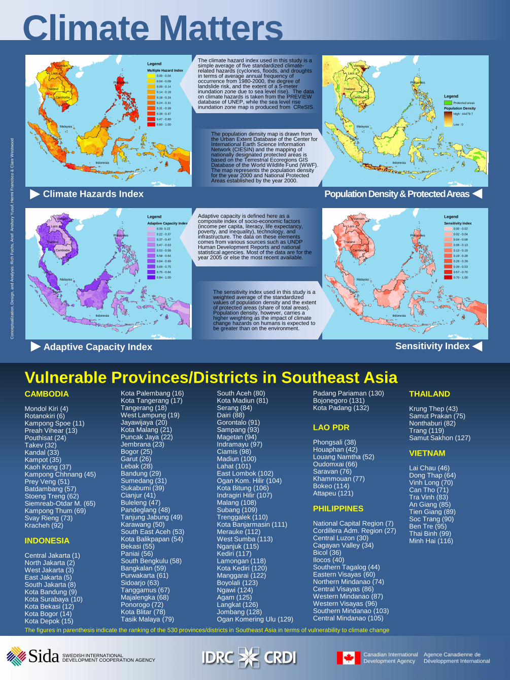
The climate hazard index used in this study is a simple average of five standardized climate-related hazards (cyclones, floods, and droughts in terms of average annual frequency of occurrence from 1980-2000, the degree of landslide risk, and the extent of a 5-meter inundation zone due to sea level rise). The data on climate hazards is taken from the PREVIEW database of UNEP, while the sea level rise inundation zone map is produced from CReSIS.
The population density map is drawn from the Urban Extent Database of the Center for International Earth Science Information Network (CIESIN) and the mapping of nationally designated protected areas is based on the Terrestrial Ecoregions GIS Database of the World Wildlife Fund (WWF). The map represents the population density
Climate MattersC
once
ptua
lizat
ion,
Des
ign,
and
Ana
lysi
s: R
ich
Fuc
hs, A
rief
Ans
hory
Yus
uf, H
erm
i Fra
ncis
co &
Cla
re W
estw
ood
Vietnam
Laos
Thailand
Cambodia
Malaysia
Indonesia
Philippines
Legend
Sensitivity Index0.00 - 0.02
0.02 - 0.04
0.04 - 0.08
0.08 - 0.13
0.13 - 0.19
0.19 - 0.28
0.28 - 0.39
0.39 - 0.53
0.57 - 0.70
0.70 - 1.00
Climate Hazards Index
Vietnam
Laos
Thailand
Cambodia
Malaysia
Indonesia
Philippines
Legend
Adaptive Capacity Index0.00- 0.22
0.22 - 0.37
0.37 - 0.47
0.47 - 0.53
0.53 - 0.58
0.58 - 0.64
0.64 - 0.69
0.69 - 0.75
0.75 - 0.84
0.84 - 1.00
Population Density & Protected Areas
Adaptive capacity is defined here as a composite index of socio-economic factors (income per capita, literacy, life expectancy, poverty, and inequality), technology, and infrastructure. The data on these elements comes from various sources such as UNDP Human Development Reports and national statistical agencies. Most of the data are for the year 2005 or else the most recent available.
The map represents the population density for the year 2000 and National Protected Areas established by the year 2000.
The sensitivity index used in this study is a weighted average of the standardized values of population density and the extent of protected areas (share of total areas). Population density, however, carries a higher weighting as the impact of climate change hazards on humans is expected to be greater than on the environment.
Con
cept
ualiz
atio
n, D
esig
n, a
nd A
naly
sis:
Ric
h F
uchs
, Ari
ef A
nsho
ry Y
usuf
, Her
mi F
ranc
isco
& C
lare
Wes
twoo
d
Adaptive Capacity Index Sensitivity Index
CAMBODIA
Mondol Kiri (4)Rotanokiri (6)Kampong Spoe (11)Preah Vihear (13)Pouthisat (24)Takev (32)Kandal (33)Kampot (35)Kaoh Kong (37)Kampong Chhnang (45)Prey Veng (51)Batdambang (57)Stoeng Treng (62)Siemreab-Otdar M. (65)Kampong Thum (69)
Kota Palembang (16)Kota Tangerang (17)Tangerang (18)West Lampung (19)Jayawijaya (20)Kota Malang (21)Puncak Jaya (22)Jembrana (23)Bogor (25)Garut (26)Lebak (28)Bandung (29)Sumedang (31)Sukabumi (39)Cianjur (41)Buleleng (47)Pandeglang (48)
South Aceh (80)Kota Madiun (81)Serang (84)Dairi (88)Gorontalo (91)Sampang (93)Magetan (94)Indramayu (97)Ciamis (98)Madiun (100)Lahat (101)East Lombok (102)Ogan Kom. Hilir (104)Kota Bitung (106)Indragiri Hilir (107)Malang (108)Subang (109)
Padang Pariaman (130)Bojonegoro (131)Kota Padang (132)
LAO PDR
Phongsali (38)Houaphan (42)Louang Namtha (52)Oudomxai (66)Saravan (76)Khammouan (77)Bokeo (114)Attapeu (121)
PHILIPPINES
THAILAND
Krung Thep (43)Samut Prakan (75)Nonthaburi (82)Trang (119)Samut Sakhon (127)
VIETNAM
Lai Chau (46)Dong Thap (64)Vinh Long (70)Can Tho (71)Tra Vinh (83)An Giang (85)Tien Giang (89)
Vulnerable Provinces/Districts in Southeast Asia
Kampong Thum (69)Svay Rieng (73)Kracheh (92)
INDONESIA
Central Jakarta (1)North Jakarta (2)West Jakarta (3)East Jakarta (5)South Jakarta (8)Kota Bandung (9)Kota Surabaya (10)Kota Bekasi (12)Kota Bogor (14)Kota Depok (15)
Pandeglang (48)Tanjung Jabung (49)Karawang (50)South East Aceh (53)Kota Balikpapan (54)Bekasi (55)Paniai (56)South Bengkulu (58)Bangkalan (59)Purwakarta (61)Sidoarjo (63)Tanggamus (67)Majalengka (68)Ponorogo (72)Kota Blitar (78)Tasik Malaya (79)
Subang (109)Trenggalek (110)Kota Banjarmasin (111)Merauke (112)West Sumba (113)Nganjuk (115)Kediri (117)Lamongan (118)Kota Kediri (120)Manggarai (122)Boyolali (123)Ngawi (124)Agam (125)Langkat (126)Jombang (128)Ogan Komering Ulu (129)
PHILIPPINES
National Capital Region (7)Cordillera Adm. Region (27)Central Luzon (30)Cagayan Valley (34)Bicol (36)Ilocos (40)Southern Tagalog (44)Eastern Visayas (60)Northern Mindanao (74)Central Visayas (86)Western Mindanao (87)Western Visayas (96)Southern Mindanao (103)Central Mindanao (105)
Tien Giang (89)Soc Trang (90)Ben Tre (95)Thai Binh (99)Minh Hai (116)
The figures in parenthesis indicate the ranking of the 530 provinces/districts in Southeast Asia in terms of vulnerability to climate change
Canadian International Development Agency
Agence Canadienne de Développment International
SWEDISH INTERNATIONAL DEVELOPMENT COOPERATION AGENCYSida