classification of the aesthetic value of the selected ... · project deliverable 4-2 classification...
TRANSCRIPT
Project Deliverable 4-2 ● Classification of the aesthetic value of the selected urban rivers - Methodology 1
WP4WP4 AESTHETIC EVALUATION URBEM
Urban River Basin Enhancement Methods
Classification of the aesthetic value of the selected urban rivers
– Methodology –
Project Deliverable 4-2
IST-CESUR J. Silva EVK-CT-2002-00082
Deliverable 4.2

Project Deliverable 4-2 ● Classification of the aesthetic value of the selected urban rivers - Methodology 2
WP4WP4 AESTHETIC EVALUATION URBEM
Coordination of Work package 4 : Instituto Superior Técnico – Centro de Sistemas Urbanos e Regionais (IST – CESUR) Av. Rovisco Pais, 1049-001 Lisbon, Portugal Tel. 0351 21 8409705, Fax 0351 21 8409884 http://www.ist.utl.pt/ or http://cesur.civil.ist.utl.pt/ © 2004 All methodologies, ideas and proposals in this document are the copyright of the URBEM project participants. These methodologies, ideas and proposals may not be used to change or improve the specification of any project to which this project relates, to modify an existing project or to initiate a new project, without first obtaining written approval from those of the URBEM participants who own the particular methodologies, ideas and proposals involved. This report is a contribution to research generally and it would be impudent for third parties to rely on it in specific application without first checking its suitability. Various sections of this report rely on data supplied by or drawn from third party sources. The URBEM partner organisations accept no liability for loss or damage suffered by the client or third parties as a result of errors or inaccuracies in such third party data. Dissemination Status Public

Project Deliverable 4-2 ● Classification of the aesthetic value of the selected urban rivers - Methodology 3
WP4WP4 AESTHETIC EVALUATION URBEM
Report Authors Part I - Classification of the aesthetic value of the selected urban rivers:
Methodology
Project Deliverable 4-2
Av Rovisco Pais, 1049-001 Lisbon, Portugal Tel: +0351 21 8418311 Fax: +0351 21 840 97 05
IST- CESUR Jorge Batista e Silva, [email protected] Graça Saraiva, [email protected] Isabel Loupa Ramos, [email protected] Filipa Monteiro, [email protected] Fernando Nunes da Silva [email protected] Cristina Câmara. Universidade de Évora Fátima Bernardo, [email protected]
Project Deliverable 4-2 ● Classification of the aesthetic value of the selected urban rivers - Methodology 4
WP4WP4 AESTHETIC EVALUATION URBEM
Part II - A “Site Method” for Aesthetic Evaluation
Institut für Landschaftsarchitektur
TU Dresden
Prof. MLA Joachim T. Tourbier Email: [email protected] Prof. MLA Richard Westmacott

Project Deliverable 4-2 ● Classification of the aesthetic value of the selected urban rivers - Methodology 5
WP4WP4 AESTHETIC EVALUATION URBEM
Summary
This document aims at reporting on the approach pursued to establish a methodology
to evaluate and classify the aesthetic values of urban watercourses. In the framework
of the URBEM the overall aim is the integration of these aesthetic values, that can
have both tangible and intangible dimensions, into decision making process for river
rehabilitation. Together with these issues, it was intended to analyse the debate on
river landscapes quality perception and evaluation, based mainly on expert
assessment, but integrating also results deriving from public surveys.
CESUR-IST/UTL methodology for the assessment of river corridors is focused in the
aesthetical value in order to guide rehabilitation interventions at city scale to make the
most of their potential aesthetical value (Part I). Closely linked to this methodology TU
DRESDEN developed a “Site method for aesthetic evaluation” that aims at being
specially designed for assessment of project sites before and after improvement (Part
II) focused on the project scale.
Project Deliverable 4-2 ● Classification of the aesthetic value of the selected urban rivers - Methodology 6
WP4WP4 AESTHETIC EVALUATION URBEM
Table of Contents Part I - Classification of the aesthetic value of the selected urban rivers:
Methodology
1 Introduction .....................................................................................9 2 The methodology.............................................................................12
2.1 Multicriteria approach ........................................................................ 12
2.2 The process...................................................................................... 15
2.3 Identifying the problem...................................................................... 16
2.4 Structuring the process ...................................................................... 17
3 Viewpoints for aesthetic assessment.................................................22 3.1 RIVER.............................................................................................. 23
3.1.1 Natural components.................................................................... 23 3.1.2 River morphology ....................................................................... 29 3.1.3 Integration in the catchment/watershed/river basin ......................... 39 3.1.4 Natural and Technological hazards ................................................ 42
3.2 CITY................................................................................................ 43
3.2.1 Cultural heritage......................................................................... 43 3.2.2 Urban space quality .................................................................... 45 3.2.3 Pollution.................................................................................... 57 3.2.4 Activities in the river front............................................................ 60 3.2.5 Accessibility ............................................................................... 61
3.3 PEOPLE............................................................................................ 67
3.3.1 Sensorial fruition ........................................................................ 67 3.3.2 RIVER LANDSCAPE PERCEPTION ................................................... 69 3.3.3 Identity..................................................................................... 70 3.3.4 Restorative capacity.................................................................... 72 3.3.5 Perceived Security ...................................................................... 74
4 Evaluating and Classifying................................................................76 4.1 Data acquisition and analysis .............................................................. 81
4.2 Public inquiry.................................................................................... 84
5 The Limits of Objectivity and Evaluation ............................................87 References............................................................................................89

Project Deliverable 4-2 ● Classification of the aesthetic value of the selected urban rivers - Methodology 7
WP4WP4 AESTHETIC EVALUATION URBEM
Part II - A “Site Method” for Aesthetic Evaluation 1 The Site Method in the Context of URBEM ..........................................95 2 The Method Described......................................................................97
2.1 The River ......................................................................................... 99
2.2 The City......................................................................................... 106
2.3 The People .................................................................................... 116
3 The Method Applied .......................................................................121 3.1 Application in light of the URBEM method............................................ 122
3.2 Aesthetic inventory of pre-improvement conditions .............................. 127
3.3 Rating aesthetic resources................................................................ 128
3.4 Mapping of distribution patterns ........................................................ 128
3.5 Aesthetic Opportunity and Constraint Analysis ..................................... 128
3.6 Scientific analysis input through hydrologists and city planners .............. 131
3.7 Defining Goals and Objectives under Stakeholder Participation............... 132
3.8 Design criteria, policy determination and planning concepts .................. 134
4 Conclusion ....................................................................................134 5 References....................................................................................134 6 Appendix : Products and Uses of the Aesthetic Assessment ...............136

Project Deliverable 4-2 ● Classification of the aesthetic value of the selected urban rivers - Methodology 8
WP4WP4 AESTHETIC EVALUATION URBEM
List of Figures Fig. 1 – Main Questions ..................................................................................................9
Fig. 2 – Sustainability Paradigm .....................................................................................10
Fig. 3 – River-City-People framework..............................................................................15
Fig. 4– The Process of MCDA (Belton, 2002) ....................................................................16
Fig. 5– Final result of Post-It session with “Experts Panel”..................................................18
Fig. 6– The total cognitive map after modelled by software ................................................20
Fig. 7– Minimal network expressing the relationships between fundamental viewpoints ..........21
Fig. 8 - River corridor based on a buffer of 500 m.............................................................23
Fig. 9 - Riverfront ........................................................................................................23
Fig. 10– Width of river corridor ......................................................................................25
Fig. 11– Distance of vegetation to river margins...............................................................26
Fig. 12– level of visibility in river corridor ........................................................................27
Fig. 13– Vertical structure of vegetation in river corridor....................................................27
Fig. 14– Colour of tree foliage in autumn.........................................................................29
Fig. 15- Generalized model illustrating hierarchical process and geomorphic variables (after Mount, 1995 ..................................................................................................30
Fig. 16– City/River relationships.....................................................................................31
Fig. 17– River width .....................................................................................................32
Fig. 18– River sinuosity ................................................................................................34
Fig. 19– A multi-dimensional framework for river management (from Boon, 1992) ................34
Fig. 20– Types of valley morphology...............................................................................37
Fig. 23 - Strahler’s stream order method ( Tibbalds, 1992) ................................................41
Fig. 24 - Viewsheds of Jardas (Barcarena) stream with intervisibility areas. ..........................46
Fig. 25– Buildings heights .............................................................................................47
Fig. 27– Typology of visual contact with water .................................................................49
Fig. 28– Typology of visual contact axes with watercourse in Jardas (Barcarena) stream. .......50
Fig. 29– Profiles contact with water from the city to the river and from the river to the city ....51
Fig. 30– Townscape of Barcarena/Cacém, modelled with a GIS, wraping the Jardas stream ....52
Fig. 31– Typology of contact with water ..........................................................................54
Fig. 32– Physical contact with water: natural and artificial banks ........................................54
Fig. 33– Litter on river margins......................................................................................58
Fig. 35- Watercolour.....................................................................................................59
Fig. 36– Crossings at Douro river (Oporto), and Thames (Walligford, London).......................62
Fig. 37– Influence of the width in the amount of crossings .................................................63
Fig. 38– Crossings in Jardas Stream (Barcarena/Cacém) ...................................................64
Fig. 39- Anchorage places being used by traditional boats (Aveiro, Portugal) ........................66
Fig. 40– River and pathway side by side (Sevilha). ...........................................................66
Fig. 41– Unravelling the complexity ................................................................................77
Fig. 42– Criteria, Descriptors and Impact indicators ..........................................................78
Fig. 43– Aesthetical profiles of urban rivers .....................................................................80
Fig. 44– GIS products: DTM, Slope analysis and viewsheds. ...............................................84
Fig. 45– Inquiry methodology ........................................................................................86

Project Deliverable 4-2 ● Classification of the aesthetic value of the selected urban rivers - Methodology 9
WP4WP4 AESTHETIC EVALUATION URBEM
Part I -
Classification of the aesthetic value of the selected urban rivers: Methodology
1 Introduction
This report intends to state the steps followed on our search to establish a
methodology for evaluating river aesthetics.
Aesthetic values of river corridors can be considered as a specific contribution for a
global assessment of those systems, in the framework of the URBEM project. The
overall aim should be the integration of these aesthetic values, that can have both
tangible and intangible dimensions, in the decision making process for river
rehabilitation. Together with these issues, it was intended to analyse the debate on
river landscapes quality perception and evaluation, based mainly on expert
assessment, but integrating also results deriving from public surveys.
Some questions have been raised in the beginning of the study aiming to establish
levels of answers that could organize our research.
These questions and their level of possible answers can be illustrated in figure 1.
Why Aesthetic values should contribute to urban watercourse rehabilitation? To assess the aesthetic appeal of a river corridor? Aesthetic evaluation should be done?
PARADIGMS
What To do in terms of aesthetical evaluation? Approach (es) can be used?
METHODOLOGIES
How To do it? To assess / evaluate aesthetics?
TECHNIQUES
Where urban watercourses to study CASE STUDIES
Fig. 1 – Main Questions
So, in our point of view, aesthetic quality in the urban environment can be considered
as a complementary dimension of sustainability, which should be achieved together
with other components of sustainable development, such as economic, ecologic and
social aims. This assumption means that aesthetic quality, in our concept, goes

Project Deliverable 4-2 ● Classification of the aesthetic value of the selected urban rivers - Methodology 10
WP4WP4 AESTHETIC EVALUATION URBEM
beyond an external/visual appearance and should be observed through a more
comprehensive approach related with other dimensions of the urban landscape.
Fig. 2 – Sustainability Paradigm
Aesthetic appreciation and evaluation is actually an important concern in the field of
environmental awareness and planning. The balance between natural and human
environments has always been a field of interest in human societies, in a search for
beauty, delight and balance of human works and their environmental relationship.
Thus, environmental aesthetics is becoming an interdisciplinary field of research,
crossing disciplines so diverse such as geography, planning, landscape architecture,
psychology, and philosophy, among others. This recognition shows that aesthetic
values in the environment are a raising issue, as an important complement area of
research such as sustainable development, planning and resource management
(Berleant, 1997).
Rivers and cities are systems that have their own patterns, originated by physical and
functional characteristics and conditions. Rivers are mostly natural systems, influenced
by geomorphology and climate, showing specific hydrologic, hydraulic and ecological
processes and patterns. Human use and appreciation of rivers relies on their physical
characteristics but also on formal and phenomenological aspects, such as unity,
contrast, identity, reflection and several other visual and aesthetical attributes,
recognized worldwide.
Cities are built by people for people to live. Their historical, social, cultural and
economic context makes them social systems with a high degree of complexity.
Quality of life and of the urban environment is actually a high valued attribute in terms
of achieving aims of urban sustainability. The balance between natural features within
ECONOMY
ECOLOGY ETHICS
AESTHETIC
DIMENSIONS (3e+1)
Economic dimension
Ecologic dimension
Ethic (social) dimension
+ Aesthetic dimension

Project Deliverable 4-2 ● Classification of the aesthetic value of the selected urban rivers - Methodology 11
WP4WP4 AESTHETIC EVALUATION URBEM
the urban environment is actually a relevant issue in the search for a sustainable
urban planning and management.
On the other hand, people are the constructers and therefore users of cities. Urban
quality of life is a very important aim to be achieved by local decision makers and
citizens. Quality of the urban landscape is one of the contributing attributes for a
pleasant urban life, where aesthetic awareness and aesthetic values play an important
role in the overall appreciation of the urbanity. Physical settings influence human
inhabitants and contribute to their well being and satisfaction. On the other hand,
human beliefs, values and attitudes shape their environment and their degree of
satisfaction about it. Public perception of the urban landscape and its involvement in
their management are critical issues when considering sustainability as a target for
urban rehabilitation.
Environmental aesthetic evaluation can be envisaged within the theoretical field of
landscape perception and evaluation. This area has a wide scientific contribution
deriving from landscape architecture and planning, environmental psychology,
environmental aesthetics and natural resources management. Several approaches and
methodologies have been developed, since the sixties, to assess and evaluate
landscape and scenic values, aiming to integrate these values into the planning and
design process.
Aesthetic values can be assessed through different approaches and motivations. The
literature reviewed establishes several approaches, from the expert or professional
point of view, concerning technical aims and the integration in the planning process.
Other approaches come from the social sciences framework, namely from the
environmental psychology, integrating behavioural studies related with public
perception and public preferences for scenic and aesthetic values. Other approaches
are more concerned with the intangible, sensorial and emotional aspects of landscape
appreciation, named as humanistic or phenomenological approaches.
Table 1 summarizes a synthesis of different approaches proposed by several authors
in this field, aiming to synthesize the motivations and methods underpinning the
complex framework of landscape and scenic evaluation.

Project Deliverable 4-2 ● Classification of the aesthetic value of the selected urban rivers - Methodology 12
WP4WP4 AESTHETIC EVALUATION URBEM
Table 1 - Synthesis of methodologies for landscape aesthetic evaluation
Zube et al., 1982 Zube, 1984 Daniel & Vining, 1982 Porteous, 1982
Expert
Paradigm
Professional
Paradigm
Formal
or
Ecologic Aesthetics
Planners
Psychophysical/
Cognitive Paradigms
Behavioural
Paradigm
Psychophysical/
Psychologic
Experimentalists
Experiential
Paradigm
Humanistic
Paradigm
Phenomenological Humanists
__ __ Activists
Recent developments in this field show the need to integrate and cross those
approaches in order to attempt, as much as possible, the complexity and subjectivity
of aesthetic values. The use of mixed methodologies is been recommended, crossing
expert approaches with other that involve public surveys, either measurable criteria
and parameters together with subjective and intangible assessment (Bell et al., 2001;
Porteous, 1996; Saraiva, 1999).
This was one path followed by our team, looking for attributes to classify the aesthetic
quality of an urban watercourse using not only expert methodologies but also
behavioural and phenomenological approaches. The integration of the results obtained
trough this approaches will be preformed trough multicriteria techniques.
2 The methodology
2.1 Multicriteria approach
The field of multiple criteria decision analysis (MCDA), sometimes named as multiple
criteria decision aid or multiple criteria decision making (MCDM) has been fully
developed in the last 30 years, by increasing its methodological foundations and
widening its scope of applications. In this process several disciplines have been
included in these multicriteria techniques, in the procedures and in the methodologies,
thereby enriching the practice of multicriteria evaluation.
Project Deliverable 4-2 ● Classification of the aesthetic value of the selected urban rivers - Methodology 13
WP4WP4 AESTHETIC EVALUATION URBEM
MCDM issues are generally related to different choices or courses of action. We need
to select when some standard of judging conflicts with to a substantial extent. As in
everyday decisions we often need - explicitly not consciously - the consideration of
multiple factors (“criteria”, in general sense). Multiple criteria decision aid has
emerged when decision makers, faced with complex decision problems, recognized the
need to have some methods for organizing and synthesizing information in such a way
that they feel comfortable and confident to make a decision. Multiple criteria decision
analysis is “umbrella terms to describe a collection of formal approach which seek to
take explicit account of multiple criteria in helping individuals or groups explore
decisions that matter” (Belton, 2002:2).
In evaluation processes, where a great diversity of units of measurement and
valuation procedures should be taken into account, MCDA becomes a “natural” – if not
inevitable – approach for organising information and structuring the problem following
a more rational way of evaluating. A multicriteria methodology can be also applied to
plans monitoring by an in continuum evaluation (Silva, 1999).
Aesthetics is a subject where all the people as something to say – to like, to dislike or
even to express their indifference to the subject. Aesthetics, also supports evaluation
discourses by experts fully based in holistic approaches, giving rise to the
consideration of a wide set of subjective values. These values are not always very well
apprehended or perceived by people/users or even by experts that usually don’t work
in this domain. Aesthetic values are also influenced by socio-economic and cultural
aspects of society, which make even more difficult any evaluation procedure that
seeks to evaluate urban rivers in different political, societal and cultural contexts.
In this problematic area - the problem of general aesthetical classification - we should
not to expect to find the “right answer”, the “right model” or the “right prescription” to
apply or adopt. The optimisation paradigm, in our perspective, should not be adopted
here.
In the literature, there are several methods and techniques developed in different
domains, as mentioned before, which are related with some specific subjects of
aesthetical evaluation. Considering this diversity, a multi-methodology can be a well-
supported approach to deal with several perspectives by combining different methods
and techniques.

Project Deliverable 4-2 ● Classification of the aesthetic value of the selected urban rivers - Methodology 14
WP4WP4 AESTHETIC EVALUATION URBEM
Multimethodology just means, to employ more than one method or methodology to
tackle real-world problem in the complexity of this project. We will adopt here the
three main arguments referred by Mingers (2001:289):
a) Multimethodology is necessary to deal effectively with the full richness of the
real world, especially with aesthetical aspects which are inevitably
multidimensional;
b) Combining different methods and approaches may well yield a better result;
c) This combination can generate new insights and provide more confidence in
the results by validating each other.
Habermas (quoted by Mingers, 2001: 290) developed a framework that considers the
advantages of viewing the world not only through a particular instrument but by
accepting different representations or general ways of looking at the world, also
known as paradigms. In this framework, he suggests the usefulness of distinguish our
relations to and interactions with three worlds: (i) the material world; (ii) the personal
world and; (iii) the social world. The first is the physical world and is more or less
independent of human beings, the second is the world of individual thoughts,
emotions, experiences, values and beliefs and the third is the world that we share and
participate in, a complex set of language, meaning, social practices, rules and
resources that enables and constrains our actions.
The Three Worlds of Habermas inspired our urban watercourses aesthetical
multicriteria evaluation approach. In fact we can find in a River some aesthetical
attributes that are intrinsically connected to its natural and physical components
where our relationship to this world is mainly the observation. The river “existed
before us and would exist whether or not we did. We can shape it through our actions,
but ultimately we are always subject to its laws” (ibidem). Some aesthetical attributes
are more related with individual emotions and the way we experience and value the
presence of the watercourse. Others are more related with the social world that, in
this context, we represent by the City as a social construction.
Some of these cities have been developed beside rivers in a deterministic way to
benefit from its presence (transport, water resources, and alluvium soils). Throughout
time, rivers have been modified according to development society need. Within the
actual framework of a more balanced development that takes into account

Project Deliverable 4-2 ● Classification of the aesthetic value of the selected urban rivers - Methodology 15
WP4WP4 AESTHETIC EVALUATION URBEM
environmental, social, institutional and economical perspectives, the rehabilitation
process of urban rivers demand for a more sustainable action.
Therefore, we established in our research framework a three dimensional approach
based on triangle vertex – River, City and People. Aesthetic quality of an urban
watercourse depends on several attributes that can be related with each one of these
dimensions and also in their relationships.
RIVER
PEOPLE
CITY
Our Social World - Intersubjectivity
Participation, language, meaning, social practices,
culture and power relations, rules, resources, constraints
Personal World - SubjectivityExperiences, individual
thoughts, emotions, values, beliefs.
Material World – Objectivity
Observation, material and Physical attributes and
processes, natural laws,
requirable care
RIVER CITY
Our Social World - Intersubjectivity
Participation, language, meaning, social practices,
culture and power relations, rules, resources, constraints
Personal World - SubjectivityExperiences, individual
thoughts, emotions, values, beliefs.
Material World – Objectivity
Observation, material and Physical attributes and
processes, natural laws,
requirable care
Fig. 3 – River-City-People framework
2.2 The process
There are on MCDA literature several perspectives and approaches in terms of
process, i.e., how to deal with a given problem in a pragmatic way (see Bana e Costa,
1992; Belton, 2002). For the purpose of this work we have chosen the process
proposed by Valerie Belton and Theodor Stewart (2002), which can be grouped in
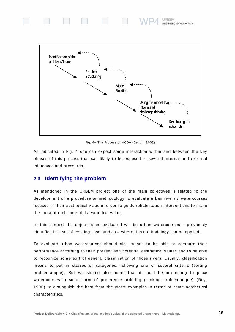
three key phases:
a) Problem identification and structuring – to opening up the issue, capture and
manage the complexity and begin to understand when the decision makers feel
comfortable and agree with some representation of the complexity and how
they might move forward;
b) Model building and use – seeks to extract the essence of the issue in a more
convergent mode of thinking in such a way that can be possible to elaborate
more detailed evaluation of potential ways to progress;
c) Action plan – the final phase is related with outcomes and recommendations,
aiding satisfying decisions that have to be taken and informing the
development of an action plan.
Project Deliverable 4-2 ● Classification of the aesthetic value of the selected urban rivers - Methodology 16
WP4WP4 AESTHETIC EVALUATION URBEM
Identification of the problem / issue
Problem Structuring
Model Building
Using the model to inform and challenge thinking
Developing an action plan
Identification of the problem / issue
Problem Structuring
Model Building
Using the model to inform and challenge thinking
Developing an action plan
Fig. 4– The Process of MCDA (Belton, 2002)
As indicated in Fig. 4 one can expect some interaction within and between the key
phases of this process that can likely to be exposed to several internal and external
influences and pressures.
2.3 Identifying the problem
As mentioned in the URBEM project one of the main objectives is related to the
development of a procedure or methodology to evaluate urban rivers / watercourses
focused in their aesthetical value in order to guide rehabilitation interventions to make
the most of their potential aesthetical value.
In this context the object to be evaluated will be urban watercourses – previously
identified in a set of existing case studies – where this methodology can be applied.
To evaluate urban watercourses should also means to be able to compare their
performance according to their present and potential aesthetical values and to be able
to recognize some sort of general classification of those rivers. Usually, classification
means to put in classes or categories, following one or several criteria (sorting
problematique). But we should also admit that it could be interesting to place
watercourses in some form of preference ordering (ranking problematique) (Roy,
1996) to distinguish the best from the worst examples in terms of some aesthetical
characteristics.

Project Deliverable 4-2 ● Classification of the aesthetic value of the selected urban rivers - Methodology 17
WP4WP4 AESTHETIC EVALUATION URBEM
The third aspect represents the true challenge of this work. It means that we have to
find the main characteristics, to describe then to organize ideas and to make clearer
the meaning(s) of aesthetic value of urban watercourses. What will be the factors that
can explain the aesthetics of the river that can benefit or damage its value(s). How to
make operational, as much as possible, some sort of procedure or methodology that
may help decision makers or technicians to assess present situations, to decide on
future rehabilitation action tacking in account this aesthetical dimension as well as
reference standards specific to each case studies. The following chapters will try to
clarify these issues.
2.4 Structuring the process
In the area of Problem Structuring Methods there are a broad range of general
managerial tools for clarify, organize, simplify, even solve, ill-structured problems or
complex organizational decision processes like:
Strategic Choice – (Friend and Jessop, 1971; Friend and Hickling, 1987);
Strategic Options Development Analysis – SODA (Eden and Simpson, 1989);
Soft Systems Methodology – SSM (Checkland, 1981);
(See also Rosenhead, 2001)
Expert Panel / Users Panel
To make more explicit the meaning of the aesthetics of a watercourse we felt the need
of using a tool that could help the team to generate ideas and facilitate the emergence
/ capture the multiplicity of aspects considered relevant to our problem.
We considered well fitted to this purpose that this discussion can start within a panel
of technicians working or interested by the subject of watercourse rehabilitation and
coming from the following scientific and professional areas:
- Hydraulic Engineering
- Environmental Engineering
- Geomorphology
- Architecture

Project Deliverable 4-2 ● Classification of the aesthetic value of the selected urban rivers - Methodology 18
WP4WP4 AESTHETIC EVALUATION URBEM
- Landscape Architecture
- Environmental Psychology
- Biology
- Urban Planning
- Economy
In other contexts one can admit that this same discussion can be prepared and
organized with the population, users or even local authorities, affected by or that can
be involved in an urban watercourse rehabilitation process.
The “Post-It” technique was chosen to be applied to this “Experts Panel” formed by
experts from all the scientific areas referred above. In the session the participants
must be confronted with a key-issue that should be well thought and phrased. In our
case we chose “What can Influence the aesthetical quality of a watercourse in a city?”
(Fig. 5). “Post-it” technique, Oval Map Technique and Cognitive Maps are very similar
methods in their purposes. We adopted the procedure referred by Eden e Ackerman
(2001), adapted to this specific situation.
Fig. 5– Final result of Post-It session with “Experts Panel”
The facilitator(s) has a neutral role. He tries to moderate the discussion and stimulate
the emergence of ideas. In a second stage, normally after a break, the participants try
tries to organize the small post-it sheets clustering them by their affinity, drawing the
more important influence relationships between concepts and labelling the cluster with

Project Deliverable 4-2 ● Classification of the aesthetic value of the selected urban rivers - Methodology 19
WP4WP4 AESTHETIC EVALUATION URBEM
a statement that should express their content. This statement generally becomes a
fundamental viewpoint of evaluation.
After this “Post-It” session it starts the work of analysing and reflecting deeply about
the ideas that were expressed. In complex structuring processes the number of ideas
that can be expressed by participants can increase to 300-400 concepts. The use of
software like Decision Explorer1 can help the team to manage this reach mess of ideas
and to represent the network of mutual influence relationships (see figure 4 based on
concepts that emerged from the session of “Experts Panel”).
1 Decision Explorer is produced by Banxia Software Ldª - (www.banxia.com)

Project Deliverable 4-2 ● Classification of the aesthetic value of the selected urban rivers - Methodology 20
WP4WP4 AESTHETIC EVALUATION URBEM
Fig. 6– The total cognitive map after modelled by software
Project Deliverable 4-2 ● Classification of the aesthetic value of the selected urban rivers - Methodology 21
WP4WP4 AESTHETIC EVALUATION URBEM
Two aspects should be remarked. The first relates to the existence of direct and
indirect relationships, which are very likely to be mentioned by participants due to this
very subjective and sometimes unclear field of aesthetics. It is not always easy to
differentiate what influences directly the aesthetical value (like “sensorial fruition”)
and what ideas only have an indirect and marginal influence.
Other set of concepts that emerge from this process is related with means, like
material or financial resources, and the mention to detailed solutions that can promote
the aesthetical value of rivers. The further analysis should purge this complex network
without losing the richness that it contains.
Integration in theRiver basin/catchment
Urban space
quality
Sensorial fruition
Cultural Heritage
BiologicalComponents
River Morphology
Natural-Artificial
dialetics
Perceivedsecurity
Accessibility
Pollution
Activities in the riverfront
Aesthetical quality of watercourses
in cities
Natural andtechnological
hazards
Restorativecapacity
Identity
CITYRIVER
PEOPLE
Fig. 7– Minimal network expressing the relationships between fundamental viewpoints
The minimal network (Fig. 7) synthesizes the fundamental viewpoints considered more
relevant to aesthetical classification of urban watercourses. This network confirms the
classical dialectics Natural-Artificial which is particularly relevant in urban contexts.
This dialectics, in terms of evaluation, means that there is a pre-positioning of people
facing natural and artificial world that determine and influence their value system of
preferences.
Project Deliverable 4-2 ● Classification of the aesthetic value of the selected urban rivers - Methodology 22
WP4WP4 AESTHETIC EVALUATION URBEM
The obtained result, represented in Fig. 7, also confirms the World – People – River
framework already explained in previous chapters and represented by three clusters of
fundamental viewpoints.
3 Viewpoints for aesthetic assessment
The general areas of concerns or viewpoints presented above should have some
proprieties already identified by literature (Bana e Costa, 1992):
• Consensualness
• Intelligibility
• Isolability
They emerged from the “post-it” group discussion and can be used as a reference
guide to other teams that would like to apply this methodology. Anyway, those
viewpoints will be the result of a structuring process that should be well discussed and
agreed by the people involved in a similar process, to guarantee a satisfying
representation of the aesthetical factors that influence the river being analysed.
But the complete version of cognitive map obtained usually shows other more
elementary viewpoints that help us to better explain and understand the meaning of
the corresponding fundamental viewpoint. Conceiving the network as a value tree,
these more elementary viewpoints are located between the top level (fundamental
viewpoint) and the bottom level (alternatives of action) aiding to refine the meaning of
the top level and to find measures of the aesthetical value.
This effort can be much better achieved in real practical situations, i.e., leading with a
real case study. According to this, a small urban watercourse has been chosen -
Jardas Stream – having an average width of 10m and a permanent flow regime. This
narrow river crosses a high-density urban area – Barcarena-Cacém – where
rehabilitation projects have been recently prepared. The following chapters will include
several examples that refer to this small river where some were applied with the help
of GIS.
The following discussion is mostly related with the city-river relationship in two types
of areas which were often used to set geographical context of some indicators:
Project Deliverable 4-2 ● Classification of the aesthetic value of the selected urban rivers - Methodology 23
WP4WP4 AESTHETIC EVALUATION URBEM
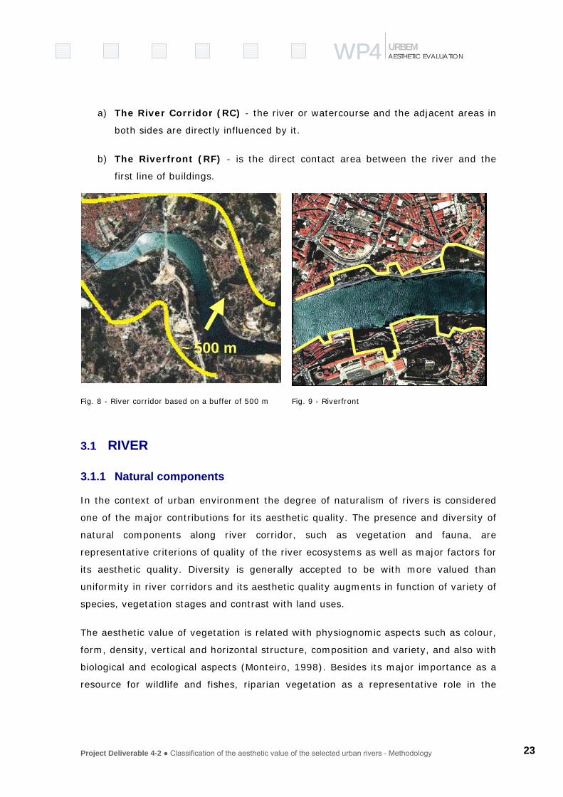
a) The River Corridor (RC) - the river or watercourse and the adjacent areas in
both sides are directly influenced by it.
b) The Riverfront (RF) - is the direct contact area between the river and the
first line of buildings.
Fig. 8 - River corridor based on a buffer of 500 m
Fig. 9 - Riverfront
3.1 RIVER
3.1.1 Natural components
In the context of urban environment the degree of naturalism of rivers is considered
one of the major contributions for its aesthetic quality. The presence and diversity of
natural components along river corridor, such as vegetation and fauna, are
representative criterions of quality of the river ecosystems as well as major factors for
its aesthetic quality. Diversity is generally accepted to be with more valued than
uniformity in river corridors and its aesthetic quality augments in function of variety of
species, vegetation stages and contrast with land uses.
The aesthetic value of vegetation is related with physiognomic aspects such as colour,
form, density, vertical and horizontal structure, composition and variety, and also with
biological and ecological aspects (Monteiro, 1998). Besides its major importance as a
resource for wildlife and fishes, riparian vegetation as a representative role in the
~ 500 m

Project Deliverable 4-2 ● Classification of the aesthetic value of the selected urban rivers - Methodology 24
WP4WP4 AESTHETIC EVALUATION URBEM
protection of river banks from erosion and in the process of filtering contaminants
(MOPT, 1992).
P1. Spatial Distribution
The existence of various types of vegetation in different stages of development
increases the aesthetic quality of river corridor by adding diversity, contrast and
mystery. The riparian vegetation enhances the presence of the river on the landscape
by revealing its presence through a linear pattern of green. Therefore it can be
recognised at long distances even when its presence is not evident and the contact
with nature is commonly from a distance (Kaplan et.al, 1998). The spatial distribution
of the vegetation is, therefore, an important element in aesthetic evaluation
assessment and both horizontal (a) and vertical (b) distribution is a relevant factor.
These geometric parameters have strong influences in the human perception of the
river and of its presence in the urban landscape.
(a) The horizontal distribution can be evaluated by the width of riparian gallery and
by the pattern of distribution of such vegetation. The width of riparian vegetation is
influenced by several aspects but it is commonly accepted by landscape ecology
standards that a 12 meters length is the minimum area to have a linear riparian
corridor (Forman, 1995). In consequence, a 4 scale classification that can be
considered for the evaluation of the horizontal distribution of river vegetation (Fig.
10).
Width of riparian vegetation edge
(i) Non existent (no vegetation);
(ii) Narrow (presence of edge species: 0-12 m);
(iii) Medium (linear corridor: 12-20 m)
(iv) Large (linear pattern: >20m)

Project Deliverable 4-2 ● Classification of the aesthetic value of the selected urban rivers - Methodology 25
WP4WP4 AESTHETIC EVALUATION URBEM
Fig. 10– Width of river corridor
The vegetation pattern on the river corridor is focused on the distribution and density
of species. Generally, sinuous distributions, similar to natural forms, are considered
more attractive than linear ones because it augments the mystery and sets a variety
of scenarios along river corridor paths, which encourages exploration. It also helps to
define vistas and views, which are important for adding quality to the landscape
(Kaplan et. al, 1998). The distance to the margins is also an important factor in the
horizontal distribution of vegetation in river corridor since it allows the visual or
physical access to the river and both situations are interesting from the aesthetic
value point of view (Fig. 11). A way to evaluate these parameters can be by analysing
the horizontal density of vegetation (shrubs and trees) along a river corridor and the
permeability of open views. Moderate permeability and density of vegetation along the
river and irregular distribution of open views are the most adequate situation.
Shrubs density
- Absent
- Sparse - >8 meters
- Medium – 2-8 meters
- Dense – 1-2 meters
Non existent
Narrow (0-12m) Large (>20m)
Medium (12-20m)

Project Deliverable 4-2 ● Classification of the aesthetic value of the selected urban rivers - Methodology 26
WP4WP4 AESTHETIC EVALUATION URBEM
Trees density
- Absent
- Sparse – sparse riparian gallery
- Medium – continuum presence of riparian gallery
- Dense – dense riparian gallery
Fig. 11– Distance of vegetation to river margins
(b) The vertical distribution can be evaluated by the species distribution in the
rivers section and also by the vegetation stage of development. The height and
density of riparian galleries is important for evaluating degree of naturalness of
waterscapes edges, especially if it as the presence of trees in high stage of
development (Monteiro, 1998). Situations with vegetation under the eye-level are
usually more attractive because allows better visual contact with the water and also
increases the perception of safety (Kaplan et al., 1998). This could be measured by
defining an area of visual obstruction counting from ground level (Fig. 12).
Distant from river
Near the river Linear patterns
Random patterns

Project Deliverable 4-2 ● Classification of the aesthetic value of the selected urban rivers - Methodology 27
WP4WP4 AESTHETIC EVALUATION URBEM
Fig. 12– Level of visibility in river corridor
Descriptor of visual obstruction to watercourse
(i) from 0-1.00m and >tree canopy baseline – obstructed visibility
(ii) 1.00m to tree canopy baseline– good visibility
The height of trees influences the presence of riparian gallery in the urban landscape
but also influences the visualization from city to river by obstructing visual contact
with water, especially in small rivers. Depending on the location of the analysis it can
be defined classes of tree height in order to define the aesthetical quality of the river.
The diversity of vertical distributions of vegetation (the presence of various types of
vegetation cross section) is also an important element for the attractiveness of
waterscapes (Fig. 13).
Fig. 13– Vertical structure of vegetation in river corridor

Project Deliverable 4-2 ● Classification of the aesthetic value of the selected urban rivers - Methodology 28
WP4WP4 AESTHETIC EVALUATION URBEM
The presence of riparian vegetation in both river margins also enhances the sense of
naturalness. This could be evaluated by classifying the presence of riparian vegetation
on margins in classes (Saraiva et al., 2001).
Index of riparian vegetation presence in margins
1 – Absence of vegetation
2 - Presence of herbaceous and shrubs
3 – Presence of sparse trees, in one or in both margins
4 – Presence of well-developed riparian gallery with tree and that is mainly continuous
in one or in both margins.
P2. Biodiversity
In this context, biological diversity is the variety of organisms in the river corridor
ecosystem. Therefore the presence of fauna and flora it is one of the main parameters
evaluate the ecological status of the river corridor, which evaluated through a set of
indexes or indicators adapted to the ecological conditions of the city-region that can
be generally defined as:
(i) Index of conservation of riparian vegetation
(ii) Index of birds species
(iii) Index of fishes
The presence of autochthones species in the river corridor is relevant for the
biodiversity of riparian areas. Therefore, it is relevant the identification of the riverside
vegetation of invasive species and the evaluation of presence and dynamics in the
river corridor as well as of planted/ornamental species. Both can be classified in 5
classes by the observation of the number of species.
Classes of ornamental species and invasive species
- 0-10% - very low presence
- 10-25% - low presence
- 25-50% - moderate presence
- 50-75% - high presence
- >75% - very high presence

Project Deliverable 4-2 ● Classification of the aesthetic value of the selected urban rivers - Methodology 29
WP4WP4 AESTHETIC EVALUATION URBEM
P3. Temporal diversity
The seasonal dynamics of vegetation introduces variety and contrast of colours and
textures in the urban landscape. Therefore the presence of riparian galleries with a
mixture species with different characteristics - such as type of tree and shrub species
(evergreen, deciduous, coniferous), stand age, colour of foliage, presence of flowers,
fragrances and flowering season - are usually more attractive for people than areas
that have no variation of species.
Therefore temporal diversity can be classified in 3 classes dependent of the diversity
of species and raging from (i) low or null diversity of species; (ii) medium diversity
(e.g. presence of deciduous and evergreen trees and shrubs); (iii) high diversity of
species (e.g. presence of trees and shrubs species with different colours of foliage,
flowering season and stand age).
Fig. 14– Colour of tree foliage in autumn
3.1.2 River morphology
River systems are natural dynamic elements, which have specific behaviours and
patterns, influenced by geology, geomorphology and climate. Its morphology and
behaviour reflects a balance of forces and processes that operate through it and upon
it (Mount, 1995). In natural systems, the movement of energy and matter shows the
tendency to attempt a dynamic equilibrium with the discharge and sediment load
provided by its basin or watershed (Schumm, 1977). This dynamics of the river
system is the result of complex interactions between the geometric properties of a
river, the landscape where it flows and the energy and forces that act on it (Mount,
1995).

Project Deliverable 4-2 ● Classification of the aesthetic value of the selected urban rivers - Methodology 30
WP4WP4 AESTHETIC EVALUATION URBEM
There are specific spatial and temporal patterns associated with each river and its
physical and biological processes. Adjustments in the river behaviour can occur due to
natural or man-made conditions, considered for various time scales, from a relative
short term into a long-term scale.
Physical characteristics of each river are related with this trend to attempt this state of
equilibrium, affecting variables of its channel morphology, such as profile, gradient,
channel cross section, and channel pattern. Fig. 15 illustrates the generalized model
illustrating hierarchical process and geomorphic variables (Mount, 1995). Discharge
and sediment load can show a high level of fluctuation, associated with patterns of
hydrological regime.
Fig. 15- Generalized model illustrating hierarchical process and geomorphic variables (after Mount, 1995)
Urban reaches show considerable changes towards an undisturbed pattern. The
urbanization process induces changes in the hydrologic regime, usually accompanied
by structural works affecting water flow, runoff processes, sediment load and
transport. These changes can affect only the urban reach or the upstream catchment,
depending on the size and impact of that process. Generally, infiltration is reduced and
runoff increased and “flashier”, increasing flood hazard (Kondolf & Keller, 1991).
Changes in sediment load induce also modifications on the dimensions and geometry
of river channels (Kondolf & Keller, 1991). The urbanization process typically induces
channel widening, down cutting, straitening and bank modification, with the use of
impervious and rigid materials in bank and edge management. Several reaches of
urban watercourses have been transformed in concrete-lined channels, with less
Project Deliverable 4-2 ● Classification of the aesthetic value of the selected urban rivers - Methodology 31
WP4WP4 AESTHETIC EVALUATION URBEM
environmental values, affecting the existence and diversity of riparian vegetation and
wildlife.
Visual appearance of urban watercourse reaches offer characteristics and attributes
according to this ‘artificialization’, with features designed to reduce flood risks, prevent
erosion or control the river ‘irregularity’. Urban uses in the riverfront and river corridor
usually are adapted to the physical manipulation of the urban river landscape, with
great or less presence of the ‘natural’ elements, such as vegetation. River edges show
generally a geometric pattern, due to the replacement of naturally or irregular
alignments, as a logical response to pressures on management or land availability
(Manning, 1997).
The emerging trends of river rehabilitation look for a more sustainable management of
urban watercourses. Introducing variety in channel and bank diversity, in order to
enhance habitats and opportunity for amenities and recreation, towards a more
pleasant urban environment.
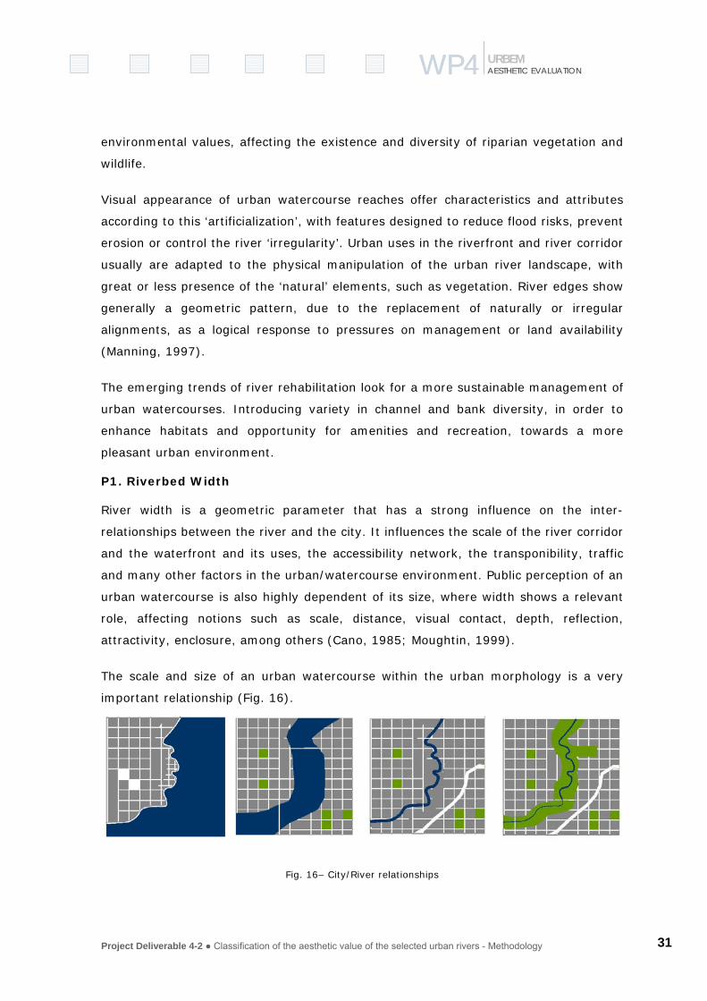
P1. Riverbed Width
River width is a geometric parameter that has a strong influence on the inter-
relationships between the river and the city. It influences the scale of the river corridor
and the waterfront and its uses, the accessibility network, the transponibility, traffic
and many other factors in the urban/watercourse environment. Public perception of an
urban watercourse is also highly dependent of its size, where width shows a relevant
role, affecting notions such as scale, distance, visual contact, depth, reflection,
attractivity, enclosure, among others (Cano, 1985; Moughtin, 1999).
The scale and size of an urban watercourse within the urban morphology is a very
important relationship (Fig. 16).
Fig. 16– City/River relationships

Project Deliverable 4-2 ● Classification of the aesthetic value of the selected urban rivers - Methodology 32
WP4WP4 AESTHETIC EVALUATION URBEM
This parameter has been chosen in our methodology as one of the starting items for
selecting the case study, due to its relevance in the urban context.
Fig. 17– River width
The width of a watercourse is determined by several aspects, such as its location in
the catchments, the stream order, the bankfull flow discharge and its fluctuations, the
valley profile, among others.
The influence of this parameter in the aesthetic evaluation process, described above,
lead to the consideration of five-scale classification, according to the literature review
(Leopold & Marchand, 1968; Dunne & Leopold, 1978):
1. Non existent (culverted);
2. Narrow (0-5m)
3. Medium (5-20m)
4. Large (20-200m)
5. Very large (> 200m)
~ 50 m
MMéérrttoollaa GGuuaaddiiaannaa rriivveerr
MMeeddiiuumm ssiizzee rriivveerr((TToolleeddoo))
SSmmaallll rriivveerr (Barcarena)
LLaarrggee rriivveerr (Lisboa)
~ 25 m
AAvveeiirroo VVoouuggaa rriivveerr FFrraannccee
SSeennaa rriivveerr

Project Deliverable 4-2 ● Classification of the aesthetic value of the selected urban rivers - Methodology 33
WP4WP4 AESTHETIC EVALUATION URBEM
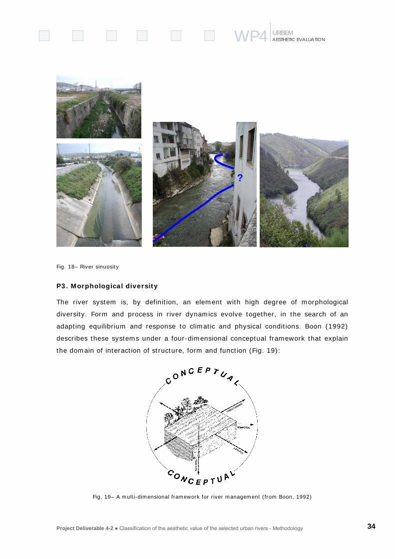
P2. Sinuosity
Sinuosity of a river is a variable that describes the existence or absence of a
meandering pattern in the landscape. Sinuosity can have influence in the aesthetic
appearance of a river, creating a sense of mystery, discovery, rather than a straight
reach. Studies developed on river aesthetic attributes showed preferences for
meandering and sinuous rivers, comparing with straight patterns (Herzog. 1985; Lee,
1979; Saraiva, 1999; Monteiro, 1998).
Sinuosity of a river is “a reflection of the channel length required to cover a given
point-to-point or straight-line distance” (Mount, 1995). It can be assessed for a river
reach through a sinuosity index (SI)
SI = thalweg length/valley length, or
SI = length of channel axis/length of meander belt axis.
Index of sinuosity (IS) (Mansikkaniemi in Christofoletti, 1991):
SI = 100(Cc-Cv/Cc)+100(Cv-Z/Cc)
Cc: length of the riverbed;
Cv: length of the valley;
Z: distance between thee limits of the reach.
Three general classes can be considered (Mount, 1995):
1. Straight (SI< 1.05)
2. Sinuous (SI between 1.05 – 1.5)
3. Meandering (SI> 1.5).
Project Deliverable 4-2 ● Classification of the aesthetic value of the selected urban rivers - Methodology 34
WP4WP4 AESTHETIC EVALUATION URBEM
Fig. 18– River sinuosity
P3. Morphological diversity
The river system is, by definition, an element with high degree of morphological
diversity. Form and process in river dynamics evolve together, in the search of an
adapting equilibrium and response to climatic and physical conditions. Boon (1992)
describes these systems under a four-dimensional conceptual framework that explain
the domain of interaction of structure, form and function (Fig. 19):
Fig. 19– A multi-dimensional framework for river management (from Boon, 1992)
?
?

Project Deliverable 4-2 ● Classification of the aesthetic value of the selected urban rivers - Methodology 35
WP4WP4 AESTHETIC EVALUATION URBEM
– the longitudinal dimension, from source to mouth;
– the lateral dimension, explaining the connections between the river, the floodplain and the valley;
– the vertical dimension, relating superficial flow with groundwater and substratum;
– the temporal dimension, related with change and its time span within the catchment.
Morphological diversity is then an intrinsic attribute of rivers and watercourses. Human
interventions can act with the aim of prevent irregularity and hazards, generally
reducing diversity, either in ecological or morphological terms. This is case in urban
environments, designed for a more controllable river management.
From the visual and aesthetic point of view, diversity is one of the most appreciated
attributes, and mostly associated with the presence of water and water features in the
landscape. Attributes such as diversity, complexity, contrast, and variety are identified
in the literature, either as formal or cognitive factors that contribute to an aesthetic
experience (Litton et al., 1974; Lee, 1979; House & Fordham, 1992; Manning, 1997;
Saraiva, 1999; Swanwick, 1996; Ulrich, 1983). It is assumed that a high degree of
diversity contributes to increase the aesthetic value of an urban watercourse.
Morphological diversity can then be assessed through an expert evaluation,
considering a scale established according to the characteristics of the considered
environment, and for a selected urban reach. An example of a three-scale evaluation
could be:
1. Low degree of morphological diversity;
2. medium degree of morphological diversity;
3. High degree of morphological diversity;
A river with its surrounding landscape, where land form and vegetation are the major
‘natural’ features, create a specific ‘land-water pattern’, that contribute to the feeling
of three major basic aesthetic criteria, according to Litton et al., 1974 – unity, variety
and vividness.
Project Deliverable 4-2 ● Classification of the aesthetic value of the selected urban rivers - Methodology 36
WP4WP4 AESTHETIC EVALUATION URBEM
These aesthetic criteria, such as unity, variety, vividness, diversity and complexity,
perceived by citizens and river users can also be assessed by interviews and enquiries,
to understand how these attributes contributes to aesthetic appreciation and setting
preferences. Psychological approaches, such as developed by Kaplan & Kaplan (1979)
identified complexity as an important attribute for cognitive processing of
environmental information and for landscape preferences.
P4. Valley morphology
Valley morphology depends on several factors and processes, such as lithologic
subtract drainage pattern, geomorphology, rainfall pattern and frequency distribution
and other aspects related with this dynamic system.
Some morphologic types of valleys can be identified, depending if there is a symmetric
or asymmetric shape:
• Steeply sloping V-shaped valley,
Unity is a formal attribute that gives consistency and harmony of different parts
juxtaposed, linking the elements to its whole. This quality of wholeness is more
then the sum of parts and is recognized as having an identity of its own. This
attribute is characteristic of water in the landscape, through notions such as
continuity, reflection, and also from an ecologic point of view.
Variety can be described as richness or diversity. It can be expressed through
movement, colour, and edge differences. As much variety or richness may be
seen, the greater the aesthetic quality, as the presence of variety insures a
maximum opportunity for visual stimulus.
Vividness is a visual quality which gives distinction and contrast and produces a
strong visual impression Vividness is often enhanced through the presence of
feature combinations.
After Litton et al., 1974

Project Deliverable 4-2 ● Classification of the aesthetic value of the selected urban rivers - Methodology 37
WP4WP4 AESTHETIC EVALUATION URBEM
• Gently-sloping V-shaped valley;
• Vertically walled canyon;
• U-shaped valley (glaciated);
• Steep sloped wall with a floodplain (asymmetric);
• Vertical wall with a floodplain (asymmetric);
• Large, broad floodplain;
• Terraced floodplain;
• Broad, braided, episodic semi-arid river channel.
Fig. 20– Types of valley morphology
Urban development is also related with this attribute, influenced by slope, drainage
conditions and others, but it is generally more developed when there is few slope
constrains, such as the case of large and flat floodplains.

Project Deliverable 4-2 ● Classification of the aesthetic value of the selected urban rivers - Methodology 38
WP4WP4 AESTHETIC EVALUATION URBEM
A very important relationship attribute of a valley is the width/height ratio, which is
related with landform, slope, boundaries definition, and sense of enclosure, view
depth. Valley morphology patterns induce variations in shape, texture and colour
perceptions, creating a sense of a ‘land-water pattern’. “This sense of pattern will be
largely revealed along skylines but also as ridgelines, separated in space and seen
against more distant similar images” (Litton et al., 1974).
Visual attractiveness of a river is generally highly related with the existence of steep
slopes, creating several features such as cascades, rapids, and waterfalls. Visual
diversity is incremented with slope, creating more fields of observation and several
aspects of aesthetic appreciation. In this sense, valley diversity contributes to the
aesthetic criteria referred above.
P5. Bank shape/ Presence of vertical and horizontal irregularities
Water banks and water shores are very
important elements in river management
and rehabilitation. They act as boundaries
between water and land, contributing to a
shoreline influenced by several factors –
edge definition, space, edge features,
riparian environment and evidence of human
impact (Litton et al., 1974).
The visual edge of any water body has two
important dimensions. The horizontal one,
running parallel with the water shore, and
the vertical one, creating the demarcation
between land and water.
Several types of shore edges can be
identified, showing different combinations
between those horizontal and vertical
dimensions. They also can show a gradual
or abrupt change, either on one dimension or both.
Vertical characteristics of edges and riverbanks can be described through cross-
sections. Fig. 19 shows several types of vertical edges and riverbeds, but much more
Culverted watercourse
Vertical banks (walls)
Trapezoidal watercourse
Asymmetric banks (wall and levee)
Natural banks (earth)
Fig. 21– River banks typology (Saraiva et al., 2001)
Project Deliverable 4-2 ● Classification of the aesthetic value of the selected urban rivers - Methodology 39
WP4WP4 AESTHETIC EVALUATION URBEM
combinations can be found in urban environments. These are shown just as an
example, and more detailed options will be developed in latter stages of the project
P6. Respect of natural dynamics/change of natural dynamics
As we saw above, urbanization changes the process of natural river dynamics, with
reflects on morphological conditions and patterns. A gradient of extensive-intensive
can be found in the contact of rivers with cities, from a diluted human pressure, with a
more ‘natural’ environment, into an intensive pressure, with human concentration and
maximum control and artifice (Manning, 1997). This balance between natural and
man-made environments is hard to achieve and to assess, is differently perceived and
appreciated by people. Some very intensive urban river environments can be very
attractive; others can look highly artificial, unnatural or degraded.
In general terms, human appreciation of river landscapes shows a trend of
preferences for naturality, legibility, integrity, and correlations between these
variables and public preferences have been found in the literature (Bernáldez et al.,
1989; Herzog, 1985; Saraiva, 1999, Ulrich, 1983). Although, human-made and
controlled environments are also valued and appreciated. An adequate balance
between natural and cultural values should be the target to attempt in rehabilitation
projects, according to each case and context.
This assessment can be conducted by expert evaluation or public surveys.
1. Classification for this parameter could be established on the degree of
disturbance
2. Undisturbed
3. Slightly disturbed
4. Moderately disturbed
5. Highly disturbed
3.1.3 Integration in the catchment/watershed/river basin
Each river is strongly related with the territory that generates runoff and sediment
transport, which is conducted by the water movement that reaches the fluvial system.

Project Deliverable 4-2 ● Classification of the aesthetic value of the selected urban rivers - Methodology 40
WP4WP4 AESTHETIC EVALUATION URBEM
So, the spatial concern of the catchment, river basin or watershed shows a strong
relevance when dealing with rivers and watercourses, even in the urban context.
A watershed is defined as an area of land that drains water, sediment and dissolved
materials to a common outlet at some points along a stream channel (Dunne &
Leopold, 1978 in FISRWG, 1998). This area can occur at multiple scales, ranging from
largest river basins, such as the Nile or the Ganges, to catchments of very small size,
only with few hectares. It is a spatial unit where hydrologic, hydraulic and ecological
processes are interrelated through the water motion flow.
Several functions and parameters can describe the relationships between a river and
its river basin. So, in urban watercourses, it is important to assess its location within
the basin, because that influences several morphological and functional
characteristics. In this chapter, only those that can influence the aesthetic appearance
of an urban watercourse are mentioned – size, stream order and degree of impervious
land in the catchment -, selected through the results obtained by the expert panel.
P1. Size of the basin
The river basin size is an important parameter that
gives the notion of a relative size of a river, in a
spatial context. The basin size influences processes
such as the sediment yield, the hydrograph
response and the amount of discharge. The shape
of a basin exerts also influence on the river
behaviour (Mount, 1995).
For the aesthetic evaluation purpose, a five scale
for basin size was established, trying to relate the
watercourse with the relative dimension of its
drainage area, in order to assess its scale according
to the urban environment and to the surrounding
landscape and to give a sense of hierarchy.
1. very small ( < 50 km2)
2. small (50 to 200 km2)
Fig. 22– Size of Barcarena river basin

Project Deliverable 4-2 ● Classification of the aesthetic value of the selected urban rivers - Methodology 41
WP4WP4 AESTHETIC EVALUATION URBEM
3. medium (200 to 1.000 km2)
4. large (1.000 to 10.000 km2)
5. very large (>10.000 km2)
Size of the basin (measured in Km2)
P2. Stream order
Stream order is a method for classifying or ordering the hierarchy of river network
within a river basin (FISRWG, 1998). Several classifications have been established,
such as the one developed by Horton (1945) and Strahler (1957). Strahler´s
classification is the most used nowadays. Within a given catchment or basin, stream
order is correlated with other parameters, such as drainage area or channel length.
Consequently, the knowledge of what order is a watercourse can provide information
concerning other characteristics such its location in the basin, its hierarchy and
relative channel size (FISRWG, 1998).
A general way of describing the
size of a stream or river is the
Strahler stream ordering system
(Strahler 1964). Using this
method the smallest permanent
streams are called "first order"
and two first order streams join
to form a larger, second order
stream; two second order
streams join to form a third
order, and so on. Smaller
streams entering a higher-
ordered stream do not change its
order number.
Fig. 23 - Strahler’s stream order method ( Tibbalds, 1992)

Project Deliverable 4-2 ● Classification of the aesthetic value of the selected urban rivers - Methodology 42
WP4WP4 AESTHETIC EVALUATION URBEM
P3. Degree of impervious land in the basin
The degree of imperviousness in the basin affects the hydrologic regime and the
runoff/infiltration rate. This imperviousness is due mainly to urban and industrial
development and other land use changes within the basin/catchment. The relevance of
these changes depends upon the size of the basin, and is more significant in small
catchments, where hydrograph response to rainfall is more evident.
This parameter has influence at mainly two levels:
1) at the basin/catchment level, increasing flood risk and vulnerability, either inside a
city, or upstream or downstream;
2) at a local level, namely within the urban areas, with reflects on homogeneity, loss
of diversity, less presence of natural elements and of permeable surfaces.
It can be assessed by measuring the impervious area present in a setting, and
calculate the rate towards the catchment area (1), or towards the viewshed (2).
3.1.4 Natural and Technological hazards
Natural hazards on the river corridor are mostly associated with floods and massif soil
erosion processes, both in form of bank erosion or landslides. The risk associated to
these hazards highly depends on the natural characteristics, as geological structure
and hydrological regimen. Nevertheless the risk might be increased, or even induced,
by human behaviours, as improper land uses, for instance, turning it into a
technological hazard. Therefore increasingly it is spread the idea of using the concept
of semi-natural hazards in order to reflect this independence.
P1. Bank erosion or landslide
The risk associated with these erosion processes depends on the geological
characteristics of the site itself, as well as, the changing land uses. Landslides are
highly favoured through the presence of stratified clay deposits in the subsoil, or by
soil types with a high capacity of absorption of water, which in conditions of slopes
tend to lead to the sliding of soil masses in presence of extreme precipitation events.
The risk may increase by human action with destabilize the slope, as for instance

Project Deliverable 4-2 ● Classification of the aesthetic value of the selected urban rivers - Methodology 43
WP4WP4 AESTHETIC EVALUATION URBEM
constructions on the slope or changes in soil cover which may alter the relation
between infiltration and surface runoff along the slope.
Bank erosion is generally associated with unstable soil conditions along the banks due
to either the soil type itself or due to missing stabilization by riparian vegetation. The
risk might be improved though the alteration of the bank shape and removal of
vegetation.
Length of banks with potential erosion or landslide
P2. Flood vulnerability
Floods are natural events, which depend of mainly on the hydrological regimen and
the soil cover within a specific catchment. The flood risk increases with land use
changes at the catchment level, notably those leading to increased imperviousness
witch may favour surface runoff, but also with the presence of housing in the natural
floodplain which may contribute to a higher risk
Flood vulnerability
Percentage of the river corridor located within the area of 100-year flood event and
the number of people living in the flood plain.
3.2 CITY
3.2.1 Cultural heritage With a human lifetime measured in a relatively short time span and the remains of our
cultural heritage measured in hundreds if not thousands of years, it is important that
we value, select and manage those aspects of our heritage that should be passed on
to future generations.
Who decides what, how and when this is done is one of the key concerns of cultural
heritage planning. There is an increasing concern and movement to wisely manage all
aspects of our cultural heritage. This does not mean “preserving” things in a way that
no change can ever occur but to encourage use and adaptive re-use of valued heritage
places, as well as their celebration and commemoration as part of our continuing
legacy to future generations. This custodial and stewardship role presents many
Project Deliverable 4-2 ● Classification of the aesthetic value of the selected urban rivers - Methodology 44
WP4WP4 AESTHETIC EVALUATION URBEM
challenges in the face of rapid and ongoing change. How the community encourages
or promotes these activities is the challenge for the future.
Built heritage features of architectural and/or historical interest comprise a wide
variety of features including dwellings, churches, town halls, mills, lighthouses, railway
stations and bridges. This built heritage ranges from public buildings in the high styles
of architecture to modest vernacular dwellings, farmsteads and industrial buildings.
Such features usually display an array of historical associations with people, places,
events or activities.
Built heritage resources are found throughout the new City in urban, suburban and
rural areas. These features are considered to be of cultural heritage value to the
community in which they are located, and frequently, in a wider context, to the
region, province or nation.
Unlike built heritage features that occupy individual sites or locations, cultural heritage
landscapes comprise collections or groups of many features, objects or spaces that
have been made or modified by past human activity.
Cultural heritage landscapes reflect human activity and include areas like traditional
“Main Streets”, historic downtown cores, crossroad villages and rural hamlets, farming
areas, mill valleys and watercourses.
Concerning aesthetic value of cultural heritage in urban areas the main priority will be
the identification of the areas or punctual elements which value had been classified or
recognized within the river corridor:
- Value as public interest (local, regional, national)
- State of physical conservation
- Attractiveness (number of visitors)
Considering these attributes and their relative importance in each urban, social and
cultural context a global descriptor may be considered.
Cultural Heritage Descriptor
- very high value;
- high value:
- moderate value;
- low value;

Project Deliverable 4-2 ● Classification of the aesthetic value of the selected urban rivers - Methodology 45
WP4WP4 AESTHETIC EVALUATION URBEM
- very low value.
3.2.2 Urban space quality
a) Visual permeability of the city morphology in the river-corridor (RC)
allowing visual contact with the river/watercourse
The aesthetic value of an urban space may be determined by the quality/quantity of
existing visual resources and by the manner in which they are perceived in the built
environment.
The visual permeability of an urban space generally depends upon two interrelated
issues:
a. Site and situation related with the morphological qualities of the terrain surface;
b. Urban settlement patterns related with the morphology of built space
Site and situation
The visual contact with the
river/watercourse (vegetation, wildlife and
scenic systems) greatly increases the
scenic value of a place and is dramatically
affected by the terrain morphology. When
considering the terrain form, shape or
structure of a valley it is important to
include elevation data.
Viewshed Analysis inventories the extent of the view from and to the stream corridor
within the study area. The viewshed provides a generalized indication of the surface
area that likely is visible from a specific point or from a set of points distributed along
an area or pedestrian, railroad, road and stream networks.
The Fig. 24 provides the surface visible from a set of points distributed along the
stream and pedestrian paths which is obtained from the application of a GIS software
(ArcGis) to Jardas (Barcarena) Stream.

Project Deliverable 4-2 ● Classification of the aesthetic value of the selected urban rivers - Methodology 46
WP4WP4 AESTHETIC EVALUATION URBEM
Fig. 24 - Viewsheds of Jardas (Barcarena) stream with intervisibility areas.
Urban Settlement Patterns
Urban settlement patterns focused on spatial distribution of buildings, alignments of
streets and open spaces (gardens, parks, river/watercourse, etc.).
The urban pattern is a combination of different factors: historical formation date,
terrain morphology, etc. The city visual permeability and accessibility to the riparian
area is largely influenced by this urban structure. Studies in urban patterns have
usually adopted buildings as the basic morphological component (Fig. 25).
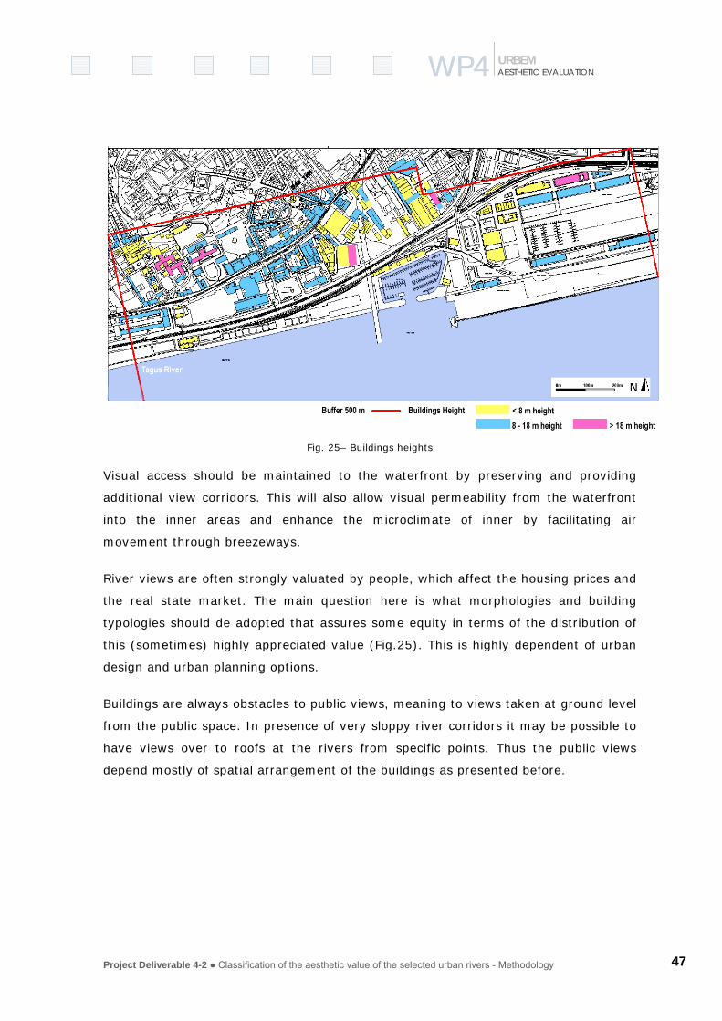
Project Deliverable 4-2 ● Classification of the aesthetic value of the selected urban rivers - Methodology 47
WP4WP4 AESTHETIC EVALUATION URBEM
Fig. 25– Buildings heights
Visual access should be maintained to the waterfront by preserving and providing
additional view corridors. This will also allow visual permeability from the waterfront
into the inner areas and enhance the microclimate of inner by facilitating air
movement through breezeways.
River views are often strongly valuated by people, which affect the housing prices and
the real state market. The main question here is what morphologies and building
typologies should de adopted that assures some equity in terms of the distribution of
this (sometimes) highly appreciated value (Fig.25). This is highly dependent of urban
design and urban planning options.
Buildings are always obstacles to public views, meaning to views taken at ground level
from the public space. In presence of very sloppy river corridors it may be possible to
have views over to roofs at the rivers from specific points. Thus the public views
depend mostly of spatial arrangement of the buildings as presented before.

Project Deliverable 4-2 ● Classification of the aesthetic value of the selected urban rivers - Methodology 48
WP4WP4 AESTHETIC EVALUATION URBEM
We must also consider, in urban areas,
the free space that is stretched in to
corridors with circulation purposes.
These way roads and pedestrian paths
provide access to the landscape and are
important view corridors to the
river/stream scenario.
Considering graphs theory we can
represent these linear features as a set
of arc and nodes. “To achieve a linear
network that can be traced by the
computer from line to line it is
necessary to add topological pointers to
the data structure. The pointer
structure is often built up with the help
of nodes” (Burrough, 1998).
In this context it was important to
consider the network visual axis that
has a physical connection with the river
stream. The number of intersection
between the two types of entities
(circulation network and stream) may
be used, per se, as an indicator of the
city-river visual connectivity and visual
contact.
a
b
c
e
d
f
g
Fig. 25 – The influence of urban morphology in views.

Project Deliverable 4-2 ● Classification of the aesthetic value of the selected urban rivers - Methodology 49
WP4WP4 AESTHETIC EVALUATION URBEM
Fig. 26– Typology of visual contact with water
The length of these visual axes is also important. It measures the level of penetration
in the city revealing how much permeable in depth the urban tissue is. Higher average
length of these visual penetrations revels (or not) higher presence of the water
surface (and the river) inside the city structure.
The Space Syntax methodology, which is also derived from graph theory, has had
strong improvements in the domain of Architecture under the impulse of Bill Hillier,
(Hillier, 1997; Heitor, 2000). Space syntax methodology describes and analyses the
relationships between spaces of urban areas and buildings. The spaces are understood
as voids (streets, squares, fields…) between walls, fences, and other impediments or
obstructions that restrain (pedestrian) traffic and/or the visual field. In this context a
river or stream can be also considered an axial space (as a street). It can be
integrated and modeled under the network analysis where connectivity, integration,
control value and global choice are considered important syntactic measures that can be
calculated.
GIS can help this analysis complemented with local surveys to assess the local
conditions that can affect the river visibility from inside the urban tissue. The line of
sight traced along the road shows the parts of the surface that are visible or hidden
from an observer point (Fig. 27 and Fig. 28). The terrain profile shows that the

Project Deliverable 4-2 ● Classification of the aesthetic value of the selected urban rivers - Methodology 50
WP4WP4 AESTHETIC EVALUATION URBEM
riparian area would not be visible from viewpoints along the road due to the surface
morphology.
Fig. 27– Typology of visual contact axes with watercourse in Jardas (Barcarena) stream.

Project Deliverable 4-2 ● Classification of the aesthetic value of the selected urban rivers - Methodology
51
WP4WP4 AESTHETIC EVALUATION URBEM
Fig. 28– Profiles contact with water from the city to the river and from the river to the city
7
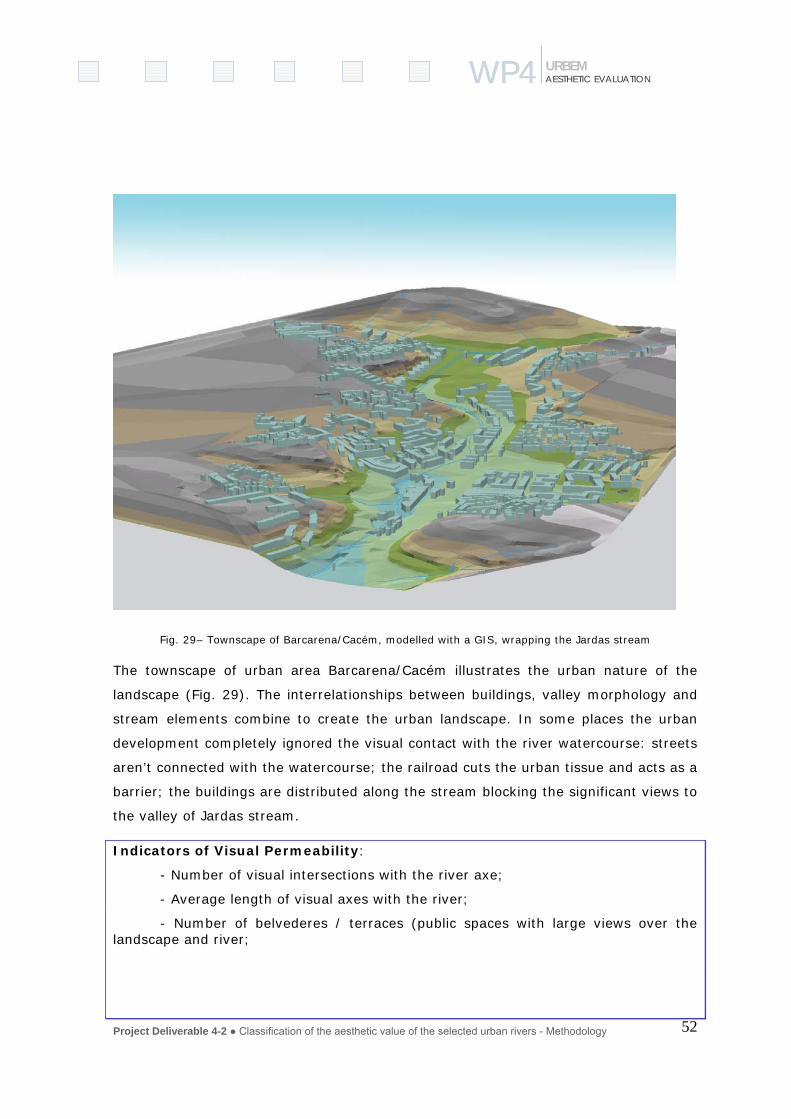
Project Deliverable 4-2 ● Classification of the aesthetic value of the selected urban rivers - Methodology
52
WP4WP4 AESTHETIC EVALUATION URBEM
Fig. 29– Townscape of Barcarena/Cacém, modelled with a GIS, wrapping the Jardas stream
The townscape of urban area Barcarena/Cacém illustrates the urban nature of the
landscape (Fig. 29). The interrelationships between buildings, valley morphology and
stream elements combine to create the urban landscape. In some places the urban
development completely ignored the visual contact with the river watercourse: streets
aren’t connected with the watercourse; the railroad cuts the urban tissue and acts as a
barrier; the buildings are distributed along the stream blocking the significant views to
the valley of Jardas stream.
Indicators of Visual Permeability:
- Number of visual intersections with the river axe;
- Average length of visual axes with the river;
- Number of belvederes / terraces (public spaces with large views over the landscape and river;

53
WP4WP AESTHETICAL EVALUATION URBEM
Descriptor of Visual Permeability
Very High permeability – indicators previously mentioned with high scores; a good spatial
distribution of points and visual axis along River Corridor allowing high impact panoramas.
Moderate permeability – moderate number of intersections and moderate number of visual
points (like belvederes); an average length of linear visual axes between 50 and 250 meters,
that allows extent perspectives over the river with an interesting aesthetic value; irregular
distribution of visualization points and axes to the river but covering all the extension of RC.
Low permeability – few visual intersections with river and few observation points that allows
wide perspectives to the river; the average extension of linear visual axes in RC is less than 50
meters; the aesthetical quality of perspectives over the river from public belvederes and linear
views from streets and public spaces is narrow and with weak value.
b) Near contact zones (proximity of visual and physical contact) with
watercourse
Visual permeability analysis refers to city scale and specifically to the river corridor.
However, it is important to consider some aspects that relate morphology of physical
contact with the river. In this context, physical contact is considered as an intense
sensorial contact that allows getting close in touch with the watercourse and all that is
connected with this experience. The fig.31 represents a typology of possible forms of
physical contacts between people and the watercourse.
Absent
Punctual
Area
Linearand short< 50m
Linearand long> 50m
Close to water Near the water Over the water
VISUAL AND PHYSICAL CONTACTWITH WATER
VISUAL CONTACTWITH WATER
WITHOUT VISUAL OR PHYSICAL CONTACTWITH WATERAbsent
Punctual
Area
Linearand short< 50m
Linearand long> 50m
Close to water Near the water Over the water
VISUAL AND PHYSICAL CONTACTWITH WATER
VISUAL CONTACTWITH WATER
WITHOUT VISUAL OR PHYSICAL CONTACTWITH WATER

54
WP4WP AESTHETICAL EVALUATION URBEM
Fig. 30– Typology of contact with water
In the first case the watercourse is visually absent because it is culvert that is a
solution adopted in many cities since a long time to hide the bad conditions of rivers
or to gain extra space to the city.
Physical contact refers to small dimension spaces where the access with the
watercourse is done only by one path. The contact zone can have several types, such
as:
a) Near the water – there is no physical contact with water but there is a very
strong sensorial relationship with the watercourse;
b) Close to water – there is a physical and complete relationship with the
watercourse in the river bank;
c) Over the water – this is a quite intense form of contact with the watercourse
because the observer is over or inside water. In some occasions this type of
contact can allow the city observation.
Fig. 31– Physical contact with water: natural and artificial banks
Considering that the majority of contact zones have public access one relevant aspect
is that of safety. The principle that should guide the evaluation of present situations or
future rehabilitation actions is referred by Manning (1997:80) “…obvious hazards
Close to water Near the water Over the water
Artificial margins
Naturalmargins
Close to water Near the water Over the water
Artificial margins
Naturalmargins
Close to water Near the water Over the water
Artificial margins
Naturalmargins

55
WP4WP AESTHETICAL EVALUATION URBEM
should be avoided or warned against and techniques exist for making the actual
contact point as safe as it need be. But action should never extend to destroying some
essential feature of the river in the interests of safety, or to prohibiting all access to it.
(…) precautions must be related to context”.
c) Public Utility given to River Watersides
The relative position between the river and the city is very important. In peripheral
urban areas that are still undeveloped land and the amount of open spaces is usually
high. In these more external rings, agriculture, forest and natural spaces are
predominant. In central areas the urban space are usually denser. Private space is
occupied with buildings and social infrastructures. Green public areas, parks, etc
usually use public open space. In these areas the access by people is usually free.
It seems important to calculate the balance between public open areas (with free
access) and private (non-public) areas in the river corridor and its riversides, which
indicates the value given by planning authorities to the presence of river in terms of
public utility of the watercourse to increase the global aesthetical value of the city
increasing the global benefits of its inhabitants and users. A high ratio (higher relative
quantities of public open areas close to the river) means that the city allows a non-
restricted access to the watercourse valuating this situation in benefit of people. A low
ratio (higher quantities of private areas) expresses low preoccupation of local
administration with the distribution of this value by all the people, which can also
mean a low public recognition, or valuation of the presence of watercourse in the city.
Sometimes public open areas (that are usually public proprieties) are not in good
conditions to a pleasant and safe use by people. Some of them may not have a stable
and planned use and some parcels may still waiting for detailed plans. In our
perspective can be important to assess the state of conservation and global quality of
these areas to guarantee an adequate public use by the population.
Indicators of Public Utility of River Watersides:
Ratio (quantitative balance) between public open areas (in good conditions) and private (non-public) areas in both watersides of the river.

56
WP4WP AESTHETICAL EVALUATION URBEM
d) Quality of the built space in river-corridor
Urban areas are very complex spaces and sometimes highly heterogeneous. We are
here centred on the quality of the built space, i.e., the conditions that an urban built
space requires to a normal accomplishment of their physical and functional purpose.
There are several factors that affect their normal appearance:
1. The quality of construction – which is related with a good structural design and
long lasting materials;
2. The state of conservation (maintenance) of buildings – that can be identified by
cleaned façades, windows, doors and roofs in good conditions, walls painted,
etc., which can be influenced by to their age or dereliction;
3. The existence of basic infrastructures like potable water supply, sewerage,
electricity, drainage, etc.;
4. The existence of sanitary conditions in public spaces – which are conditions
that can jeopardise public health like visible sewage, rats, litter, etc.;
According to this we think it will be possible to classify built urban areas in three
simple classes:
High Quality – Built spaces classified like this are in good or very good state in terms
of physical and functional conditions. They fulfil entirely the requirements needed to
accomplish their finality. They can be residential areas, industrial or more commercial
ones but there are no misuses or malfunctioning detected in accordance with what
was planned for that area. These areas: have all basic infrastructures; are in good
sanitary conditions; the state of conservation and the quality of construction can be
good or reasonable.
Medium Quality – Urban areas not having the problems of the low quality areas but
which cannot be considered as having high quality standards (some suburban areas
located in the periphery of great cities, generally occupied by medium or low standard

57
WP4WP AESTHETICAL EVALUATION URBEM
buildings but having all basic infrastructures that reasonably satisfy people needs).
These areas can be incomplete (not entirely consolidated) or under development but
their general use or finality is considered adequate.
Low Quality – Built urban spaces that clearer need intervention of urban rehabilitation,
conservation or renewing which can occur for several reasons: absence of sanitary
conditions; lack of basic infrastructures; moderate or unsatisfactory conditions in
terms of state of conservation or quality of construction. The housing do not have
adequate conditions for households. Developed or urbanised land is no longer in use
for housing, industries or services, derelict or contaminated land (brownfields), etc.
Indicator:
I1: Percentage of River Corridor occupied by High Quality urban built areas;
I2: Percentage of River Corridor occupied by Low Quality urban built areas;
3.2.3 Pollution
Urban areas are major sources of water pollution, mainly trough the discharge of
untreated or only partially treated sewage into the waterways.
Along with domestic wastes, sewage carries industrial contaminants and nutrients
(phosphorus compounds, contributed principally by detergents, as well as nitrogen
compounds), which cause eutrophication of water bodies.
Rain drainage is another major polluting agent because it carries such substances as
highway debris (including oil and chemicals from automobile exhausts), sediments
(soil), and acids and radioactive wastes from mining operations.
Agricultural areas also contribute to river pollution by rain runoff and by irrigation
return-flow of fertilisers and pesticides, as well as discharges of animal wastes from
farms. Industries besides contributing with chemical components are often source of
physical pollution when using water is cooling systems, which by returning to the
waterbody causes an increase in water temperature disturbing ecosystem functions.
In context of assessment of aesthetic quality physical, chemical or biological pollution
are only considered if they have a visual impact. Therefore 4 indicators are used to

58
WP4WP AESTHETICAL EVALUATION URBEM
assess both the pollution in the water body – dissolved or suspend matter (I2, I3 and
I4) as well as on margins (I1). These indicators are of high seasonal variability since
the visibility of pollution is highly depending on the hydrological flow regimen of the
watercourse: high discharges may dilute pollution and low flows concentrate water
pollution, as well as, it uncovers dump and litter on margins.
P1. Visible dumping and littering on margins
The visible pollution on margins may be caused by (a) being used directly as a
dumping site, or (b) through the accumulation of litter that has been thrown in
upstream, is transported by water and deposits on margins (Fig. 32). It might also
consist on (c) natural objects as tree trunks, branches or dead animal transported by
water flow. 3 classes of pollution are considered ranging from high density of objects
visible on margin to low density.
Fig. 32– Litter on river margins
P2. Floating dumping and littering on water
Dump and litter may also consist on lighter objects (in comparison to I1) that are able
to flow on water. Also here, 3 classes of pollution are considered ranging from high
density of objects visible floating on water to low density of objects.
P3. Water Turbidity
Visible pollution in the watercourse can both be assessed by the turbidity of water as
well as by the watercolour (Fig.34).
Turbidity can be measured by the degree of transparency of water, meaning that the
public generally associates low transparency as being highly polluted, whereas highly
transparent water is interpreted as “pure”. This is in fact not true, since very
transparent water might be ecology dead due to; for instance, acid rain, and low

59
WP4WP AESTHETICAL EVALUATION URBEM
transparency might be caused by high
sediment loading due to soil erosion
upstream or due to specific geo chemical
characteristics of the bedrock.
Therefore 3 classes of transparency are
used depending on the depth of view. On
highly transparent water the ground
might be visible, on medium transparent
water the ground might only be visible at
a reduced depth near the margins, and at
low transparency there is nothing visible
below water surface.
I4. Watercolour
Watercolour is highly associated with I3 –
Water turbidity. Higher turbidity or higher
concentration of pollutants or sediment
gives the water a more intense colour (fig.
33).
Also, water colour changes with distance
of view: higher distances tend to homogenize water into a “bluish clean” colour,
whereas at closer distance it becomes visible a wider range of colours. In this case a
classification is more difficult to establish since it depends on the colour of soils and
bedrock what is the natural colour of water in this specific water shed. In general it
can be stated that the most appreciated colour is ‘no colour’ at all, followed by natural
colours, as sediment loading may produce it.
Fig. 33- Watercolor
Fig. 32- Floating dumping and littering on water

60
WP4WP AESTHETICAL EVALUATION URBEM
Descriptor: A – No colour B – Natural colour C – Artificial colour
3.2.4 Activities in the river front
In the context of the aesthetic assessment of rivers in urban environment it is
important to consider the domain of the human activities in the space contacting
directly the river (river front).
With the increased presence of people at the riverfront the number observers
augments, meaning that there is a higher potential interaction between the people
and the river. In this context the following descriptors aim to inform on intensity of
actual or potential presence of people at the riverfront that may enrol in various
activities. These activities may be of different nature: economic, traditional, and
residential, as well as, recreational.
P1. Economic activities
Economic activities may be subdivided into sectors, as services and industry. These
activities provide employment, which contributes by itself to the presence of the
employees in the area. On the other hand there are activities that may attract human
presence by providing personal services as, for instance, retail trade or schools.
Besides these more permanent infrastructures, there are also occasional events that
have to be taken into account (i.e. the monthly flee market, fairs).
I1. Units of services, industries or public infra-structures (i.e. education)
I2. Employment within the RF (total)
I3. Presence of commercial units
I4. Frequency of occasional commercial events (e.g. fairs)
P.2 Traditional activities
Traditional or cultural activities are in this context defined as those activities that are
which are performed for a long time performed by the river (i.e. fishing, Easter picnic)
and that attract people to the riverfront on these specific events.
61
WP4WP AESTHETICAL EVALUATION URBEM
I1. Existence of facilities
I2. Frequency of occasional events
I3. Occasional events
1.3 Housing
I1. Inhabitants in the river corridor
I2. Built areas within the corridor occupied by residential buildings
I3. Households in the RF
I4. Inhabitants within the RF
1.4 Recreational use
Outdoor recreation is a major component of leisure where participants choose and
control their activities also according to the recreation values and aesthetic
appearance of the site. Rivers and nature in general as they have a high restorative
value are often chosen for leisure activities, both in terms of every day activity or for
vacation where a window facing the park, the sea, the river is highly valued.
I1. Presence of recreational facilities
I2. Tourism (hotels)
The ranking in classes on the contribution of each indicator the aesthetic quality of the
river has to be decided upon each urban context.
3.2.5 Accessibility
Crossing the river …
Many towns and cities owe their existence to water, developing around a port or being
located at a major crossing point. There are several built structures that allow people
to cross a river, a watercourse or a stream: a tunnel under the water (motorways,
railways); stepping stones to be used by people; fords that can be used by vehicles;
bridges that can be low and close, in touch with the water; high bridges, uplifted,
detached. Tunnels are not relevant in this context. They don’t allow people to see and

62
WP4WP AESTHETICAL EVALUATION URBEM
to have sensorial contact with the river. Fords and stepping-stones allow people to
walk on the water involving us directly with the river. However they are affected by
floods, hazardous and adventurous and belong on minor watercourses, like streams or
creeks.
In most urban watercourses, bridges are in fact the common way to cross the water
having two fundamental functions (Manning, 1997):
a) Linking function - links two margins allowing uninterrupted circulation along the river;
b) Contact zones – where people wait over the water, watch, enjoy the view and spread out to explore from this convenient access point that happen in different ways (see chapter 2.7.2).
Fig. 34– Crossings at Douro river (Oporto), and Thames (Walligford, London)
In cities, most of the bridges were built to allow the passage of road and rail traffic.
The majority of the existent bridges allow all kinds of traffic to cross but others are
exclusively to pedestrians or bikes. In fact the so-called light modes of transportation
– walk or bike - are the ones that promote a more close contact with the water, the
sight, the landscape.

63
WP4WP AESTHETICAL EVALUATION URBEM
Fig. 35– Influence of the width in the amount of crossings
The possibility to enjoy the crossing, as an aesthetical event, is related to the amount
and availability of walking bridges. However, is also evident that a very large river
cannot have the same amount of bridges as a small and narrow river. Its width
influences dramatically the cost of a bridge.
Linear density of bridges along the river seems to be a good indicator that will
measure reasonably the contribution of river crossings to the usufruct of the river by
people, as a very special place of contact. We admit that the correlation between the
length of crossings and the potential of fruition cannot be linear, meaning that, for
instance, very long bridges (normally high) are not suitable for pedestrian crossing.
In Jardas stream there are a few water crossings because streets aren’t connected
with the watercourse partially due to the railroad that blocks the access (Fig. 36).
These spatial obstacles reduce the access to waterfront and justify the weak use and
perception of Barcarena waterfront.
10m
50m
100m
500m
1000m
10m
50m
100m
500m
1000m

64
WP4WP AESTHETICAL EVALUATION URBEM
Fig. 36– Crossings in Jardas Stream (Barcarena/Cacém)

65
WP4WP AESTHETICAL EVALUATION URBEM
In cities we can also cross the rivers by boat or ferries. In cities with estuaries and
very large rivers like Tagus River in Lisbon and therefore with low densities of bridges,
there are a great amount of daily traffic of passenger that cross the river by boat or
even by ferryboats. The majority of these daily trips are done by commuters and
students but others are pure recreational. This is relevant in what concerns the
relationship of the people with the river and what concerns the development of a
collective aesthetical notion related with a daily contact with water.
Indicators:
Linear Density of walking bridges (even not exclusive for walking) allowing visual relationship with water:
→ Number of walking bridges / length (in Km) of the river section in the city
Percentage of people that daily cross the river
→ Daily passenger traffic by boats or ferries that cross the river / Total population of the city
From the river to the city…
The traditional function for the waterfront is associated with the transportation of
people and goods. The movement of goods by water transport has decreased
significantly. Nevertheless it remains an important function to some port cities.
We have considered that the water transport adds colour, movement and life to the
urban watercourses that should be seized and balanced by retaining and developing
public and private water transport. Also, the leisure activities, associated with the
regeneration of disused water frontages, are becoming popular and appealing for
users and tourists.
The distribution of anchorage places, docks, floating pier, etc, along the river can be a
good indicator of the existent possibilities related to water transports and its future
development in terms of the potential of rehabilitation.

66
WP4WP AESTHETICAL EVALUATION URBEM
Fig. 37- Anchorage places being used by traditional boats (Aveiro, Portugal)
Indicators:
Linear density of anchorage points (anchorage places, docks, floating pier, etc.):
→ Number of contact points for water transport purposes / length (in Km) of the river section in the city
Daily average density of boats in the river :
→ Daily average number of boats navigating/present in the river in a normal day / length (in Km) of the river section in the city limit
From the city to the river …
The access to riversides from the city it’s a prerequisite to promote the use by people,
which should be well balanced in terms of
nature and landscape preservation and in
terms of the transportation modes used. It
is well known the problems derived from the
use and abuse of private car that has
several recognized environmental impacts
that have to be mitigated and minimized.
Fig. 38– River and pathway side by side (Seville).
67
WP4WP AESTHETICAL EVALUATION URBEM
For these purposes more adequate sustainable transport solutions exists:
a) Car parking surfaces located closer to riversides that don’t have any
fundamental function in terms of the urban transport system are considered
inappropriate. Car parking surfaces will be, in fact, a car trip generator for
visitors and should be always controlled and inhibited. Thus parking in the
riverfront is not advisable if a public transport system can be implemented.
b) The promotion of public transports systems or soft modes is considered a long
time ago a valid alternative to access riverfront in central urban areas, in spite
of using the private car, which is generally accepted as a sustainable solution.
c) Being the river an important focus and generator of events we must mention
the problem of valleys that have become a corridor for major urban roads or
railways. Manning (1997:79) mentions this disruption that may be devastating.
“(…) major route following the river’s edge tend to separate it from its
hinterland, the land which topographically and scenically belongs to the river.
The most severe disruption arises where vehicles are involved. (…) Even in
cities, total disruption is neither necessary nor acceptable.”
Indicators:
Parking offered - Density of parking public places offered in Riverfront
Access in public transport: connectivity from the river-corridor to the city - Length of public road and underground transport networks in river corridor / Total area of RC
Access in soft modes – foot and bike: length of the ways offered inside river-corridor - Length of pedestrian paths or bikeways in River Corridor with a visual relationship over the river / Total length of the river within city
Disruption due to the existence of major roads (or rail) network - Length of non-sustainable major roads, motorways, railroads acting as a barrier between river and the city / Total length of the river within city.
3.3 PEOPLE
3.3.1 Sensorial fruition
P1.Odour
The measurement of the odour is subjective and moderate by cultural, social and
psychological factors. It is possible to distinguish between different types of odours:

68
WP4WP AESTHETICAL EVALUATION URBEM
Natural odours (e.g.: flowers, water)
Urban odours (e.g.: urban pollution, odours associated with some activities as a
bakery)
Industrial odours (e.g.: industrial pollution)
The odour can be evaluated in terms of the attractiveness or degree of annoyance.
P2.Sound and Noise
The measurement of sound is based primarily on its physical components. The decibel
scale measures the physical components of sound or noise amplitude. However this
scale does not accurately reflect the perception of loudness.
Noise it is a sound that is undesirable or unwanted, i.e., a subjective and emotional
interpretation of a phenomena. The aversiveness of noise depends on volume,
predictability, and perceived control. In combination with other factors, noise can have
adverse effects on physical and mental health.
In the context of aesthetic evaluation with can distinguish different types of sound and
noise:
Natural noise (e.g.: birds, wind)
Human noise (ex: children),
Urban noise (e.g.: traffic)
Industrial noise
These types of noise may be objectively evaluated in terms of its amplitude,
frequency, purity and regularity). And subjectively in terms of its attractiveness or
degree of annoyance.

69
WP4WP AESTHETICAL EVALUATION URBEM
3.3.2 RIVER LANDSCAPE PERCEPTION
Several approaches tried to evaluate the environmental preferences (e.g.: Berlyne,
1974; Kaplan, 1987; Bernaldez, 1981; Saraiva, 1999; Zube, 1984). Some propose
expertise evaluations and some underline the importance of user or public evaluation.
In this proposal it is considered two types of evaluation: (i) an expertise evaluation of
aesthetic preferences and; (ii) public perception of river landscape
P1.Expertise evaluation of aesthetic preferences
It is possible to identify different approaches and methodologies to evaluate the
aesthetic characteristics of a landscape. Kaplan and Kaplan (1989) developed a model
of environmental preferences, that combine nativistic and constructivist elements. In
one hand they consider that the human being prefer environments that landscapes in
which the traits of our species are most useful. So, for instance, they like green areas,
and the presence of water. One other the couple Kaplan concludes that humans have
a fondness for environments that provide rapid and comprehensive information.
The Kaplan’s model includes four main components: coherence, legibility, complexity
and mystery.
Coherence – degree of organization of a scene, or to which a scene “hangs together”.
The coherence is positively correlated with the preference.
Legibility – or degree of distinctiveness that allows the viewer to understand the
content of a scene. The greater the legibility, the greater the preference.
Complexity – or number and variety of elements in a scene.
Mystery – degree to which a scene contains hidden elements that stimulate the search
of this information.
The human being like complex scenes and scenes with some degree of mystery.
However if the scenes are very complex and/or with great mystery it can be source of
fear.
The experts may use this approach to classify the river landscape in relation to theses
four components.
70
WP4WP AESTHETICAL EVALUATION URBEM
P2.Public perception of river landscape
A river in the urban context can be analysed as a public space, defined as an open
space accessible to the public, and where people can develop individual or public
activities. To understand the public river landscape perception, as a public space it is
necessary to identify the cognitions, feelings and behaviour of its users. Carr et al.,
(1992) define three dimensions in the public space, which are the result of the
interaction between the physical characteristics of the space and the characteristics of
its user: necessities, rights and meanings and attachments.
(1) Necessities – public spaces have a role of satisfaction of the human necessities.
This necessities include, comfort (physic, psychological and social) relax and active
involvement and passive involvement;
(2) Rights – are related with the freedom of the use of the space and also the feeling
of control of this space. Concepts as appropriation and action must be included in this
dimension.
(3) Meanings and attachments – it is the capability of the human being develop
symbolic meanings and links with the spaces.
To evaluate the river landscape perception of the inhabitants it is necessary use
questionnaires with questions that include all this principle describes before. The
questionnaire in preparation in the context of the Urbem project includes a part to test
the river landscape perception of their inhabitants.
3.3.3 Identity
The research about the relation between the human behaviour and the environment
give an important relevance to the link between the person and the environment.
They use the terms, place identity and place attachment. It is possible to identify two
types of approaches: the first group tried to understand the importance of the place to
the identity of the subject (e.g.: Proshansky et al., 1983, Feldman (1990), Lalli,
1986). The second one tried to study the different forms of place attachment (e.g.:
Giuliani and Feldman, 1993, Altman and Low, 1992).

71
WP4WP AESTHETICAL EVALUATION URBEM
One possible definition of place identity is “By place identity we mean those
dimensions of the self that define the individual’s personal identity in relation to the
physical environment by means of a complex pattern of conscious and unconscious
ideas, beliefs, preferences, feelings, values, goals, and behavioural tendencies and
skills relevant to this environment” (Proshansky, 1978, p. 155).
Some studies verified that the place identity play an important role in the perception
of environment changes (e.g.: Twigger-Ross and Uzzell, 1996, Speller, et al., 1996),
perception of environmental problems (e.g.: Bonaiuto, et al. 1996), and perception of
public areas as natural parks (e.g.: Loureiro, 1999) and so on. These studies verify
that a positive and strong place identity reduce the negative perception of some
environmental problem or increase the positive perception of some environmental
aspect.
Several recent studies use the Breakwell’s model to understand the role of place in the
identity processes (e.g. Twigger-Ross and Uzzell, 1996; Speller, et al., 1996; Bernardo
et al., 1996, Speller et al., 2002). The Breakwell’s model proposes four principles of
identity: continuity, self-esteem, self-efficacy and distinctiveness.
Continuity - The desire to preserve continuity over time and situation. It is possible to
maintain continuity thought the link to a place that was the reference for the past
action and experiences. Or maintain continuity by the link to places that are congruent
with the personal values, i.e., maintain continuity via characteristics of places which
are generic and transferable from one place to another.
Self-esteem - refers to the positive evaluation of our physical environments or the
physical environments of the group, which one identifies.
Self-efficacy - is defines as an individual’s belief in their capabilities to meet with the
environmental demands.
Distinctiveness - is the desire to maintain personal distinctiveness or uniqueness. In
terms of place identity the distinctiveness can be understand as the attribution of
positive features to the place in comparison to different places.
Using this framework allows understand how a relevant element in the landscape, as
an important river that cross a city, can contribute to the identity of the inhabitants.

72
WP4WP AESTHETICAL EVALUATION URBEM
So, the valorisation of this river can contribute to the reinforcement of the identity to
the city.
To evaluate the identity of the inhabitants to the river and to the city it is necessary
use questionnaires with questions that include all these principles describe before. The
questionnaire in preparation in the context of the Urbem project includes a part to test
the importance of the city and the river to the place identity of their inhabitants.
3.3.4 Restorative capacity
There are several empirical evidences that viewing natural scenes (as visiting natural
places, or even viewing photographs of natural scenes) may have a restorative effect,
for instance contributes to reducing stress, and promote positive moods and feelings
(e.g.: Ulrich, 1981, 1984, Ulrich et al. 1991). So, natural spaces, in special with water
(Kaplan and Kaplan, 1989), in urban areas can contribute to a positive view of the
area.
Despite, authorities and researchers agree that natural scenes have this positive
potential, there is some controversy regarding the explanation of this mechanism
(Ulrich et al., 1991, Kaplan, 1995). Two important explanations were developed in the
last decade: stress reduction and attention restoration theory (ART). Both theories
grew from research programs that were initially developed as explanations of
landscape preferences (Bell, et al., 2001).
The stress reduction is supported by several studies (e.g.: Ulrich, 1979, 1984, 1986,
1991, Parsons et al., 1998) showing that contact with certain types of nature creates
what are called restorative responses. The restorative responses include reduced
physiological stress, reduced aggression, and restoration of energy and health.
Settings that foster these responses are called restorative environments. The main
principle in this theory is that human life includes high levels of stress. According to
the functional-evolutionary perspective, humans have a biological affiliation to certain
restorative natural settings. However they do not have such prepared response to
urban environments, because the human being has only a few generations of
experience with these environments. So, certain types of natural environments can be
very important because creates some restorative responses (from stress).

73
WP4WP AESTHETICAL EVALUATION URBEM
The attention restorative theory (ART) was developed by the couple Kaplan (Kaplan
and Kaplan, 1989, Kaplan, 1995). The tasks that require mental effort draw upon
direct attention. The individual must expend effort to achieve focus and inhibit
intrusive distractions. As outline S. Kaplan, this type of attention is particularly fragile
and can result in directed attention fatigue. According to ART it is necessary to rest
directed attention by using an involuntary attention that requires little effort.
The resultant directed attention fatigue may become manifest not only in performance
decrements such as decreased helping behaviour and increments in accidents, but
also in negative emotions, irritability and decreased sensitivity to interpersonal cues.
Restoration of the directed attention capability requires entering a situation in which
functioning does not involve demands on directed attention but can instead rely on
fascination.
Natural environments can be restorative because they stimulate the involuntary
attention, that requires little efforts because allows cognitive freedom (allow the
subject only concentrate in the environmental aspects that they want) and escape
from the daily activities (in the natural environments there are freedom of rules and
obligations).
Kaplan considered four interrelated characteristics of restorative experiences: being
away fascination, extent, and compatibility.
Being away - a necessary first condition for restoration involves getting distance from
further demands on directed attention and the ordinarily present or routine aspects of
one’s life. Three ways in which a sense of being away can come about include
escaping from unwanted distractions in the surroundings, distancing oneself from
one’s usual work and reminders of it, and suspending the pursuit of particular
purposes (Kaplan & Kaplan, 1989)
Fascination - the natural environments are important sources of fascination elements,
and there are restoratives because they demand effortless attention and use the
involuntary attention.
Extent - the natural environment has also de function of extent, which is treated by
the Kaplan’s (1989) as a function of connectedness and scope. The men in contact
with the natural environment feels beyond they own limits and as a part of the nature.

74
WP4WP AESTHETICAL EVALUATION URBEM
Compatibility - refers to the match between the person's goals and inclinations,
environmental demands, and the information available in the environment for the
support of intended and required activities (Kaplan, 1983). In short, compatibility
exists in situations in which what the person wants to do matches with what the
environment demands and supports.
Understandings of restorative person-environment transactions can be useful in
environmental design, planning, and policy (Kaplan & Kaplan, 1989; Kaplan, 1983;
Ulrich, 1992) and measurement of restorative qualities of person-environment
transactions can help in applying such understandings (Hartig, Korpela, Evans and
Gärling, 1996). These qualities are accessible by asking people about their perceptions
of environments.
The design and management of restorative environments can be aided with an
instrument for measuring qualities of restorative person-environment transactions.
The Perceived Restorativeness Scale (PRS) (Hartig et al., 1997) and Scale of
Restorative components of Environment (Laumann, Garling and Stormark, 2001) both
included four factors that are consistent with attention restoration theory. In the
context of the Urbem project we are developing a questionnaire to test the restorative
capabilities of a river in the urban context.
3.3.5 Perceived Security
The analysis of the security in relation to the river in urban context must be analysed
in terms of the technical evaluation and the public risk perception. Technical
evaluation of risk is very different from law views of risk. However, when we intend to
modify the preventive behaviour of the population, these perceptions must be taken in
account to define the risk communication strategies adequate to the target population.
Two types of risks must be considered:
• the risk caused by the river characteristics and urban physical pattern (ex:
floods)
• the risk associated to the use of the river area (ex: attack, drown)

75
WP4WP AESTHETICAL EVALUATION URBEM
P1.Public Risk Perception
The analysis of the research about risk perception allows identifying some important
questions:
The public risk perception is well structured, and multifactor, including factors as
“dread risk” (including perceived lack of control, dread, catastrophic potential, fatal
consequences); “Unknown risk” and “number of people exposed to the risk” (Slovic,
1987). Research has shown that lay people’ risk perception and attitudes are closely
related to the position of a hazard within this type of factor space.
The previous experiences of hazard, as well as the characteristics of the society are
important factors in the development of behavioural adjustments to minimize its
threat and mitigate its effects (Burton, Kates e White 1978).
Continuous exposures to uncontrollable threat modify risk estimations, and
consequently risk adjustments, in order to cope with stress (Taylor and Brown, 1988;
Taylor, 1992). So, it is expected that residents living under high objective risk, will
minimize their probability of damage.
The social role of the different public involved in the risk management produce
different estimation of risk (Douglas Wildavsky, 1982).
P2.Public Risk Perception of Crime
Fear of crime and associated stress are major problems in urban areas (Bell et al.,
2001). Frequently the fear of crime is not related with the true likelihood of being
victimized. Sometimes the fear of crime increases faster that the real crime (Taylor
and Hale, 1986) or the fear of crime differs in different groups of the same
neighbourhood.
Different aspects of the urban environment can have an impact on fear of crime:
environmental configuration (e.g.: Lavraska, 1982); perceived loss of territorial
control (e.g.: Taylor and Hale, 1986); decay of the environment and signs of urban
“incivilities” (e.g.: White et al., 1987); environmental configuration that facilitated the
concealed of attackers (e.g. Nasar and Jones, 1997).

76
WP4WP AESTHETICAL EVALUATION URBEM
The characteristics of the population are also important in the fear of crime. The
research reveals that those who are more concerned are those with lower incomes,
minorities, the aged, and females (Bell et al. 2001). The fear of crime can have
important impacts in the human life. People with fear of crime feel they must restrict
their activities greatly to avoid being victimized (Keanes, 1998).
Some environmental and social characteristics of the area can be important to
promote the feeling of security. The environmental urban design that helps promote
cohesion residents may moderate fear (e.g.: Fried, 1963); the presence of signs of
defence and signs of appropriation was associated with less crime (Newman, 1972);
having supportive neighbours may act to quell fear of being victimized (e.g. Gubrium,
1974).
To evaluate the risk perception in relation to floods or fear of crime, that are
subjective but determine the human behaviour, it is necessary to ask the population
about it. If the perception of risk have a big discrepancy in relation to the technical
evaluation of risk, it is necessary to develop a process of risk communication based in
the characteristics of the population and in their risk perception.
4 Evaluating and Classifying
Multicriteria analysis allows complex problems to be broken down into workable units
and to be structured in such a way that enables the complexities of the problem to
become clearer. It has the advantages of unravelling issues and adding new
knowledge about the problem.

77
WP4WP AESTHETICAL EVALUATION URBEM
Fig. 39– Unravelling the complexity
In the evaluation phase usually we seek to identify a set of criteria by which existent
or future alternatives can be ranked, the decision maker preferences or weights which
must be assigned to the various criteria and an aggregation procedure that transforms
the set of criteria in a single synthesis criterion expressing a single “compromise” rank
order. The final step involves sensitivity and robustness analysis.
The previous chapters presented the structuring process that lead to the identification
of a set of primary elements of evaluation. We used descriptors and impact indicators.
Disagregation / Agregation

78
WP4WP AESTHETICAL EVALUATION URBEM
The best(plausible)score
The worst(plausible)score
Criteriongj(a)
Impact Indicator
Descriptor
Set A ofalternatives(rivers)
Numericalcodification
•
••••
••
••
•
•
•
••
•
••
•
••
Ij
gj(a)
The best(plausible)score
The worst(plausible)score
Criteriongj(a)
Impact Indicator
Descriptor
Set A ofalternatives(rivers)
Numericalcodification
•
••••
••
••
•
•
•
••
•
••
•
••
Ij
gj(a)
Fig. 40– Criteria, Descriptors and Impact indicators
A Descriptor is a scale that describes unambiguously an ordered set of impact levels
according to a given viewpoint.
An Impact Indicator is a procedure, rule, technique or process that associates to each
potential action a subset of impact levels. Each of these levels represents the impact
as real as possible.
From the viewpoint side, the descriptor describes it through a set of impact levels.
From the side of actions (rivers) the impact indicator indicates the probable impact of
each river - potential (future) action. Often, the impact indicator can perform also the
role of a descriptor if its set of impact levels coincides with the counter-domain of that
indicator. The “Index of sinuosity” is an example of this situation. The scale “straight,
sinuous, meandering” is only useful to understand the meaning of the impact levels.
In the case of the “Quality of the built space in RC” a descriptor – “High quality,
Moderate quality, and Low quality” - was chosen to classify each urban area according
to that viewpoint. It’s a qualitative scale that can be explained by mixed information.
In that case we had to quantify the amount of areas that exists in River Corridor
belonging to each class in percentage of total RC area.
After this process we must built the set of criteria. Criterion means a function g
defined in A (set of alternatives - rivers) having values in a completely ordered set
(Vincke, 1989), i.e., a cardinal set with an absolute discriminative power allowing to
79
WP4WP AESTHETICAL EVALUATION URBEM
compare each pair of alternatives (rivers) based on the corresponding impact
indicators.
To achieve this we must built a numeric rule of codification that reproduces the order
of attractiveness between levels (see Fig. 40). Usually 0 is chosen to the minimum
(plausible) score and 1 to the maximum (plausible) score.
After this, when a complete set of evaluation criteria is defined and agreed, an aggregation function, V, is usually applied. Usually this function is additive like the
following,
( ) ∑=
==n
jjjj agwagVag
1)()()(
w j - Weight of the criterion gj
w jj
n=
=∑ 1
1 .
The weights represent the relative importance of criteria, i.e., a scaling factor that
relates scores on that criterion to scores on all other criteria.
In this stage and considering the aesthetical dimension of our problem, two issues
arise:
1. In a rigorous perspective we have to be sure that this additive formulation is
the right one to our problem. In fact, when we use an additive function that
joins all criteria in a single criterion we are accepting that an increase in the
criterion g1 is compensated by a decrease in criterion g2. This is not always
accepted in real situations – a decision maker may not accept to increase the
amount of pathways or to spend money in the ecological rehabilitation of the
river while Low Quality Urban Areas without basic infrastructures still persist.
2. Even accepting that a compensatory model is appropriate, the criteria weights
have to be elicited. There are several methods in the literature that can be
applied (e.g.,” swing weight method”). However, it has been argued that this
process can lead to different interpretations. People do not respond to them in
any consistent manner and responses do not relate to the way in which weights
are used in the synthesis of information.
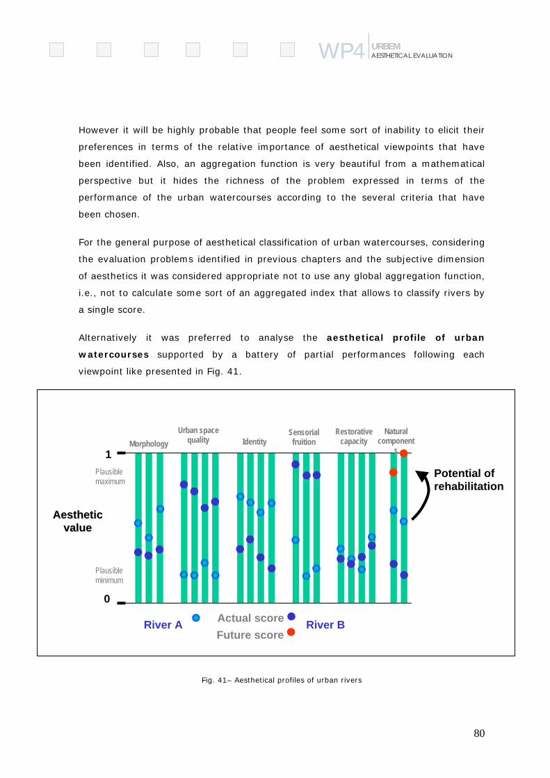
80
WP4WP AESTHETICAL EVALUATION URBEM
However it will be highly probable that people feel some sort of inability to elicit their
preferences in terms of the relative importance of aesthetical viewpoints that have
been identified. Also, an aggregation function is very beautiful from a mathematical
perspective but it hides the richness of the problem expressed in terms of the
performance of the urban watercourses according to the several criteria that have
been chosen.
For the general purpose of aesthetical classification of urban watercourses, considering
the evaluation problems identified in previous chapters and the subjective dimension
of aesthetics it was considered appropriate not to use any global aggregation function,
i.e., not to calculate some sort of an aggregated index that allows to classify rivers by
a single score.
Alternatively it was preferred to analyse the aesthetical profile of urban
watercourses supported by a battery of partial performances following each
viewpoint like presented in Fig. 41.
Fig. 41– Aesthetical profiles of urban rivers
0
1
AAeesstthheettiiccvvaalluuee
River A River BActual scoreFuture score
Plausible maximum
Plausibleminimum
Potential of rehabilitation
MorphologyUrban space
quality IdentitySensorialfruition
Natural component
s
Restorativecapacity
81
WP4WP AESTHETICAL EVALUATION URBEM
This approach has, at least, the following advantages:
- Reveals the diversity of characteristics of each urban watercourse. Some could
be more related with social and cultural environment, others with a more
naturalized landscape or a more urbanized landscape or even with a specific
geographic context;
- Allows to perceive and better understood the different dimensions that can be
improved in a river rehabilitation process;
- To compare the performances between rivers in different dimensions and
analyse their scores with reference values;
- To make a comparative analysis and get some conclusions about the profiles
of aesthetical characteristics.
All this can be done in the follow-up of this work according to the implementation of
the methodology to different rivers.
4.1 Data acquisition and analysis
This chapter focuses on the data needs and techniques that can be applied in the
context of the development of a river aesthetic classification in urban environment.
In this context landscape is formed by a combination of different components to
create a place, locality or region with a specific aesthetic value. “These include the
underlying geology and soils, the topography, archaeology, landscape history, land
use, land management, ecology, architecture and cultural associations, all of which
can influence the ways in which landscape is experienced and valued”(Chapman et al.,
1995). All these landscape components are possible to represent and analyse in a
geographic context and as geographic features.
For the purpose of aesthetical classification of urban watercourses the following
cartographic data was considered as necessary:
Hydrology (scale: 1/25000);
Topography (scale: 1/10000); using this topographic data it was possible to derive a
digital elevation model (DTM).

82
WP4WP AESTHETICAL EVALUATION URBEM
Aerial Photographs (resolution: 10m); information used to identify the most recent
changes in urban space.
Land-use (scale: 1/10000); these information includes different layers: road network,
urban areas, elevation, hydrography, green areas, forest areas, agriculture areas,
etc., split by thematic layers.
Geographic Information Systems (GIS)
GIS technologies has become an almost indispensable tool for capture, display,
structure, store, interpret, analyse, manipulate, update, simulate, model and post
process environmental entities and phenomena with geographic information (Aronoff,
1989). Nowadays GIS have relevant role to support management tasks due to it
specific abilities. For the purpose of aesthetical classification GIS can be very useful
to:
a) Data integration
b) Data analysis
c) Presentation of the results from the analysis.
Table 1 – Data integration in a GIS environment
GEOREFERENCED DATA MAPS ALPHANUMERIC DATA
VECTORIAL RASTER Inquiries and surveys Topographic Aerial photography Census Thematic maps Raster images
The need to integrate and analyse this wide range of spatial information is seen as a
key to the importance of GIS in landscape studies.
GIS can integrate both the geometry data (coordinates and topological data) and the
alphanumeric data (information describing the properties of spatial data). These
alphanumeric attributes are presented as tables linked to the graphic information.
Commonly GIS are equipped with a few tools that are important for the spatial
analysis and the terrain models generation. Computer based tools (internal
manipulation algorithms) can process a wide range of complex information in order to

83
WP4WP AESTHETICAL EVALUATION URBEM
extract the parameters necessary to classify the aesthetic value of the urban
landscape.
Spatial information is stored as points, lines and areas, defined by co-ordinate
geometry; while, non-spatial information, known as attributes data, is stored in tables.
Vectorial data is composed of graphic elements that consist of points, lines and area
features. Area features are depicted as polygonal features and corresponding area
centroids. The graphics elements are linked to relational database information that
further describes and defines each individual feature.
The spatial analysis is the ability to combine the basic data elements in form of a
question about the spatial relationships that exist between graphic features. Within a
software environment and using the GIS multi-layered information we can create
buffers (zones around features), remove or merge common boundaries between
adjacent areas and reclassification based on queries.), calculate areas, make queries,
generate Digital Elevation Models, etc.

84
WP4WP AESTHETICAL EVALUATION URBEM
Fig. 42– GIS products: DTM, Slope analysis and viewsheds.
4.2 Public inquiry
Objectives
The identification and description of parameters of the aesthetic evaluation allows
identifying a group of parameters that cannot be evaluate objectively. In relation to
the inhabitants’ perception of river, the river restorative capability and identity as well

85
WP4WP AESTHETICAL EVALUATION URBEM
as attachment of the inhabitants to the river, it is necessary to answers the
population. With this purpose in mind a questionnaire was design that will be used to
test in a specific situation, and can be adapted to different case studies.
The main objective of this survey is to understand the importance of the river for the
people in terms of their perception, activities and identity.
Inquiry structure
The questionnaires were structured according to the following topics:
1. General questions about the subjects relation to the city, like how long they
live in the city, the reasons why they choose this city, place of the job, where
they spend the free time;
2. Behaviours /activities related to the river and the river corridor. This part
includes a long list of possible activities developed in the river corridor or at the
riverfront.
3. River landscape perception It was used the model of Carr et al., (1992) which
define three dimensions in the public space: (1) necessities (that include,
comfort (physic, psychological and social) relax and active involvement and
passive involvement); (2) rights (appropriation and action) and (3) meanings
and attachments. Several questions are developed in order to include the
dimensions describe before.
4. Preferences for the future – there is a group of questions concerning the
inhabitants’ preferences in relation to possible improvements of the river,
riverfront and the city.
5. Identity – it was used the Breakwell’ model, described before, to developed an
identity scale in relation to the river and to the city. The main objective is to
understand the importance of the river and the city to inhabitants’ identity.
6. Evaluation of the restorative components of environment - it was used the
Kaplan’s’ framework to developed a scale of restorative capability of the river.
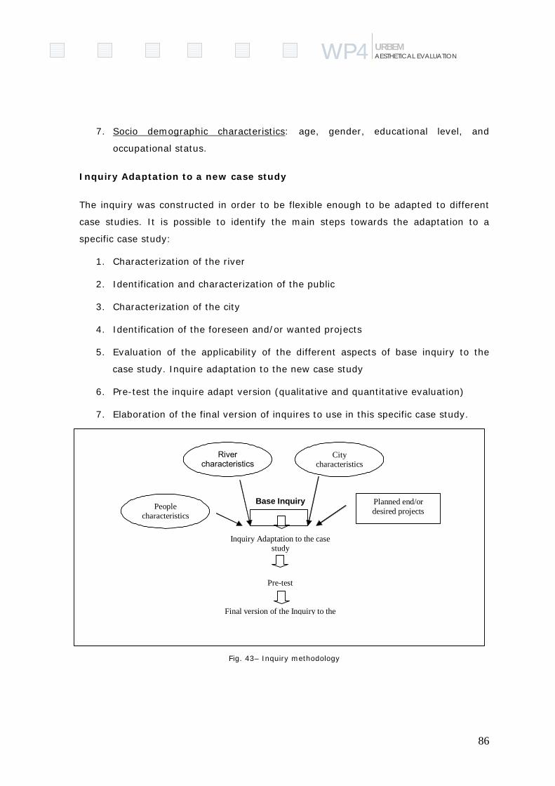
86
WP4WP AESTHETICAL EVALUATION URBEM
7. Socio demographic characteristics: age, gender, educational level, and
occupational status.
Inquiry Adaptation to a new case study
The inquiry was constructed in order to be flexible enough to be adapted to different
case studies. It is possible to identify the main steps towards the adaptation to a
specific case study:
1. Characterization of the river
2. Identification and characterization of the public
3. Characterization of the city
4. Identification of the foreseen and/or wanted projects
5. Evaluation of the applicability of the different aspects of base inquiry to the
case study. Inquire adaptation to the new case study
6. Pre-test the inquire adapt version (qualitative and quantitative evaluation)
7. Elaboration of the final version of inquires to use in this specific case study.
Fig. 43– Inquiry methodology
People characteristics
City characteristics
River characteristics
Planned end/or desired projects
Base Inquiry
Inquiry Adaptation to the case study
Pre-test
Final version of the Inquiry to the

Project Deliverable 4-2 ● Classification of the aesthetic value of the selected urban rivers - Methodology
87
WP4WP4 AESTHETIC EVALUATION URBEM
5 The Limits of Objectivity and Evaluation
As quoted above, the intersection of a river and a city is a compromise between
“natural” and “cultural” systems. Therefore, the resulting landscapes show a wide
spectrum of man-made features, which transformed more or less deeply the previous
context.
This coexistence raises the question of the appreciation of more natural environments,
or those built and adapted by humans. The aesthetic experience has several roots,
either in the appreciation of nature towards a more cultural approach. Human
personalities, values and beliefs influence the experience and knowledge of the
environment, with a permanent search for what is called beauty, harmony or
coherence. Also social values and constructs influence our appreciation of settings and
behaviours, where the personal views are infused with cultural ones.
Aesthetic values are partly influenced by “mystique” affection for landscape and its
beauty, and also by cultural features that show human presence, influence and
intervention over its surrounding environment.
Aesthetic appraisal can show a polar trend, between satisfaction and disgust, where
critical judgement is joined with appreciation (Berleant, 1997). Natural environments
can be perceived as insecure, unpredictable, and hostile.
Urban aesthetics focus on the built environment, shaped for human purposes. A
common tendency could try to oppose in aesthetic terms the city with the countryside,
which is not the main question. The historical and social dimensions cannot be
dissociated from the concept of urban beauty and meaning.
In other hand, urban aesthetics can also show negative values, associated with
pollution, crowding, litter, oppressive buildings, and other effects of urban sprawling
and discomfort. Different views about aesthetic attributes and their expression in the
urban environment can often lead to conflicts, either ideological or reflecting economic
concerns, such as individual property interests. The high degree of subjectivity is a
crossing subject in this field, where no uniformity in responses and attitudes can be
found.

Project Deliverable 4-2 ● Classification of the aesthetic value of the selected urban rivers - Methodology
88
WP4WP4 AESTHETIC EVALUATION URBEM
In the particular case of our research, it is important not to intend to classify “nice” or
“ugly” urban watercourse reaches, but to investigate which are, in each situation, the
characteristics and attributes that can be enhanced, both in “naturalistic” or
“constructed” environments.
In any case, there is always an opportunity to create or recreate new urban
landscapes, based on criteria recognised as relevant for a wide aesthetic appreciation.
The search for attempting unity, diversity, novelty, creativity and other important
ingredients to aesthetic experience should be included in all rehabilitation and renewal
urban schemes. Environmental creativity can be looked as a new tool for sustainable
planning and management of urban landscapes, joining artistic, cultural and natural
processes towards a more pleasant aesthetic environment.

Project Deliverable 4-2 ● Classification of the aesthetic value of the selected urban rivers - Methodology
89
WP4WP4 AESTHETIC EVALUATION URBEM
References Altman, I.; Low, S.M. (1992) Place attachment. New York: Plenum Press.
Aronoff, S. (1989) Geographic Information Systems: A Management Perspective. WDL Publications, Ottawa.
Bana e Costa, C. A. (1992) Structuration, Construction et Exploitation d’un Modèle Multicritère d’Aide à la Decision, PhD Thesis (not published), Instituto Superior Técnico, Lisboa.
Bell, P., Green, T., Fisher, J., Baum, A., (2001) Environmental Psychology, Ed. Thompson, USA.
Belton, V. ; Stewart, T. J. (2002) Multiple Criteria Decision Analysis. Kluwer Academic Publishers, Dordrecht.
Berleant, A. (1997) Living in the Landscape. Towards an Aesthetics of Environment. University Press of Kansas.
Berlyne, D.E. (1974) Studies in the new experimental aesthetics: Steps toward an objective psychology of aesthetic appreciation. New York: Halsted Press.
Bernaldez, F. (1981) Ecologia Y Paisage. Madrid: H. Blume Ediciones.
Bernardo, F.; Borges, M.J. (1996) Factores psicossociais no Processo de Realojamento de Idosos: Um caso de estudo. - Anais do Colóquio Habitar - Reabilitação Urbana. Habitar: Lisboa.
Bonaiuto, M. Breakwell, G.M.; Cano, I. (1996) Identity processes and environmental threat: the effects of nationalism and local identity upon perception of beach pollution. Journal of Community and Applied Social Psychology, 6, 157-175.
Bonaiuto, M.; Breakwell, G.M.; Cano, I. (1996) Identity Processes and Environmental threat: the effect of nationalism and local identity upon perception of beach pollution. Journal of Community and Applied Social Psychology, 6, 157-175.
Boon, P.J. (1992) Essential Elements in the case for River Conservation. In: Boon, Calow & Petts (Eds.) River Conservation and Management, John Wiley & Sons, Chichester: 11-33.
Breakwell, G.M. (1986) Coping with Threatened Identities. London: Methuen.
Breakwell, G.M. (1992) Processes of Self-evaluation: efficacy and estrangement. In G.M. Breakwell (Ed.), Social Psychology of Identity and the Self-concept. Surrey: Surrey University Press.
Burrough, P. (1986) Principles of Geographical information Systems for Land Resources Assessment. Clarendon, Oxford.
Burton, I., Kates, R.W.; White, G.F. (1978). The Environment as Hazard. New York: Oxford University Press.
Carr, S.; Francis, M.; Rivlin, L.G.; Stone, A.M. (1992) Public Space. Cambridge: Cambridge University Press.
Chapman et al. (1995) Landscape and Visual Impact Assessment. The Landscape Institute. Chapman & Hall, London.
Project Deliverable 4-2 ● Classification of the aesthetic value of the selected urban rivers - Methodology
90
WP4WP4 AESTHETIC EVALUATION URBEM
CHECKLAND, P. (1989) Soft Systems Methodology, in Rational Analysis for a Problematic World, Edited by J. Rosenhead, John Wiley & Sons Ltdª.
Daniel, T.; Vining, J. (1982) Methodological Issues in the Assessment of Landscape Quality. In Altman & Wohlwill (Eds), Behaviour and the Natural Environment, Plenum Press, New York.
Douglas, M., Wildavsky, A. (1982) Risk and Culture: an essay on the selection of technological and environmental dangers. Berkeley: University of California Press.
Dunne, T.; Leopold, L.B. (1978) Water in Environmental Planning. W.H. Freeman and Company, San Francisco.
Eden, C., SIMPSON, P. (1989) Using Cognitive Mapping for Strategic Options Development and Analysis (SODA), in Rational Analysis for a Problematic World, Edited by J. Rosenhead, John Wiley & Sons Ltdª.
Eden C.; Ackerman (2001) Making Strategy; The journey of Strategic Management. Sage Publications, London.
Feldman, R. M. (1990) Settlement-identity: psychological bonds with home place in a mobile society. Environment and Behavior, 22, 183- 229.
FISRWG, (1998) Stream Corridor Restoration, Principles, Processes and Practices. Prepared by the Federal Interagency Stream Restoration Working Group, National Technical Information service, U.S. Department of Commerce.
Fordham M. H. (1992). Choice and Constraint in Flood Hazard Mitigation: The Environmental Attitudes of Floodplain Residents and Engineers. Unpublished PhD thesis, Middlesex (Polytechnic) University.
Forman, R.T. (1995) – Land Mosaics. The ecology of landscapes and regions. Cambridge University Press, Cambridge.
Fried, M. (1963) Grieving for a lost home. In L.J. Duhl. (Ed.) The Urban Condition. New York: Basic Books.
FRIEND, J.; HICKLING, A. (1987) Planning Under Pressure, Pergamon Press, Oxford, England.
FRIEND, J.K. and JESSOP, W.N. (1971) Local Governement & Strategic Choice an operational research approach to the processes of public planning. London. Tavistock Publications Ltd.
Giuliani, M.V.; Feldman, R. (1993) Place attachment in a developmental and cultural context. Journal of Environmental Psychology, 13, 267-274.
Gubrium, J.F. (1974)Victimization in old age: Available evidence and three hypotheses. Crime and Delinquency, 20, 245-250.
Hartig, T., Korpela, K.M., Evans, G.W., & Gärling, T. (1996). Validation of a measure of perceived environmental restorativeness (Göteborg Psychological Reports, 26:7). Göteborg, Sweden: Department of Psychology, Göteborg University.
Hartig, T.; Kaiser, F.G.; Bowler, P.A. (1997) Further development of a measure of perceived environmental restorativeness (for publication)
Heitor, T.V (2001) Strategies for Social Sustainability through the Built Environment: A Comparative Study in Conceição, P.; Gibson, D.; Heitor, M. (Eds.) SCIENCE, TECHNOLOGY AND
Project Deliverable 4-2 ● Classification of the aesthetic value of the selected urban rivers - Methodology
91
WP4WP4 AESTHETIC EVALUATION URBEM
INNOVATION POLICY - OPPORTUNITIES AND CHALLENGES FOR THE KNOWLEDGE ECONOMY, Vol.1, Chapter 36, pp.531-543, Quorum Publishers, New York
Herzog, T.R. (1985) A Cognitive Analysis of Preference for Waterscapes. Journal of Environmental Psychology, 5 (225-241).
Hillier, Bill (1997) Why Space Syntax Works from Space Syntax - First International Symposium Proceedings, Volume 3.
Horton, R.E. (1945) Erosional Development of Streams and their Drainage Basins: Hydrophysical Approach to Quantitative Morphology. Geological Society of American Bulletin, 56: 275-370.
House, M.A.; Sangster, E.K. (1991) Public Perception of River-Corridor Management. Journal of the Institution of Water and Environmental Management, 5 (3): 312-317.
Kaplan, R.; Kaplan, S. Ryan, R.L. (1998) With People in Mind. Design and Management of Everyday Nature. Island Press, Washington.
Kaplan, S.; Kaplan, R. (1989) The Experience of Nature: A Psychological Perspective. New York: Cambridge University Press.
Kaplan, S. (1983). A model of person-environment compatibility. Environment & Behavior, 15, 311-332.
Kaplan, S. (1987) Aesthetics, affects and cognition: Environmental preferences from an evolutionary perspective. Environment and Behavior, 19, 3-32.
Kaplan, S. (1995) The restorative benefits of nature: Toward an Integrative Framework. Journal of Environmental Psychology, 15, 169-182.
Keanes, C. (1998) Evaluating the influence of fear of crime as an environmental mobility restrictor on wome’s routine activities. Environment and Behavior, 27, 650-678.
Kondolf, G.M.; Keller, E.A. (1991) Management of Urbanizing Watersheds, in California Watersheds at the Urban Interface, Proceedings of the Third Biennal Watershed Conference, University of California Water Resources Center, Report No. 75 :27-40.
Lalli, M. (1988) Urban Identity. In D.Canter, J.C.Jesuino, Soczka, L. e G.M. Stephenson (Eds). Environmental Social Psychology. Dordrecht: Kluwer Academic Publishers.
Laumann, K.; Garling, T.; Stormark, K.M. (2001) Rating Scale Measures of Restorative Components of Environments. Journal of Environmental Psychology, 21, 31-44.
Lavraska, P.J. (1982) Fear of Crime and Behavior restriction in urban and suburban neighborhoods. Population and Environment, 5, 242-264.
Lee, Michael S. (1979) Landscape Preference Assessment of Luisiana River Landscapes: A Methodological Study. In Elsner & Smardon (Eds) 1979, Proceedings of "Our National Landscape", A Conference on Applied Techniques for Analysis and Management of the Visual Resource, Pacific Southwest Forest and Range Experiment Station, Berkeley, California.
Leopold, Luna B.; Marchand, M. O´B. (1968) On the Quantitative Inventory of the Landscape. Water Resources Research, Vol.4, No.4 (709-717).
Project Deliverable 4-2 ● Classification of the aesthetic value of the selected urban rivers - Methodology
92
WP4WP4 AESTHETIC EVALUATION URBEM
Litton, R.B.; Tetlow, R.J.; Sorensen, J.; Beatty, R.A. (1974) Water and Landscape. An Aesthetic Overview of the Role of Water in the Landscape. Department of Landscape Architecture, University of California, Water Information Center Inc., New York.
Loureiro, A. (1999) Espaço Publico e Identidade: Visitantes e Residentes do Parque Natural de Montesinho. Dissertação de Mestrado no ISPA.
Manning, O. D. (1997) Design Imperatives for River Landscapes. Landscape Research, 22,1: 67-94.
Marques, P.F. (1995) Riparian corridors and opportunities for landscape restoration. International Geographical Union Conference – Study Group on erosion and desertification in regions of Mediterranean climate, Aveiro.
Mingers, J. (2001), Multimethodology – mixing and matching methods in Rosenhead, J. et al, Rational Analysis for a Problematic World Revisidted”, 2001, Jonh Wiley & Sons, Ltd.
Monteiro; F.M.P.T. (1998) Qualidade da paisagem ribeirinha num contexto mediterrâneo. Proposta de avaliação para os corredores fluviais da bacia hidrográfica da ribeira das Alcáçovas. TFC de Arquitectura Paisagista, ISA, Lisboa.
Moore, E. O. (1981) A prison environment’s effect on health care services demands. Journal of Environmental Systems, 11, 17-34
MOPT (1992) – Guía para la elaboración de estudios del medio físico. Contenido y metodología. Ministério de Obras Públicas y Transportes. Secretaría de estado para las Políticas del Agua y del Medio Ambiente, Madrid.
Moughtin, C. (1999) Urban Design: Street and Square. Oxford
Mount, J.F. (1995) California Rivers and Streams. University of California Press, Berkeley.
Nasar, J.L.; Jones, K.M. (1997) Landscape of fear and stress. Environment and Behavior, 29, 291-323.
Newman, O. (1972) Defensive Space. New York: Macmillan.
Parsons, R.; Tassinary, L.G.; Ulrich, R.S.; Hebl, M.R.; Grossman-Alexander, M. (1998) The view from the road: Implications for stress recovery and immunization. Journal of Environmental Psychology, 18, 113-140.
Porteous, J.D. (1996) Environmental Aesthetics. Ideas, Politics and Planning. Routledge, London.
Porteus, D. (1982) Approaches to Environmental Aesthetics. Journal of Environmental Psychology, 2: 53-66.
Proshansky, H.M. (1978). The city and self-identity. Environment and Behavior, 10, 147-169.
Proshansky, H.M.; Fabian, A.K. and Kaminoff, R. (1983) Place Identity: Physical world socialization of the self. Journal of Environmental Psychology, 3, 57-83.
Relph, Edward. (1987) The Modern Urban Landscape. Croom Helm Ltd, Australia.
Rosenhead, J. and Mingers, J. (2001) A new paradigm of analysis in Rosenhead, J. et al, Rational Analysis for a Problematic World Revisidted”, 2001, Jonh Wiley & Sons, Ltd.
Rosenhead, J. and Mingers, J. (Ed.) (2001), Rational Analysis for a Problematic World Revisited – problem structuring methods for complexity, uncertainty and conflict, John Wiley & Sons.
Project Deliverable 4-2 ● Classification of the aesthetic value of the selected urban rivers - Methodology
93
WP4WP4 AESTHETIC EVALUATION URBEM
Roy, B. (1996). Multicriteria Methodology for Decision Aiding. Kluwer Academic Publishers, Dordrecht.
Saraiva, M.G. (1999) - O Rio como Paisagem. Textos Universitários de Ciências Sociais e Humanas, Fundação Calouste Gulbenkian e Fundação para a Ciência e Tecnologia, Lisboa.
Saraiva, M.G.; Simões, P.; Alves, J.; Kondolf, G.K.; Morgado, S.; Domingos, S. (2001) Estudo de Requalificação Paisagística e Ambiental das Ribeiras da Costa do Estoril. Programa Base, Relatório Individual – Ribeira de Caparide. ISA, ADISA, Rioplano. Trabalho elaborado para a SANEST, SA, Lisboa.
Schumm, S.A. (1977) The Fluvial System. John Wiley & Sons, New York.
Slovic, P. (1987) Perception of Risk. Science, 236, 280-285.
Speller, G.M.; Lyons, E.; Twigger-Ross, C. (2002) A community in transition: the relationship between spatial change and identity processes. Social Psychological Review, 4(2), 39-58).
Speller, G.M.; Lyons, E.L.; Twigger-Ross, C. (1996) The imposed relocation of Arkwright: Self-evaluation processes and representation of social change in a mining community. EAESP Conference, Austria.
Strahler, A.N. (1957) Quantitative Analysis of Watershed Geomorphology. American Geophysical Union Transactions, 38: 913-920.
Swanwick (1996) Landscape Assessment of Fresh Waters. In Boon, P.J. e Howell, D.L. (Eds.) Freshwater Quality: Defining the indefinable?, The Stationery Office, Scottish Natural Heritage, Edinburgh.
Taylor, R.B.; Hale, M. (1986) Testing alternative models of fear of crime. Journal of Law and Criminology, 77, 151-189.
Taylor, S.E. (1992) Patterns of Coping with cancer. Health Psychology, 11 (2), 79-87.
Taylor, S.E.; Brown, J. (1988) Illusions and Well-Being: a social psychological perspective on mental health. Psychological Bulletin, 103, 193-210.
Turner, T. (1998) Landscape Planning and Environmental Impact Design. The natural and built environment series, UCL Press, London.
Twigger-Ross, C.; Uzzell, D.L. (1996) Place and Identity Processes. Journal of Environmental Psychology, 16, 205-220.
Ulrich, R.S. (1984) View through a window may recovery from surgery. Science, 244, 420-421.
Ulrich, R.S. (1979) Visual landscapes and psychological well-being. Landscape Research, 4, 17-23.
Ulrich, R.S. (1981) Natural versus urban scenes: some psychophysiological effects. Environment and Behavior, 13, 523-556.
Ulrich, R.S. (1986) Human responses to vegetation and landscapes. Landscape and Urban Planning, 13, 29-44.

Project Deliverable 4-2 ● Classification of the aesthetic value of the selected urban rivers - Methodology
94
WP4WP4 AESTHETIC EVALUATION URBEM
Ulrich, R.S. (1992). Effects of interior design on wellness: Theory and recent scientific research. Journal of Health Care Interior Design, 3, 97-109.
Ulrich, R.S.; Dimberg, U. & Driver, B.L. (1991) Psycho physiological indicators of leisure benefits. In B.L. Driver, P.J. Brown & G.L. Peterson, (Eds) Benefits of Leisure. State College, PA: Ventura.
Ulrich, R.S.; Simons, R.F.; Losito, B.D.; Fiorito, E.; Miles, M.A.; Zelson, M. (1991) Stress Recovery during exposure to natural and urban environments. Journal of Environmental Psychology, 11, 201-230.
Ulrich, Roger S. (1983)Aesthetic and Affective Response to Natural Environment. In Altman & Wohlwill (Eds.), Human Behaviour and Environment, Vol. 6, Behaviour and Natural Environment, Plenum Press, New York : 85-125.
White, M.; Kals, S.V.; Zahner, G.E.P.; Will, J.C. (1987) Perceived crime in the neighborhood and mental health of woman and children. Environment and Behavior, 19, 588-613.
Zube, E.; Sell, J.L.; Taylor, J.G. (1982) Landscape Perception: Research, Application and Theory. Landscape Planning, 9: 1-33.
Zube, E.H. (1984) Themes in Landscape Assessment Theory. Landscape Journal, 3 (2), 104-110.
Project Deliverable 4-2 ● Classification of the aesthetic value of the selected urban rivers - Methodology
95
WP4WP4 AESTHETIC EVALUATION URBEM
Part II
A “Site Method” for Aesthetic Evaluation 1. The Site Method in the Context of URBEM
The CESUR-IST/UTL team is leader of the URBEM Work Package # 4 “Classification of
the Aesthetic Values of Selected Urban Rivers – Methodology”. This method is
designed to assess the aesthetic appeal of river corridors. According to the work
package description, the assessment method is to be used to prepare a visual analysis
for before-and- after restoration conditions. It is recommended to use the CESUR-
IST/UTL methodology for the assessment of river corridors and to use the “Site
method for aesthetic evaluation” for project sites before and after improvement.
According to the Water Framework Directives (WFD) cities should meet a “good
ecological potential” in “heavily modified water bodies” (Article 2/23). A URBEM study
evaluated case studies of 23 urban river enhancement installations that represent
state of the art and “best practicable technology” for cities to follow. The study found
that the average size of projects was relatively small (over 50% are between 500 and
2000 m), costing 100.000 to 2 Mio € (52%). Reasons for the small size included space
constraints, use conflicts in cities, and budgetary limitations. It is probable that, in the
future, most urban river enhancement projects will be of limited size rather than for
extensive sections of the river corridor. For this reason the “Site method for aesthetic
evaluation” has been proposed.
River restoration and waterfront development are high visibility projects that have
become a priority all over the world. Some projects have been instrumental in the
economic revival of cities, including Pittsburgh (Salvesen, 2001), Saint Paul (Hammel,
2001) and Wilmington (URBEM, WP 2). City planners recognize that urban rivers are
usually among the most vivid and memorable features of a city and play a prominent
role in shaping the structure, character and identity of urban areas. Innumerable
historic paintings of urban waterfronts often symbolize the image of the whole city.
But in the nineteenth and throughout much of the twentieth century, the water quality
in most urban rivers was so bad that most cities turned their backs on their
Project Deliverable 4-2 ● Classification of the aesthetic value of the selected urban rivers - Methodology
96
WP4WP4 AESTHETIC EVALUATION URBEM
waterfronts. The widespread interest in urban river enhancement did no emerge until
advances in wastewater treatment technology had created a water quality that was
sufficiently high to convince cities that their waterfronts had enormous potential for
development.
It is proposed to integrate the “site method” into the URBEM “Decision Support
Methodology for Urban Planners and Public Environmental Authorities” (Work Package
# 5). The method is designed to ensure that decision makers understand how
measures that address river ecology would fit into the urban fabric. Work package 5
will include a visual analysis of before-and –after restoration conditions to show the
potential for urban river rehabilitation. Indicators for judging the success of river
enhancement projects will be proposed in Work package 10. . The TU Dresden gained
experiences with aesthetic considerations for river enhancement in case studies
conducted on the Cuyahoga River in Cleveland, Ohio and the Alster River in Hamburg.
Another case study to apply a prototype “site method” is expected to be conducted in
the spring of 2004, involving students and practitioners.
The restoration of the environmental and ecological integrity of urban rivers may also
enhance aesthetic experiences, in-so-doing enriching the quality of social life and
increasing economic values in riverine districts of cities. The field of urban aesthetic
evaluation has been much influenced by Kevin Lynch (1918-1984) through numerous
works including “Image of the City” (Lynch, 1984), “Site Planning” (Lynch, 1971),
“City Sense and City Design”, (Lynch, 1990) and other numerous writings.
(SOMETHING HERE Positive aesthetic experiences are in part dependent on the
subject having a clear and vivid image of the urban fabric.) His recommendation to
open up public access to the waterfront, to create public spaces and to preserve
historic structures, led to civic improvements to Boston’s Government Center and its
waterfront, resulting in one of the most memorable and delightful districts in
contemporary urban America.

Project Deliverable 4-2 ● Classification of the aesthetic value of the selected urban rivers - Methodology
97
WP4WP4 AESTHETIC EVALUATION URBEM
2. The Method Described
The “Site method for aesthetic evaluation” is designed for relatively small project sites
and is expected to achieve a multiple set of objectives related to the work packages
contained in the URBEM project:
Provide an aesthetic analysis of pre-improvement conditions (WP4)
Assess the potential of alternative rehabilitation sites (WP5)
Provide a procedure to identify potential sites for watercourse rehabilitation
(WP6)
Act as a social appraisal tool (WP7)
Provide a procedure to select appropriate (new) techniques for urban river
rehabilitation (WP8)
Function as a component of a decision support methodology (WP9)
Be used in a post-improvement comparison as an indicator of success (WP10)
Be part of a training and dissemination workshop and exhibit (WP11)
The method emphasizes pre-and-post enhancement assessment, and relates to other
work elements of the URBEM project. For example, stream restoration techniques
selected in Work package 8 will have aesthetic implications. Similarly, the social
appraisal (WP7) will be influenced by the appearance of a site. The method focuses on
enhancement of sites on urban rivers. The enhancement program for riverfront sites
must be designed in the context of the district of the city in which the site is located.
Kevin Lynch defines districts as sections of the city that have some common
recognizable character (47). Each may be special in its own way, its history, its
architecture, its open spaces, or its waterfront. The function of rivers will often be
responsible for giving the adjacent districts the common identifying characteristics
that make them distinctive, docklands for instance. The topography of the river will be
critical in determining function of riparian uses and therefore the characteristics of
adjacent districts. The bluff bank of the river for instance was usually the location of
the main defensive stronghold of the city and of the most affluent residential areas

Project Deliverable 4-2 ● Classification of the aesthetic value of the selected urban rivers - Methodology
98
WP4WP4 AESTHETIC EVALUATION URBEM
commanding fine views. Historically, low lying banks of the river hosted less desirable
uses such as trash disposal, gravel extraction, sewage facilities, and docking. People
will sensitive to these characteristics and distinctions through aesthetic stimuli that
evoke memories which give the site meaning. Therefore the method categorizes
resources or elements to be identified and mapped in an aesthetic site inventory.
Under three headings, (1) the river and (2) the city and (3) the people, we discuss
how these resources are perceived, experienced and appreciated by people and how
this appreciation affects social activity.
1. The River
Ecologic river zone
State and quality of water body
Channel type
Streambank
Floodplain
Fauna
Flora
2. The City
Spaces
Access
Boundaries or transitions forms
Focal points (and landmarks)
Activity nodes
3. The People

Project Deliverable 4-2 ● Classification of the aesthetic value of the selected urban rivers - Methodology
99
WP4WP4 AESTHETIC EVALUATION URBEM
Sensory perceptions.
Experiencing the site
Experiencing the elements of the city
Experiencing motion through the city
The list of resources is extensive, but every element will rarely occur on a particular
site. Resources are to be individually located and recorded on “field survey forms”.
Each should be documented with a photograph. Resources with potential for
enhancement, such as an obstructed view, are also to be identified and described on
the survey form. Special recordings, such as “stop-frame motion pictures” (recording
one frame per second) may be utilized to provide supportive documentation of
resources that are experienced in motion.
Elements should also be rated by degree of importance. From this process distribution
patterns of resources will emerge. The analysis of these patterns would lead to the
development of criteria for visual enhancement. These could be used for example, to
reinforce border elements that shape spaces or identify neighborhoods, to avoid
obstruction of important views of the river or to landmarks beyond, or to enhance the
individual identity and character of landmarks along the river(bridges for instance) by
lighting, color coordination etc. The site method for aesthetic evaluation presented
here is one component in a comprehensive urban river basin enhancement program
that considers both the requirements of the Water Framework Directives and the need
for cities to enhance the economic and social viability of its waterfronts by careful
attention to the important role that the river plays in shaping the image of a city. An
aesthetic evaluation will inform the design of the enhancement program.
2.1 The River
It is appropriate to start an urban river aesthetic assessment investigation with the
river itself. Case studies of the URBEM projects showed that a majority of stream
enhancement projects occurred on stream of less than 25 m width. Thirty percent of
the projects were carried out on streams only1-5 m wide. A great advantage of

Project Deliverable 4-2 ● Classification of the aesthetic value of the selected urban rivers - Methodology
100
WP4WP4 AESTHETIC EVALUATION URBEM
working with smaller rivers is that they are more manageable than larger ones.
Enhancement projects have been carried out on larger rivers with distinctive
waterfronts including the Hamburg Harbor and the tidal Anacostia in Washington DC
that were URBEM case study examples, but projects at that scale are in a minority.
Measures to enhance aesthetic experiences were included in 61% of the completed
projects that were investigated. Case studies identified ecologic enhancement (96%),
urban upgrading (43%), flood control (39%), and amenity/recreation (43%) as
benefits. It is common to consider amenity and recreation together. There also is a
generally accepted concept in the literature that ecologically healthy natural
environments are aesthetically pleasing (Leopold, USDA). This may also be applied to
river systems, but it would be a mistake to conclude that urban rivers are always
producing less positive aesthetic responses than rivers in natural settings.
An aesthetic analysis of a river should not be an isolated task. It is integral to a
comprehensive planning effort that will be proposed as the final output of URBEM.
Aesthetic stimuli are an essential consideration in how people experience a site and
are therefore important elements of a social appraisal (WP7). Stakeholders will readily
identify these experiences which are therefore an important part of stakeholder
involvement (WP9). It is essential that aesthetic analysis is understandable to the
public and is an integral part of all tasks in enhancement projects including those
based on scientific method. The scientific basis for hydro-morphological river
enhancement are well understood but the aesthetic implications of such improvements
need careful consideration. In URBEM case study sites, participants were asked to
summarize river morphology using the “Rosgen Classification” (see summary in the
appendix). The classification is based on the physical characteristics of the river
including slope, curvature (sinuosity), width-to-depth ratio, particle size in streambed,
stream entrenchment and land forms. Another classification method is the
“Gewässerstrukturgüte Kartierung”(LAWA 1998) which is used in central Europe. In
many countries projects that require public funding are required to conduct an
assessment of existing state in order to assess need. This existing method is well
suited to the task and lends itself to pre-and-post improvement assessment, problem
definition, and an expression of the preferred state. The two existing classifications
systems mentioned above were adapted for aesthetic analysis, for reasons of
efficiency and functionality. All the components of those classifications relate to the

Project Deliverable 4-2 ● Classification of the aesthetic value of the selected urban rivers - Methodology
101
WP4WP4 AESTHETIC EVALUATION URBEM
senses, however they need to be transferred into terms understood by urban decision
makers. Categories to be used for a river analysis are:
Ecologic river zone
State and quality of water body
Channel type
Streambank
Floodplain
Fauna
Flora
Ecologic Stream Zone
River zones or stream types are a geomorphic characterization of streams. They
express channel slope and channel shape (narrow-deep, wide-shallow) and give an
indication of the type of fish that are native to each zone. In the URBEM case study
analysis participating cities were asked to define river zones using a method devised
by Huet. To encourage stakeholder participation, the different zones, typical aquatic
habitat, flora and fauna should be illustrated. This is particularly important in cities
with tidal rivers, such as the Thames in London or the Elbe in Hamburg, where at low
tide the river is reduced to a slimy trickle, meandering through banks of deep brown
mud. People find it hard to believe that these mud flats are an important feeding
habitat for wading birds and that migratory fish, such as sea trout use the channel on
their way upstream. Comparing current conditions to a reference stream in a similar
river zone will show the potential for ecologic enhancement and will help to set
potential goals.
State and Quality of Water Body
People view healthy rivers as more pleasing than rivers they know to be polluted. A
healthy aquatic environment will usually be visually apparent, but lower reaches of

Project Deliverable 4-2 ● Classification of the aesthetic value of the selected urban rivers - Methodology
102
WP4WP4 AESTHETIC EVALUATION URBEM
rivers that tend to have higher natural turbidity, may be seen as polluted and trigger a
negative aesthetic response. Good water quality also allows recreational uses of the
river which will dramatically improve its public’s image. EU states have started to
monitor water quality for each section of a river according to the WFD. The URBEM
case study survey made inquiries concerning the ecological and chemical state of
water bodies including physio-chemical pollutants, chemical pollutants and state of
bathing water quality. In some rivers, such as the Elbe which used to be one of the
most polluted rivers in Europe, water quality has improved dramatically. Last year an
Elbe swimming day was held and observed in cities between Dresden and Hamburg.
Urban river enhancement sites depend on water quality control on upstream sections
of the river. Sufficient water quality greatly increases the potential of a site for
enhancement (WP6). Important variables are
Water quality rating of stream section
Frequency of combined sewer overflows
Perceived quality of water by stakeholders
Channel type
The channels of rivers vary according to stream order. First order (younger) streams
are more directional with little flood plain, while mature rivers meander widely in
broad flood plains But river channels have been modified for various purposes, often
to make them navigable. These modifications can produce dramatically different
appearance. The dammed and locked channel of the River Moldau in Prague gives the
impression of a series of lakes. Further downstream, it has not been dammed but the
channel is narrowly confined and much faster flowing. In urban areas river channels
have almost always been confined for various reasons. In contrast, a natural stream
or river channel has much more visual and habitat diversity with cut banks, sand bars,
gravel beds, pools and riffles. The Rosgen classification was used in case study
investigations. It provides a broad, hierarchical structure for the diagnosis of a river
channel and its floodplain. The following categories of the Rosgen method are to be
adapted for an aesthetic analysis of streams.
Slope classes (8 categories)

Project Deliverable 4-2 ● Classification of the aesthetic value of the selected urban rivers - Methodology
103
WP4WP4 AESTHETIC EVALUATION URBEM
Categories of sinuosity (9)
A classification of stream types according to channel form and dominant bed
material
Longitudinal, cross-sectional and plan view categorization of stream types (9
categories)
Width-to-depth ration stream classes (9 categories)
Particle size of sediments in bed and banks
Stream entrenchment ratio and stream type (6 categories)
Land form Feature/stability stream class
Streambank and streambed
The “Gewässerstrukturgüte” (LAWA, 1998) offers a comprehensive system to analyse
streams. Almost all of the categories listed have aesthetic implications. To define the
physical conditions of streambank and streambed is a part of standard planning
procedure and a pre-requisite for post-improvement evaluations. Each of the following
inventory categories should be judged against the value of healthy hydro-
morphological and geo-morphological conditions in the stream. Some states provide
assistance for the evaluation of streams through an Internet site (GESIS, 2003). There
always are stream sections in urban areas that are in a semi-natural state. Others
have been heavily modified and confined to hard, constructed edges. These
sometimes edge the channel, sometimes the flood plain. These well-defined edges
emphasise the visual contrast of the city and the river. The following Standard
Categories of “Gewässerstrukturgüte” are also to be used here:
Forms of streambed stabilization
Forms of streambank stabilization
Transverse structures in the streambed
Streambank erosion

Project Deliverable 4-2 ● Classification of the aesthetic value of the selected urban rivers - Methodology
104
WP4WP4 AESTHETIC EVALUATION URBEM
Sediment deposits
Bridge crossings
Culverted Streams
Profile of channel cross section
Floodplain
In many countries, areas adjacent to rivers subject to frequent flooding are legally
part of the river. During the historic development of cities, the flood plains of many
urban rivers have been filled and developed, confining the river to a narrower channel.
Floodplains have influenced city form. Some cities have managed to retain the flood
plains. Dresden for instance the flood plain is managed as broad grass meadows on
both sides of the river channel, forming a central open space that structures the
downtown. The openness of this feature gives the city and its waterfront a unique
spaciousness and increases the sense of continuity along the river. It is a vivid
aesthetic experience. Others cities are enacting restrictions to prevent development of
remaining floodplains. The 100 year frequency flood is generally used to define
floodplains, which can further be divided into open floodway districts where high
velocity flows are likely to cause damage and flood fringe areas where flood damage is
primarily caused by ponding. The standard “Gewässerstrukturgüte” analysis considers
the following:
The extent of the 1,2,5, and 10year floods
Ground cover of floodplain
Flood control structures
Fauna
A healthy and diverse aquatic fauna is an indication of water quality and will further
add to positive aesthetic experiences and increase recreation opportunities. The WFD
not only considers chemical water quality but also fish fauna (Toby fauna covers fish
and invertebrates) and invertebrates as an indication of good hydro-morphological

Project Deliverable 4-2 ● Classification of the aesthetic value of the selected urban rivers - Methodology
105
WP4WP4 AESTHETIC EVALUATION URBEM
conditions in a stream. Participants of the URBEM case studies answered questions
concerning these parameters. The “River Invertebrate Prediction and Classification
System (RIPPACS)” is used in Britain to classify streams. Species abundance and
diversity of aquatic life are used as indicators of water quality and river purity. A
healthy stream with abundant aquatic life is usually viewed as aesthetically pleasing,
and to experience wildlife along the water is an enriching experience:
Macrophytes, benthic invertebrates
Fish fauna by composition, abundance and age structure
Riparian fauna
Flora
The bright green foliage of willow, the flowers of red maple, or the white bark of
sycamore will often indicate the presence of a stream. Typical riparian trees can be
used by designers to signal water and to enhance the identity of place. In addition the
shallow littoral zone along the river bank with its emergent aquatic vegetation plays
an important role in water quality protection and as a wildlife habitat. Aquatic and
riparian vegetation are important elements in maintaining stream functions, water
quality and the beauty of the steam environment. The German nature protection law
discourages engineered structure to channel streams, but promotes the use of
biological measures paying special attention to vegetation along the riverbanks
(BnatSchG). German law recommends a 10 m vegetated strip along the banks of
streams. In the North America forested buffer strips are recommended along streams
to meet ecologic and aesthetic objectives. Existing issues for conserving and
enhancing vegetation along the water have both ecological and aesthetic concerns.
The following forms of vegetation are of interest:
Submerged aquatic vegetation
Wetlands and emergent vegetation of the reed bank zone
Vegetation of the streambank
Vegetation of a streambank buffer strip

Project Deliverable 4-2 ● Classification of the aesthetic value of the selected urban rivers - Methodology
106
WP4WP4 AESTHETIC EVALUATION URBEM
2.2 The City
The five categories of elements of city form and image are similar to those used by
Kevin Lynch.
Spaces
Access
Focal points (and landmarks)
Boundaries or transitions forms
Activity nodes
Spaces
Urban spaces include squares, parks, rivers and streams. Rivers are often among the
largest open spaces in the city. Streets, intersections and alleyways are also open
spaces, and they often create important vistas. (Streets are the principal means by
which we mentally organize the city, but we deal with these elements under the
category “access”). Urban squares are normally bounded by buildings, while urban
parks and rivers are more natural features. Clearly these urban open spaces will vary
greatly in form and size and have very different visual qualities. But they all tend to
be elements that are highly distinctive and memorable, lend character and identity to
their surroundings and give structure to the city.
Rivers and streams.
Parks and other “natural” public spaces
Squares and plazas
Recreation areas

Project Deliverable 4-2 ● Classification of the aesthetic value of the selected urban rivers - Methodology
107
WP4WP4 AESTHETIC EVALUATION URBEM
Rivers and streams: The configuration of rivers usually results in their being
equivalent to linear parks. But the appreciation and use of rivers will vary depending
on accessibility to the banks. Rivers provide open vistas to the city beyond. They are
also in sharp visual contrast with the city which is extremely complex, often visually
chaotic. The river on the other hand is very simple in form, and the smooth
horizontality of the water contrasts with the vertical forms of the city. River views are
often responsible for creating famous images of a city. Examples are the “Canaletto
view” of Dresden with its distinctive city outline viewed across the Elbe River, or the
view of Big Ben and the Houses of Parliament across the River Thames in London.
Lateral views along rivers are often the longest in the city.
Parks and other “natural” public spaces: Many urban parks are based on stream
valley systems, sometimes because this was the left-over land after development.
Fairmount Park in Philadelphia and Rock Creek Park in Washington DC are examples.
Riverfront parks as linear open spaces have often been designed to permit observation
of the water and the opposite shoreline, adding to the visual experience. Parks have
been created on floodplain building setbacks from the water, or publicly owned
setbacks for sewer lines or other underground utilities. Parks contrast strongly with
the urban fabric because they are usually relatively natural. So too are rivers. They
contrast also in form. The river has extraordinary simplicity of form that makes it an
excellent foil for the complexity of the surrounding urban fabric. Parks too are
relatively simple in form but do not have the extreme simplicity of the river.
Squares and plazas: Public squares and plazas are often important landmarks and
social activity nodes in a city. They are often associated with historic buildings and
events and are frequently historic meeting places. They are usually exciting places
where there is a great number of aesthetic stimuli competing for attention. They are
symbolic of the city for many citizens.
Recreation areas: Passive recreation areas are places where people come to escape
from the noise and tension of daily life. Most people prefer more natural areas for this
purpose. Active recreation areas include sports facilities for organized recreation. Both
types of recreation are temporal uses particularly suitable for areas of periodic
floodwater inundation. Although major rivers are often among the largest open spaces
in a city, they are not as accessible as parks. Rivers have multiple functions some of

Project Deliverable 4-2 ● Classification of the aesthetic value of the selected urban rivers - Methodology
108
WP4WP4 AESTHETIC EVALUATION URBEM
which are incompatible with recreational use. The river is an exciting place for children
to go and play but it is also a dangerous environment. Danger may be caused by the
nature of the river, by its unpredictable behavior (flooding), or by other incompatible
uses. These uses may pose a threat by polluting the water making it unfit for
recreational uses, or traffic on the river can make swimming or boating hazardous.
“Going to the park” is a routine for many urban kids. Younger children will usually be
accompanied by a parent, and often meet their friends there. Because of their
attraction, rivers are often a destination for mothers with children. For adults and
children alike, the river is a vivid image. Recreation at the river most often involves
walking along it, occasionally going down to the waters edge; and watching activity on
it both commercial and recreational activities such as rowing and sailing. It is in effect
a linear park. Sometimes there are green spaces along the banks and in the core of
the city there is often a large riverfront plaza.
In urban areas public access to the riverbanks varies. In many cases it has been
preempted in the past by other uses, particularly those involving docking and
warehousing. Today, although new uses sometimes obstruct access (affluent hotels
are probably the worst offenders), public access to the banks of urban rivers has
greatly increased. But even a small break in the continuity can disrupt not only the
use of the river as a linear park but also its perception as such. Rivers used for
transportation usually had a towpath on one bank that in many cases has become a
right-of-way for pedestrians.
ACCESS
Lynch found that the pathways of a city, the expressways, streets, alleys, railroads,
bike ways and pedestrian routes are the most important elements that shape our
mental map of the city. We experience these pathways while in motion, and the
spaces and points of visual interest are experienced in sequence. Boundaries and
transition areas structure the experience. We may travel on foot, bicycle, bus, tram,
train, or auto. Trains have their own exclusive rights of way, buses and trams have
fixed routes. Some people have an intricate knowledge of bus routes and transfer
points and their mental map of the city is largely based on this. On foot, bicycle or
auto we decide what route we will take, and we make a mental map of how we will get
to our destination. Planning our various activities involves making a mental map of

Project Deliverable 4-2 ● Classification of the aesthetic value of the selected urban rivers - Methodology
109
WP4WP4 AESTHETIC EVALUATION URBEM
how to get there and back, and places to visit en-route. It is not surprising therefore,
that paths are the most important element by which we mentally organize the city.
Paths that change direction, or change their name tend to disorientate the traveler. It
helps at the larger scale to know the point of origin and the ultimate destination of a
path. Paths are usually at grade, but they may be elevated (providing the visitor
much better orientation), or they may be underground which may confuse orientation.
Included are:
Rivers
Arterial roads and secondary roads
Railroads
Bikeways
Alleys and Pedestrian ways
Public transport facilities
Intersections
Rivers: As was noted earlier, urban rivers were once important paths to get around
the city. Of course, they may still be used for transportation, in which case the
direction of flow or the state of the tide on tidal reaches will affect timing, speed etc.
Ships will come in on the flood tide and depart on the ebb. Noises associated with
barge traffic on working rivers are often indicative the present state of the tide. The
use of urban rivers for transportation has in the past resulted in drastic modifications
to the river channel, and derelict industry, docking facilities and warehousing along
the riverfront. However many rivers are seeing a huge increase in recreational traffic
on the river. Water taxis, barge tours, riverboat excursions and boat rentals offer
increasing opportunities to experience the city waterfront from the river. Many cities
including Hamburg, Ljubljana and Dresden are planning for increasing tourist and
leisure-time uses of the river, but many city residents are more likely to perceive a
river as a boundary or obstruction than as a path.
Project Deliverable 4-2 ● Classification of the aesthetic value of the selected urban rivers - Methodology
110
WP4WP4 AESTHETIC EVALUATION URBEM
Arterial roads and secondary roads: Urban areas are to a great extent,
experienced from automobiles traveling on a hierarchy of roads from limited-access
expressways to arterial and secondary streets. Expressways are often elevated and
offer panoramic views of the city and can be important elements in our mental
organization of the city. However the limited access of these highways makes them
impenetrable to cross movement and they can often form a barrier between city
neighborhoods. Because many such highways have been routed along rivers, taking
advantage of derelict industrial sites along the riverfront, they often separate the
urban fabric from the river. There are countless examples of this in the United States.
Many arterial streets also follow the river banks as they are funneled to bridges where
they merge and cross the river. They too may obstruct access to the riverfront.
Because of the funneling effect of bridges they are frequently serious bottlenecks for
traffic and as such, are places on travel routes that are well remembered, sometimes
for negative reasons.
Railroads: Railroads often run parallel to the river. Therefore they may obstruct
access to the water but also can give the passenger wonderful views of the river.
When railroads cross the river on bridges, passengers get panoramic vistas in both
directions along the river that are often among the most memorable events on a
journey. When railroads (and roads) cross rivers, engineering considerations usually
dictate that crossings be at 90 degrees to the river. If the river at that point is not
flowing in the general direction that it flows through the city, the observer may be
badly disoriented.
Underground railways of course are quite different, and people who use the subway or
metro frequently will have a mental map of a city that is based on the subway map.
For clarity, a subway map is likely to be stylized and bear only a superficial
resemblance to the real city above. Emerging from underground, one may be
surprised to find that places shown as quite distant on the map are in reality very
close or vice-versa.
Bikeways: Bikeways may be exclusively for bicycles or they may be shared with
vehicular traffic or pedestrians. The riverfront is a favorite route for cyclists if there is
continuity of access. When bikeways are shared with vehicular traffic, the cyclist must

Project Deliverable 4-2 ● Classification of the aesthetic value of the selected urban rivers - Methodology
111
WP4WP4 AESTHETIC EVALUATION URBEM
be so wary of inattentive or aggressive drivers that their visual experience of the city
is very limited.
Alleys and Pedestrian ways: As vehicular traffic on streets has become heavier and
sidewalks in busy cities become narrower, alleys and back ways are increasingly used
by pedestrians. They often are attractive, quiet and intimate connections between
open-spaces, including the river and the larger urban fabric. It is important to identify
both those pathways that run alongside the river and those that link the urban district
with the river.
Public transport facilities: Facilities that serve the enhancement site or nearby
urban communities should be identified and mapped. Proximity and connections to
important destination points should be noted and assessed for possible enhancement.
Intersections: The points at which streets merge or cross are important nodes in the
structure of a city. Unfortunately, because they are also often bottlenecks for traffic,
they are usually well remembered. Where more than two roads intersect, or if they
intersect at angles other than ninety degrees, the traveler is often confused.
FOCAL POINTS AND LANDMARKS
Prominent landmarks and focal points help to make cities memorable. Lynch
characterizes these points as having clarity of form, figure-background contrast and
the prominence of spatial location. A hill, such as Arthur’s Seat in Edinburgh is visible
from many points in the city, and also its rugged topography contrasts strongly with
its urban surroundings. This gives it considerable spatial prominence. Buildings are the
most common urban focal points and landmarks, but in cities located on major rivers,
bridges are among the most prominent landmarks. Visual attention is drawn to a focal
point by directing the view of it by means of a vista or panorama. The viewer’s
attention may be focused along a narrow street or an avenue, or it may be a
panoramic view across a river or open space. Such features do not always need to be
dramatic. Often small features and details make places memorable. Lynch points out
that historical associations powerfully reinforce landmarks (81). Ancient cities such as
Istanbul, Rome or Prague have tremendous richness of form, texture and detail, with
strong historical significance that all add to the visual experience.

Project Deliverable 4-2 ● Classification of the aesthetic value of the selected urban rivers - Methodology
112
WP4WP4 AESTHETIC EVALUATION URBEM
Rivers occupy the lowest elevation in a city and are therefore not prominent
topographically. The wide spatial, horizontal quality of a river and reflections of the
city in the water may serve to enhance the prominence of adjacent landmarks. The
view of Manhattan Island from the Upper Bay of New York Harbor is an example of a
prominent landmark made more so by its location on the water’s edge. In spite of lack
of topographical prominence, the river itself is often an important landmark.
Important focal points and landmarks may be outside the city (such as the view of the
Rocky Mountains from Denver) or they may be landmarks within the city (as were the
Trade Center Towers in Manhattan). As with the same examples, landmarks may be
natural or man-made. They may be only significant locally as a landmark (the local
pub for instance), or they may be recognized internationally (Big Ben in London for
instance). An essential characteristic of landmarks is their singularity. Included are:
Prominent Landforms
Single Buildings
Grouping of buildings
Engineered structures
Monuments, statues etc.
Visually important natural features, tree masses, avenues etc.
Vistas and Panoramas
Prominent Landforms: In some riverine cities the bluff overlooking the river is the
most prominent feature. As a general rule, this is the case only for cities on upstream
stretches of rivers where there are sharp cut banks. The bluffs often have strong
historical associations with the military defense of the city, and can provide impressive
vistas along the river.
Single Buildings: Building may be landmarks of focal points for several reasons.
They may have architectural or historical significance. Buildings may also have
characteristic or prominent forms or other features that make them memorable.

Project Deliverable 4-2 ● Classification of the aesthetic value of the selected urban rivers - Methodology
113
WP4WP4 AESTHETIC EVALUATION URBEM
Architectural significance Work of famous architect
Good example of particular style
Historical significance Association with a historic event
Association with a historic person
Grouping of buildings: Groups of relatively insignificant buildings may become focal
points or landmarks because of grouping or location.
Engineered structures: Bridges can be the focus of a view or afford views from
them. When moving from the confinement of a city across a bridge, broad prospects
of the shoreline and views up or down the river are revealed. The location of some
bridges can make them especially prominent, the Golden Gate Bridge in San Francisco
for instance. But many bridges also have design or historical significance, the Brooklyn
Bridge in New York or Ironbridge in Coalebrookdale in England for instance. Other
engineered structures may have significance including docks, canals, and locks.
Monuments, statues etc: Some monuments and statues in riverine districts may be
historically related to the river. Others may be situated in prominent locations on the
banks, but others may have little or no connection to the river.
Visually important natural features, tree masses, avenues etc: Characteristic
flood plain species of trees along rivers can provide strong visual reinforcement of
riparian zones. Trees may also have been deliberately planted to delineate the course
of the river or even to connect the river to the urban fabric
Vistas and Panoramas: Views of the river. These will include glimpses of the river
through gaps in buildings, framed views of the river down streets or avenues,
longitudinal views from bridges and panoramic views from riverside plazas. The
characteristics of important views should be specified. Viewpoints should also be
recorded.
Views across the river: The river provides an unobstructed foreground which allows
features on the opposite bank to be viewed, often enhanced by reflection in the water.

Project Deliverable 4-2 ● Classification of the aesthetic value of the selected urban rivers - Methodology
114
WP4WP4 AESTHETIC EVALUATION URBEM
Views from the river: People traveling the river on boats will get excellent views of
the city which will constantly be changing as the viewer moves up or downstream.
EDGES, BOUNDARIES, AND TRANSITIONS.
Visually perceived spaces are shaped by their outer limits, boundaries or transitions.
The earliest places shaped by humans were clearings surrounded by woodlands.
Boundaries to riverine districts in which the site is located will already have been
identified. The river is not an enclosing element like a woodland edge but it is
nevertheless the strongest physical and visual boundary that separates riverine
districts. Like an expressway or a railroad, a river can be both a path (if you are in a
boat) and an edge (If you are in your car).
Edges that are reinforced by topography
Edges that are formed by vegetation or natural areas
Edges formed by streets
City edges to the river that are important visually
Setbacks from the river channel that create a boundary or edge
Edges to the river that obstruct physical or visual access
Edges to the river that enhance physical and/or visual access
Gateways and portals
Edges that are reinforced by topography: The bluff slope along a river will often
be a prominent topographical edge that defines areas in riverine districts. Steep land
along tributary streams will sometimes cause a distinct physical break between two
riverfront districts.
Edges that are formed by vegetation or natural areas: Parkland may be located
along a topographical feature such as a tributary stream or have no relationship to the

Project Deliverable 4-2 ● Classification of the aesthetic value of the selected urban rivers - Methodology
115
WP4WP4 AESTHETIC EVALUATION URBEM
topography. In either case, natural areas or areas of parkland often form clear
boundaries to city districts.
Edges formed by streets: A path can also be a boundary that can provide access
but can also be an obstruction. An extreme case is a limited access expressway
crossing the city. When you are on it, it is a path but, try to cross it, and you find it is
an obstruction to movement and clearly an edge. A city street may also form the
boundary between two distinct areas of the city
City edges to the river that are important visually: (These may be inventoried
under “landmarks”)
Setbacks from the river channel that create a boundary or edge: Structures of
a city that have a distinct setback from the banks of the river on each side often
define spaces. Locations along these edges are often the most prestigious addresses
in town. Examples are the Jungfernstieg along the Alster in Hamburg.
Edges to the river that obstruct physical or visual access: Flood protection walls
or levees will often block views of the river from the city. They may also separate the
city spatially from the river. They rarely form an edge between districts of the city.
Edges to the river that enhance physical and/or visual access: In cases where
levees or floodwalls form a strong boundary or obstruction between city and river,
ramps or steps to enable people to cross them will reduce their impact.
Gateways and portals: Edges are rarely impenetrable and if the points of
penetration are well defined they form important gateways. Bridges are points at
which the river can be crossed and are clearly important landmarks in the city
structure. Gateways in a city wall are similar. Gateways help to create a “sense of
arrival”. If areas on each side are very different the experience of passing through a
gateway is especially vivid.
SOCIAL ACTIVITY NODES
Places that are nodes of social activity are landmarks in a city. Their use by the public
attests to their importance:

Project Deliverable 4-2 ● Classification of the aesthetic value of the selected urban rivers - Methodology
116
WP4WP4 AESTHETIC EVALUATION URBEM
Sites of arrival or departure
Important traditional meeting places
Sites of recurring events or activities
Historic sites
Sites of arrival or departure: These are important points on pathways and may be
covered under “access”. They include riverboat and ferry landings, railroad and bus
stations, transfer points for public transport
Important traditional meeting places: These are often located at a place where a
well known landmark is located or at sites of arrival or departure. Other places that
are well-known, easily described and memorable will be traditional for people to
arrange to meet. They will almost always have very strong visual identity and
distinctiveness.
Sites of recurring events or activities: Events or activities may have a strong
association with a place and the aesthetic qualities of that place. Events may be
regularly occurring or sporadic and the frequency of occurrence will vary. Weekly
markets are a defining event in many small towns.
Historic sites: Historic sites are usually important activity nodes. Because they are
prominent and easily described, they are often also traditional meeting places. Events
to commemorate the historic significance of a place may also be important social
events. Historic sites will attract tourists and some of their attraction for social activity
will derive from the cosmopolitan atmosphere.
2.3 The People
sensory perceptions.
experiencing the site
experiencing the elements of the city

Project Deliverable 4-2 ● Classification of the aesthetic value of the selected urban rivers - Methodology
117
WP4WP4 AESTHETIC EVALUATION URBEM
experiencing motion through the city
Sensory PerceptionS
Aesthetics includes all the human senses. The most sensitive for humans is sight, but
sounds, smells and touch all add to the way we experience our environment. Some of
the sounds and smells of the river and the city can be even more strongly evocative
than sights and it is the ability to bring back old memories that are the most powerful
stimuli. The cry of seagulls and the smell of fresh mud when the tide goes out along
the Thames in London; the rhythmic beat of the paddlewheels and the sound of music
as a paddle steamer passes on the Elbe.
The brain is “constantly trying to fit the present situation into an old context”
(Hudacsko). When the brain makes a match, we experience a positive affect which
then helps access related memories. We are all aware of the memories so easily
triggered by such simple stimuli as a couple of musical notes or the smell of new-
mown grass.
Experiencing the site
Aesthetics are sensed and expressed emotionally”. “Discerning the predictable
properties of emotion has been a major scientific challenge”. “The seemingly limitless
range of human emotions is accounted for by a handful of biological reactions” which
will vary only with the rate and intensity of stimuli”. These experiences can also be
classified as positive or negative.
“Six types of aesthetic emotional experiences can be identified:”
Attraction
Distraction
Stress
Relief
Disillusionment

Project Deliverable 4-2 ● Classification of the aesthetic value of the selected urban rivers - Methodology
118
WP4WP4 AESTHETIC EVALUATION URBEM
Aversion
Attraction: is experienced when the brain makes a match with the present aesthetic
stimuli and conjours up related positive memories. When aesthetic attraction occurs,
Hudacsko suggests, our minds are processing new information in an “optimal fashion”.
A scene is made memorable by vivid, intense stimuli that focus our attention on that
scene and it will not be memorable if there are too many competing stimuli.
Distraction: will occur if stimuli appear suddenly with great intensity, and focus our
attention elsewhere. Hudacsko calls this “over-optimal processing”. This is one of the
negative aesthetic experiences.
Stress: will occur when the brain cannot process the information quickly and retrieve
related memories”. This is “sub-optimal” processing. Getting lost in a city is a stressful
situation because the brain cannot make a match with a memory that will show us the
way The surroundings may be beautiful but the brain is not trying to match memories
of beautiful scenery. Fear is another form of stress, when the rate of distressing
experiences increases rapidly.
Relief: occurs when the sub-optimal processing that leads to stress ceases. Laughter
is triggered by sudden relief from stressful situations and joy is really relief from low
level stress. Relief will occur if you are lost in a city and suddenly realize where you
are. Memories come flooding back.
Disillusionment: has to do with anticipation. It may occur if one is anticipating relief
from stress and it does not happen, or anticipating an attraction that is not realized.
Aversion: is, unlike the preceding experiences, is quite subjective. It occurs when an
object appears that we have tagged unacceptable. This is a learned behavior and
therefore personal and subjective.
Experiencing elements of the city
Kevin Lynch wrote that, if the city is visibly organized and sharply identified, then the
citizen can inform it with his own meanings and connections. Clear organization and
identification will make it possible for the brain to match stimuli to past situations and

Project Deliverable 4-2 ● Classification of the aesthetic value of the selected urban rivers - Methodology
119
WP4WP4 AESTHETIC EVALUATION URBEM
to bring up related memories resulting in a pleasurable experience. Most people would
probably say that natural landscape is more aesthetically pleasing than urban
landscape. This is because people have more negative experiences that result from
distraction, stress and disillusionment in the city than in the countryside. But Lynch
has suggested that the urban landscape “can and should be just as meaningful and
delightful as the natural landscape and should be designed to be so” (Lynch, 1990)
Spaces: include city squares and parks. The openness and comparative simplicity of
parks and city squares contrasts strongly with the density and complexity of the rest
of the urban fabric. The aesthetic stimulus will probably be matched quickly by the
brain and the memories evoke are likely to be pleasant. Entering an open space in a
city may give a great sense of relief as the stress of excessive stimuli is lessened. The
simplicity and spatial quality of urban rivers and the views of landmarks afforded by
them make for an attractive experience, and one that is much less stressful than the
more chaotic urban scenery
Access: When we travel through the city, we experience a sequence of spaces and
forms. The river itself, once an important pathway in most cities for both people and
goods, is more often an obstruction to access and may cause serious bottlenecks
where roads converge at bridges. The inevitable delays may make crossing the
bridges stressful for the traveler. On the other hand, the glimpses we get of the river
are among the more memorable experiences on the journey.
Focal points: Focal points demand visual attention. Views of these focal points, which
usually are also important landmarks, are memorable experiences. They also may be
visible from several viewpoints, and this familiarity makes it easier for the brain to
match the experience, which thereby becomes more attractive. Urban waterfronts
typically offer a high concentration of focal points and because of the openness of the
river, fine, unobstructed views. Variations of views of the same focal points may be
obtained from different viewpoint, giving the viewer much better orientation and
therefore increasing the attractiveness of the experience.
Boundaries or transitions: form the outer limits or edges of perceived spaces or
districts. The clearest boundaries are visually prominent, continuous in form, and
impenetrable to cross movement. Generally effective boundaries are as harmonious as
possible and focus attention on the characteristics of the enclosed area. The sensory

Project Deliverable 4-2 ● Classification of the aesthetic value of the selected urban rivers - Methodology
120
WP4WP4 AESTHETIC EVALUATION URBEM
stimuli of the effective boundary are muted and not distracting. In urban settings,
buildings shape spaces just as masses of trees tend to shape spaces in parks. Rivers
clearly are important and among the most prominent boundaries in the city.
Gateways and portals are extremely important elements along edges. The
characteristics of areas on each side may be quite different. Passing from one pace to
another one is likely to experience relief or disillusionment.
Social activity nodes: are urban spaces of intense activity and a high intensity of
aesthetic stimuli. Therefore they can cause considerable stress. The designer can
reduce the stressful stimuli by creating a consistent language for signs and other
features so that they may be easily read and intelligible. Activities at nodes that relate
to current events or events of the past are likely to be attended by people in a relaxed
frame of mind when the brain can process diverse stimuli. But nodes are also
everyday places that are strategic points in a city or important transfer points on
routes through the city. They tend to occur at places where paths cross or converge
and include places such as transportation hubs. As such, serious distraction can occur
at the points, focusing attention away from important messages.
Experiences in motion
When travelling through the city, visual images are constantly changing. The sequence
of these experiences can be important in forming a mental picture of the city. But the
sensory stimuli may be so diverse and come in such rapid succession that the
experience becomes stressful, and distracting if the stimuli are too demanding.
Continually repeated, evenly spaced features such as street trees can lessen the stress
and give the traveler a sense of harmony and progression. Different speeds will
change the traveler’s experience of the city. Pedestrians experience the city much
more slowly than a cyclist or motorist and the detailing of the pathways, visibility from
the path, and the character and rhythm of the spatial visual experience can be
purposefully arranged.
Demands on the attention of the traveler by competitors for road space will seriously
increase stress and distractions.

Project Deliverable 4-2 ● Classification of the aesthetic value of the selected urban rivers - Methodology
121
WP4WP4 AESTHETIC EVALUATION URBEM
3. The Method Applied
Application in light of the URBEM method
Aesthetic inventory of pre-improvement conditions
Rating of resources by degree of importance
Mapping of distribution patterns
Aesthetic opportunity and constraint analysis
Scientific analysis input through hydrologist and city planners
Architectural programming to define goals and objectives through a “functional
site
programming method”
Design criteria and policy determination
The “Site Method” will be used to prepare an aesthetic analysis as an integrated part
of the process of urban river enhancement. The costs of preparing an aesthetic
inventory and analysis before an improvement project has commenced will need to be
justified to city fathers. So will the expenditure to compare this analysis with post
improvement conditions some years later when planted trees, and other
improvements have matured. The URBEM existing case studies analysis found that, of
23 case studies investigated, only 22% included any sort of visual analysis. A high
61% of case study participants named visual and spatial concerns and the
enhancement of aesthetic experiences as components of their projects. A post
development evaluation to apply indicators of success to all aspects of an
improvement project is a stated objective of URBEM and helps to justify public
expenditures. To justify the cost and to assure funding, a visual analysis should
provide multiple benefits to improve its cost-effectiveness. Following is a list of the
potential benefits of a visual analysis:
Provide an aesthetic analysis of pre-improvement conditions (WP4)
Help to assess the potential of alternative sites (WP5)

Project Deliverable 4-2 ● Classification of the aesthetic value of the selected urban rivers - Methodology
122
WP4WP4 AESTHETIC EVALUATION URBEM
Implement and test a river rehabilitation assessment tool (WP6)
Be part of an social appraisal tool (WP7)
Provide input into the selection of appropriate (new) techniques for urban river
rehabilitation (WP8)
Function as a component of a decision support methodology (WP9)
Be used in a post-improvement comparison as an indicator of success (WP10)
Be part of a training and dissemination workshop and exhibit (WP11)
When a proposal for a visual analysis is made, its contents, implications and
usefulness need to be made clear. As a planning endeavor, an aesthetic analysis
involves first a survey and inventory of existing conditions, then value and policy
determination, and finally an implementation, or use phase. The analysis can help to
overcome reservations held by some concerning any form of re-naturalization in the
city. Ecological upgrading of a stream by requiring hydrologic forest buffers to provide
shade, leaf litter input, runoff pollution filtration and bank stabilization may excite a
water resources planner. But it will do little for architects and city planners if the
buffer blocks views of important landmarks or when it obstructs a popular open space.
Many methods have been developed to defining river corridors in rural landscapes
based on aesthetic criteria. In a city however, urban rivers need to be evaluated on
different criteria. The architect Kevin Lynch applied a lifetime of research to this
problem.
3.1 Application in light of the URBEM method
The following is an explanation of how to carry out the various tasks of a site based
aesthetic analysis as part of an urban river basin enhancement method:
Aesthetic analysis of pre-improvement conditions
When the Site Method is being used to conduct an aesthetic analysis (WP4) of pre-
improvement conditions, cooperation between water resources planners and city

Project Deliverable 4-2 ● Classification of the aesthetic value of the selected urban rivers - Methodology
123
WP4WP4 AESTHETIC EVALUATION URBEM
planners is essential. Changes to any site will require a review and approval process
that will involve many city agencies. Advocates for improvements along urban rivers
will need to find allies. Those could be the department of the environment, the
recreation department, historic preservation officers, or the city planning office. All of
these will find a sensitive inventory of existing conditions as a useful basis for future
urban planning. When conducting an aesthetic analysis of a stream section or
alternate stream sections that are being considered for improvement, one would
initially start with the stream or river itself.
The river
Ecologic river zone
State and quality of water body and
Channel type
Streambank
Floodplain
Fauna
Flora
The city
Spaces
Transitions and boundaries
Focal points
Activity nodes
Movement
The people

Project Deliverable 4-2 ● Classification of the aesthetic value of the selected urban rivers - Methodology
124
WP4WP4 AESTHETIC EVALUATION URBEM
Sensual experiences
Assessing the Potential of alternative rehabilitation sites.
A site may be chosen because of its natural beauty, or it may be derelict, disturbed or
devastated and in need of enhancement. It is a standard planning procedure to
develop outline schemes for alternative sites for public improvements and to develop a
final plan for a chosen site. An analysis of alternative rehabilitation sites (WP5) is best
conducted by establishing a set of aesthetic review criteria based on the desired image
of the city and its waterfront. In order to compare sites, clear goals and objectives are
needed. It is important to include elements in the inventory that produce negative
aesthetic responses as these are also important in the comparative review process.
Stream section inventory of aesthetic resources of alternative sites
Goals and objectives of enhancement program
Comparison of alternatives
Implement and test aesthetic assessment as a river rehabilitation appraisal tool
Aesthetic criteria for the assessment of alternative sites should be tested as part of a
river rehabilitation assessment tool. For such a test (WP6) criteria need to be
reasonable and practical. Our judiciary system, rooted in the tradition of logical
reasoning frowns upon decision making that is arbitrary (determined by chance, whim,
or impulse), capricious (sudden and unpredictable), and unreasonable (not governed
by reason or rational thinking). When it comes to aesthetics, particular care needs to
be taken to be reasonable. Aesthetic assessment can be conducted by experts, or in a
more costly fashion through surveys of the general public. Criteria for an assessment
need to be understandable and acceptable by the general public and decision-makers.
The aesthetic assessment should develop criteria that stakeholders can modify as part
of a social assessment. A assessment tool will need to be found reasonable by the
following groups:
o City planning departments, and their architects and planners

Project Deliverable 4-2 ● Classification of the aesthetic value of the selected urban rivers - Methodology
125
WP4WP4 AESTHETIC EVALUATION URBEM
o Recreation departments, and their landscape architects and planners
o Environmental departments and their scientists
o Civil engineering departments
o Multi-disciplinary consulting agencies
o The general public and it’s political representatives
Using aesthetic assessment as part of a social appraisal tool
Aesthetics will be a part of a social appraisal tool (WP7) involving stakeholder
identification, and stakeholder perception of the urban environment. The WFD
mandates stakeholder involvement in planning and decision making. This will enable
citizens to participate in consultations about rehabilitation projects and should help to
develop indicators for evaluating enhancement projects. How a river enhancement site
appeals to the senses, and how it relates to social activities, the behavior of people
and their human comfort all are a part of social appraisal. It has long been proven
that meaningful public participation in decision making requires an educated
constituency. Public involvement in the formulation of a plan can achieve this.
o Stakeholder identification
o Initial survey of stakeholder awareness and perception of the urban
environment
o Aesthetic indicators against which enhancement projects can be measured
o Enable stakeholders to react to alternative rehabilitation schemes
o Develop a aesthetic appraisal tool for social use
o Demonstrate and test aesthetic appraisal tool
Project Deliverable 4-2 ● Classification of the aesthetic value of the selected urban rivers - Methodology
126
WP4WP4 AESTHETIC EVALUATION URBEM
Aesthetic assessment as an input into the selection of appropriate (new) techniques for urban river rehabilitation.
Aesthetics will provide input into the selection of appropriate (new) techniques for
urban river rehabilitation (WP 8). The channel of a small stream that is straight will
look quite different from a meandering channel with gravel point bars, or a channel
with braided bars. A visual interpretation of reeds along a shoreline can be that they
accumulate litter. The public may interpret the emerging tips of aquatic vegetation as
a sign of polluted water. Each enhancement technique will have a characteristic
appearance that will have implications on the distinctiveness and image of a
neighborhood.
Visualize the appearance of enhancement techniques
Interpretation of aesthetic implications of techniques (eg. noise of running
water, shade, visual screen)
Screening techniques to meet aesthetic goals
Aesthetic assessment as a component of a decision support methodology
A “decision support methodology” (WP9) for city authorities must give careful
consideration to aesthetic aspects. The WFD offers new opportunities through
stormwater runoff management and the enhancement of urban streams in the city.
Both have potential for aesthetic enhancement and are a new aspect of urban design.
A decision support methodology to be developed by URBEM will reflect the natural and
social sciences, and the design arts, and will consider aesthetic criteria. The
“architectural programming” method, as developed by William Peña has been
amended to include aesthetic design considerations into urban decision making. In
future all proposals to re-naturalize urban waterfronts will need to consider aesthetics
and require stakeholder participation in decision making. Ideally tasks will be part of a
planning process that is comprehensible and easy to use.
Panel of experts
Stakeholder involvement in planning process

Project Deliverable 4-2 ● Classification of the aesthetic value of the selected urban rivers - Methodology
127
WP4WP4 AESTHETIC EVALUATION URBEM
Testing of method through workshops
Aesthetic Assessment for a post-improvement comparison as an indicator of success
The final purpose of an aesthetic is to be used in a post-improvement comparison as
an indicator of success (WP10). This work element will have implications on the
content of the initial inventory. Targets for indicators of success need to lend
themselves to monitoring. Design decisions should aim to meet targets set.
Re-improvement inventory
Post-improvement inventory
Comparison of pre-and-post improvement conditions
Targeting indicators of success
Training and dissemination workshop
The aesthetic assessment method is to be part of a training and dissemination
workshop and exhibit (WP11) to be carried out at the end of the project. It is also to
be tested at the end of the first project year. The target audience and future users are
city agencies and their consultants, including civil engineers, water resource experts,
landscape architects, and multidisciplinary consulting firms.
Manual to use aesthetic component
Testing
3.2 Aesthetic inventory of pre-improvement conditions
An aesthetic inventory should be conducted for the riverine district in which the site is
located to ensure that the site design fits the context of the district. The inventory is
best conducted on foot. Consideration should be given to the impact of the river
looking towards it, from the river itself and from the opposite shoreline. The inventory
can be more detailed close to the project site on a neighborhood scale. A custom “field

Project Deliverable 4-2 ● Classification of the aesthetic value of the selected urban rivers - Methodology
128
WP4WP4 AESTHETIC EVALUATION URBEM
survey” form should be designed for specific sites. Forms should be used to record
each resource identified. Location may be recorded by street address or by grid
coordinates. A photograph should be taken of each resource recorded.
3.3 Rating aesthetic resources
Each items identified in the inventory should be rated for a number of attributes. First,
the significance of the item in supporting the distinctive character of the riverine
district that is being surveyed should be assessed, and secondly the significance of a
resource in forming a vivid and coherent image of the district. The significance of the
resource in terms of present use and popularity must also be rated. Resources that do
not meet their full potential should be identified. For buildings the physical condition
of the structure, and for natural features the quality of management should be
recorded. This rating should be conducted in the field and recorded on field survey
forms. The rating applies to all resource categories and resource groups (Fig. 1).
Resource
identification and spatial quantification
Qualitative resource identification through rating
1. TheRiver 2. The City
Fig. 1 - Aesthetic inventory and rating
3.4 Mapping of distribution patterns
Field survey forms and photographs should be processed for computer storage.
Printouts showing the geographic distribution of resources by type can now be
prepared. Photographs can be keyed to their location on printout maps to be used at
public meetings. The process may highlight distribution patterns of resources that will
suggest strategies for enhancing both the project site and the district in which it is
located.
3.5 Aesthetic Opportunity and Constraint Analysis
By mapping the elements of river and city that evoke popular aesthetic appreciation,
distribution patterns will be revealed. This mapping will likely be carried out by a lead

Project Deliverable 4-2 ● Classification of the aesthetic value of the selected urban rivers - Methodology
129
WP4WP4 AESTHETIC EVALUATION URBEM
contractor or consulting firm, bringing together inventory and analysis that may have
been done by specialist sub-contractors. Distribution patterns and spatial
combinations of resources should be analyzed to identify opportunities and constraints
for enhancement.
The Aesthetic Opportunity and Constraint Analysis should have two components: (1)
the River, and (2) the City. Elements of each that will evoke an aesthetic experience
will have been inventoried. Opportunity and constraint analysis is a process that
brings separate elements together to identify where they can supplement and
strengthen each other.
The River
Seven elements of the river are considered in the Aesthetic Opportunity and
Constraint Analysis where they will be grouped according to their functional
relationships. An appraisal considers whether elements affect the aesthetic experience
of the stream or river positively or negatively. Positive or negative responses will be
influenced by the perception of stakeholders of the importance of the elements for the
ecological health of the river system. Elements mapped were:
Ecologic river zone and quality of water body
channel type, streambank and floodplain
fauna and flora.
Ecologic River Zone and Quality of Water Body: In the URBEM Hamburg-Wansbek case
study, a stream that had been classified as a flatland sand-stream was found to be a
salmonid stream that could support trout. After habitat improvements were made
trout were successfully reintroduced. Residents now have a totally different perception
of their neighborhood “clean water trout stream”.
Channel Type, Streambank and Floodplain: Together the channel, streambank
and floodplain legally constitute a stream. Whether a stream is straight and
channelized, meandering, or braided, deeply entrenched or shallow makes a great
difference when it comes to its aesthetic appeal. Channel and stream banks are a part

Project Deliverable 4-2 ● Classification of the aesthetic value of the selected urban rivers - Methodology
130
WP4WP4 AESTHETIC EVALUATION URBEM
of the floodplain. Here aesthetic opportunities and constraints relate to positive and or
negative appeal.
Fauna and Flora: Fish fauna, small life forms in the stream, aquatic vegetation,
wetland, and vegetation along the streambank will all influence the aesthetic appeal of
a river. The appeal will depend in part on abundance and distribution of aquatic life
and water related vegetation.
The City
Five elements of the city image will be considered in conjunction. Elements mapped
were:
spaces, boundaries or transition forms
focal points, activity nodes
access
Spaces and Boundary or Transition Forms: Spaces, boundaries and transition
forms should be considered together. They are functionally related, because
boundaries form spaces. Across a boundary there is transition from one space to the
other. Resource elements should be mapped together, showing their relationship. This
relationship should then be analyzed in regard to positive and negative aesthetic
response (attraction, distraction, stress, relief, disillusionment and aversion). Some
resource distributions will indicate clear opportunities for protection and enhancement.
Relationships that invoke a negative response may be an opportunity for
improvement. An abandoned industrial structure that forms a boundary between two
open spaces along a river may be deemed enough of an aesthetic aversion to be
demolished, creating an opportunity for a larger riverine open space. Or, if it is
architecturally or historically significant or an important landmark, it might be restored
for adaptive reuse and enhance the spaces on both sides
Focal points and Activity nodes: Focal points are centers of visual attraction that
are often located within urban spaces (Identified above). It is important that views of
prominent landforms, buildings or landmarks are not obstructed. Stream improvement
plantings can sometimes block important views. A view might be a broad prospect, or

Project Deliverable 4-2 ● Classification of the aesthetic value of the selected urban rivers - Methodology
131
WP4WP4 AESTHETIC EVALUATION URBEM
a confined vista. Characteristic views have historically been sought out by
photographers and are being offered as postcards that create a memorable image of a
city. Here also we have positive and negative experiences. Examples in new member
states of the EU are historic or religious visual focal points that have intentionally or
through ignorance been blocked from view during communist times. Nodes of social
activity are resources, which are accessible and invoke a mostly positive aesthetic
response. But this is not to say that negative aesthetic stimuli do not exist. Designers
should never assume that there are no opportunities to enhance activity nodes. An
example is a drug sale and consumption scene along the banks of the Limat River in
Zurich that was successfully ended when the site was transformed into a riverfront
park.
Access: Architects and landscape architects have long understood that sequential
views when moving through spaces create a powerful visual image. Sequences of
views offered should be carefully designed. A professor of architecture at Kent State
University (Harker, 2003) teaches a CAT – MOUSE system that uses a Circulation
Analysis Technique and Movement Sequence Evaluation. In the analysis focal points at
the terminus of views, nodes, and vistas are assessed according to their importance to
establish and clarify relationships of elements within a hierarchy. The movement
sequence evaluation considers perceptual and behavioral responses of people to their
environment as they move through spaces. It can be shown that on a curving path the
eye will focus on an “active zone” on the outside curve and pay less attention to a
“passive zone” on the inside curve. A clear sense of confinement or contraction is
experienced when moving though a narrow portal followed by a sense of relief or
expansion when moving out into a broad space.
3.6 Scientific analysis input through hydrologists and city planners
In river enhancement projects cooperation between civil engineers, hydrologists,
urban designers and landscape architects is essential but unfortunately is often
lacking. For this reason it is recommended that such cooperation be made mandatory
by cities that engage in such projects. This can best be achieved by establishing a
“Design Commission” for each project site.

Project Deliverable 4-2 ● Classification of the aesthetic value of the selected urban rivers - Methodology
132
WP4WP4 AESTHETIC EVALUATION URBEM
River improvement projects are multidisciplinary enterprises that should involve the
input of hydrologists, limnologists, transportation experts, civil engineers, city
planners and design disciplines. For such an enterprise a special board is usually
established by the lead city agency, which may be the planning commission, or the
natural resources or parks department.
Aesthetic considerations are a vitally important part of any environmental
improvement program. It is recommended that an aesthetic assessment be prepared
for all projects to be integrated into the decision making process.
3.7 Defining Goals and Objectives under Stakeholder Participation
The European Environment agency defines stakeholders as “an institution,
organization, or group that has some interest in a particular sector or system”. The
second meeting of UNECE Task force on Access to Justice in 2003 further confirmed
the Aarhus convention on Access to Information and Public Participation in Decision-
making and Access in Environmental Matters.
The Water Framework Directives insist on public information and consultation and
stakeholder involvement. Fig. 2 below shows division of Level A and Level B
stakeholders. Level A stakeholders represent groups of individuals, organizations and
institutions, while level B stakeholders represent public agencies.
Level A Stakeholders Level B Stakeholder Residents Landowners Allotment garden tenants Voluntary nature associations City and neighborhood associations Educational institutions and students Sport clubs Business and industrial corporations Political parties
City executives Department of natural resources City engineering department Water and Sewer Agency City planning commission Parks and recreation department Rivers and harbors agency
Fig. 2 - Stakeholder Groups
Public participation programs for stream valley planning in the past have found that
there can be no meaningful public participation in decision making without an
educated constituency (Tourbier, 1985). Reflecting similar needs, many European
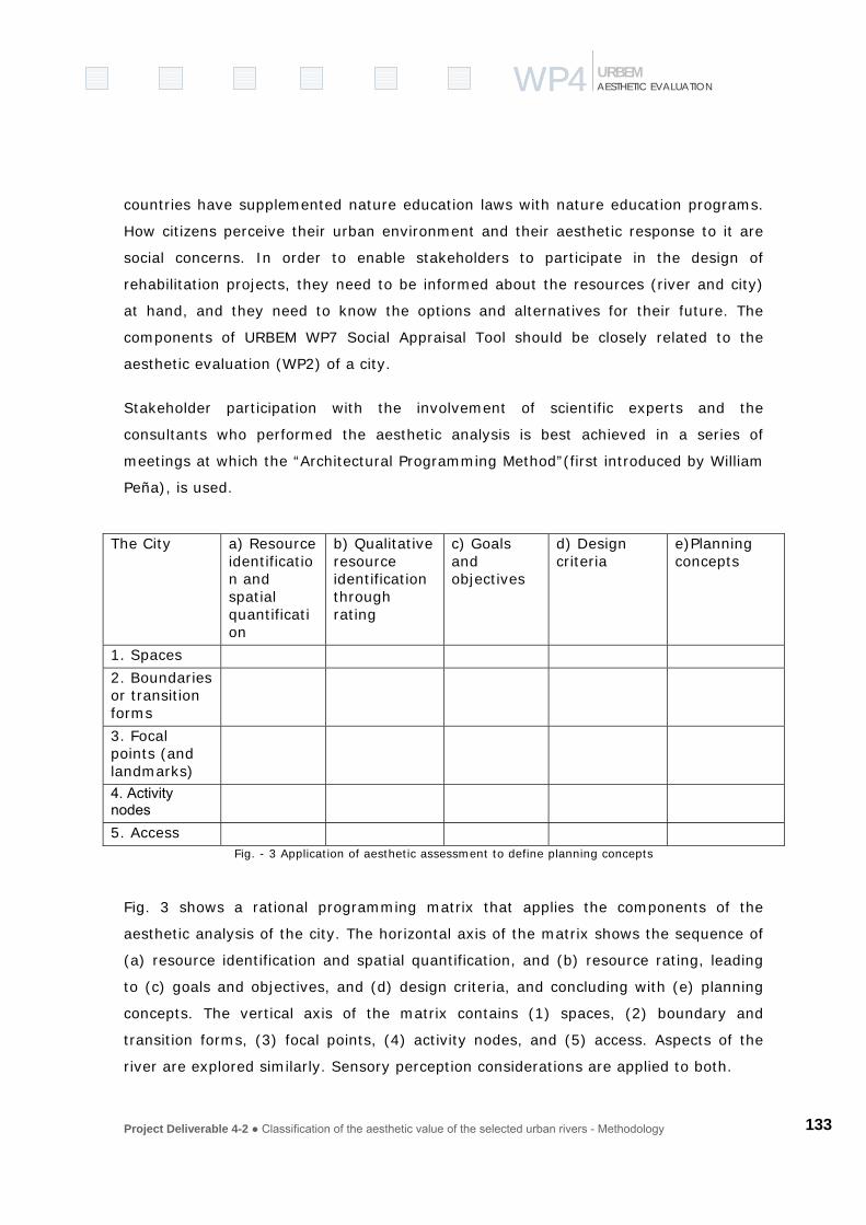
Project Deliverable 4-2 ● Classification of the aesthetic value of the selected urban rivers - Methodology
133
WP4WP4 AESTHETIC EVALUATION URBEM
countries have supplemented nature education laws with nature education programs.
How citizens perceive their urban environment and their aesthetic response to it are
social concerns. In order to enable stakeholders to participate in the design of
rehabilitation projects, they need to be informed about the resources (river and city)
at hand, and they need to know the options and alternatives for their future. The
components of URBEM WP7 Social Appraisal Tool should be closely related to the
aesthetic evaluation (WP2) of a city.
Stakeholder participation with the involvement of scientific experts and the
consultants who performed the aesthetic analysis is best achieved in a series of
meetings at which the “Architectural Programming Method”(first introduced by William
Peña), is used.
The City a) Resource
identification and spatial quantification
b) Qualitative resource identification through rating
c) Goals and objectives
d) Design criteria
e)Planning concepts
1. Spaces
2. Boundaries or transition forms
3. Focal points (and landmarks)
4. Activity nodes
5. Access Fig. - 3 Application of aesthetic assessment to define planning concepts
Fig. 3 shows a rational programming matrix that applies the components of the
aesthetic analysis of the city. The horizontal axis of the matrix shows the sequence of
(a) resource identification and spatial quantification, and (b) resource rating, leading
to (c) goals and objectives, and (d) design criteria, and concluding with (e) planning
concepts. The vertical axis of the matrix contains (1) spaces, (2) boundary and
transition forms, (3) focal points, (4) activity nodes, and (5) access. Aspects of the
river are explored similarly. Sensory perception considerations are applied to both.

Project Deliverable 4-2 ● Classification of the aesthetic value of the selected urban rivers - Methodology
134
WP4WP4 AESTHETIC EVALUATION URBEM
The matrix will be used as a basis for discussion groups with workshop participants
and invited experts. During these discussion groups, comments will be formulated on
index cards to be displayed on a wallboard for every field of the matrix and from these
comments design concepts will be proposed and summarized in proceedings of the
meeting.
3.8 Design criteria, policy determination and planning concepts
The most important portion of any project is to set goals and objectives
(Aufgabenstellung) to solve problems. The task described here is to attach to these
goals and objectives design criteria and planning concepts that are developed by a
“Design Commission”. A consulting firm would carry out the actual plans for an
enhancement project.
4. Conclusion
The aim of URBEM is to define enhancement methods for urban rivers. Enhancement
has an aesthetic component that relates to city planning and design of communities
adjacent to rivers. The cultural heritage of a city is reflected in its structures, spaces
and waterfronts, making them legible and memorable and coherent for the observer.
A methodology to assess the aesthetic qualities of urban rivers needs to reflect the
image and heritage of a place. The aesthetic evaluation methodology needs to be
integrated into an overall planning method, a final product of URBEM, forming a
decision support methodology for urban planners and public environmental authorities.
It is proposed that the CESUR-IST/UTL team method be used for an overall river
corridor assessment, and that the “Site Method” be used at the project scale.
5. References
BnatSchG, Gesetz über Naturschutz und Landespflege, §1,§2.
GESIS, Gewässerstrukturgüteinformationssystem, Land Hessen, 2003, D:ßwww.publishßfileßUseDocProto2.vbd

Project Deliverable 4-2 ● Classification of the aesthetic value of the selected urban rivers - Methodology
135
WP4WP4 AESTHETIC EVALUATION URBEM
Hammel, Bette, A renaissance on the river in Saint Paul. Architectural Record, 189:9, p. 65-66, Sept. 2001.
Harker, Charles, Prof., School of Architecture and Environmental Design, Kent State University. Personal communication, 2003.
Hudacsko, Dennis W. Aesthetic Objectivity: A Valid Basis For Visual Impact. APA National Planning Conference, Proceedings, 1999
(LAWA)Länderarbeitsgemeinschaft Wasser, Gewässer Strukturgüte Kartierung in der Bundesrepublik Deutschland, 1998
Leopold (missing: method for the aesthetic assessment of forest stands, USDA forest service)
Lynch, Kevin. City Sense and City Design. Writings and Projects of Kevin Lynch edited by Barnerjee and Michael Southworth, Cambridge, MA: The MIT Press, 1990.
Lynch, Kevin. Das Bild der Stadt (Image of the City. Braunschweig/Wiesbaden, 2001.
Lynch, Kevin, Site Planning, MIT Press, 1971.
Peña, William. Problem Seeking – An Architectural Programming Primer, 1995
Rosgen , D.L. A stream classification system. in Riparian Ecosystems and Their Mangement: Recociling Conflicting Uses, ed. R.R. Johnson et al, U.S. Forest Service Report M 120, 1985
Salvesen, David Downtown Debate (Pittsburgh). Urban Land, 60:9, p. 104-107, Sept. 2001.
Tourbier, J. T. Taproots: Stewardship through Heritage Discovery. Newark, DE: University of Delaware Water Resources Center, 1985
Tourbier, J. T. Design Resources of Doylestown. Doylestown, PA: Bucks County Planning Commission. 126 p.1968.
Project Deliverable 4-2 ● Classification of the aesthetic value of the selected urban rivers - Methodology
136
WP4WP4 AESTHETIC EVALUATION URBEM
6. Appendix : Products and Uses of the Aesthetic Assessment
Products and use of the aesthetic assessment – The River
Knowledge of the functional aspects of a river system will give context and meaning to
visual features along the river and add to the aesthetic appreciation of the riverine
environment.
Comparison of the project river with a reference stream (a stream in a largely
undeveloped state) permits stakeholders to understand the impact of the historical
development of the project stream. An illustrated comparison of the richness of the
flora of the reference stream and relatively impoverished fauna of the project stream
would be a valuable tool in discussions with stakeholders.
Stakeholders should be encouraged to make comparative aesthetic evaluations of
rivers with different water qualities in order to illustrate the importance of water
quality in the aesthetic appreciation of the river. Problem sections of the project site
and sources of water pollution can then be identified on maps for the stake holders.
Drawings of different stream channel types and form are part of the Rosgen method of
stream classification. An understanding of the different characteristics of different
orders of streams will help stakeholders understand the distinctive visual
characteristics of each type of stream. This will enable them to make suggestions that
increase the visual distinctiveness of the project stream.
Elements of streambank and floodplain are part of the “Gewässerstrukturgüte” (LAWA
1998) standard inventory form. Typical drawings of each element in different
situations will help stakeholders understand the visual character of their particular
project site and to make appropriate suggestions for enhancement
The flora and fauna in the reference stream will help stakeholders set goals for the
improvement of the health of the riverine environment which in turn will lead to an
increased aesthetic appreciation. If the improvements are not realized, disillusionment
may result in a negative aesthetic experience, but if the project is successful
anticipation can add to the positive affect.

Project Deliverable 4-2 ● Classification of the aesthetic value of the selected urban rivers - Methodology
137
WP4WP4 AESTHETIC EVALUATION URBEM
Enhancement projects will increase the potential nature observation and recreation
along a stream. These uses clearly will increase the positive aesthetic appreciation of
the river
An inventory of flora is part of the standard “Gewässerstrukturgüte” analysis. Because
of the importance of riparian vegetation to the aesthetic appreciation of the river,
other categories have been added to be able to express the visual character of
vegetation as an important element of the natural riverine landscape
Products and use of the aesthetic assessment – The City
Recognition by stakeholders of the elements (including the river) that structure the
urban fabric is an important aspect of urban river enhancement projects.
Spaces
The diverse spaces of a city, the sequence in which they are experienced, and how
they are shaped and enclosed by buildings or trees, create a vivid image of the city.
The river is one such space and its spatial relationship with other urban spaces must
be recognized
The specific uses of squares, parks, and recreation areas and other urban spaces
should be clearly related to river improvement plans.
The relationship between spaces in the city that are more natural and the river can be
important aspect of conserving remnant patches of habitat in the overall urban nature
conservation
Access
The pattern created by the streets and the river in a city will probably form the basis
of the mental map of the city for most people. The streets are the principal access
routes and the river the principal obstacle. The mental map is an essential tool in the
legibility and comprehension of the city, and critical in the aesthetic experience of the
city.

Project Deliverable 4-2 ● Classification of the aesthetic value of the selected urban rivers - Methodology
138
WP4WP4 AESTHETIC EVALUATION URBEM
Public transportation routes also form the basis of mental maps of the city. For
passengers on public transport, the negative aesthetic experience of distraction is less
likely to occur as it is not essential for the traveller to focus attention driving or
cycling.
Most pedestrian paths are sidewalks on city streets where negative sensual stimuli
(noise, diesel fumes, danger) will strongly affect the experience. But where footpaths
can be completely separated from traffic, more positive stimuli will be experienced,
and can be enhanced by the designer.
In riverine districts of the city, the river will be the destination for many pedestrians
and the linkages between the urban fabric and the river by designated footpaths is
important for the aesthetic experience of the residents.
Focal points and landmarks
Prominent landmarks and focal points have been inventoried together with the
viewpoints and the vistas that allow them to be seen. Designers can minimize
distracting stimuli that draw the viewer’s attention away from the focal point. They
can remove obstructions to the view of the focal point and they can also make the
viewpoints more accessible.
Where ecological enhancement of the river involves reestablishing riparian trees and
other measures care should be taken not to obstruct important views.
The positive aesthetic experiences provided by bridges should receive attention in
river enhancement projects. The negative experiences associated with delays and
frustration can be minimized by good traffic engineering
Edges, boundaries and transitions
Measures to increase the effectiveness of boundaries to enclose space or to emphasise
the distinctiveness of adjacent areas can be proposed by the designer.
Measures to reduce the distracting aesthetic stimuli along a boundary goes hand in
hand with focusing attention on focal points within the area
Project Deliverable 4-2 ● Classification of the aesthetic value of the selected urban rivers - Methodology
139
WP4WP4 AESTHETIC EVALUATION URBEM
Boundaries in urban areas are frequently formed by parks, belts of trees or other
remnant natural areas. Ecologic enhancement measures for these areas should be
compatible with the overall urban nature conservation plans for the city
When passing across a boundary from one area or space to another through a
gateway, or across a bridge, designers should consider contrasts in the aesthetic
stimuli on each side of the boundary. Viewers will be particularly sensitive to
contrasting stimuli, which will also emphasise the distinctiveness of each area.
In any enhancement project, the river will be one of the most prominent boundaries.
It is harmonious, and legible. Yet there will be a concentration of positive aesthetic
stimuli along the boundary. It does not however like most boundary elements enclose
a space or obstruct the view. Designers should be aware of these factors.
Features that are likely to cause averse aesthetic experiences may be deliberately
blocked by planting screens that should be part of the ecological enhancement plan for
the river.
Activity Nodes
The designer should reduce the frequency and intensity of stressful visual stimuli by
creating a consistent language for signs and other features so that they may be
intelligible and easily read.
Designers should reduce intensity of aesthetic stimuli that distract drivers at
dangerous nodes.
Regulations to ban some aesthetic stimuli such as car horns can be enacted.
Designers must recognize that nodes are, by definition, exciting and busy places,
where usually there are pedestrians, vehicles, cyclists intermingling. Clear and
intelligible direction and signage that focus attention, and the reduction of distracting
stimuli can make these safer places

Project Deliverable 4-2 ● Classification of the aesthetic value of the selected urban rivers - Methodology
140
WP4WP4 AESTHETIC EVALUATION URBEM
Products and use of the aesthetic assessment – The People
Sensory perception
All the human senses, sight, smell, noise and touch, affect aesthetic experiences,
which can be positive or negative. The designers role is to enhance the positive and
minimize the negative.
The aesthetic stimuli and the related memories invoked by rivers are intense and
evocative and the designer must take care to preserve these stimuli in enhancement
plans
Experiencing the site.
Designers should be aware of the six aesthetic emotional experiences, and attempt to
enhance the positive and minimize the negative in their plans.
The importance of a clear and legible urban structure to the enhancement area cannot
be overestimated. Elements that fit into a comprehensible structure will produce
aesthetic experiences that can easily be understood and therefore have a positive
affect.
Conversely, the same elements that are part of a chaotic urban structure may produce
negative experiences because the are not readily identifiable or understood
Experiencing the elements of the city
The various elements that make up the structure of the city were considered
individually under The City. I t is important that the designers consider how each of
these elements will be perceived by people.
It should be remembered that aesthetic stimuli for residents and tourists will invoke
different memories that will be much more specific for residents
The designer should also be aware of how the elements of the city and the aesthetic
experiences produced by them relate to one another.
Project Deliverable 4-2 ● Classification of the aesthetic value of the selected urban rivers - Methodology
141
WP4WP4 AESTHETIC EVALUATION URBEM
Experiences in motion.
Designers should be sensitive to matching the visual stimuli to the design speed.
Designers should consider ways of making the experience more harmonious by
spacing regular features along the route
Designers must reduce distracting stimuli at points of conflict between travelers
Powerful positive aesthetic experiences occur when traveling the river on a boat.
These experiences should be made widely available by promoting riverboats and good
landing facilities.