city report metropolitan lima and callao - chance 2 sustain · metropolitan lima and the...
TRANSCRIPT

CITY REPORT
February 2014
Metropolitan Lima and the Sustainability ChallengeGrowing Cities in Growing Economies
City ReportMetropolitan Lima and Callao
By Liliana Miranda Sara, Guillermo Takano, Carlos Escalante
4

Metropolitan Lima and the Sustainability ChallengeGrowing cities in growing economies
Urban Chances in PeruCities for Life Foro
City ReportMetropolitan Lima and Callao
By Liliana Miranda Sara, Guillermo Takano, Carlos Escalante
School of Built Environment and Development Studies
University of KwaZulu-Natal
Full team of researchers: Rommy Torres, Fernando Palomino, Efrain Arana, Linda Zilvert,
Sandro Chavez, Consuelo Muguruza as well as MSc. students Jean Paul Kaiser, Lisa Strauch and Ivonne Leung
2
AML MetropolitanAssemblyofLima
ALA LocalWaterAuthority
ANA NationalWaterAuthority
APN NationalPortAuthority
CAPECO ConstructionChamberofPeru
CENEPRED NationalCenterforthePreventionandandDiminishingofDisasterRisk
COFOPRI CommissionfortheFormalizationofInformalProperty
CONATA NationalCouncilofRealEstateValueAppraisals
COREDES RegionalConferenceforSocialDevelopmentofLima
EAE StrategicEnvironmntalEvaluaction
EMAPE MunicipalityCompanyofTollAdministration
ENSO ‘ElNiño’phenomenon
GPIP OfficeforthePromotionofPublicInvestmentsMML
GRC RegionalGovernmentofCallao
HIDRONAV DirectorateofHydrographyandNavigation
IGN NationalGeographicInstitute
IIRSA InitiativefortheSouthAmericanIntegration
IMARPE PeruvianMarineInstitute
INDECI NationalCivilDefenseInstitute
INDECOPI PeruvianconsumersdefenseAgency
INVERMET MunicipalityofLimaMetropolitanFundofInvestments
IPCC ClimateChangeIntergovernmentalPanel
IIRSA ProgrammeforRegionalInfrastructureinSouthAmerica
LM LimaMetropolitanArea
LiWa LimaWaterProject
MCLCP PovertyFightingConcertacionGroup
MML MetropolitanMunicipalityofLima
MINAM MinistryofEnvironmentofPeru
MOCCIC ‘CivicMovementcopingClimateChange’
MPC ProvincialMunicipalityofCallao
MST HomelessMovement
MVCS MinistryofHousing,ConstructionandSanitation
MZEE EcologicalEconomicMicro-Zoning
NCCC NationalClimateChangeCommittee
OT TerritorialPlanning
PB ParticipatoryBudgeting
POT TerritorialPlan
PRDC ConcertedDevelopmentPlanofMetropolitanLima
PCM PrimeMinister’sCouncil
PIGARS IntegralPlanforSolidWasteManagement
RUOS NationalRegisterofSocialOrganizations
SBN NationalSuperintendenceofRealEstateAssets
SEDAPAL WaterandSewerageServiceofMetropolitanLima
SENAMHI NationalServiceofMeteorologyandHydrologyofPeru
SERPAR ParksServicesAdministrationofMML
SIGRID InformationSystemforDisasterRiskManagement
SIRAD InformationSystemofResourcesforDisasterAttention
SITR RegionalSpatialInformationSystem
SMCV SociedadMineraCerroVerde
SNIP NationalSystemofPublicInvestment
SUNARP NationalPublicRecordsSuperintendence
UNDP UnitedNationsDevelopmentProgram
VdeL GlassofMilkProgram(Municipal)
ZEE EcologicEconomicZone
List of Acronyms
3
Table of ContentsTable of Contents
Summary . . . . . . . . . . . . . . . . . . . . . . . . . . . . . . . . . . . . . . . . . . . . . . . . . . . . . . . . . . . 5
1 . Introduction: Context of Urban Governance in the City Concerned . . . . . . . . . . . . . . . . . . . . . . . 61.1.LevelsofGovernmentandTerritorialJurisdictionsInvolvedintheCityRegion . . . . . . . . . . . . . . . 61.2.PlanningSchemesattheNational,Macro-regional,Metropolitan,ProvincialandDistrictLevel . . . 7
2 . Main Urban Growth Strategies – The Role of Mega-projects . . . . . . . . . . . . . . . . . . . . . . . . . . . 102.1.PositionoftheUrbanEconomyRelatedtoNationalandInternationalEconomyand
City-centeredVisions. . . . . . . . . . . . . . . . . . . . . . . . . . . . . . . . . . . . . . . . . . . . . . . . . . . . . . . . . . . .122.2.CurrentRoleofLarge-scaleInfrastructureProjectsintheUrbanEconomy . . . . . . . . . . . . . . . . 122.3.DebatesonLarge-scaleProjectsinLM . . . . . . . . . . . . . . . . . . . . . . . . . . . . . . . . . . . . . . . . 15
3 . Unequal Urban Development; Sub-standard Settlements and Mobilization . . . . . . . . . . . . . . . . . 163.1.PopulationGrowth,SpatialDistributionandDensity . . . . . . . . . . . . . . . . . . . . . . . . . . . . . . 163.2.Socio-economicInequalitiesatCityandLocalLevels:Employment,IncomeandLivingEnvironment . . . 173.3.SocialMobilizationandParticipationinSub-standardSettlements. .. .. .. .. .. .. .. .. .. .. 24
4 . Water Governance and Climate Change Issues in City Concerned . . . . . . . . . . . . . . . . . . . . . . . . 274.1.TheMetropolitanCityofLimaTerritoryandClimateConfiguration . .. .. .. .. .. .. .. .. .. .. 274.2.EnvironmentalVulnerabilities . . . . . . . . . . . . . . . . . . . . . . . . . . . . . . . . . . . . . . . . . . . . . . 284.3.WaterInstitutionality . . . . . . . . . . . . . . . . . . . . . . . . . . . . . . . . . . . . . . . . . . . . . . . . . . . . 324.4.EnvironmentalandClimateChangeInstitutionality................................ 344.5.WaterandTerritoryPolicyContext/Interactions. . . . . . . . . . . . . . . . . . . . . . . . . . . . . . . . . . 364.6.WhichistheKeyActor´sDecision-makingCapacityofInfluence? . . . . . . . . . . . . . . . . . . . . . . 374.7.ProducingVulnerabilityAnalysesandScenarios;SpatialPerspectivesandParticipation . .. .. .. 37
5 . Spatial Knowledge Management in the City: Spatial Perspectives and Participation in Knowledge Production, Exchange and Use? . . . . . . . . . . . . . . . . . . . . . . . . . . . . . . . . . . . . . 385.1.DiscoursesandRationalesforIntroducingICT-GIS-basedKMinUrbanGovernance;
Boundaries,WorkProcesses,MappingNeeds . .. .. .. .. .. .. .. .. .. .. .. .. .. .. .. .. .. 385.2.KnowledgeManagementinUrbanPlanningintheCity:ActorsandNetworks . . . . . . . . . . . . . . 395.3.KnowledgeBuilding,UseandContestation,Exchange. .. .. .. .. .. .. .. .. .. .. .. .. .. .. .. 445.4.SpatialKnowledgeProducedthroughCitizenParticipationProcesses . .. .. .. .. .. .. .. .. .. 495.5.Conclusions . . . . . . . . . . . . . . . . . . . . . . . . . . . . . . . . . . . . . . . . . . . . . . . . . . . . . . . . . . 53
6 . The Role of the City Government Finances and Venues of Participation within the Decentralization Process . . . . . . . . . . . . . . . . . . . . . . . . . . . . . . . . . . . . . . . . . . . . . . . . . . 536.1.BudgetaryConsiderations. .. .. .. .. .. .. .. .. .. .. .. .. .. .. .. .. .. .. .. .. .. .. .. .. 536.2.CitizenParticipationintheCity:ParticipatoryBudgetingProcesses? . . . . . . . . . . . . . . . . . . . . 55
7 . Case-studies . . . . . . . . . . . . . . . . . . . . . . . . . . . . . . . . . . . . . . . . . . . . . . . . . . . . . . . . . . 577.1.WP2.The‘LíneaAmarilla-ViaParqueRimac’ExpressHighway . . . . . . . . . . . . . . . . . . . . . . . . 577.2.WP3.TheLeftBankoftheRimacRiver(MIRR) . .. .. .. .. .. .. .. .. .. .. .. .. .. .. .. .. .. 597.3.WP4.ThreeScenariosforMetropolitanLimaforYear2025 . . . . . . . . . . . . . . . . . . . . . . . . . . 607.4.WP5.‘InstitutionalKnowledgeandTechnologyManagementinCallao.. . . . . . . . . . . . . . . . . . 63
8 . Conclusions . . . . . . . . . . . . . . . . . . . . . . . . . . . . . . . . . . . . . . . . . . . . . . . . . . . . . . . . . . . 65
9 . References . . . . . . . . . . . . . . . . . . . . . . . . . . . . . . . . . . . . . . . . . . . . . . . . . . . . . . . . . . . . 67
Thepresentcityprofilereportexploresthedevelopmentof Metropolitan Lima (LM), the capital of Peru on anumberofaspectsconcerningitssustainabilityintimesofhigheconomicgrowththathasoccurredsteadilyinthelast15years.Indeed,cities–andparticularlyLimaduetoitsprimacy–havebeenconsideredasenginesofeconomicgrowththatatthesametimehaveabsorbeditsimpacts.Peruvian cities have certainly reflected the effects of agrowth oriented economicmodel by developing as anunplannedurbansystemwithgreatinequalitiesbetweenurban and rural areas, aswell as between andwithincities. Issues such as high physical and environmentalrisks,waterstress,socio-spatialsegregation,lackofbasicservice coverage, uncontrolled urban sprawl overagricultural areas based on market forces instead ofplanningbut haveconstitutedLMaseloquentrelevantcaseforadetailedstudy.
Theseimpacts,togetherwiththerecenttransformationsthathaveoccurredinLMwillbeexploredinaccordancetothescientificframeworkoftheChance2sustainresearchproject. The report will explore the set of governanceschemes performing at different levels and involvingdifferentactorsinordertounderstandhowgrowth,urbanreconfigurations, social responses, environmentalprocesses and spatial knowledge are related in thisparticularcase,supportedbythecase-studiesproducedbytheChance2Sustainteamofresearchers.Sincetheprojectaims to compare these different phenomena withinternational cases, this report will also refer to thepeculiarities of LM and its regional/national context inordertoestablishitsuniquefeatures.
Chapter1examinesthedifferentlevelsofgovernmentinvolvedintheterritoryofLManditshinterlandandtheirdegreeofresponsibility,actinginautonomous,dependentoroverlappingways. There is a special emphasison the
impetuses and effects of the ongoing decentralizationprocessandonhowplanninghasbeenredistributedamongnationalandsub-nationallevelsofgovernment.Chapter2exploresthestrategicimportancegiventoinfrastructureatthenationalandmetropolitanlevelsandtherolethatlarge-scaleprojectshaveacquiredinordertoconsolidateLM’surbaneconomyaswellasthevisionsandagendasbehindtheir implementations and the impacts and debatesgenerated.Chapter3highlightsthefeaturesofurbanizationinLM,withaparticularemphasisonthesegregatedwayinwhich LMhasdeveloped and consolidated; explained inrelationtodensity,housingandinfrastructureendowments.The whole set of policy efforts and the historical roleacquiredbysocialorganizationsinordertoovercometheseinequalities are also deeply analyzed. Chapter 4 aims tounderstand the city’s hydro-climatic vulnerabilities incorrelationtotheclearterritorialdistributionofinequalityshowninchapter3andconfrontedwiththeroleofwaterandclimatechange institutions.Chapter5confronts thevisionsthatdifferentactors/sectors/levelsofgovernmenthaveonLMandamultilevelapproachtospatialknowledgebypublic,privateandcivilsocietysectors(includingCBOs1)andtowhatextentthisisrelatedwiththeconformationofainstitutionalnetwork.Chapter6outlinesseveralfiscalandbudgetaryissuesrelatedtothemostrecentdecentralizationwaveandthestructuralproblemsitaimstotackle.Italsoexplores the outcomes, problems and possibilities ofparticipatory budgeting processes as a possibility todemocratizebudgetallocationanddecision-makinginLM.Chapter 7 explores the different case studies that haveprovidedempiricalevidenceandsupported someof theanalyses and statements done along the document.Weclosethereportwithconclusionsandadetailedanalysisofthedifferentthemelinesseenalongeachchapter.
1 Community-based organization
Summary
5
Summary

Introduction: Context of Urban Governance in the City Concerned1
LM located in the coastal center of Peru next to theAndes Mountains and is formed by the Lima-Callaoconurbation(morerecentlyexpandingtothe‘Huarochiri’neighboringprovince). Ithasanestimatedpopulationof8.5millioninhabitantsandholdsthefourthplaceonthelistoflargestcitiesinSouthAmerica,2being10timesbiggerthan Arequipa, the second city of the country. LM’shinterlandconstitutestheLimaMacro-regionwhichisanarticulationofnetworksofcitiesandtownssettledalongthefourriverbasinsthatcomposetheconurbation:Chillon,Lurin, Rimac andMantaro.3 As other big cities from theSouth,therapidgrowthofLMhasbeenmarkedbyrapidurbanization4, economic and political centralization andunequalpatternsofurbanization.Thisissues,togetherwithasetofunresponsiveurbanpolicieshavecertainlysetthecurrent situationof LM, characterizedbyhigh inequalityandsocio-spatialsegregationlevels.
1 .1 . Levels of Government and Territorial Jurisdictions Involved in the City Region
Politically Peru is defined as a democratic, social,independent and sovereign republic. Its government ismeanttobeunitary,representativeanddecentralized,andis organized according to the principle of separation ofpowers into executive, legislative and judicial branches.Territorially,Peruisdividedinto25regions,194provincesand 1828 districts that are governed at three differentlevels: the national government (with 118 decentralizedinstitutionsand50decentralizedautonomousagencies),25 Regional governments and more than 1800 localgovernmentsatprovincialanddistrictlevels.
2 In: Instituto Nacional de Estadística e Informática, Perfil Socioemográfico del Perú. Censos Nacionales 2007: XI de Población y VI de Vivienda, INEI, Lima, agosto de 2008, 2ª edición, pp. 29, 30.
3 Nonetheless, there is no established macroregional jurisdiction in the LM area.
4 Urban population in Peru has increased 9.5 times between 1940 and 2007 while the rural population has only increased 1.6 times.
1 .1 .1 . National level of government
Themost relevant territorial policymaking processessuchaswaterandsanitationservicesandenergyprovision,land policies or large-scale infrastructure and naturalresource concessions, fully depend on the nationalgovernment or are at least regulated by this sphere.Ministries responsible for designing policies do not takecrosscuttingdecisionsinrelationtothereferredsectorsorrelatetosub-nationallevelsofgovernment.5
1 .1 .2 . Macro regional level
Ingeneral,issuesinmacroregionalizationhavenotstillbeen discussed in programmatic ways over existingdepartmental subdivisions and no serious proposal hasbeenpublicly debated so far sincedivergencesbetweenregionsanddepartmentsareconsideredtobeformidable(suchaseconomicorgeographic).Themostrecentefforthas been the national referendum held in 2005 forapprovingthecreationof5macro-regions.15of16regionsvotedagainsttheproposalandtheprocesswas,onceagain,putted on hold. It has been recognized that the 2005referendumprocesswasnotjoinedbyaseriouspublicandtechnicaldebateandthepopulationwasuninformedwhentheywent to vote and the proposal lacked of technicalsolutions for reverting existing ‘departmentalism’impetuses.6 The decentralization process happenedwithoutapreviousplanninginordertoestablishtherouteofthedecentralizationwithinadeeptransformationofthestate; which means changing the social and economicconditionsthatorganizetheterritory(Azpur2005).
Thismeansthatthereisnotalegitimatemacroregionalgovernment sphere surrounding LMor any othermajorcity-region in Peru. Nevertheless, LM’s immediatemacroregional context is not difficult to determine(currentlyusedonlyforresearchpurposes)beingcomposedby 3 independent regional jurisdictions; each of themgovernedby theirownsingleauthorities that constantlytendtooverlapandevencollide(seefigure1):
5 Additionally, the main branches of the central government are housed in LM: executive (presidency and ministries), legislature and judiciary powers.
6 See: http://www.larepublica.pe/01-11-2005/lecciones-y-perspectivas-del-referendum-del-30-de-octubre
6

• Lima
• Callao
• ‘Lima Provincias’ (it is a different entity whosejurisdiction includes surrounding peri-urban andrural areas at themedium and high basins of theChillon,LurinandRimacrivers).
Thesejurisdictionsinclude11provincialmunicipalities(Lima, Callao, Huarochiri, Canta, Cañete,Oyon,Hauaral,Yauyos,Barranca,CajatamboandHuaura)andmorethanahundreddistrictmunicipalities.7
1 .1 .3 . Metropolitan and provincial levels
Inshort,LMisgovernedbytworegionalgovernments:8theMunicipality of LimaMML that is a local provincialgovernmentwithregionalgovernmentcompetences9andtheRegionalGovernmentofCallao(GRC)thatatthesametime overlapswith the ProvincialMunicipality of Callao(MPC).TheCallaoterritoryisauniquecaseinthewholecountry,wherearelativelysmallterritorycontainedwithinthelimitsofabiggerone(LM)hasautonomousregionalgovernmentcompetences(seefigure1).
At the metropolitan level there is a well-recognizedgovernanceproblemlevelbetweentheMetropolitanLimaProvince and the Callao Province. Although both areconurbatedand formthesamemetropolitan region thereexistsaverylimitedplanningandadministrativerelationshipregardingnational-sectorial,regionalorlocalsphereswhichgeneratesconstantoverlappingandevenconflict/competitionsituations. Also, the neighboringHuarochiri province hasbeenaddedtothedecisionmakingprocessregardingtheLMterritory (see figure 1), since the metropolitan area hasrecently surpassed itshistoricboundaries to theeast (SanJuandeLuriganchodistrict)andHuarochirihasbecomethemain current urban growth absorption area. That hasexacerbated government overlapping and fragmentationoccurringinasinglemetropolitancity.
1 .1 .4 . The District Level
Thereare49districtmunicipalitiesinLM(42inLimaand7inCallao)thattendtoperformindependentlyfrom
7 Its direct hinterland regarding water resources includes also the neighboring regions of Pasco and Junin.
8 Mayors (district and provincial) and regional presidents and councils are elected every four years.
9 This is a unique case established by the organic law of municipalities.
eachotherandfromhigherregionalandprovinciallevelsof government. This is supported by the 1993OrganicLaw of Municipalities that undermined the power ofprovincial governments and empowered districtgovernments particularly in relation to their fiscalcapacities.Thisgovernanceshiftoccurredinacontextofneutralization of regional political opposition by theFujimoriruleduringthe1990s.10
Despite the past and current decentralization effortsdone(atleast7attempts)Peruisstillahighlycentralizedcountrywhere‘…dominantsectorshadthecapacity,andabove all, the power to block and frustrate severaldecentralistattempts,intheframeworkofaveryexcludingsociety’ (Azpur 2005:1). Considering LM’s political andeconomicimportanceatthenationallevelgreatlyrelatedtoitsprimacy,itisanimportantspaceofpoliticalstrugglebetween national and sub-national governments (itconcentrates one third of voters) to the point that thenationalgovernmenthasstrategicallyrolledbackdifferentaspectsofthedecentralizationprocessthatattheendofthedaydonotholdanytrulyregionalperspectiveandevenkeepsrelyingonterritorialfragmentationinordertosecurepoliticalprofits(forinstanceregardingtheattributionsofsectorialcompetences fromministries to theMML).Themost importantdecisionsandabout70%ofthenationalbudgetareconcentratedatthenationallevelofgovernment.Thus, Lima is a very important recipient of publicinvestmentsfromthenationalgovernmentthattendstoeven competewith local authorities (withmuch higherbudgets). National government expenditure in LMwasalmost29timesmorethanMML’sin2012.11
1 .2 . Planning Schemes at the National, Macro-regional, Metropolitan, Provincial and District Level
First at all, it is important to state that there is nocurrenttrendofenforcingandevaluatingurbanplansinPeru, which is related with the deactivation of most
10 The law that authorized the transfer of urban regulation competences from provincial municipalities back to the national government was passed only 3 days before a new mayor of Lima, Alberto Andrade, took power. He was the main political opposite to Alberto Fujimori at that time.
11 The 2012 budget for the MML was around 1742M PEN. Nonetheless, more than 50000M PEN where assigned to the Lima department during the same year, for being exclusively spent by the national government.
Introduction:ContextofUrbanGovernanceintheCityConcerned
7
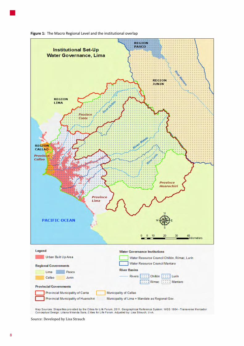
Figure 1: TheMacroRegionalLevelandtheinstitutionaloverlap
Source: Developed by Lisa Strauch
8

regionalization,differentjurisdictionstendtodeveloptheirownplanningschemeswithoutconsideringeachother.
There are no planning ormanagement coincidencesbetweenLMandstrategicneighboringprovincessuchasHuarochiriandconsequentlythereisnokindofoversighton LM’s further expansion sinceHuarochiri develops itsownplansaswell.14
1 .2 .3 . Regional and provincial levels
In Peru, local governments have a limited role inmetropolitanplanning.Theregional-provinciallevel,whichisthenaturalspaceformetropolitanmanagementandsub-nationalarticulationsremainsinakindoflimbo.Provincialmayorsperformonlyasmanagersofthecapitaldistrictbutnotofawholesetof jurisdictionsbelongingtoagreaterterritory. This processwaswell inserted in the Fujimoripolitical control apparatus that aimed to cancel anyinstitutionalintermediationandthepossiblegenerationofpoliticaloppositionflanksparticularlyunderthefigureofmetropolitanmayorsinLM.
UrbandevelopmentplanninginLimaoccursunderthejurisdictionoftwoinstitutions;theMetropolitanPlanningInstitute(IMP)oftheMML,andtheProvincialMunicipality
14 Also, in relation to public transport policies, overlap and competition levels have also risen between Lima, Huarochiri and Callao. The Huarochiri Provincial Municipality has authorized public transport lines to circulate on LM’s territory with no type of joint consultation or decision-making. The same case has occurred between Lima and Callao in relation to taxicab permissions.
planning institutionality given after the closure of theNationalPlanningInstitutein1991,occurredinaccordancewiththeaggressiveimplementationofneoliberalpoliciesafter1992.Everyplanningagencywasclosedandeveryplanningaimwasalmostcensored,beingconsideredasapart of a more “socialist” wave of central commandeconomies.Thereferredreformfollowedanideologicalline that considersplanning functionsas ‘inconvenient’andthestateasa‘facilitator’forprivateagents’actions(Calderón 1999), limiting the role of the State to theprovision an adequate environment for markets in arather subsidiaryway and reducing urban planning topurelandusezoning.
Evenasnationaldevelopmentplanningwasretakenwiththe creation and regulation of the National System ofStrategicPlanningCEPLANin2008,12inpracticaltermsthecountrystilllacksofanintegratedplanningsystem.Asaninstitution CEPLAN still hasmany political and technicallacksreflectedinits2010-2021planthatdoesnotincludeproperdiagnoses,analysesorstrategiesforreachingtheexpectedgoals.13
1 .2 .1 . National Government Level
National level entities involve on issues of ecologic-economic zoning and urban land management byinterveningonthepropertylegalizationorgranting(sellingatlowerprices)ofdesertareasandformerpublicfacilities(such as army barracks and civil airports) to privateoperators for developing real estate large-scale projectswithnoinferenceofmunicipalorregionalgovernments.Inthesamevein,theformerdeputyministerofHousinghaspromotedanationalprogramforurbanenablementthatpretendtogive570000haoflandtorealestatecompaniesforsocialhousingpurposescalled‘ProgramadeGeneracióndeSueloUrbano’(urbanlandgenerationprogram).
1 .2 .2 . Macro-regional level
Asithasbeenpreviouslysaid,regardingthejurisdictionsthat conform an hypothetical macro-region, no jointplanningconsiderationshavebeentakensincethereisnotype of institutionality at the referred level.While thenational planning system (under the figure of CEPLAN)practically denies the institutional side of macro-
12 In: http://www.ceplan.gob.pe
13 See: http://peru21.pe/noticia/391712/critican-plan-estrategico-ceplan and http://elcomercio.pe/economia/332839/noticia-ceplan-no-goza-apoyo-elaborar-estrategias-al-2021
Box 1: Clashes between the National Government and the MML regarding large scale projects
Inrelationtolargescaleprojectsdevelopment,the‘Metro del Lima’ public transportation projectwasmadeby an autonomous authority attached to theMinistryofTransportsandCommunications(withnorelationshipwith theMML). Indeed the ‘Metro deLima’andthe‘Metropolitano’segregatedbussystem(managedbytheMML)arenotinterconnectedsystemsyetandtheymighteventuallycompete.Theline2ofthe‘MetrodeLima’hasalmostthesamerouteastheline 2 of the ‘Metropolitano’ and according to thecurrentministerofTransportsandCommunications“itis obvious that thebus line cannot competewith atrainnetwork.Abuslineisdoomedtofail”.
9
1Introduction:ContextofUrbanGovernanceintheCityConcerned
ofCallaothattendtodevelopplansinparallelways.Theymerely update district development plans (from fewofthem), which in some cases include comprehensivedevelopmentproposalsandinothersarelimitedtozoningandlanduses(landusepermitsissuance).
TheIMP,asthemostimportantplanninginstitutioninLM,is in chargeof updating landuse zoningwithin the Limaprovince.Infact,LMistheonlyregioninPeruthatcountswithitsownurbanplanningagencysince1991,thatperformsas an autonomousbody from theMMLand thenationalgovernment. It initially aimed to give continuity, bypermanentlyevaluatingandadjustingtheMasterPlan1990-2010.Unfortunately,boththeIMPandtheMasterPlanhavesufferedasystematicunderminingbyauthoritiesafterthe1990s.Consequently,LMlacksofsomemaininstrumentsofterritorialplanningsuchastheTerritorialPlan(POT)andtheMetropolitanUrbanDevelopmentPlan.15OnlyCallaohasdeveloped a POT (in process of approval) being theonlyregioninthecountrythathasachievedthisgoal.TheIMPiscurrentlyelaboratingthePOTfortheChillon,LurinandRimacbasins,whichisexpectedtobefinishedin2013.Inaddition,theMMLhasconsiderednecessarytoreactivateplanningprocessesandhasrecentlyapprovedthefinalversionoftheConcertedDevelopmentRegional Plan2012-2025 (PRDC)that presents general strategic guidelines for policies andprogramswithsmalldetailandinexistentprogrammaticandterritorialplanningcontents.
15 The Metropolitan Development Plan for Lima and Callao 1990-2010 expired in 2010 and its update has not started yet (neither by the IMP nor the MPC).
1 .2 .4 . District level
The2003OrganicLawofMunicipalitiesreducedurbanplanning to the district scale, to the point that eachmunicipal district is able to approve its own urbandevelopmentplan.Thecurrentlegalframework(OrganicLawofMunicipalitiesfrom2003)statesthateverylocalgovernmentneedstodevelopa‘ConcertedDevelopmentPlan’approvedbymunicipalauthoritiesandcivilsocietyrepresentatives, which is a necessary requisite foraccedingtobudgettransfersandprioritizingparticipatorybudgetingprojects.
Nonetheless, “few local governments have theinstitutional capacity to prepare and approve urbandevelopment plans or effectivelymonitor compliancewithurbanlanduseregulations”(Endo2010:209)andalthough municipalities are in charge of providingpermitsforurbanizationandconstruction,theydonotparticipate in any aspect of urban development andhousing policies (Riofrío 2010), being plans on landadministration restricted to a handful of richmunicipalities.Theresultsanddegreeofconcertationofthereferredplansaremixed:fromplansdevelopedwithahighdegreeofparticipationtothoseonesmadebehindclosed doors by external consultants. The experiencewithconcerteddevelopmentplansshowsthattherearedifficultiesinidentifyingproblemsandpossibilities,andrelatingthemtopublicinvestmentprocessesaswellasterritorial articulation criteria besides infrastructuredevelopment, which certainly feeds existing projectatomizationtrends.
Main Urban Growth Strategies – The Role of Mega-projects2
Fromstrategicplanningexpertstocorporateconstructionlobbyists, infrastructure development is considered as acrucial component for guaranteeing Peru’s globalcompetitivenessandsustainingnationaleconomicgrowth.RawcalculationsofPeru’sinfrastructurebacklog2012-2021are estimated in almost 88000MUSD.16 Considering theamountoffundsrequired(around33%ofGDP)andrecentpublicexpenditurelevelsininfrastructure(lessthan2%ofGDPayear),theinclusionoftheprivatesectorthroughthe
16 In: http://elcomercio.pe/economia/1487422/noticia-brecha-inversion-infraestructura-alcanza-us88-mil-millones
developmentofPPPs(particularlythroughthegrantingofinfrastructure concessions) and the unlocking of existingregulatoryandbureaucraticbarriersareanimportantpartof theagendaatdifferent levelsofgovernment.Figure2shows the most important projects developed underdifferentconcessionschemesatthenationallevel.
Ingeneraltheonlystrategicinitiativetodeveloplarge-scale infrastructure at the national level is named IIRSA“InitiativeforRegionalSouthAmericanInfrastructure”. Itperforms as a coordination mechanism for the jointdevelopmentoftransport,energyandtelecommunication
10
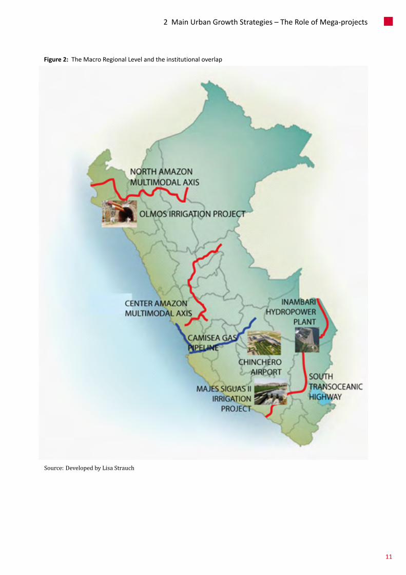
Figure 2: TheMacroRegionalLevelandtheinstitutionaloverlap
Source: Developed by Lisa Strauch
11
2MainUrbanGrowthStrategies–TheRoleofMega-projects
megaprojects beyond national boundaries in 12 SouthAmericancountries.IIRSAhasafocusonenhancingregionalcompetitivenessinordertoconsolidatetheSouthAmericancommonmarketand itsglobalpresenceasaneconomicblock.Fromthetotalportfolioof524projects,67ofthemcorrespondtoPeru,withanexpectedinvestmentofUSD8.3billion.Megaprojectslikethetransoceaniccorridorsandmultimodal axesbelong to this initiative.Other nationalinfrastructureprojectsarerelatedtotheimplementationofmassive irrigationschemesOlmos in theLambayequedepartment(USD185million)andtheMajes-Siguas II inArequipa(USD410million).Thesesprojectsareinsertedinthe context of the increasing importance of agro-exportationwithinthePeruvianeconomicgrowthmodel.
2 .1 . Position of the Urban Economy Related to National and International Economy and City-centered Visions
The size and importance historically achieved by LMprovidesenoughspecificweightformakingcentripetalforcesprevail over existing diseconomies of agglomeration. TheconstantfeedbackbetweenLM’swealthconcentrationandpolitical/fiscal centralization reinforces itsdisproportionateroleandputsconstraintstothedevelopmentofotherregions.In2006,LMconcentrated30.26%ofthecountrypopulation,58% of GDP, 84.4% of the banking portfolio, 4/5 of totaltaxation, 61% of manufacturing activities (nearly 7000factories)(MML2012),55%oftheconstructionsectoroutput,53%oftheretailandservicesectorsoutputand52%ofGVAfor2007(INEI2010).Whiletheaveragenationalproductperworkerwas15519PENin2007,LMaveragesmorethan20000PEN.17Additionally,thePortofCallaoconcentratesmorethan80%Peru’sshippingcontainertrafficthatisincreasingwiththerecentimplementationoftheSouthandNorthPiers(19%ofPeru’sminingexportsgothroughthePortofCallao).
2 .2 . Current Role of Large-scale Infrastructure Projects in the Urban Economy
Population growth in LMhas generated considerablediseconomiesregardingissuessuchaswaterandsewerage(networks are around 30 and 40 years old and areexperiencing constant and increasing collapses),
17 In contrast, other regions such as Apurimac reached 6682 PEN.
transportation(averagecarspeedinLMis16.8km/hwhileinSantiagodeChile is41km/h),18urbanviolence(therewas1policemanforevery781peoplein2011)andpublic/greenspaces(LMcountswithonly2.9m2ofgreenareaper person while the World Health Organizationrecommends10m2).19
As table 1 shows, an important numberof the recentlarge-scaleprojectsdevelopedinLMaimtotackleexistingagglomerationproblems (more than12500MUSD in lessthan10years).Recentpoliciesonlarge-scaleprojectshavetargetedtheeliminationofdiseconomiesofagglomerationandtheimprovementofLM`scompetitivenessintheglobalarenamore than thegenerationofcollectivewelfareandquality of life.20 Expansionsof theport and internationalairportforalmost1500MUSDandtheexpectedLine4ofthe‘MetrodeLima’thataimtoconnect(amongotherobjectives)theairportwiththeCBD,followthesamedirection.
ItalsocanbesaidthatmegaprojectshavealsoamorepragmaticeconomicaimofboostingGDPthroughmassiveandeffectivepublicinvestmentsontheconstructionsector.ThemainsourceofeconomicgrowthandemploymentinPeruviancitiesisthetertiarysectorinwhichconstructionandretailplayamajorrole.BothwerethemostimportantfactorsofGDPgrowth,representingalmosta1/3shareofthe 6.3% national growth rate during 2012.21 Theconstructionsectoralonegrew15.2%in2012,22which–asinmanyothercountries–hasbeenrecognizedtoholdhighsharesofaggregategrowthratesduetoitsvaluechainandemployment generation capacities despite of its lowproductivity nature and the speculative trend thatunregulatedrealestatesectorstendtofollow,risingasavery attractive recipient for private capital. In regard topubliccapital,incomeandemploymentmultipliereffectsoftheconstructionsectorareexpectedtoguaranteeaverypositivecorrelationbetweenpublic investmentsonbuiltinfrastructure(seenoftenaslarge-scaleprojects)andGDPgrowthwhichhasastrongpoliticalacceptanceeffect.
18 In average every person in Lima loses 4800 PEN a year due to transport diseconomies; being expected that private transit volume will increase 2.2 times between and freight transport volume will increase 2.24 times between 2004 and 2025 (CTLC 2001).
19 Ministry of Environment (2010).
20 For the Brazilian case, theories on ‘corporate metropolis’ follow the same line of thought (Santos 1990 as cited in Kennedy et al. 2011).
21 The construction sector has grown in approximately 350% during the last 11 years.
22 In: http://elcomercio.pe/economia/1541870/noticia-comercio-construccion-contribuyeron-mas-pbi-2012
12

Project Status Type of project Estimated budgetLevel of government involved
Metro de Lima (Line 1) Inprogress Publictransportation 950MUSD National
Metro de Lima (Line 2) Announced.Tobetenderedin2013
Publictransportation 5000MUSD National
‘Metropolitano’ Segregated Bus Lane
Delivered PublicTransportation 300MUSD Metropolitan
Via Parque Rimac Inprogress Privatetransportation
700MUSD Metropolitan
Vias Nuevas de Lima Tendered Privatetransportation
500MUSD Metropolitan
Southern expansion of the "Paseo de la Republica" express highway
Tendered Privatetransportation
196MUSD Metropolitan
Javier Prado-La Marina-Faucett axis express highway
Announced Privatetransportation 902MUSD Metropolitan
Huachipa Potable Water Plant Delivered Water 190MUSD National
Chillon Potable Water Plant Tendered Water 54MUSD National
Interceptor Norte Taboada waste-water plant
Delivered(partially) Sanitation 230MUSD National
La Chira waste-water plant Tendered Sanitation 165MUSD National
Huascacocha water channel Delivered Sanitation 94MUSD National
Upgrading of 5000 km of pipeline from the metropolitan water and sewerage networks
Inprogress Sanitation 3200MUSD National
Huachipa potable water plant Delivered Sanitation 281MUSD National
South Pier of the Callao Port Delivered Internationalconnectivity
305MUSD National
North Pier of the Callao Port Delivered Internationalconnectivity
307MUSD National
Jorge Chavez airport expansion
Inprogress Internationalconnectivity
830MUSD National
Table 1: Recentlarge-scaleprojectsinLM(Last10years)
Source: Self-elaboration based on local newspaper research
13
2MainUrbanGrowthStrategies–TheRoleofMega-projects

Figure 3: RecentLarge-ScaleUrbanDevelopmentProjectsinMetropolitanLima
Source: Made by L. Strauch, July 2013, based on table 1
14
2 .3 . Debates on Large-scale Projects in LM
There are a number of skeptical approaches, verycommon to thedevelopmentof large-scaleprojects inPeru and Lima: low-transparency levels, lack ofrelationshipwithexistingplanningframeworks,bigsocio-spatial and environmental impacts, adverse conditionsforaffectedpopulations,anddisproportionatecontracttermsinfavorofprivateoperatorsandtothedetrimentof citizens and current (and future) municipaladministrations whose maneuvering space remainsseverely limited. This coincideswith the internationalexperiencedescriber by Flyberg et al.when they referthat “megaproject development today is not a field ofwhat has been called ‘honest numbers’. (…) Projectpromotersoftenavoidandviolateestablishedpracticesof good governance, transparency and participation inpoliticalandadministrativedecisionmaking,eitheroutof ignorance or because they see such practices ascounterproductive to getting projects started. Civilsocietydoesnothavethesamesayinthisarenaofpubliclife as it does inothers; citizens are typically kept at asubstantialdistancefrommegaprojectdecision-making”(2003:5ascitedinKennedyetal.2011).
The case of the Norberto Odebrecht construction multinational
AparticularlydelicatecaseisthatoneoftheBrazilianconstructionmultinationalNorbertoOdebrechtwhichis“byfarthefirstPeruvianstate’scontractor”.23Only in4megaprojects, which include the already mentionedNorthandSouthtransoceanichighwaysandthefirststageofthe“MetrodeLima”haveshownover-costsformorethan60%.Thesesetofprojectstogetherwiththe“Olmos”irrigation scheme (also developed byOdebrecht)wereexonerated of the SNIP (National System of PublicInvestment) regulations by several supreme decrees.According to the former general comptroller GenaroMatute these are political decisionswith no technicalcriteriaatall.SincetheSNIPdoesnotregulatethemthereis no definite study and the final valuation is executedafterthecontractissigned.24
23 Las cuentas con levadura de Odebrecht. Article published in IDL-R on 30/11/2011. In: http://idl-reporteros.pe/2011/08/26/las-cuentas-con-levadura-de-odebrecht/
24 “Haciéndole el túnel al SNIP”. Article published in IDL-R on 30/08/2011. In: http://idl-reporteros.pe/2011/08/29/haciendole-el-tunel-al-snip/
Regarding the `Metro de Lima´ project
Althoughtheconsortium‘TrenElectrico’thatdevelopedthefirststageoftheprojecthasbeendenouncedofrunningover-costsformorethanUSD100million(26.6%increase),itwonthepublicbidforitssecondstage(USD650millioncontract). The granting of the concession has been alsocontroversial since it has been stated that specificemergencydecrees(issuedbythepresident)havedirectlyfavoredtheconsortiumreferredasabidder.25
Regarding the ‘North Interceptor’ sanitation project
This project involved the construction of anundergroundpipelineforbringingwastewatersfromLimato the ‘Taboada’ beach in Callao (theywere previouslydumped into the sea and the Rimac River withouttreatment).EnvironmentalorganizationsandauthoritiesfromCallaorejectedtheproposalsinceitaimedtodumpuntreatedwaters to the sea, being required to build atreatmentplant.
25 In: “Tren Eléctrico: afirman que Alan García emitió normas “con nombre propio”. Article published on 29/08/2011. In: http://www.larepublica.pe/29-08-2011/tren-electrico-afirman-que-alan-garcia-emitio-normas-con-nombre-propio
Box 2: Urban Segregation and Transportation Megaprojects
Infact,notonlythelackbutalsothedevelopmentof infrastructure can contribute to maintain orexacerbate urban fragmentation. Massivetransportationinfrastructuresuchashighways,metrolinesorsegregatedcorridorsarecommonexamples.Recently,oneofthemost importanttransportationmegaprojects: the ‘Metropolitano’ segregated bussystemhasbeenverycontestedbecauseofitseffectsonthedestructionoftheurbancontinuumatthelocallevelinthesoutherndistrictofBarranco.
Also, the first stage of the ‘Metro de Lima’ hasproduced a permanent conflict on three southern,and low income, districts of Lima (San Juan deMiraflores,VillaMariadelTriunfo,VillaElSalvador).Therailroadisbuiltonanelevatedconstructionformostofitsroute,butitgoesthroughthesedistrictsatthegroundlevelinsuchawaythatitperforms‘asaBerlinWall’inwordsofLima’smayorSusanaVillarán.
MainUrbanGrowthStrategies–TheRoleofMega-projects
15
Despite this opposition, the interceptor (withouttreatmentfacilities)wasopenedin2008.Itgeneratedtheexplosionofasocialconflictbetween localgovernmentsandpopulationsfromLimaandCallao,consideringthattheproject basically aimed to push untreated sewage fromLimatoCallao.Withthegrantingofaconcessionfortheconstructionofthe‘Taboada’watertreatmentplanttotheSpanishcompanyACS,theNorthInterceptorwillbeabletobeusedwithoutpollutingthebeachesofCallaoafter2013.
Regarding the Huascacocha channel26
The “Derivación Huascacocha-Rímac” is a waterconductionprojectlocated170km.totheeastofLM(in
26 Based on the C2S report “CONFLICTOS POR LA SOSTENIBILIDAD HÍDRICADE LA CIUDAD DE LIMA”. Cerro de Pasco: Centro Labor.
the neighboring department of Pasco) and delivered in2012.ItaimstobringwaterfromtheHuascacohalagoonat the Atlantic basin to the Pacific basin in order toguarantee Lima’s water provision. Although itsdevelopment involves 3 provinces and 4 regionalgovernments,itsonlybeneficiaryisLM,byobtainingwaterrights fromareasthatdonotbelongto its territoryandhavethesame–orevenworse–waterproblems.
Local populations were not consulted or informedabouttheimpactsofthewaterconductionchannelthathascreatedaphysicaldivisionintheirlandsalongits30kmlength.Thesepopulationsdonotcountwithpotablewater and the project has not included any sanitationdevelopmentatthelocallevel.Also,theprojectwentfromaninitialbudgetof76.9MUSDto99.9MUSDwithnoclearcostexplanation.
Unequal Urban Development; Sub-standard Settlements and Mobilization3
Rapid urbanization is perhaps themost importantphenomenonofPeru’smodernhistory.Itstartedduringthe 1940’s together with the industrialization processexperienced on great part of the region and peakedduring the second half of the 20th century after theconsolidation of the import substitution basedeconomies.CitiesfromthecoastandparticularlyLimawere established as potential development poles andreceivedamassivequantityofpublicinvestment,makingthemattractivetoalargenumberofmigrantsfromruralareasduetoanincreasinglabordemandandperceivedbetter livingconditions.Accordingtothe2007census,Peruhasanurbanpopulationof20,810,288inhabitantswhichrepresents75.9%ofthenationalpopulation.Peruisacountrythatexhibitsseveraldifferencesbetweenitsurbanandruralareas,tothepointthattoday60%ofallpoorand83%ofallextremelypoor live inruralareas.Themainreasonwhythishugeunbalanceoccurred, isthat the economic development policy and thewholenationalprojectofthoseyearswasnotmatchedwithanurbandevelopmentoraconvergencepolicyfordelayingregions that started to underperform under thatincomplete national project. This has consolidated asituationofhighinequalitybetweenLMandtherestofthe country andwithin the territory of LM itself. Thecapital city keeps experimenting large regional
differences despite the sustained economic growth inthe country and its social welfare effects as it will beshownduringthiswholesection.27
3 .1 . Population Growth, Spatial Distribution and Density
AssaidLMisconformedbytwodifferentjurisdictions,LimaandCallao.Lima’scurrentpopulationisaround7.5Minhabitants28anditisestimatedthatby2040itwillreach15.4millioninhabitants(SEDAPAL2009).Itscurrentgrossdensityis3174hab/km2.29TheboundariesoftheCallaoportcityare fullycontainedwithin theLMcoreand itsestimatedpopulation is almost 1million inhabitants. Ithasbeenprojectedthatbyyear2025,1,151,131people
27 in 2009, 11.5 percent of Peruvians were living in extreme poverty, compared to 23 percent in 2002 and HDI has improved from 0.738 in 2011 to 0.741 in 2013
28 In: http://www.munlima.gob.pe/ciudad.html
29 Population density tends to show very low numbers, because in the majority of the data is considering both the occupied urban (which is less than only 85.000 hectares) land and unoccupied land (see Table 2). See: PDC, MML 2012.
16

will be living in the area.30 Callao is the only regionaljurisdiction in Peru that is 100% urban, with a grossdensityof6404hab/km2in2007.
Its population has increased exponentially from 0.6milliontomorethan8millioninhabitantsbetween1940and2007.Particularlyduringthe1970’s,LMhasgrownveryrapidlyduetomassivemigrantwavesthatproducedinformalurbanizationinthenorth,southandeastofthecity,aswellas formalurbanization inthecentralareas.This urbanization process has extinguished mostagriculturallandfromtheRímacandChillónvalleys;andhas recently starting to affect the LurinValley, throughformalurbanizationandurbanspeculationwithoutmajorplanningorcontrol.LMhasgrownwithanannualrateof2.1%duringthe1993-2007intercensalperiod.31However,thisrateisclearlydecreasinganditisexpectedtobe1,2%forthenextdecade,meaningapproximately160000newinhabitantsperyear.
Asseeninfigure4thatpointsoutamapofthepopulationnetdensityofLM2007(informationpercensalblock),LMisverydenseinseveralareastoupto1200inhabitantsperhectare (in red). The map also evidences a clearovercrowding process particularly in the poorest centralareas, peripheral areas and slumdwellings; showing anaverageof3.8personsperroom(notonlybedrooms).
Thus,LM–againstwhathasbeenwidelysaid–isadensecity.Itstypeofurbansprawlwithhighpopulationdensitydeservesparticular attention since it is not basedon tallbuildingsbutonamajorlackofopenspaces,suchaspublicspaces and mobility infrastructure, showing highovercrowding levels particularly on the most socio-economically vulnerable areas. The lowest densities andlowest risks canbe found in its central areaswhere realestateandconstructioninvestmentsdominate.Interestingly,
30 Estimation and projection of the main socio-democratic indicators for the Constitutional Province of Callao, 1995 – 2025 – GRPPAT-2011.
31 Censo Nacional de Vivienda 2007, INEI.
ahigher height of buildings has been authorized exactlywherethepopulationdensityislower(CensusINEI,2007);andintheareaswheretherearemorepeopleperroom(3.8)constructivedensityandheightofbuildingstendtobelower.
Itisassumedthatby2025Limawillbeamegacityofmorethan10millioninhabitants.32Populationnumberanddensitywill fundamentally increase in the south, north andeastperipheries where the most vulnerable people areconcentrated. That increase would not be expansive orhorizontal.Ifdensitykeepsgrowingasexpected,itwilloccurintwodifferentways: inthecentralareasthroughformalconstruction(apartmentbuilding)andintheperipheralhillareas through informal construction (self built housing).According to these trends, the peripheral areas areslumifying, overcrowding, polluting and concentratingvulnerabilityandinsecurity(seefigure5);whilecentralareaskeepthebestresidentialstatuses,equipment,infrastructure,environmental quality, urban green spaces, security andrelativelylittlepopulationdensitybutparadoxically,higherconstructivedensity(notpopulationdensity).Sadly,nothingindicatesthatthosetrendswillrevertsofar.
3 .2 . Socio-economic Inequalities at City and Local Levels: Employment, Income and Living Environment
TheurbandevelopmentthatcharacterizesLMisbasedoneconomicinequalitywhichisgeographicallydistributedinaclearway.Asfigure6pointsout,highestincomepopulationstendtooccupythecentral-southernareaofthecity(yellow),lower incomepopulationsoccupyperipheralterritoriestothenorth,southandeast(red),andthemorecentralareasof the cityare inhabitedbymiddleclassandmixed socio-economicpopulations(white).Itisnotsurprisingthatissuesregarding physical vulnerability, urban density, housingconditions,andbasicandurbaninfrastructureendowmentsarehighlycorrelatedwiththegeographicaldistributionofpoverty. Low-income populations are concentrated oninformalsettlementslocatedontheperipheryofthecityandoldneighborhoodsinthecitycenter.Whiletheformershowhigh vulnerability levels, the latter show high levels ofdeteriorationandovercrowding.
Eventhoughrelativepoverty inLMhasdiminishedtolessthan16%ofthetotalpopulation(seefigure7)33socio-
32 With a moderate 1,3% growth rate (SEDAPAL 2009)
33 INEI, Census Data 2007.
Urban Area
1981 1993 2007
63950 Has 72208Has 84000Has
Table 2: EvolutionoftheUrbanAreaintheProvinceofLima
Source: Concerted Development Plan of Lima Province, IMP based on INEI (Census 2007)
17
3UnequalUrbanDevelopment;Sub-standardSettlementsandMobilization
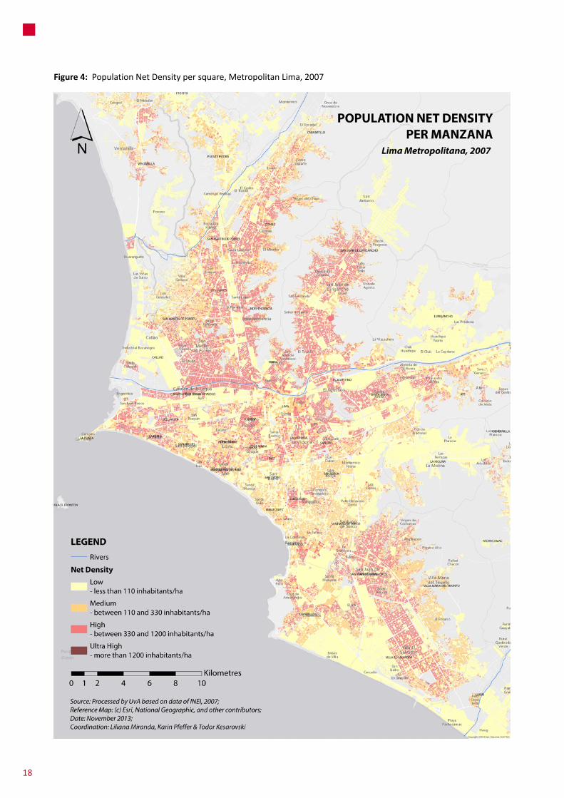
Figure 4: PopulationNetDensitypersquare,MetropolitanLima,2007
18

Figure 5: PopulationNetDensitypersquare,CityCenterofLima,2007
UnequalUrbanDevelopment;Sub-standardSettlementsandMobilization
19

Figure 6: PovertyMapMetropolitanLima,2012
Source: www.inei.gob.pe
Figure 7: %ofpopulationunderpovertylineinMetropolitanLima2004-2009PEN
20

spatialinequalitystillpersists.For2008,itisestimatedthatthe wealthiest decile earned 15 times more than thepoorestinrelationtomen,whilethedifferencebetweenthe lower and higher deciles is 20 times in relation towomen.34 For the case of Lima, the wealthiest 10%concentrate44%oftotal income,whilethe10%poorestearnonly7.2%.35Despitethesedifferences,LMhasaGINIcoefficient of 0.426 comparedwith the national rate of0.479.36Althoughtheseinequalitiescanbeeasilyreadinrelationtohousing,basicservicesandspatialsegregation,LMdoesnotcountwithsocio-spatialsegregationrelatedpoliciesforpermittinggreatersocialandspatialintegrationandpromotingmixed landuses and generatingmeetingspacesbetweendifferentsociallevels.Indeed,thisisnotpartoftheagendaofthepoliticaldecisionspheresorthepublicdebate.
Employment
Accordingtothe2007Census,WorkingAgePopulation(WAP)inPeruis19,646,652people.15,379,882ofthemlive in urban areas and 4,266,770 in rural areas.Whencomparedwiththe1993Censusdata,WAPhasincreasedby 5,259,349 people, representing an average annualgrowth rate of 2.2%, which is higher than the overallpopulation growth rate (1.6%). According to the 2007Census, the Economically Active Population (EAP) is10,637,880,whilethenonactivepopulationis9,800,772.FromthetotalEAP,64.6%aremaleand35.4%arefemale.TheurbanEAPhasincreasedatafasterrate(3.4%ayear)than the rural EAP (0.8% a year) (INEI). In 2008, 59.3percent of Peruvians in urban centers worked in theinformalsector,comparedto64.1percentin1999.Therateishighestforwomenat67.1percentin2008,comparedto52.9percentformen.
In 2008, the Economically Active Population (EAP) ofCallaowas437004(58.6%weremaleand41.5%female).OfthetotalEAP,397984wereemployed(9.3%weremenand40.7%women),whilethenumberofunemployedwas39021(50.8%weremenand49.2%werewomen).InLima,betweenFebruaryandApril2013theEAPemployedwas4890000withanunemploymentrateof5.6%(54.91%were
34 In: Diagnóstico Socio Económico Laboral de la Región Callao, Ministerio de Trabajo y Promoción del Empleo, Febrero del 2010.
35 In: Actualidad Empresarial Magazine, http://www.aempresarial.com/web/informativo.php?id=5888
36 Source: National Institute of Statistics (INEI) at http://desarrolloperuano.blogspot.com/2009/06/mejoro-el-indice-de-gini.html
menand45.09%werewomen).37 In 2001, 53.1%of theemployed population in Lima belonged to the informalsector (71.7% of the population employed in theconstructionsectorand83.8%ofthepopulationemployedintheretailsector)(RoblesN.D).
3 .2 .1 . Housing and Basic infrastructure endowments
Housing
ThehousingdeficitinLMisabout450000units(moreor less 1/3 of the national total).38Housing units in badconditions(qualityofmaterials,constructivetechnologiesand technical supervision) located on hillsides, activeravines,sandyareas,andlow-lyingcoastalareasrepresent79%ofthatdeficit(socalledqualitativedeficitof355000houses).35%ofthem(124000)cannotberecovered,50%(177000) lackbasicservicesand15%areovercrowded.39Morethan43%ofthehousingdeficitiscomposedbylow-incomehouseholds.Thelastcensusestimatedanincreaseof724221housingunitsbetween1993and2007(2123751intotal).78.3%ofthesehousesarepredominantlymadeofbricksandcementblocksand8.9%aremadeofadobeandmudwalls(INEI2009;VIVIENDA-PGT2009).40
Potable water and sewerage infrastructure
Accordingtothe2007census,36%ofhouseholdsinPeru(morethanathird)havenoaccesstosafedrinkingwaterand52%ofhouseholdsstilldonothaveaccesstoadequatesanitationservices(MinisteriodeVivienda,ConstrucciónySaneamiento2006).Eventhoughnumbersdonotmatch
37 In: http://gestion.pe/economia/desempleo-cae-ligeramente-lima-2066145
38 According to the construction chamber CAPECO, this number is more than a million for the total country..
39 MVCS (2011) Insumos para impulsar la transferencia de riesgo de desastre frente al cambio climático en el sector vivienda.
40 According to the 2007 Census, there are 7,583,140 houses in Peru. 7,566,142 are private homes, 16,998 are social housing, and 1,817 dwellings that are not suitable for human habitation (on the street, airports, ports, etc). In 2008 the quantitative backlog was calculated in 700.000 units and the qualitative backlog in 1,5 million housing units. The biggest share of them certainly belongs to the unattended low-income sectors. See:
http://www.diariolaprimeraperu.com/online/economia/deficit-de-vivienda-en-el-per-es-2-2-millones_10861.html
21
3UnequalUrbanDevelopment;Sub-standardSettlementsandMobilization
exactly,approximately86%ofhouseholdsfromlow-incomeareasand99.5%fromhigh-incomeareasareconnectedtothe potablewater network in Lima (with an average of93%).Accordingtoprojectionsofthe lastcensus(2007),73.5%of the supplied population have access towaterinside their dwellings, 7.4% of households have accessoutside their dwellings and 3.9% use public fountains.AccordingtoSEDAPAL,41thereare230000houseswithnowater connection (more than 1 million 200 thousandinhabitants) and near 1,5 million with water rationing(about6hoursperday).
Only8.55%ofwastewaterisreused,meaningthatmorethan90%ofwastewaterproducedisdumpeddirectlyintothe ocean and the Rimac River (15.1% of that has beenpreviouslytreated)(MinistryofEnvironment2010:2).Whilein 1995, the supply of potable water in Lima surpasseddemandin1.44m3/s,by2003thatsituationwasreversedwithdemand surpassing supply in 1.61m3/s (MinistryofEnvironment2005:9).Itisestimatedthatby2040demandwillsurpasssupplyin13.48m3/sifcurrentprovisioncapacitiesdonotincrease(SEDAPAL2009:28).Waterdistributionisveryinequitable.Although SEDAPAL indicates that the averageconsumptionperpersonis250litersinthecity,consumptionatthesocio-economiclevel“A”is400litersperpersonwhileconsumptionatthelevels“D”and“E”isonly60(SEDAPAL2009). Additionally, households without connection payalmost10timesmorethanthoseoneswithaccesstothepublicnetwork,consuminglessthan25litersperpersonaday.AccordingtotheformerpresidentofSEDAPAL,42ifeveryinhabitantofLimaconnectedtothepublicnetworksaved10litersofwaterperday,130000peoplewouldbe suppliedwithoutneedingextrainfrastructure,savinghighcoststothenationalandcityeconomy.
3 .2 .2 . Policy regards
Peru’s urban policy features represented an ultimatecaseforresearchersandpolicymakersjustafewdecadesago, due to their progressive nature. In general, theyinitiallytriedtounderstandandsupportalternativewaysof city production from very early urbanization stages.Nonetheless, this set of primarily progressive policiesdissipated into a ‘public tolerance’ model that did notopposed and certainly set the environment for theconsolidationofalaissez faireurbanismpromotedbytheneoliberalstatereformgivensincethe1990s.
41 61% in the North, 22% in the Centre and 17% the South. In: Notes from Sanitation Advisory Group of Sedapal, Mayo 2013.
42 Presentation from Eng. Guillermo León. Project jumpstart conference LiWa, 2010.
The pioneering 13517 ‘Ley de Barrios Marginales’ and its further use (Marginal Neighborhoods Law) .
The law 13517 ‘Ley de Barrios Marginales’ (1961)recognizedtheconceptof ‘self-development’supportedontherelationshipbetweenthestateandneighborhoodmovements(Riofrío,1990).Thelawaimedtodobasicallytwothings:tointegrateexistingsub-standardsettlementsthrough legal and physical regularization and to stopfurtheroccupationsbytheirprohibitionandthecreationofanewurbandevelopmentschemecalledUPIS(PopularUrbanizationofSocialInterest).UPISaimed–atleast–toprovide plotswith services thatwould be progressivelyself-builtwithpublicsupport(Riofrío1990).
The policy basically aimed to allow the informaloccupation of non-urbanized public land. Although theregularization law was passed in the early 1960s, itsapplicationwaslimited(itguaranteedthatpeoplewouldnot be evicted but did not formalized land tenure). Itpermittedthe issuingof landtitleswithoutanypreviousupgradingorserviceprovision,thatwaspoliticallybeneficialand less costly for the government (Ramírez-Corzo andRiofrío 2006; Calderón 2006), in such a way that the‘housingprovisionpolicybecamealandprovisionpolicy’(Ramírez-CorzoandRiofrío2006:14).Thisphilosophystillremainsandhasdefinedeverypolicydevelopedonwards.
The current situation
Thefewremainingactionsforpublichousingprovisionandorderedaccess to landwere totally abandonedandinsteadofanationalhousingpolicy,independenthousingprogramsandprojectshavebeenimplemented;consideringthemarketasthemaindeveloper.Forunderstandingtheproblematic ways in which urban development visionsoccurandcollide it isnecessary toexpose the legalandinstitutional changes that occurred during the FujimoriAdministration(1990-2001):In1992theStatedissolvedtheMinistryofHousing,thedevelopmentbanking,themutualfinancingsystemandpublicprogramsforlandaccess.The1995 update of the land law abolished limits to urbanexpansion by eliminating municipal instruments andliberalizing thesaleofperi-urbanagriculturalanddesertlandforexpandingthesupply,43andpublicpoliciesrelatedtourbanpoverty in Peruhavenot been included in theNational Constitution. The current trendof the informal
43 Contrary as expected, the Land Law increased prices since agricultural land owners were able to sell land to private developers and not only to informal sub-dividers who willed to pay lower prices (Calderon 2006).
22

expansion process can be recently characterized by a‘entrepreneurialorganization’sinceithasreachedastagewhererealestatepromoterscountwithresourcesandlinksto different decision making spheres (political parties,judges, police, etc.), and cannot be associated anymorewiththeimageofself-helpedpopulationsthatstruggleforaplaceinthecity.
There are policies and programs for housing andupgrading of sub-standard settlements but they tend tofocusonurbanandlegalaspects,notpayingmuchattentionto socio-economic regards. The main urban upgradingprogramsarethe‘BarrioMio’programfromtheMMLandthepopularhousingpolicy(fromtheMMLaswell).Forthecase of the national government, we canmention the‘Techo Propio’, the informal property regularizationprogram(notveryactiveinLimaduringthelastyears)andwater supply programs. The next two sub-sectionswillexplorethissetofrecentexperiences,amongothers.
3 .2 .2 .1 . Housing Policies
a . At the National Level:
The MIVIVIENDA fund and the ‘Techo Propio’ program
Housing policies for low-income sectors have beenhistorically oriented to provide non-urbanized land, andrarely to provide or permit access to houses.While thepolicyofinformallandregularizationcomesfrom1961andhasbeenconsideredaspioneeringinLatinAmerica;housingpolicies inPeruconsolidatedonlyduringtheearly2000s,basicallyfollowinganumberofguidelinesfromtheIADB.Despite the socio-economic distribution of the housingdeficits (concentratedon low income sectors), themostimportanthousingprogramisaPublicPrivatePartnershipcreated to provide housing solutions formiddle-incomesectorsandinvigoratetheconstructionindustry:the700MUSD‘MIVIVIENDA’Fund(Myhouse).Morethanadecadeafter the creation of the fund, the supply effects wereconsiderable.Whilein1996,ahousingstockof600,000m2wasoffered; thisnumber rose to1,400,000m2 tenyearslater(Calderón2009).AtthesametimemortgagebankinggrewfromUS$1150million in2002toUS$34million in2008(Interbank2008citedinCalderón2009).
The ‘Techo Propio’ (My own roof) program is the low-incomecomponentoftheMIVIVIENDAfund.Itacquiredtheformofasubsidyofupto90%ofthevalueofhousesbetweenUS$4000andUS$8000.Until2006only3000householdswerebenefitted(Calderón2009),beingthelast(failed)attempttoprovidebuilthousingsolutionstolow-incomePeruvians.
‘TechoPropio’hasthreeoperationmodes:44
– Newhouse acquisition. It permits to buy a housebuiltinany‘TechoPropio’registeredproject.Thesehousescostfrom20350PENto51800PEN(subsidiesgofrom11100PENto18500PENdependingonthepriceofthehouse).
– Houseconstruction.Itpermitstobuildahouseonaplotthatbelongstothebeneficiaryhousehold(witha17390PENsubsidy).
– Housing upgrading. It permits to improve housingconditions(witha8510PENsubsidy).
To lower costs for theprivate sector, thegovernmentkeepsprovidingwell-locatedpubliclandathighlysubsidizedprices.Forexample,thelandofthe64ha.‘ColliqueAirport’hasbeenofferedatapricetentimes lowerthanmarketprices (Riofrío 2010). Zoning change negotiations weredirectly held between the districtmunicipality and thenationalgovernmentthathaddeclaredtheinvestmentasof ‘national interest’with nometropolitanmunicipalityinvolvement(ibid).
According to the Construction Business CoalitionCAPECO,from171000low-incomehousesneededin2012,only 138 (0.08%) could be provided by formal provisionchannels.45 Socialhousingprovidedby the formal sectortendstoreducehabitableareasinordertoreduceprices,making it more affordable to low-income sectors, butmaintaining profitmargins (there is a supply of 34m2, 2roommini apartments). Contrarily, low-income familiestendtobelarge,holdingbusinessesinsidethehousesandrequiring bigger and multifunctional spaces. Formalsuppliersarefacingthelow-incomehousingproblemwithaseriouslackofcreativityandknowledgeofthemarket,buildingovercrowdedneighborhoodssincethemomentoftheirinauguration.
The COFOPRI informal property regularization program
The Informal Property Formalization Commission(COFOPRI)wasestablishedin1996fordistributingpropertytitles.Consideredatthattimeastheworld’sbiggesttenurialregularizationproject,COFOPRIdeliveredalmost1,6million
44 R.M. Nº 209-2012-Vivienda that approves the operative regulation for accessing to the household subsidy.
45 In: http://www.otramirada.pe/content/396-mil-viviendas-faltan-en-lima-¿quién-se-hace-cargo
23
3UnequalUrbanDevelopment;Sub-standardSettlementsandMobilization
titlesuntil2006.46ThemainassumptionsoftheprogramarebasedonideasfromPeruvianeconomistHernandodeSotoaboutlegalrecognitionofthe‘defective’assetsbaseofthepoorinordertoincludethemintoamarketeconomy.Thus, a well functioning property rights system wouldenhance poverty alleviation and development throughmarketsolutionssuchasmortgagecreditandlandpropertyexchange(DeSoto2000).
Inspiteofthemassivequantityoftitlesprovided,theexpected virtuous cycle property-credit-improvement ofqualityoflifehasnotbeenconcretized(Saavedra2006)andthereareevenidentifiedcasesofadverseeffectsduetotheprogram’sone-dimensionalandisolatedapproachtotheurbanlandtenureissue(Ramírez-CorzoandRiofrío,2006;Clichevsky,2006).
b . At the metropolitan level: The Municipal Policy of Popular Housing
ItwascreatedbythecurrentadministrationthroughthepassingoftheMunicipalOrdinance1643fromDecember2012basedonaproposalfromthe‘MovimientodelosSinTecho’MST socialmovement (at themetropolitan andnationallevel).Thisprogramaimstopromotetheaccessfromlow-incomesectorsofthecitytodecenthousing.Thespecificobjectivesoftheprogramare:
– to improve the dwelling conditions of low-incomesectorsfromcentralareasofLMintheframeworkofanurbanrenewalstrategy;
– to promote an adequate dwelling densification inlow-incomeareasofmediumconsolidation,throughaneffectivepublicaction;
– topromoteaccesstohousingthroughthegenerationofanappropriatehousingsupplyinnewurbanizationsforlow-incomesectors.
3 .2 .2 .2 . Neighborhood upgrading policies
a . At the national level
Inrelationtourbanupgrading,thenationalgovernmenttriedtotimidlyimplementaprogramcalled‘MiBarrio’byfollowingonceagaintheguidelinesfromtheIADB.Itcouldnotreachsubstantialachievements.Thispolicyhasbeenredevelopedby thecurrentMetropolitanAdministration
46 As Durand-Lasserve and Selod (2007) state, if massive delivery of land titles would be an only indicator of success; then the program can be certainly considered as successful.
that has initiated a more ambitious program at themetropolitanlevel,orientedtoriskreduction.
b . At the metropolitan level: The ‘Barrio Mío’ urban infrastructure upgrading program
TheMMLhas jumpstarted theBarrioMioprogram in2012.Itaimstodevelopurbaninfrastructurein17criticalareasofLimawithanannualbudgetof150MPEN(during3years).ThefirststageofBarrioMio(300MPEN) is thedevelopment of an emergency program in irregularsettlementswiththehighestvulnerabilityconditions.971stairwaysand707contentionwallswillbebuiltin6districtsofLima,attending35%oftheuniverseidentifiedinthe17areas.Additionally,populationsfrom1053settlementsarereceivingcapacitybuildingaboutriskmanagementinordertodevelopariskmapofeachsettlement.Asecondstagewillconsidertheimprovementofmainroads,plantingoftrees, and implementation of infrastructure such aslibraries,nurseries,etc.
Inrelationtourbanrenewalofcentralareas,theMMLhaspassedanordinanceinearly2012thatdeclares‘asofmetropolitaninterest’thephysicalandlegalregularizationofovercrowdedplotsinLM.
3 .2 .2 .3 Social Policies in LM
In relation to the attention of the socio-economicnecessities of low-incomepopulations (that aswe havesaid, aremostly located in precarious and overcrowdeddwellings) there are direct health programs such as the‘SistemaMetropolitanodelaSolidaridad’SISOL,youthandeducationprogramssuchasthe‘ChicosyChicas’planandthe ‘Programa Especial de Estímulos a la innovaciónpedagógica y de Gestión’. In relation to the nationalgovernment,programsorientedtopromotesocialinclusionprioritizeruralareasinthecountry(whereextremepovertyislocated)insteadofLM.
3 .3 . Social Mobilization and Participation in Sub-standard Settlements
The legitimation of self-development by law 13517consolidatedoneofthemostimportantstructuresofsocialmobilizationvis-à-visthestate.Throughverysolidterritorialorganizationschemesbasedonarepresentativedemocracyinstitutionality,neighborhoodorganizationswereable to
24
directlynegotiatedevelopmentprojectswithseveralstateagenciessuchasdistrictmunicipalitiesforroads,SEDAPALforwaterandsanitation,etc.Ifdirectnegotiationsdidnotwork, socialmobilizationwas away to be heard. Localleaderswere commonly recognizedby state agencies aslegitimatecounterpartsinpolicyandbusiness,performing“the function of regulating and promoting urbanconsolidation, replacing what elsewhere is the role offormal state authorities” (Caria 2008:85). According toRamirez-Corzo and Riofrio (2006:15) “the result of thisprocesshasbeentheformationofrealcities,wherelowincomefamilies(…)coulddeveloptheirdailyactivitiesandbuildtheirhistory”.
Spatial knowledge components
ThesocialpactestablishedbyLaw13517configuredadevelopmentpatternthroughwhichfamilieshadtoprepareandfollowanurbanarrangementplansimilartothoseonesfromconventionalurbanizations (with regularplot sizes,adequateroadwidthsandaconsiderablequantityoflandreservedforurbanequipment).“Familiesknewthatoneofthe requisites for recognizing the occupation was thepresentationofaplot-planofthesettlementthatagreedwiththeregulatoryframework”(Ramirez-CorzoandRiofrio2006:12). In addition, the approval of the Legal Decree22612 of 1979 established that those neighborhoodscreatedunderLaw13517couldberecognizedasordinaryneighborhoodsandevendistricts.
Thiswasthedominantmodeluntilthe1990s,whentheinstaurationofneoliberalismandtheimplosionofpoliticalparties(andeverykindofpoliticalrepresentationscheme)had a devastating effect on traditional organizationschemes and theway of accessing to the city by low-income populations. Alberto Fujimori took power andparadoxicallykeptrelyingoncitizenparticipation,butinthis case as an instrument for the consolidation ofauthoritarianismduringthe1990s.The1993Constitutionabolishedtherighttoadequatehousingandeliminatedthe‘social interest’rationale;defininganumberofnewcitizen rights based on participation thatwere used toundermine existing political representation and everypossibility of opposition to the regime. Also, the 1993OrganicLawofMunicipalitiesunderminedthepoweroflocal governments and re-concentrated power into thepresidential figure; developing a clientelist systemnon-mediatedbypoliticalparties.Thesocialpolicyapparatuswascentralizedmainlybythecreationofthe“Ministryofthe Presidency” which strategically delivered publicservicesinordertomaintainFujimori’spoliticalclientelismapparatus. The Ministry of the Presidency managedaround20%ofthetotalbudget.
Currently,socialorganizationsmobilize in instrumentalways more related to their own specific agendas.Organization structureshavebeenatomized to thepointthatdemandsarecoveredevenathouseholdlevelsandtheinequalitytopicisgenerallynotseenbyorganizationsthatarefocusedonunsatisfiedbasicneedsandinsomecases,demands on human rights. Participation channels forattending socialmobilization related to housing are notinstitutional and rather respond to the level of pressurefromneighborhoodorganizations.Forinstance,ifarelativelybig socialmobilization occurs, authorities listen to localleaders through the implementation of dialoguecommissions, restricting them to extensive negotiationprocessesinwhichtimeframesareextendedthusrequiringorganizationalstrengthtoreacheffectivesolutions.
Inthiscontextofhighdemobilization,landoccupationsarenowpromotedbylandtraffickerswhoactviolentlyandveryoftendefraudpeople.Accordingtothepolice,thereisanalreadyidentifiedlandtraffickingmafiainthecitythatoperatesin22districtsofthecity.
The ‘Movimiento de los Sin Techo’ (MST) in LM
In relation to cases of socialmobilizationwith amoreorganicandpragmaticcontent,themostimportantmovementriseninLMisthe‘MovimientodelosSinTecho’(MST).47Itis
47 The MST is active since June 2011, and is currently the most important and active neighborhood organization in Lima. It has presented proposals to the MML and the National Congress for passing housing program laws and ordinances. It has also made big massive mobilizations to the national congress, claiming the implementation of housing programs; to the National Elections Jury in order to protest against the impeachment of the mayor and to the UN for presenting a letter, among others.
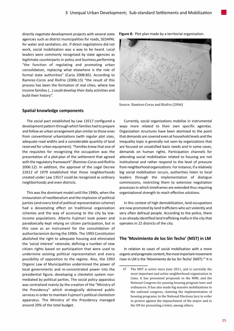
Figure 8: Plotplanmadebyaterritorialorganization.
Source: Ramírez-Corzo and Riofrio (2006)
25
3UnequalUrbanDevelopment;Sub-standardSettlementsandMobilization
thefirstsocialmovementthatclaimsforhousingrightsin Peru, expanding the agenda from neighborhoodorganizations (historically limited to land and basicserviceissues).Housinghasbeenhistoricallyseenasatask to be covered by the household and not thecommunitysphere.Unliketheirpredecessorstheydon’tclaima territorybut ahousingpolicy suitable for theurbanpoor.
TheMST (with the technical support of NGOs) haspresented to the National Congress and the LimaMetropolitan Council, normative proposals for
implementing land banks and municipal housingprograms. The Housing commission of the nationalcongress has approved the law project 1000/2011-CR,proposedbytheMSTinordertoprovidedecenthousingforvulnerablepopulations.ThisachievementrequiredaseriesofsocialmobilizationTheMST(withthetechnicalsupportofNGOs)haspresentedtotheNationalCongressandtheLimaMetropolitanCouncil,normativeproposalsfor implementing land banks and municipal housingprograms. The Housing commission of the nationalcongress has approved the law project 1000/2011-CR,proposedbytheMSTinordertoprovidedecenthousing
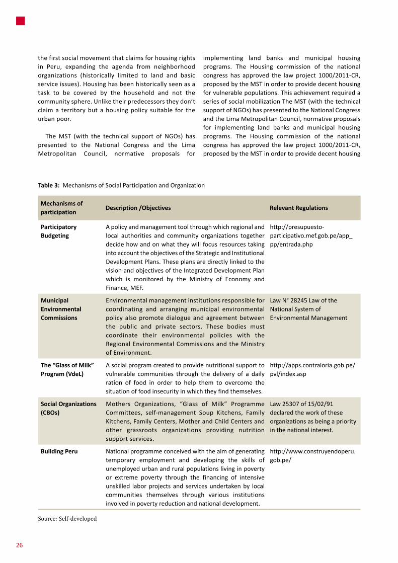
Mechanisms of participation
Description /Objectives Relevant Regulations
Participatory Budgeting
Apolicyandmanagementtoolthroughwhichregionalandlocal authorities and community organizations togetherdecidehowandonwhattheywillfocusresourcestakingintoaccounttheobjectivesoftheStrategicandInstitutionalDevelopmentPlans.TheseplansaredirectlylinkedtothevisionandobjectivesoftheIntegratedDevelopmentPlanwhich is monitored by the Ministry of Economy andFinance,MEF.
http://presupuesto-participativo.mef.gob.pe/app_pp/entrada.php
Municipal Environmental Commissions
Environmentalmanagementinstitutionsresponsibleforcoordinating and arranging municipal environmentalpolicy alsopromotedialogueandagreementbetweenthe public and private sectors. These bodies mustcoordinate their environmental policies with theRegionalEnvironmentalCommissionsandtheMinistryofEnvironment.
LawN°28245LawoftheNationalSystemofEnvironmentalManagement
The “Glass of Milk” Program (VdeL)
Asocialprogramcreatedtoprovidenutritionalsupporttovulnerable communities through the delivery of a dailyration of food in order to help them to overcome thesituationoffoodinsecurityinwhichtheyfindthemselves.
http://apps.contraloria.gob.pe/pvl/index.asp
Social Organizations (CBOs)
Mothers Organizations, “Glass of Milk” ProgrammeCommittees, self-management Soup Kitchens, FamilyKitchens,FamilyCenters,MotherandChildCentersandother grassroots organizations providing nutritionsupportservices.
Law25307of15/02/91declaredtheworkoftheseorganizationsasbeingapriorityinthenationalinterest.
Building Peru Nationalprogrammeconceivedwiththeaimofgeneratingtemporary employment and developing the skills ofunemployedurbanandruralpopulationslivinginpovertyor extreme poverty through the financing of intensiveunskilled laborprojects and servicesundertakenby localcommunities themselves through various institutionsinvolvedinpovertyreductionandnationaldevelopment.
http://www.construyendoperu.gob.pe/
Table 3: MechanismsofSocialParticipationandOrganization
Source: Self-developed
26
forvulnerablepopulations.Thisachievementrequiredaseriesofsocialmobilizations48madebythemetropolitanandnationalMST.TheMSThasalsomobilizedindefenseofthemayorfacingthe2013impeachmentprocess.
Community based schemes
Currently,socialorganizationsprimarilyprovideservicesforaccessingtoongoinggovernmentsocialprogramsforfoodprovisionandemploymentgeneration,suchassoupkitchensandtheGlassofMilkProgram(VasodeLeche-VdeL). The VdeL Program is a good example of a localinitiativethatbecomesnational.Itwasinformallyinitiated
48 Between October 2011 and October 2012, the MST has done 8 demonstrations, participated in public audiences in the National Congress, offered a press conference and gave several interviews to congressmen from the housing commission.
bytheMunicipalityofLimabetween1983and1984andlaterextendedthroughoutthecountry.
For the case of LM, the National Register of SocialOrganizations (R.U.O.S) was established at themetropolitan level, and regulated conditions andrequirementsfortherecognitionandregistrationofsocialorganizations that provide public services, undertakemunicipalworks,andparticipateinsecurityissues,amongothers.Underthislegislationdistrictmunicipalitieswithregisteredsocialorganizationshavebecomethemainallyoftheauthoritiesonattendingpublicsafetyissues,claimsforassistance,ordecisionsofotherlevelsofgovernmentthataffectthem.Thecommunityboardsarerecognizedbymunicipalauthoritiesasorganizationsthatrepresentthe community under the Law of the Right to PublicParticipation(Law26300).49
49 In: http://www.congreso.gob.pe/ntley/Imagenes/Leyes/26300.pdf
Water Governance and Climate Change Issues in City Concerned4
4 .1 . The Metropolitan City of Lima Territory and Climate Configuration
Located on a pacific coastal plain at the foot of theAndeanmountains,Limaisthesecondbiggestdesertcityin the world after Cairo. The Lima Macro-region is anarticulationofnetworksofcitiesandtownssettledalongthe four river basins that compose the LM conurbation:Rímac (41%), Chillon (22%) and Lurin (14%), Mantaro(23%)50(thefirsttwobasinshavealmostdisappearedduetourbanization).The4basinsarefedbyAndeanglaciersandrainwaterfromtheAndes(seeFigure9foramapofthefourriverbasinsinrelationtoLima).
Becauseofitslatitude(12°south)Limashouldhaveatropical climate due to its proximity to the Equator,similarlytoRiodeJaneirowhichischaracterizedbywarmtemperatures and rainfall. But the presence of the
50 In: Bardossy A, Jochen S, Chamorro Alejandro, 2011. Modelamiento del Clima y Balance hídrico de Lima. LiWa project- IWS- University of Stuttgart
Humboldt current (considering that LM has a 160 kmcoastline)changesthissituationtothepointthatLMhasa subtropical,moderate andwet climatewith drizzles(“garúas”) during winter. The metropolitan area isdominatedbyalackofrainfall(9mmperyear)andaverylow river water level during most seasons (there aresufficientlevelsonlyduring3or4monthsayear)whichhasforcedthecitytostorewaterinhugereservoirsinthemountains on the other side of the Andes (‘Marca’projects). Different from the first three basins that arelocatedatthepacificside,theMantarobasinislocatedattheothersideof theAndes,and isconnectedwith theRimac basin through great trasvasement infrastructuredevelopments.So,LMhassurpassedthecapacityof itsbasinstoprovidewaterresourcethattogetherwiththedecreaseofglaciers,theconstantrainfalldecreaseduringthe last 40 years in the high Mantaro basin, and theexcessiveuseofgroundwater,haveresultedinacriticalscenarioofhydricstress.51
51 Water reserves per person in Lima (33 m3) are very low in comparison with other Latin American cities (SEDAPAL 2011).
27
4WaterGovernanceandClimateChangeIssuesinCityConcerned
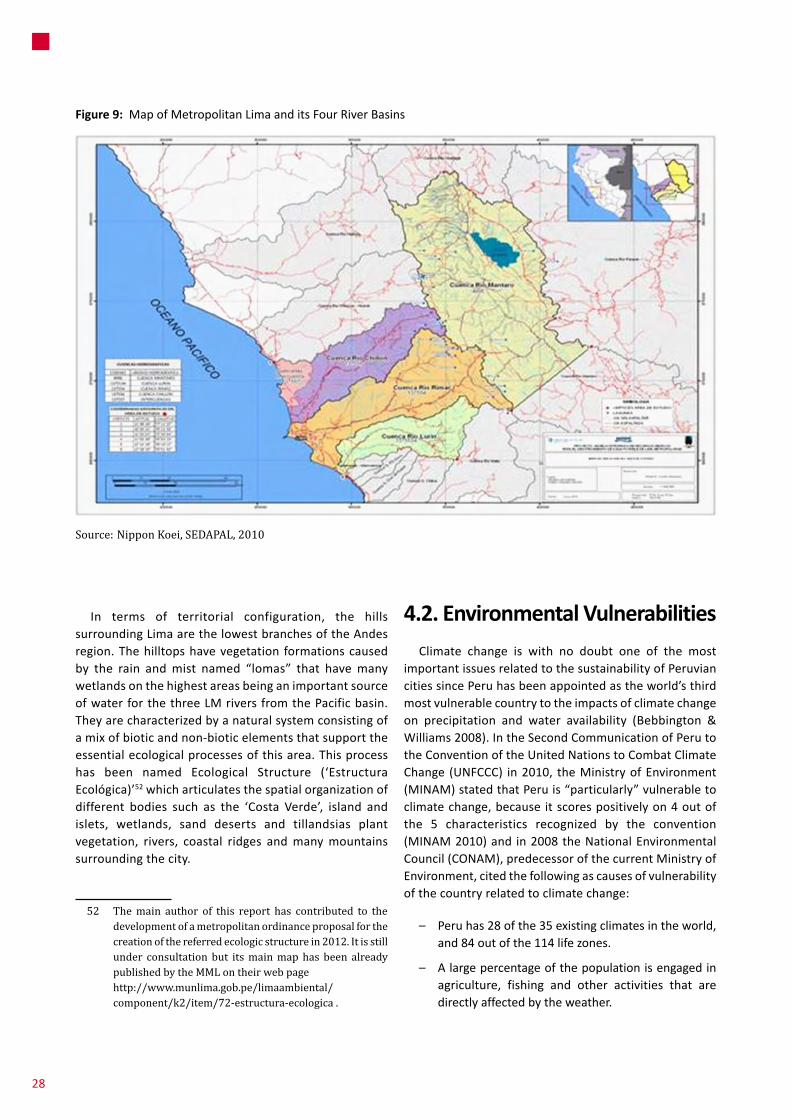
Figure 9: MapofMetropolitanLimaanditsFourRiverBasins
Source: Nippon Koei, SEDAPAL, 2010
In terms of territorial configuration, the hillssurroundingLimaarethelowestbranchesoftheAndesregion.Thehilltopshavevegetation formationscausedby the rain andmist named “lomas” that havemanywetlandsonthehighestareasbeinganimportantsourceofwaterforthethreeLMriversfromthePacificbasin.Theyarecharacterizedbyanaturalsystemconsistingofamixofbioticandnon-bioticelementsthatsupporttheessentialecologicalprocessesofthisarea.Thisprocesshas been named Ecological Structure (‘EstructuraEcológica)’52whicharticulatesthespatialorganizationofdifferent bodies such as the ‘Costa Verde’, island andislets, wetlands, sand deserts and tillandsias plantvegetation, rivers, coastal ridges andmanymountainssurroundingthecity.
52 The main author of this report has contributed to the development of a metropolitan ordinance proposal for the creation of the referred ecologic structure in 2012. It is still under consultation but its main map has been already published by the MML on their web page
http://www.munlima.gob.pe/limaambiental/component/k2/item/72-estructura-ecologica .
4 .2 . Environmental VulnerabilitiesClimate change is with no doubt one of the most
importantissuesrelatedtothesustainabilityofPeruviancitiessincePeruhasbeenappointedastheworld’sthirdmostvulnerablecountrytotheimpactsofclimatechangeon precipitation and water availability (Bebbington &Williams2008).IntheSecondCommunicationofPerutotheConventionoftheUnitedNationstoCombatClimateChange (UNFCCC) in2010, theMinistryofEnvironment(MINAM)statedthatPeruis“particularly”vulnerabletoclimatechange,becauseitscorespositivelyon4outofthe 5 characteristics recognized by the convention(MINAM2010)and in2008theNationalEnvironmentalCouncil(CONAM),predecessorofthecurrentMinistryofEnvironment,citedthefollowingascausesofvulnerabilityofthecountryrelatedtoclimatechange:
– Peruhas28ofthe35existingclimatesintheworld,and84outofthe114lifezones.
– Alargepercentageofthepopulationisengagedinagriculture, fishing and other activities that aredirectlyaffectedbytheweather.
28

– 51%ofthePeruvianpopulationlivesinpoverty,21%inextremepoverty.53
– There is a low adaptive capacity due to limitedfinancial, human and technological resources andinstitutionswithlimitedcapacity.
– - Peruhasover70%oftheworlds’tropicalglaciersandsince1980,theyhavelost22%oftheirsurfacearea(500km2),theequivalentofnearlytenyearsofwatersupplyforLima.54
Peru’swater resources are also vulnerable to climatechangeassomeofthecountry’sperennialriversarefedbyglaciersthatarerapidlydisappearingduetoclimatechange.Theglacialmeltingwillgenerateatemporaryincreaseinflow, followed by a drastic decrease in the volume andregularityofwaterresourcesinlaterdecades(leadingtoscarcity ofwater, especially in the coastal area of Peru)(Calvo 2009). It should be noted that, despite beingsurrounded by three important water sources (PacificOcean,AtlanticOcean,andLakeTiticaca)theavailabilityofwaterintheAtlanticbasinismuchmoreabundantthaninthe Pacific basin, with 97.8% of rain flowing onto theAtlantic side of theAndeanmountain range,while only1.7%flowstowardsthePacificside,whereapproximately80%ofthepopulationofPerulives.55
TherapidgrowthofLMhascausedadecrease in theamountofagricultural land,andtheoccupationofslopeareas has produced a loss of local flora, fauna andecosystems.Asaresult,onlyafewproductiveagriculturalareas remain, especially in the Lurin River Valley that isconstantly threatened by pressures from industrial andhousing developments.56 Water pollution generated byindustries andmines, and the disposal of 83%ofwastewatersintheriversandthesea,certainlyexacerbatetheproblem.57Thisalladdsuptothepollutionoflandbytheinadequatereleaseofsolidwaste (ofdomesticandnon-
53 Poverty levels have dropped significantly since this report was published.
54 Ministry of the Environment (MINAM), GEF, PNUD. Second National Communication of Peru to the United Nations Framework Convention on Climate Change. Lima, Peru. May 2010, p. 102.
55 Ministry of the Environment (MINAM), GEF, PNUD. Second National Communication of Peru to the United Nations Framework Convention on Climate Change. Lima, Peru. May 2010. Page 78.
56 In total, the IMP-MML acknowledges still 12,000 ha of agricultural areas surrounding LM (2013).
57 SEDAPAL is currently developing projects to increase the treatment capacity to 100% in the near future (La Chira and Taboada projects).
domesticorigin)in9dumps,situatedinthebasinChillón(4),Rímac (2)andLurín (3).58Theecological footprintofLimawascalculatedinmorethan12millionha.(1,47ha.per inhabitant) (Alfaro 2008). Additionally, Lima countswith only 2.9m2 of green area per person (Ministry ofEnvironment 2010), while the WHO recommendedminimumproportionis10m2.
AccordingtotheBarrioMioProgram,therearearound3million people living on the hillsides areas of the city(morethan20degreesinsomecases)veryvulnerabletolandslides(seefigure10).Thosepeoplelivinginotherhighrisk areas such as river banks, slopes, floodplains anderoded areas, marine coastlines, etc. have not beencountedyet.59There isahighconcentrationofdomesticproductionandinfrastructurelocatedinvulnerableareas(airportandseaportincluded),ahighlevelofrelianceonhydroelectricenergy(68%),60andarapidlygrowingurbanpoorpopulationwithalowadaptationcapacitytodwindlewater resources (see figure11 foramapofhydrologicalhazards of Lima). Consequently, the potentially seriousconsequencesofclimatechangeonwaterresourcesinLimaareveryhigh.
Major environmental disasters (climate and water related)
PeruisstronglyinfluencedbythepresenceoftheElNiñophenomenon(ENSO),characterizedbythepresenceofanabnormallywarmwatercurrentforlongerthan4months.The PacificOcean along Peru’swest coast getswarmer,resulting in increasedrainfall incoastalareas.Themajoreffects of El Niño are caused by the rising sea watertemperaturethatgenerateshighevaporation.Then,cloudsmovebeyondtheAndesandcausepersistentrainfallinthearea,whichcausesfloods,mudslidesandlandslides.Asitwillbeseeninthenexttable,extremeclimateeventsarenot that unusual in Lima (themain impacts of extremerainfallsinLimain1970,1998and2012areoutlined).Themajor impacts of ENSO in Lima are the destruction ofhouses,agriculturalareasandinfrastructure;andepidemicsofwater-bornediseasessuchasdengue,malaria,cholera,anddiarrhea.
According to experts, climate change threats at thenationallevelwouldbetheincreaseofdroughtstogetherwith the increase in frequency, intensity, duration and
58 Proyecto SIRAD, 2010, PNUD.EU.INDECI.IRD
59 In: Torres, Rommy ‘Curso de Ciudades Costeras, Cambio Climático y Género’. Foro/IHS, UCV Trujillo, 2013
60 In: Miranda Sara (2012).
29
4WaterGovernanceandClimateChangeIssuesinCityConcerned

Figure 10: HumanVulnerabilityinLM
Source: “Barrio Mio” MML program
30

Figure 11: HydrologicalhazardsinMetropolitanLima
Source: INEI, 2007; Sedapal, 2007; LIWA; CGIAR-CSI; T. Allende, Est. de Ciudades Focales MIRR, IMP/CENCA, IDRC;Conception: Liliana Miranda, Karin Pfeffer, Todor Kesarovsi, 2013
31
4WaterGovernanceandClimateChangeIssuesinCityConcerned
– sea level rises (and coastal erosion) affectingvulnerableareas including theport, theairport aswellasthe‘CostaVerde’area;
– -scarcity of thewater supply and increasedwatercosts that leads to increasing conflicts overwaterresources;
– poor sanitationasa resultofwater shortagesandincreasingfloodsthatleadtohigherratesofwaterbornediseases;and
– adecreaseinenergysupplyduetotheoccurrenceofdroughts.
4 .3 . Water InstitutionalityIn relation towater governance in a context of climatechange,wehaveidentifiedaslowprocessofbuildingnewinstitutionsunderthenewapproachofmanagingwaterattheriverbasinlevel.Today,threeyearsaftertheenactmentof thenew LawonWaterResources, Peruhas installedonlyfourWaterResourceCouncils.Theprocessisbarredbythediversityofsub-nationallevelcontextsinwhichithastofunction.
4 .3 .1 . The national level
The institutional framework for water resourcemanagementhasbeenexpandedthroughthecreationoftheMinistryofEnvironment(MINAM)andtheNationalWaterAuthority(ANA)in2008,aswellasthecreationoftheNationalSystemofEnvironmentalManagementandthe transfer of environmental competences to regionaland local governments.63 TheMinistry of Environment(MINAM) replaced theNational Environmental Council(CONAM). This new entitywas created in search for astronger environmental authority with capacities toattendtothelargeanddiverseenvironmentalproblemsin the country. Nonetheless it presents severalmanagementproblemsduetoitslackofrepresentativenessand its centralist performance. The National WaterAuthority(ANA)isastateagencyfoundedin2009asanexecutiveandregulatorywatermanagemententity.Ithasinitiated a paradigm shift from a sectorial watermanagementtoanintegratedmanagementthatconsidersthebasinasitsterritorialunit.
In 2004 a national strategy for water resources wasestablished and efforts are currently underway for its
63 Originally the general water law appointed the Ministry of Agriculture (MINAG) as the authority responsible for the concession of water rights.
unpredictabilityofheavyrainsandextremeclimateeventslikefloods,landslides,mudslidesandthe‘ElNiño’and‘LaNiña’(ENSO)phenomena.Additionally,anewphenomenonhasbeendetected:‘ElDana’,whichentailswarmairarrivingfromtheAtlanticOcean thatcrosses themountainsandincreasesrainfall.61ThatwouldhavebeenthecauseofthedisasteroccurredintheChosicadistrictduringthespringof2012attheEastofLima.Additionally,temperature(atleast2degrees)andsealevelrises(atleast1cmperyearaccordingtotheIPCC)willoccur,affectingtheportofCallaoandthe‘CostaVerde’attheBayofLima.
Figure12reflectsflood,earthquake,tsunamiandmudsliderisksidentifiedbytheIMPonthewholeLimaMacro-region.62Asitcanbeseenonfigures4,6and10theareasexhibitinghigher poverty levels, tend to coincide with the mostvulnerableareasintermsofnaturalhazards.Followingfigure12,itcanbesaidthatalmost50%oftheLMterritoryisinsomekindofhydrologicriskthatwouldbeexacerbated inpresenceof intense rainfall. Theseeventshave importantsocialandeconomiceffects,impactingtheinfrastructureofimportantactivitieslikeagriculture,communicationnetworks,servicesandliving;negativelyaffectingGDP.
In addition to the phenomena and processes alreadymentioned,thefollowingconsequencesofclimatechangeandwaterrelateddisasterscanbementioned:
61 Eduardo Calvo, IPCC, Ppt. presentation, Universidad Stuttgart 2012, Proyecto LiWa.
62 In: “Proyecto Ciudades Focales, Margen Izquierda del río Rímac” project, IDRC, IMP, CENCA
Box 3: The effects of ENSO at the national level .
ENSO from1997-1998was the largest recordedwith scientific instruments, and unleashed heavyrains causing severe flooding andmudslides in thecoastalareaanddroughtinthesouthernhighlands,and generated significant economic and healthimpacts.ThetotaldamageamountedforUSD3500million.This includesdirectdamagevaluedatUSD1612million(46%oftotal),andindirectdamageorlossvaluedatanadditionalUSD1888million(54%).The productive sector was the most affected,amountingfor46%oftotaldamage,transportationwas at second place with 21%, social sectorsamountedfor14%,othersectorsincludingthecostsof prevention and emergency care amounted for12%, anddamage towater andelectricity servicesamountedfor7%ofthetotal.
32

Table 4: Limahistoricextremeevents
Source: Eduardo Calvo (IPCC)
Figure 12: SynthesisofLimaNaturalHazards(earthquakes,tsunamis,flooding,erosionandmudslides)
Source: T. Allende, Estudio de Ciudades Focales MIRR, IMP/CENCA, IDRC
15 January 1970 23 February 1998 March 2012
� 5hourrain,17mm(SENAMHI)
� Morethan2,000housescollapsed;Expresshighwayflooded,150fires,JorgeChávezairportdamagedandthecitywasisolated(Huaraz,forinstance,askedforanairbridgewithLima).
� WaterfallinArmendárizhillinBarranco.
� T°Máxoftheocean24.6°C
� AHuaycoalmostreachGovernmentalPalace(80m).
� HuaycolororiversuddenlyappearedandpassedbyalltheareawevisitedlastSunday(Campoy,Zárate,RimacyelTréboldeCaquetá)
� TheRimacriverwaterflowraisedtoonemeterhigh.
� Vandalism
� HeavyraincomingfromBrasil
� AnomalycomingfromtheAtlantic,pushesthehumiditytowardstheAndes,generatingrain.
� LocatedintheborderofPerú,BrasilandBolivia.ComesfromSouthtoNorth.Asahurricainetravelsaleatory.
� Getstothemountainsandraisesthehumiditygeneratingtherain.
� 2011happenedthesamebuttheydidnotreachthecoastofPeru
Lima, historic extreme events
WaterGovernanceandClimateChangeIssuesinCityConcerned
33

4 .3 .4 . The district level
MunicipalitiesinLimaarenotcurrentlyparticipatingindecisionmakingonwaterandsanitationinvestmentsinthecity. Their intervention and decision capacities on citydevelopment and infrastructure location related withnaturalhazardsarelimitedtorecommendationsonwatersaving or the reuse of treatedwastewater forwateringgreenareas.
4 .4 . Environmental and Climate Change Institutionality
Since 1965, a gradual evolutionof the environmentalmanagement frameworkhasoccurred in Peru, includingthecreationofenvironmentalmanagementbodiesatthenational levelandtheapprovalofseveralenvironmentalmanagementlaws.ClimatechangeconcernsinPerubeganin1993withthecreationoftheNationalClimateChangeCommittee(NCCC),65beginningaprocessofanalysisanddevelopmentof scenariosandmitigationplans. In2001,theNCCCdevelopedadocumentcontainingadescriptionofnationalcircumstances,aninventoryofGHGemissions,a review of the environment in Peru, a description ofpolicies,programsandmeasuresrelatedtoclimatechange,vulnerabilityandadaptationmeasures,andanidentificationof the needs of vulnerable populations. TheNCCC alsoestablishedtheNationalClimateChangeStrategy(2003),whichhastwomainstrandsoffocus.Thefirstisrelatedtoadaptation,developingnationalprioritiesbasedonstudiesof climate vulnerability, and the second is related tomitigation.Yet,accordingtotheCitizensMovementagainstClimateChange (MOCICC2009), littleprogresshasbeenmadesinceitsadoptionin2003andonlyaround13%havebeenimplemented.Publicinvestmentinclimatechangetodateamountstomorethan138millionPEN(morethan39millionEuros).6658%ofthisamountareconcentratedin11viableprojects intheareasofadaptation,desertificationandmitigatingtheeffectsofdrought,andwaterresourcesand climate changemanagement.Only 1%of the totalinvestment are allocated in 9 projects currently underimplementation,while28%areinvestedinprojectsunderdevelopment,and13%areontheirevaluationstage.
The current national administration is providing,withsome limitations, a more extensive and betterimplementationoftheNationalClimateChangeStrategy.
65 Peru has signed the Framework Convention on Climate Change and one Peruvian scientist is a member of the IPCC.
66 Exchange rate 3.480 (buy). Source: Superintendencia de Banca, Seguros y AFP.
implementation,albeitwithmany institutionalproblemsrelatedwith lackof coordination (sector and territorial).Regarding thewater sector specifically key initiatives inLimaconsider:
– “Agua para todos” (“Water for all”), a nationalprogramme initiated in 2006by theMinistryHousingthroughSEDAPAL,hasinvested163MUSDinthewaterandsanitationsectoruntilDecember2009(228MUSDoverallinvestment).
– The National Programme for the EnvironmentalRehabilitationofWatersheds(2010)bytheMinistryoftheEnvironmentthataimstopromotepublicinvestmentprojectsonthetreatmentandreuseofwastewater;
– TheconstructionoftheTaboadawastewatertreatmentplant(14m3/s)grantedbySEDAPALandthenationalPPPunitPROINVERSION.
4 .3 .2 . The macro-regional level
The Lima Macro-region’s hinterland influences 5RegionalGovernmentsand11ProvincialMunicipalitiesandmorethanahundreddistrictmunicipalities.RegionalGovernments are in charge of leading the Inter-basinHydricResourceManagementCouncilforRimac,ChillonandLurin,createdwithintheframeworkoftheGeneralLawofHydricResources. TheANAhas constituted theLocalWaterAuthority(ALA)ofChillon,RimacandLurin64as the legitimate administrator and granter of waterrights from the three rivers. Also, the creation of theInter-basin Council of Rimac, Chillon and Lurin thatmerges 3 Regional Governments (Callao,MetropolitanLimaand‘LimaProvincias’)withtheALA,wouldrepresenta legitimate institutional body for coordination andconsultation(involvingmetropolitan,macro-regionalandnationalauthorities).
4 .3 .3 . The city level
WaterandsanitationservicesinLMareprovidedbytheLima Potable Water and Sanitation Service providerSEDAPAL, a decentralized public company owned byFONAFEattheMinistryofEconomyandadministeredbytheMinistryofHousing,ConstructionandSanitation).Seefigure13foramapofSEDAPAL’sareaofresponsibility.
64 The ANA has granted 5416 water rights for agricultural uses and 71 rights for non-agricultural uses (for human consumption, mining, industries, energy production, fishing and mixed uses).
34

Figure 13: MapofSEDAPAL’sareaofresponsibility
Source: SEDAPAL’s official web page
35
4WaterGovernanceandClimateChangeIssuesinCityConcerned

Infact,formerPrimeMinisterSalomonLernerstatedattheNational Congress that “…Climate change is the biggestglobalenvironmentalmenacethatPeruisfacingandwillaffectthepoorestruralpopulationsinaveryspecialway,sincetheydependalmostexclusivelyonweatherinordertosubsist.That iswhymitigationandadaptationactionswillbetaken,makingtheclimatechangefocuscompulsorytoeveryprocessofdevelopmentplanning”.67
APlanofActiononAdaptationandMitigationtoCombatClimate Change was also published by the Ministry ofEnvironmentMINAMinApril2010forpublicconsultation.It describes MINAM’s proposed strategies regardingprograms, projects and priority actions in the short andmediumterminrelationtoclimatechange,constitutingthefirstapproachtothe“NationalAdaptationandMitigationPlantoCombatClimateChange”formulatedbytheNationalClimateChangeCommittee(NCCC).
Atthecitylevel,theMMLapproveditsenvironmentalpolicy with the participation of the metropolitanenvironmentalcommissioninSeptember2012.Indeed,theCallaoProvincialMunicipalityapproveditsownmanyyearsago. Inbothcases theirproposalshaveprioritizedwaterand climate risks. The environmental lawmandates thecreation of environmental commissions for eachmunicipalityandregionalgovernmentthatmustconformatechnicalgrouponclimatechange.Thesecommissionsand groups exist in both Lima and Callao regionalgovernments and both have developed their ClimateChangeAdaptationStrategies(2009-2019).Thesestrategieshave not been approved yet and their implementationremainsuncertain.Asamatteroffact,thoseinstrumentshavenotbeenproperlymatchedwiththeriskmanagementplans (thathavenotbeenapprovedyeteither)orurbandevelopmentplansthatareoutofdate(thelastonewasdevelopedin1977).
TheNCCC has updated the Climate ChangeNationalStrategy(ENCC)uptoyear2012.Itsmainfocusisadaptation,riskmanagementandwater. Theactionplan for climatechange adaptation and mitigation, developed by theMINAM and the NCCC was disseminated in 2012 forconsultationbutithasnotbeenapprovedyet.
Risk Management and Climate Change
Although regional and local governments (provincialand district levels) have competences for leading civildefense councils and developing and implementing riskmanagementplans,institutionalcapacitiesandresources
67 In: http://e.elcomercio.pe/66/doc/0/0/3/8/6/386179.pdf
forpreventionarestilllimited.Investmentsinthecitydonotconsiderpreventionorconsiderhazardmapsex-ante.Coordinationinverticalorhorizontalwaysisstillincipientandhasbeensystematicallyoverwhelmedbythedamageproduced by most natural or anthropogenic disastersoccurredduringthepastfewyears,withafewexceptions.Nevertheless,itcanbesaidthatthingsareimproving.TheTechnicalGrouponClimateChangeinLimaandCallaohasbeencreatedandisfunctioning.However,itneedstobestrengthened. Climate Change adaptation strategies inCallao(2011)andLima(2012)stillneedtobeapprovedand their priorities incorporated into Municipal andRegionalbudgets.
4 .5 . Water and Territory Policy Context/Interactions
There is no current connectionbetween landpoliciesandwater and sanitationpoliciesmanagedby SEDAPAL,sincetheMMLhasnoinfluenceonSEDAPAL’sdecisions,noteven for prioritizing or limiting water and sanitationprovision in high-risk areas, or enforcing regulations forlimitingcityexpansion.Indeed,SEDAPALhasopenlyrefusedto consider the incorporation of representatives of theMMLonitsboardofdirectorsaswellasthepossibilityofbeing transferred to themunicipal government, as it isoccurring in every other region in accordance to thedecentralizationprocess.
SEDAPAL has developed studies for determining LM’swaterdemandto2040,butbasedonlyonpopulationandeconomicgrowth,meaningthatprojectsproposeddonottakesocialandenvironmentalregards intoconsideration(localhydricdemands,currentlanduses,etc.)asitcanbeseen in theHuascacocha channel case-study.Under thecurrentderegulationregime,itisimportantfortheMinistryofHousing(morerelatedtorealestatecorporativeintereststhat are seen as economic growth engines) to keep fullcontrolofthewatercompany,sincetheMMLisseenasarather regulatory apparatus regarding urbanization andurbanexpansion.
Electricity
Electricity supply is administered by the ElectricityGenerationCompanyofLima(EDEGEL),aprivatecompanyunder the supervision of theOSINERGMIN regulator. Itgenerates and commercializes hydroelectric energy(through5plants)andthermalenergy(through2plants).Inordertogenerateelectricity,EDEGELcontrolsthemainwaterresourceofLima:theRimacRiver(duetocontracts
36

signeddirectlywiththenationalgovernment).68ThereisnolevelofcoordinationorconsultationbetweenEDEGELandMML,abouttheprioritizationorlimitationoftheserviceprovisionincertainareaswherethemunicipalitymayhaveconsideredtheconsolidationorlimitationofurbanuses;oreventheprovisionofenergyincaseofemergency.
4 .6 . Which is the Key Actor´s Decision-making Capacity of Influence?
InLMtherearediverseauthoritieswithdefinedandoverlapping competences and functions for territorialmanagement, involving themetropolitan city and themacro-region; which results in fragmentation,disarticulationandweakeningoftheroleofthestateinthecityatdifferentscalesofgovernment.ItcanbearguedthatthemainvulnerabilityofMetropolitanLimaismerelyinstitutional since city and territorial management isdelinkedfromrisk,waterandclimateriskmanagement.InstitutionsfromLMhavelimitedcapacitiestodevelop,leadandpromoteaclimatechangeadaptionprocess.69
Strategic decisions to be taken on adaptation andmitigation of climate change effectswill probably causeconflicts between economic development, ecologicalquality and social demands. Although efficiency andeffectivenessofstrategiesagainstclimatechangedependonthecooperationamongauthoritiesaswellasbetweenauthorities, citizens and other stakeholders; there is apersistentsectorialapproachthatdominatesoveramoreterritorialandintegrativepointofview.
4 .7 . Producing Vulnerability Analyses and Scenarios; Spatial Perspectives and Participation
At the national level, climate scenarios have beengenerated,bothatthenationallevelandatthelevelof
68 According to informants from SEDAPAL, in 2004 EDEGEL opened the sluicegates in order to get water for electric generation, which resulted in the water reserves going straight to the ocean, leaving the city unsupplied and generating a generalized drought.
69 For instance, SEDAPAL does not count with any capacity to involve into climate change policies.
individualkeywatersheds,inordertodevelopintegratedassessmentsofvulnerabilityandadaptation.Inparallel,the2003ProgrammeforStrengtheningNationalCapacityto Manage the Impacts of Climate Change and AirPollution (PROCLIM) initiated the development ofscenariosinthePiura,MantaroandSantariverbasins.Subsequently,in2007,theAndeanRegionalProjectforAdaptationtoClimateChange(PRAA)begangeneratingscenariosfortheUrubambaandMantaroriverbasins.Inthelattercase,theemphasiswasontheeffectsofthereductionofglaciers(witha longerprojectionperiod).Morerecently,intheframeworkoftheSecondNationalCommunicationofPerutotheUnitedNationsFrameworkConvention on Climate Change (UNFCCC) through thedevelopment of Integrated Local Assessments (ELI),studies were conducted on theMayo and Santa riverbasins,aswellasastudyofclimatechangescenariosatthenationallevel.70
The study of climate scenarios for Peru, aimed todetermine trendsand ratesof currentnational climaticextremesbasedonobserveddata,andalsotoestimatefuture projections to 2030 based on global scenarios.Projections about climate in 2030 assumed a highemissionsscenario(A2)andwerecalculatedbasedonanaverage for a 10 year period (2025-2035), noting thefollowingconclusions:71
– Changesinprecipitationlevelsvaryacrossregions.Onthecoastandinthenorthernhighlands,andinpartsof the central highlands and southern Amazonincreasesinprecipitationlevelswereregisteredofupto20%,whiledecreasesofupto20%wereregisteredinthenorthernAmazonandpartsofthecentralandsouthernhighlands.
– Theestimatedextremerainfallshowsadecreaseinthenext30yearsinmuchofthecountry.
– Withrespecttoextremetemperatures,anincreaseinboththeminimumandthemaximumtemperaturesisexpectedacrossmostofthecountry.Themaximumtemperatureisexpectedtorisebyanaverageof1.6°C(0.53°C/decade),whiletheminimumtemperatureisexpected to rise by an average of 1.4°C (0.47 °C/decade).
– Thelargestincreasesintemperatureareexpectedonthe northern coast and highlands, the northernAmazon,andthecentralandsouthernhighlands.
70 Ministry of the Environment (MINAM), GEF, PNUD. Second National Communication of Peru to the United Nations Framework Convention on Climate Change. Lima, Peru. May 2010 .Page 79.
71 Ibid. Page 86.
37
4WaterGovernanceandClimateChangeIssuesinCityConcerned

– Regionssuchasthesouth-centralcoastandsouthernAmazondidnotindicatemajorchangesby2030withrespecttoextremetemperatures.
For the case of LM, theWP4 case study aims tounderstand the city’s hydro-climatic vulnerabilities,interactions betweenwater governance and climatechange,andthelevelsofperceptionofriskacceptance.Amultilevel analysis of the institutional dimensions(government, civil society and private sector) and amultiscalar analysis of the spatial-territorialdimensionshasbeendone(seenasadialoguebetweenthemetropolitancity, the locality-neighborhoodandthe macro-region). Construction, validation andtransfer of inclusive climate scenarios (bringingtogetherdifferenttypesofknowledgeprovidedbythedifferenttypesofactors,institutionsandnetworksarepartofaprocessofsocialconstructionofknowledgeforbuildingconsensus.
Differentkindsofanalysisweredevelopedanddifferentinformation sources were consulted.72 Inmethodologicalterms, theprocess implied theorganizationof a seriesofinclusive scenario73 workshops and the development ofinterviewswiththemainactorsfromthemetropolitancityand its greater territory,which has permitted to exploredifferenttypesofknowledge(tacit,expert,codified,specialist)aswellasthedominantdiscoursesthateachparticipantactor(interviewedand/orcontacted)hadrevealedinrelationtodevelopmentandwater(explicitandimplicit).
72 Experts’ workshop, SENAMHI, IPCC, PNUD, SEDAPAL, LiWa (IWS, ZIRN), MINAM, IMP/MML. Systematization of existing information: IMP, chance2sustain, FORO, INEI, SEDAPAL, among others.
73 ‘Scenarios are not forecasts. They represent possible futures and the multiplicity of future. They are based on mental maps and project the contexts of insecurity on decision-making, trying to have a complex and not a precise vision. They are hypothetic and do not aim to become real’. León Christian, 2011, LiWa.
Spatial Knowledge Management in the City: Spatial Perspectives and Participation in Knowledge Production, Exchange and Use?
5
5 .1 . Discourses and Rationales for Introducing ICT-GIS-based KM in Urban Governance; Boundaries, Work Processes, Mapping Needs
Thedegreeofspatialknowledgepenetrationisrelativelylow. In general, organizations in charge of generatingclimatic, physical and socio-economic basic informationusefulformeasuringcityvulnerability,adaptationcapacitiesandsocio-economictrends,belongmostlytothenationalgovernment and depend on ministries from differentsectors.Thishindersaccessandmanagementofinformationsincegovernmentinstitutionslacktheabilitytoexpandandupdateinformation.Existinginformationisnotaccessible,istooexpensiveorout-of-date.
Spatial information management systems in LM arepartiallydeveloped;institutionshaveverylowbudgetsandinitiatives are fragmented. Private sector institutions thatdeveloptheseinstrumentssuchasthinktanksandconsultantsrarelysharetheirinformationandsellitatveryhighprices.
Atthesametimeeffortsareduplicatedandthegeneratedcartographycannotbematchedduetotheuseofdifferentgeo-reference systems. Municipalities and ministries usethesesystemsmainlyformappingpurposes(services,streetmaps), taxation, delimitation of boundaries, zoning,determinationofurbanparametersandthedevelopmentofbigtransportinfrastructureprojects,amongothers.
Spatialknowledgesystems(inGIS)havetheadvantageofvisualizing trends, impacts and territorial problems in aneasier and fasterwaywithhigh capacity for storing largeamountsofdata;andforcalculating,organizingandrelatingstatistical informationwithin graphicmedia suchasplans,maps,etc.ICT_GISbasedsystemsareusedinurbanplanningforvisualizingchangeson the supplyofenergyandwaternetworks, the allocation of amusement facilities, andmodelingurbanmanagementsystemsformobilityorretaildistributionpurposes.Itisseenasaclearadvantagebothforspecialistsandauthoritiestobeabletopresenttheirproposalswith a strong technological backdrop. For planners andprojectdevelopersitisessentialtoterritorializeproblemsasacomplementtothetextstheywriteandthestatisticaltablestheyproduce.Inthatsense,asystemthatlinkscartography
38

GovernmentofLima,theRegionalGovernmentofCallao(GRC) and ‘Lima Provincias’; themetropolitan level thatincludes the MML, the municipality of Callao and themunicipalityofHuarochiri;andthelocallevelthatincludes49districts(43districtbelongstotheLimaprovinceand6belongstoCallao).TheyconformsortofaspatialknowledgeinstitutionalsysteminLMthatispresentedintable5.
Inrelationtotheirfunctions,publicandprivateactorsandnetworksinvolvedinactivitiesrelatedtoknowledgemanagementforurbanplanninginLMcanbedividedintwogroups: thoseoneswhocollectandgeneratebasicinformationandthoseoneswhoanalyze, integrateandtranslate gathered data. Among the former we canmention national government institutions and someprivate firms,while among the latterwe canmentionmunicipalities, universities and some civil societyinstitutions (table 6 enumerates intervening publicinstitutions). During this section,many of the differenturbanplanninginstitutionsinvolvedinspecificknowledgemanagementtaskswillbeintroduced.
One of the national government institutions that produce basic information for urban planning in LMistheNational Instituteof InformaticsandStatistics (INEI)thatcarriesoutpopulationandhousingcensuses,andseveralstudiessuchastheNationalHouseholdSurvey(ENAHO),the Permanent Employment Survey and the householdscreening system SISFOH that has a socio-economicinformation system of poor and vulnerable householdscalled the General Household List (‘Padron General deHogares’)fortheidentificationandselectionofpotentialbeneficiariesofsocialprograms.Itreliesoncartographyforlocatinghousesandhouseholds.
Other institutions that produce socio-economicinformationareopinionandmarketstudiessuchasIpsos-Apoyoandthe‘Cuanto’Institute.
In relation to the production of information regarding urban and developable land thefollowingpublicinstitutionscoexist:theSuperintendent’sOfficeofNationalAssetsSBNthatadministerspublicplotsandotherstate-ownedestates,theNational Valuation Council CONATA that determinesurban land values, the Superintendent’sOffice of PublicRegistries SUNARP in charge of organizing real estateregistration,theAgencyfortheFormalizationofInformalPropertyCOFOPRI inchargeof formalizing landpropertyandgeneratingacadasterwithformalizedplots;andtheMetropolitan Planning Institute IMP at themetropolitanlevel.TheIMPandtheOfficeforTerritorialConditioningoftheGRCworktogetherinmakingcompatiblezoningmapsregarding hydrographic basins. Despite the lack ofconnections between Lima and Callao, the relationship
withdatabases isseenasuseful for investors,officersandusers,andnotonlyforplanners.
FormostdistrictmunicipalitiesinLMtheurbancadasterhas awell-developedGIS system,which is updated andintroduces precise measurements and geo-referencedallocationofplots.However,noneofthemareconnectedtoeachother.Thequalityof thegeographic informationgeneratedisessentialforusers,facilitatingdecision-makingforinvestors,particularlywhereitisavailableviainternetasitisthecaseinthehigh-incomedistrictsofMiraflores,Surco,SanIsidroandLaMolinaaswellasCallaoMunicipality.Having a web-based cadaster is considered to boostproductivity,whichimpliesthatGISinstrumentsarelinkedtocompetitivenessdiscoursesalignedwithmodernityandculturalpatternsofglobalcitiesandglobalizationingeneralwhichhaveagreatdealofinfluenceonimportantsectorsofLMandPeru.
TheuseofGIStechnologiesiswidespreadinthebusinesssector–suchasrealestate–,statesectorswithhigherlevelsofmodernization–suchastransport,basicserviceproviders,highincomemunicipalities–,andacademicandprofessionalsectors linked to globalization processes and large-scaleinfrastructure development.Oneof the sectors that hasmore affinity with this new culture is the Ministry ofHousing, Construction and Sanitation MVCS thatunderstands its role as supporting the private sector,generating information for facilitating real estateinvestments.According toLuisTagle,nationaldirectorofurbanism from the referredMinistry, “today the privateinvestorhasthemacro-visionofthecityandthestateworksasasupportingentity(and)geographicinformationwouldprovidetoolsforhelpinginvestorstoconfrontzoningplanswithinfrastructuredeficits”.74Thisstatementclearlyshowsthepositionofthenational/sectoralgovernmentaboutwhoisthemaindeveloperofMetropolitanLimaandhowspatialknowledge shouldbeused in the sector of thePeruvianStatewithahighdegreeofinvolvementinLM’sdevelopment.
5 .2 . Knowledge Management in Urban Planning in the City: Actors and Networks
Both (international) public and private sector actorsparticipateinthemanagementofspatialknowledgeinLM.Publicinstitutionsbelongtodifferentlevels:thenationallevelofgovernmentthatincludesministriesanditsmainagencies; the regional level that includes the Regional
74 Interviewed on February 14th, 2013.
39
5SpatialKnowledgeManagementintheCity
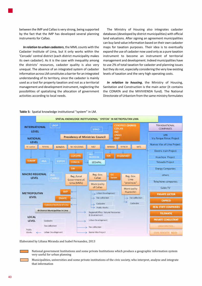
Table 5: Spatialknowledgeinstitutional“system”inLM.
Elaborated by Liliana Miranda and Isabel Fernandez, 2013
National government Institutions and some private Institutions which produce a geographic information system very useful for urban planning
Municipalities, universities and some private institutions of the civic society, who interpret, analyze and integrate that information
betweentheIMPandCallaoisverystrong,beingsupportedby the fact that the IMPhasdeveloped severalplanninginstrumentsforCallao.
In relation to urban cadasters,theMMLcountswiththeCadaster Institute of Lima, but it onlyworkswithin the‘Cercado’centraldistrict(eachdistrictmunicipalitymakesitsowncadaster).Asitisthecasewithinequalityamongthe districts’ resources, cadaster quality is also veryunequal.TheabsenceofanintegratedsystemofcadasterinformationacrossLMconstitutesabarrierforanintegratedunderstandingofitsterritory,sincethecadasterismainlyusedasatoolforpropertytaxationandnotasaterritorialmanagementanddevelopmentinstrument,neglectingthepossibilities of spatializing the allocation of governmentactivitiesaccordingtolocalneeds.
The Ministry of Housing also integrates cadasterdatabases(developedbydistrictmunicipalities)withofficiallandvaluations.Aftersigninganagreementmunicipalitiescanbuylandvalueinformationbasedontheirowncadastermaps for taxation purposes. Their idea is to eventuallyexpandtheuseofcadasternowusedonlyasapuretaxationinstrument to become an instrument of territorialmanagementanddevelopment.Indeedmunicipalitieshavetouse2%oftotaltaxationforcadasterandplanningissuesbuttheydonot,especiallyconsideringtheverylowexistinglevelsoftaxationandtheveryhighoperatingcosts.
In relation to housing, the Ministry of Housing,SanitationandConstructionisthemainactor(itcontainsthe CONATA and the MIVIVIENDA fund). The NationalDirectorateofUrbanismfromthesameministryformulates
40

Elaborated by Liliana Miranda and Isabel Fernandez, 2013
Institution Definition
UNDP UnitedNationsDevelopmentProgramme
SIRAD InformationSystemofResourcesforDisasterAttention
CENEPRED NationalCentreforPrevention,Estimation,anddisasterriskreduction
CEPLAN NationalStrategicPlanningCenter
INEI NationalInstituteofInformationandStatistics
ONGEI NationalOfficeofelectronicgovernmentandinformationtechnology
IDEP InfraestructuradeDatosEspaciales
ANA NationalAuthorityofWater
ALA LocalAuthorityofWater
MML MetropolitanMunicipalityofLima
Table 5: ListofactorsLegend:
Institution Definition
M Justice MinistryofJustice
MINAG MinistryofAgriculture
MINDIS MinistryofDefense
M HOUSING MinistryofHousing
MINAM MinistryofEnvironment
MINEM MinistryofEnergyandMine
MTC MinistryofTransportandCommunications
MEF MinistryofEconomyandFinance
ALA CHIRILU LocalAuthorityofWaterofChillon,RimacandLurinrivers
nationalurbanregulationsbutalsoelaboratesurbanplansand provides technical assistance to provincialmunicipalities. In the private sector, the ConstructionChamberCAPECObringstogetherconstructionenterprisesinthecountryandproducesinformationrelatedtobuildingprices, and carries out market studies. In relation toinformalsettlements,processesofformalizationareheldby the Commission for the Formalization of InformalPropertyCOFOPRIthatisalsoinchargeofelaboratingplotandperimeterplans,andpublicregistrationofproperties.TheseplansareelaboratedthroughtheuseofmapsandGISsystems,andtheconfigurationofadistrictlevelgraphicbase of urban properties and cadaster. The procedureimpliestheconstructionofacartographicmosaicnamed‘territorial unity’ that is incorporated to thegraphic andstatisticalbaseofCOFOPRI.
In relation to environmental issues, theMinistry ofEnvironment is themost important actor. It formulatesenvironmentalnormsandpolicies,andprovidesassistancefortheelaborationofecological-economiczoning.Otherimportant bodies are the Sanitation Deputy Ministry(MVCS)andSEDAPALthathasoneofthemostdetailedandup-to-date basemaps of the city.Within theMML, theDeputy Regional Office of National Resources and
Environmentdealswithprotectedareas,basinsandwater-hydrologicalresources.IthasgeneratedthefirstecologicstructuremapinLMandthefirstmapofpublicspacesandgreenareasofLima.75
Inadditiontherearemorespecializedinitiatives,suchastheMinistryofEnvironmentGeoserverthatprocessesinformationrelatedtoenvironmentalissuesusingofficialdataprovidedbyvariousgovernmentdepartments.Sofarsuch data has not been standardized and can not bematchedtoabasemap.
ItisimportanttomentiontheeffortsfromtheMinistryofHousingforgeneratingaclimatemapofPeru,whichisaccessibleviainternetinordertopermitprojectdeveloperstoapplybioclimaticdesigninthewholecountry.
In relation to vulnerability issues,theNationalInstituteof Civil Defense INDECI formulates and supervises theNationalPlan for theManagementofDisasterRisksandleadstheSINAGREDsystemforexecutingthereferredplan.Additionally, theNational Center for thePrevention and
75 In: http://www.munlima.gob.pe/limaambiental/component/k2/item/72-estructura-ecologica
41
5SpatialKnowledgeManagementintheCity

issues).ItisbasedonamodeldevelopedforQuito,Ecuador.TheplatformhasbeeninstalledinthecitiesofLM,Cañete,HuauraandTrujillo.
In relation to boundary demarcation: competences and processes. The National Directorate of TerritorialDemarcation of the PrimeMinister’s Office PCM is thetechnical entity in charge of providing information fordecision-making on boundary demarcation, and localinstitutionssuchastheIMPworktogetherwiththereferreddirectorate. Then, boundary demarcation decisions passthroughthe“TerritorialDemarcationCommission”oftheNationalCongress,which tends topoliticize theprocess,andat theenddecisions are takenbasedonhowmanypeoplegotoprotesttothecongress.
Also, the National Geographic Institute IGN is adecentralizedpublicagency(incorporatedinthedefensesector)thataimstoelaborateandupdatebasiccartographyin Peru, participating in the creation, delimitation and
Diminishing of Disaster Risk CENEPRED is in charge ofcoordinating, facilitatingandsupervisingtheformulationandimplementationoftheDisasterRiskNationalPlanandthe Information System for Disaster Risk ManagementSIGRID. Also the Geo-Physical Institute studies naturalphenomenathatcanaffectthenationalterritory,andtheINGENEMET has developed a study of critical areas indangeroflandslides,floodingandmudslidedisastersinLM.The UNDP has elaborated the Information System ofResourcesforDisasterAttentionSIRAD,aGIS-basedwebmapping service platform that links digital maps withdatabases on decision and intervention centers, watersupply,foodsupply,emergencymedicalattention,energysupply,transport,telecommunications,potentialareasforshelters,potentialareasforgatheringrubbleandeconomicareas.Itpermitslocalandregionalauthoritiestoanalyzethe vulnerability of essential resource inventories fororganizingandmonitoringpost-disasterrecoveryprocesses(for the case ofMetropolitan Lima it is very focused onearthquakes and tsunamis, and not on climate change
INSTITUTIONS Agencies Role Description
CENEPRED SISGRID InformationSystemfordisasterriskmanagement:forLimaSIRAD
Ministry of Justice SUNARP NationalPublicRecordsSuperintendence
Ministry of Housing COFOPRI Formalizationoflandpropertyagency
CONATA NationalCouncilofrealestatevalueappraisals(fordefiningthemunicipaltaxes)
SBN NationalSuperintendenceofrealestateproperty(stateassets)
SEDAPAL WaterCompanyforLimaandCallao
Ministry of Defense SISFOSH Povertymappingforsocialprogramsfocalization
MINAM IGN GeographiccartographyInstitute
MINEM INGEMMET Geologymapping,miningandconcessionsInstitution
MEF PROINVERSION Megaprojectsmapping
Regional Government of Callao
GISTerritorialSystem Mapping of boundaries, human settlements, Ecological andeconomiczoning
Metropolitan Municipality of Lima
ICLCadastralInstituteofLima
Lima“cercado”cadaster,mappingforMMLofficesbyrequest(asconsultant)
IMP MetropolitanInstitutionofPlanning
EMAPE MunicipalityCompanyofTollAdministration
District Municipalities Cadasteroffices Locating,sizinganddefiningownersoftherealstateinthedistrictplotbyplot
Table 6: PublicagenciesinvolvedinspatialknowledgemanagementforurbanplanninginLM.
Source: Self-developed
42

demarcation of territorial demarcation through theelaborationofofficialcartography.
In relation to the implementation of large-scale urban projects, therearemanymunicipalagenciessuchas theMetropolitan Office for Private Investments PromotionGPIP promoting projects such as ‘Via Parque Rimac’,‘NuevasVíasdeLima’and‘ViaExpresaSur’(seetable1),whichuseinstrumentssuchassynthesisplans,infographies,etc.ThereisalsotheTollAdministrationCompanyofLimaEMAPE, that builds and administers highways andotherhigh transit roads; and the Metropolitan Fund ofInvestmentsINVERMETthatfinancesandexecutesprojectsand infrastructure works in the city. Both agencies –together with the Urban Development Office and theNeighborhoodParticipationOfficeoftheMML–formpartofthedirectors’boardofthe‘BarrioMio’program.
5 .2 .1 . Network Formation: networks and platforms
From the spatial knowledge point of view, theseinstitutions contribute by providing spatial registrationinstrumentsandvirtualcommunicationsystemswithusers.However, the various systems in place are not alwaysinterconnected; they use their own cartographic bases;theydonotsharethesameplotorcoordinatedsystemsofcadasdralcodes;theirplotinformationdonotcoincide;anddonotshowmuch interest inconstitutingacoordinatedGISand/norcadasdralsystemforLM.
An initial step on this regard is the Spatial Data Infrastructure of Peru IDEPthataimstointegratedifferentpublicinstitutionsthatprovidespatialinformation.Itisstillunder construction but moving very slowly because itconcernsacomplexprocessofstandardization.Itsgoalistostandardizeandsystematizecartographicandgeo-spatialinformation from different state actors within a singleplatformmanagedbytheNationalGovernmentfromthePrimeMinister’sOffice(PCM).Itisrelatedtoanimportantmove towards an electronic government paradigmwellestablishedattheLatinAmericanlevel.InstitutionssuchastheNationalGeographicInstitute(IGN),theNavy,INDECOPI(in charge of standardization) and COFOPRI are activeparticipants.
The Metropolitan Assembly AML
TheMetropolitan Assembly AMLisaconsultationandcoordination body of the MML integrating 42 districtmayors from Lima and 29 representatives from the civil
society.TheassemblyispresidedbythemayorofLimaandhas the responsibility to coordinate the efficientimplementationofmetropolitanplans,amongothers.Thecivil society groupwithin theAMLhas been very activeduring thecurrentAdministrationandhasapproved theConcerted Regional Development Plan PRDC and oftenrequested information about the execution of the plan.They have insisted on the role of the IMP in the plan’senforcement and on making it decentralized andparticipatoryinnature.ThePRDCandtheRegionalDisastersPlanusedspatial information,togetherwithsometopicsraisedbytheAMLsuchastheimplementationofelectronicconsultingforparticipatorybudgetingprocesses.76
COREDES Lima
TheRegionalConferenceforSocialDevelopmentofLimaCOREDES77integratesanumberofCBOsandCSOs.Attheendof2010itelaboratedanagendaforLimainthecontextofthemunicipalelectoralcampaignduringthatyear.Theagenda contains different aspects of the city includingeconomicandurbandevelopment.78Informationrelatedtotheagendawassubmittedtothenewadministrationandanumberofmixedworkcommissions(MMLandCOREDES)wereconvenedtocontributetotheOperativeInstitutionalPlanoftheMML.FewofthemembersofCOREDEShavebeenelectedmembersoftheAML.
Poverty Fighting Concertacion Group MCLCP (‘Mesa de Concertación de Lucha contra la Pobreza’) - Work group on housing
ThisconcertacionspacewascreatedbySupremeDecree01-2001-PROMUDEHfrom2001.TheMCLCPofLM79counts
76 The same assembly previously worked on a political document called ‘El Acuerdo por Lima’ (Agreement for Lima) that was presented by the mayor in 2011.
77 COREDES belongs to the National Conference for Social Development (CONADES) that is a national scale meeting space of networks, organizations and citizen movements in the country.
78 The agenda was composed by a series of programmatic proposals that Lima’s civil society (concentrated in COREDES) proposed to the candidates for metropolitan mayor. It included topics such as urban management; soil, housing; habitat and vulnerability; economic development and employment; capacity building; security; environmental management and climate change; fight against corruption.
79 As a concertation space, it does not count with specific members, but participants that represent a series of public institutions and social organizations that exchange information and sometimes reach some level of agreement.
43
5SpatialKnowledgeManagementintheCity

with aworking grouponhousingwhere representativesfromtheMML,districtsmunicipalities,nationalgovernmentagenciessuchasCOFOPRIand INDECIandseveralNGOshave an active participation. They are discussinginterventionstrategiesoftheMetropolitanPopularHousingProgramof theMML and the ‘Kuelap’ project in the ‘ElAgustino’districtthatwouldbethefirstpilotprogramoflow-incomeurbanizationonhillsides.ThePopularHousingProgrampresentedtotheMCLCPgeo-referenceddataforidentifying possible plots for urban renewal, estates inruins, monument estates, land uses and quantitativehousingdeficits(blocklevel).Thatspacealsohasaworkinggrouponwaterandenvironment,amongothers.
Environmental Networks
When referring to knowledge management, theenvironmental sector is one of the most advanced. Inrelation tohydro-climatic knowledgemanagement thereareprogramsandprojectsfrom:
• national entities promoted by the Ministry ofEnvironmentMINAM and the LimaMetropolitanMunicipalityMML (Officeof Services to theCity /EnvironmentDeputyOfficeGSC/SMA)andtheOfficeforParksAdministrationSERPAR;
• the ProvincialMunicipality of CallaoMPC and theLimaandCallaoregionalgovernments;80
• districtmunicipalities(forinstance,theclimatepactbetween San Borja, Pueblo Libre andMiraflores,signedonSeptember2012);
• research projects by the ‘Servicio Nacional deMeterología e hidrología del Perú’ SENAMHI,‘InstitutodelmardelPerú‘IMARPE,81Chance2Sustain,LiWa(withtheparticipationofSEDAPAL,MML,theNGO Fomento de la Vida FOVIDA, NationalEngineeringUniversityUNI,FORO,amongothers)82and several universities (‘Pontificia UniversidadCatólicadelPéruPUCPamongthemostrenowned);
• technicalcooperationprojectsbyUNDPandAVINA;83andfromCSOssuchasTheCitiesforLifeForumand
80 The Regional Strategy of Climate Change of Callao has been approved and its second update is in progress.
81 See: http://www.imarpe.pe
82 A computerized water flow model system http://www.lima-water.de/
83 Latin American foundation supported by the VIVA trust fund created by Stephan Schmidheiny for promoting sustainable development through an alliance between private companies and philanthropic organizations.
the ‘Movimiento Ciudadano Frente al CambioClimático’MOCCIC,amongothers.
• amulti-sectoralteamconvenedbycivilsocietyandgovernmental representatives that developed theEnvironmentalAtlasofLima84(initiatedin2002andpublishedin2009).
AnotherinitiativeforspatialinformationmanagementistheLiwaTool,acomputerizedmodelforwaterflowunderdevelopmentbyIfakasamemberoftheGerman-PeruvianteamofresearchinstitutesworkingundertheLiwaresearchproject.85Oneofthemostimportantcontributionsofthisstudywas the standardization of thematic information,which enabled data comparison (seeMiranda Sara andBaud2014).
5 .3 . Knowledge Building, Use and Contestation, Exchange
Processesofconstruction,useandexchangeofspatialknowledgeareinfluencedbycontradictorytrends.Ononehand, there is the introduction of new informationtechnologies in the context of globalization. Theintroduction of ICT-GIS systems in urban governancebelongstoatechnologicalrevolutionexperimentedbythewholeworld,inthecontextofaglobaleconomythatreliesontelecommunicationandinformation.86
PublicentitieshaveInternet-basedconsultationsystemssuchasCOFOPRIthathasafreeon-lineservicethatpermitsuserstocheckthesituationoftheirplotsandtheirrecords.Another important system is the online cadaster thatcontains information about land status for developingurbanandruraldevelopmentplans,transport,environment,security, taxation, etc. Access via internet is free orpreferentialbypublicandprivatesectoractorsaswellasthe general public. The SUNARP has a web-basedinformation systemof registered estates namedVirtualRegistry Tutor, and the SBNhas an integrated systemof
84 See: http://www.geoserver.itc.nl/lima/start/start.html
85 See: http://www.lima-water.de/
86 Another group which is very prone to use new communication technologies is the new generation of children and youngsters from all social levels, as it can be evidenced from the large numbers of internet cafes in the country and particularly in LM. Nonetheless, greatest part of this interest is related to amusement purposes and to a much lesser extent to more academic purposes. Thus, there is a pending task to take advantage of that interest for new technologies, but relating it to greater social challenges.
44

geographic information and numeric databases thatenhances themanagement of cadaster information andmoreefficientadministration.
On the other hand, there is a persistent ‘secretismculture’relatedwithlowlevelsoftransparencyandsharing,especially from government representatives andconsultants.Therearecaseswhen information ishiddenforsecuringrealestateinvestmentsinhazardousareas(i.e.the ‘Costa Verde’ which is a high risk area because ofearthquakes and tsunamis); and opposite cases wheninformationonhazardsisintentionallyusedtoundervalueland for securing investments through less expensivereallocationsandexpropriations, likethe‘LineaAmarilla-Via Parque Rimac’ case as it will be seen in caseChance2Sustaincase-studiesonmega-projectsandonsub-standardsettlements.
Additionally, there is the fear that informationmightempower new actors against existing local leadership,undermining existing investment dynamics secured bysome agreements between private operators, socialleadersandthelocalgovernment.Forinstance,duringtheLiWatoolconstructionprocess,SEDAPALlimitedaccesstotheirinformationtotheIMPandotherinstitutions,despitethesignatureofspecificagreements for thosepurposesbackin2005.ThiscanberelatedtoalackoftrustaboutpossiblefurtheruseoftheinformationbytheIMP,adividebetween water and land policies, and the referredsecretismculture.Thesuspicionofsharinginformationisthe fundamentalproblem facing thebuildupofamulti-sectorplatformforinformationexchangeandknowledgeconstruction, One reason for this concerns the cost ofinformationandlackofinstitutionalcontinuity:fromhighlevels of rotation of public officers to land traffickingmayorsandpowerfuleconomicgroupsthatprefertokeepinformationwellhidden.
EachelectioninLMrepresentsacompletechangeinthecompositionofthehighleveltechnicalandpoliticalteamfor eachMunicipal and/or RegionalGovernment and/orNationalGovernmentifauthoritiesarenotreelected.Thisimplies a complete absence of a continuous process ormethodology of knowledge accumulation in the publicsector.Cityofficersdonothaveexpertisefordailyuseofgeographic information; andwhenmanagers’ capacitiesare developed, they leave the institutions (sometimestakingalltheinformationwiththem)becauseofthehighrotation levels. Considering this problem, civil societyinstitutionstendtofunctionasakindofrepositorydatabaseof experiences, and it is very common that newadministrations go there after elections to requestinformation about their districts. Interestingly,membersfrom the local community claim their right to include
upcoming authorities into the process; recognizing andlegitimizing their presence and openness to transferknowledge.Ingeneralsocialleadershaveaverystrongtacitknowledge on how to deal with public agents withinpolitical spaceswhile technical institutions (such as thealreadymentionedDESCOandCENCA)providetechnicalandfinancialinformationforsupportingtheirdiscourses.
5 .3 .1 . Knowledge Construction in Urban Planning
In relation to the construction of urban and spatialplanning several actors (some of them international)participate by developing local, regional, national andinternational regional integrationmegaprojects (such asIIRSAamongothers)asshownintable7.Nevertheless,itcan be said that the different levels perform in ratherindependentways.Thereremainsastrongdisconnectionbetween municipal and regional bodies and serviceproviders when defining land use and implementinfrastructure, being also a constant interference ofjudiciarycourts.LMlacksofterritorialplanningtechnicalspaceswellarticulatedandincoordinationwithnationallevelsectors.
Thereisneitheranintegralnorunitaryvisionofthecityas a whole. The dominant rationale has not given anyprioritytolongtermplanning,buthasconsolidatedmarketorientationsthroughseveralderegulationpolicies(intheform of administrative simplification instruments), theweakeningofregionalandlocalinstitutionality(evenasapartofthedecentralizationprocess),andtherelianceonmegaprojects as city development engines that haveexacerbatedconflictsandgeneratedcorruptionproblemsin a context of non-sufficient instruments of urban andterritorialmanagement.
Asamatteroffact,bigrealestateoperatorsandprivateinvestors (supported by well recognized lobbyist andconsultants)holdtheclearest‘pro-growth’visionofLMwithnocounterdiscoursesfromspacessuchassocialorganizationsthat remain very atomized and maintain their focus onimmediatehouseandneighborhoodscaleissues.Figure14pointsoutadominantvisionfromprivatesectorsoperators(through a consultancy paid by the VEOLIA Frenchinfrastructureandenvironmentalservicesprovisionfirm).Itrelieson the re-developmentofnewcentralities, the realestateexploitationofthe‘CostaVerde’andSouthLimasea-fronts and the implementation of a whole new ‘self-sustainable’cityofalmost35000haonthesouthernpartofthecity(righthandsideoffigure14).
45
5SpatialKnowledgeManagementintheCity

Inthesamevein,figure15showstheofficialvisiontoyear2025publishedalmost3yearsaftertheURVIA-VEOLIAvision. It legitimizes it by relying on the referredpolicentrality87andproposing‘coastalborder’developmentson the ‘Costa Verde’ and Southern Lima and a ‘self-sustainable’expansioninthesamesouthernquadrantofthe city. Despite the celebrated participatory and‘concertative’natureoftheplan,thereferredmaphasnotbeendevelopedduring theparticipatoryprocessandnotechnicalinformationhasbeenprovidedinrelationtobothmegaprojects.ItisexpectedthattheUrbanDevelopmentPlan (still in progress) will provide technical support.
87 “The traditionally monocentric structure of Lima has started to desapear with the creation of the first deconcetrated development poles, largely driven by real estate laws before the guidelines of an always incompetetent and unefficient urban planning” (Ludeña 2010:76).
Although the PDRC relies on reorganizing the existingcoreofthecity,itisalsopushingforthedevelopmentofmassive quantities of new urban land for an alreadysprawled city, with unknown future effects on theremainingLurinValley.ThesouthernareaofLimawillbethe main area of contention between farmers andspeculators.Todaythedesertinvadersarenothomelesspoormigrants.New invadersare thenewrichandbigreal estate consortia whose growing power hasconsolidatedwith the reductionofahugeeco-park intheSouthofLimafrommorethan8000hato1700ha(Ludeña2010:47).
88The current planning vacuum becomes a verycomplex issueespeciallywhenthe ‘GrañayMontero’group,thebiggestconstructionfirminPeruisplanningtodevelopaso-calledsatellitecitybiggerthan8km2inthe referred areawith no apparent concern for self-sustainibility.Developingpurestrategicguidelineswith
88
(INTERNATIONAL) NATIONAL
(MACRO) REGIONAL
LOCAL LEVEL
PROVINCE LEVEL
DISTRICT LEVEL
MACRO INTERNATIONAL PROJECTS (IRSA: transoceanic etc .)
X X
CONCERTED DEVELOPMENT PLANS X X X X
NATIONAL TERRITORIAL DEVELOPMENT PLAN 2004-2013 X
NATIONAL PLAN OF URBAN DEVELOPMENT (MVCS) X88
TERRITORIAL DEVELOPMENT PLANS (Macro, middle and micro ZEE, EAE)
X X X
LAND MANAGEMENT PLANS (Watershed programmed, brokers, intermediate cities…)
X
URBAN DEVELOPMENT PLAN (Zoning Scheme, Risk Management Plan, PIGARS, Road and Transports plans, etc .)
X X
RURAL DEVELOPMENT PLAN X
HUMAN SETTLEMENTS DEVELOPMENT PLANS X
Table 7: WhodoeswhatinspatialplanninginPeru?
Source: Self-developed
88 Only one National Urban Development Plan was done by the MVCS decades ago but it has never updated.
46
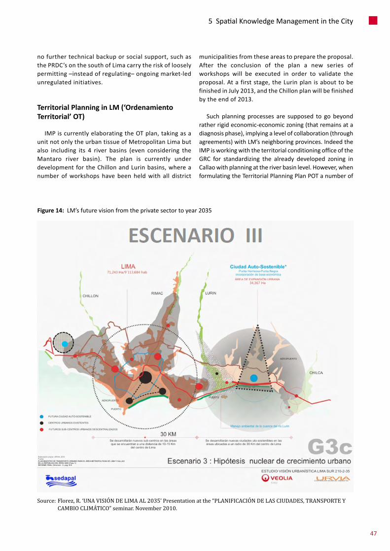
nofurthertechnicalbackuporsocialsupport,suchasthePRDC’sonthesouthofLimacarrytheriskoflooselypermitting–insteadofregulating–ongoingmarket-ledunregulatedinitiatives.
Territorial Planning in LM (‘Ordenamiento Territorial’ OT)
IMPiscurrentlyelaboratingtheOTplan,takingasaunitnotonlytheurbantissueofMetropolitanLimabutalso including its 4 river basins (even considering theMantaro river basin). The plan is currently underdevelopmentfortheChillonandLurinbasins,whereanumber ofworkshops have been heldwith all district
municipalitiesfromtheseareastopreparetheproposal.After the conclusion of the plan a new series ofworkshops will be executed in order to validate theproposal.Atafirststage,theLurinplanisabouttobefinishedinJuly2013,andtheChillonplanwillbefinishedbytheendof2013.
Such planning processes are supposed to go beyondratherrigideconomic-economiczoning(thatremainsatadiagnosisphase),implyingalevelofcollaboration(throughagreements)withLM’sneighboringprovinces.IndeedtheIMPisworkingwiththeterritorialconditioningofficeoftheGRC for standardizing the already developed zoning inCallaowithplanningattheriverbasinlevel.However,whenformulatingtheTerritorialPlanningPlanPOTanumberof
Figure 14: LM’sfuturevisionfromtheprivatesectortoyear2035
Source: Florez, R. ‘UNA VISIÓN DE LIMA AL 2035’ Presentation at the “PLANIFICACIÓN DE LAS CIUDADES, TRANSPORTE Y CAMBIO CLIMÁTICO” seminar. November 2010.
47
5SpatialKnowledgeManagementintheCity
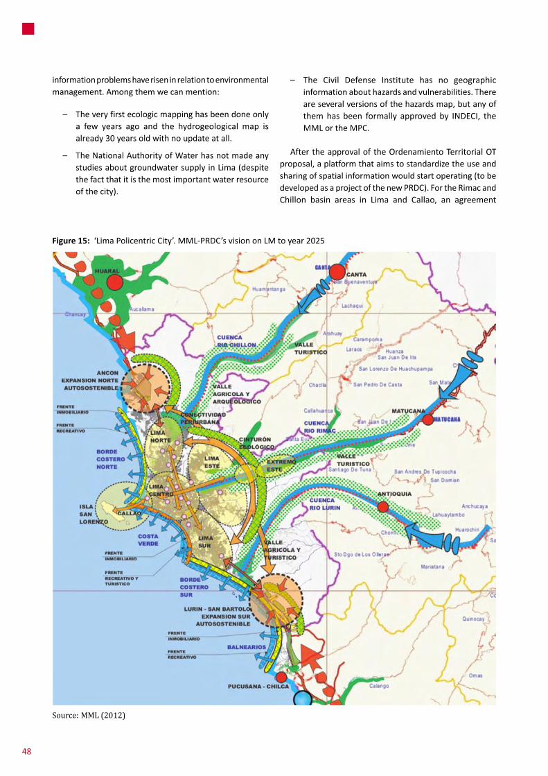
– The Civil Defense Institute has no geographicinformationabouthazardsandvulnerabilities.Thereareseveralversionsofthehazardsmap,butanyofthemhas been formally approved by INDECI, theMMLortheMPC.
AftertheapprovaloftheOrdenamientoTerritorialOTproposal,aplatformthataimstostandardizetheuseandsharingofspatialinformationwouldstartoperating(tobedevelopedasaprojectofthenewPRDC).FortheRimacandChillon basin areas in Lima and Callao, an agreement
informationproblemshaveriseninrelationtoenvironmentalmanagement.Amongthemwecanmention:
– Theveryfirstecologicmappinghasbeendoneonlya few years ago and the hydrogeological map isalready30yearsoldwithnoupdateatall.
– TheNationalAuthorityofWaterhasnotmadeanystudiesaboutgroundwatersupplyinLima(despitethefactthatitisthemostimportantwaterresourceofthecity).
Figure 15: ‘LimaPolicentricCity’.MML-PRDC’svisiononLMtoyear2025
Source: MML (2012)
48

betweenINEI(NationalInstituteofStatistics)andSEDAPALhasbeensignedinordertoestablishacommoncartographicbase.ThemainstrategyistoconformanucleusthatwouldprogressivelyexpandtoamanagementinformationsystemandpromotetheuseofmetadataatthelevelofthepublicapparatusinLima.Atthismoment,agreementshavebeenonlydonewithrespecttocartographicstandardsanddonotyetrepresentanintegratedsystem.
Animportantissueisthatthesekindsofactivitiesaredependentonpoliticalmorethantechnicaldecisions;andcurrentrelationsbetweenofficesrespondtoveryspecificinterests instead of being open to institutionalizedinformation platforms. For example while the IMP iscurrentlycoordinatingwithSEDAPAL;themayorofLimaisclaimingachaironSEDAPAL’sboardwithacleardenialfromthe central government. Also, when the nationalgovernmentrealizedthattransferringterritorialplanningOT functions to the MML would have an importantempowerment effect regarding land policy decision-making, it decided to stop the transfer process fromEnvironmentalMinistrytoMML.
The Plan of Incentives for Municipal Management
Adifferentkindof initiativecomesfromthePlanofIncentivesforMunicipalManagement(Law29332-2011)held by the national government. According to thispolicy, an economic incentive of 1 million PEN wasofferedtoeachmunicipalitythatwouldhaveidentified
physical risks in their jurisdictions. 1200 out of 1800municipalities responded to theplanduring2012. Forthose 1200 municipalities, an extra 1.5M PEN wereoffered to translate that information into mitigationplans and 700 respondedwhich is considered by theMinistryofHousingagreatsuccess.
Eventhoughtheresponsefromlocalgovernmentshasbeenmassive,noappropriateguidelinesabouttherequiredinformationhavebeendesigned(noindicators,variablesandnotevendefinitionsofdangerorvulnerability)andthequality of the information given back to the nationalgovernmentisverymixed.Also,theprovidedincentivescanbeusedindiscretionarywaysandnotfordealingspecificallywithriskandvulnerabilityissues.
5 .4 . Spatial Knowledge Produced through Citizen Participation Processes
Knowledge components of the ‘Barrio Mio’ program for upgrading sub-standard settlements
The ‘Barrio Mio’ program aims to build urbaninfrastructure in marginal areas. The first step of theproject is to reduce physical vulnerability by buildingstairwaysandretainingwalls.Afterthefirstphase,severalintegral urban projects will be executed by usingparticipatory planning techniques, such as theconstruction of roads, parks, sport infrastructure inaccordancetothepopulations’needs.
Fordeveloping its interventionmodel,BarrioMiohasdevelopedanurbanpovertymap(seefigure10)basedoninformationfromthe2007censusandsystematicfieldworkgatheringgeographicaldata fromthosedwellingssettledafter the census. It has characterized the poorestpopulationsaccordingtotheirunsatisfiedbasicneeds,buthas also applied theGINI inequality index. 17 territorieswithrelativelyindependenturbanstructures(amoreorlessdefinedcoreforprogrammaticpurposes)wereidentifiedinperipheralareasofthecity(mostvulnerable).Theseareaswere identified after analyzing demographic (INEI) andphysical/geographicalvariablesofthecity.Theaimwastobuildamodelforprioritizingactionsonatechnicalbasis.Themodelwouldavoidpoliticalmanipulationofinvestmentprioritization;and‘anticipatethedemandfromthecity’,sothathigherlevelsoforganization/reactioncapacitieswouldnot overpower real urban problems, and lead to biaseddecision-makingprocesses.
Box 4: Corporative pressures on Territorial Planning (OT) regulation
Formorethan10yearstheOTlawofPeruisstillwaiting for approval, seeming to be that it is notoccurring due to the pressures from corporate andmining powers at the national level.While in ruralareas,miningcorporatepowertendstoinfluencebigpartofpolicymakingrelatedtotheterritory,forthecase of LM this role is accomplishedby real estatelobbies that tend to undermine every regulatorybarrierandpubliclyavailableinformationinthesamewayasminingcompaniesdo.Nevertheless,since2013theMMLhasstartedtoregainlandpolicypowersfromrealestatelobbiesbydevelopingtheterritorialplanoftheChillónandLurinriverbasins(itwouldbefinalizedthis year) and has started to develop the UrbanDevelopmentPlanoftheprovinceofLima.
49
5SpatialKnowledgeManagementintheCity
NGOs, theChurch, territorial leaders,citizens,etc.)wereconvenedtodiscussaproposalaboutthevisionofeachfivesectors.Second,anumberofthematicmeetings(sector-oriented such as education, transport, health, security)wereconvenedinordertorecognizespecificissuesonthereferredterritories.Despitethebigeffortstoopendialogueinthewidestwaypossible,twofundamentalgroupsforthefutureconfigurationofthecitysuchasrealestateoperatorsand land traffickers did not participate in the plan’sformulationprocess.91Thefirstgroupgenerallyusesmoredirectmechanismsforexpressingitspointsofview,andthesecondgroupremainsmarginaltoregularprocessesduetoitsillegalnature.
TThereareseveralnetworksthatbringactorstogetherlinkedtoseveraltopicswithincityplanning.UnfortunatelytheprocessofformulationandfollowupofthePRDCdoesnothaveaninstitutionalizedspacethatmaygroupdifferentactors. From that perspective, the neighborhoodconsultation system of the 2013 MML participatorybudgetingisanimportantachievement.Theimplementationofthesystemconsistednotonlyofinternetaccess,butalsotheinstallationofcomputerstationsinpublicspacessuchasparks,shoppingareas,municipalities,theimplementationof capacity buildingworkshops, and the participation ofpublicfigures.
Other local experiences
Despitetheseefforts,citizenparticipationprocessesinLMhave not been focused very specifically on buildingspatialknowledge(neitherintheprocessofconstructionof the PRDC or the electronic consultationmechanismsreferredtoearlier).However,thereareveryrelevantlocalinitiativesregardingtheconstructionofcommunitymapsfor risk management. These maps not only containinformationaboutrisks,butconstituteaninstrumentforstimulatingthepopulationtotakeactionsforriskreduction.
Anotheraspectrelatedtocitizenparticipationandthefollow-upofurbantransformationsandtheperformanceof public institutions occurs around several ICT-basedobservatoriessuchas‘LimacomoVamos’92thatfollows-up
91 Considering that they do not take part of any similar process.
92 ‘Lima Como Vamos’ –together with institutions from Arequipa and Trujillo– form part of a network of 70 similar institutions from different Latin American cities the Latin American Network for Just, Democratic and Sustainable Cities and Territories. These initiatives aim to improve city management with an inclusive, sustainable and ethical perspective.
Wheninformationonstairwayswas incorporated intothemodel,includingtheslopethresholdfordecidingwheretobuildastairway,theslopevariablewascrossedwithavariableofexistingstairspreviouslymadebythecommunity.Thisindicatedtheslopethresholdassignedbythepeopleandbecametheofficialone.Thecorrelationindicatedthatthose settlementswith slopes steeper than 30%wouldnecessarily need a stairway and those settlementswithslopes between 24% and 30%would be on a transitionstage (decisions on intervening in this range would beconsideredsecondpriorityandlinkedtoothervariables).Thecurrent identified limit forbuildingonslopeareas is47%.
The 2012-2025 Concerted89 Plan for the Regional Development of Lima as a learning process (PRDC)
ThenewMetropolitanAdministrationhasconsidereditnecessarytoreactivateplanningprocesses,byjumpstartingthenewConcertedDevelopmentPlan2012-2025(PRDC)90.Ingeneral,theplanproposesdevelopmentguidelinesforthe city andwill be thebasis formore specific planningschemes, aiming to merge two different kinds ofassessments:afirstacademiconemadebyconsultantsandtechnicians; and a second onemade in a participatorymanner.Onthisbasis, thetechnical teamintegratedtheknowledgeproduced in variousways and generated thedefiniteplan.Nonethelessgeographictoolswerenotusedinasystematicwaybeyondsomespecific topicssuchastransport,securityandurbandevelopment(publicspaces,urbanequipment,amongothers).
In methodological terms, the PRDC tried to identifycertainareasofthecitywithrelativelysimilarfeaturesfortheanalysis:CentralLima,SouthLima,EastLimaandNorthLimaandCallao(seefigure16).Afterthisinitialterritorialsubdivisionthepopulationfromtheseareaswasconvokedthroughthecitizenparticipationofficeofeachmunicipalityand the mass media. Then, two parallel participatoryprocessesandtheireventualconvergenceweredesignedin order tomerge sector and territorial dynamics. First,participants from different sectors (private sector, sub-nationalandnationalgovernment,CSOs,universitiesand
89 The term ‘concerted’ is related to the fact that the plan has been approved by different local actors that have participated on the its formulation.
90 According to the national legislation, concerted development plans are focused on the populations and propose general guidelines, while urban development plans are focused on the city and imply more specific projects and instruments.
50

Figure 16: OperativeareasoftheRegionalConcertedPlanofLima
Source: IMP/MML
LimaNorte
KimaCentro
LimaEste
LimaSur
Callao
ZonasLEYENDA
51
5SpatialKnowledgeManagementintheCity

qualityof lifevariations inLM. It ispromotedbyprivatesectorinstitutionssuchastheCatholicUniversityofPeru,RadioProgramasdelPeru(broadcasting),the‘AsociacionCivilTransparencia’(thirdsector)theGermanInternationalCooperation Agency GIZ and the ‘Asociación Atocongo’(CSR).NGOssuchastheUrbanObservatoryDESCO93and‘InfoVivienda’fromCENCA94alsohaveinitiatives.
Community-based knowledge reactions to large scale projects . The MIRR and the LA-VPR large-scale project .
Community-basedknowledgeisusedinrelationtolarge-scaleprojects;thecaseoftheMIRRfacing‘LineaAmarilla-ViaParqueRimac’megaprojectisemblematic.ForresidentsfromtheMIRR,thefactthattheyhaveneverbeenconsultedorproperlyinformed,isaviolationoftheircitizenrights,whichmadethemcontesttheprojectbyusingthefollowingknowledge-basednegotiationmechanisms:
• Surveys:neighborhoodassociationsgetinvolvedinsurveying the settlement as a tool for generatingindependentandcommunitydriveninformation
93 The Urban Observatory DESCO is a web based virtual platform that contains information on public space and risk management (vulnerability maps for risk mitigation plans) for the districts of South Lima.
94 ‘Info Vivienda’ summarizes news about housing, water and sanitation and urban development topics. It is used for following up the current urban situation and discussing it with the population where CENCA works (San Juan de Lurigancho district).
• Writing letters to the municipality to demandinformation
• Neighborhood councils organize informativeworkshops and assemblieswhere residents voicetheirconcerns.
• Distributionof leafletsandnewspaperswrittenbyresidents/leaders/lawyers
• Shift from protest/confrontational phase to aconversation/legalphase:communityprotestsgiveway to technical legal matters,95 establishingrelationshipswithlawyerswhoofferedlegalexpertiseforchallengingthecontract
• Pricecalculationsoftheirhouses(independentlyoftheevaluationsmadebytheMMLandthecompany)
• Fighting “Ordenanza 1020” at the constitutionalcourt in a alliance with a group of oppositioncongressmen
AttheHuascaránneighborhood(RightMarginoftheRimacRiver),themajorityofthepopulationcompletelyrejectstheimplementationoftheprojectgiventhatthesettlement is consolidated and not exposed toenvironmentalorphysical risks.Theresidentsdemandtheconstructionofanalternativeroute,giventhatthereis ample space between the river and the first line ofhouses,making their own proposal for an alternativerouteforthehighway.
95 Importantly, this change of space has a negative effect: neighborhoods have atomized and tend to technically negotiate in parallel.
Source: http://play.tuteve.tv/videogaleria/listado/111614/ 2012-11-22-21112012
Figure 17: SocialLeaderfromthe‘Huascarán’neighborhoodshowingtheirproposalforchangingthelayoutonTV
Still capture from ‘RMP program from 21/11/12
52
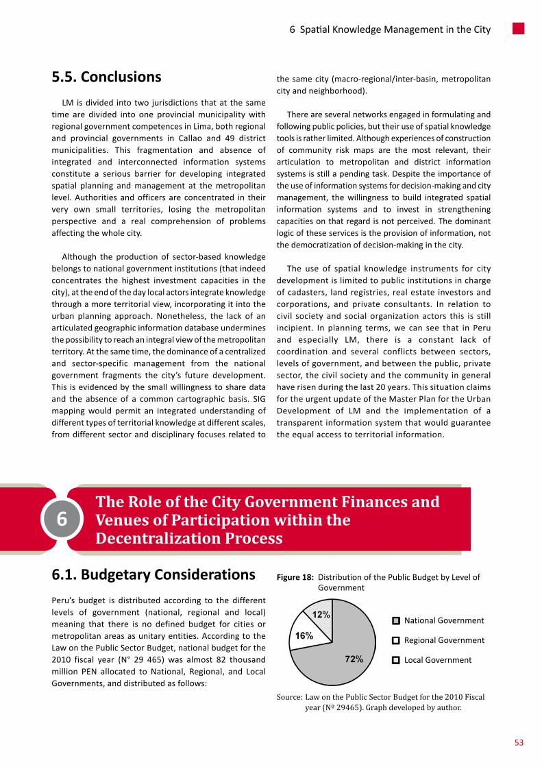
6 .1 . Budgetary ConsiderationsPeru’s budget is distributed according to the differentlevels of government (national, regional and local)meaning that there is no defined budget for cities ormetropolitanareasasunitaryentities.AccordingtotheLawonthePublicSectorBudget,nationalbudgetforthe2010 fiscal year (N° 29 465) was almost 82 thousandmillion PEN allocated to National, Regional, and LocalGovernments,anddistributedasfollows:
5 .5 . ConclusionsLM isdivided into two jurisdictions thatat thesame
time are divided into one provincialmunicipalitywithregionalgovernmentcompetencesinLima,bothregionaland provincial governments in Callao and 49 districtmunicipalities. This fragmentation and absence ofintegrated and interconnected information systemsconstitute a serious barrier for developing integratedspatial planning andmanagement at themetropolitanlevel.Authorities andofficers are concentrated in theirvery own small territories, losing the metropolitanperspective and a real comprehension of problemsaffectingthewholecity.
Although the production of sector-based knowledgebelongstonationalgovernmentinstitutions(thatindeedconcentrates the highest investment capacities in thecity),attheendofthedaylocalactorsintegrateknowledgethroughamoreterritorialview,incorporatingitintotheurban planning approach. Nonetheless, the lack of anarticulatedgeographicinformationdatabaseunderminesthepossibilitytoreachanintegralviewofthemetropolitanterritory.Atthesametime,thedominanceofacentralizedand sector-specific management from the nationalgovernment fragments the city’s future development.This isevidencedbythesmallwillingnesstosharedataand the absence of a common cartographic basis. SIGmappingwould permit an integrated understanding ofdifferenttypesofterritorialknowledgeatdifferentscales,fromdifferentsectoranddisciplinaryfocusesrelatedto
thesamecity(macro-regional/inter-basin,metropolitancityandneighborhood).
Thereareseveralnetworksengagedinformulatingandfollowingpublicpolicies,buttheiruseofspatialknowledgetoolsisratherlimited.Althoughexperiencesofconstructionof community risk maps are the most relevant, theirarticulation to metropolitan and district informationsystemsisstillapendingtask.Despitetheimportanceoftheuseofinformationsystemsfordecision-makingandcitymanagement, thewillingness to build integrated spatialinformation systems and to invest in strengtheningcapacitiesonthatregardisnotperceived.Thedominantlogicoftheseservicesistheprovisionofinformation,notthedemocratizationofdecision-makinginthecity.
The use of spatial knowledge instruments for citydevelopmentislimitedtopublicinstitutionsinchargeofcadasters, landregistries,realestate investorsandcorporations, and private consultants. In relation tocivil society and social organization actors this is stillincipient. In planning terms,we can see that in Peruand especially LM, there is a constant lack ofcoordination and several conflicts between sectors,levelsofgovernment,andbetweenthepublic,privatesector,thecivilsocietyandthecommunityingeneralhaverisenduringthelast20years.ThissituationclaimsfortheurgentupdateoftheMasterPlanfortheUrbanDevelopment of LM and the implementation of atransparentinformationsystemthatwouldguaranteetheequalaccesstoterritorialinformation.
The Role of the City Government Finances and Venues of Participation within the Decentralization Process
6
Figure 18: DistributionofthePublicBudgetbyLevelofGovernment
Source: Law on the Public Sector Budget for the 2010 Fiscal year (Nº 29465). Graph developed by author.
NationalGovernment
RegionalGovernment
LocalGovernment
53
6SpatialKnowledgeManagementintheCity
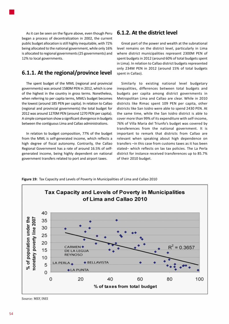
Asitcanbeseenonthefigureabove,eventhoughPerubeganaprocessofdecentralization in2002, thecurrentpublicbudgetallocationisstillhighlyinequitable,with72%beingallocatedtothenationalgovernment,whileonly16%isallocatedtoregionalgovernments(25governments)and12%tolocalgovernments.
6 .1 .1 . At the regional/province level
The spentbudgetof theMML (regional andprovincialgovernments)wasaround1580MPENin2012,whichisoneof thehighest in thecountry ingross terms.Nonetheless,whenreferringtopercapitaterms,MML’sbudgetbecomesthelowest(around185PENpercapita).InrelationtoCallao(regionalandprovincialgovernments) thetotalbudget for2012wasaround1270MPEN(around1270PENpercapita).AsimplecomparisonshowasignificantdivergenceinbudgetsbetweenthecontiguousLimaandCallaoadministrations.
In relation tobudgetcomposition,77%of thebudgetfromtheMMLisself-generatedincome,whichreflectsahigh degree of fiscal autonomy. Contrarily, the CallaoRegionalGovernmenthasarateofaround16.5%ofself-generated income, being highly dependent on nationalgovernmenttransfersrelatedtoportandairporttaxes.
6 .1 .2 . At the district level
Greatpartofthepowerandwealthatthesubnationallevel remains on the district level, particularly in Limawhere districtmunicipalities represent 2300M PEN ofspentbudgetsin2012(around60%oftotalbudgetsspentinLima).InrelationtoCallaodistrictbudgetsrepresentedonly 234M PEN in 2012 (around 15% of total budgetsspentinCallao).
Similarly to existing national level budgetaryinequalities, differences between total budgets andbudgets per capita among district governments inMetropolitanLimaandCallaoareclear.While in2010districts like Rimac spent 109 PEN per capita, otherdistrictslikeSanIsidrowereabletospend2430PEN.Atthe same time,while the San Isidro district is able tocovermorethan99%ofitsexpenditurewithself-income,76%ofVillaMariadelTriunfo’sbudgetwascoveredbytransferences from the national government. It isimportant to remark that districts from Callao arerelevant when speaking about high dependence ontransfers–inthiscasefromcustomstaxesasithasbeenstated–whichreflectson lax taxpolicies.TheLaPerladistrictforinstancereceivedtransferencesupto85.7%oftheir2010budget.
Figure 19: TaxCapacityandLevelsofPovertyinMunicipalitiesofLimaandCallao2010
Source: MEF, INEI
54
– Establishprioritiesonpublicinvestment
– Reinforcethefollow-upandcitizencontrolofpublicadministration.
6 .2 .1 . Overall Performance
PB’s results and levels of participation are diverse,startingbythepointthatingeneralverylowsharesofthemunicipalbudgetshavebeendecidedthroughparticipation(only5.4%oftotaldistrictbudgetsinLimaandCallao).Forinstance, while 32.2% of the total 2010 budget of thePuente Piedra district corresponded to participatoryprojects,thispercentagereachedonly0.4%forLaMolina(oneoftherichestdistricts).ThishelpstoconfirmthefactthatatthedistrictlevelinLima,thosemunicipalitieswithlower average consumption capacity have moreparticipatoryfundsasapercentageoftotalbudgets(Seefigure18).Theslightlyconvextrendcurvetellsusthattheproportionoftheparticipatorybudgetsharegrowsfasterasincometendstoconstantlydecrease.
Inadditiontoitsdesignproblems,achievementsofPBarebeingcurrentlyunderminedbythestructuralproblemsof thebiggerdecentralizationwave.Theseproblemsaregenerallyrelatedtothetechnical/politicalweaknessesofsubnationalgovernmentsthatarefueledbyrecentralizingnationalgovernmentpoliciesandmechanisms.Thedesignand general management of the process have beenhistoricallyheldinatop-downmannerbytheMinistryofFinanceandresponsibilitieshavenotbeensharedtoothersectorsor levelsorgovernment. Importantstepsback intheprocessareheldmainlyfromtheMinistryofFinance,whichiscommonlyagainstPB.
Itshouldbenotedthat,whileinPerutherearevariousmechanisms of participation in national and municipalgovernance,mostofthemarenotprocessesthathaveasignificantimpactonthecoredecisionmakingprocessesof the municipal government but relate rather toparticipationindecisionsonsmallinvestmentprojectsandpublic works such as: sport facilities, local health orcommunitycenters,placementoftracksandtrails,publicandornamentallandscaping,etc.
The2012MetropolitanPB (MML)process consideredabudgetofaround39MPEN,97which represented less than2.5%of the total spentbudget in2012and11.1%of thebudgetforcapitalexpenses.Thismeansthatregardinglargepublicinvestmentprojectsandpublicworksthatwilldirectly
97 http://www.munlima.gob.pe/images/stories/gerencias/Region/Resultados_PIP_Viables_PP_Lima_Metropolitana_2012_al_30-Nov-2011.pdf
In general, thosemunicipalities thathavebetter socio-economicsituationshavehigherbudgets,whichmakessensesincehigherincomedistrictsareabletocollectmoretaxes.Figure 19 hereby confirms that correlation: districtswithlowerincomepopulationshavelowertaxcollectingcapacitiesandlesspossibilitiesofinvestingwiththeirownmeans.
6 .2 . Citizen Participation in the City: Participatory Budgeting Processes?
Participatory Budgeting (PB) is a new approach togovernance that has been implemented in Peru sinceyear2000invariousmunicipalitiesnationwide.In2003,community participation was institutionalized at theregional and local government levels as a part of thedecentralization process initiated by the Peruviangovernment. Inclusivetoolsandprocessessuchas theConcertedDevelopment Plans (PDC) andParticipatoryBudgeting(PP)wereestablished.
TheFrameworkLawofParticipatoryBudgetingdefinesthe PB process “as amechanism for equitable, rational,efficient, effective and transparent allocation of publicresources,whichstrengthensrelationsbetweenthestateandcivilsociety.Tothisend,regionalandlocalgovernmentspromotethedevelopmentofmechanismsandstrategiesforpublicparticipationonbudgetplanning,aswellas inmonitoringandoverseeingofpublicresourcemanagement.”Inthatsense,“participatoryBudgetingisnotamanagementtool, but amanagement process”96 that involves actorsbothinternalandexternaltopublicinstitutions,promotingpubliccommitmentandparticipationonthedevelopmentprocess.Itislocallyunderstoodasapolicyandmanagementtool through which regional and local authorities andcommunityorganizationsdecidetogetherhowandonwhattheywillallocateresources,takingintoaccountthevisionsandobjectivesofStrategicandInstitutionalDevelopmentPlansmonitoredbytheMinistryofEconomyandFinanceMEF.Accordingtothecurrentlegalframeworkitaimsto:
– Increase theefficiencyof expenditureaccording toplanningconsiderations
– Reinforcetherelationshipbetweenstateandsociety
– Involve the population on the actions foraccomplishingConcertedDevelopmentPlans
96 Grey, Carlos. Module III “Participatory Budgeting” from the course Public Management of Development, Pachacámac-Anc-Invent Group, Lima, August 2003.
55
6SpatialKnowledgeManagementintheCity
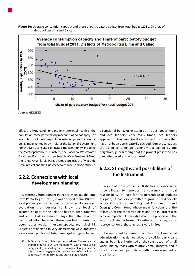
affectthelivingconditionsandenvironmentalhealthofthepopulation,theseparticipatorymechanismsdonotapply.Forexample,forallthelargepublicinvestmentprojectscurrentlybeingimplementedinLM,neithertheNationalGovernmentnortheMMLconsultedorinvitedthecommunity,includingthe ‘Metropolitano’ bus system, the TaboadaWastewaterTreatmentPlant,theHuachipaPotableWaterTreatmentPlant,the‘LineaAmarilla-ViaParqueRimac’project,the‘MetrodeLima’projectandtheHuascacochachannel,amongothers.98
6 .2 .2 . Connections with local development planning
DifferentlyfrompioneerPBexperiences(asthatonefromPortoAlegre-Brazil),itwasdecidedtolinkPBwithlocalplanninginthePeruvianexperience.Howeveranevaluation that permits to know the level ofaccomplishmentofthisrelationhasnotbeendoneyetand an initial assessment says that the level ofcommunication between these two instruments hasbeen rather weak. In urban spaces, municipal PBProjectsaredecidedinverydiscretionalwaysandoveraverysmallportionoftotalmunicipalbudgets.Indeed
98 Differently from mining projects where Environmental Impact Studies (EIA) are mandatory (with strong social components) for starting their development, regulations on infrastructure megaprojects indicate that no ‘social license’ is necessary for approving and starting the projects.
discretionalbehaviorexistsinbothsides(governmentand local leaders) since many times, local leadersapproachtothemunicipalitywithspecificprojectsthathavenotbeenparticipatorilydecided.Currently,leadersare asked to bring an assembly act signed by theneighbors,guaranteeingthattheprojectpresentedhasbeendiscussedatthelocallevel.
6 .2 .3 . Strengths and possibilities of the Instrument
Inspiteoftheseproblems,PBstillhasrelevancesinceit contributes to generate transparency and fiscalresponsibility (at least for the percentage of budgetsassigned). It has alsopermitted a groupof civil societyactors (from Local and Regional Coordination andOversight Committees whose main functions are thefollow-upoftheconcertedplansandthePBprocess)toachieveimportantknowledgeabouttheprocessandtheway the State performs. Nonetheless, the degree ofrepresentationoftheseactorsisverylimited.
Itisimportanttomentionthatthecurrentmunicipaladministrationhasdemocratizedthecall forparticipantagents,butitisstillorientedontheconstructionofsmallworks,mainlyroadswithrelativelysmallbudgets,anditisnotinvolvedintopicsrelatedwiththemanagementofurbanland.
Figure 20: Averageconsumtioncapacityandshareofparticipatorybudgetfromtotalbudget2011.DistrictsofMetropolitanLimaandCalloa
Source: MEF, INEI
56
7 .1 . WP2 . The ‘Línea Amarilla-Via Parque Rimac’ Express Highway
“Via Parque Rimac” is a large-scale transportinfrastructureprojectthataimstomergetransportation(connecting 13 districts of the city on the east-westdirection through a 9km. highway along the “Rimac”River) with public space issues. Its main publicizedobjectivewas to reach the international airport from‘Surco’ and ‘La Molina’ (LM’s richest districts) in 18minutes. The case-study evidences the use of severalPPP instruments that at the end of the day benefitprivate operators in the long term, affecting furthermunicipaladministrations.Theseinstrumentslegitimizeprojectsthroughthesignatureofcontractswithverylowpublicawarenesslevels.
The project scope has changed through 2 differentmunicipal administrations: LuisCastañeda’s, (2003-2010)andSusanaVillarán’s(2011-2014).Duringthefirstperioditwasnamed‘LineaAmarilla’anditaimedtodeveloponlythe9kmhighway(with2kmunderneaththeRimacRivernearby the historical center area). The project waspresented to theMetropolitan Council onMarch 2009through an existing PPPmanagementmechanism called‘iniciativaprivada’(privateinitiative)bytheOASBraziliancontractor.99Threemonthslater,onJune26th,theprojectwasdeclaredas‘of interest’withrelativelynohesitationand sixmonths later itwas granted toOAS through thedirectgrantingmechanism (‘adjudicacióndirecta’).WorkwasexpectedtobegininMay2010.
Even though the operator officially stated that theproject was considered as the first road infrastructuremegaproject that held a highly participatory process,affected populations have stated that the project wasplanned without the neighbors’ agreement. Lots ofcontestationtotheprojectrose,fromsuspicionsaboutthetransparency of the concession to demonstrations fromaffectedpopulations fromthe ‘Margen IzquierdadelRioRímac’MIRR area (Left Margin of the Rimac River)whowere never consulted about their eventual reallocation
99 Through the ‘iniciativa privada’ mechanism, private contractors can directly propose and develop projects of public interest.
(morethan1000families).100Thisconflictsuspendedtheproject until the Castañeda Administration mandatefinishedinDecember2010.
When the new administration (claimed to be moresocially oriented) took power in 2011, a contractrenegotiationprocessstartedinordertomodifytheprojectand include amore integral intervention perspective. Inadditiontotheoriginalcomponentsoftheproject(onlyaroadandtunnel)therenegotiationoftheconcessionimpliedtherecoveryof6kmoftheRimacriverfront,thedevelopmentofa25ha.parkandtwonewroadinterchanges.
Toachievethesenewgoals,budgetswereraisedfrom571Mto703MUSDandtheconcessionperiodwasextendedfrom30to40years.Intherenegociationprocessitwasalsodecided that7%of the toll incomewouldbe transferredback toMML, diverging from the original contract thatprovisionedfortheMMLtogiveup100%ofthatincome.Thenumberofaffectedfamilieswasreducedfrom1350to950 families, and theminimum compensation increasedfrom5000USDto30000USD.Twosocialhousingcomplexes“Acomayo”and“PatioUnión”werespecificallyimplementedinordertoprovidehousestothosefamiliesthatvoluntarilywoulddecidetobereallocated.
Transport network features
Twoinfrastructurecomponentshavebeenpackagedandsold intothesameLA-VPRconcession:therefurbishmentandmanagementofanexisting16kmhighwaycalled‘ViadeEvitamiento’(bluelineinfigure19)andthedevelopmentofthe9kmnewhighway(proper‘ViaParqueRimac’project–redlineinfigure19).Nevertheless,theytendtoperformasseparateroadsystems: the firstone, ‘ViadeEvitamiento’(VE)developedandmanagedbytheMMLformanyyears,hasmostlyattendedthenorth-southdemandbyconnectingitsthreemostimportantregionalconnections(‘PanamericanaNorte’,‘PanamericanaSur’and‘Central’highways);andthesecondone,LA-VPR,willconnecttheexistingVEwithCallaointheeast-westdirection.Indeedbothinfrastructureswillpay2independenttolltickets,bothofthemcollectedbytheconcession(thefirstonesinceFebruary2013andthesecondoneaftertheVPRcomponentisdelivered).
100 The WP3 case study makes a detailed analysis of the MIRR area and a number of social aspects related to LA-VPR.
Case-studies7
57
7TheRoleoftheCityGovernmentFinancesandVenuesofParticipationwithintheDecentralizationProcess

concession is basically allocating 80% of the roadinfrastructure budget on `Via Parque Rimac’ whichconcentratesonly6.2%oftheexpecteddemandfor2010and 22.6% by 2040 (the other 93.8% of the expecteddemand in2010and77.4%by2040comesfrom‘ViadeEvitamiento’whichhasalreadybeenoperative formanyyears and represents only about 5%of the ‘Via ParqueRimac’investmentamount).
Fiscal capacities of the Metropolitan Municipality (MML)
Ithasbeenstatedthatthefinancial-managerialschemefollowedbytheViaParqueRimacprojectisaconsequenceofthelackofcapacityfromMMLtoself-financeprojectsofthisscale;soperformingaconcessionofthattypewastheonlyremainingoption.“Itisthefirsttimethatacontractofthat magnitude is signed, and the first time that themunicipalitydoesnotputanymoneyfordevelopingsuchaproject”.102 Thebudget forMetropolitan Lima is 460M
102 Declaration from Luis Castañeda. In: http://www.larepublica.pe/node/232291/print
Financial aspects
TheMML is giving up the ‘Evitamiento’ toll system,whichisthemostprofitableinthecountry(70%ofthetotaltoll income from theMML). Calculationsmade byOASindicateapproximately4170MUSDafteryear30ingrossrevenuefortheconcession.101Itisinterestingtomakeanevaluation of the LA-VPR contract in comparison withanother project called ‘ViasNuevas de Lima’ (2013) forunderstanding the difference that contract terms andbenefitscanacquire.While‘ViasNuevasdeLima’givesup30%ofthetotaltollincomefromtheMMLfora590MUSD(30yearconcession),LAaimedtogaveup70%ofthesameincomefora571MUSDconcession(30yearsaswell).
Although93%oftheincomefrombothhighwayswillgoto the same concessionaire, investments at ‘Via deEvitamiento’ represent less than 5% of the total. The
101 Indeed this calculation is rather conservative since it considers a 7.48% annual growth rate of toll income for the first year and a starting toll collection of less than 50M USD for 2013; while according to EMAPE, between 2011 and 2012 toll income for the referred VE toll point has grown 13.89%, making more than 60M USD in 2012.
Figure 21: LA-VPRprojectlayout
Source: Self developed.
58

USD(oneofthelowestconsideringothercapitalcitiesofthe region, and any other region in Peru in per capitaterms).In2011ithasspentonly60.4MUSDintransportinfrastructureprojectsandbudgeted88.4MUSDfor2012(includingdebtservicingfrompreviousandfutureprojects).ConsideringthatscenarioitwasverydifficultforMMLtosustainsuchaprojectwithitsownfundsortorequestanewcreditline.
7 .2 . WP3 . The Left Bank of the Rimac River (MIRR)
TheMIRRisalowincomeresidentialarealocatednearbythecitycenter(seefigure20),betweentheRimacRiverandtheArgentinaAvenue,oneofthemostimportantindustrialaxisinLM.Itwaspopulatedduringthe1940sand1950sandwascharacterizedbytheformationofsettlementsinunfavorablelocations(priortotheoccupation,theareawas
a landfill called ‘ElMontón’).103 The areawas a formergarbagedumpandthefirstsettlersweredevotedtothebreedingofpigs,itiscurrentlythemaincenterofrecyclingofpaperandpaperboardfromLima.
There are processes that have been important forgeneratingsocialmobilizationsinLMandhaveinfluencedtheurbanterritorialconsolidationoftheMIRR:
a. At thebeginningof the1970s,agroupofpeopletookthelandofanabandonedbrickfactoryattheindustrialareanexttotheMIRRsettlement.Thesepeople understood that it did not constitute aninvasionofprivatepropertybuttherescueoflandthat belonged to all Peruvians. Therefore, theoccupationwaspopularlynamedas ‘TheRescue’,beingamilestoneinthehistoryofPeruviansocial
103 Until the early 1960s, irregular settlements tended to occupy more central –but more difficult to develop– areas.
Source: Self developed.
Map Source: Census Blocks from INEI, 2007 Adjustedby:LisaStrauch,UvA
Figure 22: LocationoftheMIRR
MIRR
citycenter
59
7Case-studies

movements. Settlers from the Rescue made analliancewithothersettlementsoftheMIRR,formingthe “Front of the Rescuers’ and establishing analliancewiththeveryactivetradeunionmovementatthattime.
b. Afewyearsago,theMMLmanagedtoreallocatestreetvendorsfromtheoutskirtsofthehistoricalcentertothefirstblocksoftheArgentinaAvenue,creating the LasMalvinas fair that energized theeconomyoftheMIRR.
c. TodaytheMMLisimplementingtheLA-VPRmegaprojectthatinvolvedtherelocationoffamiliesandprovokedthepeople’sreactionindefenseoftheirproperty.
Reactions to ‘Via Parque Rimac’
In close relation to the LA-VPR,WP2 case study the‘PrimerodeMayo’neighborhoodhasbeenselectedasacase-studyaccordingtothedegreeofimpactandreactiontotheproject.The‘BarrioObreroPrimerodeMayo’isthefirstsettlementemergedattheMIR.
FollowingthenationaltrendmostorganizationsattheMIRRarecurrentlyformedaroundpragmaticinterestsandare not inspired by political-ideological objectives andorganizationsoftenlosetheirpurposeoncetheconsolidationoftheneighborhoodoccurs.However,asthepopulationisfacingapossiblereallocationinunfavorableconditionsduetoLA-VPR,theneighborhoodcouncilhasreactivatedandseveralorganizationshavetakenactionsfordefendingtherightsofthelocalpopulation.OnMarch18th2010hundredsofpeoplemadeademonstrationtothecitycenteragainstthe project andonMay 28th theywent to theNationalCongress,protestingagainstapossibleeviction.Thisactionindeed stopped the process for almost two years andeffectivelychangedtheprojectcompensationscheme.ThecaseoftheMIRRalthoughitisanexampleoflossofpoliticalvisionofthesocialmovementbut itshowedtheintrinsicvalue a base firmly united around a proposal forcompensation.
It is worth mentioning that the mobilization of TheRescue had a strong ideological base and occurred in aboomingmomentoftheneighborhoodmovementinLima,whilethedemonstrationsaftertheLA-VPRhaveoccurredin a period of decay of socialmovements.Nonetheless,their claims didn’t lose effectiveness in the defense ofspecific interestsmanaging to stop the execution of theprojectforaperiodandforcingarenegotiation.104
104 More related to economic compensations,
Overall people lament the lack of information, thecomplete state of uncertainty and the provision ofcontradictory information from authorities or officialswhich tends to aggravate the situation. The project isperceived to be implemented in a top-down mannerwithout consultationmechanisms. It has already causedand will continue generating social conflicts with thepopulation.Mostresidentsrelatethemegaprojectwiththedisappearanceofthesettlementandrejectitasathreattotheir lifelongeffortsconsidering that theirmainconcernwastheconsolidationoftheirhouses,theregularization/formalizationof theirproperty, and the improvementoftheir neighborhood. Since the announcement of theproject,residentslivewiththeuncertaintythattheymightbeevicted.Hence,theycannottakeindividualandcollectiveactionstoimprovethesettlement,reachingastandstill.
Inrelationtothecompensationprogram,itisperceivedthat the company and theMML pursue an inadequatehousingprogrammewhichdoesnotrespondtotheneedsof the affected population. Theminimum compensationschemethathasincreasedfroma5000USDtoa30000USD,isstillconsideredasnotfair.Althoughthesettlementsarecharacterizedbyahighresidentialdensity(severalfamiliesmayliveineachhouse)theprogramforeseestocompensateonlytheownerof thehouse.Someownersrentpartsoftheir houses and relocationwould deprive themof thissourceofincome.Sincethesettlementsarespacesforlivingbutalsoforworkinginformsofsmallshopsandworkshopsinsidethehouses,peoplewhousetheirhousesforeconomicactivities are worried that relocation might affect theirprofessionalactivityandincomegeneration.
7 .3 . WP4 . Three Scenarios for Metropolitan Lima for Year 2025
Duringrecentyearstwoprocesseshaveruninparalleltoanalyze the consequences of plausible climate changescenarios in LMswater governancewhere Cities for LifeForumhasbeenactivelyengaged.ThefirstprocesswasledbyaGerman-financedresearchprogrammewhoseobjectivewasthedevelopmentofclimatechangescenariosandwatersimulationmodels.ThesecondprocesshasbeeninitiatedbytheMMLinordertoconstructcitydevelopmentstrategiesand a climate change adaptation strategy (sponsoredbyAVINA).TheChance2Sustainprogrammehasalsoopenedupadiscussiononamorespatialperspectiveincitydevelopmentandwatergovernance,byframingandspatializingscenarioswithmappingmethods,whichcanhelpvisualizinginequitiesandindicateareasofwaterrelatedvulnerabilities.
60

Afterthreeyearsofconsultations,interviews,workshops,focus groups, seminars and round tables; a level ofconsensus has been reached and the bases for takingmeasures and actions for the adaptation facing seriousdroughts and intensive rainfalls in critical periods as ‘ElNiño’,‘LaNiña’or‘elDANA’havebeenset.
The two main scenarios that the diagnosis of the‘Estrategia deAdaptación al Cambio Climático de Lima’(MML)haselaboratedare–ononehand–droughtand–ontheotherhand–intensiverainfall.Inbothcases,theriseoftemperature would be almost 2 degrees105 and inconsequence,sealevelwouldriseatleast1centimeterperyear.Additionally, there isa thirdplausiblescenariothatcombines the first two: permanent droughtwith heavyrainfallsoccurringmoreoften.Accordingtokeyactors,thatisthemostprobablescenario.
Asshownintable4,accordingtothefirstscenario,theexpected impacts of heavy rainfalls are the increase ofoverflows, landslides, mudslides and floods (with 6%increase of rainfall per year and higher river flows)20aggravatedwiththeextrememeteorologicalconditionsofrecurringevents(ElNiño,Dana)andthemeltingofglaciers.However, there is an opportunity of changing daily lifepatternsfromanaridcitytothoseonesfromagreencity(withapotentialincreaseofagricultureareasandcoastalhillsinsideandoutsidethecityarea)withawarmerweather(openingnewopportunitiesforsummertourism).
Thesecondscenario(alsoshowninthetable4)maybetheworst,bycombiningthefirsttwoscenarios:permanentdroughtwith eventual extremeevents related to radicaltemperaturechangesandintenserainfallincrease.
Thethirdscenarioentailsthatconsideringthepresenceofmoreextremeandpermanentdrought(a10%annualrainfalldecrease)106waterscarcitywouldincrease,creatingconflicts related to the access to hydric resources andhidroenergy (68%of the countryenergy is generatedbywater sources). Considering current population growthtrends,ifper-capitawaterconsumptionisnotreducedanda more aggressive policy for recycling and reuse isestablished;water demandwould increase to a criticalsituation,relatedonceagain,withDandEsocioeconomicsectors,whicharethemostvulnerable.
Thesethreescenariosimplythatinsufficientsanitationand drainage infrastructure, as a result of a lack of
105 IPCC, Panel Intergubernamental de Cambio Climático
106 IWS, LiWa 2012. The information has been based on hydrologic modeling works made by Dr. Andra Bardossy and Alejandro Chamorro from IWS, Stuttgart University.
investmentinprevention,cancauseanincreaseofwatertransmitteddiseases.Also, rising temperature canboosttropicaldiseaseslikedengueandmalaria(forinstanceinApril2013,66denguecaseswheredetectedinTabladadeLurin in VillaMaría del Triunfo, a low-incomedistrict insouthernLM).107
Figure21pointsouttherelationshipbetweenpopulationanddensity increasesandwateravailability.Onceagain,themostaffectedpopulationswouldbethoseonesfromthenorth,eastandsouthperipheries.Theturnfrombluetolightbluecolorsrepresentsadecreasefrom50-150litersofdailywaterconsumptiontolessthan50liters.
Peru is one of the tenmost vulnerable countries inrelationtoclimatechange.108LMwillexperiencemanyoftheconsequences,makingwaterscarcityandheavyrainsissues of great concern. Considering the residentialoccupationoffloodablelandandveryinclinedhillsidesand gaps, with low quality buildings and roadinfrastructure and bridges exposed to landslides andfloods; structural vulnerability of Limawould increaseparticularly on hillsides with more than 20 degreegradients (where theMML is implementing the ‘BarrioMio’ upgradingprogram), zonesnext to rivers anddryravines as well as urban roads and basements notpreparedforintenserainfall(duetoalackofdrainage).Someoftheplausibleimpactsare:
– Areductioninavailabilityofandaccesstowater,andanincreaseindependencyonrainandgroundwater(causingrationingduringdrought);
– increasedlevelsofwaterpollution;
– reducedhydropowergeneration;
– increasingunsatisfieddemandsforwaterandenergy,leadingtogreaterconflictsonwaterandlanduse;
– reallocation of large numbers of people due toclimaticdisplacementssuchastidalwavesandsealevelrises.
– anincreaseintheincidenceofwaterbornediseasesasaresultoftheuseofpollutedwater,lowerhygienelevelsasaresultofwatershortages,andincreasedENSOrelatedflooding.
107 In: http://peru21.pe/actualidad/suben-66-casos-dengue-villa-maria-triunfo-2125876
108 Tyndall Centre for Climate Change Research (2004). W Neil Adger, Nick Brooks, Graham Bentham, Maureen Agnew and Siri Eriksen, New Indicators of Vulnerability and Adaptive Capacity. Tyndall Project IT1.11. Technical Report 7. UK: Tyndal Centre.
61
7Case-studies

Conclusions
Themainconclusionthatcomesoutofbothprojectsisthat themainscenario isuncertainty:noscientific truthexistsabouttheclimatechangescenarioforLimain2025or2040.
Even though these processes used concertacion andsocialconstructionofknowledge,theactorscouldidentifyaneglectingattituderegardingriskingeneralandclimaticriskinparticular.Therearedifferentriskperceptionsthaningeneralarenotveryaccepted.Thekindsofincludedandexchanged knowledge differed considerably butrepresenting interesting points for comparing ideas onadaptivemanagementandtheroleofknowledgebuilding.
Therearespacesofcoordinationandparticipationbuttheyare still incipientand require tobe institutionalized.Underthosespaces,mandatedbylaw,aprocessofsocialconstruction of knowledge contributed to designmetropolitan water governance and climate changeadaptationstrategies.Ouranalysis focusedspecificallyonthe extent to which concertacion processes allow the
inclusion of a wider range of actors, discourses andknowledge in metropolitan governance and adaptationstrategies, and later on, how they influencepriorities indecision-making processes.Concertacion processes offerpossibilitiesofmutualunderstandingandbuildingconsensusthroughtheinclusionofawiderrangeofactorsandvarioustypesofknowledgeintothediscussionsanddialogues.
Key discourses in water governance were identifiedamongactorsfromtheLimawatergovernancenetwork,onthebasisofworkshopdiscussionsandindividualinterviews(seeMiranda Sara et al. 2011).109 The main discoursesincludeaviewonwaterasan“economicgood”,a“humanright”,a“rightofnatureforallbeings(human/ecosystem)”and/or“(drinkingwater)sector”.Actorsintheconcertacionprocesses also identified development as “pro-growth”,“pro-poor”,“pro-life/green”and“sectoral(mainlypro-largescale water infrastructure investments)” discourses;associated to the so called public-private-partnerships.
109 The characterization refers to the model built up in Miranda Sara, Hordijk et al. 2011, Water Governance Key Approaches: an analytical framework, Chance2Sustain, EADI.
Source: Population census 2007 (INEI). Water consumption data 2007 (Sedepal); Population / water growth rates - Lima project
Figure 23: DensityscenariosandunequalwaterdistributioninLima
Moderatepopulationgrowth/increaseinwateravailability
Waterinlitrespercapitaperday
Others Others
<50
50-145
145-230
230-400
>400
Noprovision
Nopopulation
Nodata
Noprovision
Nopopulation
Nodata
Kilometers
02.55101520
N
<50
50-145
145-230
230-400
>400
Waterinlitrespercapitaperday
Considerablepopulationgrowth/Decreaseinwateravailability
62

Double discourseswhere also identified, betweenwhatparticipants stated into the workshops and what theirinstitutionslaterdid.
InthecaseofLM,governmentactors,particularlyfromthe central government, often apply a dominant “pro-growth” combined with a “pro-sector” discourse; anddecision-making processes are considered as nottransparent or concerted. However, metropolitangovernment and its related institutions, aswell as civilsocietyorganizations,aregraduallytakinga“pro-poor”and“pro-life/green”focuswithatendencytoopentransparentspaces for concertation. The water company takes acombined “pro-sector” and technocratic approach byfollowing the hierarchical centralized decisions fromnational government. It can be stated that the mainvulnerability of LM is an institutional vulnerability sinceterritorialmanagementinthecityishighlycentralizedandnotarticulatedfromwaterand(climatic)riskmanagement:
Thediscussionof theseanalysisand theconcertacionprocessesfortheconstruction,validationandtransferofinclusive climate scenarios (combining various types ofknowledge) has contributed to expand the actors’opportunities of acceptation andmutual understanding,building up consensus, developing measures andagreementsforcollaborativeactionovertimeandbringingin knowledge fromdifferent territorial and spatial scalelevelswithdiversewateranddevelopmentdiscoursesanddifferentterritorialandcityvisions.Infact,anewquestionrelatedtothefutureofthemetropolitancityandthemacroregioncanberaised:howtointegrateandharmonizeurbangrowth,riskmanagement,natureconservationandhydroenergygenerationwithanequitable,ecoefficient,safeandintegratedwatermanagement(fromtheupperbasintotheocean,passingthroughtheMetropolitanCity)?
7 .4 . WP5 . ‘Institutional Knowledge and Technology Management in Callao .110
Since2009,theRegionalGovernmentofCallao,throughthe Spatial Conditioning Office as part of the RegionalOfficeofBudget,PlanningandSpatialConditioning,takesup the challenge to develop a number of documents inconsultationwiththeProvincialMunicipalityofCallaoandseveral districtmunicipalities. They furthermore consultwith public institutions such as the Peruvian Marineinstitute IMARPE, the Directorate of Hydrography and
110 Based on the WP5 report on Callao by Consuelo Mugurazu.
NavigationHIDRONAV, the national port authority APN,privatecompanies,andcivilsociety.
Themain knowledge products are divided into threeimportant processes (executed by i.e. the SpatialConditioningOffice)
– Processofspatialplanning
– Processofdelineatingboundaries
– Process of information gathering for the spatialdatabase–GIS
Inordertocentralizeandshareall spatialproducts,aTIC-GIS product has been developed for integratingcomputing tools, internet and communications. Thisproduct is built on a GIS platform server and is called:Regional Spatial Information System (SITR). The mainobjectives of the SITR are to systematize the productsdeveloped;tohaveaGISmapserverandametadataserver;to manage the spatial databases for decision-makingprocesses; topublishtheproducts forthebenefitof theinstitutionalstructures,localgovernmentsandpublicandprivate institutions; to provide information that guidesspatialplanningandurbandevelopment; topasson theactions of demarcation and spatial organization; tocontribute to disaster risk management; to providefeedbackandcomplywithPeruvianregulationsonspatialdata.TheSITRcontainsdiverseknowledgegeneratedbythe Spatial Conditioning Office, such as accurateinformation,maps,databaseandmetadataof EcologicalEconomicZoningandboundaries;accurateinformationandmapsforthespatialorganizationoftheVentanilladistrict;databases,mapsandspatialcataloguesforPorcinoPark,Mi Perú, hazards in human settlements and historicalmonumentsandruinousproperties.
Althoughlegislationonspatialplanningisnotclearandexplicit(oftenusingconfusingtermsasspatialconditioning,spatialorganization,environmentalandlandmanagement,etc.) it was possible to conduct studies and generateimportantinformationinCallao.ThisinformationisnotonlyusefulfortheRegionalGovernmentofCallao,butalsoforthemunicipalities,publicinstitutions,theprivatesector,andcivilsociety.Theknowledgeproductsbecomemanagementand guiding instruments for the development andimplementationofurbanspatialplanning,environmentalrisksmanagementoractionsofdemarcation.Forinstance,theMZEEofCallaowas incorporated inthestudyontheChillon watershed proposed by the multi-sectorialcommissionforspatialplanningoftheChillónriverbasin.Also,theSpatialConditioningofficehasbeencoordinatingwith the IMP its participation on the spatial planning ofChillón,wheretheMZEEproducthasbeingincorporated.
63
7Case-studies
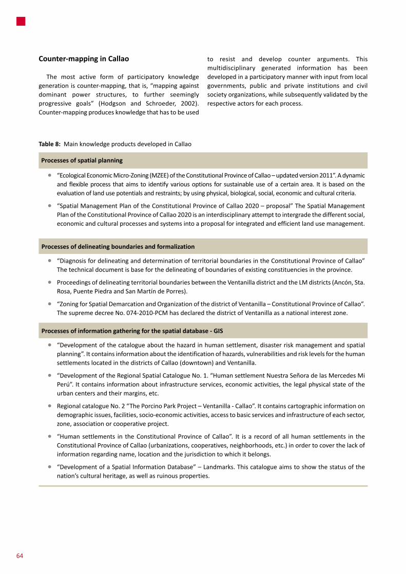
Processes of spatial planning
• “EcologicalEconomicMicro-Zoning(MZEE)oftheConstitutionalProvinceofCallao–updatedversion2011”.Adynamicand flexibleprocess thataims to identifyvariousoptions forsustainableuseofacertainarea. It isbasedontheevaluationoflandusepotentialsandrestraints;byusingphysical,biological,social,economicandculturalcriteria.
• “SpatialManagementPlanoftheConstitutionalProvinceofCallao2020–proposal”TheSpatialManagementPlanoftheConstitutionalProvinceofCallao2020isaninterdisciplinaryattempttointergradethedifferentsocial,economicandculturalprocessesandsystemsintoaproposalforintegratedandefficientlandusemanagement.
Processes of delineating boundaries and formalization
• “DiagnosisfordelineatinganddeterminationofterritorialboundariesintheConstitutionalProvinceofCallao”Thetechnicaldocumentisbaseforthedelineatingofboundariesofexistingconstituenciesintheprovince.
• ProceedingsofdelineatingterritorialboundariesbetweentheVentanilladistrictandtheLMdistricts(Ancón,Sta.Rosa,PuentePiedraandSanMartíndePorres).
• “ZoningforSpatialDemarcationandOrganizationofthedistrictofVentanilla–ConstitutionalProvinceofCallao”.ThesupremedecreeNo.074-2010-PCMhasdeclaredthedistrictofVentanillaasanationalinterestzone.
Processes of information gathering for the spatial database - GIS
• “Developmentofthecatalogueaboutthehazardinhumansettlement,disasterriskmanagementandspatialplanning”.Itcontainsinformationabouttheidentificationofhazards,vulnerabilitiesandrisklevelsforthehumansettlementslocatedinthedistrictsofCallao(downtown)andVentanilla.
• “DevelopmentoftheRegionalSpatialCatalogueNo.1.“HumansettlementNuestraSeñoradelasMercedesMiPerú”.Itcontainsinformationaboutinfrastructureservices,economicactivities,thelegalphysicalstateoftheurbancentersandtheirmargins,etc.
• RegionalcatalogueNo.2“ThePorcinoParkProject–Ventanilla-Callao”.Itcontainscartographicinformationondemographicissues,facilities,socio-economicactivities,accesstobasicservicesandinfrastructureofeachsector,zone,associationorcooperativeproject.
• “Human settlements in theConstitutional ProvinceofCallao”. It is a recordof all human settlements in theConstitutionalProvinceofCallao(urbanizations,cooperatives,neighborhoods,etc.)inordertocoverthelackofinformationregardingname,locationandthejurisdictiontowhichitbelongs.
• “DevelopmentofaSpatialInformationDatabase”–Landmarks.Thiscatalogueaimstoshowthestatusofthenation’sculturalheritage,aswellasruinousproperties.
Table 8: MainknowledgeproductsdevelopedinCallao
Counter-mapping in Callao
The most active form of participatory knowledgegenerationiscounter-mapping,thatis,“mappingagainstdominant power structures, to further seeminglyprogressive goals” (Hodgson and Schroeder, 2002).Counter-mappingproducesknowledgethathastobeused
to resist and develop counter arguments. Thismultidisciplinary generated information has beendevelopedinaparticipatorymannerwithinputfromlocalgovernments, public and private institutions and civilsocietyorganizations,whilesubsequentlyvalidatedbytherespectiveactorsforeachprocess.
64
state that consolidating a public management with aterritorializedfocusisstilladifficulttasksincesectorbasedapproaches biased by strong centralist impetuses havetended to historically overpower more territoriallyintegratedorautonomousgovernanceschemes.
At both national and local levels, the current publicpolicy package relies on the promotion of privateinvestments in order to reach a ‘modernity’ andcompetitivenesslevelthatwouldeventuallysustainmoresocially oriented or pro-poor approaches. The dominantrationalehasnotgivenanyprioritytolongtermplanning,buthasconsolidatedmarketorientationsthroughseveralderegulation policies (in the form of administrativesimplificationinstruments),theweakeningofregionalandlocal institutionalityandtherelianceonmegaprojectsascitydevelopmentengines;whichhasexacerbatedconflictsandgeneratedcorruptionproblems ina contextofnon-sufficientinstrumentsofurbanandterritorialmanagement.InLMtheseactionsoccurinacontextwherepureprofitorientedactionsperformwithnocounterpartfromstrongplanning approaches or socially oriented policies,whichexacerbatessocio-spatialsegregation.
Nevertheless, “pro-poor” and “pro-life” focuses haverecentlystartedtobecomemorerelevantwithinthenewmetropolitan administration. These approaches arematerializing in ongoing large-scale programs such as‘Barrio Mio’ that aims to build urban infrastructure inmarginalareas.Buttheyarestillveryfocusedonsmallerneighborhood scales and run in parallel with moreintegratedmetropolitanvisionsthatarestilldrivenbyrealestatecorporativepowers.Similarly,itshouldbenotedthatrecentlyopenedparticipatoryspacessuchasparticipatorybudgeting, do not have a significant impact on coredecision-makingprocessesat the localandmetropolitanlevels. They are more related to decisions on smallinvestmentproject,notapplyingtolargerprojectsinwhich(affected) populations commonly remain marginalized.Differently from the past, when effective connectionchannelsbetweenthestateandorganizations,participatorybudgeting and concerted development planning havebecome almost the only official instrument. Its designlimitations have caused organizations’ voices to loselegitimacyinrelationtoissuessuchasdecisionsonlarge-scale infrastructure provision, feeling that the onlyremaininginterlocutionchannelissocialunrest.
Cities are the territorial expression of a model ofeconomicdevelopment that includes space ina fixedform. The classic phrase from Margaret Thatcher,“Thereisnosuchthingassociety.Thereareindividualmenandwomenandtherearefamilies”111explainsthesocial and economicmodel that has constructed themodernurbanparadigmappliedinLMsincethe1990s.Ithasprioritizedthecompetitionbetweenindividuals,enterprisesandterritoriesoversolidarity,collaborationandsharedresponsibility.
The dominant visions that governmental actors keepapplyingonLM’sdevelopmentthatcanbemostlytypifiedas “pro-growth” and/or “pro-sector” since economicgrowth strategies aremostly channeled through sector/centralist-based policy actions with rather fragmentedterritorialapproacheswithnointegralvisionofthecityasawhole.Thereisadiversityofauthoritieswithoverlappingfunctionsthatgeneratesfragmentation,disarticulationandweakeningoftheroleofthestateinthecityatdifferentscalesofgovernment.Probably,themosteloquentcaseistherelationbetweenLimaandCallao.Althoughbothareconurbatedandformthesamemetropolitanregionthereexistsaverylimitedplanningandadministrativerelationshipregarding national-sectorial, regional or local spheres,whichgeneratesconstantoverlappingandevenconflict/competitionsituations.
There is also a strong bias towards putting nationalvisionsaheadofmetropolitanorlocalscaleones,especiallyin LM as Peru’s capital city that represents a strategicpolitical arena for national government actors sinceonethird of the whole voting population live there (oftenthrough the direct intervention of ministries or thepresidenthimself).112Thosepoliticalpressureshavebeeneffective in undermining the ongoing decentralizationprocessesthatdoesnotimplyagenuinepowertransferencetosub-nationallevelsinLM.Thisreflects,forinstance,intheconflictiverelationshipoftheMMLwithSEDAPALandthe incapacity of themetropolitan government to takedecisions onwater infrastructure. Despite the relativelywellestablishedgovernmentsubdivision,itisimportantto
111 Margaret Thatcher, Interview for Woman‘s Own magazine. October 31, 1987.
112 The most important decisions and about 70% of the national budget are concentrated at the national level of government.
Conclusions8
65
8Conclusions
Additionally, the arrival of the global city dominantdiscourse to LM is specializing land uses in favor ofefficiency. It is operationalized by strong public privateinvestments in an unregulated environmentwhich havestrong impacts on the urban and social fabric, enablingspeculativebehaviorfromrealestateoperatorsinalreadyconsolidatedmiddle and high-income central areas anddeveloping profit oriented low-income “micro housing”initiatives that misunderstand the complexities of thedemand. In parallel, CBOs densify their originalneighborhoods (overcrowding them) through informalchannels.Intheseneighborhoodslandtraffickingisontheriseatamomentwhensocialorganizationstructureshavedecayedandlosttheirdirectlinkwiththestateapparatus.CBOsmobilizeininstrumentalwaysmorerelatedtotheirown specific agendas and organization structures havebeenatomizedtothepointthatdemandsarecoveredevenathouseholdlevels.
Although increasing socio-economic inequalities havegreat impacts in relation to housing, basic services andspatialsegregation,LMdoesnotcountwithsocio-spatialsegregation related policies for permitting greater socialand spatial integration, promotingmixed land uses andgeneratingmeetingspacesbetweendifferentsocialstrata.
Asthisreportshows,theterritorialdistributionofincomeremainscertainlycorrelatedwithdensityandparticularlyvulnerabilityissues.Unfortunately,issuessuchasclimatechangevulnerabilitieshavenotbeenwellacknowledgedin amomentwhile new kinds of informal urbanizationtend to occupy evenmore inadequate areas and newsituationsofgreatriskforthecity’slowestincomefamiliesareunderconfiguration.
Thecityreporthastoldusataleoftwodifferentcities.Oneisdesperatelytryingtoinsertintoa(secondorthirdorder?) global networkof citiesby receiving thebulkofinvestmentsanddevelopmentefforts;andtheotheronehas been not only left aside by policy makers but isperforming as the main absorber of the negativeexternalities of the first. Instead of getting closer to aconvergence point, the implementation of neoliberalpolicieshascontributedtopolarizatethem.Asithasbeensaidduringthereport,thecurrentmainvulnerabilityofLMisinstitutionalinamomentwhenplanningschemeshavebeenalmostcompletelydismissedandanimportantpartofthecityadministration(anddecisions)havebeenputinthehandsofprofitorientedsectors,thefuturescenarioisnotveryoptimistic.
66

References9
Alfaro,A.(2008)LaHuellaEcologicadelasCiudadesenelPeru.In:Miranda, L. (ed). CONSTRUYENDO CIUDADES PARA LA VIDA:APORTESALACONSTRUCCIÓNSOSTENIBLEENELPERÚ.Lima:ForoCiudadesparalaVida.
Azpur,J.(2005)DescentralizaciónyregionalizaciónenelPerú,Lima:GrupoPropuestaCiudadana.
BebbingtonA.andM.Williams.2008.WaterandMiningConflictsinPeru.Mountain Research and Development28(3):190-195
Calderón,J.(1999)AccesoporlosPobresalSueloUrbanoyMercadoInmobiliarioenLimaMetropolitana,Cambridge:LincolnInstituteofLandPolicy.
Calderón,J.(2006)Mercadodetierrasurbanas,propiedadypobreza,Cambridge:LincolnInstituteofLandPolicy.
Calderón,J(2009)ElefectoMivivienda:políticadeviviendaparalaclasemediaydiferenciaciónsocial,Ecuador Debate. La cuestión de la vivienda hoy,Quito:CentroAndinodeAcciónPopularCAAP(76).
Caria, A. S. (2008) TÍTULOS SIN DESARROLLO: Los efectos de latitulacióndetierrasenlosnuevosbarriosdeLima,Lima:CentrodeestudiosypromocióndeldesarrolloDESCO.
CentroLabor(2013)CONFLICTOSPORLASOSTENIBILIDADHÍDRICADELACIUDADDELIMA.Chance2sustain.
Clichevsky, N. (2006) Regularizando la informalidad del suelo enAmérica Latina y el Caribe.Unaevaluación sober la basede13paísesy71programas,SantiagodeChile:UN,CEPAL.
CTLC (2001) PLAN ESTRATEGICO DE TRANSPORTE URBANO.PROYECTOS METROPOLITANOS INFORME FINAL. VOLUMEN I.LIMA:CONSEJODETRANSPORTEDELIMAYCALLAO.
DeSoto,H.(2000)ElMisteriodelCapital:¿Porquéelcapitalismotriunfaenoccidenteyfracasaenelrestodelmundo?Lima:ElComercio.
DURAND-LASSERVE,A;SELOD;H(2007)Theformalisationofurbanlandtenureindevelopingcountries.PaperpresentedattheWorldBank’s2007UrbanResearchSymposium,May14-16,WashingtonDC.
Endo,V.(2010)ApplyingtheLandGovernanceAssessmentFrameworkinamiddle-incomeeconomy:ThecaseofPeru.InDeininger,K.(etal.)INNOVATIONSINLANDRIGHTSRECOGNITION,ADMINISTRATION,ANDGOVERNANCE.Washington DC: The International Bank forReconstructionandDevelopment/TheWorldBank.
Escalante, C. (2012)WP3 SETTLEMENT FIELD REPORT (PER CITY)Margen Izquierda del Rio Rímac. INFORME DE CAMPO.Chance2sustain.
Filippi,M;Hordijk,M;Alegria, J;Rojas, J. (2013)Whenknowledgeintegration is the missing link in resilience to climate change:continuitiesandchangesinArequipa’swatergovernancesystem.Documentunderdevelopment.
Hodgson, D; Schroeder, R. (2002) Dilemmas of Counter-MappingCommunityResourcesinTanzania.In:DevelopmentandChange,Vol.33.
InstitutoNacionaldeEstadísticaeInformáticaINEI(2009)VCensodePoblaciónyXIdeVivienda
Instituto Nacional de Estadística e Informática INEI (2010) Perú:PrincipalesIndicadoresDepartamentales.
Hordijk,M.(2009)Peru’sParticipatoryBudgeting:ConfigurationsofPower,OpportunitiesforChange.In:TheOpenUrbanStudiesJournal,2009(2).
Ludeña, W. (2010) LIMA. REESTRUCTURACIÓN ECONÓMICA YTRANSFORMACIONESURBANAS.PERIODO1990–2005.Lima:PUCP.
MinistryofEnvironment(2005)GEOLimaandCallao2005:PerspectivesoftheUrbanEnvironment,MinistryofEnvironment,Peru.
MinistryofEnvironment(2010).“SecondCommunicationofPerutotheUNFCCC-UnitedNationsCombatClimateChangeConvention”(“SegundaComunicaciónNacionaldelPerúalaConvenciónMarcodelasNacionesUnidassobreCambioClimático”.)
MinisteriodeVivienda,ConstrucciónySaneamiento(2006)PLANESNACIONALESDEVIVIENDAYSANEAMIENTO2006–2015.
MirandaSara,L;Torres,R.(2011).¿Doinclusivescenarioscontributeto reduce water vulnerabilities facing Climate Change inmetropolitancities?PolicyBriefWP4.Chance2Sustain.
MirandaSara,L.(2012)FieldworkReport,WP4Lima.Chance2sustain.
Miranda Sara, L. Baud, I (2014) Knowledge building in adaptationmanagement:concertacionprocessesintransformingLimawaterandclimatechangegovernance.Tobepublished.
MOCICC (2009). Aportes desde la Sociedad Civil a la EstrategiaNacionaldeCambioClimático.
Mugurazu, C. (2012) Institutional knowledge and technologymanagementinCallao.Chance2sustain
MunicipalidaddeLimaMetropolitanaMML(2012)PlanRegionaldeDesarrolloConcertadodeLimaal2015.Lima:MML.
MVCS (2011) Insumos para impulsar la transferencia de riesgo dedesastrefrentealcambioclimáticoenelsectorvivienda.
Ramírez-Corzo,D.andRiofrío,G.(2006)Formalizacióndelapropiedadymejoramientodebarrios:bienlegal,bienmarginal,Lima:CentrodeestudiosypromocióndeldesarrolloDESCO.
Remy,M.I: (2010) DIAGNÓSTICO SOBRE LA EFECTIVIDAD DE LOSMECANISMOS PARTICIPATIVOS EN EL PROCESO DEDESCENTRALIZACIÓN,Unpublished document.
Riofrío, G. (1990) Producir la ciudad (popular) de los 90: entre elmercadoyelestado,Lima:
CentrodeestudiosypromocióndeldesarrolloDESCO.
Riofrío, G. (2010) Alan Garcia, Alcalde de Lima. In: Desarrollo, democracia y otras fantasias, Serie Perú Hoy(17)Lima:CentrodeestudiosypromocióndeldesarrolloDESCO.
Robles,L.(N.D.)Medicióndelsectorinformalapartirdeencuestasdehogares.INEI.
Saavedra,T.(2006)ExperienciasemblemáticasenlasuperacióndelaprecariedadypobrezaurbanasenAméricaLatinayelCaribe:accesoalsuelourbanoparalospobres,SantiagodeChile:UNCEPAL.
SEDAPAL(2009)PotableWaterandSewerageServices inLimaandCallao,OptimizedMasterPlan.Volume1.
VIVIENDA-PGT (2009)Gestiónde riesgosenvivienda,urbanismoysaneamiento–Presentaciónenreunióndetrabajo–MinisteriodeVivienda, construcción y Saneamiento – Programa de GestiónTerritorialAgosto2009
UNDP(2006)InformesobreDesarrolloHumanoPerú2006,Lima:UNDP.
References
67

EADIKaiser-Friedrich-Strasse11D-53113BonnTel.:(+49)228.2618101Fax:(+49)228.2618103www.eadi.orgwww.chance2sustain.eu
Chance2Sustainexamineshowgovernmentsandcitizensincitieswithdifferingpatternsofurbaneconomicgrowthmakeuseofparticipatory(orintegrated)spatial knowledgemanagement todirecturbangovernance towardsmoresustainable development. Consortium partners: European Association ofDevelopmentResearchandTrainingInstitutes(EADI,Germany),GovernanceforInclusiveDevelopment(GID)attheAmsterdamInstituteforSocialScienceResearch (AISSR-UvA, Netherlands), French National Center for ScientificResearch (CNRS, France), SchoolofPlanningandArchitecture (SPA, India),CitiesforLifeForum(FORO,Peru),CentroBrasileirodeAnáliseePlanejamento(CEBRAP,Brazil),NorwegianInstituteforUrbanandRegionalResearch(NIBR,Norway),UniversityofKwaZulu-Natal(UKZN,SouthAfrica)