city of salinas - california · september 27, 2017 at 2‐4pm in the city of salinas rotunda...
TRANSCRIPT

City of Salinas COMMUNITY DEVELOPMENT DEPARTMENT * 65 W. Alisal Street * Salinas, California 93901 * (831) 758-7206 *
Fax (831) 758-7215
DATE: September 8, 2017
TO: State Clearinghouse FROM: Jill Miller, Senior Planner
State Responsible Agencies City of Salinas
State Trustee Agencies Community Development Department
Other Public Agencies 65 West Alisal Street (Second Floor)
Interested Organizations Salinas, CA 93901
Telephone: (831) 758‐7206
Fax: (831) 775‐4258 Email: [email protected]
SUBJECT: Notice of Preparation – Salinas Central Area Specific Plan (CASP)
EIR CONSULTANT
Steve McMurtry, Principal Planner
De Novo Planning Group
1020 Suncast Lane, Suite 106
El Dorado Hills, CA 95762
Phone: (916) 580-9818
An Initial Study has been prepared for the proposed project and is attached to this Notice of Preparation (NOP).
The Initial Study, which is incorporated herein by reference, contains a description of the proposed project, a
map showing its location, and discussion of its probable environmental effects. Notably, the proposed project
is one of statewide, regional, or areawide significance, making the project subject to the requirements of Public
Resources Code section 21092.4. That statute provides that, for any such project, “the lead agency shall consult
with transportation planning agencies and public agencies that have transportation facilities within their
jurisdictions that could be affected by the project. Consultation shall be conducted in the same manner as for
responsible agencies pursuant to [CEQA], and shall be for the purpose of the lead agency obtaining information
concerning the project’s effect on major local arterials, public transit, freeways, highways, overpasses, on‐ramps,
off‐ramps, and rail transit service within the jurisdiction of a transportation planning agency or a public agency
that is consulted by the lead agency.” As used in section 21092.4, the term “As used in this section,
‘transportation facilities’ includes major local arterials and public transit within five miles of the project site
and freeways, highways, overpasses, on‐ramps, offramps, and rail transit service within 10 miles of the project
site.”
The Initial Study lists those issues that will require detailed analysis and technical studies that will need to be
evaluated and/or prepared as part of the EIR. The EIR will consider potential environmental effects of the
proposed project to determine the level of significance of the environmental effect, and will analyze these
potential effects to the detail necessary to make a determination on the level of significance.
Those environmental issues that have been determined to be less than significant will have a discussion that is
limited to a brief explanation of why those effects are not considered potentially significant. (See CEQA
Guidelines, § 15128.) In addition, the EIR may also consider those environmental issues, which are raised by
responsible agencies, trustee agencies, and members of the public or related agencies during the NOP process.

We need to know the views of your agency or organization as to the scope and content of the environmental
information germane to your agency’s statutory responsibilities or of interest to your organization in connection
with the proposed project. Specifically, we are requesting the following:
1. If you are a public agency, state whether your agency will be a responsible or trustee agency for the
proposed project and list the permits or approvals from your agency that will be required for the project
and its future actions;
2. Identify significant environmental effects and mitigation measures that you believe need to be explored in
the EIR with supporting discussion of why you believe these effects may be significant;
3. Describe special studies and other information that you believe are necessary for the City of Salinas to
analyze the significant environmental effects, alternatives, and mitigation measures you have identified;
4. For public agencies that provide infrastructure and public services, identify any facilities that must be
provided (both on‐ and off‐site) to provide services to the proposed project;
5. Indicate whether a member(s) from your agency would like to attend a scoping workshop/meeting for
public agencies to discuss the scope and content of the EIR’s environmental information;
6. Provide the name, title, and telephone number of the contact person from your agency or organization that
we can contact regarding your comments.
Due to the time limits mandated by State law, your response must be sent to and received by the City of Salinas by
the following deadlines:
For responsible agencies, transportation planning agencies, and public agencies that have transportation
facilities within their jurisdictions that could be affected by the project, not later than 30 days after you
receive this notice.
For all other agencies and organizations, not later than 30 days following the publication of this Notice of
Preparation. The 30‐day review period ends on October 9, 2017.
If we do not receive a response from your agency or organization, we will presume that your agency or organization
has no response to make.
Because the project is one of statewide, regional, or areawide significance, the City of Salinas as lead agency is
required to conduct at least one scoping meeting for the proposed project. (CEQA Guidelines, § 15082, subd.
(c)(1).) A public scoping meeting will be held during the public review period as follows:
1. September 27, 2017 at 2‐4pm in the City of Salinas Rotunda (located at 200 Lincoln Avenue, Salinas,
CA 93901).
Please send your response to Jill Miller – Senior Planner at the City of Salinas, 65 West Alisal Street, Salinas, CA
93901. If you have any questions, please contact Jill Miller – Senior Planner at (831) 758‐ 7206 or via email at
[email protected]. The Notice of Preparation and the Initial Study are available for review at the
City of Salinas Community Development Department located at 65 W. Alisal Street; at three Salinas
libraries including the Steinbeck Library located at 350 Lincoln Avenue, the El Gabilan Library located at
1400 N. Main Street, and the Cesar Chavez Library located at 615 Williams Road; and on-line on the City’s
website at: https://www.cityofsalinas.org/our-city-services/community-development/documents-public-
review.

PUBLICDRAFT
INITIALSTUDYANDNOP
FORTHE
CITYOFSALINAS
CENTRALAREASPECIFICPLAN(CASP)
SEPTEMBER7,2017
Preparedfor:
CityofSalinasCommunityDevelopmentDepartment65W.AlisalStreetSalinas,CA93901
Preparedby:
DeNovoPlanningGroup1020SuncastLane,Suite106ElDoradoHills,CA95762(916) 949‐3231
D e N o v o P l a n n i n g G r o u p
A L a n d U s e P l a n n i n g , D e s i g n , a n d E n v i r o n m e n t a l F i r m


PUBLICDRAFT
INITIALSTUDYANDNOP
FORTHE
CITYOFSALINAS
CENTRALAREASPECIFICPLAN(CASP)
SEPTEMBER7,2017
Preparedfor:
CityofSalinasCommunityDevelopmentDepartment
65W.AlisalStreetSalinas,CA93901
Preparedby:
DeNovoPlanningGroup1020SuncastLane,Suite106
ElDoradoHills,95762(916) 949‐3231


SALINASCASP NOP
NOP‐PAGE1
NOTICE OF PREPARATION
TO: State Clearinghouse FROM: Jill Miller, Senior Planner State Responsible Agencies City of Salinas State Trustee Agencies Community Development Department Other Public Agencies 65 West Alisal Street (Second Floor) Interested Organizations Salinas, CA 93901
Telephone: (831) 758‐7206 Fax: (831) 775‐4258 Email: [email protected]
SUBJECT: Notice of Preparation – Salinas Central Area Specific Plan (CASP)
An Initial Study has been prepared for the proposed project and is attached to this Notice of
Preparation (NOP). The Initial Study, which is incorporated herein by reference, contains a description
of the proposed project, a map showing its location, and discussion of its probable environmental
effects. Notably, the proposed project is one of statewide, regional, or areawide significance, making
the project subject to the requirements of Public Resources Code section 21092.4. That statute
provides that, for any such project, “the lead agency shall consult with transportation planning
agencies and public agencies that have transportation facilities within their jurisdictions that could be
affected by the project. Consultation shall be conducted in the same manner as for responsible
agencies pursuant to [CEQA], and shall be for the purpose of the lead agency obtaining information
concerning the project’s effect on major local arterials, public transit, freeways, highways, overpasses,
on‐ramps, off‐ramps, and rail transit service within the jurisdiction of a transportation planning
agency or a public agency that is consulted by the lead agency.” As used in section 21092.4, the term
“As used in this section, ‘transportation facilities’ includes major local arterials and public transit
within five miles of the project site and freeways, highways, overpasses, on‐ramps, offramps, and rail
transit service within 10 miles of the project site.”
The Initial Study lists those issues that will require detailed analysis and technical studies that will
need to be evaluated and/or prepared as part of the EIR. The EIR will consider potential environmental
effects of the proposed project to determine the level of significance of the environmental effect, and
will analyze these potential effects to the detail necessary to make a determination on the level of
significance.
Those environmental issues that have been determined to be less than significant will have a
discussion that is limited to a brief explanation of why those effects are not considered potentially
significant. (See CEQA Guidelines, § 15128.) In addition, the EIR may also consider those
environmental issues which are raised by responsible agencies, trustee agencies, and members of the
public or related agencies during the NOP process.
NOP SALINASCASP
NOP‐PAGE2
We need to know the views of your agency or organization as to the scope and content of the
environmental information germane to your agency’s statutory responsibilities or of interest to your
organization in connection with the proposed project. Specifically, we are requesting the following:
1. If you are a public agency, state whether your agency will be a responsible or trustee agency
for the proposed project and list the permits or approvals from your agency that will be
required for the project and its future actions;
2. Identify significant environmental effects and mitigation measures that you believe need to
be explored in the EIR with supporting discussion of why you believe these effects may be
significant;
3. Describe special studies and other information that you believe are necessary for the City of
Salinas to analyze the significant environmental effects, alternatives, and mitigation measures
you have identified;
4. For public agencies that provide infrastructure and public services, identify any facilities that
must be provided (both on‐ and off‐site) to provide services to the proposed project;
5. Indicate whether a member(s) from your agency would like to attend a scoping
workshop/meeting for public agencies to discuss the scope and content of the EIR’s
environmental information;
6. Provide the name, title, and telephone number of the contact person from your agency or
organization that we can contact regarding your comments.
Due to the time limits mandated by State law, your response must be sent and received by the City of
Salinas by the following deadlines:
For responsible agencies, transportation planning agencies, and public agencies that have
transportation facilities within their jurisdictions that could be affected by the project, not
later than 30 days after you receive this notice.
For all other agencies and organizations, not later than 30 days following the publication of
this Notice of Preparation. The 30‐day review period ends on October 9, 2017.
If we do not receive a response from your agency or organization, we will presume that your agency
or organization has no response to make.
Because the project is one of statewide, regional, or areawide significance, the City of Salinas as lead
agency is required to conduct at least one scoping meeting for the proposed project. (CEQA
Guidelines, § 15082, subd. (c)(1).) A public scoping meeting will be held during the public review
period as follows:
1. September 27, 2017 at 2‐4pm in the City of Salinas Rotunda (located at 200 Lincoln Avenue,
Salinas, CA 93901).
Please send your response to Jill Miller – Senior Planner at the City of Salinas, 65 West Alisal Street,
Salinas, CA 93901. If you have any questions, please contact Jill Miller – Senior Planner at (831) 758‐
7206 or via email at [email protected]. The Central Area environmental documents are
available for review at the above address.

INITIALSTUDY–SALINASCASP September2017
PAGEI
TABLE OF CONTENTS
INITIALSTUDYCHECKLIST.........................................................................................................................1
ProjectTitle...................................................................................................................................................................1
LeadAgencyNameandAddress..........................................................................................................................1
ContactPersonandPhoneNumber....................................................................................................................1
ProjectSponsor’sNameandAddress.................................................................................................................1
ProjectEntitlements..................................................................................................................................................1
Introduction..................................................................................................................................................................2
ProjectLocationandSetting..................................................................................................................................3
PlanningBackground................................................................................................................................................5
ProjectDescription....................................................................................................................................................7
ApprovalsRequired(e.g.,permits,etc.)..........................................................................................................17
ENVIRONMENTALFACTORSPOTENTIALLYAFFECTED...................................................................31
DETERMINATION..........................................................................................................................................31
EVALUATIONOFENVIRONMENTALIMPACTS................................................................................32
ENVIRONMENTALCHECKLIST................................................................................................................35
I.AESTHETICS.............................................................................................................................................................35
II.AGRICULTUREANDFORESTRESOURCES................................................................................................39
III.AIRQUALITY........................................................................................................................................................42
IV.BIOLOGICALRESOURCES................................................................................................................................44
V.CULTURALRESOURCES.....................................................................................................................................46
VI.GEOLOGYANDSOILS........................................................................................................................................47
VII.GREENHOUSEGASEMISSIONS...................................................................................................................51
VIII.HAZARDSANDHAZARDOUSMATERIALS............................................................................................52
IX.HYDROLOGYANDWATERQUALITY..........................................................................................................54
X.LANDUSEANDPLANNING..............................................................................................................................56
XI.MINERALRESOURCES......................................................................................................................................60
XII.NOISE......................................................................................................................................................................61
XIII.POPULATIONANDHOUSING......................................................................................................................63
XIV.PUBLICSERVICES............................................................................................................................................64
XV.RECREATION.......................................................................................................................................................65
XVI.TRANSPORTATIONANDTRAFFIC............................................................................................................66

INITIALSTUDY–SALINASCASP September2017
PAGEII
XVII.TRIBALCULTURALRESOURCES..............................................................................................................68
XVIII.UTILITIESANDSERVICESYSTEMS.......................................................................................................69
XVIV.MANDATORYFINDINGSOFSIGNIFICANCE......................................................................................71
REPORTPREPARERS...................................................................................................................................73
REFERENCES....................................................................................................................................................75

INITIALSTUDY–SALINASCASP September2017
PAGE1
INITIAL STUDY CHECKLIST
PROJECT TITLE Central Area Specific Plan (CASP)
LEAD AGENCY NAME AND ADDRESS City of Salinas Community Development Department 65 W. Alisal Street Salinas, CA 93901
CONTACT PERSON AND PHONE NUMBER Jill Miller, Senior Planner Community Development Department City of Salinas 65 West Alisal Street (Second Floor) Salinas, CA 93901 Telephone: (831) 758‐7407 Fax: (831) 775‐4258 Email: [email protected]
PROJECT SPONSOR’S NAME AND ADDRESS Hugh Bikle, Hugh Walker, Matt Lewis, and Ray Harrod c/o Hugh Bikle, Thrust IV, Inc. 1540 Constitution Boulevard Salinas, CA 93906 Tel: (831) 443‐0417 Fax: (831) 443‐6535
PROJECT ENTITLEMENTS The City of Salinas will be the Lead Agency for the proposed Central Area Specific Plan (hereinafter
referred to as proposed project, Specific Plan, or CASP), pursuant to the State Guidelines for
Implementation of the California Environmental Quality Act (CEQA), Section 15050. Actions that would be
required from the City include, but are not limited to the following:
Certification of the Environmental Impact Report (EIR) and adoption of the Mitigation Monitoring
and Reporting Program (MMRP); and
Approval of the proposed Central Area Specific Plan (CASP)
An application for rezoning of the Specific Plan Area from New Urbanism Interim (NI) with a Specific Plan
Overlay to the zoning designations laid out in the CASP within the applicable Specific Plan Overlay District
has not been filed at this time, but is required to be filed. A Development Agreement application,
Tentative Parcel Map application, and Vesting Tentative Tract Map application would also need to be filed.
However, the EIR will analyze the total impacts of the CASP, including these applications yet unfiled, so
that future filings will not require separate environmental analysis as long as the development proposed
does not substantially deviate from the approved CASP.

INITIALSTUDY–SALINASCASP September2017
PAGE2
INTRODUCTION The proposed CASP will establish the land use planning and regulatory guidance, including the land use
and zoning designations and policies, development regulations, and design standards, for the
approximately 760‐acre Specific Plan Area. The Specific Plan will serve as a bridge between the Salinas
General Plan and individual development applications in the Specific Plan Area, applying—and adding
greater specificity to—the goals, policies and concepts of the General Plan for that area. The Specific Plan
provides a complete blueprint for development of the Specific Plan Area, including:
A description of proposed land uses;
Policies, regulations and standards to support the Specific Plan;
Infrastructure needed to support the Specific Plan; and
Implementation and administrative processes needed for plan development.
The Specific Plan has been crafted to be consistent with overall community goals as expressed in the
General Plan, as well as more specific policies and implementation measures contained in other
documents. The City of Salinas Zoning Code requirements will apply to development applications and
property within the Specific Plan Area unless specifically superseded by the development regulations or
design standards contained in the Specific Plan.
The Specific Plan will establish the overall land use concept and development framework for the Specific
Plan Area. The specific planning process involves the following analyses: planning, environmental,
financial, and engineering. The process also includes public comment and contribution; developing a
document that will guide the future development of the Specific Plan Area; and subsequent
implementation measures recommended by the Specific Plan. The contents of the Specific Plan reflect
the physical characteristics of the Specific Plan Area, as well as the City’s goals for land use change in
general and for the Specific Plan Area in particular. The Specific Plan establishes and/or identifies:
The context for the Specific Plan by describing New Urbanism and other design principles,
purpose, relationship to and conformance with the General Plan policies, the preparation process,
and the content of the Plan.
The proposed land use plan, General Plan Land Use and Zoning Designations, development
intensities, and organization of land uses used to meet the objectives of the Specific Plan.
The use classifications and development regulations to implement the land uses contained in the
Specific Plan which will create a New Urbanism style community.
The standards that guide design and planning of residential and commercial development, as well
as parks and other amenities.
The location and classification of roadways and the circulation infrastructure needed to link the
Specific Plan Area to the vicinity road network.
Public services and a description of a framework for expansion of infrastructure systems.
The plans for low impact development features and the supplemental storm water collection
system that are being incorporated into the project to comply with the City’s National Pollutant
Discharge Elimination System (NPDES) Permit, Storm Water Development Standards (SWDS) and
Storm Water Standard Plans (SWSP).

INITIALSTUDY–SALINASCASP September2017
PAGE3
The proposed financing plan, project phasing, public facility cost summaries, and funding sources.
The project review process, actions, and approvals needed to implement and amend the Specific
Plan.
ENVIRONMENTAL IMPACT REPORT (EIR) TIERING Section 15063(c)(3)(D) of the CEQA Guidelines states that a purpose of an Initial Study is to assist in the
preparation of an EIR, if one is required, by identifying whether a program EIR, tiering, or another
appropriate process can be used for analysis of the project’s environmental effects. Earlier analyses may
be used where, pursuant to tiering, an effect has been adequately analyzed in an earlier EIR or negative
declaration (ND).
The Final Environmental Impact Report, Salinas General Plan (Cotton Bridges Associates 2002) and Final
Supplemental for the Salinas General Plan Final Program EIR (EDAW/AECOM 2007) have been used as
tiering documents for some topics within this IS (as discussed further throughout this IS). These
documents are available for review in‐person at the City of Salinas Community Development Department
(65 West Alisal Street, 2nd Floor).
PROJECT LOCATION AND SETTING The City of Salinas is located in northern Monterey County, within the Salinas Valley between the Gabilan
and Santa Lucia mountain ranges. Salinas is situated approximately 20 miles northeast of the city of
Monterey, 60 miles south of San Jose, 101 miles south of San Francisco and 325 miles north of Los Angeles,
as illustrated in Figure 1. Several regional transportation routes and terminals are located within or near
Salinas, including U.S. Highway 101 (U.S. 101), State Routes 68 (SR 68) and 183 (SR 183), the Union Pacific
Railroad lines and the Amtrak Station (ITC), and the Monterey Regional Airport in Monterey. Salinas
Municipal Airport, a general aviation facility, is located in the southeastern portion of the city.
The majority of the Specific Plan Area is located within the Salinas incorporated city limits and urban
service boundary. However, a portion of the northwestern corner of the Specific Plan Area has not yet
been annexed by the City, as shown in Figure 2. The Specific Plan Area is bounded by Natividad Road on
the west, East Boronda Road (also referred to as “Boronda Road”) on the south, Old Stage Road and the
future extension of Constitutional Boulevard on the east, and the future extension of Russell Road on the
north. U.S. 101 and North Main Street are located to the west. Unincorporated land under the jurisdiction
of the County of Monterey abuts the Specific Plan Area to the north. The City and County General Plan
land use designations for the surrounding areas are illustrated in Figure 3.
ASSESSOR PARCEL NUMBERS (APNS), PROPERTY OWNERSHIP, AND ZONING The Specific Plan Area includes approximately 20 parcels and many property owners. Three of these
parcels are located within the City’s Sphere of Influence and the CASP, but are not currently annexed by
the City. The current zoning within the Specific Plan Area is New Urbanism Interim (NI) with a Specific Plan
Overlay.
SPECIFIC PLAN AREA PHYSICAL CHARACTERISTICS The Specific Plan Area is currently agricultural land, consisting of row crop agriculture (see Figure 4). Two
creeks cross through the Specific Plan Area: Gabilan Creek in the west and Natividad Creek in the east.

INITIALSTUDY–SALINASCASP September2017
PAGE4
Natividad Creek has three tributaries that connect onsite and continue south. There is a designated 100‐
year flood zone per Federal Emergency Management Agency (FEMA) Flood Insurance Rate Maps (FIRM)
along Gabilan Creek and Natividad Creek. These areas are currently located in FEMA Flood Zones A and
AE. The remainder of the Specific Plan Area is located in FEMA Flood Zone X (shaded and unshaded).
The bluffs vary from approximately five feet to 30 feet above the creek floodplains. The bluff’s slopes
range between 20:1 and 4:1 (horizontal to vertical). However, the actual creek banks do experience slopes
steeper than 4:1 in some instances. A 25‐foot‐high terrace near the middle of the CASP divides the two
drainage basins. TheSpecific Plan Area generally slopes from a northerly to southerly direction towards
Boronda Road. The overall topographic relief is approximately 76 feet, with a maximum elevation of
approximately 146 feet above sea level at the northeast corner on Old Stage Road, and a minimum
elevation of approximately 70 feet above sea level at Natividad Creek in the Boronda Road crossing.
Figure 5 provides an aerial view of the Specific Plan Area. Much of the Specific Plan Area has been heavily
disturbed from its natural conditions as a result of years of cultivation. None of the parcels have
Williamson Act contracts or other encumbrances protecting agricultural activities. According to maps
produced by the State of California Farmland Mapping and Monitoring Program (FMMP), the Specific Plan
Area is considered prime farmland, farmland of statewide importance, unique farmland, and/or other
land. The loss of farmland has been addressed as part of the Environmental Impact Report for the Salinas
General Plan. The City Council adopted findings and a statement of overriding considerations. The Specific
Plan Area is not within an adopted Habitat Conservation Plan or Natural Community Conservation Plan.
Urban development consists of several residences throughout the Specific Plan Area, several storage
barns, a Pacific Gas & Electric (PG&E) subs‐station near the northern boundary, and a drainage ditch near
the eastern boundary. Three PG&E transmission lines are also located in the center of the Specific Plan
Area. As noted previously, Natividad Creek traverses the eastern portion of the Specific Plan Area from
north to south, and Gablan Creek traverses the western portion of the Specific Plan Area from north to
south.
Existing infrastructure is currently located along Boronda Road, Hemingway Drive, and Constitution
Boulevard, including water, sewer, overhead electricity, storm drainage, and natural gas utilities. PG&E
currently operates a 12 kV overhead power line along Old Stage Road and Williams Road. A 12 kV
underground primary line exists along Boronda Road. PG&E also maintains 112 kV transmission lines and
corresponding easements along the northwest side of Old Stage Road, westerly along the proposed
Russell Road alignment, and southerly down the middle of theSpecific Plan Area. PG&E plans to install a
substation near the intersection of the proposed Russell Road alignment and the central north to south
transmission lines.
Monterey‐Salinas Transit (MST) currently provides limited transit service in the vicinity of the Specific Plan
Area. Three transit routes currently pass by the Specific Plan Area – Routes 4, 72, and 955, which currently
provide transit service between the Salinas Transit Center located in Downtown Salinas and the
Northridge Mall located along North Main Street. This route passes the Specific Plan Area along Boronda
Road between Independence Boulevard and Natividad Road; however, there are currently no bus stop
locations along this segment of Boronda Road. The existing bus stops closest to the Specific Plan Area are

INITIALSTUDY–SALINASCASP September2017
PAGE5
located along Independence Boulevard near Nantucket Boulevard and along Boronda Road near San Juan
Grade Road.
Ambient noise levels are currently low except immediately adjacent to the surrounding arterial roadways
and from noise associated with farming operations.
There is dust generated by farming activities such as tilling, and emissions associated with farming
activities such as tractors and other motorized farming equipment within the Specific Plan Area. The
Specific Plan Area is located in a non‐attainment zone for the North Central Coast Air Basin.
ADJACENT LAND USE North: Land to the north of the Specific Plan Area is currently used primarily for agricultural production
with some scattered residences along Old Stage Road. Further to the north is the unincorporated
community of Natividad, near the corner of the intersection of Old Natividad Road and Old Stage Road.
Scattered residences and other non‐residential uses are located within Natividad. These land uses are all
located in the unincorporated area of Monterey County.
East: Land to the east of the Specific Plan Area is currently used primarily for agriculture. Across Boronda
Road directly to the east and southeast, is the East Area Specific Plan. The portion of the East Area Specific
Plan which abuts the Specific Plan Area is primarily residential. Development of the East Area Specific Plan
is expected to include up to 4,000 dwelling units and 22 acres of village center/commercial uses.
South: Across Boronda Road directly to the south, is the Harden Ranch Specific Plan. The portion of the
Harden Ranch Specific Plan which abuts the Plan Area is primarily residential. Additionally, two schools,
Everett Alvarez High School and John Steinbeck Elementary School, are located to the south of the Specific
Plan Area.
West: Across Natividad Road directly to the west, is the West Area Specific Plan. The portion of the West
Area Specific Plan which abuts the Plan Area is primarily residential. Most of the residences are of the
type associated with low density residential uses, mainly single‐family detached homes. The area directly
to the west is residential consisting of low, medium and high density residential uses. The West Area
Specific Plan designates this land for Supplemental Storm Water Detention / Retention, Neighborhood
Parks, Neighborhood Edge Residential (NE), Neighborhood General 1 Residential (NG‐1), and
Neighborhood General 2 Residential (NG‐2). Also located farther to the west is Santa Rita Elementary
School (Santa Rita Union School District) which is zoned Public/Semipublic (PS).
The City and County General Plan land use designations for the areas to the south and north of the Specific
Plan Area, respectively, are illustrated in Figure 3.
PLANNING BACKGROUND
SPHERE OF INFLUENCE AMENDMENT, PRE‐ZONING AND ANNEXATION In 1986, the City entered into the Boronda Memorandum of Understanding (MOU) with the County of
Monterey. The intent of the MOU was to preserve the best agricultural land located to the south and west
of Salinas, and to provide certain areas for future urban growth. This future growth was to be
predominantly in a northeasterly direction, between San Juan Grade Road to the northwest and Williams
Road to the southeast.

INITIALSTUDY–SALINASCASP September2017
PAGE6
In 2006, the Boronda MOU was replaced by the Greater Salinas Area MOU adopted jointly by the City
Council and County Board of Supervisors. The intent of the MOU was to preserve agricultural lands within
Monterey County, provide future growth areas for Salinas and provide adequate financing for services
and facilities for the City and the County’s Greater Salinas Area Plan area. Subsequent to the adoption of
the MOU, the City of Salinas began the process of amending its Sphere of Influence to include the Future
Growth Areas (FGAs) which are located generally to the north and east of the City. The portion of the FGA
which is located generally north of Boronda Road, west of Williams Road, east of San Juan Grade Road
and south of Rogge Road and the future extension of Russell Road is referred to as the North of Boronda
FGA. In December 2007, applications for an amendment to the City’s Sphere of Influence (to include the
FGAs) and Pre‐Zoning and Annexation (for the majority of the North of Boronda FGA consisting of
approximately 2,400 acres) were submitted to the Monterey County Local Agency Formation Commission
(LAFCO) for consideration. A Supplemental EIR for the Salinas General Plan Final Program EIR
(SCH#2007031055) was also submitted in conjunction with the subject applications. The applications were
approved by LAFCO on May 19, 2008.
The North of Boronda FGA was formally annexed to the incorporated City of Salinas on September 8, 2008
and zoned New Urbanism Interim (NI) with a Specific Plan Overlay District. The North Boronda FGA is
inclusive of the CASP. However, a portion of the northwest corn of the CASP includes any area currently
located outside of the current City of Salinas city limits. This area would be annexed by the City as part of
the proposed project.
SPECIFIC PLAN INITIATION Policy LU‐4 of the Salinas General Plan requires the preparation of Specific Plans prior to development of
any portion of the FGAs (which includes the North of Boronda FGA and the proposed CASP). The adoption
of the CASP by the City is authorized by the California Government Code, Title 7, Division 1, Chapter 3,
Article VIII, Section 65450 through 65457. The Specific Plan is also subject to the requirements of Article
VI, Division 15: Specific Plans of the Salinas Zoning Code.
For planning purposes, the North of Boronda FGA has been generally divided by the City into three
separate proposed Specific Plan Areas – the West Area (WASP), the Central Area (CASP) and East Area
(EASP). A fourth Specific Plan (consisting of approximately 20 acres) known as the Gateway Center Specific
Plan (GCSP) was carved out of the proposed WASP to facilitate the development of a large commercial
center.
The three Specific Plan Areas are shown in Figure 3. To date, applications for Specific Plans have been
submitted to the City for the WASP and CASP. Infrastructure development and circulation improvements
have been coordinated among the WASP, CASP, and EASP Areas through the overall planning process.
PLANNING PROCESS A majority of the CASP property owners and developers have been involved with and worked in a
collaborative fashion to develop the proposed CASP. The General Plan identifies the level of development
that would be allowable within the FGA (including the North of Boronda FGA and the CASP). Given this
fact, the General Plan land uses, densities, goals and policies, the number of total housing units and mixed
use/commercial floor areas and other factors were the starting point for the CASP planning process.

INITIALSTUDY–SALINASCASP September2017
PAGE7
The General Plan requires that new development in the FGA be based on New Urbanism as well as other
design principles to promote walkability and the use of alternative modes of transportation, provide a
variety of housing choices, ensure access to parks and open space, promote sustainability, etc. To ensure
preservation of agricultural land and to achieve the other benefits of compact urban design, the General
Plan mandates that new residential development have a minimum average density of nine dwelling units
per net residential acre and that this density not be achieved through an exclusive mix of low and high
density units. As a method of ensuring a variety of housing choices, the General Plan further requires that
15%‐25% of the housing units fall within the density range of 16 to 24 units per net residential acre and
35% to 45% of the housing units fall within the density range of seven to 14 units per net residential
developable acre. These factors were also addressed in the planning of the CASP.
The actual distribution of land uses within the CASP is dependent on opportunities and constraints in the
Specific Plan Area and the relationship between the CASP and surrounding developed and developing
areas. Based on the above‐stated factors, conceptual land use diagrams were prepared with the intent of
implementing the General Plan within the CASP. More detailed maps and project description materials
were then prepared to incorporate the City’s direction and City staff review of the conceptual diagrams.
The overall level of development in the CASP has been planned to match the level and type of
development for the area anticipated in the General Plan. It is intended that upon approval of the CASP,
the document will clearly direct all aspects of the physical development of the Specific Plan Area.
PROJECT DESCRIPTION The following provides a summary of the proposed project and its key components.
PROJECT GOALS AND OBJECTIVES The principal objective of the proposed project is the approval and subsequent implementation of the
proposed CASP and related entitlements. The applicable Specific Plan Overlay District has not been filed
at this time, but is required to be filed. A Specific Plan Overlay district will also apply to each zoning
districts.
The CASP includes goals, which are a description of some desired future condition, as a basis for
objectives, policies, implementation measures, and other tools used for achieving the goals. The goals for
the CASP are based on the Salinas General Plan, especially as it applies to the FGA and the principles of
New Urbanism developed by the City. The design principles of Crime Prevention through Environmental
Design (CPTED), Smart Growth and Green building/streets are also included to promote the creation of a
vibrant, healthy, walkable, safe and sustainable community. The City’s National Pollutant Discharge
Elimination System (NPDES) Permit, Storm Water Development Standards (SWDA) and Storm Water
Standard Plans (SWSP) are also addressed in the design.
The CASP provides the community vision, land use plan, development regulations, design guidelines, and
implementation measures to ensure development that is consistent with the goals, objectives, principles,
and policies of the General Plan. The guiding principles used in development of the CASP were based upon
relevant General Plan framework goals and land use, development and design policies, including the
following:

INITIALSTUDY–SALINASCASP September2017
PAGE8
Use of innovative and imaginative site planning techniques in order to develop a sense of place
where the amenities, facilities, and features exhibit an overall high level of urban design and
architectural integration;
A lively mix of residential, shopping and community services within a clearly defined Village
Center;
A clear, gradual transition, block by block, between high density, active Village Center and the
low‐density edges of the plan area;
An advantageous and sensitive use of natural resource features and open spaces;
Quality and craftsmanship in the built environment;
The emphasis on the pedestrian rather than automobile, including the provision of pedestrian
amenities and decorative street lighting;
Tree‐lined streets with houses with porches and other features to promote “eyes on the street”;
A variety of land uses and housing types throughout the community; and
An interconnected bike lane and pathway network that encourages residents to frequently walk
and bicycle to the various uses and facilities in their community.
LAND USE CONCEPT The CASP was designed using the principles of New Urbanism and Traditional Neighborhood Development
(TND). TND, also known as village‐style development, represents a comprehensive planning system that
includes a variety of housing types and land uses in a defined area. The variety of uses in TND permits
educational facilities, civic buildings and commercial establishments to be located within walking distance
of private homes. The TND concept applies only at the scale of the neighborhood or town, and should not
be confused with New Urbanism, which encompasses all scales of planning and development, from the
individual building to the entire region. The New Urbanism movement began in the 1970s as a reaction to
suburban sprawl. New Urbanism is based on principles of planning and architecture that work together
to create human‐scale, walkable communities. The heart of New Urbanism is in the proper design of
neighborhoods, which can be defined by the following elements:
Traditional Neighborhood Structure. There is a discernable “Village Center” which provides a
quality public realm with public open space designed as civic art. The traditional neighborhood
also contains a range of uses and densities within a five to 10‐minute walk to the Village Center.
Transect. The highest densities are found at the Village Center and densities progressively reduce,
block by block towards the edge of the plan. This transect ends at the edges of the plan and at a
series of restored creek habitats.
Walkability. The majority of the dwellings are within a five‐minute walk of the Village Center. The
street design is pedestrian‐friendly (buildings close to the street; porches, windows & doors
overlooking the detached 5‐ foot wide sidewalks with 8‐ foot wide planter strips, and tree‐lined
streets; on street parking; hidden parking lots; garages facing landscaped alleys placed behind the
homes with somewhat narrower, curved, slower speed streets.
Grid Street System. An interconnected street network disperses traffic and eases walking within
the neighborhood. There is a hierarchy of interconnected curved narrow streets, boulevards, and
landscaped alleys. A high quality pedestrian access network and public realm makes walking more

INITIALSTUDY–SALINASCASP September2017
PAGE9
pleasurable. The plan provides an interconnected street system to increase walkability and bicycle
access. No Cul‐De‐Sacs or looped streets are allowed as they greatly increase the pedestrian and
bicyclist travel distance.
Mixed Use and Variety of Uses. A mix of shops, offices, multi‐family (e.g. apartments), and other
higher density housing types are centrally located in the Village Center districts, and within the
Neighborhood General districts located at the northeast corner of Natividad Road and East
Boronda Road. This allows for a variety of shops and services within walking distance of
everyone’s home.
Mixed Housing Types and Lot Sizes. Within the neighborhoods between the Village Center, and
the open spaces and plan’s Plan area edges, a variety of housing types, lot sizes and prices are
intermixed within each block in these neighborhoods. This will provide a variety of housing
options and promotes diversity amongst residents.
Quality Architecture and Urban Design. Neighborhood design places an emphasis on beauty,
aesthetics, human comfort, and creating a sense of place with special placement of civic uses such
as schools, libraries, fire stations and open space sites within the community. Human scale
architecture and beautiful surroundings nourish the human spirit.
Increased Density. The clustering of residences, shops, and services closer together for ease of
walking enables a more efficient use of services and resources, and creates a more convenient,
enjoyable place to live.
Smart Transportation. The pedestrian‐friendly site design encourages a greater use of bicycles
and walking as daily transportation. The Plan area also makes public transportation more
convenient and accessible by providing bus pullouts with benches and shelters in close walking
distance of all homes, businesses, schools, parks and open spaces.
Sustainability. Promoting a reduced environmental impact incorporating eco‐friendly
technologies such as Leadership in Energy and Environmental Design (LEED) and Green Building,
energy efficiency, such as Light Emitting Diode (LED) lighting, renewable energy sources, onsite
water cleansing utilizing parcel based post‐construction Low Impact Development (LID), best
management practices to the maximum extent practicable, reducing storm water runoff by
maximizing site based infiltration and detention practices and minimizing managed turf areas,
restoring the Natividad and Gabilan Creek corridors which run through the project site with a
greatly improved and enhanced riparian habitat and promoting walking more and driving less, all
are components of a new urbanism sustainable community.
Quality of Life. Taken together, these elements add up to a higher quality of life and create a place
that enriches, uplifts, and inspires the human spirit.
SPECIFIC PLAN OVERLAY DISTRICT The Salinas General Plan requires the approval of Specific Plans in the FGA areas prior to development of
any land within each area. The Development Regulations and Design Standards not established through
the Specific Plan shall be those established in the applicable regulations of the City of Salinas Zoning Code.
Where there is a conflict between the Specific Plan and the Zoning Code, the Specific Plan prevails.

INITIALSTUDY–SALINASCASP September2017
PAGE10
GENERAL PLAN LAND USES In accordance with the General Plan, the Specific Plans for the FGA will specify the ultimate distribution,
location and intensity of land uses in the FGA in accordance with the total development capacities
provided under the General Plan for these areas. The Land Use Designations shown for land located within
the FGA boundaries on the General Plan Land Use and Circulation Policy Map are provided for generally
illustrative purposes, provide no land use entitlements, and are subject to adjustment and refinement as
part of the Specific Plan approval process.
The General Plan Land Use Designations for the proposed CASP include Mixed Use, Residential Low
Density, Residential Medium Density, Residential High Density, Public/Semipublic, Open Space and Park.
These designations are consistent with the existing General Plan Land Use Designations for the Specific
Plan Area. Upon approval of the CASP, the location distribution and intensity of these General Plan Land
Use Designations shall be in accordance with the CASP’s proposed land use plan. These Designations and
the proposed Zoning Districts are described further below.
LAND USE COMPONENTS The CASP proposes housing in a variety of densities that correspond with residential land use designations
included in the General Plan as shown below. The density distribution will be in accordance with General
Plan requirements of 15%‐25% of the housing units to fall within the density range of 16 to 24 units per
net residential acre and 35% to 45% of the housing units to fall within the density range of seven to 14
units per net developable residential acre.
As previously indicated, the Specific Plan Area is currently zoned New Urbanism Interim (NI) with a Specific
Plan Overlay district. In conjunction with the approval of the CASP, the Specific Plan Area is expected to
include the following districts. The corresponding General Plan Land Use Designations are also indicated.
Proposed Zoning Districts Existing General Plan Land Use Designations
Neighborhood Edge (NE) Residential Low Density
Neighborhood General (NG) Residential Medium Density
Village Center (VC) Mixed Use and Residential High Density
Open Space (OS) Open Space
Park (P) Park
Public, Quasi Public (PS),
& Religious Assembly Public/Semipublic
Figure 6 provides a Specific Plan/Illustrative map of the Specific Plan Area. The Specific Plan Area is
designed to provide a gradual transition from the surrounding (primarily rural) land uses and the Plan Area
core. The average density of each block within the residential areas gradually increases from the
Neighborhood Edge zone’s low‐density boundary through the Neighborhood General zone, to the higher
density Village Center zone.
Schools
The CASP falls within two elementary school districts and one high school district: Santa Rita Union
Elementary School District, Alisal Union Elementary School District and the Salinas Union High School

INITIALSTUDY–SALINASCASP September2017
PAGE11
District. The developers for the CASP worked with all three School Districts to identify each School
District’s needs in terms of elementary and middle schools. Three proposed school sites were chosen
within the Specific Plan Area: one elementary school site within the Santa Rita Union School District; one
Elementary school site within the Alisal Union School District (grades K‐6); and one middle school site
within the Salinas High School District (grades 7‐8).
The three school sites within the Specific Plan Area comprise approximately 48 acres of land. The CASP
Land Use Plan incorporates a traditional neighborhood approach to school design with respect to
walkability, building orientation, parking locations, and play field orientation. The Santa Rita School
District site will be reserved for purchase by the school district for 5 years after the approval of the CASP.
The other two school sites are owned by the applicable school districts.
PG&E Substation and California Water Service Company Sites
The CASP includes an existing PG&E substation site in the north central portion of the Specific Plan Area,
near the future extensions of Russell Road and Hemingway Drive, as shown in Figure 4. The expanded
PG&E substation site will comprise of approximately 4.52 net acres of land within the Specific Plan Area,
plus a 2.43 net acre 50‐foot wide landscaped buffer surrounding the facilities. Also located within the
expanded PG&E substation parcel will be one of two required California Water Service Company (Cal
Water) wells, storage, and water treatment facilities. The other Cal Water well, storage and water
treatment facility is located just east of the proposed Alisal Elementary School site. Both well and water
treatment parcels have a landscape buffer/screening with an eight‐foot high decorative masonry wall
which will fully enclose both Cal Water sites.
Public Library and Fire Station
The CASP Land Use Plan designates an approximately 2.0‐acre site in the Village Center for an
approximately 22,000 square foot library with on‐site parking for 88 cars, and a 2.0 net acre site for a new
Fire Station at the northeast corner of the Southerly Greenway Street and Natividad Road.
Park and Open Space Linkages
Approximately 150 acres of land within the CASP are dedicated to parks, open space and landscaped
promenade (with a minimum 10‐foot sidewalk) that transect the entire Specific Plan Area. The diversity
of park types provides a full range of recreational areas and aesthetic green spaces to be enjoyed by the
CASP residents and the surrounding communities. The design standards for the CASP parks and open
spaces will be subject to the City’s Park Standards, which are currently being updated. Included within the
Specific Plan Area are a variety of park types and sizes, ranging from large open space areas along the
creek corridors to small parks, neighborhood parks, play fields, tot lots and public garden areas.
The CASP features two existing creeks. One is an agricultural drainage ditch and seasonal creek (Natividad
Creek) and the other is a partially natural year‐round creek corridor (Gabilan Creek). A carefully planned
park, open space, drainage, detention and retention system that improves the existing topographic and
biologic features at both corridors will provide the CASP with a unique open space network for both
passive natural areas and active recreation and outdoor education areas.

INITIALSTUDY–SALINASCASP September2017
PAGE12
The proposed trail/open space system creates one of the binding elements of the CASP. The trail corridors
along Natividad Creek and Gabilan Creek, together with the strategically located pedestrian/bicycle
connections and the promenades transecting the Specific Plan Area, provide the opportunity to link all
neighborhoods to the mixed‐use Village Center, parks, schools and retail and employment areas
throughout the CASP community. The trail system would allow for an extensive network of linkages to
smaller neighborhood parks, pocket parks and green spaces throughout the Specific Plan Area as well as
to the other FGAs to the east and west and to the existing neighborhoods to the south. In addition, the
natural drainage tributaries of Natividad Creek and Gabilan Creek, shown in Figure 4, are envisioned to
be preserved and enhanced as natural ecological and recreational elements in the CASP’s diverse open
space system. A walking/biking trail system with activity “nodes” for picnicking, sitting, exercising or other
activities will traverse the creek corridors, and provide connectivity with existing trails.
Internal Neighborhood Parks and Green Spaces
The CASP will include a parks and open space network and greenbelt connections within all residential
density categories. Developers, in addition to designing and building the public parks and opens spaces
on their land will also provide for each individual medium and high density project will provide their own
internal systems of green spaces, tot lots and courts, garden sitting/strolling areas, entry features and
other landscape elements according to the City’s and this CASP’s landscape design regulations and
guidelines. Because each of the parks and green spaces within neighborhoods will be located and designed
as visual and functional focal points within the neighborhood, the parks and open space systems will
greatly enhance the visual nature, quality of life, and housing marketability.
Community centers, neighborhood recreation buildings, and other appropriate park‐oriented structures
are permitted and encouraged within the Specific Plan Area where practical. Design regulations,
standards, and descriptions for these park types are included in the CASP and the City’s Park Standards
and Parks Master Plan Update.
Focal Parks
The CASP will incorporate sightlines, viewsheds and focal points throughout the community and
neighborhoods. Elements such as connecting road alignments, open space corridors, park locations, park
shapes and the geometrics of the Specific Plan Area physical layout would be orchestrated to reinforce a
“sense of place” and pedestrian “connectivity” within this new community. The three focal park elements
of the open space system are the Village Green, the Natividad and Gabilan Creek corridors, and the
Southerly Greenway Promenade.
INFRASTRUCTURE, PUBLIC SERVICES, AND UTILITIES
Circulation Network
The WASP circulation system will include a roadway network, a pedestrian and bicycle network, and public
transit. The CASP emphasizes ensuring connectivity between uses and on creating a safe and efficient
circulation system that complies with City of Salinas policies. These design principles put an emphasis on
facilitating increased daily pedestrian and bicycle trips by connecting residences in a safe and convenient
grid system to public transit, public facilities, parks and neighborhoods, and to retail and employment
opportunities. The proposed traditional neighborhood grid street layout provides for shorter
INITIALSTUDY–SALINASCASP September2017
PAGE13
walking/bicycling distances than the “modern” walled neighborhoods with limited access points.
The circulation system is designed to link with existing city and regional transit, street, bike and pedestrian
systems, as well as the other planned developments for the other FGAs, the East Area and West Area
Specific Plan Areas.
The proposed vehicular circulation plan aims to slow traffic within the neighborhoods while still allowing
convenient and safe access to the new neighborhoods, as well as good linkages between the new
neighborhood and the existing City. City street standards adopted for use in development of the FGA will
be the basis for street development standards in the CASP. However, the CASP also emphasizes facilitating
increased daily pedestrian trips by connecting residential neighborhoods to public facilities such as schools
and parks, and to employment areas. As such, the street standards for the FGA will be supplemented in
the Specific Plan with wide sidewalks, landscaped parkways, and other pedestrian‐friendly circulation
features.
The overriding concept of the “walkable neighborhood” suggests that the safe movement of pedestrians
is critical. Visitors, workers and residents may arrive in the neighborhood by vehicles, but they quickly
enter the realm of the pedestrian, who moves no more than four miles per hour. Although the street
design focus must be on the pedestrian and bike, many types of transportation are accommodated and
brought into balance within the proposed neighborhood streetscape. Limited lane widths, two‐way traffic,
on‐street parking, tighter curb radii, narrow street crossings (bulb outs), speed tables (flat‐topped speed
bumps for traffic calming), small scale roundabouts, added stop signs, ample sidewalks, wide landscaped
parks strips, and the promenade with homes and businesses facing the street, and minimizing driveways
in front (which interrupt the sidewalk and result in cars parked in the front setback). These are all key
elements of a walkable, pedestrian‐first strategy. These standards will be established in the right‐of‐way’s
of the Specific Plan Area in order to balance out its use by drivers, bicyclists and pedestrians. In the
transition between Village Center and Neighborhood Edge, the ingredients of the street design vary by
location to generate a quality of place and a character that varies from place to place within the
neighborhood.
Public Transit
The primary public transit provider serving Salinas is Monterey‐Salinas Transit (MST). The MST operates
regionally from five key transit centers: the Monterey Transit Plaza, Salinas Transit Center, Watsonville
Transit Center, Edgewater Transit Exchange in Seaside/Sand City, and Marina Transit Exchange. Each of
these centers operates on a time‐transfer "pulse" schedule providing easy connections and quick transfers
to multiple routings.
MST currently provides limited transit service in the vicinity of the Specific Plan Area. MST would continue
to provide transit opportunities near the Specific Plan Area; however, as noted above, transit access to
the Specific Plan Area is currently limited and indirect, because of lack of development in the area. The
high density apartment and retail components of the CASP and other nearby planned development of the
FGA (including the East Area Specific Plan Area) would lead to an increased demand for transit in the
Specific Plan Area.

INITIALSTUDY–SALINASCASP September2017
PAGE14
Pedestrian Circulation
The CASP endeavors to encourage a walkable community by providing accessible and safe movement of
pedestrians within the Specific Plan Area with access to the surrounding neighborhoods. Sidewalks will be
provided along both sides of all internal streets, but not alleyways. Walkways through commercial areas
will also extend the path of travel from sidewalks to access on‐site destinations. ADA accessibility should
be maintained through pedestrian path of travel and connections. Design of the Village Center will
accommodate pedestrian circulation with 15‐foot wide sidewalks and safe access routes to all proposed
parking areas. Pedestrians will be able to access all buildings and uses within the Specific Plan Area.
Sidewalks will be a minimum of five feet wide in residential areas and eight feet wide along school and
park frontages.
The CASP will have a fully landscaped greenway (The Promenade) running along the entire length of the
Southerly Greenway Street (from east to west). The Promenade will have a 12 to 14‐foot wide Class I
concrete pedestrian/bicycle route connecting the East and West Future Growth Areas through the Specific
Plan Area.
Bicycle Circulation
The existing bicycle network in Salinas consists of Class I, II and III bikeways, which cover significant
portions of north, south and east Salinas. A Class I bike path currently exists adjacent to Natividad Creek
and under the PG&E tower lines adjacent to Hemingway Drive. As part of the proposed project, this Class
I bike path is planned to be extended into the Specific Plan Area. Class II bike lanes currently exist and are
planned to be extended around the Specific Plan Area on East Boronda Road, Constitution Boulevard,
Independence Boulevard, Hemingway Drive, Natividad Road, Russell Road, and Old Stage Roads.
The CASP would encourage the use of alternative modes of transportation by incorporating bicycle and
pedestrian friendly designs through an integrated system of roads, footpaths and bikeways. At buildout,
bike lanes in the east‐west direction are planned to be provided along both sides of the future Russell
Road, Old Stage Road, and on the north side of the Southerly Greenway Promenade and along the north
side of East Boronda Road. In the north‐south direction, bike lanes are planned to be provided along
Natividad Road, both creeks, and Constitution Boulevard.
Storm Drainage
The CASP storm water drainage system will need to meet a number of requirements from the City of
Salinas, the County of Monterey, the State of California, and the federal government (including but not
limited to the requirements contained within the City of Salinas Stormwater Development Standards, the
City of Salinas Stormwater Program (SSWP), the National Pollution Discharge Elimination System (NPDES),
and the applicable Storm Water Pollution Prevention Plans (SWPPP)). The requirements include Low
Impact Development (LID) requirements, water quality treatment requirements, and hydro‐modification
mitigation requirements. In addition, the approach to mitigating storm water impacts will utilize
site/parcel‐ based Post Construction Best Management Practices (PCBMPs) to the maximum extent
practicable (MEP) to maximize infiltration and groundwater recharge, filter any storm water runoff to
meet water quality requirements, reduce the cost of “grey” infrastructure in favor of “green”

INITIALSTUDY–SALINASCASP September2017
PAGE15
infrastructure and mitigate both the post‐project peak storm water runoff rates and the post‐project
storm water runoff volumes, in order to not have a negative impact on any downstream facility.
The storm water conveyance and retention system would include an integrated network of open
waterways and drains, pervious pavement, underground storm drain pipes, land along the creek corridors
retention and detention basins and water quality basins, plus a wide range of PCBMPs and LID features.
Water Supply
Two privately owned public utility companies provide domestic water service to the City of Salinas: Alisal
Water Corporation (ALCO) and Cal Water. The current division of service areas splits the CASP in half
approximately along the PG&E towerline with ALCO serving the eastern half and Cal Water serving the
western half. Both ALCO and Cal Water have produced or are currently in the process of producing Water
Supply Assessments (WSA) per the requirements of Senate Bill 610 (Stats. 2001, ch. 643) (Wat Code, §
10910 et seq; see also CEQA Guidelines, § 15155).
Cal Water is a water utility that has been providing water service in the area since 1962. A single
distribution system provides services to the City of Salinas and Bolsa Knolls while small hydraulically‐
isolated distribution systems provide services to the other communities. Cal Water issued a “Can and Will
Serve” letter on October 31, 2014 indicating that they will provide water service to the proposed Specific
Plan Area. Two Cal Water wells are planned be installed within the Specific Plan Area. The proposed
system will tie into Cal Water’s existing system on Russell Road, Rogge Road, Natividad Road, and East
Boronda Road. Cal Water would serve the western half of the Specific Plan Area with 12‐inch diameter
and 16‐inch diameter main trunk lines and 8‐inch diameter distribution lines branching off the trunk lines
and serving individual streets.
ALCO is a local water utility that has been providing water service since 1932. ALCO draws all of its water
from the Salinas Valley Groundwater Basin; more specifically the East Side Aquifer. ALCO issued a “Can
and Will Serve” letter on February 10, 2014 indicating that they will provide water service to the proposed
Plan Area with their planned system upgrades. ALCO would serve the eastern half of the Specific Plan Area
with 18‐inch and 30‐inch diameter main trunk lines and 12‐inch diameter distribution lines branching off
the trunk lines to serve the individual streets.
Water conservation will include utilizing site/parcel‐based PC‐BMPs to enhance storm water infiltration
to the maximum extent practicable. This will enhance groundwater recharge and in turn, future available
supply of potable water. Extensive use of native and naturalizing species is proposed where appropriate
to reduce water demands. The CASP will implement a Water Conservation program requiring the use of
low‐flow toilets and shower heads, demand controlled irrigation systems, and other measures as required
by the City. All landscaping and irrigation in the CASP will comply with the City’s Water Conservation
Ordinance, Water Efficient Landscape Ordinance and other requirements.
Sanitary Sewer System
The City of Salinas provides its residents with sewer collection facilities and maintenance. The Monterey
Regional Water Pollution Control Agency (MRWPCA) provides regional wastewater conveyance,
treatment, disposal, and wastewater recycling services to customers in northern Monterey County

INITIALSTUDY–SALINASCASP September2017
PAGE16
including the City of Salinas. The CASP sewer system will connect to the existing City of Salinas sewer
infrastructure and will ultimately connect to the MRWPCA’s system. The MRWPCA serves the City with
the Salinas Pump Station and the Salinas interceptor.
The sewer system for the Specific Plan Area will consist of 8‐inch to 12‐inch pipes, designed in accordance
with the City of Salinas design standards at the time of final design. The sewer mains will be public streets
and private alleys with public service easements. The sewer mains will connect to the existing City of
Salinas sewer system at two locations: the 10‐inch sewer in Independence Boulevard, and the 18‐inch
sewer near Constitution Boulevard.
The sewer collection and conveyance system would entail a minimum of four creek crossings; one for
Gabilan Creek and three for Natividad Creek and its tributaries. These creek crossings could require the
use of siphons. The technical memorandum prepared by CDM Consultants suggests directing
approximately 1.1 MGD of flow to the existing 24‐inch sewer in McKinnon Drive (CDM Consultants 2007).
This would require the construction of approximately 6,000 linear feet (LF) of offsite sewer pipe in
Boronda Road from McKinnon Drive to Natividad Road and trigger the need for a pump station and 2,000
LF of force main in Boronda Road from Independence Boulevard to Natividad Road. Final design of the
sewer system collection and conveyance system will be determined by the City, in coordination with CDM
Consultants, based on potential impacts and a cost/benefit analysis.
Monterey Salinas Transit (MST)
MST would provide transit service to the CASP from bus stops located within the Specific Plan and along
its perimeter. The current bus stops closest to the Specific Plan Area are located along Independence
Boulevard near Nantucket Boulevard and along Boronda Road near San Juan Grade Road.
Electricity and Natural Gas
Pacific Gas and Electric Company (PG& E) provides electrical services to the City of Salinas and will provide
this service to the Specific Plan Area. PG&E indicates that sufficient primary line power service exists in
proximity to the Specific Plan Area. A 12kV underground primary line exists along Boronda Road that may
be extended into the Specific Plan Area.
Existing PG&E transmission towers and corresponding easement extend through the center of the Specific
Plan Area north of Hemingway Drive. They also border the Specific Plan Area along the north (future
Russell Road) and along Old Stage Road. The proposed land uses will not disturb or impede access to any
transmission tower. Also, structures will not be allowed underneath or within the swing zone of the
transmission lines.
PG&E also provides natural gas service for the City and will provide gas service to the site. PG&E will need
to extend their existing gas service from existing lines located on Boronda Road into the Specific Plan Area.
Telecommunications
Extension of existing underground networks adjacent to the Specific Plan Area (e.g. to the south) will be
required to provide cable television, internet and telecommunication service to the Specific Plan Area.
Dark fiber conduit will be installed at a minimum along and within all arterial streets within or fronting the
Specific Plan Area.

INITIALSTUDY–SALINASCASP September2017
PAGE17
Solid Waste Management and Recycling
Solid Waste generated within the Specific Plan Area is collected by Republic Services of Salinas and
delivered to the Salinas Valley Solid Waste Authority (SVSWA) Transfer Station that then transports the
collected refuse to the Johnson Canyon Landfill which SVSWA owns and operates by contract. It is
estimated that the landfill has 30 years of disposal capacity to meet the need of current jurisdiction served
by the landfill. SVSWA has proposed a comprehensive approach to providing for solid waste disposal
needs of its member jurisdictions for approximately 70 years which includes increased waste division and
materials recovery as well as the application of advanced technologies for processing solid waste. In
addition to providing sufficient long‐term capacity, the SVSWA facility improvements would increase the
ability of SVSWA’s member jurisdictions to achieve their Assembly Bill (AB) 939 diversion mandates.
PHASING
The Specific Plan Area is owned by approximately multiple entities. Almost all of these ownerships border
one or more existing public streets that contain, or are planned to contain, most of the utility
infrastructure necessary to support development. The CASP is designed such that each current
institutional or individual owner may develop their property independent of development by other
property owners. Agreement may be needed between two or more property owners to facilitate
independent development by permitting any developing ownership to obtain from adjoining ownerships
the access and easements necessary for roadways or utilities to support development of their individual
property.
The public schools and public facilities will be constructed based on projections of the need for these
facilities as the Specific Plan Area and surrounding area develop; the middle school site is expected to be
developed first. Similarly, the Village Center will be constructed based on local and regional market
demand for such retail and commercial services.
In general, phasing of residential development within these individual ownerships is projected to proceed
from the surrounding arterial and collector streets toward the center of the Specific Plan Area. However,
exceptions to this can occur for the development of a school or library, initiation of a community park, or
development of a specific residential property. In such instances roads and utility infrastructure would be
extended into the Specific Plan Area to serve those projects.
Each phase of the development will be graded and all erosion control measures will be required to be
installed in accordance with a Storm Water Pollution Prevent Plan (SWPPP). Infrastructure improvements
required for each phase will include but are not limited to all frontage improvements, storm drainage,
sanitary sewer, water line, dry utilities (i.e. gas, electric, telecommunications, etc.) and other
improvements as determined by the City to serve the needs of the subject phase and/or comply with the
Mitigation Monitoring and Reporting Program (MMRP). The phasing of the small and neighborhood parks
and certain public improvements could also be subject to a Development Agreement.
APPROVALS REQUIRED (E.G., PERMITS, ETC.) The City of Salinas will be the Lead Agency for the proposed project, pursuant to the State Guidelines for
Implementation of the California Environmental Quality Act (CEQA), Section 15050. Actions that would be
required from the City as lead agency include, but are not limited to the following:

INITIALSTUDY–SALINASCASP September2017
PAGE18
Certification of the Environmental Impact Report (EIR) and adoption of the MMRP.
Approval of the proposed CASP.
Rezoning of the Specific Plan area from New Urbanism Interim (NI) with a Specific Plan Overlay to
Neighborhood Edge (NE)/Low Density Residential, Neighborhood General/Medium Density
Residential), Village Center (VC), Public/Semipublic (PS), Parks (P) and Open Space (OS). A Specific
Plan Overlay District is also applicable to each Zoning District.
Tentative Parcel Map.
Vesting Tentative Tract Map.
Development Agreement.
Other governmental agencies serving as responsible or trustee agencies as defined by CEQA that may
require approval include, but are not limited to, the following:
Cal Water Service Company (Cal Water)
Alisal Water Corporation (ALCO)
Monterey County Local Agency Formation Commission (LAFCO)
Transportation Agency for Monterey County (TAMC)
Monterey‐Salinas Transit (MST)
Monterey Bay Air Resources District (MBARD)
California Department of Fish and Wildlife (CDFW)
California Department of Transportation (CALTRANS) ‐ District 5
California Public Utilities Commission (CPUC)
Regional Water Quality Control Board (RWQCB) ‐ Central Coast Region
United States Army Corps of Engineers (USACE)

!
!
!
!!!
!! !!
!!
!
!
!
! !!
!
!
!
!
!
!
!
!
!
!
!
!
! !
!!
!
!
!
!
!
!
!
!!
!!
!!
!
!
!
!
! !
!
!
!
! !
! !
!
!
!
!
!! !
!
! !
!!
!
!!
!
!!
!
PinnaclesNationalPark
YosemiteNational
Park
Golden GateNRA
GoldenGateNRA
Los PadresNational Forest
§̈¦880 §̈¦680
§̈¦80
§̈¦280
§̈¦205
§̈¦5
§̈¦580
£¤101
£¤101
£¤101
£¤101
£¤156
UV41
UV120
UV168
UV68
UV4
UV129
UV84
UV59 UV99
UV92
UV24
UV17
UV1
UV227
UV25
UV145
UV46
UV132
UV180
UV85
UV198
UV35
UV58
UV165
UV33
UV9
UV108
UV140
UV229
UV49
UV166
UV269
UV152
BerkeleyOakland
AlamedaDublin LivermoreHayward
BrentwoodWalnut CreekLafayette
DanvilleSan Ramon
Mendota FresnoKerman
San Joaquin
Coalinga
Lemoore
Avenal
Madera
LivingstonAtwater
MercedGustine
Dos Palos
MarinaSalinas
SeasideMontereyCarmel By The Sea
Gonzales
Soledad
Greenfield
King City
Sausalito
HollisterSan Juan Bautista
Palo Alto Milpitas
San JoseCupertino
Los Gatos
Morgan Hill
GilroyScotts Valley
Santa Cruz CapitolaWatsonville
Manteca EscalonTracy Ripon
Paso Robles
Atascadero
Morro Bay
San Luis Obispo
Pismo BeachGrover City Arroyo Grande
Pacifica San Mateo
Foster City
Redwood CityHalf Moon Bay
Portola Valley
WaterfordModestoCeres
TurlockPatterson
Newman
San Francisco
Calaveras County
Tuolumne CountySan Joaquin CountyContra Costa
County
Stanislaus CountyAlameda County
Mariposa County
San FranciscoCounty
Madera County
San MateoCounty
Merced County
Fresno County
Santa Clara County
Santa Cruz County
San Benito County
Monterey County
Kings County
Kern County
San Luis Obispo County
Santa Barbara County
StanislausNationalForest
Los PadresNationalForest
SierraNationalForest
!
!
Los Angeles
San Francisco
NEVADA
Salinas
Pacific Ocean
MontereyBay
P a c i f i cO c e a n
Project Location
CITY OF SALINAS CENTRAL AREA SPECIFIC PLANFigure 1: Regional Location Map
0 105
Miles
³Sources: California Spatial Information Library;National Park Service. Map date: January 10, 2017.

INITIALSTUDY–SALINASCASP September2017
PAGE20
Thispageleftintentionallyblank.

Central Area Specific Plan
Castroville Blvd
Eucalyptus Rd
3rd St
Russell Rd
ChaparralSt
Reservation Rd
Towt St
Harris R
d
River Rd
Maple St
Alta St
Espinosa Rd
Carmel Valley Rd
Harki
nsRd
Blanco Rd
AirportBlvd
San Juan Canyon
Rd
Williams Rd
Dolan Rd
Old StageRd
Abbott St
San
Benancio Rd
Alisal Rd
Crazy HorseCanyonRd
Watkins GateRd
Old Stage Rd
NashuaRd
Mescal
St
SanMiguelCanyonRd
Chualar River Rd
Corral De Tierra Rd
San Juan Rd
Laureles Grade
Elkhorn Rd
Del M
onte B
lv d
Coop
er Rd
Laure
lesGr
ade
San Juan Canyon Rd
SanJua
n Grade Rd
SalinasMunicipal
Airport
Monterey PeninsulaAirport
MarinaMunicipal
AirportMARINA
SANDCITY
DEL REY OAKS
SEASIDE
SALINAS
GONZALES
MONTEREY
Moss LandingState Beach
Salinas RiverState Beach
MarinaState
Beach
DunesStatePark
ZmudowskiState
Beach
San JuanBauista
State Park
Garland RanchRegional Park
Fremont PeakStatePark
UV68
UV183UV1
£¤101
£¤101
£¤156
CITY OF SALINAS CENTRAL AREA SPECIFIC PLAN
Figure 2: Vicinity Map
Sources: California Spatial Information Library;ESRI StreetMap North America; MontereyCounty GIS. Map date: August 30, 2017.
0 21
Miles
³
SSaa
nnBB
eenn
ii tt ooCC
oouu
nntt yy
MMoo
nntt ee
rr eeyy
CCoo
uunn
tt yy
Mo n t
e re y
Ba y
SSII EE
RRRR
AADD
EESS
AALL
II NNAA
SS
LegendCentral AreaSpecific Plan
Boundary

INITIALSTUDY–SALINASCASP September2017
PAGE22
Thispageleftintentionallyblank.

TowtS
t
Old Stage RdSanJuanGradeRd
Del Monte Ave
ELau
relDr
BeaconHillDr
Russe
ll Rd
MckinnonSt Hard
enPk
wy
Arca
diaWa
y
Cons
titutio
n Blvd
Chap
arra
l St
Nantu
cket B
lvd Rider A
ve
EAlvi
n Dr
Sherwood DrLinwoodDr
Natividad Rd
NSanbor
nRdN
Sanb
ornRd
Free
dom
Pkwy
William
s Rd
E Bor
onda
Rd
ElDoradoDr
IndependenceBlvdNativ
idadCreek
NatividadCreek
Gabil
anCr
eek
Nativ
idadCr
eek
NatividadCree
k
CITY
OF S
ALIN
AS C
ENTR
AL A
REA
SPEC
IFIC
PLAN
Fig
ure
3: A
dja
ce
nt
Lan
d U
se
s
Sourc
es: M
onter
ey Co
unty
GIS;
City
of Sa
linas.
Map
date:
Augu
st 30
, 201
7.
Plann
ing A
reas
City o
f S
alina
s
CA
SP
Bou
nda
ry
Gate
wa
y C
en
ter
Spe
cific
Pla
n
Mont
erey C
ount
y Gen
eral
Plan
2010
Fa
rmla
nd
s 4
0-1
60
Ac
Pe
rman
ent
Gra
zin
g 1
0-1
60 A
c
Pu
blic
/Qua
si-P
ublic
Resid
entia
l -
Ru
ral D
ensity 5
Resid
entia
l -
Low
De
nsity 5
-1
Resid
entia
l -
Me
diu
m D
en
sity 1
-5U
nits/A
cre
City
of S
alina
s Gen
eral P
lan La
nd U
seR
esid
entia
l L
ow
Den
sity
Resid
entia
l M
ed
ium
Den
sity
Resid
entia
l H
igh D
en
sity
Com
me
rcia
l-R
eta
il
Art
eri
al F
ron
tag
e
Com
me
rcia
l-O
ffic
e
Mix
ed U
se
Pu
blic
/Se
mip
ublic
Pa
rk
Ope
n S
pa
ce
Cen
tral
Are
a Sp
ecif
ic P
lan
Cen
tral
Are
a Sp
ecif
ic P
lan
East
Are
a Sp
ecif
ic P
lan
East
Are
a Sp
ecif
ic P
lan
Wes
t Ar
eaW
est
Area
Spec
ific
Pla
nSp
ecif
ic P
lan
GabilanCreek
02
,00
01
,00
0
Fee
t³1
:32
,00
0

INITIALSTUDY–SALINASCASP September2017
PAGE24
Thispageleftintentionallyblank.

×Ö
×Ö
×Ö×Ö
×Ö
×Ö" )
" ) " )" )" )
" ) " )
" )" )" ) " )
" )" )" )
" )" )" )" )" ) " )
$+
! (
! (
! (
E Boron
daRd
BeaconHillDr
Constitu
tionB
lvd
Nantu
cket B
lvd
Old Stage Rd
IndependenceBlvd
Natividad
Creek
GabilanCreek
Gabilan
Creek
Natividad Creek
NatividadCreek
Sourc
es: M
onter
ey Co
unty
GIS;
Goog
le Ma
ps; A
rcGIS
Onlin
eIm
agery
Base
Map S
ervice
. Map
date:
Febr
uary
17, 2
017.
RESIDE
NTIAL
RESIDE
NTIAL
ALVA
REZ
HIGH
SCHO
OL
CITY
OF S
ALIN
ASC
ENTR
AL
AREA
SPEC
IFIC
PLAN
Fig
ure
4:
Exis
tin
g L
an
d U
se
s
Lege
ndC
AS
P B
ou
ndary
City o
f S
alin
as
Exist
ing B
uildin
gs an
d Tow
ers
×ÖR
esid
en
ce
" )S
tora
ge B
arn
$+P
G&
E S
ubsta
tio
n
! (P
G&
E T
ransm
issio
n T
ow
ers
Exist
ing W
ater F
eatur
esC
reek
Dra
ina
ge C
anal
FARM
ING
FARM
ING
FARM
ING
FARM
ING
FARM
ING
050
025
0
Fe
et³
1:1
5,0
00

INITIALSTUDY–SALINASCASP September2017
PAGE26
Thispageleftintentionallyblank.

NatividadRd
BeaconHillDr
Arca
diaW
ay
Constitu
tionB
lvd
Nantu
cket
Blvd
E Bor
onda
Rd
E Alvi
n Dr
Old Stage Rd
ElDoradoDr
IndependenceBlvd
CITY
OF S
ALIN
AS C
ENTR
AL
AREA
SPEC
IFIC
PLAN
Fig
ure
5: A
eria
l V
iew
Sourc
es: M
onter
ey Co
unty
GIS;
ArcG
IS On
line I
mage
ryBa
se Ma
p Serv
ice. M
ap da
te: Fe
brua
ry 16
, 201
7.
Lege
nd CA
SP
Bo
und
ary
City o
f S
alin
as
01,0
00
50
0
Fe
et³
1:2
0,0
00
City of Salinas
Unincorporated Monterey County

INITIALSTUDY–SALINASCASP September2017
PAGE28
Thispageleftintentionallyblank.

CITY
OF S
ALIN
ASCE
NTRA
L ARE
A SP
ECIFI
C PL
AN
Fig
ure
6.
Sp
ecific
Pla
n/
Illu
str
ative
Ma
p
Lege
nd Vill
ag
e C
en
ter
- B
Vill
ag
e C
en
ter
- A
Neig
hb
orh
oo
d G
en
era
l -
C
Neig
hb
orh
oo
d G
en
era
l -
B
Neig
hb
orh
oo
d G
en
era
l - A
Neig
hb
orh
oo
d E
dge -
B
Neig
hb
orh
oo
d E
dge -
A
Pu
blic
, Q
ua
si P
ublic
, R
eligio
us A
sse
mbly
Pa
rks
Ope
n S
pa
ce
/Pa
ths
Pedestr
ian P
ath
s
County
(show
n f
or
conceptu
al pla
nnin
g
purp
oses o
nly
)
05
00
25
0
Fe
et³
1:1
6,0
00
Sourc
es: Ci
ty of
Salin
as. M
ap da
te: Se
ptemb
er 7,
2017
.

INITIALSTUDY–SALINASCASP September2017
PAGE30
Thispageleftintentionallyblank.

INITIALSTUDY–SALINASCASP September2017
PAGE31
ENVIRONMENTAL FACTORS POTENTIALLY AFFECTED
The environmental factors checked below would be potentially affected by this project, involving at least
one impact that is a "Potentially Significant Impact" as indicated by the checklist on the following pages.
Aesthetics X Agriculture and Forestry
Resources X Air Quality
X Biological Resources X Cultural Resources Geology/Soils
X Greenhouse Gasses X Hazards and Hazardous
Materials X Hydrology/Water Quality
Land Use and Planning Mineral Resources X Noise
X Population and Housing X Public Services Recreation
X Transportation/Traffic X Utilities/Service Systems X Tribal Cultural Resources
X Mandatory Findings of
Significance
DETERMINATION
On the basis of this initial evaluation:
I find that the proposed project COULD NOT have a significant effect on the environment, and a NEGATIVE
DECLARATION will be prepared.
I find that although the proposed project could have a significant effect on the environment, there will not be a
significant effect in this case because revisions in the project have been made by or agreed to by the project
proponent. A MITIGATED NEGATIVE DECLARATION will be prepared.
I find that the proposed project MAY have a significant effect on the environment, and an ENVIRONMENTAL IMPACT
REPORT is required.
X
I find that the proposed project MAY have a "potentially significant impact" or "potentially significant unless
mitigated" impact on the environment, but at least one effect 1) has been adequately analyzed, or is within the scope
of, in an earlier higher tier or programmatic document pursuant to applicable legal standards, and 2) has been
addressed by mitigation measures based on the earlier analysis as described on attached sheets. An
ENVIRONMENTAL IMPACT REPORT is required, but it must analyze only the effects that remain to be addressed.
I find that although the proposed project could have a significant effect on the environment, because all potentially
significant effects (a) have been analyzed adequately in an earlier EIR or NEGATIVE DECLARATION pursuant to
applicable standards, and (b) have been avoided or mitigated pursuant to that earlier EIR or NEGATIVE DECLARATION,
including revisions or mitigation measures that are imposed upon the proposed project, nothing further is required.
Signature
Date

INITIALSTUDY–SALINASCASP September2017
PAGE32
EVALUATION OF ENVIRONMENTAL IMPACTS 1. A brief explanation is required for all answers except "No Impact" answers that are adequately
supported by the information sources a lead agency cites in the parentheses following each
question. A "No Impact" answer is adequately supported if the referenced information sources
show that the impact simply does not apply to projects like the one involved (e.g., the project falls
outside a fault rupture zone). A "No Impact" answer should be explained where it is based on
project‐specific factors as well as general standards (e.g., the project will not expose sensitive
receptors to pollutants, based on a project‐specific screening analysis).
2. All answers must take account of the whole action involved, including off‐site as well as on‐site,
cumulative as well as project‐level, indirect as well as direct, and construction as well as
operational impacts.
3. Once the lead agency has determined that a particular physical impact may occur, the checklist
answers must indicate whether the impact is potentially significant, less than significant with
mitigation, or less than significant. "Potentially Significant Impact" is appropriate if there is
substantial evidence that an effect may be significant. If there are one or more "Potentially
Significant Impact" entries when the determination is made, an EIR is required.
4. "Negative Declaration: Less Than Significant with Mitigation Incorporated" applies where the
incorporation of mitigation measures has reduced an effect from "Potentially Significant Impact"
to a "Less Than Significant Impact." The lead agency must describe the mitigation measures, and
briefly explain how they reduce the effect to a less than significant level.
5. Earlier analyses may be used where, pursuant to the tiering, program Environmental Impact
Report (EIR), or other California Environmental Quality Act (CEQA) process, an effect has been
adequately analyzed in an earlier EIR or negative declaration (ND). Section 15063(c)(3)(D). In this
case, a brief discussion should identify the following:
a) Earlier Analysis Used. Identify and state where they are available for review.
b) Impacts Adequately Addressed. Identify which effects from the above checklist were
within the scope of (§ 15168) or adequately analyzed (§ 15152) in an earlier document
pursuant to applicable legal standards, and state whether such effects were addressed by
mitigation measures based on the earlier analysis.
c) Mitigation Measures. For effects that are "Less than Significant with Mitigation Measures
Incorporated," describe the mitigation measures which were incorporated or refined
from the earlier document and the extent to which they address site‐specific conditions
for the project.
6. Lead agencies are encouraged to incorporate into the checklist references to information sources
for potential impacts (e.g., general plans, zoning ordinances). Reference to a previously prepared
or outside document should, where appropriate, include a reference to the page or pages where
the statement is substantiated.
7. Supporting Information Sources: A source list should be attached, and other sources used or
individuals contacted should be cited in the discussion.

INITIALSTUDY–SALINASCASP September2017
PAGE33
8. This is only a suggested form, and lead agencies are free to use different formats; however, lead
agencies should normally address the questions from this checklist that are relevant to a project's
environmental effects in whatever format is selected.
9. The explanation of each issue should identify:
a) The significance criteria or threshold, if any, used to evaluate each question; and
b) The mitigation measure identified, if any, to reduce the impact to less than significance.

INITIALSTUDY–SALINASCASP September2017
PAGE34
Thispageleftintentionallyblank.
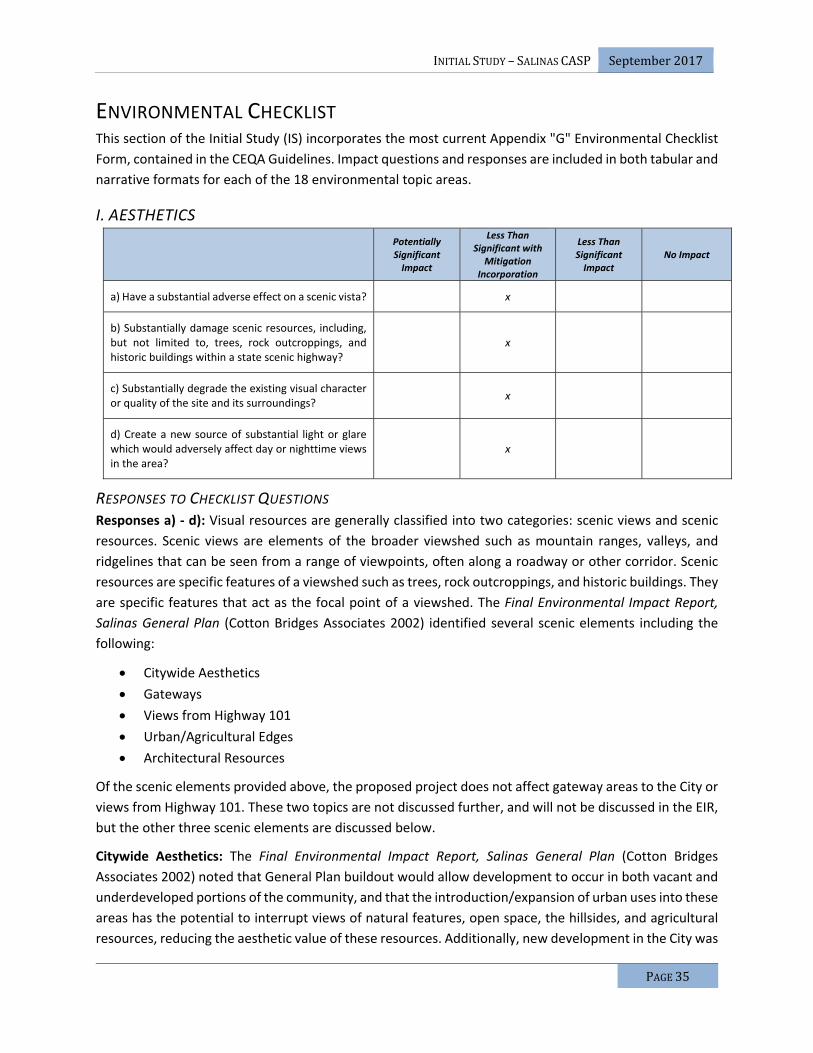
INITIALSTUDY–SALINASCASP September2017
PAGE35
ENVIRONMENTAL CHECKLIST This section of the Initial Study (IS) incorporates the most current Appendix "G" Environmental Checklist
Form, contained in the CEQA Guidelines. Impact questions and responses are included in both tabular and
narrative formats for each of the 18 environmental topic areas.
I. AESTHETICS
Potentially Significant Impact
Less Than Significant with
Mitigation Incorporation
Less Than Significant Impact
No Impact
a) Have a substantial adverse effect on a scenic vista? x
b) Substantially damage scenic resources, including, but not limited to, trees, rock outcroppings, and historic buildings within a state scenic highway?
x
c) Substantially degrade the existing visual character or quality of the site and its surroundings?
x
d) Create a new source of substantial light or glare which would adversely affect day or nighttime views in the area?
x
RESPONSES TO CHECKLIST QUESTIONS Responses a) ‐ d): Visual resources are generally classified into two categories: scenic views and scenic
resources. Scenic views are elements of the broader viewshed such as mountain ranges, valleys, and
ridgelines that can be seen from a range of viewpoints, often along a roadway or other corridor. Scenic
resources are specific features of a viewshed such as trees, rock outcroppings, and historic buildings. They
are specific features that act as the focal point of a viewshed. The Final Environmental Impact Report,
Salinas General Plan (Cotton Bridges Associates 2002) identified several scenic elements including the
following:
Citywide Aesthetics
Gateways
Views from Highway 101
Urban/Agricultural Edges
Architectural Resources
Of the scenic elements provided above, the proposed project does not affect gateway areas to the City or
views from Highway 101. These two topics are not discussed further, and will not be discussed in the EIR,
but the other three scenic elements are discussed below.
Citywide Aesthetics: The Final Environmental Impact Report, Salinas General Plan (Cotton Bridges
Associates 2002) noted that General Plan buildout would allow development to occur in both vacant and
underdeveloped portions of the community, and that the introduction/expansion of urban uses into these
areas has the potential to interrupt views of natural features, open space, the hillsides, and agricultural
resources, reducing the aesthetic value of these resources. Additionally, new development in the City was

INITIALSTUDY–SALINASCASP September2017
PAGE36
found to increase the amount of light and glare in the community, particularly in areas planned for
nonresidential development, such as retail and general commercial. It was found that future development
under the General Plan has the potential to change the visual character of the City.
To minimize and mitigate the impacts on Citywide aesthetics, the Final Environmental Impact Report,
Salinas General Plan (Cotton Bridges Associates 2002) presented the following five mitigation measures:
Mitigation Measure A1 requires the City to implement the City’s Gateway Guidelines; Mitigation Measure
A2 requires the City to strengthen and require compliance with the City’s Design Guidelines; Mitigation
Measure A3 requires the City to improve the Lighting Ordinance; Mitigation Measure A4 requires the City
to implement landscaping requirements for all proposed projects; and Mitigation Measure A5 requires
the City to review all discretionary projects for aesthetics impacts. The Final Environmental Impact Report,
Salinas General Plan (Cotton Bridges Associates 2002) concluded that with the implementation of
Mitigation Measures A1 through A5, the potential citywide aesthetics impact would be reduced to a less
than significant level.
Subsequently, the Final Supplemental for the Salinas General Plan Final Program EIR (EDAW/AECOM
2007) indicated that aesthetic impacts associated with the FGAs, which includes the CASP, would not be
different from those discussed in the Final Environmental Impact Report, Salinas General Plan (Cotton
Bridges Associates 2002).
Any future development under the approved General Plan, which includes all development under the
proposed project, would be required to comply with the above‐referenced regulations, policies, and
standards. Implementation of the proposed project would not result in any new significant adverse
impacts beyond those addressed in the Final Environmental Impact Report, Salinas General Plan (Cotton
Bridges Associates 2002) and Final Supplemental for the Salinas General Plan Final Program EIR
(EDAW/AECOM 2007). This EIR will utilize the earlier analysis of this topic provided in the Final
Environmental Impact Report, Salinas General Plan (Cotton Bridges Associates 2002) and Final
Supplemental for the Salinas General Plan Final Program EIR (EDAW/AECOM 2007) pursuant to the tiering
requirements of CEQA. The EIR will address this topic in light of the previous impact conclusions in those
certified EIRs, and will identify if there are any new impacts or mitigation measures to be considered. This
topic will be addressed in a section of the EIR that focuses on topics that have a tiered analysis.
Urban/Agricultural Edges: The Final Environmental Impact Report, Salinas General Plan (Cotton Bridges
Associates 2002) noted that General Plan buildout will allow development to occur on and adjacent to
land used for agricultural operations. The expansion of development into these areas may modify certain
areas of the community that currently have distinct urban/agricultural edges.
To minimize and mitigate the impacts on Urban/Agricultural Edges, the Final Environmental Impact
Report, Salinas General Plan (Cotton Bridges Associates 2002) presented the following six mitigation
measures: Mitigation Measure A1 requires the City to implement the City’s Gateway Guidelines.;
Mitigation Measure A2 requires the City to strengthen and require compliance with the City’s Design
Guidelines; Mitigation Measure A5 requires the City to review all discretionary projects for aesthetics
impacts; Mitigation Measure A6 requires the City to encourage the maintenance and provision of buffers
between urban and agricultural uses; Mitigation Measure A7 requires the City to continue to implement
the Boronda Memorandum of Understanding, which directs growth away from the most productive

INITIALSTUDY–SALINASCASP September2017
PAGE37
farmland in the Salinas Planning Area; and Mitigation Measure A8 requires the City to encourage City‐
centered growth through infill projects and incentives. The Final Environmental Impact Report, Salinas
General Plan (Cotton Bridges Associates 2002) concluded that with the implementation of these
mitigation measures, the potential urban/agricultural edge impacts would be reduced to a less than
significant level.
Subsequently, the Final Supplemental for the Salinas General Plan Final Program EIR (EDAW/AECOM
2007) indicated that aesthetic impacts associated with the Future Growth Areas (FGAs), which includes
the Specific Plan Area, would not be different from those discussed in the Final Environmental Impact
Report, Salinas General Plan (Cotton Bridges Associates 2002).
Any future development under the General Plan, which includes all development under the proposed
project, would be required to comply with the above‐referenced regulations, policies, and standards.
Implementation of the proposed project would not result in any new significant adverse impacts beyond
those addressed in the Final Environmental Impact Report, Salinas General Plan (Cotton Bridges
Associates 2002) and Final Supplemental for the Salinas General Plan Final Program EIR (EDAW/AECOM
2007). This EIR will utilize the earlier analysis of this topic provided in the Final Environmental Impact
Report, Salinas General Plan (Cotton Bridges Associates 2002) and Final Supplemental for the Salinas
General Plan Final Program EIR (EDAW/AECOM 2007) pursuant to the tiering requirements of CEQA. The
EIR will address this topic in light of the previous impact conclusions in those certified EIRs, and will identify
if there are any new impacts or mitigation measures to be considered. This topic will be addressed in a
section of the EIR that focuses on topics that have a tiered analysis.
Architectural Resources: The Final Environmental Impact Report, Salinas General Plan (Cotton Bridges
Associates 2002) noted new development and rehabilitation projects may impact significant architectural
resources in the community in two primary ways: 1) new development and rehabilitation projects may be
proposed that would be architecturally and stylistically incompatible with existing architectural resources,
detracting from the existing resources’ aesthetic value and contributing to visual discontinuity in
neighborhoods that have a concentration of significant architectural resources; and 2) new development
and rehabilitation projects may be proposed that would result in the removal of significant architectural
resources or that would modify the structure so that the aesthetic value of the structure is destroyed.
To minimize and mitigate the impacts on Urban/Agricultural Edges, the Final Environmental Impact
Report, Salinas General Plan (Cotton Bridges Associates 2002) presented the following three mitigation
measures: Mitigation Measure A5 requires the City to review all discretionary projects for aesthetics
impacts; Mitigation Measure A9 requires the City to expand participation in the California Main Street
Program; and Mitigation Measure A10 requires the City to consider implementing a historic/architectural
preservation program. The Final Environmental Impact Report, Salinas General Plan (Cotton Bridges
Associates 2002) concluded that with the implementation of these mitigation measures, the potential
urban/agricultural edge impacts would be reduced to a less than significant level.
Subsequently, the Final Supplemental for the Salinas General Plan Final Program EIR (EDAW/AECOM
2007) indicated that aesthetic impacts associated with the FGAs, which includes the CASP, would not be
different from those discussed in the Final Environmental Impact Report, Salinas General Plan (Cotton
Bridges Associates 2002).

INITIALSTUDY–SALINASCASP September2017
PAGE38
Any future development under the approved General Plan, which includes all development under the
proposed project, would be required to comply with the above referenced regulations, policies, and
standards. Implementation of the proposed project would not result in any new significant adverse
impacts beyond those addressed in the in the Final Environmental Impact Report, Salinas General Plan
(Cotton Bridges Associates 2002) and Final Supplemental for the Salinas General Plan Final Program EIR
(EDAW/AECOM 2007). This EIR will utilize the earlier analysis of this topic provided in the Final
Environmental Impact Report, Salinas General Plan (Cotton Bridges Associates 2002) and Final
Supplemental for the Salinas General Plan Final Program EIR (EDAW/AECOM 2007) pursuant to the tiering
requirements of CEQA. The EIR will address this topic in light of the previous impact conclusions in those
certified EIRs, and will identify if there are any new impacts or mitigation measures to be considered. This
topic will be addressed in a section of the EIR that focuses on topics that have a tiered analysis.

INITIALSTUDY–SALINASCASP September2017
PAGE39
II. AGRICULTURE AND FOREST RESOURCES
Potentially Significant Impact
Less Than Significant with
Mitigation Incorporation
Less Than Significant Impact
No Impact
a) Convert Prime Farmland, Unique Farmland, or Farmland of Statewide Importance (Farmland), as shown on the maps prepared pursuant to the Farmland Mapping and Monitoring Program of the California Resources Agency, to non‐agricultural use?
x
b) Conflict with existing zoning for agricultural use, or a Williamson Act contract?
x
c) Conflict with existing zoning for, or cause rezoning of, forest land (as defined in Public Resources Code section 12220(g)), timberland (as defined by Public Resources Code section 4526), or timberland zoned Timberland Production (as defined by Government Code section 51104(g))?
x
d) Result in the loss of forest land or conversion of forest land to non‐forest use?
x
e) Involve other changes in the existing environment which, due to their location or nature, could result in conversion of Farmland, to non‐agricultural use or conversion of forest land to non‐forest use?
x
RESPONSES TO CHECKLIST QUESTIONS Responses a), e): The Final Environmental Impact Report, Salinas General Plan (Cotton Bridges Associates
2002) noted that General Plan buildout would result in the conversion of 3,525 acres designated for
agriculture to urban uses. Much of the conversion of the agricultural land within the City limits would be
for urban uses and parks. The Final Environmental Impact Report, Salinas General Plan (Cotton Bridges
Associates 2002) also indicates that General Plan buildout would result in agricultural activity in proximity
to residential and other urban uses, which may result in conflicts between the uses. It is noted that
agricultural activity can cause nuisances related to air quality and noise that may disturb surrounding
development. Urban activities may also negatively affect nearby agricultural uses, as increased vandalism
often occurs and the introduction of domestic animals may disturb certain agricultural activities.
The Final Environmental Impact Report, Salinas General Plan (Cotton Bridges Associates 2002) noted that
the City would work to preserve important agricultural lands located to the south and west of the City and
within the Salinas Planning Area, and as part of the General Plan process, the community of Salinas
indicated that land designated for future growth outside the City limits should be minimized to protect
the valuable agricultural resources. The FGAs were established in the north of Salinas, north of Boronda
Road, and east of the Salinas Municipal Airport, which are all located away from the best agricultural lands
in the south and west. The proposed project is located within the North of Boronda Road Future Growth
Area, which is one of the areas specifically identified for future growth. The Final Environmental Impact
Report, Salinas General Plan (Cotton Bridges Associates 2002) notes that a significant impact associated

INITIALSTUDY–SALINASCASP September2017
PAGE40
with the conversion of agricultural land in the Future Growth Areas (FGAs) to residential and other urban
uses and potential compatibility issues are anticipated.
To minimize and mitigate the impacts from the conversion of agricultural land in the FGAs and potential
compatibility issues, the Final Environmental Impact Report, Salinas General Plan (Cotton Bridges
Associates 2002) presented the following five mitigation measures: Mitigation Measure AG1 requires the
City to continue to cooperate with the County of Monterey to implement the Greater Salinas Area
Memorandum of Understanding (GSA‐MOU), which directs City growth to occur generally to the north
and east away from the most productive farmland; Mitigation Measure AG2 requires the City to give
priority to redevelopment and infill projects that reduce development pressure on agricultural lands; and
Mitigation Measure AG3 requires implementation of the “Right‐to‐Farm” Ordinance. This includes
noticing residential development within 1,000 feet of an established agricultural operation that residents
in the area may experience inconveniences and discomfort associated with the normal farming and
grazing activities, such as noise and dust. The Notice specifically states that a variety of activities may
occur that may be incompatible with the proposed development and that an established agricultural
operation in full compliance with applicable laws, shall not be considered a nuisance due to changes in
the surrounding area. The Notice also states that a person’s right to recover under a nuisance claim against
these activities may be restricted; and Mitigation Measure AG4 requires the City to encourage the
provision and maintenance of buffers, such as roadways, topographic features, and open space, to
prevent incompatibilities between agricultural and nonagricultural land uses.
The Final Environmental Impact Report, Salinas General Plan (Cotton Bridges Associates 2002) concluded
that with the implementation of Mitigation Measures AG1 through AG4, the impacts on potential
compatibility issues would be reduced to a less than significant level; however, while the impacts on
agricultural conversion would be reduced to the extent feasible, a significant and unavoidable impact
would remain related to the loss of important farmland. Mitigation AG5 specifically addressed Agricultural
Land Conservation Easement Program, which states that the City will work with the County of Monterey,
and other local jurisdictions, to create and implement an agricultural land conservation easement
program including such measures as securing the dedication of easements or by paying a mitigation fee
that could be used to purchase easements through a mitigation bank. Additionally, in 2006, the City
Council adopted Resolution No. 19422, approving the Agricultural Land Preservation Program. The
resolution adopted a per acre mitigation fee for agricultural lands currently designated by the California
Department of Conservation’s Farmland Mapping Program as “Prime” or “of Statewide Importance.”
The City of Salinas certified the Final Environmental Impact Report, Salinas General Plan (Cotton Bridges
Associates 2002), adopted a statement of overriding considerations relative to this significant and
unavoidable impact, and approved the Salinas General Plan.
Subsequently, the Final Supplemental for the Salinas General Plan Final Program EIR (EDAW/AECOM
2007) indicated that agricultural impacts associated with the FGAs, which includes the CASP, would not
be different from those discussed in the Final Environmental Impact Report, Salinas General Plan (Cotton
Bridges Associates 2002).
Any future development under the approved General Plan, which includes all development under the
proposed project, would be required to comply with the above‐referenced regulations, policies, and

INITIALSTUDY–SALINASCASP September2017
PAGE41
standards. Implementation of the proposed project would not result in any new significant adverse
impacts beyond those addressed in the Final Environmental Impact Report, Salinas General Plan (Cotton
Bridges Associates 2002) and Final Supplemental for the Salinas General Plan Final Program EIR
(EDAW/AECOM 2007). The conversion of prime agricultural land is an impact within the scope of the
programmatic analysis in the Final EIR and Final Supplemental EIR for the General Plan (see CEQA
Guidelines section 15168, subdivision (c)). This EIR will utilize the earlier analysis of this topic provided in
the Final Environmental Impact Report, Salinas General Plan (Cotton Bridges Associates 2002) and Final
Supplemental for the Salinas General Plan Final Program EIR (EDAW/AECOM 2007) pursuant to the tiering
requirements of CEQA. The EIR will address this topic in light of the previous impact conclusions in those
certified EIRs, and will identify if there are any new impacts or mitigation measures to be considered. This
topic will be addressed in a section of the EIR that focuses on topics that have a tiered analysis.
Responses b): The Specific Plan Area is currently zoned New Urbanism Interim (NI); therefore, there are
no conflicts with land zoned as farmland. The Specific Plan Area is not under a Williamson Act contract;
therefore, there are no conflicts with Williamson Act contracts. These topics do not warrant additional
analysis and will not be addressed further in the EIR. Implementation of the proposed project would have
no impact relative to this environmental topic.
Responses c), d): The Specific Plan Area is currently zoned New Urbanism Interim (NI), and used
exclusively for row crop/agricultural production; therefore, there are no conflicts with land zoned as forest
land, timberland, or timber land production. The Specific Plan Area does not have any forest resources;
therefore, there would be no loss of forest land or conversion of forest land to non‐forest use. These
topics do not warrant additional analysis and will not be addressed further in the EIR. Implementation of
the proposed project would have no impact relative to these environmental topics.

INITIALSTUDY–SALINASCASP September2017
PAGE42
III. AIR QUALITY
Potentially Significant Impact
Less Than Significant with
Mitigation Incorporation
Less Than Significant Impact
No Impact
a) Conflict with or obstruct implementation of the applicable air quality plan?
x
b) Violate any air quality standard or contribute substantially to an existing or projected air quality violation?
x
c) Result in a cumulatively considerable net increase of any criteria pollutant for which the project region is non‐attainment under an applicable federal or state ambient air quality standard (including releasing emissions which exceed quantitative thresholds for ozone precursors)?
x
d) Expose sensitive receptors to substantial pollutant concentrations?
x
e) Create objectionable odors affecting a substantial number of people?
x
RESPONSES TO CHECKLIST QUESTIONS Responses a), c), d), e): Based on the current air quality conditions in the air basin, it has been determined
that the potential impacts on air quality caused by the proposed project will require a detailed analysis in
the EIR. Consequently, the lead agency will examine each of the five environmental issues listed in the
checklist above in the EIR and will decide whether the proposed project has the potential to have a
significant impact on air quality. At this point a definitive impact conclusion for each of these
environmental topics will not be made, rather all are considered potentially significant until a detailed
analysis is prepared in the EIR.
The EIR will include an air quality analysis that presents the methodology, thresholds of significance, a
consistency analysis, cumulative impact analysis, and a discussion of feasible mitigation measures that
should be implemented to reduce impacts on air quality. The project may result in short‐term
construction‐related emissions and long‐term operational emissions, primarily attributable to emissions
from vehicle trips and from energy consumption by the residential and commercial uses. The Specific Plan
Area is located within the jurisdiction of the Monterey Bay Air Resources District (MBARD). We will consult
with the MBARD regarding the project’s potential to cause impacts, and the applicability of the MBARD’s
Rules and Regulations. The air quality analysis will include the following:
• A description of regional and local air quality as well meteorological conditions that could affect
air pollutant dispersal or transport in the vicinity of the CASP. Applicable air quality regulatory
framework, standards, and significance thresholds will be discussed.
• Short‐term (i.e., construction) increases in regional criteria air pollutants will be quantitatively
assessed. The California Air Resources Board (ARB)‐approved California Emissions Estimator

INITIALSTUDY–SALINASCASP September2017
PAGE43
Model (CalEEMod) computer model will be used to estimate regional mobile source and
particulate matter emissions associated with the construction of the proposed project.
• Long‐term (operational) increases in regional criteria air pollutants will be quantitatively assessed
for area source, mobile sources, and stationary sources. The ARB‐approved CalEEMod computer
model will be used to estimate emissions associated with the proposed project. Exposure to
odorous or toxic air contaminants will be assessed through a screening method as recommended
by the MBARD.
• Local mobile‐source (carbon monoxide) (CO) concentrations will be assessed through a CO
screening method as recommended by the MBARD. Mobile source CO concentrations will be
modeled for signalized intersections expected to operate at unacceptable levels of service. If the
screening method indicates that modeling is necessary, upon review of the traffic analysis, CO
concentrations will be modeled using the Caltrans‐approved CALINE4 computer model.

INITIALSTUDY–SALINASCASP September2017
PAGE44
IV. BIOLOGICAL RESOURCES
Potentially Significant Impact
Less Than Significant with
Mitigation Incorporation
Less Than Significant Impact
No Impact
a) Have a substantial adverse effect, either directly or through habitat modifications, on any species identified as a candidate, sensitive, or special status species in local or regional plans, policies, or regulations, or by the California Department of Fish and Game or U.S. Fish and Wildlife Service?
x
b) Have a substantial adverse effect on any riparian habitat or other sensitive natural community identified in local or regional plans, policies, regulations or by the California Department of Fish and Game or US Fish and Wildlife Service?
x
c) Have a substantial adverse effect on federally protected wetlands as defined by Section 404 of the Clean Water Act (including, but not limited to, marsh, vernal pool, coastal, etc.) through direct removal, filling, hydrological interruption, or other means?
x
d) Interfere substantially with the movement of any native resident or migratory fish or wildlife species or with established native resident or migratory wildlife corridors, or impede the use of native wildlife nursery sites?
x
e) Conflict with any local policies or ordinances protecting biological resources, such as a tree preservation policy or ordinance?
x
f) Conflict with the provisions of an adopted Habitat Conservation Plan, Natural Community Conservation Plan, or other approved local, regional, or state habitat conservation plan?
x
RESPONSES TO CHECKLIST QUESTIONS Responses a), b), c), d), e), f): Based on the documented special status species, sensitive natural
communities, wetlands, waters of the US, and other biological resources in the region, it has been
determined that the potential impacts on biological resources as a result of the proposed project will
require a detailed analysis. As such, the lead agency will examine each of the environmental issues listed
in the checklist above in the EIR and will decide whether the proposed project has the potential to have a
significant impact on biological resources. At this point a definitive impact conclusion for each of these
environmental topics will not be made; rather, all impacts are considered potentially significant until a
detailed analysis is prepared in the EIR.
The EIR will provide a summary of local biological resources, including descriptions and mapping of plant
communities, the associated plant and wildlife species, special status species, and sensitive biological
resources known to occur, or with the potential to occur in the project vicinity. This section will discuss

INITIALSTUDY–SALINASCASP September2017
PAGE45
the methodology, thresholds of significance, and a summary of local biological resources (terrestrial and
aquatic), including descriptions and mapping of plant communities, the associated plant and wildlife
species, and sensitive biological resources known to occur based on past or present observations, or with
the potential to occur in the project vicinity based on habitat conditions. The information in this section
will be based on field investigation(s), biological database searches, including a search of the California
Natural Diversity Database (CNDDB), the California Native Plant Society’s Electronic Inventory, the
California Wildlife‐Habitat Relationships database, an inventory of rare and endangered plants (California
Department of Fish & Wildlife, 2017), and the United States Fish and Wildlife Service’s list of special‐status
species with potential to occur in the region. The analysis will conclude with a consistency analysis,
cumulative impact analysis, and a discussion of feasible mitigation measures that should be implemented
in order to reduce impacts on biological resources and to ensure compliance with the Federal and State
regulations.

INITIALSTUDY–SALINASCASP September2017
PAGE46
V. CULTURAL RESOURCES
Potentially Significant Impact
Less Than Significant with
Mitigation Incorporation
Less Than Significant Impact
No Impact
a) Cause a substantial adverse change in the significance of a historical resource as defined in '15064.5?
x
b) Cause a substantial adverse change in the significance of an archaeological resource pursuant to '15064.5?
x
c) Directly or indirectly destroy a unique paleontological resource or site or unique geologic feature?
x
d) Disturb any human remains, including those interred outside of formal cemeteries?
x
RESPONSES TO CHECKLIST QUESTIONS Responses a), b), c), d): Based on known historical and archaeological resources in the region, and the
potential for undocumented underground cultural resources in the region, it has been determined that
the potential impacts on cultural resources caused by the proposed project will require a detailed analysis
in the EIR. As such, the lead agency will examine each of the four environmental issues listed in the
checklist above in the EIR and will decide whether the proposed project has the potential to have a
significant impact on cultural resources. At this point, a definitive impact conclusion for each of these
environmental topics will not be made; rather all are considered potentially significant until a detailed
analysis is prepared in the EIR.
The EIR will include a historical and prehistorical overview of the area, the potential for surface and
subsurface cultural resources to be found in the area, the types of cultural resources that may be expected
to be found, a review of existing regulations and policies that protect cultural resources, an impact
analysis, and mitigation that should be implemented with each improvement project. The Northwest
Information Center of the California Historical Resources Information System (CHRIS) and the Native
American Heritage Commission (NAHC) will be contacted for file checks to identify known cultural,
archaeological, and historic resources and sacred lands in the Specific Plan Area. Tribal consultation and
consultation with local historical groups pursuant to SB 18 (Stats. 2002, ch. 905) and AB 52 (Stats. 2014,
ch. 532) will occur as part of this work effort. The EIR section will provide an analysis including thresholds
of significance, impact discussion, and a discussion of feasible mitigation measures that should be
implemented to reduce impacts associated with cultural resources.

INITIALSTUDY–SALINASCASP September2017
PAGE47
VI. GEOLOGY AND SOILS
Potentially Significant Impact
Less Than Significant with
Mitigation
Less Than Significant Impact
No Impact
a) Expose people or structures to potential substantial adverse effects, including the risk of loss, injury, or death involving:
i) Rupture of a known earthquake fault, as delineated on the most recent Alquist‐Priolo Earthquake Fault Zoning Map issued by the State Geologist for the area or based on other substantial evidence of a known fault? Refer to Division of Mines and Geology Special Publication 42.
x
ii) Strong seismic ground shaking? x
iii) Seismic‐related ground failure, including liquefaction?
x
iv) Landslides? x
b) Result in substantial soil erosion or the loss of topsoil?
x
c) Be located on a geologic unit or soil that is unstable, or that would become unstable as a result of the project, and potentially result in on‐ or off‐site landslide, lateral spreading, subsidence, liquefaction or collapse?
x
d) Be located on expansive soil, as defined in Table 18‐1‐B of the Uniform Building Code (1994), creating substantial risks to life or property?
x
e) Have soils incapable of adequately supporting the use of septic tanks or alternative waste water disposal systems where sewers are not available for the disposal of waste water?
x
RESPONSES TO CHECKLIST QUESTIONS Responses a‐i), a‐ii), a‐iii), c): The Final Environmental Impact Report, Salinas General Plan (Cotton Bridges
Associates 2002) and Final Supplemental for the Salinas General Plan Final Program EIR (EDAW/AECOM
2007) indicate that there are no Alquist‐Priolo Earthquake Fault Zones within the City of Salinas. The
analysis cites a high risk of seismic activity and other geologic hazards associated with earthquakes in
Salinas due to the region being seismically active; however, the analysis also indicates that there are no
active faults within the Salinas Planning Area.
Liquefaction typically requires a significant sudden decrease of shearing resistance in cohesionless soils
and a sudden increase in water pressure, which is typically associated with an earthquake of high
magnitude. According to the Web Soils Survey (Natural Resources Conservation Service 2017), the soils in

INITIALSTUDY–SALINASCASP September2017
PAGE48
the Specific Plan Area have a high sand content in the soils. Given the high sandy soils, combined with the
region being seismically active, the potential for liquefaction is present within the Specific Plan Area.
To minimize and mitigate the risks associated with seismicity, Final Environmental Impact Report, Salinas
General Plan (Cotton Bridges Associates 2002) presented the following six mitigation measures:
Mitigation Measure GS1 requires the City to assess development proposals for potential hazards pursuant
to the California Environmental Quality Act (CEQA), requiring mitigation measures to mitigate all identified
public safety hazards; Mitigation Measure GS2 requires the City to use open space easements, buffers,
and other techniques when necessary to avoid public safety hazards; Mitigation Measure GS3 requires
the City to implement the most recent geologic, seismic, and structural guidelines; Mitigation Measure
GS4 requires the City during the review of development proposals involving grading, unstable soils, and
other hazardous conditions, to require surveys of soils and geologic conditions be performed by a state
licensed engineering geologist or civil engineer, where appropriate. Based on the results of the survey,
design measures will be incorporated into projects to minimize geologic hazards; Mitigation Measure GS5
requires the City to implement the City’s Multi‐hazard Emergency Plan; and Mitigation Measure GS6
requires the City to coordinate with local agencies and organizations to provide emergency preparedness
education and educational materials to its residents and businesses.
The City of Salinas requires a final geotechnical evaluation to be performed at a design level to ensure
that the foundations, structures, roadway sections, sidewalks, and other improvements can
accommodate the specific soils and anticipated seismic activity. The final geotechnical evaluation would
include design recommendations to ensure that the combination of seismicity and soil conditions do not
pose a threat to the health and safety of people or structures. In addition, all new construction in the City
of Salinas is required to comply with the California Building Standards Code, which contains criteria and
standards designed to reduce risks associated with seismicity to acceptable levels. In order to apply this
code to site development, the City of Salinas requires that new construction be in accordance with
building, grading and erosion control ordinances and include inspections during construction to ensure
that design standards are met. The Final Environmental Impact Report, Salinas General Plan (Cotton
Bridges Associates 2002) and Final Supplemental for the Salinas General Plan Final Program EIR
(EDAW/AECOM 2007) found that the General Plan goals, policies, and implementation programs, in
combination with the Alquist‐Priolo Act, California Building Standards Code, and City of Salinas
requirements, would reduce potential impacts associated with surface fault rupture, seismic shaking, and
seismic ground failure, to a less than significant level.
Any future development under the approved General Plan, which includes all development under the
proposed project, would be required to comply with the above referenced regulations, policies, and
standards. Implementation of the proposed project would not result in any new significant adverse
impacts beyond those addressed in the Final Environmental Impact Report, Salinas General Plan (Cotton
Bridges Associates 2002) and Final Supplemental for the Salinas General Plan Final Program EIR
(EDAW/AECOM 2007). This EIR will utilize the earlier analysis of this topic provided in the Final
Environmental Impact Report, Salinas General Plan (Cotton Bridges Associates 2002) and Final
Supplemental for the Salinas General Plan Final Program EIR (EDAW/AECOM 2007) pursuant to the tiering
requirements of CEQA. The EIR will address this topic in light of the previous impact conclusions in those

INITIALSTUDY–SALINASCASP September2017
PAGE49
certified EIRs, and will identify if there are any new impacts or mitigation measures to be considered. This
topic will be addressed in a section of the EIR that focuses on topics that have a tiered analysis.
Responses a‐iv): The overall topographic relief of the Specific Plan Area is approximately 76 feet, with a
maximum elevation of approximately 146 feet above sea level at the northeast corner on Old Stage Road,
and a minimum elevation of approximately 70 feet above sea level in Natividad Creek at the Boronda Road
crossing. Two creeks cross through the Specific Plan Area: Gabilan Creek to the west and Natividad Creek
to the east. The greatest elevation changes within the Specific Plan Area occur along these creeks.
However, the Specific Plan Area would have no slopes located outside of the planned Open Space and/or
Park land uses that could be subject to significant landslide. Therefore, the potential for landslides to
cause substantial adverse effects to people or structure in the Specific Plan Area is highly unlikely.
Implementation of the proposed project would have a less than significant relative to this topic, does not
warrant additional analysis and will not be addressed further in the EIR.
Response b): The Specific Plan Area has a relatively low risk of landslides (a form of erosion). However,
slopes adjacent to the Gabilan Creek and Natividad Creek are higher, and could undergo erosion under
certain conditions. Additionally, all new development would require some land clearing, mass grading,
and other ground‐disturbing activities that could temporarily increase soil erosion rates during and shortly
after project construction. Construction‐related erosion could result in the loss of a substantial amount of
nonrenewable topsoil and could adversely affect water quality in nearby surface waters.
The Regional Water Quality Control Board (RWQCB) requires a project specific Storm Water Pollution
Prevention Plan (SWPPP) to be prepared for each project that disturbs an area one acre or larger. The
SWPPPs include project specific best management measures that are designed to control drainage and
erosion. Further, new construction in the Specific Plan Area would be required to comply with the City's
National Pollutant Discharge Elimination System (NPDES) Permit requirements, the City's Storm Water
Development Standards (SWDS), and City Public Works Standards, all of which are intended to reduce
potential erosion impacts to a less than significant level.
To minimize the impacts on soil erosion and the loss of topsoil, the Final Supplemental for the Salinas
General Plan Final Program EIR (EDAW/AECOM 2007) indicated that development within the General Plan
would potentially result in substantial soil and topsoil erosion from wind or water. The Final Supplemental
for the Salinas General Plan Final Program EIR (EDAW/AECOM 2007) provided mitigation for this impact
that includes complying with MBARD guidelines to reduce emissions of fugitive dust and PM10 emissions.
The Final Supplemental for the Salinas General Plan Final Program EIR (EDAW/AECOM 2007) also
identified that mitigation for this impact could also include performing geotechnical evaluations specific
to the design of facilities to ensure that buildings and infrastructure is built safely. Site specific
geotechnical evaluations will provide site specific design measures such as the soil compaction
requirements, foundation designs, engineering fill requirements, and more specific design measures for
each individual facility that is constructed.
Any future development under the proposed project would be required to comply with the above
referenced regulations, policies, and standards. Implementation of the proposed project would not result
in any new significant adverse impacts beyond those addressed in the Final Environmental Impact Report,
Salinas General Plan (Cotton Bridges Associates 2002) and Final Supplemental for the Salinas General Plan

INITIALSTUDY–SALINASCASP September2017
PAGE50
Final Program EIR (EDAW/AECOM 2007). This EIR will utilize the earlier analysis of this topic provided in
the Final Environmental Impact Report, Salinas General Plan (Cotton Bridges Associates 2002) and Final
Supplemental for the Salinas General Plan Final Program EIR (EDAW/AECOM 2007) pursuant to the tiering
requirements of CEQA. The EIR will address this topic in light of the previous impact conclusions in those
certified EIRs, and will identify if there are any new impacts or mitigation measures to be considered. This
topic will be addressed in a section of the EIR that focuses on topics that have a tiered analysis.
Response d): Expansive soils are those that undergo volume changes as moisture content fluctuates;
swelling substantially when wet or shrinking when dry. Soil expansion can damage structures by cracking
foundations, causing settlement and distorting structural elements. Expansion is a typical characteristic
of certain varieties of clay‐type soils. Expansive soils shrink and swell in volume during changes in moisture
content, such as a result of seasonal rain events, and can cause damage to foundations, concrete slabs,
roadway improvements, and pavement sections. The Final Supplemental for the Salinas General Plan Final
Program EIR (EDAW/AECOM 2007) identified that mitigation for this impact could include performing site‐
specific geotechnical evaluations to determine whether expansive soils would be a hazard.
The City of Salinas requires a final geotechnical evaluation to be performed at a design‐level to ensure
that the foundations, structures, roadway sections, sidewalks, and other improvements can
accommodate the specific soils, including expansive soils. The final geotechnical evaluation would include
design recommendations to ensure that soil conditions do not pose a threat to the health and safety of
people or structures. Any future development under the approved General Plan, which includes all
development under the proposed project, would be required to comply with the above referenced
regulations, policies, and standards. Implementation of the proposed project would not result in any new
significant adverse impacts beyond those addressed in the Final Environmental Impact Report, Salinas
General Plan (Cotton Bridges Associates 2002) and Final Supplemental for the Salinas General Plan Final
Program EIR (EDAW/AECOM 2007). This EIR will utilize the earlier analysis of this topic provided in the
Final Environmental Impact Report, Salinas General Plan (Cotton Bridges Associates 2002) and Final
Supplemental for the Salinas General Plan Final Program EIR (EDAW/AECOM 2007) pursuant to the tiering
requirements of CEQA. The EIR will address this topic in light of the previous impact conclusions in those
certified EIRs, and will identify if there are any new impacts or mitigation measures to be considered. This
topic will be addressed in a section of the EIR that focuses on topics that have a tiered analysis.
Responses e): The proposed project would not result in the construction or installation of septic tanks or
alternative waste water disposal systems. Instead, the proposed project would be served by wastewater
collection, conveyance, treatment, disposal, and recycling services through the City of Salinas and
Monterey Regional Water Pollution Control Agency (MRWPCA). The sewer system for the CASP would
consist of 8‐inch to 12‐inch pipes, designed in accordance with the City of Salinas design standards at the
time of final design. The sewer mains will be located in public streets and private alleys with public service
easements. The sewer mains will connect to the existing City of Salinas sewer system at two locations: the
10‐inch sewer in Independence Boulevard, and the 18‐inch sewer near Constitution Boulevard.
Implementation of the proposed project would have no impact relative to this topic, does not warrant
additional analysis and will not be addressed further in the EIR.

INITIALSTUDY–SALINASCASP September2017
PAGE51
VII.GREENHOUSEGASEMISSIONS
Potentially Significant Impact
Less Than Significant with
Mitigation Incorporation
Less Than Significant Impact
No Impact
a) Generate greenhouse gas emissions, either directly or indirectly, that may have a significant impact on the environment?
x
b) Conflict with an applicable plan, policy or regulation adopted for the purpose of reducing the emissions of greenhouse gasses?
x
RESPONSES TO CHECKLIST QUESTIONS Responses a), b): Implementation of the proposed project could generate greenhouse gases (GHGs) from
a variety of sources, including but not limited to vehicle trips, electricity consumption, water use, and solid
waste generation. It has been determined that the potential impacts from GHG emissions by the proposed
project will require a detailed analysis in the EIR. As such, the lead agency will examine each of the
environmental issues listed in the checklist above in the EIR and will decide whether the proposed project
has the potential to have a significant impact from GHG emissions. At this point a definitive impact
conclusion for each of these environmental topics will not be made, rather all are considered potentially
significant until a detailed analysis is prepared in the EIR.
The EIR will include a GHG emissions analysis pursuant to the requirements of the California Governor’s
Executive Order S‐3‐05 and The Global Warming Solutions Act of 2006 (AB 32). The analysis will follow the
California Air Pollution Control Officers Association (CAPCOA) white paper methodology and
recommendations presented in “Climate Change and CEQA”, which was prepared in coordination with
the California Air Resources Board (CARB) and the Governor’s Office of Planning and Research (OPR) as a
common platform for public agencies to ensure that GHG emissions are appropriately considered and
addressed under CEQA. Also, a greenhouse emissions analysis using the Monterey Bay Air Resources
District CEQA Air Quality Guidelines will be performed. These analyses will consider a regional approach
toward determining whether GHG emissions are significant, and will present mitigation measures to
reduce impacts. The discussion and analysis will include quantification of GHGs generated by the project
using the California Emissions Estimator Model (CalEEMod) computer model as well as a qualitative
discussion of the project’s consistency with any applicable state and local plans to reduce the impacts of
climate change.
The EIR will provide an analysis including the methodology, thresholds of significance, a consistency
analysis, cumulative impact analysis, and a discussion of feasible mitigation measures that should be
implemented to reduce impacts associated with GHG emissions.

INITIALSTUDY–SALINASCASP September2017
PAGE52
VIII. HAZARDS AND HAZARDOUS MATERIALS
Potentially Significant Impact
Less Than Significant with
Mitigation Incorporation
Less Than Significant Impact
No Impact
a) Create a significant hazard to the public or the environment through the routine transport, use, or disposal of hazardous materials?
x
b) Create a significant hazard to the public or the environment through reasonably foreseeable upset and accident conditions involving the release of hazardous materials into the environment?
x
c) Emit hazardous emissions or handle hazardous or acutely hazardous materials, substances, or waste within one‐quarter mile of an existing or proposed school?
x
d) Be located on a site which is included on a list of hazardous materials sites compiled pursuant to Government Code Section 65962.5 and, as a result, would it create a significant hazard to the public or the environment?
x
e) For a project located within an airport land use plan or, where such a plan has not been adopted, within two miles of a public airport or public use airport, would the project result in a safety hazard for people residing or working in the project area?
x
f) For a project within the vicinity of a private airstrip, would the project result in a safety hazard for people residing or working in the project area?
x
g) Impair implementation of or physically interfere with an adopted emergency response plan or emergency evacuation plan?
x
h) Expose people or structures to a significant risk of loss, injury or death involving wildland fires, including where wildlands are adjacent to urbanized areas or where residences are intermixed with wildlands?
x
RESPONSES TO CHECKLIST QUESTIONS Responses a‐c): The proposed project includes the approval and subsequent implementation of an
approximately 760‐acre Specific Plan Area that includes residential, mixed use commercial, public
facilities, parks, and open space which include supplemental storm water detention/retention basins.
These uses are not expected to create a significant hazard to the public or the environment through the
routine transport, use, or disposal of hazardous materials. Additionally, these uses are not expected to
create a significant hazard to the public or the environment through reasonably foreseeable upset and
accident conditions involving the release of hazardous materials into the environment. While the
proposed project includes three schools within the boundary of the Specific Plan Area, the land uses are

INITIALSTUDY–SALINASCASP September2017
PAGE53
not expected to emit hazardous emissions or handle hazardous or acutely hazardous materials,
substances, or waste. Implementation of the proposed project would have a less then significant impact
relative to these topics.
Responses d): The EIR will include a hazards analysis with a screening‐level of Phase II Environmental Site
Assessment (ESA) (limited soil sampling). The hazards analysis will include a review of existing ESAs and
any other relevant studies for the Specific Plan Area to obtain a historical record of environmental
conditions. The analysis will also include a review of recent records and aerial photographs. A site
reconnaissance will be performed to observe the Specific Plan Area and potential areas of interest. Public
agencies will be interviewed to gather information on the current and historical use of the properties. If
environmental conditions are identified, mitigation measures, as applicable, will be identified to address
the environmental conditions.
This section will provide an analysis including the methodology, thresholds of significance, a consistency
analysis, cumulative impact analysis, and a discussion of feasible mitigation measures that should be
implemented to reduce impacts associated with hazards and hazardous materials. At this point a definitive
impact conclusion for this environmental topic will not be made, rather it is considered potentially
significant until a detailed analysis is prepared in the environmental impact report.
Responses e‐f): The proposed project is not located in the vicinity of an airport or private airstrip;
therefore, it would not result in a safety hazard related to air traffic for people residing or working in the
Specific Plan Area. Implementation of the proposed project would have no impact relative to this
environmental topic.
Responses g): The City has adopted a Multi‐hazard Emergency Plan, which serves as extensions of the
California Emergency Plan and the Emergency Resource Management Plan. The purpose of the Multi‐
hazard Emergency Plan is to respond to emergency situations with a coordinated system of emergency
service providers and facilities. The Emergency Operations Center (EOC) in Salinas serves as the center of
the City’s emergency operations. The Plan also addresses evacuation and movement of people in the
event of an emergency. The proposed project does not impair implementation of or physically interfere
with the Multi‐hazard Emergency Plan. Implementation of the proposed project would have a less than
significant impact relative to this environmental topic.
Responses h): The proposed project is not located in an area that is considered a high risk for wildfires.
The proposed project would not expose people or structures to a significant risk of loss, injury or death
involving wildland fires. Implementation of the proposed project would have a less than significant impact
relative to this environmental topic.
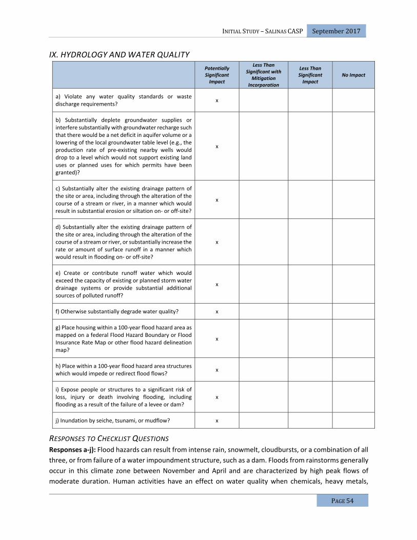
INITIALSTUDY–SALINASCASP September2017
PAGE54
IX. HYDROLOGY AND WATER QUALITY
Potentially Significant Impact
Less Than Significant with
Mitigation Incorporation
Less Than Significant Impact
No Impact
a) Violate any water quality standards or waste discharge requirements?
x
b) Substantially deplete groundwater supplies or interfere substantially with groundwater recharge such that there would be a net deficit in aquifer volume or a lowering of the local groundwater table level (e.g., the production rate of pre‐existing nearby wells would drop to a level which would not support existing land uses or planned uses for which permits have been granted)?
x
c) Substantially alter the existing drainage pattern of the site or area, including through the alteration of the course of a stream or river, in a manner which would result in substantial erosion or siltation on‐ or off‐site?
x
d) Substantially alter the existing drainage pattern of the site or area, including through the alteration of the course of a stream or river, or substantially increase the rate or amount of surface runoff in a manner which would result in flooding on‐ or off‐site?
x
e) Create or contribute runoff water which would exceed the capacity of existing or planned storm water drainage systems or provide substantial additional sources of polluted runoff?
x
f) Otherwise substantially degrade water quality? x
g) Place housing within a 100‐year flood hazard area as mapped on a federal Flood Hazard Boundary or Flood Insurance Rate Map or other flood hazard delineation map?
x
h) Place within a 100‐year flood hazard area structures which would impede or redirect flood flows?
x
i) Expose people or structures to a significant risk of loss, injury or death involving flooding, including flooding as a result of the failure of a levee or dam?
x
j) Inundation by seiche, tsunami, or mudflow? x
RESPONSES TO CHECKLIST QUESTIONS Responses a‐j): Flood hazards can result from intense rain, snowmelt, cloudbursts, or a combination of all
three, or from failure of a water impoundment structure, such as a dam. Floods from rainstorms generally
occur in this climate zone between November and April and are characterized by high peak flows of
moderate duration. Human activities have an effect on water quality when chemicals, heavy metals,

INITIALSTUDY–SALINASCASP September2017
PAGE55
hydrocarbons (auto emissions and car crank case oil), and other materials are transported with storm
water into drainage systems. Construction activities can increase sediment runoff, including concrete
waste and other pollutants.
It has been determined that the potential impacts on hydrology and water quality caused by the proposed
project will require a detailed analysis in the EIR. As such, the lead agency will examine each of the 10
environmental issues listed in the checklist above in the EIR and will decide whether the proposed project
has the potential to have a significant impact on hydrology and water quality. At this point a definitive
impact conclusion for each of these environmental topics will not be made, rather all are considered
potentially significant until a detailed analysis is prepared in the EIR.
The EIR will present the existing Federal Emergency Management Agency (FEMA) flood zones and risk of
flooding in the Specific Plan Area and general vicinity as well as summarize onsite hydrology and hydraulic
calculations under existing and proposed conditions. The EIR will also evaluate the potential construction
and operational impacts of the proposed project on water quality. This section will describe the surface
drainage patterns of the Specific Plan Area and adjoining areas, and identify surface water quality in the
Specific Plan Area based on existing and available data. This section will also identify 303D‐listed impaired
water bodies in the vicinity of the Specific Plan Area. Conformity of the proposed project to water quality
regulations and the Specific Plan Area’s potential to be inundated by seiche, tsunami, or mudflow, will
also be discussed. Mitigation measures will be developed to incorporate BMPs, consistent with the
requirements of the City of Salinas SWDS and Salinas NPDES permit with the CCRWQCB to reduce the
potential for site runoff.
This section will provide an analysis including the methodology, thresholds of significance, a consistency
analysis, cumulative impact analysis, and a discussion of feasible mitigation measures that should be
implemented to reduce impacts associated with hydrology and water quality.

INITIALSTUDY–SALINASCASP September2017
PAGE56
X. LAND USE AND PLANNING
Potentially Significant Impact
Less Than Significant with
Mitigation Incorporation
Less Than Significant Impact
No Impact
a) Physically divide an established community? x
b) Conflict with any applicable land use plan, policy, or regulation of an agency with jurisdiction over the project (including, but not limited to the general plan, specific plan, local coastal program, or zoning ordinance) adopted for the purpose of avoiding or mitigating an environmental effect?
x
c) Conflict with any applicable habitat conservation plan or natural community conservation plan?
x
RESPONSES TO CHECKLIST QUESTIONS Response a): Residential units are currently located within the Specific Plan Area (see Figure 4). These
residential units would to be demolished during the development of the proposed project. However, the
number of residential units within the Specific Plan Area is very small in comparison to the overall size of
the Specific Plan Area. Additionally, development of the Specific Plan Area would facilitate physical access
to and between nearby established communities, including the residential areas located to the south of
the Specific Plan Area. Buildout of the proposed project would also provide access to the proposed
developments that are planned to be located to the east and west of the proposed project Specific Plan
Area (the other proposed developments of the North Boronda FGA, including the proposed West Area
Specific Plan Area). Therefore, the proposed project would have a limited potential to divide an
established community. Implementation of the proposed project would have a less than significant
impact relative to this environmental topic.
Response b): The Final Environmental Impact Report, Salinas General Plan (Cotton Bridges Associates
2002) noted that General Plan Land Use Plan assists in creating a balance between jobs and housing units
within the City, and that a variety of land uses within the City of Salinas creates an important balance
between the generation of public revenues and the provision of public services and facilities. Achieving
and maintaining a balance of land uses ensures fiscal stability and also creates a desirable community in
which people can live, shop, work, and recreate.
New Urbanism principles, a component of the General Plan Land Use Element, were used to design a land
use plan that is compact and pedestrian‐friendly, with a mixture of uses surrounding activity
centers/neighborhood focal points in the CASP. Higher density residential uses are proposed around
retail, recreation, and public uses and all of these core activity centers are proposed to be connected with
pedestrian, bicycle, and transit systems.
The parcels located within the City’s Sphere of Influence, but outside of the current City boundary, would
be annexed to the City as part of the proposed project. The Specific Plan Area would be consistent with
the expected intensity of development within the Specific Plan Area under General Plan buildout

INITIALSTUDY–SALINASCASP September2017
PAGE57
conditions as analyzed in the Final Environmental Impact Report, Salinas General Plan (Cotton Bridges
Associates 2002).
The Final Environmental Impact Report, Salinas General Plan (Cotton Bridges Associates 2002) noted that
the General Plan may impact the related land use plans and policies that have been adopted to avoid or
mitigate an environmental effect. The Salinas Zoning Code, Salinas Redevelopment Plan, Greater Salinas
Area Plan, Salinas Municipal Airport Master Plan, Monterey County Airport Land Use Plan, and Greater
Salinas Area Memorandum of Understanding, are specifically mentioned. Of these documents, the
proposed project does not affect an existing Specific Plan, the Salinas Municipal Airport Master Plan, or
the Monterey County Airport Land Use Plan, and the Salinas Redevelopment Plan is no longer in effect.
These plans/policies/regulations are not discussed further, but the other three (i.e. the Salinas Zoning
Code; the Greater Salinas Area Plan; and the Greater Salinas Area Memorandum of Understanding) are
discussed below.
Salinas Zoning Code: The Final Environmental Impact Report, Salinas General Plan (Cotton Bridges
Associates 2002) noted that implementation of the General Plan will change existing General Plan land
use designations for certain parcels within the City and that existing zoning designations for those parcels
may not be consistent with the new land use designations. A significant impact associated with the Zoning
Code may occur where zoning on specific parcels is inconsistent with new General Plan land use
designations for those parcels.
To minimize and mitigate the potential impacts, the Final Environmental Impact Report, Salinas General
Plan (Cotton Bridges Associates 2002) presented Mitigation Measure LU1, which requires the City to
review and update the Zoning Code and Subdivision Ordinance to ensure consistency with the General
Plan and to help implement the General Plan policies and New Urbanism principles. The Final
Environmental Impact Report, Salinas General Plan (Cotton Bridges Associates 2002) concluded that with
the implementation of the mitigation measure, the impact would be reduced to a less than significant
level.
Subsequently, the Final Supplemental for the Salinas General Plan Final Program EIR (EDAW/AECOM
2007) indicated that impacts associated with the FGAs, which includes the CASP, would not be different
from those discussed in the Final Environmental Impact Report, Salinas General Plan (Cotton Bridges
Associates 2002). Mitigation AG5 specifically addressed Agricultural Land Conservation Easement
Program, which states that the City will work with the County of Monterey, and other local jurisdictions,
to create and implement an agricultural land conservation easement program including such measures as
securing the dedication of easements or by paying a mitigation fee that could be used to purchase
easements through a mitigation bank. Additionally, in 2006, the City Council adopted Resolution No.
19422, approving the Agricultural Land Preservation Program. The resolution adopted a per acre
mitigation fee for agricultural lands currently designated by the California Department of Conservation’s
Farmland Mapping Program as “Prime” or “of Statewide Importance.” The City certified this EIR and
approved annexation of the North of Boronda Future Growth Area, which includes the Specific Plan Area.
The Specific Plan Area is currently zoned New Urbanism Interim (NI) with a Specific Plan Overlay. The
proposed project includes a rezone to the zones as provided within the CASP. The purpose of the rezone

INITIALSTUDY–SALINASCASP September2017
PAGE58
is to ensure consistency between the proposed General Plan Land Use Designations and Zoning. With the
approval of the rezoning application, the Specific Plan would be consistent with the Salinas Zoning Code.
Implementation of the proposed project would not result in any new significant adverse impacts beyond
those addressed in the Final Environmental Impact Report, Salinas General Plan (Cotton Bridges
Associates 2002) and Final Supplemental for the Salinas General Plan Final Program EIR (EDAW/AECOM
2007). This EIR will utilize the earlier analysis of this topic provided in the Final Environmental Impact
Report, Salinas General Plan (Cotton Bridges Associates 2002) and Final Supplemental for the Salinas
General Plan Final Program EIR (EDAW/AECOM 2007) pursuant to the tiering requirements of CEQA. The
EIR will address this topic in light of the previous impact conclusions in those certified EIRs, and will identify
if there are any new impacts or mitigation measures to be considered. This topic will be addressed in a
section of the EIR that focuses on topics that have a tiered analysis.
Greater Salinas Area Plan: The Final Environmental Impact Report, Salinas General Plan (Cotton Bridges
Associates 2002) noted that implementation of General Plan will result in development outside the
existing City limits, into the Greater Salinas Planning Area. Development occurring outside of the City limits
is subject to the Greater Salinas Area Plan. The Greater Salinas Area Plan is a part of the Monterey County
General Plan, and was first published in 1986. It was most recently updated in January 1996. The
implementation of the City of Salinas General Plan may conflict with the Greater Salinas Area Plan,
resulting in a significant impact.
To minimize and mitigate the potential impacts, the Final Environmental Impact Report, Salinas General
Plan (Cotton Bridges Associates 2002) presented Mitigation Measure LU2, which requires the City to be
consistent with a portion of Draft Policy LU 3.4 of the Monterey County Draft General Plan, and to
cooperate with LAFCO and the County of Monterey to direct growth outside the City limits to the Future
Growth Area, on lands that are served or are planned to be served, with a full range of urban services,
such as public water and sewer, an extensive road network, public transit, safety and emergency response
services, parks, trails, and open space. The Final Environmental Impact Report, Salinas General Plan
(Cotton Bridges Associates 2002) concluded that with the implementation of this mitigation measure, the
impact would be reduced to a less than significant level.
Subsequently, the Final Supplemental for the Salinas General Plan Final Program EIR (EDAW/AECOM
2007) indicated that impacts associated with the FGAs, which include the CASP, would not be different
from those discussed in the Final Environmental Impact Report, Salinas General Plan (Cotton Bridges
Associates 2002). The City certified this EIR and approved annexation of the North of Boronda Future
Growth Area, which includes the CASP.
The project as proposed is consistent with the Greater Salinas Area Plan. All development under the
proposed project would be required to comply with the above‐referenced regulations, policies, and
standards. Implementation of the proposed project would not result in any new significant adverse
impacts beyond those addressed in the Final Environmental Impact Report, Salinas General Plan (Cotton
Bridges Associates 2002) and Final Supplemental for the Salinas General Plan Final Program EIR
(EDAW/AECOM 2007). This EIR will utilize the earlier analysis of this topic provided in the Final
Environmental Impact Report, Salinas General Plan (Cotton Bridges Associates 2002) and Final
Supplemental for the Salinas General Plan Final Program EIR (EDAW/AECOM 2007) pursuant to the tiering
INITIALSTUDY–SALINASCASP September2017
PAGE59
requirements of CEQA. The EIR will address this topic in light of the previous impact conclusions in those
certified EIRs, and will identify if there are any new impacts or mitigation measures to be considered. This
topic will be addressed in a section of the EIR that focuses on topics that have a tiered analysis.
Greater Salinas Area Memorandum of Understanding (GSA‐MOU): The Final Environmental Impact
Report, Salinas General Plan (Cotton Bridges Associates 2002) noted that implementation of General Plan
will result in the eventual annexation of additional land to the City in order to accommodate future
growth, and that annexed land will be converted from agricultural use to urban use.
To minimize and mitigate the potential impacts, the Final Environmental Impact Report, Salinas General
Plan (Cotton Bridges Associates 2002) presented the following two mitigation measures: Mitigation
Measure LU5 requires the City to continue to cooperate with the County of Monterey to implement the
GSA‐MOU, which directs that City growth generally to the north and east away from the most productive
farmland; and Mitigation Measure LU6 requires the City to encourage City‐centered growth and give
priority to redevelopment and infill projects that reduce development pressure on agricultural lands. The
City will also establish an incentive program to promote these projects, such as priority permit processing
and density bonuses for such developments. The Final Environmental Impact Report, Salinas General Plan
(Cotton Bridges Associates 2002) concluded that with the implementation of this mitigation measure, the
impact would be reduced to a less than significant level.
Subsequently, the Final Supplemental for the Salinas General Plan Final Program EIR (EDAW/AECOM
2007) indicated that impacts associated with the FGAs, which include the Specific Plan Area, would not
be different from those discussed in the Final Environmental Impact Report, Salinas General Plan (Cotton
Bridges Associates 2002). The City certified this EIR and approved annexation of the North of Boronda
FGA, which includes the CASP.
The project as proposed is consistent with the GSA‐MOU. All development under the proposed project
would be required to comply with the above‐referenced regulations, policies, and standards.
Implementation of the proposed project would not result in any new significant adverse impacts beyond
those addressed in the Final Environmental Impact Report, Salinas General Plan (Cotton Bridges
Associates 2002) and Final Supplemental for the Salinas General Plan Final Program EIR (EDAW/AECOM
2007). This EIR will utilize the earlier analysis of this topic provided in the Final Environmental Impact
Report, Salinas General Plan (Cotton Bridges Associates 2002) and Final Supplemental for the Salinas
General Plan Final Program EIR (EDAW/AECOM 2007) pursuant to the tiering requirements of CEQA. The
EIR will address this topic in light of the previous impact conclusions in those certified EIRs, and will identify
if there are any new impacts or mitigation measures to be considered. This topic will be addressed in a
section of the EIR that focuses on topics that have a tiered analysis.
Responses c): The Specific Plan Area is not within an area governed by an adopted habitat conservation
plan or natural community conservation plan; therefore, there are no conflicts with a habitat conservation
plan or natural community conservation plan. Implementation of the proposed project would have no
impact relative to this environmental topic.

INITIALSTUDY–SALINASCASP September2017
PAGE60
XI. MINERAL RESOURCES
Potentially Significant Impact
Less Than Significant with
Mitigation Incorporation
Less Than Significant Impact
No Impact
a) Result in the loss of availability of a known mineral resource that would be of value to the region and the residents of the state?
x
b) Result in the loss of availability of a locally‐important mineral resource recovery site delineated on a local general plan, specific plan or other land use plan?
x
RESPONSES TO CHECKLIST QUESTIONS Response a‐b): There is a quarry located in the northeastern portion of the Salinas Planning Area near the
FGA, but outside of the Specific Plan Area. The quarry is designated by the State Division of Mines and
Geology as an Aggregate Resource Area and has been mined for Dolomite deposits for many years. Mining
activities are ongoing at this quarry facility, and are anticipated to continue for at least fifty (50) years.
The proposed project does not conflict with the mining activities at this quarry and there are no other
designated mineral resources or mining activities proximate to the Specific Plan Area. Furthermore, it was
determined in the Final Supplemental for the Salinas General Plan Final Program EIR (EDAW/AECOM 2007)
that development of the Future Growth Area, including the Specific Plan Area, would not have a significant
impact on mineral resources or mining activities. As such, implementation of the proposed project would
have no impact on mineral resources. This EIR will utilize the earlier analysis of this topic provided in the
Final Environmental Impact Report, Salinas General Plan (Cotton Bridges Associates 2002) and Final
Supplemental for the Salinas General Plan Final Program EIR (EDAW/AECOM 2007) pursuant to the tiering
requirements of CEQA. The EIR will address this topic in light of the previous impact conclusions in those
certified EIRs, and will identify if there are any new impacts or mitigation measures to be considered. This
topic will be addressed in a section of the EIR that focuses on topics that have a tiered analysis.

INITIALSTUDY–SALINASCASP September2017
PAGE61
XII. NOISE
Potentially Significant Impact
Less Than Significant with
Mitigation Incorporation
Less Than Significant Impact
No Impact
a) Exposure of persons to or generation of noise levels in excess of standards established in the local general plan or noise ordinance, or applicable standards of other agencies?
x
b) Exposure of persons to or generation of excessive groundborne vibration or groundborne noise levels?
x
c) A substantial permanent increase in ambient noise levels in the project vicinity above levels existing without the project?
x
d) A substantial temporary or periodic increase in ambient noise levels in the project vicinity above levels existing without the project?
x
e) For a project located within an airport land use plan or, where such a plan has not been adopted, within two miles of a public airport or public use airport, would the project expose people residing or working in the project area to excessive noise levels?
x
f) For a project within the vicinity of a private airstrip, would the project expose people residing or working in the project area to excessive noise levels?
x
RESPONSES TO CHECKLIST QUESTIONS Responses a), b), c), d), e), f): Based on existing and projected noise levels along roadways, and noise
associated with construction projects, it has been determined that the potential impacts from noise
caused by the proposed project will require a detailed analysis in the EIR. As such, the lead agency will
examine each of the six environmental issues listed in the checklist above in the EIR and will decide
whether the proposed project has the potential to have a significant impact from noise. At this point a
definitive impact conclusion for each of these environmental topics will not be made, rather all are
considered potentially significant until a detailed analysis is prepared in the EIR.
The EIR will include a noise analysis. The noise analysis will identify the noise level standards contained in
Monterey County and City of Salinas General Plan Noise Elements which are applicable to this project, as
well as any germane, State, and Federal standards. Transportation, stationary, and community noise
sources will be evaluated. Continuous (24‐hour) and short‐term noise measurements will be performed
in the Specific Plan Area and in the project vicinity in order to quantify existing ambient noise levels from
existing community noise sources. The noise study will provide an estimate of existing traffic noise levels
adjacent to the Specific Plan Area roadways through application of accepted traffic noise prediction
methodologies. Any significant noise sources other than local traffic within the Specific Plan Area will be
identified and quantified through additional noise level measurements. The noise study will identify all
significant noise impacts due to and upon development of the proposed project. The noise study will

INITIALSTUDY–SALINASCASP September2017
PAGE62
determine the land use compatibility of proposed commercial uses and facilities associated with public
infrastructure, as it may affect existing noise sensitive receptors in the Specific Plan Area and in the
immediate vicinity. An assessment of construction noise and vibration impacts and potential mitigation
measures will also be provided. The study will present appropriate and practical recommendations for
noise control aimed at reducing any noise impacts.
The EIR will include thresholds of significance, a consistency analysis, cumulative impact analysis, and a
discussion of feasible mitigation measures that should be implemented to reduce impacts associated with
noise.

INITIALSTUDY–SALINASCASP September2017
PAGE63
XIII. POPULATION AND HOUSING
Potentially Significant Impact
Less Than Significant with
Mitigation Incorporation
Less Than Significant Impact
No Impact
a) Induce substantial population growth in an area, either directly (for example, by proposing new homes and businesses) or indirectly (for example, through extension of roads or other infrastructure)?
x
b) Displace substantial numbers of existing housing, necessitating the construction of replacement housing elsewhere?
x
c) Displace substantial numbers of people, necessitating the construction of replacement housing elsewhere?
x
RESPONSES TO CHECKLIST QUESTIONS Response a): It is anticipated that Specific Plan Area will have approximately 11,635 residents at project
build‐out (City of Salinas 2013). This level of development is consistent with the expected intensity of
development within the Specific Plan Area under General Plan buildout conditions as analyzed in the Final
Environmental Impact Report, Salinas General Plan (Cotton Bridges Associates 2002). The EIR will provide
an analysis of the potential growth inducing impacts caused by the proposed project.
Response b,) c): The Final Environmental Impact Report, Salinas General Plan (Cotton Bridges Associates
2002) noted that the General Plan would not result in the displacement of substantial numbers of existing
housing units or persons since the majority of the FGA designated for future development consist of
vacant, agricultural, or redevelopment of nonresidential land. Additionally, any individual units that
require removal would be offset by the increase in housing by the development of approximately 18,397
dwelling units at General Plan buildout.
The proposed project would necessitate the removal of existing houses within the Specific Plan Area;
however, any individual units that require removal would be offset by the increase in housing by the
development of the additional dwelling units at Specific Plan buildout. As such, the proposed project
would not displace substantial numbers of existing housing or people. Implementation of the proposed
project would not result in any new significant adverse impacts beyond those addressed in the in the Final
Environmental Impact Report, Salinas General Plan (Cotton Bridges Associates 2002) and Final
Supplemental for the Salinas General Plan Final Program EIR (EDAW/AECOM 2007). This EIR will utilize the
earlier analysis of this topic provided in the Final Environmental Impact Report, Salinas General Plan
(Cotton Bridges Associates 2002) and Final Supplemental for the Salinas General Plan Final Program EIR
(EDAW/AECOM 2007) pursuant to the tiering requirements of CEQA. The EIR will address this topic in light
of the previous impact conclusions in those certified EIRs, and will identify if there are any new impacts
or mitigation measures to be considered. This topic will be addressed in a section of the EIR that focuses
on topics that have a tiered analysis.

INITIALSTUDY–SALINASCASP September2017
PAGE64
XIV. PUBLIC SERVICES
Potentially Significant Impact
Less Than Significant with
Mitigation Incorporation
Less Than Significant Impact
No Impact
a) Would the project result in substantial adverse physical impacts associated with the provision of new or physically altered governmental facilities, need for new or physically altered governmental facilities, the construction of which could cause significant environmental impacts, in order to maintain acceptable service ratios, response times or other performance objectives for any of the public services:
i) Fire protection? x
ii) Police protection? x
iii) Schools? x
iv) Parks? x
v) Other public facilities? x
RESPONSES TO CHECKLIST QUESTIONS Responses a) i‐v): Implementation of the proposed project would result in increased demand for police
and fire protection in the Specific Plan Area. The project may also increase demand for local schools, parks
and other public facilities. It has been determined that the potential impacts from increased demands on
public services caused by the proposed project will require a detailed analysis in the EIR. As such, the lead
agency will examine each of the five environmental issues listed in the checklist above in the EIR and will
decide whether the proposed project has the potential to have a significant physical impact associated
the provision of new or physically altered governmental facilities, the need for new or physically altered
governmental facilities, the construction of which could cause significant environmental impacts to public
services. A detailed analysis with adequate mitigation measures will be prepared in the EIR. This analysis
will include the examination of public facilities impact fees as well as police, library and park fees.
During the preparation of the EIR, the public service providers will be consulted in order to determine
existing service levels in the CASP. This would include documentation regarding existing staff levels,
equipment and facilities, current service capacity, existing service boundaries, and planned service
expansions. Master plans from such public service providers and City policies, programs, and standards
associated with the provision of public services will be presented in the EIR.
The EIR will provide an analysis including the thresholds of significance, a consistency analysis, cumulative
impact analysis, and a discussion of feasible mitigation measures that should be implemented to reduce
impacts associated with public services.

INITIALSTUDY–SALINASCASP September2017
PAGE65
XV. RECREATION
Potentially Significant Impact
Less Than Significant with
Mitigation Incorporation
Less Than Significant Impact
No Impact
a) Would the project increase the use of existing neighborhood and regional parks or other recreational facilities such that substantial physical deterioration of the facility would occur or be accelerated?
x
b) Does the project include recreational facilities or require the construction or expansion of recreational facilities which might have an adverse physical effect on the environment?
x
RESPONSES TO CHECKLIST QUESTIONS Response a‐b): The future residents and employees of the CASP are expected to increase demand for
park and recreational facilities, some of which may increase the use of existing regional parks or other
recreational facilities. However, much of the demand for park and recreational facilities will be met by the
construction of new parks and recreational facilities within the boundary of the Specific Plan area. The
new demand is not anticipated to cause substantial physical deterioration of existing facilities. The
impacts from construction of new facilities will be analyzed within the context of each environmental
topic of the EIR as part of the overall land use plan.

INITIALSTUDY–SALINASCASP September2017
PAGE66
XVI. TRANSPORTATION AND TRAFFIC
Potentially Significant Impact
Less Than Significant with
Mitigation Incorporation
Less Than Significant Impact
No Impact
a) Conflict with an applicable plan, ordinance or policy establishing measures of effectiveness for the performance of the circulation system, taking into account all modes of transportation including mass transit and non‐motorized travel and relevant components of the circulation system, including but not limited to intersections, streets, highways and freeways, pedestrian and bicycle paths, and mass transit?
x
b) Conflict with an applicable congestion management program, including, but not limited to level of service standards and travel demand measures, or other standards established by the county congestion management agency for designated roads or highways?
x
c) Result in a change in air traffic patterns, including either an increase in traffic levels or a change in location that results in substantial safety risks?
x
d) Substantially increase hazards due to a design feature (e.g., sharp curves or dangerous intersections) or incompatible uses (e.g., farm equipment)?
x
e) Result in inadequate emergency access? x
f) Conflict with adopted policies, plans, or programs regarding public transit, bicycle, or pedestrian facilities, or otherwise decrease the performance or safety of such facilities?
x
RESPONSES TO CHECKLIST QUESTIONS Responses a‐b, d‐f): Based on existing and projected traffic volume levels along roadways, it has been
determined that the potential traffic impacts anticipated as a result of the proposed project will require a
detailed analysis in the EIR. As such, the City of Salinas will examine each of the five environmental issues
listed in the checklist above in the EIR and will determine whether the proposed project has the potential
to have a significant impact from traffic. At this point a definitive impact conclusion for each of these
environmental topics will not be made, rather all are considered potentially significant until a detailed
analysis is conducted in the EIR.
The EIR will include a Traffic Impact Analysis (TIA) to address the impacts of the CASP on the surrounding
transportation system including the roadways, transit service, pedestrian facilities, and bicycle facilities.
An analysis of vehicle miles travelled (VMT) associated with the proposed project is also under
consideration to be included within the TIA. The TIA will be conducted to address compliance with the
City’s General Plan and other requirements under CEQA. It will be prepared following applicable guidelines
of the City of Salinas, Monterey County, and Caltrans. The EIR will describe existing and future traffic

INITIALSTUDY–SALINASCASP September2017
PAGE67
conditions and will identify the trips that will be generated by the project and the projected distribution
of those trips on the roadway system. The EIR will also analyze traffic impacts associated with the project
under existing and cumulative conditions. Potential impacts associated with site access, on‐site
circulation, and parking will be addressed in the EIR. Lastly, the EIR will provide an analysis of overall
vehicle miles travelled (VMT) associated with the proposed project.
The TIA will include an evaluation of existing conditions, future conditions, cumulative conditions,
cumulative plus project conditions, access and circulation, and project alternatives. Future conditions will
be evaluated with the use of a travel model being developed by City traffic staff and AMBAG. Significant
impacts will be identified in accordance with the established criteria, and mitigation measures will be
identified to lessen the significance of impacts.
The EIR will provide an analysis including the thresholds of significance, a consistency analysis, cumulative
impact analysis, and a discussion of feasible mitigation measures that should be implemented to reduce
impacts associated with transportation/traffic.
Responses c): The proposed project is not located in the vicinity of an airport or airstrip; therefore, it
would not result in a change in air traffic patterns, including either an increase in traffic levels or a change
in location that results in substantial safety risks. Implementation of the proposed project would have no
impact relative to this environmental topic.

INITIALSTUDY–SALINASCASP September2017
PAGE68
XVII. TRIBAL CULTURAL RESOURCES
PotentiallySignificantImpact
LessThanSignificantwithMitigation
Incorporation
LessThanSignificantImpact
NoImpact
a) Would the project cause a substantial adversechange in the significance of a tribal culturalresource,definedinPublicResourcesCodeSection21074 as either a site, feature, place, culturallandscapethatisgeographicallydefinedintermsofthesizeandscopeofthelandscape,sacredplace,orobject with cultural value to a California NativeAmericantribe,andthatis:
i)Listedoreligible for listing in theCaliforniaRegister of Historical Resources, or in a localregister of historical resources as defined inPublicResourcesCodeSection5020.1(k)?
x
ii)Aresourcedeterminedbytheleadagency,inits discretion and supported by substantialevidence, tobesignificantpursuant tocriteriasetforthinsubdivision(c)ofPublicResourcesCodeSection5024.1?Inapplyingthecriteriasetforth in subdivision (c) of Public ResourcesCode Section 5024.1, the lead agency shallconsider thesignificanceof theresources toaCaliforniaNativeAmericantribe.
x
BACKGROUNDAssembly Bill 52 (AB 52) requires a lead agency, prior to the release of a negative declaration, mitigated
negative declaration, or environmental impact report for a project, to begin consultation with a California
Native American tribe that is traditionally and culturally affiliated with the geographic area of the
proposed project if: (1) the California Native American tribe requested to the lead agency, in writing, to
be informed by the lead agency through formal notification of proposed projects in the geographic area
that is traditionally and culturally affiliated with the tribe, and (2) the California Native American tribe
responds, in writing, within 30 days of receipt of the formal notification, and requests the consultation.
The City of Salinas has received requests from three California Native American tribes to be informed
through formal notification of proposed projects in the City’s geographic area.
RESPONSESTOCHECKLISTQUESTIONSResponses ai‐aii): Based on known historical and archaeological resources in the region, and the potential for undocumented underground tribal cultural resources in the region, it has been determined
that the potential impacts on tribal cultural resources caused by the proposed project will require
consultation with tribal leaders in accordance with AB 52 and a detailed analysis in the EIR. The lead
agency will examine each of the environmental issues listed in the checklist above in the EIR and will
decide whether the proposed project has the potential to have a significant impact on tribal cultural
resources. Refer to the Cultural Resources section of this IS/MND. At this point, a definitive impact
conclusion for each of these environmental topics will not be made; rather all are considered potentially
significant until a detailed analysis is prepared in the EIR.

INITIALSTUDY–SALINASCASP September2017
PAGE69
XVIII. UTILITIES AND SERVICE SYSTEMS
Potentially Significant Impact
Less Than Significant with
Mitigation Incorporation
Less Than Significant Impact
No Impact
a) Exceed wastewater treatment requirements of the applicable Regional Water Quality Control Board?
x
b) Require or result in the construction of new water or wastewater treatment facilities or expansion of existing facilities, the construction of which could cause significant environmental effects?
x
c) Require or result in the construction of new storm water drainage facilities or expansion of existing facilities, the construction of which could cause significant environmental effects?
x
d) Have sufficient water supplies available to serve the project from existing entitlements and resources, or are new or expanded entitlements needed?
x
e) Result in a determination by the wastewater treatment provider which serves or may serve the project that it has adequate capacity to serve the projects projected demand in addition to the providers existing commitments?
x
f) Be served by a landfill with sufficient permitted capacity to accommodate the projects solid waste disposal needs?
x
g) Comply with federal, state, and local statutes and regulations related to solid waste?
x
RESPONSES TO CHECKLIST QUESTIONS Responses a‐g): Implementation of the proposed project would result in increased demands for utilities
to serve the project. As such, the City of Salinas will examine each of the seven environmental issues listed
in the checklist above in the EIR and will decide whether the proposed project has the potential to have a
significant impact on utilities and service systems. At this point a definitive impact conclusion for each of
these environmental topics will not be made, rather all are considered potentially significant until a
detailed analysis is prepared in the EIR.
The EIR will analyze wastewater, water, and storm drainage infrastructure, as well as other utilities (i.e.,
solid waste, gas, electric, etc.), that are needed to serve the proposed project. The wastewater assessment
will include a discussion of the proposed collection and conveyance system, treatment methods and
capacity at the treatment plants, disposal location(s) and methods, and the potential for recycled water
use for irrigation. The EIR will analyze the impacts associated with on‐site and off‐site construction of the
conveyance system, including temporary impacts associated with the construction phase. The proposed
infrastructure which will likely include a system of gravity pipes, pump station(s) (only as absolutely
required), and a forcemain(s), will be presented. The EIR will provide a discussion of the wastewater

INITIALSTUDY–SALINASCASP September2017
PAGE70
treatment plants that are within proximity to the Specific Plan Area, including current demand and
capacity at these plants. The analysis will discuss the disposal methods and location, including
environmental impacts and permit requirements associated with disposal of treated wastewater. The EIR
will also address the potential for the use of recycled water for irrigation to the extent allowed by the
City’s Waste Discharge Permit issued by the Monterey Regional Water Pollution Control Agency
(MRWPCA).
The storm drainage assessment will include a discussion of the proposed drainage collection system
including impacts associated with on‐site and off‐site construction of the storm drainage system, including
temporary impacts associated with the construction phase. The EIR will identify permit requirements and
mitigations needed to minimize and/or avoid impacts. The proposed infrastructure will be presented. This
will likely include a system of gravity pipes, storage basin(s), pump station(s) (only as absolutely required),
and forcemain(s). This section will include a consistency review of the storm drainage system with the
City’s Storm Water Master Plan (SWMP) and an analysis of the potential for storm drainage impacts.
The EIR will include an assessment of project water demand and supply. Water Supply Assessments are
being prepared by both Cal Water and ALCO, for both of their respective service areas within the Specific
Plan Area. In addition, information from the 2007 Final Supplement for the Salinas General Plan Final
Program EIR and Cal Water’s 2015 or later Urban Water Management Plan (UWMP) will be used in
determining the available water supplies to meet the demands under normal, single‐dry, and multiple‐dry
year conditions. The EIR will identify whether the City has sufficient supplies and supply reliability to meet
the water demand associated with the proposed project.
The EIR will also address solid waste collection and disposal services for the proposed project. This will
include an assessment of the existing capacity and project demands. The assessment will identify whether
there is sufficient capacity to meet the project demands.
The EIR will provide thresholds of significance, a consistency analysis, cumulative impact analysis, and a
discussion of feasible mitigation measures that should be implemented to reduce impacts associated with
utilities and service systems.

INITIALSTUDY–SALINASCASP September2017
PAGE71
XVIV. MANDATORY FINDINGS OF SIGNIFICANCE
Potentially Significant Impact
Less Than Significant with
Mitigation Incorporation
Less Than Significant Impact
No Impact
a) Does the project have the potential to degrade the quality of the environment, substantially reduce the habitat of a fish or wildlife species, cause a fish or wildlife population to drop below self‐sustaining levels, threaten to eliminate a plant or animal community, substantially reduce the number or restrict the range of an endangered, rare or threatened species or eliminate important examples of the major periods of California history or prehistory?
x
b) Does the project have impacts that are individually limited, but cumulatively considerable? ("Cumulatively considerable" means that the incremental effects of a project are considerable when viewed in connection with the effects of past projects, the effects of other current projects, and the effects of probable future projects)?
x
c) Does the project have environmental effects which will cause substantial adverse effects on human beings, either directly or indirectly?
x
RESPONSES TO CHECKLIST QUESTIONS Responses a‐c): It has been determined that the potential for the proposed project to: degrade the quality
of the environment; substantially reduce the habitat of a fish or wildlife species; cause a fish or wildlife
population to drop below self‐sustaining levels; threaten to eliminate a plant or animal community;
substantially reduce the number or restrict the range of an endangered, rare or threatened species;
eliminate important examples of the major periods of California history or prehistory; create cumulatively
considerable impacts; or adversely affect human beings will require more detailed analysis in an EIR. As
such, the City of Salinas will examine each of these environmental issues in the EIR and will decide whether
the proposed project has the potential to have significant impacts on these environmental issues. At this
point a definitive impact conclusion for each of these environmental topics will not be made, rather all
are considered potentially significant until a detailed analysis is prepared in the EIR.

INITIALSTUDY–SALINASCASP September2017
PAGE72
Thispageleftintentionallyblank.

INITIALSTUDY–SALINASCASP September2017
PAGE73
REPORT PREPARERS This document was prepared by De Novo Planning Group under the direction of the City of Salinas. De
Novo Planning Group staff participating in document preparation included the following:
• Steve McMurtry, Principal Planner;
• Ben Ritchie, Principal Planner;
• Beth Thompson, Principal Planner;
• Josh Smith, Associate Planner; and
• Elise Carroll, Associate Planner.

INITIALSTUDY–SALINASCASP September2017
PAGE74
Thispageleftintentionallyblank.

INITIALSTUDY–SALINASCASP September2017
PAGE75
REFERENCES
Cal Water. 2015. 2015 Urban Water Management Plan. Salinas District. June 2016.
CDM Consultants. 2007. Northern Salinas Development Evaluation for Sanitary Sewer. January 24, 2007.
California Department of Fish and Wildlife. 2017. California Wildlife Habitat Relationships (CWHR).
Available at: https://www.wildlife.ca.gov/Data/CWHR
City of Salinas. 2002. The Final Environmental Impact Report, Salinas General Plan. Prepared by Cotton
Bridges Associates.
City of Salinas. 2002. Salinas Bikeways Plan. December 10, 2002.
City of Salinas. 2006. The Greater Salinas Area Memorandum of Understanding. Passed and adopted on
August 29, 2006.
City of Salinas. 2007. Final Supplement for the Salinas General Plan Final Program EIR. Prepared by EDAW.
November 19, 2007.
City of Salinas. 2009. Salinas‐AG Industrial Center (SCH#2008041171) Draft Program EIR. July 13, 2009.
City of Salinas. 2010. City of Salinas Municipal Service Review and Sphere of Influence Plan.
City of Salinas. 2011. The Gateway Center Specific Plan ISMND. July 26, 2011.
City of Salinas. 2015. City of Salinas General Plan. Adopted September 17, 2002. Housing Element certified
February 2016. Available at: http://www.cityofsalinas.org
City of Salinas. 2015. West Area Specific Plan (WASP) Initial Study. October 2015.
Governor’s Office of Planning and Research. The Planner’s Guide to Specific Plans. January 2001.
Monterey Bay Air Resources District (MBARD). CEQA Air Quality Guidelines (Guidance for Other Lead
Agencies) Programs & Resources. 2008. Available at: http://mbard.org/programs‐
resources/planning/.
Monterey County. 1996. Greater Salinas Area Plan – A Part of the Monterey County General Plan.
Approved by the Monterey County Planning Commission January 9, 1985. Last updated on January
9, 1996.
National Park Service. 2017. California Spatial Information Library. Accessed on 1/10/2017.
United States Department of Agriculture (USDA), Natural Resources Conservation Service (NRCS). 2016.
Web Soil Survey. Accessed on February 23, 2017. Available at:
http://websoilsurvey.nrcs.usda.gov/app/HomePage.htm.

INITIALSTUDY–SALINASCASP September2017
PAGE76
Thispageleftintentionallyblank.