city of greater geelong - geelongaustralia.com.au · the proposal is to further subdivide medium...
TRANSCRIPT
CITY OF GREATER GEELONG
AGENDA
DEVELOPMENT HEARINGS PANEL
MEETING NO 586
TO BE HELD AT BROUGHAM STREET OFFICE (GROUND FLOOR)
100 BROUGHAM STREET, GEELONG ON THURSDAY, 16 MAY 2019 AT 5.00 P.M.
1. Committee Members Present 2. Officers Present 3. Apologies 4. Confirmation of Minutes 5. Declaration of Interest 6. Matters for Consideration 7. Late Reports 8. Next Meeting Peter Smith
Chair
16 May 2019 Committee Membership Distribution:
P Smith (Chair) Councillors
J Rush G Smith, Director – Planning and Development
P Schembri G Russell - Communications and Marketing
V Shelton M Nigido - Building Services
Town Planners

I N D E X Application No.
Subject Address: Proposed Use: Page No.
PP-1549-2014/A 204-242 Reserve Road and
542-586 Barwon Heads Road, CHARLEMONT
Staged Multi Lot Subdivision, Removal of Native Vegetation and Creation of Access to a Road Zone Category 1 and a Public Acquisition Overlay
3
Amended plans including subdivision of medium density superlots and changes to other stages resulting in creation of an additional 34 lots and construction of vehicle crossings over public open space.
PP-1298-2018 1641-1649 Queenscliff Road, POINT LONSDALE
Use and Development of the Land for a Self Storage Facility (including Fencing), Business Identification Signage and access to a Road Zone Category 1
48
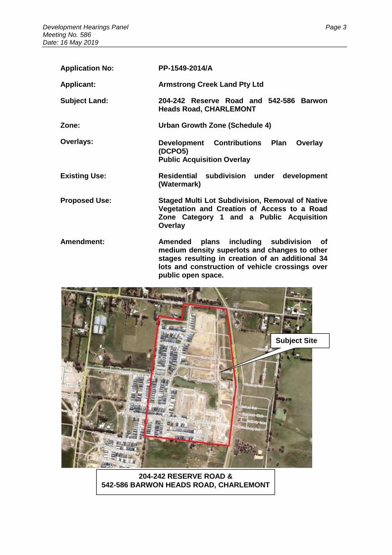
Development Hearings Panel Page 3 Meeting No. 586 Date: 16 May 2019
Application No: PP-1549-2014/A
Applicant: Armstrong Creek Land Pty Ltd
Subject Land: 204-242 Reserve Road and 542-586 Barwon Heads Road, CHARLEMONT
Zone: Urban Growth Zone (Schedule 4)
Overlays: Development Contributions Plan Overlay (DCPO5) Public Acquisition Overlay
Existing Use: Residential subdivision under development (Watermark)
Proposed Use: Staged Multi Lot Subdivision, Removal of Native Vegetation and Creation of Access to a Road Zone Category 1 and a Public Acquisition Overlay
Amendment: Amended plans including subdivision of medium density superlots and changes to other stages resulting in creation of an additional 34 lots and construction of vehicle crossings over public open space.
204-242 RESERVE ROAD &
542-586 BARWON HEADS ROAD, CHARLEMONT
Subject Site

Development Hearings Panel Page 4 Meeting No. 586 Date: 16 May 2019
Summary
The subject land is known as the Watermark estate and is bound by Barwon Heads Rd to the east, Reserve Rd and a private lot to the north, and private land to the west and south, including the Charlemont Rise estate (under construction).
The subject land is in the Urban Growth Zone (Schedule 4), within the Horseshoe Bend Precinct Structure Plan. The land is affected by the Development Contributions Plan Overlay (Schedule 5) and Public Acquisition Overlay.
The land is currently being developed for a multi-lot subdivision, pursuant to Planning Permit PP-1549-2014 (issued 23/7/2015). Stages 1-8 of the estate have been completed.
The proposal is to further subdivide medium density ‘superlots’, including creation of a Barwon Water reserve. A number of the proposed lots would have no road frontage and instead vehicle access is proposed via multiple driveways across a 15m wide public open space corridor, including an offroad shared access path.
The application has been assessed against the purpose and decision guidelines set out in the Urban Growth Zone, Horseshoe Bend Precinct Structure Plan and relevant Planning Policy and Local Planning Policy Framework. The application has also been assessed against the relevant Particular Provisions at Clause 52.29 and Clause 56 along with Section 61(4) of the Planning and Environment Act 1987.
The application is considered to be prohibited under the Urban Growth Zone as it is not in accordance with the Horseshoe Bend Precinct Structure Plan and the requirements (Applied zone provisions) of Schedule 4 to the Urban Growth Zone have not been met.
The proposal is also considered an unsatisfactory response to the purpose of the Urban Growth Zone and applied zones (General Residential Zone and Public Park and Recreation Zone) as well as the Planning Policy Framework, Local Planning Policy Framework and Clauses 52.05 and 52.06.
Notice of the application was not given as the proposal is considered prohibited. Alternatively, in the event it is considered in accordance with the Horseshoe Bend Precinct Structure Plan, the application would be exempt from notice requirements under the Urban Growth Zone.
Council received notice of an appeal lodged under Section 79 of the Planning and Environment Act 1987 2 May 2019. It is recommended that, had an appeal not been lodged, the application be refused based on the grounds contained in this report.
Recommendation
That had an appeal not been lodged under Section 79 of the Planning and Environment Act 1987, the Responsible Authority having considered all matters which the Planning and Environment Act, 1987, requires it to consider, would have decided to Refuse to Grant an Amended Planning Permit for the Staged Multi Lot Subdivision, Removal of Native Vegetation and Creation of Access to a Road Zone Category 1 and a Public Acquisition Overlay at 204-242 Reserve Road and 542-586 Barwon Heads Road, CHARLEMONT on the following grounds:

Development Hearings Panel Page 5 Meeting No. 586 Date: 16 May 2019
1. The proposal fails to satisfy Clause 37.07 (Urban Growth Zone) of the
Greater Geelong Planning Scheme as it is not generally in accordance with the Horseshoe Bend Precinct Structure Plan, in particular clauses 4.1 (Image and Character) 4.2 (Subdivision and Housing) and 4.6 (Transport and Movement) of the Horseshoe Bend Precinct Structure Plan.
2. The proposal is contrary to the purpose of the Urban Growth Zone and
applied General Residential Zone of the Greater Geelong Planning Scheme, namely to manage the transition of non-urban land into urban land in accordance with a Structure Plan.
3. The proposal does not accord with Clause 37.07 (Urban Growth Zone) of the
Greater Geelong Planning Scheme as the written consent of the public land manager has not been provided for the proposed works in the public open space, as is required under the applied Public Park and Recreation Zone pursuant to Schedule 4 to the Urban Growth Zone of the Greater Geelong Planning Scheme.
4. The proposal is considered contrary to Clauses 15.01-1S (Urban Design),
15.01-3S (Subdivision Design), 16.01-1S (Integrated Housing), 16.01-3S (Housing Diversity) and 18.02-1S (Sustainable Personal Transport of the Greater Geelong Planning Scheme.
5. The proposal is considered contrary to Clauses 21.08-5 (Accessibility) and
21.11 (Armstrong Creek Urban Growth Area) of the Greater Geelong Planning Scheme.
6. The proposal does not meet the objectives of Clause 56.03-1 (Compact and
walkable neighbourhoods), 56.04-1 (Lot diversity and distribution), 56.04-2 (Lot area and building envelopes), 56.04-4 (Street orientation), 56.05-2 (Public open space provision), 56.06-1 (Integrated mobility), 56.06-2 (Walking and cycling network), 56.06-4 (Neighbourhood street network), 56.06-5 (Walking and cycling network detail), 56.06-7 (Neighbourhood street network detail), and 56.06-8 (Lot access).
7. The proposal fails to satisfy Clause 65.02 (Approval of an application to
subdivide land) as it would result in inappropriate lot sizes and dimensions, fails to address adjoining roads, reserves and public open space and would compromise the amenity and movement of pedestrians and cyclists in the off road shared access trail.
Report
The Site & Locality
The subject land is known as the Watermark estate and is bound by Barwon Heads Rd to the east, Reserve Rd and a private lot to the north, private land to the west and south, including the Charlemont Rise estate (under construction).

Development Hearings Panel Page 6 Meeting No. 586 Date: 16 May 2019
Image 1: Site and surrounding area
At the time the original permit was issued, the land comprised two titles with a total area of 39.2 hectares. Since this time, the subdivision has progressed and titles have been issued for the lots in Stages 1-8 of the estate. It is noted the road proposed to access the Stage 8 (south) medium density lot has been constructed as part of the works required prior to the issue of a Statement of Compliance.
Figure 3: Armstrong Creek Growth Area Precincts. Source: COGG website

Development Hearings Panel Page 7 Meeting No. 586 Date: 16 May 2019
The site is located in the Armstrong Creek Growth Area within the Horseshoe Bend Precinct, with the site being located toward the northeast end of the precinct and having abuttal to the Marshall and North East Industrial Precincts (to the north). The Horseshoe Bend Precinct comprises a total of 638 hectares and will eventually be developed with 7,069 new dwellings. The land undulates gently, rising to a ridgeline in the centre of the precinct.
Figure 2: Horseshoe Bend Precinct (subject land outlined in red). Source: Horseshoe Bend PSP
A permit (PP-1302-2017) has been issued for some land opposite to the east - a multi-lot staged subdivision, known as the ‘Glenlee’ estate. There are examples of rural living environments in the area surrounding the subject site. Ultimately all of the surrounding land will be subdivided for residential purposes, with land associated with the Regional Play Ground (opposite to the east) being developed for recreation purposes. Land along both Reserve Road (the proposed East-West Link Road) and Barwon Heads Road and widening at the intersection is covered by a Public Acquisition Overlay Schedule 3 for the purposes of road widening and a new intersection. Site History Planning permit PP-1549-2014 was issued 23/7/2015 for Staged Multi Lot Subdivision, Removal of Native Vegetation and Creation of Access to a Road Zone Category 1 and a Public Acquisition Overlay. Endorsed plans were issued 17/9/2015.

Development Hearings Panel Page 8 Meeting No. 586 Date: 16 May 2019
The permit was amended 26/10/2015 pursuant to Section 71(1) (a) of the Planning and Environment Act 1987 to correct a clerical error. Amended plans were issued 5/5/2017 and are the current plans. Proposal
The following amendments are proposed to the plans:
Stage 8: o The 0.55 hectare medium density site has been replaced with twenty lots
(No’s 851-869). It is noted there is an error on the plans, showing two lot no’s for Lot 856. Vehicle access to Lots 869-858 is proposed via a 13.5m wide road and Lots 851-857 would be rear-loaded, with access via an 8m wide laneway linking the east and west parts of the proposed 13.5m road. Lot sizes would be generally 135-142sqm, with larger irregular shaped corner lots between 153-225sqm.
o The 0.29 hectare medium density site has been replaced with four lots (No’s 847-850), between 405-528sqm in size. A 5m wide road reserve (notated as ‘pedestrian access only) is shown on the north and east sides. The road over the linear public open space corridor (easement) has been replaced with four individual crossovers to each lot, also over the public open space.
o The lots have been removed from stage 8 and included in a new stage (stage 8a).
Stage 11: the 0.25 hectare medium density site has been replaced with six lots (No’s 1157-1163) between 223-454sqm in size and a Barwon Water reserve (326sqm). These lots have been included in a new stage (stage 11a). Lots 1157-1160 would front a road to the south, while Lots 1161 and 1163 will be accessed via individual crossovers across the public open space. The lot has been removed from stage 11 and included in a new stage (stage 11a).
Lots less than 300 square metres are proposed to be developed in accordance with the Small Lot Housing Code.
In stage 10, the drainage reserve has increased from 0.23 to 0.27ha.
The lot summary shows an additional 34 lots are to be created. The proposed subdivision of the medium density lots would result in an additional 30 lots. Changes to Stages 10, 11 and 12 will also result in an additional 4 lots.
It is noted Stages 10 (drainage reserve) and 11A are within current Lot B PS811179H. Stages 8A and 8B are shown within Lot A PS804357A. Stage 12 and part of Stage 10 are within Lot A PS730377D. Greater Geelong Planning Scheme
Zone
The subject site (and surrounding properties) are located within the Urban Growth Zone (Schedule 4). The land abuts a Road Zone (Category 1) to the east (Barwon Heads Road). Overlay
The subject site (and surrounding properties) are located within a Development Contributions Plan Overlay (Schedule 5). The land also abuts (and is partly within) a Public Acquisition Overlay to the east (along Barwon Heads Road).

Development Hearings Panel Page 9 Meeting No. 586 Date: 16 May 2019
Permit required clause and condition
Pursuant to Clause 52.29-2 a permit is required to subdivide land adjacent to:
A road in a Road Zone, Category 1.
Land in a Public Acquisition Overlay if the purpose of acquisition is for a Category 1 road.
Urban Growth Zone Clause 37.07-10 (Subdivision of land) of the Urban Growth Zone provides any requirement in the schedule to the zone or the precinct structure plan must be met. Also pursuant to Clause 37.07-11 (Buildings and works) if the schedule to this zone specifies:
That the provisions of a zone apply to the development of land, the provisions of the zone apply to land in the circumstances specified in the schedule.
Provisions relating to the development of land, those provisions apply to land in the circumstances specified in the schedule.
The zone also provides that for applications for both subdivision and buildings and works, if the schedule to this zone specifies that a permit is required to construct a building or construct or carry out works, a permit granted must:
Be generally in accordance with the precinct structure plan applying to the land.
Include any conditions or requirements specified in the schedule to this zone or the precinct structure plan.
Schedule 4 to the UGZ states at 2.2 (Applied zone provisions) the provisions of zones in this scheme apply to the use and subdivision of land, construction of a building and construction and carrying out of works, by reference to Map 1 of this schedule. Map 1 of the schedule identifies the subject site as land for residential, public open space (easement), passive open space and wetland/basin/drainage and encumbered open space (drainage). Table 1 of the schedule identifies the relevant applied zones to the application are the General Residential Zone (Schedule 1) and Public Park and Recreation Zone (to the public open space). Applied Zones Pursuant to Clause 32.08-3 (General Residential Zone) a permit is required to subdivide land. Pursuant to Clause 36.02-2 (Public Park and Recreation Zone) a permit is required to construct or carry out works. Section 72 Pursuant to Section 72 of the Planning and Environment Act 1987 a person may apply to amend a permit. Encumbrances on title Land affected by the amendment are the following titles: Lot B PS811179H (contains Stages 10 (drainage reserve) and 11A). Lot A PS804357A (contains Stages 8A and 8B)

Development Hearings Panel Page 10 Meeting No. 586 Date: 16 May 2019
The subject site is not burdened by a Restrictive Covenant or Section 173 Agreement. It is noted a restriction is recorded on the Plan of Subdivision for Lots 201-250 PS730377D and Lots 701 - 730 PS804357A, which lists the same lots as both beneficiaries and burdened land and does not include Lot A on either title (the subject site). It is also noted the applicant declared on the application form the proposal does not breach any encumbrances on title. A 9.96m Barwon Water pipeline easement (E-1) and a 6.04m pipeline/drainage/sewerage easement (E-2) in favour of Barwon Water and Council runs along the alignment of the shared access path/sewer pipeline reserve discussed earlier on Lot B PS811179H. A 16m wide Barwon Water pipeline easement (E-1) is shown along the sewer pipeline reserve on Lot A PS804357A. Cultural Heritage Management Plan (CHMP) Areas of cultural heritage sensitivity are defined within Division 3 of the Aboriginal Heritage Regulations 2018. Division 3 does not identify the site or part of the site as within an area of cultural heritage sensitivity. In accordance with the above assessment, a cultural heritage management plan is required and a cultural heritage management plan has not been approved. COASTAL INUNDATION AND EROSION: Clause 13.01-1 of the SPPF requires the Responsible Authority to consider the potential coastal impacts of climate change. Strategies include:
In planning for possible sea level rise, an increase of 0.2 metres over current 1 in 100 year flood levels by 2040 may be used for new development in close proximity to existing development (urban infill).
Plan for possible sea level rise of 0.8 metres by 2100, and allow for the combined effects of tides, storm surges, coastal processes and local conditions such as topography and geology when assessing risks and coastal impacts associated with climate change.
Consider the risks associated with climate change in planning and management decision making processes.
The subject site is located within close proximity of existing urban development. Council’s data indicates that the site is unlikely to be affected by the potential coastal impacts of climate change at 2040/2100.

Development Hearings Panel Page 11 Meeting No. 586 Date: 16 May 2019
LANDFILL GAS RISK ASSESSMENT Before deciding on a Planning Permit application, a Responsible Authority is required to consider, amongst other things:
Any significant effects the responsible authority considers the environment may have on the use or development [S 60(1) of the PEA].
Clause 13.04-1S of The State Planning Policy Framework which aims to ensure that potentially contaminated land is suitable for its intended future use and development, and that contaminated land is used safely.
The EPA has adopted the “Best Practice Environmental Management, Siting, Design Operation and Rehabilitation of Landfills” (September 2010) or “Landfill BPEM.”. The Landfill BPEM identifies that:
Risks associated with landfill gases may occur for at least 30 years post-closure.
Appropriate buffer distances must be maintained between the landfill and sensitive land uses. The BPEM recommends a 500 metre buffer for landfills that contained putrescible waste and 200 metres for landfills that contained non-putrescible waste.
Where the recommended buffers are unavailable, it must be demonstrated that risks are suitably mitigated.
All buildings and structures and associated infrastructure should be considered. The BPEM specifies that development undertaken within a buffer distance of up to 500 metres may be at risk. As the subject site is not located within 500 metres of an identified former landfill site, a risk assessment is not required. DEVELOPMENTS IN BUSHFIRE PRONE AREAS Clause 13.02-1S (Bushfire planning) seeks to strengthen the resilience of settlements and communities to bushfire through risk-based planning that prioritises the protection of human life. The policy must be applied to all planning and decision making under the Planning and Environment Act 1987 relating to land which is:
Within a designated bushfire prone area;
Subject to a Bushfire Management Overlay; or
Proposed to be used or developed in a way that may create a bushfire hazard. The proposal is listed at Clause 13.02-1S as one of the uses or developments which should be considered:
Subdivisions of more than 10 lots. The site is located within a designated bushfire prone area. As the site is located within a designated bushfire prone area the assessment of this application has considered:
The risk of bushfire to people, property and community infrastructure.
Whether the implementation of appropriate bushfire protection measures to address the identified bushfire risk is necessary.
Whether the proposal can implement bushfire protection measures without unacceptable biodiversity impacts.
Development Hearings Panel Page 12 Meeting No. 586 Date: 16 May 2019
The application is expected to create a risk bushfire to people, property and community infrastructure. Bushfire risk is discussed further in the CFA referral assessment later in the report. Officer Direct Or Indirect Interest: No Council officers have any direct or indirect interest in the matter to which this report relates, in accordance with Section 80 (C) of the Local Government Act. Planning Policy Framework
11.03-2S – Growth Area Objective To locate urban growth close to transport corridors and services and provide efficient and effective infrastructure to create sustainability benefits while protecting primary production, major sources of raw materials and valued environmental areas. Strategies Concentrate urban expansion into growth areas that are served by high-capacity public transport. Implement the strategic directions in the Growth Area Framework Plans. Encourage average overall residential densities in the growth areas of a minimum of 15 dwellings per net developable hectare, and over time, seek an overall increase in residential densities to more than 20 dwellings per net developable hectare. Deliver timely and adequate provision of public transport and local and regional infrastructure and services, in line with a preferred sequence of land release. Provide for significant amounts of local employment opportunities and in some areas, provide large scale industrial or other more regional employment generators. Create a network of mixed-use activity centres that are high quality, well designed and create a sense of place. Provide a diversity of housing type and distribution. Retain unique characteristics of established areas impacted by growth. Protect and manage natural resources and areas of heritage, cultural and environmental significance. Create well planned, easy to maintain and safe streets and neighbourhoods that reduce opportunities for crime, improve perceptions of safety and increase levels of community participation.

Development Hearings Panel Page 13 Meeting No. 586 Date: 16 May 2019
Develop Growth Area Framework Plans that will:
Include objectives for each growth area.
Identify the long term pattern of urban growth.
Identify the location of broad urban development types, for example activity
centre, residential, employment, freight centres and mixed use employment.
Identify the boundaries of individual communities, landscape values and, as
appropriate, the need for discrete urban breaks and how land uses in these
breaks will be managed.
Identify transport networks and options for investigation, such as future railway
lines and stations, freight activity centres, freeways and arterial roads.
Identify the location of open space to be retained for recreation, and/or
biodiversity protection and/or flood risk reduction purposes guided and directed
by regional biodiversity conservation strategies.
Show significant waterways as opportunities for creating linear trails, along with
areas required to be retained for biodiversity protection and/or flood risk
reduction purposes.
Identify appropriate uses for constrained areas, including quarry buffers.
Develop precinct structure plans consistent with the Precinct Structure Planning Guidelines (Growth Areas Authority, 2009) approved by the Minister for Planning to:
Establish a sense of place and community.
Create greater housing choice, diversity and affordable places to live.
Create highly accessible and vibrant activity centres.
Provide for local employment and business activity.
Provide better transport choices.
Respond to climate change and increase environmental sustainability.
Deliver accessible, integrated and adaptable community infrastructure.
Policy document Consider as relevant:
The Victorian Transport Plan (Victorian Government, 2008)
Any applicable Growth Area Framework Plans (Department of Sustainability and
Environment, 2006)
Precinct Structure Planning Guidelines (Growth Areas Authority, 2009)
Ministerial Direction No. 12 – Urban Growth Areas
Development Hearings Panel Page 14 Meeting No. 586 Date: 16 May 2019
15.01-1S Urban Design Objective To create urban environments that are safe, functional and provide good quality environments with a sense of place and cultural identity. Strategies Require development to respond to its context in terms of character, cultural identity, natural features, surrounding landscape and climate. Ensure development contributes to community and cultural life by improving the quality of living and working environments, facilitating accessibility and providing for inclusiveness. Ensure the interface between the private and public realm protects and enhances personal safety. Ensure development supports public realm amenity and safe access to walking and cycling environments and public transport. Ensure that the design and location of publicly accessible private spaces, including car parking areas, forecourts and walkways, is of a high standard, creates a safe environment for users and enables easy and efficient use. Ensure that development provides landscaping that supports the amenity, attractiveness and safety of the public realm. Ensure that development, including signs, minimises detrimental impacts on amenity, on the natural and built environment and on the safety and efficiency of roads. Promote good urban design along and abutting transport corridors. Policy documents Consider as relevant:
Urban Design Guidelines for Victoria (Department of Environment, Land, Water and Planning, 2017)
15.01-3S - Subdivision Design Objective To ensure the design of subdivisions achieves attractive, safe, accessible, diverse and sustainable neighbourhoods. Strategies In the development of new residential areas and in the redevelopment of existing areas, subdivision should be designed to create liveable and sustainable communities by:

Development Hearings Panel Page 15 Meeting No. 586 Date: 16 May 2019
Creating compact neighbourhoods that have walkable distances between activities.
Developing activity centres in appropriate locations with a mix of uses and services and access to public transport.
Creating neighbourhood centres that include services to meet day to day needs.
Creating urban places with a strong sense of place that are functional, safe and attractive.
Providing a range of lot sizes to suit a variety of dwelling and household types to meet the needs and aspirations of different groups of people.
Creating landscaped streets and a network of open spaces to meet a variety of needs with links to regional parks where possible.
Protecting and enhancing native habitat.
Facilitating an urban structure where neighbourhoods are clustered to support larger activity centres served by high quality public transport.
Reduce car dependency by allowing for:
o Convenient and safe public transport
o Safe and attractive spaces and networks for walking and cycling
o Subdivision layouts that allow easy movement within and between neighbourhoods.
o A convenient and safe road network.
Being accessible to people with disabilities.
Creating an urban structure and providing utilities and services that enable energy efficiency, resource conservation, integrated water management and minimisation of waste and air pollution.
Policy documents
Consider as relevant:
Urban Design Guidelines for Victoria (Department of Environment, Land, Water and Planning, 2017)
16.01-1S - Integrated Housing Objective To promote a housing market that meets community needs. Strategies Increase the supply of housing in existing urban areas by facilitating increased housing yield in appropriate locations, including under-utilised urban land. Ensure that an appropriate quantity, quality and type of housing is provided, including aged care facilities and other housing suitable for older people, supported accommodation for people with disability, rooming houses, student accommodation and social housing. Ensure housing developments are integrated with infrastructure and services, whether they are located in existing suburbs, growth areas or regional towns.

Development Hearings Panel Page 16 Meeting No. 586 Date: 16 May 2019
Facilitate the delivery of high quality social housing to meet the needs of Victorians. 16.01-3S – Housing Diversity Objective To provide for a range of housing types to meet diverse needs Strategies Ensure housing stock matches changing demand by widening housing choice. Facilitate diverse housing that offers choice and meets changing household needs through:
A mix of housing types.
Adaptable internal dwelling design.
Universal design. Encourage the development of well-designed medium-density housing which:
Respects the neighbourhood character.
Improves housing choice.
Makes better use of existing infrastructure.
Improves energy efficiency of housing. Support opportunities for a range of income groups to choose housing in well-serviced locations. Ensure planning for growth areas provides for a mix of housing types and higher housing densities in and around activity centres. 18.02-1S - Sustainable Personal Transport Objective To promote the use of sustainable personal transport. Strategies Ensure development and the planning for new suburbs, urban renewal precincts, greyfield redevelopment areas and transit-oriented development areas (such as railway stations) provide opportunities to promote more walking and cycling. Encourage the use of walking and cycling by creating environments that are safe and attractive. Develop high quality pedestrian environments that are accessible to footpath-bound vehicles such as wheelchairs, prams and scooters. Ensure cycling routes and infrastructure are constructed early in new developments.
Development Hearings Panel Page 17 Meeting No. 586 Date: 16 May 2019
Provide direct and connected pedestrian and bicycle infrastructure to and between key destinations including activity centres, public transport interchanges, employment areas, urban renewal precincts and major attractions. Ensure cycling infrastructure (on-road bicycle lanes and off-road bicycle paths) is planned to provide the most direct route practical and to separate cyclists from other road users, particularly motor vehicles. Require the provision of adequate bicycle parking and related facilities to meet demand at education, recreation, transport, shopping and community facilities and other major attractions when issuing planning approvals. Provide improved facilities, particularly storage, for cyclists at public transport interchanges, rail stations and major attractions. Ensure provision of bicycle end-of-trip facilities in commercial buildings Local Planning Policy Framework
Municipal Strategic Statement
Summary of relevant MSS
21.06-2 - Urban Growth The objective of Clause 21.06-2 of the Municipal Strategic Statement is to:
limit urban sprawl by directing urban growth to designated urban growth areas.
improve housing affordability through the maintenance of appropriate urban land supplies, the promotion of competition in the housing market and the development of a diverse range of well-located housing stock.
Strategies
Direct the majority of new Greenfield residential development to the designated primary urban growth areas at Armstrong Creek, Ocean Grove, Drysdale/Clifton Springs, Lara and Leopold.
Maintain the non-urban break between Geelong and Werribee and, in particular, prevent further expansion of the Little River township boundary.
Maintain the Geelong Ring Road as the western boundary of urban Geelong.
Ensure that land use and development does not compromise the capacity or potential future development of areas designated for future urban growth, as shown on the relevant Structure Plan or Urban Growth Plan.
Require a minimum residential density of 15 dwellings per hectare in all new urban growth areas.
Ensure development occ`urs within designated settlement boundaries.
Where possible use natural boundaries to define the edges of urban areas.
Provide for infill urban growth in the Fyansford area.
Prevent further subdivision and medium density housing in Breamlea.
Limit rural living development to existing zoned land in the existing nodes at Lara, Drysdale/Clifton Springs, Wallington, Lovely Banks and Batesford.
Ensure new residential neighbourhoods provide a mix of housing suited to the needs of a diverse range of household types.

Development Hearings Panel Page 18 Meeting No. 586 Date: 16 May 2019
21.08-5 - Accessibility The objective of Clause 21.08-5 of the Municipal Strategic Statement is to:
ensure safe access to community and development infrastructure for all members of the community.
Strategies
Where possible, ensure shared recreational, walking and cycling trails provide accessible links between activity centres, schools, public transport hubs, open space and recreation areas.
Encourage passive surveillance of all recreational areas and trails.
Require the provision of safe bicycle parking and storage facilities in activity centres, employment nodes, community facilities, recreation areas and public transport hubs.
Ensure all development and community infrastructure provides safe accessibility for all members of the community.
21.11-2 – Armstrong Creek Urban Growth Area The objective of Clause 21.11-2 of the Municipal Strategic Statement is to:
provide a wide range of housing types and densities in an urban structure based on walkable neighbourhoods, public transport and mixed use activity centres.
establish a network of mixed use activity centres providing retail, community and educational facilities for the incoming Armstrong Creek community.
create an economic and employment structure that complements the broader Geelong region while providing employment areas, business opportunities and local jobs.
protect and enhance the natural environmental features and cultural heritage values of the Armstrong Creek area and provide a distinct urban character and green setting.
ensure the provision of a comprehensive and well connected network of open space and recreation facilities.
provide a sustainable movement and access network within the Armstrong Creek area.
provide utility services that meet current best practice standards and are environmentally sustainable.
ensure the orderly and controlled development of Armstrong Creek. Strategies
Ensure land use and development in the Armstrong Creek Urban Growth Area proceeds generally in accordance with the Armstrong Creek Urban Growth - Framework Plan Incorporated Document.
Require the preparation of Precinct Structure Plans providing for at least one ‘walkable neighbourhood’ of approximately 1.6 kilometres in diameter, prior to any application for land use and development in the Armstrong Creek Urban Growth Area.
Ensure that Precinct Structure Plans in the ACUGA are generally in accordance with the Armstrong Creek Urban Growth Plan, Volume 1.

Development Hearings Panel Page 19 Meeting No. 586 Date: 16 May 2019
Require planning permit applications for subdivision to demonstrate: o that required infrastructure will be provided to the subdivision area in a
timely manner. o that the subdivision layout will achieve integration with existing or future
subdivision layouts for surrounding landholdings; and o that the subdivision will facilities the orderly development of the precinct.
Response The proposal is regarded as an inappropriate response to the Planning Policy Framework and Local Planning Policy Framework. It fails to provide proper separation between pedestrians and cyclists, by proposing vehicle access across public open space and an off-road shared path. The proposal also does not achieve good orientation to the proposed Barwon Water Reserve or provide an active interface with the adjoining Barwon Heads Road and East-West Link Road. It is also considered that while the medium density sites are appropriate for a form of medium density development, they are not well located or serviced to a degree that minimum amenity standards (i.e. Clauses 55 and 56) can be put aside. Overall the proposal does not provide an appropriate interface with public realm, will compromise the amenity and function of the intended use of the public open space and provide an unacceptably low standard of amenity.
Development Hearings Panel Page 20 Meeting No. 586 Date: 16 May 2019
Referrals
EXTERNAL Section 55 Determining Authorities:
Authority/Department Advice/Response/Conditions
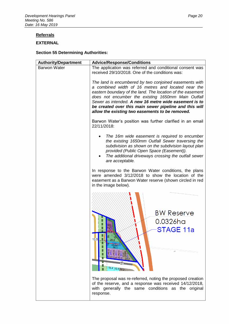
Barwon Water The application was referred and conditional consent was received 29/10/2018. One of the conditions was: The land is encumbered by two conjoined easements with a combined width of 16 metres and located near the eastern boundary of the land. The location of the easement does not encumber the existing 1650mm Main Outfall Sewer as intended. A new 16 metre wide easement is to be created over this main sewer pipeline and this will allow the existing two easements to be removed. Barwon Water’s position was further clarified in an email 22/11/2018:
The 16m wide easement is required to encumber the existing 1650mm Outfall Sewer traversing the subdivision as shown on the subdivision layout plan provided (Public Open Space (Easement)).
The additional driveways crossing the outfall sewer are acceptable.
In response to the Barwon Water conditions, the plans were amended 3/12/2018 to show the location of the easement as a Barwon Water reserve (shown circled in red in the image below).
The proposal was re-referred, noting the proposed creation of the reserve, and a response was received 14/12/2018, with generally the same conditions as the original response.
Development Hearings Panel Page 21 Meeting No. 586 Date: 16 May 2019
Response: The proposed reserve would isolate the proposed lot 1163 adjoining to the north, leaving it without access to a road. It would abut the reserve and Barwon Heads Rd/East West Link Rd PAO to the north and east and the public open space to the west. A vehicle crossing is proposed to the lot across the public open space, which includes a shared path, which is regarded as unsatisfactory. It is noted that while Barwon Water have not objected to the proposal, their condition requires an easement, not a reserve. It is acknowledged it may not be possible to build over the easement (dependant on Barwon Water requirements), the easement could be used for an alternative purpose, such as private or communal open space and access to the road further south in a medium density development. The reserve is also not required for active or passive recreation, given sufficient space is provided within the overall subdivision further southeast.
Authority/Department Advice/Response/Conditions
Downer Conditional consent.
Response: The conditions should be included in the event a permit is issued.
Authority/Department Advice/Response/Conditions
Conditional consent. The application is supported subject to conditions on the planning permit.
Response: The conditions should be included in the event a permit is issued.
Authority/Department Advice/Response/Conditions
Transport for Victoria No objection.
Response: Noted
Authority/Department Advice/Response/Conditions
CFA The application was referred and conditional consent was received 16/10/2018. One of the comments was: The siting and layout of the subdivision should consider the vegetation located on the surrounding land and avoid creating new development that conflicts with the updated state bushfire planning policy contained at Clause 13.05 of the planning scheme. The applicant provided a Bushfire Planning Report (Brett Lane and Associates, November 2018) and the application was re-referred to CFA. No response has been received.

Development Hearings Panel Page 22 Meeting No. 586 Date: 16 May 2019
Response: In the event the proposed amendment is approved, a response regarding bushfire safety from CFA should be sought prior to an amended permit or plans being issued. It is noted the Bushfire Planning Report states: Given the lack of classified vegetation, there is no defendable space required for the subject site. All dwellings in the subdivision may be built to BAL-LOW given that Bushfire Prone Area mapping is likely to be removed from the permit area itself following construction. Provided this is correct, the proposal would not result in directing population growth and development to a location with a BAL level above 12.5 and would meet the requirements of Clause 13.02-1S (Bushfire planning).
Authority/Department Advice/Response/Conditions
VicRoads No objection.
Response: Noted.
Section 52:
Authority/Department Advice/Response/Conditions
CCMA No objection
Response: Noted.
INTERNAL
Authority/Department Advice/Response/Conditions
Open Space and Recreation
Further information requested 1. Written approval from Barwon Water relating to the
(increased number of) driveways crossing the sewer easement. Note that the sewer main is to be duplicated at some point into the future, and any costs associated with reinstatement of the driveways will not be paid for by Council. This would also potentially leave the lots with no vehicular access during construction. I would be hesitant to recommend this access across the easement even with Barwon Water approval, due the reinstatement and access issues detailed above, as well as creating potential conflict points between private residents and the public utilising the shared path.
2. Apart from point one, the interface of the easement to its surrounds remains unchanged. As long as road or open space fronts one side of the easement we are satisfied that reasonable passive surveillance will be achieved. A 2.5m shared path does need to run along the full extent of the easement as per Plan 11 – Walking/Cycling Links of the Horseshoe Bend PSP. This should be shown on an amended plan prior to it being endorsed.

Development Hearings Panel Page 23 Meeting No. 586 Date: 16 May 2019
3. What are the 5m wide spaces between the medium density lots and intersections?
4. Concept layouts of the intersections in the PAO adjacent to each medium density site – need to assess interface.
Response: The concern regarding the driveways crossing the public open space is regarded as valid as it will create conflict points with users of the shared path. While Barwon Water have not objected, it is considered the vehicle crossings will compromise the functionality of the shared path and is unsatisfactory. The applicant has not advised what the 5m wide spaces are for (they are shown as road reserve on the plan) and concept layouts of the intersections with the PAO have not been provided.
Authority/Department Advice/Response/Conditions
Engineering The applicant has not provided adequate detail or acceptable plans/drawings that enable Traffic & Engineering to assess the suitability of the submitted Subdivision Layout Plan and associated supporting documentation. For Council to effectively consider traffic, public safety and servicing requirements issues that need to be more fully addressed include but are not limited to:
Stage 11A (Lots 1161 & 1163) – details of access including bollards or similar treatment to define trafficable area with such access subject to “No Standing” status, shared path to delineate property boundaries across POS frontage, provisions for safety of shared path users, utilities services locations & easement requirements, cost and maintenance of access & bollards responsibility of landowner (& notated on title), formal approval of Barwon Water (building over easement) & City of Greater Geelong, Recreation & Open Space to access across the POS, clarify street address, etc.
Stage 8A (North?) – details of interface with existing roads and infrastructure (Watermark Stage 8), vehicle crossing/lot access provisions addressing location & minimum offset to intersections, car parking, intersection safety & treatment requirements, etc.
Stage 8A (South?) (Lots 847 – 850 incl.) – details of access across POS including bollards or similar treatment to define trafficable area with such access subject to “No Standing” status, footpath to delineate property boundaries across POS frontage, utilities services locations & easement requirements, cost and maintenance of access & bollards responsibility of landowner (& notated on title), formal approval of Barwon Water (building over easement) & City of Greater Geelong, Recreation & Open Space for access across the POS or locate footpaths also within this area, clarify street address, etc.

Development Hearings Panel Page 24 Meeting No. 586 Date: 16 May 2019
Each of the above proposals must be fully detailed and provide adequate information for Council to be able to make an informed decision of respective proposal acceptability otherwise Traffic & Engineering must seek additional detail from the applicant.
Response: The comments are acknowledged and identify problems with the proposed vehicle crossings across the public open space and shared path, including pedestrian safety and potential parking in the open space, as well as potential physical additions (bollards) being required to be placed in the shared path. As discussed earlier, it is considered the crossings would compromise the function of the off-road shared path by adding vehicular movements across it, as well as requiring physical impediments to bicycle movements to prevent vehicle access.
Authority/Department Advice/Response/Conditions
Environment The only item that is considered relevant is that all the other medium density sites have a 5 metre landscape buffer adjacent to Barwon Heads Road. It is noted that there isn’t one provided for the lots south of the central drainage reserve, in particular the lot closest to Barwon Heads Road shown in a brown colour. It would seem a sound design outcome and consistent with the balance of the eastern edge of the development to incorporate a similar 5 metre landscaped edge to this major roadway, next to such small lots where it will be difficult to establish large canopy trees. It is suggested the Subdivision Layout Plan be amended to reflect this design outcome.
Response: As noted earlier, the applicant has not advised the purpose of the 5m wide spaces.
Authority/Department Advice/Response/Conditions
Parks Regarding the 5m buffer zones, it is assumed that these have been included at the request of Vic Roads? It is not uncommon to see these types of reserves created (vested in Council) to prevent future access directly from main roads. The interface of each medium density site could be softened via the use of appropriately selected trees on the Barwon Heads Road frontages and also within the easements however, the sewer easements in Section A of Armstrong Creek were an item discussed in detail with Barwon Water as any design was required to consider the future duplication and secondly, ensure that unimpeded access was provided to the various maintenance access points throughout the site. It is suggested that this may need to occur again due to the time lapse since.

Development Hearings Panel Page 25 Meeting No. 586 Date: 16 May 2019
Response: As noted earlier, the applicant has not advised the purpose of the 5m wide spaces. Barwon Water has provided conditional consent to the proposal.
Authority/Department Advice/Response/Conditions
Urban Growth No objection.
Response: Noted.
Authority/Department Advice/Response/Conditions
Waste Conditional consent.
Response: Noted. In the event a permit is issued, consideration should be given to whether the conditions are required in addition to those included in the current permit.
PUBLIC NOTIFICATION: The application is not exempt from the notice requirements of Section 52(1)(a), (b) and (d), the decision requirements of Section 64(1), (2) and (3) and the review rights of Section 82(1) of the Act, as it is not considered to be in accordance with the Horseshoe Bend Precinct Structure Plan. Alternatively, in the event the proposal is considered in accordance with the Horseshoe Bend Precinct Structure Plan, it would be exempt from notice requirements pursuant to Clause 37.07-13 of the Greater Geelong Planning Scheme. AMENDMENT OF THE APPLICATION The applicant made a request to amend the application following public notification pursuant to Section 57A of the Planning and Environment Act 1987 on 3 December 2018. Council has accepted the amendment. The amendment amended the plans to include creation of a Barwon Water reserve in proposed Stage 11a. These are the plans currently under assessment. Assessment
ZONE: Clause 37.07 – Urban Growth Zone The purpose of Clause 37.07 of the Urban Growth Zone is:
To implement the Municipal Planning Strategy and the Planning Policy Framework
To manage the transition of non-urban land into urban land in accordance with a precinct structure plan.
To provide for a range of uses and the development of land in accordance with a precinct structure plan.
To contain urban use and development to areas identified for urban development in a precinct structure plan.
To provide for the continued non-urban use of the land until urban development in accordance with a precinct structure plan occurs.
To ensure that, before a precinct structure plan is applied, the use and development of land does not prejudice the future urban use and development of the land.

Development Hearings Panel Page 26 Meeting No. 586 Date: 16 May 2019
As noted earlier, the provisions of the applied zones must be met pursuant to Schedule 4 of the Urban Growth Zone. Also any other requirement in the schedule or the precinct structure plan must be met. The applied zones relevant to the application are the General Residential Zone (Schedule 1) and Public Park and Recreation Zone (to the public open space). Clause 32.08 - General Residential Zone The purpose of the zone is:
To implement the Municipal Planning Strategy and the Planning Policy Framework.
To encourage development that respects the neighbourhood character of the area.
To encourage a diversity of housing types and housing growth particularly in locations offering good access to services and transport.
To allow educational, recreational, religious, community and a limited range of other non-residential uses to serve local community needs in appropriate locations.
Pursuant to Clause 32.08-3 (General Residential Zone) a permit is required to subdivide land. An application to subdivide land for over 60 lots must meet the requirements of Clause 56 (ResCode). Clause 36.02 - Public Park and Recreation Zone The purpose of the zone is:
To implement the Municipal Planning Strategy and the Planning Policy Framework.
To recognise areas for public recreation and open space.
To protect and conserve areas of significance where appropriate.
To provide for commercial uses where appropriate. Pursuant to Clause 36.02-3 (Application requirements) an application for a permit by a person other than the relevant public land manager must be accompanied by the written consent of the public land manager, indicating that the public land manager consents generally or conditionally either:
To the application for permit being made.
To the application for permit being made and to the proposed use or development. Response Urban Growth Zone and Applied Zones Council’s Open Space and Recreation Department has not consented to the proposal and has instead raised concerns about the proposed vehicle crossings across the public open space. This is a mandatory requirement of the PPRZ and therefore this element of the proposal is not considered to be in accordance with the principles of the zone and applied zones.

Development Hearings Panel Page 27 Meeting No. 586 Date: 16 May 2019
The proposal is also regarded as inconsistent with the purpose of the GRZ, as it does not achieve a sufficient level of amenity for the proposed lots, which will not have good access to services and transport. Use of the small lot housing code is not supported in this location and the lots do not comply with the standards or objectives of Clause 56. This is further discussed in the PSP and Clause 56 assessments later in the report. Finally, the proposal is regarded as inconsistent with the Horseshoe Bend PSP, which is a requirement of the UGZ for subdivision proposals and it is accordingly considered inconsistent with the provisions under the zone. Horseshoe Bend PSP The Horseshoe Bend PSP (September 2014) is an incorporated document pursuant to Clause 81.01 of the Scheme. The PSP identifies the relevant land as for residential and public open space (easement) purposes. Clauses 4.1 (Image and Character), 4.2 (Subdivision and Housing) and 4.6 (Transport and Movement) of the PSP are of particular relevance to the proposal. Clause 3.2 (Land Use Budget) lists the sewerage easement as proposed public open space (encumbered land available for recreation). Clause 4.1 Image and Character includes the following objectives:
Capitalise on the existing natural and cultural features of the site, and to deliberately incorporate specific urban design, landscaping and built form initiatives to create interesting, attractive and diverse neighbourhoods.
Enhance the waterways and drainage reserves as a linear green space, recreation area, walking / cycling link and landscape asset through the HBP;
Provide a series of off road (along the greenways, waterways, main sewer easement and other open space links) and on-street, open space and trails to provide trail loops linking from the Armstrong Creek Town Centre, Armstrong Creek, Marshall railway station, the community hubs / sporting facilities and on to the Barwon River Parklands;
Facilitate a series of greenways that protect and enhance high quality roadside vegetation, and will be used a recreation links for cycling and walking and other recreation activities;
Protect and enhance the value of areas and sites of environmental significance and to promote their appropriate use or enjoyment as assets in HBP;
Retain and conserve the remnant indigenous tree communities (including roadside vegetation) in HBP;
Promote new landscape and street tree planting that is consistent with the existing predominantly native / indigenous landscape character but does not exclude exotic species where appropriate to promote a particular theme, to provide alternative feature trees or to enhance passive solar access;
Enhance the Surf Coast Highway as a major boulevard through the HBP, through: o Landscaping and road design that enables planting of large canopy trees
(refer to Figure M) and o Design of adjacent land uses to provide a positive land use interface with the
Highway; o Progressive reduction in the speed limit from 100 km/hr to 60km/hr (adjacent
to the Armstrong Creek Town Centre) and 80 km/hr (north of the Armstrong Creek Town Centre) as intersections are constructed, and adjacent land uses are developed.

Development Hearings Panel Page 28 Meeting No. 586 Date: 16 May 2019
Provide a balanced cross-section for the Armstrong Creek East-West Link Road to meet the needs of both the road users and the development and which provides opportunities for landscaping that responds to the amenity needs of the adjacent land use in both the interim and ultimate condition of the road;
Provide for appropriate landscaping along the Armstrong Creek East-West Link Road that responds to the adjoining land use context (i.e. landscape character to change as the land use interface changes) and provides appropriate noise attenuation and a visual buffer for adjoining properties to the north and south;
Plan and provide for human-scale facilities including a 'main street' neighbourhood activity centre and a range of other planned and co-located community facilities;
To plan and provide a subdivision design and pedestrian/cycle path network that emphasises walkability and safe access for bicycles;
Encourage distribution of densities through the plan area to achieve a diverse selection of lots and housing forms in all streets and neighbourhoods;
Encourage street based urban design treatments that create points of internal amenity, such as small green spaces, urban parks and character streets/diverse cross-sections that provide a context for diverse housing and land uses throughout the HBPSP;
Discourage intersections that aren’t functional for pedestrians and cyclists, and road design speeds that prevent planting of canopy trees;
Protect or treat appropriately places of recognised heritage value;
Treat appropriately the eastern rural / urban interface in order to minimise adverse visual impacts beyond the growth area;
Create a range of public art opportunities which enhance sense of place, interpret heritage and landscape and promote the identity and character of the HBP.
The objectives for enhancing or developing the image and character are met by implementation of all of the following.
Plan 3: Horseshoe Bend Precinct Urban Structure.
Appendix 5: Public Open Space Guidelines.
Appendix 8: Road Cross Sections.
Planning and design guidelines under Section 4.1.3. The following planning and design guidelines for image and character must be met and are assessed in the following table:
New development with an interface with open space, including greenways, linear waterways and the Barwon River Parklands must be designed to address the public land while promoting public use and surveillance.
Response: It is unclear how future dwellings on proposed Lots 1160, 1161 and 1163 could be oriented to front the adjoining public open space, including the proposed Barwon Water reserve and linear reserve to the west. As discussed earlier, the proposed vehicle crossings across the public open space (easement) is also considered a failure to properly address the function of this future public land.
New development adjacent to greenways must include an edge road condition, or alternative access or design arrangement that ensures the development fronts the greenway except in situations where limited side fences are approved.
Response: N/A

Development Hearings Panel Page 29 Meeting No. 586 Date: 16 May 2019
New development must implement (construction and landscaping) the footpaths and shared paths included in Appendix 7 and road cross-sections in Appendix 8.
Response: N/A
Street trees along declared arterial roads must be selected and planted in accordance with the clear zone guidelines to the satisfaction of the relevant road authority.
Response: Noted
The neighbourhood activity centre must be designed on 'main street' principles of street front activity rather than 'big box' shops / internal malls surrounded on all sides by large highly visible car parking areas.
Response: N/A
New development adjacent to the Armstrong Creek East-West Link Road must provide an active frontage to the arterial road, with access controlled via an appropriate treatment, such as a frontage road.
Response: Proposed Stage 11a is located on the southwest corner of the East-West Link Rd/Barwon Heads Rd intersection. It does not include an active frontage and instead provides a ‘pedestrian access’ road reserve. As discussed earlier, the access proposed for Lots 1163 and 1161 across the public open space is not regarded as appropriate.
Development of the Armstrong Creek East-West Link Road must provide appropriate landscaping that softens the interface between the arterial road and the adjoining land uses.
Response: Plans for the East-West link have not been provided and it is unclear what the interface would be. It is apparent this guideline applies to the works in the road reserve/PAO and not within the subject land.
New development must provide safe road crossings for pedestrians and cyclists on key shared use paths that serve HBP and link to abutting precincts / neighbourhoods (refer Plan 13 Cycling and Walking).
Response: As discussed earlier, details of how the proposed new vehicle crossings across the shared path would be made safe for pedestrians and cyclists have not been provided. Council’s Engineering Department has raised concerns on this issue.
Development must respect sites of historic archaeological significance as identified in the Horseshoe Bend Historic Cultural Assessment. Where sites are to be disturbed, appropriate approvals must be sought and obtained prior to subdivision or development of those land parcels.
Response: Noted
Where key pedestrian and shared paths intersect with roads, safe road crossings must be provided to the satisfaction of the relevant Road Authority.
Response: Noted

Development Hearings Panel Page 30 Meeting No. 586 Date: 16 May 2019
New development must incorporate measures for protection of environmentally significant areas in accordance with the Native Vegetation Precinct Plan (NVPP) and any approved Offset Management Plan
Response: N/A
The following planning and design guidelines should be met and are assessed in the following table.
New development should not include actions or results that harm or lessen the values within environmentally significant areas.
Response: Noted.
New development fronting drainage reserves and open space should provide for a diverse range of lot types and sizes, including a range of (small and large) lot products and a diverse range of streetscapes.
Response: Proposed Stage 11a and 8a (south) offer lots of a similar size to most others in the subdivision, which is not regarded as meeting the guideline. These stages also do not offer a streetscape adjacent to the open space. An integrated development would be better suited to meeting this guideline.
Protection, where possible, of existing vegetation, and in particular, scattered native trees as high amenity landscaped features in streetscapes and open space (refer to Section 4.4 for details).
Response: No vegetation is included in the land subject to the amendment.
New development should avoid loss of roadside vegetation of recognised significance where possible, and where achievable through application of the cross sections in Appendix 8 Road Cross Sections and through appropriate application of the Native Vegetation Framework’s three-step approach for trees identified as ‘practical retention trees in Appendix 2 of the NVPP).
Response: There is no loss of additional road side vegetation that isn’t in accordance with the NVPP.
Planning for public art needs to identify opportunities of different types for artists to respond to the design of new development, its context and the makeup of the community.
Response: N/A
The rural urban interface should minimise adverse impacts at the growth area boundary between urban land uses and rural activity by:
achieving a well-designed transition, including a physical separation of the urban land use from the rural boundary by locating a combination of roads / access lanes, vegetated linear reserves and pathways, drainage reserves, basins and systems or infrastructure and easements;
ensuring the adjacent street network is arranged to provide good visual integration and physical access for emergency services.
Response: N/A

Development Hearings Panel Page 31 Meeting No. 586 Date: 16 May 2019
Clause 4.2 Subdivision and Housing includes the following objectives:
provide a diversity of lots sizes that can facilitate different housing types;
encourage opportunities for affordable housing;
to reach a target density for each sub-precinct in accordance with Plan 4 housing density and diversity and Table 3 Lot Yield and distribution of densities, or by demonstrating an alternative means of balancing densities across the sub-precinct;
provide residential neighbourhoods that promote liveability through high urban design standards, creating attractive streetscapes and a distinctive neighbourhood character;
provide lot sizes and housing types which are responsive to the character of the natural and built environment in the area and respond to principles of environmental sustainability;
encourage large integrated housing sites (including for example medium density housing and other specialised housing forms) within or at the interface of activity centres and overlooking open space.
avoid gated communities in order to maximise residential permeability and neighbourhood integration.
facilitate delivery of smaller lot housing through implementation of the Small Lot Housing Code in suitable locations, generally; o Within the walkable catchment to activity centres, including the MAC, NAC,
and LACs o Within 800m of the train station, o Within 120m of open space, o Where a contiguous row of lots smaller than 300m2 is proposed.
The objectives for housing are met by the implementation of all of the following:
Plan 3: Horseshoe Bend Precinct Urban Structure.
Table 2: Summary Residential Lot Yield Analysis.
Plan 6: Public Open Space.
Plan 11: Walking / Cycling Links.
Planning and design guidelines as set out in Section 4.2.3.
Small Lot Housing Code (GAA, 2012)
Road Cross Sections as set out in Appendix 8. The following planning and design guidelines must be met:
Prior to residential development of existing land parcels within areas nominated on Plan 4 as sub-precinct B (Boundary Road) and sub-precinct C (Charlemont Road) a Master Plan must be developed that:
Creates an integrated road network that provides opportunities for road connections to abutting landholdings;
Avoids the creation of cul-de-sacs;
Provides through connections (vehicle, pedestrian and cycle) between sub-precincts D and E and the surrounding parcels to integrate these areas within the broader community; and,
Provides a service delivery strategy which identifies timing and provision of critical drainage and utility infrastructure.
Response: N/A

Development Hearings Panel Page 32 Meeting No. 586 Date: 16 May 2019
Residential densities in Plan 4 Housing Density and Diversity and Table 3 must be met within the boundaries of the planning permit application for subdivision, unless it can be demonstrated that densities will be achieved across a larger, contiguous area within the applicant’s control. If densities are proposed to be ‘balanced’ across a broader area, the applicant must provide an overall density strategy for their entire landholding or area of control, which:
Shows how densities will be distributed across current and future planning permit application areas;
Demonstrates how the distribution of densities responds to the target densities identified in Plan 4, or how an alternative approach that promotes greater housing diversity will result in achievement of yield targets contained in Table 3;
Includes a table that tracks density and yields achieved in previous, current and future planning permit applications within the HBP and within the applicant’s control.
This density strategy must be updated as part of each application for a planning permit submitted by or on behalf of the applicant for land within the HBP.
Response: The proposal meets the lot yield target specified in Appendix 2 (Detailed residential lot yield by property) for the subject land, which includes a total target for the subject land of 437 dwellings across both lots.
Residential development must include a range of dwelling densities, including conventional, small lot / medium density.
Response: The superlots were ‘set aside’ in the original design for medium density housing to deliver this outcome. The proposal includes a number of lots that are of the more conventional arrangement, relative to others included in the subject subdivision. Therefore the proposal is not considered to deliver a sufficient range of dwelling densities across the subject and does not achieve the outcome sought by this guideline.
Each dwelling must be connected to a reticulated recycled water supply system (where connected to the lot) for toilet flushing and garden watering.
Response: Noted.
Development adjacent to the Armstrong Creek East-West Link Road, Surf Coast Highway and Barwon Heads Road must provide an active frontage to the arterial road, with access controlled via frontage roads.
Response: The proposal does not provide active frontages to Barwon Heads Rd or the East-West Link Road.
Development adjacent to drainage reserves must provide an active frontage other than corner lots as necessary. Design guidelines in appendix 5 apply to drainage reserves.
Response: The proposal does provide lots facing the drainage reserve in Stage 8A. It does not, however, provide an active frontage to the proposed Barwon Water Reserve in Stage 11a.
The subdivision of land for housing that creates a lot less than 300m2, where the Responsible Authority has approved application of the Small Lot Housing Code, must be nominated via a restriction on title.

Development Hearings Panel Page 33 Meeting No. 586 Date: 16 May 2019
Response: The proposed location for the lots less than 300sqm is regarded as inappropriate, as it does not meet any of the criteria listed in the Clause 4.2 objectives1. While it is acknowledged the site is suitable for a form of medium density development, given this is its purpose on the endorsed plan, it is not regarded as appropriate to universally apply the SMHC in this location. The SLHC has significantly lesser amenity requirements for dwellings, which under the PSP can be offset by being well located. Therefore it is considered a higher standard of amenity should be applied which can be achieved by an integrated development proposal meeting Clause 55 (ResCode) standards.
Residential development is to be within 400 metre street walking distance of an existing or planned public transport stop.
Response: The application was referred to TfV who have not changed their original consent to the proposal.
The following planning and design guidelines should be met:
The total lot yield recommended for HBP as outlined in Table 3 should be achieved
Response: As discussed earlier, the proposal does not achieve the lot yield required in Table 3 for the subject site.
Development of medium density housing is encouraged as follows: o part of an integrated development site and designed to comply with
the objectives of Clauses 54 or 55 of the Scheme; o generally within 400 metres of the main street core of activity
centres; o associated with other high activity areas.
Response: The proposal does not meet this guideline.
Back and side fences along access controlled roads (e.g. Surf Coast Highway and Armstrong Creek East-West Link Road) should be avoided. Lots must be designed and sited to address access controlled roads but be separated from these roads by frontage roads or inter-connected T-head courts except where approved by the Responsible Authority.
Response: The proposal would likely result in back and side fences to Barwon Heads Rd and the East-West Link Rd which fails to meet this guideline.
Clause 4.6 Transport and Movement includes the following objectives:
ensure the detailed planning of HBP facilitates a broad range of transport modes that start with making attractive, accessible and convenient walking and cycling trips;
develop shared paths or safe on-road links that provide a network of inter-connected walking and cycling routes throughout HBP and inter-linking activity centres and other people places (including to link with similar routes outside HBP);
1 The only exception being the ‘contiguous row of lots…’ which would lead to indifferent results if it is considered in isolation of the other requirements.
Development Hearings Panel Page 34 Meeting No. 586 Date: 16 May 2019
develop a safe and appropriate road network that services HBP and beyond, that recognizes the wider regional function of key existing highways and major roads but one that encourages trips by walking and cycling through the planning of movement links and mode choices;
plan appropriately for and to facilitate the provision of public transport with good accessibility to all households and other people places.
encourage diversity in street design to support diverse land uses and to protect scattered native vegetation where possible.
Ensure the design of the cross-section and road elements creates a positive relationship between the street and adjacent land uses.
The objectives for transport and movement are met by implementation of all of the following.
Plan 3: Horseshoe Bend Precinct Structure.
Plan 10A: Road Hierarchy (interim).
Plan 10B: Road Hierarchy (ultimate).
Appendix 7: Road Design and Delivery Characteristics.
Plan 11: Walking / Cycling Links.
Plan 12: Public Transport Network.
Appendix 8: Road Cross Sections. The following planning and design guidelines for transport and movement must be met and are assessed in the following table:
Connector streets (including any culverts and all related infrastructure) must be constructed progressively by development proponents as part of the subdivision works (before the issue of a statement of compliance for the relevant stages).
Response: Noted.
All road designs that have an interim role must be designed to easily facilitate the delivery of the ultimate cross section.
Response: N/A
Underground infrastructure such as drainage and utilities must be provided in their ultimate location e.g. within ultimate cross section allocation as reflected in Appendix 8.
Response: Noted.
All intersections with Surf Coast Highway, Barwon Heads Road and the Armstrong Creek East-West Link Road must be designed, constructed and controlled, in accordance with the precinct infrastructure plan, to the satisfaction of the Responsible Authority and the Roads Corporation.
Response: Noted.
Subdivisions must be staged to provide for the timely connection of road links between properties and to the arterial road network to support transport and movement links (that is, public transport, walking, cycling and vehicular links).
Response: Noted.
Development Hearings Panel Page 35 Meeting No. 586 Date: 16 May 2019
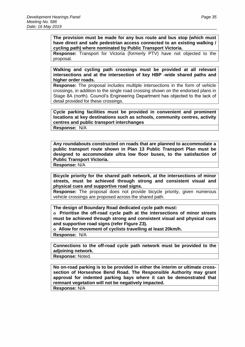
The provision must be made for any bus route and bus stop (which must have direct and safe pedestrian access connected to an existing walking / cycling path) where nominated by Public Transport Victoria.
Response: Transport for Victoria (formerly PTV) have not objected to the proposal.
Walking and cycling path crossings must be provided at all relevant intersections and at the intersection of key HBP -wide shared paths and higher order roads.
Response: The proposal includes multiple intersections in the form of vehicle crossings, in addition to the single road crossing shown on the endorsed plans in Stage 8A (north). Council’s Engineering Department has objected to the lack of detail provided for these crossings.
Cycle parking facilities must be provided in convenient and prominent locations at key destinations such as schools, community centres, activity centres and public transport interchanges
Response: N/A
Any roundabouts constructed on roads that are planned to accommodate a public transport route shown in Plan 13 Public Transport Plan must be designed to accommodate ultra low floor buses, to the satisfaction of Public Transport Victoria.
Response: N/A
Bicycle priority for the shared path network, at the intersections of minor streets, must be achieved through strong and consistent visual and physical cues and supportive road signs.
Response: The proposal does not provide bicycle priority, given numerous vehicle crossings are proposed across the shared path.
The design of Boundary Road dedicated cycle path must: o Prioritise the off-road cycle path at the intersections of minor streets
must be achieved through strong and consistent visual and physical cues and supportive road signs (refer Figure Z3). o Allow for movement of cyclists travelling at least 20km/h.
Response: N/A
Connections to the off-road cycle path network must be provided to the adjoining network.
Response: Noted.
No on-road parking is to be provided in either the interim or ultimate cross-section of Horseshoe Bend Road. The Responsible Authority may grant approval for indented parking bays where it can be demonstrated that remnant vegetation will not be negatively impacted.
Response: N/A
Development Hearings Panel Page 36 Meeting No. 586 Date: 16 May 2019
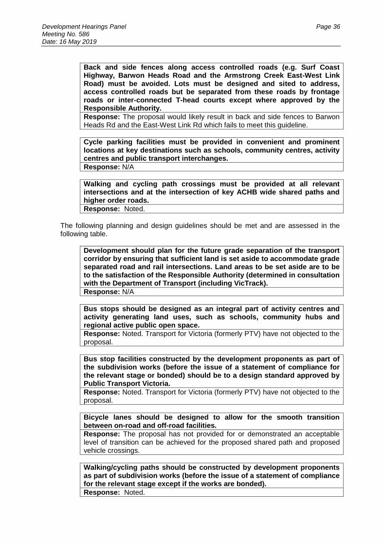
Back and side fences along access controlled roads (e.g. Surf Coast Highway, Barwon Heads Road and the Armstrong Creek East-West Link Road) must be avoided. Lots must be designed and sited to address, access controlled roads but be separated from these roads by frontage roads or inter-connected T-head courts except where approved by the Responsible Authority.
Response: The proposal would likely result in back and side fences to Barwon Heads Rd and the East-West Link Rd which fails to meet this guideline.
Cycle parking facilities must be provided in convenient and prominent locations at key destinations such as schools, community centres, activity centres and public transport interchanges.
Response: N/A
Walking and cycling path crossings must be provided at all relevant intersections and at the intersection of key ACHB wide shared paths and higher order roads.
Response: Noted.
The following planning and design guidelines should be met and are assessed in the following table.
Development should plan for the future grade separation of the transport corridor by ensuring that sufficient land is set aside to accommodate grade separated road and rail intersections. Land areas to be set aside are to be to the satisfaction of the Responsible Authority (determined in consultation with the Department of Transport (including VicTrack).
Response: N/A
Bus stops should be designed as an integral part of activity centres and activity generating land uses, such as schools, community hubs and regional active public open space.
Response: Noted. Transport for Victoria (formerly PTV) have not objected to the proposal.
Bus stop facilities constructed by the development proponents as part of the subdivision works (before the issue of a statement of compliance for the relevant stage or bonded) should be to a design standard approved by Public Transport Victoria.
Response: Noted. Transport for Victoria (formerly PTV) have not objected to the proposal.
Bicycle lanes should be designed to allow for the smooth transition between on-road and off-road facilities.
Response: The proposal has not provided for or demonstrated an acceptable level of transition can be achieved for the proposed shared path and proposed vehicle crossings.
Walking/cycling paths should be constructed by development proponents as part of subdivision works (before the issue of a statement of compliance for the relevant stage except if the works are bonded).
Response: Noted.

Development Hearings Panel Page 37 Meeting No. 586 Date: 16 May 2019
Walking/cycling paths and footpaths should be designed and located to maximise passive surveillance.
Response: Noted.
The local street network should be designed to provide permeable and safe routes for walking / cycling to activity centres, community facilities, public open spaces and public transport.
Response: The proposal does not meet this guideline as a number of lots do not have direct access to a street and instead must cross an off-road shared path, which compromises its functionality.
Road and street cross sections should be consistent generally with those in Appendix 8: Road Cross Sections (Figures I to Z3.) but with consideration of the need for adjustments within the overall specified road reserve widths if required to cater for existing utilities and existing street trees.
Response: Noted.
Courts that are not inter-connected for walking / cycling permeability should be avoided.
Response: No courts are proposed.
Courts where included must have a T-head, court bowl or equivalent except where providing vehicle access to four or less dwellings and garbage collection is to occur at the mouth of the court.
Response: No courts are proposed.
OVERLAY: Clause 45.01 – Public Acquisition Overlay The purpose of Clause 45.01 of the Public Acquisition Overlay is to:
implement the Municipal Planning Strategy and the Planning Policy Framework.
identify areas which require the preparation of a development contributions plan for the purpose of levying contributions for the provision of works, services and facilities before development can commence.
Response VicRoads are responsible for Barwon Heads Roads and the East-West Link Rd, which is captured by this overlay for a duplication in the near future. The subdivision plan has incorporated the future widening of this road. VicRoads have not objected to the proposal. Clause 45.06 – Development Contributions Plan Overlay Schedule 5 The purpose of Clause 45.06 of the Development Contributions Plan Overlay is to:
implement the State Planning Policy Framework and the Local Planning Policy Framework, including the Municipal Strategic Statement and local planning policies.
identify areas which require the preparation of a development contributions plan for the purpose of levying contributions for the provision of works, services and facilities before development can commence.

Development Hearings Panel Page 38 Meeting No. 586 Date: 16 May 2019
Response Council’s Urban Growth Department has advised no changes to permit conditions would be required for the amended proposal. RELEVANT PARTICULAR PROVISIONS: The following Particular Provisions are applicable to this application: Clause 52.29 - Land Adjacent to a Road Zone, Category 1 or a Public Acquisition for a Category 1 Road The purpose of Clause 52.29 (Land Adjacent to a Road Zone, Category 1 or a Public Acquisition for a Category 1 Road) of the Particular Provisions is to:
ensure appropriate access to identified roads.
ensure appropriate subdivision of land adjacent to identified roads. Response The application was referred to VicRoads who did not object to the proposal. Clause 56 - ResCode Assessment – Subdivision
Title & Objective Complies / Does Not Comply / Variation Required
56.01-1 Subdivision site and context description The site and context description may use a site plan, photographs or other techniques and must accurately describe the site and surrounding area 56.01-2 Subdivision design response The design response must explain how the proposed design:
Derives from and responds to the site and context description.
Responds to any site and context features for the area identified in a local planning policy or a Neighbourhood Character Overlay.
Responds to any relevant objective, policy, strategy or plan set out for the area in this scheme.
Meets the relevant objectives of Clause 56.
N/A
C1
Does not comply

Development Hearings Panel Page 39 Meeting No. 586 Date: 16 May 2019
56.02-1 Strategic implementation objective To ensure that the layout and design of a subdivision is consistent with and implements any objective, policy, strategy or plan for the area set out in this scheme.
The brief cover letters provided by the applicant are not regarded as a satisfactory response to this standard or objective. They do not provide sufficient detail of how the proposal has been designed to be consistent with and implements the various policy requirements of the Greater Geelong Planning Scheme, including the zone and applied zones, Planning Policy and Local Planning Policy Frameworks, Clause 56 or the PSP. A response to these was requested by Council in the Request for Further Information letter, but the applicant stated this would be covered by the planning report for the original subdivision, notwithstanding this did not address the changes proposed in the subject amendment.
The cover letter to the further information response only addresses further information items and issues raised by Council and generally does not demonstrate which objectives in the Scheme it seeks to implement or respond to.
C2 56.03-1 Compact and walkable neighbourhoods objectives To create compact neighbourhoods that are oriented around easy walking distances to activity centres, schools and community facilities, public open space and public transport. To allow easy movement through and between neighbourhoods for all people.
Does not comply
The proposal does not comply with this objective as it includes vehicle crossings over public open space, which disrupts a shared access path. It also includes lots of insufficient size and dimensions that are not located within easy walking distance of an activity centre or services.
C3 56.03-2 Activity centre objective To provide for mixed-use activity centres, including neighbourhood activity centres, of appropriate area and location.
N/A
C4 56.03-3 Planning for community facilities objective To provide appropriately located sites for community facilities including schools, libraries, preschools and childcare, health services, police and fire stations, recreation and sports facilities.
N/A

Development Hearings Panel Page 40 Meeting No. 586 Date: 16 May 2019
C5 56.03-4 Built environment objective To create urban places with identity and character.
N/A The application is for subdivision only and no built form is proposed.
C7 56.04-1 Lot diversity and distribution objectives To achieve housing densities that support compact and walkable neighbourhoods and the efficient provision of public transport services. To provide higher housing densities within walking distance of neighbourhood centres. To achieve increased housing densities in designated growth areas. To provide a range of lot sizes to suit a variety of dwelling and household types.
Does not comply
As discussed earlier, the location of the proposed lots less than 300sqm is regarded as inappropriate for the application of the Small Lot Housing Code. The proposed lots less than 300sqm are also not within 400m walking distance of an activity centre, as required by this standard.
While the site(s) is suitable for medium density development, reliance on achieving this through creating single dwelling allotments is regarded as inappropriate and does not achieve an acceptable design. An integrated development proposal is recommended to avoid the issues with the current proposal.
C8 56.04-2 Lot area and building envelopes objective To provide lots with areas and dimensions that enable the appropriate siting and construction of a dwelling, solar access, private open space, vehicle access and parking, water management, easements and the retention of significant vegetation and site features.
Does not comply
Given the proposal relied on the Small Lot Housing Code, the proposal did not demonstrate each lot could be developed for a dwelling in accordance with Clause 55. Concept designs for dwellings on some of the lots were provided on a ‘without prejudice’ basis. These showed the majority of dwellings proposed with relatively minimal private open space also with relatively poor solar access.
Also as discussed earlier, numerous dwellings would require vehicle crossings over public open space which is inappropriate.
Council’s Engineering Department has also not provided support for the carparking layout shown.
C9 56.04-3 Solar orientation of lots objective To provide good solar orientation of lots and solar access for future dwellings.
Complies

Development Hearings Panel Page 41 Meeting No. 586 Date: 16 May 2019
C10 56.04-4 Street orientation objective To provide a lot layout that contributes to community social interaction, personal safety and property security.
Does not comply
As discussed earlier, the proposal does not achieve orientation or active frontages with Barwon Heads Rd or the East-West Link Rd. It also does not provide a road adjacent to the public open space, instead relying on access across it.
C11 56.04-5 Common area objectives To identify common areas and the purpose for which the area is commonly held. To ensure the provision of common area is appropriate and that necessary management arrangements are in place. To maintain direct public access throughout the neighbourhood street network.
- N/A
C12 56.05-1 Integrated urban landscape objectives To provide attractive and continuous landscaping in streets and public open spaces that contribute to the character and identity of new neighbourhoods and urban places or to existing or preferred neighbourhood character in existing urban areas. To incorporate natural and cultural features in the design of streets and public open space where appropriate. To protect and enhance native habitat and discourage the planting and spread of noxious weeds. To provide for integrated water management systems and contribute to drinking water conservation.
N/A
Landscaping objectives were considered in the original proposal and are generally not relevant to the proposal.
C13 56.05-2 Public open space provision objectives To provide a variety of open spaces with links to other open spaces and regional parks where possible.
Does not comply
As discussed earlier, the proposed use of the public open space for vehicle crossings to private dwellings is regarded as inappropriate and would result in reduced quality for its intended use as a shared path as well as for the general amenity of other users/residents in the area.
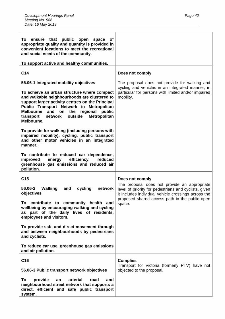
Development Hearings Panel Page 42 Meeting No. 586 Date: 16 May 2019
To ensure that public open space of appropriate quality and quantity is provided in convenient locations to meet the recreational and social needs of the community. To support active and healthy communities.
C14 56.06-1 Integrated mobility objectives To achieve an urban structure where compact and walkable neighbourhoods are clustered to support larger activity centres on the Principal Public Transport Network in Metropolitan Melbourne and on the regional public transport network outside Metropolitan Melbourne. To provide for walking (including persons with impaired mobility), cycling, public transport and other motor vehicles in an integrated manner. To contribute to reduced car dependence, improved energy efficiency, reduced greenhouse gas emissions and reduced air pollution.
Does not comply The proposal does not provide for walking and cycling and vehicles in an integrated manner, in particular for persons with limited and/or impaired mobility.
C15 56.06-2 Walking and cycling network objectives To contribute to community health and wellbeing by encouraging walking and cycling as part of the daily lives of residents, employees and visitors. To provide safe and direct movement through and between neighbourhoods by pedestrians and cyclists. To reduce car use, greenhouse gas emissions and air pollution.
Does not comply
The proposal does not provide an appropriate level of priority for pedestrians and cyclists, given it includes individual vehicle crossings across the proposed shared access path in the public open space.
C16 56.06-3 Public transport network objectives To provide an arterial road and neighbourhood street network that supports a direct, efficient and safe public transport system.
Complies Transport for Victoria (formerly PTV) have not objected to the proposal.
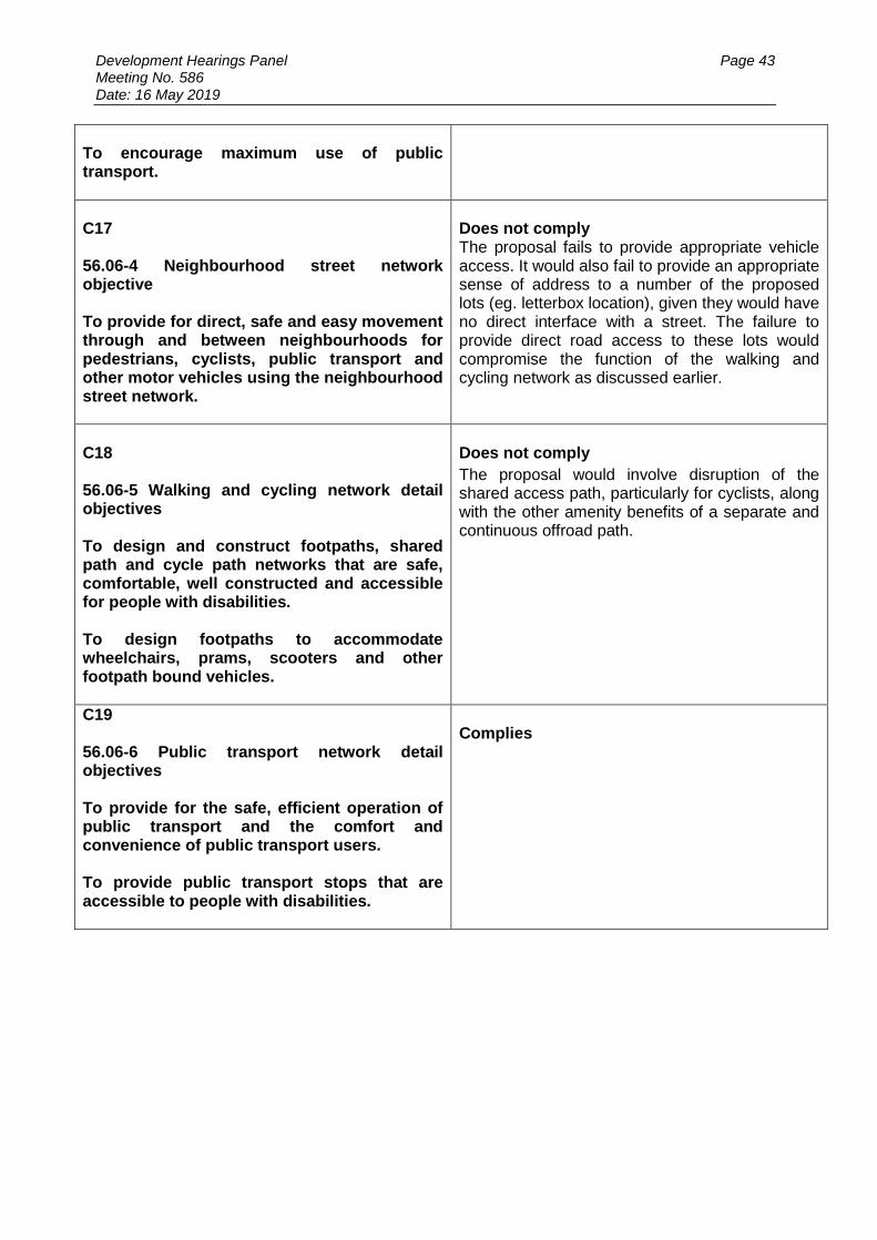
Development Hearings Panel Page 43 Meeting No. 586 Date: 16 May 2019
To encourage maximum use of public transport.
C17 56.06-4 Neighbourhood street network objective To provide for direct, safe and easy movement through and between neighbourhoods for pedestrians, cyclists, public transport and other motor vehicles using the neighbourhood street network.
Does not comply The proposal fails to provide appropriate vehicle access. It would also fail to provide an appropriate sense of address to a number of the proposed lots (eg. letterbox location), given they would have no direct interface with a street. The failure to provide direct road access to these lots would compromise the function of the walking and cycling network as discussed earlier.
C18 56.06-5 Walking and cycling network detail objectives To design and construct footpaths, shared path and cycle path networks that are safe, comfortable, well constructed and accessible for people with disabilities. To design footpaths to accommodate wheelchairs, prams, scooters and other footpath bound vehicles.
Does not comply
The proposal would involve disruption of the shared access path, particularly for cyclists, along with the other amenity benefits of a separate and continuous offroad path.
C19 56.06-6 Public transport network detail objectives To provide for the safe, efficient operation of public transport and the comfort and convenience of public transport users. To provide public transport stops that are accessible to people with disabilities.
Complies

Development Hearings Panel Page 44 Meeting No. 586 Date: 16 May 2019
C20 56.06-7 Neighbourhood street network detail objective To design and construct street carriageways and verges so that the street geometry and traffic speeds provide an accessible and safe neighbourhood street system for all users.
Does not comply As discussed earlier, the proposal fails to provide streets and access to a number of the proposed lots and is regarded as an unsatisfactory response. It also results in a failure to prioritise for pedestrians and cyclists due to the vehicle crossings across the shared access path and public open space. Council’s Engineering Department has advised it is not satisfied with the information provided to assess the proposed roads.
C21 56.06-8 Lot access objective To provide for safe vehicle access between roads and lots.
Does not comply
The proposal includes a number of lots in proposed Stage 11A less than 300sqm in size but have not access via rear or side access lanes, which does not comply with the standard. Also as outlined earlier a number of lots have no direct access to a road at all, but instead rely on vehicle crossings proposed across public open space.
It is further noted a larger amount of space is required to provide public roads and meet the higher carparking rate of this clause. An integrated development proposal would be recommended to meet Clause 55/52.06, which has lesser requirements for parking and access. A more comprehensive design response should deliver an outcome better meeting the dwelling diversity objectives of the Scheme.
C22 56.07-1 Drinking water supply objectives To reduce the use of drinking water. To provide an adequate, cost-effective supply of drinking water.
Complies
C23 56.07-2 Reused and recycled water objective To provide for the substitution of drinking water for non-drinking purposes with reused and recycled water.
Complies
Development Hearings Panel Page 45 Meeting No. 586 Date: 16 May 2019
C24 56.07-3 Waste water management objective To provide a waste water system that is adequate for the maintenance of public health and the management of effluent in an environmentally friendly manner.
Complies
As discussed earlier, Barwon Water has not required a reserve as proposed. Instead their conditions require an easement to be created only.
56.07-4 C25 Urban run-off management objectives To minimise damage to properties and inconvenience to residents from stormwater. To ensure that the street operates adequately during major storm events and provides for public safety. To minimise increases in stormwater and protect the environmental values and physical characteristics of receiving waters from degradation by stormwater. To encourage stormwater management that maximises the retention and reuse of stormwater. To encourage stormwater management that contributes to cooling, local habitat improvements and provision of attractive and enjoyable spaces.
Complies
The applicant has not demonstrated the new requirements of this standard (amended 26/10/2018) have been met, particularly regarding whether the proposal has been designed to meet best practice performance objectives.
Notwithstanding this, Council engineers and the CCMA have not raised any stormwater concerns and it is considered the objective of Clause 56.07-4 is met. Interim stormwater storage measures have been approved by Council, in lieu of providing the ultimate Sparrovale wetlands which will provide for stormwater treatment from the subject site and other lots in the Horseshoe Bend precinct.
C26 56.08-1 Site management objectives To protect drainage infrastructure and receiving waters from sedimentation and contamination. To protect the site and surrounding area from environmental degradation or nuisance prior to and during construction of subdivision works. To encourage the reuse of materials from the site and recycled materials in the construction of subdivisions where practical.
Complies

Development Hearings Panel Page 46 Meeting No. 586 Date: 16 May 2019
C27 56.09-1 Shared trenching objectives To maximise the opportunities for shared trenching. To minimise constraints on landscaping within street reserves.
Complies
The proposal was referred to service authorities and no objections were received.
C28 56.09-2 Electricity, telecommunications and gas objectives To provide public utilities to each lot in a timely, efficient and cost effective manner. To reduce greenhouse gas emissions by supporting generation and use of electricity from renewable sources.
Complies
The proposal was referred to service authorities and no objections were received.
C29 56.09-3 Fire hydrants objective To provide fire hydrants and fire plugs in positions that enable fire fighters to access water safely, effectively and efficiently.
Complies
The proposal was referred to CFA who did not object.
C30 56.09-4 Public lighting objective To provide public lighting to ensure the safety of pedestrians, cyclists and vehicles. To provide pedestrians with a sense of personal safety at night. To contribute to reducing greenhouse gas emissions and to saving energy.
Complies

Development Hearings Panel Page 47 Meeting No. 586 Date: 16 May 2019
DECISION GUIDELINES OF CLAUSE 65: Clause 65.02 of the Greater Geelong Planning Scheme outlines the decision guidelines to be considered by the Responsible Authority when making decisions on applications to subdivide land. These include:
The suitability of the land for subdivision.
The existing use and possible future development of the land and nearby land.
The availability of subdivided land in the locality, and the need for the creation of further lots.
The effect of development on the use or development of other land which has a common means of drainage.
The subdivision pattern having regard to the physical characteristics of the land including existing vegetation.
The density of the proposed development.
The area and dimensions of each lot in the subdivision.
The layout of roads having regard to their function and relationship to existing roads.
The movement of pedestrians and vehicles throughout the subdivision and the ease of access to all lots.
The provision and location of reserves for public open space and other community facilities.
The staging of the subdivision.
The design and siting of buildings having regard to safety and the risk of spread of fire.
The provision of off-street parking.
The provision and location of common property.
The functions of any body corporate.
The availability and provision of utility services, including water, sewerage, drainage, electricity and gas.
If the land is not sewered and no provision has been made for the land to be sewered, the capacity of the land to treat and retain all sewage and sullage within the boundaries of each lot.
Whether, in relation to subdivision plans, native vegetation can be protected through subdivision and siting of open space areas.
The proposal has been assessed against the above and is not considered to accord with the decision guidelines of Clause 65 of the Greater Geelong Planning Scheme. Legislative Issues
The Planning and Environment Act 1987 and the Greater Geelong Planning Scheme are the relevant documents under which Council must consider this application. Conclusion
In summary, it is considered the proposal should be refused as it is inconsistent with the purpose of the Urban Growth Zone and applied zones. It would result in inappropriate lot sizes and dimensions, fails to address adjoining roads, reserves and public open space and would compromise the amenity and movement of pedestrians and cyclists in the off road shared access trail. On this basis, it is recommended that no permit be issued and the application be refused.

Development Hearings Panel Page 48 Meeting No. 586 Date: 16 May 2019
Application No: PP-1298-2018
Applicant: M J Golightly
Subject Land: 1641-1649 Queenscliff Road, POINT LONSDALE
Owner: M Golightly and E Malone
Zone: Farming Zone
Overlays: Significant Landscape Overlay 11
Existing Use: Dwelling
Proposal: Use and Development of the Land for a Self Storage Facility (including Fencing), Business Identification Signage and access to a Road Zone Category 1
1641-1649 QUEENSCLIFF ROAD, POINT LONSDALE
Subject Site

Development Hearings Panel Page 49 Meeting No. 586 Date: 16 May 2019
Summary
The subject site, 1641-1649 Queenscliff Road, Point Lonsdale is located on the corner of Queenscliff Road and Bellarine Highway. The site has a frontage of approximately 134m along the Bellarine Highway, a secondary frontage of approximately 85m to Queenscliff Road, and an overall area of approximately 1.5 hectares. A corner splay is located at the intersection. There are no easements located on site and the site is flat. The site is accessed from Queenscliff Road, via a crushed rock driveway.
Bellarine Highway and Queenscliff Road are main roads, governed by Vic Roads. A Public Acquisition Overlay is located to the south of the subject site to allow opportunity for future road widening of Bellarine Highway.
Roadside vegetation is located along the property boundaries that assists in screening the property from Queenscliff Road and Bellarine Highway. Vegetation along Queenscliff Road is included in a Vegetation Protection Overlay 1. The purpose of this overlay is to protect areas of significant indigenous vegetation and maintain habitat corridors.
The site is located in a Farming Zone and is used for rural lifestyle purposes. The property is divided into two paddocks.
o The front paddock has recently been fenced with a 1.8m high colorbond fence and is currently vacant. Note: Retrospective approval is now sought for the construction of the fence.
o The rear paddock is used for the purposes of a dwelling and outbuildings.
The dwelling and outbuildings are located in the north east section of the rear paddock and is accessed via a sealed driveway. The rear paddock has vegetation planted along the boundaries and around the dwelling. Vegetation is also scattered within the paddock. The site is enclosed in part by timber post and wire fencing in addition to the steel perimeter fence around the front paddock.
The site is located on the gateway into the Point Lonsdale township.
The subject site and land to the north, east and west is located in a Farming Zone. The adjoining property to the north and west is used for the purpose of storage and an engineering workshop. This property stores shipping containers, and boat and caravans in the open. This land use is to cease operation in the near future. The Bellarine Tourist Railway line and shedding is located to the north of this property. Land further to the north of the line is zoned Farming. Land to the west of the subject site is used for farming purposes.
Land to the south of the subject site is zoned General Residential 1 and is currently being developed for residential purposes. This includes stages of the ‘The Point Residential Estate’.
The application seeks approval for the Use and Development of the Land for a Self-Storage Facility (including Fencing), Business Identification Signage and access to a Road Zone Category 1. The containers and an existing client base will be purchased from a nearby business which is ceasing operation.
It is proposed to store a total of 80 shipping containers on site, predominately for the storage of house hold goods. The containers will be located in the front fenced paddock and consist of two different sizes. Retrospective approval is also sought for the fence.
The storage containers can be painted a muted green colour to better blend in with the environment. The existing solid fence, roadside vegetation and
Development Hearings Panel Page 50 Meeting No. 586 Date: 16 May 2019
supplementary landscaping will screen much of the storage area from the public realm.
The containers may also be used to store machinery and equipment related to domestic use or commercial businesses. No flammable goods such as gas bottles and corrosive materials will not be stored.
The goods will only be stored within the containers. No goods will be stored in the open. There will be no caravans or boats will be stored on the land as part of this proposal.
The containers would be leased individually to clients on a month per month basis. The targeted clientele will consist of people who are moving house and need somewhere to store furniture and boxes etc. in between moves.
The facility is to be open seven days a week between the hours of 6am to 7pm.
A staff member will only be present on site during appointments or sporadically throughout the day to carry out general maintenance of the facility. No direct enquires will occur on site.
There is a dwelling on the land which will provide an onsite presence at times through the day and during the night. The main driveway to the dwelling however will be blocked off via another gate to avoid people accessing the wrong area of the property.
Clients will generally arrive with car and trailers as opposed to heavy vehicles. They will be issued with a swipe pass which will open an automated gate to the facility which is easily accessible from the entrance. They can only access the facility within the prescribed hours of operation. No toilets facilities are proposed onsite. It is expected the customers will only be onsite for a short period i.e. drop off / pick up goods. Clients are expected to arrive by vehicle and trailer. It is expected that there may be up to a maximum of eight clients visiting the site per day.
The site will be accessed from the existing crossover on the western boundary of the property. The site access is sealed and has sufficient width to accommodate two-way vehicle movement to avoid vehicles queuing on the road way.
A small car parking area, providing 10 spaces, is to be along the western internal boundary of the facility. The carpark is to be constructed from crushed rock. It is however expected clients will park their vehicle directly in front of their storage container.
One business identification sign is proposed at the property entrance to Queenscliff Road. The sign display dimension will be 1.2m x 1.2m. Information displayed will include the name of the storage business and relevant contact information.
The application was advertised to all owners and occupiers that adjoin and located opposite the subject site. Two signs were also placed on site, one fronting Bellarine Highway and the other fronting Queenscliff Road. As a result, no objections were received. It however is noted that 66 letters of support were received. The letters of support were generic, containing the same content.
A consultation meeting was not held as no objections were received.
The application was referred externally to the Catchment Management Authority, Vic Roads and internally to Council’s Strategic Planning, Engineering, Parks, Environment and Health Departments. Council’s Strategic Planning Department recommended that this application be refused as there is no strategic basis for the location.
All other referral authorities consented to the proposal, subject to conditions.

Development Hearings Panel Page 51 Meeting No. 586 Date: 16 May 2019
Having regard to the provisions of the Greater Geelong Planning Scheme, it is considered that there is no strategic justification to support the industrial use of this land as:
o The City of Greater Geelong Industrial and Land Use Strategy does not identify any land in Point Lonsdale for industrial uses. This is due to the high landscape quality of the area and its attractiveness as a tourist destination.
o The scheme encourages industrial land uses to be phased out of Point Lonsdale and redirected to appropriately zoned (industrial) land elsewhere in the Bellarine.
o Following on, the Point Lonsdale Structure Plan redirects residents to rely on the Ocean Grove Industrial estate to support their needs. This Industrial Estate is conveniently located approximately 10km away from the subject site. This equates to a 9 minute drive according to Google Maps.
o The Point Lonsdale Structure Plan identifies the subject site should be developed for low intensity tourist development that achieves improved outcomes on the gateway into the township. The industrial use conflicts with this policy direction.
o The Point Lonsdale Structure Plan identifies Point Lonsdale as a tourist town. Tourism is the primary economic driver of the town. The plan identifies that there is currently a lack of tourism facilities in town and there are limited areas to provide these facilities in the town boundary. It is therefore considered important that this site is developed for the purpose of a tourism use, to support the economic sustainability of the township, provide local employment and provide an attractive gateway to the town. The proposed industrial use does not achieve this outcome.
o The use has the real potential to limit the establishment of low scale tourist accommodation on neighbouring land to the north and east. This land is also earmarked in the structure plan to be developed for low scale tourism. It is relevant to noted that the industrial use on the neighbouring land will cease in the near future. The proposal therefore has the real potential to conflict with any tourism development on neighbouring land. If approved, the self-storage facility will be allowed to remain on this land indefinitely, undermining policy. It could limit the scale of development and tourism experience on the neighbouring land.
o Whilst it is noted that the containers are temporary structures that can be easily removed from the land, with the storage area able to revert back to a paddock - there is no timeframe on when this will happen. This use could stay on the land indefinitely.
o The proposed use could be reasonably located in an urban zone, there is no strategic justification, or special circumstance to locate the business on the subject site. The scheme encourages such an outcome.
o The use does not strengthen the townships coastal village character and landscape setting on the gateway into the township.
o The proposal does not conform to the purpose of the Farming Zone as it does not result in a sustainable land management practice. It is inconsistent with the structure plan and fragments the existing dwelling from the front paddock.
It is also noted that the proposal does not have an of open style fencing, of a type traditional to rural areas- as directed by the Significant Landscape Overlay. The fence is solid Colorbond and relies on roadside plantings for screening. There is no guarantee this screening will remain for the lifetime of the fence.
Notwithstanding the above, the subject site is located in an Aboriginal Culturally Sensitive Area. A Cultural Heritage Management Plan is required for the use.

Development Hearings Panel Page 52 Meeting No. 586 Date: 16 May 2019
As such, this application is recommended for Refusal.
Recommendation
That the Responsible Authority having considered all matters which the Planning and Environment Act, 1987, requires it to consider, decides to refuse to Grant a Planning Permit for the Use and Development of the Land for a Self Storage Facility (including Fencing), Business Identification Signage and access to a Road Zone Category 1 at 1641-1649 Queenscliff Road, POINT LONSDALE on the following grounds: 1. The proposal is inconsistent with the Greater Geelong Planning Scheme, in
particular the Point Lonsdale Structure Plan, as there is no strategic basis for the location.
2. The proposal is inconsistent with objectives and policy requirements of
Clause 21.14-2 Bellarine Peninsula as: a) The use and development is not generally in accordance with the Point
Lonsdale Structure Plan as use and development does not support low scaled and designated tourism opportunities on the subject site.
b) Policy directs industrial development to be located in existing and future areas identified in Structure Plans on the Bellarine Peninsula, rather than on the subject site.
c) The use and development does not strengthen the townships coastal village character and landscape setting on the gateway into the township.
d) The proposal will set an undesirable precedent undermining the direction of the structure plan.
3. The proposal is inconsistent with the Point Lonsdale Structure Plan and
does not result in the orderly planning of the area. The Structure Plan notes that:
a) The City of Greater Geelong Industrial and Land Use Strategy does not
identify any land in Point Lonsdale for industrial uses. This is due to the high landscape quality of the area and its attractiveness as a tourist destination.
b) Ad hoc light industrial uses with existing use rights on land north of Bellarine Highway should be to be replaced with an appropriately designed low scale, low density tourist accommodation on the gateway.
c) Any redevelopment of the site should include revegetation with indigenous planting as appropriate and in accordance with a Management Plan for the site.
4. The proposal is inconsistent with the objectives of the Farming Zone as:
a) The proposal does not support the purpose of the zone b) The proposal does not result in a sustainable land management
practice and infrastructure provision. 5. The proposal is inconsistent the policy requirements of the Significant
Landscape Overlay 11 as:

Development Hearings Panel Page 53 Meeting No. 586 Date: 16 May 2019
a) The proposal does not minimise the visual impact on infrastructure and signage along a key touring route.
b) The proposal does not have open style fencing, of a type traditional to rural areas as directed by the Significant Landscape Overlay. The fence is solid Colorbond and relies on roadside plantings for screening. There is no guarantee this screening will remain for the lifetime of the fence.
6. The proposal is inconsistent with the objectives of Clause 21.07-5 Rural
areas as the proposal does not provide an attractive landscape setting on the gateway into the township.
7. The proposal is inconsistent with the objectives and policy requirements of
Clause 22.64 Discretionary Uses in Rural Areas: a) The proposed use could be reasonably located in an urban zone b) The intensity of the use and scale of the development does not
compliment and support the local rural context outlined in the Point Lonsdale Structure Plan
8. The Aboriginal Heritage Act S52(1) does not allow for a permit to be issued
conditional to the provision of a Cultural Heritage Management Plan.
Report
The Site & Locality
The subject site, 1641-1649 Queenscliff Road, Point Lonsdale is located on the corner of Queenscliff Road and Bellarine Highway. The site has a frontage of approximately 134m to the Bellarine Highway, a secondary frontage of approximately 85m to Queenscliff Road, and an overall area of approximately 1.5 ha. A corner splay is located at the intersection. There are no easements located on site and the site is flat. The site is accessed by Queenscliff Road, via a crushed rock driveway. Bellarine Highway and Queenscliff Road are main roads, governed by Vic Roads. They are classified as a Road Zone Category 1. A Public Acquisition Overlay is located to the south of the subject site to allow opportunity for future road widening of Bellarine Highway. Roadside vegetation is located along the property boundaries that assists in screening the property from the Queenscliff Road and Bellarine Highway. Vegetation along Queenscliff Road is included in a Vegetation Protection Overlay 1. The purpose of this overlay is to protect areas of significant indigenous vegetation and maintain habitat corridors.

Development Hearings Panel Page 54 Meeting No. 586 Date: 16 May 2019
The site is located in a Farming Zone and is used for rural lifestyle purposes. The property is divided into two paddocks. The front paddock has recently been fenced with a 1.8m high colorbond fence and is currently vacant. Note: Retrospective approval is now sought for the construction of the fence. The rear paddock is used for the purposes of a dwelling and outbuildings. The dwelling is located in the north east section of the property and is accessed via a sealed driveway. The rear paddock has vegetation planted along the boundaries and around the dwelling. Vegetation is also scattered within the paddock. The site is enclosed in part by timber post and wire fencing in addition to the steel fence around the perimeter of the front paddock. The site is located on to the gateway into the Point Lonsdale township. The subject site and land to the north, east and west is located in a Farming Zone. The adjoining property to the north and west is used for the purpose of storage and engineering workshop. An audit of planning records indicates that this industrial land use has enjoyed existing use rights within the Farming Zone. It is however understood this land use will cease in the near future. This property stores shipping containers, and boat and caravans in the open. The Bellarine Tourist Railway line and shedding is located to the north of this property. Land further to the north of the line is zoned Farming. Land to the west of the subject site is used for farming purposes. Land to the south of the subject site is zoned General Residential 1 and is currently being developed for residential purposes. This includes stages of the ‘The Point Residential Estate’.
Photo 1: The location of the subject site

Development Hearings Panel Page 55 Meeting No. 586 Date: 16 May 2019
Photo 2: The subject site
Photo 3: Entry to the subject site

Development Hearings Panel Page 56 Meeting No. 586 Date: 16 May 2019
Photo 4: View from entry to the subject site to Queenscliff Road
Photo 5: The front paddock and new fencing
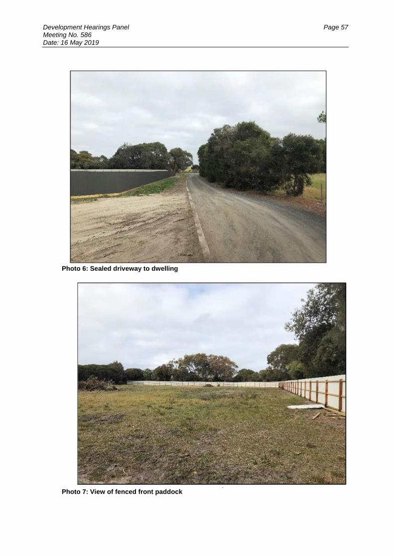
Development Hearings Panel Page 57 Meeting No. 586 Date: 16 May 2019
Photo 6: Sealed driveway to dwelling
Photo 7: View of fenced front paddock
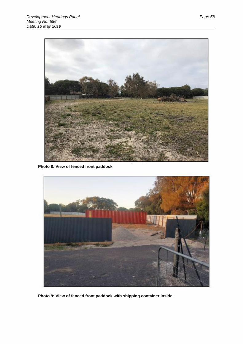
Development Hearings Panel Page 58 Meeting No. 586 Date: 16 May 2019
Photo 8: View of fenced front paddock
Photo 9: View of fenced front paddock with shipping container inside

Development Hearings Panel Page 59 Meeting No. 586 Date: 16 May 2019
Photo 10: View of fenced front paddock with shipping container inside. View from Queenscliff Road. Note the shipping container is higher than the fence and can be seen from Queenscliff Road.
Photo 11: View of fenced front paddock with shipping container inside. View from Queenscliff Road. Note part of the entrance will be exposed, exposing operations on site.

Development Hearings Panel Page 60 Meeting No. 586 Date: 16 May 2019
Photo 12: View of fenced front paddock with shipping container inside- proposed setback from boundary. Note the container sits higher than the fence.
Photo 13: Vegetation screening along Queenscliff Road- hiding the new fence
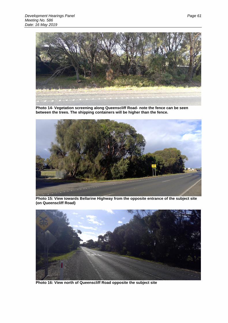
Development Hearings Panel Page 61 Meeting No. 586 Date: 16 May 2019
Photo 14- Vegetation screening along Queenscliff Road- note the fence can be seen between the trees. The shipping containers will be higher than the fence.
Photo 15: View towards Bellarine Highway from the opposite entrance of the subject site (on Queenscliff Road)
Photo 16: View north of Queenscliff Road opposite the subject site

Development Hearings Panel Page 62 Meeting No. 586 Date: 16 May 2019
Photo 17: View on Queenscliff Road towards Bellarine Highway. The Point residential estate is located at the end of Queenscliff Road.
Photo 18: View on Bellarine Highway towards subject site.
Photo 19: View of the Point Residential estate located to the south east of the subject site.

Development Hearings Panel Page 63 Meeting No. 586 Date: 16 May 2019
Photo 20: View of the neighbouring land to the north and east currently used for shipping container storage and boat storage. The large shed is associated with the Bellarine Tourist Railway.
Photo 21: View of the farming land located to the north west of the subject site.
Site History
Planning Permit 28-1978 allowed for the subject site (1641-1649 Queenscliff Road) to be used for the purposes of caravan storage.
This permit has since expired.
Proposal
This application seeks approval for the Use and Development of the Land for a Self-Storage Facility (including Fencing), Business Identification Signage and access to a Road Zone Category 1. The containers and an existing client base will be purchased from a nearby business which is ceasing operation.
Development Hearings Panel Page 64 Meeting No. 586 Date: 16 May 2019
Use It is proposed to store a total of 80 shipping containers on site, predominately for the storage of house hold goods. The containers are temporary structures that can be easily removed from the land, with the storage area able to revert back to a paddock. The containers may also be used to store machinery and equipment related to domestic use or commercial businesses. No flammable goods such as gas bottles and corrosive materials be stored The goods will only be stored within the containers. No goods will be stored in the open. There will be no caravans or boats stored on the land as part of this proposal. The containers would be leased individually to clients on a month by month basis. The targeted clientele will consist of people who are moving house and need somewhere to store furniture and boxes etc. in between moves. The facility is to be open seven days a week between the hours of 6am to 7pm. A staff member will only be present on site during the following times:
During appointments to greet new clients and show them around the facility
Sporadically throughout the day to carry out general maintenance of the facility. No direct enquires will occur on site. All exchange of money would occur online. Similarly, any bookings or enquiries would be made online or over the phone. There is a dwelling on the land which will provide an onsite presence at times through the day and during the night. The main driveway to the dwelling however will be blocked off via another gate to avoid people accessing the wrong area of the property. Clients will generally arrive with car and trailers as opposed to heavy vehicles. They will be issued with a swipe pass which will open an automated gate to the facility which is easily accessible from the entrance. They can only access the facility within the prescribed hours of operation. Security measures will include the key code entrance gate. Each container will be pad locked with key supplied to the person renting the container. A camera and light pole will be located at the entrance gate for additional security measures. The latest the storage area will be open is 7pm, which is generally daylight hours as such substantial lighting is not proposed. No toilets facilities are proposed onsite. It is expected the customers will only be onsite for a short period i.e. drop off / pick up goods as such toilet facilities are not considered warranted. Shipping containers The containers will be placed within the fenced paddock at the front of the property. They will placed along the front and eastern boundaries, 2m from boundary. The containers will also be placed in centre of the sectioned paddock. Vehicles will be able to drive around the storage containers. The driveway is to be constructed with crushed rock.

Development Hearings Panel Page 65 Meeting No. 586 Date: 16 May 2019
The shipping containers are to include two different sizes, being:
40 x 20-foot containers - 6m (l) x 2.44m (w) x 2.59m (h) / internal storage = 33.1 cubic metres
40 x 40-foot containers - 12m (l) x 2.44m (w) x 2.59m (h) / Internal storage = 67 cubic metres
The storage containers can be painted a muted green colour to better blend in with the environment. The existing solid fence, roadside vegetation and supplementary landscaping will screen much of the storage area from the public realm. The containers will not be stacked on top of one another but rather placed directly on the ground (maximum one container high).
Buildings & Works
The placement of shipping containers on the land is considered to constitute buildings and works with the definition of a Building under the Planning and Environment Act 1987 including the term “a structure.” For the purpose of this application we consider a shipping container to be a structure on the land. Retrospective approval is however sought for a timber/steel fence. This fence is to have a height of 1.8m and be constructed from corrugated iron. It is also to have a 150mm high treated pine plinth at the base. Traffic and Car parking A small car parking area, providing 10 spaces, is to be along the western internal boundary of the facility. The carpark is to be constructed from crushed rock. It is however expected clients will park their vehicle directly in front of their storage container.
Site access
The site will be accessed from the existing crossover on the western boundary of the property. The site access is sealed and has sufficient width to accommodate two-way vehicle movement to avoid vehicles queuing on the road way. Although no physical change is proposed to existing access and crossover to the Queenscliff Road, the proposed use will likely impact on the traffic volume and frequency to the site and therefore a permit required under this provision in accordance with the Victorian Civil and Administrative Tribunal decision Peninsula Blue Developments Pty Ltd v Frankston CC [2015] VCAT 571. Clients are expected to arrive by vehicle and trailer. It is expected that there may be up to a maximum of eight clients visiting the site per day.
The scale and intensity of the use is suited towards passenger vehicles with trailers
dropping off and picking up residential storage and not heavy vehicles.
Dust Mitigation The car park and storage area will have a gravel base which is not expected to generate excessive dust, unlike exposed soil or bare ground.
Development Hearings Panel Page 66 Meeting No. 586 Date: 16 May 2019
If dust does become an issue on hot windy days, then the storage area can be sprayed with water from a hose or similar. The storage area will be enclosed by a perimeter fence with screening vegetation to provide a wind break Signage One business identification sign is proposed at the property entrance to Queenscliff Road. The sign display dimension will be 1.2m x 1.2m. Information displayed will include the name of the storage business and relevant contact information. The sign will be supported by timber posts and will not be internally illuminated or flood lit. No vegetation removal
No native vegetation will be removed as the storage area is cleared of vegetation.
Greater Geelong Planning Scheme
Definition and Nesting
Pursuant to Clause 74 a Store is defined as Warehouse. A store is defined as Land used to store goods, machinery, or vehicles. Pursuant to Clause 74.04.16 a Store is nested in the Warehouse Group. Note: The use has not been defined as shipping container storage due to the following key distinctions:
The use does not include any port related activities.
The containers will be used to store goods and therefore provide a storage function on the land similar to a building.
The use will not include cleaning, repair, servicing, painting or fumigation of the shipping containers.
ZONE
The subject site is located in a Farming Zone. The purpose of the Farming Zone is to:
To implement the Municipal Planning Strategy and the Planning Policy Framework.
To provide for the use of land for agriculture.
To encourage the retention of productive agricultural land.
To ensure that non-agricultural uses, including dwellings, do not adversely affect the use of land for agriculture.
To encourage the retention of employment and population to support rural communities.
To encourage use and development of land based on comprehensive and sustainable land management practices and infrastructure provision.
To provide for the use and development of land for the specific purposes identified in a schedule to this zone.
Before deciding on an application to use or subdivide land, construct a building or construct or carry out works, in addition to the decision guidelines in Clause 65, the responsible authority must consider, as appropriate:

Development Hearings Panel Page 67 Meeting No. 586 Date: 16 May 2019
General issues
The Municipal Planning Strategy and the Planning Policy Framework.
Any Regional Catchment Strategy and associated plan applying to the land.
The capability of the land to accommodate the proposed use or development, including the disposal of effluent.
How the use or development relates to sustainable land management.
Whether the site is suitable for the use or development and whether the proposal is compatible with adjoining and nearby land uses.
How the use and development makes use of existing infrastructure and services.
Agricultural issues and the impacts from non-agricultural uses
Whether the use or development will support and enhance agricultural production.
Whether the use or development will adversely affect soil quality or permanently remove land from agricultural production.
The potential for the use or development to limit the operation and expansion of adjoining and nearby agricultural uses.
The capacity of the site to sustain the agricultural use.
The agricultural qualities of the land, such as soil quality, access to water and access to rural infrastructure.
Any integrated land management plan prepared for the site.
Environmental issues
The impact of the proposal on the natural physical features and resources of the area, in particular on soil and water quality.
The impact of the use or development on the flora and fauna on the site and its surrounds.
The need to protect and enhance the biodiversity of the area, including the retention of vegetation and faunal habitat and the need to revegetate land including riparian buffers along waterways, gullies, ridgelines, property boundaries and saline discharge and recharge area.
The location of on-site effluent disposal areas to minimise the impact of nutrient loads on waterways and native vegetation.
Design and siting issues
The need to locate buildings in one area to avoid any adverse impacts on surrounding agricultural uses and to minimise the loss of productive agricultural land.
The impact of the siting, design, height, bulk, colours and materials to be used, on the natural environment, major roads, vistas and water features and the measures to be undertaken to minimise any adverse impacts.
The impact on the character and appearance of the area or features of architectural, historic or scientific significance or of natural scenic beauty or importance.
The location and design of existing and proposed infrastructure including roads, gas, water, drainage, telecommunications and sewerage facilities.
Whether the use and development will require traffic management measures.

Development Hearings Panel Page 68 Meeting No. 586 Date: 16 May 2019
OVERLAY
The subject site is located in a Significant Landscape Overlay 11. The objectives of the Significant Landscape Overlay 11 is to:
To protect locally significant views and vistas that contribute to the landscape, including extensive and scenic outviews across waterbodies from main roads and settlements.
To maintain a natural landscape break between settlements.
To minimise the visual impact of infrastructure and signage throughout the landscape.
To strengthen the presence of indigenous vegetation throughout the area, particularly adjacent to lakes and waterbodies, at roadsides, and in settlements and riparian strips.
To protect the landscape setting of places of cultural heritage significance.
To protect cultural vegetation elements that positively contribute to the character of the landscape, including exotic wind breaks and feature planting around homesteads.
To recognise and protect the continuation of the land as a working farmed landscape.
Before deciding on an application, the responsible authority must consider, as appropriate:
The need to ensure the proposal is located to minimise visibility from Shell Road and the Bellarine Highway, and uses vegetation and low-lying building forms to minimise visual intrusion into the open rural character viewed from these roads.
Where a proposal is visible across Lake Victoria or any other waterbody, that it: o Avoids substantial ground disturbance. o Is set back a sufficient distance to allow for the protection of riparian
vegetation. o Is constructed of suitable materials and colours that minimise distant
visibility.
The need to ensure the proposal avoids additional linear urban development along main roads and key touring routes.
The need to ensure the proposal utilises materials and colours that blend in with the surrounding landscape.
The retention of existing indigenous trees and understorey, and the planting of new indigenous vegetation wherever possible, including at the edge of Lake Victoria and other waterbodies.
The use of open style fencing of a type traditionally used in rural areas (ie post and wire) where fencing is necessary.
PERMIT REQUIRED CLAUSE AND CONDITION
Pursuant to Clause 35.07-1 of the Farming Zone a permit is required to use the land for the purposes of a warehouse (self storage facility).
Pursuant to Clause 35.07-4 of the Farming Zone a permit is required for buildings and works.
Pursuant to Clause 42.03-2 of the Significant Landscape Overlay 11 a permit is required for buildings and works
Pursuant to Clause 52.29 Land Adjacent to a Road Zone Category 1 a permit is required to access the subject site
Pursuant to Clause 52.05-2 Signs a permit is required to display a Business Identification Sign.

Development Hearings Panel Page 69 Meeting No. 586 Date: 16 May 2019
RESTRICTIVE COVENANT
The subject site is not burdened by a Restrictive Covenant or Section 173 Agreement. CULTURAL HERITAGE MANAGEMENT PLAN (CHMP) The Aboriginal Heritage Regulations 2007 specify the circumstances in which a cultural heritage management plan is required for an activity or class of activity. Division 2 of the Aboriginal Heritage Regulations 2007 specifies exempt activities which do not require a cultural heritage management plan. The proposal is not listed as an exempt activity. Areas of cultural heritage sensitivity are defined within Division 3 of the Aboriginal Heritage Regulations 2007. Division 3 identifies the site or part of the site as within an area of cultural heritage sensitivity. High impact activities are defined within Division 5 of the Aboriginal Heritage Regulations 2007. Division 5 lists the proposal as a high impact activity. Following on, Regulation 58 outlines that the use of land for storage of shipping containers is a type of (or nested as) that requires statutory authorisation (a permit under the relevant planning scheme). The use is a high impact activity. Furthermore, there is no evidence that the site has been subject to significant ground disturbance which is defined as ‘disturbance of (a) the topsoil or surface rock layer of the ground or (b) a way - by machinery in the course of grading, excavating, digging, dredging or deep ripping, but does not include ploughing other than deep ripping. Thus, whilst it is noted that the placement of containers on the land will not result in significant ground i.e. disturbance of topsoil or surface rock layer of the ground and therefore is deemed a high impact Activity. No excavation work is proposed with the car park and driveways to be covered in gravel. It is however considered that use is a high impact activity under Regulation 58. Therefore under Regulation 7 of the Regulations, a cultural heritage management plan is required. COASTAL INUNDATION AND EROSION Clause 13.01-1 of the SPPF requires the Responsible Authority to consider the potential coastal impacts of climate change. Strategies include:
In planning for possible sea level rise, an increase of 0.2 metres over current 1 in 100 year flood levels by 2040 may be used for new development in close proximity to existing development (urban infill).
Plan for possible sea level rise of 0.8 metres by 2100, and allow for the combined effects of tides, storm surges, coastal processes and local conditions such as topography and geology when assessing risks and coastal impacts associated with climate change.
Consider the risks associated with climate change in planning and management decision making processes.
The subject site is located within close proximity of existing urban development.

Development Hearings Panel Page 70 Meeting No. 586 Date: 16 May 2019
Council’s data indicates that the site is likely to be affected by the potential coastal impacts of climate change at 2100. As such, this application has been referred to the CCMA. CCMA have consented to the proposal, subject to conditions. LANDFILL GAS RISK ASSESSMENT Before deciding on a Planning Permit application, a Responsible Authority is required to consider, amongst other things:
Any significant effects the responsible authority considers the environment may have on the use or development [S 60(1) of the PEA].
Clause 13.03-1 of The State Planning Policy Framework which aims to ensure that potentially contaminated land is suitable for its intended future use and development, and that contaminated land is used safely.
The EPA has adopted the “Best Practice Environmental Management, Siting, Design Operation and Rehabilitation of Landfills” (September 2010) or “Landfill BPEM.”. The Landfill BPEM identifies that:
Risks associated with landfill gases may occur for at least 30 years post-closure.
Appropriate buffer distances must be maintained between the landfill and sensitive land uses. The BPEM recommends a 500 metre buffer for landfills that contained putrescible waste and 200 metres for landfills that contained non-putrescible waste.
Where the recommended buffers are unavailable, it must be demonstrated that risks are suitably mitigated.
All buildings and structures and associated infrastructure should be considered. The BPEM specifies that development undertaken within a buffer distance of up to 500 metres may be at risk. As the subject site is not located within 500 metres of an identified former landfill site, a risk assessment is not required. DEVELOPMENTS IN BUSHFIRE PRONE AREAS Clause 13.05 (Bushfire) seeks to strengthen the resilience of settlements and communities to bushfire through risk-based planning that prioritises the protection of human life. The policy must be applied to all planning and decision making under the Planning and Environment Act 1987 relating to land which is:
Within a designated bushfire prone area;
Subject to a Bushfire Management Overlay; or
Proposed to be used or developed in a way that may create a bushfire hazard.
Development Hearings Panel Page 71 Meeting No. 586 Date: 16 May 2019
The proposal is listed at Clause 13.05 as one of the uses or developments which should be considered:
Subdivisions of more than 10 lots.
Accommodation.
Child care centre.
Education centre.
Emergency services facility.
Hospital.
Indoor recreation facility.
Major sports and recreation facility.
Place of assembly.
▪Any application for development that will result in people congregating in large numbers.
The site is located within a designated bushfire prone area. The application is not expected to create a risk bushfire to people, property and community infrastructure. It is considered that no bushfire protection measures to address the identified bushfire risk is necessary. It is recommended that the following notes also be included on any permit issued:
- This property is in a designated bushfire prone area. - Special bushfire construction requirements apply at the Building Permit stage. - This permit has not determined the Bushfire Attack Level (BAL. The relevant
Building Surveyor will be responsible for determining the BAL. - Any building should consider AS 3959-2009 Construction of Buildings in
Bushfire-prone Areas (Standards Australia, 2009).
OFFICER DIRECT OR INDIRECT INTEREST: No Council officers have any direct or indirect interest in the matter to which this report relates, in accordance with Section 80 (C) of the Local Government Act. Car Parking
Under the provisions of Clause 52.06 (Carparking), 10% of the site area is to be designated for parking. The area of the front paddock is 6400m2. Therefore 640m2 is required for parking.
The plan shows that a carpark will be provided along the northern internal boundary. This takes up an area of approximately 340m2 including space for an accessway of 6.4m. The remaining balance 300m2 can be easily accommodated within at the front of each container and within an overflow parking area. The number of spaces provided satisfies the scheme requirements. THE STATE PLANNING POLICY FRAMEWORK (SPPF): The following State Planning Policies are applicable to this application:

Development Hearings Panel Page 72 Meeting No. 586 Date: 16 May 2019
The purpose of Clause 11 Settlement is to anticipate and respond to the needs of existing and future communities through provision of zoned and serviced land for housing, employment, recreation and open space, commercial and community facilities and infrastructure. Planning is to prevent environmental and amenity problems created by siting incompatible land uses close together. Planning is to facilitate sustainable development that takes full advantage of existing settlement patterns and investment in transport, utility, social, community and commercial infrastructure and services. The purpose of Clause 11.01-1S Settlement is to promote the sustainable growth and development of Victoria and deliver choice and opportunity for all Victorians through a network of settlements. Strategies to achieve this include to:
Develop sustainable communities through a settlement framework offering convenient access to jobs, services, infrastructure and community facilities.
Ensure regions and their settlements are planned in accordance with their relevant regional growth plan.
Guide the structure, functioning and character of each settlement taking into account municipal and regional contexts and frameworks.
Create and reinforce settlement boundaries.
Balancing strategic objectives to achieve improved land use and development outcomes at a regional, catchment and local level.
Preserving and protecting features of rural land and natural resources and features to enhance their contribution to settlements and landscapes
Providing for appropriately located supplies of residential, commercial, and industrial land across a region, sufficient to meet community needs in accordance with the relevant regional growth plan.
The objective of Clause 11.02-1S Supply of urban land is to ensure a sufficient supply of land is available for residential, commercial, retail, industrial, recreational, institutional and other community uses. Strategies to achieve this include to plan to accommodate projected population growth over at least a 15 year period and provide clear direction on locations where growth should occur. Residential land supply will be considered on a municipal basis, rather than a town-by-town basis. The purpose of Clause 11.02-2S Structure Planning is to facilitate the orderly development of urban areas. Strategies to achieve this include to:
Ensure effective planning and management of the land use and development of an area through the preparation of relevant plans.
Facilitate the preparation of a hierarchy of structure plans or precinct structure plans that includes to:
o Take into account the strategic and physical context of the location. o Provide the broad planning framework for an area as well as the more
detailed planning requirements for neighbourhoods and precincts, where appropriate.
o Provide for the development of sustainable and liveable urban areas in an integrated manner.

Development Hearings Panel Page 73 Meeting No. 586 Date: 16 May 2019
The objective of Clause 11.03-3S Peri-Urban areas is to manage growth in peri-urban areas to protect and enhance their identified valued attributes. Strategies to achieve this include to:
Identify and protect areas that are strategically important for the environment, biodiversity, landscape, open space, water, agriculture, energy, recreation, tourism, environment, cultural heritage, infrastructure, extractive and other natural resources.
Establish growth boundaries for peri-urban towns to avoid urban sprawl and protect agricultural land and environmental assets.
Enhance the character, identity, attractiveness and amenity of peri-urban towns.
Prevent dispersed settlement and provide for non-urban breaks between urban areas
The objective of Clause 11.03-4S Coastal settlement is to plan for sustainable coastal development. Strategies to achieve this include to:
Support a network of diverse coastal settlements that provide for a broad range of housing types, economic opportunities and services.
Identify a clear settlement boundary around coastal settlements to ensure that growth in coastal areas is planned and coastal values are protected. Where no settlement boundary is identified, the extent of a settlement is defined by the extent of existing urban zoned land and any land identified on a plan in the planning scheme for future urban settlement.
Direct new residential and other urban development and infrastructure to locations within defined settlement boundaries of existing settlements that are capable of accommodating growth.
Avoid linear urban sprawl along the coastal edge and ribbon development in rural landscapes
The objective of Clause 11.03-5S Distinctive areas and landscapes is to protect and enhance the valued attributes of identified distinctive areas and landscapes. Strategies to achieve this include to:
Recognise the important role these areas play in the state as tourist destinations.
Support use and development where it enhances the valued characteristics of these areas.
Avoid use and development that could undermine the long-term natural or non-urban use of land in these areas.
The policy basis of Clause 12 Environmental and Landscape values includes to Planning should protect, restore and enhance sites and features of nature conservation, biodiversity, geological or landscape value. The objective of Clause 12.01-1S Protection of biodiversity is to assist the protection and conservation of Victoria’s biodiversity.

Development Hearings Panel Page 74 Meeting No. 586 Date: 16 May 2019
The objective of Clause 12.05-2S Landscapes is to protect and enhance significant landscapes and open spaces that contribute to character, identity and sustainable environments. Strategies to achieve this include to:
Ensure development does not detract from the natural qualities of significant landscape areas.
Improve the landscape qualities, open space linkages and environmental performance in significant landscapes and open spaces, including green wedges, conservation areas and non-urban areas.
Recognise the natural landscape for its aesthetic value and as a fully functioning system.
Ensure important natural features are protected and enhanced. The objective of Clause 13.05-1S Noise abatement is to assist the control of noise effects on sensitive land uses. Strategies to achieve this include to ensure that development is not prejudiced and community amenity is not reduced by noise emissions, using a range of building design, urban design and land use separation techniques as appropriate to the land use functions and character of the area. The objective of Clause 13.06-1S Air quality management is to assist the protection and improvement of air quality. Strategies to achieve this include to ensure, wherever possible, that there is suitable separation between land uses that reduce air amenity and sensitive land uses. The objective of Clause 13.07-1S Land use compatibility is to safeguard community amenity while facilitating appropriate commercial, industrial or other uses with potential off-site effects. Strategies to achieve this include to ensure the compatibility of a use or development as appropriate to the land use functions and character of the area by:
Directing land uses to appropriate locations.
Using a range of building design, urban design, operational and land use separation measures.
The objective of Clause 14.01-1S Protection of agricultural land is to protect the state’s agricultural base by preserving productive farmland. The objective of Clause 14.01-2S Sustainable agricultural land use is to encourage sustainable agricultural land use. The objective of Clause 15.01-6S Design for rural areas is to ensure development respects valued areas of rural character. Strategies to achieve this include to:
Ensure that the siting, scale and appearance of development protects and enhances rural character.
Protect the visual amenity of valued rural landscapes and character areas along township approaches and sensitive tourist routes by ensuring new development is sympathetically located.
Site and design development to minimise visual impacts on surrounding natural scenery and landscape features including ridgelines, hill tops, waterways, lakes and wetlands.
The objective of Clause 16.01-5S Rural residential development is to identify land suitable for rural residential development. Strategies to achieve this include to demonstrate need and identify locations for rural residential development through a housing and settlement strategy.
Development Hearings Panel Page 75 Meeting No. 586 Date: 16 May 2019
The objective of Clause 17.02-2S Out of centre development is to manage out-of-centre development. Strategies to achieve this include to:
Discourage proposals for expansion of single use retail, commercial and recreational facilities outside activity centres.
The objective of Clause 17.03-1S Industrial land supply is to ensure availability of land for industry. Strategies to achieve this include to:
Provide an adequate supply of industrial land in appropriate locations including sufficient stocks of large sites for strategic investment.
Protect and carefully plan existing industrial areas to, where possible, facilitate further industrial development.
The objective of Clause 17.03-2S Industrial development siting is to facilitate the sustainable development and operation of industry. Strategies to achieve this include to:
Encourage manufacturing and storage industries that generate significant volumes of freight to locate close to air, rail and road freight terminals.
Provide adequate separation and buffer areas between sensitive uses to ensure that residents are not affected by adverse environmental effects, nuisance or exposure to hazards.
The objective of Clause 17.04-1S Facilitating tourism is to encourage tourism development to maximise the economic, social and cultural benefits of developing the state as a competitive domestic and international tourist destination. Consider as relevant any applicable regional tourism development strategy. THE LOCAL PLANNING POLICY FRAMEWORK (LPPF) Municipal Strategic Statement (MSS): The following policies of the Municipal Strategic Statement are applicable to this application: The policy basis of Clause 21.02 City of Greater Geelong Sustainable Growth in includes to manage growth by setting clear settlement boundaries and consolidate development within those boundaries in a managed way; and encourage diversity in Industry. The objective of Clause 21.07-2 Industry is to
To provide an adequate supply of appropriately located industrial land that meets the needs of different industries.
To direct different types of industrial development to appropriate locations.
To facilitate well designed and serviced industrial development that provides a high level of amenity for workers and visitors.
To minimise land use conflicts. Strategies to achieve this include to:
Focus new industrial development around major transport routes and infrastructure assets.
Ensure all industrial development provides high quality urban design and landscaping.
Development Hearings Panel Page 76 Meeting No. 586 Date: 16 May 2019
The objective of Clause 21.07-5 Rural areas is:
To support the use of the northern, western and southern rural areas for productive agriculture.
To ensure that rural areas provide an attractive setting through the preservation of the rural landscape character.
To protect and enhance the Bellarine Peninsula as a productive rural area with highly significant landscapes based on farming and environmental features.
The objectives of Clause 21.14-2 Bellarine are to:
To protect and enhance the rural and coastal environment on the Bellarine Peninsula and maintain non-urban breaks between settlements.
To facilitate the development of Ocean Grove, Drysdale/Clifton Springs and Leopold as hubs of development and service provision on the Bellarine Peninsula. In all other townships on the Bellarine Peninsula provide retail, commercial and community uses and facilities that serve the daily needs of the community and encourage street based activity.
To provide for sustainable industrial, commercial, retail, agricultural and tourism development in designated locations, to service the wider Bellarine community.
To preserve the individual character, identity and role of each Bellarine township.
Strategies to achieve this include to:
Ensure that development responds to the identity and character of the individual township in which it is located.
Protect rural and coastal environments from inappropriate urban encroachment.
Ensure land use and development proceeds generally in accordance with the relevant Structure Plan maps included in this Clause.
Ensure that development outside of settlement boundaries (as shown in the Structure Plan maps included in this clause) does not compromise the rural, environmental and landscape values of the non-urban breaks.
Direct the bulk of residential growth and retail development to Ocean Grove, Drysdale/Clifton Springs and Leopold consistent with the relevant Structure Plan maps included in this clause.
Direct bulky goods retailing and industrial development to existing and future areas as identified in Structure Plan maps included in this clause.
Point Lonsdale:
Support low scaled and designed tourism opportunities on designated land identified on the Point Lonsdale Structure Plan map at Clause 21.14-12.
Ensure new development strengthens the township’s coastal village character and landscape setting by requiring a high standard of architectural and urban design response including;
Low scale forms
Contemporary design quality.
Use of materials such as timber, corrugated iron, weatherboard or light coloured render.
Limiting site coverage and provide front and side setbacks that reflect existing neighbourhood patterns and provide opportunities for maintenance and planting of native coastal and indigenous vegetation

Development Hearings Panel Page 77 Meeting No. 586 Date: 16 May 2019

Development Hearings Panel Page 78 Meeting No. 586 Date: 16 May 2019
It is noted that the structure plan identifies the subject site provides opportunities for low scaled and designed tourism accommodation. References- Point Lonsdale Structure Plan, Planisphere, 2009 (amended November 2011). Point Lonsdale Structure Plan, Planisphere, 2009 (amended November 2011). The Point Lonsdale Structure Plan notes the following:
Tourism is the primary economic driver of the town.
The Bellarine Strategic Plan notes a lack of high quality conference, eco-tourism and four and five star accommodation in the region. New developments that address this shortage is encouraged.
The Structure Plan identifies land to the north of the Bellarine Highway (including the subject site) suitable for the development of low scale, low density tourist accommodation- such as eco-tourism, passive recreation, caravan, camping and cabin style accommodation. These uses should not impact on the rural landscape, support the economic sustainability of the township, and provide local employment. Any use and development should also include revegetation of the site with indigenous plantings in accordance with a management plan for the site.
The plan also highlights the need to replace (and not support) ad hoc light industrial uses in this area (including the subject site) to achieve improved outcomes for this key gateway site.
In regards to Industrial land, the Structure plan notes that the City of Greater Geelong’s Industrial Land Strategy provides some guidance as to the appropriate location of industrial uses in the municipality. It is considered that there is no location within the study area suitable for this type of use and in general, the strategy identifies the Bellarine Peninsula as inappropriate for industrial uses. This is due to the “high landscape quality of the area and its attractiveness as a tourist destination.” The Strategy does however identify an additional 15ha of land in Grubb Road, Ocean Grove for future industrial use that could serve a wider Bellarine Peninsula catchment.
Local Planning Policies The following Local Planning Policies are applicable to this application: The objective of Clause 22.64 Discretionary uses in rural areas is to:
To discourage discretionary non-agricultural uses in rural areas that could reasonably be located in an urban zone.
To preserve the productive agricultural capacity of the land and where possible enhance the environmental condition of the land.
To maintain the unique rural landscape character of rural areas. For a discretionary non-agricultural use, it is policy that:
The intensity of the use will complement and support the local rural context.
The use will not result in an unreasonable loss of productive agricultural land.
Existing agricultural activity on adjoining land will not be compromised.

Development Hearings Panel Page 79 Meeting No. 586 Date: 16 May 2019
The scale of the development will complement and respect the rural landscape character.
Buildings and structures are designed and sited to not be visually dominant and can blend into the surrounding landscape and natural environment. Visual impacts should be mitigated or minimised through sensitive design, landscaping, materials and colours.
The site has access to an appropriately constructed or sealed road that is capable of accommodating anticipated traffic levels or has convenient access to a major road.
The site has access to all necessary servicing infrastructure. Where infrastructure is required or needs upgrading the applicant will meet all costs.
RELEVANT PARTICULAR PROVISIONS The following Particular Provisions are applicable to this application: The purpose of Clause 52.05 Signs includes to:
To regulate the development of land for signs and associated structures.
To ensure signs are compatible with the amenity and visual appearance of an area, including the existing or desired future character.
To ensure signs do not contribute to excessive visual clutter or visual disorder.
To ensure that signs do not cause loss of amenity or adversely affect the natural or built environment or the safety, appearance or efficiency of a road.
This zone is in Category 4. The purpose of Clause 52.06 Car parking is to:
To ensure that car parking is provided in accordance with the Municipal Planning Strategy and the Planning Policy Framework.
To ensure the provision of an appropriate number of car parking spaces having regard to the demand likely to be generated, the activities on the land and the nature of the locality.
To support sustainable transport alternatives to the motor car.
To promote the efficient use of car parking spaces through the consolidation of car parking facilities.
To ensure that car parking does not adversely affect the amenity of the locality.
To ensure that the design and location of car parking is of a high standard, creates a safe environment for users and enables easy and efficient use.
The use is classified as a Store. Under Clause 52.06 a Store requires 10 percent of the site to be set aside for parking. The site area proposed to be used for storage totals 6400m2. Therefore 640m2 is required for car parking. The purpose of Clause 52.29 Land Adjacent to a Road Zone Category 1 is to:
To ensure appropriate access to identified roads.
To ensure appropriate subdivision of land adjacent to identified roads. Before deciding on an application, in addition to the decision guidelines in Clause 65, the responsible authority must consider:
The Municipal Planning Strategy and the Planning Policy Framework.
The views of the relevant road authority.
The effect of the proposal on the operation of the road and on public safety.

Development Hearings Panel Page 80 Meeting No. 586 Date: 16 May 2019
Any policy made by the relevant road authority pursuant to Schedule 2, Clause 3 of the Road Management Act 2004 regarding access between a controlled access road and adjacent land.
REFERRALS
INTERNAL
Department: Planning Strategy
Response: Pg 73 of the Structure Plan states: The City of Greater Geelong’s Industrial Land Strategy provides some guidance as to the appropriate location of industrial uses in the municipality. It is considered that there is no location within the study area suitable for this type of use and in general, the strategy identifies the Bellarine Peninsula as inappropriate for industrial uses. This is due to the “high landscape quality of the area and its attractiveness as a tourist destination.” The Strategy does however identify an additional 15ha of land in Grubb Road, Ocean Grove for future industrial use that could serve a wider Bellarine Peninsula catchment. Further, over the long term, existing industrial uses such as the shell grit operation on the Shell Road site should be phased out of the town and replaced with more sensitive uses such as ecotourism or residential. I am familiar with this site and it is acknowledged the buildings and works are low in scale, could be easily removed and will not be visually dominant but the fact remains the use is industrial and there is no policy support for this type of use in this location. There is no policy conflict as clause 22.64 is relevant to this application while clause 22.06 Tourism, Accommodation and Function Centre Development in Rural Areas would be relevant to a tourism proposal. A tourism use also has support in the Structure Plan. If this application were to be approved the assessment should clearly articulate the unique circumstances that make the proposal appropriate in this instance as there could be implications for how the policy discretion is applied for future proposals for industrial uses in the farm zone. It is recommended the permit be refused due to lack of policy support.
Officer Comment:
Recommendation for Refusal supported.
Department: Engineering
Response: VicRoads are the responsible authority and will comment regarding traffic matters related to the access of Queenscliff Road.
Most of the amended plans conditions have been addressed in the Revised Site plan received on the 21st February. 6m access gate – addressed
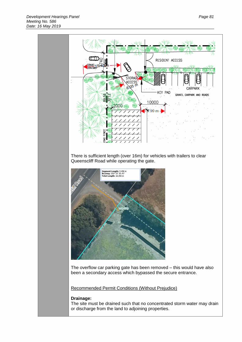
Development Hearings Panel Page 81 Meeting No. 586 Date: 16 May 2019
There is sufficient length (over 16m) for vehicles with trailers to clear Queenscliff Road while operating the gate.
The overflow car parking gate has been removed – this would have also been a secondary access which bypassed the secure entrance.
Recommended Permit Conditions (Without Prejudice) Drainage: The site must be drained such that no concentrated storm water may drain or discharge from the land to adjoining properties.

Development Hearings Panel Page 82 Meeting No. 586 Date: 16 May 2019
Drainage & Vehicular Access: Prior to the commencement of use approved by this Permit, the developer must construct vehicular crossings in accordance with the requirements and standards of the City of Greater Geelong and VicRoads in accordance with the approved plans to the satisfaction of the Responsible Authority. Note:
1. All internal drainage must be designed and constructed to satisfy AS/NZS 3500.
2. A Vehicle Crossing Permit must be obtained prior to commencement of works.
Car Parking Prior to the occupation of the dwellings / statement of compliance, the developer must construct the car park including accessways, in accordance with the endorsed plans to the satisfaction of the Responsible Authority. Non-Standard Conditions Prior to the commencement of the development, amended plans to the satisfaction of the Responsible Authority must be submitted to and approved by the Responsible Authority. When approved, the plans will be endorsed and will then form part of the permit. The plans must be generally in accordance with the plans submitted with the application but modified to show:
a) The driveway sealed with an all-weather surface full width from Queenscliff Road to both access gates.
DRAINAGE NOTES While the site is not subject to flooding, the adjoining Road is subject to flooding during major stormwater events, and the applicable flood level in Road is 2.7m AHD. It is strongly recommended that the finished floor level for habitable floors be constructed with 300mm freeboard above the adjoining flood level at a minimum level of 3.0m AHD.
Officer Comment:
No objection, subject to conditions

Development Hearings Panel Page 83 Meeting No. 586 Date: 16 May 2019
Department: Environment
Response: Thanks for referring the further information, this unit is satisfied that the applicant has responded to our initial concerns and doesn’t object to a permit being issued, subject to the conditions listed below. Recommended Permit Conditions (Without Prejudice) Unless otherwise approved in writing by the Responsible Authority, prior to commencement of operations of the storage facility, the landscape/planting plan submitted with the application (dated 01/11/18), must be completed to the satisfaction of the responsible authority. An inspection is required to satisfy this condition, the permit holder should contact the responsible authority with 2 weeks’ notice provided to arrange this inspection. All shipping containers are required to be painted/clad in a muted colour/finish prior to arrival to the site if applicable.
Officer Comment:
No objection, subject to conditions
Department: Health
Response: Environmental Health has considered the information submitted with the application for a planning permit at the abovementioned property. Environmental Health has no objection to the granting of a planning permit providing general amenity conditions are included within. Standard Condition 1) The amenity of the area must not be detrimentally affected by the use
or development through the: a) Transport of materials, goods or commodities to or from the land; b) Appearance of any building, works or materials; c) Emission of noise, artificial light, vibration, odour, fumes, smoke,
vapour, steam, soot, ash, dust, waste water, waste products, grit or oil;
d) Presence of vermin; to the satisfaction of the Responsible Authority.
Officer Comment:
No objection, subject to conditions
Department: Parks
Response: The road the entrance is on is a Vic Roads road. It is our understanding this road is maintained by Vic Roads and we do not maintain the trees on this road reserve. However I have observed vegetation that has been pruned and I will notify the environment unit, as they may have some input into this matter.
Officer Comment:
No objection

Development Hearings Panel Page 84 Meeting No. 586 Date: 16 May 2019
EXTERNAL
Authority: CCMA
Response: In light of the above information and pursuant to Section 56 of the Planning and Environment Act 1987, the Authority does not object, and recommends the following conditions:
1. Finished floor levels of the storage unit must be constructed above the natural surface level at the site of the proposed storage unit.
2. Water resistant building materials that minimise the physical effects of flooding on the structure and its contents must be used for foundations, footings, floor and walls up to the Nominal Flood Protection Level of 1.3 m AHD.
3. Any electrical fittings must be fixed above the Nominal Flood Protection Level of 1.3 m AHD.
4. Any high value and/or hazardous materials must be stored at or above the Nominal Flood Protection Level of 1.3 metres AHD.
Details of the proposed flood-proofing measures must be submitted to and approved by the Responsible Authority and the Corangamite Catchment Management Authority prior to the commencement of works. In accordance with Section 66 of the Planning and Environment Act 1987, please provide an electronic copy of the outcome of this proposal to the Authority for our records. Should you have any queries, please do not hesitate to contact our office on (03) 5232 9100 or [email protected]. To assist the CMA in handling any enquiries please quote CCMA-F-2018-00834 in your correspondence with us. Conditions regarding retrospective approval for fencing
In light of the above information and pursuant to Section 56 of the Planning and Environment Act 1987, the Authority does not object, and recommends the following condition:
Any sections of the fencing that are below 1.30 metres AHD must be of an open style up to at least a height of 1.30 metres AHD to enable water to pass through freely.

Development Hearings Panel Page 85 Meeting No. 586 Date: 16 May 2019
In accordance with Section 66 of the Planning and Environment Act 1987, please provide an electronic copy of the outcome of this proposal to the Authority for our records.
Officer Comment:
No objection, subject to conditions. It is noted that the lowest elevation on site is 1.41m AHD. Therefore the existing fencing will be able to meet the CCMA condition requirements.
Authority: Vic Roads
Response: Thank you for your correspondence dated 16 November 2018 referring details of the above planning permit application to the Roads Corporation (VicRoads) pursuant to Section 55 of the Planning and Environment Act 1987. Please quote the above reference number in all contact with VicRoads. VicRoads has considered the proposal and in principle has no objection. VicRoads would require that the following conditions be included in any Notice of Decision to issue a Planning Permit or Planning Permit:
1. The crossover and driveway must be maintained in a fit and proper state so as not to compromise the ability of vehicles to enter and exit the site in a safe manner or compromise operational efficiency of the road or public safety. Note: The crossover and driveway must be able to accommodate the biggest design vehicles which might be used for containers delivering.
2. Vehicles must enter and exit the land in a forward direction at all times.
Please forward a copy of the Planning Permit (including endorsed plans), Notice of Decision to Grant or Refusal to Grant a Planning Permit to this office as required under Section 66 of the Planning and Environment Act 1987.
Officer Comment:
No objection, subject to conditions
AMENDMENT OF THE PROPOSAL PRIOR TO PUBLIC NOTIFICATION The applicant made a request to amend the application pursuant to Section 50 of the Planning and Environment Act 1987 on 22 February 2019. Council accepted the amendment. The amendment made the following changes to the application:
Amended application form to include retrospective approval for fencing
Elevation plan of shipping containers and fencing
Amended plans to address engineering issues
Confirmation that all items will be stored in the containers. There will be no storage out in the open
Landscape Plan revised
No toilet/amenities will be provided on site
Security measures for the facility, explained. These are the plans that form the basis of this report.

Development Hearings Panel Page 86 Meeting No. 586 Date: 16 May 2019
PUBLIC NOTIFICATION: The application is not exempt from the notice requirements of Section 52(1)(a), (b) and (d), the decision requirements of Section 64(1), (2) and (3) and the review rights of Section 82(1) of the Act and pursuant to Section 52 of the Planning and Environment Act 1987 the following forms of advertising were undertaken:
Notices were sent to owners and occupiers of adjoining land (including opposite)
Two A3 sign(s) was/were placed on the land- one fronting Bellarine Highway and the other fronting Queenscliff Road.
No objections have been lodged with Council. Sixty six letters of support were however received. The letters of support state:
We are choosing to support this application as, due to increasing population and dwindling property sizes, there is a growing need for a storage facility and there is not currently an available facility in the Queenscliff and Point Lonsdale area.
Across the road from the address of the application, the development of The Point estate (amongst various other new estates) has added more than 400 new houses, with an average of less than 450 square metre lot sizes, resulting in residents with an excess of equipment and possessions in need of nearby storage.
As a local resident, having close, convenient and secure access to my storage is essential for my possessions and I would personally utilise and I look forward to the approval of the application.
All letters are generic- they include the same content. AMENDMENT OF THE APPLICATION FOLLOWING PUBLIC NOTIFICATION The application was not amended following public notification. CONSULTATION
A consultation meeting was not held as no objections were received. ASSESSMENT
Use
Whilst it is acknowledged that the subject site and immediately adjoining land is removed from farming production, this does not mean that the site is therefore suited to be used for the proposed non agricultural (industrial) use. The industrial land use is a Section 2 use within the Farming Zone. As stated under the provisions of Clause 65 in the scheme, because a permit can be granted does not imply that a permit should or will be granted. The Responsible Authority must decide whether the proposal will produce acceptable outcomes in terms of the decision guidelines of this clause. The purpose of the Farming Zone aims to support and encourage farming activities. The zone does allow other uses to be considered, provided they result in sustainable land management practices.
Development Hearings Panel Page 87 Meeting No. 586 Date: 16 May 2019
Following on, Clause 22.64 of the scheme provides guidance on the types of non-agricultural uses that might be appropriate in rural areas. The objective of this Clause discourages non agricultural uses from being established that could reasonably be located in an urban zone; and aims to ensure any non agricultural maintain the unique rural landscape character of rural areas. The intensity of the use is to compliment and support the local rural context and ensure the scale compliment and respect the rural landscape character. Clause 21.14 of Council’s MSS (Bellarine Peninsula), provides further guidance on the type of uses that can be considered in rural areas around the Point Lonsdale township. The Point Lonsdale Structure Plan and policy encourages the subject site to be used for the purposes of low scale tourist accommodation. Policy specifically requires support to be given for the establishment of this use. Furthermore, the objective of this Clause and supporting policy directs industrial land uses to be located in appropriately zoned areas, as identified in Structure Plan maps. It is important to note that there is no industrial land identified for the Point Lonsdale township and the surrounds. The Point Lonsdale Structure Plan is a referenced document in the scheme that helped formulate this policy and also relevant to revert to for guidance. The structure plan redirects industrial development to be located in the Industrial Zone for Ocean Grove. It states that Point Lonsdale is not suited to industrial land uses due to the “high landscape quality of the area and its attractiveness as a tourist destination.” The plan encourages tourist development to support the economic sustainability of the township. Having regard to the above, it is considered that there is no strategic justification to support the industrial use of this land as:
The City of Greater Geelong Industrial and Land Use Strategy does not identify any land in Point Lonsdale for industrial uses. This is due to the high landscape quality of the area and its attractiveness as a tourist destination.
The scheme encourages industrial land uses to be phased out of Point Lonsdale and redirected to appropriately zoned (industrial) land elsewhere in the Bellarine.
Following on, the Point Lonsdale Structure Plan redirects residents to rely on the Ocean Grove Industrial estate to support their needs. This Industrial Estate is conveniently located approximately 10km away from the subject site. This equates to a 9 minute drive according to Google Maps.
The Point Lonsdale Structure Plan identifies the subject site should be developed for low intensity tourist development that achieves improved outcomes on the gateway into the township. The industrial use conflicts with this policy direction.
The Point Lonsdale Structure Plan identifies Point Lonsdale as a tourist town. Tourism is the primary economic driver of the town. The plan identifies that there is currently a lack of tourism facilities in town and there are limited areas to provide these facilities in the town boundary.
It is therefore considered important that this site is developed for the purpose of a tourism use, to support the economic sustainability of the township, provide local employment and provide an attractive gateway to the town. The proposed industrial use does not achieve this outcome.

Development Hearings Panel Page 88 Meeting No. 586 Date: 16 May 2019
The use has the real potential to limit the establishment of low scale tourist accommodation on neighbouring land to the north and east. This land is also earmarked in the structure plan to be developed for low scale tourism. It is relevant to noted that the industrial use on the neighbouring land will cease in the near future. The proposal therefore has the real potential to conflict with any tourism development on neighbouring land. If approved, the self-storage facility will be allowed to remain on this land indefinitely, undermining policy. It could limit the scale of development and tourism experience neighbouring land.
Whilst it is noted that the containers are temporary structures that can be easily removed from the land, with the storage area able to revert back to a paddock - there is no timeframe on when this will happen. This use could stay on the land indefinitely.
The proposed use could be reasonably located in an urban zone, there is no strategic justification, or special circumstance to locate the business on the subject site. The scheme encourages such an outcome.
The use does not strengthen the townships coastal village character and landscape setting on the gateway into the township.
The proposal does not result conform to the purpose of the Farming Zone as it does not result in a sustainable land management practice. It is inconsistent with the structure plan and fragments the existing dwelling from the front paddock.
Notwithstanding the above, it is noted that 66 letters of support were received. The letters demonstrate a growing support for self-storage facilities in Point Lonsdale. It is however clear that policy currently within the scheme does not support the subject site for being used for this purpose. Industrial land uses are to be redirected to appropriately zoned locations elsewhere on the Bellarine Peninsula. Following on, the Point Lonsdale Structure Plan redirects residents to rely on the Ocean Grove Industrial estate to support their needs- as outlined above. It is relevant to note that Council’s Strategic Planning Department also objected to this application.
Development
The Point Lonsdale Structure Plan notes that Tourism is the primary economic driver of the town. The Plan therefore aims to further enhance Point Lonsdale as a tourist destination.
The subject site is identified in a Structure Plan as being located on the gateway to the township. The plan therefore encourages a low scale and low density tourism development on the subject site to enhance the rural landscape setting on the gateway to this tourist town.
It is considered that the placement of shipping containers on the subject site does achieve this outcome as:
The proposal will have an industrial appearance- contrary to the policy direction.
The shipping containers and fencing can be seen from the roadside and will be more visually prominent over time in the event that road side vegetation diminishes.
Development Hearings Panel Page 89 Meeting No. 586 Date: 16 May 2019
Furthermore, it is considered that the proposed fence does not comply with the requirements of the Significant Landscape Overlay. Policy requires the fencing to be open style fencing of a traditional type used in rural area (ie post and wire).
The fence however is constructed out of Colorbond and has a height of 1.8m. The style of the fence is more appropriate in an urban, rather than rural context.
The applicant believes that this fence is appropriate as it is predominately screened from public view via roadside vegetation.
It is however considered that this vegetation cannot be relied upon to support the proposal. This vegetation may be removed or accidently destroyed in the future. There is real potential that this could happen along the Bellarine Hwy frontage, given part of this land is included in the Public Acquisition Overlay, earmarked for road widening. If this were to happen, the fencing would be exposed.
This urban style fencing is not appropriate on the gateway to the township. Rather, the scheme encourages low level development on site that compliments the natural environment.
It is also noted the Significant Landscape Overlay aims to strengthen the presence of indigenous vegetation within the Overlay. The proposal does not achieve this outcome.
Car parking
Under the provisions of Clause 52.06 (Carparking), 10% of the site area is to be designated for parking. The area of the front paddock is 6400m2. Therefore 640m2 is required for parking.
The plan shows that a carpark will be provided along the northern internal boundary. This takes up an area of approximately 340m2 including space for an accessway of 6.4m. The remain balance 300m2 can be easily accommodated within at the front of each container and within an overflow parking area. Council’s Engineering department have no objection to the parking layout, subject to conditions. It is also relevant to note that the carpark and access way is to be constructed in crushed rock. The applicant advised that they are prepared to accept a permit condition to control dust on site, should this application be supported. If dust does become an issue on hot windy days, then the storage area can be sprayed with water from a hose or similar. Access
The storage facility is to be accessed via the existing accessway. The application was referred to Vic Roads under the provisions of Clause 52.29 to determine if this access was appropriate.
Vic Roads have since advised that that have no objection to the proposal, subject to conditions. They are satisfied that the road network can safely cater for the proposed land use.

Development Hearings Panel Page 90 Meeting No. 586 Date: 16 May 2019
Signage
A business identification sign is to be located at the entrance on Queenscliff Road. It is have an overall area of 1.44m2, meeting the dimension requirements in a Farming Zone for business identification signage. If approved, it is recommended that a condition be included on any permit issued to ensure that the signage is clad in muted tone to blend in with the surrounding landscape.
Legislative Issues
The Planning and Environment Act 1987 and the Greater Geelong Planning Scheme are the relevant documents under which Council must consider this application. Conclusion
Having regard to the provisions of the Greater Geelong Planning Scheme, it is considered that there is no strategic justification to support the industrial use of this land as:
The City of Greater Geelong Industrial and Land Use Strategy does not identify any land in Point Lonsdale for industrial uses. This is due to the high landscape quality of the area and its attractiveness as a tourist destination.
The scheme encourages industrial land uses to be phased out of Point Lonsdale and redirected to appropriately zoned (industrial) land elsewhere in the Bellarine.
Following on, the Point Lonsdale Structure Plan redirects residents to rely on the Ocean Grove Industrial estate to support their needs. This Industrial Estate is conveniently located approximately 10km away from the subject site. This equates to a 9 minute drive according to Google Maps.
The Point Lonsdale Structure Plan identifies the subject site should be developed for low intensity tourist development that achieves improved outcomes on the gateway into the township. The industrial use conflicts with this policy direction.
The Point Lonsdale Structure Plan identifies Point Lonsdale as a tourist town. Tourism is the primary economic driver of the town. The plan identifies that there is currently a lack of tourism facilities in town and there are limited areas to provide these facilities in the town boundary.
It is therefore considered important that this site is developed for the purpose of a tourism use, to support the economic sustainability of the township, provide local employment and provide an attractive gateway to the town. The proposed industrial use does not achieve this outcome.
The use has the real potential to limit the establishment of low scale tourist accommodation on neighbouring land to the north and east. This land is also earmarked in the structure plan to be developed for low scale tourism.
It is relevant to noted that the industrial use on the neighbouring land will cease in the near future. The proposal therefore has the real potential to conflict with any tourism development on neighbouring land. If approved, the self-storage facility will be allowed to remain on this land indefinitely, undermining policy. It could limit the scale of development and tourism experience neighbouring land.
Whilst it is noted that the containers are temporary structures that can be easily removed from the land, with the storage area able to revert back to a paddock - there is no timeframe on when this will happen. This use could stay on the land indefinitely.
The proposed use could be reasonably located in an urban zone, there is no strategic justification, or special circumstance to locate the business on the subject site. The scheme encourages such an outcome.

Development Hearings Panel Page 91 Meeting No. 586 Date: 16 May 2019
The use does not strengthen the townships coastal village character and landscape setting on the gateway into the township.
The proposal does not result conform to the purpose of the Farming Zone as it does not result in a sustainable land management practice. It is inconsistent with the structure plan and fragments the existing dwelling from the front paddock.
It is also noted that the proposal does not have an of open style fencing, of a type traditional to rural areas- as directed by the Significant Landscape Overlay. The fence is solid Colorbond and relies on roadside plantings for screening. There is no guarantee this screening will remain for the lifetime of the fence. The application is therefore recommended for refusal.