city of coachella - californiacity of coachella ...sustain.scag.ca.gov/documents/cbresources/... ·...
TRANSCRIPT

CITY OF COACHELLA Acknowledgements | i Pueblo Viejo Revitalization Plan
ACKNOWLEDGEMENTS In addition to a number of Coachella’s Local Community Members, the following individuals and/or organizations participated in the Pueblo Viejo revitalization planning process: Project Partners Jennifer Brost Sarnecki | Southern California Association of Governments Pria Hidysian | Southern California Association of Governments Eunice Lovi | SunLine Transit Authority City Council
Eduardo Garcia | Mayor Steven Hernandez | Mayor Pro Tem Jesse Villarreal | Council Member Emmanuel Martinez | Council Member Gilbert Ramirez, Jr. | Council Member
Planning Commission
Mitch Moldenhauer | Chairman Isela Chapa | Vice Chairman Eddie Cedeno | Commissioner Guillermo Sanchez | Commissioner Manny Rios | Commissioner Rodolfo “Rudy” Gutierrez | Alternate Commissioner City Staff Timothy Brown | City Manager
Carmen Manriquez | Community Development Director Luis Lopez | Planning Manager Gabriel Perez | Senior Planner Gabe Papp | Senior Planner Lori Williams | Economic Development Director Community‐Based Organizations Coachella Chamber of Commerce Pueblo Viejo Business Merchants
Coachella Valley Adult School Palm View Elementary School Our Lady of Soledad Catholic Church Native American Tribal Representatives (Four Winds) Developers and Property Owners Consultant Team RBF Consulting | Urban Design Studio Economic Research Associates (ERA | AECOM) Urban Crossroads

CITY OF COACHELLA Table of Contents | ii Pueblo Viejo Revitalization Plan
TABLE OF CONTENTS I. INTRODUCTION
A. Plan Purpose .............................................................................................................. I‐1 B. How to Use the Plan ................................................................................................... I‐1 C. Background ............................................................................................................... I‐2 D. Project Partners ......................................................................................................... I‐3 E. Planning Area ........................................................................................................... I‐4 F. Plan Organization ..................................................................................................... I‐4
II. VISION PLAN
A. Community Planning Process .................................................................................... II‐1 B. Key Community Priorities ......................................................................................... II‐3 C. Vision Statement and Perspective Rendering ........................................................... II‐4 D. Conceptual Vision Plan ............................................................................................. II‐4
III. FAÇADE REHABILITATION
A. Existing Storefront Conditions .................................................................................. III‐1 B. Façade Rehabilitation Recommendations................................................................ III‐2
IV. IMPLEMENTATION PROGRAM
A. Primary Action Steps and Tools ............................................................................... IV‐1 B. Potential Funding Sources ...................................................................................... IV‐4 C. Implementation Matrix .......................................................................................... IV‐12
V. APPENDIX
Item A. Stakeholder Interview and Community Workshop Summaries | RBF Consulting Item B. 2006 Design Guidelines Diagnostic | RBF Consulting Item C. City of Coachella Zoning Code Diagnostic | RBF Consulting
Item D. Interim Assessment of Vacant and/or Underutilized Infill Lots | ERA (Jan 2009) Item E. Pueblo Viejo Study Area Market Analysis | ERA (Feb 2009)
Item F. Catalyst Sites Pro Forma Analysis | ERA (May 2009) Item G. Traffic and Circulation Memorandum | Urban Crossroads (Jun 2009)
(Continued on Next Page)

CITY OF COACHELLA Table of Contents | iii Pueblo Viejo Revitalization Plan
TABLE OF CONTENTS (Continued)
LIST OF EXHIBITS
Exhibit 1 – Illustrative Vision Plan Graphic............................................................................... II‐6 Exhibit 2 – Street Cross‐Section (Commercial)....................................................................... II‐16 Exhibit 3 – Street Cross‐Section (Residential) ........................................................................ II‐17 Exhibit 4 – Street Cross‐Section (Commercial Interfacing with Residential) ........................... II‐18 Exhibit 5 – Pueblo Viejo Street Design Features..................................................................... II‐23 Exhibit 6 – Pueblo Viejo Speed Measure Designs .................................................................. II‐24
CITY OF COACHELLA Introduction | I‐1 Pueblo Viejo Revitalization Plan
I. INTRODUCTION
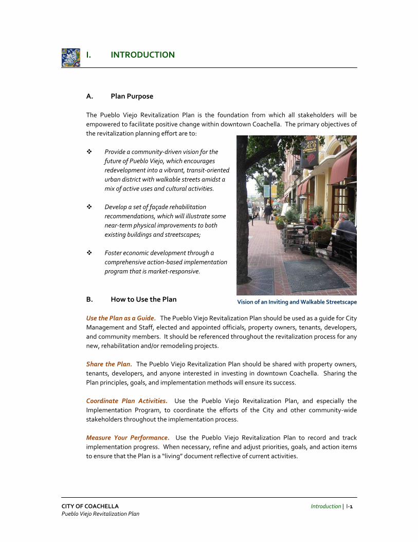
A. Plan Purpose The Pueblo Viejo Revitalization Plan is the foundation from which all stakeholders will be empowered to facilitate positive change within downtown Coachella. The primary objectives of the revitalization planning effort are to:
Provide a community‐driven vision for the future of Pueblo Viejo, which encourages redevelopment into a vibrant, transit‐oriented urban district with walkable streets amidst a mix of active uses and cultural activities.
Develop a set of façade rehabilitation
recommendations, which will illustrate some near‐term physical improvements to both existing buildings and streetscapes;
Foster economic development through a
comprehensive action‐based implementation program that is market‐responsive.
B. How to Use the Plan
Use the Plan as a Guide. The Pueblo Viejo Revitalization Plan should be used as a guide for City Management and Staff, elected and appointed officials, property owners, tenants, developers, and community members. It should be referenced throughout the revitalization process for any new, rehabilitation and/or remodeling projects. Share the Plan. The Pueblo Viejo Revitalization Plan should be shared with property owners, tenants, developers, and anyone interested in investing in downtown Coachella. Sharing the Plan principles, goals, and implementation methods will ensure its success. Coordinate Plan Activities. Use the Pueblo Viejo Revitalization Plan, and especially the Implementation Program, to coordinate the efforts of the City and other community‐wide stakeholders throughout the implementation process. Measure Your Performance. Use the Pueblo Viejo Revitalization Plan to record and track implementation progress. When necessary, refine and adjust priorities, goals, and action items to ensure that the Plan is a “living” document reflective of current activities.
Vision of an Inviting and Walkable Streetscape

CITY OF COACHELLA Introduction | I‐2 Pueblo Viejo Revitalization Plan
C. Background
Pueblo Viejo, the City of Coachella’s historic downtown was established around a Southern Pacific Railroad station and first settled in the late 1800s. The historic downtown community was organized in a traditional neighborhood grid pattern, with Sixth Street serving as the major commercial hub of retail, schools, churches, and other neighborhood services within walking distance for residents. The nationwide shift towards post World War II auto‐oriented residential subdivisions and commercial developments signified a decline of the historic downtown and the proliferation of strip commercial malls along the City’s two major enhanced arterials – Harrison Avenue (formerly Highway 86) and Grapefruit Boulevard (formerly Highway 111). Many of the services that remain in the downtown served the once fledgling community, but these facilities are now overburdened due to capacity demands of a growing City. The overtaxed City Hall is the only major destination that draws residents to the downtown area, amidst numerous vacant parcels and dilapidated buildings. In the mid 1980s, the City commissioned a Site Plan for the main commercial corridor, along Sixth Street. The City Council dubbed the area as “Pueblo Viejo” – or “Old Town” – in celebration of the Latino heritage of Coachella, which is ninety‐seven (97) percent Latino. The plans called for retail, commercial, housing, transit center and hotel, as well as a convention center building. The plan was very forward‐thinking for that time, as it incorporated numerous smart growth elements such as pedestrian‐friendly design, multi‐modal transportation and mixed‐use development. None of the elements of this planning effort ever materialized due to long‐standing financial difficulties in Coachella, and some vacant areas developed without incorporating the preferred smart growth principles. In 2005, a historic inventory and design guidelines were created for Pueblo Viejo, which served as baseline information for the City in pursing grant funding for further revitalization planning. Each year, the Southern California Association of Governments (SCAG) awards projects within the SCAG region, which coordinate land Lopes Hardware (Historic Structure)
Looking West Down Sixth Street
Coachella City Hall
Palm View Elementary School
Sixth Street Storefront (North Side)

CITY OF COACHELLA Introduction | I‐3 Pueblo Viejo Revitalization Plan
use and transportation activities, demonstrate excellence in planning and design, and most importantly, that work towards improving the mobility, livability, prosperity and sustainability of our region. Awards are granted through SCAG’s Compass Blueprint Demonstration Program. In 2008, the City of Coachella successfully submitted an application for the Pueblo Viejo Revitalization Project, requesting Compass Blueprint services and funding to assist in preparation of a master plan for the City’s downtown area. The City’s goal has been to preserve the historic character of Pueblo Viejo while accommodating future population growth and development. The revitalization planning effort also called for integration of a new transit center, in partnership with SunLine Transit Agency, which may lead to an expanded future transit village within Pueblo Viejo.
[Source: City of Coachella 2008 Compass Blueprint Demonstration Application, Background]
D. Project Partners
Southern California Association of Governments (SCAG). SCAG is the nation’s largest metropolitan planning organization (MPO), representing six counties, 189 cities and more than 18 million residents. SCAG undertakes a variety of planning and policy initiatives to plan for a livable and sustainable Southern California, now and in the future. SCAG supported this project through the Compass Blueprint Demonstration Program. Compass Blueprint Demonstration Projects provide opportunities for local planning efforts to become regional showcases for great planning. Demonstration Projects enable cities and counties to better evaluate planning options and stimulate sustainable development opportunities. Assistance is free of charge to local partners.
SunLine Transit Agency. This bus transit agency is the regional transportation mode of choice within the Coachella Valley, with a mission to provide environmentally conscious public transportation services and alternative fuel solutions to meet the mobility needs of
residents of this region. As co‐applicant to the City of Coachella, in preparation of the Pueblo Viejo Revitalization Plan through the SCAG Compass Blueprint Demonstration Program, SunLine Transit Agency provided staffing support, as well as bus transit ridership and route information.
[Source: http://www.scag.ca.gov/about and http://www.sunline.org/home]
Altura Credit Union (Historic Structure)

CITY OF COACHELLA Introduction | I‐4 Pueblo Viejo Revitalization Plan
E. Planning Area The primary portion of the Pueblo Viejo Revitalization Planning area is triangular in shape – bounded by Harrison Street on the west, Grapefruit Boulevard on the east, as well as Bagdad Avenue and Ninth Street on the south (shown in the Planning Area Map). Existing land uses within this area include a strong mix of single‐family residential, public facilities (civic/park uses), retail/commercial, and institutional (elementary schools and churches). Several larger vacant parcels exist at the northernmost portion of the project area (bisected by Avenue 50), and at the intersection of Sixth and Harrison Streets. Also scattered throughout the project area are smaller vacant infill lots. The secondary portion of the Revitalization Planning area includes land to the east of Grapefruit Boulevard, which encompasses a mix of medium‐ to heavy‐industrial and agricultural uses. A railroad parallels Grapefruit Boulevard (shown in the Planning Area Map). F. Plan Organization Section I – Introduction This section provides an overview of how to use the Plan, as well as historical background of the project area. The Pueblo Viejo Revitalization Plan should be used as a guide for City Management and Staff, elected and appointed officials, property owners, tenants, developers, and community members. It should be referenced throughout the revitalization process for any new, rehabilitation and/or remodeling projects. Section II – Vision Plan This section details the overall vision for the downtown, including community values, vision statement, and an illustrative plan identifying key aspects of the vision. The Pueblo Viejo Revitalization Plan should be shared with property owners, tenants, developers, and anyone interested in investing in downtown Coachella. Sharing the Plan principles, goals, and implementation methods will ensure its success.
Pueblo Viejo Planning Area Map

CITY OF COACHELLA Introduction | I‐5 Pueblo Viejo Revitalization Plan
Section III – Façade Rehabilitation This section discusses the existing storefront conditions within the planning area, and provides potential façade rehabilitation recommendations. Section IV – Implementation Program This section specifies the primary action steps and tools necessary to record and track the implement process. When necessary, project proponents should refine and adjust priorities, goals, and action items to ensure that the Plan is a “living” document reflective of current activities.
Section V – Appendix This section provides background materials and data related to development of the Revitalization Plan, including technical studies, economic conditions, and summaries from each community workshop held throughout the stakeholder outreach process.

CITY OF COACHELLA Vision Plan | II‐1 Pueblo Viejo Revitalization Plan
II. VISION PLAN
A. Community Planning Process The Pueblo Viejo Revitalization Planning process involved local residents, business owners, property owners, developers, and representatives from the Chamber of Commerce, school district, adult school, churches, Native American tribes, SunLine Transit Agency, Planning Commission and City Council. The process was divided into three phases, as described below: Phase I – Gain Project Understanding Phase I focused on developing a more thorough understanding of the various opportunities, constraints, and visions within the Pueblo Viejo project area. An initial kick‐off meeting and afternoon walking tour was conducted by the Project Team and City Staff on November 21, 2008. Several physical conditions (related to existing streetscape and circulation) were photographed and noted, along with sidewalk and curb‐to‐curb dimensions for streets immediately within the Sixth Street commercial area. Using information from the field reconnaissance, as well as various baseline documents provided by City Staff and SunLine Transit Agency, the Project Team developed a draft Opportunities and Constraints Sketch of Pueblo Viejo. This sketch was presented to over 40 community
members during Workshop No. 1, which was held at the Coachella Boys and Girls Club on the evening of January 27, 2009. Community members were asked to confirm and/or identify additional opportunities, constraints, and visions for Pueblo Viejo. In addition, community members participated in a visual design preference survey using handheld voting devices. During this exercise participants were asked to rate a series of photographs based on each their appropriateness for the Pueblo Viejo revitalization effort. Participants rated architectural styles, streetscape elements, as well as design features related to parking and circulation.
Opportunities and Constraints Map

CITY OF COACHELLA Vision Plan | II‐2 Pueblo Viejo Revitalization Plan
Results from the visual design preference survey were used to:
Obtain an understanding of the community’s preferences for the identity of Pueblo Viejo
Identify major gateways, circulation patterns, and commercial corridors within Pueblo Viejo
Verify existing and desirable future land use conditions within Pueblo Viejo
Prepare update recommendations to the City of Coachella’s Zoning Code and 2006 Pueblo Viejo Design Guidelines
Separate from Workshop No. 1, the Project Team and City Staff conducted thirteen (13) one‐on‐one interviews with several key community members to identify site specific opportunities and constraints related to the Pueblo Viejo area and on‐going revitalization efforts. The interviews were also held on January 27, 2009 at City Hall. Phase II – Develop the Draft Pueblo Viejo Revitalization Plan Phase II focused on further development of the draft Pueblo Viejo Revitalization Plan. Based on community input received from the Stakeholder Interviews and Workshop No. 1, the following draft vision plan components were developed in preparation for a second community outreach event (see Appendix Item A – Stakeholder Interview and Community Workshop Summaries):
Draft Vision Statement Draft Illustrative Vision Plan Graphic Draft Façade Rehabilitation Recommendations Draft Perspective Rendering Draft Street Cross Sections Draft Landscape Plant Palette Draft Color Palette Draft Market Study Analysis
On the evening of April 28, 2009, Workshop No. 2 was held at the Coachella Boys and Girls Club to present all draft vision plan materials and encourage participants to provide additional ideas or comments for incorporation into a final draft revitalization plan.
Images of Community Workshop Participants

CITY OF COACHELLA Vision Plan | II‐3 Pueblo Viejo Revitalization Plan
Following the Workshop No. 2, the Project Team revised the draft vision plan components and conducted a joint study session on May 18, 2009 with Planning Commission and City Council members. The purpose of the meeting was to allow these governing officials to review comments received from all stakeholders, as well as the draft Pueblo Viejo Revitalization Plan. Phase III – Develop the Final Pueblo Viejo Revitalization Plan Phase III focused on finalizing the draft Pueblo Viejo Revitalization Plan, based on comments received from the Planning Commission and City Council.
B. Key Community Priorities The following key community priorities were developed based on outreach conducted with all stakeholders. These priorities provide the foundation of the Pueblo Viejo Revitalization Plan. Preserve Historic Charm. Encouraging architecture that preserves local heritage is important to the character of Pueblo Viejo. Architectural styles such as Spanish Colonial and Mission Revival complement existing buildings and reflect the character of Pueblo Viejo. Expand Civic Center Presence. Clustering City Hall and other civic uses (such as the fire station, post office, library, senior center and Chamber of Commerce) in a concentrated area has been essential in defining the heart of Pueblo Viejo. As consideration is given to Coachella’s City Hall and Library renovation/expansion, it is important to evaluate opportunities to expand the already‐existing civic center presence in Coachella. Encourage a Vibrant Street Scene. Creating outdoor dining, retail and public gathering spaces along Sixth Street, with iconic mixed‐use developments at the gateways (or bookends of Sixth Street at Harrison Street and Grapefruit Boulevard) will encourage visitors to walk the core of Pueblo Viejo. Shaded walkways, provided by fully‐covered arcades, trellises, and/or tree canopies, complemented by benches and water fountains, will provide an active and attractive street scene in Pueblo Viejo. Provide Community Gathering Space. Like a true downtown in the heart of Coachella, Pueblo Viejo is a gathering place for community events, festivals, and just to relax. Numerous pedestrian gathering plazas and connections should exist around buildings, so that visitors may conveniently access rear parking, or just sit while enjoying the company of friends and family. Develop Strong and Successful Merchants. Providing support to existing businesses will help the City to retain long‐time merchants, and encourage new businesses to locate within Pueblo Viejo. Business retention and recruitment is vital to a successful downtown.

CITY OF COACHELLA Vision Plan | II‐4 Pueblo Viejo Revitalization Plan
C. Vision Statement and Perspective Rendering A vision statement is an encouraging or inspiring statement for the future of a place, and should reflect the desirable elements prescribed by the local community. The following vision statement for Pueblo Viejo was developed by the community members of Coachella. COMMUNITY VISION STATEMENT “Pueblo Viejo is the civic and cultural heart of Coachella. The community is proud of the historic charm, locally‐owned businesses, and vibrant civic center. As you enter through the attractive gateways on Sixth Street, you are immersed in a lively street scene offering shady walkways, cooling water fountains, outdoor dining, and unique shopping. Once empty lots are now filled with mixed‐use buildings that respect the heritage, climate, and community values. Family‐friendly events and festivals fill the streets and public spaces. As you relax in the clean, well maintained civic center core, you know . . . you have arrived in Pueblo Viejo!”
COMMUNITY VISION PERSPECTIVE
D. Conceptual Vision Plan The Pueblo Viejo Conceptual Vision Plan includes six (6) main components, which are referenced within Exhibit 1 – Illustrative Vision Plan Graphic and described in narrative form throughout the remaining pages in this section:
Architectural Character Site Planning and Land Uses Infill Development Sites and Catalyst Projects Cultural and Historic Celebration Streetscape Enhancements and Cross Sections Parking and Circulation

CITY OF COACHELLA Vision Plan | II‐5 Pueblo Viejo Revitalization Plan
ARCHITECTURAL CHARACTER A mix of architectural styles and details can create an authentic and timeless downtown. The following Spanish Colonial and Mission Revival styles were most preferred by Pueblo Viejo stakeholders, along with the possibility for future development to integrate some contemporary styling. While these themes were selected by the community because they respect the culture and heritage of Pueblo Viejo, they are not intended to be a requirement. Instead, they are provided to encourage compatibility and to ensure quality development in the downtown (see Appendix Item A – Stakeholder Interview and Community Workshop Summaries). Traditional Downtown. Traditional downtown architecture is characterized by relatively modest scale and façade topping parapet, which could be partially raised in a stepped or triangular pattern. The arrangement of windows is generally straightforward, with storefronts and display windows banded by transoms on lower stories and double‐hanging sashes on upper stories (when present). Architectural detailing is typified by contrasting color bulkheads, wall planes, and upper story parapet detailing. Storefronts are primarily glass for the purpose of display and piers frame the storefront. Spanish Colonial. Spanish Colonial architecture is best characterized by a combination of detail from several eras of Spanish and Mexican architecture, using features such as smooth plaster (stucco) walls, low‐pitched clay tile, shed, or flat roofs, and terra cotta or cast concrete ornaments. Other elements typically include small balconies, semi‐circular arcades, wood casement or tall, double‐hung windows, canvas awnings and decorative iron trim. In terms of site design, Spanish Colonial buildings are typically rectangular or L‐shaped with horizontal massing, and include interior and exterior courtyards. Mission Revival. Mission Revival architecture is characterized by massive walls with broad, unadorned surfaces and limited fenestration (e.g. windows, doors, skylights, or curtain walls), wide, projecting eaves, and low‐pitched clay tile roofs. Similar to Spanish Colonial architecture, other Mission Revival design elements include long, arcaded corridors, piered arches, and curved gables. Exterior walls are coated with plaster (stucco) to shield adobe bricks beneath from weathering. Contemporary. Contemporary architecture, which is best described as “architecture of the current time,” may be appropriate in new construction, although buildings should consider the use of materials, colors, and design elements similar to those of surrounding structures. Creative interpretations of traditional design elements should be reviewed by the City on a case‐by‐case basis, to ensure that projects are consistent with the underlying architectural style.
Contemporary Architecture
Mission Revival Architecture
Spanish Colonial Architecture
Traditional Architecture

CITY OF COACHELLA Vision Plan | II‐6 Pueblo Viejo Revitalization Plan
EXHIBIT 1 – Illustrative Vision Plan Graphic

CITY OF COACHELLA Vision Plan | II‐7 Pueblo Viejo Revitalization Plan
SITE PLANNING AND LAND USES Major Gateways:
There are three (3) major gateways into the Pueblo Viejo area, as defined by the local community.
The first major gateway is located at the northern‐most tip of the project area, where Harrison Street and Grapefruit Boulevard split (heading south). A vehicular‐oriented commercial center and signage mark this entrance into Pueblo Viejo.
The second major gateway is located at one of the “book‐ends” of Sixth Street, where intersecting with Grapefruit Boulevard. While one‐story commercial buildings exist at this intersection, the community felt is was an important gateway into Pueblo Viejo because of its axis along Sixth Street and terminus with the future Bus Transfer Center.
The third major gateway is located at the other “book‐end” of Sixth Street, where intersecting with Harrison Street. The vacant properties located on the north‐ and south‐east sides of this intersection are prime for development of iconic, two‐to‐three story commercial/retail and residential mixed‐use. Corner gathering plazas, fountains, and way‐finding signage will enhance these corners as a significant entry into Pueblo Viejo.
Looking East Down Sixth Street from Harrison Street
1.
3.
2.
Photo of Major Gateway 1
Photo of Major Gateway 2
Photo of Major Gateway 3
Image of Public Plaza Water Fountain and Seating

CITY OF COACHELLA Vision Plan | II‐8 Pueblo Viejo Revitalization Plan
Land Uses: Civic Center uses within the immediate Pueblo Viejo project area include City Hall, Fire Station, Chamber of Commerce, Post Office, Library, Senior Center, and Veteran’s Park.
Commercial uses in Pueblo Viejo are generally located within the northern‐most portion of the triangular project area (where Harrison Street and Grapefruit Boulevard split), as well as along Harrison Street, Grapefruit Boulevard, and the entire Sixth Street corridor. The northernmost triangle is comprised of vehicular‐oriented uses with expansive parking lots, and some vacant parcels zoned for future commercial use. Strip commercial centers are generally found along Harrison Street (a mix of retail and neighborhood commercial) and Grapefruit Boulevard (auto‐related commercial). Sixth Street is comprised of local restaurants and retail‐related storefronts.
Industrial uses are located along the south side of Avenue 50 and east of the railroad tracks running parallel to Grapefruit Boulevard. This Revitalization Plan does not call for a change in industrial use, although it would be ideal to improve the industrial area on the south side of Avenue 50 to be more compatible with single‐family residential neighborhoods to the south.
Residential uses within Pueblo Viejo are predominantly single‐family units with some duplexes scattered throughout the area. The majority of residential uses are located along Fifth Street (north to Avenue 50) and Seventh Street (south to Baghdad Avenue).
Coachella City Hall Coachella Fire Station Chamber of Commerce
United States Postal Service Coachella Senior Center Veteran’s Park
Existing Commercial Uses
Existing Industrial Uses
Existing Residential Uses

CITY OF COACHELLA Vision Plan | II‐9 Pueblo Viejo Revitalization Plan
Institutional uses include Palm View Elementary School and Coachella Valley Adult School, which are located along the south side of Seventh Street. Additionally, a historic church that is now being uses as a quasi‐public community center is located along First Street.
Future Mixed‐Use is planned along the entire Sixth Street corridor and along the portions of Vine Avenue and Orchard Street that wrap the City Hall block. Storefronts should include active ground‐floor retail and neighborhood‐serving commercial, with upper floors (if applicable) designed to accommodate general/medical office and/or residential uses.
Some parcels along this mixed‐use corridor are underutilized and/or
vacant, making them ideal infill lots for redevelopment. Existing commercial uses along Sixth Street are generally one‐story. Future mixed‐use structures are encouraged to be two‐story, between Tripoli Way and Vine Avenue. In an effort to create iconic gateways, two‐to‐three story mixed‐use structures are encouraged at the corners of Harrison Street and Grapefruit Boulevard, where they intersect Sixth Street. The primary design issue related to mixed‐use projects is the need to successfully balance the requirements of residential uses, such as the need for privacy and security, with the needs of commercial uses related to access, visibility, parking, loading, and possibly the extension of hours of operation to maintain a lively downtown.
Pedestrian Connections:
Pedestrian connections between buildings are critical for access between rear parking lots/structures and storefronts along Sixth Street. They can be designed as semi‐ or fully‐covered breezeways, or landscaped pocket parks with outdoor tables/benches and wall space for community murals. (The image at the left is an example of an existing pocket park that could be improved as a connection with removal of fencing.)
Pedestrian connections may also be used for access to perimeter stores, outdoor café seating, or as general public gathering space. Unique architectural, landscape or water feature elements can create spaces that are visually interesting for passersby. A primary objective of the Revitalization Plan is to maintain walkability, so where possible, rear parking lots/structures should be designed for vehicular access from either Fifth Street, Seventh Street, and/or smaller side streets. Minimizing driveway access points along Sixth Street will reduce the frequency of automobiles crossing the path of pedestrians.
Existing Institutional Uses
Photo of Existing Pocket Park
Image of Pedestrian Connections

CITY OF COACHELLA Vision Plan | II‐10 Pueblo Viejo Revitalization Plan
INFILL DEVELOPMENT SITES AND CATALYST PROJECTS Catalyst Site One – City Hall Renovation / Expansion: City Hall, and the adjacent Veteran’s Park located within the same block, is currently the major draw for people who visit Pueblo Viejo. Many city residents stop by to pay utility bills, while others discuss development projects with Community Development Department staff. With a growing population and an aging structure, one of the City’s priorities is to evaluate options for renovating/expanding or building a new City Hall. The Revitalization Plan considers the option of renovating/expanding City Hall among one of the most important catalyst projects for redeveloping Pueblo Viejo. Given that this Revitalization Plan serves as the “ideal” vision for improvements to be made within Pueblo Viejo, this Plan calls for complete reconstruction of City Hall within its existing block. The architectural style would be consistent with that found in Santa Barbara (or Spanish Colonial), creating a courtyard‐like entry on the south side and additional gathering plaza space on the Veteran’s Park side. The amenities already contained within both park spaces (No. 23, north and south) would be enhanced, but overall, these two park spaces would remain as less “programmed” green space so as to preserve as many existing trees as possible. Conceptually, a new City Hall building (No. 9) would be situated mid‐block and in line with the Fifth Street axis to create an inviting and continuous pedestrian‐oriented passage through the covered arcades of the reconstructed City Hall building. Angled parking would remain along all four sides of the Civic Center block – in particular on Sixth Street, Orchard Street and Vine Avenue, with additional angled parking to be provided along the south side of Fourth Street.
Sixth Street – A “Convertible” Street
The significance of Sixth Street as a well‐connected commercial corridor for pedestrians, bicyclists and motorists is important to the vitality of Pueblo Viejo. During community events or street fairs in particular, the segment of Sixth Street between Orchard Street and Vine Avenue may serve as a “convertible street” (No. 8) by being temporarily converted to a pedestrian‐only thoroughfare using barricades and vehicle detour signs. This entire segment would include decorative paving to distinguish it as a community gathering plaza when closed. When open, this segment would serve as a primary connector for
vehicles traveling from one end of Sixth Street to another, and be striped to provide angled parking for visitors.
9.
23.
23.
8.

CITY OF COACHELLA Vision Plan | II‐11 Pueblo Viejo Revitalization Plan
While accommodating a reasonable amount of traffic, vehicle speeds should be moderated to ensure pedestrian safety. All pedestrian crosswalks within every Sixth Street intersection in Pueblo Viejo should be improved with decorative paving to distinguish the crosswalk from vehicle travel lanes, and may be improved with curb extensions to shorten the pedestrian crosswalk distance. If incorporated in the crosswalk design, then the radius of curb extensions should be examined to allow a street sweeper to navigate with ease, especially in locations where angled parking is provided. Where possible, “Key Access Intersections” along Sixth Street (No. 20; also shown in the Pueblo Viejo Street Design Features Plan on Page II‐23) should include dedicated turn lanes to avoid excessive vehicle queues. Roundabout designs may also be considered at these “Key Access Intersections” to maintain a continuous flow of traffic, but should be carefully designed so as to maximize safe pedestrian crossing access. Catalyst Site Two – Bus Transfer Center Like many southern California cities that are promoting walkable neighborhoods with a mix of residential and commercial uses around public mass transit systems, the City of Coachella has partnered with SunLine Transit Agency to identify sites for a future bus transfer center (No. 26). The vision within this Revitalization Plan calls for a future bus transfer facility on the east side of Grapefruit Boulevard, in direct line with the Sixth Street commercial corridor axis. Bus transfer centers generally include covered bus bays (approximately eight to ten shown) and ticket/information kiosk for transit patrons. Given the City’s future inland port and entertainment district development concepts for east of Grapefruit Boulevard, this location for a bus transfer center is ideal. Increased bus ridership into this transit center, due to visitors of Pueblo Viejo from other regions, may lead to future expansion opportunities as a full‐blown regional transit center.
Looking East To Proposed Bus Transfer Center
26.
Images of Transit Schedule / Bus Transfer Center

CITY OF COACHELLA Vision Plan | II‐12 Pueblo Viejo Revitalization Plan
Catalyst Site Three (Assessor Parcel Numbers: 778‐092‐001 to ‐008)
This property is bound by Sixth Street on the north, Seventh Street on the South, Palm Avenue on the west, and Orchard Street on the east. The land uses envisioned for this catalyst site include a mix of ground‐floor retail with office (general and/or medical) space on upper floors. To meet parking requirements, the City may evaluate parking structure concepts up to three stories in height, a cost‐sharing analysis and joint‐use agreement with adjacent elementary and adult school facilities.
(See Appendix Item F – Catalyst Sites Pro Forma Analysis)
Catalyst Site Four (Assessor Parcel Numbers: 778‐080‐006, North Side of Sixth Street; 778‐081‐003, South Side)
This catalyst site includes two different parcels which span both the north and south sides of Sixth Street. The property on the north side (located on the east side of Harrison Street, between Fourth and Sixth Streets) is a large vacant piece of land (No. 5). The property on the south side (located on the east side of Harrison Street, between Sixth Street and Baghdad Avenue) is fairly developed with neighborhood commercial uses (No. 6). Both properties are situated at the major gateway to Pueblo Viejo and are critical catalyst sites to the project area’s revitalization.
6.
5.
5.
6.
7.
Looking Northwest across Vacant Parcel on North Side
Existing Retail on South Side Vacant Parcel on North

CITY OF COACHELLA Vision Plan | II‐13 Pueblo Viejo Revitalization Plan
This Revitalization Plan envisions a solid mix of ground‐floor retail and public gathering plaza space fronting Harrison Street on the north property, with active senior residential units located on upper floors (up to three stories). A separate senior center building and green open space are also contemplated for this catalyst site. The City will evaluate development proposals based on economic and market feasibility, and is open to project proposals that include horizontal and/or vertical mixed‐use. A similar mix of senior‐related uses, retail and commercial office space are contemplated for the property on the south property. Development proposals for this site should again focus ground‐floor retail activity on the Harrison and Sixth Streets sides. The Revitalization Plan also explores the option of extending Fifth Street (No. 7) through to Harrison Street, for the purpose of completing the downtown street grid network. Development proposals may or may not wish to include this extension, but those that do should indicate such as a “right‐turn in/right‐turn out” intersection with Harrison Street. To meet parking requirements for development on both the north and south properties, the City may evaluate parking structure (up to three stories in height) and/or surface parking lot concepts, a cost‐sharing analysis and joint‐use agreement with adjacent property owners. (See Appendix Item F – Catalyst Sites Pro Forma Analysis) CULTURAL AND HISTORIC CELEBRATION Heritage Walk
Many cities with historic downtowns establish “heritage walks” or pedestrian paths of milestone markers that celebrate the history of how their downtown developed over time (e.g. historic buildings, monuments, events and/or culture). Pueblo Viejo has a rich history – a story that should be expressed through the area’s revitalization efforts.
While a specific “heritage walk” route has not been developed for Pueblo Viejo, the following locations represent a few places that City officials, business merchants, residents and other Pueblo Viejo stakeholders may wish to consider in the event that the community desires to establish a specific route:
‐ City Hall (as reconstructed, and/or including all of the existing monuments in front of City Hall, such as the Water Trough) ‐ Historic Church (located on First Street) ‐ Veteran’s Park ‐ Lopes Hardware (as Original Bank) ‐ Altura Credit Union (as Original Fire Station)
Vietnam Veteran’s Park Plaque
Original Fire Station

CITY OF COACHELLA Vision Plan | II‐14 Pueblo Viejo Revitalization Plan
STREETSCAPE ENHANCEMENTS AND CROSS‐SECTIONS
Sidewalk Improvements
Most existing sidewalks within Pueblo Viejo are concrete from curb‐face to building frontage, leaving pedestrians fully exposed to intensive hot and cold weather conditions and visually harsh concrete conditions. Minimal street lighting exists, leading to reduced night‐time visibility. Other segments have crumbled curb‐faces and cracked sidewalks due to imbalanced soil compositions, which have resulted in entire sidewalk sections being closed off to pedestrians. Further, many sidewalks abut large numbers of utility boxes and overhead electrical wires, as opposed to visually appealing landscape buffers, and lead into faded intersection crosswalks. The City of Coachella has prioritized major street improvements throughout Pueblo Viejo, which include re‐paving and installation of sidewalks where currently non‐existent. Future near‐ and long‐term street enhancements should prioritize sidewalks that are currently closed‐off to pedestrians and are encouraged to include the following improvements:
Underground Overhead Utility Poles and Boxes Prepare (Treat) Soil Prior to Installation of New Concrete Sidewalks Re‐Paint Intersection Crosswalks and/or Install Decorative Paving Include Mosaics and/or other Diverse Design Elements in Sidewalks for Visual Interest Consider Implementing “Heritage Walk” Monuments in Newly Installed Sidewalks Install Pedestrian‐Scaled Sidewalk Lighting (Specific to Pueblo Viejo Identity) Integrate Landscape Buffers with Overhead Tree Canopies (Specific to Pueblo Viejo Identity) Install Seat Benches for Pedestrians (Specific to Pueblo Viejo Identity)
Existing Sidewalk Faded Crosswalk
Overhead Utility Lines Closed Sidewalk Sidewalk Utility Boxes
Deteriorating Curb Face
Sidewalk Marker for Heritage Walk

CITY OF COACHELLA Vision Plan | II‐15 Pueblo Viejo Revitalization Plan
Phoenix Dactylifera California Fan Palm
Lighting Quality street lighting can enhance the identity of a downtown by complementing a building’s architecture and/or sidewalk landscaping, but most importantly, it enhances night‐time security because of increased visibility.
Sidewalk street lighting within Pueblo Viejo in encouraged to be compatible with Spanish Colonial, Mission Revival, and/or Contemporary architecture (generally includes bell‐shaped street lamps). It should also be pedestrian‐scaled and provide opportunities for hanging planters and/or a street banner program that further celebrates the Pueblo Viejo heritage. The sidewalk street scene is essential in creating a relatable “sense of place” for residents and visitors.
Landscaping
Landscaping should be considered an integral design element in the planning for new or redeveloped streetscapes and project sites within Pueblo Viejo. Landscaping can enhance the quality of a downtown by framing and softening the appearance of buildings, screening undesirable views, and providing shade and comfort to pedestrians.
The following pages include possible landscape types for iconic trees, tree canopies, and shrubs that the City may wish to evaluate for planting within the downtown. Further, the use of a desert‐climate, drought‐tolerant plant mixture is encouraged.
In some instances, a street sidewalk may be enhanced through larger potted plants that are strategically‐placed near storefront entrances, sidewalk benches and trash cans. If space is available, large potted plants and/or planter bed shrubs may be used to screen any parking lots and/or utility boxes that already exist along Sixth Street.
Iconic Palm Tree Options
Image of Sidewalk Lighting
Images of Potted Landscaping

CITY OF COACHELLA Vision Plan | II‐16 Pueblo Viejo Revitalization Plan
Desert Sweet Acacia
Australian Willow Chinese Pistache Blue Palo Verde
Prosopis Chilansis
Tipu Tree
Chitalpa
Cassia
Lagerstroemia
Canopy Tree Options
Plaza Shade Tree Options Shrubs Options
Red Bird of Paradise
Leucophyllum New Gold Lantana
Montevidensis Lantana Red Yucca
Feathery Cassia
Bougainvillea
Agave Americana
Mulenbergia
Pennisetum
Agave Blue Flame

CITY OF COACHELLA Vision Plan | II‐17 Pueblo Viejo Revitalization Plan
Street Furniture During the outreach process, Pueblo Viejo community members preferred sidewalk bench seating to that of portable benches. Planter seat walls not only serve as resting spots for pedestrians, but act as a planter bed walls. Further, they offer a number of opportunities to creatively integrate custom tiles or other artistic design elements that celebrate the Pueblo Viejo heritage.
Community members were also open to various configurations of sidewalk seating. Benches and/or planter seat walls could be located directly in front of a store and face outward to the street, or be located closer to the curb and face inward towards a store. Overall, the community encouraged use of concrete, stone, wood, and/or stucco for seating to maintain cooler seating options for pedestrians.
Street Cross‐Sections
Following are three Street Cross‐Section Exhibits (2 through 4) for existing streets within Pueblo Viejo, which provide concepts for street enhancements along commercial, residential, and combined commercial/residential adjacent streets. Enhancements relate to parallel versus angled parking, sidewalk depth for outdoor dining/café and/or sidewalk sale space, street tree locations, mid‐block crosswalk locations (if desired), and curb extensions at intersections.
EXHIBIT 2 –Street Cross‐Section (Commercial)
Images of Planter Seat Walls

CITY OF COACHELLA Vision Plan | II‐18 Pueblo Viejo Revitalization Plan
EXHIBIT 3 –Street Cross‐Section (Residential)

CITY OF COACHELLA Vision Plan | II‐19 Pueblo Viejo Revitalization Plan
EXHIBIT 4 –Street Cross‐Section (Commercial Interfacing with Residential)

CITY OF COACHELLA Vision Plan | II‐20 Pueblo Viejo Revitalization Plan
PARKING AND CIRCULATION According to the parking and circulation analysis completed by Urban Crossroads (See Appendix Item G – Traffic and Circulation Memorandum, Urban Crossroads), the following sections are structured with recommendations related to:
“Park Once” Strategy Angled vs. Parallel Parking Existing City Parking Requirements Shared and Off‐Street Parking Traffic Control and Speed Measures Regional Bicycle and Pedestrian Trail
“Park Once” Strategy Fundamental to the creation of an active, walkable, and compact mixed‐use district is the creation of a “park once” environment – one in which visitors can literally park their vehicle in one place and then walk throughout the remainder of their visit. While this strategy may not be immediately necessary in Pueblo Viejo and will take time to employ (given the cost of providing concentrated parking structures/lots), it will be important for City representatives to consider this type of strategy in the future. The typical suburban pattern of isolated, single use buildings, each surrounded by parking lots, requires two vehicular movements and a parking space to be dedicated for each visit to a shop, or office, or civic institution. To accomplish three errands in this type of environment requires six movements and three separate parking spaces for three tasks. With most parking held in private hands, spaces are not efficiently shared between uses, and each building's private lots are therefore typically sized to handle a worst‐case parking load. If a proposed transit‐oriented district attempts to provide typical suburban quantities of parking, with little or no sharing, the result will be a system that is costly and inefficient, and a land use pattern that is anything but transit‐oriented. Applying conventional suburban parking ratios will generate freestanding retail boxes surrounded by cars, or pedestrian‐hostile buildings that hover above parking lots; and the resulting low‐density fabric generates too few pedestrians to allow a downtown to reach a critical mass of people.
To employ a “park once” strategy, the City of Coachella and other potential joint‐use stakeholders should make efficient use of parking supply by including as many spaces as possible in a common pool of shared, publicly available spaces. Build a small number of cost‐effective, strategically located parking structures, rather than many small, inefficient and scattered private lots.
Following are a few ways in which the City may implement a “park once” strategy:
Require private parking for non‐residential development to be made available to the general
public for lease or rent.

CITY OF COACHELLA Vision Plan | II‐21 Pueblo Viejo Revitalization Plan
Consider constructing centralized public parking structures/lots at the rear of storefronts located along Sixth Street. Fund the garages by renting and leasing spaces to employees, residents, and/or transit patrons on a daily and/or hourly basis.
Facilitate shared parking in parking lots wherever feasible.
Angled vs. Parallel Parking The Pueblo Viejo community strongly encouraged the addition of angled parking spaces, instead of parallel parking. Currently, angled parking exists on the north side of Sixth Street, directly in front of City Hall. It is also located around the Civic Center block along Vine Avenue and Orchard Street. Most other street segments in and around the core area of Pueblo Viejo are designed for parallel parking. The proposed street cross sections within this Revitalization Plan have integrated angled parking in a variety of ways, to provide options for the City of Coachella and prospective developers as redevelopment occurs. In areas where parallel parking remains, sidewalk depths will remain deeper, allowing for outdoor café dining and/or merchant sidewalk sales events. Existing City Parking Requirements The City of Coachella’s current parking code requirement of four (4) parking spaces per 1,000 square feet of commercial development is typical for a suburban environment. The code allows for a 60 percent reduction in the number of parking spaces required in areas where public parking lots are available. This helps to encourage shared parking, but still requires 40 percent of the parking to be placed on site. Given this reduction, the City’s current parking standards are conducive to a downtown environment where a “park once” strategy would be employed and access to alternative transportation modes (i.e. walking, biking, transit) are equally prioritized. Any existing buildings for commercial use located within 500 feet of a publicly owned parking lot and located within the Sixth Street commercial core area defined as the area bounded by Harrison Street, Fourth Street, Grapefruit Boulevard (Highway 111), Eighth Street and property bordered by Harrison Street, Cairo Avenue, Baghdad Avenue and 300 feet east of Harrison Street is exempt from the City’s standard parking requirements. Any existing building for commercial use located more than 500 feet from a publicly owned parking lot and located within the Sixth Street commercial core area bounded by Harrison Street, Fourth Street, Grapefruit Boulevard (Highway 111), Eighth Street and property bordered by Harrison Street, Cairo Avenue, Baghdad Avenue and 300 feet east of Harrison Street will be required to meet the parking requirements, except that the required number of parking spaces may be reduced by 60 percent with the approval of the Planning Commission as a part of architectural review. Private parking lots developed for uses within this exempt area shall comply with this section, including the size of parking spaces and required aisle width.
Image of Preferred Angled Parking
Image of Parallel Parking

CITY OF COACHELLA Vision Plan | II‐22 Pueblo Viejo Revitalization Plan
Expansions of any existing buildings for commercial uses located within the Sixth Street commercial core area bounded by Harrison Street, Fourth Street, Grapefruit Boulevard (Highway 111), Eighth Street and property bordered by Harrison Street, Cairo Avenue, Baghdad Avenue and 300 feet east of Harrison Street will be required to meet the parking requirements, except that the required number of parking spaces may be reduced by 60 percent with the approval of the Planning Commission as a part of architectural review.
New building structures for commercial use will be required to meet the City’s requirements. Shared and Off‐Site Parking
As noted in the City of Coachella’s Zoning Code, the Planning Commission may approve a Conditional Use Permit (CUP) to allow the use of shared and off‐site parking requirements – to reduce the total number of required on‐site parking spaces for different uses – when projects comply with the following:
A parking study has been submitted to the City, which addresses the potential peak parking demand, including an actual parking survey of the parking facility under consideration.
Evidence has been submitted to the City, demonstrating that no substantial conflict will occur in the
principal hours or periods of peak demand for the structures or uses for which the joint use is proposed.
Evidence of agreements for such use by a proper legal instrument, recorded in the office of the county recorder with two copies thereof, will be filed with the Planning Division as a condition of any approval.
In no case shall the total parking reduction be allowed to exceed 50 percent of the total
parking for all uses combined.
Any off‐site parking shall be located so that it will adequately serve the use for which it is intended, with safe and convenient access without unreasonable hazard to pedestrian, vehicular traffic, or traffic congestion, and shall not be detrimental to the use of business, property or residential neighborhood in the vicinity.
Traffic Control and Speed Measures Traffic conditions on residential streets can greatly affect neighborhood livability. When local and collector streets are safe and pleasant, the quality of life is enhanced. When traffic problems are a daily occurrence, the sense of community and personal well‐being are threatened. With proactive attention to neighborhood connectivity issues by residential and business owners in Pueblo Viejo, and the City's efforts in education, engineering, and enforcement, stakeholders can work together to address potential neighborhood traffic problems. Continued citizen involvement in Pueblo Viejo is an important part of all traffic calming projects. The people who live and work in the project area can have the opportunity to become actively involved in the planning and decision‐making process. Traffic calming for Pueblo Viejo is a concept that seeks harmony between automobiles and people living in the area.

CITY OF COACHELLA Vision Plan | II‐23 Pueblo Viejo Revitalization Plan
Based upon this initial assessment, it is recommended that various traffic control and traffic calming devices be implemented throughout the revitalization process (See Exhibit 6 – Pueblo Viejo Detailed Street Cross‐Sections and Exhibit 7 – Pueblo Viejo Speed Measure Designs for more detail regarding street classifications and traffic control measures).
Pedestrian crosswalks along Harrison Street and Grapefruit Boulevard should be limited to the traffic signal locations shown in Exhibit 5 – Pueblo Viejo Street Design Features. Harrison Street and Grapefruit Boulevard are projected to carry in excess of 50,000 vehicles per day (VPD) and 25,000 VPD, respectively for General Plan build‐out conditions (see Exhibit 6).
On‐street diagonal parking areas are indicated on segments of Fourth Street, Sixth Street,
Seventh Street, Vine Avenue, Orchard Street, and Palm Avenue (see Exhibits 2 through 4). As indicated in the Street Cross‐Sections, some streets may have diagonal parking on one side, diagonal parking on both sides, or parallel parking on both sides.
The Street Design Features referenced in Exhibit 5 show local street intersection locations
within Pueblo Viejo where narrowing or curb extensions are proposed to enhance pedestrian activity. Sample Speed Measure Designs are provided in Exhibit 7 for intersection narrowing/curb extensions, mid‐block raised crosswalks, and speed lumps.
Mid‐block raised crosswalks are recommended at four different locations along Sixth Street.
Speed bumps are also suggested at two locations (Fourth Street east of Harrison Street, and Fifth Street west of Palm Avenue).
Regional Bicycle and Pedestrian Trail The sliver of land located directly to the east of Grapefruit Boulevard (No. 24) and runs parallel to the railroad tracks, is envisioned to include a regional bicycle path and pedestrian trail. The intent is to provide physical connection between the northern and southern sections of Coachella, as well as the proposed bus transfer center.
24.
24.
Sketch of Regional Bicycle Trail and Pedestrian Path

CITY OF COACHELLA Vision Plan | II‐24 Pueblo Viejo Revitalization Plan
EXHIBIT 5 –Pueblo Viejo Street Design Features

CITY OF COACHELLA Vision Plan | II‐25 Pueblo Viejo Revitalization Plan
EXHIBIT 6 – Pueblo Viejo Detailed Street Cross‐Sections

CITY OF COACHELLA Vision Plan | II‐26 Pueblo Viejo Revitalization Plan
EXHIBIT 7 – Pueblo Viejo Speed Measure Designs

CITY OF COACHELLA Implementation Program | IV‐1 Pueblo Viejo Revitalization Plan
IV. IMPLEMENTATION PROGRAM A. Primary Action Steps and Tools
The primary action steps and tools have been organized into the following categories:
Policy Implement Priority Projects First Physical Improvements Communication Technical Assistance Long‐Term Maintenance and Management Document, Monitor, and Demonstrate Progress
Policy. One of the first steps the City of Coachella should consider is formalizing the Pueblo Viejo Revitalization Plan so that the strategies and recommendations are consistently followed and adhered to over the life of the plan. The following action steps should be considered:
Adopt the Pueblo Viejo Revitalization Plan as official policy of the City of Coachella.
Implement the Façade Rehabilitation Recommendations, as desired by the City and business merchants, in conjunction with other near‐term revitalization efforts being undertaken.
Amend the Pueblo Viejo Design Guidelines to reflect the recommendations contained in
Appendix B – 2006 Design Guidelines Diagnostic.
Update the Zoning Code to reflect the recommendations in Appendix C – City of Coachella Zoning Code Diagnostic.
Develop a civic center block site master plan for renovation/expansion of City Hall. A
detailed site analysis and design study should be completed for the civic center block to determine City Hall building design, precise location, access, possible closure of Sixth Street (immediately in front of City Hall), as well as integration of other civic‐related functions and outdoor public gathering plazas/open space.
Adopt incentives for infill and rehabilitation projects. Incentives my include:
o Reduced Parking Requirements o Increased Floor Area Ratio (FAR) or Density/Intensity of Uses o Financial Assistance, Grants, or Loans o Design Assistance o Maintenance and Operations Cost Assistance

CITY OF COACHELLA Implementation Program | IV‐2 Pueblo Viejo Revitalization Plan
Implement Priority Projects First. Following adoption of the Pueblo Viejo Revitalization Plan, the City should initiate working on both catalyst site development and near‐term street enhancement projects immediately. Completing high visibility projects early on will create a strong sense of accomplishment and help to maintain the energized momentum of community members. In addition to the catalytic importance of a City Hall renovation/expansion project, the following two sites have been identified as catalyst site development projects within Pueblo Viejo (see Appendix Item F – Catalyst Sites Pro Forma Analysis for a detailed summary of each project’s economic feasibility):
Catalyst Site Three (located at the southwest corner of Sixth Street and Orchard Street) Catalyst Site Four (located on the north east corner if Harrison and Sixth Street).
Physical Improvements. The majority of the Pueblo Viejo Revitalization Plan and Façade Rehabilitation Recommendations are oriented toward physical improvements that support the vision and revitalization of Pueblo Viejo. The Implementation Matrix contained at the end of this Section summarizes specific actions to help implement these physical improvements. In general, they are summarized by the following:
Design It Approve It Fund It Build It Enhance It Repair It Replace It Maintain It
Communication. Constant communication with community members regarding the goals, objectives, and benefits of the Revitalization Plan are essential to successful implementation. The Plan should be used daily by City Staff, elected and appointed officials, property owners, business owners, developers, and other community stakeholders. The Plan is a guide for all capital investments and improvements, and all land use and environmental regulations and decisions. To ensure on‐going communication and continued community‐building, the following actions are recommended:
Distribute copies of the Revitalization Plan to all elected and appointed officials, City Staff Pueblo Viejo business merchants, and representatives of the Chamber of Commerce, School District, Adult School, and key developers/property owners.
Place the Revitalization Plan on the City’s website for community members to reference.
Provide copies of the Revitalization Plan to applicants submitting proposals to the City for
new or redevelopment projects.
Make copies of the Revitalization Plan available for use at the Planning Department counter.
Regularly review and update the Revitalization Plan, as necessary.

CITY OF COACHELLA Implementation Program | IV‐3 Pueblo Viejo Revitalization Plan
Consider offering to hold additional community outreach meetings with all stakeholders as implementation progresses.
Reference the Vision Plan, Vision Statement, and Key Community Priorities in all
development applications related to Pueblo Viejo.
Include a standard agenda item to discuss implementation and regular update of the Plan when meeting with the Pueblo Viejo merchant’s group.
These steps will help to ensure that the Plan is consistently up‐to‐date (as a “living” document), rather than being placed on a shelf only to be reviewed should a follow‐up planning process be initiated in the future. Technical Assistance. The success of the Pueblo Viejo Revitalization Plan is largely dependant on the City’s ability to remain as active partners with the development community. There are a number of ways the City can provide assistance and technical support including the following:
Develop and provide property owners, project applicants, and prospective developers a list of pre‐approved consultants.
Assist with identification and pursuit of funding for some or all professional planning and
design services for projects that are consistent with the Plan. The amount of funding could be based on a points system tied to the goals of this plan.
Provide small business assistance programs to allow existing business to expand and new
businesses to locate within Pueblo Viejo.
Long‐Term Maintenance and Management. Just as this Plan is a “living” document that needs to be reviewed and updated, long‐term maintenance and management of Pueblo Viejo should not be ignored. Although pursuit of grants, Redevelopment Agency support, and an involved community will aid in this endeavor, it is important to explore more formal mechanisms to provide continued management of downtown. The following options should be considered:
Formalize the merchants group by establishing a Downtown Main Street Program. This program would be responsible for the overall management, as well as fundraising for downtown improvements. Local main street organizations have great success rates because of the program’s unique development of public‐private partnerships and its Four‐Point Approach (see below) which have proven successful in communities ranging in size from 250 to over 1 million people.
Establish a Business Improvement District (BID). A business improvement district or BID
would provide a steady income for implementation of the Revitalization Plan. BID’s are self‐taxing business districts in which a majority of the business and property owners agree to pay for capital improvements, maintenance, marketing, parking, and other physical enhancements. This can be implemented in conjunction with or separate from a Main Street Program.

CITY OF COACHELLA Implementation Program | IV‐4 Pueblo Viejo Revitalization Plan
Document, Monitor, and Demonstrate Progress. A key component to the success of a long‐term plan such as the Revitalization Plan and Façade Rehabilitation Recommendations is to continually document progress and monitor success. It is important that each improvement be documented and monitored so that future decisions can be made based on objective data. Data does not have to be costly if planned in advanced, such as before and after photos, analysis of increased sales or property tax data, etc. B. Potential Funding Sources
The following is a list of potential funding sources relevant to implementation the Pueblo Viejo Revitalization Plan:
The Main Street Four‐Point Approach The National Trust Main Street Center offers a comprehensive downtown revitalization strategy. The strategy focuses on four points which work together to build a sustainable and complete community revitalization effort. Organization involves getting everyone working toward the same goal and assembling the appropriate human and financial resources to implement the revitalization program. An organizing body is essential to this step. This body could be formed as a:
Downtown Committee or Merchants Group Downtown Manager and volunteer staff Redevelopment Agency
Promotion sells a positive image of the commercial district and encourages consumers and investors to live, work, shop, play and invest in downtown through advertising, retail promotional activity, special events, and marketing campaigns. These activities improve consumer and investor confidence in the district and encourage commercial activity and investment in the area. Design means getting Pueblo Viejo into top physical shape by creating an inviting atmosphere through attractive window displays, parking areas, building improvements, street furniture, signs, sidewalks, street lights, and landscaping. This conveys a positive visual message about the commercial district and what it has to offer. Good maintenance practices and long‐term planning are also an important component of good design. Economic Restructuring strengthens a community's existing economic assets while expanding and diversifying its economic base. By sharpening the competitiveness of existing business owners and recruiting compatible new businesses and new economic uses.
For more information, visit www.mainstreet.org

CITY OF COACHELLA Implementation Program | IV‐5 Pueblo Viejo Revitalization Plan
Federal Funding Sources
Community Development Block Grants (CDBG): The Community Development Block Grant program is a federal grant program administered locally. CDBG funding can be used for economic development purposes including property acquisition and as part of the City's comprehensive strategy for economic development.
Federal Economic Development Administration (EDA): Funds from the EDA can be
used to finance construction and rehabilitation of infrastructure and facilities that are necessary to achieve long‐term growth and dynamic local economies. Grants to communities for site preparation and construction of water and sewer facilities, access roads, etc.
US Federal Highway Administration (FHWA) Transportation and Community and
System Preservation Program (TCSP): The TCSP is a comprehensive initiative of research and grants to investigate the relationships between transportation and community and system preservation and private sector‐based initiatives. States, local governments, and metropolitan planning organizations are eligible for these discretionary grants. Grants to plan and implement strategies that improve the efficiency of the transportation system; reduce environmental impacts of transportation; reduce the need for costly future public infrastructure investments; ensure efficient access to jobs, services, and centers of trade; and examine private sector development patterns and investments that support these goals.
Federal Highway Administration Department of Transportation (DOT): The FHWA
provides funds to the States to develop and maintain recreational trails and trail‐related facilities for both non‐motorized and motorized recreational trail uses.
American Recovery and Reinvestment Act: The American Recovery and reinvestment
act includes $48 billion for transportation infrastructure investments including projects with complete streets elements, bicycle and pedestrian infrastructure.
FTA Metropolitan Planning Program: Operated by the Federal Transit Administration
(FTA), this program provides financial assistance, through the states, to metropolitan planning organizations (MPOs) to support the costs of preparing long‐range transportation plans required as a condition of obtaining Federal Capital Program and Urbanized Area Formula Program grants for transit projects. Funds can be used for technical studies relating to management, operations, capital requirements, innovative financing opportunities, and economic feasibility; evaluation of previously assisted projects; and other similar or related activities preliminary to and in preparation for the construction, acquisition, or improved operation of transportation systems, facilities, and equipment, including the planning for “livability” features such as improved pedestrian and bicycle access to the station and shops and community services in the station area, incorporating arts and artistic design in stations and surrounding areas, and other improvements that enhance the usability and community‐friendliness of the transit system environment. Up to a maximum of 20 percent of the preliminary engineering and design costs for a transportation facility.

CITY OF COACHELLA Implementation Program | IV‐6 Pueblo Viejo Revitalization Plan
Safe, Accountable, Flexible, Efficient Transportation Equity Act: A Legacy for Users (SAFETEA‐LU): Continuing the transportation enhancement program of TEA‐21, SAFETEA‐LU gives local governments unprecedented flexibility in developing a mix of highway corridor enhancements, with funds for such projects as public transit, bikeways, highway enhancements, recreation, historic preservation, scenic byways, and other alternatives to address transportation and community needs. States and localities are permitted to use Federal dollars (provided primarily from the gasoline tax) for more flexibility to meet their transportation needs. More comprehensive planning, taking into account such factors as desired land use patterns and environmental effects, is required as a prerequisite to Federal funding.
Energy Efficiency and Conservation Block Grants (EECBG): Administered by the Office
of Weatherization and Intergovernmental Programs in the Office of Energy Efficiency and Renewable Energy of the U.S. Department of Energy (DOE), these formula grants are available to states, U.S. territories, local governments and Indian tribes to reduce energy use and fossil fuel emissions, and for improvements in energy efficiency. Projects that modify streets to better accommodate bikes and pedestrians are among the eligible uses.
State Funding Sources
Infrastructure State Revolving Fund Program of the California Infrastructure and
Economic Development Bank (CIEDP): This is a loan program that provides low‐cost financing to public agencies for a variety of infrastructure programs, including streets, bridges, drainage, water supply, flood control, environmental mitigation measures, sewage collection and treatment, solid waste collection and disposal, water treatment and distribution, educational facilities, and parks and recreational facilities. Funding assistance ranges from $250,000 to $10,000,000. The application process is complicated and slow. There must be a dedicated source for debt service of the loan. Tax increment flowing from redevelopment projects is often favored as a funding source for retiring this debt because it flows for a long time and is steady. The term of the loan can be as long twenty years.
Building Equity and Growth in Neighborhoods Program (BEGIN): BEGIN reduces local
regulatory barriers to affordable ownership housing, and provides down payment assistance loans to qualifying first‐time low‐ and moderate‐income buyers of homes in BEGIN projects. Eligible homes must be newly constructed in projects facilitated by local regulatory incentives or barrier reductions, and may include manufactured homes.
CalHome Program: CalHome enables low‐and very‐low‐income households to become
or remain homeowners. Grants eligible to local public agencies and nonprofit developers to assist individual households through deferred‐payment loans. Direct, forgivable loans to assist development projects involving multiple ownership units, including single‐family subdivisions.
Code Enforcement Grant Program (CEGP): The CECP funds capital expenditure costs of
existing or proposed local building code enforcement programs. Grants for three‐year local programs. There is no formal match requirement, but grants must supplement

CITY OF COACHELLA Implementation Program | IV‐7 Pueblo Viejo Revitalization Plan
existing funding for code enforcement that covers soft costs and staffing. Maximum grant amount to a single recipient was $300,000; minimum grant was $30,000. Eligible activities include purchase of capital assets that will be dedicated to local housing code enforcement. These may include tangible physical property with an expected useful life of 15 years or more, major maintenance of a capital asset, and equipment with an expected useful life of two years or more, such as vehicles, computers, and inspection equipment.
Multi‐Family Housing Program (MHP): The MHP assists with new construction,
rehabilitation, and preservation of permanent and transitional rental housing for lower‐income households. Eligible activities include new construction, rehabilitation, or acquisition and rehabilitation of permanent or transitional rental housing, and the conversion of nonresidential structures to rental housing. Projects are not eligible if construction has commenced as of the application date, or if they are receiving 9% Federal low‐income housing tax credits. MHP funds will be provided for post‐construction permanent financing only. Eligible costs include the cost of child care, after‐school care, and social service facilities integrally linked to the assisted housing units; real property acquisition; refinancing to retain affordable rents; necessary on‐site and off‐site improvements; reasonable fees and consulting costs; and capitalized reserves.
Pre‐Development Loan Program (PDLP): The PDLP provides predevelopment capital to
finance the start of low‐income housing projects. Eligible activities include predevelopment costs of projects to construct, rehabilitate, convert, or preserve assisted housing, including manufactured housing and mobile home parks. Eligible costs include, but are not limited to, site control, site acquisition for future low‐income housing development, engineering studies, architectural plans, application fees, legal services, permits, bonding, and site preparation. Priority will be given to developments that are rural, located in the public transit corridors, or which preserve and acquire existing government‐assisted rental housing at risk of conversion to market rents.
Workforce Housing Reward Program: This program, although not currently making
awards, provides financial incentives to cities and counties that issue building permits for new housing that is affordable to very‐low or low‐income households. Eligible activities include construction or acquisition of capital assets such as traffic improvements, neighborhood parks, bike paths, libraries, school facilities, play areas, community centers, and police and fire stations.
California Infrastructure and Economic Development Bank (CIEDB): The CIEDB was
created in 1994 to promote economic revitalization, enable future development, and encourage a healthy climate for jobs in California. The CIEDB has broad authority to issue tax‐exempt and taxable revenue bonds, provide financing to public agencies, provide credit enhancements, acquire or lease facilities, and leverage State and Federal funds. The Infrastructure Bank’s current programs include the Infrastructure State Revolving Fund (ISRF) Program and the Conduit Revenue Bond Program.
California Pollution Control Financing Authority Sustainable Communities Loan and
Grant Program: The SCGL program has been designed to be flexible and encourage creativity. Funding will be awarded to communities that wish to implement policies,

CITY OF COACHELLA Implementation Program | IV‐8 Pueblo Viejo Revitalization Plan
programs, and projects using sustainable development principles. All projects must encompass sustainable development principles to be eligible for funding. Examples of eligible projects are: (1) Specific plans, or portions of specific plans that direct the nature of development and revitalization within the boundaries of a required general plan consistent with sustainable development principles. (2) Alternative transportation studies, urban design studies, finance plans, redevelopment plans and engineering studies that facilitate sustainable development. (3) Projects such as a community center, park enhancements, or infrastructure improvements that are key elements of a comprehensive community or neighborhood sustainable development plan. (4) Funding for local communities to hire individuals at various stages of planning, depending on the needs of the community. An example would be hiring a new staff member or consultant to assist an individual community with the design and/or implementation of a particular plan for development or revitalization using sustainable development principles. (5) Funding for communities to hire technical experts to identify, assess, and complete applications for State, Federal, and private economic assistance programs that fund sustainable development and sound environmental policies and programs.
Integrated Waste Management Board Sustainable Building Grants: These grants are
available from the California Integrated Waste Management Board to provide local public funding for projects that advance the use of green building design and construction practices. There are no matching requirements, and the amount available has ranged from $50,000 to $100,000. It is recommended that these grants be studied closely for their potential to undertake smaller building and retrofitting projects in Coachella.
Trade and Commerce Agency Renewable Energy Loan Guarantee Program: This is a
loan guarantee program provided by the California Trade and Commerce Agency. The loan guarantees are available to businesses that need financial assistance to purchase and install renewable energy systems.
Local Funding Sources
Coachella General Fund: The City’s General Fund is used to support ongoing City
operations and services, including general government operations, development services, public safety and community services. Primary revenue sources for the General Fund are property taxes, sales taxes, and intergovernmental revenues. It is not uncommon for cities that are seeking to improve their community to commit a certain amount of the General Fund to the effort over a period of years. Improvements and ongoing projects or programs should have general community‐wide benefits.
Redevelopment Agency (RDA) Tax Increment and Housing Set‐Aside Funds: Pueblo
Viejo is located within the boundaries of City Redevelopment Area, and redevelopment funds could be used for land banking, public capital improvements, or other projects or purposes that would support implementation of the Plan. The future generation of a new tax increment in the redevelopment project area is also a possibility. State redevelopment law requires that the redevelopment agency set aside 20 percent of any property tax increment revenues for low‐ and moderate‐income housing needs.

CITY OF COACHELLA Implementation Program | IV‐9 Pueblo Viejo Revitalization Plan
California Subdivision Map Act (Reimbursement District): Under Articles 5 and 6 of Chapter 4 of the California Subdivision Map Act (as amended from time to time), cities are authorized to collect funds to cover the costs of public improvements including roads, bridges, drainage and sanitary sewer facilities, and groundwater recharge facilities. Under these provisions, the City could enter into an agreement with a developer for reimbursement of that portion of improvement costs equal to the difference between the amount it would have cost the developer to install improvements to serve his/her property only, and the actual cost of such improvements. Reimbursement would occur by levying a charge on any real property similarly benefited or by establishing and maintaining a local benefit district to levy and collect charges or costs from other benefited properties. It is possible, under this approach, to defer payment of charges or costs by other benefited properties until such property is developed.
General Obligation Bonds (G.O. Bonds): G.O. bonds may be used to acquire, construct,
and improve public capital facilities and real property; however, they may not be used to finance equipment purchases, or pay for operations and maintenance. G.O. Bonds must be approved by two‐thirds of the voters throughout the issuer’s jurisdiction in advance of their issuance and typically require the issuing jurisdiction to levy a uniform ad valorem (property value) property tax on all taxable properties to repay the annual debt service.
Public Enterprise Revenue Bonds: Local governments have the ability to issue bonds to
finance facilities for revenue producing public enterprises. The enterprises developed under these funds are financed by user charges that, in turn, are applied to bond debt service payments. Revenue bonds do not require approval by a two‐third vote since they are neither payable from taxes, nor from the general fund. The Revenue Bond Act of 1941 (Government Code Sections 54300 et seq.) is the most commonly used bond act. Under this act, bonds may be issued for revenue producing facilities such as airports, harbors, hospitals, parking, and garbage collection. Bonds under this act are adopted by resolution of the legislative body and subject to approval by a simple majority of the citizens voting on the bond measure.
Development Incentive Programs: Incentive programs are created to encourage the
private sector to provide the desired public improvement.
Business Improvement Areas (BIAs): BIAs are self‐taxing business districts. BIAs include Business Improvement Districts (BIDs), Local Improvement Districts (LIDs), and other such financial districts. Business and/or property owners pay for capital improvements, maintenance, marketing, parking, and other items as jointly agreed to through systematic, periodic self‐assessment. Districts can undertake a wide variety of programs, including, but not limited to, the following:
o Fountains, benches, and trash receptacles and integrated signing o Street lighting o Security services that are supplemental to those normally provided by the
municipality. o Special cleaning operations, graffiti removal, and waste management o Decorations and public art
CITY OF COACHELLA Implementation Program | IV‐10 Pueblo Viejo Revitalization Plan
o Promotions of public events that benefit the area o Furnishing music to any public place in the area o Promotion of tourism within the area (only businesses benefiting from tourist visits
can be assessed for this type of benefit) o Any other activities that benefit businesses located in the area
Landscape and Lighting Maintenance District (LMDS): The Landscaping and Lighting
Act of 1972 enables assessments to be imposed to finance the maintenance and servicing of landscaping, street lighting facilities, ornamental structures, and park and recreational improvements.
Special Benefit Assessment District: Special Benefit Assessment Districts (ADs) are
formed to finance specific improvements for the benefit of a specific area by levying an annual assessment on all property owners in the district. Each parcel of property within an AD is assessed a portion of the costs of the public improvements to be financed by the AD, based on the proportion of benefit received by that parcel. The amount of the assessment is strictly limited to an amount that recovers the cost of the “special benefit” provided to the property. Traditionally, improvements to be financed using an AD include, but are not limited to, streets and roads, water, sewer, flood control facilities, utility lines and landscaping. A detailed report prepared by a qualified engineer is required and must demonstrate that the assessment amount is of special benefit to the parcel upon which the assessment is levied. Prior to creating an assessment district, the City, county or special district must hold a public hearing and receive approval from a majority of the affected property owners casting a ballot. Ballots are weighted according to the proportional financial obligation of the affected property. There are many assessment acts that govern the formation of assessment districts, such as the Improvement Act of 1911, Municipal Improvement Act of 1913, Improvement Bond Act of 1915, and the Benefit Assessment Act of 1982, as well as other specific facility improvement acts.
Infrastructure Financing District (IFD): An Infrastructure Financing District (Government
Code section 53395‐53397.11) may finance the planning, design, purchase, construction, expansion, improvement, seismic retrofit, or rehabilitation (but not the operation or maintenance thereof) of any real or tangible public facility property with a useful life of 15 years or longer that provides significant benefits to the district established as an IFD. It may include, but is not limited to (1) Highways, interchanges, ramps and bridges, arterial streets, parking facilities, and transit facilities;(2) Sewage treatment and water reclamation plants and interceptor pipes; (3) Facilities for the collection and treatment of water for urban uses; (4) Flood control levees and dams, retention basins, and drainage channels;(5) Child care facilities;(6) Libraries; (7) Parks, recreational facilities, and open space; and (8) Facilities for the transfer and disposal of solid waste, including transfer stations and vehicles. IFDs use a tax‐increment method of financing similar to Redevelopment Agencies, but IFDs need not make a special finding that an area is blight. The time limit for collecting tax increments is 30 years. Like Redevelopment Agencies, IFDs have affordable housing requirements they must fulfill, but IFDs have no eminent domain authority. Two‐thirds approval of the voters in a proposed district is necessary to establish an IFD unless there are fewer than 12 landowners in the district. In such cases, only two‐thirds of the landowners are needed to form the IFD.

CITY OF COACHELLA Implementation Program | IV‐11 Pueblo Viejo Revitalization Plan
Commercial Parking Benefit District: Parking net revenues collected from paid parking (i.e. parking pay stations, meters, leases, and permits) in the Commercial Parking Benefit District are dedicated to funding public improvements and services that benefit Pueblo Viejo. ("Net revenues" means total parking revenues from the area, less revenue collection costs, such as purchase and operation of the meters, enforcement and the administration of the district.) To ensure that the benefits from these revenues are clearly distinguished from other improvement funding sources, it is recommended that they remain separate from the City’s General Fund. Parking Benefit Districts are only effective when district merchants and property owners can clearly see that the monies collected are being spent for the benefit of their blocks, on projects that they have chosen through participation in or with an established Commercial Parking Benefit District advisory body to the City Council. This advisory body advises the City on policies and expenditures of parking meter revenue. City Council retains final approval over all expenditures. Bonding against future revenue enables the City to fund larger capital improvement projects (including the cost of the meters).
Development Impact Fees: Dedications of land and impact fees are exactions that lessen
the impacts of new development resulting from increased population or demand on services. The City’s current development impact fees could help to offset costs of public improvements, architectural review, etc.
In‐Lieu Parking Fee: The use of a parking in‐lieu fee to construct and fund common
parking facilities serving the commercial businesses has been used successfully in other downtown revitalizations. Potential funding sources range from in‐lieu fees for spaces to parking revenues from monthly parking and short‐term parking fees. The city will need secure, accessible, well‐signed and reasonably priced off‐street parking, in addition to on‐street parking, as the Plan is realized and Downtown reaches its full potential.
Private and Non‐Profit Funding Sources
Private Donations: Private donations for a variety of different types of projects are
generally available from foundations, institutions, and corporations that have major interests in these areas. Information about grants is available online, in libraries and from nonprofit support organizations like the Center for Nonprofit Management in Los Angeles.
Donor Programs: Some of the proposed Specific Plan improvements may lend
themselves to a public campaign for donor gifts. Donor programs have been used very successfully in many cities to provide funds for streetscape and community design elements. Such programs can be tailored to solicit contributions from individuals, corporations, local businesses, and community and business associations. Many improvements could be funded by donor gifts for items such as benches, trash receptacles, street trees, street tree grates, public art elements, and information kiosks. Donors could be acknowledged with a plaque on the element itself or other prominent display, such as a “wall of fame” with donor names. This type of program could be spearheaded by an active downtown management program, and could draw from the wider community of businesses and residents.

CITY OF COACHELLA Implementation Program | IV‐12 Pueblo Viejo Revitalization Plan
C. Implementation Matrix
The following Implementation Matrix provides specific steps and timelines for this Revitalization Plan, to assist the City and other stakeholders in undertaking improvements over the next ten (10) years. The matrix includes the following components:
Action steps as articulated by the Implementation Matrix and Section II – Vision Plan.
Recommended timelines for implementation, based on the following:
o Short‐Term (0 to 1 year) o Mid‐Term (2 to 5 years) o Long‐Term (6 to 10 years)
Leaders and team members responsible for carrying out each implementation step.
Funding sources corresponding to Section B – Potential Funding Sources (above).

CITY OF COACHELLA | Pueblo Viejo Revitalization Plan Implementation Matrix
Years of Implementation
Implementation Leader Steps Description of Actions
0‐1 2‐6 > 6 City Private BID/DT
Potential Funding Sources, If Applicable
(See Section IV.B for Potential Funding Source Programs)
REVITALIZATION PLAN INITIATION
A. Adopt the Pueblo Viejo Revitalization Plan X X Local
B. Implement the Façade Rehabilitation Recommendations (As Desired) X X X X X Federal, State, Local, Private
PROJECT DESIGN – Design It!
A. Encourage Projects to Reflect Spanish Colonial, Mission Revival, or Contemporary Architecture X X X X X X Local, Private
B. Implement Iconic and Compatible Land Uses X X X X X State, Local, Private
1. Encourage 3‐Story (or Otherwise Iconic) Mixed‐Use Projects at Major Gateways X X X X X
2. Provide Public Gathering Plazas, Park Space, and Way‐Finding Signage at Major Gateways X X X X X
3. Install Unique Street Enhancements at Major Gateway Intersection Crosswalks X X X X
4. Assemble Vacant Infill Lots for 2‐to 3‐Story Mixed‐Use Development Projects X X X X X
5. Provide Numerous Pedestrian Connections Between Sixth Street Storefronts and Rear Parking X X X X X
C. Prioritize Infill and Catalyst Site Development Projects X X X Federal, State, Local, Private
1. Renovate / Expand City Hall (Develop Civic Center Block Site Master Plan) X X X
2. Provide for a “Convertible” Sixth Street Segment in front of City Hall X X X
3. Provide for Bus Transfer Center at Intersection of Sixth Street and Grapefruit Boulevard X X X X
4. Develop “Cree” Property as 2‐ to 3‐Story Retail/Office Mixed‐Use X X X X
5. Develop “Hughes/Flores” Properties as 3‐Story Senior Residential/Office/Retail Mixed‐Use X X X X
D. Celebrate Cultural and Historic Charm of Pueblo Viejo X X X X X State, Local, Private
1. Plan and Implement a “Heritage Walk” X X X X
2. Install Sidewalk Monuments, Painted Murals, and/or Artistic Tiles along “Heritage Walk” Route X X X X
E. Enhance Existing Streetscape X X X X X X Federal, State, Local, Private
1. Underground Overhead Utility Poles and Sidewalk Boxes X X X
2. Prepare (Treat) Soil Prior to Installation of New Concrete Sidewalks X X X X
3. Re‐Paint Intersection Crosswalks or Install Decorative Paving X X X X X
4. Install Pedestrian‐Scaled Sidewalk Lighting X X X
5. Expand Sidewalks to Integrate Landscape Buffers with Overhead Tree Canopies X X X X X
6. Install Street Furniture Along Sidewalks (e.g. Benches, Trash Cans, etc.) X X X X X
7. Provide Sidewalk Space for Outdoor Café Dining and/or Merchant Sidewalk Sales Events X X X X X
8. Employ a “Park Once” Strategy through Development of Concentrated Parking Structures/Lots X X X
9. Redevelop Specific Street Segments to Allow for Additional Angled Parking Spaces X X X X X
10. Evaluate Parking Requirement Thresholds and Explore Joint‐Use Parking Agreements X X X X
11. Install Mid‐Block Narrowing or Curb Extensions to Slow Vehicular Traffic X X X X
12. Explore Use of Mid‐Block Raised Pedestrian Crosswalks to Slow Vehicular Traffic X X X X
F. Develop a Regional Bicycle and Pedestrian Trail along Grapefruit Boulevard X X State, Local

CITY OF COACHELLA | Pueblo Viejo Revitalization Plan Implementation Matrix
Years of Implementation
Implementation Leader Steps Description of Actions
0‐1 2‐6 > 6 City Private BID/DT
Potential Funding Sources, If Applicable
(See Section IV.B for Potential Funding Source Programs)
POLICY AND LAND USE – Approve It!
A. Update or Amend the 2006 Pueblo Viejo Design Guidelines X X Local
B. Update or Amend the City of Coachella Zoning Code X X Local
C. Adopt Incentives for Infill and Rehabilitation Projects X X X Local
IMPROVEMENTS FUNDING – Fund It, Build It!
A. Assist with Identification and Pursuit of New and/or Redevelopment Project Funding X X X X X X Local, Private
B. Confer with Prospective Developers and Key Property Owners X X X X Local, Private
ORGANIZATION AND COMMUNICATION – Enhance It!
A. Develop a Main Street Program X X X X State, Local, Private
1. Formalize a Business Merchants Group X X X X
2. Hire a Certified Main Street Manager X X X
B. Establish a Business Improvement District (BID) X X X State, Local, Private
C. Regularly Update and Distribute Copies of the Pueblo Viejo Revitalization Plan X X X X Local
D. Provide Technical Assistance X X X X Local
1. Develop and Provide a List of Pre‐Approved Design Consultants to Prospective Applicants X X X
2. Provide Small Business Assistance Programs to Encourage Business Retention/Expansion X X X X
E. Document, Monitor, and Demonstrate Progress with Revitalization Plan Implementation X X X X X State, Local, Private
ECONOMIC – Repair It, Replace It, Maintain It!
A. Assist with Identification and Pursuit of Improvement Project Funding X X X X X X State, Local, Private