chard regeneration plan - south somerset 1 to 27 intro... · chard regeneration plan ... chard is...
TRANSCRIPT
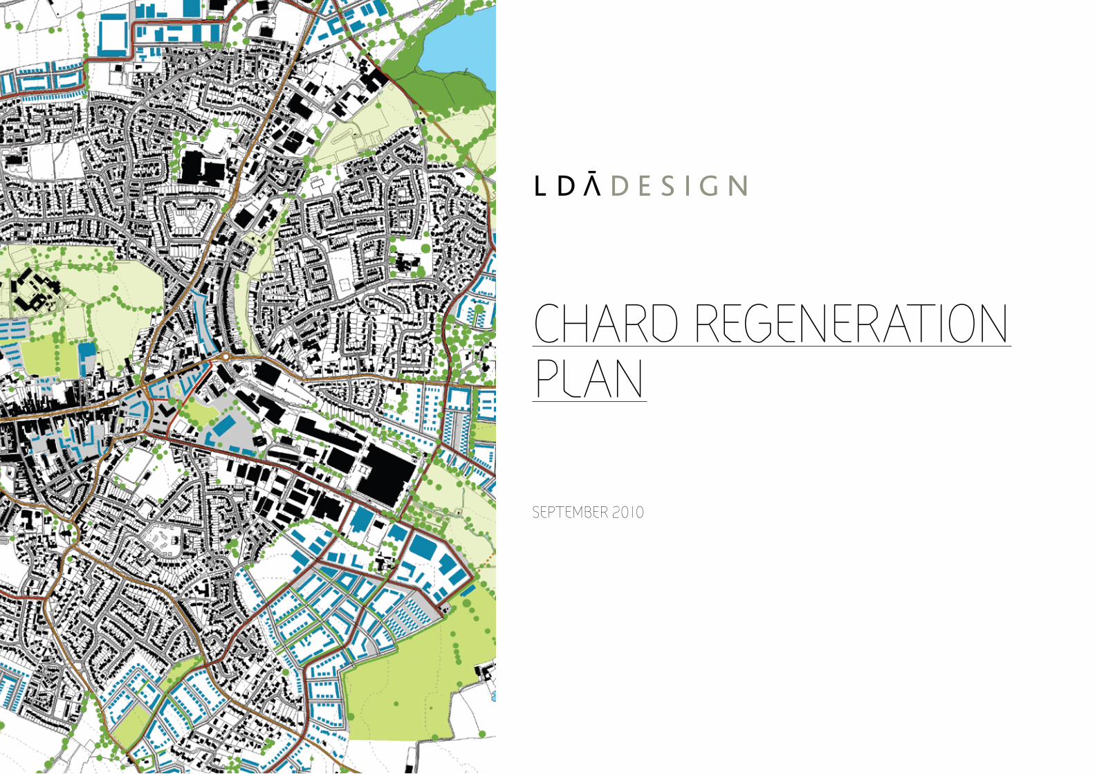
cHARD REGENERATIONPlAN
SEPTEmbER 2010
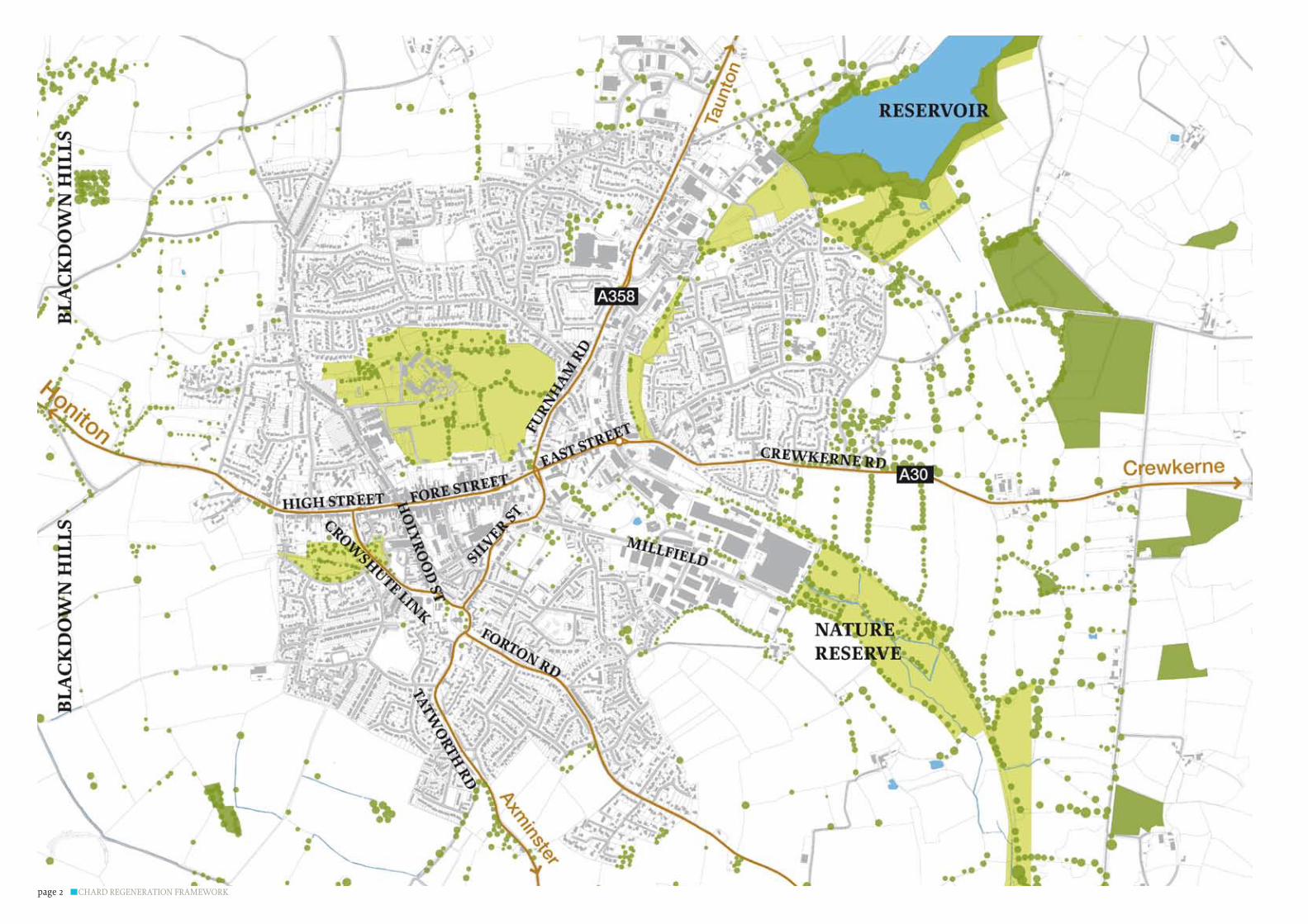
CHARD REGENERATION FRAMEWORKpage 2
CHARD REGENERATION FRAMEWORK page 3
cONTENTS
1.0 INTRODucTION 41.1 The need for the Regeneration Framework 51.2 The Vision 61.3 The Regeneration Aims 81.4 Purpose and scope of this document 8
2.0 THE POTENTIAl FOR cHANGE 92.1.0 The Focus for Regeneration 92.1.1 Approach 92.1.2 Urban Pattern 102.1.3 Urban Quality / Fragmentation 122.1.4 Opportunity Sites and Relocations 122.1.5 Streets and Spaces 122.1.6 Areas of Recognised Townscape and Heritage Interest 132.1.7 Open Space 142.2.0 Regeneration Opportunity Areas 142.3.0 Capacity for Growth 152.3.1 Topography and Hydrology 152.3.2 Landscape and Visual Sensitivity 162.3.3 Nature reserves, Vegetation and Open Space 172.3.3 Capacity for Growth Plan 182.4.0 Spatial Growth Model 19
3.0 REGulATORy, mARkET AND INFRASTRucTuRE INFluENcES 203.1.0 National Housing Requirements 213.1.1 National Planning Policies 21 3.1.2 Masterplanning and Design 223.1.3 Regional Planning Policy 223.1.4 Local Planning Policy 233.2.0 Economic and Market Considerations 233.2.1 Retail 233.2.2 Commercial 243.2.3 Leisure 24
3.2.4 Residential 243.2.5 Town Centre Development 243.3.0 Infrastructure Capacity 243.3.1 Transport and Movement 243.3.2 Utilities 253.3.2.1 Electrical and Gas 253.3.2.2 Foul Drainage 253.3.2.3 Water Supply 253.3.2.4 Data 253.3.3 Energy Infrastructure 3.4.0 Community Regeneration Opportunities 263.4.1 Index of Multiple Deprivation 2004 263.4.2 Health and Housing 263.4.3 Access to Facilities 263.4.4 Education and Employment 263.4.5 Crime 27 3.4.6 Community Regeneration Initiatives 273.5.0 KeyInfluencesontheFramework 27
4.0 A FRAmEWORk FOR cHANGE 294.1.0 The Town Wide Framework 294.1.1 Growth and Regeneration Opportunity Areas 294.1.2 Access and Movement 304.1.3 Public Transport 31 4.1.4 Landuse and Character 324.1.5 Landscape and Strategic Open Space 334.1.6 Development Uses 344.1.7 Development Density 354.1.8 Schools and Local Centres 364.2.0 The Town Centre Framework 374.2.1 Regeneration Opportunities 37 4.2.2 Access and Movement 384.2.3 Public Spaces 394.2.4 Development Uses 404.2.5 Development Scale 41
5.0 IlluSTRATIvE mASTERPlANS 425.1.0 Town Wide Illustrative Masterplan 435.2.0 Town Centre Illustrative Masterplan 44
6.0 DESIGN cODES 466.1.0 Character Areas 486.1.1 The Growth Area 496.1.2 Avishayes 506.1.3 Stop Line Slopes 526.1.4 Millfield 546.1.5 Holbear 566.1.6 The Western Growth Area 586.1.7 The Northern Growth Area 606.2.0 The Town Centre 626.2.1 The Back Plots 636.2.2 East End 656.2.3 High Street & Fore Street 676.2.4 Green Heart 696.3.0 Street Codes 726.3.1 Primary Street Codes 746.2.2 Secondary Street Codes 896.2.3 Shared Street Codes 916.4.0 Spaces 95
7.0 DEvElOPmENT OPTIONS AND PHASING PREcEDENTS 100 7.1.0 Development Options 1017.2.0 Phasing Plans 102

CHARD REGENERATION FRAMEWORKpage 4
1.0INTRODucTION
The Chard Regeneration Framework is a set of documents that considers how the long term growth and regeneration of the town should be directed. It takes into account a range of factors that will need to be addressed in order to achieve social, economic and environmental objectives and to ensure that development is deliverable, viable and sustainable. The Chard Regeneration Framework is comprised of a suite of documents including:
The Chard Vision - ‘Make it in Chard’ �The Regeneration Plan �The Implementation Plan �
This document is the ‘Regeneration Plan’ and it sets out proposals for the evolution of the town over the next 20 years. Thefirstsectionofthisdocumentdescribestheprocess undertaken for establishing the aims, objectives and overall vision for the development of the town. The subsequent sections sets out a framework for making this vision a reality. The Chard Regeneration Framework will form an integral part of the evidence base for South Somerset District Councils Core Strategy.

CHARD REGENERATION FRAMEWORK page 5
Although Chard is no longer on the main route out of London as it once
was, the town retains a strategic location between the north and
south coasts and is situated with easy reach of stunning countryside
and nearby regional centres.
chard regional contextfigUre no. 1
chard local context
1.1 THE NEED FOR THE REGENERATION FRAmEWORk Chard is sometimes described as a ‘well-kept secret’. It nestles within the beautiful hills of South Somerset, close to the Devon and Dorset borders only 12 miles from the English Channel to the south and 30 miles from the Bristol Channel to the north. The town is little known outside the region but, as the people of the town know well, it has a continuing heritage of innovation and manufacture that in its heyday, made the town a major centre of production for commodities, such as lace manufacturing, engineering and iron founding. The ongoing recognition of this culture, coupled with the high proportion of major manufactures operating in Chard mean that the town is still an important centre for employment and manufacturing. It is a good place to live and work with most of the services and facilities required for all stages of life. However a number of the traditional industries within Chard are in decline and, as a destination for shoppers and people seeking leisure activities, it is beginning to lose out to nearby towns including Taunton and Yeovil. It has proved difficulttobringlandforhousingandbusinessforwardthrough to delivery to meet the needs of the future. The town centre has seen better days and heavy goods vehicles passing throughcausetrafficdelaysandenvironmentalproblems. To address these issues South Somerset District Council, Chard Town Council, Somerset County Council and the South West of England Regional Development Agency have commissioned ‘The Chard Regeneration Framework’ to provide a long term plan to guide the future of the town.
figUre no. 2

CHARD REGENERATION FRAMEWORKpage 6
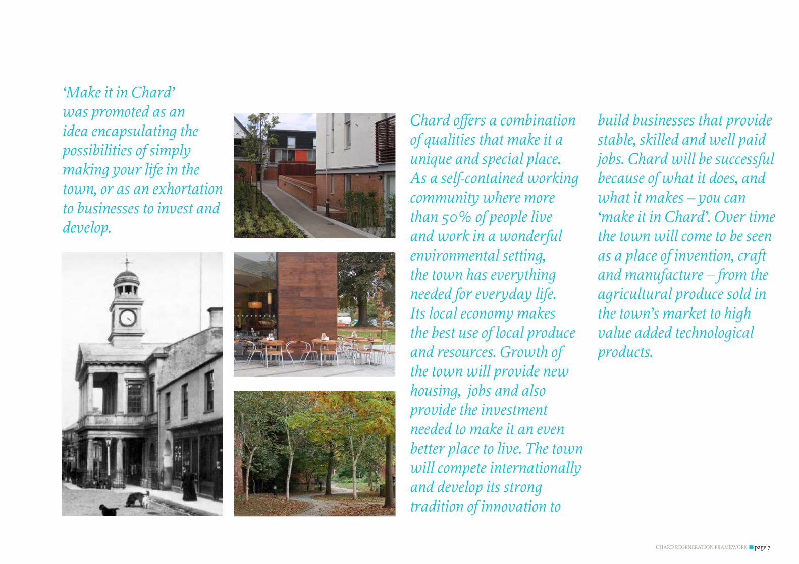
1.2 THE vISIONOne of the major stages in the preparation of the Regeneration Framework was the development of a vision for the town through a process of collaborative working between the partners to the project, the consultants, the community and stakeholders. The process of working with the community and others is described in the accompanying Statement of Community Involvement. One of the interesting observations made during the preparation of the vision was the duality of the town’s personality. It is strongly local but is has a genuinely international role. It has a strong heritage but has a strong culture of looking forward and innovating. This theme is repeated throughout the fabric of the town, even the rills in the main street run both north and south. There is something in this that makes Chard very distinctive. The simple way of saying it is ‘Chard – the best of both worlds’ which emphasises that you can have a lovely local life whilst at the same time pursuing a career researching and making products that will be sold internationally. Also important to many people was the ideathattheplaceisdefinedbywhatitdoesratherthanwhatitis. It is not just ‘a market town’. It is a place that still makes and produces things. This feeling came through very strongly in the community events. There was an evident pride in the fact that it has always punched above its weight through innovating and manufacturing things with a national and international presence – hence, ‘actions speak louder than words’. ‘Make it in Chard’ was promoted as an idea encapsulating the possibilities of simply making your life in the town, or as an exhortation to businesses to invest and develop.
CHARD REGENERATION FRAMEWORK page 7
Chard offers a combination of qualities that make it a unique and special place. As a self-contained working community where more than 50% of people live and work in a wonderful environmental setting, the town has everything needed for everyday life. Its local economy makes the best use of local produce and resources. Growth of the town will provide new housing, jobs and also provide the investment needed to make it an even better place to live. The town will compete internationally and develop its strong tradition of innovation to
build businesses that provide stable, skilled and well paid jobs. Chard will be successful because of what it does, and what it makes – you can ‘make it in Chard’. Over time the town will come to be seen as a place of invention, craft and manufacture – from the agricultural produce sold in the town’s market to high value added technological products.
‘Make it in Chard’ was promoted as an idea encapsulating the possibilities of simply making your life in the town, or as an exhortation to businesses to invest and develop.

CHARD REGENERATION FRAMEWORKpage 8
AIm 1 Chard should build on its long tradition of innovation and manufacturing excellence to develop and attract businesses associated with products and services of the highest quality that offer well paid, skilled jobs.
Thetownhasacontinuoustraditionofinnovationwithtechnological‘firsts’suchaspoweredflightandartificiallimbstothecreationandmanufactureof �technically innovative products and services such as electrical rail conductors and precision engineering. People are rightly proud of what Chard has achieved. Making things should remain central to the identity of the town. The town’s manufacturing base, consisting �of a number of internationally renowned companies, should be supported, developed and promoted. Awareness of the town’s industries and small businesses should be widened and premises and space for investment created. Business incubation, education, skills development and training for existing and future workforce should be actively supported.TheregenerationofthetownshouldreachastagewheretheworldknowsthatChardisagoodplacetofindskilledpeopleandstartlong-lastingbusinessesoffering �well paid jobs.
AIm 2 Regeneration and investment should strengthen the community and make the town increasingly self-sufficient with all the services, facilities and events necessary to make it a great place to live.
As it grows, Chard will be able to offer an outstanding quality of life for residents and visitors to the town. As a ‘great place to live’ the town will need to offer a �better mix of shops and businesses in the town centre and develop a better range of leisure activities for people of all ages and income. Regeneration and investment should deliver affordable housing for the people who live and work in the town and improved education, health care and social support facilities. Chard can be a healthy place to live with good access to the countryside, excellent sport and recreation, high quality local food and a physical environment that �makes walking and cycling a more attractive proposition than driving. The regeneration of the town provides an opportunity to revitalise existing events and create new festivals that bring people together. Connections with local farmers and the local creative community can be strengthened by providing support to promote and sell local produce. Chard will be sought after as a place to live with a range of employment prospects and all the services and facilities necessary for a high quality of life for all ages.
AIm 3 Chard should develop and enhance its urban environment so that it has a quality that is comparable to its stunning natural setting and rich cultural heritage.
Chardissurroundedbybeautifulhillsthatarerichwithfloraandfauna.Ithasmanyfinecollectionsofbuildingsandarichheritagestretchingbackmany �centuries. This existing environment will be protected and enhanced. New development, together with improvement to streets and spaces, will build a town recognised as having a great urban environment combining the best of the old and new. Green spaces in and around the town will be better linked and connected and accessibility to the countryside will be improved. Chard will be a place that is easy to move around on foot, by bicycle, on public transport and by private vehicle. This means ensuring that there are safe direct links �betweenexistingcommunities,thetowncentre,servicesandfacilitiesandthecountryside.Theimpactsoftrafficonpeoplelivingandworkinginthetownwillbeminimised whilst balancing the need to make the town accessible to visitors and those using it.
1.3 THE REGENERATION AImSThe vision was based on three key aims which the community,localstakeholders,councilofficersandpoliticians expressed as important. These were developed toreflectsocial,economicandenvironmentalfactorsthatwould need to be addressed in order to achieve the Vision for the town. Each aim represents something that the people of Chard feel is important for the town to achieve in order to create a better future for the people who live and work there.
1.4 PuRPOSE AND ScOPE OF THIS DOcumENTThe vision and aims only have value if they are capable of being delivered and have a clear set of actions spelling out how this might be achieved. This document provides the focus to the delivery of the vision. It sets out the plans and proposals necessary to make the vision happen. It contains the following sections:
Section 2: The Potential for Change documents the �process of identifying where the focus for regeneration in the town should be located and considers the capacity for growthinthefortheopportunitiesareasidentified;Section 3: Regulatory, Market and Infrastructure �Influencesdiscussestheexternalandinfrastructurecapacityinfluencesthatwillhaveanimpactonhowthe areas with potential for change will be able to move forward;Section 4: A Framework For Change sets out a range of �frameworkplansfordeliveringchange;Section 5: The Illustrative Masterplans shows the town �wide and town centre Illustrative Masterplans which haveemergedfromtheframeworksplans;Section 6: Design Codes sets out the design codes and �describesthespecificproposalsthatcanbetakenforward within the over arching framework for the town including character areas for the areas of new development. Section 7: Delivery describes the phasing scheme for the �growth and regeneration of the town.
ThefinaldocumentoftheChardRegenerationFrameworksuite of documents, the implementation plan’ spells out how the regeneration plans and proposals will be delivered, and identifiesthephasingofprojectsandpossiblefundingstreams.

CHARD REGENERATION FRAMEWORK page 9
2.0 THE POTENTIAl FOR cHANGE
The vision and the underlying aims for the regeneration of the town set out the community’s aspirations for the development of Chard. Ultimately the ability to deliver these aspirations will depend on the potential of the regeneration opportunities in the town centre and the capacity that the town has to grow without adverse impact on its underlying character, identity and landscape setting.ThissectionoftheFrameworkdescribesandidentifieswhereregeneration should be focussed in the town centre and assesses growth potential of sites around the town to identify a preferred growth model.
2.1.0 THE FOcuS FOR REGENERATION
The regeneration of Chard will not happen overnight. Towns evolveslowlyandalthoughsomesignificantimprovementsmight be able to be brought forward quite quickly, a long term approach needs to be adopted to achieve the full realisation of the aims and vision. To ensure that the maximum results are derived from the regeneration efforts a focused and coordinated approach will be required, this approach is set out below.
2.1.1 APPROAcH Regeneration needs to be focussed on those areas which have the greatest need for, and capacity to accept change. The physicalareasidentifiedshouldbecapableofbeingimprovedor developed to help to deliver the vision and the three aims that underpin it. These areas will generally be those that fall into one or more of the following categories:
Capable of contributing to the creation of an urban �pattern that strengthens and enhances the existing urbanformofthetown;Areas that are fragmented or with a poor urban quality �withinwhichthereisopportunityforchange;Sites that are available for change due to development �opportunities arising from relocation and/or change of use;Streets and spaces with opportunity for enhancement �to improve the pedestrian experience and to improve accessibility by sustainable modes of transport.
Inadditionthefocusforregenerationwillbeinfluencedbyrespecting and avoiding impacts on:
Areasofrecognisedtownscapeandheritageinterest; �Valuable areas of green space. �
Areasforregenerationfocushavebeenidentifiedbymappingand appraising each of these areas to identify ‘regeneration opportunity areas’. The regeneration of Chard is not just focused on physical improvements to the built form of the town. To achieve the objectives set out in the vision, areas where social and economic improvements can be achieved will be identifiedincombinationandadditiontoenvironmentalfactors to deliver a holistic regeneration package. The process of identifying areas for social and economic improvement will lead to the creation of a package of ‘soft regeneration’ measure to be applied in tandem with the physical and environmental measures.
CHARD REGENERATION FRAMEWORKpage 10
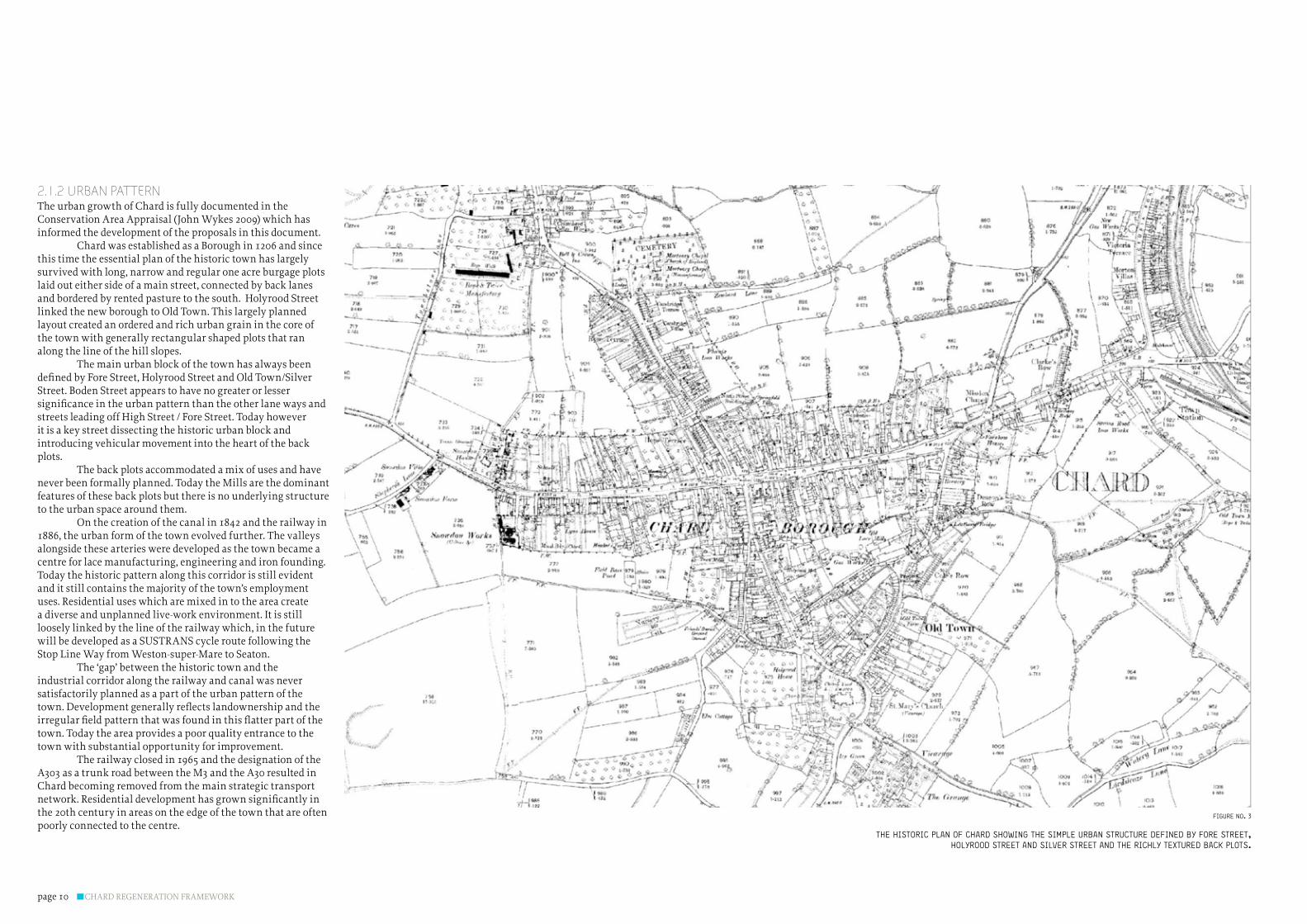
2.1.2 uRbAN PATTERNThe urban growth of Chard is fully documented in the Conservation Area Appraisal (John Wykes 2009) which has informed the development of the proposals in this document. Chard was established as a Borough in 1206 and since this time the essential plan of the historic town has largely survived with long, narrow and regular one acre burgage plots laid out either side of a main street, connected by back lanes and bordered by rented pasture to the south. Holyrood Street linked the new borough to Old Town. This largely planned layout created an ordered and rich urban grain in the core of the town with generally rectangular shaped plots that ran along the line of the hill slopes. The main urban block of the town has always been definedbyForeStreet,HolyroodStreetandOldTown/SilverStreet. Boden Street appears to have no greater or lesser significanceintheurbanpatternthantheotherlanewaysandstreets leading off High Street / Fore Street. Today however it is a key street dissecting the historic urban block and introducing vehicular movement into the heart of the back plots. The back plots accommodated a mix of uses and have never been formally planned. Today the Mills are the dominant features of these back plots but there is no underlying structure to the urban space around them. On the creation of the canal in 1842 and the railway in 1886, the urban form of the town evolved further. The valleys alongside these arteries were developed as the town became a centre for lace manufacturing, engineering and iron founding. Today the historic pattern along this corridor is still evident and it still contains the majority of the town’s employment uses. Residential uses which are mixed in to the area create a diverse and unplanned live-work environment. It is still loosely linked by the line of the railway which, in the future will be developed as a SUSTRANS cycle route following the Stop Line Way from Weston-super-Mare to Seaton. The ‘gap’ between the historic town and the industrial corridor along the railway and canal was never satisfactorily planned as a part of the urban pattern of the town.Developmentgenerallyreflectslandownershipandtheirregularfieldpatternthatwasfoundinthisflatterpartofthetown. Today the area provides a poor quality entrance to the town with substantial opportunity for improvement. The railway closed in 1965 and the designation of the A303 as a trunk road between the M3 and the A30 resulted in Chard becoming removed from the main strategic transport network.Residentialdevelopmenthasgrownsignificantlyinthe 20th century in areas on the edge of the town that are often poorly connected to the centre.
the historic plan of chard showing the simple Urban strUctUre defined by fore street, holyrood street and silver street and the richly textUred back plots.
figUre no. 3

CHARD REGENERATION FRAMEWORK page 11
conceptUal diagram of the growth of chard’s historic town centre from it’s strategic position on roUte between coast and town
Today the three broad stages in the evolution of Chard are still evident. The unresolved and unplanned areas that were never addressed as the town evolved now form the least satisfactory parts of Chard. The particular areas with opportunity to reinstate or build a positive urban pattern are thebackplotsbetweenForeStreetandOldTown;and,theEastEnd between the end of Fore Street and Crewkerne Road where years of unplanned and ad hoc development has created an unattractive and unsatisfactory entrance to the town. The mixed living-employment zone along the railway corridor is a distinctive part of the urban structure of Chard and needs to be planned as an accessible jobs corridor in the heart of the town. It needs to be seen as a positive part of the urban structure providing employment close to where people live with sustainable movement potential via the Stop Line Way cycle route. Whilst suburban Chard functions adequately as a living environment, these peripheral areas do have opportunities to develop as the town grows. Increased critical mass through growth will bring the possibility of creating and enhancing neighbourhood centres that meet local needs.
figUre no. 4

CHARD REGENERATION FRAMEWORKpage 12
2.1.3 uRbAN QuAlITy / FRAGmENTATIONOverthepast50yearsorsotherehasbeenasignificantamount of poor quality development in Chard, as a result some of the historic fabric has declined. Despite the strength of the historic urban structure, this legacy has contributed to a decline in the urban quality of the town. In many respects the areas of poor urban quality and fragmentation echo those areas with potential for improvement in urban pattern. However they also include areas in which the fundamental urban structure is sound, but the quality and arrangement of buildings lets the town down. Key areas include the block between Fore Street, Silver Street and Furnham Road which, despite being close to the main commercial core of the town and on its most busy junction, contains a low density mix of uses and sheds. The area creates a poor impression of the town centre, particularly for those passing through the town. In a similar vein, the substantial area of housing between Mill Lane and Old Town has considerable opportunity for enhancement and redevelopment. Areas on the northern side of the high street to the rear of the Co-op also lack urban character and quality and have great potential to be turned into a more positive part of the town centre. Together these various sites create the impression that the beautiful historic town centre is surrounded by a mix of gap sites and poor quality development. Car parks, whilst essential to the economic functioning of the town, have also played their part in contributing to the poor quality and fragmentation of parts of the town. The large expanses of tarmac create ‘holes’ in the urban fabric with little vitality or interest beyond their basic use. The Boden Street car park has a particular prominence intheheartofthetownandMarketfieldscarparkcouldbeimproved to form a far more positive part of the town centre.
2.1.4 OPPORTuNITy SITES AND RElOcATIONSSome sites have regeneration potential because there are known plans for relocation and/or development. The town centre has a number of such sites. These include the Air Control Industries (ACI) factory at the heart of the town around Boden Mill and also the Furnicare charity which occupies part of the Mill itself. These premises have been brought into public sector ownership and represent the single biggest town centre regeneration opportunity. They also correspond with one of the key areas in which there is a significantopportunitytostrengthentheurbanpattern.
On the northern side of the town centre Chard Town Football club has plans to relocate in order to provide facilities and a pitch that meets modern standards whilst at the same time allowing for the development of youth teams. Whilst the
rugby club does not have any similar plans, if the football club were to relocate to a purpose built sports facility there may be a corresponding opportunity for it to move and free up another major town centre location for development. Holyrood School and Cresta also offer opportunities for redevelopment and regeneration of the town. There is potential for the school to be a part of the Building Schools of the Future programme and be redeveloped, although the timescale for this is not yet known. Its town centre location is seen as important by the community so it is likely that any redevelopment would be on-site. However in doing this there would be wider opportunities to improve accessibility between the northern part of the town and Fore Street and also improve the relationship between the school and the open space it sits within. The school, open space and a redeveloped Cresta would together create a formidable community resource. AlongHighStreetandForeStreetthesignificantnumberofvacantshopsandpremisesalsoofferpotential;thereis space for the town to develop and room for additional new retail units and new start up businesses once the regeneration processachievessufficientmomentum.
2.1.5 STREETS AND SPAcESThe majority of the streets and spaces within the town have potential for enhancement. However some have greater significanceduetotheirimportancetothephysicalandsocialfabric of Chard. The key opportunity is High Street/Fore Street whichhasthepotentialtobeaveryfinestreet.Howevercarsdominate and the quality of materials, surfacing and street furnitureispoor.Thereisfartoomuchtrafficcirculationandlittle room for community events and functions. The eastern end of the Fore Street where it splays out at the junction with SilverStreethassufficientscaleandpotentialurbanqualityforit to be developed into a key civic space within the town. Holyrood Street suffers many of the same problems as the other key streets and spaces within the town but also has the potential to become more prominent in terms of its retail offer and improve its environmental quality. Boden Street is also a very poor quality street. It is enclosed by blank facades which include the eastern wall of the Lidl. It has few redeeming features and because it is used to access two car parks is also very busy. Chard lacks any civic spaces of note. The area to the rear of the Guildhall and the Lidl carpark is perhaps the busiest area off the main streets. However the rear facades of buildings and the Lidl supermarket mean that this area has lack of strong urbanqualitiesdespitethepresenceofsomefinebuildingssuch as the Baptist Church and Lace Mill.
diagram showing the difference between the planned pattern of the historic town
and the irregUlar Unplanned area between the town and the railway
figUre no. 5
historic planned town
key

CHARD REGENERATION FRAMEWORK page 13
2.1.6 AREAS OF REcOGNISED TOWNScAPE AND HERITAGE INTERESTA Conservation Area Appraisal has been carried out to identify the key heritage assets of Chard. The mapping of areas of recognised townscape and heritage interest highlights the areas which are important to the town’s character and identity andbydefinitionidentifiesareasinwhichthedegreeofchangeto the existing fabric should be relatively minimal. TheConservationAreaAppraisalidentifiesthesurvival of much of the historic town plan and many of the individual burgage plots as one of its key attributes. The town has 120 Listed Building entries, including a Grade I Parish Church, late C16 and early C17 gentry houses, some impressive C18-early C19 houses, public buildings, Nonconformist churches and multi-storey former mill buildings (outside the current conservation area boundary). It also contains a dozen unlisted buildings and groups of individual merit and group value, in Fore Street and the south east side of Holyrood Street. Amongst the groupings of buildings there are many small details of interest, including stone paving, open water channels, wrought and cast ironwork, boundary walls and gatepiers,signsandplaques;andtheconsistentuseoflocalbuilding stones, sometimes in combination, stucco and rough-cast render and a rich red local brick. Theconservationareaappraisalidentifiedanumberof issues which might be redressed through the regeneration framework. These included the poor condition and/or lack of current use of a number of listed buildings on Fore Street and High Street. Some examples of C20 redevelopment on Fore and HolyroodStreetswereidentifiedasobtrusive,poorlydetailedand of alien materials. The study also picked up the importance of addressing associated clutter created by over-scaled lighting andtrafficsignsandtheimpactoftheincrementallossofauthentic details, such as windows and doors on a number of unlisted C19 and early C20 buildings of group value. TheConservationAreaappraisalidentifiessomeomissions and anomalies in the current Conservation Area boundary and various changes are proposed to the boundary includingonbothsidesofHighStreet;behindChardSchool;and west of the parish church. In addition there are also opportunities to amend the current boundary on both sides of Fore Street and High Street to recognise and protect medieval plot boundaries and rear walls. The two former mill buildings are not currently in the conservation area as is also the case for, the former Boden Club and Institute and adjacent terraced houses and the elaborate archway to Boden’s Old Lace Mill in Boden and Mill Streets. The appraisal also highlights the heritage value of the C19 development north of Fore Street and suggests the extension of the Conservation Area boundary up Combe Street to include some of this area
town centre heritage and landscape
figUre no. 6
conservation area
listed bUildings
green spaces
hedges & woodland
key

CHARD REGENERATION FRAMEWORKpage 14
2.1.7 OPEN SPAcEThe open spaces in and around the town centre are a valued asset and the regeneration framework will seek to enhance and improve these for the community. However some open spaces represent particular regeneration opportunities. Foremost amongst these is the open spaces associated with the Rugby Club, Cricket Club and Holyrood School. The area is carved into separate pockets of space, none of which are particularly accessible. There are a number of additional sites around the school and its grounds that also provide potential opportunities for development. This entire area, fromtheRugby/Cricketgrounds,theschoolplayingfieldsandbuildings, Cresta and the areas of open space to the north has the potential to be comprehensively masterplaned to provide a refreshed set of community facilities and new accessible green space in the centre of the town.
2.2.0 REGENERATION OPPORTuNITy AREASChardhassignificantpotentialforregenerationinthetowncentre. These opportunities have the potential, if addressed incrementally over time, to fundamentally transform the natureofthetowncentreandgoasignificantwaytowardsachieving the vision for the town. Each opportunity has the potential to address, in an integrated way, a number of the physical planning issues discussed above.
The following emerge as opportunity areas with the potential todeliverregenerationbenefitstothetown:
TheBackPlots:thissignificantareastretchingtothe �south of Fore Street between Holyrood Street and Silver Street currently offers little to Chard in terms of urban structure and use, with the exception of the Lace Mill whichisutilisedbytheLibraryandSSDCofficesandBoden Mill, currently occupied by ACI. There is potential for the ‘Back Plots’ to be comprehensively planned so that they become an integral part of the town centre, offering a distinct and complementary offer to Fore Street / High Street.The Eastend: this area ensures a very poor sense of �arrival into the town from the north and east. It has a fragmented collection of uses and is largely dominated bytraffic.Theareahasthepotentialtobeplannedasa mixed use area creating a strong urban connection between the town centre and the employment areas along the railway corridor.The Stop Line Corridor: this is the area running through �the eastern side of the town along the line of the old railway. The area is currently characterised by the employment and industrial uses along its length. This
area is fairly fragmented at present and needs to be recognised as a mixed use live-work zone which is the main location for the majority of the employers within the town.The Green Heart: The open space to the north of �Holyrood Street does not function as a town centre park and green lung in the way it might. Comprehensive planning and redevelopment of the area, optimising the potential for redevelopment of the Chard Town football club site, rugby club, Holyrood School and Cresta could bringmajorleisurebenefitstothetownatthesametimeas releasing development value.Town Centre Retail Core: this area refers to the main �‘urban spine’ of the town along High Street/Fore Street This area needs to offer a high quality public realm as well as provide the diversity and mix of uses necessary to act as the primary retail core of the town. Holyrood Street also has an important role to play in supporting this function.
In addition to the above main priority regeneration areas, the key streets and spaces should be recognised as areas in which capitalworkscouldbringsignificantregenerationbenefits.
town centre opportUnity sites
figUre no. xx
the stop line corridor
regeneration opportUnity areas
figUre no. 8
green heart
east end
the back plots
fore street/high street
key

CHARD REGENERATION FRAMEWORK page 15
2.3.0 cAPAcITy FOR GROWTHIn addition to responding to the regeneration requirements andopportunitiesidentifiedin2.1theregenerationframeworkneeds to identify the opportunities and capacity for growth. Whilsttheamountofgrowthwillbedefinedbymarketandviability issues, the ability of a place to accommodate growth isdefinedbythecharacteristicsofitsnaturalandculturallandscape setting. These characteristics can be brought togethertodefinethoseareaswherethereisphysicalcapacityfor growth.
2.3.1 TOPOGRAPHy AND HyDROlOGyChard is situated in the south-west corner of Somerset, near the Dorset and Devon borders, in an area of attractive undulating landscape. The town is located on the major watershed between the Bristol and English Channels at the escarpment foot of the Blackdown Hills and has a high degree of enclosure by surrounding hills to the east and west. The character of the townisstronglyinfluencedbyitstopographicsetting.TheBlackdown Hills to the north, rise up steeply at a point just beyond the western boundaries of the town. To the south is the broad valley of the River Axe, which rises near Beaminster inDorsetandflowssouthtotheEnglishChannel.Thenorth-eastflowingRiverIslewhichrisesintheDorsethillssouthof Crewkerne and historically fed the Chard Canal and the associated Chard Reservoir. Chardissurroundedbysomesignificanthills,withWindwhistle to the east over 200m, Snowdon Hill to the west to 216m, a series of rounded heights to the north-west (Combe Beacon and Stony Down), and gentler undulations down to the valley of the Axe. The town itself is on a fairly level site, with a noticeable, gradual rise from east to west, along the Fore Street and High Street axis, at about 100m at Furnham to over 200m at the top end of High Street, where the chalk ridge has steeper slopes; The combination of topography and hydrology sets the basic form of the town. To the west settlement has spread up the Blackdown slopes almost as far as the point where the escarpment begins to rise steeply above the town. The Axe and the Isle Valleys which run north and south have provided the level ground that has been exploited by the railway, canal and industrial development. Avishayes to the east sits on a low hill which has a boundary set by tributary valleys of the Axe/Isle at the bottom of the Windwhistle Hill. Urban form largelyreflectstopographyandinmanyinstancesblocksandsubdivisionsflowalongthecontours. The slopes rising up to the west and the clearly demarcated edge to the hill at Avishayes sets limits to the eastwards and westwards growth of the town and the Axe/Isle
valleys through the town provide a strong structuring element which, due to gradient continues to be a sensible place for the location of larger uses requiring good accessibility. To the north and south the topographic boundaries are less clear. The slopes to the south run along the valley sides towards Forton. There is no clear and logical boundary constraining the ability of Chard to grow in this direction in topographic terms. The same is true to the north, though the shapeofthelandforminthisareameansthatanysignificantgrowth would rapidly become visually and physically detached from the town. Fig: 9 Shows chard in its topographic context. This is an important spatial organising factor which also has a direct impact on landscape and visual sensitivity.
significant topography and hydrologyfigUre no. 9
peak of hill
valley bottom
water body
sUrroUnding settlement
key
existing bUilt environment
CHARD REGENERATION FRAMEWORKpage 16
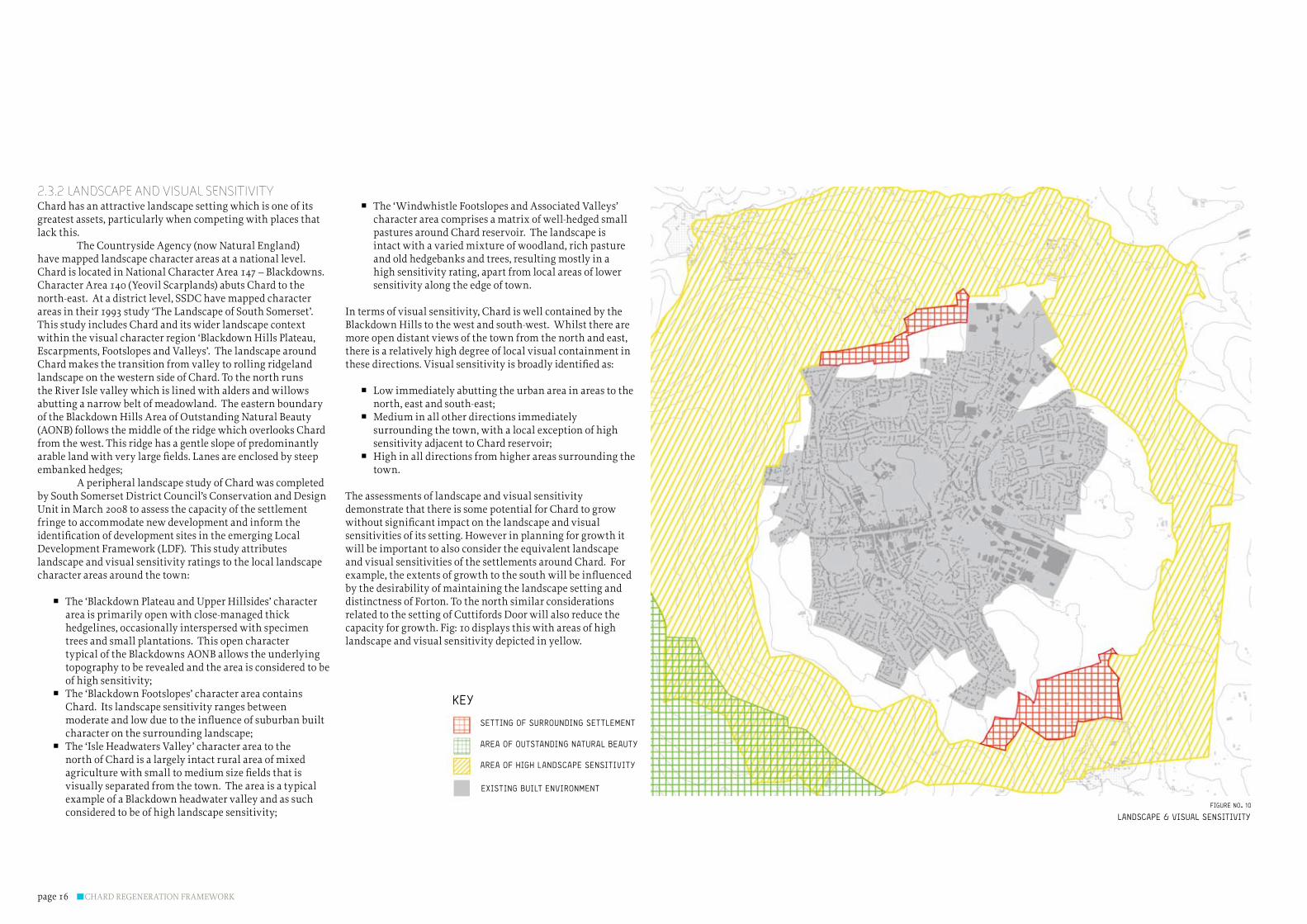
2.3.2 lANDScAPE AND vISuAl SENSITIvITyChard has an attractive landscape setting which is one of its greatest assets, particularly when competing with places that lack this. The Countryside Agency (now Natural England) have mapped landscape character areas at a national level. Chard is located in National Character Area 147 – Blackdowns. Character Area 140 (Yeovil Scarplands) abuts Chard to the north-east. At a district level, SSDC have mapped character areas in their 1993 study ‘The Landscape of South Somerset’. This study includes Chard and its wider landscape context within the visual character region ‘Blackdown Hills Plateau, Escarpments, Footslopes and Valleys’. The landscape around Chard makes the transition from valley to rolling ridgeland landscape on the western side of Chard. To the north runs the River Isle valley which is lined with alders and willows abutting a narrow belt of meadowland. The eastern boundary of the Blackdown Hills Area of Outstanding Natural Beauty (AONB) follows the middle of the ridge which overlooks Chard from the west. This ridge has a gentle slope of predominantly arablelandwithverylargefields.Lanesareenclosedbysteepembankedhedges; A peripheral landscape study of Chard was completed by South Somerset District Council’s Conservation and Design Unit in March 2008 to assess the capacity of the settlement fringe to accommodate new development and inform the identificationofdevelopmentsitesintheemergingLocalDevelopment Framework (LDF). This study attributes landscape and visual sensitivity ratings to the local landscape character areas around the town:
The ‘Blackdown Plateau and Upper Hillsides’ character �area is primarily open with close-managed thick hedgelines, occasionally interspersed with specimen trees and small plantations. This open character typical of the Blackdowns AONB allows the underlying topography to be revealed and the area is considered to be ofhighsensitivity;The ‘Blackdown Footslopes’ character area contains �Chard. Its landscape sensitivity ranges between moderateandlowduetotheinfluenceofsuburbanbuiltcharacteronthesurroundinglandscape;The ‘Isle Headwaters Valley’ character area to the �north of Chard is a largely intact rural area of mixed agriculturewithsmalltomediumsizefieldsthatisvisually separated from the town. The area is a typical example of a Blackdown headwater valley and as such consideredtobeofhighlandscapesensitivity;
The ‘Windwhistle Footslopes and Associated Valleys’ �character area comprises a matrix of well-hedged small pastures around Chard reservoir. The landscape is intact with a varied mixture of woodland, rich pasture and old hedgebanks and trees, resulting mostly in a high sensitivity rating, apart from local areas of lower sensitivity along the edge of town.
In terms of visual sensitivity, Chard is well contained by the Blackdown Hills to the west and south-west. Whilst there are more open distant views of the town from the north and east, there is a relatively high degree of local visual containment in thesedirections.Visualsensitivityisbroadlyidentifiedas:
Low immediately abutting the urban area in areas to the �north,eastandsouth-east;Medium in all other directions immediately �surrounding the town, with a local exception of high sensitivityadjacenttoChardreservoir;High in all directions from higher areas surrounding the �town.
The assessments of landscape and visual sensitivity demonstrate that there is some potential for Chard to grow withoutsignificantimpactonthelandscapeandvisualsensitivities of its setting. However in planning for growth it will be important to also consider the equivalent landscape and visual sensitivities of the settlements around Chard. For example,theextentsofgrowthtothesouthwillbeinfluencedby the desirability of maintaining the landscape setting and distinctness of Forton. To the north similar considerations related to the setting of Cuttifords Door will also reduce the capacity for growth. Fig: 10 displays this with areas of high landscape and visual sensitivity depicted in yellow.
landscape & visUal sensitivityfigUre no. 10
area of oUtstanding natUral beaUty
setting of sUrroUnding settlement
area of high landscape sensitivity
existing bUilt environment
key

CHARD REGENERATION FRAMEWORK page 17
2.3.3 NATuRE RESERvES, vEGETATION AND OPEN SPAcE
There are a number of areas of ecological value surrounding Chard, in particular to the east and surrounding Chard reservoir. Chard reservoir is designated as a Local Nature Reserve and Snowdon Hill Quarry to the west of the town is a SiteofSpecialScientificInterest. There are numerous county wildlife sites in close proximity to the town, primarily to the east. To the southeast lays a complex of unimproved grassland and scrub (Chard railwayfields)thatislinkedbythedisusedrail-linewithBreach copse, an ancient woodland site, and ‘The Drift’ which is a mosaic of mixed habitat running through to the Forton Road. The pattern of hedges and vegetation also gives a clear indication and approximation of the main areas of ecological value, habitat corridors and reservoirs. They also have a landscape value in their own right and contribute to character and visual diversity. There are distinct and varying patterns around the town. The eastern margins of the town havesignificantareasofscatteredwoodlandandwellwoodedhedgerows which create an, almost sylvan landscape character which links to the historic landscape pattern associated with TheDrift.Tothesouthandwestthefieldpatternisofalargerscale with an almost a complete absence of trees until the topography of the area rises to the higher wooded escarpment of the Blackdowns. There are some open spaces around the edge of the town, including an informal park to the west of the housing associated with Mitchell Gardens. The key recreational facility on the edge of the town is the Chard reservoir and associated open space. All of the above features are depicted in Fig:11 The pattern of recognised areas of ecological value, vegetation and open space place some absolute constraints on the direction of growth, particularly to the east around Chard Reservoir and within the Railway Fields. The pattern also suggests the potential for differentiation of character in response to the different landscape structures to be found around the edges of the town.
natUre/vegetation/open space
figUre no. 11
sUrroUnding settlement
edge parkland
natUre reserves
existing woodland
key
existing bUilt environment

CHARD REGENERATION FRAMEWORKpage 18
2.3.4 cAPAcITy FOR GROWTHThe mapping described above can be brought together to defineareasinwhichthetownhasthephysicalcapacitytogrow. Chard has not yet reached the capacity of its landscape setting to accept growth and change can be accommodated without harming the important qualities of its landscape setting, image, identity and character. In addition growth can bemanagedtoavoidsignificantimpactsontheneighbouringsettlements of Forton and Cuttisfords Door.The main growth opportunities are:
The eastern side of the town, currently allocated in �the Local Plan as the Chard key site, referred to here as the Eastern Growth Area. This area has few physical constraints.Howevertwofactorshaveaninfluenceonthe extent of growth. To the north-east around Avishayes a natural boundary to growth is provided by the shallow tributary valleys of the Isle and Axe Rivers. To the south-east growth will need to be contained to respect the setting of Forton and retain connectivity with the town centre;The south western side of town: this area slopes up �towards the higher land to the west. However there is an area of slack slopes between the escarpment and the edge of the town which has capacity to accommodate future expansion of the town subject to other planning and infrastructure considerations. The development area should not extend along the A30 and the gap between the outlying cottage at the fork and the existing edge of the town would need to be maintained.The northern edge of town: there are opportunities for �incremental growth on the northern periphery of the town. Only a narrow band of development would be achievable to maintain connectivity to with the rest of the town.Areas where development could be physically �accommodated are highlighted in white on Fig: 12. It should be noted that at this scale the capacity mapping doesnottakeintoaccountsitespecificdesignissueswhich may have an impact upon the detailed alignment of the potential development areas.
capacity for growth
figUre no. 12
areas with opportUnity for growth
chard existing bUild environment
areas to remain Undeveloped
landscape featUre to be retained
key
CHARD REGENERATION FRAMEWORK page 19
spatial growth model
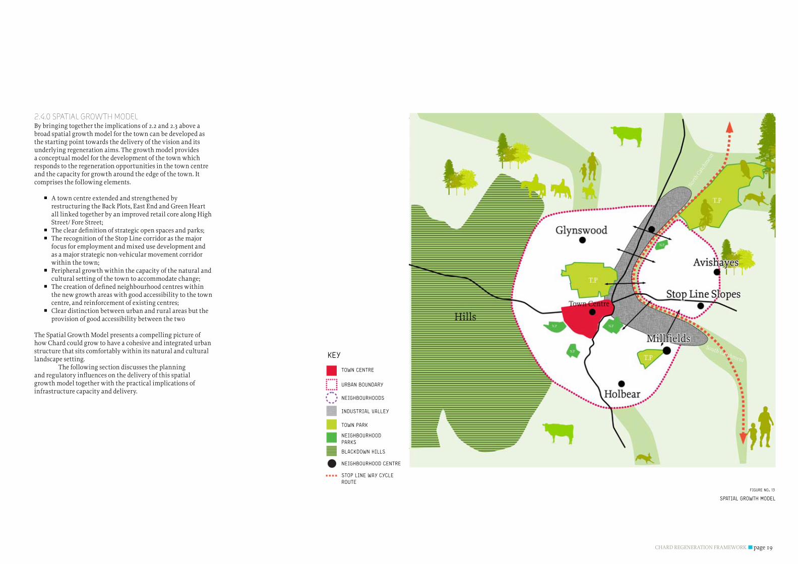
2.4.0 SPATIAl GROWTH mODElBy bringing together the implications of 2.2 and 2.3 above a broad spatial growth model for the town can be developed as the starting point towards the delivery of the vision and its underlying regeneration aims. The growth model provides a conceptual model for the development of the town which responds to the regeneration opportunities in the town centre and the capacity for growth around the edge of the town. It comprises the following elements.
A town centre extended and strengthened by �restructuring the Back Plots, East End and Green Heart all linked together by an improved retail core along High Street/ForeStreet;Thecleardefinitionofstrategicopenspacesandparks; �The recognition of the Stop Line corridor as the major �focus for employment and mixed use development and as a major strategic non-vehicular movement corridor withinthetown;Peripheral growth within the capacity of the natural and �culturalsettingofthetowntoaccommodatechange;Thecreationofdefinedneighbourhoodcentreswithin �the new growth areas with good accessibility to the town centre,andreinforcementofexistingcentres;Clear distinction between urban and rural areas but the �provision of good accessibility between the two
The Spatial Growth Model presents a compelling picture of how Chard could grow to have a cohesive and integrated urban structure that sits comfortably within its natural and cultural landscape setting. The following section discusses the planning andregulatoryinfluencesonthedeliveryofthisspatialgrowth model together with the practical implications of infrastructure capacity and delivery.
figUre no. 13
town centre
neighboUrhoods
Urban boUndary
stop line way cycleroUte
indUstrial valley
town park
neighboUrhood parks
blackdown hills
neighboUrhood centre
key

CHARD REGENERATION FRAMEWORKpage 20
3.0 REGulATORy, mARkETAND INFRASTRucTuREINFluENcES
Theprevioussectionidentifiestheregenerationopportunitysites throughout the town, the physical opportunities for growth and establishes a Spatial Vision for growth. Future development in Chard will need to not only respond to the requirements of its immediate environment but respond to regional and national government objectives. In addition to this, the growth and regeneration of the town will be subject to economic conditions and current and emerging national, regional and local policy requirements. These drivers will affect the potential for the delivery of the Spatial Vision but in many cases will also apply to development all over the UK. Policies and objectives that have implicit impacts upon how development in Chard should be approachedwillstronglyinfluencehowtheregenerationandgrowthopportunitysitesidentifiedaredelivered.Thissectionconsiders the economic and regulatory drivers and realities thatwillinfluencehowtheSpatialVisionisachieved.
CHARD REGENERATION FRAMEWORK page 21
3.1.0 NATIONAl HOuSING REQuIREmENTS The Department of Communities and Local Government document ‘Homes for the future: more affordable, more sustainable’(2007)identifiesaUKhousingtargetfor2016of240,000 additional homes a year to meet growing demand and affordability issues. The level of housing supply needs to increase over time towards this target, a total of three million new homes are needed by 2020, two million of them by2016.Thisnationalrequirementinfluencesalllevelsofplanning policy and is a fundamental driver for development and growth in Chard. In addition to the national housing requirements an appreciation of the current existing undersupply of housing needs to be addressed. This has a profound effect upon affordability and is an issue that affects the whole of the South West. The current economic climate has dented the appetite of developers to commence the delivery of newhomes;howeverthereisawideconsensusthatthegeneralneed for growth and demand for housing remains strong, with respect to affordability this is particularly true. However it is increasingly apparent that there will be a need to revisit delivery models if the rates of house building are to recover sufficientlytohaveanychanceofmeetingGovernmenttargets.
3.1.1 NATIONAl PlANNING POlIcIESHigher level strategic thinking related to climate change and CO2 reduction is being fed through to Planning Policy Statements (PPSs) (and their predecessors Planning Policy Guidance Notes (PPGs). These are prepared by the Government to provide guidance to local authorities and others on planning policy and the operation of the planning system. Local authorities must take their contents into account in preparing development plans.
PPS1 Delivering Sustainable Development PPS1 (2005) sets out the Government’s overarching planning policies on the delivery of sustainable development through the planning system. The principles set out in PPS1 (and PPS Planning and Climate Change – supplement to PPS1) complement and inform all other PPS documents and need be consulted when considering other aspects of national planning policy. The Government believes that climate change is the greatest long term challenge facing the world today. Addressing climate change is therefore the Government’s principal concern for sustainable development. The Planning White Paper ‘planning for a Sustainable Future (2007)’ has emphasised the fundamental importance of planning in delivering sustainable development in a changing global
context. PPS1 and its climate change supplement state that the planning system should support the delivery timetable for reducing carbon emissions, namely the ‘Building a Greener Future: policy statement (2007)’ zero emissions target for new homes by 2016.
PPS3 HousingPPS3 Housing (2006) introduces the approach to planning for housing and sets out the roles of regional planning bodies and local planning authorities in delivering the Government’s housing objectives. The principal aim of PPS3 is to underpin the Government’s positive response to the challenge of housing supply. It seeks to make planning more responsive to the housing market to ensure the delivery of the right quantity, variety and choice of housing to meet the needs and demands of an area, thereby ensuring that communities are sustainable, mixed and inclusive. To achieve this, the statement puts forwardfivekeyhousingpolicyobjectives,asfollows:
High quality housing that is well-designed and built to a �high standard.A mix of housing, both market and affordable, �particularly in terms of tenure and price, to support a wide variety of households in all areas, both urban and rural.Asufficientquantityofhousingtakingintoaccount �need and demand and seeking to improve choice.Housing developments in suitable locations, which offer �a good range of community facilities and with good access to jobs, key services and infrastructure.Aflexible,responsivesupplyofland–managedinaway �thatmakesefficientandeffectiveuseofland,includingre-use of previously-developed land, where appropriate.
Another key objective of PPS3 is to achieve high quality housing;thedocumentstatesthatgooddesignisfundamentalto the development of high quality new housing informing that design which is inappropriate in its context, or which fails to take the opportunities available for improving the character and quality of an area and the way it functions, should not be accepted. Local planning Authorities are to encourage applicants to bring forward sustainable and environmentally friendlynewhousingdevelopmentsthatreflecttheapproachoutlined in PPS on climate change and the Code for Sustainable Homes. Addressing these objectives will have a clear impact upon the form and location of future growth and regeneration across the town. The Regeneration Framework for the town
needs not only to ensure that the required housing numbers are delivered, but that the housing provision meets the current and future needs of the local population, affordability issues areparticularlyinfluentialtherefore.
PPG4 Industrial and Commercial Development and Small FirmsPPG4 (1992) considers location strategies for new business developments and states that economic growth and high-quality environments need to be integrated and pursued simultaneously. It promotes mixed use developments for industrial and commercial activities that do not cause unacceptable disturbance to residential areas in terms of increasedtraffic,noise,pollutionorotheradverseeffects.This enables people to live close to where they work creating a numberofsustainabilitybenefits,promotesdiversityandcanhelp create areas with a distinctive character. The document also states that development necessary to sustain the rural economy should be weighed with the need to protect the countryside in terms of, for example, its landscape, wildlife, agriculture, natural resources and recreational value.
PPS6: Planning for Town CentresPPS6(2005)promotesaclear‘towncentresfirst’policyapproach in an attempt to rectify policy approaches in the past that have severely damaged the viability and attractiveness of traditional town centres. It states that “local planning authorities should assess the scope for consolidating and strengthening…centres by seeking to focus a wider range ofservicesthere,promotethediversificationofusesandimprove the environment”. This has direct implication for how opportunity sites within the town centre might be developed;thesequentialtestestablishedbyPlanningPolicyGuidance Note 6 in the early 1990s now has relevance for other commercial land uses, not just retail. Previously the domains of the retail sectors, towns and cities now have increased numbersofoffice,leisureandresidentialdevelopmentscompeting for space. These trends have placed increased development pressure on town centre sites, while at the same time marginalising smaller centres, like Chard, that have failed to redefinethemselvesinthefaceofcompetitionfromthelargercentres and edge of town stores. For Chard town centre to survive in the face of increased competition for its shoppers, there needs to be a shift in its offer, not just in retail, but also in what it can offer in terms of leisure and individuality.
PPS7: Sustainable Development in Rural Areas PPS7 (2004) sets out the Government’s objectives for
development in rural areas, these broadly follow the same principles as detailed in PPS1 with regard to raising the quality of life, promoting sustainable patterns of development and improvingeconomicperformanceofruralareaswithspecificfocus on managing the impacts of development on open countryside.InadditionPPS7makespecificreferencetothedesign and character of rural settlements stating that areas of significanthistoricandarchitecturalvalueberespectedandenhanced to preserve the contribution that these features can have on local countryside character. PPS9 Biodiversity and Geological ConservationPPS9 (2005) and its associated Circular 06/05 highlight the importance of preserving biodiversity and geological conservation interests and what measure should be put in place to manage development that interacts with these interests. Due to the rural context of Chard growth of the town willinevitablyresultinconflictsbetweendevelopmentandbiodiversity and geological conservation interests. PPS4 is clear thatdevelopmentthatwouldsignificantlyharmanyoftheseinterests should not be permitted unless the development cannot reasonably be located on any alternative sites that would result in less or no harm, that adequate mitigation measures are put in place to reduce negative impacts and that appropriate compensation measures are sought. The document highlights the importance of maintaining networks of natural habitats as they can link sites of biodiversity importance and provide routes or stepping stones for the migration, dispersal and genetic exchange of species in the wider environment. The PPS states that development proposals provide many opportunitiesforbuilding-inbeneficialbiodiversityorgeological features as part of good design which can preserve and enhance these natural habitat networks and connections.
PPG13 Transport PPG13 (2001) sets out the Government’s objectives to integrate planning and transport at the national, regional, strategic and local level and to promote more sustainable transport choices both for carrying people and for moving freight. It also aims to promote accessibility to jobs, shopping, leisure facilities and services by public transport, walking and cycling and to reduce the need to travel, especially by car. To deliver these objectives, the guidance says that local planning authorities should actively manage the pattern of urban growth, locate facilities to improve accessibility on foot and cycle, accommodate housing principally within urban areas and recognise that provision for movement by walking, cycling and public transport are important but may be less achievable in some rural areas. Land use planning has a key role in delivering the
CHARD REGENERATION FRAMEWORKpage 22
Governments integrated transport strategy. By shaping the patternofdevelopmentandinfluencingthelocation,scale,density, design and mix of land uses, planning can help to reduce the need to travel, reduce the length of journeys and make it safer and easier for people to access jobs, shopping, leisure facilities and services by public transport, walking, and cycling.
PPG15: Planning and the Historic Environment and PPG16 Archaeology and Planning PPG15 (1994) and Circular 01/07: Revisions to Principles of Selection for Listed Buildings lays out government policies fortheidentificationandprotectionofhistoricbuildings,conservation areas, and other elements of the historic environment. The guidance highlights that development and conservation generally need to be considered together and should take into account matters of economic prosperity, visualimpact,buildingalterations,trafficandaffectonthecharacter of conservation areas. PPG 16 (1990) Sets out the reasons why the governmentwishestoprotectarchaeologicalassets;“ArchaeologicalRemainsshouldbeseenasafinite,andnon-renewable resource, in many cases highly vulnerable to damage and destruction. Appropriate management is therefore essential to ensure that they survive in good condition. In particular, care must be taken to ensure that archaeological remains are not needlessly or thoughtlessly destroyed. They contain irreplaceable information about our past and the potential for an increase in future knowledge. They are part of our sense of national identity and are valuable for their role in education, leisure and tourism.” These two items of national policy guidance are of particular importance in Chard where the quality of the historic environment is one of the town’s primary assets. The masterplan should wherever possible ensure that new development and regeneration is sensitively incorporated into the existing historic environment and does not detract from the town historic character.
PPG17: Planning for Open Space, Sport and RecreationPPG17 highlights the importance of leisure provision in underpinning people’s quality of life. This is one of the fundamental objectives set out in the aims for the regeneration of Chard and ensuring that the future development and growth of the town provides adequate leisure spaces and facilities will be key to achieving this. Several opportunities for increasing and improving the leisure offer in Chard havebeenidentifiedbothintermsofformalandinformalrecreation spaces and dedicated leisure facilities. The level of provision needs to be considered in detail to ensure that any currentdeficitisaccountedforindeliveringleisurespacesandfacilities for the expansion of the town.
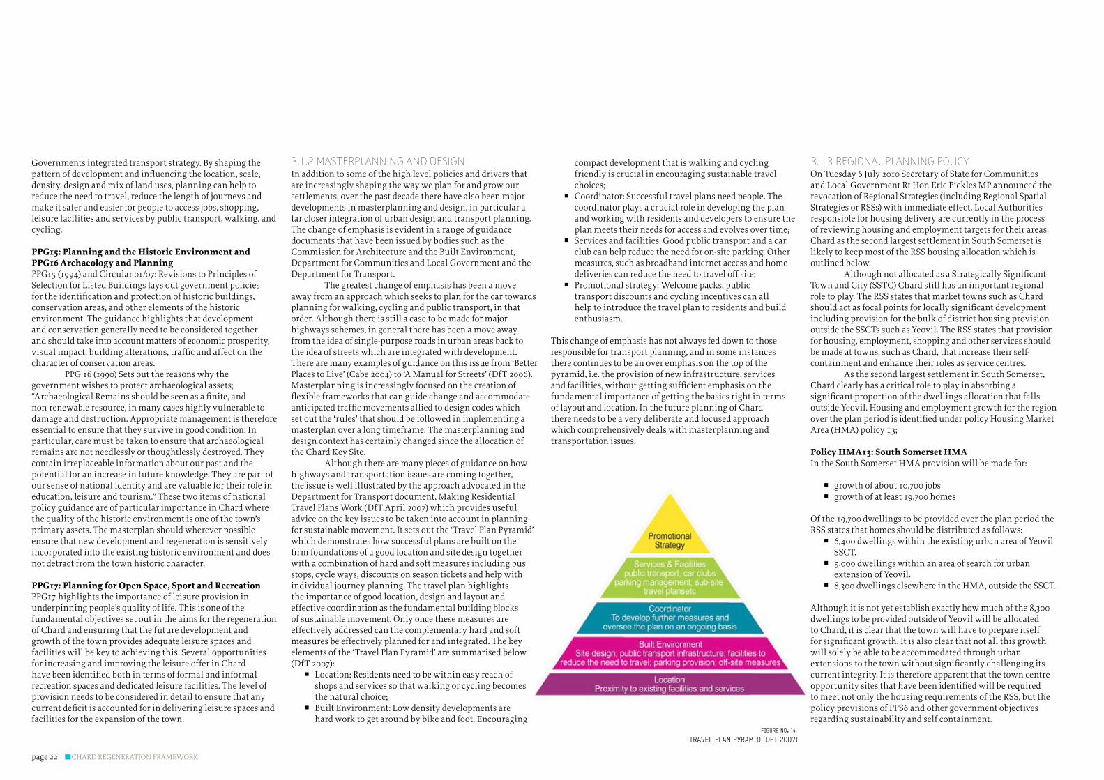
3.1.2 mASTERPlANNING AND DESIGNIn addition to some of the high level policies and drivers that are increasingly shaping the way we plan for and grow our settlements, over the past decade there have also been major developments in masterplanning and design, in particular a far closer integration of urban design and transport planning. The change of emphasis is evident in a range of guidance documents that have been issued by bodies such as the Commission for Architecture and the Built Environment, Department for Communities and Local Government and the Department for Transport. The greatest change of emphasis has been a move away from an approach which seeks to plan for the car towards planning for walking, cycling and public transport, in that order. Although there is still a case to be made for major highways schemes, in general there has been a move away from the idea of single-purpose roads in urban areas back to the idea of streets which are integrated with development. There are many examples of guidance on this issue from ‘Better Places to Live’ (Cabe 2004) to ‘A Manual for Streets’ (DfT 2006). Masterplanning is increasingly focused on the creation of flexibleframeworksthatcanguidechangeandaccommodateanticipatedtrafficmovementsalliedtodesigncodeswhichset out the ‘rules’ that should be followed in implementing a masterplan over a long timeframe. The masterplanning and design context has certainly changed since the allocation of the Chard Key Site. Although there are many pieces of guidance on how highways and transportation issues are coming together, the issue is well illustrated by the approach advocated in the Department for Transport document, Making Residential Travel Plans Work (DfT April 2007) which provides useful advice on the key issues to be taken into account in planning for sustainable movement. It sets out the ‘Travel Plan Pyramid’ which demonstrates how successful plans are built on the firmfoundationsofagoodlocationandsitedesigntogetherwith a combination of hard and soft measures including bus stops, cycle ways, discounts on season tickets and help with individual journey planning. The travel plan highlights the importance of good location, design and layout and effective coordination as the fundamental building blocks of sustainable movement. Only once these measures are effectively addressed can the complementary hard and soft measures be effectively planned for and integrated. The key elements of the ‘Travel Plan Pyramid’ are summarised below (DfT 2007):
Location: Residents need to be within easy reach of �shops and services so that walking or cycling becomes thenaturalchoice;Built Environment: Low density developments are �hard work to get around by bike and foot. Encouraging
compact development that is walking and cycling friendly is crucial in encouraging sustainable travel choices;Coordinator: Successful travel plans need people. The �coordinator plays a crucial role in developing the plan and working with residents and developers to ensure the planmeetstheirneedsforaccessandevolvesovertime;Services and facilities: Good public transport and a car �club can help reduce the need for on-site parking. Other measures, such as broadband internet access and home deliveriescanreducetheneedtotraveloffsite;Promotional strategy: Welcome packs, public �transport discounts and cycling incentives can all help to introduce the travel plan to residents and build enthusiasm.
This change of emphasis has not always fed down to those responsible for transport planning, and in some instances there continues to be an over emphasis on the top of the pyramid, i.e. the provision of new infrastructure, services andfacilities,withoutgettingsufficientemphasisonthefundamental importance of getting the basics right in terms of layout and location. In the future planning of Chard there needs to be a very deliberate and focused approach which comprehensively deals with masterplanning and transportation issues.
3.1.3 REGIONAl PlANNING POlIcy On Tuesday 6 July 2010 Secretary of State for Communities and Local Government Rt Hon Eric Pickles MP announced the revocation of Regional Strategies (including Regional Spatial Strategies or RSSs) with immediate effect. Local Authorities responsible for housing delivery are currently in the process of reviewing housing and employment targets for their areas. Chard as the second largest settlement in South Somerset is likely to keep most of the RSS housing allocation which is outlined below. AlthoughnotallocatedasaStrategicallySignificantTown and City (SSTC) Chard still has an important regional role to play. The RSS states that market towns such as Chard shouldactasfocalpointsforlocallysignificantdevelopmentincluding provision for the bulk of district housing provision outside the SSCTs such as Yeovil. The RSS states that provision for housing, employment, shopping and other services should be made at towns, such as Chard, that increase their self-containment and enhance their roles as service centres. As the second largest settlement in South Somerset, Chard clearly has a critical role to play in absorbing a significantproportionofthedwellingsallocationthatfallsoutside Yeovil. Housing and employment growth for the region overtheplanperiodisidentifiedunderpolicyHousingMarketArea(HMA)policy13;
Policy HMA13: South Somerset HMAIn the South Somerset HMA provision will be made for:
growth of about 10,700 jobs �growth of at least 19,700 homes �
Of the 19,700 dwellings to be provided over the plan period the RSS states that homes should be distributed as follows:
6,400 dwellings within the existing urban area of Yeovil �SSCT.5,000 dwellings within an area of search for urban �extension of Yeovil.8,300 dwellings elsewhere in the HMA, outside the SSCT. �
Although it is not yet establish exactly how much of the 8,300 dwellings to be provided outside of Yeovil will be allocated to Chard, it is clear that the town will have to prepare itself forsignificantgrowth.Itisalsoclearthatnotallthisgrowthwill solely be able to be accommodated through urban extensionstothetownwithoutsignificantlychallengingitscurrent integrity. It is therefore apparent that the town centre opportunitysitesthathavebeenidentifiedwillberequiredto meet not only the housing requirements of the RSS, but the policy provisions of PPS6 and other government objectives regarding sustainability and self containment.
travel plan pyramid (dft 2007)figUre no. 14
CHARD REGENERATION FRAMEWORK page 23
In addition to ensuring that the regeneration framework brings forward development sites that deliver the housing requirements of the RSS there also needs to be a consideration for the mix, type and tenure of the housing provided. A number of detailed studies have been undertaken that consider the current demand for housing in the region, most notably the Taunton and South Somerset Housing Market Areas assessment undertaken by Fordham Research. These documents, in conjunction with other sources such as the current housing register provide a clear indication of the importance for providing affordable housing in the in Somerset and the South West Generally. Given Chard’s strategic position it is likely that the growth of the town may havetoaccommodateasignificantproportionofaffordablemarket and social housing. The delivery of growth in Chard is not only vital in terms of reaching national and regional housing targets but also in terms of addressing local housing requirements and acting as the catalyst for unlocking improvements in the town centre. Different levels of growth will have differing impacts upon the towns form and upon the level of regeneration that can be derived from the values offered by different growth scenarios. This issue will be addressed in more detail later in the document in relation to the ‘development options’ for the town.
3.1.4 lOcAl PlANNING POlIcy South Somerset District Council Local Plan. Until the Core strategy is completed the adopted South Somerset Local Plan (2006) will be the primary document used to assess planningapplicationsinChard.TheLocalPlanbroadlyreflectsregional policy objectives in its allocation of housing and employment development in the region which state that the majority of development should be centred around existing towns and settlements. In support of this sentiment the Local Plan proposes 82% of the housing allocations and 90% of employmentallocationsintheDistrict’sfivedesignatedTownsof Yeovil, Chard, Crewkerne, Wincanton and Ilminster. WithintheseTowns,Yeovilhasastatussignificantlyhigher than the other four and is the main focus for development;thehousingallocationsinYeovilrepresentapproximately 46% of total allocations and about 56% of allocations in Towns. Chard is set to accommodate the next highest amount of growth and the local plan allocates its various development requirementsforthetownthroughanumberofspecificdevelopment proposals including the Chard Key Site and the Boden Mill Town Centre Key Site. These sites and policies linked to facilitating their development in their current form have experienced a range of issues that have lead to progress towards their delivery being halted. There have been a range
of issues that have contributed to this which need to be carefully considered so that the same issues do not further hinder the delivery of these and other important development opportunities across the town. From this brief policy review, it is clear that Chard has an important regional role to play for accommodating housing growth and providing employment opportunities. However it is also clear that Chard will not accommodate enough growth to gain the critical mass to compete on level terms with Yeovil or Taunton. Chard therefore will have to develop and promote a unique set of attributes that build on the town’s individuality to allow it to function as a sustainable self contained entity. Diversifying the offer and mix of uses within the town centre will be key to achieving this.
3.2.0 EcONOmIc AND mARkET cONSIDERATIONSA key factor affecting Chard’s ability to maintain and improve its competitiveness in relation to its nearby centres will be containment, i.e. the extent to which the local population is employed and directs its spending within the town. Chard’s proximity to competing centres, such as Taunton and Yeovil offering a superior range and amount of retail provision presents both threat and opportunity: the threat of increasing competition for the town’s existing convenience expenditure, and an opportunity to leverage the town’s historic character and setting to enhance and increase the town’s retail offer in terms of both quality and size. To compete Chard needs to draw on how it is different to these centres as the town does not have, even after growth, the critical mass to compete on the same terms. It will be vital for the town centre opportunity sites to draw on the unique attributes of the town and its location in order to start to build a distinctive and diverse market offer, both as a place to live and as a place to do business. Regeneration of the town centre will need to address the competitiveness of Chard in terms of its retail and commercial offer in order to ensure the towns continued vitality and viability, and is one of the key regeneration aims identifiedthroughthevisioningprocess.Theexperienceofthe built environment plays a key role in determining the success of this. The following section considers the economic andcommercialfactorsthatwillinfluencehowtheidentifiedopportunity sites will need to respond in commercial terms. 3.2.1 RETAIlOne of the major contributing factors to enable Chard to act as a self contained and self sustaining town will be developing a retail strategy that serves its current and future needs. Providing an appropriate strategy to develop a retail offer that responds to market realities and differentiates itself from its surrounding competitor towns will be vital in ensuring the
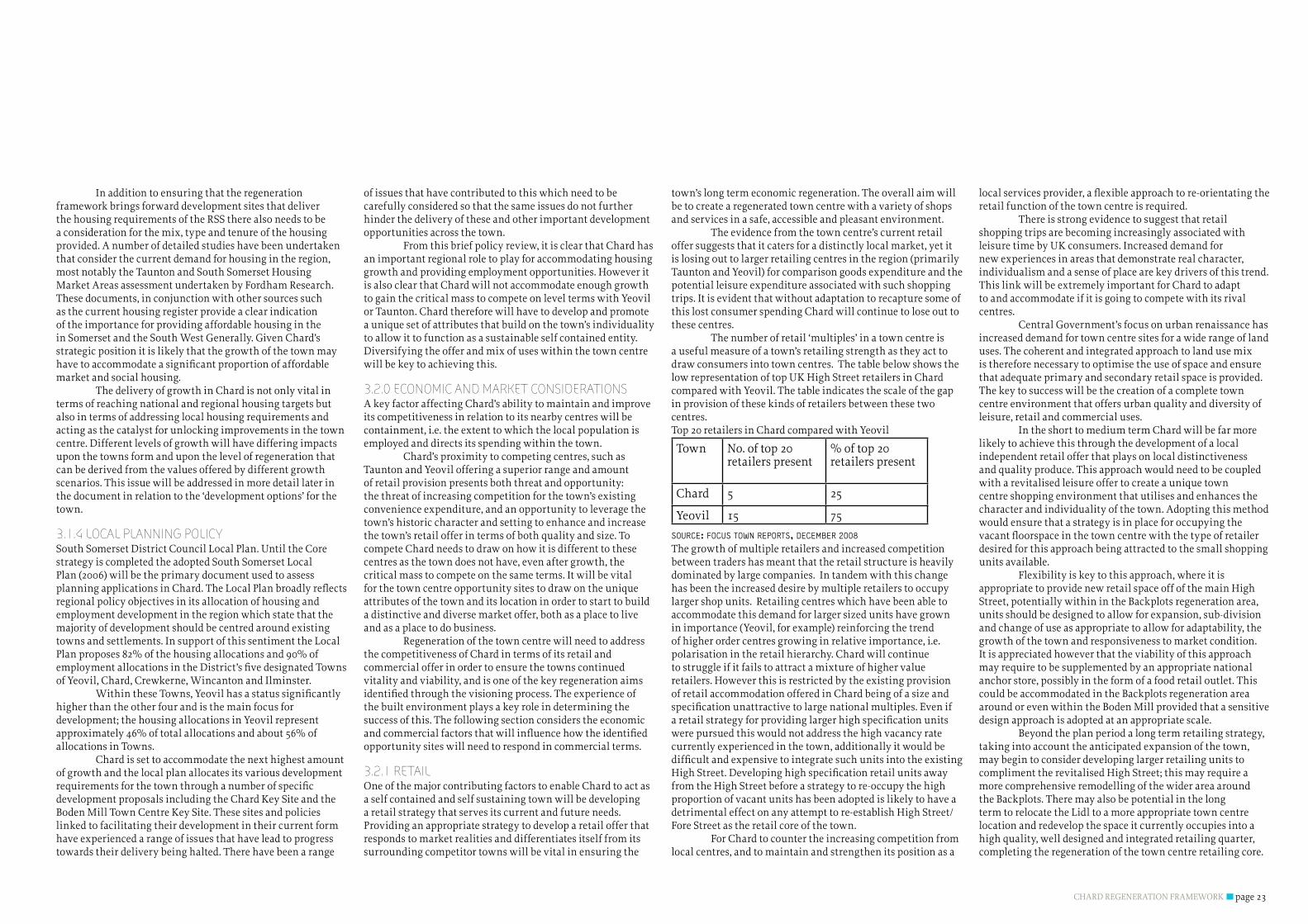
town’s long term economic regeneration. The overall aim will be to create a regenerated town centre with a variety of shops and services in a safe, accessible and pleasant environment. The evidence from the town centre’s current retail offer suggests that it caters for a distinctly local market, yet it is losing out to larger retailing centres in the region (primarily Taunton and Yeovil) for comparison goods expenditure and the potential leisure expenditure associated with such shopping trips. It is evident that without adaptation to recapture some of this lost consumer spending Chard will continue to lose out to these centres. The number of retail ‘multiples’ in a town centre is a useful measure of a town’s retailing strength as they act to draw consumers into town centres. The table below shows the low representation of top UK High Street retailers in Chard compared with Yeovil. The table indicates the scale of the gap in provision of these kinds of retailers between these two centres. Top 20 retailers in Chard compared with Yeovil Town No. of top 20
retailers present% of top 20 retailers present
Chard 5 25
Yeovil 15 75
soUrce: focUs town reports, december 2008
The growth of multiple retailers and increased competition between traders has meant that the retail structure is heavily dominated by large companies. In tandem with this change has been the increased desire by multiple retailers to occupy larger shop units. Retailing centres which have been able to accommodate this demand for larger sized units have grown in importance (Yeovil, for example) reinforcing the trend of higher order centres growing in relative importance, i.e. polarisation in the retail hierarchy. Chard will continue to struggle if it fails to attract a mixture of higher value retailers. However this is restricted by the existing provision of retail accommodation offered in Chard being of a size and specificationunattractivetolargenationalmultiples.Evenifaretailstrategyforprovidinglargerhighspecificationunitswere pursued this would not address the high vacancy rate currently experienced in the town, additionally it would be difficultandexpensivetointegratesuchunitsintotheexistingHighStreet.Developinghighspecificationretailunitsawayfrom the High Street before a strategy to re-occupy the high proportion of vacant units has been adopted is likely to have a detrimental effect on any attempt to re-establish High Street/Fore Street as the retail core of the town. For Chard to counter the increasing competition from local centres, and to maintain and strengthen its position as a
localservicesprovider,aflexibleapproachtore-orientatingtheretail function of the town centre is required. There is strong evidence to suggest that retail shopping trips are becoming increasingly associated with leisure time by UK consumers. Increased demand for new experiences in areas that demonstrate real character, individualism and a sense of place are key drivers of this trend. This link will be extremely important for Chard to adapt to and accommodate if it is going to compete with its rival centres. Central Government’s focus on urban renaissance has increased demand for town centre sites for a wide range of land uses. The coherent and integrated approach to land use mix is therefore necessary to optimise the use of space and ensure that adequate primary and secondary retail space is provided. The key to success will be the creation of a complete town centre environment that offers urban quality and diversity of leisure, retail and commercial uses. In the short to medium term Chard will be far more likely to achieve this through the development of a local independent retail offer that plays on local distinctiveness and quality produce. This approach would need to be coupled with a revitalised leisure offer to create a unique town centre shopping environment that utilises and enhances the character and individuality of the town. Adopting this method would ensure that a strategy is in place for occupying the vacantfloorspaceinthetowncentrewiththetypeofretailerdesired for this approach being attracted to the small shopping units available. Flexibility is key to this approach, where it is appropriate to provide new retail space off of the main High Street, potentially within in the Backplots regeneration area, units should be designed to allow for expansion, sub-division and change of use as appropriate to allow for adaptability, the growth of the town and responsiveness to market condition.It is appreciated however that the viability of this approach may require to be supplemented by an appropriate national anchor store, possibly in the form of a food retail outlet. This could be accommodated in the Backplots regeneration area around or even within the Boden Mill provided that a sensitive design approach is adopted at an appropriate scale. Beyond the plan period a long term retailing strategy, taking into account the anticipated expansion of the town, may begin to consider developing larger retailing units to complimenttherevitalisedHighStreet;thismayrequireamore comprehensive remodelling of the wider area around the Backplots. There may also be potential in the long term to relocate the Lidl to a more appropriate town centre location and redevelop the space it currently occupies into a high quality, well designed and integrated retailing quarter, completing the regeneration of the town centre retailing core.
CHARD REGENERATION FRAMEWORKpage 24
This however would be dependant upon the level of growth that Chard chooses to accept.
3.2.2 cOmmERcIAl The South Somerset Settlement Role and Function Study (2009) recognises that Chard is relatively self contained and the town has the potential for employment and business opportunities to be developed further. Establishing how Chard’s employment and commercial sectors should be developed will be a key element of the regeneration framework. CurrentlytheofficemarketinChardisweak,primarilysupplyingsmallofficesuitesofconvertedaccommodationoccupiedbylocalfirms.TauntonandYeovilprovidethemainareasofcompetitionintermsofofficespace which tend to attract national companies. This can be explained with reference to a number of factors including: location, access to infrastructure and the quality of the existing provision. The retail and leisure context in which thecurrentofficesupplyinChardexistsisalsoacontributingfactortothetown’sunderperformanceintheofficemarket. The importance of providing environmentally friendlyofficespaceisincreasing,followingtheintroductionoftheclimatechangelevyonfirmsinApril2001,implementationofEnergyPerformanceCertificatesin2008and the growing importance of BREEAM. Historically, the environment has not been seen as an important issue by occupiers, but this is likely to change in light of current and emerging policy provisions. It is clear that for Chard to improve its attractiveness in the officesectorarangeofimprovementstothetowningeneralneed to be made over and above simply providing additional units. However there is an opportunity in developing new officespacetocaterfortheemergingpolicyrequirementsregarding sustainable development. In terms of manufacturing, Chard has traditionally had a strong presence in this sector with the majority of the town’s employers operating in this industry today. There is clearly a strong industrial tradition in Chard which makes a major contribution to the unique character of the town. It is apparent however that in the current economic climate, with a generaldeclineinmanufacturingacrosstheUK,itisdifficultto see how the level of industrial based employment will rise over the coming decade, which will in turn have an impact on the demand for future industrial space. Manufacturing willremainimportanttoChard;howeveritmayexperiencechanges in the form and intensity of this manufacturing. It is likely that in the future, more smaller industrial ventures will spawn from the current larger operations. It is important to
ensure that once this occurs, the town is in a position to offer the space and support for accommodating these new ventures. The provision of employment accommodation ought tobeofaqualityandontermssufficienttobeginattractinghigher value jobs to the town, building upon the existing manufacturing base and diversifying into new sectors. Action on this is essential to address the likelihood that some of the key manufacturing sectors look likely to decline in the future. Any regeneration effort ought to seek to provide accommodationinsuitablesizerangesandofsufficientqualityto catalyse demand from service sector occupiers which will provide more secure, higher value employment.
3.2.3 lEISuRE The improvement in the town’s leisure offer will be a key component in increasing potential occupiers’ appetite for relocation to Chard. Chard has a good visitor attraction offer in the surrounding area including Cricket St Thomas Wildlife Park, Ferne Animal Sanctuary, Forde Abbey, Chard Reservoir Nature Reserve and numerous walking trails and cycling routes such as that which runs along the Stop Line way, connecting Chard to the cycle network. However, the leisure offer in the town itself is weak both in terms of formal and informal recreational facilities. Chard has great potential to vastly improve its leisure offer in a way that brings out the individuality and uniqueness of the town as a positive asset. As highlighted above leisure and retail consumers are demanding more unique places in which to visit and spend their time. This need for something different and fresh could leadtoalternativeleasearrangementswithmoreflexibleand shorter agreements that allow a more frequent change of tenant.
3.2.4 RESIDENTIAlThe dynamics of the local housing market coupled with the below average earnings of the population in Chard result in affordability issues. This is worsened, in the short term, by the current economic recession, and the likely fall in the availability of credit due to tighter lending criteria being imposed on banks. Therefore the overall design of any regenerationframeworkwillneedtobeflexibletoallowittodeal with market conditions as they develop over the medium term to long term. Town/city centre development has rapidly increased in recent years, as urban living has become fashionable particularly in large cities and developers increasingly look to residential units to add value to mixed use schemes. In terms of housingtypes,demandforflatshasdiminishedmarkedlyover
the course of the last year and has been replaced by demand formoretraditionalhouses;thereforeanyschemewillneedtorespond to this developing trend. The need for a high level of affordable housing in Chard is well appreciated however this must be balanced against a range of other competing funding requirements being placed on developers in the form of infrastructure contributions and emerging sustainability policies. Due to the current economic situation and complexities surround the housing market in general the regeneration strategy should at every opportunity investigate the potential for involving the HCA to unlock housing sites that deliver a range and mix of housing suitable for the needs of the projected population of the town.
3.2.5 TOWN cENTRE DEvElOPmENTFor Chard to regenerate its town centre it needs to increase the diversificationandmixofitscurrentuses,bringinginmoreactivity into the centre and create a unique and individual environment to stand out as a great place to visit. As with any project however, the nature of what can be achieved in the town centre is dependent on what uses and demand exists or can be created. The options for the delivery of the Town Centre Key Site are made more complex by the fact that the area around the ACI site and Lace Mill is relatively remote from the existing concentration of businesses. The wrong sort retail uses in this location could potentially compete with the established coreofthetown.Theexistingtowncentrehasasignificantnumber of vacant buildings and premises with under utilised potential. New uses need to be linked to support the existing retail cores around Fore Street / Holyrood Street and build from there. The footfall to support new uses and repair fragmented urban form is more likely to be found around Lidl/GuildhallthanfurtherafieldatthebottomendoftheHighStreet or around Lace Mill. This is also, in some respects, the area requiring the most attention. The delivery strategy for the Town Centre Key Site is therefore likely to involve working along an axis between the town centre and the Mill, retaining theMarketfieldsCarPark(albeitinanimprovedform)fortheforeseeablefuturetocreateapedestrianflowfromthisdirection. Uses are likely to be focussed on niche retailers, independents, live-work, craft workshops and some residential uses. A new market building could provide a home for the market and create a permanent home for the sale of local produce. At each step it will be vital to get the quality of the urban environment right – quality and individuality will be
essential to the delivery of long term success.
3.3.0 INFRASTRucTuRE cAPAcITy A key factor upon how growth and regeneration is approachedinChardwillbeinfluencedbyhowthetown’shighways and utilities infrastructure is developed. How these issues are addressed will form a key organising factor in how the plan for the town might look. Solutions to the town’s highways and infrastructure issues need to be developed with a number of objectives in mind, not just capacity, however this is an important factor to consider when approaching thereleaseofdevelopmentplots.Solutionsneedtobefitforpurpose and contribute to the wider objectives set out in the Chard Vision, above all they need to be deliverable and support the growth and regeneration of the town in a progressive way. 3.3.1 TRANSPORT AND mOvEmENT Chard town centre currently experiences a number oftrafficrelatedproblemsthatresultinanegativeexperienceoftheurbanenvironmentandpresentapoorfirstimpressionofthetown.ArangeofconflictsexistbetweenlargeHGV’saccessing industrial areas via the town centre and residential streetsnotdesignedtoaccommodatesuchtrafficmovements.Certain elements of the town centre’s highways network are also nearing capacity, such as the central junction in the town, theConventTrafficSignalsandChurchStreetwhichwouldstruggletoaccommodatetheincreasedflowscreatedfromthedevelopment of the eastern growth area. There is potential toupgradethisjunctiontoincreaseitsefficiencyintermsoftrafficflow,howeverthiswouldneedtobesupplementedwith a physical increase in the total capacity of the network toenablesignificantdevelopmenttotheeastofthetown.Itis clear therefore that for Chard to accommodate its future growth requirements the creation of an alternative route between the A358 Furnham, Road and the A358 Tatworth Road will be required. The adopted local plan includes a proposal for an external distributor road around the outer edge of what was then known as the Key Site. Although termed a distributor road this route would provide a bypass route for through trafficpassingbetweenthesouth,eastandnorthernedgesofthetown.Themajorroleofthisrouteistoallowtraffictobesegregated from the urban area. To establish if the external bypass type distributor road as indicated in the local plan is the most appropriate, cost effective and deliverable method ofservingthecoretrafficfunctionsofthetownitiscrucialtoconsiderhowtrafficinChardcurrentlyoperates. Toassesshowtrafficinthetowncurrentlyoperates

CHARD REGENERATION FRAMEWORK page 25
TrafficSurveysundertakenbyAutosurveysin2008onbehalfof IMA Transport Planning, and purchased from IMA by SSDC have been used. This survey used number plate recognition technology which matched number plates crossing the town boundary on the four A roads and Forton Lane. This would provideinformationonwhatproportionofthetrafficinChardisthroughtraffic(trafficthathasastartandenddestinationoutsideofthetown)andspecificallywhatkindofadistributorroad,internalorexternal,wouldbestservethistrafficneedonthe eastern side of the town. The method allows vehicles up to thirty minutes between entry and exiting the town. This means the survey datawilltendtoslightlyoverestimatethroughtraffic,asthirtyminutesislongenoughtohavestoppedbrieflyinthetown. Analysis of this data indicates that only around 13-14% oftrafficinChardinthepeakhouristhroughtraffic(12.9%PMpeak,14.5%AM)andthatonly6%oftrafficinChardwouldbenefitfromanexternal,bypasstypedistributorroadon the eastern side of the town. The survey indicated that the remainderofthethroughtrafficistoorfromthewest,orisonlynotionallythroughtrafficasitleavesbythesamerouteasit arrives. Additionalevidencefromrecenttrafficsurveysindicates that the majority of trips within the town are internal, that is journeys that are generated within the town and have an end destination that is also within the town, these are estimated as being up to 50% of movements within the town. An external distributor road would be very poor atservingthesekindsoftrafficmovementswithinChard.Therefore in terms of function, provision of an external bypass type distributor road would not be the most appropriate way of servingChardstrafficneeds. The distributor road/bypass as indicated in the Local Plan has been a proposal since at least 1994 when the plan wasfirstdrafted.ThereissomeevidencetosuggestthatthepercentageofthroughtrafficinChardwashigherin1994than it is now, as cordon surveys from that year show a higher percentageoftrafficenteringthetowntobethroughtrafficthan is the case of a survey in 2007. However in light of the most up to date surveys it can be seen that the level of relief fromthroughtrafficisverylowandinsufficienttojustifya road in the form of a bypass. It should also be noted that throughtrafficistheonetypeoftrafficthatwillnotincreaseas a result of development in Chard. Finally, although PPS1 states that development scenarios beyond the plan period are not a material factor in determining what should be in the development plan, it is reasonable to consider “where next” for Chard. Given the landscape constraints to the west then any further
development after the key site is likely to push east again, at which point an external distributor road would be merged with the urban area. The alternative to creating an external bypass type road would be to develop an internal distributor road that utilises a system of streets that serves a wider permeability function whilst also directly servicing development plots within the new eastern growth area. There are a number of place making advantages to this approach as it allows for multi-functional streets with active frontages to be developed where a genuine identify and character can be established rather than a single purpose road. The internal distributor approach also has a number of advantages in terms of deliverability and cost. The distributor road/bypass as detailed in the Local Plan is expected to cost around £18 million, which would need to be provided up front before development can takeplace,giventhecurrentfinancialclimateandthereasonsdetailed above this solution is not a viable option. The internal distributor road approach allows for the incremental release of development plots, linked to highways capacitywhichcanalsobecash-flowed,avoidingtheneedtodeliver a holistic infrastructure scheme up front. Detailed trafficmodellingandviabilitytestingundertakentoinformthis framework suggests that peripheral permeability could be delivered in a series of phases which also incrementally create the highways capacity necessary to accommodate development. These phases have been carefully considered to tie in with the wider masterplanning and regeneration objectives, and provide a safeguard against partial buildout of the eastern growth area.
3.3.2 uTIlITIESThegrowthofChardwillrequiresignificantalterationsto the form and loadings of the services infrastructure throughout the town. In turn this will have an effect on where and how certain elements of the utilities infrastructure are accommodated in the development plan for the town. A full analysis of the utilities requirements are provided in the Utilities and Energy Report, a summary of the main implications for the spatial development and deliverability of growth and regeneration in the town is provided below.
3.3.2.1 ElEcTRIcAl AND GAS SuPPlyThe local electricity Distribution Network Operator (DNO) is Western Power Distribution (WPD) and Wales & West Utilities are the area’s gas transporter. With regard to gas nearly all areas of the town are supplied by a low pressure network. A medium pressure main runs on the eastern edge of the town. Gas governors reducing to low pressure exist on
Chaffcombe Road and near Touches Lanes. Medium pressure is also supplied to some of the industrial sites, including Oscar Mayer and Beeching Close. Western Power Distribution had indicated that there is currently about 4MVA spare capacity in the network. An indicative accommodation schedule for the proposed development was used to produce predictions of future energy demands based on the Local Plans Key Site housing allocation. The Key Site housing numbers were varied from the basic amount to +50% and +100% to test sensitivity. The table below displays the results of this analysis.
No. of Dwellings
Residential Non-residential
Energy (MWh)
Energy (MWh)
Chard Current
Estimate 4,446
98,141 Unknown
Proposed +100% Scenario
3,882 43,938 5,872
Proposed +50% Scenario
2,997 33,651 5,872
Proposed Basic Scenario
2,112 23,364 5,872
As can be seen even the basic proposed development hasasignificantimpactonChard’senergyconsumption. Once a certain size of new development has occurred, the resulting increase in power demand could necessitate reinforcementattheprimarysubstationlocatedonMillfieldRoad. As stated above Western Power Distribution had indicated that there is currently about 4MVA spare capacity in the network, full development may result in a total additional maximum demand of 7 to 10MVA, WPD have initially suggested that this may require a new transformer at the primary substation or perhaps a new primary substation.
3.3.2.2 FOul DRAINAGEWessex Water is the area’s sewerage operator. Chard Sewage Treatment Works (STW) is located to the North East of Chard near Peasmarsh by the dismantled railway track. A sewer connecting this to Chard runs under the track. Initial discussions with Wessex Water highlighted that major developmentinChard,beyondjustinfill,maycausecapacity
issues at the STW. With regard to the foul sewer network there would also be capacity issues with the existing system and reinforcement work would be required. Wessex Water (WW) have advised that in terms of numbers the existing foul sewerage system would be able to accommodateroughly100propertiesintheMillfieldArea.WW stated a scheme to service further development has been estimated at £1.5 - 2.0 million. Forton, just to the south of Chard, is the start of South West Water (SWW) wastewater area. STW used by SWW near Tatworth only has spare capacity for approximately 30-40 dwellings. The STW currently serves a population of just over 2000, a further 1000 dwellings (or 2000 people) would double this resulting in major improvements being required. SWW have indicated that it would be more than £500,000 to bring this facility up to the required capacity.
3.3.2.3 WATER SuPPlyWessex Water is the area’s water distributor. Chard is served by two service reservoirs, both on the west side of town at Snowdon Hill and Catch Gate Lane. Various mains cross thetownandsurroundingfields(particularlyintheWest).Regarding the Key Site in the Local Plan, Wessex Water had previously proposed that to service the east of town would require a new main to the north of Chard, from the existing trunk system back to a position near the north of the town.
3.3.2.4 DATAADSL Broadband is available at the Chard exchange. BT’s Broadband checker results show that the Chard Exchange supports BT Total Broadband with an estimated maximum connection speed to be up to 6.5 Mbps (Megabits per second). 21CN (21st Century Network) is a Next Generation Network being deployed by BT over the next 5 years offering services at up to 24Mbps. BT have set a target date of 2010 for the switch to 21CN for the Chard exchange. Alloftheabovewillhaveanimportantinfluenceonhowthetown grows, what will also need to be considered is how these factors can be accommodated in a way that contributes to the challenge of achieving a sustainable development. This is discussed in the following section.
3.3.3 ENERGy INFRASTRucTuREAttitudes to sustainable development are changing rapidly at all levels, from the average UK resident to the highest political level there is an increasing appreciation of the issues that need to be addressed. Policy and legislation related to sustainable development and climate change is under major review, and is expectedtotightensignificantlyinthecomingyears.

CHARD REGENERATION FRAMEWORKpage 26
The ‘Building a Greener Future’ policy statement, published in 2007, sets out the Government’s proposals to require reduced carbon dioxide emissions from new housing developments in England and Wales. It sets out a timetable for changes to the Building Regulations requirements for CO2 performance with the eventual aim of achieving ‘zero carbon’ new homes by 2016. The extent to which the Government’s Zero Carbon timelinewillinfluencedevelopmentformandviabilityisonly just becoming evident. Discussions are ongoing at the Ministeriallevelinordertofinalisetheexactrequirementsofthe‘zerocarbon’definition,anddecisionsarestilltobemadethat will have a profound impact on how schemes are designed and delivered. Thedefinition‘zerocarbon’thatoriginallyemployedrequired all predicted emissions to be mitigated by renewable energy generated within the curtilage of the building. However, a UK Green Building Council report into the technical feasibility of mitigating all predicted emissions on-site, the Government instigated a comprehensive review of the definition. In December 2008 the department for Communities and Local Government (CLG) launched a consultation on a possiblenewdefinition.Thedefinitionintheconsultationdocument was based on a hierarchical approach requiring high-levelsofenergyefficiency,followedbyamandatorylevelof on-site carbon mitigation (including district heating/cooling networks), followed by a list of “allowable solutions” for dealing with the remaining emissions (considering both regulated and non-regulated energy uses).
government’s proposed sUstainability hierarch
“Allowable solutions” proposed so far include:
Carboncompliancebeyondtheminimumstandard; �
Energyefficientappliances/buildingcontrolsystemsasa �waytoreduceenergydemand;Exports of low carbon or renewable heat (or cooling) to �surroundingdevelopments;S106planningobligations; �Retrofittingofexistingbuildingsinthelocality; �investmentinLZCenergyinfrastructure(benefitsof �ownershiptransferredtothebuyerofthehome);Offsite renewable electricity connected via direct �physicalconnections;and,Any other measures announced by Government. �
The consultation closed in March 2009 and the Government is currently considering the responses received. Although some work is already underway to consider how‘allowablesolutions’mightbedelivered,definitiverecommendations cannot be made until the details of the new definitionhavebeenreleased. Much of the development of the eastern growth area will fall within the 2016 Zero Carbon timeline detailed above. As such, mechanisms for developing the appropriate utilities infrastructure and potential ‘allowable solutions’ to help achievetherequiredtargetsmustbeidentified. The provision of energy infrastructure and other utilities will ultimately have a major impact on the form of the masterplan, its phasing and delivery. High quality provisionwillbeverydifficulttoachievethroughasequenceof unconnected and piecemeal developments. A strong coordinated approach will therefore be essential. Options and ultimate solutions for the energy, waste and water strategy will be dependent on location conditions as well the policy framework. The potential for up front investment in energy infrastructure, and other utilities, through Regional Infrastructure Fund (RIF)/Homes and Communities Agency money might deliver an asset that will ultimately deliver a return on investment, although the details of how this might work and whether it would be deemed acceptableunderthedefinitionof‘zerocarbon’mustbeclarified. The potential for providing off site contributions towards achieving sustainability targets has been investigated. House Condition Survey is a survey regularly carried out on behalf of South Somerset District Council to assess the condition of the housing stock in its area. The most recent onewasinlate2007;thisassessedtheprivatesectorhousing’sconditionandenergyefficiency.Ofparticularnotearethefollowingfindings: “Overall the results show housing conditions to be considerably worse than the national average. The main
indicator of overall condition, non decent homes, is 6% above the national average. Indications are that the main reasons forthisareparticularlypoorthermalefficiencyofthestockcoupled with problems of disrepair….” In Chard it is estimated that roughly 20 -25% of private sector housing suffers from inadequate thermal comfort and this is linked to energy performance. Thepotentialforaddressingthesefuelinefficienciespresents a clear opportunity to assist in achieving the Government Zero Carbon aspirations. However it is also apparent that for future development phases to achieve Zero Carbon a holistic networked approach is required rather than retrofittingasolution.Thiswillrequireaplannedapproachfrom the outset to ensure that the infrastructure to deliver Zero Carbon developments are realised.
3.4.0 cOmmuNITy REGENERATION OPPORTuNITIES Theregenerationareasin2.3wereidentifiedthroughanalysingthe physical form of the town and considering how it can bealteredtoachieveregenerationbenefits.Inadditiontorepairingthepoorurbanstructureandinefficientuseofspacethroughout the town they also have the ability to address wider social objectives and needs. Social factors also play a vitalroleintheregenerationprocessandcaninfluencehowthe regeneration opportunity areas might be developed. Social and community regeneration initiatives will also be vital in helping to achieve the aims and objectives of the vision for the town. The regeneration framework will seek to improve social and community related issues through a combination of physical and community regeneration measures. Social factors thattheregenerationplanshouldaddressaredetailedbelow;
3.4.1 INDEX OF mulTIPlE DEPRIvATION 2004A key measure of social prosperity can be derived from considering deprivation indices data. The index of multiple deprivation considers a locations performance against a range of categories comprising employment, health, education, access to housing and services, crime and environment. Wards are split into Super Output Areas (approx 1000-1500 residents). Each Super output Area is ranked according to how deprived it is. Rank 1 is the most deprived SuperOutputAreainSouthSomerset;rank103istheleastdeprived Super Output Area in South Somerset. An analysis of multiple deprivation has shown that some Super Output Areas in Chard are amongst the 20% most deprived in the UK.
3.4.2 HEAlTH AND HOuSING OfficeofNationalStatisticsestimatesforSouthSomersetpredict that the population will increase by 25,300 between 2005 and 2028, and that 90% of this increase will be in the over
60 age group. This ageing population will lead to increased demand for health and care facilities, and affect the type of provision needed for housing, leisure and cultural services. To address this issue it will be important that the right kind of housing is provided in the right locations to meet the needs of the whole community including older people. Accessibility is another important issue and improving the connectivity between key locations throughout the town is paramount to improving access to health services and facilities ingeneralinChard.Significantimprovementscanbemadein terms of accessibility as a result of the regeneration of key opportunity sites in the town, with the creation of the Green Heart potentially providing a number of health and leisure relatedbenefitswithincreasedaccesstoformalandinformalrecreational green space.
3.4.3 AccESS TO FAcIlITIESChard is the second largest centre in terms of the number of shop units and retail turnover in South Somerset. However, an area of concern within Chard is that the vacancy rate has increasedsignificantlysince1994.Communityfacilitiesareavital part of creating sustainable communities that are healthy, active and well educated. Chard performs reasonably well in terms of the total number of community facilities provided within the centre, however accessing these facilities is often difficult,withsomecommunityfacilitiessuchastheCrestasports centre in desperate need of renovation. In addition to this, the rural nature of the town causes some residents difficultiesinaccessingservices.Thoselackingindependentmeans of transport can feel particularly isolated. Physical enhancements to the built environment across the town could help to mitigate the negative perception of poorly maintained and vacant units, particularly in the high street. This improved perception should in turn raise confidenceinthetowningeneralandprovidedtheappropriatesupport and networks are in place vacancy rates will begin to reduce. The potential of creating an improved community resource in the centre of the town around Holyrood School and CrestaintheareaidentifiedastheGreenHeartprovidestheopportunity to enhance and make the most of an existing asset in an accessible location.
3.4.4 EDucATION AND EmPlOymENT A major issue facing Chard is the low skill/low wage employmentprofile.OSNdatashowsthatin200134%of Chard’s residents between the ages of 16 and 74 had no qualificationscomparedwith27%ofSomersetresidents.Forthose attaining higher levels of education 5.5% of Chard’s working age population had the equivalent of 2 or more A levels and 10% were educated to degree level or higher compared with 7.1% and 17.5% for Somerset respectively. Scope for developing a strategy for improving the basic skills

CHARD REGENERATION FRAMEWORK page 27
base of the town is intrinsically related to, and should be delivered in hand with, initiatives to broaden and diversify the employment base of the town. Physical improvements to the builtenvironment,especiallytheopportunityareasidentifiedaround the Stop Line Corridor have potential to play a vital role inenhancingtheemploymentprofileofthetown.Thiscouldbe supported by the provision of appropriate studio/workshop and incubation space in the town centre around Boden Mill.
3.4.5 cRImE Chard has a dated perception of antisocial behaviour and although this reputation is undeserved the current built form of the town contributes to this negative outlook with its many areas of dead frontage, poor natural surveillance and single use zoned development patterns. There is a wealth of guidance how good design can be utilised to reduce the fear and perception of crime. By promoting mixed use developments with good natural circulation and surveillance areas of the town centre that may appear threatening can soon become positive and active parts of the built fabric.
3.4.6 cOmmuNITy REGENERATION INITIATIvESClearly physical improvements to the town centre will need to be supplemented by a range of community orientated regeneration initiatives. Social and economic regeneration will play a vital role in complementing and enhancing the physical measures set out in this report. Focusing on measures to enhance the experience of the town from a community perspective is of equal importance to delivering physical improvements to the town. Without a strategy to promote the economic and social regeneration of Chard, the full potential of the town will not be realised. Community regeneration initiatives will be represented in a range of forms including event organisation, festivals and networking. Details as to some of the initiatives that could be utilised to support and maintain momentum in the regeneration process are set out in the Implementation Plan.
3.5.0 kEy INFluENcES ON THE FRAmEWORkThe above analysis has a number of implications for how regeneration and growth can be delivered by optimising opportunitiesidentifiedinSection2.Withtherecentimpactofthe ‘credit crunch’ and the increasing impact of climate change and design on planning policy, the picture is quite different to that which existed when the original key site growth scenario was envisaged. The successful regeneration of the town centre will be key to the success of the Regeneration Framework. The creation of a strong image and identity for the town and a distinct offer that plays to the strengths of the setting and community of Chard will underpin the future of the town in social, economic
and environmental terms. There is little likelihood that Chard will be able to compete with its larger neighbours which have the attributes necessary to attract national retailers and other investors. The challenge for Chard will be to create an integrated niche leisure and retail experience that is distinctive with the potential to function as a self contained and locally sustainable economy. The Regeneration Framework does not need to provide thesitesandopportunitiestoattractmajornationalplayers;itneeds to enable local business start ups and independents. This suggests a certain scale and quantum of development offer capable of being developed incrementally as the regeneration initiative gathers pace. The ‘Back Plots’ to the south of High Street / Fore Street offers the best opportunity to deliver on this potential of the town. However the perception (and reality) ofenvironmentalqualityisalsoaprerequisite.Significantimprovement to the East End of the town and the public realm generally will need to support the core town centre regeneration initiative. These improvement could include the creation of a new green space in the town centre, utilising the potential of the area around Holyrood School and the Cricket Club. Whilst large employment sites may still be required, the greater priority is to create a physical and cultural environment that encourages enterprise and innovation. People leaving the big employers may be the catalyst for the development of a new economy provided the right support and premises are available. In addition there are opportunities to encourage creative and arts based business and businesses associated with high quality local produce. Small scale incubation space offering appropriate accommodation and support at the right price will be important, as will the availability of space to move in to. Major buildings such as the Boden Mill could be a focus to the development and support for new businesses in Chard. Regeneration of the town centre and its continued success will be assisted by getting more people to live in the centre, supporting local businesses, and improving the sustainable connectivity with existing residential areas. Transport issues have always been a major issue in the town, and it is likely that growth in the town over the past decade has been frustrated by the complexities of delivering the distributor road as promoted by the Local Plan. The current economic climate together with changes in transport policy, trafficmovementaroundChardanddesignapproachesmakeit highly unlikely that the eastern distributor road will be designed or delivered as originally envisaged. Far more likely is a phased approach in which the necessary highways capacity is delivered as a series of streets integrated into the development.
This would minimise costs and risks and create a design solution which allows for expansion to the town and which delivers a stronger sense of place. The implications of the Governments Zero Carbon timeline will need to be factored into the Regeneration Framework from the outset. It will be necessary to consider whether to lead or react to policy. Each phase of development completed without addressing the zero carbon agenda is likely to reduce the viability of the subsequent phases that will need to meet new regulation. It will be essential to consider whether upfront investment in energy infrastructure combined with a phased approach to delivery and revenue from an organisation such as an Energy Supply Company could make zero carbon deliverable from the outset. Finally community regeneration initiatives will need to be developed to compliment the physical measures being taken to revitalise the town.