character type 4 the rolling tablelands - … · of the eastern tablelands (character area 4.1)...
TRANSCRIPT
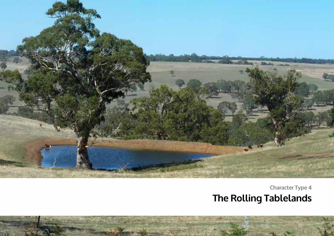
Character Type 4
The Rolling Tablelands

Long distance views in the cleared landscape of the Merino Tablelands
Roads follow the curves of the landscape Rolling landscape on the Kadnook-Conneewirrico Road featuring scattered Red Gums
389
DPCD South West Victoria Landscape Assessment Study | The RoLLing TAbLeLAnDS
© 2013
Logo is at twice the size for the footer
The Rolling Tablelands Character Type encompasses the Dundas and Merino Tablelands, and an area of rolling topography to the east of the southern arm of the Grampian’s Serra Range
It is defined by a broad plateau of rolling hills dissected by deep river valleys. Significant stands of vegetation line the valleys, creek corridors and roadsides in most part of this Character Type, with the exception of heavily cleared areas in the south-west that display a much more open characteristic. The land is sparsely settled, with farm buildings and structures blending into the landscape rather than dominating it. Majestic individual Red Gums are a feature of this area.
Three distinctive Character Areas have been determined and will be discussed in more detail within the Character Area Papers.
4.1 Eastern Tablelands
4.2 Open Valleys
4.3 Vegetated Tablelands
4 The Rolling Tablelands

Figure 1 The Rolling Tablelands location
4.1
4.2
4.3
Glenelg Hwy
Glenelg Hwy
MERINO
SOUTHERNGRAMPIANS SHIRE
SOUTHERN GRAMPIANS
SHIRE
ARARAT RURAL CITY
MOYNESHIRE
WESTWIMMERA
SHIRE
GLENELG SHIRE
LOCAL GOVERNMENT AREAS
CHARACTER AREA BOUNDARY
NATIONAL PARKSCHARACTER TYPE BOUNDARY
STATE PARKS
HIGHWAY
ARTERIAL ROADSTUDY AREA BOUNDARY
N
TOWNSHIPAREAS
390
DPCD South West Victoria Landscape Assessment Study | The RoLLing TAbLeLAnDS
© 2013
Logo is at twice the size for the footer
391
DPCD South West Victoria Landscape Assessment Study | The RoLLing TAbLeLAnDS
© 2013
Logo is at twice the size for the footer
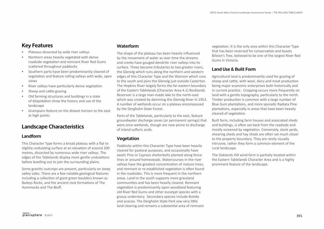
Key Features ▪ Plateaus dissected by wide river valleys ▪ Northern areas heavily vegetated with dense
roadside vegetation and remnant River Red Gums scattered throughout paddocks
▪ Southern parts have been predominantly cleared of vegetation and feature rolling valleys with wide, open views
▪ River valleys have particularly dense vegetation ▪ Sheep and cattle grazing ▪ Old farming structures and buildings in a state
of dilapidation show the history and use of the landscape
▪ Grampians feature on the distant horizon to the east at high points
landscape Characteristics
landformThis Character Type forms a broad plateau with a flat to slightly undulating surface at an elevation of around 200 metres, dissected by numerous wide river valleys. The edges of the Tablelands display more gentle undulations before levelling out to join the surrounding plains.
Some granitic outcrops are present, particularly on steep valley sides. There are a few notable geological features including a collection of giant green boulders known as Baileys Rocks, and the ancient rock formations of The Hummocks and The Bluff.
Waterform The shape of the plateau has been heavily influenced by the movement of water as over time the streams and creeks have gouged dendritic river valleys into its surface. These become tributaries to two greater rivers, the Glenelg which runs along the northern and western edges of this Character Type and the Wannon which runs to the south and joins the Glenelg just outside Casterton. The Hopkins River largely forms the far-eastern boundary of the Eastern Tablelands (Character Area 4.1) Rocklands Reservoir is a large man-made lake to the north-east which was created by damming the Glenelg River in 1953. A number of wetlands occur on a plateau encompassed by the Dergholm State Forest.
Parts of the Tablelands, particularly to the east, feature groundwater discharge zones (or permanent springs) that were once wetlands, though are now prone to discharge of inland sulfuric acids.
Vegetation Paddocks within this Character Type have been heavily cleared for pastoral purposes, and occasionally have exotic Pine or Cypress shelterbelts planted along fence lines or around homesteads. Watercourses in the river valleys have the greatest concentration of mature trees, and remnant or re-established vegetation is often found in the roadsides. This is more frequent in the northern areas. Land to the south supports more grassland communities and has been heavily cleared. Remnant vegetation is predominantly open woodland featuring old River Red Gums and other eucalypt species with a grassy understory. Secondary species include Buloke and acacias. The Dergholm State Park saw very little land clearing and remains a substantial area of remnant
vegetation. It is the only area within this Character Type that has been reserved for conservation and boasts Bilston’s Tree, believed to be one of the largest River Red Gums in Victoria.
land Use & built Form Agricultural land is predominantly used for grazing of sheep and cattle, with wool, dairy and meat production being major economic enterprises both historically and in current practice. Cropping occurs more frequently on land with a gentle topography, particularly to the north. Timber production is common with a large number of Blue Gum plantations, and more sporadic Radiata Pine plantations, especially in areas that have been heavily cleared of vegetation.
Built form, including farm houses and associated sheds and buildings, is often set back from the roadside and mostly screened by vegetation. Conversely, stock yards, shearing sheds and hay sheds are often set much closer to the property boundary. They are rarely visually intrusive, rather they form a common element of the rural landscape.
The Oaklands Hill wind farm is partially located within the Eastern Tablelands Character Area and is a highly prominent feature of the landscape.

Figure 2 The Rolling Tablelands Contours & Waterform
0 - 200M
500 - 1200M
CHARACTER AREA BOUNDARY
400 - 500M
CHARACTER TYPE BOUNDARY 200 - 300M
300 - 400M
STUDY AREA BOUNDARY
N
392
DPCD South West Victoria Landscape Assessment Study | The RoLLing TAbLeLAnDS
© 2013
Logo is at twice the size for the footer
Views are filtered through vegetation in northern areas
View across the rolling, partially vegetated landscape
Grampians silhouette features on the horizon of views facing east
393
DPCD South West Victoria Landscape Assessment Study | The RoLLing TAbLeLAnDS
© 2013
Logo is at twice the size for the footer
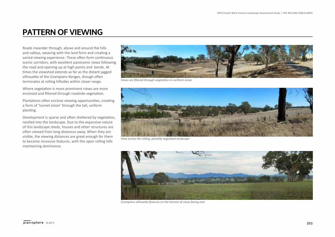
Roads meander through, above and around the hills and valleys, weaving with the land form and creating a varied viewing experience. These often form continuous scenic corridors, with excellent panoramic views following the road and opening up at high points and bends. At times the viewshed extends as far as the distant jagged silhouette of the Grampians Ranges, though often terminates at rolling hillsides within closer range.
Where vegetation is more prominent views are more enclosed and filtered through roadside vegetation.
Plantations often enclose viewing opportunities, creating a form of ‘tunnel vision’ through the tall, uniform planting.
Development is sparse and often sheltered by vegetation, nestled into the landscape. Due to the expansive nature of this landscape sheds, houses and other structures are often viewed from long distances away. When they are visible, the viewing distances are great enough for them to become recessive features, with the open rolling hills maintaining dominance.
PaTTeRn oF VieWing
Bilston’s Tree, believed to be Victoria’s largest Red Gum
Rural church near Nareen
Aboriginal scar tree on the Glenelg River near Harrow
The Hummocks, Wando Vale: an ancient geological formation & the scene of a massacre of Aboriginal people in 1840
394
DPCD South West Victoria Landscape Assessment Study | The RoLLing TAbLeLAnDS
© 2013
Logo is at twice the size for the footer
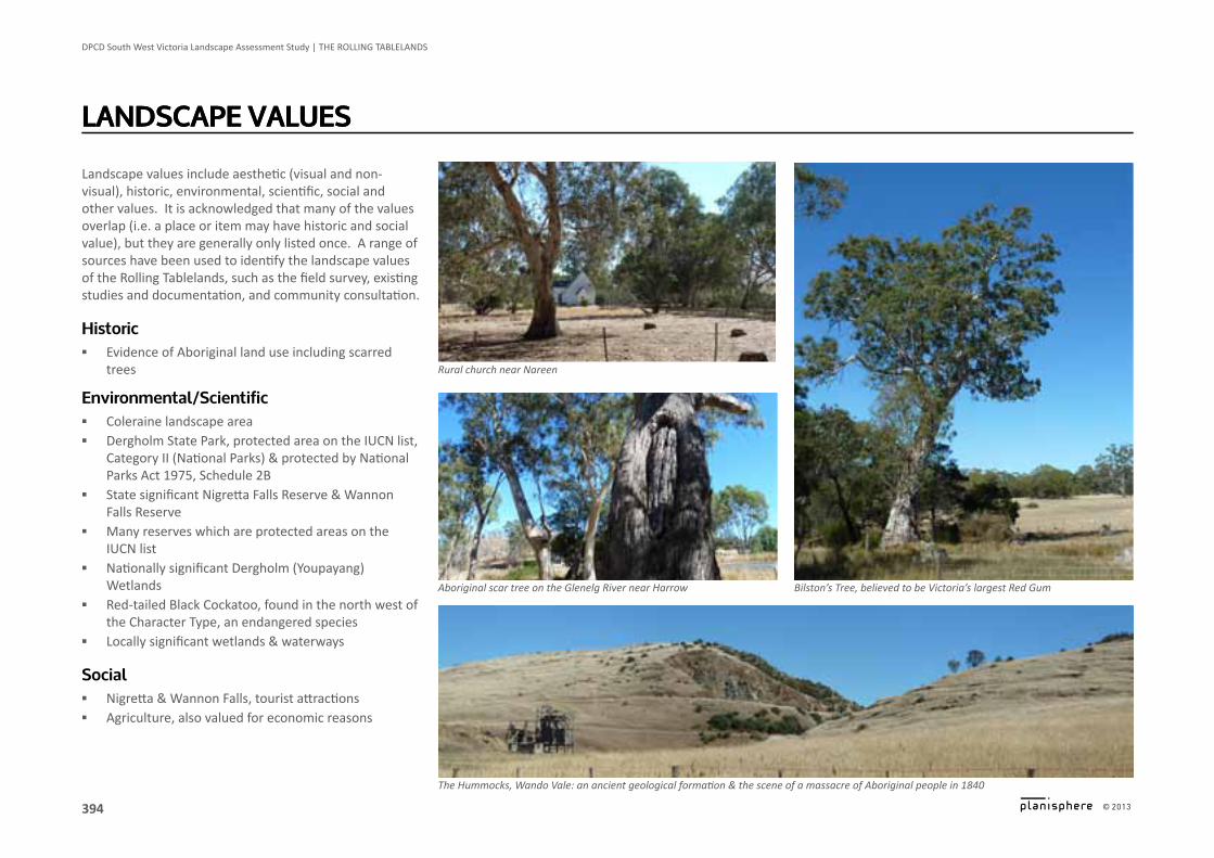
Landscape values include aesthetic (visual and non-visual), historic, environmental, scientific, social and other values. It is acknowledged that many of the values overlap (i.e. a place or item may have historic and social value), but they are generally only listed once. A range of sources have been used to identify the landscape values of the Rolling Tablelands, such as the field survey, existing studies and documentation, and community consultation.
historic ▪ Evidence of Aboriginal land use including scarred
trees
environmental/scientific ▪ Coleraine landscape area ▪ Dergholm State Park, protected area on the IUCN list,
Category II (National Parks) & protected by National Parks Act 1975, Schedule 2B
▪ State significant Nigretta Falls Reserve & Wannon Falls Reserve
▪ Many reserves which are protected areas on the IUCN list
▪ Nationally significant Dergholm (Youpayang) Wetlands
▪ Red-tailed Black Cockatoo, found in the north west of the Character Type, an endangered species
▪ Locally significant wetlands & waterways
social ▪ Nigretta & Wannon Falls, tourist attractions ▪ Agriculture, also valued for economic reasons
landsCaPe ValUeslandsCaPe ValUes

395
DPCD South West Victoria Landscape Assessment Study | The RoLLing TAbLeLAnDS
© 2013
Logo is at twice the size for the footer
landscape MorphologyThe tablelands are a plateau that rises to an elevation of around 200 metres, forming the far western portion of the Victorian Uplands Bioregion. Over time the tributaries of the Wannon and Glenelg Rivers have gouged wide river valleys into the surface, leaving behind a variable topography dissected by numerous valleys. The Merino Tablelands to the south east has an underlying structure of softer, more easily eroded sediments which has formed into more rounded hills and ridges.
The Ecological Vegetation Classes that were most commonly found were the Plains Grassy Woodland, Plains Grassland and Inland Slopes Woodland Complexes. It was an open bushland dominated by River Red Gums with an understory of grasses (Kangaroo, Wallaby and Spear Grasses) and herbs, interspersed with lightly wooded areas of open grassland. Yellow Gums, Manna Gums, Swamp Gums and Yellow Box and other eucalypt species were commonly found, as well as Acacias and Sheoaks. The soils of the Merino Tablelands were more suited to supporting open grasslands than woodlands.
The tablelands were the traditional lands of several groups of Aboriginal people. It has been recorded that fire was commonly used as a tool to hunt in south western Victoria, using it to flush out game which in turn kept the understoreys of the bush open and grassy.
Displacement of Aboriginal people was particularly violent in this region, with numerous altercations occurring over the theft of livestock. The Hummocks in Wando Vale is an outstanding geological feature, and also the site of a violent massacre lead by the Whyte brothers that resulted in the deaths of 60 Aboriginal people. This was not an uncommon story across the Western District.
Change in The landsCaPe
Over 90% of the endemic vegetation has been eradicated from the region since European Settlement. This has included the replacement of indigenous grasslands with introduced pasture, and clearing of trees and shrubby understory. The loss of vegetation has resulted in widespread sheet erosion and land slips, and erosion along gullies and riverbanks. This has caused high levels of siltation and changes in the hydrology of creeks and waterways.
Some areas of land have been rehabilitated, however continual use of the land for grazing of sheep and cattle has slowed this process down.
The clearing of land has also heightened the development of inland acid sulfate soils. Naturally occurring groundwater springs would have collected in permanently saturated wetlands where the proponent material, hydrogen sulfide, would have been stabilised. Clearing and draining the wetlands for agriculture has caused the hydrogen sulfide to oxidise, creating acid sulfate soils and contributing to land degradation.
Closer Settlement and Soldier Settlement policies saw the land become more fragmented as a finer grain of subdivision was introduced.
sensitivity to ChangeThe varied topography of the Rolling Tablelands Character Type is moderately sensitive to change.
Where a high level of vegetation is present, particularly within an undulating topography, the landscape exhibits a low sensitivity to change.
This is reversed where that landscape is predominantly cleared of vegetation, as any change is more likely to be visually intrusive.
The ridges and steep slopes of the valleys are particularly vulnerable in these instances. Currently the majority of development located within the valleys is set back into vegetation, with very few structures dominating or breaking the skyline. Where this does occur the viewing distances are often great enough to prevent the landscape from being dominated by development.
anticipated landscape Change ▪ Expansion of timber plantation industries ▪ Rehabilitation of hill slopes and waterways ▪ Increase in cropping, particularly in the Eastern
Tablelands ▪ Majestic Red Gums slowly declining ▪ The State Governments planning zones review
may lead to an increase in tourism, retail and accommodation uses in rural areas, a potential increase in rural living density and a potential increase in smaller lots and dwellings in the farming zone.

Figure 3 The Rolling Tablelands Cultural heritage sensitivity
AREAS OF ABORIGINAL CULTURAL SENSITIVITY
WATERCOURSES
CHARACTER AREA BOUNDARY
CHARACTER TYPE BOUNDARY
STUDY AREA BOUNDARY
NWATERBODIES
396
DPCD South West Victoria Landscape Assessment Study | The RoLLing TAbLeLAnDS
© 2013
Logo is at twice the size for the footer
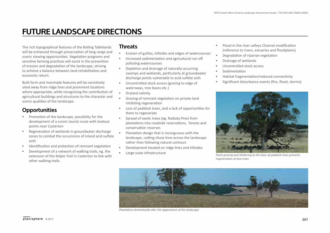
Plantations dramatically alter the appearance of the landscape
Stock grazing and sheltering at the base of paddock trees prevents regeneration of new trees
397
DPCD South West Victoria Landscape Assessment Study | The RoLLing TAbLeLAnDS
© 2013
Logo is at twice the size for the footer
The rich topographical features of the Rolling Tablelands will be enhanced through preservation of long range and scenic viewing opportunities. Vegetation programs and sensitive farming practices will assist in the prevention of erosion and degradation of the landscape, striving to achieve a balance between land rehabilitation and economic return.
Built form and manmade features will be sensitively sited away from ridge lines and prominent locations where appropriate, while recognising the contribution of agricultural buildings and structures to the character and scenic qualities of the landscape.
opportunities ▪ Promotion of the landscape, possibility for the
development of a scenic tourist route with lookout points near Casterton
▪ Regeneration of wetlands in groundwater discharge zones to combat the occurrence of inland acid sulfate soils
▪ Identification and protection of remnant vegetation ▪ Development of a network of walking trails, eg. the
extension of the Kelpie Trail in Casterton to link with other walking trails.
FUTURe landsCaPe diReCTions
Threats ▪ Erosion of gullies, hillsides and edges of watercourses ▪ Increased sedimentation and agricultural run-off
polluting watercourses ▪ Depletion and drainage of naturally occurring
swamps and wetlands, particularly at groundwater discharge points vulnerable to acid-sulfate soils
▪ Uncontrolled stock access (grazing to edge of waterways, tree bases etc.)
▪ Dryland salinity ▪ Grazing of remnant vegetation on private land
inhibiting regeneration ▪ Loss of paddock trees, and a lack of opportunities for
them to regenerate ▪ Spread of exotic trees (eg. Radiata Pine) from
plantations into roadside reservations, forests and conservation reserves
▪ Plantation design that is incongruous with the landscape, cutting sharp lines across the landscape rather than following natural contours
▪ Development located on ridge lines and hillsides ▪ Large scale infrastructure
▪ Flood in the river valleys Channel modification (reference to rivers, estuaries and floodplains)
▪ Degradation of riparian vegetation ▪ Drainage of wetlands ▪ Uncontrolled stock access ▪ Sedimentation ▪ Habitat fragmentation/reduced connectivity ▪ Significant disturbance events (fire, flood, storms)
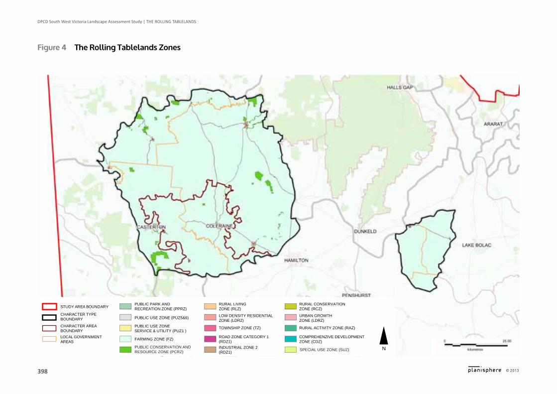
Figure 4 The Rolling Tablelands Zones
ROAD ZONE CATEGORY 1 (RDZ1)FARMING ZONE (FZ)LOCAL GOVERNMENT
AREAS
TOWNSHIP ZONE (TZ)PUBLIC USE ZONE SERVICE & UTILITY (PUZ1 )
CHARACTER AREA BOUNDARY
LOW DENSITY RESIDENTIAL ZONE (LDRZ)
PUBLIC USE ZONE (PUZ5&6)CHARACTER TYPE BOUNDARY
RURAL LIVING ZONE (RLZ)
PUBLIC PARK AND RECREATION ZONE (PPRZ)STUDY AREA BOUNDARY
NINDUSTRIAL ZONE 2(RDZ1)
COMPREHENZIVE DEVELOPMENT ZONE (CDZ)
RURAL ACTIVITY ZONE (RAZ)
URBAN GROWTH ZONE (LDRZ)
RURAL CONSERVATION ZONE (RCZ)
PUBLIC CONSERVATION ANDRESOURCE ZONE (PCRZ) SPECIAL USE ZONE (SUZ)
398
DPCD South West Victoria Landscape Assessment Study | The RoLLing TAbLeLAnDS
© 2013
Logo is at twice the size for the footer
399
DPCD South West Victoria Landscape Assessment Study | The RoLLing TAbLeLAnDS
© 2013
Logo is at twice the size for the footer
Planning scheme Policies & ControlsThe following Planning Schemes apply to the Rolling Tablelands:
▪ Ararat ▪ Glenelg ▪ Horsham ▪ Moyne
▪ Northern Grampians ▪ Southern Grampians ▪ West Wimmera
Key Zones ▪ Farming Zone (FZ) ▪ Public Conservation & Recreation Zone (PCRZ) ▪ Rural Living Zone (RLZ)
Key overlays ▪ Significant Landscape Overlay (SLO) ▪ Environmental Significance Overlay (ESO) ▪ Heritage Overlay (HO) ▪ Vegetation Protection Overlay (VPO) ▪ Wildfire / Bushfire Management Overlay (WMO /
BMO) ▪ Land Subject to Inundation Overlay (LSIO) ▪ Rural Floodway Overlay (RFO)
landscape Management objectivesTo achieve the future landscape character directions for the Rolling Tablelands, the following landscape management objectives are recommended:
▪ To maintain the positive contribution that productive agricultural land makes to the character of the Rolling Tablelands area.
landsCaPe PRoTeCTion & ManageMenT ▪ To manage and protect remnant indigenous
vegetation as an important character element, especially River Red Gums.
▪ To increase indigenous planting in the heavily cleared areas of the landscape and to further emphasise natural features such as creeks and river valleys.
▪ To create linked corridors of indigenous vegetation throughout the Rolling Tablelands landscape.
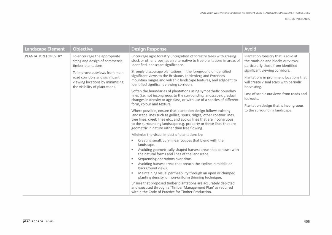
▪ To encourage the appropriate siting and design of commercial timber plantations.
▪ To improve outviews from main road corridors and significant viewing locations by minimizing the visibility of plantations.
▪ To retain the varied viewing experience from the many scenic corridors within the Rolling Tablelands landscape.
▪ To recognise the contribution of agricultural buildings and structures to the character and scenic qualities of the landscape.
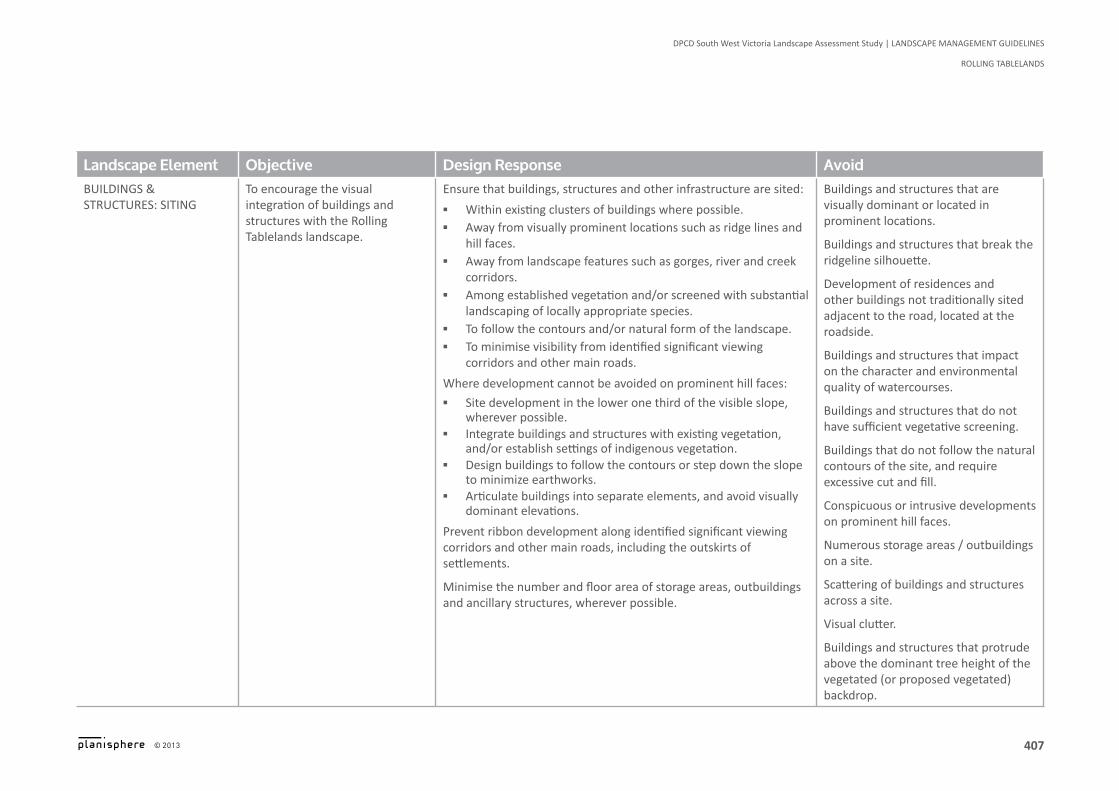
▪ To encourage the visual integration of buildings and structures with the Rolling Tablelands landscape.
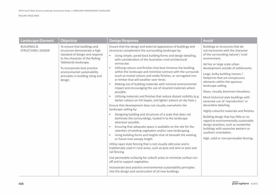
▪ To ensure that buildings and structures demonstrate a high standard of design and respond to the character of the Rolling Tablelands landscape.
▪ To incorporate best practice environmental sustainability principles in building siting and design.
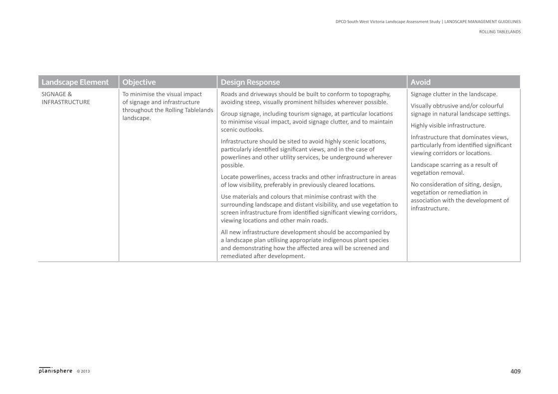
▪ To minimise the visual impact of signage and infrastructure throughout the Rolling Tablelands landscape.
▪ To contain existing settlements and prevent their unchecked expansion into the surrounding landscape.

Figure 5 The Rolling Tablelands overlays
EROSION MANAGEMENT OVERLAY
ENVIRONMENTAL SIGNIFICANCE OVERLAY
LOCAL GOVERNMENT AREAS
LAND SUBJECT TO INNUNDATION OVERLAY
SIGNIFICANT LANDSCAPE OVERLAY
CHARACTER AREA BOUNDARY
VEGETATION PROTECTION OVERLAY
WILDFIRE MANAGEMENT OVERLAY
CHARACTER TYPE BOUNDARY
SALINITY MANAGEMENT OVERLAY
TOWHSHIP AREAS HERITAGE OVERLAYSTUDY AREA BOUNDARY
N
400
DPCD South West Victoria Landscape Assessment Study | The RoLLing TAbLeLAnDS
© 2013
Logo is at twice the size for the footer
401
DPCD South West Victoria Landscape Assessment Study | The RoLLing TAbLeLAnDS
© 2013
Logo is at twice the size for the footer

Landscape Management Guidelines
Rolling Tablelands

403
DPCD South West Victoria Landscape Assessment Study | LANDSCAPE MANAGEMENT GUIDELINES
ROLLING TABLELANDS
© 2013
Logo is at twice the size for the footer
Landscape Management Guidelines
Landscape Element Objective Design Response AvoidLandscape management
To maintain the positive contribution that productive agricultural land makes to the character of the Rolling Tablelands area.
Encourage the contribution of sustainable land management practices and productive agricultural activities that have a positive impact on the landscape.
Unkempt and poorly managed agricultural lands.
Uses, development and management practices that reduce the productivity of agricultural lands.
Uses and development that interfere with the ongoing management of agricultural lands.

404
DPCD South West Victoria Landscape Assessment Study | LANDSCAPE MANAGEMENT GUIDELINES
ROLLING TABLELANDS
© 2013
Logo is at twice the size for the footer
Landscape Element Objective Design Response AvoidIndIgenous VegetatIon To manage and protect remnant
indigenous vegetation as an important character element, especially River Red Gums.
To increase indigenous planting in the heavily cleared areas of the landscape and to further emphasise natural features such as creeks and river valleys.
To create linked corridors of indigenous vegetation throughout the Rolling Tablelands landscape.
Where practical, protect and rehabilitate significant stands of remnant indigenous vegetation, particularly at roadsides, throughout paddocks , on hill faces and ridges, and along river and creek corridors, subject to considerations such as farming requirements, fire protection and safety.
Encourage farmers to protect and manage original stands of indigenous vegetation such as River Red Gums by fencing around old trees, trimming diseased or shattered branches, leaving dead trees standing for wildlife habitat (where practical), and planting new trees, particularly in bare paddocks.
Minimise indigenous vegetation removal in new development.
Where vegetation loss cannot be avoided, balance the loss of vegetation with rehabilitation on the site or nearby areas, and replace any native or indigenous trees lost with indigenous trees that will grow to a similar size.
Screen buildings, structures and large areas of hard surfaces with appropriately scaled indigenous vegetation that is appropriate to the landscape character of the area.
Encourage the rehabilitation of rolling hills and slopes, and reinforce vegetative linkages to natural features such as existing river and creek environs.
Encourage the removal of environmental weeds and their replacement with local indigenous species.
Encourage the planting of indigenous shelterbelts, as opposed to exotic, adjacent to identified significant viewing corridors.
Loss of significant stands of vegetation, particularly remnant River Red Gums.
Ad hoc clearing and removal of vegetation.
Development which requires permanent clearing of vegetation.
Lack of landscaping and substantial vegetation in new development.
Landscaping that provides little connection to the surrounding natural environment and existing landscape character.
Hard surfaces and hard edges in landscaping.
Continuous spreading / planting of environmental weeds.
Degradation of significant flora.
405
DPCD South West Victoria Landscape Assessment Study | LANDSCAPE MANAGEMENT GUIDELINES
ROLLING TABLELANDS
© 2013
Logo is at twice the size for the footer
Landscape Element Objective Design Response AvoidpLantatIon foRestRy to encourage the appropriate
siting and design of commercial timber plantations.
To improve outviews from main road corridors and significant viewing locations by minimizing the visibility of plantations.
Encourage agro forestry (integration of forestry trees with grazing stock or other crops) as an alternative to tree plantations in areas of identified landscape significance.
Strongly discourage plantations in the foreground of identified significant views to the Brisbane, Lerderderg and Pyrenees mountain ranges and volcanic landscape features, and adjacent to identified significant viewing corridors.
Soften the boundaries of plantations using sympathetic boundary lines (i.e. not incongruous to the surrounding landscape), gradual changes in density or age class, or with use of a species of different form, colour and texture.
Where possible, ensure that plantation design follows existing landscape lines such as gullies, spurs, ridges, other contour lines, tree lines, creek lines etc., and avoids lines that are incongruous to the surrounding landscape e.g. property or fence lines that are geometric in nature rather than free flowing.
Minimise the visual impact of plantations by:
▪ Creating small, curvilinear coupes that blend with the landscape.
▪ Avoiding geometrically shaped harvest areas that contrast with the natural forms and lines of the landscape.
▪ Sequencing operations over time. ▪ Avoiding harvest areas that breach the skyline in middle or
background views. ▪ Maintaining visual permeability through an open or clumped
planting density, or non-uniform thinning technique.
Ensure that proposed timber plantations are accurately depicted and executed through a ‘Timber Management Plan’ as required within the Code of Practice for Timber Production.
Plantation forestry that is solid at the roadside and blocks outviews, particularly those from identified significant viewing corridors.
Plantations in prominent locations that will create visual scars with periodic harvesting.
Loss of scenic outviews from roads and lookouts.
Plantation design that is incongruous to the surrounding landscape.

406
DPCD South West Victoria Landscape Assessment Study | LANDSCAPE MANAGEMENT GUIDELINES
ROLLING TABLELANDS
© 2013
Logo is at twice the size for the footer
Landscape Element Objective Design Response AvoidVIews & VIstas To retain the varied viewing
experience from the many scenic corridors within the Rolling Tablelands landscape.
To recognise the contribution of agricultural buildings and structures to the character and scenic qualities of the landscape.
Development should be avoided in the foreground (up to 500 metres from the viewing location) of identified significant views, or designed and sited to retain the character and scenic qualities of the views from that location.
If not an agricultural building or structure that is traditionally sited close to the road, built form and other development should be set back from identified viewing corridors, and designed and sited to minimise visual intrusion (e.g. low building heights, minimal building footprints, appropriate colours and materials to the setting, and integration with vegetation).
Consider the cumulative impact of developments visible from identified significant viewing corridors, other roads and key viewing locations, on the character and views of the surrounding landscapes.
Unsympathetic / intrusive buildings and structures that obscure prominent views.
Conspicuous or incongruous (out of place) buildings, structures or infrastructure visible in the foreground of views to notable landscape features.
407
DPCD South West Victoria Landscape Assessment Study | LANDSCAPE MANAGEMENT GUIDELINES
ROLLING TABLELANDS
© 2013
Logo is at twice the size for the footer
Landscape Element Objective Design Response AvoidBUILDInGS & STRUCTURES: SITInG
To encourage the visual integration of buildings and structures with the Rolling Tablelands landscape.
Ensure that buildings, structures and other infrastructure are sited:
▪ Within existing clusters of buildings where possible. ▪ Away from visually prominent locations such as ridge lines and
hill faces. ▪ Away from landscape features such as gorges, river and creek
corridors. ▪ Among established vegetation and/or screened with substantial
landscaping of locally appropriate species. ▪ To follow the contours and/or natural form of the landscape. ▪ To minimise visibility from identified significant viewing
corridors and other main roads.
Where development cannot be avoided on prominent hill faces:
▪ Site development in the lower one third of the visible slope, wherever possible.
▪ Integrate buildings and structures with existing vegetation, and/or establish settings of indigenous vegetation.
▪ Design buildings to follow the contours or step down the slope to minimize earthworks.
▪ Articulate buildings into separate elements, and avoid visually dominant elevations.
Prevent ribbon development along identified significant viewing corridors and other main roads, including the outskirts of settlements.
Minimise the number and floor area of storage areas, outbuildings and ancillary structures, wherever possible.
Buildings and structures that are visually dominant or located in prominent locations.
Buildings and structures that break the ridgeline silhouette.
Development of residences and other buildings not traditionally sited adjacent to the road, located at the roadside.
Buildings and structures that impact on the character and environmental quality of watercourses.
Buildings and structures that do not have sufficient vegetative screening.
Buildings that do not follow the natural contours of the site, and require excessive cut and fill.
Conspicuous or intrusive developments on prominent hill faces.
numerous storage areas / outbuildings on a site.
Scattering of buildings and structures across a site.
Visual clutter.
Buildings and structures that protrude above the dominant tree height of the vegetated (or proposed vegetated) backdrop.
408
DPCD South West Victoria Landscape Assessment Study | LANDSCAPE MANAGEMENT GUIDELINES
ROLLING TABLELANDS
© 2013
Logo is at twice the size for the footer
Landscape Element Objective Design Response AvoidBUILDInGS & STRUCTURES: DESIGn
To ensure that buildings and structures demonstrate a high standard of design and respond to the character of the Rolling Tablelands landscape.
To incorporate best practice environmental sustainability principles in building siting and design.
Ensure that the design and external appearance of buildings and structures complement the surrounding landscape by:
▪ Using simple, pared-back building forms and design detailing, with consideration of the Australian rural architectural vernacular.
▪ Utilising colours and finishes that best immerse the building within the landscape and minimise contrast with the surrounds (such as muted colours and matte finishes, or corrugated iron or timber that will weather over time).
▪ Making use of building materials with minimal environmental impact and encouraging the use of recycled materials where possible.
▪ Utilising materials and finishes that reduce distant visibility (e.g. darker colours on hill slopes, and lighter colours on sky lines.)
Ensure that development does not visually overwhelm the landscape setting by:
▪ Designing building and structures of a scale that does not dominate the surroundings, tucked in to the landscape wherever possible.
▪ Ensuring that adequate space is available on the site for the retention of existing vegetation and/or new landscaping.
▪ Using building forms and heights that sit beneath the existing or future tree canopy height.
Utilise open style fencing that is not visually obtrusive and is traditionally used in rural areas, such as post and wire or post and rail fencing.
Use permeable surfacing for unbuilt areas to minimize surface run-off and to support vegetation.
Incorporate best practice environmental sustainability principles into the design and construction of all new buildings.
Buildings or structures that do not harmonise with the character of the surrounding natural / rural environment.
Ad hoc or large scale urban development outside of settlements.
Large, bulky building masses / footprints that are conspicuous elements within the spacious landscape setting.
Sheer, visually dominant elevations.
Mock historical style buildings with excessive use of ‘reproduction’ or decorative detailing.
Highly colourful materials and finishes.
Building design that has little or no regard to environmentally sustainable design practices, such as residential buildings with excessive western or southern orientation.
High, solid or non-permeable fencing.
409
DPCD South West Victoria Landscape Assessment Study | LANDSCAPE MANAGEMENT GUIDELINES
ROLLING TABLELANDS
© 2013
Logo is at twice the size for the footer
Landscape Element Objective Design Response AvoidsIgnage & InfRastRuctuRe
To minimise the visual impact of signage and infrastructure throughout the Rolling Tablelands landscape.
Roads and driveways should be built to conform to topography, avoiding steep, visually prominent hillsides wherever possible.
Group signage, including tourism signage, at particular locations to minimise visual impact, avoid signage clutter, and to maintain scenic outlooks.
Infrastructure should be sited to avoid highly scenic locations, particularly identified significant views, and in the case of powerlines and other utility services, be underground wherever possible.
Locate powerlines, access tracks and other infrastructure in areas of low visibility, preferably in previously cleared locations.
Use materials and colours that minimise contrast with the surrounding landscape and distant visibility, and use vegetation to screen infrastructure from identified significant viewing corridors, viewing locations and other main roads.
All new infrastructure development should be accompanied by a landscape plan utilising appropriate indigenous plant species and demonstrating how the affected area will be screened and remediated after development.
Signage clutter in the landscape.
Visually obtrusive and/or colourful signage in natural landscape settings.
Highly visible infrastructure.
Infrastructure that dominates views, particularly from identified significant viewing corridors or locations.
Landscape scarring as a result of vegetation removal.
no consideration of siting, design, vegetation or remediation in association with the development of infrastructure.

410
DPCD South West Victoria Landscape Assessment Study | LANDSCAPE MANAGEMENT GUIDELINES
ROLLING TABLELANDS
© 2013
Logo is at twice the size for the footer
Landscape Element Objective Design Response AvoidsettLement edges To contain existing settlements
and prevent their unchecked expansion into the surrounding landscape
Ensure that settlements maintain their individual character and physical distance from each other.
Ensure settlements have a definite visual edge, delineating the boundary between urban development and the natural / rural landscape beyond.
Carefully site buildings and structures at settlement edges to integrate with existing topography and vegetation.
Development ‘clutter’ at the edges to settlements.
The expansion of rural living development into the landscape.
Ribbon development between settlements.
Suburban style residential development, with large areas of hard paving, in the rural environment.


412
DPCD South West Victoria Landscape Assessment Study | The RoLLing TAbLeLAnDS
© 2013
Logo is at twice the size for the footer
Character Area 4.1
Eastern Tablelands
413
DPCD South West Victoria Landscape Assessment Study | The RoLLing TAbLeLAnDS
© 2013
Logo is at twice the size for the footer
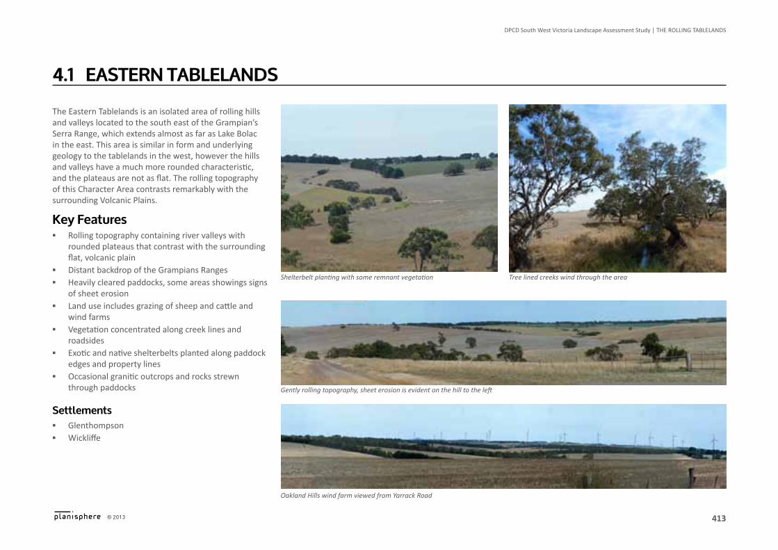
The Eastern Tablelands is an isolated area of rolling hills and valleys located to the south east of the Grampian’s Serra Range, which extends almost as far as Lake Bolac in the east. This area is similar in form and underlying geology to the tablelands in the west, however the hills and valleys have a much more rounded characteristic, and the plateaus are not as flat. The rolling topography of this Character Area contrasts remarkably with the surrounding Volcanic Plains.
Key Features ▪ Rolling topography containing river valleys with
rounded plateaus that contrast with the surrounding flat, volcanic plain
▪ Distant backdrop of the Grampians Ranges ▪ Heavily cleared paddocks, some areas showings signs
of sheet erosion ▪ Land use includes grazing of sheep and cattle and
wind farms ▪ Vegetation concentrated along creek lines and
roadsides ▪ Exotic and native shelterbelts planted along paddock
edges and property lines ▪ Occasional granitic outcrops and rocks strewn
through paddocks
Settlements ▪ Glenthompson ▪ Wickliffe
4.1 EASTErn TAblElAndS
Oakland Hills wind farm viewed from Yarrack Road
Tree lined creeks wind through the areaShelterbelt planting with some remnant vegetation
Gently rolling topography, sheet erosion is evident on the hill to the left

414
DPCD South West Victoria Landscape Assessment Study | The RoLLing TAbLeLAnDS
© 2013
Logo is at twice the size for the footer
RURAL CITY OF ARARATSHIRE OF
SOUTHERN GRAMPIANS
SHIRE OFMOYNE
Lake Fyans
Hopkins River
Glenelg Highway
Figure 1 Eastern Tablelands Overview
LOCAL GOVERNMENT AREAS
STATE PARKS
HIGHWAY
ARTERIAL ROAD
SIGNIFICANT LANDSCAPE OVERLAY HERITAGE OVERLAY
VEGETATION PROTECTION OVERLAY
ENVIRONMENTAL SIGNIFICANCE OVERLAY
WETLAND
RAMSAR WETLAND
WATER BODY
MINOR RIVER
MAJOR RIVER
CHARACTER AREA BOUNDARY
CHARACTER TYPE BOUNDARY
STUDY AREA BOUNDARY
NATIONAL PARKS
N
415
DPCD South West Victoria Landscape Assessment Study | The RoLLing TAbLeLAnDS
© 2013
Logo is at twice the size for the footer
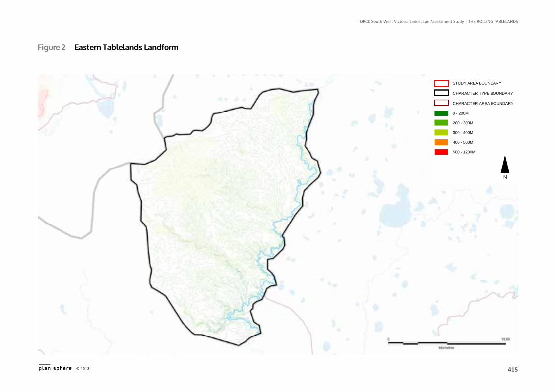
Figure 2 Eastern Tablelands landform
0 - 200M
500 - 1200M
CHARACTER AREA BOUNDARY
400 - 500M
CHARACTER TYPE BOUNDARY
200 - 300M
300 - 400M
STUDY AREA BOUNDARY
N
416
DPCD South West Victoria Landscape Assessment Study | The RoLLing TAbLeLAnDS
© 2013
Logo is at twice the size for the footer
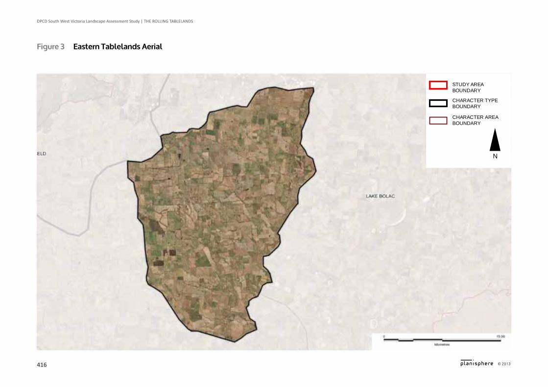
Figure 3 Eastern Tablelands Aerial
CHARACTER AREA BOUNDARY
CHARACTER TYPE BOUNDARY
STUDY AREA BOUNDARY
N
417
DPCD South West Victoria Landscape Assessment Study | The RoLLing TAbLeLAnDS
© 2013
Logo is at twice the size for the footer
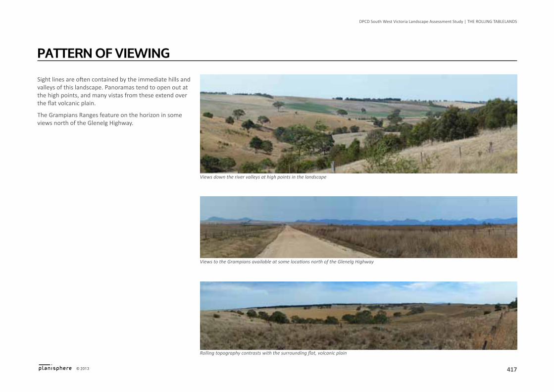
Sight lines are often contained by the immediate hills and valleys of this landscape. Panoramas tend to open out at the high points, and many vistas from these extend over the flat volcanic plain.
The Grampians Ranges feature on the horizon in some views north of the Glenelg Highway.
PATTErn OF viEwing
Views down the river valleys at high points in the landscape
Views to the Grampians available at some locations north of the Glenelg Highway
Rolling topography contrasts with the surrounding flat, volcanic plain
418
DPCD South West Victoria Landscape Assessment Study | The RoLLing TAbLeLAnDS
© 2013
Logo is at twice the size for the footer
Heritage ▪ Evidence of Aboriginal use
– along the banks of the Hopkins river – hearth stones at Berrambool
▪ Massacres & killings of Aborigines occurred in the Area in the early-mid 1800s
Environmental/Scientific ▪ Mount Rouse & surrounding area, protected by
Ararat SLO2 & Moyne SLO1, an area with high environmental & landscape values
▪ Locally significant vegetation, protected by Ararat VPO1 & VPO2
▪ Locally significant sites of biodiversity, protected by Ararat ESO3
▪ Locally significant watercourses, waterbodies & wetlands, protected by Ararat ESO2
Social ▪ Lake Bolac Eel Festival, a community music and art
festival held each autumn
lAndSCAPE vAluES
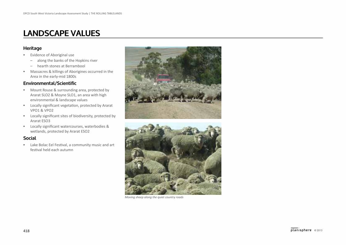
Moving sheep along the quiet country roads

419
DPCD South West Victoria Landscape Assessment Study | The RoLLing TAbLeLAnDS
© 2013
Logo is at twice the size for the footer
Planning Scheme Policies & ControlsThis Character Area is subject to the Ararat, Moyne and Southern Grampians Planning Schemes.
Key Zones ▪ FZ
Key Overlays ▪ Ararat SLO2: Mount Rouse ▪ Moyne SLO1: Mount Rouse Area of Natural Beauty ▪ Ararat ESO2: Watercourses, Waterbody & Wetland
Protection Areas ▪ Ararat ESO3: Habitat Protection Areas ▪ Ararat HO126: Narrapumelap Homestead ▪ Moyne HO1: Chatsworth House ▪ Southern Grampians HO215, HO216, HO217, HO218,
HO219, HO220, HO225 ▪ Ararat VPO1: Significant & Remnant Vegetation Areas ▪ Ararat VPO2: Roadside Vegetation Protection Areas ▪ Ararat & Southern Grampians WMO / BMO
lAndSCAPE PrOTECTiOn & mAnAgEmEnT