chapter eight esmf implementation and management
TRANSCRIPT
Federal Republic of Nigeria
Federal Ministry of Agriculture and Rural Development
Staple Crop Processing Zones Support Project (SCPZ)
Environmental and Social Management FrameworkDRAFT REPORT
January, 2015
i
E4830

Table of Contents Content PageTable of Contents iList of Tables iiiList of Figures iiiList of Plates ivList of Appendices ivList of Abbreviations and Acronyms vExecutive Summary vii
CHAPTER ONE: Project Description 11.1 Project Background 11.2 Project Development Objective (PDO) and Guiding Principles of the SCPZ 11.3 Project Location 21.4 Purpose of the ESMF 31.5 Rationale for the ESMF and other Safeguards Instruments 41.6 Scope of the ESMF 41.7 Approach for the Preparation of ESMF 5CHAPTER TWO: Proposed Project Activities 62.1 Project Setup 62.2 Direct Investment Components of the Project 62.3 The SCPZ and ABIR Development Footprint 72.4 Delineation of Scope and Project Boundaries for Purposes of the ESMF of the ESMF 72.5 The Proposed Project Activities 9CHAPTER THREE: Policy, Legal and Institutional Framework 113.1 Introduction 113.2 Administrative Framework 113.2.1 Federal Level Institution 113.2.2 Legal and Administrative Structure at State Level 133.2.3 Legal and Administrative Structure at Local Government Area 143.3 Relevant Regulatory Instruments and Policies 143.3.1 Federal Level Environmental Regulatory Instruments 143.3.2 State Level 203.3.3 Applicable International Legal and Administrative Instruments 213.4 World Bank Safeguards Policies 213.4.1 World Bank Safeguards Policies Triggered by the Proposed Activity 223.5 Comparison between Nigeria EIA Guidelines and World Bank EA Guidelines 223.6 Adequacy of the Existing Institutional Framework for Addressing Potential
Environmental & Social Issues in the SCPZ and ABIR in Kogi State 23CHAPTER FOUR: Description of Biophysical and Socio-Economic Environment 244.1 Location 244.2 Physical Environment 244.2.1 Climate 244.2.2 Air Quality 264.2.3 Geology 264.2.4 Relief and Drainage 264.2.5 Soils Characteristics 264.2.6 Hydrology 264.3 Biological Environment 274.3.1 Fauna 274.3.2 Vegetation 284.3.3 Protected Areas and Sensitive Habitats 294.3.4 Drivers of Vegetation Cover Change 304.3.5 Ecological Problems: 304.4 Socio-Economic Background of Project Area and Environs 304.4.1 Brief History of State 304.4.2 The Core Area of the SCPZ and ABIR in Kogi State 314.4.3 Administrative Structure
334.4.4 Local Dispute Resolution Procedure 33
ii

4.4.5 Literacy 334.4.6 Agricultural Production and Livelihoods 334.4.7 Women and their right to Ownership of Farmland in the ABIR communities 344.4.8 Vulnerable people 344.4.9 Land Competition and Conflict 344.4.10 Land Tenure and Land Use across the ABIR influence communities 344.4.11 Infrastructure (Road and Electricity) 354.4.12 Water Supply for Domestic Use 364.4.13 Health facilities and Prevalent Diseases 36CHAPTER 5: Description of Potential Environmental and Social Impacts 375.1 Environmental and Social Screening Process 375.2 Environmental Screening Criteria 375.3 Project-Level Environmental and Social Reviews 385.3.1 Environmental and Social Impact assessment 405.3.2 Method of Impact Assessment for the ESMF 405.4 The Potential Positive Impacts 405.4.1 The Potential Negative Impacts 445.5 Cumulative Environmental and Social Impacts 445.6 Assessment of a No Project and Go Ahead Project Alternatives 44CHAPTER 6 Environmental and Social Mitigation Measures 466.0 Introduction 466.1 Approach to Developing Mitigation Measure 466.2 Mitigation Measures 466.3 Enhancement of positive Impacts and Reduction/Avoidance of Negative Impacts 556.3.1 Gender Mainstreaming and Vulnerability Assessment 556.3.2 Waste Management Plan 566.3.3 Biodiversity Loss and Soil Management 576.3.4 Forest Reserve Management and Water Body 576.3.5 Managing Pastoralist Conflicts 576.3.6 Chance Find Protocols 57CHAPTER 7: Public Involvement/Consultant 587.0 Introduction 587.1 Objectives of Public involvement/Consultations 587.2 Mechanism for Consultation and Participation 587.3 Identifying Stakeholders 597.4 This ESMF and Public Involvement 607.5 ESMF Communication Plan 647.5.1 Mechanism for Engagement/Consultation of PAPs 657.5.2 Tools for Consultation of Stakeholders 657.5.3 Plan for Future Consultations and Communication 64CHAPTER 8: ESMF Implementation and Management 678.0 Introduction 678.1 Instituional Arrangements 718.1.1 Project Management Unit 718.1.2 Environmental and Social Safeguards Unit 718.2 ESMF Communication Plan 72 8.3 Measures for Strengthening Organizational Capability – Capacity Building and Training 738.4 Grievance mechanism 788.4.1 Grievance Management Process 788.4.2 Composition of Grievance redress Committee 788.4.3 Independent Mediation Committee 808.5 Environmental and Social Monitoring 808.6 Environmental Code of conduct, Social Integration and Participation 818.7 Budgets for the ESMF 828.8 Update and Revision of ESMF 838.9 Disclosures of Safeguard Instrument 83CHAPTER 9: Conclusion 859.0 Conclusion 85Bibliography 86Annexes 87
iii

List of TablesTable Page2.1: List of Main Proposed Project Activities 102.2: SCPZ Project Components 103.1: World Bank Safeguard Policies 224.1: Annual Rainfall in Lokoja (2002-2011) 244.2: List of Fauna Identified in the Proposed Project Area 274.3: Animals in the Area 284.4: Base Data for the LGAs Affected by the Kogi State SCPZ and ABIR 304.5: Education Level in Project Area 314.6: Existing Land use Classification of the Proposed Area 334.7: Ownership of Health and medical Institutions by Type and LGA 355.1: Potential Negative Impact of the SCPZ (Agricultural Activities & Agro Processing) 396.1: Approach to Mitigation Measure Development 426.2: Summary of Envisaged Activities/Impacts and Mitigation Measures SCPZ (Agricultural
Activities & Agro Processing) Facilities 427.1: Record of Consultations 507.2: Concerns Voiced by Stakeholders and Measures taken to Address them in the ESMF 518.1: Safeguard responsibilities 578.2: Training Modules on Environment and Social Management 608.3: Principal Steps of the Grievance Management Process 638.4: Estimated Annual Budget to Implement ESMF 678.5: Typical Information to be Disclosed 68
List of FiguresFigure Page1.1: Map of Nigeria showing Kogi State and Proposed SCPZ & ABIR catchment area1.2: ESMF Preparation Approach 2.1: The Alape SCPZ and ABIR in Kogi State 92.2: The Proposed SCPZ and ABIR 30km Radius Project Boundary 94.1: Kogi State showing the Affected LGAs 244.2: Temperature Characteristics 254.3: Characteristics of Relative Humidity within the Project Area 254.4: Monthly Daily Sunshine Pattern in the Study Area 254.5: The Forest Reserves within Proposed ABIR/SCPZ Area 294.6: SCPZ & ABIR Area indicating the Affected Communities and their LGAs4.7: Land use Map of the Proposed Project (SCPZ & ABIR)5.1: Steps in Environmental and Social Screening Processes6.1: Indicative Buffer Zone for Sensitive zones within SCPZ & ABIR 478.1: Grievance redress Flow Path 63
List of BoxesBox1 Operational Policy (OP)/Bank Procedure (BP) 4.01: Environmental Assessment 21
iv

List of AnnexesAnnex Page 1: Summary of World Bank Environmental and Social Safeguard Policies (10+2) 872: Land Use Analysis 883: Generic Environmental and Social Screening Form 964 Additional Screening Questions to Determine the Need and Possible Extent of
Further Environmental and Social Review and Management 1025: Federal Guidelines for EIA Process - EIA ACT No.86 of 1992 1056: Draft Terms of Reference for the ESIA for Site Specific Subproject in SCPZ/ABIR 1087: Draft Terms of Reference for the ESMP for Site Specific Subproject in SCPZ/ABIR 1118: Climate Change- Impact Vulnerability Assessment Due to Project 112 9: Environemntal Interaction matrix and Checklist 11310: Sample Checklist for Environmental Impact Prediction 11411: Generic Environmental and Social Mitigation Measures Checklist 11812 Gender Mainstreaming and Vulnerability Assessment 12113 Protection of Cultural Property 12214 Details of Public Consultations 12315: Details of Public Consultations- photos 12816: Public Participation in Project Cycle 13017: Grievance Registration Form 13118 Indicative Environmental Code of Conduct and Clauses for Contractors 13218-2: General Environemntal Management Conditions for Construction Contracts 134
v

LIST OF ACRONYMSABIR Agribusiness Investment Region ARAP Abbreviated Resettlement Action PlanARAR Applicable or Relevant and Appropriate Requirements ATA Agricultural Transformation AgendaCADP Commercial Agriculture Development ProgramCEFC Community and Farmer Environment CommitteeDFI Development Finance InstitutionEA Environmental AuditEMC Executive Management CommitteesEMP Environmental Management PlanESMF Environmental and Social Management FrameworkESIA Environmental and Social Impact AssessmentEIA Environmental Impact AssessmentFEPA Federal Environmental Protection AgencyFGN Federal Government of NigeriaFMARD Federal Ministry of Agriculture and Rural DevelopmentFMEnv Federal Ministry of EnvironmentFMEH Federal Ministry of HealthGEMS3 Growth and Employment in StatesGES Growth Enhancement SupportGON Government of Nigeria GRM Grievance Redress MechanismILO International Labor OrganizationIUCN International Union for Conservation of NatureKSG Kogi State GovernmentKSEPB Kogi State Environmental Protection BoardKSMENR Kogi State Ministry of Environment and Natural ResourcesLGA Local Government AreaLGDO Local Government Desk OfficerLNG Liquefy Natural GasMDA Ministries Departments and AgenciesNWRI National Water Resources InstituteNESREA National Environmental Standards and Regulations EnforcementNOSDRA National Oil Spill Detection and Response Agency NGO Non-Government OrganizationNIRSAL Nigerian Incentive-based Risk Sharing for Agricultural Lending NIPC Nigerian Investment Promotion Council NIWA Nigeria Inland Water Authority NTPF None Timber Forest ProductPAPs Project Affected PersonsPCU Project Coordinating UnitPDO Project Development ObjectivesPPP Public Private PartnershipRAP Resettlement Action PlanRPF Resettlement Policy FrameworkRBDA River Basin Development AuthoritiesSEPA State Environmental Protection AgencySCPZ Staple Crop Processing Zone SCPZA Staple Crop Processing Zone Authority SMEs Small and Medium Scale Enterprises SMEDAN Small and Medium Enterprises Development Agency of Nigeria SON Standards Organization of NigeriaSPV Special Purpose VehicleTA Technical Assistance WAAPP West Africa Agricultural Productivity ProgramWHO World Health Organization
vi

EXECUTIVE SUMMARY
Background The Federal Government of Nigeria has recognised that the high food import dependency fuels domestic inflation and exposes the country, with high susceptibility, to shocks in global markets. This trend of dependency on food imports, with its attendant great danger for national food security, in a world where even the exporting countries are mindful about food adequacy, is considered unacceptable and unsustainable fiscally, economically or politically. It is consequent upon this that the Government of Nigeria has come up with several initiatives, amongst which is the Agricultural Transformation Agenda (ATA), to redress the situation. The ATA is addressing the constraints inherent in the Nigerian Agricultural Sector with a view to unlocking its widely acknowledged potentials through a paradigm shift from government-controlled to private-sector led agriculture.
In pursuing this agenda, the Federal Ministry for Agriculture and Rural Development (FMARD) in collaboration with the Government of Kogi State and seeking the support of the World Bank has earmarked 250ha for the establishment of the Staple Crop Processing Zone (SCPZ) and 280,000ha of land surrounding the SCPZ as Agribusiness Investment Region (ABIR) in which professionally managed farms produce the raw materials for the factories to be established in the SCPZ.
The general concept of the ABIR and the SCPZ Programs in particular adds to the vision of ATA by seeking to channel investments into infrastructure, and strengthening the policy and investment climate, in an ‘Economic Zone’ type of operating environment, for unlocking economies of scale and improving competitiveness for processing and value added activities. This should improve competitive cost structure for agro-processors in Nigeria, reduce the absorption of capital and operational costs and make them competitive in domestic, regional and global markets.
Furthermore, the concept of the SCPZ as proposed by the Federal Government of Nigeria is based on the following three guiding principles: (i) take an integrated approach to the value chain by addressing critical upstream and downstream bottlenecks and facilitating market linkages; (ii) offer a superior operating environment that reduces the cost of doing business, and iii) take a private sector-led approach. The Operating Principles are the following; (i) investment-driven strategic partnerships with the private sector; (ii) integrated value chain approach; (iii) Self-sustaining, government-support and private sector managed.
Project Development Objective (PDO) and Direct Investment Components of the ProjectThe Project Development Objective (PDO) is to support agricultural productivity growth and value-addition of targeted small and medium scale farmers by facilitating inclusive public and private investment in selected agribusiness clusters.
The Project has four components as follows: Component 1: Support to public infrastructure development for the Alape model SCPZ Component 2: Support to farmers-agribusiness linkage and to economic opportunities along
the value chains Component 3: Institutional development in SCPZ Component 4: Project Management and Coordination
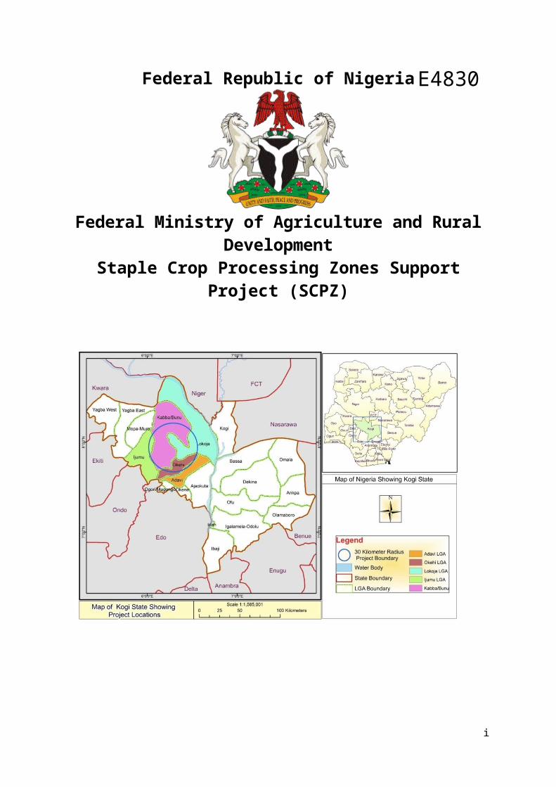
Description of the Project Area and EnvironsThe proposed project location spans its influence across five Local Government Areas of Kogi State, Nigeria, namely::Kabba-Bunu, Lokoja, Okehi, Adavi and Ijumu. A brief description of how the affects these areas and the environs are given below:
Kabba-Bunu Area: Kabba-Bunu is the host local government where the proposed land for the Alape SCPZ (255 Ha) is located. It is located on latitude 6.2888831 and longitude 7.93077. It has a land area of 2,757.57km2 and a population of 144,579 people made up of 72,639 males and 71,940 females. It shares boundaries with Kwara state and Lokoja to the north, Ijumu and Mopa-Muru to the west, Okehi to the south and Lokoja to the east. The communities and settlements in Kabba-Bunu
vii

within the ABIR include Agbadu-Bunu, Ape and Odo-Ape villages. Other settlements within the area include the Tivs, Ebira, Fulani, Tata, Apaa, Aiyede and Ighun.
Adavi Area : Adavi Local Government Council was created from Okehi Local Government Area on 27th August, 1991 along with the creation of Kogi State. It is found in the central part of Kogi State and is located between latitudes 7o15′ to 8o51’N and longitudes 6o to 6o5’E. It has a land area of 730,608km2 and a population of 217,219 made up of 108,891 males and 108,328 females. It is made up of many towns and villages including Ogaminana, Kuroko, Inoziomi, Adavi-eba, Nagazi and Osarangada. Most of these settlements are located along the major roads. The settlement within the forested ABIR zone is Iresuare farm settlement in Osarangada community. Iresuare makes up about 10% of the population of Osara-Ngada which is about 4500 people. A major natural resource that is descriptive of Osara-Ngada is the Osara Dam which was constructed from the Osara River.
Lokoja Area: Lokoja is a local government council as well as the capital city of Kogi state. It is located on latitude 09.18196 and longitude 007.17379 and shares boundaries with Niger state to the north, Kabba-Bunu to the west, Kogi to the east and Okehi and Adavi to the south. Kwara and Niger states as well as Ajakuta, Adavi, Okehi and Kabba/Bunu LGAs. It has an area of 3,180 km² and a populat ion of 196,643 (2006 population census) made up of 95,498 females and 101,145 males. The city of Lokoja was the capital of British Northern Nigeria Protectorate until the amalgamation of Northern and Southern Nigeria Protectorates into one nation in 1914. It is a trade centre for this agricultural region because it sits at the confluence of the Niger and Benue rivers, and is close to the new federal capital of Nigeria in Abuja. Oshokosho, Iwaa, Jakara, Obajana and Apata are agricultural communities in Lokoja LGA that falls within the ABIR.
Ijumu Area: Ijumu is located on latitude 07.84340 and longitude 05.95331. It has a land area of 1,328.284km2 and a population of 118,593 made up of 59,582 males and 59,011 females. It shares boundaries with Mope-Muru and Ondo state to the west, Kabba-Bunu to the north and east and Okehi to the south. Some of the communities and settlements in Ijumu within the ABIR are Ayegunle and Aiye.
Okehi Area: Okehi is found in the central part of Kogi state and is located between latitudes 0.7 to 07. 600147 and longitudes 0.6 to 06.203570. It is made up of two major districts namely; Ihima and Eika. There are 13 clans in Eika and 6 clans in Ihima. The settlements in Okehi around the ABIR are Ohu, Iru, Irukura and Irukuochakoko. The Fulani settlement is a major migrant settlement in the area. Okehi has a land mass of 672 582km2 and a population of 223,574 (made up of 112,879 males and 110,695 females). The area is known for cloth weaving particularly carried out by women which dominates about 5% of the livelihood activity in the area.
Purpose of the ESMFAt the time of project preparation, the specific sites that the project would be implemented are not known in sufficient details. Therefore, there is a need for an ESMF to outline the principles and procedures that would be followed to ensure that implementation of SCPZ meets with the existing Environmental Impact Assessment (EIA) laws in Nigeria and World Bank safeguards policies. The ESMF spells out the Environmental and Social (E & S) safeguards, institutional arrangements and capacity required to use the framework. This ensures that sub-projects under the SCPZ and listed related, associated and or induced activities in the ABIR as set forth in this document, meet the national and local E&S requirements, and also consistent with World Bank safeguards. The ESMF sets out basic principles and processes within which the sub-projects are implemented agreeable to all parties.
The other objectives of the ESMF include: Assessment of potential adverse E&S impacts commonly associated with the sub-projects
and the way to avoid, minimize or mitigate them; Establishment of clear procedures and methodologies for the E&S planning, review, approval
and implementation of sub-projects; Development of an ESA screening/initial assessment system to be used for sub-projects; and Specification of roles and responsibilities and the necessary reporting procedures for
managing and monitoring sub-project E&S concerns.
viii

To realize the objectives of this ESMF, the scope of work include the following tasks: Task 1: Environmental screening and scoping; Task 2: Environmental policy and regulatory framework; Task 3: Potential positive and negative environmental and social impacts; Task 4: Analysis of environmental and social mitigation principles; Task 5: Development of environmental and social management plan to mitigate negative
impacts; Task 6: Institutional framework; Task 7: Training needs; and Task 8: Public consultation.
Rationale for the ESMF and other Safeguards Instruments At the time of project preparation, the specific sites that the project would be implemented in are not known in sufficient details. While a master plan for the Kogi State SCPZ and ABIR has been developed, the specific sites for each of the core investment activities and infrastructures and the ancillary facilities are not known at this point in time in sufficient details. Therefore, there is a need for an environment and social management framework that outlines the principles and procedures that would be followed to ensure that implementation of SCPZ meets with the existing EIA law in Nigeria and World Bank Safeguards policies. This ESMF however, does not attempt to address site specific impacts related to individual undertakings (in any specific form) as the locations and extent of impacts or activities are not known at this preparatory stage.
This ESMF is prepared as a standalone document but aligned with two other standalone documents [Resettlement Policy Framework (RPF) and Integrated Pest Management Plan (IPMP)]` prepared in parallel for this proposed project. The ESMF provides guidance for addressing potential environmental and social impacts that may result from civil works as well as the overall transformation of the land expected in the SCPZ and ABIR, while the RPF establishes the resettlement and compensation principles, organizational arrangements and design criteria to be applied to meet the needs of the people who may be affected by the project activities requiring land acquisition and /or denial, restriction or loss of access to economic resources and the IPMP provides a comprehensive integrated management plan for pests in the SCPZ and related, associated or induced activities in the ABIR
Approach for the preparation of ESMF The ESMF has been prepared in accordance with applicable World Bank Safeguard Policies and Nigeria environmental assessment Act and Guidelines, and which involves the following activities:
Data Gathering; Participatory Public consultations and discussions with relevant sector institutions, including
non- governmental organizations (NGOs); Data collection and analysis, consisting of Literature reviews; Environmental and Social
screening and scoping studies; Determination of potential impacts; Identification of impacts mitigation measures; Preparation of an Environmental and Social
Management Plan; Review of comments from stakeholders; and Preparation and Submission of reports.
Delineation of Scope and Project Boundaries This Environment and Social Management Framework (ESMF) has been prepared in connection with the Staple Crop Processing Zones (SCPZ) Support Project, comprising four components described at pages _below (hereafter, the “SCZP Support Project). The ESMF shall apply to significant adverse environmental and social management risks, impacts and mitigation in Kogi State resulting from the following:
1. Investments directly funded by the SCZP Support Project, including infrastructure and other investments anticipated to be financed under Components 1 and 2.
2. Establishment of the SCPZ Core Area, comprising approximately 250 hectares, as well as private investment by tenants in the SCPZ Core Area.
3. Investment by the anchor tenant (expected to be Cargill) in the establishment of a nucleus farm in the ABIR comprising approximately 30,000 hectares (final dimensions still to be determined).
ix

For purposes of this ESMF, the term “Project” shall refer to the above three categories of activities, and the terms “sub-project”, etc., shall have a corresponding meaning.
The Kogi State Government has, in addition, expressed its intention to apply the ESMF to subsequent SCPZ-related investments within the ABIR, in order to assure consistent treatment throughout the ABIR. In short, the project area for purposes of this ESMF would be wherever Bank investments take place, plus the SCPZ Core Area, including that of Cargill. In addition, the World Bank’s safeguards will apply to any SCPZ-related investment in the ABIR and other investment for the sake of due diligence and harmonization in terms of joint efforts tilted toward sustainable development are encouraged to subscribe to and use it.
Environmental and Social Screening and Assessment ProcessThe screening process is the first step in operationalizing the ESMF process. The objective of screening is to identify those sub-projects that have minimal/no environmental or social concerns. A checklist of items that are required to be adhered to conform to the provisions of this ESMF has been developed. Subprojects triggering significant environmental / social impacts are envisaged under this project and hence it has been categorized as “A”. Thus the various subprojects shall cleared for implementation after undertaking the necessary environmental and social assessments, as mandated by the Environmental laws of Nigerian Governments (national and state) and conforming to the safeguard policies of the World Bank. The process for conformance to these procedures has been defined in this framework and the criteria established as per the checklist of items to enable the identification of such projects.
The report on the outcome of the screening, scoping and EA category exercises will be sent to the World Bank for review and clearance. In addition, all EAs/ESMP prepared will be sent to the World Bank for review and clearance to ensure compliance with OP4.01 and any other relevant safeguard policies, procedures and guidelines.
Potential Environmental and Social Impacts and Mitigation PrinciplesThe project is envisaged to have a range of positive environmental and social impacts. Some of these are a function of the objectives of the project, while others are a function of the way in which the project is designed to meet its objectives. The project beneficiaries are the population of poor rural communities living aside from the roads. Specifically, the following are some of the benefits that could be due to the project: improved soil conservation, increased farm incomes from crop output and ensuring dignity in farming practices, food security, poverty alleviation, elevation of rural income and national economy, improved nutrition, employment creation for community members, empowerment of farmers enhanced gender opportunities, improved infrastructure, improved health care, attainment of the agricultural transformation agenda of the federal government, etc
As a rule of the thumb, conversely, it is anticipated that the project would exert some negative impacts on the social and physical environment within which they are implemented. These impacts have been identified, albeit, generically but contains issues relevant to or applicable to the local environments of the proposed project area as outlined in the ES Tables a & b for Agricultural activities & Agro Processing) facilities and infrastructures development, respectively below. In the Tables the corresponding mitigation principles have been identified as well and this would be made more robust by the ESIA/ESMP that shall be prepared for each subproject when the sufficient details are known.
Cumulative Environmental and Social ImpactsNo long term or cumulative adverse environmental and social impacts of sub-projects are envisaged. However, the combination of multiple impacts from existing projects, the proposed project, and/or anticipated future subprojects may result in significant negative and/or positive environmental and social impacts that would not be expected in case of a standalone project.
The cumulative impacts of the project may potentially affect other areas coterminous to the project area but the mitigation measure for this risk is that in depth technical and spatial analysis will be conducted to model the impact of the proposed subprojects once sufficient details are known and thus limit the risks. In addition, the proposed screening of subprojects with the site specific ESIAs/ESMPs
x

for the various potential subprojects would give priority to assessing cumulative impacts stemming from each proposed undertakings or subproject activities.
ES Table a: Summary of Envisaged Activities/Impacts and Mitigation Principles SCPZ (Agricultural activities & Agro Processing) facilitiesEnvisaged Activities
Potential Impact/Concerns
Agricultural activities Crop production that involves Clearing of forest, development and operation of agricultural fields, Construction of Weirs, etc.
A. Environmental B.Biodiversity
Interference on biodiversity conservation (changes in flora and fauna)
Cultivation of only cassava may alter natural vegetation;
Fire prevention and control
Avoid environmentally sensitive sites and unnecessary exposure or access to sensitive habitat;
Consult Forestry Department in the selection and use of such sites;
Maintain adequate buffer zones of at least 1km around the forest reserves where investment should not take place within the SCPZ/ABIR. Educate and train community on firefighting, prevention and use of equipment and implement regular drills
Make as an agenda to revegetate the deforested forest reserve shall be developed
Avoid killing of bush meatsWater Resources
Alterations of local natural water cycles/ hydrology
Weirs create a barrier across the river that can lead to water rationing for the downstream riparian communities
Weirs can be dangerous with regard to safety
Water quality issues
Promote buffer zones of at least 500m along the local streams to serve as natural filters for surface runoff from the cultivated areas.
No weir should be constructed without first investigating if there is an alternative that will achieve the objective without compromising other interests.
Weirs must be robust structures in order to withstand the hydraulic forces to which they are subjected
Consider the safety of all parties from the outset.Soils
Cassava cultivation continuous growth deplete soil fertility and grown on slope provides little protection from the direct impact of rainfall
Changes in soil nutrient cycles (fertility and carbon storage capacity)
Soil structure and surface layer disruption due to agronomic practices
Ensure better soil/crop management Apply integrated crop/soil management that
increase yields and reduce erosion Intercrop with maize, peanut, bean, cowpea,
melon and pumpkin Avoid cultivation on slopes and maintain
vegetation of such areas Avoid broadcasting of fertilizers
Air quality Degradation due to vehicular
movement, mobilization of equipment
Deterioration from burning of biomass of cleared forest and addition of carbon into atmosphere
Ensure that vehicles and other equipment are regularly inspected according to scheduled maintenance for proper exhaust emission.
Train drivers to minimize speed limits on earthen roads in dry periods, especially
Avoid burning of biomass as much as possible and use fire only in situations where this is least environmental damaging.
Biomass generated should be made available as fire wood and also as pegs around plots of farms
xi

ES Table a: Summary of Envisaged Activities/Impacts and Mitigation Principles SCPZ (Agricultural activities & Agro Processing) facilitiesEnvisaged Activities
Potential Impact/Concerns
Climate Change Cassava is a drought-tolerant crop
but long drought affects its growth especially when it occurs after planting
Cassava tubers rot if waterlogging stays longer than a week
Delay until the rains come If drought happens before planting or use irrigation.
Plant cassava in raised rows that is adaptable to waterlogging.
Encourage all farmers to use diverse agroforestry systems that provide positive benefits in terms of productive outputs (fruits, leaves, etc inter-spatially) as well as other beneficial ecosystem services (nutrient recycling, etc).
Adapt farming system to climate change
Pesticides and Chemical Use Lethal and sub-lethal impacts on
other non-target biota; ‘Pesticide treadmill’- higher and
higher doses of pesticides required to control pest populations that develop resistance and elimination of pest predators.
Washed out of soils, and pollute rivers and groundwater
Intake of toxic chemicals by plants, animals and humans
Improper use, contamination by high exposure due to no or poor precautionary measures leading to health impacts
Encourage use of organic farming practices when possible
Encourage eco-friendly technologies-Integrated Pest Management (See IPMP prepared for this SCPZ & ABIR)
Intercrop with legumes as much as possible. Avoid uuncontrolled mass spraying of fungicides
will be avoided. Discourage the use of herbicides. Train farmers in insecticide and fungicides
applications and use of PPE Develop research and extension programs
addressing plant disease problems Environmental Agency assist farmers and
Extension services on Safe handling, Storage and Disposal
Waste Management Agricultural waste, fertiliser and
chemical containers improper disposal
Provide means of collecting containers from farmers
Development a waste management plan which includes salvaging of useable biomass can significantly reduce the volumes of waste that has to be disposed of.
SOCIALLand take
Land acquisition and compensation issues
increased values in land prices leading to economic displacement of poor land tenants
Follow the principles set out in the Resettlement Policy Framework
Ensure continual community consultation Conclude all resettlement issues that may arise Avoid land speculators and discourage
speculation in the area Identify tenant farmers and involve them as part of
labour for the SCPZ project and as much as possible provide them individual plots to farm in support of the agro processing facilities
Displacement Maintaining Livelihoods Loss of fallow and agricultural
Land Loss of employment (land based
wage employment and workers) Elimination of smallholder farmers Increasing demand for lands for
farming/ settlements by fringe communities because productive lands not available;
Follow the principles set out in the Resettlement Policy Framework
Re-establish affected farmers agricultural activity Assist to develop appropriate skills and technology
to raise the productive capacity of individual farmers and collectively.
Ensure continual community consultation Conclude all resettlement issues that may arise Provides technical training and input to local
communities to facilitate access to the length and breadth of local investment in the SCPZ project.
Utilise existing farmers organsiations and if lacking form farmers into cassava producers association
Add value to the cassava industry through value
xii

ES Table a: Summary of Envisaged Activities/Impacts and Mitigation Principles SCPZ (Agricultural activities & Agro Processing) facilitiesEnvisaged Activities
Potential Impact/Concerns
addition and creation of market linkages with smallholder farmers with agro-processing centers.
Avoid settlementsCultural Heritage
Chance finds of cultural resources Interference with local cultural
identity and heritage
Avoidance of impacts due to project Follow the protocol/procedures for “chance finds”
in line with Physical Cultural Resources (OP/BP 4.11).
Social Tension,& conflict Restriction and outright loss of
grazing ground Social exclusion of women or the
vulnerable persons
Continual engage in public consultation Incorporate methods within the skills of local
people. Contractors encouraged using local labour
wherever possible. Ensure promises to communities are fulfilled; if
they prove to be not possible, reasonable alternatives must be negotiated
Avoid conflicts between farmers and pastoralist by striking an understanding on where to graze cattle and creating corridors for cattle movement
Ensure development benefits to all communities and groups, regardless of ethnicity, gender, generation, health conditions or socio-economic status.
Target women and youths, who have often been left out of efforts to increase sustainable livelihoods
Traffic and Transportation Increase in traffic on the roads Accident to people and animals
Indicate speed limits on the road Use seep breakers with adequate signage
Public and Occupational health and safety
Lack of awareness creation programs on health and safety including chemical handling.
Unavailability and poor use of personal protective equipment and limited/ no enforcement process
Influx of people resulting in spread of communicable diseases such as HIV/AIDS and STDs, Pathogenic disease and disease outbreak and Water-Borne and water related Diseases
Psychosocial disorder
Prepare and implement an Environmental, Health and Safety (EHS) plan which will outline procedures for avoiding health and safety incidents and for emergency medical treatment.
Make it mandatory for all workers within the zone and region to wear suitable Personal Protective Equipment (PPE) as appropriate.
Train workers sufficiently in safe methods of work Conduct safety training for pesticide handlers and
all agricultural workers which includes handling of agro-chemicals, use of PPE and what to do in the case of pesticide exposure.
Develop Emergency Response plan and ensure provisions of First Aids boxes
Create public awareness on HIV/AIDS awareness and treatment and other communicable diseases.
Conduct health screening Conduct Occupational Health Risk Assessment for
contractors, personnel and project affected communities (broader effects/health impacts of project activities on communities)
Safety and security Safety and security of community
informants/ whistle blowers Safety and security of project field
staff
Utilise the services of local security in addition to the Nigerian Police
Train staff on security issues and continually reinforce the awareness.
Cassava Processing which involves Dealing with waste, Treatment technologies for wastes from
Cassava Processing Pollution of Waters Pollution of environment due to
processing with high concentration of organic matter, cyanide and processing chemicals
Solid wastes Generation lead to foul odor, especially from the final
Site facilities away from populated area, water abstraction points or drinking water sources
Prevent conflict with other users or overburdening the supply system and avoid pollution hotspot zone
Design a treatment plant Avoid release into surface water systems and
intall Proper waste water management
xiii

ES Table a: Summary of Envisaged Activities/Impacts and Mitigation Principles SCPZ (Agricultural activities & Agro Processing) facilitiesEnvisaged Activities
Potential Impact/Concerns
processing, etc slurry waste and leachates formed by rain
Visual impacts due to unsightly stagnant ponds and ditches
Dust emissions from milling operations
Ensure careful of storage of solid waste Store solid waste for a minimum period and
develop suitable enterprise linkages for cassava pulp waste
Use good screening technology to remove dust particles and broken fragments when processing
Locate chipping factories away from populous areas
Ensure workers use appropriate PPE to protect their from skin contact with the dust that can cause dermatological problems and from inhalation
ES Table b: Summary of Envisaged Activities/Impacts and Mitigation Principles for SCPZ & ABIR infrastructures Development and OperationsEnvisaged Activities
Potential Impact/Concerns Proposed Mitigation Action/ Measures
Development of Gas PipelineTransmission Lines, Water supply system, Access Roads,, etc
All with the following common activities:
Site clearing and/or leveling, Compacting & Blasting, Use of heavy equipment and hazardous materials, Material Extraction/quarrying, Slope stability/Excavation, cutting, and filling, Hazardous materials storage and disposal, Waste management, Construction camp and crew set up, and Land use/Land take
Environmental C.BiodiversitySite clearing and/or leveling with
Damage to sensitive terrestrial ecosystems (changes in flora and fauna)
Development of bare soil which cause erosion, siltation, changes in natural water flow, and/or damage to aquatic ecosystems
Endangering of Species (flora and fauna
In planning routes, involve a multidisciplinary team including (ideally) an ecologist, geo-technical and relevant engineers, soil scientist, hydrologist, and other relevant professionals such as archaeologists or tourism specialists
Avoid routing across agriculturally productive soils Avoid environmentally sensitive sites and unnecessary
exposure or access to sensitive habitat; Maintain adequate buffer zones of at least 1km around
the forest reserves where investment should not take place within the SCPZ/ABIR.
Identify species that are/likely to be endangered.Water Resources and Drainage
Alterations in local natural water cycles/ hydrology
Scour and erosion below unprotected drainage out falls
Disruption of groundwater or drinking or irrigation water
Promote buffer zones of at least 200m along the local streams to ensure their integrity and protection of other aquatic life forms. The buffer reserves will serve as natural filters for surface runoff from the plantation areas. The reserves will also play a major role in protecting the banks of the waterways from channel erosion.
Where cutting is unavoidable due to alignment, protection of embankment slopes should be ensured
Minimize cuts and fills and compensate for impact by protecting wetlands
Take special precautions to prevent dumping of debris, oil, fuel, sand cement, and similar harmful materials
Use elevated porous fills (rock-fills) or multiple pipes to maintain natural groundwater and near-surface flow patterns
Conduct hydrological investigations during project preparation
Ensure provision of longitudinal and cross drainage as per requirements with proper location of drainage outfall
Install drainage structures during rather than after construction road construction for instance to avoid onset of erosion
Redevelopment of quarries in case new quarries are setup for the Project
knots holding two ends of pipelines shall be firmly fixed with additional means to eliminate leakage gas
Extraction of water in water scarce areas with consent
xiv

ES Table b: Summary of Envisaged Activities/Impacts and Mitigation Principles for SCPZ & ABIR infrastructures Development and OperationsEnvisaged Activities
Potential Impact/Concerns Proposed Mitigation Action/ Measures
of community Scheduling construction activities as per water
availabilitySoils and Slope stability/Excavation,cutting, and filling Landslides or other forms of mass
instability on slopes Development of erosion or gullies Crosses of major areas of deep-
seated instability When excavated soil is piled
inappropriately cause erosion, siltation, changes in natural water flow, and damage to aquatic ecosystems
Destroy valuable ecosystems when fill is inappropriately placed such as on water courses and land subsidence
Exposure of inhabitants and crew to risk of falls and injuries in excavation pits
Protection of land on hill side from stability loss due to cutting
Protection of lands on valley side from debris due to construction
Adequacy of drainage for erosion control Geological/geo-morphological studies conducted to
investigate and recommend best available options. Civil engineering structures and bio-engineering
measures used. Avoid undercutting of slope toes. Ensure slope stability along hill Quarrying prohibited in river beds, where flood
discharge is significant. Ensure adequate safety precautions generally and kit
workers to protect them from being injured by flying or falling rock
Air quality and Noise Degradation due to vehicular
movement, mobilization of equipment, construction activities such as earthworks,
Deterioration from burning of biomass from clearing and addition of carbon into atmosphere
Water the road immediately before compacting to strengthen the road surface, otherwise traffic will soon beat back the road surface to pre-bladed condition
When possible, delay compacting until the beginning of the wet season or when water becomes more available
Ensure that vehicles and other equipment are regularly inspected according to scheduled maintenance for proper exhaust emission.
Train drivers to minimize speed limits on earthen roads in dry periods, especially
Avoid burning of biomass as much as possible and use fire only in situations where this is least environmental damaging.
Speed controlled using speed bumps. If water is available, the road surface can be sprayed on a frequent schedule.
Permanent speed bumps installed in villages and bazaars to reduce traffic speeds in inhabited areas.
Bitumen surface constructed in bazaars, with speed controls.
Dense vegetation planted on roadside. Work schedule to minimize disturbance. Alight public when loud noise will be generated
Use of heavy equipment and hazardous Materials
Cause erosion due to machinery
tracks, damage to roads, stream banks
Compact soil, change surface and groundwater flows, and adversely affect future use for agriculture
Contaminate ground or surface water when hydraulic oil, motor oil or other harmful mechanical fluids are spilled or dumped
Put workers at risk from exposure to hazardous materials
Spills, leaks or injuries from any
Maintenance of machinery and equipment to avoid pollution
Minimize use of heavy machinery Set protocols for vehicle maintenance, such as
requiring that repairs and fueling occur elsewhere or over impervious surface such as plastic sheeting. Prevent dumping of hazardous materials, and capture leaks or spills with drop cloths or wood shavings. Burn waste oil that is not reusable or readily recyclable and does not contain heavy metals and are flammable. Prohibit use of waste oil as cooking fuel
Investigate and use less toxic alternative products Prevent fuel tank leaks by a) monitoring and cross-
checking fuel level deliveries and use, b) checking pipes and joints for leaks c) tightening generator fuel lines, d) preventing over-filling of main storage and
xv

ES Table b: Summary of Envisaged Activities/Impacts and Mitigation Principles for SCPZ & ABIR infrastructures Development and OperationsEnvisaged Activities
Potential Impact/Concerns Proposed Mitigation Action/ Measures
type of hazardous material (e.g. bitumen, cement, paint, explosives, fuels, lubricants)
Improper use, contamination by high exposure, no precautionary measures leading to health impacts
High volume of waste/spoil Spoil tipped away from designated
areas and failing or being washed on the farmland
vehicle tanks Minimize spoil by balancing cut and fill wherever
possible Safe tipping areas identified and enforced. Spoil traps constructed. Land owner compensated. Checks to ensure that storage is good and that there
are no losses or leaks. Checks to ensure that protective clothing and safety
measures are used.
Waste Management Construction and other types of
waste generated
Assess the nature of waste and develop a waste management plan based on waste management hierarchy
Allow salvaging of useable biomass to reduce the volumes of waste that has to be disposed of.
SOCIAL
Land use/Land take Displacement due (i) to affected
persons living or engaged in livelihood activity within the right of way; or (ii) for technical or safety reasons, the infrastructure route departs from the existing alignment and affects persons living or engaged in livelihood activities with the altered right of way.
Liaise with the Land Ministry to assist farmers to map their plots and the information documented for future reference;
Proper arrangements to be made on land tenure systems to be adopted;
Allow stakeholder consultations to identify best practices and guide implementation in partnership with traditional authorities.
Maintain Farmers’ right to participate in discussions to allocate parcel of land in the ABIR and price cost of farm produce and other possible benefits/ compensation arrangements
Construction - camp and crew Damage local habitat, compact soil,
and create erosion via building and occupation of construction camp
Contaminate surface water and spread disease via solid waste and faeces generated by camp Spread communicable diseases including malaria, tuberculosis, and HIV/AIDS via construction crew who come from outside the region
Introduce alcohol or other socially destructive substances via construction crew
Adversely affect local flora and fauna (especially game and fuel wood) via poaching and collection by construction crews
Generate trash due to lack of solid waste management
Avoidance of sensitive areas for location of construction camps
Infrastructure arrangements for workers and construction Equipment
Adequately train the workers on appropriate social behaviours and create general public awareness on HIV/AIDs and other related or communicable diseases
Instruct workers to restrain from hunting bush meats Ensure adequate and good housekeeping
Utility Disruptions Need to realign utility supply lines Increase in traffic and interruption of
local traffic
Notification of communities and users Relocation of utilities, common property resources
and cultural properties Ensure that all road signs are completed with
speed limits zones and traffic signs in place. Provide pedestrian pathways within the
settlements of the communities.Safety and security
Safety and security of community informants/ whistle blowers
Safety and security of project field staff
Devise and implement policies and procedures to protect field staff and farmers
Install safety signs and security alert system along pipeline route
Train operators and laborers on safe operation of the
xvi

ES Table b: Summary of Envisaged Activities/Impacts and Mitigation Principles for SCPZ & ABIR infrastructures Development and OperationsEnvisaged Activities
Potential Impact/Concerns Proposed Mitigation Action/ Measures
Increased vehicular speed that could lead to significant increases in accident rates for both human and animal populations.
Operation of machinery endangers both operators and laborers
Poorly planned borrow pits and quarries pose threats, ranging from falls from quarry faces to drowning in quarry pits that have become standing water reservoirs
machines Burrow pits shall be located far from project routes.
Public and Occupational health and safety
Road crew members from other geographic areas can spread various health problems, especially
HIV/AIDS and other sexually transmitted infections (STIs), to local populations
Accidents from operation of construction equipment
Accident due to disorganized site Unavailability and poor use of
personal protective equipment and limited/ no enforcement process
Explosion/leakage of gas from pipeline
Design and implement awareness creation programs to educate persons on protecting workers’ health and safety including paying attention to chemical handling. The Project will require preparation and implementation of an Environmental, Health and Safety (EHS) plan which will outline procedures for avoiding health and safety incidents and for emergency medical treatment.
HIV/AIDS awareness programs Develop an Emergency Response plan than includes
the provisions of First Aids boxes Provide emergency response plan for fire outbreak
from pipelines due to vandals, explosions, etc. Make it mandatory for all workers within the zone and
region to wear suitable Personal Protective Equipment (PPE) as appropriate.
Train workers sufficiently in the safe methods pertaining to their area of work to avoid injuries. The use of PPEs to be encouraged and with incentives
Traffic safety measures installed, such as warning signs, delineators and barriers.
Awareness of road safety raised among affected communities.
Road safety audits carried out and recommendations implemented
Cultural Heritage Alteration of socio-cultural values
and the stability of communities adversely affected by
Exposure to rapid social change or tourism.
Graveyards and Sacred Areas Excavation may reveal
archaeological or other valuable cultural resources which could be physically damaged from construction activities.
Avoid routing through sites of known paleontological, archeological, historic, religious, or cultural significance
Any cultural site including sacred groves be well demarcated and the area not cleared for development.
Necessary cultural rites agreed with community and performed prior to access to grove
Avoidance of impacts due to project Protection of boundaries from impacts due to
construction Relocation in case impacts are unavoidable Specify procedures for archaeological “chance finds”
during the course of construction activities in contract document in line with Physical Cultural Resources (OP/BP 4.11).
Social Tension Local people excluded from
project activities Promises made to local people
during feasibility and planning phases
pastoralists likely to lose grazing grounds for their livestock
Designs methods within the skills of local people and incorporate them into project activities.
Ensure Contractors use local labor wherever applicable.
Checks to ensure that the promises to local people are fulfilled; if they are not realistic, reasonable alternatives shall be negotiated
Find alternative land for pastoralists to use and create paths for their cattle
Maintenance Failure of equipment and facilities
Monitor and maintain equipment, structures and system.
Ensure Maintenance contracts that is
xvii

ES Table b: Summary of Envisaged Activities/Impacts and Mitigation Principles for SCPZ & ABIR infrastructures Development and OperationsEnvisaged Activities
Potential Impact/Concerns Proposed Mitigation Action/ Measures
performance-based with penalties in case of non-compliance with agreed standards (e.g. flouting safety rules,).
Maintain anti-corrosion of pipelines where metals are used
Assessment of a No Project and Go Ahead Project AlternativesThe Analysis of Alternatives is an analytical comparison of multiple alternatives and has long been a part of environmental assessment practice. The purpose of the analysis of the alternatives is to determine which alternative best meets the threshold criteria of sustainable development. The following alternative actions were considered in relation to the proposed project-
Analysis of alternatives is done to establish the preferred or most environmentally sound, financially feasible and benign option for achieving project objectives. This requires a systematic comparison of proposed investment design in terms of site, technology, processes etc in terms of their impacts and feasibility of their mitigation, capital, recurrent costs, suitability under local conditions and institutional, training and monitoring requirements. For each alternative, the environmental cost should be quantified to the extent possible and economic values attached where feasible, and the basic for selected alternative stated. The analysis of alternative should include a NO ACTION alternative. The following alternative actions were considered for the study areas –
The “No Action” alternative assumes that there will be no alteration to the existing areas. This would imply that the SCPZ AND ABIR investment proposed area/location would be left in their present states with a real potential for worsening. Specifically, if the area is left unimproved, environmental degradation as a result of the ongoing agricultural practices by the locals would continue and in turn will continue to lead to an ever increasing destruction of the habitat without proper or sustainable management leading to soil erosion, deforestation, etc.. In other words, damage and loss rates may increase even in the remaining forest reserve as there will not be proper and systematic management, monitoring and guidance from the appropriate authorities which had characterise the area over the years. Furthermore, poverty level amongst the local population will remain high and the objective of the ATA of the Federal Government for the country will suffer a setback.
A no-action or no project alternative is certainly not recommended.
A “Go Ahead Project Alternative,” though more expensive in terms of cost in every respect at the start, is seen to be the most feasible than do nothing alternative. Go ahead alternative is expected to reduce operational costs for cassava processors by up to 30% and create 7,500 new jobs and contribute overall up to US$ 0.5b to Nigeria’s economy. The development of Alape ABIR / SCPZ will strengthen national food security, improve regional economic growth and generally improve livelihoods in the rural farming communities in the SCPZ/ABIR through increased household incomes arising from opportunities for secured markets, improved productivity, reduced post-harvest losses and increased employment of the locals. In addition, the negative impacts on the environmental resources due to the unsustainable manner in which the local farmers devastate the forest resources to eke out a living in the area will be reduced if not eliminated as there will be enhanced knowledge on how these environmental resources could better be mined or used through knowledge to be created by the project. This in turn will reduce the overall level of poverty noticed in the communities.
The two scenarios considered herewith are summarized in ES Table c. The inference from this consideration is that even though the go ahead option is more extensive, it is a the preferred or most environmentally sound, financially feasible and benign option for achieving project objectives and ensuring economic growth and sustainable development both at the micro and macro scale.Thus the advantages of the “go ahead” alternative makes it a better option than the “No-Action” alternative.
xviii

ES Table c Analysis of the Alternatives Criteria No Project Alternative Go Ahead Project Alternative
Overall Protection of the environment and social well being
The field visits revealed the level of poverty in the communities, the unsustainable manner in which environmental resources are being devastated to the extent that taking a "no action” alternative will not benefit members of the study areas or their environment and even the national economy as the government moves away from petroleum to non-petroleum-focused economy
Intervention would lead to strengthening agriculture in a more professionalized and highly organized manner which provides room for best practice soil conservation and sustainable management of natural resources. It will further generate income, which in turn increases the living standard of the locals and overall improvement of the national economy even in the absence of petroleum product
Long-term Effectiveness and Permanence
No action alternative does not meet the long-term effectiveness and permanence criteria of the national and local economy including the agenda to improve the overall management of environmental resources for sustainable development
Go ahead option will further improve the local and national economy with sustainable development agenda in mind through careful planning based on informed decision making by all parties including the locals of the project environment
Compliance with Applicable or Relevant Appropriate Requirements
Does not require compliance with applicable or relevant appropriate requirements even at local levels
All undertakings will go through an established system of screening to ensure the necessary standard and permit requirements even at the local levels are met.
Short-term Effectiveness No action alternative will not add any input under this criteria
The go ahead alternative will be completed in a long-term period based on the projections. However the benefits when completed outweighs a “no action” alternative because of the systematic manner of development
ESMF Implementation and ManagementThe successful implementation of the ESMF depends on the commitment of the sector and related institutions, and the capacity within the institutions to apply or use the framework effectively, and the appropriate and functional institutional arrangements, among others. Hence these key ESMF areas relevant to its successful implementation were included in the ESMF, namely: institutional arrangements, capacity building, environmental and social monitoring. . The roles and responsibilities of these levels of institutions with regard to this ESMF are outlined in the ES Table d.
ES Table d: Safeguard Responsibilities S/No Category Roles
1 PMU Implementing authority, has the mandate to ensure:- Compliance with World Bank Safeguards Policies and other
relevant laws in Nigeria in the SCPZ and ABIR in line with this ESMF
- Smooth and efficient implementation of the project - Faithful implementation of the ESMF and other safeguard
instruments developed for each subproject 2 PMU Safeguards
Unit/Safeguards Officer
- Assists PMU to comply with and fully implement World Bank Safeguards Policies and other relevant laws in Nigeria.
- Take lead in ensuring adequate screening and scoping of project in the SCPZ for the appropriate safeguard instrument.
- Ensure adequate review of all safeguard reports before sent to the Bank
- Supervision of the contractors, supervisors, training of contractors and workers, monitoring of the implementation of the ESMF and other safeguard instruments.
3 Federal Ministry of Environment and her agencies (Such as NESREA)
- Lead role -provision of advice on screening, scoping, review of draft EA/ESMP report (in liaison with State Ministry of Environment), receiving comments from stakeholders, public hearing of the project proposals, and convening a technical decision-making panel, Project categorization for EA, ensuring conformity with applicable standards, Environmental and social liability investigations, Monitoring and evaluation process and
xix

ES Table d: Safeguard Responsibilities S/No Category Roles
criteria 4 State Ministry of
Environment/EPA
- Collaborate FMEnv and Pparticipate in the EA processes and in project decision-making that helps prevent or minimize impacts and to mitigate them and ensures conformity with applicable standards, environmental and social liability investigations, monitoring and evaluation process, etc.
5 The Federal Ministry of Agriculture and Rural Development (FMARD)
- Provides overall leadership and direction to the other MDAs by engaging all the critical stakeholders in SCPZ and ABIR to support, cooperate with and participate in established policy direction; and
- Pursues an agenda of encouraging and ensuring investors comply with all environmental laws and policies
6 The Kogi State Ministry of Agriculture
- Coordinates state-wide agricultural programmes including creation of awareness of farmers on the appropriate pesticides to use in consonance with this ESMF and IPMP
7 The Staple Crop Processing Zone Authority (SCPZA) -
Yet to be established but shall serve as principal body and agency of the Federal Government in all SCPZs in Nigeria. For the Kogi SCPZ and ABIR:
- Responsible for the ensuring development and issuance of guidelines and standards for the effective operation of ABIR / SCPZs;
- Ensures inclusion, as condition of approval to all investors in SCPZ and ABIR compliance clause on environmental and social standards and guidelines in accordance with this ESMF and subsequent ESIA/ESMP carried out in consonance with relevant local laws and triggered World Bank Safeguards policies;
- Ensures SCPZ EMC prepare relevant safeguard reports for all proposed investments
- Appoints qualified environmental and social safeguard officer who understands the germane issues and follow through with other relevant bodies in support of PMU
8 SCPZA Executive Management Committees (EMC)
- EMC represents SCPZA at the level of each zone and responsible for implementation of the Master Plan for the SCPZ and oversees the day-to-day administration of the SCPZ and ABIR.
- Ensure compliance by all investors with all relevant environmental and social guidelines and policies as contained in this ESMF and subsequent safeguard instruments to be developed in line with national laws and World Bank safeguard policies
- Work with the PMU to ensure adequate review of draft ESIA/ESMP reports before sending it to FMEnv and the World Bank
- Ensure inclusion of appropriate environmental and social clauses in all tender documents and requests for all projects/subprojects in SCPZ and ABIR
9 World Bank - Provides guidance on the compliance of safeguards policies - Will be involved in monitoring compliance with its safeguard
policies via its oversight missions- Maintains an oversight role, review and provide clearance and
approval for the ESMF and other relevant safeguard instruments developed for subprojects.
- Conducts regular supervision for satisfactory ESMF/ESMP implementation, fulfillment of community liaison and provide support role throughout the project implementation, and monitor the progress of the project implementation.
- Recommend additional measures for strengthening the management framework and implementation performance.
- capacity building of the proponent as needed
10 Local government - Appoints Local Government Desk Officers (LGDOs) who visit communities and the ABIR / SCPZ operators on a regular basis to facilitate intensive participatory process and compliance to
xx

ES Table d: Safeguard Responsibilities S/No Category Roles
the local environmental laws - Support and work with the PMU by participating in
environmental and social screening and scoping process of subprojects and public review of ESIA and ESMPs
11 Community Farmer Environmental Committee (CFEC)
Constituted by SCPZA EMC, - CFEC will assist to ensure sustainable agricultural practices, - identify the necessary environmental and social training needs
and other areas of support for farmers, - participate in review of safeguard instruments and contribute to
community mobilization.
12 Potential Investors / Developers
- Adhere to the tenets of this ESMF and other relevant environmental and social guidelines and laws for best practice in carrying out their activities.
- Mandatorily set up safeguard units for managing all safeguard activities to the full satisfaction of all stakeholders.
13 Zone Level Special Purpose Vehicle (SPV)
- Zone-specific project company to provide specialized services be provided commercially and charged to operators within the SCPZ and ABIR.
- Mainstream and ensure compliance with all environmental and social issues according to the dictates of this ESMF and subsequent safeguard instruments to be prepared into the implementation of all infrastructural developments
14 NGOs/CSOs/CDA - Assist to ensure effective response actions to relevant environmental and social issues,
- Conducts scientific researches alongside government groups to evolve and devise sustainable environmental strategies and rehabilitation techniques,
- Organizing, coordinating and ensuring safe use of chemicals and pesticides through awareness creation
- Providing wide support assistance helpful in management planning, institutional/governance issues and other livelihood related matter, Project impacts mitigation and monitoring
Capacity Building and Training Based on the public consultation, the capacity assessment of implementing federal and state level Ministries, Departments and Agencies (MDAs) as well as the PMU, were carried out. The effective functioning of the MDAs is hindered by limited technical skills and resource constraints. Thus, institutional barriers include:
Limited knowledge of the relationship between World Bank Safeguards policies and the extant environmental and social laws in Nigeria;
Lack of enforcement of development control regulations; Limited knowledge on EIAs and Environmental and Social Audits during
construction/rehabilitation of drainages and culverts; Limited knowledge on Strategic Environmental and Social Assessment; Limited monitoring of water quality, river flow and lack of systemic hydrologic data collection; Limited technical capacity on solid waste management;
In order to achieve the goal of the ESMF, there is a need for capacity building and strengthening of relevant competencies on environmental and social management at federal and state level MDAs – Kogi State Ministry of. It involves organizational development, the elaboration of management structures, processes and procedures, not only within organizations but also the management of relationships between the different organizations and sectors (public, private and community). The environmental and social management requirements and provisions outlined in this ESMF, competencies and capacity building will be required in the following areas:
Environmental Impact Assessment Process - screening, scoping, impact analysis, mitigation measures and monitoring, reviewing ESIA reports;
xxi

Environmental Due Diligence - types of due diligence, screening projects for liabilities, scoping due diligence investigations and reviewing due diligence reports; and
Monitoring and Evaluation - understanding the importance of monitoring and evaluation (M&E) in project implementation, M&E requirements for environmental and social sustainability of projects.
Estimated Budget for Implementing the ESMF To effectively implement the environmental and social management mitigation measures as part of the ESMF, necessary budgetary provisions have to be made for sub-projects. It is important to identify financial requirements even if indicative. This ensures upfront appreciation of the financial requirements and allows early planning and budgeting accordingly. Tentative budget for each of the project includes the environmental and social mitigation cost, management costs, cost of environmental monitoring and capacity building. All administrative costs for implementing the ESMF shall be budgeted for as part of the project costing.
Table ES e below shows an indicative budget breakdown of the cost for implementing the due diligence in the project. The total cost for implementing the ESMF is estimated att N49.17m ($265,783.78)) (Table ES d).
ES Table e: Estimated Annual Budget to Implement ESMF1 ESMF Requirements Budget Basis and
Assumptions Total Cost per Annum (N)
2 Capacity Building for PMU Personnel
Training Programs held in-country
N5M
Meetings, Workshops and Stakeholder Engagement
Monthly estimated expenses of N35,000/person for 10persons/per year
N4.2m(to based on actual expenses)
3 Environmental Screening of transactions
No additional budget No additional budget
Engagement of Specialists Assume specialists may be engaged times to investigate issues
To be worked out when is to be engaged
Field Visits to facility locations Field visits estimated for 2 PMU personnel per year. Covers, transport, accommodation and daily allowances
N1.5m
Meetings, Workshops and Stakeholder Engagement
No additional budget Based on actual expenses
4 ESIA Scoping Workshops ESIA Scoping workshops per year
As part of the ESIA/EMP preparation
Typical ESIA Report for subprojects
Assume average cost of each ESIA depending on the extent of the road
N20m
Typical ESMP for subproject N12m
Engagement of Environmental and Social Specialists
As part of the ESIA/EMP preparation
5 Monitoring Compliance with ESMP on E&S Issues during pre-operations activities
Assume quarterly monitoring activities over 5 days each quarter per year
N2m
6 Monitoring Compliance with ESMP and on E&S Issues during operations
Assume quarterly monitoring activities over 5 days each quarter per year
As part of item 5
7 TOTAL Estimated Budget
N 44.7m
8 Contingency 10% of sub-total 4.47
xxii

ES Table e: Estimated Annual Budget to Implement ESMF1 ESMF Requirements Budget Basis and
Assumptions Total Cost per Annum (N)
Grand Total N49.17m ($265,783.78)
$1=N185
Stakeholders Consultation In accordance with World Bank safeguards policy governing EA Category A projects, the GoN recognizes that stakeholder consultation is an important element of the SCPZ and the EA process. The objectives of the consultations were to:
Inform the affected communities within the ABIR about the project development objective,
Give them opportunity to express their perceptions and concerns about the project impact;
Collect useful local data/information/solutions that will help in the ESMF/ESMP/ESIA project preparation (e.g. Local grievance redress procedures).
Receive from, and deliberate with the stakeholders on measures to avoid or mitigate impacts as well as facilitate rehabilitation of affected persons
Empower their voice by mainstreaming their inputs into ESMF/ESIA implementation plan
Strategy for Stakeholder Identification and EngagementStakeholders have been and are being considered at two broad levels:1) those that the project will directly or indirectly affect positively or negatively including those who will lose land, farms, grazing land, buildings, crops, economic trees, businesses, etc. and 2) those that will support project with data, capacity and other forms of technical support before and during implementation (FADAMA, Government Ministries and Agencies).Identification of government agencies and roles was facilitated by the client and from the information contained in the project appraisal document. The identification of primary stakeholders was determined through the following procedures:
Determination of the local government areas and community within the 30km radius around the SCPZ (through satellite imagery and GIS technology);
Visit to the local government area headquarters- meeting with LGA chairmen and head of department of Agriculture and Fadama desk officers
Meeting and engagements with community leaders and traditional council heads Consultation/engagements with small social groups including women, farmer groups, herders,
etc.
The consultation process outlined in Table ES f which is considered as a continuum for the entire project life cycle began on 13th August 2014 and continued till 27th August for the first phase which covered the stakeholder government agencies and the communities within the SCPZ core zone for the safeguard instruments (ESMF, RPF and IPMP) preparation.
The second phase was the combined World Bank and FMARD mission which took place from October 13th to October 17th 2014, and provided a platform to validate earlier data and deepened discussions and engagement with the relevant stakeholders, especially Federal Ministry of Environment, Forestry Dept, etc. on essentially safeguard concerns of the project.
The third phase of the consultation at this stage captured four other LGAs and affected groups and communities within the 280,000Ha of ABIR catchment from 27th to 3rd November 2014. These communities and LGAs visited are Iwaa and Oshokosho in Lokoja LGA, Iresuare/Osara-Gada in Adavi LGA, Ohu and Irukura in Okehi LGA and Iyara in Ijumu LGA.
ES Table f: Record of ConsultationsLGA Locations Groups identified/consulted Dates
LGA Locations Groups identified/consulted Dates
xxiii

ES Table f: Record of ConsultationsLGA Locations Groups identified/consulted Dates
Kabba-Bunu
Odo-Ape, Kabba, Agbadu, Eshi, Ilegun, Oyo
Community leaders, women farmers, Fulani settlement, Ebira settlement, Hunters group, youths
11th -16th August 2014, 14th -15th
October 2014,
Lokoja Obajana, Oshokosho, Iwaa
As in above 7th -10th August 2014, 27th October 2014
Adavi Iresuare/Osara Ngada
Community leaders, Fadama farmers group, women, Fulani settlement, Youths
28th October -3rd November 2014
Ijumu Ayegunle and Aiye
Community leaders, Chairman Ijumu LGA, Fadama farmers group, women, Fulani settlement, Youths
28th October -3rd November 2014
Okehi Irukuochakoko, Irukura, Ohu
Community leaders, Fadama farmers group, women, Fulani settlement, Youths
28th October -3rd November 2014
Gains of the ConsultationsThe project development objectives, scope and safeguard concerns were extensively described to all the stakeholders and communities across the visited locations to ensure good participation and inputs. The outcome of consultations were largely similar in terms of concerns, request and expectations. There is also ostensibly similarity in terms of project affected groups, livelihood pattern, and socio-economic conditions.Consultations with government stakeholder agencies was a platform to assess and discuss on cross cutting issues including agencies capacities, involvement in the SCPZ project, roles and responsibilities, and knowledge sharing from their various project experiences that may benefit the proposed project in terms of stakeholder institutional arrangement and interfacing for rapid resettlement implementation and sound safeguard responsibilities. Some stakeholder concerns and issues that featured during the consultation meetings include the following:
The perceived neglect of some communities in the location The need to use modern and environment friendly machines to guide against environmental
degradation Proper disposal/management of waste How government acquire land and types of land tenure in place in Kogi state What will happen to pastoralists who use part of the land as pastoral grounds? When will the project implementation commence? Will the sitting of the facilities be evenly spread across communities that own the lands? The facilities should be sited within distance that is close to the settlement/community for
maximum economic benefit of the people. The community people should be carried along in employment, training and other benefits
that the project will bring.
General Perceptions about the projectGenerally, with regard to perceptions about the project, there was a general acceptance and buy-in to the project across the locations and groups visited. The farmers, youths, women and Fulani herdsmen were appreciative of being consulted and expressed optimism that the project will positively impact their livelihoods. In Alape, Kabba-Bunu and Oshokosho, Lokoja the traditional council were satisfied with the process of consultations and stated that they have never seen it in that extensive manner before, and were convinced that the proponent will fulfil its covenant of compensating for their lost assets. Other areas such as Adavi, Okehi and Ijumu knew little about the project before now but were happy to embrace the project which they said will make a difference.
There was a general acceptance and buy-in to the project across the locations and groups visited. The farmers, youths, women and Fulani herdsmen were appreciative of being consulted and expressed optimism that the project will positively impact their livelihoods.
xxiv
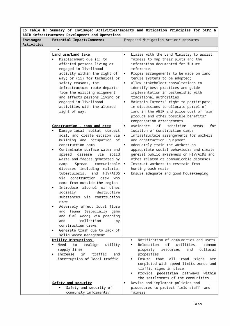
In Alape, Kabba-Bunu and Oshokosho, Lokoja the traditional council were satisfied with the process of consultations and stated that they have never seen it in that extensive manner before, and were convinced that the proponent will fulfil its covenant of compensating for their lost assets.Other areas such as Adavi, Okehi and Ijumu knew little about the project before now but were happy to embrace the project which they said will make a difference in the socio-economic landscape of their people.
This consultation which has started during project implementation will continue during implementation. To this end, the proponent is required to provide relevant materials in a timely manner prior to consultation and in a form and language that are understandable and accessible to the groups being consulted.
DisclosureThe ESMF has been prepared in consultation with the Federal level PMU, State MDAs, CBOs/NGOs and some community groups. The ESMF will be disclosed publicly as a separate and standalone document for review and comment through the Federal/State Ministries of Environment at designated locations at Federal, Kogi State and LGAs, and in World Bank Info-Shop. Individual ESIAs/ESMPs will be prepared for each sub-project based on the guidelines and procedures highlighted in this ESMF and will be disclosed in like manner.
xxv

,CHAPTER ONE PROJECT DESCRIPTION
1.1 Project BackgroundAgriculture has been acknowledged to possess the greatest potential for sustainable economic development especially in terms of its resource-based approach to growth. This notwithstanding, Nigeria’s comparative advantage in many agricultural products is being hampered by poor access to reasonably priced infrastructure and low cost financing along with problems in securing regular feedstock supplies. Also, the issue of instability in the policy and regulatory environment, which has been cited over the years to be the most common challenge to investment in building processing facilities across Nigeria, has been a factor militating against Nigeria's agricultural potential.
Nigeria’s food import bill of over two trillion naira annually is not only exceptionally high vis-à-vis its national income, but also has an unsustainable annual growth rate of 11%. Thus, in addition to Nigeria’s high rates of population growth, the rapid rate of urbanization and changing tastes as well as an ageing farming population would seem to dictate an even greater potential danger of its dependence on basic food imports. Such a high import dependency hurts Nigerian farmers, displacing local production and domestic unemployment (which grew from 4.3% in 1970 to 6.4% in 1980 and to 24% in 2011) while contributing to employment elsewhere. The high food import dependency also fuels domestic inflation and exposes the country, with high susceptibility, to shocks in global markets. This trend of dependency on food imports, with its attendant great danger for national food security, in a world where even the exporting countries are mindful about food adequacy, would therefore appear to be unacceptable and unsustainable fiscally, economically or politically. It is consequent upon this that the Government of Nigeria has come up with several initiatives, amongst which is the Agricultural Transformation Agenda (ATA), to redress the situation. The ATA is addressing the constraints inherent in the Nigerian Agricultural Sector with a view to unlocking its widely acknowledged potentials. Through a paradigm shift from government-controlled to private-sector led agriculture, ATA has deregulated the seed, fertilizer and mechanization sectors; improving farmers’ access to modern farm inputs.
In pursuing this agenda, the Federal Ministry for Agriculture and Rural Development (FMARD) in collaboration with the Government of Kogi State have earmarked 250ha for the establishment of the Staple Crop Processing Zone (SCPZ) and 280,000ha of land surrounding the SCPZ as Agribusiness Investment Region (ABIR) in which professionally managed farms produce the raw materials for the factories to be established in the SCPZ..
The general concept of the ABIR and the SCPZ Programs in particular adds to the vision of ATA by seeking to channel investments into infrastructure, and strengthening the policy and investment climate, in an ‘Economic Zone’ type of operating environment, for unlocking economies of scale and improving competitiveness for processing and value added activities. This should improve competitive cost structure for agro-processors in Nigeria, reduce the absorption of capital and operational costs and make them competitive in domestic, regional and global markets.
The SCPZ and ABIR in Kogi State is one of 6 such zones in Nigeria and Cargill Inc., which holds a 60% share in the Nigerian starch market, has expressed interest in setting up a starch processing and an animal feed plant in the CSCPC Kogi and to establish a 30,000ha farm to supply these factories. This large scale Foreign Direct Investment is likely to have a signal effect and result in other investors following in due course.
The Cargill farm and factories itself are expected to offer far reaching benefits including but not limited to the creation of more than US$550 million per year of additional incomes for local farmers and labourers. The key value addition is that the yield of professionally managed cassava farms is with 25 t/ha 66% higher than that of artisanal cassava farms (15 t/ha) and that the starch processed from this cassava farm replaces large parts of the starch presently imported by Cargill Inc. for the Nigerian food and beverage market. It is expected that around 7,500 farmer-households will be engaged in this value chain as Contract Farmers and an additional 1,000 as labourers.
1.2 Project Development Objective (PDO) and Guiding Principles of the SCPZThe Project Development Objective (PDO) is to support agricultural productivity growth and value-addition of targeted small and medium scale farmers by facilitating inclusive public and private investment in selected agribusiness clusters.
1

The concept of the Staple Crop Processing Zones under ATA as proposed by the Federal Government of Nigeria is based on the following three guiding principles: (i) take an integrated approach to the value chain by addressing critical upstream and downstream bottlenecks and facilitating market linkages; (ii) offer a superior operating environment that reduces the cost of doing business, and iii) take a private sector-led approach. The Operating Principles are the following; (i) investment-driven strategic partnerships with the private sector; (ii) integrated value chain approach; (iii) Self-sustaining, government-support and private sector managed.
The SCPZ program aims to channel infrastructure investments to facilitate efficient value chain linkages and reduce the cost of doing business, and improve the competitiveness of Nigeria’s agro-industrial production. By creating an enabling business environment around selected value chains clusters, the FGN and State Governments seek to attract private sector investors to set up processing plants in high food production areas, in order to boost import substitution, create wealth opportunities for farming communities, reduce post-harvest losses, create sustainable employment in agro-production, processing and related activities, and drive rapid rural development. In general a SCPZ consist of a core area of about 250 ha designated to host processing plants and other post-harvest activities, and the Agribusiness Investment Region (ABIR) which is the immediate surrounding production catchment area (30km around the core area) which is critical to ensuring adequate feedstock supplies to the SCPZ.
The project approach to the Government’s SCPZs Program consists of test running the concept gradually in one of site, as an integrated agribusiness supply chain project, with strong farmers –agribusiness linkages aim to overcome the multiple, interlocking constraints in infrastructure provision and productivity growth along agricultural supply chains.
The Project will focus its support on the cassava supply value chain in Kogi State, partnering with a leading global agribusiness company (Cargill) committed to pioneer industrial processing of cassava in Kogi State as the anchor investor in the Alape SCPZ site. The Project will also support the FGN to gradually expand the Program with an open window for technical assistance to a limited number of states with strong business case while developing a based framework developed and from Lessons learnt from the Alape SCPZ, in term of technical and institutional design, land safeguards management, partnership with investors and engaging with communities and other stakeholders. Kogi states net position in cassava production and business environment makes it a natural candidate to host the first model SCPZ. Identification of SCPZ sites across the country benefited from the use of available knowledge and evidence. The areas designated for the SCPZ including that of Kogi are based on the findings of spatial analysis in 2012 based on following selection criteria: agricultural potential, proximity to production clusters, and existence of clusters of agro-industrial activities, competitiveness, business environment for the private sector, and the state governments commitment to buy-in the project. For example, Kogi state is the largest producer of cassava in Nigeria. In 2012 alone, Kogi state produced over 4 million MT of fresh cassava tubers. In addition to being the largest producer, Kogi is also one of the states with significant net cassava surpluses making it a natural cluster for raw material supply. Related to net production position is the fact that cassava is not a major staple in Kogi state. In terms of enabling environment, World Bank doing business report ranks Kogi seventh (7) out of 36 States with respect to starting a new business.
1.3 Project location The proposed location spans across five Local Government Areas of Kogi State, Nigeria namely::Kabba-Bunu, Lokoja,Okehi, Adavi and Ijumu as depicted in Fig 1.1 although the exact location of each potential investments that would be financed under the Project is not yet known. Fig. 1.2 depicts the Proposed SCPZ and global 30Km radius of the ABIR
2

(FMARD/UNIDO,/MAHINDRA 2013)Figure1.1: Map of Nigeria showing Kogi State and the Proposed SCPZ & ABIR catchment area
1.4 Purpose of the ESMFAt the time of project preparation, the specific sites that the project would be implemented are not known in sufficient details. Therefore, there is a need for an ESMF to outline the principles and procedures that would be followed to ensure that implementation of SCPZ meets with the existing Environmental Impact Assessment (EIA) laws in Nigeria and World Bank safeguards policies. The ESMF spells out the Environmental and Social safeguards, institutional arrangements and capacity required to use the framework. This ensures that sub-projects under the SCPZ and listed related, associated and or induced activities in the ABIR as set forth in this document, meet the national and local E&S requirements, and also consistent with World Bank safeguards. The ESMF sets out basic principles and processes within which the sub-projects are implemented agreeable to all parties.
The other objectives of the ESMF include: Assessment of potential adverse E&S impacts commonly associated with the sub-projects
and the way to avoid, minimize or mitigate them; Establishment of clear procedures and methodologies for the E&S planning, review, approval
and implementation of sub-projects; Development of an ESA screening/initial assessment system to be used for sub-projects; and Specification of roles and responsibilities and the necessary reporting procedures for
managing and monitoring sub-project E&S concerns.
To realize the objectives of this ESMF, the scope of work include the following tasks: Task 1: Environmental screening and scoping; Task 2: Environmental policy and regulatory framework; Task 3: Potential positive and negative environmental and social impacts; Task 4: Analysis of environmental and social mitigation principles; Task 5: Development of environmental and social management plan to mitigate negative
impacts; Task 6: Institutional framework; Task 7: Training needs; and
3

Task 8: Public consultation.
1.5 Rationale for the ESMF and other Safeguards Instruments At the time of project preparation, the specific sites that the project would be implemented in are not known in sufficient details. While a master plan for the Kogi State SCPZ and ABIR has been developed, the specific sites for each of the core investment activities and infrastructures and the ancillary facilities are not known at this point in time in sufficient details. Therefore, there is a need for an environment and social management framework that outlines the principles and procedures that would be followed to ensure that implementation of SCPZ meets with the existing EIA law in Nigeria and World Bank Safeguards policies. This ESMF however, does not attempt to address site specific impacts related to individual undertakings (in any specific form) as the locations and extent of impacts or activities are not known at this preparatory stage.
This ESMF is prepared as a standalone document but aligned with two other standalone documents [Resettlement Policy Framework (RPF) and Integrated Pest Management Plan (IPMP)]` prepared in parallel for this proposed project. The ESMF provides guidance for addressing potential environmental and social impacts that may result from civil works as well as the overall transformation of the land expected in the SCPZ and ABIR, while the RPF establishes the resettlement and compensation principles, organizational arrangements and design criteria to be applied to meet the needs of the people who may be affected by the project activities requiring land acquisition and /or denial, restriction or loss of access to economic resources and the IPMP provides a comprehensive integrated management plan for pests in the SCPZ and related, associated or induced activities in the ABIR
1.6 Scope of the ESMF This ESMF outlines the process and procedure to be followed when any activity that will be financed under the Staple Crop Processing Zones (SCPZ) project has the potential to trigger any of the World Bank safeguard policies, especially Environmental Assessment, OP 4.01
For emphasis Staple Crop Processing Zones (SCPZ) covers the Staple Crop Processing Zones (SCPZ) Support Project and applies to the following:1. Investments directly funded by the SCZP Support Project, including infrastructure and other
investments anticipated to be financed under Components 1 and 2.2. Establishment of the SCPZ Core Area, comprising approximately 250 hectares, as well as
private investment by tenants in the SCPZ Core Area.3. Investment by the anchor tenant (expected to be Cargill) in the establishment of a nucleus
farm in the ABIR comprising approximately 30,000 hectares (final dimensions are still to be determined).
However, the Kogi State Government has, in addition, expressed its intention to apply the ESMF to subsequent SCPZ-related investments within the ABIR, in order to assure consistent management of environmental and social issues throughout the ABIR.
Thus for the purposes of this ESMF, therefore, the term “project” shall refer to the above three categories of activities, and the terms “sub-project”, environmental and social impacts “” mitigation measures, etc., shall have a corresponding meaning.
This ESMF includes details of the existing environmental laws and regulatory framework in the country; World Bank safeguard policies, analysis of environmental and social impacts including alternatives; institutional arrangements for implementing the ESMF, capacity building needs; and public consultation carried out during project preparation. The ESMF clarifies the environmental mitigation principles, organizational arrangements and design criteria to be applied to the project. The report provides basic information about the scope of adverse environmental and social impacts to be induced by project operations; mitigation and monitoring actions to be taken and indicative cost implications.
Specifically, the ESMF focuses on: assessing the potential environmental and social impacts of sub-projects, whether positive or
negative, and propose mitigation measures which will effectively address these impacts;
4

establishing clear directives and methodologies for the environmental and social screening of micro-projects to be financed under the project;
identifying the environmental policy, regulatory and institutional framework pertaining to the project;
Establishing social inclusiveness, especially vulnerable groups and mitigation of social exclusion
Guiding the development of specific Environmental and Social Impact Assessments (ESIAs) activity as might be needed for specific sub-projects.
1.7 Approach for the Preparation of ESMF The ESMF has been prepared in accordance with applicable World Bank safeguard policies and Nigeria environmental assessment act and guidelines, and which involves the following activities summarized in Fig 1.2:
Data Gathering; Participatory Public consultations and discussions with relevant sector institutions, including
non- governmental organizations (NGOs); Data collection and analysis, consisting of Literature reviews; Environmental and Social
screening and scoping studies; Determination of potential impacts; Identification of impacts mitigation measures; Preparation of an Environmental and Social
Management Plan; Review of comments from stakeholders; and Preparation and Submission of reports.
Figure1.2: ESMF Preparation Approach
5
Objectives of the ESMF
Potential Environmental and Social Impact Identification - Screening
Formulation of Environmental and Social Mitigation Measures for the Identified Impacts
Environmental & Social Data Collection
Review of relevant environmental and social document
Consultation with Community and Key Stakeholders
Field visits

CHAPTER TWO PROPOSED PROJECT ACTIVITIES
2.1 Project SetupThe SCPZ Support Project will contribute to the broader objectives of the FGN's SCPZ Program consisting of 'increasing food production and reducing the demand for imports, adding value through processing, reducing the cost of doing business for processors, and attracting new investment to create jobs, especially in rural areas, and to drive the economy'. The expansion of agribusiness - farmer linkages s under the SCPZ program through the right mix of public and private investments will ultimately improve agricultural productivity, generate shared growth and substantially reduce poverty in rural areas.
The management structure foresees that overall coordination and management will be under the responsibility of FMARD which will establish the following bodies:
A Project Steering Committee (PSC) to oversee project implementation. It will approve annual budgets and work programs, and technical and financial progress reports submitted by the PMU. It will ensure adequate articulation of project activities with the broader SCPZ Program and with national policies. It will be also in charge of supervising external monitoring and evaluation of project’s performance.
The SCPZ Program Coordination Team (PCT) established within FMARD will be the technical arm of the PSC. Under the leadership of the Director, Department of Agro-Processing and Marketing (APM), the PCT is composed of core dedicated FMARD personal and consultants, and desk officers from relevant MDAs. The PCT will benefit from the expertise of the United Nations Industrial Development Organization (UNIDO) in development of agro-industrial zones, through a senior technical advisor being selected. The PCT role is expected to be taken over by the SCPZ Authority once it is fully operational. In collaboration with the PMU, It will be charge of implementing part of Project support on institutional development, in particular Subcomponent 3.3 on the technical assistance to FMARD and SCPZ Authority to establishing regulatory rules, capitalizing and disseminating lessons learnt, and promoting the program, as well as providing technical assistance to selected states to roll out their SCPZ and agribusiness development programs.
A Project State Implementation Management Committee (SIMCO). A technical working group set at the state level to facilitate the coordination of project activities on the ground. It will be composed of the PMU core staff, representatives of the Governor and focal points in key relevant MDA at the State level. SPCZs Desk officers at federal level may also participate to meetings on request depending on the specific agenda and technical issues to be discussed. The PIC will be chaired by the PMU Director who will inform HMA, the Chairman of the PSC and the Governor of Kogi State on their deliberations for action. The SIMCO will evolve toward the SCPZ Executive Management Committee once the SCZ authority is full established and operational.
2.2 Direct Investment Components of the ProjectThe Project has four components as follows:
Component 1: Support to public infrastructure development for the Alape model SCPZ in Kogi State ($77.00 million, of which IDA will contribute $58.00 million): In line with international best practices, and considering that Kogi SCPZ is located in a remote area without access to any basic infrastructure, this component will support the Government in the following: (i) the development of off-site infrastructure including energy (electrical and thermal), access roads, and water supply to the SCPZ; (ii) preparation of the SCPZ development plan and provision of initial on-site infrastructure to ensure minimum utility services for up to 3 private investment projects; and (iii) social infrastructure for supporting productive activities taking place within both the SCPZ and the ABIR.
Component 2: Support to farmers-agribusiness linkage and to economic opportunities along the value chains ($25 million, of which IDA $15 million): This component is designed to strengthen linkages between investors in the SCPZ and local economy in the surrounding communities. It will benefit primarily farmers and SMEs, providing jobs and income opportunities in the ABIR. In coordination with FADAMA III/AF and other relevant operations in the portfolio, the project will provide support through an agribusiness service provider, to structure value
6

chains development programs that link farmers, SMEs and communities in the catchment areas, giving special consideration to women and youth, with agro-processing firms as follows: (i) Improving farmer’s productivity and (ii) Promotion of economic opportunities for the community.
Component 3: Institutional development in SCPZ ($27.50 million, of which IDA $17.50 million). A key requirement for the effective management of the project will be to create institutions that have the capacity to coordinate the complex set of technical inputs, engage in effective monitoring and evaluation, and are able to adapt their working methods according to lessons learned. Project support will focus on the following: (i) On-site Technical assistance for zone development, operation, and management, through a delivery partner, which will be an engineering firm or consortium of firms, competitively selected to to provide specialized skill required during discrete phases of the project ; (ii) Support to Kogi State Land Management Unit and to the implementation of safeguards instruments ; (iii) Support to FMARD and selected States for the development of agribusiness clusters.
Component 4: Project Management and Coordination ($11.50 million, of which IDA $9.50 million): This component will finance project management and coordination with the Program, M&E (including knowledge management, and impact evaluation), and communication. A dedicated project management and coordination structure will be set up before negotiations. A Project Management Unit will be established in Kogi State to lead and coordinate implementation of project activities, including the management of the designated account and project procurement activities. It will also support the gradual establishment of a Special Purpose Vehicle (SPV), which will be the permanent structure in charge of further development of the infrastructure, management and promotion of the zone.
2.3 The SCPZ and ABIR Development FootprintThe SCPZ and ABIR shall involve three categories of land use area zoned as follows and portrayed in Figures 2.1 and 2.2:
The SCPZ core area.This area shall comprise 250 hectares, made available by the State Government to the Federal Government for the creation of the processing zone, where agro-processing facilities will be established.
The Agribusiness Investment Region (ABIR).This is a 280,000 hectare area, more or less, within 30 km radius surrounding the SCPZ core area, and intended to meet the anticipated future demand of commercial agricultural producers associated with and supplying the SCPZ.
Land for infrastructure and other works financed by the project. The exact location and size of land required is not yet known. This category of land will overlap with the other categories.
The SCPZ core area and the ABIR are expected to be the site of investments requiring the allocation of significant quantities of land to the private sector. As the first private sector mover in the SCPZ, Cargill is currently in discussions with the Government of Nigeria and the Government of Kogi for access to land in both the SCPZ core area and the ABIR. To establish its cassava processing plant, Cargill is seeking approximately 50-60 hectares in the core zone (the Cargill Plant). Cargill is also negotiating an approximately 30,000 hectares in the ABIR (the Cargill Farm) in order to ensure a steady and sufficient supply of produce to the processing plant. The exact dimensions and boundaries of the Cargill Farm have not yet been defined, pending the outcome of ongoing discussions with local communities and Kogi State.
2.4 Delineation of Scope and Project Boundaries for Purposes of the ESMF of the ESMF This Environment and Social Management Framework (ESMF) has been prepared in connection with the Staple Crop Processing Zones (SCPZ) Support Project, comprising four components described at pages _below (hereafter, the “SCZP Support Project). The ESMF shall apply to significant adverse environmental and social management risks, impacts and mitigation in Kogi State resulting from the following:
1. Investments directly funded by the SCZP Support Project, including infrastructure and other investments anticipated to be financed under Components 1 and 2.
2. Establishment of the SCPZ Core Area, comprising approximately 250 hectares, as well as private investment by tenants in the SCPZ Core Area.
7

3. Investment by the anchor tenant (expected to be Cargill) in the establishment of a nucleus farm in the ABIR comprising approximately 30,000 hectares (final dimensions still to be determined).
For purposes of this ESMF, the term “Project” shall refer to the above three categories of activities, and the terms “sub-project”, “PAP” etc., shall have a corresponding meaning.The Kogi State Government has, in addition, expressed its intention to apply the ESMF to subsequent SCPZ-related investments within the ABIR, in order to assure consistent treatment throughout the ABIR. In short, the project area for purposes of this ESMF would be wherever Bank investments take place, plus the SCPZ Core Area, plus Cargill. In addition, the World Bank’s safeguards will apply to any SCPZ-related investment in the ABIR. Within the ABIR, investment not financed by the Bank, whether in whole or in part, investment not related to the SCPZ will not fall within World Bank safeguards policies.
(FMARD/UNIDO,/MAHINDRA 2013)Figure 2.1: The Alape SCPZ and ABIR in Kogi State-Nigeria
8

Figure. 2.2: The Proposed SCPZ and ABIR 30Km Radius Project Boundary
2.5 The Proposed Project ActivitiesThe proposed SCPZ and AGIR Development will transform 250ha of agricultural and undeveloped land into an agricultural production field processing zone and 280,000 ha or mostly agricultural and undeveloped land into large scale monoculture plantations. For the proposed investments directly supported by the Project, the land requirements expected for implementation of Component 1 of the Project are outlined in Table 2.1 with the list of the main proposed project activities.
Table 0.2: SCPZ Project Components and Main Proposed Project ActivitiesSCPZ Support Project Expected Land Requirement
SCPZ Support Project
Component Ha
Component 1.1: Power Generation 10 5.0 0.2 4.8
Component 1.2: Water Development 100 50 1.7 48.3
Component 1.3: Land clearance & roads 100 50 1.7 48.3
Component 1.4 Social Infrastructure 10 5 0.2 4.8
Proposed Project ActivitiesCrop production Agro processing Facilities Infrastructure Farm Establishment/Cultivation
Clearing of forest Development and operation of
agricultural fields Construction of weir/dams
Establishment and operation of facilities for processing of raw cassava tubers into starch, chips, garri, etc
Development of necessary support infrastructures (gas transmission line, water supply system,
As for the land required for the SCPZ Core Area, the Cargill Farm and future investments in the ABIR, the following three scenarios should be considered:
9

“Business as usual”: Under this scenario, despite the joint commitment of the Federal Government and Kogi State to establish an enabling investment environment through the SCPZ Support Project, no private investor uses this opportunity to establish a processing plant in the SCPZ and/or a professional managed farms in the ABIR. In turn, it can be expected that in such a scenario the SCPZ Support Project will not started or will stopped at an early stage and the land and resources of the SCPZ and ABIR continued to be used similar to a non-project scenario i.e. “business as usual”.
Cargill only: Cargill Inc. has made clear commitments to establish a Starch Processing Factory, a Chicken Animal Feed Factory and up to 30,000 ha of professional managed farmland, a portion of which will be subleased to Contract Farmers. Under this scenario, one would assume that no other investor will follow the Cargill model and that in the long run, the activities of the SCPZ Support Project are implemented, but only 50ha of the SCPZ and 30,000 ha of the ABIR managed professionally, while the rest will be occupied over time by small holder farmers and used similar to the “business as usual” scenario.
“Base case”: The base case scenario assumes that over time 60,000 ha of farm land will be put to professionally managed cultivation over the next 20 years to feed processing units, supporting multiple value chains involving processing capabilities such as starch, flour, animal feed, meat production, high value crops, and multiple supporting services, either directly to these value chains such as tractor and agrichemical distributors or indirectly such as banks, food and fuel retailing, etc. In the first phase of 5 years approximately 30,000 ha of land will be cultivated (i.e. the Cargill Scenario). In the second phase, professionally cultivated land will be increased to 40,000 ha by year 10. In subsequent phase productive land will be increased to at least 60,000 ha.
For purposes preparation of this ESMF, it has been assumed that the Cargill scenario will be realized over the short term and that some progress will be made toward securing subsequent investments in both the ABIR and SCPZ as envisaged under the Base Case scenario. The Safeguard instruments that will be supported by sub-component 3.2 of the project is intended to help the government and its partners appropriately guide and sequence the pace of SCPZ-related investment in the ABIR.
10

CHAPTER THREE POLICY, LEGAL AND INSTITUTIONAL FRAMEWORK
3.1 IntroductionThe environment has emerged as one of the most topical issues of contemporary times. This is in realization of the ever-increasing negative environmental impacts of rapid industrial development. As natural resources are being exploited at rates unprecedented in human history, the quality of the environment deteriorates and many of the development projects become unsustainable. This has therefore necessitated the enforcement of relevant environmental protection laws in order to protect and restore the Nigerian environment.
Thus the main aim of this Chapter is to review Nigerian legislation, guidelines and International conventions that are relevant to the proposed project. The legislation outlined in the foregoing parts of this chapter are derived from Nigerian Government laws and regulations, State and local Government laws as well as international conventions and other instruments that Nigeria is signatory to. The World Bank Safeguard Policies are also discussed in addition to other relevant voluntary standard tools.The Chapter is presented in Sections detailing, essentially, the relevant Administrative and legal framework/structure and then the relevant regulatory instrument and policies.
3.2 Administrative FrameworkThe relevant administrative structures are presented here below:
3.2.1 Federal Level Institution 1. National Council on EnvironmentThis consists of the Minister of Environment, Minister of State for Environment, and State Commissioners of Environment and is the apex policy making organ on environment. The Council participates in the formulation, coordination, harmonization and implementation of national sustainable development policies and measures for broad national development. The Council meets regularly to consider and receive States’ reports on environmental management; national environmental priorities and action plans as it affects Federal and State governments; and exchange ideas and information and where necessary the Federal Government through Federal Ministry of Environment gives financial and technical assistance to States having problems in implementing environmental policies.
2. The Federal Ministry of EnvironmentIn Nigeria, the power of regulation of all environmental matters is vested in the Federal Ministry of Environment (FMENV), hitherto, the now defunct Federal Environmental Protection Agency (FEPA) which was set up by Act 88, of 1988) Set up by Presidential Directive No. Ref. .No. SGF.6/S.221 of October 12, 1999.
The Ministry Is Empowered with regulation of all environmental matters, protecting, enhancing and preserving the Nigerian environment
Carries out the Federal Executive Council decisions on environmental matters. Mandated to co-ordinate the environmental protection and conservation of natural resources
for sustainable development in Nigeria some of which are: monitor and enforce environmental protection measures; enforce international laws, conventions, protocols and treaties on the environment; prescribe standards and make regulations on air quality, water quality, pollution and
effluent limitations, the atmosphere and ozone layer protection, control of toxic and hazardous substances; and
Promote cooperation with similar bodies in other countries and international agencies connected with environmental protection.
In response to her mandate the Ministry has developed far reaching legal reference instruments for
Achieving environmentally sound management of resources and sustainable development across all major sectors of the economy.
For enforcement mechanism the Ministry has two agencies namely:
11

National Oil Spill Detection and Response Agency set up by NOSDRA ACT, 2005 and National Environmental Standards and Regulations Enforcement Agency set by NESREA ACT 2007.
The National Environmental Standards and Regulations Enforcement Agency is most directly relevant to the proposed project.
3. National Environmental Standards and Regulations Enforcement AgencyThe Federal Government in line with Section 20 of the 1999 constitution of the Federal Republic of Nigeria established the National Environmental Standards and Regulations Enforcement Agency {NESREA} as a parastatal of the Federal Ministry of Environment.
The bill for an act establishing the agency was signed and published in the Federal Republic of Nigeria Official Gazette No.92, Vol. 94 of 31st July, 2007. By the NESREA Act, the Federal Environmental Protection Agency Act Cap F 10 LFN 2004 was repealed.
NESREA has responsibility for the protection and development of the environment, biodiversity conservation and sustainable development of Nigeria’s natural resources in general and environmental technology including coordination, and liaison with, relevant stakeholders within and outside Nigeria on matters of enforcement of environmental standards, regulations, rules, laws policies and guidelines. Its role in impact mitigation monitoring cannot be over emphasized in the SCPZ / ABIR project.
4. Federal Ministry of Agriculture and Rural Development (FMARD)The Federal Ministry of Agriculture and Rural Development ensures that the citizenry are provided with credible and timely information on government activities, programs and initiatives in the development of agriculture and food production; while creating an enabling technological environment for socio-economic development of the nation
As part of the Transformation Agenda for import substitution and creation of rural employment, saving foreign exchange, the Ministry has adopted a multi-disciplinary, private-public collaboration approach to increase crop yields such as for cassava and to organize farmers into cost-effective supply chains and link them to large scale factories; which in turn provides employment for landless labour and offers opportunity to develop the agro-service industry.
5. Federal Ministry of Water Resources (FMWR) The Federal Ministry of Water Resources (FMWR), initially created in 1976, is responsible for formulating and coordinating national water policies, management of water resources including allocations between states, and approving developmental projects. Specifically the functions of the FMWR include:
Establishment and operation of National Water Quality Laboratories and Monitoring Network and water quality standards.
Maintenance of database on water supply and sanitation facilities and performance. Mobilization of national and international funding and technical support. Promote and
coordinate other collaborative activities by other government and Nongovernmental agencies in the sector.
Provision of technical support and assistance to State and Local Government Water Supply and Sanitation Agencies and community water supply and sanitation committees.
Creation of an enabling environment for meaningful private sector participation in the sector. Provision of a framework for regulation of private sector participation in water supply and
sanitation. Assistance to individual agencies, and be responsible for the maintenance of the hydrological
primary network.
Specifically on the SCPZ, the ministry through the Nigeria Hydrological Service Agency (NIHSA) will provide the technical assistance on water resource (underground and surface water) assessment of the SCPZ and the ABIR in general. This will guide inform decision on water supply to the zone.
12

6. Federal Ministry of Worksa) Facilitate the rehabilitation of existing and construction of new access roads to link the
SCPZ and the surrounding ABIR with the national road network,b) Rehabilitate/expand feeder roads within the ABIR,c) Supervise any road construction by private investors to meet national standards.
7. Federal Ministry of Petroleum Resourcesa) Facilitating the extension of the national gas pipeline network to serve the SCPZb) Monitoring and supervision of design, construction and operations for the transportation
and storage of gas associated with the power supply to the SCPZ.
3.2.2 Legal and Administrative Structure at State LevelThe Nigerian constitution allows state to make legislation, laws and edicts on their environment. The relevant state structures are highlighted below:
1. Kogi State Ministry of Environment and Physical DevelopmentIn support of the FMENV Act and the need to protect public health and safety, and to restore and enhance environmental quality, and sustain economic vitality through effective and efficient implementation of environmental programmes, the State Government has set up
Kogi State Ministry of Environment and Physical Development to take charge of affairs relating to the Environment affairs in the States. This state government agency is responsible for the management of the environment in Kogi State and mirrors the responsibilities of the Federal Ministry of Environment at the state level. With it, the Department of Forestry is responsible for the forest reserves found across the state including the Oinye Forest Reserve, the Chokochoko Forest Reserves and others, as well as the management of production forests and plantations located within the ABIR.
2. Kogi State Ministry of Agriculture: With an estimated 75% of the population engaged in subsistence farming, the State Ministry of Agriculture is an important Ministry within Kogi State Government. The State Ministry is a strong supporter of the SCPZ Support Project and responsible for coordinating state-wide agricultural programs such as ABIR. The Ministry has four technical departments including the Agricultural Services department, which is most relevant for the Project. There are for Parastatals under the Ministry, these are:
Kogi State Agriculture Development Project; Kogi State Land Development Board; Agro-Allied Investment Company; and Kogi State Agriculture Trust Fund.
The Kogi State Ministry of Agriculture see the goals of the SCPZ to be a) increased cassava production to achieve import substitution, b) increase value chain addition through processing, c) reduce the cost of doing business for processors; and d) create jobs and derive rapid rural growth.
3. Kogi State Ministry of Lands The Land Use Act of 1978 transferred authority over land from customary oversight into the control and management of State Governors. The Kogi State Ministry of Lands is the authority that oversees land issues in Kogi State. This Ministry is responsible for the compulsory acquisition process and will be a key factor in the management of resettlement and in the compensation process.The roles of State Governments shall include:
a) Provide suitable land for the establishment of the SCPZ to FMRAD;b) Provide investors in the SCPZ with access to land in the ABIR for feedstock production
and related purposes;c) Enable the connection of the SCPZ to national and state level infrastructure by providing
the necessary land;d) Finalize the provision of relevant land titles to the local populations in the ABIR to assure
that they are compensated in line with the Resettlement Policy Framework for the ABIR in case of state sponsored land acquisition of agribusinesses;
e) Promoting minimal displacement of land holders within the SCPZ and ABIR through a zoning process that identifies and protects residential land as well as associated food
13

crop farms and ensuring that compensation is paid in line with the Resettlement Policy Framework for the ABIR;
f) Ensure the proper functioning of the SCPZ by participating actively in the governance of SCPZ through appropriate appointments to the Executive Management Committee of the Zones;
g) Promote the formation of Special Purpose Vehicles through Public Private Partnerships for the establishment, development and sustainability of SCPZ;
h) Facilitate the development of Agro-Industrial Towns within the ABIR;i) Facilitate harmonized land taxes for SCPZ investors in the ABIR and benefit sharing
schemes with the customary owners; andj) Provide transhuman populations with security of tenure to either settle down or continue
with their livelihood patterns.
3.2.3 Legal and Administrative Structure at Local Government AreaThe project affected Local Governments include Adavi, Ijumu, Kabba-Bunu and Lokoja Local Government Councils. These Local Government Councils, without any specific laws on environmental management are charged with the following responsibilities, inter alia:
Co-ordinating the activities of Local Government Council; Maintenance of Law and Order in collaboration with Law Enforcement Agencies; Collection of taxes and fees; Establishment and maintenance of cemeteries, burial grounds and homes for the destitute or
infirm Establishment, maintenance and regulation of markets, motor parks and public conveniences; Construction and maintenance of roads, streets, drains and other public highways, parks, and
open spaces; Naming of roads and streets, and numbering of houses; Provision and maintenance of public transportation and refuse disposal; and Registration of births, deaths and marriages;
The local government will be involved at project / sub project screening stage and ESIA review level.
3.2.4 International Level Institutions The mandate of United Nations Conference on Environment and Development (UNCED) emanates from General Assembly resolution 44/228 of 1992 which, inter alia, affirmed that UNCED should elaborate strategies and measures to halt and reverse the effects of environmental degradation in the context of increased national and international efforts to promote sustainable and environmentally sound development in all countries and that the promotion of economic growth in developing countries is essential to address problems of environmental degradationNigeria is a subscriber to these various mandates that have been enunciated and encouraged to maintain consistent positions in the various governing bodies and thus obliged to implement the various arrangements mandated, protocols, treaties and conventions through national legislation. Also, International Development Partners/Agencies such as World Bank and other financial organizations interested in development projects have also sets of environmental categorizations, assessments and management standards. The framework provided by these international organizations must be complied with by project proponents before these institutions invest in them.
3.3 Relevant Regulatory Instruments and Policies Below, an outline of the relevant regulatory instrument to the proposed project and this ESMF is given as they relate to the Federal, State and Local governments. Also highlighted are the applicable international protocols, treaties and conventions and the World Bank Safeguard Policies.
3.3.1 Federal Level Environmental Regulatory Instruments1. National Policy on Environment
The National Policy on Environment from 1989, which was significantly updated in 1999, provides “a viable national mechanism for cooperation, coordination and regular consultation, as well as harmonious management of the policy formulation and implementation process which requires the establishment of effective institutions and linkages within and among the various tiers of government – federal, state and local government”. The objective of the policy is to foster the sustainable management of natural resources in Nigeria through the provision of guidelines and strategies that
14

assure that the environment is of adequate quality to guarantee the health and well-being of citizens;
manage natural resources for the benefit of present and future generations; maintains, enhances and restores ecosystems and ecological processes that are essential for
the preservation of biological diversity; raise the public awareness and promote the understanding of essential linkages between the
environment and development; and cooperate with other countries, international organizations and agencies on the trans-boundary
environmental management.
2. Environmental Impact Assessment (EIA) Act No. 86 of 1992, CAP E12, LFN 2004The most relevant environmental regulations for the SCPZ Support Project and the sustainable management of the natural resources in the ABIR is the “EIA Act (No. 86 of 1992), which gives specific powers to the FMEnv to request and facilitate EIAs for all major public or private sector investments, i.e. any proposed physical work or activity that is likely to have significantly impacts on the environment. In effect, the decree deals with all EIA-related issues including: (a) timing and processing of EIA; (b) content of an EIA report including the factors to be considered in the EIA; (c) public involvement in the EIA process and public disclosure; (d) trans-boundary impact (covering state and international boundaries); (e) definition and requirement of environmental management plans for polluting development projects; (f) review of EIA and conflict resolution mechanisms; (g) powers of the FEPA now defunct to further regulate the EIA process; and, (h) lists of activities subject to mandatory EIA.
Further information on development project that requires an EIA based on the Act No. 86 of 1992 are provided in subsection 4.4 below.
As part of the effective utilization of the EIA tool, the Ministry has produced Sectoral guidelines detailing the necessary requirements of the EIA process from each Sector. One of these Sectoral Guidelines directly relevant to the proposed project is the 1995 National EIA Sectoral Guidelines for Agriculture and Rural Development. It contains a set of guidelines for the evaluation and mitigation of environmental impacts from a wide range of agricultural activities including but not limited to:
agricultural land development (bush clearing, land preparation and consolidation); large-scale farming; agro-industrial projects; dams and reservoirs; irrigation and drainage programs; and use of agro-chemicals and fertilizers.
There are other Sectoral Guidelines such as on Infrastructure Development which are relevant to the proposed project activities
3. National Environmental Standards and Regulation Enforcement Agency (NESREA) ACT 2007
The Act enables the Agency to prohibit the process and use of equipment or technology that undermine environmental quality; to conduct field follow-up of compliance with set standards and take procedures prescribed by law against any violator; Section 27 prohibits, without lawful authority, the discharge of hazardous substances into the environment.
Section 7 provides the Agency authority to ensure compliance with environmental laws, local and international, on environmental sanitation and pollution prevention and control through monitory and regulatory measures. While Section 8 (1)(K) empowers the Agency to make and review regulations on air and water quality, effluent limitations, control of harmful substances and other forms of environmental pollution and sanitation.
Regulations Gazette as supplementary to the NESREA Act and relevant to the proposed project are listed below: National Environmental (Sanitation and Wastes Control) Regulations, 2009. S. I. No. 28:
The purpose of this regulation is to provide the legal framework for the adoption of sustainable
15

and environment friendly practices in environmental sanitation and waste management to minimize pollution. This law will guide the general sanitation practices of different players throughout the phases of the proposed ABIR/SCPZ project.
National Environmental (Ozone Layer Protection) Regulations, 2009. S. I. No. 32: These provisions seek to prohibit the import, manufacture, sale and the use of ozone-depleting substances. This law prohibits the use of Ozone depletion substances and will guide the kind of chemicals that the processing plants and other manufacturing activities within the ABIR can use.
National Environmental (Noise Standards and Control) Regulations, 2009. S. I. No. 35: The main objective of the provisions of this Regulation is to ensure tranquility of the human environment or surrounding and their psychological well-being by regulating noise levels. Since the proposed project activities is a mixed development including industrial and residential, this law will guide the noise level at all phases (pre-construction, construction, operation and decommissioning) by different activities within the ABIR / SCPZ.
National Environmental (Construction Sector) Regulations, 2010. S. I. No. 19: The purpose of these Regulations is to prevent and minimize pollution from Construction, Decommissioning and Demolition Activities to the Nigerian Environment. This law will guide different construction and related activities within the proposed ABIR/SCPZ so as to ensure that such activity do not lead to pollution of whatever kind.
National Environmental (Control of Vehicular Emissions from Petrol and Diesel Engines) Regulations, 2010. S. I. No. 20: The purpose of this regulations is to restore, preserve and improve the quality of air. The standards contained herein provide for the protection of the air from pollutants from vehicular emission. This law will guide vehicular emissions and emission from agricultural machineries within the proposed ABIR/SCPZ.
National Environmental (Surface and Groundwater Quality Control) Regulations, 2010. S. I. No. 22: The purpose of this Regulation is to restore, enhance and preserve the physical, chemical and biological integrity of the nation's surface waters, and to maintain existing water uses. This law will guide the activities relation to water supply to the proposed ABIR/SCPZ.
Furthermore, the work of NESREA is guided by its corporate strategic plan that describes the scale of the environmental and social challenges, and explains how NESREA, with the support of other key stakeholders, addresses these issues around the following policies : Environmental Enforcement Policy: This policy aims at providing actions to take in enforcing
environmental legislation, standards, regulations and guidelines fairly and appropriately in a manner that will protect environmental quality and safeguard public health.
National Environmental Sanitation Policy: This policy seeks to stimulate, promote and strengthen all government regulations concerned with housing and urban development, food security water supply, sanitation related endemic diseases and illnesses, flood and erosion control, drought control, school health services and environmental education and is relevant with a view on the Agri-industrial City to be established in the ABIR as well as accommodation for Contract Farmers and Workers.
National Policy Guidelines on Sanitary Inspection of Premises: This policy seeks to promote clean and healthy environment for the populace.
National Policy Guidelines on Solid Waste Management: The aim of this policy is to improve and safeguard public health and welfare through efficient sanitary Solid Waste Management methods that will be economical, sustainable and guarantee sound environmental health.
National Policy Guidelines on Pest and Vector Control: This policy is to establish and strengthen pest and vector control units at the three tiers of government (see also the Integrated Pest Management Plan for the SCPZ Support Project and the ABIR).
National Training Manual on Food Sanitation for Food Handlers: The aim of this policy is to provide food handlers with the knowledge and skill required to ensure sound food sanitation practices in order to protect public health, promote quality of life and reduce poverty. While it is assumed that the agro-businesses to be established in SCPZ are professional enterprises, their work nevertheless must be in line with national standards and therefore the training manual and the supervision offered by NESREA is relevant for their work.
4 The Harmful Waste (Special Criminal Provision Etc.) Act 1988The Act was enacted with the specific object of prohibiting the carrying, depositing and dumping of hazardous wastes on any land, territorial waters and matters relating thereto. This Act is essentially a penal legislation. The offences are constituted as doing any of the act or omission stated in the
16

section 12 of the act. The jurisdiction of the Act is far reaching as it sought to remove any immunity conferred by diplomatic immunities and privileges Act on any offender for the purpose of criminal prosecution. Section 6 of the Act provides a very stringent sentence of life imprisonment and in addition the forfeiture of any aircraft, vehicle or land connected with or involved with the violation
5. National Guidelines on Environmental Management Systems (1999): The guidelines establish the requirement for an Environmental Management System (EMS) in ‘all organizations/facilities in Nigeria’. They also state that this EMS should be audited annually or as deemed necessary.
6. National Guidelines on Environmental Auditing (2001): These are designed to serve as a reference for compliance with the Environmental Audit requirements of the FMEnv. It states that it is mandatory for a company to carry out an audit every 3 years or at the discretion of the Hon. Minister of the FMEnv.
7. Natural Resources Conservation Council Act 286 of 1990 This Act is aimed at establishing the Natural Resources conservation council to be responsible for the conservation of natural resources of Nigeria and to formulate national policy for natural resources conservation.
8. Forest Law:The National Forest Law governs the forestry sector in the country. The Act provides for the preservation of forests and the setting up of forest reserves. Apart the National Forest Law, all states and the Federal Capital Territory have sub-national laws on forests (FRA Country Report: Nigeria, 2010). These sub-national regulations are largely drawn from national regulations. As a consequence of decentralization, the management and control of forests is vested in state governments, although dual ownership of natural forests by local and state governments still exists in the northern states. While local governments are responsible for communal forest areas in the northern states, state governments are in control of forest reserves, game reserves and sanctuaries in other parts of the country. The federal government is however in control of the national parks. The National Forest Policy provides also basic guidelines for states’ regulations and recognizes the role of communities in forest management as it calls for “innovative approaches to community participation in forest management on both forest reserves and forest areas outside forest reserves”. It states that to implement the policy, the government must develop a supportive legal basis for tree tenure, access rights, and the sharing of benefits from wood and non-wood forest products as well as a National Forestry Act. While the National Forestry Act includes community-based arrangements, decentralization of responsibilities and devolution of powers to local actors, neither the Tropical Forest Tenure Assessment of 2009 nor the FAO Forest Resources Assessment of 2010 could report that local communities own forestland or hold management rights over state lands. In that perspective, the forests and forest reserves in the ABIR remain legally under the management and control of the Kogi State Government rather than the local populations.
8. National Policy on Flood and Erosion Control 2006 (FMEnv)This policy addresses the need to combat erosion in the country utilizing the procedures outlined in the National Action Plan for Flood and Erosion Control and Technical Guidelines, developed by the WIC Environmental Committee which was set up to plan an operational platform for these issues.
9. Nigeria’s Local Agenda 21 Nigeria’s Local Agenda 21 programme seeks to:
integrate environment into development planning at all levels of government and the private sector;
commence a transition to sustainable development; address sectoral priorities, plans, policies and strategies for the major sectors
of the economy; and Simultaneously foster regional and global partnership.
10. Agriculture Sector related regulatory instrumentsAgriculture Sector Policies Sector-specific agricultural policies were largely designed to facilitate agricultural marketing, reduce agricultural production cost and enhance agricultural product prices as incentives for increased agricultural production. Major policy instruments for this purpose included
17

those targeted at agricultural commodity marketing and pricing, input supply and distribution, input price subsidy, land resource use, agricultural research, agricultural extension and technology transfer, agricultural mechanization, agricultural cooperatives and agricultural water resources and irrigation development This report shall limit its review to aspects of this policy as it relates specifically to agricultural water resources and irrigation development.
11. The Agricultural Transformation Agenda The Agricultural Transformation Agenda (ATA) is focused on building stronger and more inclusive growth in the non-oil sector, employment generation and poverty reduction including economic diversification. The ATA is a direct implementation response by the agricultural sector to the current administration’s Transformation Agenda (2011-2015) which derives from the vision 20:2020 and the 1st National Implementation Plan (NIP). Rather than trying to drive the entire agricultural sector forward at the same time as in many past strategy documents, the ATA focuses on a few key first moves - priority food staples and traditional export crops, and intends to develop these for growth and employment creation, with the expectation that the rest of the sector will subsequently follow.
Women play a prominent role in agriculture and women farmers are identified as a key target group in the ATA. Women are particularly active in trading and processing, which implies that the ATA’s emphasis on value chain development has the potential to benefit women. Also, women are key to improving nutrition outcomes in the country. Reducing women’s workloads through appropriate agricultural technologies, addressing their bargaining power within house- holds by enabling policies that put more income directly into the hands of women, are, for example, some key pathways to improving nutrition outcomes that can be enabled through the agriculture sector. Agricultural Transformation Agenda also focuses on: Deregulation of seed and fertilizer sectors Marketing reforms to structure markets Innovative financing for agriculture New agricultural investment framework.
12. Land Use Act of 1978: The Land Use Act, which was modified in 1990, remains the primary legal means to acquire land in the country. This is more so as it vests all land comprised in the territory of each state in the Federation in the Governor of the state and requires that such land shall be held in trust and administered for the use and common benefit of all Nigerians in accordance with the provisions of this Act. According to the Act, administration of land area is divided into urban land which will be directly under the control and management of the Governor of each State; and non-urban land, which will be under the control and management of the Local Government. State Governors are given the right to grant statutory rights of occupancy to any person or for any purpose; and the Local Government will have the right to grant customary rights of occupancy to any person or organization for agricultural, residential and other purposes. The acquisition of the land for the proposed SCPZ and the entire ABIR project will thus be governed by the provisions of this law and international best practice such as the World Bank Operational Policy 4.12 (Involuntary Resettlement) and in particular the provisions outlined in the Resettlement Policy Framework for the SCPZ and ABIR.
13. Draft National Building Code, 2006 The need to evolve a National Building Code arose from the following existing conditions of
Nigerian cities and environment: a. The absence of planning for our towns and cities; b. Incessant collapse of buildings, fire infernos, built environment abuse and other disasters; c. Dearth of referenced design standards for professionals; d. Use of non-professionals and quacks; e. Use of untested products and materials; f. Lack of maintenance culture The Code which is seen as opening a new vista in the Building Industry is aimed at
eliminating or reducing to the barest minimum the incidents of collapsed buildings in Nigeria and as well promotes safety and qualitative housing for every Nigerian.
State Governments are implored to integrate the provisions of this Code into their local laws particularly those relating to Design, Construction and Maintenance (Post Construction) and efficiently monitor the implementation of the code.
18

14. Inland Waterways Authority (NIWA, 1997): The NIWA is tasked to:
- provide regulations for inland navigation;- ensure the development of infrastructural facilities for a national inland waterways
network connecting the creeks and the rivers with the economic centers using the river-ports as nodal points for inter model exchange;
- ensure the development of local technical and managerial skill to meet the challenges of modern inland waterways transportation; and
- carry out environmental impact assessment of navigation and other dredging activities within the inland water and its right-of-ways.
This law becomes relevant for the ABIR and SCPZ in the short run with a view on the potential dam on River Oinye to provide water for SCPZ Project and in the long run with the potential extraction and transportation of water from the River Niger 20 km in the north of the ABIR as well as the planned graduation of Lokoja to an in-country port for large vessels travelling up the River Niger.
15. Water Resources Act 101 of 1993 This provision vests all water and water resources in the Federal Government of Nigeria and regulates the exploitation of water resources. It also vests in the Federal Government the rights and control of water in any water course affecting more than one state for the purpose, inter alia, of ensuring the application of appropriate standards and techniques for the investigation, use, control, protection, management and administration of water resources.
16. National Water Supply and Sanitation Policy (NWSSP) was adopted in January 2000. The centerpiece of this policy is the provision of sufficient potable water and adequate sanitation to all Nigerians in an affordable and sustainable way through participatory investment by the three tiers of government, the private sector and the beneficiary. The Policy sets consumption standards for Semi – urban (small towns) and Urban Water supply
17. Nigerian Standard for Drinking Water Quality, 2007 This standard is based on general principles of preventive, integrated and collaborative multi-
agency approach. This standard sets parameters and maximum allowable limits in drinking water in Nigeria. It also includes normative references/laws guiding drinking water quality, definition of
terminologies, institutional roles and responsibilities, monitoring, data management and compliance criteria.
In developing this Standard, references were made to the Nigerian Industrial Standards for Potable Water and Natural Mineral Water, the National Guidelines and Standards for Water Quality in Nigeria, the World Health Organization (WHO) guidelines for drinking water quality (3rd Edition) and International Standard Organization of Nigeria (ISO).
The principles - The effective protection of public health against water related diseases requires a preventive integrated management approach.
However, since the proposed SCPZ/ABIR project and its ancillaries will involve the extraction and utilization of large quantity of water resources from both underground and surface sources, the relevant water resources laws discussed above will be relevant in ensuring sustainable use.
18. Labour Act (1990): Nigeria has ratified all eight core Labor-Standard-Conventions of the International Labor
Organization. While Nigeria has ratified the core conventions and enacted laws to enforce the provisions, there are indications of restrictions on the trade union rights of workers in Nigeria, discrimination, child labor and forced labor. The Labor Act as the primary law protecting the employment rights of individual workers covers protection of wages; contracts; employment terms and conditions; recruitment; and classifies workers and special worker types. Union membership is governed by the Trade Union Amendment Act (1995). The 1999 Constitution further includes the objective for “equal pay for equal work without discrimination on account of sex, or any other ground whatsoever”, but implementation is reported to be slow.
19

19. The Factories Act (1990): This is the primary law regulating health, safety and welfare of workers in factories in the
country. The law holds management and staff personally responsible for violations of the provisions in the act. With respect to safety, there are general provisions as to the securing, fixing, usage, maintenance and storage of prime movers, transmission machinery, other machinery, unfenced machinery, dangerous liquids, automated machines, hoists and lifts, chains, ropes and lifting tackle, cranes and other lifting machines, steam boilers, steam receivers containers, and air receivers. There are in addition to these, standards set for the training and supervision of inexperienced workers, safe access to any work place, prevention of fire and safety arrangements in case of fire and first aid boxes. The law stipulates that it is mandatory that all accidents and industrial diseases be notified to the nearest inspector of factories and be investigated; it is prohibited for the occupier of a factory to make any deductions from the wages of any employee in respect of anything to be done or provided in pursuance of the Factories Act.
20. Criminal Code: The Nigerian Criminal Code makes it an offence punishable with up to 6 month imprisonment
for any person who:o Violates the atmosphere in any place so as to make it noxious to the health of persons in
general dwelling or carry on business in the neighborhood, or passing along a public way: or
o Does any act which is, and which he knows or has reason to believe to be likely to spread the infection of any disease dangerous to life, whether human or animals.
21. Public Health Law (L.N 47 of 1955, Cap 103) Provides justification for the execution of developmental projects under guidelines that
promote health by protecting the environment and safeguarding the health of humans. The Public Health laws empower Medical Officers of Health (operating at the Local
Government Council, under supervision of the State and Federal Ministries) to require, by implication, that individuals and groups ensure that their activities promote an environment that fosters good health (subsections 6 and 7(m).
3.3.2 State Level Some of the legal instruments put in place by the State for Environmental protection include the following: Kogi State Ministry of Environment and Physical Development: This state government agency
is responsible for the management of the environment in Kogi State and mirrors the responsibilities of the Federal Ministry of Environment at state level. With it, the Department of Forestry is responsible for the forest reserves found across the state including the Oinye Forest Reserve, the Chokochoko Forest Reserves and others as well as the management of production forests and plantations located within the ABIR.
Kogi State Ministry of Agriculture: With an estimated 75% of the population engaged in subsistence farming, the State Ministry of Agriculture is an important Ministry within Kogi State Government. The State Ministry is a strong supporter of the SCPZ Support Project and responsible for coordinating state-wide agricultural programs such as ABIR. The Ministry has four technical departments including the Agricultural Services department, which is most relevant for the Project. There are for Parastatals under the Ministry include: Kogi State Agriculture Development Project; Kogi State Land Development Board; Agro-Allied Investment Company; and Kogi State Agriculture Trust Fund.
The Kogi State Ministry of Agriculture sees the goals of the SCPZ to be a) increased cassava production to achieve import substitution, b) increase value chain addition through processing, c) reduce the cost of doing business for processors; and d) create jobs and derive rapid rural growth.
Kogi State Ministry of Lands. The Land Use Act of 1978 transferred authority over land from customary oversight into the control and management of State Governors. The Kogi State Ministry of Lands is the authority that oversees land issues in Kogi State. This Ministry is responsible for
20
the compulsory acquisition process and will be a key factor in the management of resettlement and in the compensation process.The roles of State Governments shall include:
Provide suitable land for the establishment of the SCPZ to FMRAD; Provide investors in the SCPZ with access to land in the ABIR for feedstock production
and related purposes; Enable the connection of the SCPZ to national and state level infrastructure by providing
the necessary land; Finalize the provision of relevant land titles to the local populations in the ABIR to assure
that they are compensated in line with the Resettlement Policy Framework for the ABIR in case of state sponsored land acquisition of agribusinesses;
Promoting minimal displacement of land holders within the SCPZ and ABIR through a zoning process that identifies and protects residential land as well as associated food crop farms and ensuring that compensation is paid in line with the Resettlement Policy Framework for the ABIR;
Ensure the proper functioning of the SCPZ by participating actively in the governance of SCPZ through appropriate appointments to the Executive Management Committee of the Zones;
Promote the formation of Special Purpose Vehicles through Public Private Partnerships for the establishment, development and sustainability of SCPZ;
Facilitate the development of Agro-Industrial Towns within the ABIR; Facilitate harmonized land taxes for SCPZ investors in the ABIR and benefit sharing
schemes with the customary owners; and Provide transhumant populations with security of tenure to either settle down or continue
with their livelihood patterns.
3.3.3 Applicable International Legal and Administrative Instruments Several international regulations, protocols, treaties and conventions have been signed by the World aimed at halting environmental degradation and thus protecting human health against possible adverse effects. Nigeria subscribes to a number of this International Regulations and Conventions relating to Environmental Protection. Some of the guidelines/conventions/treaties to which Nigeria is a signatory are below outlined:
Both the Vienna convention for the protection of the Ozone Layer and Montreal protocol for Control of Substances that deplete the ozone layer
Basel convention on the prevention of trans-boundary movement of hazardous wastes and their disposal.
Convention on the prevention of the international trade in endangered species (CITES) Convention on Biodiversity Convention on climate change Convention on Desertification Convention on Persistent Organic Pollutants World Health Organization (WHO) Health and Safety Component of EIA, 1987 E.t.c.
3.4 World Bank Safeguards PoliciesThe World Bank has 10+2 Environmental and Social Safeguard Policies to reduce or eliminate the adverse effects of development projects, and improve decision making for supported projects. These are summarized in shown in Box 2.1 are described in greater detail in Annex 1
While compliance with these safeguard policies is required to assure that the SCPZ Support Project is eligible for World Bank support, in a more general sense the safeguard policies are mitigation and management tools to address operational risks associated with the environmental and social performance of an investment. From that perspective, the Government of Nigeria and Kogi State will make
21
+OP 4.00 Use of Country Systems
Box 1: Operational Policy (OP)/Bank Procedure (BP) 4.01: Environmental Assessment

compliance with the safeguard policies of the World Bank a requirement for all investments in the SCPZ and the ABIR in Kogi State.The IFC and the World Bank Group have developed a set of Sectoral Environment, Health and Safety (EHS) Guidelines specific to particular industries sectors or types of projects.
3.4.1 World Bank Safeguards Policies Triggered by the Proposed ActivityThe proposed SCPZ Support Project and the associated overall development of the SCPZ and ABIR trigger seven out of the World Bank safeguard policies as indicated in Table 3.1 and has been screened to be a Category A project.
Table 3.1: World Bank Safeguard PoliciesS/N Safeguard Policies Safeguards
TriggeredReason
1 Environmental Assessment (OP/OB/GP 4.01)
Yes Activities including large scale farming, construction of several factories and the establishment of a new town and will have adverse effect on the environment. Also, the acquisition of land and resources for these activities will lead to economic and potentially physical displacement.
2 Natural Habitats (OP/BP 4.04)
Yes The activities outlined above require the significant conversion of significant areas of natural habitats. The right of way of some of the ancillary services such as pipeline may pass through sensitive ecosystem like wetland thereby causing disturbance and or damage to these ecosystems.
3 Pest Management (OP 4.09)
Yes The activities include large scale agricultural production and improved agricultural activities which could lead to increased use of pesticides. The IPMP report discusses the applicability of this policy in detail.
4 Indigenous peoples (OP 4.10)
No The people in the area are by the World Bank not considered as indigenous peoples.
5 Physical Cultural Heritage (OP 4.11)
Yes Civil works, including excavations (e.g. pipelines and construction of plants) and the transformation of land into farms will most likely not be able to avoid all cultural heritage sites as well as presently unknown sites that can be expected to be found in this area rich of cultural and historical values.
6 Involuntary Resettlement (OP/BP 4.12)
Yes The activities under the project as well as its associated activities will require the acquisition of up to 280,000 ha of land through expropriation procedures.
7 Forest (OP 4.36) Yes The establishment of the SCPZ and the ABIR will have impacts on the quality of natural forests, plantations and several protected areas located within the ABIR, even though the ecological value of the remaining forests in these forest reserves seems very limited.
8 Safety of Dams (OP/BP 4.37)
Yes The provision of water for SCPZ and ABIR development might impound streams water and require the establishment of weirs and/or dams. As it can be expected that these are small dams, generic dam safety measures designed by qualified engineers should be sufficient.
9 Projects on International Waterways (OP/BP/GP 7.50)
No Water will not be sourced from international waterway and the catchment area does not discharge into such.
10 Projects in Disputed Areas (OP/BP/GP 7.60)
No There are no records of disputes in the area of the SCPZ and ABIR beside of the normal conflicts between individual and collective land owners.
3.5 Comparison between Nigeria EIA Guidelines and World Bank EA Guidelines The Nigerian Environmental Impact Assessment Act (No. 86 of 1992) requires that all development projects be screened for their potential impacts. Based on the screening, a full, partial, or no
22

Environmental impact assessment may be required. Guidelines issued in 1995 direct the screening process. According to these guidelines: Category I projects require a full EIA. Such projects include large-scale activities like agriculture
development on 500 hectares or more, land reclamation of 50 hectares or more, fisheries that establish land based aquaculture of 50 hectares or more, forestry projects that converts more than 50 hectares, etc.
Category II projects require only a partial EIA that focuses on mitigation and environmental planning measures, unless the project is located near an environmentally sensitive area, in which case a full EIA is required.
Category III projects are those considered to have “essentially beneficial impacts” on the environment and for which the Federal Ministry of the Environment will prepare an Environmental Impact Statement, but which do not need an EIA.
With regard to EA, the World Bank categorized projects into: Category A: These projects are those whose impacts are sensitive, diverse, and
unprecedentedly, felt beyond the immediate project environment and are potentially irreversible over the long term. Such projects require full EA. The proposed project
Category B: These are projects that involve site specific and immediate project environment interactions. Specifically, they do not significantly affect human populations, alter natural systems and resources, consume much natural resources (e.g., ground water) or have adverse impacts that are not sensitive, diverse, unprecedented and are mostly reversible. Category B projects will require partial EA, and environmental and social action plans.
Category C: These are projects that are mostly benign in nature and are likely to have minimal or no adverse environmental impacts. Beyond screening, no further EA action is required, although some may require environmental and social action plans.
Category FI: A proposed project is classified as Category FI, if it provides funds through a financial intermediary to subprojects that may result in adverse environmental impacts. Here the financial intermediate is responsible for setting up an Environmental and Social Management Framework that supervises the establishment of EIAs in line with the World Bank System.
The World Bank Categorization (A, B, & C) corresponds in principle with the Nigeria EIA requirements of Category I, II and III as both use the level of impacts associated with a given project as trigger for the required environmental assessment. However, in the event of divergence between the two with regard to investments within the SCPZ and ABIR, the more stringent safeguard policy shall take precedence.
Thus, for the SCPZ and ABIR in Kogi State which is considered to be a category 1 project, the Nigeria’s EIA requirements and World Bank operational procedures both apply and require: Early consideration of environmental and social issues (starting at the screening stage); Identification and early consultation with stakeholders; Prevention of adverse impacts through the consideration of feasible alternatives; and Incorporation of mitigation measures into planning and (engineering) design.
3.6 Adequacy of the existing Institutional Framework for Addressing Potential Environmental & Social Issues in the SCPZ and ABIR in Kogi State
It is generally agreed that despite significant efforts at Federal, State and Local Government Level, the implementation of the existing environmental and social legislation is wanting as the capability in particular at state and local level to assure the sustainable management of natural resources and the enforcement of rules and regulations leaves room for improvement. The SCPZ Support Project therefore provides and opportunity for a significant investment into the enhancement of capabilities as well as the acquisition of equipment to enable the implementation of the provisions outlined in the ESMF and subsequent emanating instrument (ESIA/ESMP).
23

CHAPTER FOUR DESCRIPTION OF BIOPHYSICAL AND SOCIO-ECONOMIC ENVIRONMENT
4.1 LocationThe Kogi State SCPZ and ABIR is located in the old Kabba region in Kogi State of North Central Nigeria and covers parts of five Local Governmental Areas (LGA): Adavi,Ijumu, KabbaBunu, Lokoja and Okehi(Fig 4.1).
Figure 4.1: Kogi State showing the affected LGAs
4.2 Physical Environment
4.2.1 ClimateThe climate in the Kogi State SCPZ and ABIR is classified as ‘tropical savannah’ with two clearly marked seasons; wet (between April and October) and dry (between November and March). It is located within the humid tropical climatic region with rainfall being the single most important element for defining the climatic seasons. Average annual rainfall in the SCPZ and ABIR is about 1,140 mm, with the highest monthly rainfall occurring in September (on average, around 210 mm) and the lowest in December (on average, less than 3 mm).Table 4.1 Annual Rainfall in Lokoja (2002-2011).
Year2002 2003 2004 2005 2006 2007 2008 2009
2010 2011
Rainfall Amount (mm)
1276
923.6 1335
939.4 1684 1501 1312 1632
1071
931.5
Source: Nigeria Meteorological Agency (NIMET)Average temperatures remain fairly consistent throughout the year (fig 4.2), and these range from around 26oC in July to 32oC in March, with a pronounced dry season extending from November through to March. During this time, the climate is dominated by the dry north-eastern wind (‘Harmattan’).
24

Figure 4.2: Temperature Characteristics
The relative humidity value is high and correlates with the rainfall. Overall, an average of 75.08% and 57.42% are recorded at 10:00hrs and 16:00hrs local time. Further assessment shows that the highest values are recorded in the early mornings. The lowest value of 68% in the region is recorded in February. During the dry season, values between 65% and 75% are common, while 90% humidity can be recorded in the raining season.
Figure 4.3: Characteristics of Relative Humidity within the Project AreaThe predominant wind direction in the dry season is in north eastern directions, while in the wet season, the wind generally blows in a south-western direction. The wind speed is generally 2.4-4.5 knot. The intensity of the sunshine lasts longer in the dry season ranging between 7-9 hrs/day, while it is between 5-7 hrs/day in the wet season. The mean annual sunshine hour in the area is about 1,740 hours, with mean monthly values between 46 and 182 hours in July and January respectively (Fig 4.4).
Figure 4.4: Monthly Daily Sunshine Pattern in the Study Area
4.2.2 Air QualityGenerally, air quality in the SCPZ and ABIR complies with the standards of the Federal Ministry of Environment (FMEnv) and of the WHO. Existing data suggests low concentration of carbon monoxide (CO), hydrogen sulphide (H2S), sulphur dioxide (SO2), nitrogen oxide (NO2), dust, suspended
25

particulate matter (SPM), volatile organic carbon (CH4) and total hydrocarbon (THC). This may be explained by the low population density and absence of industrial development with the exception of Lokoja town, where the cement factory in Obajana has elevated dust levels along the main roads in the region.
4.2.3 GeologyKogi state has two main rock types, namely, basement complex rocks of the Precambrian age in the western half of the state and extending slightly eastwards beyond the lower Niger valley and the older sedimentary rocks in the eastern half. The various sedimentary rock groups extend along the banks of Rivers Niger and Benue and southeastwards through Enugu and Anambra states, to join the Udi Plateau.
4.2.4 Relief and DrainageThe physical features of the State are largely mountainous. It covers very large part of the State, most of which are rocky and of undulating high lands to average height of about 1,400m above sea level.The land rises from a about 300 metres along the NigerBenue conflute, to the heights of between 300 and 600 metres above sea level in the uplands. Agbaja Plateau, which ranges from 335 to 366 metres above sea level, and the much higher OkoroAgbo hills at Ogidi in ljumu LGA are some of the predominant to landforms of the state. The state is drained by the Niger and Benue rivers and their tributaries.
The confluence of the Niger and Benue rivers which could be viewed from the top of Mount Patti is located within the state. of The Benue river is navigable as far as Garua in the rainy season floods, but up to Makurdi in Benue State in the dry season (lloeje, 1979). The Mabolo (Anambra) is the biggest river in Igalaland. Mabolo, Okura, Ubele and Ofu rivers run off the DekinaAnkpaOturkpo watershed. Osome ra Falls at Kilometre Four on OkeneAjaokuta Road, of Ofejiji Falls in OkuraOlafia and Egeneja Warm id Spring in Bassa Local Government Area are other drainage features (Benue State, 1985). Areas such as Ajaokuta, Okene. Kabba and Lokoja are generally hilly and rocky, while areas such as Ankpa. Dekina. Ofu are fairly plain. The confluence of rivers Niger and Benue created alluvial fertile soil, which is very goal for crop production. Other smaller Fivers cover most parts of the State and empty into the Niger and Benue rivers.
The bigger rivers have wide flood plains such as the portion of the lower Niger in Kogi state, which is more than 1,600 metres wide at Lokoja, while the in small streams have narrow valleys. The general rain is undulating and characterised by high hills, Jos plateaus and numerous inselbergs and elongated a ridges.
4.2.5 Soils CharacteristicsThe flood plains of the Niger and Benue river valleys in Kogi State have the hydromorphic soils which contain a mixture of coarse alluvial and colluvial deposits (Areola, 1985). The alluvial soils along the valleys of the rivers are sandy, while the adjoining laterite soils are deeply weathered and grey or reddish in colour, sticky and permeable.
Available data suggests that six soil types can be found within the SCPZ and ABIR: lithosols, cambisols, luvisols, eroded soils, alluvial soils and arenosols. The soils are mostly coarse textured, ranging from loamy to sandy loam in the surface horizons and from sandy loam to clay in the subsurface horizon. The soil pH ranges from 5.3 to 7.0 and the organic matter content is generally low (0.46 to 1.54%), which reduces soil fertility. The Cation Exchange Capacity is generally low from within 1.44-16.07 meq/100g in the surface horizon and 1.61-24.18meq/100g at the subsurface horizons, which means that the soil has low potentials for retaining plant nutrients. During the dry season, the soils reduce in terms of plant nutrients, water holding capacity, moisture content, fertility etc and become generally more acidic.
4.2.6 HydrologyThe Kogi State SCPZ and ABIR is traversed from west to east by a network of seasonal (non-perennial) streams which converge to form the Oinye River, which further flows to the Obajana cement plant area where it is impounded for water supply purposes. Downstream of this dam, the river flows in a south-eastern direction as River Adankolo. To the extreme north of the ABIR one finds the River Epu, which flows in an eastward direction and empties into the River Niger. The extreme
26
south of the ABIR is demarcated by the Osara River, which is regulated through a dam (Osara Dam) and could serve as alternative source of water supply to the Kogi Stage ABIR and SCPZ. Based upon regional information there are indication of two types of aquiferin in the ABIR: an unconfined aquifer in the weathered Precambrian basement complex rocks with a water table approximately 20 to 30 m below the surface and an overburden aquifer in the younger sedimentary rocks and alluvium along the riverbeds. The overburden aquifer would typically consist of 2 to 3 layer sequences made up of sands, gravel, silts and clays. The groundwater resources are relatively undeveloped for community water supply purposes as the local settlement rely on 1 or 2 boreholes in the lower unconfined basement aquifer. They were constructed in recent years by the Kogi State Community and Social Development Agency (KGCSDA) with financial support from the World Bank. Other communities source their water from shallow, hand-dug wells, the semi-perennial Oinye river system and/or rainwater harvesting.Apart from turbidity, studies have shown that other parameters for measuring water quality were found to be much lower than the Federal Ministry of Environments’ limits. These parameters include total dissolved solids (TDS), chemical oxygen demand (COD), total alkanity, total hardness, chloride, phosphates, sulphates and nitrates and macro and trace minerals. Staphylococcus aureus and Pseudomonas fluorescens are the most abundant micro-organisms in the surface waters.
4.3 Biological Environment4.3.1 Fauna Based on existing literature, field observations and interactions with the locals, especially the hunters, different faunas have been identified to domicile in the proposed project location (Table 4.2 and 4.3).
Table 4.2: List of Fauna Identified in the Proposed Project Area
S/N Common name Species Family Group FMEnv& IUCN
StatusInsects & Organisms1 Dragon fly Acanthaeschna victoria Aeishnidae Insecta/Arthropoda Not threatened2 Termite Trinervitermestrinervoides Termitidae Insecta/Arthropoda Not threatened3 Black ant Lasiusniger Formicidae Insecta/Arthropoda Not threatened4 Moth Chrysiridiarhipheus Uraniidae Insecta/Arthropoda Not threatened
5 Red patch butterfly Chlosyne Rosita Nymphalidae Insecta/Arthropoda Not threatened
6 Beetle Lixusangustatus Curculionidae Insecta/Arthropoda Not threatened7 Giant wasp Ophionluteus Ichneumonidae Insecta Not threatened8 Earthworm Lumbricusterrestris Acanthodrilidae Annelida Not threatened9 Spider Eriophoratransmarina Araneidae Arachnida Not threatenedMAMMALS1 African giant rat Cricetomysgambianus Nesomyidae Mammal/Rodent Least Concern2 Ground squirrel Xeruserythropus Sciuridae Mammal Least Concern3 Rabbit Lepus sp. Leporidae Mammal EndangeredAVES1 Black Kite Milvusmigrans Accipitridae Aves Least Concern2 Pied Crow Corvusalbus Corvidae Chordata/Aves Least Concern3 Cattle egret Bubulcus ibis Ardeidae Aves Least ConcernREPTILES
1 Red Neck Cobra Najapallida Elapidae Reptilia Not Evaluated
2 Tree frog Litoriacaerulea Hylidae Amphibian/chordate Least concern3 Lizard Agama_agama Least concernMOLLUSCS1 Snail Achatinaachatina Achatinidae Mollusca/Gastropoda Not threatened2 A. marginata Achatinidae Mollusca/Gastropoda Not threatened3 Limicolaria aurora Achatinidae Mollusca/Gastropoda Not threatened4 Land Slug Limaxmaximus Limacidae Mollusca/Gastropoda Not threatenedOther Animals in the Area
S/N Common Name Scientific Name Status1 Monitor Lizard Varanusniloticus Endangered2 Royal Lizard Varanusexanthematicus Endangered
27

Table 4.2: List of Fauna Identified in the Proposed Project Area
S/N Common name Species Family Group FMEnv& IUCN
Status3 Little Egret Egretta alba Endangered4 Cattle Egret Ardeola ibis Endangered5 Nubian vulture Aegypiustracheliotus Endangered6 Palm nut vulture Gypohieraxangolensis Endangered7 West Africa River Eagle Halaetusvocifer Endangered8 Helmet guinea fowl Numidameleagris Threatened9 Crested guinea fowl Gutteraedourdi Endangered10 Crowned crane Balearicapavonina Endangered11 African grey parrot Psittaculaerithacus Endangered12 Roan Antelope Hippotragusequinus Endangered
4.3.2 VegetationThe vegetation can be divided into four zones made up of;
1. The flood plain complexes of savannah, which is a mixture of several vegetation types, found on river flood plains;
2. Mixed leguminous wooded savannah spread mg from Abugi through Koton-karfe. Itobe, Ajaokuta is characterized by mixed formation of trees, shrubs and grasses;
3. Most lowland forest of Savannah mosaic type - this is wooded savannah with Daniella Olivier and oil palms dominating. However, along the river valleys riparian forests are well developed;
4. In the rest of the State, particularly South of Idah, is a mixture of vegetation wooded savannah, rain and mangrove forests.
The rain forest belt (selva type) covers Dekina, Ofu, Ankpa, Olamaboro, Idah and Bassa local government areas with rich deciduous and occasional stunted trees including palms, Iroko, mahogany, akeeapple and other towering trees. Other LGAs are in the guinea savannah or parkland savannah belt with tall grasses and some trees.
These are green in the rainy season with fresh leaves and tall grasses, but the land is open during the dry season, showing charred trees and the remains of burnt grasses. The trees which grow in clusters are up to six metres tall, interspersed with grasses which grow up to about three metres.These trees include locust bean, shea butter, oil bean and the isoberlinia trees. The different types of vegetation are, however, not in their natural luxuriant state owing to the careless human use of the forest and the resultant derived deciduous and savannah vegetations.
Specifically around the proposed project area,typical plants found in include Daniella oliveri (copaiba), Prosopis africana (red mortal wood), Parkia biglobosa (locustbean plant), Melicia excelsa, Elaeis guineensis (oil palm), Syzygium guineense (waterberry tree orkerosene wood), Bombox buonopozense(red silk cotton tree), Khaya seneglensis (dry zonemahogany), Dalium guineense (velvet tamarind), Parinari curatellifolia (roughskinned plum),Eythropleum suaeolens (sasswood), Lophira lanceolata (red wood), Alstonia boonei, Pentaclatra macrophyla (oil bean tree),Hymenocardia acida (wedding heart), Vitex doniana (black plum) and Lannea species.
The dominant grasses and grassy materials make a continuous cover of the derived savanna land.Most of these grasses are perennial and grow to a height of about 3m. These include Hyparrheniainvolucrata, Andropogon gayanus, Andropogon tectorum, Loudetia flavida, Imperata cylindrica,Laucia spp,Panicum maximum, Ctenium newtonii, Diheteropogon grandiflorus, Rothboliacochinchinesi Schizachyrium sanguineum, Anthephora ampulacea, Pennisetum pedillcelatum,Aristida kerstingii, Pennisetum unisetum, Digitaria horizontalis, and Pennisetum purpurum.
There are several forbs interspaced among the grasses. These include Senna obtusifolia,Chamaecrista mimosoides, Crotalaria incana, Crotalaria retusa, Desmodium ascendens,Desmodium velutinum, Indigofera hirsuta, Eriosema laurentii, Sesbania sudanica, Stylosanthesmucronata, Tephrosia nana, Tephrosia peniculata, Vigna racemosa, Vigna reticulata, Tridaxprocumbens, Emilia sonchifolia, Ageratum conyzoides, Amaranthus spinosus, Aspilia africana,Nauclea latif
28

olia, Biden pilosa, Boerhavia diffusa, Boerhavia repens, Celosia argentea,Centrosema pubescens, Cleome rutidosperma, Euphorbia hirta, Gloriosa superba, Helianthusannuus, Hibiscus mutablilis, Ipomoea biloba, Mimosa pudica, Mirabilis jalapa, Mucana pruriens,Mucana utilis, Nicotianaplumbaginifolia, Sesamumradiatum, Solanum welwichii, Taliniumtriangulare, Stanchytarpheta jamaicensis, etc (Essien and Nkang, 2013).
There are other herbs which resemble grasses but are really not grasses. These include Afromomumdanielli (family Zingiberaceae), Ascolepis elata, Bulbostylis barbata, Cyperus rotundus, Kyllingaodorata, Mariscus alternifolius and Rhyncho sporatriflora. In addition to these, around settlment are established/introduced trees such as Gmelinaarborea, Eucalyptus spp, Tectona grandis, Mangifera indica, Citrus spp, Psiduimguajava,Anacardium occidentales, Azadirachta indica, and Cocos nucifera. Both cash and food crops suchas yam, cassava, maize, bean, rice, and melon are grownextensively. The plants in this ar aregreen in the rainy season with fresh leaves and tall grasses, but the land is open during the dryseason, showing charred trees and the remains of burnt grasses. The trees which grow in clusters areup to six meters tall, interspersed with grasses which grow up to about three meters. The differenttypes of plants are, however, not in their natural luxuriant state owing to the careless human use ofthe plant and the resultant deciduous and savanna vegetation.
4.3.3 Protected Areas and Sensitive HabitatsThere are fourforest reserves within the Kogi State SCPZ and ABIR, namely: :
1. Chokochoko Forest Reserve - 13,986 ha2. Oinyi Forest Reserve - 13,120 ha3. Olle Forest Reserve - 9,593 ha4. Bunu Forest Reserve - 51,842 ha
These forests reserves cover more or less a contiguous surface area with a few kilometers of savanna grasslands separating them (Fig 4.5). A report on “Nigeria’s path to sustainable development through green economy” concludes that “over 25,000 ha of gazetted forest are being lost to de-reservation annually” (Federal Government of Nigeria 2012:50). The same is true of these four forests which have not been managed or protected for decades and consequently most economic trees have been logged and the reserves opened up for farms etc. Today, the deforestation and degradation of the forest reserves is such that the ground habitat in and outside the forest reserves are identical and cannot be said to meet the criterion of “forests” as a biological category.
Figure 4.5: The Forest Reserves within proposed ABIR / SCPZ Area.
However, of all the known “forest reserve” in the Alape SCPZ / ABIR region only Chokochoko Forest Reserve has some historical legal records. Interaction with the local reveals that apart from this Chokochoko Forest Reserve the local communities were not aware of Oinyi Forest Reserve,Olle Forest Reserve and Bunu Forest Reserve.The community leaders mentained the fact that they are yet to be consulted by anygovernment official on the designation of these forest reserves nor hasany
29

government cameto either administer nor manage these forest reserves.However, Oinyi Forest Reserve is marked in national and international maps and documents such as the World Database of Protected Areas as provided by the Department of Forestry of the Federal Ministy of Agriculture and Rural Developemnt in 1978. The other forests “Olle Forest Reserve” and Bunu Forest Reserves” also appear in some government sketches / maps.In any case, the proposed SCPZ and ABIR activities shall be made to avoid any interference with forest reserves with adequate buffers
4.3.4 Drivers of Vegetation Cover Change In a seasonal trend analysis for the period between 2000-2010 study derived from the forestry monitoring and evaluation coordinating unit (FORMECU) by Adeofun, et al, land use land cover and rainfall were observed to be drivers of vegetation change in Kogi State. The study revealed that conversion to land use types such as built-up-area and agricultural land was attributed to a high population growth rate from 2,147,756m2 in 1991 to 3,314,043m2 in 2006 (FGEG 2007). Also, Nathaniel (2012) revealed in his study that there was a decrease of about -50.9 % in vegetation cover between 1986 and 2007. This conversion of vegetation into other land use land cover, coupled with climatic variation, has influence on vegetation greening-up and greening-down of the study area.
Table 4.3: Land-use and Land Cover Distribution of Kogi state (Area (Km2))Land cover categories Year 1976 Year 1995
Agricultural land 21902.65 23081.94Built-up-area 20.77 124.23
Disturbed forest 568.76 299.94
Forest plantation 2.20 39.14
Fresh water march/swamp 1319.37 333.32Riparian forest 1777.46 1027.92
Rock outcrop/un-vegetated area 73.11 65.10
Tree crop plantation 1.63 1.60
Undisturbed forest 1142.26 427.22Water body 5.17 73.88
Woodland savannah 2097.00 3100.22
Grassland 57.56 393.43
Total 28967.94 28967.94
Osunmadewa, B. And Christine Wessollek, C.(2012):
4.3.5 Ecological Problems: The ecological problems in the state are not necessarily peculiar to it. Some of these include leaching, erosion and general impoverishment of the soil. These problems are compounded by the annual bush burning of the savannah that further exposes the top soil to more erosion. Floods pose a problem on the flood plains during the rainy season, while aridity is a problem to several areas at short distances from the rivers during the dry season. Much damage is done to land and propertv as a result of these phenomena
4.4 Socio-Economic Background of Project Area and Environs
4.4.1 Brief History of State Kogi state formed in the year 1991 is located in the North central part of Nigeria with its capital at Lokoja. The state is regarded as the confluence state because of the meeting point of the two major rivers- Niger and Benue. Kogi state shares borders with the Federal Capital Territory to the north, Nasarawa state to the north east, Benue state to the east, Enugu state to south-east, Anambra state
30

to the south, Edo state to the south-west, Ondo and Ekiti states to the west, Kwara state to the north-west and Niger state to the north.
The State has a population of 3,928,799 as at 2013 (estimated from the Nigerian National 2006 population census) figure of 3,278,489 and a landmass of about 30,354.74 square kilometres with a population density of 284 per square kilometre. 4.4.2 The Core Area of the SCPZ and ABIR in Kogi StateThe proposed SCPZ and ABIR land area is located within five (5) Local Government Councils in Kogi state: Kabba-Bunu, Lokoja, Okehi, Adavi and Ijumu . In Table 4.4, the surface area, population, religion, settlements of migrants and livelihoods situation in the five local government of the proposed project are presented. In terms of land mass, Lokoja LGA has the largest surface area coverage of 3,243.32Sq Km, followed by Kabba – Bunu (2,757.57sq km). Okehi has the smallest of 672,582sq Km.In Table 4.5 an estimates of persons living in or near the SCPZ Core area and Cargill Farm are presented.
Source: SCPZ Safeguard Team (2014)Figure 4.6: SCPZ & ABIR indicating the Affected Communities and their LGAs
Table 4.4: Socio-Economic Data for the 5 LGAs affected by SCPZ and ABIRCategories LGAs
Adavi Ijumu Kabba-Bunu Lokoja OkehiSurface Area
730,608 1,328.284 2,757.57 3,243.32 672,582
Population Total=217,219Male = 108,891Female = 108,328
Total=118,593Male = 59,582Female = 59,011
Total=144,579Male = 72,639Female = 71,940
Total=196,643Male = 101,145Female = 95,498
Total=223,574Male = 112,879Female = 110,695
31

Religion Moslems = 60%Christians= 40%others = 0%
Moslems = 50%Christians= 50%others = 0%
Moslems = 40%Christians= 59%others = 1%
Moslems = 54%Christians= 45%others = 1%
No estimate
Settlements of Migrants
Iresuare farm settlement in Osara-Gada community
~ 2,000 Fulani
AyegunleAiye
~ 1,500 Fulani
Agbadu-Bunu, Ape and Odo-Ape, Tata, Apaa, and Aiyede Others are Ilegun, Kabba, Eshi, Ihaji, Tiv, Ebira,
~ 2,000Fulani
IwaaAmogbe,Oshokoshoko, Jakara, Apata, Hausa, Bassa and Tiv are around 20% of population
~ 2,000Fulani
Irukuochakoko,Ohu, Irukura
~ 2,000 Fulani
LivelihoodsAgriculture 94% 85% 90% 90% 90%Trading 0.5% 4.5% 1% 1% 3.5%Employment
0% 5% 2% 3% 5%
Pastoralism 5% 5% 5% 5% 0.5%Logging <0.1% <0.1% 0.5% 0.5% 0.5%Hunting 0.5% 0.5% 0.5% 0.5% 0.5%Fishing <0.1% <0.1% <0.1% <0.1% <0.1%Others <0.1% <0.1% 1% <0.1% <0.1%
Source: Safeguard Team Field Work (2014)
Table 4.5: Estimates of Persons Living in or near the SCPZ Core Area and Cargill FarmEthnic group Estimated number of
affected personsSettlement pattern
Bunu Communities(Indigene ethnic group, sub-group of Okun ethnicity)
4,800 living within the proposed farm area2,000 living outside the proposed farm area but cultivating fields within the proposed farm area
Large square, tin roofed huts Large, nucleated and accessible settlements along main roads and secondary roads. (Ape, Aiyede, Ighun, Tata, Ibori, Eshe, Oke Bukun, Ayegunle, Ode Ape, Agbadu, Apaa,Agbede)
Tiv communities (settler farmers from Benue State who arrived in the last 8 to 20 years)
1,440 living within the proposed farm area.
Small, scattered homesteads. Circular, thatched huts arranged in a circular pattern often around a central communal hut. Tiv settlements are clustered in the centre of the farm area
Fulani settlements(semi settled farmer-pastoralist arriving from northern Nigeria over the past 2 generations)
850 living within the proposed farm area.200 living just outside the farm area and cultivating or grazing within the farm area.
Groups of circular thatched huts arranged in a linear pattern. Cluster of settlements in southern part of proposed farm and along the eastern boundary.
Igbira settlements(settlers from Okene area of Kogi state)
410 living within the proposed farm area.
Clusters of square, usually tin roofed huts. Small settlements of up to 50 people.
Bassa farmers(settler farmers)
Not estimated Individual families living amongst Bunu communities
Nomadic Fulani (Bororo) Not estimated, no fixed dwellings,
Migration through the project area.
N.B: The configuration of the Cargill farm is still under discussion and final design is expected to result in significantly fewer PAP than indicated hereSource: PEIA fieldwork 2014 - Analysis of 2012 satellite imagery, GIS analysis.
32

4.4.3 Administrative StructureInformation about the traditional administrative structure within these communities is similar and shows that the governance structure is hierarchical formed around the traditional leadership. For example, community governance hierarchy follows a systematic order of household head, ward head, districts or clan chief and the Obaru as the head of the community. T he Obaru in each c o m m u n i t y reports to Olubunu o r t h e a p e x K i n g i n t h e L G A .The communities build their administrative structure around this chain of command which is based on the size of the population or domain that each leader has within his constituent/community.
4.4.4 Local Dispute Resolution ProcedureThere exists a traditional mechanism for dispute resolution in the communities structured after the order of the administrative command described above. An aggrieved person is required to lodge his/her complaint to the head of the ward or clan. A matter that is not adjudicated satisfactorily at this level is taken to the Obaru Council.
4.4.5 LiteracyThe outcome of the safeguard survey shows that illiteracy level is highest in Iresuare farm settlement within Osara-Ngada community in Adavi LGA and lowest in Ayegunle in Ijumu LGA. Table 3.2 below shows that at least 90% of the people met in Ayegunle attended primary education compared to 70% in Irukuochakoko, 65% in Oshokosho/Iwaa, 50% in Alape Kabba-Bunu and 20% in Iresuare.
Table 0-1: Education level i project areaLevel of Education in %
Settlements LGA No-formal education
Primary education
Secondary education
Tertiaryeducation
Iresuare Adavi 80% 20% 10% 2%Ayegunle Ijumu 10% 90% 60% 40%Alape Kabba-Bunu 50% 50% 20% 10%Oshokosho/ Iwaa
Lokoja 35% 65% 20% 10%
Irukuochakoko Okehi 30% 70% 20% 20%Source: Community Primary Survey (2014)
4.4.6 Agricultural Production and LivelihoodsAgricultural land use in the ABIR is characterized by arable land that supports the cultivation of cassava, yam, maize, sorghum and vegetables. Cash crops grown in the area are cocoa, coffee and cashew. About 90% of the population engages in agricultural activities as a major means of livelihood; although a large proportion of this (about 98%) consists of subsistence farming while the Fulani nomadic are found in cattle grazing activities.Other forms of livelihood and the estimated ratio of community participation are trading which accounts for 4% in Irukuochakoko, 1% in Oshokosho/Iwaa (Lokoja), 0.5% in Iresuare (Adavi) 4.5% in Ayegunle (Ijumu) and 1.5% in Alape (Kabba-Bunu). Those in employed job are few and are found in Irukuochakoko, Oshokosho and Ayegunle (Ijumu). Those in Ayegunle (5%) are employed by the local government council. Employment in Irukuochakoko is driven by women cloth weaving artisanship while Obajana Cement factory is the employer of the 3% population of Oshokosho and Iwaa.
Pastoralism is a livelihood in the area that is essentially practiced by the Fulani settlement and very few indigenes. This means of livelihood is approximately engaged by about 5% of the population in Adavi, Lokoja and Kabba-Bunu project areas.Prior to the project, there has been a recent effort, to increase agricultural production, by The Federal Government of Nigeria and the development partners (World Bank) aimed at the enhancement of farming production and processing in the area. This is through the FADAMA 3 project which is said to have been extended to Kabba-Bunu, Ijumu, Adavi and Okehi areas under the FADAMA additional financing. For example, the available boreholes, market shades and Garri processing equipment in Iresuare farm settlement is attributed to the FADAMA 3 additional financing project.
33

The outcome of the impact of the FADAMA 3 programmes on productivity, income and welfare of the people could not be ascertained as the programmes are said to be at early implementation stage in the area.
4.4.7 Women and their right to Ownership of Farmland in the ABIR communitiesThe Survey carried out in all the project area converged around the point that lands are culturally not owned by women. However, women interviewed on the field stated that they own farms and have access to farmland from their husbands and/or community heads on non-payment conditions. It is only in Alape, Kabba-Bunu through GEMS 3 systematic land titling report that land ownership to about 20% by women is recorded. This RPF survey traced the development to, widows who have direct transfer of the right to their late husband’s land inheritance and other categories to those who received land from the community for residential purposes.
4.4.8 Vulnerable peopleTo the extent that over 90% of the people of the project area depend on agriculture and land based resources for livelihood, significant acquisition of land for this project without proper mitigation measures will expose some social groups to economic vulnerability. This might include women farmers and women heads of households as well as aged people and people with disabilities. While the proportion of the potential vulnerable women and aged persons are not readily determined at this stage, the ratio of disabled people is estimated to account for less than 1% of the population of the communities.
4.4.9 Land Competition and ConflictThere is largely peaceful co-existence in the communities and among indigenes and settlers with respect to land use and social interactions. However, it is reported that there is a court case over the contention of the ownership of the Osara-Ngada land between Okehi and Adavi local government councils. Aside from this, there is a major incessant conflict, across the 5 local government areas, over the use of land by the Fulani pastoralists for grazing their cattle. Nomadic pastoralists have no land use rights and depend largely on the hospitality/generosity of their hosts. They may have access to routes, corridors/passageways for wildlife and domestic animals, indicating a desire by government to provide grazing land for both nomadic and settled pastoralists. However, existing grazing reserves are only rudimentary lacking any facilities. Thus, generally, nomads move to open pasture to raise stock as well as avoid contact with agricultural communities.The cattle movements avoid areas of tsetse fly infestation and other diseases and follow the location of farming communities for crops residues and markets for their products, thus trampling into the farm land. The increasing human population, irrigation and expansion of town and villages accelerated the encroachment of land cultivation and urbanization into grazing area and stock routes, leading to competition for resources and create farmer/herder clashes which have resulted in heavy losses in lives and properties. The local farmers claim that the Fulani’s cattle frequently destroy their crops, resulting in conflict which is sometimes violent.
4.4.10 Land Tenure and Land Use across the ABIR influence communities Detailed evaluations of land rights and use in the ABIR as a whole have not yet been conducted. However, a number of important assessments have been undertaken with respect to the land tentatively earmarked for the Cargill Farm, namely the PEIA Report and the Initial Land Tenure Assessment prepared by GEMS3. As of this time, a precise boundary for the Cargill area has not been determined and indeed, the design of the farm appears to be following an iterative process, taking into account new information about demographics and the location of communities, feedback from community consultations, issues raised during the aforementioned studies and Cargill’s own investigations, and other considerations. In principle, however, the expectation is that the Government of Kogi State will grant a certificate of occupancy for 99 years to Cargill for an area of up to 30,000 hectares for cassava plantation adjacent to the SCPZ core area. The area tentatively slated for Cargill is currently inhabited by a number of different communities, including so-called “indigene” Bunu communities, presided over by a number of different chiefs arrayed in a complex hierarchy. Other groups include “settlers” (mainly Tiv and Igbira) who obtain usufructory rights by paying small annual tribute to Bunu chiefs, and Fulani communities reside in and graze animals in the area, and in some cases engage in settled agriculture. Estimates vary as to the number of potentially affected people who live in the 30,000 hectare area, and final figures will depend on the configuration of the area, which is reportedly being revised to exclude some of the larger nucleated villages. In any event, it is likely that at least several thousand people utilize land within the area that Cargill anticipates
34

including in its farm. Land rights in the area are generally undocumented, governed by custom and few if any formal certificates of occupancy have been issued, especially with respect to agricultural land.
Clan and communal land ownership is practised in most of the communities while in Ayegunle (Ijumu LGA) there are a few land-owning families. Over 90% of the farmers across the project area are land owners while others who are not land owners including settlers have the privilege to farm land from the community through the community head. In terms of land use, the Fadama farmers and community elders informed that about 90% of the land area is used for agriculture, 2% is made up of water bodies, while about 8% is for settlement. The account of this differs only in Alape Kabba-Bunnu area where about 54% of total land area is used for agriculture, 23.45% for mixed vegetation, 2.76% is fresh water swamp (wet land) while 6.26% and 1.17% are for human settlements and water bodies respectively. Non-land owners in Kabba-Bunu and Lokoja project areas pay some form of royalty/rent (N2, 000 annually) to the community for the use of their land irrespective of the size of land occupied Annex 2 contains more detailed information on land tenure issues.
Meanwhile, Figure 4.6 and Table 4.6 provides a general land use map and existing land use classification of the proposed project area.
Figure 4.7: Land use Map of the Proposed Project (SCPZ & ABIR)
4.4.11 Infrastructure (Road and Electricity)The project area is characterized by huge physical infrastructural deficit. The Kabba-Bunu and Lokoja-Obajana road is in a dilapidated condition and makes it difficult for the movement of agricultural goods and services. This has been described as one of the reasons for low productivity and rural-urban migration amongst youth in the area. Major roads to farm settlements in Osara-Ngada, in Adavi, Oshokosho and Iwaa in Lokoja are unpaved and difficult to access by vehicles. Ijumu and Irukuochakoko project areas are relatively accessible by vehicle but the farm roads are narrow and in a poor state of repair.Most of the project area, except Alape, is connected to The National Grid. This development however, does not in any way translate to power availability as the communities except Obajana area (supplied by Dangote group) make use of local generators for energy supply.
35

4.4.12 Water Supply for Domestic UseThe communities in the project areas rely on boreholes, wells and streams for their water supply. The number of available and functional boreholes are quite few and inadequate in many of the communities
4.4.13 Health facilities and Prevalent DiseasesA common trend across the project area is the availability of primary health centres across the communities in the project area. However, secondary health facilities (general hospitals) are located in the major towns such as Lokoja and Kabba which are about 10 kilometres away or more from the rural people. Common sicknesses reported in the project areas are: malaria, typhoid and rheumatism.
36

CHAPTER FIVE DESCRIPTION OF POTENTIAL ENVIRONMENTAL AND SOCIAL IMPACTS
This Section five contains a preliminary summary of the impacts that are likely to result from the project as a result of the interaction between the project components and the environmental elements. It should be noted that the impacts identified here are preliminary in nature. The potential for occurrence of the impacts identified has to be ascertained during further stages of the project and investment design and development.
5.1 Environmental and Social Screening ProcessThe screening process is the first step in operationalizing the ESMF process. Environmental and Social screening process distinguishes sub-projects and activities that will require thorough review vis-à-vis developing preventive and mitigation measures for those that would have adverse negative impacts and enhancing the opportunities to due to those with positive impacts. To this end, the screening is directed at identifying those sub-projects activities that have minimal/no environmental or social concerns so that they can move to implementation stage in accordance with pre-approved standards or codes of practices for environmental and social management while those identified to have adverse/more significant impacts are elaborated on and appropriate mitigation measures and management plan designed for ensuring social-environmental sustainability. The extent of elaboration of environmental and social work that might be required for the project prior to implementation will depend on the outcome of the screening process.Every subproject proposal funded under the SCPZ and by extension ABIR will undergo an environmental and social screening process before it is selected for implementation. The screening process will establish the level of environmental and social assessment required, as well as help the PMU to understand the environmental and social issues related to the project before they are considered for implementation and thus assist in the decision making process.
Thus the environmental and social screening conducted as part of the ESMF was intended to provide inputs into the initial identification of potential impacts with the implementation of the proposed project activities in the SCPZ and ABIR.
5.2 Environmental Screening CriteriaGenerally, the screening exercise will be carried out prior to initiation of any project preparation activities. The screening exercise will be used as a tool to identify the severity of impacts of environmental and social issues, and thereby integrate their mitigation measures into the project preparation accordingly. The screening criteria include the following, inter alia:
1. Environmental factors such as;• Sensitive areas, natural habitats, declared forest reserves and sensitive areas• Felling of trees/clearance of non-agricultural vegetative cover• Loss of productive agricultural land• Impacts on seasonal (non-perennial) streams/rivers• Vulnerability to natural hazards, landslides/slips where slope angle is greater than 40%, soil
erosion and,• Environmental features as wet lands, protected ground water zone, • Etc
2. Social factors such as;• Land availability to peasant farmers particularly small hold farming • Loss of structures including farmlands and ancestral land.• Loss of livelihood including farmlands and economic trees• Impacts on common property resources• Etc.
The screening shall provide information on the categories of subprojects for inclusion in the project and categories of subprojects to be excluded in sensitive areas through exclusion criteria.
The categorization shall be done through the use of an Environmental Screening Checklist of the proposed projects to determine if they fall under any EA Category A, B or C as mentioned in Section 3.5 Chapter 3. For instance, Category B Projects will result in adverse environmental impacts on human populations or environmentally important areas--including wetlands, forests, grasslands, and
37

other natural habitats-that are less adverse than those of Category A projects which are more severe in the light of the core investment activities of the project including the infrastructures the gas and power connections, road improvements, water works, etc. in both the SCPZ and ABIR. In general, such impacts are localized, do not affect sensitive area/resources, and reversible, unlike Category A projects. While all category A projects will require EA/ESIA with development of adequate ESMP, category B projects will require only an ESMP. Category C - Projects are generally benign and typically do not require EA. However, all such subprojects shall be screened to determine if specific environmental management plans (e.g., waste management plan) are required.
Annex 3 presents an indicative Environmental & Social Screening checklist that could be used in the screening of projects. Fig.2 presents a diagrammatic representation of steps in the environmental and social Screening processes to be followed in determining the level of impact and assessment of all stages in project development. . In addition, each sub-project planned for implementation under the project shall be screened for possible triggering of OP4.12 (Involuntary Resettlement) and the processes and procedures have adequately been captured in the RPF prepared alongside this ESMF.The report on the outcome of the screening, scoping and EA category and so on will be sent to the World Bank for clearance.
Figure 5.1: Steps in Environmental and Social Screening Processes
5.3 Project-Level Environmental and Social ReviewsThe application of ESMF to the SCPZ/ABIR subprojects enables preparation of a standardized environmental and social assessment documents for appraisal and implementation. This is because subprojects triggering significant environmental and social impacts, i.e. subprojects with potential to trigger impacts on environmental sensitive areas, or resettlement activities. For instance, are envisaged under the project. To this end, all subprojects shall undertake the necessary environmental and social assessments, as mandated by the Environmental laws of Nigerian Governments (national
38

and state) and in conformance to the safeguard policies of the World Bank and in line with the processes/procedures defined in this framework. The criteria established as per the Checklist of items shall enable the appropriate categorization of all (sub) projects.
At the stage of detailed project preparation, ESIA shall be used to evaluate a subproject’s potential environmental risks and impacts in its area of influence; identifies ways of improving project planning, design and implementation by preventing, minimizing, mitigating, or compensating for adverse environmental and social impacts and enhancing positive impacts, including throughout the project implementation. The World Bank favours preventative measures over mitigation or compensatory measures, whenever feasible.
Any significant environmental and social issues that may arise would be addressed and mitigated through an ESMP. The environmental management measures through the ESMP should be included as part of the specifications and codified in the bidding documents to ensure implementation.
The ESIA or standalone ESMP documents need to be prepared by a Consultant in accordance with the Typical TORs presented in Annexes 4 and 5 for Environmental Assessment and ESMP preparation, as the case may be. Below an outline of how the ESIA should be carried out are outlined:
5.3.1 Environmental and Social Impact AssessmentThe screening determines whether the proposed project requires a further ESIA or not. If it is determined that the project requires an ESIA, then the scoping is carried out to determine the coverage or scope of the ESIA study.
The necessary steps in conducting an ESIA are listed below: Step 1: Scoping and Terms of Reference
- a process to identify issues relevant for ESIA consideration and determine assessment methods to be used.
- Terms of Reference (ToR) for the ESIA study is normally prepared as an output of the scoping exercise. The ToR needs to be approved by the Ministry of Environment and the World Bank before proceeding with the ESIA.
Step 2: Baseline Data CollectionBaseline data pertaining to physical, biological, socio-economic domain cum health issues is collected to describe the status and trends of environmental and social factors against which predicted changes can be compared and evaluated.
Step 3: Identify Environmental ImpactsThe ESIA exercise will identify potential impacts and assess its significance. The categories of impacts, direct, indirect or cumulative, should be indicated.
Step 4: Design Mitigation MeasuresThe mitigation measures should include analysis of project alternatives, compensatory measures, corrective measures and preventive measures.
Step 5: Public Consultation and ParticipationThe ESIA should consider public perspective and include them in the entire assessment process and should start early in the process.
Step 6: Develop Environmental and Social Management Plan (ESMP)The ESMP should be developed primarily to document key environmental issues likely to arise from project implementation, prescribe mitigation measures to be integrated in the project design, design monitoring and evaluation schedules to be implemented during project construction and operation, and estimate costs required for implementing mitigation measures. This plan must be reviewed by the project management and approved before any construction activity is initiated by any sub-project.
Step 7: Prepare ESIA Report
39

The ESIA report should be prepared in line with the Ministry of Environment and World Bank Format.
Step 8: ClearanceAll ESIAs/ESMP will be sent to the World Bank for review and clearance to ensure compliance with OP4.01 and any other relevant policies, procedures and guidelines. The report will also be reviewed by the Federal Ministry of Environment with all the necessary and relevant disclosures
5.3.2 Method of Impact Assessment for the ESMFIn the development of the potential impacts, environmental and social issues common to core investment activities were identified and listed in a checklist. These were presented to the individuals at the stakeholder meetings and the representatives of the organizations met during the consultations. Based on the local knowledge of the stakeholders and the available literature and field survey, the common issues were identified. Based on this, a generally simplified environmental impact matrix that links project activities with some socio-environmental components that could be used for the ESIA is presented in Annex 6.
5.4 The Potential Positive Impacts The project is envisaged to have a range of positive environmental and social impacts. Some of these are a function of the objectives of the project, while others are a function of the way in which the project is designed to meet its objectives.
Specifically, the following are some of the benefits that could be due to the project:: Improved soil conservation Increased farm incomes from crop output and ensuring dignity in farming practices Food Security Poverty Alleviation Elevation of rural income and national economy Improved nutrition Employment creation for community members Empowerment of farmers Enhanced gender opportunities Improved infrastructure Improved health care Attainment of the Agricultural transformation agenda of the federal government
5.4.1 The Potential Negative Impacts The potential negative impacts that could emanate from the project are presented in Tables 5.1 and 5.2 for the Agricultural activities & Agro Processing facilities and infrastructural development, in both the SCPZ and ABIR, respectively.
Table 5.1: Potential Negative Impact of the Agricultural activities & Agro ProcessingFacilities in SCPZ and ABIR
Envisaged Activities
Potential Impact/Concerns
Agricultural activities Crop production that involves Clearing of forest, development and operation of agricultural fields, Construction of Weirs, etc.
D. Environmental Biodiversity
Interference on biodiversity conservation (changes in flora and fauna) Cultivation of only cassava may alter natural vegetation; Fire prevention and control
Water Resources Alterations of local natural water cycles/ hydrology Weirs create a barrier across the river that can lead to water rationing for the
downstream riparian communities Weirs can be dangerous with regard to safety Water quality issues
Soils Cassava cultivation continuous growth deplete soil fertility and grown on slope
provides little protection from the direct impact of rainfall
40

Table 5.1: Potential Negative Impact of the Agricultural activities & Agro ProcessingFacilities in SCPZ and ABIR
Envisaged Activities
Potential Impact/Concerns
Changes in soil nutrient cycles (fertility and carbon storage capacity) Soil structure and surface layer disruption due to agronomic practices
Air quality Degradation due to vehicular movement, mobilization of equipment Deterioration from burning of biomass of cleared forest and addition of carbon into
atmosphere Climate Change
Cassava is a drought-tolerant crop but long drought affects its growth especially when it occurs after planting
Cassava tubers rot if waterlogging stays longer than a weekPesticides and Chemical Use
Lethal and sub-lethal impacts on other non-target biota; ‘Pesticide treadmill’- higher and higher doses of pesticides required to control pest
populations that develop resistance and elimination of pest predators. Washed out of soils, and pollute rivers and groundwater Intake of toxic chemicals by plants, animals and humans Improper use, contamination by high exposure due to no or poor precautionary
measures leading to health impactsWaste Management
Agricultural waste, fertiliser and chemical containers improper disposal
SOCIALLand take
Land acquisition and compensation issues increased values in land prices leading to economic displacement of poor land tenants
Displacement Maintaining Livelihoods Loss of fallow and agricultural Land Loss of employment (land based wage employment and workers) Elimination of smallholder farmers Increasing demand for lands for farming/ settlements by fringe communities because
productive lands not available;
Cultural Heritage Chance finds of cultural resources Interference with local cultural identity and heritage
Social Tension,& conflict Restriction and outright loss of grazing ground Social exclusion of women or the vulnerable persons
Traffic and Transportation Increase in traffic on the roads Accident to people and animals
Public and Occupational health and safety Lack of awareness creation programs on health and safety including chemical
handling. Unavailability and poor use of personal protective equipment and limited/ no
enforcement process Influx of people resulting in spread of communication diseases
Safety and security Safety and security of community informants/ whistle blowers Safety and security of project field staff
41

Table 5.1: Potential Negative Impact of the Agricultural activities & Agro ProcessingFacilities in SCPZ and ABIR
Envisaged Activities
Potential Impact/Concerns
Cassava Processing which involves Dealing with waste, Treatment technologies for wastes from processing, etc
Cassava Processing Pollution of Waters Pollution of environment due to processing with high concentration of organic matter,
cyanide and processing chemicals Solid wastes Generation lead to foul odor, especially from the final slurry waste and
leachates formed by rain Visual impacts due to unsightly stagnant ponds and ditches Dust emissions from milling operations
Table 5.2: Summary of Envisaged Activities/Impacts and Mitigation Measures SCPZ & ABIR infrastructures Development and Operations*Envisaged Activities
Potential Impact/Concerns
Development of Gas PipelineTransmission Lines, Water supply system, Access Roads,, etc
All with the following common activities:
Site clearing and/or leveling, Compacting & Blasting, Use of heavy equipment and hazardous materials, Material Extraction/quarrying, Slope stability/Excavation, cutting, and filling, Hazardous materials storage and disposal, Waste management, Construction
Environmental BiodiversitySite clearing and/or leveling with
Damage to sensitive terrestrial ecosystems (changes in flora and fauna) Development of bare soil which cause erosion, siltation, changes in natural water flow,
and/or damage to aquatic ecosystems Endangering of Species (flora and fauna
Water Resources and Drainage Alterations in local natural water cycles/ hydrology Scour and erosion below unprotected drainage out falls Disruption of groundwater or drinking or irrigation water
Soils and Slope stability/Excavation,cutting, and filling Landslides or other forms of mass instability on slopes Development of erosion or gullies Crosses of major areas of deep- seated instability When excavated soil is piled inappropriately cause erosion, siltation, changes in natural
water flow, and damage to aquatic ecosystems Destroy valuable ecosystems when fill is inappropriately placed such as on water courses
and land subsidence Exposure of inhabitants and crew to risk of falls and injuries in excavation pitsAir quality and Noise
Degradation due to vehicular movement, mobilization of equipment, construction activities such as earthworks,
Deterioration from burning of biomass from clearing and addition of carbon into atmosphere
Use of heavy equipment and hazardous Materials Cause erosion due to machinery tracks, damage to roads, stream banks Compact soil, change surface and groundwater flows, and adversely affect future use
for agriculture Contaminate ground or surface water when hydraulic oil, motor oil or other harmful
mechanical fluids are spilled or dumped Put workers at risk from exposure to hazardous materials Spills, leaks or injuries from any type of hazardous material (e.g. bitumen, cement,
paint, explosives, fuels, lubricants) Improper use, contamination by high exposure, no precautionary measures leading to
health impacts
42

Table 5.2: Summary of Envisaged Activities/Impacts and Mitigation Measures SCPZ & ABIR infrastructures Development and Operations*Envisaged Activities
Potential Impact/Concerns
camp and crew set up, and Land use/Land take
High volume of waste/spoil Spoil tipped away from designated areas and failing or being washed on the farmland
Waste Management Construction and other types of waste generated
SOCIAL
Land use/Land take Displacement due (i) to affected persons living or engaged in livelihood activity within the
right of way; or (ii) for technical or safety reasons, the infrastructure route departs from the existing alignment and affects persons living or engaged in livelihood activities with the altered right of way.
Construction - camp and crew Damage local habitat, compact soil, and create erosion via building and occupation of
construction camp Contaminate surface water and spread disease via solid waste and faeces generated by
camp Spread communicable diseases including malaria, tuberculosis, and HIV/AIDS via construction crew who come from outside the region
Introduce alcohol or other socially destructive substances via construction crew Adversely affect local flora and fauna (especially game and fuel wood) via poaching and
collection by construction crews Generate trash due to lack of solid waste management Utility Disruptions Need to realign utility supply lines Increase in traffic and interruption of local trafficSafety and security
Safety and security of community informants/ whistle blowers Safety and security of project field staff Increased vehicular speed that could lead to significant increases in accident rates for
both human and animal populations. Operation of machinery endangers both operators and laborers Poorly planned borrow pits and quarries pose threats, ranging from falls from quarry
faces to drowning in quarry pits that have become standing water reservoirsPublic and Occupational health and safety
Road crew members from other geographic areas can spread various health problems, especially
HIV/AIDS and other sexually transmitted infections (STIs), to local populations Accidents from operation of construction equipment Accident due to disorganized site Unavailability and poor use of personal protective equipment and limited/ no
enforcement process Explosion/leakage of gas from pipeline
Cultural Heritage Alteration of socio-cultural values and the stability of communities adversely affected by Exposure to rapid social change or tourism. Graveyards and Sacred Areas Excavation may reveal archaeological or other valuable cultural resources which could
be physically damaged from construction activities.Social Tension
Local people excluded from project activities Promises made to local people during feasibility and planning phases pastoralists likely to lose grazing grounds for their livestock
Maintenance Failure of equipment and facilities
43

*The ESIA/ESMP shall provide further specific details when the exact sites and magnitude of the sub-project are known including their impacts
5.5 Cumulative Environmental and Social ImpactsNo long term or cumulative adverse environmental and social impacts of sub-projects are envisaged. However, the combination of multiple impacts from existing projects, the proposed project, and/or anticipated future subprojects may result in significant negative and/or positive environmental and social impacts that would not be expected in case of a standalone project. The cumulative impacts of the project may potentially affect other areas coterminous to the project area but the mitigation measure for this risk is that in depth technical and spatial analysis will be conducted to model the impact of the proposed subprojects once sufficient details are known and thus limit the risks. In addition, the proposed screening of subprojects with the site specific ESIAs/ESMPs for the various potential subprojects would give priority to assessing cumulative impacts stemming from each proposed undertakings or subproject activities.
5.6 Assessment of a No Project and Go Ahead Project AlternativesThe Analysis of Alternatives is an analytical comparison of multiple alternatives and has long been a part of environmental assessment practice. The purpose of the analysis of the alternatives is to determine which alternative best meets the threshold criteria of sustainable development. The following alternative actions were considered in relation to the proposed project-
Analysis of alternatives is done to establish the preferred or most environmentally sound, financially feasible and benign option for achieving project objectives. This requires a systematic comparison of proposed investment design in terms of site, technology, processes etc in terms of their impacts and feasibility of their mitigation, capital, recurrent costs, suitability under local conditions and institutional, training and monitoring requirements. For each alternative, the environmental cost should be quantified to the extent possible and economic values attached where feasible, and the basic for selected alternative stated. The analysis of alternative should include a NO ACTION alternative. The following alternative actions were considered for the study areas –
The “No Action” alternative assumes that there will be no alteration to the existing areas. This would imply that the SCPZ AND ABIR investment proposed area/location would be left in their present states with a real potential for worsening. Specifically, if the area is left unimproved, environmental degradation as a result of the ongoing agricultural practices by the locals would continue and in turn will continue to lead to an ever increasing destruction of the habitat without proper or sustainable management leading to soil erosion, deforestation, etc.. In other words, damage and loss rates may increase even in the remaining forest reserve as there will not be proper and systematic management, monitoring and guidance from the appropriate authorities which had characterise the area over the years. Furthermore, poverty level amongst the local population will remain high and the objective of the ATA of the Federal Government for the country will suffer a setback.
A no-action or no project alternative is certainly not recommended.
A “Go Ahead Project Alternative,” though more expensive in terms of cost in every respect at the start, is seen to be the most feasible than do nothing alternative. Go ahead alternative is expected to reduce operational costs for cassava processors by up to 30% and create 7,500 new jobs and contribute overall up to US$ 0.5b to Nigeria’s economy. The development of Alape ABIR / SCPZ will strengthen national food security, improve regional economic growth and generally improve livelihoods in the rural farming communities in the SCPZ/ABIR through increased household incomes arising from opportunities for secured markets, improved productivity, reduced post-harvest losses and increased employment of the locals. In addition, the negative impacts on the environmental resources due to the unsustainable manner in which the local farmers devastate the forest resources to eke out a living in the area will be reduced if not eliminated as there will be enhanced knowledge on how these environmental resources could better be mined or used through knowledge to be created by the project. This in turn will reduce the overall level of poverty noticed in the communities.
44

The two scenarios considered herewith are summarized in Table 5.4. The inference from this consideration is that even though the go ahead option is more extensive, it is a the preferred or most environmentally sound, financially feasible and benign option for achieving project objectives and ensuring economic growth and sustainable development both at the micro and macro scale.Thus the advantages of the “go ahead” alternative makes it a better option than the “No-Action” alternative.
Table 5.4Analysis of the alternativeCriteria No Project Alternative Go Ahead Project Alternative
Overall Protection of the environment and social well being
The field visits revealed the level of poverty in the communities, the unsustainable manner in which environmental resources are being devastated to the extent that taking a "no action” alternative will not benefit members of the study areas or their environment and even the national economy as the government moves away from petroleum to non-petroleum-focused economy
Intervention would lead to strengthening agriculture in a more professionalized and highly organized manner which provides room for best practice soil conservation and sustainable management of natural resources. It will further generate income, which in turn increases the living standard of the locals and overall improvement of the national economy even in the absence of petroleum product
Long-term Effectiveness and Permanence
No action alternative does not meet the long-term effectiveness and permanence criteria of the national and local economy including the agenda to improve the overall management of environmental resources for sustainable development
Go ahead option will further improve the local and national economy with sustainable development agenda in mind through careful planning based on informed decision making by all parties including the locals of the project environment
Compliance with Applicable or Relevant Appropriate Requirements
Does not require compliance with applicable or relevant appropriate requirements even at local levels
All undertakings will go through an established system of screening to ensure the necessary standard and permit requirements even at the local levels are met.
Short-term Effectiveness No action alternative will not add any input under this criteria
The go ahead alternative will be completed in a long-term period based on the projections. However the benefits when completed outweighs a “no action” alternative because of the systematic manner of development
CHAPTER 6 ENVIRONMENTAL AND SOCIAL MITIGATION MEASURES
6.0 IntroductionThe Objective of the ESMF is to provide a framework for preventing and mitigating the negative impacts associated with project implementation. In this CHAPTER, this is discussed.
6.1 Approaches to Developing Mitigation MeasureOptions to address the various environmental and social issues identified have been worked out based on review of good practices and requirement of compliance with the legal provisions as well as consultations with the relevant stakeholders. The principle that guides the approach to mitigation measure development is outlined in Table 6.1.
Table 6.1: Approach to Mitigation Measure Development S Mitigation Measure Practice
1 Seek Alternatives to avoid particular impacts.
Consider alternatives to a proposed project activity.Examine alternative ways to achieve the objectives to maximize benefits and minimize undesirable impacts.
2 Arrange Compensation Restore damaged resources, such as, water source, irrigation
45

where particular impacts are unavoidable.
system, forest.Proper rehabilitation scheme, such as, skills training, new employment.Adequate compensation payments to affected persons for damage or loss of property, livelihood and provision of rehabilitation measures.
3 Take Corrective Measures to reduce unavoidable effects.
Consider corrective measures to reduce adverse impacts to acceptable standards, such as, remove spoil material during construction, replace or relocate community water source, assist in school expansion to handle influx of laborers' children, and others.
4 Implement Preventive Measures to avoid some impacts altogether.
Pre-preparation for minimizing adverse impacts, such as, implement health education program, initiate public awareness programs.
Source: Reference Manual for Environmental and Social Aspects of Integrated Road Development, 2003, DoR.
6.2 Mitigation MeasuresBased on the impacts, potential problems and effects, and taking into consideration the above mitigation measure development approaches, appropriate mitigation measures suitable to the project are suggested in Table 6.2.
Table 6.2: Summary of Envisaged Activities/Impacts and Mitigation Measures for Agricultural activities & Agro Processing) facilities in the SCPZ and ABIREnvisaged Activities
Potential Impact/Concerns
Agricultural activities Crop production that involves Clearing of forest, development and operation of agricultural fields, Construction of Weirs, etc.
E. Environmental F.Biodiversity
Interference on biodiversity conservation (changes in flora and fauna)
Cultivation of only cassava may alter natural vegetation;
Fire prevention and control
Avoid environmentally sensitive sites and unnecessary exposure or access to sensitive habitat;
Consult Forestry Dept in the selection and use of such sites;
Maintain adequate buffer zones of at least 1km around the forest reserves where investment should not take place within the SCPZ/ABIR. Educate and train community on firefighting, prevention and use of equipment and implement regular drills
Make as an agenda to revegetate the deforested forest reserve shall be developed
Avoid killing of bush meatsWater Resources
Alterations of local natural water cycles/ hydrology
Weirs create a barrier across the river that can lead to water rationing for the downstream riparian communities
Weirs can be dangerous with regard to safety
Water quality issues
Promote buffer zones of at least 500m along the local streams to serve as natural filters for surface runoff from the cultivated areas.
No weir should be constructed without first investigating if there is an alternative that will achieve the objective without compromising other interests.
Weirs must be robust structures in order to withstand the hydraulic forces to which they are subjected
Consider the safety of all parties from the outset.
Soils Cassava cultivation continuous
growth deplete soil fertility and grown on slope provides little protection from the direct impact of rainfall
Changes in soil nutrient cycles
Ensure better soil/crop management Apply integrated crop/soil management that
increase yields and reduce erosion Intercrop with maize, peanut, bean, cowpea,
melon and pumpkin Avoid cultivation on slopes and maintain
46

Table 6.2: Summary of Envisaged Activities/Impacts and Mitigation Measures for Agricultural activities & Agro Processing) facilities in the SCPZ and ABIREnvisaged Activities
Potential Impact/Concerns
(fertility and carbon storage capacity)
Soil structure and surface layer disruption due to agronomic practices
vegetation of such areas Avoid broadcasting of fertilizers
Air quality Degradation due to vehicular
movement, mobilization of equipment
Deterioration from burning of biomass of cleared forest and addition of carbon into atmosphere
Ensure that vehicles and other equipment are regularly inspected according to scheduled maintenance for proper exhaust emission.
Train drivers to minimize speed limits on earthen roads in dry periods, especially
Avoid burning of biomass as much as possible and use fire only in situations where this is least environmental damaging.
Biomass generated should be made available as fire wood and also as pegs around plots of farms
Climate Change Cassava is a drought-tolerant
crop but long drought affects its growth especially when it occurs after planting
Cassava tubers rot if waterlogging stays longer than a week
Delay until the rains come If drought happens before planting or use irrigation.
Plant cassava in raised rows that is adaptable to waterlogging.
Encourage all farmers to use diverse agroforestry systems that provide positive benefits in terms of productive outputs (fruits, leaves, etc inter-spatially) as well as other beneficial ecosystem services (nutrient recycling, etc).
Adapt farming system to climate change
Pesticides and Chemical Use Lethal and sub-lethal impacts
on other non-target biota; ‘Pesticide treadmill’- higher and
higher doses of pesticides required to control pest populations that develop resistance and elimination of pest predators.
Washed out of soils, and pollute rivers and groundwater
Intake of toxic chemicals by plants, animals and humans
Improper use, contamination by high exposure due to no or poor precautionary measures leading to health impacts
Encourage use of organic farming practices when possible
Encourage eco-friendly technologies-Integrated Pest Management (See IPMP prepared for this SCPZ & ABIR)
Intercrop with legumes as much as possible. Avoid uncontrolled mass spraying of
fungicides will be avoided. Discourage the use of herbicides. Train farmers in insecticide and fungicides
applications and use of PPE Develop research and extension programs
addressing plant disease problems Environmental Agency assist farmers and
Extension services on Safe handling, Storage and Disposal
Waste Management Agricultural waste, fertiliser and
chemical containers improper disposal
Provide means of collecting containers from farmers
Development a waste management plan which includes salvaging of useable biomass can significantly reduce the volumes of waste that has to be disposed of.
SOCIALLand take
Land acquisition and compensation issues
Follow the principles set out in the Resettlement Policy Framework
Ensure continual community consultation
47

Table 6.2: Summary of Envisaged Activities/Impacts and Mitigation Measures for Agricultural activities & Agro Processing) facilities in the SCPZ and ABIREnvisaged Activities
Potential Impact/Concerns
increased values in land prices leading to economic displacement of poor land tenants
Conclude all resettlement issues that may arise
Avoid land speculators and discourage speculation in the area
Identify tenant farmers and involve them as part of labour for the SCPZ project and as much as possible provide them individual plots to farm in support of the agro processing facilities
Displacement Maintaining Livelihoods
Loss of fallow and agricultural Land
Loss of employment (land based wage employment and workers)
Elimination of smallholder farmers
Increasing demand for lands for farming/ settlements by fringe communities because productive lands not available;
Follow the principles set out in the Resettlement Policy Framework
Re-establish affected farmers agricultural activity
Assist to develop appropriate skills and technology to raise the productive capacity of individual farmers and collectively.
Ensure continual community consultation Conclude all resettlement issues that may
arise Provides technical training and input to local
communities to facilitate access to the length and breadth of local investment in the SCPZ project.
Utilise existing farmers organsiations and if lacking form farmers into cassava producers association
Add value to the cassava industry through value addition and creation of market linkages with smallholder farmers with agro-processing centers.
Avoid settlementsCultural Heritage
Chance finds of cultural resources
Interference with local cultural identity and heritage
Avoidance of impacts due to project Follow the protocol/procedures for “chance
finds” in line with Physical Cultural Resources (OP/BP 4.11).
Social Tension,& conflict Restriction and outright loss of
grazing ground Social exclusion of women or
the vulnerable persons
Continual engage in public consultation Incorporate methods within the skills of local
people. Contractors encouraged using local labour
wherever possible. Ensure promises to communities are fulfilled;
if they prove to be not possible, reasonable alternatives must be negotiated
Avoid conflicts between farmers and pastoralist by striking an understanding on where to graze cattle and creating corridors for cattle movement
Ensure development benefits to all communities and groups, regardless of ethnicity, gender, generation, health conditions or socio-economic status.
Target women and youths, who have often been left out of efforts to increase sustainable livelihoods
48
Table 6.2: Summary of Envisaged Activities/Impacts and Mitigation Measures for Agricultural activities & Agro Processing) facilities in the SCPZ and ABIREnvisaged Activities
Potential Impact/Concerns
Traffic and Transportation Increase in traffic on the roads Accident to people and
animals
Indicate speed limits on the road Use seep breakers with adequate signage
Public and Occupational health and safety
Lack of awareness creation programs on health and safety including chemical handling.
Unavailability and poor use of personal protective equipment and limited/ no enforcement process
Influx of people resulting in spread of communicable diseases such as HIV/AIDS and STDs, Pathogenic disease and disease outbreak and Water-Borne and water related Diseases
Psychosocial disorder
Prepare and implement an Environmental, Health and Safety (EHS) plan which will outline procedures for avoiding health and safety incidents and for emergency medical treatment.
Make it mandatory for all workers within the zone and region to wear suitable Personal Protective Equipment (PPE) as appropriate.
Train workers sufficiently in safe methods of work
Conduct safety training for pesticide handlers and all agricultural workers which includes handling of agro-chemicals, use of PPE and what to do in the case of pesticide exposure.
Develop Emergency Response plan and ensure provisions of First Aids boxes
Create public awareness on HIV/AIDS awareness and treatment and other communicable diseases.
Conduct health screening Conduct Occupational Health Risk
Assessment for contractors, personnel and project affected communities (broader effects/health impacts of project activities on communities)
Safety and security Safety and security of
community informants/ whistle blowers
Safety and security of project field staff
Utilise the services of local security in addition to the Nigerian Police
Train staff on security issues and continually reinforce the awareness.
Cassava Processing which involves Dealing with waste, Treatment technologies for wastes from processing, etc
Cassava Processing Pollution of Waters Pollution of environment due to
processing with high concentration of organic matter, cyanide and processing chemicals
Solid wastes Generation lead to foul odor, especially from the final slurry waste and leachates formed by rain
Visual impacts due to unsightly stagnant ponds and ditches
Dust emissions from milling operations
Site facilities away from populated area, water abstraction points or drinking water sources
Prevent conflict with other users or overburdening the supply system and avoid pollution hotspot zone
Design a treatment plant Avoid release into surface water systems and
intall Proper waste water management Ensure careful of storage of solid waste Store solid waste for a minimum period and
develop suitable enterprise linkages for cassava pulp waste
Use good screening technology to remove dust particles and broken fragments when processing
Locate chipping factories away from populous areas
Ensure workers use appropriate PPE to protect their from skin contact with the dust that can cause dermatological problems and
49

Table 6.2: Summary of Envisaged Activities/Impacts and Mitigation Measures for Agricultural activities & Agro Processing) facilities in the SCPZ and ABIREnvisaged Activities
Potential Impact/Concerns
from inhalation
Table 6.3: Summary of Envisaged Activities/Impacts and Mitigation Measures SCPZ & ABIR infrastructures Development and OperationsEnvisaged Activities
Potential Impact/Concerns Proposed Mitigation Action/ Measures
Development of Gas PipelineTransmission Lines, Water supply system, Access Roads,, etc
All with the following common activities:
Site clearing and/or leveling, Compacting & Blasting, Use of heavy equipment and hazardous materials, Material Extraction/quarrying, Slope stability/Excavation, cutting, and filling, Hazardous materials storage and disposal, Waste management, Construction camp and crew set up, and Land use/Land take
Environmental G.BiodiversitySite clearing and/or leveling with
Damage to sensitive terrestrial ecosystems (changes in flora and fauna)
Development of bare soil which cause erosion, siltation, changes in natural water flow, and/or damage to aquatic ecosystems
Endangering of Species (flora and fauna
In planning routes, involve a multidisciplinary team including (ideally) an ecologist, geo-technical and relevant engineers, soil scientist, hydrologist, and other relevant professionals such as archaeologists or tourism specialists
Avoid routing across agriculturally productive soils
Avoid environmentally sensitive sites and unnecessary exposure or access to sensitive habitat;
Maintain adequate buffer zones of at least 1km around the forest reserves where investment should not take place within the SCPZ/ABIR.
Identify species that are/likely to be endangered.Water Resources and Drainage
Alterations in local natural water cycles/ hydrology
Scour and erosion below unprotected drainage out falls
Disruption of groundwater or drinking or irrigation water
Promote buffer zones of at least 200m along the local streams to ensure their integrity and protection of other aquatic life forms. The buffer reserves will serve as natural filters for surface runoff from the plantation areas. The reserves will also play a major role in protecting the banks of the waterways from channel erosion.
Where cutting is unavoidable due to alignment, protection of embankment slopes should be ensured
Minimize cuts and fills and compensate for impact by protecting wetlands
Take special precautions to prevent dumping of debris, oil, fuel, sand cement, and similar harmful materials
Use elevated porous fills (rock-fills) or multiple pipes to maintain natural groundwater and near-surface flow patterns
Conduct hydrological investigations during project preparation
Ensure provision of longitudinal and cross drainage as per requirements with proper location of drainage outfall
Install drainage structures during rather than after construction road construction for instance to avoid onset of erosion
Redevelopment of quarries in case new quarries are setup for the Project
knots holding two ends of pipelines shall be firmly fixed with additional means to eliminate leakage gas
Extraction of water in water scarce areas with
50

Table 6.3: Summary of Envisaged Activities/Impacts and Mitigation Measures SCPZ & ABIR infrastructures Development and OperationsEnvisaged Activities
Potential Impact/Concerns Proposed Mitigation Action/ Measures
consent of community Scheduling construction activities as per water
availabilitySoils and Slope stability/Excavation,cutting, and filling Landslides or other forms of mass
instability on slopes Development of erosion or gullies Crosses of major areas of deep-
seated instability When excavated soil is piled
inappropriately cause erosion, siltation, changes in natural water flow, and damage to aquatic ecosystems
Destroy valuable ecosystems when fill is inappropriately placed such as on water courses and land subsidence
Exposure of inhabitants and crew to risk of falls and injuries in excavation pits
Protection of land on hill side from stability loss due to cutting
Protection of lands on valley side from debris due to construction
Adequacy of drainage for erosion control Geological/geo-morphological studies conducted
to investigate and recommend best available options.
Civil engineering structures and bio-engineering measures used.
Avoid undercutting of slope toes. Ensure slope stability along hill Quarrying prohibited in river beds, where flood
discharge is significant. Ensure adequate safety precautions generally
and kit workers to protect them from being injured by flying or falling rock
Air quality and Noise Degradation due to vehicular
movement, mobilization of equipment, construction activities such as earthworks,
Deterioration from burning of biomass from clearing and addition of carbon into atmosphere
Water the road immediately before compacting to strengthen the road surface, otherwise traffic will soon beat back the road surface to pre-bladed condition
When possible, delay compacting until the beginning of the wet season or when water becomes more available
Ensure that vehicles and other equipment are regularly inspected according to scheduled maintenance for proper exhaust emission.
Train drivers to minimize speed limits on earthen roads in dry periods, especially
Avoid burning of biomass as much as possible and use fire only in situations where this is least environmental damaging.
Speed controlled using speed bumps. If water is available, the road surface can be sprayed on a frequent schedule.
Permanent speed bumps installed in villages and bazaars to reduce traffic speeds in inhabited areas.
Bitumen surface constructed in bazaars, with speed controls.
Dense vegetation planted on roadside. Work schedule to minimize disturbance. Alight public when loud noise will be
generatedUse of heavy equipment and hazardous Materials
Cause erosion due to
machinery tracks, damage to roads, stream banks
Compact soil, change surface
Maintenance of machinery and equipment to avoid pollution
Minimize use of heavy machinery Set protocols for vehicle maintenance, such as
requiring that repairs and fueling occur elsewhere or over impervious surface such as plastic sheeting. Prevent dumping of hazardous
51

Table 6.3: Summary of Envisaged Activities/Impacts and Mitigation Measures SCPZ & ABIR infrastructures Development and OperationsEnvisaged Activities
Potential Impact/Concerns Proposed Mitigation Action/ Measures
and groundwater flows, and adversely affect future use for agriculture
Contaminate ground or surface water when hydraulic oil, motor oil or other harmful mechanical fluids are spilled or dumped
Put workers at risk from exposure to hazardous materials
Spills, leaks or injuries from any type of hazardous material (e.g. bitumen, cement, paint, explosives, fuels, lubricants)
Improper use, contamination by high exposure, no precautionary measures leading to health impacts
High volume of waste/spoil Spoil tipped away from
designated areas and failing or being washed on the farmland
materials, and capture leaks or spills with drop cloths or wood shavings. Burn waste oil that is not reusable or readily recyclable and does not contain heavy metals and are flammable. Prohibit use of waste oil as cooking fuel
Investigate and use less toxic alternative products
Prevent fuel tank leaks by a) monitoring and cross-checking fuel level deliveries and use, b) checking pipes and joints for leaks c) tightening generator fuel lines, d) preventing over-filling of main storage and vehicle tanks
Minimize spoil by balancing cut and fill wherever possible
Safe tipping areas identified and enforced. Spoil traps constructed. Land owner compensated. Checks to ensure that storage is good and that
there are no losses or leaks. Checks to ensure that protective clothing and
safety measures are used.
Waste Management Construction and other types of
waste generated
Assess the nature of waste and develop a waste management plan based on waste management hierarchy
Allow salvaging of useable biomass to reduce the volumes of waste that has to be disposed of.
SOCIAL
Land use/Land take Displacement due (i) to affected
persons living or engaged in livelihood activity within the right of way; or (ii) for technical or safety reasons, the infrastructure route departs from the existing alignment and affects persons living or engaged in livelihood activities with the altered right of way.
Liaise with the Land Ministry to assist farmers to map their plots and the information documented for future reference;
Proper arrangements to be made on land tenure systems to be adopted;
Allow stakeholder consultations to identify best practices and guide implementation in partnership with traditional authorities.
Maintain Farmers’ right to participate in discussions to allocate parcel of land in the ABIR and price cost of farm produce and other possible benefits/ compensation arrangements
Construction - camp and crew Damage local habitat, compact
soil, and create erosion via building and occupation of construction camp
Contaminate surface water and spread disease via solid waste and faeces generated by camp Spread communicable diseases including malaria, tuberculosis, and HIV/AIDS via construction crew who come from outside the region
Introduce alcohol or other socially destructive substances via construction crew
Avoidance of sensitive areas for location of construction camps
Infrastructure arrangements for workers and construction Equipment
Adequately train the workers on appropriate social behaviours and create general public awareness on HIV/AIDs and other related or communicable diseases
Instruct workers to restrain from hunting bush meats
Ensure adequate and good housekeeping
52

Table 6.3: Summary of Envisaged Activities/Impacts and Mitigation Measures SCPZ & ABIR infrastructures Development and OperationsEnvisaged Activities
Potential Impact/Concerns Proposed Mitigation Action/ Measures
Adversely affect local flora and fauna (especially game and fuel wood) via poaching and collection by construction crews
Generate trash due to lack of solid waste management
Utility Disruptions Need to realign utility supply lines Increase in traffic and interruption of
local traffic
Notification of communities and users Relocation of utilities, common property
resources and cultural properties Ensure that all road signs are completed with
speed limits zones and traffic signs in place. Provide pedestrian pathways within the
settlements of the communities.Safety and security
Safety and security of community informants/ whistle blowers
Safety and security of project field staff
Increased vehicular speed that could lead to significant increases in accident rates for both human and animal populations.
Operation of machinery endangers both operators and laborers
Poorly planned borrow pits and quarries pose threats, ranging from falls from quarry faces to drowning in quarry pits that have become standing water reservoirs
Devise and implement policies and procedures to protect field staff and farmers
Install safety signs and security alert system along pipeline route
Train operators and laborers on safe operation of the machines
Burrow pits shall be located far from project routes.
Public and Occupational health and safety
Road crew members from other geographic areas can spread various health problems, especially
HIV/AIDS and other sexually transmitted infections (STIs), to local populations
Accidents from operation of construction equipment
Accident due to disorganized site
Unavailability and poor use of personal protective equipment and limited/ no enforcement process
Explosion/leakage of gas from pipeline
Design and implement awareness creation programs to educate persons on protecting workers’ health and safety including paying attention to chemical handling. The Project will require preparation and implementation of an Environmental, Health and Safety (EHS) plan which will outline procedures for avoiding health and safety incidents and for emergency medical treatment.
HIV/AIDS awareness programs Develop an Emergency Response plan than
includes the provisions of First Aids boxes Provide emergency response plan for fire
outbreak from pipelines due to vandals, explosions, etc.
Make it mandatory for all workers within the zone and region to wear suitable Personal Protective Equipment (PPE) as appropriate.
Train workers sufficiently in the safe methods pertaining to their area of work to avoid injuries. The use of PPEs to be encouraged and with incentives
Traffic safety measures installed, such as
53

Table 6.3: Summary of Envisaged Activities/Impacts and Mitigation Measures SCPZ & ABIR infrastructures Development and OperationsEnvisaged Activities
Potential Impact/Concerns Proposed Mitigation Action/ Measures
warning signs, delineators and barriers. Awareness of road safety raised among affected
communities. Road safety audits carried out and
recommendations implementedCultural Heritage
Alteration of socio-cultural values and the stability of communities adversely affected by
Exposure to rapid social change or tourism.
Graveyards and Sacred Areas Excavation may reveal
archaeological or other valuable cultural resources which could be physically damaged from construction activities.
Avoid routing through sites of known paleontological, archeological, historic, religious, or cultural significance
Any cultural site including sacred groves be well demarcated and the area not cleared for development.
Necessary cultural rites agreed with community and performed prior to access to grove
Avoidance of impacts due to project Protection of boundaries from impacts due to
construction Relocation in case impacts are unavoidable Specify procedures for archaeological “chance
finds” during the course of construction activities in contract document in line with Physical Cultural Resources (OP/BP 4.11).
Social Tension Local people excluded from
project activities Promises made to local people
during feasibility and planning phases
pastoralists likely to lose grazing grounds for their livestock
Designs methods within the skills of local people and incorporate them into project activities.
Ensure Contractors use local labor wherever applicable.
Checks to ensure that the promises to local people are fulfilled; if they are not realistic, reasonable alternatives shall be negotiated
Find alternative land for pastoralists to use and create paths for their cattle
Maintenance Failure of equipment and
facilities
Monitor and maintain equipment, structures and system.
Ensure Maintenance contracts that is performance-based with penalties in case of non-compliance with agreed standards (e.g. flouting safety rules,).
Maintain anti-corrosion of pipelines where metals are used
6.3 Enhancement of Positive Impacts and Reduction/Avoidance of Negative ImpactsA Mechanism for Enhancement of Positive Impacts and Reduction/Avoidance of Negative Impacts has been developed. These include the followings:
6.3.1 Gender Mainstreaming and Vulnerability AssessmentThe empowerment of women groups is essential for public good and more so that a number of them are farmers as well. Thus women are key to ensuring the sensibility and sustainability of the overall project management at the farm levels especially. To encourage the participation of women’s major activities to be performed by women and men in the project should be at ratio of 60:40. Annex 6 outlines some information that should be provided in an assessment of the challenges and opportunities for gender concerns.
54

The primary objective of the vulnerable persons assessment and assistance measures is to avoid the occurrence of project-induced vulnerability, and if it occurs, to mitigate this through preventive and follow-up measures.Criteria used to assess Project-induced vulnerability include pre-Project poverty, household composition, income, food supply, housing, social support, and health. The criteria are used to establish household vulnerability relative to local conditions. Vulnerability thus becomes locally defined as those households that are recognized to be in a difficult situation against the background of general poverty in the area.
Vulnerability should be viewed in two stages: pre-existing vulnerability and transitional hardship vulnerability. Pre-existing vulnerability includes that stage which would be present with or without Project development. Transitional hardship vulnerability occurs when those directly affected by the Project, whether predisposed or not, are unable to adjust to new conditions due to shock or stress related to Project activities.
Project measures to identify vulnerable households and individuals include: Participatory engagement techniques to confirm community perceptions of well-being and to
identify at-risk households Analysis of baseline data to identify at-risk households Implementation of household monitoring surveys designed to reveal trends in social welfare
(household composition, assets, sources of income, expenditures….) Self-registration at offices of households that identify themselves as vulnerable or at risk; with
all such registrations leading to an evaluation of that household by the project/investor team in order to assess the households’ vulnerability
Regular visits to all physically displaced households and any economically displaced households identified as vulnerable during resettlement planning and implementation processes to re-assess those households’ vulnerability. Such visits will occur at least once a quarter; and each visit will be recorded in the database flagging changes to indicators that are problematic
6.3.2 Waste Management Plan During the construction and subsequent operation and maintenance phases, it is inevitable that discharges of materials to the environment will occur. If these are not controlled, they may act as a source of environmental disturbance or nuisance.
For effective management, the waste management plan during construction and operation phases will ensure that all the waste must be properly identified, minimized, segregated, properly stored, reused, tracked, monitored and audited. All the wastes that cannot be re-used will be safely managed and disposed of in a manner that meets regulatory requirements. Furthermore, awareness shall be created amongst investors to hold the tenets of good waste management.
6.3.3 Biodiversity Loss and Soil Management The establishment of cassava schemes in on reserve or in off reserve areas may have both negative as well as positive impacts to the associated environment and ecosystem. These impacts can be a result of converting the diverse mixed forest tree species to monoculture stands.As a matter of principle, encourage all farmers to use diverse agroforestry systems that can provide positive benefits in terms of productive outputs(fruits, leaves, etc) as well as other beneficial ecosystem services (nutrient recycling, etc). The selection of native species and the determination of how to increase biodiversity with spatial planting will also guarantee minimum impact on biodiversity, including wildlife and birds.
6.3.4 Forest Reserve Management and Water BodyAs a matter of principle, adequate buffer zones shall be maintained around the periphery of the forest reserves and all water bodies. As portrayed in Fig 6.1, the Forest Reserves would have at least 1km buffer zone area where investment should not take place within the SCPZ/ABIR. Also, a 200m setback shall be created for all the major water bodies. Also set an agenda to assist as part of corporate social responsibility to replant the devastating forest reserve within the zone.
55

Fig 6.1: Indicative Buffer Zone for Sensitive zones within SCPZ & ABIR
6.3.5 Managing Pastoralist ConflictsAs part of the broader project Grievance Redress Mechanism and learning from the lessons of the Bank-supported FADAMA projects phase 2 and 3, Conflict Resolution Committees will be set up to handle the farmer-pastoralist conflicts. These Committees will be set up at village, Local Government Council, and State levels to settle disputes that may arise from resource use. Such committees should draw membership from recognized groups or agencies. It shall be charged with the responsibility of fostering harmonious co-habitation of livestock and crop farmers; ensure peace and order in the area, resolve adjudicate conflicts where such may arise, meet regularly for the purpose of achieving the set goals and objectives. The committee will comprise the following persons drawn from across the spectrum of the different community levels including Ardo Fulani, Local traditional rulers, Agriculture office representatives, Local Government representatives, police, representatives of farmers; representatives of herders; and other respectable and influential personalities. In addition, the following mitigation measures are recommended:
Establishment of Grazing Reserves while the existing ones need to be gazetted and properly managed;
In order to encourage pastoralists to patronize the grazing reserves, pasture, veterinary and other supportive services should be provided;
Cattle routes should be surveyed, gazetted and protected; and Night grazing by young boys and girls should be discouraged.
6.3.6 Chance Find Protocols In the event of chance finds of items of cultural significance, all forms of excavation in and around the site will be stopped. Subsequently, experienced archaeologists and anthropologist would be recruited to carry out an investigation and proposed plans for the preservation of such cultural artefacts (Annex..). During the project site induction meeting, all contractors will be made aware of the presence of an on-site archaeologist who will monitor earthmoving and excavation activities. The following procedure is to be executed in the event that archaeological material is discovered. Annex 14 describes the procedure in detail:
• All construction activity in the vicinity of the find/feature/site will cease immediately; • Delineate the discovered find/ feature/ site will be delineated;
56
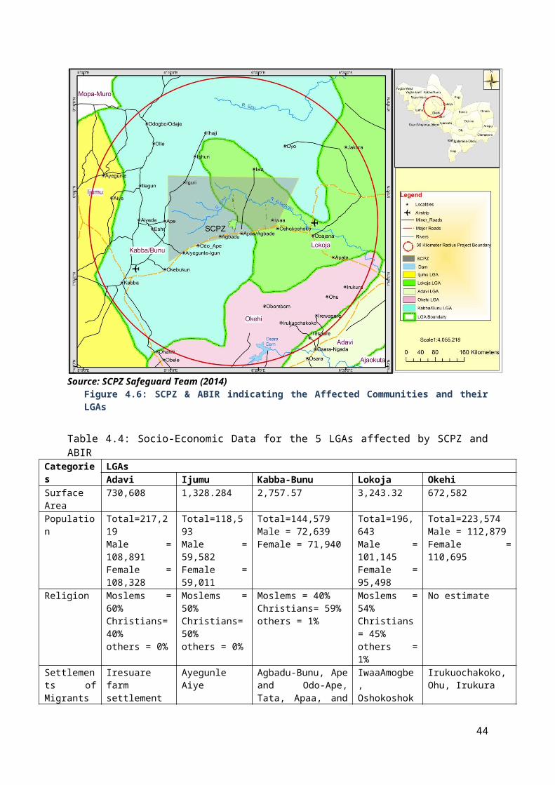
• Record the find location, and all remains are to be left in place; • Secure the area to prevent any damage or loss of removable objects; • The on-site archaeologist will assess, record and photograph the find/feature/ site; • The on-site archaeologist will undertake the inspection process in accordance with all
project health and safety protocols under direction of the Health and Safety Officer; and • In consultation with the statutory authorities the on-site and Project Archaeologist will
determine the appropriate course of action to take.
CHAPTER SEVEN PUBLIC INVOLVEMENT /CONSULTATION
7.0 Introduction One key factor that exists in all successful approaches to project development and implementation is participation by all stakeholders. The more direct involvement of the local level people in the planning and management processes, the greater the likelihood that resource use and protection problems will be solved as well as the likelihood of development opportunities occurring in a balanced way and to the broad benefit of all communities in the project.
Thus in line with the requirements of the World Bank Safeguard for all category A and B projects for IBRD or IDA financing, the preparation of this ESMF included consultations of relevant government agencies, communities and social groups within the SCPZ and ABIR. The consultation process which is a continuum began on 13th August 2014 and continued till 27th August for the first phase which covered the stakeholder government agencies and the communities within the SCPZ core zone. The second phase was the combined World Bank and FMARD mission which took place from October 13th to October 17th 2014, and provided a platform to validate earlier data and deepened discussions and engagement with the relevant stakeholders, especially Federal Ministry of Environment, Forestry Dept, etc. on essentially safeguard concerns of the project. The third phase of the consultation at this stage captured four other LGAs and affected groups and communities within the 280,000Ha of ABIR catchment from 27th to 3rd November 2014. These communities and LGAs visited are Iwaa and Oshokosho in Lokoja LGA, Iresuare/Osara-Gada in Adavi LGA, Ohu and Irukura in Okehi LGA and Iyara in Ijumu LGA.
7.1 Objectives of Public Involvement/Consultations Specifically, the objectives included:
1. Canvass stakeholders’ inputs, views and concerns; and take account of the information and views of the public in the project design and in decision making.
2. Obtain local and traditional knowledge that may be useful for decision-making; 3. Facilitate consideration of alternatives, mitigation measures and tradeoffs; 4. Ensure that important impacts are not overlooked and benefits maximized; 5. Reduce conflict through the early identification of contentious issues; 6. Provide an opportunity for the public to influence the designs and implementation in a positive
manner; 7. Improve transparency and accountability in decision-making; and 8. Increase public confidence in the project.
7.2 Mechanism for Consultation and Participation
57

Public involvement/consultation was considered a fundamental tool for: 1. Managing two-way communication between the project proponent and the public.2. Building understanding and improving decision-making by actively involving individuals,
groups and organizations with a stake
In this regard it makes sense, at this juncture in this ESMF, to understand the following concepts: public involvement, consultation and communication that are frequently confused with each other and that should be kept separate..
Public involvement here includes public consultation (or dialogue) and public participation, which is a more interactive and intensive process of stakeholder engagement.
Consultation is basically a two-way process in which the ideas and concerns of stakeholders and the subproject designers are shared and considered.
Communication involves dissemination of information from the subproject proponents to the concerned public.
For this ESMF and subsequent safeguard instruments to be prepared, public participation strategy for the project revolves around the provision of a full opportunity for involvement of all stakeholders, especially the direct stakeholders. Therefore, as a matter of strategy, public consultation will be an on-going activity taking place throughout the entire project cycle. The consultation process will ensure that all those identified as stakeholders are consulted.
Subject to PMU‟s approval, information about the project will be shared with the public, to enable meaningful contribution, and enhance the success of the project. There are many vehicles that could be used for communication and consultation such as listed below:
Meetings, filling in of questionnaires/ application forms, public readings and explanations of project ideas and requirements making public documents available at the national, local and community levels at suitable locations like the official residences/offices of local elders, announcement
In various media, newspaper announcements placement in more than one paper, preferably all local papers , notice board near project site, posters located in strategic locations and many public places frequented by community and radio and local television
Any of these means to use must take into account the low literacy levels prevalent in the rural communities by allowing enough time for responses and feedback and putting messages in the language readily understood by such people. Ideas and complaints coming from the population must be documented and utilised in decision making.
In fact the PMU should as a matter of reaching the relevant public engage directly with stakeholders and taking their concerns into account. In other words, for effective consultation, the PMUs should hold specific events (preferably community-level meetings) at which affected people will feel comfortable expressing their views. Such events should be carefully documented by written minutes, recordings, video recordings, etc. and the minutes of these meetings together with attendance lists should be included in the prepared instrument whether ESMP or ESIA to demonstrate that consultation has taken place. ESMP/ESIA will explicitly show how ideas from public were taken into account.
Generally, the PMUs are not required to accept every suggestion or demand made, but they should take each reasonable suggestion into account as a matter of good faith.
7.3 Identifying StakeholdersStakeholders for the purpose of this project shall be defined as all those people and institutions that have an interest in the planning and execution of the project, farmers, potentially affected communities; traditional rulers/ Religious leaders; NGOs/CBOs; Local Government officials; State MDAs; Local social and professional groups e.g., farmers, market women, etc. Below an outline is indicated of the key stakeholders identified at present which will be updated during project execution: Stakeholders for the purpose of this project shall be defined as all those people and institutions that have an interest in the planning and execution of the project, potentially affected communities; traditional rulers/ Religious leaders; NGOs/CBOs; Local Government officials; State MDAs; Local
58

social and professional groups e.g., farmers, market women, road transport workers, International organization such as the World Band, FAO etc. While the ESMF consultations and stakeholders engagement provide stakeholders, the general understanding of the whole project and the opportunity to contribute to the process as well as expressing the community concerns and issues on the project, the future ESIAs/ ESMPs consultation and stakeholders engagement on the other hand addresses same issues in detail with respect to individual sub-projects and ancillary facilities. Below an outline is indicated of the key stakeholders identified for ESMF and the list will be updated for ESIAs/ESMPs sub-projects during project execution:
Who? How to identify them
People living in the vicinity of the proposed works.
Field Survey Identify the local government area(s) that the proposed corridor of work falls
within. Review available data to determine the stakeholder profile of the whole
stakeholder or relevant group. Use identified groups and individuals to tap into stakeholder networks to
identify others. Special interest groups.
Identify key individuals or groups through organised groups, local clubs, community halls and religious places.
Organisations such as environmental groups will be aware of similar local groups or individuals.
Individual people who own properties that will be directly or indirectly affected.
Advertise in local newspapers, telling people that they may be affected and
asking them to register interest in attending meetings or receiving further information.
Business (owners and employees).
Field Survey Council lists or property registers.
MDAsInternational organisations
Constitutional Responsibility/ministerial mandate Financial and technical supports.
7.4 This ESMF and Public Involvement In the course of the preparation of this ESMF relevant stakeholders considered as key were met and consulted. The record of consultation is outlined in Table 7.1 and Annex 7 contains Plates of some of the stakeholders met with the highlight of meetings. It is considered the public involvement initiated will be built upon at the various sub-project levels in the SCPZ and ABIR.
Table 7.1: Record of Consultations
Kabba-Bunu Odo-Ape, Kabba, Agbadu, Eshi, Ilegun, Oyo
Community leaders, women farmers, Fulani settlement, Ebira settlement, Hunters group, youths
11th -16th August 2014, 14th -15th
October 2014,
Lokoja Obajana, Oshokosho, As in above 7th -10th August 2014, 27th
59

Table 7.1: Record of Consultations
Iwaa October 2014
Adavi Iresuare/Osara Ngada Community leaders, Fadama farmers group, women, Fulani settlement, Youths
28th October -3rd November 2014
Ijumu Ayegunle and Aiye Community leaders, Chairman Ijumu LGA, Fadama farmers group, women, Fulani settlement, Youths
28th October -3rd November 2014
Okehi Irukuochakoko, Irukura, Ohu
Community leaders, Fadama farmers group, women, Fulani settlement, Youths
28th October -3rd November 2014
Through this, the PMUs will be able to: clarify the project's objectives in terms of stakeholders‟ needs and concerns identify feasible alternatives (in particular alternative locations) and examine their relative
merits in terms of environmental, social and economic factors identify and prioritise environmental and social issues and establish the scope of future
studies and/or site specific management plan Identify processes for continued stakeholders‟ involvement.
Generally, with regard to perceptions about the project, there was a general acceptance and buy-in to the project across the locations and groups visited. The farmers, youths, women and Fulani herdsmen were appreciative of being consulted and expressed optimism that the project will positively impact their livelihoods. In Alape, Kabba-Bunu and Oshokosho, Lokoja the traditional council were satisfied with the process of consultations and stated that they have never seen it in that extensive manner before, and were convinced that the proponent will fulfil its covenant of compensating for their lost assets. Other areas such as Adavi, Okehi and Ijumu knew little about the project before now but were happy to embrace the project which they said will make a difference.
Based on the project development objectives, scope and safeguard concerns which were extensively described to all the stakeholders and communities across the visited locations to ensure good participation and inputs, a number of concerns with raised. These are highlighted in Table 7.2.
Concern and Outcome of Public Consultation
Table 7.2: Concerns voiced by stakeholders and measures taken to address them in the ESMFMDAs Environmental and Social
ConcernsESMF Measures
FMARD The ministry is aware that the project will create some environmental and social challenges. The ministry is however, willing to abide by all international, national, state and local laws and best practices with respect to agriculture business and provision of the ancillary services to the region.
The ESMF provides the necessary guidelines for mainstreaming environmental and social issues into the totality of the ABIR / SCPZ.Waste and effluents from the processing factory will be treated and disposed in line with the provisions of OP 4.01 and the Nigerian extant laws.Ministry of Environment must be allowed to monitor and ensure compliance of environmental responsibility and sustainability
Kogi Agriculture Development Project
Integration of local famers into the ABIR / SCPZ projects.
Project has already taken care of integration of local farmers which will be strengthen by means of further consultations with relevant stakeholders. This aspect is also already being supported by FADAMA III AF
Kogi State The ministry has 100% support for This sub-component is being supported by
60

Table 7.2: Concerns voiced by stakeholders and measures taken to address them in the ESMFMDAs Environmental and Social
ConcernsESMF Measures
Ministry of Agriculture
the project. It also admits numerous environmental and social challenges but is willing to provide technical and personnel support for project implementation in a sustainable manner as it does not want local farmers to be out of job
FADAMA III AF. An area where attention of the Ministry is needed is training of farmers in pesticide use.
Kogi State Ministry of Lands
Land acquisition from indigenous owners. Kogi State is already working with both national agencies and international donors to ensure proper land title registration and ensure proper resettlement plan in line with best practices
The RPF being prepared at the same time with this ESMF takes care of land issue.
Kogi State Ministry of Environment and Natural Resources
Concerns about the issue of deforestation, pollution during construction, operation and decommissioning, soil degradation and the use of banned chemicals.The department of forestry in the ministry noted that there are four forests reserves within the ABIR. These forests are still functional though they have suffered neglect over the years and have been encroached by illegal loggers, settlers and Fulani herdsmen.
Adequate buffer zone around all the game reservs shall be ensured. Also, an agenda to revegetate the deforested forest reserve shall be developed The ESMF shall ensure sustainable agricultural practices through appropriate measures for all phases of project implementation. A separate report, Integrated Pest Management Plan is being developed to handle the use of chemicals.
LGAs (Kabba-Bunnu, Adavi, Lokoja, Ijumu and Okehi )
The environmental and social concerns of the LGAs include: youth employment, women empowerments, and infrastructural developments due to cumulative impacts that may arise from increase in population. They however, want to be institutionally involved in mainstreaming environmental and social issues during project implementation.
Integration of youths and women into the project are part of the essence of the project development. Thus contributions shall always be welcomed as to how this can work effectively. Adequate screening of all sub-project shall assist in determining negative environmental and social impacts and appropriate mitigation measures. It is expected that contributions from the community members shall enrich the process. .Appropriate safeguards instrument will be prepared and adhered to during project implementation. ESMF institutional framework for mainstreaming environmental and social issues integrates the LGAs.
Other MDAs All the MDAs contacted show full support for the project but only raise caution on the issues of deforestation, water supply and displacement of local people from their livelihoods. The Nigeria Hydrological Services Agency is already providing technical assistance to the proponent on the issue of water supply.
The forest reserves shall be avoided with adequate buffers around them and measure to assist in replanting the reserves where they have been deforested shall be advocated and supported in the SCPZ and ABIR. A separate report on RPF is looking into the issue of displacement from livelihood source(s).
KabbaBunu LGAAgbadu Community
Deforestation Appropriate screening of sub-projects must be carried out and where deforestation is identified the proponent must ensure Re-vegetation activities including planting of buffer trees around the project as well as around the infrastructures and along the lawns.
61

Table 7.2: Concerns voiced by stakeholders and measures taken to address them in the ESMFMDAs Environmental and Social
ConcernsESMF Measures
Also, sub-projects must avoid sensitive area so as to ensure preservation of bio-diversity and sustainable environment.
Youth employment The ABIR / SCPZ concept emboldens an employment generation programme and the proponent will ensure active participation of youth especially the local youth.
Odo-Ape Community
Soil erosion. Preventive measures shall be adopted for soil erosion and the relevant ESMF/ESMP developed shall take this on board on how to ensure erosion control measures
Location of the processing plant in the community.
Not known exactly at present, however, the FMARD and Kog State Government have developed a comprehensive master plan for the SCPZ zone. The plan is amendable.
General Public Consultation All Project Affected Communities and other Stakeholders(Odo-Ape community;Ape community;Agbadu community;Bassa camp; andEbira settlers)
The proximity of the processing plant to the community and the need for buffer zone.
Strict compliance to final master plan when all the activities are known must be ensured and all safeguard instruments must be adhered to even in near and farther future development
The need for afforestation after clearing the forest at the project site
Appropriate screening of sub-projects must be carried out and where deforestation is identified the proponent must ensure Re-vegetation activities including planting of buffer trees around the project as well as around the infrastructures. Also, sub-projects must avoid sensitive area so as to ensure preservation of bio-diversity and sustainable environment.
The perceived neglect of some communities in the location of essential components of the processing zone
The government is involved in this proposed development and would ensure essential amenities reach out to affected communities with stakeholder’s engagement at all levels
The need to use modern and environment friendly machines to guide against air and noise pollution
Best practices agronomic practices shall be preached and adopted in the SCPZ and ABIR
Proper disposal/management of waste during construction and operations
ESIA, EIA, ESMP and other safeguards instruments for sub-projects must contain waste management plan
The neglect by previous governments in terms of provision of infrastructure and social amenities; and
The government is involved in this proposed development and would ensure essential amenities reach out to affected communities with stakeholder’s engagement at all levels
Availability of adequate water resources throughout the hydrological year both in quality and quantity that will support the ABIR / SCPZ and the communities’ water requirements.
The proponent must ensure that project area water source is different from communities’ water supply sources. No interference is anticipated in community water source
ADAVI LGAIresuare farm settlement (Osara-Gada)
We are concerned about our farmlands
Farmers shall be integrated in the project
LOKOJAIwaaAmogbe / Well informed about the project but The RPF is dealing with this aspect of the
62

Table 7.2: Concerns voiced by stakeholders and measures taken to address them in the ESMFMDAs Environmental and Social
ConcernsESMF Measures
Iwaa are concerned about land acquisition
project
Deforestation Appropriate screening of sub-projects must be carried out and where deforestation is identified the proponent must ensure Re-vegetation activities including planting of buffer trees around the forest reserves, and leaving vegetation around infrastructures. Also, sub-projects must avoid sensitive area so as to ensure preservation of bio-diversity and sustainable environment.
Traffic from Trailers from Obajana experience
A robust Traffic and Vehicle Management Plan (TVMP) for the processing plant within the SCPZ and ABIR would be developed.
Youth employment The ABIR / SCPZ concept is an employment generation programme and the proponent must ensure active participation of youth especially the local youth.
Oshokoshoko Land acquisition The RPF is dealing with this aspect of the project
Deforestation Appropriate screening of sub-projects must be carried out and where deforestation is identified the proponent must ensure Re-vegetation activities including planting of buffer trees around the forest reserves, and leaving vegetation around infrastructures. Also, sub-projects must avoid sensitive area so as to ensure preservation of bio-diversity and sustainable environment.
Traffic from Trailers from Obajana experience
A robust Traffic and Vehicle Management Plan (TVMP) for the processing plant within the SCPZ and ABIR shall be developed
Infrastructural Development we are concerned about the poor state of the road.
The rehabilitation of this road is already being taken care of by the Government.
Fulani settlement
Loss of grazing land and source of livelihood
Appropriate resettlement to a government approved grazing zone. Integration of settled herdsmen into ABIR / SCPZ activities to provide support services such as security.
IJUMU LGAAyegunle We are concerned about land
acquisitionA second instrument, the RPF, being developed alongside this ESMF takes care of this.
Loss of grazing land and source of livelihood for herdsmen
Appropriate resettlement to government approved grazing zone. Integration of settled herdsmen into ABIR / SCPZ activities to provide support services such as security
Want infrastructural Development (Road & water) as part of benefit to the community
Appropriate mechanism for community support shall be developed in subsequent safeguard instruments
Aiye We are concerned about land acquisition
A second instrument, the RPF, being developed alongside this ESMF takes care of this
Youth and women employment The ABIR / SCPZ concept is an employment generation programme and the proponent must ensure active participation of youth and women.
Want infrastructure Development (Road in particular) as benefit from
Proponent in conjunction with the affected communities must develop a robust corporate
63

Table 7.2: Concerns voiced by stakeholders and measures taken to address them in the ESMFMDAs Environmental and Social
ConcernsESMF Measures
SCPZ and ABIR social responsibility programe including but not limited to water supply and provision of primary healthcare centers and schools.
OKEHI LGAObombom Had limited information about the
ABIR and SCPZ project but are concerned about land acquisition
Appropriate mechanism for community support shall be developed in subsequent safeguard instruments
Loss of grazing land and source of livelihood for herdsmen
Appropriate resettlement to a government approved grazing zone. Integration of settled herdsmen into ABIR / SCPZ activities to provide support services such as security are recommended.
Want infrastructural Development (Road in particular) as part of benefit to community
Appropriate mechanism for community support shall be developed in subsequent safeguard instruments
7.5 ESMF Communication Plan The ESMF Communication Plan refers to specific guidelines and protocols consistent with the principles of participation that will govern the project and which will be reflected in the Communication Plans, including the Communication Plans of the Social Safeguard Frameworks of the Project. They are:
I. establishment of feasible participation mechanisms , II. establishment of participation mechanisms prepared with the basic objectives of
transparency, responsibility of delivery of public service and an anti-corruption approach; III. promotion of arenas of dialogue based on realistic and objective data avoiding the creation of
expectations that cannot be met; IV. Non-discrimination for the most vulnerable groups, such as women, young persons, older
persons and indigenous communities.
7.5.1 Mechanism for Engagement/Consultation of PAPsTwo or more ways are suggested for meaningful engagement of farmers and communities members as well as other stakeholders. The first is to use the existing recognized traditional structure in which consultation is conducted through the village/community leadership. This means of engagement is widely acceptable and an easy way to reach to all the groups in the community based on the existing traditional governance structure. The use of social gatherings such as churches and mosques will also be important for dissemination of information to PAPs, and finally, there is the need to segment consultations into smaller targeted groups. This is premised at giving a voice to less advantage groups, minority settlers and groups in the resettlement planning. To do this effectively, the attendance records of the various groups having phone numbers and contacts will be used to call or reach out to direct stakeholders, including coordinating them for group meetings as and when necessary.
7.5.2 Tools for Consultation of StakeholdersDepending on the target stakeholder and objective of consultation at any point, one or a combination of the following tools should be used.
Table 7.3: Future Consultations and Communication ToolStakeholder Consultation Tools
Direct Stakeholders/Project affected persons and groups
Farmers groups Land owners, tenants, squatters Herdsmen Vulnerable group/women
Focus group discussions, questionnaire, worship centres, Fadama group/desk officers, community town hall meetings, Print materials, texting by phone
Project partners FADAMA
Phone calls, e-mails, visit, facilitation meetings, electronic media
64

Table 7.3: Future Consultations and Communication ToolStakeholder Consultation Tools
GEMS 3 Contractors
Government Agencies/Ministries Phone calls, e-mails, visit, meetings, electronic media
Potential Investors Phone calls, e-mails, visit, meetings, electronic media
7.5.3 Plan for Future Consultations and CommunicationConsultation will continue before, during and after project implementation (Annex..). The proponent is required to provide relevant materials in a timely manner prior to consultation and in a form and language that are understandable and accessible to the groups being consulted. This requirements and phasing of consultations are as follows:
Consultation on the finalization of ESMF – to include:o Circulation of the draft ESMF for comments toll relevant institutions (Federal Ministry
of Environment, FMARD, Kogi State Ministry of Environment, Kogi State Ministry of Agriculture, etc.)
o Organization of public stakeholder workshops and comments incorporated in the final ESMF document
o Public disclosure of Final ESMF (cleared by WB) in-country at designated centres accessible to stakeholders and at the WB info shop prior to appraisal
During the preparation of individual ESIA/ESMP o Potential investors, Farmers, interested groups and communities with LGCs affected
will be consulted and informed about the proposed subproject activities and how they stand to be impacted environmental and socially speaking
o Identification of impacts and appropriate mitigation measures shall be sought through consultation with the relevant local stakeholders community members and expert knowledge gained elsewhere and judgement in the light of best practice
o Consultation of the proponent and implementing government agencies on relevant policy terms.
During the Implementation of the ESMPo Stakeholder communities and farmers will be informed about the date/schedule of
project commencement who will be involved in site selection, screening and planning administration of needed mitigation measures and monitoring and evaluation
During audit/monitoring and evaluation of the ESMP to determine the performance of the ESMP
o Farmers and community members will be consulted to appreciate their understanding of the impacts that have been generated and whether the mitigation measures are working or if there will be need to change the entire ESMP. This will take place 6months after the start of the implementation of ESMP and 2 years after for the audit.
65

CHAPTER EIGHT ESMF IMPLEMENTATION AND MANAGEMENT
8.0 IntroductionThe successful implementation of the ESMF depends on the commitment of the PMU and other institutions relevant to it. In addition, the capacity within the institutions to apply or use the framework effectively, and the appropriate and functional institutional arrangements, among others will go a long way to ensure the adherence to the framework.
This CHAPTER addresses the key ESMF areas relevant to its successful implementation: Institutional arrangements; Participation/consultation Framework ESMF Communication Plan in the Project Cycle Measures for Strengthening Organizational Capability - Capacity building; Environmental and Social Mitigation Principles and Clauses Environmental and Social Monitoring Budgets for the ESMF Update and Revision of ESMF Disclosures of Safeguard Instruments
8.1 Institutional ArrangementsSince one of the main purposes of the ESMF is to establish roles and responsibility for the activities that have to be undertaken, this sub-section details below, institutional arrangements and the roles and responsibilities of the various institutions relevant to the successful implementation of the ESMF as outlined in Table 8.1.
8.1.1 Project Management UnitAs a point of emphasis, the Project Management Unit (PMU) with a Project Coordinator (PC) as the head to be established, shall serve as the implementing body with the mandate to:
Co-ordinate the project programmes and actions in the SCPZ, especially and by extension any SCPZ activities in the ABIR
66
Plan, coordinate, manage and develop the various sub-project activities safeguard sections and parts
Prepare plans for SCPZ as a whole for effective project development and management. Coordinate all environmental and social issues through a Safeguard unit.
Nevertheless, the PMU shall liaise with the various levels of government and other identified stakeholders, namely relevant Federal MDAs, State MDAs, Local Government Council Offices, the communities, NGOs/CSOs, Traditional Rulers; Trade Unions/Local social and professional groups e.g., farmers, market women, and the General Public
8.1.2 Environmental and Social Safeguards Unit To ensure sustainability in all the SCPZ sub-project activities, an environmental and social development safeguards unit shall be formed which includes the environmental and social development safeguards officers that reports directly to the PMU PC. The paramount objective of the environmental/social safeguards officers is to ensure the effective consideration and management of environmental and social concerns in all aspects of SCPZ, from the design, planning, implementation, monitoring and evaluation of initiatives. Thus, a key function of the environmental and social development safeguard officers is to engender a broad consensus, through participatory methods and extensive dialogue on the potential environmental and social concerns from project civil works as incorporated into the World Bank's environmental and social safeguards policies triggered by the project and environmental compliance with the EA. With this, particular attention is directed at minimizing environmental and social risks associated with the development of sub-project initiatives, as well as the identification and maximization of social development opportunities arising from investments thus, the recruitment of assistant environmental and social officers. In the implementation of the project, and for or all environmental and social issues the safeguard unit, shall work closely with other relevant MDAs in preparing a coordinated response on the environmental and social aspects of the sub-projects. The roles and responsibilities of the environmental and social safeguards officers to anchor environmental and social issues distinctively are described below.
• Review all ESIAs/ESMPs documents prepared by environmental and social consultants and ensure adequacy under the World Bank Safeguard policies.
• Ensure that the project design and specifications adequately reflect the recommendations of the ESIAs/ ESMPs;
• Co-ordinate application, follow up processing and obtain requisite clearances required for the project, if required;
• Prepare compliance reports with statutory requirements; • Develop, organize and deliver training program for the PMU staff, the contractors and others
involved in the project implementation, in collaboration with the PMU; • Review and approve the Contractor’s Implementation Plan for the environmental measures,
as per the ESIA and any other supplementary environmental and social studies that may need to be carried out by the PMU;
• Liaise with the Contractors and the PMU / MDAs on implementation of the ESMPs; • Liaise with various Central and State Government agencies on environmental, resettlement
and other regulatory matters; • Continuously interact with the NGOs and community groups that would be involved in the
project • Establish dialogue with the affected communities and ensure that the environmental and
social concerns and suggestions are incorporated and implemented in the project; • Review the performance of the project through an assessment of the periodic environmental
and social monitoring reports; provide a summary of the same to the Project Manager, and initiate necessary follow-up actions;
• Provide support and assistance to the Federal and State Government Agencies and the World Bank to supervise the implementation.
67

Table 8.1: Safeguard Responsibilities S/No Category Roles
1 PMU Implementing authority, has the mandate to ensure:- Compliance with World Bank Safeguards Policies and
other relevant laws in Nigeria in the SCPZ and ABIR in line with this ESMF
- Smooth and efficient implementation of the project - Faithful implementation of the ESMF and other
safeguard instruments developed for each subproject 2 PMU Safeguards
Unit/Safeguards Officer
- Assists PMU to comply with and fully implement World Bank Safeguards Policies and other relevant laws in Nigeria.
- Take lead in ensuring adequate screening and scoping of project in the SCPZ for the appropriate safeguard instrument.
- Ensure adequate review of all safeguard reports before sent to the Bank
- Supervision of the contractors, supervisors, training of contractors and workers, monitoring of the implementation of the ESMF and other safeguard instruments.
3 Federal Ministry of Environment and her agencies (Such as NESREA)
- Lead role -provision of advice on screening, scoping, review of draft EA/ESMP report (in liaison with State Ministry of Environment), receiving comments from stakeholders, public hearing of the project proposals, and convening a technical decision-making panel, Project categorization for EA, ensuring conformity with applicable standards, Environmental and social liability investigations, Monitoring and evaluation process and criteria
4 State Ministry of Environment/EPA
- Collaborate FMEnv and Pparticipate in the EA processes and in project decision-making that helps prevent or minimize impacts and to mitigate them and ensures conformity with applicable standards, environmental and social liability investigations, monitoring and evaluation process, etc.
5 The Federal Ministry of Agriculture and Rural Development (FMARD)
- Provides overall leadership and direction to the other MDAs by engaging all the critical stakeholders in SCPZ and ABIR to support, cooperate with and participate in established policy direction; and
- Pursues an agenda of encouraging and ensuring investors comply with all environmental laws and policies
6 The Kogi State Ministry of Agriculture
- Coordinates state-wide agricultural programmes including creation of awareness of farmers on the appropriate pesticides to use in consonance with this ESMF and IPMP
7 The Staple Crop Processing Zone Authority (SCPZA) -
Yet to be established but shall serve as principal body and agency of the Federal Government in all SCPZs in Nigeria. For the Kogi SCPZ and ABIR:
- Responsible for the ensuring development and issuance of guidelines and standards for the effective operation of ABIR / SCPZs;
- Ensures inclusion, as condition of approval to all investors in SCPZ and ABIR compliance clause on environmental and social standards and guidelines in accordance with this ESMF and subsequent ESIA/ESMP carried out in consonance with relevant local laws and
68

Table 8.1: Safeguard Responsibilities S/No Category Roles
triggered World Bank Safeguards policies; - Ensures SCPZ EMC prepare relevant safeguard reports
for all proposed investments- Appoints qualified environmental and social safeguard
officer who understands the germane issues and follow through with other relevant bodies in support of PMU
8 SCPZA Executive Management Committees (EMC)
- EMC represents SCPZA at the level of each zone and responsible for implementation of the Master Plan for the SCPZ and oversees the day-to-day administration of the SCPZ and ABIR.
- Ensure compliance by all investors with all relevant environmental and social guidelines and policies as contained in this ESMF and subsequent safeguard instruments to be developed in line with national laws and World Bank safeguard policies
- Work with the PMU to ensure adequate review of draft ESIA/ESMP reports before sending it to FMEnv and the World Bank
- Ensure inclusion of appropriate environmental and social clauses in all tender documents and requests for all projects/subprojects in SCPZ and ABIR
9 World Bank - Provides guidance on the compliance of safeguards policies
- Will be involved in monitoring compliance with its safeguard policies via its oversight missions
- Maintains an oversight role, review and provide clearance and approval for the ESMF and other relevant safeguard instruments developed for subprojects.
- Conducts regular supervision for satisfactory ESMF/ESMP implementation, fulfillment of community liaison and provide support role throughout the project implementation, and monitor the progress of the project implementation.
- Recommend additional measures for strengthening the management framework and implementation performance.
- capacity building of the proponent as needed
10 Local government - Appoints Local Government Desk Officers (LGDOs) who visit communities and the ABIR / SCPZ operators on a regular basis to facilitate intensive participatory process and compliance to the local environmental laws
- Support and work with the PMU by participating in environmental and social screening and scoping process of subprojects and public review of ESIA and ESMPs
11 Community Farmer Environmental Committee (CFEC)
Constituted by SCPZA EMC, - CFEC will assist to ensure sustainable agricultural
practices, - identify the necessary environmental and social training
needs and other areas of support for farmers, - participate in review of safeguard instruments and
contribute to community mobilization. 12 Potential Investors /
Developers- Adhere to the tenets of this ESMF and other relevant
environmental and social guidelines and laws for best practice in carrying out their activities.
- Mandatorily set up safeguard units for managing all
69

Table 8.1: Safeguard Responsibilities S/No Category Roles
safeguard activities to the full satisfaction of all stakeholders.
13 Zone Level Special Purpose Vehicle (SPV)
- Zone-specific project company to provide specialized services be provided commercially and charged to operators within the SCPZ and ABIR.
- Mainstream and ensure compliance with all environmental and social issues according to the dictates of this ESMF and subsequent safeguard instruments to be prepared into the implementation of all infrastructural developments
14 NGOs/CSOs/CDA - Assist to ensure effective response actions to relevant environmental and social issues,
- Conducts scientific researches alongside government groups to evolve and devise sustainable environmental strategies and rehabilitation techniques,
- Organizing, coordinating and ensuring safe use of chemicals and pesticides through awareness creation
- Providing wide support assistance helpful in management planning, institutional/governance issues and other livelihood related matter, Project impacts mitigation and monitoring
8.2 ESMF Communication Plan The ESMF Communication Plan refers to specific guidelines and protocols consistent with the principles of participation that will govern the project and which will be reflected in the Communication Plans, including the Communication Plans of the Social Safeguard Frameworks of the Project.
They are: I. establishment of feasible participation mechanisms ,
II. establishment of participation mechanisms prepared with the basic objectives of transparency, responsibility of delivery of public service and an anticorruption approach;
III. promotion of arenas of dialogue based on realistic and objective data avoiding the creation of expectations that cannot be met;
IV. positive discrimination for the most vulnerable groups, such as women, young persons, children, older persons and indigenous communities.
8.3 Measures for Strengthening Organizational Capability - Capacity Building and TrainingBased on the public consultation, the capacity assessment of implementing federal and state level Ministries, Departments and Agencies (MDAs) as well as the PMU, were carried out. The effective functioning of the MDAs is hindered by limited technical skills and resource constraints. Thus, institutional barriers include:
Limited knowledge of the relationship between World Bank Safeguards policies and the extant environmental and social laws in Nigeria;
Lack of enforcement of development control regulations; Limited knowledge on EIAs and Environmental and Social Audits during
construction/rehabilitation of drainages and culverts; Limited knowledge on Strategic Environmental and Social Assessment; Limited monitoring of water quality, river flow and lack of systemic hydrologic data collection; Limited technical capacity on solid waste management;
In order to achieve the goal of the ESMF, there is a need for capacity building and strengthening of relevant competencies on environmental and social management at federal and state level MDAs – Kogi State Ministry of. It involves organizational development, the elaboration of management structures, processes and procedures, not only within organizations but also the management of relationships between the different organizations and sectors (public, private and community). The
70

environmental and social management requirements and provisions outlined in this ESMF, competencies and capacity building will be required in the following areas:
Environmental Impact Assessment Process - screening, scoping, impact analysis, mitigation measures and monitoring, reviewing ESIA reports;
Environmental Due Diligence - types of due diligence, screening projects for liabilities, scoping due diligence investigations and reviewing due diligence reports; and
Monitoring and Evaluation - understanding the importance of monitoring and evaluation (M&E) in project implementation, M&E requirements for environmental and social sustainability of projects.
Specific areas for effective institutional capacity needs are given in Table 8.2.
71

Table 8.2.: Training/Capacity Building NeedsProgramme/Description Participants Form of
Training Duration When Conducted by Agency Coordinating Estimated Costs
USDEnvironmental and Social Accountability
WB Safeguards Awareness Training of Environmental Safeguards Policies triggered
PMU, Ministry of Environment and , project affiliated MDAs, SCPZA
Workshop ½ Working day During project preparatory stage
World Bank World Bank Not inclusive
World Bank Social Accountability System
PMU, Ministry of Women Affairs, Community Development, Social Welfare and Poverty reduction, Project affiliated MDAs
Workshop ½ Working day During project preparatory stage
World Bank World Bank Not inclusive
Nigerian Environmental Guidelines Introduction to Environment Basic Concept of Environment Environmental Regulations and Statutory requirements as per Government.
PMU, Ministry of Environment and project affiliated MDAs, SCPZA
Workshop ½ Working day During project preparatory stage
Relevant Consultant PMU, Ministry of Environment and
Environmental Considerations in subproject activities: Environmental components affected during construction and operation stages; Environmental management and Best practice; Stakeholder participation
PMU, Ministry of Environment and project affiliated MDAs, SCPZA
Workshop 1 Working day During project preparatory stage
Relevant Consultant PMU, Environmental specialist, Ministry of Environment and
Project Screening and Scoping PMU, Ministry of Environment andproject affiliated MDAs, SCPZA
Training of Trainers
½ Working day During project preparatory stage
Relevant Consultant PMU, Environmental specialist, Ministry of Environment and
72

Table 8.2.: Training/Capacity Building NeedsProgramme/Description Participants Form of
Training Duration When Conducted by Agency Coordinating Estimated Costs
USDReview of EIA and its integration into designs EIA methodology; Environmental provisions Implementation arrangements
PMU, Ministry of Environment andproject affiliated MDAs, SCPZA
Lecture and Field visit
½ Working day PMU, Environmental specialist,
Preparation of ESIA, EA and Training of ½ Working day During project Relevant Consultant PMU, Environmental
EMP Term of Reference/Implementation
Trainers preparatory stage specialist, Ministry of Environment and
Preparation and administration of questionnaires and stakeholders consultation/FGD
PMU, Ministry of Environment and , project affiliated MDAs, SCPZA
Training of Trainers
½ Working day During project preparatory stage
Relevant Consultant PMU, Environmental specialist, Ministry of Environment and
Project Management (scope, implementation, time, budget, costs, resource, quality, procurement, monitoring and evaluation)
PMU, Ministry of Environment andproject affiliated MDAs, SCPZA
Training of Trainers
½ Working day During project preparatory stage
Project Management Consultant
PMU, Environmental specialist, Ministry of Environment and
Environmental and Social Audits
PMU, Ministry of Environment and project affiliated MDAs
Training of Trainers
½ Working day During project preparatory stage
Relevant Consultant PMU, Environmental specialist, Ministry of Environment and
Strategic Environmental and Social Assessment (SESA)
PMU, Ministry of Environment andproject affiliated MDAs
Training of Trainers
½ Working day During project preparatory stage
Relevant Consultant PMU, Environmental specialist, Ministry of Environment and
Logistic and planning PMU, Ministry of Environment and , project affiliated MDAs
Training of Trainers
½ Working day During project preparatory stage
Relevant Consultant PMU, Environmental specialist, Ministry of Environment and
Total 15,000
73

Table 8.2.: Training/Capacity Building NeedsProgramme/Description Participants Form of
Training Duration When Conducted by Agency Coordinating Estimated Costs
USD Training program: Agricultural Practices and management program
Land use, Erosion and Dam safety
PMU, Project affiliated MDAs
Training of Trainers ½ Working day During project preparatory stage
Relevant Consultant
PMU, Ministry of Water resources, Ministry of Environment and
Agricultural Practices and climate change adaptation
PMU, Project affiliated MDAs
Training of Trainers ½ Working day During project preparatory stage
Relevant Consultant
PMU, State Emergency
Agronomics and Agro forestry PMU, Project affiliated MDAs
Training of Trainers ½ Working day During project preparatory stage
Relevant Consultant
PMU, State Emergency Management Agency
Pesticides Use, Storage and Disposal of containers
PMU, Project affiliated MDAs
Training of Trainers ½ Working day During project preparatory stage
Relevant Consultant
PMU, State Ministry of Agriculture
Total 10,000
Training program (Health Impact Assessment) - HIA
Overview of HIA PMU, Ministry of Environment and , project affiliated MDAs
Training of Trainers During project preparatory stage
Relevant Consultant
PMU, State Ministry of Health
7,500
Screening—How to Decide Whether to Conduct an HIA
PMU, Ministry of Environment and , project affiliated MDAs
Training of Trainers During project preparatory stage
Relevant Consultant
PMU, State Ministry of Health
Environmental Health Areas
PMU, Ministry of Environment and , project affiliated MDAs
Training of Trainers During project preparatory stage
Relevant Consultant
PMU, State Ministry of Health
Scoping—How Comprehensive Should the HIA Be
PMU, Ministry of Environment and , project affiliated MDAs
Training of Trainers During project preparatory stage
Relevant Consultant
PMU, State Ministry of Health
Baseline Data—What, When, and How Much?
PMU, Ministry of Environment and , project affiliated MDAs
Training of Trainers During project preparatory stage
Relevant Consultant
PMU, State Ministry of Health
74

Table 8.2.: Training/Capacity Building NeedsProgramme/Description Participants Form of
Training Duration When Conducted by Agency Coordinating Estimated Costs
USDRisk Assessment—Assessing and Ranking Impacts
PMU, Ministry of Environment and , project affiliated MDAs
Training of Trainers During project preparatory stage
Relevant Consultant
PMU, State Ministry of Health
Health Action Plan PMU, Ministry of Environment and , project affiliated MDAs
Training of Trainers During project preparatory stage
Relevant Consultant
PMU, State Ministry of Health
Monitoring and Verification Monitoring and Verification PMU, Ministry of
Environment and , project affiliated MDAs Training of Trainers During project
preparatory stage Relevant Consultant
PMU, State Ministry of Health
Resourcing PMU, Ministry of Environment and , project affiliated MDAs
Training of Trainers During project preparatory stage
Relevant Consultant PMU, State Ministry of Health
Training Programs [Occupational Health and Safety Management Plan (OHSMP)
Occupational Health and Safety(OHS) Leadership Management
PMU, Ministry of Environment and , project affiliated MDAs Contractors, Project affected Community representatives
Training of Trainers
During project initiation stage (Before commencement of civil works)
Relevant Consultant PMU, State Ministry of Environment and
7, 500
Safety performance assessment PMU, Ministry of Environment and , project affiliated MDAs, Contractors
Training of Trainers
During project initiation stage (Before commencement of civil works)
Relevant Consultant
PMU, State Ministry of Environment and Habitat
Hazard Analysis and Control PMU, Ministry of Environment and Habitat, project affiliated MDAs, Contractors
Training of Trainers
During project initiation stage (Before commencement of civil works)
Relevant Consultant
PMU, State Ministry of Environment and
75

Table 8.2.: Training/Capacity Building NeedsProgramme/Description Participants Form of
Training Duration When Conducted by Agency Coordinating Estimated Costs
USDHazard Communication Program
PMU, Ministry of Environment and , project affiliated MDAs Contractors
Training of Trainers
During project initiation stage (Before commencement of civil works)
Relevant Consultant
PMU, State Ministry of Environment and
Effective Accident Investigation
PMU, Ministry of Environment and , project affiliated MDAs Contractors
Training of Trainers
During project initiation stage (Before commencement of
Relevant Consultant
PMU, State Ministry of Environment and
Programme/Description Participants Form of Training
When Training to be conducted by who
Training Conducting Agency Training Costs USD
civil works)
Conducting Health and Safety Audits
PMU, Ministry of Environment and , project affiliated MDAs Contractors
Training of Trainers
During project initiation stage (Before commencement of civil works)
Relevant Consultant
PMU, State Ministry of Environment and
Job Hazard Analysis PMU, Ministry of Environment and , project affiliated MDAs Contractors
Training of Trainers
During project initiation stage (Before commencement of civil works)
Relevant Consultant
PMU, State Ministry of Environment and
Occupational Health Risk Assessment
PMU, Ministry of Environment and , project affiliated MDAs Contractors
Training of Trainers
During project initiation stage (Before commencement of civil works)
Relevant Consultant
PMU, State Ministry of Environment and
Work Stress Risk Assessment PMU, Ministry of Environment and , project affiliated MDAs, Contractors
Training of Trainers
During project initiation stage (Before commencement of civil works)
Relevant Consultant
PMU, State Ministry of Environment and
76

Table 8.2.: Training/Capacity Building NeedsProgramme/Description Participants Form of
Training Duration When Conducted by Agency Coordinating Estimated Costs
USD
Electrical safety PMU, Ministry of Environment and , project affiliated MDAs, Contractors
Training of Trainers
During project initiation stage (Before commencement of civil works)
Relevant Consultant
PMU, State Fire services
Bush Fire Safety PMU, Ministry of Environment and , project affiliated MDAs Contractors
Training of Trainers
During project initiation stage (Before commencement of civil works)
Relevant Consultant
PMU, State Fire services
Pesticides and other Chemicals Management and Waste Management
Farmers Hands on During project initiation stage (Before farming activities
Relevant Consultant
PMU, State Ministry of Environment and Ministry of Agriculture
Traffic and Transport Management
PMU, Ministry of Environment, project affiliated MDAs Contractors
During project initiation stage (Before commencement of civil works)
Relevant Consultant
PMU, State Ministry Works and Transport
Emergency Planning and Management
PMU, Ministry of Environment and Habitat, project affiliated MDAs, Contractors
During project initiation stage (Before commencement of civil works)
Relevant Consultant
PMU, SEMA
GRAND TOTAL 35,700
77

8.4 Grievance MechanismThe Grievance Redress Mechanism (GRM) is part of the broader process of stakeholder engagement, accountability, quality and compliance assurance in the SCPZ and ABIR designed to solving disputes at the earliest possible time, which is in the interest of all parties concerned. This shall further be made tighter in all future ESIAs/ESMPs once the specific sites of the various project/subproject investments are known since there are different LGAs and communities affected.
The objectives of the grievance redress mechanism are to: Provide an effective avenue for aggrieved persons to expressing their concerns and
resolving disputes that are caused by the project Promote a mutually constructive relationship among farmers, community members, project
affected persons, government and investors Prevent and address community concerns, and Assist larger processes that create positive social change Identify early and resolve issues that would lead to judicial proceedings
8.4.1 Grievance Management ProcessThere is no ideal model or one-size-fits-all approach to grievance resolution- localized mechanisms that take account the specific issues, cultural context, local customs, and project conditions and scale works better. Nevertheless, in Figure 8.1, an outline of the Grievance Redress Flow Path/process that could be followed includes,
Receive, register and acknowledge complaint Screen and establish the foundation of the grievance Implement and Monitor a redress action Advise for a judicial proceedings as last resort if necessary Document the experience for future reference essentially, registration of complaints,
acknowledgement, follow-ups, mediation and corrective actions is presented.
This is further amplified in Table 8 .3 which describes the steps in the grievance management process irrespective of the size and nature of the grievance.In all these, the existing traditional mechanism for dispute resolution in the communities structured after the order of the administrative command described Section 4 in which an aggrieved person is required to lodge his/her complaint to the head of the ward or clan a matter that is not adjudicated satisfactorily at this level is taken to the Obaru Council shall not be in any way not reckoned with.
8.4.2 Composition of Grievance Redress CommitteeA functional Grievance Redress Committee shall be constituted by the PMU in conjunction with the local community to monitor and review the progress of implementation of the scheme or plan of rehabilitation and resettlement of the affected people and to carry out post implementation social audits. The SCPZ-PMU will incorporate the use of existing local grievance redress process available in the community to addressing disputes that may result from this project. This will entai l co-opting the traditional council and some local leaders as members of the GRC. The specif ic composition of these committees will vary depending upon location and context. Further details will be spelt out at the RAP stage. The main functions of the Committee are:
Publicize within the list of affected persons and the functioning of the grievance redressed Procedure established;
Verify grievances and their merits; Recommend to the PMU solutions to such grievances; Communicate the decisions to the Claimants; Ensure that all notices, forms, and other documentation required by Claimants are made
available in Local language understood by people Ensure documentation of all received complaints and the progress of remediation.
78

Figure 8.1: Grievance Redress Flow Path
Table 8.3: Principal Steps of the Grievance Management ProcessStep Description Timeline1 Receipt of the grievance 1/2day2 Completion of the grievance form 1/2day
3 Entry of the complaint into the grievance database 1/2day
4 Preliminary assessment of grievance: internal evaluation of the severity of the complaint (or “Community Impact Ranking,”)
2days
5 Written acknowledgement of the receipt of the grievance. If key information is missing from the grievance, request for further information
7days
6 Investigation and resolution of grievance 2-4weeks7 Response letter and registration in database. If the solution is
accepted, resolution (including any payments) and closure of the case
Within 6weeks
8 If the proposal is not accepted by the complainant, referral to the Independent Mediation Committee
6-8weeks after registration of grievance
9 Resort to judicial measures At any stage in the process though complainant would be persuaded to exercised patience until thorough utilization of this mediation path
* If this time limit cannot be met, the PMU through the GRM advises the complainant in writing that they require additional time
79

8.4.3 Independent Mediation CommitteeThe Independent Mediation Committee (or IMC) is a structure that is to be established by the PMU to independently and impartially resolve grievances through mediation and dispute resolution. Mediation by the IMC is only to take place in case the complainant is not satisfied with the initial resolution proposed by the GRC. The Committee uses mediation to resolve disputes or complaints submitted to it. The Mediation Committee shall operate independently from the PMU but has access to any information that the PMU and or its implementation partners have regarding the complaint. The determinations of the GRC are non-binding on either party. The IMC meets as needed, depending on registered complaints and disputes, and its members receive a stipend from the PMU to cover costs of attending meetings. If a solution that is acceptable to all parties emerges out of the meeting with the IMC, the grievance may be considered resolved and closed out; all parties are then notified. If no acceptable solution is agreed upon, either party has the option of taking legal action.The composition of the IMC shall be established based on the specific area (site) of investment within the SCPZ and shall include three people of high reputation as impartial mediators in the region such as Elders, retired judges etc.
8.5 Environmental and Social Monitoring Monitoring is a key component of the ESMF during project implementation. Monitoring verifies the effectiveness of impact mitigation measures, including the extent to which mitigation measures are successfully implemented. Monitoring specifically helps to:
Improve environmental and social management practices; Check the efficiency and quality of the ESMP processes; Establish the scientific reliability and credibility of the ESMP for the project and Provide the opportunity to report the results on safeguards and impacts and proposed
mitigation measures implementation.
Monitoring will be one of the principal activities of environmental and social management of the activities/projects once environmental permit is secured for a sub-project, contract is awarded and the project implementation commences. The PMU Safeguard Units will commence monitoring as an important feedback mechanism. This ensures that the environmental and social mitigation measures in this ESMF are
Adhered to in implementation and are strengthened by arising situations: Identified in the planning phase (contained in the EA report), and incorporated in the project
design and cost are being implemented; Maintained throughout the construction and operation phases through to the
decommissioning of sites, facilities and equipment; and Where inadequate, additional remedial actions are identified (including corrective measures
or re-design of mitigation measures).
Methods for monitoring the implementation of mitigation measures or environmental and social impacts should be as simple as possible, consistent with collecting useful information, so that the sub project implementer can apply them. For instance, they could just be regular observations of the sub project activities or sites during construction and then when in use.
Are plant/equipment being maintained and damages repaired? Does a water source look muddier/cloudier and different than it should, if so, why and
where is the potential source of contamination.
Some indicators that could be used to ensure participation process involved in subproject activities include:
Number and percentage of affected households/individuals/institutions consulted during the planning stage;
Levels of decision-making of affected people; Level of understanding of project impacts and mitigation; Effectiveness of local authorities to contributing and making relevant decisions; Frequency and quality of public meetings; Degree of involvement of women or disadvantaged groups in discussions
80

Most observations of inappropriate behaviour or adverse impacts should lead to common sense solutions. In some cases, there may be need to require investigation by a technically qualified person.
The monitoring roles and responsibilities would be carried out by the following:
PMUs Safeguard Units monitor effectively the investors/contractors engaged to ensure adherence to the environmental and social clauses and principles for all the SCPZ and ABIR activities, not readily identified now. The monitoring results from the executing agencies are reported to the MoE/EPA, for necessary action.
MoE/EPA (Federal and State levels) as usual, play the leading oversight role as it relates to safeguard issues, will carry out its own compliance monitoring to satisfy itself that the permit conditions and relevant standards and mitigation measures are being fulfilled by operators in the sub-projects.
MDAs (relevant ones) would participate in the monitoring giving consideration to specific components as they relate to their areas of statutory responsibility.
Local Government traditionally would participate in the monitoring to ensure and verify adequacy of implementation of various measures.
Communities as well as the CBOs/NGOs will be useful agents in collection of data that will be vital in monitoring and realigning the project to the part of sustainability as such they will play a role in the monitoring framework.
World Bank will continually assess the implementation of the ESMF and other safeguard instruments and suggest additional measures as the need may be for effectiveness and efficiency.
8.6 Environmental Code of Conduct, Social Integration and Participation An indicative Environmental Code of Conduct for contractors that shall work on the project is shown in Annex 8. These procedures, if followed, would yield benefits for longer period in terms of financial and environmental sustainability.Furthermore, all activities as a matter of principle will promote the avoidance of any activity/subproject that
Overlooks the rights and special provisions of vulnerable groups in the communities Causes any conflict among community or groups Restricts the participation of women and/or marginalized any group.
It is considered necessary to include in contract clauses the idea of holding Contractors financially and in some cases criminally liable for adverse impact that result from failure to implement contracted required mitigated measures.
As a matter of principles, Social inclusions or community participation in various aspects of the project/subprojects shall be managed, in particular through the inclusion of clauses that involve the following measures:
1.Community participation
Participation in decision- making built into the planning and implementation of all subprojects to allow local people a voice in matters concerning them.
Involvement of affected people for consultation with and participation of in the preparation and implementation
A summary of the views expressed and how these views were taken into account in preparing the ESMP
A review of the alternatives presented and the choices made by affected persons wherever options available to them, including choices related to mitigation measures
2.Integration with host populations & promotion of social inclusion
Use existing local groups rather than form new ones Reduce social exclusion by increasing access to opportunities, goods, services and
facilities for all stakeholders, especially the marginalized and women; For close social integration to occur, socially marginalized groups and individuals must
fully participate in social and economic opportunities. Target women and youths, who have often been left out of efforts to increase
sustainable livelihoods.
81

3. Social Inclusion & Avoidance of elite Capture/ Vulnerable groups
Encouragement of programmes that meet peoples felt needs and reduce the feeling of alienation, which creates not only the perception but also the actual situation of being socially excluded.
Include special efforts (affirmative action) to fully integrate socially marginalized people into the society
Ensure access to information on all project/subproject activities through participatory village focus groups.
Partnerships could go far in removing the barriers to social inclusion. Where different groups or individual have different views or opinions, particularly
emphasis will be put on the views and needs of the vulnerable groups4.Gender issues The empowerment of women groups is essential for public good, so ensure for every
project opportunities at least 60% are targeted at women. A gender study that strive to mainstream gender concerns is relevant. Annex 10 outlines some information that should be provided in an assessment of the challenges and opportunities for the gender concerns.
5. Avoidance of promotion of any conflict among community groups
Ensure an agreement on expectations Avoid conflicts between farmers and pastoralist by striking an understanding on where
to graze cattle and creating corridors for cattle movement faithful implementation of memorandums of understanding Service delivery, equitable Ensure development benefits to all communities and groups, regardless of ethnicity,
gender, generation, health conditions or socio-economic status. Design subproject activities in manner that encourage cross-cultural communication
systems that facilitate human coexistence, harmony and mutual partnerships.6. Implementation Arrangements:
Include and ensure community participation and oversight of projects in their domains
7. Accountability inthe use of public funds
Ensure public information dissemination Collective embracement of the tenets of probity, accountability and transparency.
8. Grievance procedures
To resolving conflict in the communities use existing traditional methods that are affordable and accessible procedures for redressal of disputes such as:
community meetings, elders-in-council, dialogue, council of chiefs, appeals and summons, elders assembly, religious leaders, youth council, women groups, and ultimately the police and courts.
9. Project Monitoring Ensure local communities/CBOs/NGOs play a role in the monitoring framework.
8.7 Budgets for the ESMFTo effectively implement the environmental and social management measures suggested as part of the ESMF, necessary budgetary provisions has been be made as shown in Table 8.4. It is important to identify financial resource requirements even if indicative. This ensures upfront appreciation of the financial requirements and allows early planning and budgeting accordingly. The tentative budget includes the environmental management costs other than the good engineering practices, cost of environmental and resettlement issues and monitoring. All administrative costs for implementing the ESMF shall be budgeted for as part of the PMU’s costing.
The indicative budget shown in Table 8.4 covers: Routine E & S duties of the PMU; Capacity Building for the PMU and other stakeholders; Engagement of Environmental and Social Specialists Environmental and Social Due Diligence investigations and or Audits; Environmental and Social Impact Assessment (ESIA) Studies commissioned directly by the
PMU and potential investors Monitoring and evaluation activities of the PMU
82

Table 8.4: Estimated Annual Budget to Implement ESMF1 ESMF Requirements Budget Basis and
Assumptions Total Cost per Annum (N)
2 Capacity Building for PMU Personnel
Training Programs held in-country
N5M
Meetings, Workshops and Stakeholder Engagement
Monthly estimated expenses of N35,000/person for 10persons/per year
N4.2m(to based on actual expenses)
3 Environmental Screening of transactions
No additional budget No additional budget
Engagement of Specialists Assume specialists may be engaged times to investigate issues
To be worked out when is to be engaged
Field Visits to facility locations Field visits estimated for 2 PMU personnel per year. Covers, transport, accommodation and daily allowances
N1.5m
Meetings, Workshops and Stakeholder Engagement
No additional budget Based on actual expenses
4 ESIA Scoping Workshops ESIA Scoping workshops per year
As part of the ESIA/EMP preparation
Typical ESIA Report for subprojects
Assume average cost of each ESIA depending on the extent of the road
N20m
Typical ESMP for subproject N12m
Engagement of Environmental and Social Specialists
As part of the ESIA/EMP preparation
5 Monitoring Compliance with ESMP on E&S Issues during pre-operations activities
Assume quarterly monitoring activities over 5 days each quarter per year
N2m
6 Monitoring Compliance with ESMP and on E&S Issues during operations
Assume quarterly monitoring activities over 5 days each quarter per year
As part of item 5
7 TOTAL Estimated Budget
N 44.7m
8 Contingency 10% of sub-total 4.47
Grand Total N49.17m ($265,783.78)
$1=N185
8.8 Update and Revision of ESMFThe ESMF shall be utilized for screening of projects as well as implementation of the specified environmental and social provisions in the road sub-projects and is considered to be a ‘living document’ enabling revision where necessary. It is imminent that certain factors that would have been overlooked or not considered due to the preparation of this document upstream in the project cycle with minimum ground verification would crop up especially during sub-project implementation.
The factors that would have implications on compliance with World Bank policies as well as national and state environmental regulations would be addressed through updating of the ESMF and the conducting of ESIA/EMP for projects when the need arises as has been done in this update.
8.9 Disclosures of Safeguard InstrumentsThe ESMF has been prepared in consultation with the relevant stakeholders. Copies of this ESMF and other safeguard instruments (ESIA/EMP) that would be prepared for the subprojects shall be
83

disclosed in compliance with relevant Nigerian regulations and the World Bank operational policy. It will be disclosed in-country designated sites at FMARD, Federal Ministry of Environment, Kogi State Ministry of Environment, headquarters of affected LGAs and at the primary/secondary schools in the project areas, translated as much as possible into main local language. It will also be disclosed in 2 daily newspapers for 21 days as required by the Nigerian extant laws, while the World Bank will disclose the document at its info shop.
Table 8.5 outlines information to be disclosed.Table 8.5: Typical Information to be disclosed Topic Documents to be disclosed Frequency Media
PublicConsultation
Minutes of Formal PublicConsultation Meetings
Within two weeks ofMeeting
Kogi State website.Kogi State Ministry of Environment Local government Secretariat of affected LGAs
EnvironmentManagement
ESMF Prior to commencement of any work at the SCPZ / ABIR
Kogi State Ministry of Environment Kogi State website.Local government Secretariat of affected LGAsWorld Bank Infoshop.
Environment and Social impacts Assessment Report (ESIAs);
Environment and Social Management Plans (ESMPs) and other safeguards instruments
Prior to awarding works that the ESIA or ESMP was prepared for and
to remain on website
Federal Ministry of Environment;Kogi State Ministry of Environment;Kogi State website.Local government Secretariat of affected LGAsWorld Bank Infoshop.
All environmental documents
A nontechnical executive summary
As applicable to the environmental document being disclosed.
Electronically and in paper copies
84

CHAPTER NINE CONCLUSION
9.0 Conclusion To support Agricultural Transformation Agenda (ATA) which seeks to address the constraints inherent in the Nigerian Agricultural Sector with a view to unlocking its widely acknowledged potentials, the Federal Government of Nigeria under the Federal Ministry of Agriculture, working with the Kogi State Government intends to establish a Staple Crop Processing Zone (SCPZ) with an Agribusiness Investment Region (ABIR) in Agbadu- Alape axis of the Kogi State.
The general concept of SCPZ and ABIR Program adds to the vision of ATA by seeking to channel investments into infrastructure and strengthening the policy and investment climate, in an ‘Economic Zone’ type of operating environment. This is directed at unlocking economies of scale and improving competitiveness for processing and value added activities. This is expected to improve competitive cost structure for agro-processors in Nigeria, reducing the absorption of capital and operational costs and making them competitive in domestic, regional and global markets. Thus, if well implemented, the project will support needed reforms and expectation of the agricultural sector of the Nigeria economy.In the course of implementation, however, negative environmental and social impacts have been identified at a cursory assessment which require adequate and careful attention for this proposed project which has been categorised as 1 or A in the light of the yardstick of the Nigerian EIA regulations and World Bank Safeguard EA Policy.Since at present, during this preparatory stage, no sufficient details are available with regard to the exact locations for each subproject activities and the core investment and infrastructures themselves, it became most helpful to prepare this ESMF. The ESMP outlined the principles and procedures that would be followed to ensure that implementation of SCPZ and ABIR investments activities satisfy the requirements of the existing relevant environmental assessment in Nigeria and that of World Bank Safeguards policies. This ESMF did not attempt to address any site specific impacts related to individual undertakings (in any specific form) as the locations and extent of impacts or activities are not known at this preparatory stage.Nevertheless, it spelt out the basic principles and processes within which the project/sub-projects shall be implemented, agreeable to all parties that would operate in the SCPZ and ABIR. Specifically, it provides guidance for environmental and social safeguards requirements for each subproject, subproject environmental and social screening and scoping, institutional arrangements and capacity required to use this framework and overall, the processes of ensuring all undertaking in the SCPZ/ABIR meet the national and local environmental & social requirements that also consistent with World Bank safeguards policies.
In conclusion, it is heavily considered that adherence to the principles set out in this ESMF by all parties that would operate in the SCPZ and ABIR is one sure way of making the proposed investment activities profitable sustainably in every sense.
85

Bibliography
Federal Ministry of Environment (2011): Resettlement Policy Framework (RPF) for The Nigeria Erosion and Watershed Management Project covering Abia, Anambra, Cross River, Edo, Ebonyi, Enugu, and Imo States prepared by Eugene O. Itua
FPMU (2008?)Environmental & Social Management Framework (ESMF) For Rural Access And Mobility Project, covering Enugu and Osun State - Draft Final Report (Updated Edition) Prepared By Earth Guard,
LAMATA (2009): Environmental and Social Management Framework (ESMF) Towards The Preparation For LUTP II, Prepared By Multiple Development Services, June.
Ministry Of Local Development, Nepal, (2004): Environmental and Social Management Framework for Rural Access Improvement Project
The World Bank (2012): Project Appraisal Document On A Second Rural Access And Mobility Project (RAMP 2) to Federal Republic Of Nigeria Report No: 65586-NGUSAID (2009): Environmental Guidelines for Small-Scale Activities in Africa
World Bank (2010): Environmental And Social Management Framework (ESMF) Environmental And Social Management Framework For State Expenditure Effectiveness For Opportunities And Results (SEEFOR) In Niger Delta States (Bayelsa, Delta, Edo & Rivers) Nigeria Prepared By Eugene Itua
Https://Www.Cgidd.Com/
86

Annexes
Annex 1: Summary of World Bank Environmental and Social Safeguard Policies (10+2) Use of Country Systems (OP 4.00). The Bank's environmental and social ("safeguard") policies are
designed to avoid, mitigate, or minimize adverse environmental and social impacts of projects supported by the Bank. The Bank encourages its borrowing member countries to adopt and implement systems that meet these objectives while ensuring that development resources are used transparently and efficiently to achieve desired outcomes..
Environmental Assessment (OP 4.01). Outlines Bank policy and procedure for the environmental assessment of Bank lending operations. The Bank undertakes environmental screening of each proposed project to determine the appropriate extent and type of EA process. This environmental process will apply to all sub-projects to be funded by the proposed project.
Natural Habitats (OP 4.04). The conservation of natural habitats, like other measures that protect and enhance the environment, is essential for long-term sustainable development. The Bank does not support projects involving the significant conversion of natural habitats unless there are no feasible alternatives for the project and its siting, and comprehensive analysis demonstrates that overall benefits from the project substantially outweigh the environmental costs.
Pest Management (OP 4.09). The policy supports safe, affective, and environmentally sound pest management. It promotes the use of biological and environmental control methods. An assessment is made of the capacity of the country’s regulatory framework and institutions to promote and support safe, effective, and environmentally sound pest management.
Involuntary Resettlement (OP 4.12). This policy covers direct economic and social impacts that both result from Bank-assisted investment projects, and are caused by (a) the involuntary taking of land resulting in (i) relocation or loss of shelter; (ii) loss of assets or access to assets, or (iii) loss of income sources or means of livelihood, whether or not the affected persons must move to another location; or (b) the involuntary restriction of access to legally designated parks and protected areas resulting in adverse impacts on the livelihoods of the displaced persons. The ESMF and RPF reports discuss the applicability of this policy in detail.
Indigenous Peoples (OD 4.20). This directive provides guidance to ensure that indigenous peoples benefit from development projects, and to avoid or mitigate adverse effects of Bank-financed development projects on indigenous peoples. Measures to address issues pertaining to indigenous peoples must be based on the informed participation of the indigenous people themselves.
Forests (OP 4.36). This policy applies to the following types of Bank-financed investment projects: (a) projects that have or may have impacts on the health and quality of forests; (b) projects that affect the rights and welfare of people and their level of dependence upon or interaction with forests; and (c) projects that aim to bring about changes in the management, protection, or utilization of natural forests or plantations, whether they are publicly, privately or communally owned.
Physical Cultural Properties (OP 4.11). Assist in preserving physical cultural resources and avoiding their destruction or damage. PCR includes resources of archaeological, paleontological, historical, architectural, religious (including graveyards and burial sites), aesthetic, or other cultural significance.
Safety of Dams (OP 4.37). For the life of any dam, the owner is responsible for ensuring that appropriate measures are taken and sufficient resources provided for the safety to the dam, irrespective of its funding sources or construction status. The Bank distinguishes between small and large dams.
Projects on International Waterways (O 7.50). The Bank recognizes that the cooperation and good will of riparians is essential for the efficient utilization and protection of international waterways and attaches great importance to riparians making appropriate agreements or arrangement for the entire waterway or any part thereof.
Disputed Areas (OP/BP/GP 7.60). Project in disputed areas may occur the Bank and its member countries as well as between the borrower and one or more neighbouring countries.
Disclosure Policy (OP 17.50).Supports decision making by the Borrower and Bank by allowing the public access to information on environmental and social aspects of projects. Mandated by six safeguard policies that have specific requirements for disclosure in country (Before project appraisal in local language and in English) and World Bank INFO-Shop (Before project appraisal in English). Documents can be in draft but must meet WB standards).
Annex 2: Land IssuesA. IntroductionThis Annex assesses the key land related risks confronting the establishment of the Alape Staple Crop Processing Zone (SCPZ) in Kogi State, and outlines Project strategies for addressing them1. Three categories of land are involved in the Alape SCPZ:
87

Annex 2: Land Issues The SCPZ core area. This area comprises 250 hectares, which are being made available by the
State Government to the Federal Government for the creation of the processing zone, where agro-processing facilities will be established.
The Agribusiness Investment Region (ABIR). This is a 200,000 hectare2 area, more or less, intended to meet the anticipated future demand of commercial agricultural producers associated with and supplying the SCPZ.
Land for infrastructure and other works financed by the project. The location and amount of this land is still to be determined. This category of land will overlap with the other categories.
This Annex is concerned primarily with the first two categories of land. The SCPZ core area and the ABIR are expected to be the site of investments requiring the allocation of significant quantities of land to the private sector. As the first private sector mover in the SCPZ, Cargill is currently in discussions with the Government of Nigeria and the Government of Kogi for access to land in both the SCPZ core area and the ABIR. To establish its cassava processing plant, Cargill is seeking approximately 50-60 hectares in the core zone (the Cargill Plant). Cargill is also negotiating a right of occupancy to approximately 30,000 hectares in the ABIR (the Cargill Farm) in order to ensure a steady and sufficient supply of produce to the processing plant. The exact dimensions and boundaries of the Cargill Farm have not yet been defined, pending the outcome of ongoing discussions with local communities and Kogi State, analysis of alternatives for minimizing displacement and adverse environmental impact, and further refinement of Cargill’s farm model (see Annex 2, paragraph 29 et. seq.) B. Investment in African Agricultural Land and Emerging International Standards The design and inception of the Government of Nigeria’s SCPZ Program is taking place against the backdrop of considerable attention – both globally and domestically – to the phenomenon of rising commercial interest in African agricultural land3. It is widely acknowledged that increased private sector investment in agriculture, if done correctly, represents a very important opportunity for unlocking the economic potential of rural Africa. There is also evidence, however, that poorly managed and regulated investment can result in “land grabs” that undermine local land rights, disrupt livelihoods, weaken food security and diminish the long-term prospects for investment by exacerbating tensions between investors and host communities. As in many other countries that have attracted growing investor interest, concerns about the potential risks of large-scale agricultural investment have been aired in Nigeria. Such concerns have been heightened in part by reports of enquiries by investors about possible access to very large tracts of land, and some specific examples of investments that have triggered local conflicts. In Nigeria as elsewhere, increasing attention has been drawn to questions such as:
How will investments affect the land rights of host communities? What types of compensation can communities expect, both in the short term and in the form of
longer-term, continuing benefits? How can community interests be protected if an investment fails? Are there sufficient regulatory tools to deter bad investments, and to ensure that deals are made
fairly, transparently and consensually?
1 This Annex complements and expands upon land analysis set forth in the Political Economy and Institutional Assessment (PEIA) summarized in Annex 6, and in draft project safeguard instruments. It also draws upon an Initial Land Tenure Assessment for the Kogi State SCPZ prepared by the GEMS 3 Project (October 31, 2013). 2 The 30km radius area as defined in the SCPZ Master Plan, excluding existing settlements, water bodies, protected areas, etc..3 K. Deininger, D. By;erlee et. al. 2011. Rising Global Interest in Farmland: Can It Yield Sustainable and Equitable Benefits? (World Bank, Washington DC). The extent of the phenomenon is difficult to quantify reliably. World Bank research suggests that up to 46.6 million hectares of agricultural land worldwide were the subject of large-scale investment transactions in the period from October 2008 to August 2009 alone. A more recent study published in 2012 by the International Land Coalition and partners reports that between 2000 and 2010, deals approved or under negotiation may comprise up to 203 million hectares of which 143 million hectares are in Africa.
88

Annex 2: Land Issues Is there sufficient capacity within government and at village level to deploy such tools successfully?
These concerns have provoked significant debate within international fora, resulting in the emergence of an increasing number of norms, guidelines and best practice tools. Of particular note are the Voluntary Guidelines on the Responsible Tenure of Land, Fisheries and Forests in the context of National Food Security (Voluntary Guidelines), endorsed by the Council on Food Security in May 2012. The Guidelines are the result of a three year process of consultations and negotiations started by FAO in 2009 and then finalized through CFS-led intergovernmental negotiations that included participation of civil society organizations, private and public sector representatives, international organizations and academic. On the subject of investments, the Voluntary Guidelines set forth a number of important principles, including the following:
Investments in agricultural lands should occur transparently and should be consistent with the objectives of social and economic growth and sustainable human development.
Responsible investment should do no harm, and safeguard against dispossession of legitimate tenure right holders and environmental damage.
Investments should contribute to policy objectives, such as poverty eradication, food security, sustainable land use, employment creation and support to local communities.
A range of production and investment models should be considered that do not result in the large-scale transfer of land and that encourage partnerships with local tenure rights holders.
Investments should be subject to consultation and participation, and affected people and communities should be informed of their rights and assisted to develop their capacity to engage in consultations and negotiations.
Large-scale investments should be preceded by independent assessments of potential positive and negative impacts on tenure rights, food security, livelihoods and the environment.
All existing legitimate rights, including customary and informal rights, should be systematically and impartially identified.
Investments should be monitored and grievance mechanisms provided for aggrieved parties.
The Voluntary Guidelines have attracted endorsements from a number of public and private stakeholders who have in various ways indicated their commitment to supporting their implementation, including the Government of Nigeria, the World Bank and Cargill. Other recent instruments related to the issues of land and agricultural investment, most of which refer to or cite the Voluntary Guidelines include the recently endorsed Principles for Responsible Agricultural Investment (CFS, October 2014), the African Union Draft Guidelines on Large-Scale Land Transactions and a range of commodity roundtable standards, including the Buonsucro Standards to which Cargill is a signatory.The shared principles emerging from these various international initiatives have provided both a useful prism through which to examine the land issues related to investment in the SCPZ, and guidance for developing a project “framework” for dealing with the associated risks.C. The Legal Framework for Land and Land Tenure Characteristics of the Project Area
(i) The Land Use Act and Compulsory Land Acquisition
Under Nigeria’s Land Use Act of 1978, rural land is owned by the State and subject to control by the Governor. The law provides for the recognition of various private interests located on state-owned land, including customary owners of residential and agricultural plots. These people may be entitled to obtain Certificates of Occupancy under the Land Use Act, confirming their rights. In the vast majority of cases in rural Nigeria, however, rural land holders have not obtained formal certificates, and customary rights remain undocumented. There have been some efforts in recent years to accelerate the documentation of rural land rights, including in Kogi a GEMS3-supported Systematic Land Titling and Registration Programme (SLTR) pilot that is in the process of completing the issuance of Certificates of Occupancy to several thousand household and business parcels in the vicinity of the proposed Cargill Farm.4
Under the Land Use Act, there is apparently no legally recognized ownership of common areas (grazing, forest, water resources, etc.) by communities. In other words, to the extent the law recognizes private rights, these are rights of individuals or households. There is no ownership of land vested in communities as such. However, in practice, a number of traditional authorities assert ownership over various parts of the ABIR, manage the allocation of land, enter into agreements with tenants, etc. As in most parts of rural Africa, long-
4 The SLTR has focused mainly on titling residential plots in settlements along the highway and just outside the Cargill Farm, but as part of this process it has in some cases tried to identify and register agricultural plots held by each of the participating households.
89

Annex 2: Land Issuesstanding customary arrangements for land management and allocation persist and retain legitimacy at the local level that may exceed that accorded to formal law.
Under the Land Use Act, the state government may “clear” rural land of existing uses on the basis that the land is required in the public interest. Public interest is understood in Nigeria to include private investments that are likely to bring economic improvements to the country. The nature of compensation and impact mitigation under the Act is limited when viewed from the perspective of international best practice. Only crops and improvements are compensated, often using scheduled rates that are out-of-date and non-aligned with market value. No compensation is required for traditionally-held common lands. The law does not require that alternatives be explored to minimize the need for displacement. There is no reference to mitigating livelihood impacts or giving preference to land-for-land compensation. Provisions for ex ante consultation, monitoring and grievance mechanisms are generally lacking, and there is no provision for the reversion of land to original owners in the event a proposed investment does not materialize. In practice, there is a long history in Nigeria (as in most countries on the continent) of public distrust of government compulsory acquisition, particularly when used in support of a commercial private actor, and a poor track record in terms of compensation and governance.
(ii) Land Tenure in the ABIRDetailed evaluations of land rights and use in the ABIR as a whole have not yet been conducted. However, a number of important assessments have been undertaken with respect to the land tentatively earmarked for the Cargill Farm, namely the PEIA Report and the Initial Land Tenure Assessment prepared by GEMS3 (see citations in footnote 1 and the summary of the PEIA report in Annex 6). As of this time, a precise boundary for the Cargill area has not been determined and indeed, the design of the farm appears to be following an iterative process, taking into account new information about demographics and the location of communities, feedback from community consultations, issues raised during the aforementioned studies and Cargill’s own investigations, and other considerations. In principle, however, the expectation is that the Government of Kogi State will grant a certificate of occupancy for 99 years to Cargill for an area of up to 30,000 hectares for cassava plantation adjacent to the SCPZ core area. The area tentatively slated for Cargill is currently inhabited by a number of different communities, including so-called “indigene” Bunu communities, presided over by a number of different chiefs arrayed in a complex hierarchy. Other groups include “settlers” (mainly Tiv and Igbira) who obtain usufructory rights by paying small annual tribute to Bunu chiefs, and Fulani communities reside in and graze animals in the area, and in some cases engage in settled agriculture. Estimates vary as to the number of potentially affected people who live in the 30,000 hectare area, and final figures will depend on the configuration of the area, which is reportedly being revised to exclude some of the larger nucleated villages. In any event, it is likely that at least several thousand people utilize land within the area that Cargill anticipates including in its farm. Land rights in the area are generally undocumented, governed by custom and few if any formal certificates of occupancy have been issued, especially with respect to agricultural land.
D. Land-related challenges that the Project will need to address.From the above account of the legal framework and of assessments conducted during project preparation, a number of key land issues emerge that need to be diligently and appropriately managed during project implementation.
(i) Documentation or spatial information concerning existing rights is lackingAs described above, a complex array of customary rights and land uses is present in the ABIR, typical of much of rural Nigeria. Land claims and practices of long-established communities, of migrant tenants who have been in the area for various length of time, and of pastoral groups (some of whom have adopted settled agricultural practices) all co-exist and overlap in the area. Virtually none of these rights and uses as they affect agricultural areas are documented or formalized in the form of certificates of occupancy. Although significant progress has been made by the GEMS3-supported systematic land titling and registration initiative, that process has focused on settlement areas rather than the agricultural and common property areas that are likely to be the target of future SCPZ-related investments.
This information deficit has a number of ramifications. It makes it difficult for outsiders, including government and investors, to ascertain the true tenurial situation on the ground, sometimes leading to facile assumptions that land is “empty.” Genuine stakeholders are liable to being disadvantaged or left out of negotiations and excluded from compensation or other benefits. Investors in turn may be exposed to possible future conflict with persons whose claims – legitimate or not – may have been previously overlooked. Conflicting claims to
90

Annex 2: Land Issuesthe same land by neighboring groups may also be present, fueled in part by the absence of clearly defined boundaries between traditional areas, as most such areas have never been mapped or documented.
(ii) The legal status of common areas is uncertainA related set of concerns arises with respect to the legal status of common areas, or areas that are not used for purposes of settled agriculture. Such areas may be critical components in local livelihood systems, providing access to forest products, food, water, fodder and reserve land for agricultural expansion or rotation. As noted, the Land Use Act’s recognition of customary rights of occupancy extends only to farm land under cultivation by households and individuals. While traditional communities may de facto manage common lands and allocate it amongst their members or to outsiders, the legal authority for doing so is unclear.
In this respect, Nigerian land law since passage of the Land Use Act provides sharp contrasts with a number of other countries in Africa where community rights over common land is at least given some legal backing (if often ambiguous and weakly enforced). Tanzanian villages, for example, have management authority over all village land within their boundaries; Ghanaian traditional authorities hold ownership rights on behalf of their communities to land customarily claimed by those communities; communities in Mozambique have the opportunity under law (admittedly little used to date) to demarcate and register their interests in commonly held land. The absence of such provisions in Nigerian law means that communities have no explicit legal basis for protecting these areas from outside incursion or for claiming compensation if government decides to clear the land for a public or private purpose. It also limits the legal standing of communities in negotiating the conveyancing of these lands to investors. While in practice, investors and government recognize that some level of agreement with local communities is essential, current law does not provide a clear and secure legal framework within which such negotiations should proceed.
(iii) Compulsory acquisition processes and compensation standards are not consistent with international best practice
Related to the previous issues, compulsory acquisition processes as stipulated in the Land Use Act are insufficient to minimize and mitigate impacts on affected people and communities, for reasons described in section C above. If “gap filling” measures are not utilized, the legacy of discontent even where the law is scrupulously followed can seriously weaken an investor’s social licence to operate on acquired land.
(iv) Reliance on compulsory acquisition may limit the potential involvement of local communities as genuine partners in an investment
Internationally, there is considerable debate about when and whether a private commercial investment should be considered a “public purpose” justifying compulsory acquisition by government. This skepticism notwithstanding, a number of national laws in Africa – Nigeria’s included – make broad provision for the characterization of private investment as a public purpose. There would appear to be no strong legal basis for challenging the type of compulsory acquisition the Kogi State government intends to exercise on behalf of Cargill.
Aside from questions about the definition of public interest, there is a view that the use of compulsory acquisition may result in sidelining communities, making them in essence “spectators” to deals between government and investors concerning “their” land, and reducing their bargaining power. Hence, in a number of other World Bank supported projects, alternative approaches have been encouraged in which communities remain in the “driver’s seat” through joint ventures, direct lease, etc. and through the design of investments that reflect as much as possible genuine informed choices by local people. In Nigeria, the nature of existing land rights under national law make direct dealing difficult – communities, for example, do not have legal rights to convey common lands, which are technically under the control of government. Moreover, to insist on direct leasing between local people and investors in the Nigeria context may not provide the needed security an investor seeks, and may not benefit communities because it could lead to multiple non-transparent side deals being struck with different stakeholders.
Given the nature of the existing legal framework, and the anticipated use of compulsory acquisition, the challenge for the project will be to deploy supplementary methods to ensure that project design and farm configuration reflect local choices, to overcome traditional governance problems with compulsory acquisition, and to ensure that local people are incorporated in investment agreements, with clear and enforceable rights, as opposed to being observers.
91

Annex 2: Land Issues(v) Benefit arrangements may be vaguely defined and constrained by weak community
capacity to negotiate. There is no explicit requirement that investors provide or share benefits with local communities in exchange for land being made available, beyond the compensation required by law. In practice, a responsible investor’s recognition of the importance of obtaining a “social license” to operate does provide communities some important leverage in this regard, as ongoing discussions between Cargill and communities located in and around the proposed Cargill Farm demonstrate. Nevertheless, evidence suggests that communities often lack the capacity to make informed decisions – and to negotiate on the basis of those decisions – about the value of the rights they are ceding, the potential impacts of specific investments and how to define what benefits they should legitimately expect to receive. Limited experience in Nigeria – as well as more extensive experience elsewhere – suggests that benefit agreements between local communities and investors are often vaguely defined and have weak legal status, leaving communities with limited recourse if and when investors fail to provide promised benefits.
Negotiations between communities and investors may also be distorted by the evolving nature of leadership accountability within communities. In a number of African countries(for example, in parts of Ghana), it has been observed that traditional fiduciary relationships between community leaders and members have evolved in the direction of chiefs beginning to treat community land as their own land, and taking upon themselves the right to negotiate deals with investors without involving the community as a whole. For both communities and investors, this kind of elite capture can lead to negative outcomes. Responsible investors need to avoid the tendency to rely excessively on what they hear from one or a few highly visible community representatives who may be inclined to dominate the consultation process, in favor of deep consultation with all segments of the community. It will be critical to ensure that all land users on a given piece of land (including tenants, sharecroppers, migrants, women and other vulnerable members of the community) – and not the community leader alone – are consulted, protected and benefitted as land transactions are consummated.
(v) There is weak capacity in State Government to conduct land acquisition and reallocation efficiently and fairly
As the PEIA report explores in depth, there is extremely weak capacity within state and local government institutions responsible for land administration. There is very limited experience (none within the local government area of the project) with implementing the land acquisition procedures under the Land Use Act. Land allocation to individuals and investors is generally done on an ad hoc basis, often without following clear and documented procedures, and unaccompanied by the kind of due diligence required to ensure respect for existing rights and uses. The GEMS3-supported SLTR process, mentioned above, is an exception to this general picture. That initiative, in addition to documenting rights for up to 2000 households in settlements in and around the ABIR through a transparent and participatory process, has helped train local staff and provided access to some needed technology.
The Commissioner of Lands for Kogi State has indicated his strong commitment to piloting in the ABIR the application of internationally-recognized best practices, including the Voluntary Guidelines and Bank Safeguard Policies, both with respect to how land is first acquired by government and then leased to investors. At the moment this aspiration is constrained by weak financial, human and technological capacity that will need to be addressed.
(vi) There is a dearth of analytical tools to help guide government allocation for sustainable investments
The above mentioned capacity weaknesses in government are exacerbated by the absence of analytical tools to help plan the sequencing and configuration of investments in the ABIR in a manner that reflects principles of environmental and social sustainability, including taking into account the induced and cumulative effects of progressively intensifying investment in the area on future land availability, livelihoods, water resources, biodiversity, food security, etc. Individual ESIAs prepared in the context of specific investments can help alleviate this to some extent, but cannot substitute for a region-wide strategic assessment of these issues to assist better upfront identification of what land might be appropriate to target for what kind of investment.
Similarly, state land administration lacks access to evolving international thinking about how best to structure and memorialize deals, including the drafting and structuring of leases, land valuation, and potential investment models that may enhance the role of both local government and local communities as partners in or beneficiaries of investments.
92

Annex 2: Land IssuesE. Proposed Project Engagement on LandThe project’s approach to addressing the above issues rests on two pillars. First, the project will establish a “framework” for engagement on land-related issues (the “Land Framework”). This framework will set forth threshold standards concerning land to which investors, landowners and government actors involved in SCPZ investments in the ABIR will be expected to commit as well as a process for ensuring ongoing communication between all parties to ensure that commitments are observed over time and problems are addressed as they arise. Second, the project will put in place a suite of capacity enhancement support and technical assistance to support the implementation of different aspects of the Framework, including the establishment and operationalization of a Land Management Unit for the ABIR/SCPZI within the Kogi State Government.As an early output, the Project, through the provision of international and national technical assistance and in-depth stakeholder engagement, will support the preparation and operationalization of a “Land Framework” document. The Land Framework will set forth rules and procedures that will govern the identification of land suitable for investment, protocols for community engagement, principles of inclusive investment and the conditions for allocation of land to investors in the SPCZ and ABIR in a manner that is consistent with international best practice and World Bank Group safeguards (including the project ESMF and RPF).
The Land Framework will, inter alia, address the following matters, the operationalization of which will in turn be supported by the project:
Participatory land use mapping, documentation and planning. The Land Framework will set forth requirements and processes for completing a comprehensive land use and land rights survey of the entire ABIR, including the recordation of existing rights and uses (formal and customary) in a manner that helps better inventory, define and secure the rights of communities and investors, and improve the efficiency, accuracy and transparency of land-related information. Uses of common property resources should be included in this process, as often the perception that certain land areas are “unutilized” arises from a failure to recognize local uses of such areas that are important for livelihoods. Flowing from such an inventory, a facilitated process of participatory planning will take place, involving all levels of the community, to help communities themselves define areas they consider appropriate for investment, to help evaluate the value of land, crops and other assets and to assess potential impacts on livelihoods. Considerable experience has been gained in a number of countries in the utilization of low-cost and culturally-appropriate technologies to map and document customary rights and in carrying out participatory processes of rights ascertainment and community-level planning that can be utilized for this purpose.
Community-investor engagement. Basic principles and modalities for community engagement will be established. Transparent and inclusive consultation will be essential, both between communities, the government and prospective investors, and within communities themselves (to ensure that the implications of proposed allocations of community land are both understood and accepted by the community at large, that benefits are equitably targeted and that risks of elite capture are mitigated). Local communities need to be fully consulted regarding all the implications of the proposed land transaction through a village consultation process. The Framework will establish modalities for providing targeted technical assistance to help improve the capacity of local communities to understand their rights, to engage meaningfully in consultations with government and investors, and to make informed choices with respect to agreements entered into with investors, compensation and benefit sharing arrangements, and the like.
Minimizing dislocation. The starting point of the World Bank’s resettlement policy is that projects should be designed so that displacement is avoided to the greatest extent possible, exploring all possible alternatives. This principle needs to be kept in mind as the detailed modeling of specific ABIR investments are initiated. In most cases, there will likely be a wide range of options in how the farm boundaries will ultimately be drawn. Investors may also have considerable flexibility to rely to a large extent on supplies provided by outgrowers producing on their own land, or some combination of nucleus-outgrower arrangements. Hence, the burden on the investor will be to show that it has done its utmost to avoid displacement and that where any displacement is still contemplated, there is a very credible explanation as to why it could not be avoided. This explanation should be included in the RAP as well as the non-technical summary of the project description to be distributed to stakeholders. A guiding principle should be that notwithstanding the government’s broad powers to invoke compulsory acquisition, as much as possible the relinquishment of land should be on a consensual basis, reflecting well-informed and carefully considered choices. Livelihood restoration or enhancement. Despite the weak compensation provisions in applicable law, the principles guiding the mitigation of displacement impacts of SCPZ-related investments in the ABIR will be
93

Annex 2: Land Issuesthose set forth in the RPF and subsequent RAPs. Bank safeguards give preference to land-for-land compensation where livelihoods are land-based. This ties into a broader commitment to maintain or improve livelihoods, for which cash compensation is usually insufficient, and to ensure that household food security is not undermined. Investors, with project support, will need to investigate ways in which land-for-land can be accommodated. Land should be of equivalent quality taking into account factors such as soil quality, location, etc. And people should acquire secure tenure rights to the alternative land, with the project facilitating the issuance of titles.
Memorialized, transparent and enforceable agreements between investors and communities. As noted, under the current legal framework, the lessor of land in the ABIR will be Kogi State, as the land legally belongs to the state. In reality, however, despite the formal legal situation, it is the communities on the ground who are relinquishing the land, from which they currently derive their livelihoods. Hence the terms of the investors’ agreement with local communities is in many ways more important than the formal lease with the state government. It will be important to show that any such agreement includes local benefits that are sustained for the life of the investment, and aim to ensure that local people are equally well or better off than they were prior to the investment. The Bank’s own research on dozens of commercial agriculture investments shows that genuine involvement of communities as partners is key to success. Where governments “own” the land, this often has meant trying to find ways to ensure that community involvement goes beyond being passive third-party recipients of compensation, CSR and employment opportunities in deals that are formally structured as leases between investors and the Government. A number of models are being tried around the world, from revenue sharing arrangements (perhaps with a community-operated fund as the manager of the community’s share), land-for-equity schemes, participation of community representatives in farm management oversight committees, participatory monitoring and evaluation, etc. No one model is perfect or appropriate in all circumstances, but a goal of the project will to be build understanding of and encourage the implementation of agreements that reflect locally-suitable adaptations of such innovations.
A common critique is that discussions between investors and communities remain at the level of fuzzy commitments, leading to dissatisfaction later on. The Land Framework will require the documentation of such understandings in a written agreement, so that promises are clearly understood, parties can be held to account and expectations are held in check. These agreements can be free-standing or may even be part of a tripartite agreement between investor, community and Government. At the same time, the rights and responsibilities of investor and Government clearly and transparently spelled out. Here too the similar criticisms have been aired – deals are arranged in secret, responsibilities of the parties are poorly defined, etc. A very strong emphasis of recent international initiatives (such as those spearheaded by the G8 and UK) has been to ensure that deals are transparent and the details are publically accessible. The Project will help put in place a platform for ensuring that lease terms are publically accessible.
Monitoring investment performance and compliance with commitments. The Land Framework will require and the project will help put in place capacity and processes for monitoring investor performance and the social and environmental impacts of investments over time.
Strategic Environmental and Social Assessment. The successful realization of the investment vision for the SCPZ and ABIR anticipates extensive investments in both production and processing in the area over the coming decade, the full impacts of which may not be fully understood through site specific safeguards analysis for different project activities or specific investments. The Project will therefore support preparation of a strategic environmental and social assessment (SESA) of the SCPZ and ABIR, to assist in the planning, locating, and sequencing of future sustainable agribusiness investments, comprising a systematic, in-depth analysis of potential cumulative and induced environmental and social impacts of different investment scenarios over the medium to long term.
Land Management Unit. To help address the capacity shortcomings in state and local land administration detailed above, and to strengthen the ability of government to implement the activities required under the Land Framework, the project will support the creation of a Land Management Unit for the ABIR/SCPZ within the state government. The LMU will be develop management tools and user interface processes required for modern land management in the SCPZ and ABIR. To this end, it will define registration processes and build databases for administrating land ownership, leasehold and other land use claims within the project area, in the process developing tools, institutional capacities and procedures that can be scaled up in other parts of Kogi State in the future.. Over its initial three years it is anticipated that the LMU will build up sufficient
94

Annex 2: Land Issuescapacity to implement an economically viable system of land registration and management within the SCPZ areas, one which is fully compliant with federal legislation and state level protocols as well as with international best practices.
Project financing for the LMU will support equipment and logistics and operating costs (land surveys, delineation and mapping, data gathering, storage and processing, and processing and assistance to occupants for the formalization of their rights, etc.); engagement of an expert consulting company with both international and national specialized competency in land management; and other steps needed to build organizational strength within the LMU.
Annex 3: Generic Environmental and Social Screening Form
No Item Details
95

Annex 3: Generic Environmental and Social Screening FormINTRODUCTION
1 Name of the SCPZ/ABIR
2
3 Local Government
4 Brief description of the project
5 Does the site /project require any;Yes No If yes give the extent (in ha)
Reclamation of land, wetlandsClearing of forestFelling of trees
6 Minimum land area required for the proposed development (ha)
7 Available total land area within the identified location (ha)
8 Expected construction period
9 Responsible contact person with contact Information
10 Present Land Ownership State Private Others including SCPZ/ABIR (specify)
11 Source of Funding
12 Total Cost of the Project
13 Anticipated Date of Completion
DESCRIPTION OF THE ENVIRONMENT
PHYSICAL
14 Topography & Landforms (map) Attach an extract from relevant 1: 50,000 topographic sheet/ if detailed maps are available provide them
15 Relief (difference in elevation) Low <20m Medium 20-40m
High 40-60 >60m
16 Slope Low <30% Medium 30-40 %
High 40-60 %
Very High > 60%
17 Position on Slope Bottom Mid-slope Upper-slope
18 Soil
19 Soil Depth Shallow< 20cm
Moderate20 – 100 cm
Deep >100cm
20 Soil Erosion Low Medium High
21 Climate Wet Zone Intermediate Zone Dry Zone/ Semi Arid Zone
22 Annual dry period
23 Source of fresh Surface Water Spring/canal Tank/Reservoir
Perennial Stream
Seasonal Stream
None
24 Surface Water Use Domestic Washing/Bathing Irrigation Animal use
25 Surface Water Quality Poor Moderate Good
26 Ground Water Availability Dug Well Tube Well Other (specify)
96

Annex 3: Generic Environmental and Social Screening Form27 Ground Water Use Domestic Washing/Bathing Irrigation Animal
use28 Ground Water Quality Poor Moderate Good
29 Incidence of Natural Disasters Floods Prolonged droughts Cyclones/tidal waves Other
30 Geological Hazards Landslides Rock falls Subsidence Other
ECOLOGICAL
31 Habitat Types in the Project Site(indicate the % of each habitat type)
Natural forest ( %), degraded forest( %), natural scrubland( %), degraded scrubland( %), riverine forest, grassland( %), abandoned agricultural land( %), marsh( %), salt marsh( %), home-gardens( %), barren land ( %), Land occupied by people ( %), Buildings( %), Roads or other development ( %), Other ( %) (List)
32 Habitat types within 250m radius from the site periphery (indicate the % of each habitat type)
Natural forest ( %), degraded forest( %), natural scrubland( %), degraded scrubland( %), riverine forest, grassland( %), abandoned agricultural land( %), marsh( %), salt marsh( %), home-gardens( %), barren land ( %), Land occupied by people ( %), Buildings( %), Roads or other development ( %), Other ( %) (List)
33 Habitat types within 500m radius from the site periphery (indicate the % of each habitat type)
Natural forest ( %), degraded forest( %), natural scrubland( %), degraded scrubland( %), riverine forest, grassland( %), abandoned agricultural land( %), marsh( %), salt marsh( %), home-gardens( %), barren land ( %), Land occupied by people ( %), Buildings( %), Roads or other development ( %), Other ( %) (List)
34 Are there any environmentally and culturally sensitive areas within 250m?
Protected Areas
Migratory pathways of animals
Archeological sites
Wetlands
Savanna
35 Are there any plants of conservation importance within 250m (endemic and threatened species)?If yes, provide a list
36 Are there any animals of conservation importance within 250m (endemic and threatened species)?If yes, provide a listAlso, are there is habitat for animals of conservation importance?Will the project degrade or destroy such site?
ENVIRONMENTAL SENSITIVITY
37
97

Annex 3: Generic Environmental and Social Screening FormDoes the project wholly or partly fall within any of the following areas?
Area Yes No Unaware
Animal HabitationAny erodable area Any Flood Area Any flood protection area 60 meters from the bank of a public stream Any reservations beyond the full supply level of a reservoirAny archaeological reserve, ancient or protected monument Within a distance of one mile of the boundary of a forest or National Reserve
ENVIRONMENTAL IMPACT AND MITIGATION / ENHANCEMENT DURING CONSTRUCTION PERIOD
IMPACTS MITIGATION/ ENHANCEMENT
H M L N/A
38 Soil erosion
39 Water pollution
40 Noise pollution
41 Solid waste generation
42 Loss of vegetation cover
43 Habitat loss or fragmentation
44 General disturbance to animal behavior
45 Interference with normal movement of animals
46 Irreversible/irreparable environmental change
ENVIRONMENTAL IMPACT AND MITIGATION / ENHANCEMENT DURING OPERATION PERIOD
47 Sewerage Disposal Cess Pool Sewage Pond
Septic Tank Other
48 Solid Waste Disposal
49 Drinking Water Supply Common Dug Well Yes / No Individual dug well Yes / No
Common Tube Well Yes / No Town supply – pipe/borehole
Yes / No
Spring Yes / No Town supply – Stand post
Yes / No
50 Alteration to storm water drainage pattern
No changes No major Changes
Major changes
51 What is the degree of community engagement or information dissemination to date?
Very good ( ), Good ( ), Fair ( ) and Poor ( )
52 Provide information about the access road to the project site
Tare: Yes NoDistance to project site: Size:
98

Annex 3: Generic Environmental and Social Screening FormCONTACT DETAILS OF OFFICIALS AND RECOMMENDATIONS
53 Name of the officer who completed the form (From the Developer)
54 Designation and contact Information
55 List of team members
56 Overall observation and recommendation
57 Signature and date
58 Name and Contact Information of the officer who checked this form (Environmental Officer)
59 Remarks
60 Signature and Date
Additional Screening Questions to Determine the Need and Possible Extent of Further Environmental and Social Review and Management
1.0 Biodiversity and Natural Resources (Yes/No/ Not Applicable)
1.1 Would the proposed project result in the conversion or degradation of modified habitat, natural habitat or critical habitat?
1.2 Are any development activities proposed within a legally protected area (e.g. natural reserve, national park) for the protection or conservation of biodiversity?
1.3 Would the proposed project pose a risk of introducing invasive alien species? 1.4 Does the project involve natural forest harvesting?
1.6 Does the project involve significant extraction, diversion or containment of surface or ground water?For example, construction of dams, reservoirs, river basin developments, groundwater extraction.
1.7 Does the project pose a risk of degrading soils?2.0 Pollution (Yes/No/ Not
Applicable)2.1 Would the proposed project result in the release of pollutants to the environment
due to routine or non-routine circumstances with the potential for negative local and regional impacts?
2.2 Would the proposed project result in the generation of waste that cannot be recovered, reused, or disposed of in an environmentally and socially sound manner?
2.3 Will the propose project involve the manufacture, trade, release, and/or use of chemicals and hazardous materials subject to international action bans or phase-outs? For example, DDT, PCBs and other chemicals listed in international conventions such as the Stockholm Convention on Persistent Organic Pollutants, or the Montreal Protocol.
2.4 Is there a potential for the release, in the environment, of hazardous materials resulting from their production, transportation, handling, storage and use for project activities?
2.5 Will the proposed project involve the application of pesticides that have a known negative effect on the environment or human health?
3.0 Climate Change (Yes/No/ Not Applicable)
3.1 Will the proposed project result in significant5greenhouse gas emissions?
99

Annex 3: Generic Environmental and Social Screening FormAnnex E provides additional guidance for answering this question.
3.2Is the proposed project likely to directly or indirectly increase environmental and social vulnerability to climate change now or in the future (also known as maladaptive practices)?
4. Social Equity and Equality (Yes/No/ Not Applicable)
4.1 Would the proposed project have environmental and social impacts that could affect vulnerable groupssuch as women children and physically challenged?
4.2 Is the project likely to significantly impact gender equality and women’s empowerment?
4.3 Is the proposed project likely to directly or indirectly increase social inequalities now or in the future?
4.4 Will the proposed project have variable impacts on women and men, different ethnic groups, social classes?
4.5 Have there been challenges in engaging women and other certain key groups of stakeholders in the project design process?
4.6 Will the project have specific human rights implications for vulnerable groups?5. Demographics (Yes/No/ Not
Applicable)5.1 Is the project likely to result in a substantial influx of people into the affected
community (ies)?5.2 Would the proposed project result in substantial voluntary or involuntary
resettlement of populations?For example, projects with environmental and social benefits (e.g. protected areas, climate change adaptation) that impact human settlements, and certain disadvantaged groups within these settlements in particular.
5.3 Would the proposed project lead to significant population density increase which could affect the environmental and social sustainability of the project? For example, a project aiming at financing tourism infrastructure in a specific
area (mountain) could lead to significant population density increase which could have serious environmental and social impacts (e.g. destruction of the area’s ecology, noise pollution, waste management problems, greater work burden on women).
1. Culture (Yes/No/ Not Applicable)
6.1 Is the project likely to significantly affect the cultural traditions of affected communities, including gender-based roles?
6.2 Will the proposed project result in physical interventions (during construction or implementation) that would affect areas that have known physical or cultural significance to indigenous groups and other communities with settled recognized cultural claims?
6.3 Would the proposed project produce a physical “splintering” of a community?For example, through the construction of a road, powerline, or dam that divides a community.
2. Health and Safety (Yes/No/ Not Applicable)
7.1 Would the proposed project be susceptible to or lead to increased vulnerability to earthquakes, subsidence, landslides, erosion, flooding or extreme climatic conditions?For example, development projects located within a floodplain or landslide prone area.
7.2 Will the project result in increased health risks as a result of a change in living and working conditions? In particular, will it have the potential to lead to an increase in HIV/AIDS infection?
5
100

Annex 3: Generic Environmental and Social Screening Form7.3 Will the proposed project require additional health services including testing?3. Socio-Economics (Yes/No/ Not
Applicable)8.1 Is the proposed project likely to have impacts that could affect women’s and
men’s ability to use, develop and protect natural resources and other natural capital assets?For example, activities that could lead to natural resources degradation or depletion in communities who depend on these resources for their development, livelihoods, and well-being?
8.2 Is the proposed project likely to significantly affect land tenure arrangements and/or traditional cultural ownership patterns?
8.3 Is the proposed project likely to negatively affect the income levels or employment opportunities of vulnerable groups?
9. Cumulative and/or Secondary Impacts (Yes/No/ Not Applicable)
9.1 Is the proposed project location subject to currently approved land use plans (e.g. roads, settlements) which could affect the environmental and social sustainability of the project? For example, industrial development, transportation infrastructureetc within the SCPZ / ABIR,.
9.2 Would the proposed project result in secondary or consequential development which could lead to environmental and social effects, or would it have potential to generate cumulative impacts with other known existing or planned activities in the area? For example, a new road through forested land will generate direct environmental and social impacts through the cutting of forest and earthworks associated with construction and potential relocation of inhabitants. These are direct impacts. In addition, however, the new road would likely also bring new commercial and domestic development (houses, shops, businesses). In turn, these will generate indirect impacts. (Sometimes these are termed “secondary” or “consequential” impacts). Or if there are similar developments planned in the same forested area then cumulative impacts need to be considered.
Is the proposed project likely to increase environmental and/or social vulnerability to climate change now or in the future?
YES NO Does the project involve any of the following activities?
o Changes in land useo Agricultural expansion or intensification o Intensification of water useo Development in areas that are under existential threat (e.g. low-lying
areas), or the longer-term habitability which is in question (e.g. areas at risk of extreme desertification)
o Other economic/livelihood development based on climate-sensitive resources (e.g. exploitation of rangelands, forests, fisheries, rivers, natural resource-based tourism; etc)
o Activities in areas with existing conflicts over natural resourceso Pricing of basic commodities (e.g. water)o Privatization of, or formalisation of rights over, natural resourceso Resettlement (e.g. facilitated or incentivized voluntary resettlement)
Does the project have the potential to have negative impacts on any marginalized or already vulnerable groups, particularly those dependent on climate-sensitive resources, such as:
o Pastoralists o Hunter-gathererso Forest dwellers
101

Annex 3: Generic Environmental and Social Screening Formo Subsistence farmers or fisher folkoo Women and minority groups
Are project activities/outcomes predicated on assumptions (implicit or explicit) that future climatic and environmental conditions will resemble those of the present day? (e.g. require persistence of current rainfall regimes, surface runoff, extremes frequency/severity, natural resource abundance, ecological conditions, etc).
;
Annex 4: Additional Screening Questions to Determine the Need and Possible Extent of Further Environmental and Social Review and Management
1. Biodiversity and Natural Resources Answer (Yes/No/ Not Applicable)
1.1 Would the proposed project result in the conversion or degradation of modified habitat, natural habitat or critical habitat?
1.2 Are any development activities proposed within a legally protected area (e.g. natural reserve, national park) for the protection or conservation of biodiversity?
1.3 Would the proposed project pose a risk of introducing invasive alien species? 1.4 Does the project involve natural forest harvesting or plantation development
without an independent forest certification system for sustainable forest management (e.g. PEFC, the Forest Stewardship Council c ertification systems, or processes established or accepted by the relevant National Environmental Authority)?
1.5 Does the project involve the production and harvesting of fish populations or other aquatic species without an accepted system of independent certification to ensure sustainability (e.g. the Marine Stewardship Council certification s ystem, or certifications, standards, or processes established or accepted by the relevant National Environmental Authority)?
102

Annex 4: Additional Screening Questions to Determine the Need and Possible Extent of Further Environmental and Social Review and Management
1.6
Does the project involve significant extraction, diversion or containment of surface or ground water? For example, construction of dams, reservoirs, river basin developments, groundwater extraction.
1.7 Does the project pose a risk of degrading soils? 2. Pollution Answer
(Yes/No/ Not Applicable)
2.1 Would the proposed project result in the release of pollutants to the environment due to routine or non-routine circumstances with the potential for negative local, regional, and transboundary impacts?
2.2 Would the proposed project result in the generation of waste that cannot be recovered, reused, or disposed of in an environmentally and socially sound manner?
2.3
Will the propose project involve the manufacture, trade, release, and/or use of chemicals and hazardous materials subject to international action bans or phase-outs? For example, DDT, PCBs and other chemicals listed in international conventions such as the Stockholm Convention on Persistent Organic Pollutants, or the Montreal Protocol.
2.4 Is there a potential for the release, in the environment, of hazardous materials resulting from their production, transportation, handling, storage and use for project activities?
2.5 Will the proposed project involve the application of pesticides that have a known negative effect on the environment or human health?
3. Climate Change
3.1 Will the proposed project result in significant6greenhouse gas emissions? Annex E provides additional guidance for answering this question.
3.2Is the proposed project likely to directly or indirectly increase environmental and social vulnerability to climate change now or in the future (also known as maladaptive practices)?
For example, a project that would involve indirectly removing mangroves from coastal zones or
ADDITIONAL SCREENING QUESTIONS TO DETERMINE THE NEED AND POSSIBLE EXTENT OF FURTHER
ENVIRONMENTAL AND SOCIAL REVIEW AND MANAGEMENT encouraging land use plans that would suggest building houses on floodplains could increase the surrounding population’s vulnerability to climate change, specifically flooding.
4. Social Equity and Equality Answer (Yes/No/ Not Applicable)
4.1 Would the proposed project have environmental and social impacts that could affect vulnerable groups?
4.2 Is the project likely to significantly impact gender equality and women’s empowerment?
4.3 Is the proposed project likely to directly or indirectly increase social inequalities now or in the future?
4.4 Will the proposed project have variable impacts on women and men, different ethnic groups, social classes?
4.5 Have there been challenges in engaging women and other certain key groups of stakeholders in the project design process?
103

Annex 4: Additional Screening Questions to Determine the Need and Possible Extent of Further Environmental and Social Review and Management
4.6 Will the project have specific human rights implications for vulnerable groups? 5. Demographics Answer
(Yes/No/ Not Applicable)
5.1 Is the project likely to result in a substantial influx of people into the affected community(ies)?
5.2
Would the proposed project result in substantial voluntary or involuntary resettlement of populations? For example, projects with environmental and social benefits (e.g. protected areas, climate change adaptation) that impact human settlements, and certain disadvantaged groups within these settlements in particular.
5.3 Would the proposed project lead to significant population density increase which could affect the environmental and social sustainability of the project? For example, a project aiming at financing tourism infrastructure in a specific area (e.g.
coastal zone, mountain) could lead to significant population density increase which could have serious environmental and social impacts (e.g. destruction of the area’s ecology, noise pollution, waste management problems, greater work burden on women).
6. Culture Answer (Yes/No/ Not Applicable)
6.1 Is the project likely to significantly affect the cultural traditions of affected communities, including gender-based roles?
6.2 Will the proposed project result in physical interventions (during construction or implementation) that would affect areas that have known physical or cultural significance to indigenous groups and other communities with settled recognized cultural claims?
6.3
Would the proposed project produce a physical “splintering” of a community? For example, through the construction of a road, powerline, or dam that divides a community.
7. Health and Safety Answer (Yes/No/ Not Applicable)
7.1
Would the proposed project be susceptible to or lead to increased vulnerability to earthquakes, subsidence, landslides, erosion, flooding or extreme climatic conditions? For example, development projects located within a floodplain or landslide prone area.
7.2 Will the project result in increased health risks as a result of a change in living and working conditions? In particular, will it have the potential to lead to an increase in HIV/AIDS infection?
7.3 Will the proposed project require additional health services including testing? 8. Socio-Economics Answer ADDITIONAL SCREENING QUESTIONS TO DETERMINE THE NEED AND POSSIBLE
EXTENT OF FURTHER ENVIRONMENTAL AND SOCIAL REVIEW AND MANAGEMENT
(Yes/No/ Not Applicable)
8.1
Is the proposed project likely to have impacts that could affect women’s and men’s ability to use, develop and protect natural resources and other natural capital assets? For example, activities that could lead to natural resources degradation or depletion in communities who depend on these resources for their development, livelihoods, and well-being?
104

Annex 4: Additional Screening Questions to Determine the Need and Possible Extent of Further Environmental and Social Review and Management
8.2 Is the proposed project likely to significantly affect land tenure arrangements and/or traditional cultural ownership patterns?
8.3 Is the proposed project likely to negatively affect the income levels or employment opportunities of vulnerable groups?
9. Cumulative and/or Secondary Impacts Answer (Yes/No/ Not Applicable)
9.1
Is the proposed project location subject to currently approved land use plans (e.g. roads, settlements) which could affect the environmental and social sustainability of the project? For example, future plans for urban growth, industrial development, transportation infrastructure, etc.
9.2
Would the proposed project result in secondary or consequential development which could lead to environmental and social effects, or would it have potential to generate cumulative impacts with other known existing or planned activities in the area? For example, a new road through forested land will generate direct environmental and social impacts through the cutting of forest and earthworks associated with construction and potential relocation of inhabitants. These are direct impacts. In addition, however, the new road would likely also bring new commercial and domestic development (houses, shops, businesses). In turn, these will generate indirect impacts. (Sometimes these are termed “secondary” or “consequential” impacts). Or if there are similar developments planned in the same forested area then cumulative impacts need to be considered.
Annex 5: Federal Guidelines for EIA Process - EIA ACT No.86 of 1992
Introduction The process for undertaking ESIA and other forms of environmental assessment in Nigeria is presented in the EIA Decree No. 86 of 1992. The Federal Government of Nigeria enacted the Environmental Impact Assessment (EIA) No. 86 of 1992 as a demonstration of her commitment to Rio declaration. Prior to the enactment of EIA act in Nigeria, project appraisals were limited predominantly to feasibility studies and economic – cost – benefits analysis. Most of these appraisals did not account for environmental costs, public opinion, and social and environmental impacts of development projects.
The EIA Act gave the Federal Ministry of Environment the implementing mandate and requires that the process of EIA be mandatory applied in all major development projects right from the planning stage to ensure that likely environmental problems, including appropriate mitigation measures to address the inevitable consequences of development are anticipated prior to project implementation and addressed throughout the project cycle. The EIA Act stipulates that all Agencies, Institutions (whether public or private) except exempted by the Act, shall, before embarking on proposed projects, apply in writing to The Federal Ministry of Environment so that subject activities can be quickly identified and allow for the conduct of environmental assessment(s) as the activities are being planned. The Act made provision for all stakeholders (agencies, public, experts, NGOs, communities, etc) to be notified, consulted and or given the opportunity to make comments on the EIA of a project prior to approval or disapproval. The objectives of the EIA Act of 1992 among others include:
• The establishment of the environmental effects of proposed activities before a decision is taken to embark upon them.
• Promotion of the implementation of appropriate policy in all Federal land, states, and Local Government Area consistent with all laws and decision making process through which these goals in (1) above may be reached.
• It encourages the development of procedures for information exchange, notification and constitution between organs and persons when proposed activities are likely to have significant effects on boundary or trans – state or on
105

Annex 5: Federal Guidelines for EIA Process - EIA ACT No.86 of 1992
the environment bordering towns and villages. Minimum content of an ESIA study Section 4 of the EIA Act specifies the minimum content of an EIA to include the following;
• A description of the proposed activities; • A description of the potential affected environment, including detailed information necessary to identify and assess
the environmental effects of the proposed activities; • A description of the practical activities; • An assessment of the likely or potential environmental and social impacts of the proposed activity and the
alternatives, including the direct or indirect, cumulative, short-term and long-term effects; • An identification and description of measures available to mitigate negative environmental and social impacts of the
proposed activity and assessment of those measures; • An indication of gaps in knowledge and uncertainty, which may be encountered in computing the required
information; • An indication of whether the environment of any state or local government areas outside Nigeria is likely to be
affected by the proposed activity or its alternatives; and • A brief and non-technical summary of the information provided under the above listed paragraphs.
EIA procedural guideline in Nigeria After the dissemination of the EIA Act 86 in 1992, the Federal Ministry of Environment (formally called FEPA) came up with the EIA Procedural Guideline and Sectoral Guidelines for some Nigerian Economic sub-sectors. The EIA Procedural Guideline contains a list of steps which when carefully followed shall result in better project planning and a streamlined decision making process. These steps include, brief descriptions of the project environment and process, legal framework, identified impacts etc. These steps are;
• Project proposal; • Initial environmental examination (IEE) / preliminary assessment; • Screening; • Scoping; • EIA study; • Review; • Decision making; and • Monitoring, and Auditing.
EIA Sectoral guideline in Nigeria The sectoral Guidelines provide sector-specific guide for preparation of EIA reports. Sectoral guidelines have been developed for the following sectors. 1. Oil and Gas, including petroleum refining, petrochemical industry pipelines, on-shore, offshore exploration and
drilling etc. 2. Infrastructures – including airports, construction, harbours, construction and expansion, railways highways, etc 3. Industries – including all other manufacturing industries, besides those in the oil and gas sector. 4. Agriculture - all agricultural practices including land clearing, afforestation projects, etc. 5. Mining – including solid minerals prospecting and exploration. In practice, sectoral guidelines:
• are most useful in the early stages of an environmental assessment when ToR for the ESIA are unavailable or are being prepared;
• help with impact identification and in the development of detailed TOR for conducting an ESIA; provide guidance on how to present information in the proper format to aid in review; and provides useful information against which to evaluate the actual results of the ESIA.
ESIA Studies / Report Preparation ESIA studies and report preparation are the responsibilities of the project client. In the course of preparing an EIA Report of a proposed sub-project, all stakeholders should be consulted. The objective of such consultation is to identify early in the ESIA process, the worries of stakeholders regarding the impacts of the proposed sub-project in order to address such issues during the actual study and to reflect such comments in the sub-project’s ESIA report. ESIA Review Process To establish the type of review to be adopted, a draft ESIA report should be submitted to the Oyo State Ministry of
106

Annex 5: Federal Guidelines for EIA Process - EIA ACT No.86 of 1992
Environment and Habitat and also the Federal Ministry of Environment by a client for evaluation. There are different forms of reviews, depending on the nature, scope, anticipated impact, risks, etc that may arise in project planning and implementation, and an ESIA report may be subject to any or a combination of these reviews. The various types of review are an in-house review, public review, panel review and mediation. In – House Review In order to assess how far issues raised in the Terms of Reference (ToR) have been addressed and to determine if the draft ESIA reports are suitable for public review (if necessary), all draft ESIA reports forwarded to the Ministry are reviewed in-house. If the in-house review finds that the issues in the report do not merit putting it on public display, the review process may be terminated at the in-house review stage. Some projects (e.g. those that fall under Category III of the EIA Act) may be recommended for approval by the Ministry’s In-House Panel of Experts.
Public Review (Public Display) The provisions of Section 25 of the EIA Act states that, ‘interested members of the public are given the opportunity to participate in the ESIA review process through comments on project reports that are put on display’. Displays are usually done for a 21 working day period at strategic locations. Notices of such venues of display are usually published in the National and relevant State daily newspapers and information about such display are complemented with further announcements on the relevant state electronic media. Often times, the venues of displays include the Local Government Headquarters, where a project is located, the State Ministry of Environment or Environmental Protection Agency(s), The Federal Ministry of Environment. Comments received from the display venues are forwarded to the Federal Ministry of Environment Headquarters as well as the Oyo State Ministry of Environment and Habitat for collation and evaluation preparatory to the Review Panel meeting for the project. Review Panel After the public display exercise, The Federal Ministry of Environment and Oyo State Ministry of Environment and Habitat may decide to set up a review panel to review the draft ESIA report depending on the sensitivity or significance of the comments received. The review panel meetings are held in the public so that stakeholders can utilize this opportunity to put forward their views and concerns for consideration. The choice of members of the review panel depends on the type of project, its scope as well as the ecosystem to be affected. However, the Chairman of the affected Local Government(s) and the Commissioner of Environment of the project location are always included in the Panel.
Projects that are likely to cause significant negative effects that are immitigable, or of public concerns are referred to Federal Ministry of Environment Ministerial council for subsequent referral to mediation. For a mediation to be set up, Ministerial Council would have been convinced that the parties involved are willing to participate in the mediation and to abide by its decisions. ESIA Approval After the submission of a satisfactory final ESIA report, the Federal Ministry of Environment and Oyo State Ministry of Environment and Habitat could decide to set a number of conditions for the approval of the implementation of the project. Such conditions usually include a statement that mitigation measures highlighted in the projects ESIA report shall be complied with. Impact Mitigation Monitoring (IMM) The following are the objectives of an ESIA Impact mitigation monitoring:
Check that mitigation measures are implemented as appropriate; Determine whether environmental changes are as a result of project developments and/or natural variation; Monitor emissions and discharges at all stages of project development for compliance with regulatory standards; Compare effluent quality/quantity with design specifications and statutory standards; Determine the effectiveness of Environmental Management Plans, Environmental Monitoring Plans and especially
the mitigation measures to predicted impacts and to also act as a feedback mechanism towards the improvement of the ESIA Evaluation and Approval process;
Determine duration of identified impacts; Create a data bank for future development of predictive tools.
The Legal requirements for Impact Mitigation Monitoring in the EIA process are specified in Sections 16 (c), 17 (2) (c), 37 (c), (1), 40 (1) (a) (2), 41(1) and 41 (2) of the EIA Act as well as Section 11 of the EIA procedural guideline Environmental Impact Monitoring is designed to monitor the Environmental and Social Management Plan (ESMP), and concerns during project operations. It is also designed to ascertain the extent to which commitments contained in EIA reports are reflected during the various phases of project development and operations.
107

Annex 5: Federal Guidelines for EIA Process - EIA ACT No.86 of 1992
Impact Mitigation Monitoring (IMM) exercises are conducted to assess the degree and effectiveness of the mitigation measures offered in an ESIA report. Hence, relevant documents, in-house monitoring records as they affect the project, the project implementation schedule, as well as all other documents to support the environmental good housekeeping of the project are scrutinized and verified. In a typical Impact Mitigation Monitoring exercise, the following statutory actions are carried out,
Facility inspection; Interactive session with project managers on the Mitigation Checklist for the ESIA of that subproject; Interview and interaction with the action party responsible for ensuring full implementation of a particular action; Inspection and Verification of the parameters that shall be monitored to ensure effective implementation of that
action; Check the timing for the implementation of the action to ensure that the objectives of mitigation are fully met; Interact with project Engineers and Technicians on mitigation measures that are not applicable, or not enforceable
or still not practicable in line with good environmental principles with a view to finding out practical alternatives. At the conclusion of an IMM exercise, a report should be written for the Minister/Head of Department’s approval, after which, necessary suggested corrective measures would be communicated to the client.
Annex 6: Draft Terms of Reference for the ESIA for Site Specific Subproject in SCPZ/ABIR1.0 Introduction1.1 The Purpose of the ESIAThere is need to carry out an Environmental and Social Impact Assessment (ESIA), which will have to comply with the environmental procedures of the Federal Republic of Nigeria and with the environmental guidelines of the financing institutions, World Bank.
2.0 Objectives of the ESIAThe objectives of the ESIA are to: Thoroughly document baseline conditions of the study area and the socio-economic conditions of the affected
communities. Place the ecological baseline conditions of the concession area in the context of the surrounding region. Inform, obtain and address contributions from stakeholders including relevant authorities and the public. Assess in detail, the environmental and social impact that would result from the project Identify mitigation measures that would reduce the significance of predicted negative impacts or enhanced
predicted benefits of the proposed mining projects. Develop an appropriate Monitoring Plan for the proposed (Name of Ancillary Infrastructure) in SCPZ/ABIR
projects Area Meet the requirements of the National environmental regulatory agencies in Nigeria as well as international best
practice for project of this nature.
108

Annex 6: Draft Terms of Reference for the ESIA for Site Specific Subproject in SCPZ/ABIRThe ESIA will identify the potential environmental and social impacts associated with the development and then provide the measures that will be required to manage those impacts, which will be incorporated into an Environmental Management and Monitoring Plan. A multi-disciplinary team of experts will conduct the ESIA with the stages identified as follows:
3.0 Phase Description Screening/Scoping- Identification of key issues and concern that are to be addressed by the specialist studies Stakeholders engagement Baseline -Characterize current broadly defined environmental and social conditions on and near the site to serve
as a basis against which impacts can be measured and monitored. Assessment and Mitigation - Identification of positive and negative impacts; The potential spatial extent, severity,
duration and probability of impacts are described along with mitigation actions. Integration - Collation of specialist studies and assessments and the compilation of the ESIA Report. Review - The ESIA Report is reviewed by the Federal Ministry of Environment, sector agencies and
stakeholders.
The ESIA process will be guided by the Federal Guidelines for EIA process as stipulated in Annex 6 and international best practice guidelines for projects of this nature such as the World Bank.
4.0TasksThe EMP, based on the Environmental and Social assessment, should identify those E&S issues that require a more detailed management plan in order to manage potential impacts and mitigation. In the conduct of the ESIA the consultant team will undertake the following tasks:
Assemble relevant baseline information on the project area including its geology, soils, hydrology, climate, surface water quality, noise, air quality and terrestrial and aquatic flora and fauna. Collect Information on the socio-economic background of the project area; Provide a detailed description of the projects;
Identify the relevant laws, guidelines, regulations and standards that would define the operating framework of the project;
Identify, as far as is possible, and assess the physical, biological, socio-economic as well as cumulative impacts of the project which will include the transport and processing components of the project;
Describe alternatives examined in developing the project, and identify other alternatives that would achieve the same objectives;
Stakeholders engagement Prepare an Environmental Management Plan that recommends measures to address those adverse impacts
that can be avoided, or reduced to acceptable levels including a plan for monitoring during project implementation. The Management Plan will include a Mitigation Plan, Emergency Response Plan, Monitoring Plan and provisions for Environmental Auditing.
5.0 Specific Issues to be addressed by the ESIAThe consultant team will address the full range of issues as it pertains to the proposed project. The EMP, based on the Environmental and Social assessment, should identify those E&S issues that require a more detailed management plan in order to manage potential impacts and mitigation.
Specific issues include: A detailed description of the project areas including maps showing the boundaries of the project areas, layout of
current land uses of the surrounding areas and network of drainage systems; Current water quality data from surrounding streams, rivers and ground waterand the establishment of fixed
stations for continuous monitoring ; Dust and noise management in particular from haul roads, crushing plant; Impacts to aquatic and terrestrial flora and fauna; Water Use and effluent management; Waste management; Land use; Cultural and archaeological resources; Occupational Health and Safety; Social and economic impacts to the local communities including direct benefits such as jobs; Cumulative impacts of the project; Presentation of the proposed (Name of Ancillary Infrastructure) inSCPZ/ABIR plan with all relevant information
concerning potential impacts on the environment and develop mitigation strategies to reduce the identified
109

Annex 6: Draft Terms of Reference for the ESIA for Site Specific Subproject in SCPZ/ABIRimpacts;
A Monitoring Plan with focus on reclamation efforts and on discharge and receiving water quality limits with provisions for effluent discharge monitoring. This will be based on the results of the ESIA and the management plan;
A Detailed Emergency Response Plan to respond to environmental emergencies and issues with respect to worker’s safety as well as residents. The plan will consider identification of emergencies, response mechanisms, personnel responsibilities and equipment and training requirements.
6.0 Site Visit and ScopingThe ESIA consultant will cover the cost of site visits associated with the conduct of the ESIA, public notices and other costs associated with the ESIA.
7.0 ESIA ReportOutline for an Environmental and Social Impact Assessment ReportAn Environmental and Social Impact Assessment process should not exclusively be perceived as a matter of preparing a report and obtaining approval only, instead the use of the ESIA should help ensure that the environmental and social concerns of local communities and other stakeholders are taken into account throughout the life of the (Name of Ancillary Infrastructure) in SCPZ/ABIR Project Area. The ESIA should be tailored to the specific sub-project and to the legal requirements, environmental and social conditions where it is situated. The coverage of the ESIA report itself will therefore depend on local circumstances.
To describe and agree on the extent and boundaries of the proposed subprojects, a map may be useful. The Identification of relevant stakeholders would be part of this mapping exercise, and these stakeholders can then be involved in the mapping process, which can help everyone understand the complex flow of impacts and feedback loops more easily.
The following outline for a typical ESIA report is offered on the basis that identified issues will not necessarily have the same degree of relevance for all subprojects. Executive summary / non-technical summary - The summary should be written in non-technical language, be
translated to the major indigenous language, Yoruba and be accessible and understandable to the relevant stakeholders and/or affected communities.
Methods and Key issues – This provides the opportunity to clarify some basic information about the ESIA including what difficulties have been encountered and the limitation of the assessment.
Legislative Framework – The legislative framework should include the relevant legislation and requirements of the country and region where the project is situated. It is also important to include a statement that commits the project to compliance.
Consultation Process – Should contain the step by step approach and views expressed. If clear recommendations resulting from the consultation process were not followed, the reasons for those decisions should be provided.
Description of the existing Social and Environmental Baseline – should describe information collected on the past, present and future context for the (Name of Ancillary Infrastructure) in SCPZ/ABIR Project Area in order to provide a picture of existing trends resulting from natural events or human activities, the current state of the environment, the current socio-economic conditions in the region, and any potential future changes which may occur as a result of planned developments.
Consideration of Alternatives – this section should present the results of a well thought-out process that has ensured that reasonable alternatives of different types have been considered.
Description of the proposed development – this section should cover the objectives and scope of the sub-projects, an overview of the sub-project and its location, a detailed description and layout, the site preparation and construction, and the nature of the process, as well as resources and technologies to be used.
Prediction and Evaluation of significant social and environmental impacts – this should emphasize the most important impacts, who or what these will affect, and how significant the effect will be.
Mitigation / offset measures – this section should provide an assessment of the hierarchy of impacts and whether mitigation measures proposed to alleviate the impacts and residual and/or cumulative effects. Proposed methodology to reduce negative impacts should also be included.
Environmental and Social management and monitoring plans – This section should provide a framework for managing and monitoring impacts (implementation costs inclusive) for the duration of the sub-projects and also ascertain the necessity of introducing corrective measures. It should be designed to ensure that the commitments made in the ESIA, and in any subsequent assessment reports, together with any license approval or similar conditions are implemented.
110

Annex 6: Draft Terms of Reference for the ESIA for Site Specific Subproject in SCPZ/ABIR Bibliography – A list of all references cited should be included in the report.
Roles and Responsibilities In undertaking an ESIA, it is important that the roles, responsibilities, rights and involvements of all stakeholders in the process are clearly defined and agreed before commencement.
The level of involvement of stakeholders in the ESIA will depend (not limited) on the following factors; Location of the sub-projects; Legislation; Source for financing of the sub-project; Public profile of the sub-project.
8.0 The Technical team for the ESIA will be procured by the SCPZA.
9. 0 Management of the ESIA processThe consultant will manage the overall ESIA process and will be responsible for the compilation and presentation of the ESIA Report. The consultant will plan, coordinate and execute all activities of the ESIA process as well as in the planning and execution of the public scoping meeting and public hearing if required. The consultant will provide updates to all relevant agencies on the ESIA process.
10. DurationThe duration for the preparation of ESIA will be one year from the date of contract signing.
11. ESIA SubmissionThis will be discussed with the SCPZA.
ANNEX 7: Draft Terms of Reference for ESMP for Site Specific Subproject in SCPZ/ABIRIntroduction and Project Description: Give a short description of the projectThis part will be completed in time and will include necessary information related to the projectand methodology to carry out the study.
Purpose of ESMPThis section will indicate (i) the objectives and the project activities; (ii) the activities that may cause environmental and social negative impacts and needing adequate mitigation measures.
Tasks The consultant should realize the following:Scoping including stakeholder engagement to identify potential issues of most concern
1. Assess the potential environmental and social impacts related to project activities and recommend adequate mitigation measures, including costs estimation.
2. Review institutional assessment and framework for environmental management. 3. Identify responsibilities and actors for the implementation of proposed mitigation measures 4. Assess the capacity available to implement the proposed mitigation measures, and suggest
recommendation in terms of training and capacity building, and estimate their costs. 5. Develop an Environmental and Social Management Plan (ESMP) for the project. The ESMP should
underline (i) the potential environmental and social impacts resulting from project activities (ii) the proposed mitigation measures; (iii) the institutional responsibilities for implementation; (iv)the monitoring indicators; (v) the institutional responsibilities for monitoring and implementation of mitigation measures; (vi) the costs of activities; and (vii) the calendar of implementation.
111

ANNEX 7: Draft Terms of Reference for ESMP for Site Specific Subproject in SCPZ/ABIR6. Public consultations. The ESMP results and the proposed mitigation measures will be discussed with
relevant stakeholders, NGOs, local administration and other organizations mainly involved in the project activities. Recommendations from this public consultations will be included in the final ESMP report.
Plan of the ESMP report 1. Cover page2. Table of contents3. List of acronyms4. Executive summary 5. Introduction6. Description of sub-project sites 7. Applicable standards: including WB OPs. projects should meet Nigerian standards, Kogi state standards,
WB OPs, and other elements of good international practice. If there are specific international standards or practices that need to be met, these should be listed
8. Description of environmental and social impacts and mitigation measures for project activities9. Institutional Assessment and framework for Environmental Management.10. Environmental and Social Management Plan (ESMP) for the project including the proposed mitigation
measures; Institutional Responsibilities for Implementation; Monitoring indicators; Institutional responsibilities for monitoring and implementation of mitigation; Summarized table for ESMP including costs ESMP Training requirements.11. Public Consultation12. Conclusion and Recommendations13. Annexes: List of persons / institutions meet.
Duration of study The duration of study will be determined according to the type of activity.
Production of final report The consultant will produce the final report one (1) week after receiving comments from the World Bank, Kogi State Ministry of Environment (State Environmental Protection Board and Department of forestry)and the SCPZA. The report will include all the comments from all. Supervision of study The consultancy will be supervised by the Environmental and Social Development Specialist.Deliverables: Five Hard copies of all reports (Inception, Draft, Draft Final and Final) and soft copy of reports.
Annex 8: Climate Change- Environmental and Social Impact Vulnerability Assessment Due to Project
YES NO
i Does the project involve any of the following activities?
o Changes in land use
o Agricultural expansion or intensification
o Intensification of water use
o Development in areas that are under existential threat (e.g. low-lying coastal areas), or the longer-term habitability of which is in question (e.g. areas at risk of extreme desertification or extreme disaster risk)
o Other economic/livelihood development based on climate-sensitive resources (e.g.
exploitation of rangelands, forests, fisheries, rivers, lakes; natural resource-based tourism; etc)
o Activities in areas with existing conflicts over natural resources
112

ANNEX 7: Draft Terms of Reference for ESMP for Site Specific Subproject in SCPZ/ABIRo Pricing of basic commodities (e.g. water)
o Privatization of, or formalisation of rights over, natural resources
o Resettlement (e.g. facilitated or incentivised voluntary resettlement)
ii Does the project have the potential to have nagative impacts on any marginalized or already vulnerable groups, particularly those dependent on climate-sensitive resources, such as:
o Pastoralists
o Hunter-gatherers
o Forest dwellers
o Subsistence farmers or fisher folk
o Indigenous peoples (or other peoples) living outside of the mainstream economy
o Women and minority groups
iii Are project activities/outcomes predicated on assumptions (implicit or explicit) that future climatic and environmental conditions will resemble those of the present day? (e.g. require persistence of current rainfall regimes, surface runoff, extremes frequency/severity, natural resource abundance, ecological conditions, etc).
113

ANNEX 9: Environmental Interaction Matrix and Checklist
Impact Category
Physical Resources Ecological Systems Landscape
Activities
Soi
l Ero
sion
Deb
ris D
epos
ition
Silt
atio
n
Soi
l Com
pact
ion
Sur
face
Run
off
Hyd
rolo
gy
Topo
grap
hy
Dra
inag
e W
etla
nds
Sur
face
Wat
er
Sur
face
Wat
er
Gro
und
wat
er
Gro
und
Wat
er
Hab
itat C
hang
e
Spe
cies
Div
ersi
ty
Alie
n sp
ecie
s
Veg
etat
ion
Poa
chin
g
Wild
life
Mov
emen
t
Ani
mal
Har
assm
ent
Eco
logi
cal F
unct
ion
Exc
eptio
nal
Trop
ical
For
est
Sce
nic
Qua
lity
Wild
erne
ss Q
ualit
y
Vie
wsh
ed
Car
ryin
g C
apac
ity
Vis
itor E
xper
ienc
e
Hum
an S
ettle
men
t
Com
patib
ility
ConstructionVegetation clearingConstruction campQuarry managementTrucking gravel Cutting & fillingBlasting
Construction material useManagement of spoilStorage of diesel/oilsWaste managementWater useOperationVehicle traffic MovementRoad maintenanceMaintenance of machineryTourist activitiesWaste managementOff-road drivingDe-commissioningRipping old roadShaping
Revegetation Legend: Impact Rating (Low, Medium & High; Adverse (x), Beneficial Impact Level (n)
114

ANNEX 10: Sample Checklist for Environmental Impact Prediction
Project Undertakings Baseline ConditionPossible
Environmental Impact
Field Analysis
Impact Prediction
& Monitoring
Mitigation Measures
I M S
Opening of trailEstablishment of RoWRemoval of vegetation
Physical Environment
Land use pattern along the road alignment
Loss of agricultural and forest area within RoW
Loss of private land
Loss of forest Compensation
Topography of the alignment, soil and geology/slope inclinations
Slope instability resulting land slides and erosion
Number and size of landslides along the alignment
Soil erosion and land slides initiated by the clearance of vegetation
Water bodies near project
Sedimentation of the streams and siltation to agricultural land
Turbidity in streams and soil condition of adjoining agriculture land
Natural drainage pattern Disturbance to natural drainage
Water logging Design of
drainage facilities
Biological Environment
Type, area, and condition of forest along road alignment
Loss of trees and vegetation
Quantity of forest and trees extracted during alignment clearance
List of locally found &endangeredDisturbance to wildlife population
Disturbance to wildlife population
Physical Environment
115
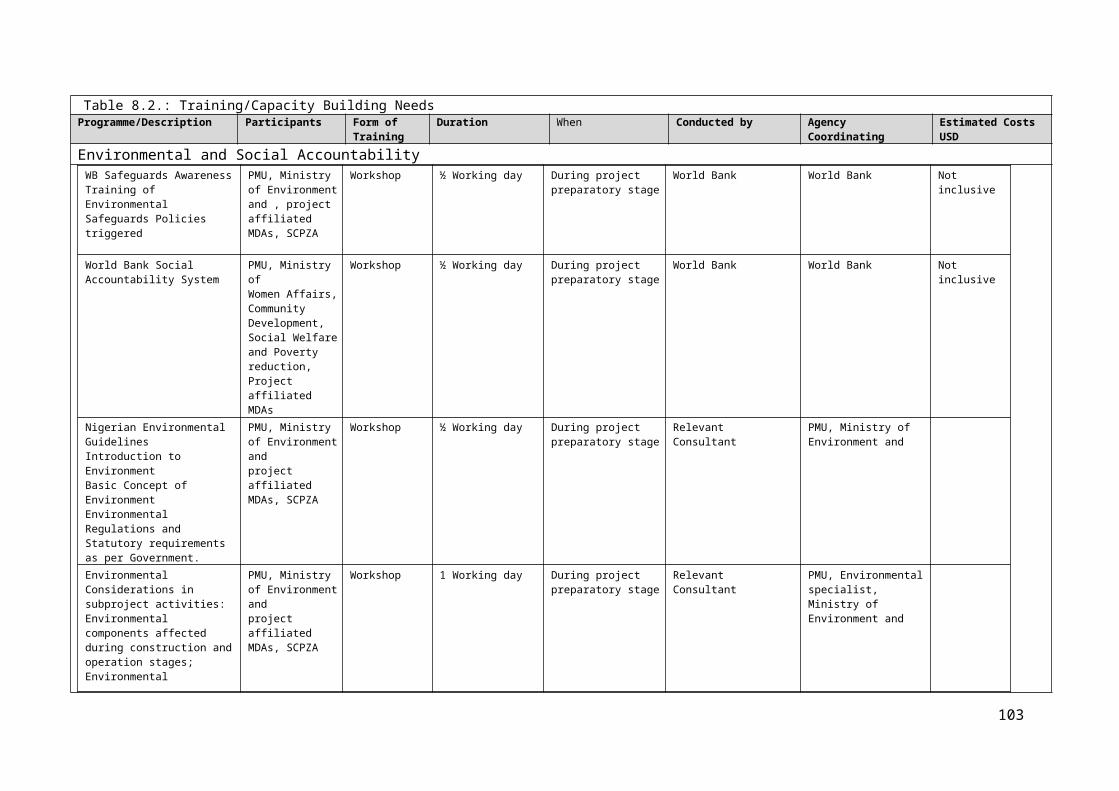
ANNEX 10: Sample Checklist for Environmental Impact Prediction
Project Undertakings Baseline ConditionPossible
Environmental Impact
Field Analysis
Impact Prediction
& Monitoring
Mitigation Measures
I M S
Earthworks (cut and fill equalization)
Topography of the alignment, soil & geology
Accelerated erosion resulting slope instability and landslides
Number and locations of landslides
Extent of civil and bioengineering works for stabilizing eroded and unstable areas?
Water bodies near project Siltation of surface water
Turbidity in streams
Biological Environment
Forest located along the alignment and its area/type/condition
Destruction of vegetation
Quantity/number of trees felled
List of locally found & endangered species
Disturbance to wildlife
Wildlife sitting in the area according to locals
Operation of quarries and borrow pits
Physical Environment
Location/topography/ soil/geology
Disruption of natural land contour resulting slope instability and landslide/ erosion
Quarrying method and possibility of slipping of overburdens
Quantify specifications like restriction to small area, confined to existing quarry sites, not close to tree cover, 60 m away from dwellings, 200 m away from archaeological and cultural sites
Natural drainage pattern
Disturbance to natural drainage patterns resulting in water logging
Water logging
116

ANNEX 10: Sample Checklist for Environmental Impact Prediction
Project Undertakings Baseline ConditionPossible
Environmental Impact
Field Analysis
Impact Prediction
& Monitoring
Mitigation Measures
I M S
Water bodies nearbyContamination of surface water bodies
Turbidity
Biological Environment
Forest located along the alignment, area/type/condition
Removal of vegetation
Any vegetation removal from quarry site, their quantity
List of locally found & endangered species
Disturbance to wildlife population
Wildlife siting in the area according to locals
Spoil and construction waste disposal
Physical Environment
Location/ Topography
Scouring of valley side slopes resulting landslides and erosion
Spoil disposal practice adopted by the project.
Landslides Spoil disposal
practice (designated site/ compaction/leveling/rehabilitation with planting vegetation)
Land used/Area Destruction of property (agriculture land, irrigation etc.)
Land use nearby disposal site
Natural drainage pattern Disruption of natural drainage
Water logging Cross road
drainage / side, drainage/surface drainage construction
Water bodies Siltation of surface water Turbidity
Biological EnvironmentLocation/vegetation type Disturbance to
vegetation Area of
vegetation disturbed and condition
117

ANNEX 10: Sample Checklist for Environmental Impact Prediction
Project Undertakings Baseline ConditionPossible
Environmental Impact
Field Analysis
Impact Prediction
& Monitoring
Mitigation Measures
I M S
Locally found aquatic life in the Water bodies
Disturbance to Aquatic life due to siltation
Turbidity of the water bodies/change in availability of aquatic life
Work camp operation
Physical Environment
Use of machineries and local ambience
Short-term air and noise pollution from machine operation
Site observation
Water bodies nearbyContamination of water bodies due to run-off
Water quality of the nearby stream
Area and type of land occupied or hired
Temporary loss of land
Location of work camp
Water bodies nearby Contamination of water
Runoff to water bodies nearby, sanitary condition, water quality
Provision of rehabilitation after the project completion
Biological Environment
Location/vegetation typeDisturbance to vegetation due to site clearance
Area of vegetation disturbed and condition
Locally found wildlife including endangered species
Possibility of illegal hunting/trapping/fishing
Illegal hunting, trapping of wildlife
Labor camp Physical Environment
Area and type of land occupied or hired
Temporary loss of land (agriculture land/forest land)
Previous land use of the camp/condition of the camp site
Location Solid waste disposal issues
Waste disposal site and waste disposal system
Provision of rehabilitation after the project completion
118

ANNEX 10: Sample Checklist for Environmental Impact Prediction
Project Undertakings Baseline ConditionPossible
Environmental Impact
Field Analysis
Impact Prediction
& Monitoring
Mitigation Measures
I M S
Biological Environment
Area/Type/condition of forest nearbyPressure to the forest vicinity for fuel wood
Fuel wood consumption by workers
Condition of forest in vicinity
Locally found fauna including endangered ones
Possibility of illegal hunting/trapping/fishing
Illegal hunting, trapping of wildlife
Locally found aquatic lives
Impact due to surface and ground water contamination from unsanitary disposal of toilet waste
Number and condition of toilets at camp
Stockpiling of construction materials Water bodies nearby
Siltation of surface water resulting from uncontrolled runoff from storage piles
Visual turbidity of surface waters
Disturbance to tree and vegetation
Disturbance to houses and prime agricultural land
119

120

Annex 11: Generic Environmental and Social Mitigation Measures Checklist Upon completion of the screening form, which would have identified potential sub-project negative environmental and social impacts, the PMU or stakeholders at various levels may use the checklist below to identify the corresponding mitigation measures to successfully manage these impacts. Phase Land
Degradation Water Bio-diversity, Natural Habitats
and Wetlands People
Planning
i. Clearance for agrouctulrea activities and infrastructures such micro dams, hill side terracing, soil bunds etc. ii. Introduce crop rotation management, use of fertilizers, tree planting and soil drainage (v) Control bush burning and fires. vi) Protection of roadsides by planting of vegetation. vii) Protection of outlet of drainage canals and culverts to avoid clogging of river drains. viii) Prepare an effective and sustainable maintenance plan.
Review, update and enforce pollution control legislation. v) Strengthen enforcement capacity. vi) Develop and implement rural water supply and sanitation policy. vii) Locate sub-projects at far/safe distances from water points and sources. viii) Increase public awareness.
i) Consideration of alternative locations/siting of subprojects. ii) Reduce biomass use through provision of alternative energy sources and construction materials (cooking stoves, photovoltaics). iii) Strengthen natural resource management capacities iv) Develop alternatives to slash and burning clearing, decrease overgrazing. v) Promote agro forestry. vi) Wetlands management and small irrigation development. vii) Protect sensitive ecosystems such as forests and wetlands, prevent further encroachment in protected areas. viii) Enforce existing laws. ix) Locate sub-projects appropriately. x) Training of communities of sustainable uses of resources. xi) Identify certain species of trees and animals that must be protected. xii) Exclude ecosystems that provided and important habitat for protected species. xiii)Establish buffer zones around protected parks and wetlands
i) No involuntary settlement allowed due to land acquisition, denial or restriction of access to economic resources such as trees, buildings etc., used by members of communities. ii) Provide social services in areas of Primary education Primary health care Water supply Micro-finance Feeder roads Soil conservation and natural resources management. Basic and required training at State and local community levels. Ensure that these services are equitably distributed throughout the districts and that access is open to all ethnic groups irrespective of status. iii) Ensure that vulnerable groups in sub- project areas are included in project activities and benefit from decision-making and implementation. iv) Provide employment opportunities during contracting of Civil works e.t.c
Construction
• Construction in dry season. Protection of soil surfaces during construction. • Adequate protection from livestock entry by fencing the site perimeters. • Employ all unskilled labour from local community and semi-skilled labour first from local community when
available there in. • Source goods and services from local districts first, when available. • Control and daily cleaning at construction sites. • Provision of adequate waste disposal services including proper disposal of chemicals and other
hazardous materials. • Dust control by water, appropriate design and siting, restrict construction to certain times. • Appropriate and suitable storage of building materials on site. • Siting of Latrines at safe distances from wells and other water points and using closed systems for
sewage drainage. • Restrict construction to certain hours • Minimize loss of natural vegetation during construction; alternative sites; various special measures for
sensitive species • Restoration of vegetation; cleanup of construction sites. • Safety designs (signage) • Ensure availability of clean potable water for use in latrines, canteens and for drinking.
121

Annex 11: Generic Environmental and Social Mitigation Measures Checklist Upon completion of the screening form, which would have identified potential sub-project negative environmental and social impacts, the PMU or stakeholders at various levels may use the checklist below to identify the corresponding mitigation measures to successfully manage these impacts. Phase Land
Degradation Water Bio-diversity, Natural Habitats
and Wetlands People
• Use of appropriate building materials. No asbestos etc Day to Day Operations
• Use facilities/infrastructure as designed and as intended. • Employ trained staff to man and secure facilities. • Log and report any damages done and repairs needed. • Perform periodic monitoring of all aspects as contained in the sub-project Environmental and Social
Monitoring Plan.
Maintenance
• Prepare and adopt suitable maintenance plan. • Maintain appropriate budget necessary to implement maintenance plan. • Implement maintenance plan in two stages: for activities requiring day-to-to maintenance such as repairs
to damages done, regular inspections etc and longer/periodic term maintenance. • Have suitably trained staff to carry out maintenance and access to materials/goods/equipment.
ANNEX 12: Gender Mainstreaming and Vulnerability Assessment- Indicative Framework for Assessing and Mainstreaming Gender Concerns
PreambleNigeria made several commitments to ensuring that gender issues are not only a part of the national discourse but also that they are integrated into policies and development programs. These commitments are contained in frameworks such as the Vision 20:2020 Plan, the National gender Policy and the United Nations’ MDGs framework.
To this end and as part of project preparation, a gender study and consultations with communities should be conducted to assess the challenges and opportunities for the mainstreaming of gender concerns in the project
Objective1. Ascertain how to promote women’s participation in the project and in particular activities.
122

ANNEX 12: Gender Mainstreaming and Vulnerability Assessment- Indicative Framework for Assessing and Mainstreaming Gender Concerns2. Determine under what conditions women could participate in the community-based activities.
As part of project preparation, a gender study and consultations with communities should be conducted to assess the challenges and opportunities for the mainstreaming of gender concerns in the project
Focus/Scope of the StudyIn particular, the study should provide information on:- Women’s needs: aims to assess women’s transport needs and identify ways to address such needs, including
during subproject selection.- Women’s voice in community consultation: aims to identify mechanisms to ensure women’s preferences are
reflected in community consultations, whether for consultations on social safeguards or subproject selection.- Women’s participation in community-based maintenance: aims to identify context-specific entry points and
mechanisms (e.g. quotas) for women’s participation in the maintenance of rehabilitated infrastructure such as roads.
- Project impact on women’s livelihoods: recommend indicators or give indications on sex-disaggregation of existing indicators to reflect the project direct and indirect impact on women’s livelihoods.
Annex 13 Protection of Cultural Property
1. Cultural property include monuments, structures, works of art, or sites of significance points of view, and are defined as sites and structures having archaeological, historical, architectural, or religious significance, and natural sites with cultural values. This includes cemeteries, graveyards and graves. 2. The initial phase of the proposed emergency reconstruction operations pose limited risks of damaging cultural property since projects will largely consist of small investments in community infrastructure, reconstruction of existing structures, and minor public works. Nevertheless, the following procedures for
123

Annex 13 Protection of Cultural Property
identification, protection from theft, and treatment of discovered artifacts should be followed and included in standard bidding documents as provided in Annex 15. .
Chance Find Procedures 3. Chance find procedures will be used as follows: (a) Stop the construction activities in the area of the chance find; (b) Delineate the discovered site or area; (c) Secure the site to prevent any damage or loss of removable objects. In cases of removable antiquities or
sensitive remains, a night guard shall be present until the responsible local authorities and the Ministry in charge of Department of Archaeology and Museums take over;
(d) Notify the supervisory Engineer who in turn will notify the responsible local authorities and the Ministry of Culture immediately (within 24 hours or less); (e) Responsible local authorities and the Ministry in charge of Department of Archaeology and Museums
would be in charge of protecting and preserving the site before deciding on subsequent appropriate procedures. This would require a preliminary evaluation of the findings to be performed by the archeologists of the Department of Archaeology and Museums (within 72 hours). The significance and importance of the findings should be assessed according to the various criteria relevant to cultural heritage; those include the aesthetic, historic, scientific or research, social and economic values;
(f) Decisions on how to handle the finding shall be taken by the responsible authorities and the Ministry in
charge of Department of Archaeology and Museums. This could include changes in the layout (such as when finding an irremovable remain of cultural or archeological importance) conservation, preservation, restoration and salvage;
(g) Implementation for the authority decision concerning the management of the finding shall be
communicated in writing by the Ministry in charge of Department of Archaeology and Museums; and (h) Construction work could resume only after permission is given from the responsible local authorities and
the Ministry in charge of Department of Archaeology and Museums concerning safeguard of the heritage 4. These procedures must be referred to as standard provisions in construction contracts, when applicable, and as proposed in Annex 11. During project supervision, the Site Engineer shall monitor the above regulations relating to the treatment of any chance find encountered are observed. 5. Relevant findings will be recorded in World Bank Project Supervision Reports (PSRs), and Implementation Completion Reports (ICRs) will assess the overall effectiveness of the project’s cultural property mitigation, management, and activities, as appropriate.
124

ANNEX 14: Details of Public Consultations
Public Consultation at Alape This meeting commenced at 2.15pm and was held at the palace of the traditional ruler of Odo-Ape on the 16 th of August 2014. The forum was a rallying point for all the social groups, community heads and interest groups that had been previously consulted on the project.A total of 61 persons attended the meeting including stakeholders as follows:1. Odo-Ape community,2. Ape community3. Agbadu community4. Bassa camp5. Fulani representative6. Ebira representative7. Federal ministry of agriculture8. Kogi ADP9. Kogi Fadama 3IntroductionChief Awoniyi introduced the essence of the meeting followed by self-introduction of persons. Interactions on the triggered safeguards instruments took place with the different consultants preparing RPF, ESMF and IPMP. Presented in this RPF however, are the interactions that focused on the OP 4.12 (involuntary resettlement).The consultant preparing RPF thanked the leadership and entire community for their cooperation and response to the call for community consultation. He reiterated the essence of the project in the Alape community in which he stated that the project in the area is to provide a model SCPZ that would be replicated in the other proposed SCPZ zones in the country. The success factors for the project include robust stakeholder participation and synergy. He stated that the RPF is an important document that will describe the process and methods for carrying out resettlement under the Project, including compensation, relocation and rehabilitation of project affected persons, pointing out that careful handling of social and legacy issues is important to avert crises that may affect project sustainability; this underscores the need for social profiling of the community. He specifically stated that the team is in the community to hear from, learn and deliberate with the community to elicit useful information that will be mainstreamed into the project planning and the sub-projects RAP that will be taking in the near future. Following this explanations, the consultant enjoined the people to ask questions and make contributions as much as possible.The questions and interactions took off as follows:Question Response Response byWhat is the perception of the community about the project?
Well received. Community leaders, women and youths
Do you all understand the project concept and benefit?
The agencies and consultants coming for different related studies have explained that the project is to improve the way farming is practiced, introduce staple crop processing, bring employment to women and youths, and improve farmers opportunities
Community
Has there been conflicts relating to the land where SCPZ is being sited
No Community
Who owns part or all of the land for SCPZ?
The land belongs to Alape which is made up of 3 related communities (Agbadu, Odo-Ape and Ape)
Oba of Odo-Ape & community
How do people acquire land? Individuals who want to acquire land go to the head of the particular community where he/she wants to acquire land. Each community has a land committee under the village head. They are responsible for guiding him/her on customary obligations to be fulfilled to acquire land
Oba of Odo-Ape
Are there local mechanism s for settling land disputes?
Land disputes have hardly occurred. However, the traditional council has the mandate to settle any civil dispute including land conflict matters
community
Do individuals own or inherit land in your community
All lands belong to the community Oba of Odo-Ape & community
Do women have right to own farms? Yes Elders, Women & communityDo women have equal rights as men in agricultural participation and community decision makings?
Yes Elders, Women & community
How much is a plot of land? No specific price. It depends on what is agreed between the community and the party interested in land lease
Oba of Odo-Ape & community
What is the population of the 3 project affected communities?
Agbadu: 50,000, Odo-Ape: 30,000 and Ape: 30,000 Oba of Odo-Ape & community
125

ANNEX 14: Details of Public Consultations
What are the key means of livelihood in this community?
100% of the people practice farming. Other activities are trading and hunting.
Community
Means of transportation/movement Car, motor-cycle and by foot (trekking) CommunityWhat are the forms of cooperative societies in the locality?
Women farmers association and youth farmers association
Community
Are there herdsmen? Yes, but mainly Fulani migrant herdsmen. CommunityIn what way do the herders rear their cattle to avoid destruction of public crops and assets?
The few herdsmen who are from the community practice enclosed cattle rearing which implies control to cattle movement. Where the problem lies is the migrant Fulani herdsmen who operate without borders and destroy crops
community
How can the activities of cow encroachment on farms be avoided or controlled
There should be a grazing reserve/zone for herdsmen to reduce conflict that is associated with cattle destruction of farm crops
Ex-commissioner of Agriculture, Fulani
Has there been youth migration Yes. Youths of the community have migrated to the city in search of greener pasture, but much more, people from other communities have migrated into the community because of the farming opportunities available and the hospitality of the community towards visitors
Oba of Odo-Ape & community
Expectation from Cargill or the project? Water, electricity, road construction, employment, hospital.
Commitment of the community to project implementation
Cooperation to contractors and investors, provision of security and other assistances that may be required
community
CONCERNS, EXPECTATIONS AND ANSWERSQuestion Response Responded byWould compensation be given for the economic crops demolished and those soon to be demolished?
Yes FMARD, consultant
Would cassava be the only crop to be produced on project site?
No, but considering soya bean also FMARD, consultant
Are all the land within the ABIR going to be taking from the community?
Yes, to the once at project site but lands would be available for those that need to farm and every other thing would be provided
FMARD, consultant
W;ould dams be provided for farming with or without dry season for effective farming?
3 options were created by GEMs which include;1. The use of Oyin river 2. Drawing pipes from Osara dam.3. Infiltration gallery of all boreholes to be used.
FMARD, consultant
In conclusion, the people of ALAPE wanted to know what skills and education to enlist their children in order to be relevant to the opportunities that the project will provide. The RPF consultant encouraged them to acquire skills and study on courses relevant to agricultural production, processing, agricultural financing, engineering marketing and services. Closing prayers was said by the FMARD representative.
Community concerns - kabba-bunuProject Area
Issues Group/Organization
Details
Kab
ba-B
unu
(Odo
-Ape
, K
abba
,
Agb
adu,
E
shi,
Ilegu
n, )
Concerns & Questions Communities, Women, Youth
Can the investments/factories be spread across all the communities in Alape to ensure no one community is marginalized
Will this project provide employment for our teaming youths and women?
Will government and investor ensure the community that waste/effluents from the processing factory will be treated and handled in a manner that will not cause air pollution in the area
Will the project provide scholarship opportunity for the students in the community?
126

ANNEX 14: Details of Public Consultations
Responses to Questions and Concerns
The factories will be located at one location for ease of operation as is the practice in SCPZ’s around the globe.
Geographical spread of investment will be achieved as more investors will be attracted to the ABIR.
The project will not promise scholarship but may train groups that will be identified for project implementation and RAP in particular;
Waste and effluents from the processing factory will be treated and disposed in line with the provisions of OP 4.01 and the Nigerian extant laws.
Ministry of Environment is a stakeholder in this project to monitor and ensure compliance of environmental responsibility and sustainability
Expectations and Request
Community Water, electricity, road construction, employment, hospital.They want the project to create a 2km radius along the main road as buffer for the communityThey requested that the investor (Cargill should locate the processing factory within Alape land and at close distance to settlement to enhance community socio-economic network
Women & Youths
Want the project to give the community preference in job employment and contractsWant to be assisted with inputs and technical support to participate commensurably in the Cargill farm plan
Fulani herdsmen
Want to be integrated into the project stream by creating for them a grazing reserve area, and by giving them employment as security personnel
Ebira settlement
Want to be carried along/participate in the agri-investment programme of Cargill
FADAMA III ADFItems DescriptionName of Stakeholder: FADAMA III ADFDate: 01/08/2014Present: See Attendance list Venue: FADAMA III office, LokojaLanguage of Communication: English and YorubaOpening Remarks: The FADAMA State Project Coordinator, Mr PSF Ogunmola gave the
welcome address and opening remarks;Thereafter, the ESMF consultant introduced his team and the reason for their visit to the FADAMA office.
Stakeholder Remarks: HistoryThe Alape SCPZ/ABIR projectInvolvement of FADAMA III ADFThe Concerned communitiesFADAMA’s activities in these communitiesContacts of important stakeholders
AGBADU TOWNItems DescriptionName of Stakeholder: Agbadu Town, Kabba-Bunu LGADate: 02/08/2014
Present: See Attendance list
Venue: Palace of Obajemu of Agbadu TownLanguage of Communication: English and YorubaOpening Remarks: Chief Ehalaiye (Kogi State Ministry of Agriculture Desk Officer) gave the
welcome address and opening remarks;He also introduced the Consultant to the traditional rulers, women leaders, youth leaders and other members of the communities present;The ESMF consultant thereafter elaborated on the essence of the ESMF;
Questions from the consultant and the response from the community members:
Perception of the community about the projectWell received.Knowledge of the project concept and benefitsThey indicated that they have been well informed about the project by the agencies and consultants coming for different related studies. They noted
127

ANNEX 14: Details of Public Consultations
that based on their understanding the project is to improve the way farming is practiced, bring employment to women and youths, and improve farmers opportunitiesPerceived environmental and social impactMaintenance of the 1 kilometer buffer zone between the SCPZ/ABIR and the communityEnhanced afforestation to cover for the large scale deforestation in the establishment of the nucleus farm and processing plants.First consideration should be given to the indigenes of the community in terms of employment before any others since they are the most affected.
Queries and Concerns Anxiety on the quick completion of the land acquisition process and importantly on compensation payment.Expectations on the benefits of the project
ODO-APE TOWNItems DescriptionName of Stakeholder: Odo-Ape Community, Kabba-Bunu LGADate: 01/08/2014Present: See Attendance list
Venue: Obaro of Odo-Ape PalaceLanguage of Communication: English and YorubaOpening Remarks: (Kogi State Ministry of Agriculture Desk Officer) gave the welcome address
and opening remarks;He also introduced the Consultant to the traditional rulers, women leaders, youth leaders and other members of the communities present;The ESMF consultant thereafter elaborated on the essence of the ESMF
Questions from the consultant and the response from the community members:
Perception of the community about the projectWell received.Knowledge of the project concept and benefitsThey indicated that they have been well informed about the project by the agencies and consultants coming for different related studies. They noted that based on their understanding the project is to improve the way farming is practiced, bring employment to women and youths, and improve farmers opportunitiesPerceived environmental and social impactThe need to locate important sections of the processing zone in their community. This is to enable the engagement of the indigenes of the community in the project. The SCPZ/ABIR is located on their land so they must benefit more.
Queries and Concerns The proposed farming system which does not make use of ridges will potentially lead to soil erosion as is presently being experienced on the pilot cassava farm.
JOINT TOWN HALL MEETING
128

ANNEX 14: Details of Public Consultations
129
Items DescriptionName of Stakeholder: General Stakeholders Consultation,Date: 16/08/2014Present: Project Coordinator
Traditional ruler and inhabitants of Odo-Ape community, Traditional ruler and inhabitants of Agbadu community Rep of Traditional ruler and inhabitants of Ape community Inhabitants of Bassa camp Ebira settlers Rep of Federal Ministry of Agriculture Rep of Kogi ADP Rep of KogiFadama III ADF Consultants for ESMF, RPF and IPMP
Venue: Obaro of Odoape’s PalaceLanguage of Communication: English/YorubaOpening Remarks: Chief Awoniyi gave the welcome address and opening remarks;
Chief Ehalaiye (Kogi State Ministry of Agriculture Desk Officer) introduced the Consultant, the traditional rulers, women leaders, youth leaders and the other members of the project affected communities present;The ESMF consultant thereafter elaborated on the essence of the ESMF;
Questions from the consultant and the response from the community members:
Perception of the community about the projectWell received.Knowledge of the project concept and benefitsThe agencies and consultants coming for different related studies have explained that the project is to improve the way farming is practiced, bring employment to women and youths, and improve farmers opportunitiesThe Soil ConditionGood but susceptible to erosionThe Air ConditionUnpolluted and Natural air conditionWater condition and accessibilityThe available water is good for consumption and are got from boreholes and wells in the communityAvailable water source
Odo-Ape 10 boreholes but 1 functional Agbadu 1 functional borehole Ape 4 boreholes but none functional
The major ailment in the areaMalariaAvailable health care facilities
Odo-Ape 1 dispensary center Agbadu 1 health center Ape 1 dispensary center
Available educational facilities Odo-Ape 2 pry, 1 UBE, 1Sec Agbadu 1 pry Ape 1 pry, 1 UBE
Available communication facilitiesThe major networks available includes;
Mtn, Glo, Airtel, Etisalat
Queries and Concerns The proposed farming system which does not make use of ridges will potentially lead to soil erosion as is presently being experienced on the pilot cassava farm.
The proposed farming system will also lead to surface water pollution coming from water erosion with herbicides and pesticides applied on the farm into Oinye River

ANNEX 15: Details of Public Consultations – Photos
130
Group Picture taken after the joint public consultation with the representatives of the three affected communities
Group Picture taken at project site after FGD with the project coordinator Chief Awoniyi in mat cap), Kogi State Agriculture commissioner(Mr. Atte; white safari) and the representatives of the investor (CARGILL)
Group Picture taken after consultation with women leaders of the three affected communities
Group Picture taken after consultation with the leaders of Agbadu community

131
Group Picture taken after consultation with the leaders of Odoape community
Group Picture taken after consultation with the Kogi FADAMA officials
Group Picture taken after consultation with PAP in Okehi LGA
Group Picture taken after consultation with the leaders of Oshokoshoko/Iwaa community
Group Picture taken during consultation with the people of Iresuare community

Annex 16: Public Participation in Project Cycle Project Cycle
ESIA Component
Public Participation Activity
Pre-Feasibility
Environmental and Social Screening
Identifies public groups and begins initial contact with groups.
Initial Environmental Examination (IEE)
Continue consultations – public provides input to IEE report.
Scoping
Identifies major issues for Scoping and TOR using public input and makes plan for public involvement.
Feasibility
Environmental and Social Impact Assessment (ESIA)
The public reviews and comments on draft ESIA study report. The public provides input to design and survey.
Detailed Survey and Design
Integration of Environmental Mitigation Measures
Detailed design made available to the public.
Construction and Operation
Environmental and Social Monitoring
The public provides input to post evaluation of impacts and mitigation measures.
132

Annex 17: Grievance Registration Form
THIRD PARTY GRIEVANCE FORMCOMPLAINANT DETAILS
Complainant’s name (Or name of a representative for complainant/s)Land parcel number (if applicable)Complainant’s postal addressComplainant’s telephone number and e-mail address (if available)Preferred language of communicationComplainant confidentiality ☐ I wish to raise my grievance anonymously
☐ I request that my identity is not disclosed to anyone internally except the grievance coordinator handling my case
I would prefer if the personnel contacting me is: ☐ male, ☐ female, ☐ gender does not matter GRIEVANCE DETAILSDate :Description of incident details (what happened? when? how? where? quantities?)Severity ☐ One time incident/grievance (date _______________)
☐ Recurring (how many times? _____) ☐ On-going (currently experiencing problem)
Complainant’s request/proposal to resolve grievance (Please explain what should be done to solve this problem?)Grievance type (environment, human rights, livelihood, health, legal, property, corruption)Level of damage: ☐low ☐medium ☐ high
Additional documentation related to grievanceVerbal Complaint If complainant is verbal and in the case that the compliant
cannot read or write, the environmental and social specialist will help to write it down.
ANNEX 18: Indicative Environmental Code of Conduct and Clauses for Contractors1. Environmental Code of Conduct for Infrastructure Development
133

ANNEX 18: Indicative Environmental Code of Conduct and Clauses for Contractors
SN Environmental Issue Potential Impact Codes of Conduct
Pre-construction/Construction Phase
1 Land Use
Road alignment may pass through cultivated and forested land resulting in a permanent loss of the resources.
While the landowner has to part away with his land ownership, the environmental effects can amplify if proper operation and maintenance schedules are overruled.
Plan infrastructure such as road alignment to minimize loss of resources. Avoid width of infrastructure such as road of more than 4.5 m in hilly area. Demarcate RoW to avoid encroachment.
2 Material Use
Excess extraction of local resources, such as wood, sand, soil, boulders, etc.
Degradation of forests, erosion and landslide at steep locales due to boulder, stone extraction.
Change in river/stream ecosystem due to unchecked sand extraction.
Extract materials only on need basis. Avoid sensitive areas, such as steep slopes and water-ways.
3 Slope Stability
Extraction of forest products and cutting of trees in the steep slopes increases soil erosion/landslide due to loss of soil binding materials.
Wrong alignment can trigger slope failure
Haphazard disposal of construction waste can disturb slopes
Improper drainage facilities can result in erosion and landslides
Extract carefully and secure the top soil within 25 cm from the surface. Limit down grading of the infrastructure such as road to 50. If down grading exceeds 70, construction of side drainage is necessary. Keep optimum balance in extraction and filling of soil works. geo-hazardous assessment and mapping Use designated disposal site and avoid sidecasting of spoil Provide proper drainage Use bio-engineering on exposed slopes
4 Wildlife
Wildlife habitats at forests, shrub land along infrastructure such as road alignment are affected from the infrastructure such as road construction activities.
Wildlife and human conflicts increase as wildlife might destroy the crops or attack the construction worker.
Avoid as much as possible areas with high biodiversity. Efficient movement of machinery and other traffic. Control poaching activities and regulate movement of labor force and their dependents into the forest area. District Forest Office and its subsidiary body should be involved in monitoring the activities of the construction workers and officials to minimize wildlife harassing, trapping and poaching.
5 Drainage
Higher flow rate of surface water and water logging induce land slides, erosion.
Quality of infrastructure such as road diminishes due to poor drainage such as water logging, immense flow rate of surface water.
It is strongly recommended that the cross drainage outlets must be channeled to the confirmed natural drains. If horizontal slope exceeds 5%, construction of flow control device necessary every 20m.
6 Protection of Vegetation
Protected areas and highly forested areas.
Degradation of forest areas. Degradation of agricultural land.
Use minimum and efficient use of wood products for construction. Initiate plantation at damaged and damage prone areas. Increase liability of local forest user groups. Avoid protected areas or densely forested areas
7 Disposal of Construction
Dumping of wastes along the infrastructure such as road or
Selected spoil dumping sites should be used. After disposal, the area should be leveled and
134

ANNEX 18: Indicative Environmental Code of Conduct and Clauses for Contractors
SN Environmental Issue Potential Impact Codes of Conduct
Wastes elsewhere.
compacted. It is recommended to conserve the soil by planting indigenous plants including grasses. Wastes could also be used as leveling materials along the infrastructure such as roadside.
8Disposal of Sanitary Wastes
Unmanaged sanitary waste disposal creating health problems and public nuisance.
Proper sanitation area needs to be demarked. Check for hygiene of work force.
9Impacts on amenities along RoW
Infrastructure such as road crossings at water supply, irrigation lines may be disturbed/damaged.
Avoid as much as possible the crossing over such amenities.
10 Pollution
Dust generation from construction activities, construction vehicular movement increases air pollution.
Noise pollution likely from construction machinery operation and vehicular movement.
Sanitary problems likely at the construction and workforce quarters.
Possibly construction period should be during August to December when soil moisture content is most. Consider construction of infrastructure such as road at 50 m from settlement. Enforce speed limit of vehicles and construct the infrastructure such as road according to volume and size of traffic movement.
Operation Phase
1 Encroachment Unmanaged settlement, construction along the RoW. Establish RoW properly and enforce its limits.
2Interruption of Water Flow along RoW
Concentrated flow left unattended might have severe impact at the downhill alignment of the infrastructure such as road.
Cross drain structures, namely pipe culverts, slab culverts, box culverts, need to be maintained. Outlet of these structures would be carrying the concentrated run off flow of the respective catchment, which will be quite high during rainy season, which in turn would require proper planning of drainage systems.
3Pollution/Vehicular Emission
Dust generation from vehicular movement increases air pollution.
Noise pollution likely from vehicular movement.
Enforce speed limit of vehicles. Maintain traffic size movement. Discourage use of horns.
4 Aesthetics
Infrastructure such as road construction is likely to increase landscape scars along the infrastructure such as road alignment.
In addition if the construction spoils are disposed off improperly, the ground vegetation would be destroyed which will be visible from a distance.
Such damage cannot be avoided but can be minimized through re-plantation of indigenous species and greenery development.
ANNEX 18- 2: General Environmental Management Conditions For Construction Contracts
General1. In addition to these general conditions, the Contractor shall comply with any specific Environmental Management Plan (EMP) or Environmental and Social Management Plan (ESMP) for the works he is responsible for. The Contractor shall inform himself about such an EMP, and prepare his work strategy and plan to fully take into account relevant provisions of that EMP. If the Contractor fails to implement the approved EMP after written instruction by the Supervising Engineer (SE) to fulfil his obligation within the requested time, the Owner reserves the right to arrange through the SE for execution of the missing action by a third party on account of the Contractor.
2. Notwithstanding the Contractor’s obligation under the above clause, the Contractor shall implement all measures necessary to avoid undesirable adverse environmental and social impacts wherever possible, restore work sites to acceptable standards, and abide by any environmental performance requirements specified in an EMP. In general these measures shall include but not be limited to:
135

ANNEX 18: Indicative Environmental Code of Conduct and Clauses for Contractors(a) Minimize the effect of dust on the surrounding environment resulting from earth mixing sites, asphalt mixing sites, dispersing coal ashes, vibrating equipment, temporary access infrastructure such as roads, etc. to ensure safety, health and the protection of workers and communities living in the vicinity dust producing activities.(b) Ensure that noise levels emanating from machinery, vehicles and noisy construction activities (e.g. excavation, blasting) are kept at a minimum for the safety, health and protection of workers within the vicinity of high noise levels and nearby communities.(c) Ensure that existing water flow regimes in rivers, streams and other natural or irrigation channels is maintained and/or re-established where they are disrupted due to works being carried out.
(d) Prevent bitumen, oils, lubricants and waste water used or produced during the execution of works from entering into rivers, streams, irrigation channels and other natural water bodies/reservoirs, and also ensure that stagnant water in uncovered borrow pits is treated in the best way to avoid creating possible breeding grounds for mosquitoes.(e) Prevent and minimize the impacts of quarrying, earth borrowing, piling and building of temporary construction camps and access infrastructure such as roads on the biophysical environment including protected areas and arable lands; local communities and their settlements. In as much as possible restore/rehabilitate all sites to acceptable standards.(f) Upon discovery of ancient heritage, relics or anything that might or believed to be of archaeological or historical importance during the execution of works, immediately report such findings to the SE so that the appropriate authorities may be expeditiously contacted for fulfilment of the measures aimed at protecting such historical or archaeological resources.(g) Discourage construction workers from engaging in the exploitation of natural resources such as hunting, fishing, collection of forest products or any other activity that might have a negative impact on the social and economic welfare of the local communities.(h) Implement soil erosion control measures in order to avoid surface run off and prevents siltation, etc.(i) Ensure that garbage, sanitation and drinking water facilities are provided in construction workers camps.(j) Ensure that, in as much as possible, local materials are used to avoid importation of foreign material and long distance transportation.(k) Ensure public safety, and meet traffic safety requirements for the operation of work to avoid accidents.
3. The Contractor shall indicate the period within which he/she shall maintain status on site after completion of civil works to ensure that significant adverse impacts arising from such works have been appropriately addressed.
4. The Contractor shall adhere to the proposed activity implementation schedule and the monitoring plan / strategy to ensure effective feedback of monitoring information to project management so that impact management can be implemented properly, and if necessary, adapt to changing and unforeseen conditions.
5. Besides the regular inspection of the sites by the SE for adherence to the contract conditions and specifications, the Owner may appoint an Inspector to oversee the compliance with these environmental conditions and any proposed mitigation measures. State environmental authorities may carry out similar inspection duties. In all cases, as directed by the SE, the Contractor shall comply with directives from such inspectors to implement measures required to ensure the adequacy rehabilitation measures carried out on the bio-physical environment and compensation for socio-economic disruption resulting from implementation of any works.
Worksite/Campsite Waste Management6. All vessels (drums, containers, bags, etc.) containing oil/fuel/surfacing materials and other hazardous chemicals shall be bunded in order to contain spillage. All waste containers, litter and any other waste generated during the construction shall be collected and disposed off at designated disposal sites in line with applicable government waste management regulations.
7. All drainage and effluent from storage areas, workshops and camp sites shall be captured and treated before being discharged into the drainage system in line with applicable government water pollution control regulations.
8. Used oil from maintenance shall be collected and disposed off appropriately at designated sites or be
136

ANNEX 18: Indicative Environmental Code of Conduct and Clauses for Contractorsre-used or sold for re-use locally.
9. Entry of runoff to the site shall be restricted by constructing diversion channels or holding structures such as banks, drains, dams, etc. to reduce the potential of soil erosion and water pollution.
10. Construction waste shall not be left in stockpiles along the infrastructure such as road, but removed and reused or disposed of on a daily basis.
11. If disposal sites for clean spoil are necessary, they shall be located in areas, approved by the SE, of low land use value and where they will not result in material being easily washed into drainage channels. Whenever possible, spoil materials should be placed in low-lying areas and should be compacted and planted with species indigenous to the locality.
Material Excavation and Deposit
12. The Contractor shall obtain appropriate licenses/permits from relevant authorities to operate quarries or borrow areas.
13. The location of quarries and borrow areas shall be subject to approval by relevant local and national authorities, including traditional authorities if the land on which the quarry or borrow areas fall in traditional
land.14. New extraction sites:
a) Shall not be located in the vicinity of settlement areas, cultural sites, wetlands or any other valued ecosystem component, or on on high or steep ground or in areas of high scenic value, and shall not be located less than 1km from such areas.
b) Shall not be located adjacent to stream channels wherever possible to avoid siltation of river channels. Where they are located near water sources, borrow pits and perimeter drains shall surround quarry sites.
c) Shall not be located in archaeological areas. Excavations in the vicinity of such areas shall proceed with great care and shall be done in the presence of government authorities having a mandate for their protection.
d) Shall not be located in forest reserves. However, where there are no other alternatives, permission shall be obtained from the appropriate authorities and an environmental impact study shall be conducted.
e) Shall be easily rehabilitated. Areas with minimal vegetation cover such as flat and bare ground, or areas covered with grass only or covered with shrubs less than 1.5m in height, are preferred.
f) Shall have clearly demarcated and marked boundaries to minimize vegetation clearing.15. Vegetation clearing shall be restricted to the area required for safe operation of construction work.
Vegetation clearing shall not be done more than two months in advance of operations.16. Stockpile areas shall be located in areas where trees can act as buffers to prevent dust pollution.
Perimeter drains shall be built around stockpile areas. Sediment and other pollutant traps shall be located at drainage exits from workings.
17. The Contractor shall deposit any excess material in accordance with the principles of the general conditions, and any applicable EMP, in areas approved by local authorities and/or the SE.
18. Areas for depositing hazardous materials such as contaminated liquid and solid materials shall be approved by the SE and appropriate local and/or national authorities before the commencement of
work. Use of existing, approved sites shall be preferred over the establishment of new sites.
Rehabilitation and Soil Erosion Prevention19. To the extent practicable, the Contractor shall rehabilitate the site progressively so that the rate of
rehabilitation is similar to the rate of construction.20. Always remove and retain topsoil for subsequent rehabilitation. Soils shall not be stripped when they
are wet as this can lead to soil compaction and loss of structure.21. Topsoil shall not be stored in large heaps. Low mounds of no more than 1 to 2m high are recommended.22. Re-vegetate stockpiles to protect the soil from erosion, discourage weeds and maintain an active
population of beneficial soil microbes.
137

ANNEX 18: Indicative Environmental Code of Conduct and Clauses for Contractors23. Locate stockpiles where they will not be disturbed by future construction activities.24. To the extent practicable, reinstate natural drainage patterns where they have been altered or impaired.25. Remove toxic materials and dispose of them in designated sites. Backfill excavated areas with soils or
overburden that is free of foreign material that could pollute groundwater and soil.26. Identify potentially toxic overburden and screen with suitable material to prevent mobilization of toxins.27. Ensure reshaped land is formed so as to be inherently stable, adequately drained and suitable for the
desired long-term land use, and allow natural regeneration of vegetation.28. Minimize the long-term visual impact by creating landforms that are compatible with the adjacent
landscape.29. Minimize erosion by wind and water both during and after the process of reinstatement.30. Compacted surfaces shall be deep ripped to relieve compaction unless subsurface conditions dictate
otherwise.31. Revegetate with plant species that will control erosion, provide vegetative diversity and, through
succession, contribute to a resilient ecosystem. The choice of plant species for rehabilitation shall be done in consultation with local research institutions, forest department and the local people.
Water Resources Management32. The Contractor shall at all costs avoid conflicting with water demands of local communities.33. Abstraction of both surface and underground water shall only be done with the consultation of the local
community and after obtaining a permit from the relevant Water Authority.34. Abstraction of water from wetlands shall be avoided. Where necessary, authority has to be obtained
from relevant authorities.35. Temporary damming of streams and rivers shall be done in such a way avoids disrupting water supplies to communities down stream, and maintains the ecological balance of the river system.36. No construction water containing spoils or site effluent, especially cement and oil, shall be allowed to
flow into natural water drainage courses.37. Wash water from washing out of equipment shall not be discharged into water courses or infrastructure such as road drains.38. Site spoils and temporary stockpiles shall be located away from the drainage system, and surface run
off shall be directed away from stockpiles to prevent erosion.
Traffic Management39. Location of access infrastructure such as roads/detours shall be done in consultation with the local community especially in important or sensitive environments. Access infrastructure such as roads shall not traverse wetland areas.40. Upon the completion of civil works, all access infrastructure such as roads shall be ripped and rehabilitated.41. Access infrastructure such as roads shall be sprinkled with water at least five times a day in settled areas, and three times in unsettled areas, to suppress dust emissions.Blasting42. Blasting activities shall not take place less than 2km from settlement areas, cultural sites, or wetlands
without the permission of the SE.43. Blasting activities shall be done during working hours, and local communities shall be consulted on the
proposed blasting times.44. Noise levels reaching the communities from blasting activities shall not exceed 90 decibels.
Disposal of Unusable Elements45. Unusable materials and construction elements such as electro-mechanical equipment, pipes,
accessories and demolished structures will be disposed of in a manner approved by the SE. The Contractor has to agree with the SE which elements are to be surrendered to the Client’s premises, which will be recycled or reused, and which will be disposed of at approved landfill sites.
46. As far as possible, abandoned pipelines shall remain in place. Where for any reason no alternative alignment for the new pipeline is possible, the old pipes shall be safely removed and stored at a safe place to be agreed upon with the SE and the local authorities concerned.
47. AC-pipes as well as broken parts thereof have to be treated as hazardous material and disposed of as
138

ANNEX 18: Indicative Environmental Code of Conduct and Clauses for Contractorsspecified above.
48. Unsuitable and demolished elements shall be dismantled to a size fitting on ordinary trucks for transport.
Health and Safety49. In advance of the construction work, the Contractor shall mount an awareness and hygiene campaign.
Workers and local residents shall be sensitized on health risks particularly of AIDS.50. Adequate infrastructure such as road signs to warn pedestrians and motorists of construction activities, diversions, etc. shall be provided at appropriate points.51. Construction vehicles shall not exceed maximum speed limit of 40km per hour.
Repair of Private Property52. Should the Contractor, deliberately or accidentally, damage private property, he shall repair the property to the owner’s satisfaction and at his own cost. For each repair, the Contractor shall obtain from the
owner a certificate that the damage has been made good satisfactorily in order to indemnify the Client from subsequent claims.
53. In cases where compensation for inconveniences, damage of crops etc. are claimed by the owner, the Client has to be informed by the Contractor through the SE. This compensation is in general settled under the responsibility of the Client before signing the Contract. In unforeseeable cases, the respective administrative entities of the Client will take care of compensation.
Contractor’s Environment, Health and Safety Management Plan (EHS-MP)54. Within 6 weeks of signing the Contract, the Contractor shall prepare an EHS-MP to ensure the adequate management of the health, safety, environmental and social aspects of the works, including implementation of the requirements of these general conditions and any specific requirements of an EMP for the works. The Contractor’s EHS-MP will serve two main purposes:
For the Contractor, for internal purposes, to ensure that all measures are in place for adequate EHS management, and as an operational manual for his staff.
For the Client, supported where necessary by a SE, to ensure that the Contractor is fully prepared for the adequate management of the EHS aspects of the project, and as a basis for monitoring of the Contractor’s EHS performance.
55. The Contractor’s EHS-MP shall provide at least: a description of procedures and methods for complying with these general environmental management
conditions, and any specific conditions specified in an EMP; a description of specific mitigation measures that will be implemented in order to minimize adverse impacts; a description of all planned monitoring activities (e.g. sediment discharges from borrow areas) and the
reporting thereof; and the internal organizational, management and reporting mechanisms put in place for such.
56. The Contractor’s EHS-MP will be reviewed and approved by the Client before start of the works. This review should demonstrate if the Contractor’s EHS-MP covers all of the identified impacts, and has defined appropriate measures to counteract any potential impacts.
EHS Reporting57. The Contractor shall prepare bi-weekly progress reports to the SE on compliance with these general conditions, the project EMP if any, and his own EHS-MP. An example format for a Contractor EHS report is portrayed in Annex 6. It is expected that the Contractor’s reports will include information on:
EHS management actions/measures taken, including approvals sought from local or national authorities; Problems encountered in relation to EHS aspects (incidents, including delays, cost consequences, etc. as a
result thereof); Lack of compliance with contract requirements on the part of the Contractor; Changes of assumptions, conditions, measures, designs and actual works in relation to EHS aspects; and Observations, concerns raised and/or decisions taken with regard to EHS management during site
meetings.58. It is advisable that reporting of significant EHS incidents be done “as soon as practicable”. Such incident
139

ANNEX 18: Indicative Environmental Code of Conduct and Clauses for Contractors reporting shall therefore be done individually. Also, it is advisable that the Contractor keep his own records on health, safety and welfare of persons, and damage to property. It is advisable to include such records, as well as copies of incident reports, as Annexes to the bi-weekly reports. A sample format for an incident notification is shown below. Details of EHS performance will be reported to the Client through the SE’s reports to the Client.
Training of Contractor’s Personnel59. The Contractor shall provide sufficient training to his own personnel to ensure that they are all aware of the relevant aspects of these general conditions, any project EMP, and his own EHS-MP, and are able to fulfil their expected roles and functions. Specific training should be provided to those employees that have particular responsibilities associated with the implementation of the EHS-MP. General topics should be:
EHS in general (working procedures); emergency procedures; and social and cultural aspects (awareness raising on social issues).
Cost of Compliance60. It is expected that compliance with these conditions is already part of standard good workmanship and state of art as generally required under this Contract. The item “Compliance with Environmental Management Conditions” in the Bill of Quantities covers this cost. No other payments will be made to the Contractor for compliance with any request to avoid and/or mitigate an avoidable EHS impact.
3. Example Format: EHS Report
Contract: Period of reporting:EHS Management Actions/Measures:Summarize EHS management actions/measures taken during period of reporting, including planning and management activities (e.g. risk and impact assessments), EHS training, specific design and work measures taken, etc.
EHS incidents:Report on any problems encountered in relation to EHS aspects, including its consequences (delays, costs) and corrective measures taken. Include relevant incident reports.
EHS compliance:Report on compliance with Contract EHS conditions, including any cases of non-compliance.
Changes:Report on any changes of assumptions, conditions, measures, designs and actual works in relation to EHS aspects.
Concerns and observations:Report on any observations, concerns raised and/or decisions taken with regard to EHS management during site meetings and visits.
Signature (Name, Title Date):Contractor Representative
EHS Incident Notification
Provide within 24 hrs to the Supervising Engineer
Originators Reference No:.........................................................................................................
Date of Incident:................................................................. Time:........................
140

ANNEX 18: Indicative Environmental Code of Conduct and Clauses for Contractors
Location of incident:...................................................................................................................
Name of Person(s) involved:.......................................................................................................
Employing Company:....................................................................................................................
Type of Incident:............................................................................................................................
Description of Incident:Where, when, what, how, who, operation in progress at the time (only factual)
Immediate Action:Immediate remedial action and actions taken to prevent reoccurrence or escalation
Signature (Name, Title, Date):.....................................................................................................Contractor Representative
;
141