chapter 8 - landscape introduction · 2016-04-28 · chapter 8 - landscape introduction ......
TRANSCRIPT

MYG Chapter 8: Landscape Page 1
Mynydd y Gwynt Wind Farm: Environmental Statement July 2014
CHAPTER 8 - LANDSCAPE
Introduction
8.1 This chapter presents the findings of a landscape and visual impact assessment (“LVIA”) of the proposed wind farm at the Sweet Lamb Rally Complex adjacent to the A44 between Llangurig and Devil’s Bridge. The study has identified and evaluated the potential key impacts on the landscape and visual resource of an initial study area of up to 35km radius (and 60km radius for the cumulative impact assessment element), and has evaluated the significance of the effects on the landscape resource. The assessment has been undertaken for the purposes of the Infrastructure Planning (Environmental Impact Assessment) Regulations 2009, SI 2009 No. 2263.
8.2 The assessment sets out the visual effects of the changes to the landscape through the development of the proposed Mynydd y Gwynt Wind Farm with 27 turbines and ancillary infrastructure. Landscape and visual assessment comprises separate, although linked, processes which are undertaken in parallel. The physical resource can be described objectively through the identification and categorisation of the landscape into LANDMAP Description Units. The physical resource that can be seen as a “view” is interpreted as visual amenity.
8.3 The chapter is structured as follows:
• the relevant planning policy framework, and the national and regional landscape designations within the study area;
• confirmation of the scope and methodology for the assessment – as agreed with the Powys County Council officers and the landscape representative of Natural Resources Wales (“NRW”) (formerly the Countryside Council for Wales (“CCW”));
• a description of the visual characteristics of the proposed wind farm development;
• a description of the baseline landscape and visual context of the proposed project;
• an assessment of the effect of the proposed wind farm on the landscape resource;
• an assessment of the effect of the proposed wind farm on the visual resource and visual amenity of viewers (including views from residential properties);
• an assessment of the effect of the proposed wind farm on shadow flicker at individual dwellings has been undertaken and is set out within Chapter 10;
• an assessment of the effect of the proposed wind farm on designated landscapes and visual receptors such as roads, public rights of way, settlements and individual dwellings;
• an assessment of the effect of the proposed wind farm on cultural heritage features, including the potential for impacts on the ‘setting’ of historic features, has been undertaken and is set out within Chapter 12;

Page 2 MYG Chapter 8: Landscape
Mynydd y Gwynt Wind Farm: Environmental Statement July 2014
• an assessment of the cumulative effect of the proposed wind farm in combination with other operational, consented or planned wind farms in the area; and
• a summary and conclusions of the effects and their significance in terms of the qualitative landscape and visual resource.
Anne Priscott Associates
8.4 This LVIA has been undertaken by Anne Priscott Associates Ltd on behalf of the developer Mynydd y Gwynt Ltd, through ADAS UK Ltd.
8.5 Anne Priscott (MLI) holds a BA Honours Degree in Landscape Architecture awarded by Edinburgh College of Art / Heriot-Watt University and is a member of the Landscape Institute. She has 20 years experience as a landscape architect and has undertaken LVIAs for 18 wind farm projects that have been determined (15 of which have been consented), and has been instructed to work on 5 further proposed wind farm sites that are either in the pre-scoping or scoping consultation stage.
Relevant Planning Policy Framework, and the National and Regional Landscape Designations within the Study Area
8.6 Planning Policy is considered in detail in Chapter 3. In this chapter of the Environmental Statement the national and local planning area-wide designations and site-specific policy framework are considered with regard to the LVIA. The potential landscape and visual effect of the proposed Mynydd y Gwynt Wind Farm is assessed in relation to these areas and policies.
Development Plan Policies
8.7 Development Plan policy is designed to be a ‘tiered’ system, with the higher level national policies feeding down into the more regional and local planning policies, which provide greater detail and guidance to support local decision making.
National Planning Policy Statements
8.8 At the highest level are the National Planning Policy Statements. The National Policy Statements (“NPS”) relevant to this application are:
• The Overarching National Policy Statement for Energy (EN-1) and
• National Policy Statement for Renewable Energy Infrastructure (EN-3).
8.9 The determination to be made by the Secretary of State under the Planning Act 2008 Section 104(2) must be made “in accordance with any national policy statement” and based upon whether “the adverse impact of the development would outweigh its benefits”. The overarching NPS EN-1 sets out the need for such developments stressing at paragraph 3.4.5 that “It is necessary to bring forward new renewable electricity generation projects as soon as possible. The need for new renewable electricity generation projects is therefore urgent”.

MYG Chapter 8: Landscape Page 3
Mynydd y Gwynt Wind Farm: Environmental Statement July 2014
8.10 It also recognises (paragraph 3.4.3) that “onshore wind is the most well established and currently the most economically viable source of renewable electricity available for future large scale deployment in the UK”.
8.11 Guidance generic to Energy Infrastructure projects is given in Section 5.9 regarding landscape and visual impact. It sets out that an LVIA should be provided and in broad terms what that assessment should include. More specific guidance relevant to this application is provided at paragraph 5.9.14 – 5.9.23, which in summary encourage the applicant to design the scheme “carefully, taking account of environmental effects on the landscape and siting, operational and other relevant constraints, to minimise harm to the landscape, including by reasonable mitigation”. (5.9.17). As the proposed Mynydd y Gwynt wind farm is proposed to have a 25 year operational life and to be decommissioned thereafter, it is also relevant to note that 5.9.16 makes it clear that the capacity for the impact on the landscape to be reversed in a timescale considered reasonable is a relevant factor in the determination.
8.12 EN-1 expressly recognises that “All proposed energy infrastructure is likely to have visual effects for many receptors” (5.9.18) and that “the scale of such projects means that they will often be visible within many miles of the site of the proposed infrastructure”. In this context it says that particular attention should be paid to local landscape designations, but such designations “should not be used in themselves to refuse consent, as this may unduly restrict acceptable development”. (5.9.14)
8.13 NPS EN-3, which is specific to renewable energy infrastructure, supports the aims and principles of EN-1. Section 2.7 is specific to onshore wind, with paragraphs 2.7.46 to 2.7.51 dealing specifically, albeit briefly, with Landscape and Visual Impacts.
8.14 It highlights at 2.7.48 that “Modern onshore wind turbines that are used in commercial wind farms are large structures and there will always be significant landscape and visual effects from their construction and operation for a number of kilometres around a site” and continues at 2.7.49 that “the arrangement of wind turbines should be carefully designed within a site to minimise effects on the landscape and visual amenity while meeting technical and operational siting requirements and other constraints”.
8.15 Under the heading “Mitigation” it goes on in 2.7.51 “It is unlikely that either the number or scale of wind turbines can be changed without significantly affecting the electricity generating output of the wind farm. Therefore, mitigation in the form of reduction in scale may not be feasible”.
Welsh National Policy/ Guidance
Planning Policy Wales, Edition 6, February 2014
8.16 Paragraph 5.5.1 of the PPW states that:
“Biodiversity and landscape considerations must be taken into account in determining individual applications and contributing to the implementation of specific projects. The effect of a development proposal on the wildlife or landscape of any area can be a material consideration. In such instances and in the interests of achieving sustainable development it is important to balance conservation objectives with the wider economic needs of local businesses and communities.”
Page 4 MYG Chapter 8: Landscape
Mynydd y Gwynt Wind Farm: Environmental Statement July 2014
8.17 Paragraph 12.8.10 of PPW states that local planning authorities should:
“- ensure that international and national statutory obligations to protect designated areas, species and habitats and the historic environment are observed;
- ensure that mitigation measures are required for potential detrimental effects on local communities whilst ensuring that the potential impact on economic viability is given full consideration;
- encourage the optimisation of renewable and low carbon energy in new development to facilitate the move towards zero carbon buildings.”
Technical Advice Note 8 (TAN 8): Planning for Renewable Energy, July 2005
8.18 Paragraph 2.2 of this advice note states that:
“..for efficiency and environmental reasons amongst others, large scale (over 25MW) onshore wind developments should be concentrated into particular areas defined as Strategic Search Areas (SSAs).”
8.19 The application of TAN 8 and the significance of SSAs are considered in detail in Chapter 3 and Chapter 4. The application site is in any event situated within close proximity of Nant-y-Moch SSA D. Paragraph 2.9 of TAN 8 defines the key characteristics of SSAs to include:
• “Extensive areas with a good wind resource.
• Upland areas (typically over 300m above ordnance datum) which contain a dominant landform that is flat (plateau) rather than a series of ridges.
• Generally sparsely populated.
• Dominated by conifer plantation and/or improved/ impoverished moorland.
• Has a general absence of nature conservation or historic landscape designations.”
8.20 Paragraph 4.3 of Annex D TAN 8 states that:
“The landscape value of an area is an important criterion in judging its suitability for wind turbine development. It is a factor that applies to a particular area rather than a generic landscape type.”
8.21 Paragraph 4.5 states that:
“For each existing LANDMAP aspect or character area the criteria of the influence and presence of other conservation interests such as special cultural associations, perceptual landscape characteristics such as tranquillity, wildness, sense of remoteness, scenic beauty and the existence of a consensus about importance, either nationally or locally should be applied. These judgments should be kept separate from the more objective criteria of landscape and visual sensitivity to present a more transparent assessment.”
MYG Chapter 8: Landscape Page 5
Mynydd y Gwynt Wind Farm: Environmental Statement July 2014
8.22 Paragraph 8.4 of Annex D outlines the key objectives of TAN 8 in relation to the SSAs and conservation of landscape:
“There is an explicit objective in TAN 8 to maintain the integrity and quality of the landscape within the National Parks/AONBs of Wales i.e. no change in landscape character from wind farm development.
In the rest of Wales outside the SSAs, the implicit objective is to maintain the landscape character i.e. no change in landscape character from wind farm development.
Within, and immediately adjacent to the SSAs, the implicit objective is to accept landscape change i.e. significant change in the landscape character from the wind turbine development.”
Development Plan Policies
8.23 Any development within Powys needs to satisfy the policies within the Powys Unitary Development Plan 2001 – 2016 (Adopted March 2010). This plan covers the east of the study area. The Ceredigion Unitary Plan 2001-2016 (suspended and superseded by work on the Local Development Plan in 2007) covers the western part of the study area and it is anticipated that this authority would be consulted through the decision making process.
Powys Unitary Development Plan
8.24 Relevant policies from the Unitary Development Plan are provided below in Table 8.1.
Table 8.1: Local Plan Policies
Policy Content
Policy UDP SP 3 - Natural, Historic and Built Heritage
A. In order to safeguard the natural heritage of Powys, development proposals will be expected to take account of the need to protect, conserve and wherever possible enhance sites and features of importance for their aesthetic, amenity, biodiversity, ecological, geological, nature conservation, physio-graphical and scientific value.
B. Proposals for development should seek to protect, conserve and wherever possible enhance sites and features of historic and built heritage importance including those of archaeological, architectural, heritage conservation and historic interest.
UDP SP12 - Energy Conservation and Generation
A. All developments shall demonstrate that energy conservation and efficiency measures have been considered and, where practicable, incorporated.
B. Proposals for energy generation from renewable sources will be approved providing that they meet the landscape, environmental, amenity and other requirements set out in this plan.
Policy UDP GP1 – Development Control
Development proposals will only be permitted if they take into account – where appropriate – the following:
1. The design, layout size, scale, mass and materials of the development shall complement and where possible enhance the character of the surrounding area;
2. The amenities enjoyed by the occupants of nearby or

Page 6 MYG Chapter 8: Landscape
Mynydd y Gwynt Wind Farm: Environmental Statement July 2014
Table 8.1: Local Plan Policies
Policy Content
proposed properties shall not be unacceptably affected by levels of noise, light, dust, odour, hours of operation or any other planning matter;
3. Adequate utility services shall exist or be capable of being readily and economically provided without unacceptable adverse effect on the surrounding environment;
4. Important trees, hedgerows, stone walls, open spaces and other local features that contribute significantly to the quality and character of the local environment shall be safeguarded and, where practicable, enhanced;
5. Developments shall be landscaped using appropriate indigenous species or materials which complement and enhance the character of the locality.
Additionally, development proposals must take into account:
C. Features and designated or proposed sites of natural, historic, archaeological or built heritage interest (policies ENV4, etc);
(note: only those sections relevant to Landscape have been reproduced here)
Policy ENV2 - Safeguarding the Landscape
Proposals for the development and use of land should take account of the high quality of the landscape throughout Powys and be appropriate and sensitive to the character and surrounding landscape. Where appropriate, account will also need to be taken of the special qualities or reasons for designation of the Brecon Beacons and Snowdonia National Parks. Proposals which are acceptable in principle should:
1. Contain appropriate measures to ensure satisfactory integration into the landscape;
2. Not unacceptably adversely affect features of importance for nature conservation or amenity; and
3. Not result in significant damage to ancient and semi-natural woodlands and should seek to conserve native woodlands, trees and hedgerows.
8.25 A full planning appraisal of this development, prepared by Aaron & Partners LLP, can be found at Chapter 3.
The Powys Interim Development Control Guidance
8.26 The Interim Development Control Guidance (IDCG) on Onshore Wind farm Developments (2008) refers to the policies within PPW, MIPPS, TAN 8, the Structure Plan and the UDP. With regards to landscape it states:
“Visual and landscape effects will be given special consideration. Impacts on the skyline, views and panoramas will be important considerations. These features would be identified not only in relation to the wider landscape but also in terms of significant receptors (e.g. local residents or communities). The effects of the impacts should be assessed both in relation to the landscape and the impact on visual amenity, including views.”

MYG Chapter 8: Landscape Page 7
Mynydd y Gwynt Wind Farm: Environmental Statement July 2014
8.27 However, the IDCG has not been subject to a Strategic Environmental Assessment (SEA) and consequently cannot be afforded full weight.
Landscape Designations
8.28 No national landscape designations cover the site or the local context of the site. The nearest National Park is Snowdonia, which lies 18km to the north-west of the site. The Brecon Beacons National Park lies 51km to the south of the site. The land on the Ceredigion side of the county boundary is covered by the local landscape designation of Spatial Landscape Areas. This local designation covers 13 areas including all of the upland and coastal areas within the county.
Scoping and Consultation
8.29 This section sets out the confirmation of the scope and methodology for the assessment, as agreed with the Powys County Council officers and the landscape representative of the then CCW (now NRW). NRW took over the functions of the CCW on 1st April 2013. Unless required by the context (for example in the identification of viewpoints identified / agreed with the CCW), for the sake of clarity CCW will be referred to in this chapter under its successor name, NRW.
Consultation Prior to Section 42 Consultation
8.30 The Mynydd y Gwynt Wind Farm project has been evolving since field studies and feasibility assessments began in 2004. The scope of the LVIA was agreed with the local planning authority, Powys County Council Landscape Officer, Helen Moriarty, in their Scoping Opinion issued following a meeting in September 2005, and confirmed in writing on 17th October 2005. The scope of the LVIA was also agreed in writing on 17th October 2005 with the then landscape officer, Kerry Rodgers at NRW and with the Powys County Council planning officer, Steve Packer. In 2008 a second round of consultations were undertaken with NRW and Powys County Council. In 2011-12 a further round of consultations were undertaken with NRW and Powys County Council. As the site lies adjacent to the Ceredigion border (with Powys), the study area covers land in Ceredigion. In 2011-12 Ceredigion Council was also consulted.
Other Consultation Prior to Section 42 Consultation
8.31 In addition to the formal scoping request in 2005, extensive consultation was undertaken by Anne Priscott Associates Ltd and ADAS, both prior to and following the formal scoping response, to determine and agree the appropriate methodology for the LVIA.
8.32 In August 2008 clarification of the detail of the LVIA was sought from NRW. It was agreed with Dr Carol Fielding of NRW that account should be taken of the updated LANDMAP data for both Ceredigion and Powys, and that the landscape characterisation work commissioned by Powys County Council should also be used in the assessment and reporting of effects on the character of the study area. The detailed approach to the cumulative assessment was also agreed, as is set out in the email sent from Anne Priscott to Carol Fielding in 2008.

Page 8 MYG Chapter 8: Landscape
Mynydd y Gwynt Wind Farm: Environmental Statement July 2014
8.33 A meeting was also held between ADAS and Anne Priscott and the planning case officer Steve Packer and Dr Carol Fielding in November 2011 to agree the final detail of the scope of the LVIA (amongst other topics).
8.34 Following this consultation, a final selection of 26 photomontage, photowire or wireframe viewpoints was made (see Table 8.2). Both NRW and Powys County Council were fully involved in the viewpoint selection and presentation format discussions and final decision making process, as recorded in a letter dated 2nd December 2011.
8.35 The viewpoint locations chosen were considered representative of the main landscape character areas and visual receptors. They are also representative of varying distances and directions from the Site. The locations of the 26 viewpoints that have been analysed in this report are shown on Figure 8.1.
Section 42 Consultation
8.36 On 14 May 2013 formal consultation pursuant to Section 42 of the 2008 Planning Act. This resulted in a number of consultation responses that helped to inform the finer detail of the assessment process reporting. The majority of the comments received, particularly those from NRW on 6 July 2013 from Dr Carol Fielding have been incorporated, as recorded in the Consultation Report (Document Reference: MYG-AD-5). The additional 40 degree photomontage extracts and 360 degree cumulative wireframes have been included in response to the NRW request.
8.37 Consultation has also been undertaken with the with rights of way officer regarding impact on bridleways.
Table 8.2: Viewpoints Selected for the Mynydd y Gwynt Wind Farm LVIA
Final viewpoint no used in ES
Final viewpoint name
Viewpoint no at viewpoint selection stage
Viewpoint location name
Grid ref NRW / Consultee observations and comments, including Section 42 Consultation replies (BOLD)
1 Plynlimon Fawr
VP01 Plynlimon Fawr
278966
286939
Intervisible with Cefn Croes and southerly wind farms. Also should be intervisible with Nant y Moch but not clear if this is the case. Key viewpoint and probably OK, providing can also clearly see Nant y Moch
NRW: Please include 360-degree cumulative wireframe
2 Plynlimon Range Glaslyn Foel Fadian
VP02 Plynlimon Range Glaslyn Foel Fadian
283750
295240
Apparently located in field on roadside near the entrance to Glaslyn Nature Reserve, not Foel Fadian. Viewpoint appears to be in slightly odd position. If the same as 2009/10 viewpoint 2 then OK. Provide view at entrance to Glaslyn with clear view to lake without intervening fencing/gates in the foreground. In addition there should be a view from Foel Fadian itself [see below CCW A]
3 Plynlimon Cwmbiga
VP03 Plynlimon Cwmbiga
283035
289915
Plynlimon Cwmbiga high point to the north of the Severn Way and the source of the Severn but not on it and difficult to access. Useful as a cumulative assessment viewpoint and as demonstration of effects on wider Plynlimon upland. Add high viewpoint on the Severn Way near the source [see below B].

MYG Chapter 8: Landscape Page 9
Mynydd y Gwynt Wind Farm: Environmental Statement July 2014
Table 8.2: Viewpoints Selected for the Mynydd y Gwynt Wind Farm LVIA
Final viewpoint no used in ES
Final viewpoint name
Viewpoint no at viewpoint selection stage
Viewpoint location name
Grid ref NRW / Consultee observations and comments, including Section 42 Consultation replies (BOLD)
4 PROW VP04 PROW 280998
284238
Local footpath which is probably rarely used but illustrates close by views.
5 Rhyd y Benwch on Severn Way
VP05 CCW Rhyd y Benwch on Severn Way
285771
286922
Well visited focal point/picnic site/car park. Ensure worst case view. Nearby view from access road/cycle route may be helpful [E285790, N286932]
6 Bryn y Fan High Point
VP9 Bryn y Fan High Point
293119
288500
On hill top, no specific path/PROW. Also used for Carno 3 assessment as a viewpoint. Difficult to access and not as popular as viewpoints to south but may be OK.
7 Llyn Clywedog CCW requested point C
CCW C 291518
288768
Car park on B4518 overlooking reservoir. Explores views from easily accessible popular viewpoint. Not clear from ZTV the extent of views of wind farm from here. Please include.
VP10 Dinas High Point
290414
288504
On hill top, no specific path/PROW as far as observed on site. Difficult to access and duplicates Bryn y Fan. Substitute for viewpoints c, D and/or E from public carpark overlooking reservoir if applicable and on southern side on Clywedog scenic route/or Glyndwr’s Way. Need for wireframes from viewpoints to check which is most effective at illustrating effects.
8 Top of Gorn Hill
VP13 Top of Gorn Hill
296850
284600
Gorn Hill not statutory access land but on moderately used path parallel to Glyndwr’s Way and is intervisible with Llandinam. OK. Would be useful to also have a viewpoint on Glyndwr’s Way to south as part of assessment of effect on Glyndwr’s Way [see F below].
9 Clawdd Du Mawr Major Path
VP14 Clawdd Du Mawr Major Path
285250
269350
On Monks’ Trod promoted path on a remote high point representing sensitive, remote views from south. OK assume clearest view from this path as on high point.
10 Track to east of Mynydd y Gwynt
VP15 Track to east of site
290520
283100
On track on a ridge top with landform and plantation screening views to the north east and east locally. OK.
11 Llangurig approach from A470(T)
VP16 Llangurig approach from A470(T)
291406
278072
On A470 oblique views at gap in hedgerow. Need to ensure that this is the least screened/clearest view. If the same as 2009/10 viewpoint 16 then OK.
Add viewpoint on bridge over Afon Gwy (River Wye) south of Llangurig to represent cycle route and long distance path views [see G below]
12 CCW view from Sustrans Route
Vpt20 closest and named the same but COOs 288650, 279830 used these for PHOM above.
CCW view from Sustrans Route
288453
279788
View from minor road/Sustrans route 818. Not sure if viewpoint as clear as further up hill. Consider alternative viewpoint. Looks good. Alternative viewpoint up hill E288471, N279800

Page 10 MYG Chapter 8: Landscape
Mynydd y Gwynt Wind Farm: Environmental Statement July 2014
Table 8.2: Viewpoints Selected for the Mynydd y Gwynt Wind Farm LVIA
Final viewpoint no used in ES
Final viewpoint name
Viewpoint no at viewpoint selection stage
Viewpoint location name
Grid ref NRW / Consultee observations and comments, including Section 42 Consultation replies (BOLD)
13 Wye Valley walk/ A44
CCW H CCW view from Sustrans Route
284127
282674
Close views from combination of user’s additional viewpoint. Please include. From road looking east near layby. This is not the worst case from the A44 which exists to the east. At least one additional viewpoint to illustrate effects on residents and footpath users is needed. See comments on Viewpoint I below. Two alternative viewpoints further east where Wye Valley way crosses road and where there are dwellings [see H and I]
VP21 Replace with Vpts H & I below
14 Foel y Fadian
CCW A 282833
295370
Viewpoint from prominent well visited hill top near promoted path with views of Snowdonia.
Could we have a revised wireframe with improved resolution as not clear which turbines/blades are visible there are a lot of blue lines on the horizon. Viewpoint may not be necessary but needs further check.
NRW: Please re-photograph
Re-photographed spring 2014, stormy weather but good definition and contrast showing turbines clearly.
15 CCW Sustrans route above Staylittle
VP24 CCW Sustrans route above Staylittle
289342
292120
Viewpoint with limited merit compared to others but covers NE quadrant. If the same as 2009/10 viewpoint 24 then OK.
VP25
PROW crossing to the north of the Cefn Croes Turbines
280940
280374
Viewpoint with limited merit as effect from Cefn Croes would be overwhelming. Understand from AP that this may be on mooted Cambrian Way so OK.
16 Source of the River Severn
CCW B 282158
289942
Viewpoint on well used promoted path. Views may be affected by forest plantation so this and timescale for felling/replacement should be taken into consideration. If there are alternative viewpoints on the path within moorland that have better views of the proposed wind farm then these should be used/justified. Please include.
NRW: Please re-photograph and include 360-degree cumulative wireframe
17 Source of the River Severn
CCW B Source of the River Severn
281912
290060
Viewpoint on well used promoted path. Views may be affected by forest plantation so this and timescale for felling/replacement should be taken into consideration. If there are alternative viewpoints on the path within moorland that have better views of the proposed wind farm then these should be used/justified. Please include.
NRW: Please include 360-degree cumulative wireframe
18 Llyn Clywedog
CCW D Llyn Clywedog
290680
287106
View from Glyndwr Way mid section [useful to see wireframe to check if worth including].

MYG Chapter 8: Landscape Page 11
Mynydd y Gwynt Wind Farm: Environmental Statement July 2014
Table 8.2: Viewpoints Selected for the Mynydd y Gwynt Wind Farm LVIA
Final viewpoint no used in ES
Final viewpoint name
Viewpoint no at viewpoint selection stage
Viewpoint location name
Grid ref NRW / Consultee observations and comments, including Section 42 Consultation replies (BOLD)
Please include.
19 Llyn Clywedog
CCW E Llyn Clywedog
290711
287422
View from on promoted scenic path around reservoir with panoramic views.
Two wireframes above [C and D] are adequate to illustrate effects from this area.
Included because photographed.
NRW: Please re-photograph
20 Glyndwr's Way
CCW F Glyndwr's Way
297195
284005
View from Glyndwr’s Way eastern section.
Please Include.
21 Llangurig - bridge over Afon Gwy (River Wye), Sustrans route 8
CCW G Llangurig - bridge over Afon Gwy (River Wye), Sustrans route 8
290850
279680
Covering views from Wye valley and long distance cycle route. Ensure that bridge parapet/railings and other unnecessary distracting foreground elements are excluded. Please include provided Vpt 19 view [fig 8.11s] from 2009/10 figures is not used as the bridge parapet is the dominant element in this photo view and does not reflect the openness experienced generally on this valley bottom area
22 A44 CCW I A44 283815
282726
Close views from combination of user’s possible alternative viewpoint to 13. However, Viewpoint 13 is adequate and could remain in conjunction with Viewpoint H above. Wireframe landform does not appear to coincide with SW viewpoint photo. Has a photo been taken by ADAS? If so this would be useful to see before final decision is made on whether this viewpoint or Vpt 13 is best.
23 Cadair Idris CCW J Cadair Idris
271102
301027
Viewpoint to south from major peak in Snowdonia within 30km. A wireframe only from this location may be sufficient to illustrate the effect.
Wireframe only is helpful from this point. The lines annotating the numbers of the turbines obscure the turbines themselves so this would need to be revised in the final LVIA document.
NRW & Snowdonia National Park: Please re-run wireframe from actual summit at Grid ref 271102 313027
24 Caersws CCW K Caersws 302610
291829
Distant viewpoint from north east with variety of receptors and in Caersws Basin Landscape of Special Historic Interest. Please include – a wireframe plus photo would be adequate
25 A485 South of Lledrod
CCW L A485 South of Lledrod
264088
270095
Distant viewpoint from south west. A wireframe only from this location may be sufficient to illustrate the effect. Please include – a wireframe plus photo would be adequate
26 A4120/ PROW west of Devil's Bridge
CCW M A4120/ PROW west of Devil's Bridge
270711
277999
Viewpoint from south west on road with potential views of many wind farms. If this viewpoint does not have worst case views of wind farm an alternative is E270726, N277830 further east. Not likely to be an issue due to other wind farms in view.
Page 12 MYG Chapter 8: Landscape
Mynydd y Gwynt Wind Farm: Environmental Statement July 2014
Assessment Guidelines
8.38 The approaches used for this LVIA are based on the methodologies and guidelines current at the time of writing. Best practice has been followed at all times. Where relevant guidelines exist for adjacent planning jurisdictions in England and Scotland but not for Wales these have been followed.
8.39 The primary sources are:
• Guidelines for Landscape and Visual Impact Assessment: Landscape Institute (“LI”) and Institute of Environmental Management and Assessment (“IEMA”) (Third Edition 2013);
• CCW (May 2013) LANDMAP Information Guidance Note 3: Using LANDMAP for landscape and visual impact assessment of onshore wind turbines;
• SNH (2009) Siting and design of wind farms in the landscape;
• Countryside Agency (CA) (1999, revised 2002) Landscape Character Assessment Guidance (sensitivity assessment sections);
• Scottish Natural Heritage (SNH) (2001) Guidelines on the Environmental Impact of Wind farms and Small Scale Hydroelectric Schemes;
• University of Newcastle (2002) Visual Assessment of Wind farms: Best Practice. Report F01AA303A Commissioned by SNH;
• Welsh Assembly Government (2005) Technical Advice Note 8: Renewable Energy;
• CA (2004) Landscape Character Assessment: Topic Paper 6: Techniques and Criteria for Judging Capacity and Sensitivity;
• Horner & Maclennan and Envision 3D Ltd (2006) Visual Representation of Wind farms: Good Practice Guidance commissioned by SNH;
• ENTEC (September 2008) Review of Guidance on the Assessment of Cumulative Impacts of Onshore Wind farms: Phase 1 Report;
• SNH, (March 2012) Assessing the Cumulative Effect of Onshore Wind Energy Developments; and
• Landscape Institute (2009) Advice Note 01/09: Use of Photography and Photomontage in Landscape and Visual Assessment.
Assessment Method
8.40 This section presents a summary of the methods of assessment, while the full method of assessment and sources of information are contained in Appendix 8.1. The general methodology adopted is that described in the Landscape Institute (LI) and Institute of Environmental Management and Assessment (IEMA) (Third Edition 2013) (GLVIA3).

MYG Chapter 8: Landscape Page 13
Mynydd y Gwynt Wind Farm: Environmental Statement July 2014
8.41 In the LVIA and CLVIA the quantitative results of the various impact assessment surveys are presented, describing where, and to how great a magnitude, effects would be experienced by landscape or visual receptors. The significance of these effects is also recorded. Those effects identified as being significant are then evaluated in terms of the qualitative effects they would have on the landscape and visual resource in the conclusions section of the chapter. Therefore, carefully dividing the objective quantitative data from the more subjective qualitative analysis.
Definitions and Approach
8.42 Several individual, but linked studies have been undertaken to assess the effects of the proposed wind farm on both landscape and visual receptors.
8.43 The aim of the assessment is to establish, using accepted criteria, the significance of any change or impact to the character of the local landscape and to the character of the broader area, as a consequence of the wind farm project. It also aims to determine whether the proposed development would have significant visual impacts. In contrast to other developments, wind farms have the characteristics of a very open form combined with moving elements. Therefore, wind turbine schemes cannot be compared directly to other types of static development.
8.44 Some significant effects on landscape and visual amenity as a result of a wind turbine development are inevitable, as with any large structure located in either an urban or a rural location. However, significant effects are not necessarily adverse, and adverse effects are not necessarily unacceptable, as evaluated in the conclusions section to this chapter.
8.45 The term ‘receptor’ is used in the LVIA to mean the physical landscape resource, special interest or viewer group that have the potential to experience an effect.
8.46 Landscape character is defined as being “a distinct and recognisable pattern of elements that occur consistently in a particular type of landscape. Particular combinations of geology, landform, soils, vegetation, land use, field patterns and human settlement create character”. In Wales landscape character is presented through NRW’s LANDMAP process. Areas of similar landscape character are recorded in five data sets of LANDMAP and are known as aspect areas or description units.
8.47 The landscape impact assessment must include a description of all the existing landscape interests within and in the vicinity of the proposed development. NRW request that this should be done using NRW’s LANDMAP methodology. LANDMAP is an all-Wales Geographical Information System (GIS) based landscape resource where landscape characteristics, qualities and influences on the landscape are recorded and evaluated into a nationally consistent data set. LANDMAP comprises five spatially related datasets known as Evaluated Aspects; the five layers are the Geological Landscape, Landscape, Habitats, Visual and Sensory, Historic Landscape and Cultural Landscape. All information is managed through a GIS and associated Collector database.
8.48 NRW requested in their scoping opinion that where all five layers of LANDMAP data for the local authority are available, they should all be referred to. NRW would expect any ES to demonstrate use of all five data sets in the LVIA for any wind farm application. NRW recommends that the impacts of any development proposals on the landscape character of the area and its visual effects are assessed against the findings of this study.

Page 14 MYG Chapter 8: Landscape
Mynydd y Gwynt Wind Farm: Environmental Statement July 2014
8.49 The LANDMAP data divides the refined 20km study area into 89 distinct LANDMAP aspect areas as indicated in Figures 8.2 and 8.3 (Landscape Character Areas are also shown in Figure 8.4). Those within a 20km radius of the site with potential views of the proposed wind farm are listed in Table 8.4. Details of the nature of views and sensitivity for each aspect area are also given. This information forms the basis of the landscape baseline against which the proposed wind farm has been assessed. Aspect areas where a view is likely to bring about significant effects have then been evaluated using all five layers of the data set. In addition to the advice on the use of LANDMAP provided by NRW through the scoping consultation process, paragraph 4.5 of TAN 8 (see Paragraphs 8.18 – 8.22) provides generic guidance on the use of LANDMAP in wind farm impact assessment.
8.50 The visual resource is defined as the nature and quality of a particular landscape or view (known as visual amenity).
8.51 The potential visibility of a proposed wind farm development within a landscape has been identified in maps of Zones of Theoretical Visibility (ZTVs) created electronically using digital terrain models (Figures 8.5 to 8.8). Viewpoints that would illustrate the range of views of the proposed development were identified first from the ZTV and were subsequently visited. These were used to undertake a viewpoint assessment as part of the visual impact assessment. All on-site work was conducted from public highways and public rights of way (see Figures 8.9, 8.10a). Views from private properties were only fully evaluated when permission from the owners was obtained. All roads and public rights of way within a 5km radius of the site were visited together with all residential properties within a 3km radius of the site.
8.52 Photomontages and wireframes were created for the views experienced from each viewpoint to illustrate the scale and location of the proposed turbines in each view (Figures 8.11a-z). This is so that decision makers, consultees and the public can take them into the field and visualise the development, whilst taking into account all the other factors that affect impact but which a photomontage cannot portray, including, alternative weather and lighting conditions, movement as well as the wider context of the view.
8.53 The wind farm application has been submitted with a set of visualisations printed showing a 90-degree angle of view at A3 (giving a 237.8mm viewing distance). Four 90-degree wireframes have been included for each of viewpoints 1and 3 (Viewpoint 1: Plynlimon Fawr (Figures 8.11aiv, v, vi and vii) 3: Plynlimon Cwmbiga (Figures 8.11civ, v, vi and vii). For ease of use in the field, the photographic shot in the centre of the viewpoint has been presented for each of 11 viewpoints (Viewpoints 1, 2, 3, 5, 7, 10, 13, 16, 17, 18 and 22), alongside a wider angle of view wireframe and location map showing the viewpoint locations and the ZTV of the proposed development. They are only suitable for use on site visits. They do not show sufficient contextual information (which is shown on the ES photomontages and photowires) for an assessment to be made from these images alone. They are intended for the easy dissemination of information to interested parties, and not for the purposes of assessment. These images have not been used in the assessment by the LVIA author, and are intended for field use only. These images, when printed or viewed at A3 have a 240mm high image and should be viewed at a 581mm viewing distance, as requested by NRW in their Section 42 Consultation response of 8 July 2013 (See the Consultation Report (Document Reference: MYG-AD-5)). Loose A1 size duplicate copies of the visualisations have also been provided for NRW and a number of other key consultees or agents that have a 506.5mm viewing distance.

MYG Chapter 8: Landscape Page 15
Mynydd y Gwynt Wind Farm: Environmental Statement July 2014
8.54 It should be appreciated that due to the limitations of still photography, even accurate photomontages cannot fully represent the actual impact of a proposed development. However accurate, the photomontages are limited, and should not be relied upon solely to assess the magnitude of change, degree of impact and then the significance of effect. A photomontage cannot portray alternative weather and lighting conditions, movement as well as the wider context of the view. Computer-generated wireframes have been taken into the field so that the viewpoint assessments could be undertaken in situ, taking into account a range of factors, including the effects of background, distance, weather, lighting, movement and the context of the proposed turbines.
8.55 On the basis of the fieldwork observations and the analysis of these photomontages and wireframes, the magnitude of change in the view from each of the viewpoints has been assessed.
8.56 In the GLVIA3 (2013) the LI and IEMA set out in paragraphs 5.39 and 5.40 that:
“Landscape receptors need to be assessed firstly in terms of their sensitivity, combining judgements of their susceptibility to the type of change or development proposed and the value attached to the landscape. In LVIA sensitivity is similar to the concept of landscape sensitivity used in the wider arena of landscape planning, but is not the same as it is specific to the particular project or development that is being proposed and to the location in question”.
“This means the ability of the landscape receptor (whether it be the overall character or quality/condition of a particular landscape type or area, or an individual element and/or feature, or a particular aesthetic and perceptual aspect) to accommodate proposed development without undue consequences for the maintenance of the baseline situation and/or the achievement of landscape planning policies and strategies.” The sensitivity of receptors to landscape or visual change determines the physical extent of individual studies.
8.57 Table 8.3 summarises the study areas selected for each group of receptors. The definition of the levels of sensitivity of receptors to change, whether landscape or visual, is set out in Appendix 8.1. The sensitivity of the receptor is analysed in conjunction with the magnitude of change to obtain an objective and consistent assessment of the level of impact.
8.58 The measure of sensitivity also reflects the number of people within the landscape who are likely to perceive the changes, including residents and visitors. Twenty-six viewpoint locations are analysed and used alongside ZTVs and wireframes to inform the assessment of effects. Appendix 8.1 sets out the criteria used in this assessment to judge the sensitivity of visual receptors.

Page 16 MYG Chapter 8: Landscape
Mynydd y Gwynt Wind Farm: Environmental Statement July 2014
Table 8.3: Study Area Parameters for the Individual Surveys within the LVIA
Individual Surveys Extent of Study Area
Broad-scale Visibility Assessment – Zone of Theoretical Visibility (ZTV)
35km reduced to 30km
Cumulative ZTV Initially 60km then narrowed to those that might bring about significant cumulative effects
Broad-scale Landscape Character 30km narrowed to 20km
Detailed Landscape Character 10km
National Landscape Designations 20km
A and Trunk Roads, Long-distance and Named Paths 10km
Towns 10km
B and Local Roads and Public Rights of Way 5km
Villages 5km
Individual Dwellings outside of Settlements 3km
8.59 GLVIA3 recommends that the significance of landscape and visual effects should be assessed by taking into consideration the sensitivity and importance of the receptor and the nature, scale or magnitude and duration of the change or effect. The magnitude of change to the landscape character and/or the visual amenity arising from the proposed development at any location within the study area is based on the interpretation of a combination of quantifiable parameters.
8.60 The thresholds of magnitude of change, receptor sensitivity and significance used in this LVIA have been set out in the text within Appendix 8.1 in tabular form. These have been derived from examples and guidance within GLVIA3. The threshold of significance is set in the LVIA and cumulative LVIA (CLVIA) at moderate to substantial.
8.61 In assessing the significance of landscape or visual impacts the GLVIA3 (paragraph 3.22) recommends that practitioners should: “take account of the nature of the effects, as well as the nature of the receptors”. By combining the magnitude of change and the sensitivity of receptor the significance of impact is determined. This process is recorded in Appendix 8.1. The same process applies to effects on both landscape and visual amenity receptors.
8.62 The GLVIA3 also states out that: “The regulations specify that an EIA must consider direct effects and any indirect, secondary, cumulative, short-, medium- and long-term, permanent and temporary, positive and negative effects of the development.” This means that in LVIA thought must be given to whether the likely significant landscape and visual effects:
• result directly from the development itself (direct effects) or from consequential change resulting from the development (indirect and secondary effects), such as alterations to a drainage regime which might change the vegetation downstream with consequences for the landscape, or requirement for associated development, such as a requirement for mineral extraction to supply material or a need to upgrade utilities, both of which may themselves have further landscape and visual effects;

MYG Chapter 8: Landscape Page 17
Mynydd y Gwynt Wind Farm: Environmental Statement July 2014
• are additional effects caused by the proposed development when considered in conjunction with other proposed developments of the same or different types (cumulative effects);
• are likely to be short-term or carry on over a long period of time;
• are likely to be permanent or temporary, in which case the duration, as above, is important;
• are judged to be positive (beneficial) or negative (adverse) in their consequences for landscape or for views and visual amenity (this is sometimes referred to as the ‘valency’ of the effect but as this word has a formal definition relating to chemistry it is best avoided).
8.63 It is inevitable that a proposal to site a new wind energy development in the UK will result in some significant landscape and visual effects in the general locality and context of the development site. Significant effects are, however, not necessarily adverse or, if adverse, are not necessarily unacceptable.
8.64 Wind farms can generate a range of responses from negative to positive or neutral and as such, the nature of any effect is subjective and will vary from individual to individual. There is no consensus of opinion as to the threshold above which significant changes in the view would have an unacceptable effect on visual amenity. Some people find wind turbines to be attractive features, whilst others consider that they detract from the view. This will influence the threshold at which people consider unacceptable effects will occur.
8.65 This LVIA focuses on the magnitude of change that would be experienced due to the proposal and the resultant significance of the effect of such change on receptors of varying sensitivity. The LVIA seeks to adopt a precautionary approach, whereby effects are assessed as being significant if they are moderate to substantial or greater. This threshold allows for consistency of reporting. In addition, this LVIA assumes that all effects would be considered adverse unless otherwise stated, notwithstanding the likelihood that the responses of individuals may vary from person to person.
Method for Landscape Impact Assessment
8.66 The assessment of the potential effect of the wind farm on landscape quality was undertaken by assessing the quality of the landscape and its sensitivity to the types of changes (nature of receptor) likely to be brought about by the proposed development.
8.67 The description of the landscape context is drawn from a review of the existing landscape character assessments undertaken of the area, predominantly within LANDMAP, and from additional field studies.
8.68 An assessment of the likely impacts of visibility of the development from the study area was undertaken, indicating the parts of the landscape likely to be affected by the development.
Method for Visual Impact Assessment
8.69 This assessment considers for each receptor group the extent of the predicted and actual visibility, the magnitude of the change in views and whether these changes will be

Page 18 MYG Chapter 8: Landscape
Mynydd y Gwynt Wind Farm: Environmental Statement July 2014
significant. The judgement as to whether a change will be significant for a receptor group will depend on the receptor activities, whether the receptors will be stationary or moving, the orientation of the receptor in relation to the view, whether receptors are likely to be there for the purposes of enjoying the view and the duration of the view for each receptor (in relative terms).
Method for Cumulative Assessment
8.70 The SNH Guidance issued in March 2012 and GLVIA3 (2013) set out the methodology used in this CLVIA. Whilst intended for use for development proposals in Scotland, the SNH guidance has been followed in the absence of any Welsh equivalent. At paragraph 33, The SNH guidelines set out that: “The key principle for all cumulative impact assessments is to focus on the likely significant effects and in particular those which are likely to influence the outcome of the consenting process.” Some modifications have been introduced to take account of the individual characteristics of the Powys and Ceredigion landscape context into which the guidelines are being applied. These SNH guidelines record at paragraph 24 that: “Cumulative impacts should be assessed where a proposed development involves:
• a new development in combination with one or more existing or approved but unbuilt developments;
• an extension to an existing or approved but unbuilt development;
• more than one development proposed at the same time within an area; or
• any combination of the above.”
8.71 This Guidance sets out in Box 1, paragraph 8 that: “Imagine two separate developments, A and B. The cumulative effect of both developments taken together need not simply be the sum of the effect of A plus the effect of B; it may be more, or less. This is best demonstrated using some examples as shown below
- An isolated house A in the countryside has a visual impact, standing out in its natural setting. Another isolated house B has a similar visual impact, taken alone. However if the two houses are sited close together, the visual impact of the two together may be only a little greater than for either house A or B taken alone, as they will appear as a single cluster.
- Wind farm A sited on a ridge on one side of a valley is highly visible but acceptable, providing a single visual focus on an otherwise unremarkable skyline. A second wind farm B on a ridge on the other side of the valley would have a similar effect, if it were on its own. However, the effect of having two wind farms sited on either side of the valley may be to make the observer feel surrounded by development. The combined effect of both may be much greater than the sum of the two individual effects.”
8.72 GLVIA3 defines cumulative effects as those that: ‘result from incremental changes caused by other past, present or reasonably foreseeable actions together with the project.’ The SNH Guidelines go on to state in paragraphs 45 and 46 that: “The cumulative impact of wind farm development on landscape and visual amenity is a product of:
• the distance between individual wind farms (or turbines),

MYG Chapter 8: Landscape Page 19
Mynydd y Gwynt Wind Farm: Environmental Statement July 2014
• the distance over which they are visible,
• the overall character of the landscape and its sensitivity to wind farms,
• the siting and design of the wind farms themselves, and
• the way in which the landscape is experienced.
8.73 The combination of single turbines and small clusters of turbines can raise the same issues. Where the cumulative effects of these are significant, they require assessment and this should be agreed at scoping stage.”
8.74 The initial study area for assessment of cumulative impacts is 60km to reflect the advice in the SNH Guidance, as described above. The assessment covers all wind farm developments that are constructed, have consent or are sufficiently advanced in the planning process to be considered in this assessment (submitted applications). It should be noted that schemes in scoping are not generally considered to be sufficiently well formulated, with insufficient detail of actual impacts, to be considered in cumulative assessments. The exception being where development is “reasonably foreseeable” by virtue of strategic allocations. GLVIA3 sets out at para. 7.14, that in England and Wales: “guidance from the Planning Inspectorate explicitly indicates that nationally significant infrastructure applications should consider this aspect in their cumulative effects (Planning Inspectorate 2012)”.
8.75 Whilst at the time the then proposed Nant y Moch wind farm was pre-application, NRW requested specifically that this development should be included in the cumulative assessment. Other wind farms in scoping have not been considered in this assessment because, until an application has been submitted to the local planning authority, the final layout and height to tip of the proposed turbines cannot be known - fundamental factors in the assessment of cumulative effects. The reason it was possible to include Nant y Moch in the assessment was because discussions with the developer’s project management team indicated that the design was “frozen” and that submission to the Planning Inspectorate was imminent. The second reason for this particular development being included is that it lies within TAN 8 SSAD, and there is a presumption in TAN 8 policy terms that at least 140MW of installed capacity will be located within that SSA. However this assumption must be caveated as the Nant y Moch scheme is presently (and indefinitely) on ice. At least it will be delayed several years, probably reduced significantly in size and maybe scrapped altogether. However, the assessments made in this chapter are made on the worst case basis that the Nant y Moch scheme will proceed.
8.76 The cut-off date for the inclusion of schemes in the cumulative impact assessment is August 2013.
8.77 The methods and guidance used for defining landscape character, quality, value, condition and sensitivity are the same as those used in the LVIA, as set out in Appendix 8.1, Method of Assessment. The criteria for the assessment of landscape and visual effects, including the definitions of magnitude of change and receptor sensitivity, as well as the methods for assessing the degrees of landscape and visual amenity impact significance are also the same as those employed in the LVIA.
Page 20 MYG Chapter 8: Landscape
Mynydd y Gwynt Wind Farm: Environmental Statement July 2014
8.78 A CLVIA is required under the terms of the EIA regulations as there are other operational wind turbines within the context of the site that may give rise to significant cumulative effects.
8.79 Figure 8.12 shows the location of wind farms considered within the cumulative assessment and the turbine locations of these wind farms are detailed in Appendix 8.4. Cumulative ZTVs have been presented in Figures 8.13 to 8.48. As with a single wind farm ZTV, the cumulative ZTV presents a worst-case picture of visibility, given that no screening of any above ground feature is accounted for. Rather than just illustrating those areas which will have potential views of the proposed Mynydd y Gwynt Wind Farm, the cumulative ZTVs show those locations which have the potential for views of this proposal and the other turbines; as well as those locations where views of the other turbines only will be possible. The visibility of one turbine blade tip is counted as a potential view of a wind farm.
8.80 In the CLVIA the effects being assessed are those brought about through the addition of the Mynydd y Gwynt Wind Farm and not the overall impacts of the existing developments and Mynydd y Gwynt.
Definition of Significant Effects
8.81 As discussed above, an assessment of the significance of the impacts can be made, by combining the magnitude of change (nature of effect) predicted and the sensitivity of the visual amenity or landscape character (nature of receptor), to that particular type of change. Those effects that are defined as being moderate to substantial or greater are judged to be significant.
The Proposed Development
8.82 In this section the proposal is considered in its three phases:
• construction;
• operation; and,
• decommissioning.
Construction Phase
8.83 The construction phase would be approximately 56 weeks from start of work on-site, and the activities and temporary features with the potential to cause an effect on the landscape and visual amenity of the study area would include:
• utilisation of existing access roads where possible and construction of new site access tracks and hardstanding areas for cranes (crane pads will be reseeded to allow limited surface vegetation growth);
• provision of temporary construction compound, site offices and welfare facilities;
• excavation of cable trenches and laying of cables;
• movement of construction vehicles;

MYG Chapter 8: Landscape Page 21
Mynydd y Gwynt Wind Farm: Environmental Statement July 2014
• excavation and construction of 27 wind turbine foundations;
• erection of 27 wind turbine towers and installation of nacelles and blades (using cranes);
• 80m meteorological mast;
• construction of substation and control building;
• installation of underground and above ground cable from the substation to the nearest feasible connection point on the local distribution network (subject to a separate application where necessary); and,
• reinstatement works, including removal of temporary accommodation.
8.84 The visual effects of the various aspects of the construction phase will be temporary and intermittent, and will be minimised by the relatively short construction programme. Ground disturbance will be minimised by locating cable trenches alongside the routes of the new or existing site tracks with full reinstatement over all temporarily disturbed and excavated areas.
Operational Phase
8.85 The main elements that will be visible over the 25-year operational life of the site will be:
• 27 wind turbines, with the following characteristics:
o maximum height to tip of 125m;
o tapered tubular towers, three blades and a nacelle;
o all rotors will rotate clockwise (when viewed from upwind), and with rotational speeds in the region of 8.6-19rpm;
• transformers will be housed within the nacelles or base of the wind turbine towers;
• towers, nacelles and blades are likely to be finished in a semi-matt grey colour, such as RAL7035 (to be specified by / agreed with the relevant authority);
• aviation lights (Red 25 candela and Infra-red lights on turbines: 1, 3, 12, 20 and 27 and Infra-red on the perimeter turbines:5, 8, 13, 16, 19, 24 and 25);
• maintenance tracks (on-site);
• meteorological mast (maximum height of 80m) as detailed in Figure 6.6;
• construction of the single storey substation and control building, as presented in Figure 6.8 and 6.9; and
• above ground cable from the substation as described in Chapter 17.

Page 22 MYG Chapter 8: Landscape
Mynydd y Gwynt Wind Farm: Environmental Statement July 2014
8.86 The number of visual elements present over the 25-year operational phase has been minimised by keeping the site cables from the turbines to the substation underground. This has also been achieved by incorporating the transformers in the nacelle or base of the wind turbine towers, by utilising existing farm / Rally Complex tracks and as much of the existing infrastructure as is possible, and by minimising the width and length of new tracks required to access the wind turbines. The location, size, style and appearance of the substation and the control building will be designed to minimise the effects of these elements on landscape and visual amenity. The substation is to be located on the existing car park area, as shown on Photo 2.1 in Chapter 2. This building would not be visible from any vantage points beyond the land ownership boundary. The external appearance can be controlled by way of a Requirement in the DCO.
8.87 There are a number of options open to the developer for the export of power from the site. The Mynydd y Gwynt Wind Farm will be connected to the UK electricity network via a dedicated 132kV line from a substation at SN 283088 285005 to a new Scottish Power Manweb PLC (SPM) 400/132kV Substation located at Cefn Coch; a distance of between 32km and 45km depending on the route chosen, as outlined in Chapter 17. The application for the grid connection does not form part of this application as it will be promoted by SPM; however, the purpose of this section of the LVIA chapter is to illustrate that there are no major landscape or visual constraints which may compromise the route.
8.88 Route Option 1 would follow the A44 to Llanidloes along the A-road corridor. This route would involve the least landscape and visual impact, with most of the route falling within forested areas, with little or no need for felling, or along roads, meaning the minimal physical changes to the landscape, and minimal visual impact in the more sensitive locations in this landscape.
8.89 The current preferred route (Option 2) is via an above ground 132kv cable from the substation to the Carno Wind Farm sub-station, on wooden poles and following the route of the main access tracks through the Hafren Forest, then unclassified roads round the edge of Llyn Clywedog, before crossing a short section of open land to Carno. At Carno it would join with the proposed Carno III grid connection and proceed to Cefn Coch on a shared 132kV wooden pole line. This route would involve minimal landscape and visual impact, with most of the route falling within forested areas, with little or no need for felling, or along roads, also meaning the minimal physical changes to the landscape, and minimal visual impact in the more sensitive locations in this landscape.
8.90 The photomontages have been modelled on the maximum height with a 90m rotor, representing the “worst-case” scenario turbines Whilst a 90m rotor on an 80m tower has been used for the visual representations of the wind farm in the photomontages, other combinations of rotor length and tower height, up to a maximum tip height of 125m have been considered. Should longer or shorter blades be used on corresponding shorter or taller towers, the relative impacts would not alter the assessment conclusions in terms of predicted magnitude of impact.
Decommissioning Phase
8.91 The decommissioning phase will remove all above ground structures and restore the ground disturbed by the works. Therefore, the potential landscape and visual effects of this phase will be temporary and minimised by the very short duration of the works.

MYG Chapter 8: Landscape Page 23
Mynydd y Gwynt Wind Farm: Environmental Statement July 2014
Summary
8.92 Accordingly, the main elements considered to have any potential significant effects on the landscape and visual amenity of the study area over the life of the development are the proposed 27 wind turbines and these are considered in more detail within this assessment.
Landscape and Visual Baseline
The Study Area
8.93 The landscape appraisal has examined an initial 35km broad-scale study area, centred on the site, which has been refined to 20km, with a detailed 10km study area used to identify the main effects on the fabric, character and perception of the landscape. The extent of this study area is shown on Figures 8.2, 8.3 and 8.4.
8.94 The site is located within the northern part of the Cambrian Mountains that are located within Mid Wales, on a landmass dominated by broad-scale, extensive plateaux dissected by generally tightly incised upland river valleys. The site lies to the east of Plynlimon (752m AOD), the highest peak in the Cambrians plateaux, from which the Rivers Severn and Wye rise. The site lies on a generally south-west facing exposed ridge defined by these rivers, facing the Afon Gwy (River Wye), to the east of Plynlimon. The site is situated on y Foel, a high ridge of land characterised by farmed upland grassland with some semi-natural vegetation and tracts of peat based habitats. The site (turbine layout area) lies at between 460m to 500m AOD.
8.95 The site is broadly sandwiched between afforested land to the north and south within the very extensive Hafren and Esgair Ychion Forests, which strongly influence the character of the landscape. Recently, broad areas of the Esgair Ychion Forest have been felled in association with the construction of the Cefn Croes Wind Farm, which lies from 4.3km to the south. This has opened up the landscape and some views to and from the south. These changes are described in more detail in the landscape character assessment below.
8.96 The site is bounded by the Wye Valley to the south. The A44(T) follows the route of the river within the valley bottom, linking Aberystwyth on the west coast to Llanidloes in the east. Llangurig is the nearest settlement, 6km to the east on the A44(T).
8.97 The study area covers a 30km radius extending from Newtown in the north-east, Rhyader in the south-east across to the south-west, and encompassing the coast from Aberystwyth in the south-west to Tywyn in the north-west. The River Dyfi and the Dyfi Valley lie in the north of the study area, as does the market town of Machynlleth. The study area also takes in the valleys of the rivers Severn, Wye, Vale of Rheidol, and the Elan Valley in the south of the study area. These rivers generally flow away from the centre of the study area, having risen from the landmass dominated by the highpoint of Plynlimon Fawr at 752m AOD. This is a part of the country with a relatively low population. The only main settlements in the study area are the towns of Aberystwyth, Machynlleth, Llanidloes, and Rhyader. These are small market towns. The villages of Caersws, Llangurig, Staylittle, Talybont, Devil’s Bridge and Dyffryn Castell are located on the lower valley slopes or at crossing points of rivers, and covered by the study area. Forestry is a major land use within this part of Mid Wales. To the north-east of the site and in the central part of the

Page 24 MYG Chapter 8: Landscape
Mynydd y Gwynt Wind Farm: Environmental Statement July 2014
study area site are the extensive coniferous forests of Hafren and Esgair Ychion are of particular note.
8.98 The boundary between Powys and Ceredigion Unitary Authorities lies to the west of the site and broadly runs in a north-south direction, with the whole of the site falling within Powys.
Description of the Site and Site context
8.99 The landscape character of the site and the surrounding area is described in this section. The description of the landscape context is drawn from a review of the existing landscape character assessments undertaken of the area (mainly NRW’s data set LANDMAP) and from field studies.
8.100 LANDMAP is the name given to a computer based landscape assessment and decision making process devised by the then CCW and the Wales Landscape Partnership Group (which comprises of the main local government bodies in Wales from local and central levels). LANDMAP stands for Landscape Assessment and Decision Making Process, and is designed to assist decision making over a range of disciplines, e.g. development planning and development control, environmental enhancement, biodiversity, forestry and rural development, to name but a few. There are five Evaluated Aspect layers which comprise the full set of LANDMAP information, these are:
• Visual and Sensory: This aspect layer identifies those landscape qualities that are perceived through the senses. It deals with the individual physical attributes of landform and land cover, as well as their visual patterns of distribution and sensory characteristics, and the relationships between them in a particular area.
• Landscape Habitats: This aspect layer looks at the distribution of vegetation and habitats and the basis for landscape ecology.
• Cultural Landscape: This aspect layer considers the relationship that exists between people and places; how people have given meaning to places, how the landscape has shaped their actions and their actions have shaped the landscape.
• Geological Landscape: This aspect layer studies the geology, geomorphology and hydrology.
• Historic Landscape: This aspect layer focuses on how archaeological and historical sites relate to each other and to the surrounding landscape.
8.101 The Evaluated Aspect layers allow recognisable landscape character areas to be identified throughout Wales, with recommendations made to manage and enhance the rich and varied landscape heritage in an appropriate way for the future.
8.102 In the context of the site these layers explore and describe the extensive complex of open moorland that occupies much of the borderlands between Ceredigion and Montgomeryshire. There are wide expanses of heather and bilberry low vegetation with numerous stream courses including the source of the River Severn (Viewpoint 16 (Figure 8.11p) and Viewpoint 17 (Figure 8.11q)) and Afon Gwy (River Wye). Exposed rock outcrops and screes are frequent features in the higher areas. Open, exposed wide skies

MYG Chapter 8: Landscape Page 25
Mynydd y Gwynt Wind Farm: Environmental Statement July 2014
dominate with long distance dramatic views north towards the upland peaks of the Snowdonia National Park, Cadair Idris (Viewpoint 23 (Figure 8.11w)) and west to Plynlimon (Viewpoint 1 (Figure 8.11a)) on the border with Ceredigion.
8.103 The majority of the site, including all of the wind turbine locations, lies within the Plynlimon Moorlands Visual and Sensory aspect area (LANDMAP Unit MNTGMVS910), which forms part of an extensive and complex area of open moorland that occupies the borderlands between Ceredigion and Montgomeryshire. A small proportion of the site lies within Wye Valley aspect area (MNTGMVS907). The rough moorland and upland grazing land of the Plynlimon Moorlands (MNTGMVS910) is in-dispersed with numerous stream valleys; with the stream sources of the Wye and Severn being most notable. The site runs along the north-eastern side of the Wye Valley, close to the source.
8.104 Long distance views are afforded out of the aspect area into the adjacent upland areas to the south and west. The combination of the land form shape and tree cover within the Hafren Forest prevents views of the land, and proposed turbines, from being seen to the north and east. This forest bounds the northern and eastern edge of the site. The site lies in a remote area in terms of population; with infrequent hamlets and houses mainly associated with the A44. The site forms part of the extensive Sweet Lamb Rally Complex. This enterprise is principally used for rally car testing and the Welsh Rally and has many miles of track. The site lies on the top of a plateau of undulating farmland with a high point of 541m AOD on the site. The site entrance, from the A44, lies 0.8km from the nearest turbine.
8.105 This hill top plateau is typical of the aspect area of large-scale mountains and foothills found along the Ceredigion and Montgomeryshire border in the Cambrian Mountains and on Plynlimon (Viewpoint 1 (Figure 8.11a)); with the scale of the hills increasing towards the west onto Plynlimon itself. The Wye Valley runs in a north-west, south-east direction adjacent to the site. The Wye Valley Way Walk long distance footpath follows the Wye to the north-west of the site, and runs the length of the site in a southerly direction to the west of the site (see Figure 8.9).
Description of the Site Context
Landform and Drainage
8.106 The Cambrian Mountains plateaux dominates the landform in the study area. Within this broad landmass the landform is very diverse. Generally, land falls away from higher land in the centre of the study area on Plynlimon Fawr, to the north-west of the proposed site, towards the coast and sea-level in the west, and inland to lower foothills in the south, east and north. This mountain sits within a south-west to north-east running plateau, upon which there are three main peaks, Plynlimon at 752m (Viewpoint 1 (Figure 8.11a)), Pen Pumlumon Arwystli at 741m, and Pumlumon Cwmbiga at 620m AOD (Viewpoint 3 (Figure 8.11c)). These are the highest points within the study area.
8.107 The sources of the Rivers Severn and Wye fall away to the south-east from this main ridge line. A number of the river valleys in this upland landscape have been heavily modified to form reservoirs. The River Hengwm, which feeds into the Nant-y-Moch reservoir, rises on this ridge, falling away to the south-west. This river becomes the River Rheidol below the reservoir, flowing south through Devil’s Bridge (Viewpoint 26 (Figure 8.11z)) and towards the coast in the west at Aberystwyth. In the south of the study area the Claerwen
Page 26 MYG Chapter 8: Landscape
Mynydd y Gwynt Wind Farm: Environmental Statement July 2014
Reservoir forms a dominant valley feature. This reservoir is fed by the Afon (River) Claerwen, which rises within the broad upland mass of the Esgair Gwngu Hills. In this area the high-points are between 544-572m AOD. The Elan River also rises from this broad landmass, falling towards the south-east. This river valley has been dammed to form the Elan Reservoirs.
8.108 In the east of the study area the landscape is lower-lying with extensive ranges of foothills that lead to much flatter and lower lying land on the edge of the study area at Newtown and to the east of Rhyader. The vale of the Afon Gwy (River Wye) broadens out from the upland streams and incised valleys of its source, to form a broad and shallow vale, running north-south. In the north-west the River Dovey (Afon Dyfi) flows through its incised upland source to the broad open marsh and dune lands at its mouth. The sand dune lined mouth of the river contrasts strongly with the mountainous route through which the river flows. Marshlands lie around its mouth, behind the dunes, creating formally drained levels and reed beds.
8.109 The study area extends in the west along the Ceredigion coast, taking in the coastal settlements of Aberystwyth and the seaside town of Borth. The coastal landform is defined by extensive shallow cliffs with little or no beach, other than at river mouths. The exception is Borth. At Borth the landform character changes with these shallow cliffs giving way to long sandy beaches with extensive sand dune systems. These river mouths forms mosaics of estuary, with bars, dunes and spits, such as Twyni Bach, forming transient, natural features. The riparian and coastal landform features are key features defining the overall character of the coast.
8.110 North of the River Dovey the land rises sharply over incised valley sides rising up into Snowdonia. The river forms the southern boundary of the Snowdonia National Park. The boundary of the 30km study area lies on land rising up towards the ridge of high ground, within the National Park, dominated by Cadair Idris (Viewpoint 23 (Figure 8.11w)), where the land rises to a peak of 893m. The middle part of the Dovey Valley to the north-east of Machynlleth is deeply incised, with steep valley sides rising up over convex slopes on the surrounding exposed plateau land, particularly to the north. The mountain sides are steep and smooth. The southern side is less steep, exposed and inhospitable and is characterised by side-valleys flowing north into the River Dovey, each of which has an incised nature, with mixed smooth to rugged landform features.
Land Cover
8.111 The land cover of the site and immediate surrounding area is described in more detail in Chapter 11 and shown on Figures 11.1 and 11.2.
8.112 This is a landscape dominated by upland rural farming, water storage and forestry. Extensive upland farming with sheep grazing is the main agricultural activity throughout the Cambrian Mountains. Here the patterns are very broad, with much of the land being unenclosed grass moorland. Within the valleys and foothills, to the east and west, there is a pastoral character present with hedge-enclosed grazed pastures that are also used for silage and hay as winter fodder crops. In the east of the study area hedges are particularly characteristic, defining the rural patterns of the landscape. In places the national trend of hedge decline is evident, with many of the traditional hedges having been removed and replaced by fences.

MYG Chapter 8: Landscape Page 27
Mynydd y Gwynt Wind Farm: Environmental Statement July 2014
8.113 In the west of the study area, within the shelter of the incised valleys, and on the steeper land deciduous woodlands are a key characteristic. On the slopes facing onto the sea these woodlands are stunted and wind-sculpted, forming tight dense features of note, particularly evident from roads between Aberystwyth and Machynlleth, and inland on the valley sides of the River Rheidol.
8.114 The grass moorland in the south of the study area, in the vicinity of the Claerwen Reservoir, is very extensive, covering thousands of hectares. The moorland in these areas has a smooth and continuous simple form with very little dwarf-shrub heath to provide contrasts. There is a visibly dominant element of Molinia (purple moor grass) forming high tussocks, indicating long-term under grazing in these difficult and inhospitable upland areas, which form the very extensive catchment area for the Claerwen Reservoir. There is a strong sense of neglect through a lack of livestock farming necessitating maintenance, leading to a landscape that appears simpler and visually blander than would be inherently characteristic. These patterns are typical of all of the plateaux areas across the Mid Wales uplands within the study area. Within this broad-scale moorland pattern there are extensive bogs and areas of marshy grassland formed on the deep peat soils. In places upland water bodies appear as dark peaty voids within the simple land cover that surrounds them. Cutting into these very broad plateaux areas the river valleys contrast in scale of vegetation patterns and forms of vegetation. These valleys are characterised by narrow incised bands of predominantly pastoral damp semi-improved grasslands with a moderately riparian character. In the upland valleys pastures are semi-improved with the extensive stands of bracken contrasting with tightly sheep-grazed grassland.
8.115 In the east on the foothills and lower mountain ranges the land cover patterns are still very broad. Over the majority of this area sheep-grazed grassland predominates. However, within these more agriculturally improved areas are large-scale moors and heaths characterised by bracken, birch scrub and grass moorland. Bracken stands whilst not as extensive as in the more remote upland valley areas, are frequent and a defining characteristic of the pastures.
8.116 On the coast, in the broad valley and river mouth of the Dovey, traditional grazing marshes are characteristic, many managed for wildlife and bird conservation. These areas of grazing marsh, carr woodland, reed bed, river valley grassland and saltmarsh form mosaics of largely unspoilt lowland. Only on the edges of settlements are these patterns disrupted.
8.117 The landscape of the study area is characterised by strong contrasts in terms of the levels of woodland and forestry cover present. The patterns of the upland valleys are characterised by a generally well-wooded character, with stunted oak woods on the steep valley sides. These woodlands are generally small in scale and tightly cling to the landform, appearing to be in harmony with the seasonal changes of the surrounding field vegetation.
8.118 On the coastal marshes in the valleys woodland tends to be scrubby in nature, with wetland species forming carr.
8.119 Forestry activity within the Cambrian Mountains has been very extensive. Broad tracts of forests are currently a defining characteristic of the area. Two major forests one to the east of the site, the Hafren Forest (Viewpoint 5 (Figure 8.11e)), and a number of connected afforested areas to the south of the site at Esgair Ychion are particularly broad-

Page 28 MYG Chapter 8: Landscape
Mynydd y Gwynt Wind Farm: Environmental Statement July 2014
scale. In the north-west of the study area, on the upper slopes and plateau land surrounding the Dovey Valley, forestry is also a major land use, as is the case on the slopes of the River Ystwyth at Llanafan and Pont-Rhyd-y-Groes. Some of these areas are in the process of being felled. A variety of after-use is being implemented, including replanting, natural regeneration and reversion to moorland. These activities are particularly visually evident activities in the landscape.
8.120 Overall, there are marked contrasts within the study area between the broad-scale upland moorland, incised upland valleys, forests and the riparian pastoral river valleys and coastal marshes.
Cultural Patterns
8.121 This is one of the most sparsely-populated areas in Wales. The main plateaux areas, which cover the majority of the study area, are inherently devoid of built development owing to the remote, inhospitable and inherently wet nature of much of the moorland, and its propensity to being cut off by bad weather in the winter. The majority of the population is located on the coast, in or near the main settlement of Aberystwyth. There are a number of inland market towns, widely spaced, on the edges of the broader valley floors within the study area, including Llanidloes and Rhayader. Villages and smaller groups of houses are also generally located in the valleys, in sheltered locations that are not too heavily shaded by the surrounding massive rising landform.
8.122 The main roads connecting towns in the area tend to be located in the main valleys, feeding into a smaller hierarchical network of single-track roads and metalled tracks that access isolated farms and dwellings. The sparsity of the road network increases the sense of isolation. The corridors through which the main roads, the A44(T) and A470, pass are visually defined by dramatic views of the rising land of the Mid Wales mountains, the Cambrians, through which they pass. Side views from these roads are limited in extent due to the steeply rising hillsides, and views onto adjacent plateaux are very limited. Overall, these routes are highly visually contained.
8.123 Linear widely spaced settlements and rows of cottages are a characteristic of these routes. On the land rising up from the valley floors, onto the foothills of the Cambrian Mountains, small-scale patterns of hedge enclosed fields and isolated farmsteads are visible between the extensive areas of moorland. These patterns create mixed upland characteristics.
8.124 In the east of the study area, the landscape has a stronger pastoral character, with extensive hedge-enclosed fields with more regular patterns. The population becomes more evenly distributed and lowland agriculture is readily evident. The road network is less dendritic in these lower-lying areas. However, the routes of roads still have a strong connection to the valleys.
8.125 The seaside town of Borth has a remote and traditional character; similarly Aberystwyth is defined by its historic town centre and harbour. On the southern banks of the mouth of the River Dovey the historic land use patterns of the marshes on Cors Fochno are unique and the area is a well-visited and locally important as a nature reserve.
8.126 Large-scale nineteenth and twentieth century developments are evident, such as reservoirs and a number of wind farms within the area. Coupled with the high levels of forestry in the uplands, there are places where the historically remote character has been
MYG Chapter 8: Landscape Page 29
Mynydd y Gwynt Wind Farm: Environmental Statement July 2014
eroded. However, in other places these introduced features increase the sense of exposure and isolation. These developments indicate the importance and strategic value of the remote and sparsely populated uplands and conditions provided by the Cambrian Mountains, Mid Wales uplands.
8.127 Inland the settlement character of the study area is characterised by market towns, such as Rhayader, Llanidloes, Machynlleth, and Newtown. Newtown has grown to the extent that this settlement has become a sub-regional administrative centre. All of these towns are located on the edges of the river valleys, or at important river crossing points.
8.128 Within the landscape the sparse rural population is generally much dispersed. Hamlets and small villages are important local centres, with churches and public houses within the historic cores of these settlements.
8.129 Important twentieth century features include the numerous wind farms mainly within the plateaux and on the ridges. These include the wind farms at Bryn Titli, Cefn Croes, Cemmaes II, Carno, Llangwyryfon II, Mynydd Gorddu, Llandinam P&L and Rheidol. The range in scale, in terms of numbers and sizes of turbines is highly variable, reflecting over two decades of wind generation in the area. These wind farms have become an important element in the landscape. All of these are actively maintained and in production, although some have been or are in the process of being re-powered with newer, large-scale turbines with a higher output, whilst others have been or are proposed for wind farm extensions.
8.130 In addition, high voltage transition lines cross the landscape from Newtown in the east, forming visually distinctive features, particularly in the Wye Valley adjacent to the A44(T). These step-down into a smaller scale network of locally distinctive pylons and power cables. Telecommunications masts are also infrequent yet prominent features on the skyline.
8.131 Within the study area the settlement patterns are closely intertwined with the rural farms and other cultural patterns. The market towns, villages and hamlets are very much a part of the rural landscape, with only the larger towns being distinctly defined as a landscape character aspect area in their own right by LANDMAP. This network of small settlements is linked by roads along the valleys sides, with crossing points, these roads tend to have a gently winding nature. The few roads that cross the plateaux within the Cambrian Mountains are generally straighter in form. Historically, mines were located within a number of the valleys. Mining remains are evident at Cwmstwyth, in the upper Ystwyth Valley. These relic features have a strong sense of antiquity and provide an insight in to the harsh conditions of upland mining areas in the last two centuries. Minor mine shafts and signs of 18th and 19th century mining activities are present in the Wye Valley and are of local archaeological interest. These landscapes are recorded on the Register of Historic Landscapes.
8.132 Within the valleys a number of reservoirs were created in the twentieth century. These reservoirs have become important tourist and recreational facilities for the public, as well as vital water storage features. They are relatively bland features, of a massive scale with a strong sense of isolation. Their dams are majestic features of engineering prowess. Single-track roads and rough tracks tend to meander round their sides enabling the public to access the very remote areas that form their catchment areas.

Page 30 MYG Chapter 8: Landscape
Mynydd y Gwynt Wind Farm: Environmental Statement July 2014
Potential Effects on Landscape Fabric
8.133 Changes to landscape fabric can arise where there would be direct or indirect physical changes to the landscape. In general, changes to landscape fabric occur only within the application boundary of a wind farm site.
Mitigation and Environmental Enhancement
8.134 A number of mitigation measures have been developed over time by the developers, such as, the design of the turbines, the design of ancillary development and approaches to the siting and layout of the component parts of the proposed development. The turbines have three blades with a smooth and simple tapering form emerging from nacelles that has been judged to be the most aesthetically pleasing as well as the most efficient in terms of energy capture. The colour of the turbines is generally mid-grey and there is a semi-matt-finish applied to reduce glare and to minimise the contrast between the turbines and the sky against which they are usually seen. This semi-matt dull finish reduces the distance over which the turbines can be seen on most days. Whilst the mitigation of effects on visual amenity are not possible on site, due to the nature of wind turbines, the enhancement of the landscape features that are key in defining the character of the local landscape is possible. The potential for the enhancement of the landscape through the positive management of features on the site is now set out.
8.135 The developer has incorporated measures into the development to reduce the level of the environmental impact of the proposal on the ecology and ornithology of the site; mitigation measures will also address the potential localised non-significant landscape character and fabric impacts on the proposed Mynydd y Gwynt Wind Farm site. They will also provide a measure of environmental enhancement on the landscape fabric, condition and quality, of the site and local landscape character.
8.136 It is expected that access tracks and hardstandings will be constructed using an inert crushed stone base, quarried from local quarries, which will minimise the risk of chemical leaching taking place. Locally imported material will also be used to form the new site entrance improvement works and track widening adjacent to the Afon Gwy (River Wye) only. On decommissioning these effects will not be fully reversed, however, the land adjacent to the turbines and tracks will be able to be restored to normal farming practices.
8.137 A bridleway (the Wye Valley Walk) runs 111m from Turbine 1 while another bridleway runs branches off and runs 79m from Turbine 13. The landowners have made available a car park for horse riders to park their horseboxes on an existing surfaced area within the site landholding as compensation for any effect on horse riders using the bridleways. The car park can be used for horse riders for the duration of the wind farm operation. The location of the existing car park is shown on Figure 8.49.
Construction Stage Effects on Landscape Fabric
8.138 There will be a number of temporary effects on the landscape fabric of the site as the result of ground disturbance and loss of vegetation during the construction phase for the 27 turbines. There will also be some cut and fill to existing tracks, and some 6.9km of additional tracks required to facilitate the development of the site. The engineering works required to develop the site are set out in Chapter 6.

MYG Chapter 8: Landscape Page 31
Mynydd y Gwynt Wind Farm: Environmental Statement July 2014
8.139 There will be the loss of approximately 3ha of conifer plantation to facilitate the development of Turbine 9 and potentially for some of the road widening.
8.140 The concrete platforms that would form part of the foundations of the turbines would be covered back over to within a few meters. The detail is provided within the construction section of this document (Chapter 6) and Figure 6.4.
8.141 There are areas of semi-natural vegetation and peat moorland on the site. Careful site layout has meant that these areas of higher landscape (and ecological) sensitivity have been carefully avoided on the site, and engineering works have been designed to minimise disturbance to these areas. However, any loss of vegetation will be short-term and good site management combined with reinstatement at the end of the construction phase will minimise the extent and duration of these effects. All of the land on this site is managed for upland, unenclosed grazing. The careful avoidance of areas of with soils and swards that are of higher value and quality means that the effects on the vegetation will be on the less sensitive areas of the site, and short term.
8.142 There will be long-term, but reversible effects on the landscape fabric of the site during the construction and operational life of the development. These would be as a result of the loss of ground vegetation along the upgraded site tracks, and short extensions of existing tracks to meet with the bases of the wind turbines, and to form the hardstanding areas.
8.143 The substation would be located in a low-lying position close to the main rally tracks and the existing large shed on the site near Turbine 13, adjacent to a conifer plantation (see layout on Figure 2.1). The careful siting of the substation has meant that views from the upland areas around Plynlimon (Viewpoint 1 (Figure 8.11a) and Viewpoint 3 (Figure 8.11c)) and the source of the Wye to the west and north-west would be limited and that there would be no views from the A44. There would be some temporary ground disturbance due to the creation of hardstandings for the substation and control building. The cables connecting the turbines to the substation would be run alongside tracks between the proposed turbine bases and the substation.
8.144 There is the potential for an above ground 132kv cable from the substation to main grid connection at the Carno Wind Farm sub-station to will be on wooden poles and to follow the route of the main access tracks through the Hafren Forest, then unclassified roads round the edge of Llyn Clywedog, before crossing a short section of open land to Carno. This route would involve some of the least landscape and visual impact, with most of the route falling within forested areas, with no need for felling, or along roads, meaning the minimal physical changes to the landscape, and minimal visual impact in the more sensitive locations in this landscape.
8.145 However, the losses of vegetation will be small, and the current use and management of the land will continue in harmony with the operational site and these changes will be reversible once the wind farm is decommissioned. There will be no loss on the site of distinctive landscape features, such as field boundaries, hedges or mature trees. The magnitude of change to the fabric of the site during construction is medium. The site is sensitive to this type of change as the land is managed as upland moorland and grassland; accordingly, the sensitivity is assessed as being high. The effects of the development on the landscape fabric of the site will therefore be moderate to substantial, and significant.
Page 32 MYG Chapter 8: Landscape
Mynydd y Gwynt Wind Farm: Environmental Statement July 2014
Operational Effects on Landscape Fabric
8.146 With the exception of the construction compound, all of the elements that will be in place at the end of the construction period will be part of the site for the 25-year duration of the development. Therefore the operational direct effects would be medium, and due to the high sensitivity of the site, would bring about moderate to substantial and significant effects.
Effects on Landscape Character of the Site
8.147 The character of the site is described in Paragraphs 8.93 – 8.132 above. The proposed development will utilise existing tracks where possible, and will not involve the loss of any characteristic boundary or “point” features, such as walls, hedges or indigenous trees within the site. In total approximately 3ha of coniferous plantation will be felled to facilitate the erection of Turbine 9 and for some road widening. The tracks would be laid out to follow the existing Rally Complex tracks and farm access routes on the site with only the need for 6.9km of additional roads to be constructed for the purposes of the development of the site with 27 turbines. In addition, 9.5km of existing tracks would need to be upgraded to facilitate the construction of the wind farm.
8.148 The habitats on-site are described in Chapter 11, and shown in Figures 11.1, 11.2 and 11.3.
8.149 It is unlikely that on decommissioning these tracks, and consequently these effects, will be reversed. Field observations of the Cefn Croes Wind Farm tracks have shown that whilst reinstatement of tracks to upland grazing is possible, and the landscape will be able to be fully restored to normal farming practices; the patterns of vegetation are very slow to be restored where the soil has been removed and the drainage patterns altered. Therefore the layout has been designed to fit round the most sensitive areas; including the positioning of the hardstandings and tracks. Within the overall land holding, covering over 2,000ha, the site chosen, on Y Foel, represents the most suitable part of the upper Wye Valley where the turbines would be located at the greatest distance from Plynlimon, away from the Site of Special Scientific Interest (“SSSI”). The turbines and ancillary structures have been located in areas already disturbed by tracks and the Rally Complex activities, and in an area with a large proportion of the infrastructure required for a wind farm already in place, used for other compatible activities.
8.150 The integrity of site will be protected during the construction, operation and decommissioning phases of the development through site access following the track routes and through the construction compound being located at one of the lowest and most visually enclosed locations as shown on Figure 2.1.
8.151 The effects of the proposed Mynydd y Gwynt Wind Farm would be primarily on the less tangible aspects of the landscape character.
8.152 The site is located within the Plynlimon Moorlands aspect area (MNTGMVS910), adjacent to the Hafren Forest. The boundary between these two areas follows the edge of the forestry compartments and therefore is obvious both on plan and when observing the landscape character in the field.

MYG Chapter 8: Landscape Page 33
Mynydd y Gwynt Wind Farm: Environmental Statement July 2014
8.153 The patterns within the Plynlimon Moorlands aspect area (MNTGMVS910) are clear, with distinct unimproved grassland and grass moorland on valley sides dominating (Viewpoints 1-4 (Figures 8.11a-d)). This landscape has a high level of exposure and is open with generally unenclosed large-scale rough grazing and moorland patterns on the ridge / plateau that is sympathetic to the simple, engineered characteristics of wind turbines. The landscape has limited capacity for agrarian changes other than the restoration of features. However, the site has the ability to accommodate a wind farm development due to the simple patterns and the presence of the tracks. This in part, reduces the need for new infrastructure that would otherwise need to be constructed on undisturbed upland grazing land. This is particularly notable when compared to the more elevated and exposed patterns of the adjacent Plynlimon aspect area and the forested Hafren aspect area, and the lack of settlement. Accordingly, the author of this LVIA has assessed that the site has the overall capacity to accommodate large-scale simple structures of the nature proposed. This aspect of the assessment does not pre-determine individual effects.
8.154 The substation, which would contain the switchgear, would be sited north-east of Y Drum, next to the main access track and Turbine 13, on the lower-lying part of the site, and to the east of the access to the site from the private rally complex access road. The position of the substation has been selected to ensure that there would be the minimal disturbance to features on the site, away from views in from the adjacent A44 road and the Wye Valley Walk. The local vegetation in this valley location would in part provide screening from views from the surrounding open-access landscape from the west and north, and from Plynlimon in particular.
8.155 This building would only be visible from public vantage points from the adjacent Wye Valley Walk long distance path and the bridleway crossing through the site. It would not be visible from travellers heading south-east towards the A44. The control building will be designed to be of a scale and form appropriate to the traditional farm buildings characteristic of the landscape. However, this is a substation, and the transformers will very evidently relate directly to the generation of electricity and the turbine installation.
8.156 The tracks have been laid out to follow existing rally tracks in so far as has been possible, facilitating the normal un-intensive pastoral management of the majority of the land. The proposed wind turbines have been off-set from linear features and the Wye Valley Walk long distance path, to protect these features during the construction, operational and decommissioning phases of the proposed development.
8.157 This site is an open site, with few natural vertical features on the site, and little tree cover. The exposed nature of the landscape aspect area is apparent from both the site and the public vantage points adjacent to the site.
8.158 The track extensions and widening would bring about a medium magnitude change to the character of the site. Therefore there will be some moderate to substantial and significant, permanent adverse effects on the landscape fabric of the site are anticipated.
8.159 The sensitivity of the Plynlimon Moorlands aspect area (MNTGMVS910) to change in the perception of the landscape character within which the site lies to the proposed changes has been assessed as being medium to high.

Page 34 MYG Chapter 8: Landscape
Mynydd y Gwynt Wind Farm: Environmental Statement July 2014
8.160 The magnitude of landscape character change likely to be brought about by the development proposal has been assessed using the criteria in Appendix 8.1.
8.161 The value and quality of the receiving Plynlimon Moorlands aspect area (MNTGMVS910) has been assessed as being high. The sensitivity of the landscape aspect area to the direct effects of the proposed changes has been assessed as being high, and medium to high to the indirect, perceived effects.
8.162 For introducing the proposed wind turbines onto the site the magnitude of change is judged to be high which, combined with the sensitivity of the landscape to this change being assessed as medium to high; the resulting significance of effect on the landscape character of the site is assessed as being moderate to substantial / substantial.
8.163 For the development of the switchgear and substation building the magnitude of change is judged to be low which, combined with the sensitivity of the landscape character to this change being assessed as high; the resulting significance of effect on the landscape fabric is assessed as being moderate, and not significant.
Assessment of Effects on Landscape Character Based on LANDMAP Aspect Areas
Baseline Data
8.164 The area has been characterised by the CCW through their LANDMAP visual and sensory assessment layer. This assessment is presented at Figures 8.2. The Visual and Sensory layer is only one of five layers of data sets that make up LANDMAP. The four other layers, Geological Landscape, Landscape Habitats, Historic Landscape and Cultural Landscape, have also been drawn on in this assessment (see Figures 8.3). In 1986 Land Use Consultants undertook a landscape character assessment of the Mid Wales Uplands (The Cambrian Mountains). This assessment covers the site and a large proportion of the 20km study area for the LCA. It has been useful to use as background information, however it predates the publication of the CA/SNH landscape character assessment guidance in 1999 and has therefore been given little weight as a document.
8.165 In 2007 John Campion was commissioned by Powys County Council to undertake a landscape character assessment for the authority identifying landscape character areas at a broader scale than the LANDMAP Units, incorporating all five aspect layers of LANDMAP. This body of work, published in March 2008 generally combines LANDMAP aspect areas into landscape character areas. The effects of the proposed wind farm have been assessed against these character areas, and corresponding areas have been defined for the Ceredigion part of the study area for completeness of assessment, again taking into account all five LANDMAP layers.
8.166 LANDMAP defines 120 aspect areas within the broad-scale 20km study area. The visual and sensory data held within these 120 areas defines aspect areas that are of a similar scale to landscape types.
8.167 The landscape impact assessment is based on the 120 aspect areas providing the baseline data. However, the aspect areas have also been collated into landscape character areas that link related landscape features together, to give a fuller impression of the potential impact on the landscape at a character area level. This is particularly pertinent in the forested landscapes, where LANDMAP separates out forested land and

MYG Chapter 8: Landscape Page 35
Mynydd y Gwynt Wind Farm: Environmental Statement July 2014
open land; however, with recent felling the boundaries between forested and un-forested land are less well defined, and it is useful to be able to draw conclusions based on the inherent character underlying the forestry and the actual situation today in terms of forestry cover. Forestry cover is one of the main limitations to views in this inherently sparsely wooded upland landscape.
Influences of Character on Visibility
8.168 The 35km ZTV has been interrogated, followed by field visits to areas identified as being likely to be afforded a view, with the aid of wireframes. These field visits have identified that there would be very few views over 15km, and those that would be afforded at these distances would not show a sufficient magnitude of change of view for significant effects to be identified. The character of the landscape between 20-35km radius from the proposed site would not be impacted on by this development. Accordingly, the following sections of the LVIA only look in any detail at land within a 20km radius, drawing out some of the characteristics of the more open and exposed aspect areas that are more likely to be afforded views, and potential indirect visual effects.
8.169 The initial review of the ZTV overlaid with the LANDMAP visual and sensory assessment identifies where there would be potential bare-ground views afforded to some extent of the proposed development from within the 120 visual and sensory aspect areas. This is shown in Table 8.4.
Table 8.4: Landscape Character 20km all Visual and Sensory LANDMAP Units
LANDMAP Landscape Areas
(aspect area name)
LANDMAP I.D. number
Aspect Area Classification
Distance from site Within ZTV?
Wye Valley MNTGMVS907 Open Upland Valleys Adjacent to 15km east Yes
Banwy Forest MNTGMVS320 Wooded Upland & Plateaux
20km north No
Bont-goch surrounds
CRDGNVS473 Hill & Lower Plateau Grazing
18km south-west No
Broad valley, south of Rhayader
RDNRVS147 Open Upland Valley 20km south-east No
Caban-Coch Reservoir
BRCKNHL400 Water & wetland 20km south-east No
Caersws MNTGMVS575 Village 20km north-east No
Carn Gafallt BRCKNVS954 Upland Moorland 21km south-east No
Cefn Coch Rolling Pasture
MNTGMVS776 Hillside & Scarp Slope Grazing
20km north-east No
Claerwen Valley
CRDGNVS829 Lake 19km south No
Llanbrynmair MNTGMVS234 Village 19km north-east No
Llandinam MNTGMVS211 Village 19km east No
Mynydd Pand MNTGMVS916 Hillside & Scarp Slope 20km north No

Page 36 MYG Chapter 8: Landscape
Mynydd y Gwynt Wind Farm: Environmental Statement July 2014
Coch Hillsides Grazing
Penrhyn-coch surrounds
CRDGNVS558 Hill & Lower Plateau Grazing
19km north-west No
Rhayader RDNRVS153 Urban 20km south-east No
Afon Gwy (River Wye)
RDNRVS167 River 20km east No
Trannon Uplands (Bryn Crugog)
MNTGMVS695 Open Hillside & Scarp Slopes
19km east No
Trefeglwys MNTGMVS758 Village 18km east No
Trisant surrounds
CRDGNVS472 Hill & Lower Plateau Grazing
19km south-west No
Trum Gelli/coastal upland
CRDGNVS§§§ Woodland, Upland & Plateaux
19km north-west No
Tywi Forest CRDGNVS735 Woodland, Upland & Plateaux
19km north No
Plynlimon Moorlands
MNTGMVS910 Upland Moorland Adjacent to 10km north and south
Yes
Plimlimon PWYSVS212 Rocky Upland 1.5km to 8km north-west Yes
Cambrian Mountains (north)
CRDGNVS508 Upland Moorland 3km to 14km west Yes
Plantation CRDGNVS983 Wooded Upland & Plateau
2km to 12km south west Yes
Upper Rheidol Valley
CRDGNVS402 Open Upland Valleys 8km to 10km west No
Nant-y-Moch Reservoir
CRDGNVS665 Lake 8km to 12km north-west No
Plantation CRDGNVS901 Wooded Upland & Plateau
10km to 17km west No
Plantation CRDGNVS707 Wooded Upland & Plateau
12km to 17km west No
Llywernog Valley
CRDGNVS729 Upland Grazing 10km to 15km west No
Mynydd March Margins
CRDGNVS558 Upland Grazing 12km to 20km+ west Yes
Leri Valley CRDGNVS527 Mosaic Lowland Valleys 13km to 24km west No
Afon Ceulan CRDGNVS597 Open Upland Valleys 12km to 18km north-west
No
Pen-y-Sarn Ddu
CRDGNVS585 Upland Grazing 18km to 20km north-west
No
Coastal Plateau (north)
CRDGNVS125 Open Rolling Lowland Over 20km west No
Tre Taliesin
CRDGNVS867 Mosaic Rolling Lowland 17km to 20km + north-west
No
Artists Valley
CRDGNVS497 Mosaic Upland Valleys 14km to 20km north-west
No
Devils Bridge
CRDGNVS878 Wooded Upland Valleys 9km to 18km west Yes

MYG Chapter 8: Landscape Page 37
Mynydd y Gwynt Wind Farm: Environmental Statement July 2014
Afon Castell
CRDGNVS145 Open Upland Valleys 4km to 12km west Yes
Goginan Valley
CRDGNVS742 Wooded Mosaic Upland Valleys
13km to 18km west No
Middle Ystwyth Valley
CRDGNVS436 Wooded Upland Valleys 10km to 20km south-west
Yes
Ffair Rhos (14) and Llywernog Margins
CRDGNVS471 Upland Moorland 12km to 20km south-west
Yes
Hafren Forest MNTGMVS917 Wooded Upland & Plateau
Adjacent to 8km north-east
Yes
Esgair Ychion MNTGMVS200 Wooded Upland & Plateau
3km to 8km south-east No
Wye Valley Uplands
MNTGMVS232 Upland grazing 3km to 12km east Yes
Llangurig MNTGMVS589 Village 8km east No
Upper Severn Valley
MNTGMVS420 Wooded Mosaic Upland Valleys
3.5km to 14km east Yes
Clywedog Upland Grazing
MNTGMVS457 Upland Grazing 3.5km to 20km east Yes
Llyn Clywedog MNTGMVS833 Lake 4.5km to 12km east Yes
Llanidloes Farmland
MNTGMVS204 Hillside & Scarps Slopes grazing
9km to 15km east Yes
Old Chapel Hill Mosaic
MNTGMVS438 Mosaic Upland & Plateau
8km to 15km east Yes
Llanidloes MNTGMVS551 Village 12km to 13km east No
Caersws River Bowl
MNTGMVS865 Flat Open Lowland Farmland
12km to 20km + east No
Cefn Carnedd Wooded Hillside
MNTGMVS227 Wooded Hillside & Scarps Slopes
14km to 19km east Yes
Kerry Ridgeway
MNTGMVS254 Upland Grazing 15km to 20km+ east Yes
Waun Ddubarthog Wind Farm
MNTGMVS443 Hillside & Scarps Slopes Grazing
17km to 20km+ east Yes
Upland moor, north & west of Abbeycwmhir
RDNRVS438 Upland Moorland 18km to 20km+ south-east
Yes
Improved upland, between Wye & Ithon
RDNRVS124 Upland Grazing 11km to 20km east No
Bryn-y-Sarnau forest slopes and fields
RDNRVS125 Wooded Upland & Plateau
20km + south-west Yes
Rolling hills, between Ithon & Wye
RDNRVS135 Hill & Lower Plateau Grazing
10km to 20km+ south-west
No

Page 38 MYG Chapter 8: Landscape
Mynydd y Gwynt Wind Farm: Environmental Statement July 2014
Improved Upland, west of Ithon
RDNRVS123 Upland Grazing 20km east No
Wye floor, south of Rhayader
RDNRVS141 Open Upland Valley 17km to 20km south-east
No
Lower Elan Valley
MNTGMVS865 Mosaic Lowland Valleys 17km to 20km south-east
No
Trannon Woodlands
MNTGMVS672 Wooded upland & Plateau
10km to 13km north-east No
Trannon Moors MNTGMVS585 Upland Moorland 12km to 17km north-east Yes
Esgair Cwmowen Uplands
MNTGMVS733 Upland Grazing 20km + north-east No
Carno Mosaic MNTGMVS235 Hill & Lower Plateau Mosaic
16km to 21km north-east No
Carno Grazing MNTGMVS696 Hill & Lower Plateau Mosaic
20km+ north-east No
Carno MNTGMVS556 Village 17km north-east No
Carno Uplands MNTGMVS694 Wooded Upland & Plateaux
18km north-east No
Trannon and Carno Uplands
MNTGMVS694 Mosaic Upland & Plateau
20km + north-east Yes
Banwy Upland MNTGMVS264 Mosaic Upland & Plateau
20km + north-east No
Dyfi Valley Catchment
MNTGMVS276 Mosaic Lowland Valleys 17km to 20km north No
Newydd Fynyddog
MNTGMVS363 Mosaic Upland & Plateau
14km to 20km north Yes
Newydd Fynyddog Mosaic Hillside
MNTGMVS764 Hillside & Scarp Slopes Mosaic
12km to 20km north No
Dyfi Valley Rolling Grazing
MNTGMVS493 Hillside & Scarp Slopes Grazing
10km to 18km north Yes
Teifi/Dyfi Estuary Channels
CRDGNVS522 Estuary 19km north-west No
Rhiw Goch MNTGMVS796 Upland Grazing 12km to 17km north No
Esgair Geulan MNTGMVS293 Wooded Upland & Plateau
12km to 14km north No
Glaslyn Scarp MNTGMVS312 Hillside & Scarp Slopes Moorland
8.5km to 12km north Yes
Machynlleth MNTGMVS543 Urban 18km to 19km north-east No
Machynlleth Wooded Hillsides
MNTGMVS738 Wooded Hillside & Scarp Slopes
15km to 18km north No
Dovey Valley hillside
SNPVS013 Hillside & Scarp Slopes Mosaic
20km + north-west No
Dovey Valley Sides
SNPVS013 Wooded Lowland Valley 20km + north-west No

MYG Chapter 8: Landscape Page 39
Mynydd y Gwynt Wind Farm: Environmental Statement July 2014
Dulas and Cymrun Valleys
BRCKNVS238 Open Wooded Mosaic Upland Valleys
20km + north-west No
Dyfi Estuary CRDGNVS466 Lowland Coastal Intertidal
18km north-west No
River Dovey MNTGMVS673 Flat Open Lowland Farmland
19km north-west No
Aberdovey/River Dovey
SNPVS001 Wooded Lowland Valley 20km + north-west No
Llysnant Valley CRDGNVS620 Wooded Upland Valleys 12-15km north-west No
Llechwedd Melyn Scarp Moorland
MNTGMVS497 Hillside & Scarp Slopes Moorland
12km to 17km north-west
Yes
Mynydd Bychan Woodlands
MNTGMVS579 Wooded Upland & Plateau
9km to 14km north-west No
Pennal SNPVS011 Open Lowland Valleys 20km + north-west No
Dyfi Estuary Saltmarsh
CRDGNVS369 Other Coastal Wild Land
20km + north-west No
Dyfi Grazing Marsh
CRDGNVS229 Flat Open Lowland Farmland
19km + north-west No
Lower Rheidol Valley Sides
CRDGNVS647 Open Lowland Valleys 17km + west No
Rheidol Valley Bottom
CRDGNVS248 Open Lowland Valleys 19km + west No
Lower Ystwyth Valley
CRDGNVS810 Mosaic Lowland Valleys 20km + west No
Upper Ystwyth Valley
CRDGNVS331 Open Upland Valleys 8km to 11km south No
Cambrian Mountains (south)
CRDGNVS313 Upland Moorland 8km to 20km + south Yes
Cambrian Mountains plateau tops
RDNRVS101 Upland Moorland 12km to 20km+ south Yes
Cambrian Mountain open valley
RDNRVS104 Open Upland Valleys 8km to 12km south-east No
Cambrian Mountain valley with forestry
RDNRVS103 Wooded Mosaic Upland Valleys
16km to 20km+ south No
Cambrian Mountain edge
RDNRVS105 Open Upland Valleys 11km to 21km south-east
Yes
Elan Valley reservoirs
RDNRVS100 Lake 20km+ south No
Teifi Pools RDNRVS441 Rocky Upland 11km to 19km south Yes
Mwyrno Valley RDNRVS759 Open Upland Valley 20km+ south No
Teifi Valley Bottom
CRDGNVS500 Open Lowland Valleys 20km + south-east No
Lledrod CRDGNVS728 Upland Moorland 18km to 25km south- Yes

Page 40 MYG Chapter 8: Landscape
Mynydd y Gwynt Wind Farm: Environmental Statement July 2014
Plateau west
Mountain plateau with wind farm
RDNRVS102 Upland Moorland 12km to 18km south-east
Yes
Valley slopes, Wye north of Rhayader
RDNRVS138 Open Upland Valleys 11km to 17km south Yes
Wye & Ithon valley floors, north
RDNRVS140 Open Upland Valleys 11km to 20km south No
Upland moor, east of Wye
RDNRVS4113 Upland Moorland 17km to 22km south Yes
Basin west of Rhayader
RDNRVS139 Hillside & Scarp Slope Grazing
19km to 22km south No
Claerwen Reservoir
BRCKNVS618 Lake 18km to 25km south No
Bryn Glas and Bryn Moel uplands
BRCKNVS999 Upland Moorland 20km south No
Llandinam Hill and Scarp Mosaic
MNTGMVS212 Hillside & Scarp Slope Grazing
18km to 25km east No
Clegyrnant Grazing
MNTGMVS460 Hillside & Scarp Slope Grazing
25km to 30km east No
Cwm Tafalog MNTGMVS337 Hillside & Scarp Slope Grazing
No
Mynydd y Cemmaes
MNTGMVS413 Upland Moorland 20km+ south-east Yes
Cemmaes Scarp
MNTGMVS441 Hillside & Scarp Slope Grazing
20km + east No
8.170 This initial review of the LANDMAP assessment identified where there would be views afforded of the proposed development in the landscape. There are 37 LANDMAP visual and sensory aspect areas where a potential view would be afforded of the proposed turbines. For each of these 37 aspect areas an assessment of effects has been made, radiating out from the centre of the site. Units outside the ZTV are not considered further.
8.171 Table 8.5 identifies the aspect areas where an actual view would be experienced from within the unit and the aspect areas where no view would be experienced. The areas where the magnitude of change of view experienced would be of a negligible change of view or lower, is also identified. This is because the change in view from these aspect areas would be of a sufficiently low magnitude (very low or negligible) for no significant effects to be experienced. (A negligible change on a very highly sensitive receptor would bring about a negligible effect and a very low change on a very highly sensitive receptor would bring about a moderate and not significant effect.) Accordingly no further assessment is undertaken for these aspect areas.

MYG Chapter 8: Landscape Page 41
Mynydd y Gwynt Wind Farm: Environmental Statement July 2014
Table 8.5: LANDMAP Visual and Sensory aspect areas
where a View would Actually be Afforded
LANDMAP Landscape Areas
(aspect area name)
LANDMAP I.D. number
Aspect Area Classification
Distance from site Actual view of proposed turbines (negligible views identified)
Wye Valley MNTGMVS907 Open Upland Valleys Adjacent to 15km east Yes
Plynlimon Moorlands
MNTGMVS910 Upland Moorland Adjacent to 10km north and south
Yes
Plimlimon PWYSVS212 Rocky Upland 1.5km to 8km north-west
Yes
Cambrian Mountains (north)
CRDGNVS508 Upland Moorland 3km to 14km west Yes
Plantation CRDGNVS983 Wooded Upland & Plateau
2km to 12km south west Yes – Very Low
Mynydd March Margins
CRDGNVS558 Upland Grazing 12km to 20km+ west Yes – negligible
Devils Bridge
CRDGNVS878 Wooded Upland Valleys 9km to 18km west No
Afon Castell
CRDGNVS145 Open Upland Valleys 4km to 12km west Yes
Middle Ystwyth Valley
CRDGNVS436 Wooded Upland Valleys 10km to 20km south-west
No
Ffair Rhos (14) and Llywernog Margins
CRDGNVS471 Upland Moorland 12km to 20km south-west
Yes – negligible
Hafren Forest MNTGMVS917 Wooded Upland & Plateau
Adjacent to 8km north-east
Yes
Wye Valley Uplands
MNTGMVS232 Upland grazing 3km to 12km east Yes
Upper Severn Valley
MNTGMVS420 Wooded Mosaic Upland Valleys
3.5km to 14km east Yes
Clywedog Upland Grazing
MNTGMVS457 Upland Grazing 3.5km to 20km east Yes
Llyn Clywedog
MNTGMVS833 Lake 4.5km to 12km east Yes
Llanidloes Farmland
MNTGMVS204 Hillside & Scarps Slopes grazing
9km to 15km east Yes – Very Low
Old Chapel Hill Mosaic
MNTGMVS438 Mosaic Upland & Plateau 8km to 15km east Yes
Cefn Carnedd Wooded
MNTGMVS227 Wooded Hillside & Scarps Slopes
14km to 19km east Yes – negligible

Page 42 MYG Chapter 8: Landscape
Mynydd y Gwynt Wind Farm: Environmental Statement July 2014
Table 8.5: LANDMAP Visual and Sensory aspect areas
where a View would Actually be Afforded
LANDMAP Landscape Areas
(aspect area name)
LANDMAP I.D. number
Aspect Area Classification
Distance from site Actual view of proposed turbines (negligible views identified)
Hillside
Kerry Ridgeway
MNTGMVS254 Upland Grazing 15km to 20km+ east Yes – negligible
Warn Ddubarthog Wind Farm
MNTGMVS443 Hillside & Scarps Slopes Grazing
17km to 20km+ east Yes – negligible
Upland moor, north & west of Abbeycwmhir
RDNRVS438 Upland Moorland 18km to 20km+ south-east
Yes – negligible
Bryn-y-Sarnau forest slopes and fields
RDNRVS125 Wooded Upland & Plateau
20km + south-west Yes – negligible
Trannon Moors
MNTGMVS585 Upland Moorland 12km to 17km north-east
Yes – very low
Trannon and Carno Uplands
MNTGMVS694 Mosaic Upland & Plateau 20km + north-east Yes – negligible
Newydd Fynyddog
MNTGMVS363 Mosaic Upland & Plateau 14km to 20km north Yes – negligible
Dyfi Valley Rolling Grazing
MNTGMVS493 Hillside & Scarp Slopes Grazing
10km to 18km north Yes – negligible
Glaslyn Scarp MNTGMVS312 Hillside & Scarp Slopes Moorland
8.5km to 12km north Yes – negligible
Llechwedd Melyn Scarp Moorland
MNTGMVS497 Hillside & Scarp Slopes Moorland
12km to 17km north-west
Yes – negligible
Cambrian Mountains (south)
CRDGNVS313 Upland Moorland 8km to 20km + south Yes
Cambrian Mountains plateau tops
RDNRVS101 Upland Moorland 12km to 20km+ south Yes- Very Low
Cambrian Mountain edge
RDNRVS105 Open Upland Valleys 11km to 21km south-east
Yes – negligible
Teifi Pools RDNRVS441 Rocky Upland 11km to 19km south Yes – negligible
Lledrod Plateau
CRDGNVS728 Upland Moorland 18km to 25km south-west
Yes - negligible

MYG Chapter 8: Landscape Page 43
Mynydd y Gwynt Wind Farm: Environmental Statement July 2014
Table 8.5: LANDMAP Visual and Sensory aspect areas
where a View would Actually be Afforded
LANDMAP Landscape Areas
(aspect area name)
LANDMAP I.D. number
Aspect Area Classification
Distance from site Actual view of proposed turbines (negligible views identified)
Mountain plateau with wind farm
RDNRVS102 Upland Moorland 12km to 18km south-east
Yes – Very Low
Valley slopes, Wye north of Rhayader
RDNRVS138 Open Upland Valleys 11km to 17km south Yes – negligible
Upland moor, east of Wye
RDNRVS4113 Upland Moorland 17km to 22km south Yes – negligible
Mynydd y Cemmaes
MNTGMVS413 Upland Moorland 20km+ south-east Yes – negligible
8.172 Table 8.6 identifies the extent and nature of view from the remaining 12 LANDMAP Visual and Sensory aspect areas where there is potential for significant effects. The table sets out the sensitivity of the aspect area to the proposed wind farm and identifies the key receptors within the aspect area. The sensitivity to change refers to indirect, perceived changes from all of the aspect areas. However, for the Wye Valley (MNTGMVS907) and Plynlimon Moorlands (MNTGMVS910) aspect areas the sensitivity to change also relates to the change within the aspect area, as this is where the site is located.
Table 8.6: LANDMAP Sensitivity of Visual and Sensory Aspect Areas
and Description of Views and Potential Viewers
LANDMAP
(aspect areas)
Distance and direction from site
Extent and nature of views
Sensitivity to the type to the proposed wind farm (to a wind farm outside of the aspect area except for the Plynlimon Moorlands)
Key landscape and visual receptors present in aspect area
Wye Valley
(MNTGMVS907)
Adjacent to 15km east
Views largely contained in valley, some near views to the site that sits above the valley on the north and east. Very few views beyond A44 to the south of the site. Viewpoint 12 taken from the southern side of
Medium due to a combination of its undesignated status, small scale enclosed spaces and restricted views that emphasise the valley character. Views out of the valley are not a key characteristic except to Bryn Titli in the east. High to direct changes in riparian character.
Wye Valley Walk, very few residential properties, A44. Few local roads and footpaths.

Page 44 MYG Chapter 8: Landscape
Mynydd y Gwynt Wind Farm: Environmental Statement July 2014
Table 8.6: LANDMAP Sensitivity of Visual and Sensory Aspect Areas
and Description of Views and Potential Viewers
LANDMAP
(aspect areas)
Distance and direction from site
Extent and nature of views
Sensitivity to the type to the proposed wind farm (to a wind farm outside of the aspect area except for the Plynlimon Moorlands)
Key landscape and visual receptors present in aspect area
the valley at Nanty. Viewpoint 13 from A44 at site entrance.
Plynlimon Moorlands
(MNTGMVS910)
Adjacent to 10km north and south
Open and expansive panoramic views across land particularly to the north-west and south. Views to the north-east are dominated by forestry.
Only designated in part as SSSI; un- designated status landscape, of outstanding value, the large scale of the landscape and the nature of views results in Medium-High sensitivity to the type of development proposed. High to direct changes in land cover
Remote, upland area. Three long-distance paths, one a National Trail, no roads, no residential properties. Some local footpaths. Extensive rally tracks.
Plimlimon
(PWYSVS212)
1.5km to 8km north-west
Long-range, expansive panoramic views obtained from the summit of Plimlimon. Views within the area are only to the west from the northern part of the aspect area. Views north are bounded by the Hafren Forest. Views south are to Cefn Croes.
Only designated in part as SSSI; un-designated landscape status, the large scale of the landscape and the nature of views results in High sensitivity to the type of development proposed.
Remote, upland area. Two long-distance paths, no roads, no residential properties. Some local footpaths.
Cambrian Mountains (north)
(CRDGNVS508)
3km to 14km west
Long-range, expansive panoramic views obtained from the plateau edges. Views are limited from the parts of the aspect area that are bounded by adjacent forestry. Views of Cefn Croes, which is in this aspect area.
Only designated in part as SSSI; un-designated landscape status, the large scale of the landscape and the nature of views results in Medium to High sensitivity to the type of development proposed.
Remote, upland area. No roads, no residential properties. Some local footpaths. Rally tracks and wind farm access tracks present.
Afon Castell 4km to 12km Some long views from upper
Its un-designated status, the lack of abundant
A44 and local walkers, wind
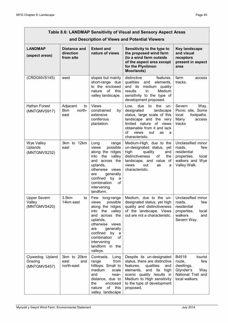
MYG Chapter 8: Landscape Page 45
Mynydd y Gwynt Wind Farm: Environmental Statement July 2014
Table 8.6: LANDMAP Sensitivity of Visual and Sensory Aspect Areas
and Description of Views and Potential Viewers
LANDMAP
(aspect areas)
Distance and direction from site
Extent and nature of views
Sensitivity to the type to the proposed wind farm (to a wind farm outside of the aspect area except for the Plynlimon Moorlands)
Key landscape and visual receptors present in aspect area
(CRDGNVS145) west slopes but mainly short-range due to the enclosed nature of this valley landscape.
distinctive features, qualities and elements, and its medium quality results in Medium sensitivity to the type of development proposed.
farm access tracks.
Hafren Forest
(MNTGMVS917)
Adjacent to 8km north-east
Views constrained by extensive coniferous plantation.
Low, due to the un-designated landscape status, large scale of this landscape and the very limited nature of views obtainable from it and lack of views out as a characteristic.
Severn Way, Picnic site, Some local footpaths. Many access tracks
Wye Valley Uplands
(MNTGMVS232)
3km to 12km east
Long range views possible along the ridges into the valley and across the uplands, otherwise views are generally confined by a combination of intervening landform.
Medium-High, due to the un-designated status, yet high quality and distinctiveness of the landscape, and value of views out as a characteristic.
Unclassified minor roads, few residential properties, local walkers and Wye Valley Walk.
Upper Severn Valley (MNTGMVS420)
3.5km to 14km east
Few long-range views possible along the ridges into the valley and across the uplands, otherwise views are generally confined by a combination of intervening landform in the valleys.
Medium, due to the un-designated status, yet high quality and distinctiveness of the landscape. Views out are not a characteristic.
Unclassified minor roads, few residential properties, local walkers and Severn Way.
Clywedog Upland Grazing
(MNTGMVS457)
3km to 20km east and north-east
Contrasts. Long range from hilltops. Small to medium scale and near-distance, due to the enclosed nature of this valley landscape
Despite its un-designated status, there are distinctive features, qualities and elements, and its high scenic quality results in Medium to High sensitivity to the type of development proposed.
B4518 tourist route, few dwellings, Glyndwr’s Way National Trail and local walkers.

Page 46 MYG Chapter 8: Landscape
Mynydd y Gwynt Wind Farm: Environmental Statement July 2014
Table 8.6: LANDMAP Sensitivity of Visual and Sensory Aspect Areas
and Description of Views and Potential Viewers
LANDMAP
(aspect areas)
Distance and direction from site
Extent and nature of views
Sensitivity to the type to the proposed wind farm (to a wind farm outside of the aspect area except for the Plynlimon Moorlands)
Key landscape and visual receptors present in aspect area
and woodland.
Llyn Clywedog
(MNTGMVS833)
4.5km to 12km east
Views constrained by rising land, and of land in the foreground; in the north-west views contained by extensive coniferous plantation.
Medium to High, although an un-designated landscape, it has high recreational value. Long distance views are a defining characteristic.
Some local footpaths. Outdoor recreation and associated car parks.
Old Chapel Hill Mosaic
(MNTGMVS438)
8km to 15km east
Long range views possible along the ridges into the valley and across the uplands, otherwise views are generally confined by a combination of intervening landform.
Medium-High, due to the un-designated status, yet high quality and distinctiveness of the landscape, and value of views out.
Unclassified minor roads, few residential properties, local walkers and bridleways.
Cambrian Mountains (south)
(CRDGNVS313)
8km to 20km east
Long-range, expansive panoramic views obtained from the plateau edges. Views are limited from the parts of the aspect area that are bounded by adjacent forestry.
Only designated in part as SSSI; un-designated landscape status, the large scale of the landscape and the nature of views results in Medium to High sensitivity to the type of development proposed.
Remote, upland area. No roads, no residential properties. Some local footpaths, access tracks.
Assessment of Effects on Landscape
8.173 Following the above appraisal of landscape character and its sensitivity to change, the following Table 8.7 presents the potential effects on landscape character with the wind farm proposal.

MYG Chapter 8: Landscape Page 47
Mynydd y Gwynt Wind Farm: Environmental Statement July 2014
Table 8.7: Effects on Landscape Character of
LANDMAP Visual and Sensory Aspect Areas
LANDMAP
(aspect areas)
Distance and direction from site
Magnitude of change of view
Sensitivity Magnitude of effect
Wye Valley
(MNTGMVS907)
Adjacent to under 1km
1km to 1.5km
1.5km to 2.5km
High
Medium to Low
Low
Medium Moderate to Substantial
Slight to Moderate / Moderate
Slight to Moderate
Plynlimon Moorlands
(MNTGMVS910)
Under 3.5km
3.5km to 6.5km
6.5km to 7km
Over 7km
High
Medium to High
Medium
Low
Medium-High
Moderate to Substantial / Substantial
Moderate to Substantial
Moderate / Moderate to Substantial
Slight to Moderate / Moderate
Plimlimon
(PWYSVS212)
Under 3km
3km to 4km
4km to 8km
High
Medium to High
No View
High Substantial
Moderate to Substantial / Substantial
No Effect
Cambrian Mountains (north)
(CRDGNVS508)
3.5km to 5.5km Medium to High Medium-High
Moderate to Substantial
Afon Castell
(CRDGNVS145)
4km to 6km
6km to 8km
Low
Very Low
Medium Slight to Moderate
Slight / Slight to Moderate
Hafren Forest
(MNTGMVS917)
Under 0.5km
0.5km to 6.5km
at 1.8km
High
No view
High
Low Moderate
No Effect
Moderate
Wye Valley Uplands
(MNTGMVS232)
3.0km to 4.5km
4.5km to 5km
over 5km
High
Medium to High
Medium
Medium-High
Moderate to Substantial
Moderate / Moderate to Substantial
Moderate
Upper Severn Valley
(MNTGMVS420)
7km to 10km Low Medium Slight to Moderate
Clywedog Upland Grazing
(MNTGMVS457)
9km + Low Medium-High
Slight to Moderate / Moderate
Llyn Clywedog
(MNTGMVS833)
6km Low Medium-High
Slight to Moderate / Moderate
Old Chapel Hill Mosaic
(MNTGMVS438)
8km + Low Medium-High
Slight to Moderate / Moderate
Cambrian Mountains (south)
(CRDGNVS313)
8km + Low Medium-High
Slight to Moderate / Moderate

Page 48 MYG Chapter 8: Landscape
Mynydd y Gwynt Wind Farm: Environmental Statement July 2014
8.174 Following the above appraisal of landscape character and its sensitivity to change, the following assessment presents the potential effects on the other four LANDMAP layers (landscape habitats, geological landscape, cultural landscape and historic landscape) and assesses the effects of the proposed wind farm on the landscape character areas in Powys (as defined by John Campion) that combine all five layers.
8.175 The whole of the wind farm site lies within the mosaic Landscape Habitats aspect area (MNTGMLH071). The stream valley to the west of Y Foel lies within the mosaic Landscape Habitats aspect area (MNTGMLH063). The forestry to the north and east of the site lies within the coniferous woodland Landscape Habitats aspect area (MNTGMLH078) and Plynlimon lies within the Pumlumon Upland Mosaic Landscape Habitats aspect area (CRDGNLH027), covering the SSSI.
8.176 The whole of the wind farm site falls within the very extensive Rural Landscapes Cultural Landscape aspect area (MNTGMCL051). This aspect area covers a vast area of mid Wales.
8.177 The whole of the wind farm site falls within the extensive Bryn Moel-Dylife-Tir Gwyr Geological Landscape aspect area (MNTGMGL654). This geological aspect area comprises a prominent upland block rising above the depression of Aberhosan with an initial crescent shaped escarpment. It includes the source of the rivers and streams of the latter area. Cwms also developed locally along the scarp face and crags. The area passes southwards to the plateau of Hafren Forest and round to Llangurig where a lower eastern scarp shows some glacial deposit filled cwms. The area includes extensive former workings for lead.
8.178 The adjacent land rising onto and including Plynlimon to the north-west lies within the Plynlimon Fawr geological landscape aspect area (CRDGNGL290). Here the high Mountain area lies to the east of the Nant-y-Moch reservoir, forming a broadly SW-NE narrow-topped ridge feature, rising to 684m in the south-west and 741m to the north-east. Steep north-west slopes are excavated by three glacial cwms (Aspect Areas 291-294). Slopes to the south-east also, towards (or across) the Powys border (towards the site). Rock crags are mainly along the ridge. Some disused metal mines are present. The land to the south of the site, including the site entrance lies within the linear Wye Cwms geological landscape aspect area (MNTGMGL677) which forms the upper parts of the Wye Valley, with the river itself forming a separate geological landscape aspect area, the Wye (MNTGMGL346).
8.179 The whole of the wind farm site falls within the very extensive Y Drum Historic Landscape aspect area (MNTGMHL301). This covers the moorland and marginal land north-west of Llangurig that is partly enclosed with large straight-sided boundaries built in the 19th century. There are small-scale 20th-century conifer plantations within the broad mosaic of land use. Early settlement and land use is indicated by isolated Neolithic to Bronze Age upland burial monuments. Widespread late 19th and early 20th-century lead mining activity, mostly focused in stream valleys is present, including on land within the site. Occasional abandoned medieval and post-medieval house sites are present in this area. The adjacent forestry within Hafren falls within the Hafren Woodland historic aspect area (MNTGMHL691).
8.180 The assessment of effects on the landscape character areas (that combine aspect areas) is set out in Table 8.8 below.

MYG Chapter 8: Landscape Page 49
Mynydd y Gwynt Wind Farm: Environmental Statement July 2014
Table 8.8: Effects on Landscape Character of Areas
Landscape Character Area
Distance and direction from site
Magnitude of change of view
Sensitivity Magnitude of effect
M30 Upper Wye and Severn Valleys
Adjacent to under 1km
1km to 1.5km
1.5km to 2.5km
7km to 10km
High
Medium to Low
Low
Low
Medium Moderate to Substantial
Slight to Moderate
Slight / Slight to Moderate
M21 Plynlimon Under 3.5km
3.5km to 6.5km
6.5km to 7km east
7km +
4km to 8km west
High
Medium to High
Medium
Low
No View
High Substantial
Moderate to Substantial/ Substantial
Moderate to Substantial
Moderate
No Effect
Cambrian Mountains (north)
3.5km to 5.5km Medium to High Medium-High Moderate to Substantial
Afon Castell
4km to 6km
6km to 8km
Low
Very Low
Medium-High Slight to Moderate / Moderate
Slight / Slight to Moderate
M25 Hafren Forest
Under 0.5km
0.5km to 6.5km
at 1.8km
High
No view
High
Low Moderate
No Effect
Moderate
M24 Llyn Clywedog
3.0km to 4.5km
4.5km to 5km
Over 5km
Over 6km
High
Medium to High
Medium
Low
Medium-High Moderate to Substantial
Moderate / Moderate to Substantial
Moderate
Slight to Moderate / Moderate
R16 - Drysgol Uplands
8km + Low Medium-High Slight to Moderate / Moderate
R15 Elenyadd Uplands
8km + Low Medium-High Slight to Moderate / Moderate
Summary of Effects on Landscape
8.181 The assessment of effects on the landscape character of the study area has shown that there would potentially be changes in view of a low magnitude or greater from 12 LANDMAP aspect areas. These are the: Wye Valley (MNTGMVS907), Plynlimon Moorlands (MNTGMVS910), Plynlimon, Cambrian Mountains (north) (CRDGNVS508), Afon Castell (CRDGNVS145), Hafren Forest (MNTGMVS917), Wye Valley Uplands (MNTGMVS232), Upper Severn Valley (MNTGMVS420), Clywedog Upland Grazing

Page 50 MYG Chapter 8: Landscape
Mynydd y Gwynt Wind Farm: Environmental Statement July 2014
(MNTGMVS457), Llyn Clywedog (MNTGMVS833), Old Chapel Hill Mosaic (MNTGMVS438) and the Cambrian Mountains (south) (CRDGNVS313).
8.182 The site is located in the Plynlimon Moorlands (MNTGMVS910), an extensive aspect area covering land from the site up to 10km both north and south. It is an aspect area characterised by open and expansive panoramic views across land, particularly to the north-west and south. Views to and from the north-east are dominated by forestry within Hafren. This aspect area is of outstanding value (Visual and Sensory). It is designated in part as an SSSI; but has un-designated landscape status. The large scale of the landscape and the nature of views results in medium-high sensitivity to the type of development proposed. The sensitivity of this area to direct changes, as identified in the section reporting effects on the fabric of the site, is higher than to indirect perceived effects. The high sensitivity to direct changes in land cover, reflects the exceptional ecological value of this relatively remote, upland area.
8.183 Significant effects have been identified for the M30 Upper Wye and Severn Valleys (up to 1km from the nearest turbine), M21 Plynlimon (up to 7km from the nearest turbine except for the area falling away to the west from the main ridge), the Cambrian Mountains (north) (CRDGNVS508) (up to 5.5km from the nearest turbine) and M24 Llyn Clywedog (up to 4.5km from the nearest turbine). The effects in relation to the individual aspect areas for each LANDMAP layer are now evaluated. LANDMAP Information Guidance Note 3 (Using LANDMAP for Landscape and Visual Impact Assessment of Onshore Wind Turbines (CCW, 2013)) states at paragraph 5 that: “S aspect areas at Level 3 should be considered for:
• The area defined by the proposed development site boundary
• The immediate environs to the site boundary, effectively the adjacent aspect areas and in addition:
• Where “likely significant effects” are anticipated, these should be examined in relation to the relevant LANDMAP aspects or layers.”
Landscape Habitats
8.184 The whole of the wind farm site lies within the mosaic Landscape Habitats aspect area (MNTGMLH071). The area is of high value. The direct effects on ecology are covered in Chapter 11: Ecology of this ES. The indirect and perceived effects of the changes from the development would be on the integrity of the mosaic where disturbed through direct effects from the tracks and turbine bases. When viewing the area from the surrounding land within 3km the new tracks would disrupt the continuity of the mosaic vegetation. Over time this would mellow and be less distinct. The sensitivity is high, coupled with the medium magnitude of change would bring about moderate to substantial and significant effects on the character within about 3km of the turbines.
8.185 The stream valley to the west of Y Foel lies within the mosaic Landscape Habitats aspect area (MNTGMLH063) and is of high value. The substation and construction compound are proposed adjacent to this area, and would be perceived as a change within about 500m of the substation and construction compound. The sensitivity is high, coupled with the medium magnitude of change would bring about moderate to substantial and significant effects on the character within about 0.5km of the substation and construction compound.

MYG Chapter 8: Landscape Page 51
Mynydd y Gwynt Wind Farm: Environmental Statement July 2014
8.186 The forestry to the north and east of the site lies within the coniferous woodland Landscape Habitats aspect area (MNTGMLH078), which is of low value. There would be no significant effects, and accordingly this area is not considered further. Plynlimon lies within the Pumlumon Upland Mosaic Landscape Habitats aspect area (CRDGNLH027), covering the SSSI, which is of outstanding value. The nearest turbine would lie 200m from the southern edge of this area. There would be no direct effects, however, when viewed from this aspect area the turbines would bring about a visual change and a change in perception of the adjacent Mosaic (MNTGMLH071). The sensitivity to adjacent and indirect effects is high, coupled with the medium magnitude of change would bring about moderate to substantial and significant effects on the character within about 4km of the turbines.
Cultural Landscape
8.187 The whole of the wind farm site falls within the very extensive Rural Landscapes Cultural Landscape aspect area (MNTGMCL051). This aspect area covers a vast area of mid Wales. The aspect area is of high value and is noted for being topographically and scenically varied and distinctive, comprising bare upland and fertile stream valleys, the latter containing a variety of field patterns. The aspect area is a catch-all and is a rural landscape that is generally well-maintained, but suffers from its inability to sustain a vibrant agricultural economy, leading to rural depopulation, diversity and hence neglect. In terms of rarity it is an aspect area that is very extensive and shares many of the characteristics and cultural essence with large tracts of Wales. The sensitivity is medium, coupled with the high magnitude of change within 3km radius would bring about moderate to substantial and significant effects on the character within about 3km of the turbines.
8.188 The source of the Wye falls within the Pumlumon (MNTGMCL036) aspect area and is noted for being of outstanding value as the source of two rivers. Views of wind turbines are recorded in the evaluation in terms of links with other aspect areas. The sensitivity is high, coupled with the medium magnitude of change would bring about moderate to substantial and significant effects on the character within about 4km of the turbines. Land within the adjacent valley to the west and south-west, and predominantly outside of the ZTV falls within the Upland (CRDGNCL028) aspect area and is of outstanding value. Where views would be afforded from the south-west looking north (outside of forested areas), the medium magnitude of change would bring about moderate to substantial and significant effects on the character within about 5km of the turbines on this highly sensitive landscape.
Geological Landscape
8.189 The whole of the wind farm site falls within the extensive Bryn Moel-Dylife-Tir Gwyr Geological Landscape aspect area (MNTGMGL654) and is of outstanding value. This geological aspect area comprises a prominent upland block rising above the depression of Aberhosan with an initial crescent shaped escarpment. It includes the source of the rivers and streams of the latter area. Cwms also developed locally along the scarp face and crags. The area passes southwards to the plateau of Hafren Forest and round to Llangurig where a lower eastern scarp shows some glacial deposit filled cwms. The area includes extensive former workings for lead. No links with other or adjacent aspect areas are identified in the citation. The sensitivity is medium, coupled with the high magnitude of change would bring about moderate to substantial and significant effects on the character within about 3km of the turbines.

Page 52 MYG Chapter 8: Landscape
Mynydd y Gwynt Wind Farm: Environmental Statement July 2014
8.190 The adjacent land rising onto and including Plynlimon to the north-west lies within the Plynlimon Fawr geological landscape aspect area (CRDGNGL290) that is noted for being a geological SSSI and is of outstanding value overall. Here the high Mountain area lies to the east of the Nant-y-Moch reservoir, forming a broadly SW-NE narrow-topped ridge feature, rising to 684m in the south-west and 741m to the north-east. Steep north-west slopes are excavated by three glacial cwms (Aspect Areas 291-294). Slopes to the south-east also, towards (or across) the Powys border (towards the site). The sensitivity is high, coupled with the medium magnitude of change would bring about moderate to substantial and significant effects on the character within about 4km of the turbines.
8.191 The land to the south of the site, including the site entrance lies within the linear Wye Cwms geological landscape aspect area (MNTGMGL677) which forms the upper parts of the Wye Valley, with the river itself forming a separate geological landscape aspect area, the Wye (MNTGMGL346). The Wye Cwms aspect area is of moderate value, but is noted for linking to the upland and downstream areas. The sensitivity is medium, coupled with the medium magnitude of change would bring about moderate and not significant effects on the character within about 1km of the turbines.
Historic Landscape
8.192 The whole of the wind farm site falls within the very extensive Y Drum Historic Landscape aspect area (MNTGMHL301) and is of high value. This covers the moorland and marginal land north-west of Llangurig that is partly enclosed with large straight-sided boundaries built in the 19th century. There are small-scale 20th-century conifer plantations within the broad mosaic of land use. Early settlement and land use is indicated by isolated Neolithic to Bronze Age upland burial monuments. Widespread late 19th and early 20th-century lead mining activity, mostly focused in stream valleys is present, including on land within the site. Occasional abandoned medieval and post-medieval house sites are present in this area. The sensitivity is high, coupled with the medium magnitude of change would bring about moderate to substantial and significant effects on the character within about 4km of the turbines.
8.193 The adjacent forestry within Hafren falls within the Hafren Woodland historic aspect area (MNTGMHL691) and is of high value, but low sensitivity to this proposed change, accordingly, no further impact assessment from the individual turbines has been undertaken. However, a broad-brush landscape and visual impact study has considered the impact of the 132MW cable route through the Hafren Forest.
8.194 South of the A44 the land within the adjacent valley to the west and south-west, and predominantly outside of the ZTV falls within the Peraidd Fynydd Forestry Plantation (CRDGNHL093) aspect area and is of low value and sensitivity to indirect changes in view. Where views would be afforded from the south-west looking north (outside of forested areas), the medium magnitude of change would bring about slight to moderate and not significant effects on the character within about 5km of the turbines on this low sensitive landscape.
8.195 On the higher land to the south-west the historic landscape is characterised by Fuches Wen (CRDGNHL103) aspect area and is a large block of undulating upland, mostly consisting of north- and northwest-facing slopes with a height range of between 300m at its northern edge and over 500m at its high points. Craggy outcrops occur on the summits. Traditionally it consists of unenclosed moorland, with blanket bog at higher levels and

MYG Chapter 8: Landscape Page 53
Mynydd y Gwynt Wind Farm: Environmental Statement July 2014
peaty deposits in hollows and valleys. Earth boundary banks are present on the northern lower slopes close to Dyffryn Castell, but the enclosures formed by these are now largely redundant, and wire fences divide the area into very large enclosures. Large-scale land improvement over the past few decades has resulted in the transformation of much of the lower slopes, and some high level plateaux, into grassland grazing. The recorded archaeology of this area consists mainly of post-Medieval sites. The greater proportion of these comprise deserted settlements and associated agricultural features such as folds, enclosures, pens and tracks, indicating a populated, albeit sparsely, upland area through to the 19th century. Metal mine remains are also present. A greater time-depth element to the landscape is provided by Bronze Age round barrows.
8.196 The area is of outstanding value and high sensitivity to indirect changes in view. Where views would be afforded from the south-west looking north (outside of forested areas), the medium magnitude of change would bring about moderate to substantial and significant effects on the character within about 5km of the turbines.
8.197 Chapter 12 fully evaluates the impact on the historic landscape, including impacts on the part of the upland Ceredigion and Elan valley that lie to the south-west of the site (Paragraphs 12.66 and 12.67). The evaluation within Chapter 12 concludes that whilst the proposed development lies adjacent to the Upland Ceredigion Historic Landscape, the turbines required for the operation of the scheme will only cause a Minor Adverse indirect visual impact on this area. As no mitigation is proposed the impact on this Historic Landscape remains as described above. The scheme’s operation will have a Slight/Moderate Adverse significance of effect on the Upland Ceredigion Historic Landscape as a whole.
8.198 Chapter 12 also evaluates impacts on the Clywedog Valley and Elan Valley Historic Landscapes. The proposed development lies in proximity to the Clywedog Valley and Elan Valley Historic Landscapes, and the development is judged to cause No Change to either the Clywedog Valley or Elan Valley Historic Landscapes as a whole. The effect of the operation of the scheme on these landscapes is, therefore, Neutral.
Landscape Character Areas
8.199 Significant landscape effects have been identified up to 6.5km from the proposed turbines in the most open and exposed and highly sensitive parts of the landscape in the Plynlimon Moorlands landscape character area, 1km in the more enclosed and well-wooded Wye Valley area and 4km in the adjacent Plynlimon area. The Cambrian Mountains (north) landscape character area lies some 3.5km from the turbines at the closet point. Significant effects on the perception of landscape character have been identified between 3.5km to 5.5km from the proposed turbines.
8.200 Therefore, whilst, in practice, although theoretically visible from 30km, the presence of the development in the view will be most visible from areas within a radius of about 6.5km, the threshold at which in the most open locations significant effects would cease to be experienced by a viewer in the landscape; and will only be likely to be clearly discernable beyond the distance of 6.5km in areas with an open character, few trees or woodlands, and be appreciated in these views as elements not impacting significantly on the appreciation of the landscape.

Page 54 MYG Chapter 8: Landscape
Mynydd y Gwynt Wind Farm: Environmental Statement July 2014
Effects on Landscape Designations
8.201 There is one national landscape designation within the study area, the Snowdonia National Park. The potential effects on this designation have been assessed and the results are recorded in the following text. The location of the National Park is shown on Figure 8.50.
8.202 The Snowdonia National Park covers land from 18km to the north-west of the site. Viewpoint 23 (Figure 8.11w), a viewpoint 31km distant from Cadair Idris, was requested by CCW. Cadair Idris (or Cader Idris) lies at the southern end of the Snowdonia National Park (Viewpoint 23 (Figure 8.11w)). The Cadair Idris peak, at 893m AOD, is one of the most popular in Wales for walkers and hikers (SnowdoniaGuide.com). The viewpoint from Cadair Idris, Figure 8.11w, shows that whilst theoretically visible from within the southern extent of the National Park, the change in view will only be discernable on very clear days, and would be in the context of views of other wind farms in the view out from the park, and notably Nant y Moch in the middle distance, and impacts on this viewing location would be negligible.
8.203 The National Park designation is an indication of the high value placed on the hills and moors by the nation. This high value has been confirmed over much of the Snowdonia National Park by the landscape character assessment undertaken for the study area. The sensitivity of the landscape to change within the Snowdonia National Park is high. The sensitivity to changes in landscape character outside of the Snowdonia National Park that affect its qualities and appreciation and views from the National Park is also assessed as being high.
8.204 There would be some views afforded from the southern edges of the Snowdonia National Park, from the ridge along the southern edge, such as from Bryn Coch (227m AOD), that would bring about a very low magnitude of change of view from the southern edge at a distance of 19.5km of the proposed turbines, that would be slight to moderate and not significant. Views in more enclosed areas and further away would be of a lower magnitude, negligible, that would also not create significant effects on the character or appreciation of the Snowdonia National Park.
8.205 The addition of the Mynydd y Gwynt wind turbines in views out from this part of the National Park would not alter the appreciation of the viewer of the view or the National Park.
8.206 There are no policies, objectives or issues set out in the Snowdonia National Park Management Plan concerning the potential impact of views from the Snowdonia National Park of turbines in the distant, broader landscape. Whilst it cannot be expected that the management Plan would anticipate indirect effects, it is worth noting that wind turbine development within the Snowdonia National Park is not necessarily seen as a potential impact on the Park as the CAT Repowering scheme is located within it. Furthermore, TAN 8 SSA D is located closer to the Snowdonia National Park than the proposed Mynydd y Gwynt Wind Farm.
8.207 Special Landscape Areas (SLA’s) were designated in October 2010, and adopted as Special Planning Guidance local landscape designations by Ceredigion Council in December 2010. The aim was to use this non-statutory policy designation to protect areas of landscape value through the planning system. They are seen by the local authority as a means of both protecting sensitive landscapes and developing an understanding and

MYG Chapter 8: Landscape Page 55
Mynydd y Gwynt Wind Farm: Environmental Statement July 2014
awareness of those features and characteristics that give a locality its sense of place. There are 13 covering most of the coast and uplands of the Unitary Authority area, the closest to the site being SLA 12, Northern Ceredigion Uplands. This SLA covers a large, expansive upland area forming the northern part of the uplands of Ceredigion. It runs from the edge of the coastal plateau, inland of the A487 road corridor, eastwards to the county boundary with Powys, and focused on Pumlumon, which rises to over 700 metres AOD. It extends southwards to include part of Llyn Brianne reservoir and the upper reaches of the Teifi Valley.
8.208 The key characteristics of the Northern Ceredigion Uplands are:
• Expansive upland area, includes Pumlumon (752 metres AOD).
• Moorland with a rugged texture of ‘peaks’ and ‘knobs’.
• Lies within ICOMOS/Cadw/CCW Register of Historic Landscapes of Outstanding Importance.
• Interspersed with conifer plantations and reservoir.
8.209 The SLA covers a large number of Landmap aspect areas, all of those within Ceredigion and prefixed by “CRDGN”, the impact of the development on these aspect areas is set out in the LVIA above. As a local landscape policy the impact of the proposed development on the purpose and objectives of the policy is considered. Wind farms are located within the area covered by the policy, including the Cefn Croes turbines. The only impact of the proposed Mynydd y Gwynt turbines would be on views out from within the policy area. There would be no impact on the purpose and objectives of the policy.
Effects on Cultural Heritage Features
8.210 The LI and IEMA Guidelines set out on page 28, paragraph 3.26 state that: “It is important for landscape assessment to consider the ecological, historical or cultural associations that contribute to the character and importance of a landscape.” And in paragraph 3.27 that: “Historic landscapes can include gardens, battlefields and the statutory settings of listed buildings and ancient monuments.” The cultural heritage aspects of the landscape have also been considered through the analysis of the five layers of LANDMAP.
8.211 The assessment of effects on cultural heritage features is set out in Chapter 12 and included a full evaluation of the Register of Historic Landscapes and the Upland Ceredigion Landscape of Outstanding Historic Interest in particular. The Upland Ceredigion Landscape of Outstanding Historic Interest is shown on Figure 8.51. The conclusions of this assessment are cross-referenced in the LVIA conclusions.
Visual Analysis
Bare-ground Visibility
8.212 The ZTV (Figures 8.5 and 8.6) for the proposed turbines of the Mynydd y Gwynt Wind Farm indicates that there will be views from the hill and mountain tops and the site-facing mountain and hillsides within the landscape. There will be bare ground views from the upper parts of the Wye Valley, predominantly from within the landholding of the landowner of the site. Beyond the site there will be very few bare-ground views from within the

Page 56 MYG Chapter 8: Landscape
Mynydd y Gwynt Wind Farm: Environmental Statement July 2014
valleys, other than from a short section of the Wye Valley to the south-east of the A44 and from the Clywedog Valley in the north-east. The bare-ground visibility identified by the ZTV analysis is reported and analysed in the following paragraphs.
8.213 In theory the proposed turbines would be visible out to 30km in the most elevated site-facing parts of the study area; and within 20km from most of the elevated parts of the landscape along the ridges of land on and around the site, and on the higher parts of the land on the site facing unforested land on the hills and Cambrian Mountains. The incised river valleys and the low-lying parts of the landscape are predominantly outside of the ZTV. In addition, the high peaks of land in the Cambrian Mountains to the south conceal views from farther to the south.
8.214 The ZTV shows very limited visibility from locations from distances of over 6km from the site when viewed from the west, north and north-west. The views afforded in these directions would be only of tips of less than six turbines. There would be no views into the Nant-y-Moch valley to the west of Plynlimon.
8.215 The assessment identifies that the screening effect of forestry vegetation in the north-east, in the areas of the Hafren Forest and adjacent land, and to the south and south-east in the environs of the Esgair Ychion forestry are such that the actual visibility in these areas does not correlate well with the ZTV. In the valleys leading towards Llanidloes in the east the tree-lined lanes with hedges and woody vegetation and large-scale plantations and woodlands in the landscape also generally heavily reduce the levels of visibility that would actually be afforded.
8.216 The detailed analysis of the locations in the landscape where a view would be afforded of the proposed Mynydd y Gwynt Wind Farm is fully explored in the LVIA for each receptor group. The significance of the change in view specifically in relation to the EIA regulations is assessed.
8.217 The ZTV shows that the land closest to the site, in and around the Sweet Lamb Rally Complex would experience a change in view and that to the south of the site around the A44 corridor, the A44 would theoretically be afforded a view of the proposed turbines. However, in reality, as is demonstrated through the LVIA process, the views that would be afforded would be limited to the higher ground, from within the more elevated and open uplands. There would be very few views afforded from the A44 or A470 roads, and none from towns and villages due to the low-lying situations of settlements in the landscape.
8.218 Field observations for the purposes of identifying effects from each of the landscape and visual receptor groups has shown that views from within the landscape, away from the more open upland grazing mountains and hilltops, are very limited. These views are fully evaluated and the effects identified and reported in the main body of the LVIA.
Viewpoint Analysis
8.219 The viewpoint selection process is documented in Paragraphs 8.31 – 8.35.
8.220 During the selection process a number of viewpoints, such as a location within some of the popular forested and woodland walk areas to the east of the site and the south of the Wye Valley and towards the south-west had to be abandoned because of the lack of view due to the forested nature of the land to the east and the incised landform to the south and

MYG Chapter 8: Landscape Page 57
Mynydd y Gwynt Wind Farm: Environmental Statement July 2014
south-west, and the well-wooded character of the Wye Valley. Initially the visuals consultants took 30 viewpoint panoramic photographs, supplemented by the re-photographing of some locations and a number of possible new viewpoint locations in 2012. Through the selection process, including input from NRW, these have been refined to 26 viewpoints. Some of the original photography undertaken in summer 2005 has been revisited to show how the forestry in these images has grown, notably in the middle-distance of Viewpoint 5 (Figure 8.11e): Rhyd-y-Benwch on the Severn Way. These 2012 photographs, taken in winter, show how the light conditions can vary substantially in the context of the site through the year. The locations of the 26 viewpoints that have been analysed in this chapter are shown on the ZTV at Figure 8.1.
8.221 The predicted views from these viewpoints are shown on the wireframes and photomontages in Viewpoints 1-26 (Figure 8.11a-z).
8.222 Each photomontage image is a monocular curvilinear projection and should be viewed at a distance of 311mm when printed at A2 (or 509mm at A1, A3 fold-out), with the page curved through 90-degrees.
8.223 It has been agreed with NRW that for the purposes of transparency and ease of public access, the central 30-degree angle of view photographic shot is presented for each viewpoint, alongside a map showing the viewpoint locations and the ZTV of the proposed development on the project website web site and in the NTS. These are intended to be for the purposes of downloading and printing on a home printer on A4 paper. They are intended for the dissemination of information, and not for the purposes of assessment.
8.224 The magnitude of change in the view from each of the 26 viewpoints has been assessed, as presented in Table 8.9.
Summary of Effects on Viewpoints
8.225 The analysis of viewpoints demonstrates that the magnitude of change of view likely to be brought about through this development reduces with distance from the development site. The magnitude of change is heavily dependant on the levels of forestry in the north-east and tree cover in the near distance in the Wye Valley between the viewpoint, or visual receptor, and the development. In most viewpoint locations the levels of visibility are defined by the undulating upland landform characteristic of the north, south and west of the study area.
8.226 The relatively high woodland cover of the Wye and Severn Valleys and the incised nature of valleys generally and the steep slope of land in the area generally has a strong bearing on the visual amenity of the area. There are a number of remote, yet publicly available views within this landscape where the landform of the site is seen on the horizon or on lower-lying ground in the near distance. Viewpoint 1, from the top of Plynlimon (Figure 8.11a), Viewpoint 16 (Figure 8.11p) and Viewpoint 17 (Figure 8.11q) from the source of the River Severn and Viewpoint 4 (Figure 8.11d) from the footpath to the south-west of the site demonstrate these views clearly. It should be noted that the photowire from Viewpoint 16 (Figure 8.11pii) shows a view of the turbines within the top if the vegetation and landform. Historically there has been earth movement and some peat loss that together have combined to make it very difficut to marry the wireframe and the photograph together. For the purposes of the assessment the wireframe (Figure 8.11pi) has been used as the basis for assessment. Viewpoint 17 (Figure 8.11q) is taken from the

Page 58 MYG Chapter 8: Landscape
Mynydd y Gwynt Wind Farm: Environmental Statement July 2014
adjacaent Source of the River Severn and the photograph has married well with the wireframe, providing a useful visualisation for the purposes of assessing effects.
8.227 From all of the views selected the wind farm would be seen as a large, yet coherent group of 27 wind turbines. At greater distances it would not be visible. From all but a few of the viewpoints, the seasonal effects of the trees and woodlands on the horizon in the views will not heavily influence visual amenity changes, with only modestly more extensive views in winter, primarily due to the high degree of openness in the west and high percentage of conifers in the north, south and east of the landscape.
8.228 The wind farm application has been submitted with a set of visualisations printed showing a 90-degree angle of view at A3 (giving a 237.8mm viewing distance). Four 90-degree wireframes have been included for each of viewpoints 1and 3 (Viewpoint 1: Plynlimon Fawr (Figures 8.11aiv, v, vi and vii) 3: Plynlimon Cwmbiga (Figures 8.11civ, v, vi and vii). In addition, the central 40-degree section of 11 of these visualisations has been extracted to provide a 581mm viewing distance on an A3 sheet. This additional presentation format has been included for Viewpoints 1, 2, 3, 5, 7, 10, 13, 16, 17, 18 and 22, as requested by Simon White by email on 2nd September 2013, and presented within File 4, Environmental Statement Figures. Loose A1 size duplicate copies of the visualisations have also been provided for NRW and a number of other key consultees or agents that have a 506.5mm viewing distance. The viewpoint analysis is used in the following sections of the LVIA as a set of data to inform the likely impacts on the visual and landscape receptors of the study area. The analysis of effects is continued in Paragraphs 8.570 et seq.

MYG Chapter 8: Landscape Page 59
Mynydd y Gwynt Wind Farm: Environmental Statement July 2014
Table 8.9: Viewpoint Assessment
Viewpoint No
Name Easting Northing Receptors View direction
degrees
Nearest turbine
Magnitude of change
Sensitivity of visual receptor
Magnitude of effect
1 Plynlimon Fawr 278966 286939 Highest point in Mid-Wales
Open Access Land
110.20 3.9km (T1) Medium to High
High Moderate to Substantial /Substantial
2 Plynlimon Range Glaslyn Foel Fadian
283750 295240 Open Access Land 177.20 8.7km (T3) Low
High Moderate
3 Plynlimon Cwmbiga
283035 289915 Long Distance Path and Open Access Land
178.20 3.4km
(T3)
Medium to High
High
Moderate to Substantial /Substantial
4 PROW 280998 284238 Public Right of Way across Open Access Land
73.10 2.5km
(T13)
High High
Substantial
5 Rhyd-y-Benwch on Severn Way
285771 286922 Picnic site and Long Distance Path
226.00 1.8km
(T12)
High High
Substantial
6 Bryn y Fan High Point
293119 288500 Open access land 238.70 8.9km
(T12)
Medium to Low
High Moderate / Moderate to Substantial
7 Llyn Clywedog 291518 288768 Out-door recreation site
241.80 7.5km (T12) Low High Moderate
8 Top of Gorn Hill 296850 284600 Open Access Land, Viewing Point
271.50 11.9km (T24) Negligible High Negligible
9 Clawdd Du Mawr Major Path
285250 269350 Long Distance Path 355.51 13.9km (T27) Negligible High Negligible
10 Track to east of Mynydd y Gwynt
290520 283100 Bridleway 289.40 5.6km (T24) Medium High Moderate to Substantial

Page 60 MYG Chapter 8: Landscape
Mynydd y Gwynt Wind Farm: Environmental Statement July 2014
Table 8.9: Viewpoint Assessment
Viewpoint No
Name Easting Northing Receptors View direction
degrees
Nearest turbine
Magnitude of change
Sensitivity of visual receptor
Magnitude of effect
11 Llangurig approach from A470(T)
291406 278072 Trunk road 322.90 8.4km (T27) Negligible High Negligible
12 CCW view from Sustrans Route
288464 279796 Sustrans route, Long Distance Path
325.00 5.1km (T27) Negligible High Negligible
13 Wye Valley Walk/ A44
284117 282654 Trunk road and long distance Path
352.35 0.9km (T27) Medium to Low
High Moderate / Moderate to Substantial
14 Foel y Fadian 282833 295370 Hill walkers near
Glyndwr’s Way
1739.00 8.8km (T3) Low High Moderate
15 CCW Sustrans route above Staylittle
289342 292120 Cycle route 217.36 7.9km (T3) Medium to Low
High Moderate / Moderate to Substantial
16 Source of the River Severn
282158 289942 Open Access Land, Viewing Point Long Distance Path
163.25 3.6km (T1) Medium High Moderate to Substantial
17 Source of the River Severn
281912 290060 Open Access Land, Viewing Point Long Distance Path
154.80 3.8km (T1) Medium to Low
High Moderate /Moderate to Substantial
18 Llyn Clywedog 290680 287106 Road and path and tourist location
243.50 6.1km (T12) Medium High Moderate to Substantial
19 Llyn Clywedog 290709 287423 Viewing Point 262.63 12.2km (T24) Medium High Moderate to Substantial
20 Glyndwr's Way 297195 284005 Long distance path 269.70 12.2km (T24) Negligible High Negligible
21 Llangurig - bridge over River Wye, Sustrans route 8
290850 279680 Long distance path 293.50 7.1km (T27) Negligible High Negligible

MYG Chapter 8: Landscape Page 61
Mynydd y Gwynt Wind Farm: Environmental Statement July 2014
Table 8.9: Viewpoint Assessment
Viewpoint No
Name Easting Northing Receptors View direction
degrees
Nearest turbine
Magnitude of change
Sensitivity of visual receptor
Magnitude of effect
22 A44 283815 282726 Trunk Road 16.00 9.7km (T25) High High Substantial
23 Cadair Idris 271102 313027 High Point 155.15 29.11km (T1) Negligible High Negligible
24 Caersws 302610 291829 Settlement 248.20 18.0km (T12) Negligible High Negligible
25 A485 South of Lledrod
264088 270095 PROW and road 52.80 24.1km (T20) Negligible High Negligible
26 A4120/ PROW west of Devil's Bridge
270711 277999 A Road 61.90 14.4km (T20) No View High No Effect

Page 62 MYG Chapter 8: Landscape
Mynydd y Gwynt Wind Farm: Environmental Statement July 2014
Effects on Visual Amenity
8.229 This section discusses the potential effects of the proposed wind turbines on the visual amenity of fixed viewpoint receptors including residents in settlements, scattered farmsteads and individual residential properties, visitors to tourist, leisure and recreational facilities; and, linear route receptors (motorists on the major and minor roads, cyclists on the Sustrans cycle paths, walkers on the footpaths, including long-distance paths, and national trail, and horse riders on the bridleways (there are no railways)).
8.230 For each receptor group, this assessment considers the extent of the predicted and actual visibility, the magnitude of the change in views and whether these changes will be significant. The judgement as to whether a change will be significant for a receptor group will depend on the receptor activities, whether the receptors will be stationary or moving, the orientation of the receptor in relation to the view, whether receptors are likely to be there for the purposes of enjoying the view and the duration of the view for each receptor (in relative terms).
8.231 Whether a significant change in a view will have an unacceptable effect on visual amenity depends on the opinions of the receptors to the type of development proposed (i.e. public perception).
8.232 Opinions on wind farms vary from person to person, with people who are in favour of wind energy developments likely to accept much greater changes in their views than those who do not find wind turbines aesthetically pleasing. At this stage, this variability in public opinion has not been taken into account, but the implications of public perception on the acceptability of significant effects are discussed in the Conclusions at the end of this Chapter.
8.233 The viewpoint analysis and assessment of impacts on the landscape character of the study area has indicated that the magnitude of change of view falls to medium at distance of about 3.5km in the west, 6km in the north, 6.5km in the south and east from the proposed wind turbines. At these distances highly sensitive receptors would cease to be significantly effected by the proposed wind farm. This has informed the study areas for the visual assessment on linear route and fixed-point receptors. Therefore, for highly sensitive visual receptors the impacts will be assessed up to a distance of 10km from the site, and for medium sensitivity receptors to a distance of 5km from the site. The reporting concentrates on effects that are significant and that fall at the threshold of significance. Distant, non-significant effects are not reported in detail. Summary tables assist in the interpretation of the results of the study.
8.234 There are a number of viewpoints and locations within the landscape that are of high sensitivity, higher than the landscape character to this type of change. This explains why there are likely to be some significant effects on visual receptors beyond the 6.5km threshold of significance identified for effects on landscape character.
Fixed Viewpoint Receptors
Settlements
8.235 The potential for the proposed wind turbines to impact on settlements and individual dwellings is assessed in the following section. This assessment includes the towns of

MYG Chapter 8: Landscape Page 63
Mynydd y Gwynt Wind Farm: Environmental Statement July 2014
Llangurig and Llanidloes, both of which lie predominantly outside of the ZTV. There are no villages within 5km of the nearest wind turbine, with the nearest villages being Ponterwyd, 9.5km to the south-west and Staylittle 8km to the north-north-east. Ponterwyd lies outside of the ZTV.
Villages and Hamlets
8.236 The incised valley location of most settlements conceals the villages in the main from views. The nearest villages to the proposed turbines are Ponterwyd, 9.5km to the south-west and Staylittle 8km to the north-north-east and the hamlet of Pant Mawr adjacent to the site entrance to the Sweet Lamb Rally Complex.
8.237 Devil’s Bridge lies 12km to the south-west of the proposed wind turbines. A viewpoint was requested by NRW from this settlement, however, wireframes indicate that no view would be afforded from this location.
8.238 Ponterwyd lies 9.5km to the south-west of the proposed wind turbines. Wireframes indicate that no view would be afforded from this location.
8.239 Staylittle lies 8km to the north-north-east of the proposed wind turbines. The ZTV indicates that Staylittle is located within an area where there is bare-ground visibility. Viewpoint 15 (Figure 8.11o) is taken from the unclassified road running north-east from the village above the village and shows a distant view of all 27 of the proposed turbines that would bring about a low magnitude of change of view. Within the village there would be no views from the main road running through. There may be some first floor views from private rooms in village properties. There would be a view from the back of the church of some of the turbines only. The magnitude of change of view would be negligible, that with the high sensitivity of the village receptors would bring about a negligible effect.
8.240 Pant Mawr lies about 1km to the south-south-east of the proposed wind turbines. A viewpoint was requested by NRW from the A44 in proximity to this settlement, Viewpoint 13, (Figure 8.11m). A view would be afforded of parts of the turbines from the environs of the hamlet on the south side of the road. On the wireframe you can see Turbines 20, 21, 17, 18, 22, 25 and 26 although in photomontage they are all hidden behind trees. In reality, when viewed from slightly to the east or west there would be a greater view, especially in winter. The magnitude of change of view would be high, the sensitivity of the viewer high and accordingly the magnitude of effect would be substantial, and the effect would be significant.
Towns
8.241 Llangurig lies 8.1km to the east-south-east of the proposed turbines. There are unlikely to be views from the majority of the town as all of the settlement lies outside of the ZTV. However, views will be afforded from the few houses adjacent to the southern fringes of the town adjacent to the unclassified road leading to the bridge over the River Wye, as indicated by Viewpoint 21 (Figure 8.11u). Llangurig is located on the northern side of the incised valley sides rising from the Afon Gwy (River Wye). The centre of the town with the municipal buildings and public open spaces lies outside of the ZTV. There would be some negligible magnitude of change views brought about through the proposed development on some locations on the southern side of the town heading towards the river, and from

Page 64 MYG Chapter 8: Landscape
Mynydd y Gwynt Wind Farm: Environmental Statement July 2014
the bridge only. Due to the high sensitivity of towns to this change this is assessed as being between negligible, and not significant.
8.242 Llanidloes lies 10-11km to the east of the proposed turbines and is set on a relatively level area of land between the steeply rising incised valley sides at a pinch point in the valley of the River Severn. The town extends along the B4518 for about 2km, and along the B4519 for about 1km. Viewpoint 8 (Figure 8.11h) is taken from Gorn Hill that looks over the town from the east from an elevated location, at about 326m AOD, compared to the town that lies at about 180-220m AOD. Whilst the southern edges of the town are within the ZTV, there are unlikely to be views from the majority of this area of Llanidloes due to the built-up nature of this part of the town; the large-scale buildings and tree cover. The proposed turbines would bring about a negligible magnitude of change of view. Due to the high sensitivity of towns to this change this is assessed as being negligible, and not significant.
Summary of Effects on Settlements
8.243 In summary, no significant effects would be experienced from roads, dwellings or public open spaces in Llangurig or Llanidloes, or any other towns. Some significant effects would be experienced within Pant Mawr by those passing through the hamlet and some first floor windows of buildings on the south side of the A44 road, as explored in the section below on individual dwellings.
Individual Dwellings
8.244 Within the context of the proposed Mynydd y Gwynt Wind Farm there are a very low number of individual dwellings located in the rural landscape. The nearest concentration of houses is along the route of the A44. The following assessment draws on the guidance from the LI and IEMA and assesses that the sensitivity of all of these dwellings to the proposed Mynydd y Gwynt Wind Farm is high.
8.245 The likely change of view from all properties within 3km has been looked at, in greater detail than more distant individual dwellings, from the road entrance to these properties on field visits, and some properties within 2km have been individually visited. The analysis of the viewpoints has assisted in this assessment. All near-dwellings are considered in the following section in general, based on field observations, the shadow-flicker assessment and the use of wireframes and the viewpoint analysis.
8.246 There are no dwellings within 3km to the north-west of the site. This quadrant of the study area is remote upland. There is one property to the north-east of the proposed turbines. Maesnant is located about 943m from the nearest turbine (Turbine 12) within the Hafren Forest. This dwelling is outside of the ZTV for most of the turbines due to the enclosing nature of the incised landform; however the dwelling would be see the remainder of the turbines in the context of the surrounding forestry. There would be a high magnitude of change of view from the curtilage of the house, and a change of view from within the dwelling. This, due to the high sensitivity of the dwelling, would bring about a substantial and significant effect.
8.247 There are a number of individual properties between 2-3km from the proposed turbines to the east of the site. These are to the east of the Hafren Forest. All of these properties lie outside of the ZTV, and therefore would not be afforded a view.
MYG Chapter 8: Landscape Page 65
Mynydd y Gwynt Wind Farm: Environmental Statement July 2014
8.248 To the south and south-west of the proposed site all dwellings are located alongside the A44. The only part of the A44 within the ZTV is from the site entrance at Pont Rhydgaled (Glanrhyd Farmhouse) for about 1.5km to the west. Six Sycamores, Manod (both south of the A44) and a pair of semi-detached bungalow dwellings (Penrhiwgaled 1&2) on the north-side of the A44 are the only dwellings potentially in the ZTV to the south-west of the site.
8.249 Six Sycamores is accessed from the A44 along a steep drive that descends to the house just above the Afon Gwy (River Wye). This dwelling would not be afforded a view due to the steep land, the enclosing tree cover and the fact that the house has a south-facing aspect away from the site.
8.250 Manod is a two-storey house facing south, away from the A44 and the proposed site, towards the Wye Valley. The rear elevation has two kitchen windows facing towards the site. From the rear elevation there would be a high magnitude of change of view from the curtilage of the house, and a change of view from within the dwelling. This, due to the high sensitivity of the dwelling, would bring about a substantial and significant effect. From the windows of the kitchen there would be a medium magnitude of change of view that, due to the high sensitivity of the dwelling, would bring about a moderate to substantial and significant effect.
8.251 The pair of semi-detached bungalow dwellings on the north-side of the A44 (Penrhiwgaled 1 and 2) would be afforded a view to the north from the rear elevation, and the eastern of the two dwellings would be afforded a view from the side windows. From the western dwelling there would be a high magnitude of change of view from the curtilage of the semi-detached bungalow, and a change of view from within the dwelling. This, due to the high sensitivity of the dwelling, would bring about a substantial and significant effect. From the eastern dwelling there would be a high magnitude of change of view from within the semi-detached bungalow and from the curtilage of the dwelling. This, due to the high sensitivity of the dwelling, would bring about a substantial and significant effect.
8.252 To the east of the site entrance at Pont Rhydgaled there would be no views afforded as the land of the A44 route and houses adjacent to the route all fall outside of the ZTV.
8.253 At the site entrance at Pont Rhydgaled, about 800m from the proposed turbines, the development would bring about a medium magnitude of change of view from the north and east facing views from the farmhouse (Glanrhyd). This due to the high sensitivity of the dwelling would bring about a moderate to substantial and significant effect. From Bont Isaf there would be a high magnitude of view from the curtilage of the house, but no change of view from within the dwelling. This due to the high sensitivity of the dwelling would bring about a substantial and significant effect.
Summary of Effects on Individual Dwellings
8.254 In summary, there would only be six properties afforded a view, and the change in view would bring about significant visual effects on the occupiers of these six properties. All of these dwellings are inhabited by farm workers on the landowner’s estate or are parties to the wind farm development who would be less sensitive to the proposed development than other inhabitants of dwellings. However, their sensitivity in the assessment is treated in the same way as any other inhabitant. The reduction in sensitivity is considered for these two dwellings in the planning balance, as set out above and evaluated in the Planning

Page 66 MYG Chapter 8: Landscape
Mynydd y Gwynt Wind Farm: Environmental Statement July 2014
Appraisal. No other dwellings within 3km would be afforded a view, and there would be no other significant effects on dwellings.
Tourist and Recreational Facilities
8.255 Outdoor tourist attractions are assessed in Appendix 8.1 to be highly sensitive to views of a wind farm in the landscape. Within the study area there are a wide range of informal tourist attractions, many of which are focused around walking on long-distance routes over the hills, mountain bike activities and recreation along the river valleys. However, the only formal tourist attractions in the context of the site are the Hafren Forest and the Llyn Clwedog visitor attractions.
8.256 Hafren Forest covers a very extensive area of open access land. An open picnic area and car park act as a hub for activities within the forest: Viewpoint 5 (Figure 8.11e) is taken from the access road adjacent to the picnic area. Much of the lower-lying land in the forest lies outside of the ZTV. However, there would be a view afforded from the higher parts of the picnic area and from the access tack at this point. From this location, approximately 1.5km from the nearest turbines (Turbines 3, 8, 10, 11 and 12) the magnitude of change of view would be high, that due to the highly sensitive receptors, would bring about some substantial, and significant effects on users of the picnic area. The Hafren Forest is actively managed on a long-term cycle of felling and replanting. The Forest Management Plan (Appendix 8.2) shows that no broad-scale forest felling is planned, and that the aim is for the area to retain a forest cover in the long-term, therefore, it is highly unlikely that large areas will be opened up and that there would be a much greater area over which the public can roam with greater magnitude of change views of the turbines than presently afforded. Wireframes have demonstrated that from the lower parts of the picnic area visible in the foreground of the image in Viewpoint 5 (Figure 8.11e), the turbines would not be visible.
8.257 There would be a glimpse view afforded from the access road as it crosses a cattle-grid 2.5km east of the nearest turbines. From this location, a view for approximately 50m of road would be experienced of a few tips and possibly a hub above the forestry. The magnitude of change of view would be low, that due to the highly sensitive receptors, would bring about some moderate, and not significant effects on users of the access road, including walking users of the Severn Way at this point.
8.258 There would be very few views from within the forest, with those being afforded being from the higher-lying land close to the site or from open higher-lying glades, or areas when felling has created a more open aspect.
8.259 Overall, the picnic site represents one of the most open locations. There are likely to be some medium magnitude of change views from the paths linking the Severn Way and the Wye Valley Walk within the forest near to the site. These, due to the highly sensitive nature of walkers, would bring about some moderate to substantial and significant effects, for about 300m of the path. There would be no views afforded from Glyndwr’s Way within the Forest.
8.260 Overall, some significant effects would be experienced with the more open parts of the forestry, close to the site, at the higher levels of the picnic site and glimpses from a short section of the access route. However, these would be experienced in a minority of public
MYG Chapter 8: Landscape Page 67
Mynydd y Gwynt Wind Farm: Environmental Statement July 2014
open spaces within the forest; with most of the forest trails and spaces being unlikely to experience a view.
8.261 The Llyn Clwedog reservoir is a popular visitor attraction. It covers 256 hectares of open water, surrounded on the southern end by open access land. The Glyndwr’s Way National Trail runs along the southern side of the reservoir; passing through the north-eastern edge of the Hafren Forest on the western side.
8.262 The reservoir is managed for recreation by Severn Trent Water. There are four car parks, two of which provide access to the water, whilst one enables visitors to walk along the dam on the south-eastern side, and the fourth is elevated and affords panoramic views of the reservoir and Hafren Forest.
8.263 There would be views afforded from the water from the northern end of the reservoir of five turbine tips. There would be no views afforded from the two main access points onto the water, where the majority of recreation, including fishing and boating takes place. The views, where afforded from the waterbody itself, would be of a low magnitude of change of view that due to the high sensitivity of the receptors, would bring about some moderate, and not significant effects on recreational users of the water.
8.264 There is a seasonal refreshments service adjacent to the B4518 from April to October, from Wednesdays to Sundays, at the viewing platform Viewpoint 7 (Figure 8.11g). From this location, approximately 7.5km from the nearest turbines the magnitude of change of view would be medium to low, that due to the highly sensitive receptors, would bring about some moderate / moderate to substantial, and not significant effects on users of the viewing station area. There would be views afforded from the south of the reservoir, looking in the opposite direction from the water body towards the site. Viewpoints 18 and 19 (Figures 8.11r and s) have been taken from viewing locations near to Llyn Clywedog. The magnitude of change of view would be medium, and due to the highly sensitive receptors, would bring about some moderate to substantial, and significant effects on walkers on the ridge-top of this open access land.
8.265 Distant and panoramic views are also afforded over the reservoir from Bryn y Fan. This hill rises to 482m AOD and is accessible from the dam car park. Viewpoint 6 (Figure 8.11f) is taken from the top of Bryn y Fan, showing the reservoir in the middle distance. The magnitude of change of view at 8.9km from the nearest turbine would be medium to low, that due to the highly sensitive receptors, would bring about some moderate / moderate to substantial, and not significant effects on walkers from the top of this hill.
8.266 There would be no views afforded from the south-western side of the reservoir, including from the main dam.
8.267 In summary, there would be very few views from the accessible shoreline of the reservoir, and none from the dam. The views afforded from the water would not be of a level to bring about any significant effects on users of the water. There would however be views afforded from the higher, open access areas of land overlooking the reservoir. However, none of these would be significant. Overall, no significant effects would be experienced.
8.268 Hill walking is the main attraction to this part of the mid-Wales landscape. There are three long-distance paths that are considered in this assessment: Glyndwr’s Way (National

Page 68 MYG Chapter 8: Landscape
Mynydd y Gwynt Wind Farm: Environmental Statement July 2014
Trail), the Severn Way and the Wye Valley Walk. The detail of the assessment of effects on walkers using these routes is set out below.
8.269 Other highly sensitive tourist attractions include the picnic and camping sites in the area. The nearest picnic and dog-walking area to the proposed wind farm is located within the Hafren Forest, as described above; and all of the other formal picnic sites are associated with the reservoir.
8.270 The nearest camping and caravan site is located at Troed-yr-Esgair, about 2km to the west of Llangurig and 5.5km from the site, on the southern side of the Wye River. This site falls outside of the ZTV.
8.271 There is a bothy adjacent to the bridleway heading due south from the site across Nant Rhys. This provides informal shelter to walkers. The bothy lies in a clearing within extensive forestry. There would be a very low magnitude of change of view from this part of the bridleway, but none from within the bothy, that due to the high sensitivity of the receptor would bring about a slight to moderate effect that would not be significant.
Summary of Effects on Tourist and Recreation Facility Users
8.272 The only significant effects on tourist attractions that would be brought about would be on the users of the Hafren Forest picnic site upper level and access road, and from a short, 300m section of the path link between the Wye Valley Walk and the Severn Way, close to Turbines 8, 10, 11 and 12 within the forest and from walkers on higher land surrounding Llyn Clywedog. There would be no significant changes in view from any other formal out-door recreation locations. The three long-distance paths in the study area are considered in detail below.
Linear Route Vehicular Receptors
8.273 An assessment has been undertaken of the potential impacts of the proposed development on linear routes, including major roads, the local road network, footpaths and other public rights of way and long distance walking and cycle paths. This assessment has focussed on the near and middle distance views from roads, as it has been judged that moving traffic will be far less likely to be impacted on by distant objects forming a relatively small portion of the view than static visual receptors.
8.274 The majority of the viewpoints analysed would be experienced from linear routes. A and trunk road receptors are assessed to be highly sensitive and are analysed over a broader area of 10km whilst less sensitive B road receptors are analysed to a distance of 5km from a wind turbine, where significant effects are anticipated. Minor unclassified roads are also analysed over a 5km radius from the proposed turbines.
Motorists
A and Trunk Roads
8.275 There are no motorways within the study area. The sensitivity of all A-class roads and trunk roads is assessed to be high, based on the high number of users of these routes, rather than the particular individual vehicle driver being highly sensitive. This is recorded in Appendix 8.1. There are three roads within this category running through the study area, the A44 and the A470 and a short section of the A4120 in the south-west. The likely

MYG Chapter 8: Landscape Page 69
Mynydd y Gwynt Wind Farm: Environmental Statement July 2014
changes of view, and nature of effect on motorists using these routes are set out below. In addition to cars and lorries, some cyclists use these routes. The duration of view experienced by these users is anticipated to be longer, due to the relatively slow speed of travel.
Description of the A Road Network
8.276 The A44 runs from east to west across Mid Wales in the west through the south-west of the study area. This road passes the access point to the site. At the nearest point to the site the route runs 0.8km to the south of the site. Viewpoint 13 (Figure 8.11m) is taken from this route, 0.9km from the nearest turbine (Turbine 27). The A44 links with the north-south orientated A470 at Llanidloes. The A44 links with the A4120 in the south-west. As there would be no views afforded from the A4120, no further assessment has been undertaken from this route.
8.277 The A470 runs 7.5km to the east of the wind farm at the nearest point. This route runs south from Llanidloes to Rhayader. Apart from a 1.5km section to the south of Llangurig and a short, 400m section on the southern side of Llanidloes there is no potential for visibility identified on the ZTV. In reality there would be no views from this route at Llanidloes. Accordingly, only the Llangurig part of this route is considered further in the assessment.
Assessment of Effects on A Road Users
8.278 The sequence of views from the A44 road users, in both directions has been assessed, and is recorded in Table 8.10. The assessment identified that there would be some significant effects of a moderate to substantial magnitude for a 0.3km section of the A44 for east-bound drives, along a stretch of road closest to the site where there would be a view extending over a 1.4km length of road, the majority of which would be of a negligible level. There would be some non-significant negligible effects for west-bound traffic for a 1.4km section of the A44 close to Llangurig, and for a 0.3km section closest to the site. There would be no views from any other parts of the A44 as it lies in an enclosed low-lying location in this hilly / mountainous upland landscape. There would be no views afforded for drivers driving through Llangurig.
Table 8.10: Impact on A Road Linear Routes – A44
Viewpoint
number
Section distance from nearest turbine
Section duration along linear route
Magnitude of change relative to distance
Sensitivity of road to change
Magnitude of effect
A44 travelling East
10km to 2km 12km No view High No effect
2km to 1.5km 0.8km Negligible High Negligible
1.5km to 1.2km 0.3km Medium High Moderate to Substantial
1.2km to 1.1km 0.3km Negligible High Negligible
Viewpoint 13 1.0km to 0.8km 1km Negligible High Negligible
0.8km to 7.5km 7.7km No view High No effect

Page 70 MYG Chapter 8: Landscape
Mynydd y Gwynt Wind Farm: Environmental Statement July 2014
A44 travelling West
7.5km to 6.8km 0.7km No view High No effect
6.8km to 5.5km 1.4km Negligible High Negligible
5.5km to 0.8km 6.3km No View High No View
Viewpoint 13 0.8km to 1.1km 0.3km Negligible High Negligible
1.1km to 10km 14km No view High No effect
8.279 The A470 runs in a north-south direction between Rhyader and Newtown, through Llangurig and Llanidloes in part through the Wye Valley. The sequence of views from the A470 road users, in both directions has been assessed, and is recorded in Table 8.11. With the exception of one 1.5km section of road south of Llangurig that would be afforded side views of a few tips and a hub by travellers, there would be no views from this road. Viewpoint 11 (Figure 8.11k) is taken from this road about 8km to the south-east of the site where a negligible magnitude of change of view opens up intermittently for about 1.5km. The viewpoint shows the negligible magnitude of change of view that would be afforded from this road, and that, with the high sensitivity of the receptor would bring about a negligible effect.
Table 8.11: Impact on A Road Linear Routes – A470
Viewpoint
number
Section Distance from nearest turbine
Section duration along linear route
Magnitude of change relative to distance
Sensitivity of road to change
Magnitude of effect
A470 travelling South
10km to 7.5km 4.2km No view High No effect
Viewpoint 11 7.5km to 8km 1.5km Negligible High Negligible
8km to 10km 2.3km No view High No effect
A470 travelling North
10km to 8km 2.3km No view High No effect
Viewpoint 11 8km to 7.5km 1.5km Negligible High Negligible
7.5km to 10km 4.2km No view High No effect
Summary of Effects on A Road Users
8.280 There would be no views afforded from the A4120. A few moderate to substantial and significant effects would be experienced by motorists using the A44 between 1.5km to 1.2km from the proposed development for a duration of 300m. A few negligible effects would be experienced by users of the A44 from two other sections of this route. A 1.5km section of the A470 would be afforded side views in both directions that would create negligible, not significant effects.
B Roads
8.281 The potential impacts on B roads within 5km of a wind turbine are now considered. These roads are generally assessed as being of medium sensitivity to a change of this nature.

MYG Chapter 8: Landscape Page 71
Mynydd y Gwynt Wind Farm: Environmental Statement July 2014
However, the B4518 is a particularly popular tourist route in this part of Mid Wales, and accordingly the users have been assessed as being highly sensitive to changes in view, because the tourist users of this road are on the road with the specific purpose of gaining views out into the broader landscape. As this route is considered to be of a higher sensitivity, the assessment of effects on the users of the B4518 has been undertaken over a 10km study area. The potential effects on dwellings alongside these roads have been considered separately as set out above.
8.282 The B4518 runs south from Pennant to the north-east of the site, through Staylittle to Llanidloes where it joins the A470. The road runs along the north-eastern side of Llyn Clywedog. The majority of the route within a 10km radius of the proposed turbines lies within the ZTV.
8.283 The closest point along this route to the proposed turbines is located on a 2km length of road to the north-east of Llyn Clywedog, at a distance of between 6.6 to 6.9km from the site. Table 8.12 sets out the magnitude of change of view that would be experienced in each direction by users of this route.
8.284 The assessment recorded in the table concludes that there would be a sequence of four views of the turbines from the users of this road at a distance of about 6.6km to 7.5km and 7.5 to 8km and 8.4 to 8.8km and 9.1to 9.5km from the site. These changes in view would bring about some negligible, low and very low magnitude of change views, predominantly as side views, that with the high sensitivity of the users of the road would bring about some negligible, slight to moderate and moderate and not significant effects. The change in view would extend over 2.8km for south-east bound travellers and 4.6km for north-west bound travellers; with 1.5km of these views bringing about a moderate effect in each direction; from the same stretch of road to the east of Llyn Clywedog.
Table 8.12: Impact on B Road Linear Routes – B4518
Viewpoint
number
Section distance from nearest turbine
Section duration along linear route
Magnitude of change relative to distance
Sensitivity of road to change
Magnitude of effect
B4518 travelling South-East
10km to 8km 2.25km No view High No effect
Viewpoint 7 8km to 7.5km 1km Very Low High Slight to Moderate
7.5km to 6.6km 2.3km No view High No effect
6.6km to 6.9km 1.5km Low High Moderate
6.9km to 7.5km 1.3km No View High No Effect
7.5km to 7.6km 0.3km Negligible High Negligible
7.6km to 7.7km 1km No View High No Effect
B4518 travelling North-West
10km to 9.5km 1.1km No view High No effect
9.5km to 9.1km 0.7km Very Low High Slight to Moderate

Page 72 MYG Chapter 8: Landscape
Mynydd y Gwynt Wind Farm: Environmental Statement July 2014
9.1km to 8.8km 0.35km No view High No effect
8.8km to 8.4km 0.4km Very Low High Slight to Moderate
8.4km to 8.2km 0.8km No View High No Effect
8.2km to 7.6km 1km Negligible High Negligible
7.6km to 7.5km 1km Negligible High Negligible
7.5km to 6.9km 1.3km No view High No effect
6.9km to 6.6km 1.5km Low High Moderate
Summary of Effects on B Road Users
8.285 In summary, some effects of a moderate magnitude are anticipated from the B4518, the only B road within 10km of the site. The greatest magnitude of effect would be moderate, for a 1.5km length of road, 6.6km to 6.9km to the north-east of the nearest wind turbine. There would be no significant effects.
Local, Unclassified Roads
8.286 The impact of the proposed development on the local road network of the study area has been considered in the general assessment of impacts on landscape character and on landscape visual amenity. Near views from local roads are now considered. The assessment starts by identifying effects closest to the site, identifying the extent of significant effects; with the study extending to beyond the threshold of significance. Users of unclassified, local roads are judged, as set out in Appendix 8.1, to have a medium level of sensitivity to changes in view.
8.287 Within the proximity of the site there is a network of unclassified roads; following the minor river valleys or crossing over the more domesticated hills, connecting lowland and hill farmlands. In the valleys and within enclosed farmland the majority of these are hedge-lined and many are sunken, particularly where they cross the slope, such as to the east of the Hafren Forest. Those crossing unenclosed and in-bye land tend to be open, with either fences or open sides, such as in the Comins Bwlch-y-pridd area of open land to the east of the site.
8.288 The closest unclassified road to the site is the road running from Llanidloes along the Severn Valley through the Hafren Forest and north towards Staylittle. This road lies 1.8km to the north-east of the site at the closest point. The greatest change of view from unclassified road users will be seen from traffic using this road. The south-eastern length of this route forms the Severn Way, between the car park and picnic site within the Hafren Forest (Viewpoint 5 (Figure 8.11e)) and Llanidloes, over 10km to the west. The assessment of effects on walkers on this road is set out below.
8.289 The road passes within 1.8km from the site at the nearest point at the Hafren Forest picnic site, as shown on Viewpoint 5 (Figure 8.11e). The outdoor recreational facilities within the Hafren Forest, and on the western side of Llyn Clwyedog are accessed from this road. The magnitude of change of view from vehicles travelling across the route, over a length of about 500m would be high. The sensitivity of this road, and all of the other unclassified roads is assessed as being medium, as an unclassified road that has more than “low

MYG Chapter 8: Landscape Page 73
Mynydd y Gwynt Wind Farm: Environmental Statement July 2014
usage”. From this 500m section of road moderate to substantial, and significant effects, due to the change in view would be experienced by travellers.
8.290 The assessment of effects on local roads has shown, as recorded in Table 8.13 that there would be no other significant effects on car travellers using the local, unclassified road network.
8.291 From the local road network there will be a series of views with the wind turbines set against the open sky or the backdrop of forestry and mountain or hillsides, characteristic of the area. The wind turbines will, from every near and middle distance view appear to be a large single group with a uniform, strong, simple and sculptural form. These views would be predominantly from the east and north-eastern quadrant of the study area; with the turbines seen towards the south-west.
8.292 From these roads (with the exception of the 500m length of road described above) the view will be of a medium magnitude when looking directly at the site with a clear view of the turbines. Most of the roads however would only be afforded very intermittent or side views of the proposed development, as these roads generally connect the surrounding hamlets and cross the valley streams and heads of tributaries that flow into the larger Severn and Wye valleys and are sunken in nature and within valley heads, or on land falling towards the valleys that is also concealed from views.
8.293 There are very few sections where the view will be direct. The majority of views will only be afforded intermittently due to the high hedges enclosing the roads that in many places are within dips, particularly on land rising up from the valleys, or adjacent to the large-scale forestry plantations characteristic of the receiving landscape. The sensitivity is medium and the impact therefore assessed as being moderate to substantial and significant in the near, under 2.0km, distance to the north-east. Views over 2.0km would be of a medium magnitude or lower, and would create moderate, not significant visual effects.
Table 8.13: Impact on Linear Routes:
the Unclassified Road running between Staylittle and Llanidloes
Viewpoint
Number or note
Section distance from nearest turbine
Section duration along linear route
Magnitude of change relative to distance
Sensitivity of road to change
Magnitude of effect
Travelling South-East
8km to 1.8km 7.2km No view / Negligible
Medium Negligible / No effect
1.8km to 1.8km 0.5km High Medium Moderate to Substantial
1.8km to 3.9km 3.6km No View Medium No Effect
from 13.9km 3.9km to 6.3km 3.2km No View Medium No Effect
east - turbines behind driver except switch-back
6.3km to 5.8km 0.5km Low Medium Slight to Moderate
Viewpoint 15 5.8km to 10km 4.6km No View Medium No Effect
Page 74 MYG Chapter 8: Landscape
Mynydd y Gwynt Wind Farm: Environmental Statement July 2014
behind viewer
Travelling North-West
10km to 8km 2.4km No view Medium No effect
Viewpoint 15 8.0km to 7.8km 0.2km Medium/ Low Medium Slight to moderate / moderate
7.8km to 7.7km 0.1km No view Medium No effect
7.7km to 5.8km 1.9km Low Medium Moderate
5.8km to 6.3km 0.5km No View Medium No Effect
6.3km to 5.4km 0.5km Medium to Low Medium Slight to Moderate / Moderate
5.4km to 4.4km 0.5km Medium Medium Moderate
4.4km to 3.9km 1.8km Medium Medium Moderate
3.9km to 1.8km 3.6km No View Medium No effect
Viewpoint 15 1.8km to 1.8km 0.5km High Medium Moderate to Substantial
1.8km to 8km 7.2km No View Medium No View
Summary of Effects on Unclassified Road Users B Roads
8.294 The closest unclassified road to the site (1.8km) is the road running from Llanidloes along the Severn Valley through the Hafren Forest and north towards Staylittle. The greatest change of view from unclassified road users will be seen from traffic using this road.
8.295 From a 500m section of road moderate to substantial, and significant effects due to the change in view would be experienced by travellers.
Rail Users
8.296 There are no railways within the study area, and therefore no assessment of effects on rail users has been undertaken.
Cyclists
8.297 There are two Sustrans routes, National Cycle Routes 8 and 81. Route 81 is recently created and connects Aberystwyth in the west with Sandwell in Birmingham in the east. It travels on predominantly open road sections with few traffic-free sections, via Llanidloes and Newtown. Route 8 is more established and connects Cardiff and Holyhead via Brecon, Builth Wells, Machynlleth, Porthmadog and Bangor. This route runs to the along the unclassified Staylittle to Llanidloes road to the north-east of the site.
8.298 Cyclists, as set out in Appendix 8.1, are highly sensitive receptors.
Route 8
8.299 Route 8 runs south from Staylittle through Hafren Forest to Llanidloes. It then runs south to Llangurig where it follows an unclassified road in the Wye Valley, parallel to the A470, south towards Rhayader. The full route in the 10km study area covers 28.15km.
8.300 Viewpoint 15 (Figure 8.11o) is taken from the route as it passes through Staylittle village on the B4518, 400m from the lower-lying route of Sustrans Route 8. Viewpoint 5 (Figure

MYG Chapter 8: Landscape Page 75
Mynydd y Gwynt Wind Farm: Environmental Statement July 2014
8.11e) is taken from the route as it passes through the Hafren Forest and Viewpoint 21 (Figure 8.11u) is taken from the bridge over the Afon Gwy (River Wye) at Llangurig. The Route shares the same course as the Wye Valley walk to the south of Llangurig, and the same course as the Severn Way through Hafren Forest and Glyndwr’s Way near Staylittle.
8.301 The assessment of effects on Route 8 is set out in Table 8.14. The Route passes within 1.8km from the site at the nearest point at the road access to the Hafren Forest picnic site, as shown on Viewpoint 5 (Figure 8.11e). The magnitude of change of view from cyclists travelling across the route, over a length of about 500m would be high. The sensitivity of this road as a cycle route is assessed as being high. From this 500m section of road substantial, and significant effects, due to the change in view would be experienced by cyclists in both directions. The only other significant effect would be from a 2.3km section of the route east of Hafren for north-west bound cyclists. There would be no change in view for the majority of the route in both directions.
Table 8.14: Impact on Linear Routes: the Sustrans Route 8
Viewpoint
number
Section distance from nearest turbine
Section duration along linear route
Magnitude of change relative to distance
Sensitivity of road to change
Magnitude of effect
Travelling South-East
10km to 8km 2.2km No view High No effect
8km to 7.2km 0.85km Negligible High Negligible
400m from Viewpoint 12
7.2km to 7km 0.1km No view High No effect
7km to 6.8km 0.45km Negligible High Negligible
6.8km to 6.5km 0.35km No view High No effect
6.5km to 5.7km 1.2km Low High Moderate
5.7km to 1.8km 4.25km No view High No effect
Viewpoint 5 1.8km to 1.8km 0.5km High High Substantial
1.8km to 3.9km 3.6km No View High No Effect
3.9km to 6.3km 3.2km No View High No Effect
6.3km to 10.0km
4.1km No view High No effect
10.0km to 6.8km
6.7km No View High No Effect
6.8km to 7km 0.3km No view High No effect
Viewpoint 21 7km to 7.3km 0.45km Very Low High Slight to Moderate
7.3km to 10km 3.1km No view High No effect
Travelling North-West
10km to 7.3km 2.4km No view High No effect
Viewpoint 21 7.3km to 7km 0.2km Very Low High Slight to Moderate
7km to 6.8km 0.1km No view High No effect
6.8km to 10km 1.9km No View High No Effect
10km to 9.1km 0.5km No View High No Effect
9.1km to 6.3km 3.2km Negligible High Slight to Moderate
Page 76 MYG Chapter 8: Landscape
Mynydd y Gwynt Wind Farm: Environmental Statement July 2014
6.3km to 5.4km 0.5km Medium to Low High Moderate / Moderate to Substantial
5.4km to 4.4km 0.5km Medium High Moderate to Substantial
4.4km to 3.9km 1.8km Medium High Moderate to Substantial
3.9km to 1.8km 3.6km No View High No effect
Viewpoint 5 1.8km to 1.8km 0.5km High High Substantial
1.8km to 5.7km 4.25km No View High No View
5.7km to 6.5km 1.2km No View High No View
6.5km to 6.8km 0.35km No View High No View
6.8km to 7km 0.45km No View High No View
400m from Viewpoint 12
7km to 7.2km 0.1km No View High No View
7.2km to 8km 0.85km No View High No View
8km to 10km 2.2km No View High No View
Route 81
8.302 Route 81 runs along with Route 8 through much of the study area in the west, splitting south of Llanidloes at Felindre Bridge on the Severn to head north-east towards Shropshire on an unclassified road off the B4569. Only a short section of this Route south of Llanidloes runs as a stand-alone route within 10km of the proposed turbines, between 9km to 10km. There would be no views afforded from this part of the Route. This Route is not considered further.
8.303 Cyclists using the road network more generally, and the public rights of way, have been included in the assessment of receptors for these routes that have a longer duration of view, are therefore more sensitive to changes in view. However, those using A and Trunk Roads will experience a greater magnitude of change of view than cars. Cyclists using B roads and unclassified routes are also highly sensitive.
Summary of Effects on Cyclists
8.304 There would be significant effects over Route 8 over 2.8km for north-west bound cyclists and 500m for south-east bound cyclists following the route where it passes through Hafren Forest to the north-east of the site. Beyond 5.4km from the site no significant changes in views are anticipated from Routes 8 or 81 or any other routes used by cyclists.
Walkers and Horse Riders
Public Rights of Way
8.305 There are three public rights of way crossing within the turbine layout, including a bridleway. The Wye Valley Walk long distance footpath runs to the west of the proposed turbines within 111m of Turbine 1, 200m from Turbine 4 and 430m from Turbine 5.
8.306 The other rights of way are: a bridleway heading east-west between the Wye Valley and Hafren Forest (where open access riding is permitted by Forest Enterprise throughout the Forest); a path crossing between the turbines, towards the east from the Wye Valley,

MYG Chapter 8: Landscape Page 77
Mynydd y Gwynt Wind Farm: Environmental Statement July 2014
heading further to the north-east into the Hafren Forest to link to the Severn Way at the picnic site in Hafren, as shown on Viewpoint 5 (Figure 8.11e); and a footpath that runs in an east-west direction between the two valleys, and is most proximal to Turbines 4, 8, 10, 11 and 12.
8.307 The broader network of public rights of way is more extensive in the east, in the more pastoral areas, than in the south and west which are upland and more remote areas, as shown in Figures 8.9 and 8.10.
8.308 The majority of the surrounding area to the site is either moorland or forestry, the majority of which is open access land. These parts of the landscape have fewer defined paths as shown on Figure 8.9. However, the paths in this part of the landscape tend to be long-distance paths, one of which is a National Trail (Glyndwr’s Way).
8.309 Within 5km of a wind turbine there are 32 sections of public rights of way. There are also four long-distance or named paths within 10km of the site: the Severn Way, the Cambrian Way, the Wye Valley Walk and Glyndwr’s Way. The following section sets out an assessment of the impact of views from public rights of way within 5km of the site, and from named long distance paths (including National Trails) within 10km.
8.310 Figure 8.10a, shows the location of public rights of way within 5km of the site and Figure 8.9, shows the locations of named long distance paths (including National Trails) within 10km.
8.311 A series of footpaths run between the Hafren Forest and the Severn Valley in the north and the Wye Valley to the south, connecting moorland, forestry access areas, open upland and minor settlements between.
8.312 These paths and bridleways tend to connect and integrate with the unclassified road network in the east, and with the A44 running through the study area. They cross over the higher hills in the west. The long-distance named paths tend to cover the higher and more scenic routes through the Cambrian Mountains and in the river valleys, being designed to provide a range of experiences, rather than for easy and direct access to and from local points in the landscape, reflecting the historic reasons for their development.
8.313 There are three public rights of way crossing the site within the proposed wind turbine layout. In addition, a bridleway runs 111m from Turbine 1, and a public right of way runs to the south-east of the turbines. A second bridleway runs adjacent to Turbine 13 and near Turbine 14 before heading east into the Hafren Forest. The greatest magnitude of change of view would be experienced by users of footpaths travelling east or west from the site, where the turbines would be seen on the horizon along the length of the Y Foel and Tir Gwyn ridge.
8.314 From the local public right of way network there will be a series of views with the wind turbines set against the open sky when viewed from the surrounding land, and against the forested backdrop of Hafren when viewed from the higher land on the Plynlimon ridge to the west. From all near and middle distance view the wind turbines will appear to be a single group with a strong, simple and cohesive form.
8.315 From paths within 3.0km on the higher land the view will be of a high magnitude when looking directly at the site. There are sections of paths 2, 9, 30, 31 and 32, where the view

Page 78 MYG Chapter 8: Landscape
Mynydd y Gwynt Wind Farm: Environmental Statement July 2014
will be direct, such as from the path leading across Esgair Y Maen (Viewpoint 4 (Figure 8.11d)) to the west.
8.316 The magnitude of view from these sections of path is assessed as being high. The view will be open outside of the forested areas due to the upland grazing open nature of the smooth short vegetation on rolling landform and, particularly on land rising up from the valleys. In the valleys themselves, or in the forestry that is now characteristic of the receiving landscape. The sensitivity of these paths is assessed as being medium and the impact therefore assessed as being moderate to substantial and significant in the near, under 3.5km, distance to the west and 5km to the east, and under 1km to the north and south. Views over 2.5km to the south where the paths rise up onto Bryn Du would be of a medium magnitude or lower, and would create moderate, not significant visual effects.
8.317 The proposed turbines will be in close proximity to the bridleway crossing the site, as described above. As agreed with the Council and set out in the mitigation section above, it was requested to create a temporary car park for horse riders to park their horseboxes on an existing surfaced area within the Manod Estate landholding as compensation for any effect on horse riders using this bridleway. A car park usable for horse riders for the duration of the wind farm operation now exists. The location of the car park is shown on Figure 8.49.
8.318 The nearest long-distance named path is the Wye Valley Walk.
8.319 The Wye Valley Walk is a 136-mile (218km) walk following the Wye through the Anglo-Welsh borders from its mountain source. Along its route the path follows the river through startling contrasts from ravine gorges cloaked in woodland, through meadow and orchard, to rugged and remote uplands and through forestry.
8.320 The official website identifies that it takes 12 days to complete from end to end.
8.321 The route starts at the Rhyd-y-Benwch car park in the Hafren Forest and ends at the Marker stones at Chepstow Castle. The highest point on the route is at the source, but adjacent high points are Nantyhendy Hill (480m) and Merbach Hill (318m).
8.322 The river descends (680m) from source to sea. The highlights of the route near the site and near the source are natural features and scenery. The main cultural associations are on the lower reaches of the river beyond the study area.
8.323 The path runs along the Wye Valley within the boundary of the landholding of Mynydd y Gwynt, on which the wind farm is proposed. The majority of the path within 2km of the proposed turbines lies within the ZTV.
8.324 Walkers heading south-east would pass within 1km of the proposed development for the first 5.8km of the route as it descends from Plynlimon as shown by Table 8.15. From this length of route, there would be a high magnitude of change of view experienced and substantial effects that would be significant would result. Between 1km to 1.2km, covering a linear distance of 1.6km, the path runs through woodland on the edge of forestry and the view would be lower in magnitude at low, that with the high sensitivity of the walkers would bring about moderate and not significant effects. The route splits and walkers can either follow the Wye close to its banks, outside of the ZTV, or rise on to higher land, hugging the

MYG Chapter 8: Landscape Page 79
Mynydd y Gwynt Wind Farm: Environmental Statement July 2014
edge of the forestry and experience a broader view of the valley, and the turbines. The view would be behind the walker.
8.325 For west-bound walkers there would be either a very low, negligible or no view from the route for 11.9km until the walker reaches the alternative route at about 2.2km distant. The route splits and walkers can either follow the Wye close to its banks, outside of the ZTV, or rise on to higher land, hugging the edge of the forestry and experience a broader view of the valley, where a medium magnitude of change of view would bring about some moderate to substantial and significant effects. Between 1.2km to 1.0km, covering a linear distance of 1.6km the path runs through woodland on the edge of forestry and the view would be lower in magnitude at low, that with the high sensitivity of the walkers would bring about moderate and not significant effects. Walkers heading to the source across the Mynydd y Gwynt farm would pass within 1km of the proposed development for the first 5.8km of the route as it rises to the source and Plynlimon. From this length of route, there would be a high magnitude of change of view experienced creating substantial effects that would be significant.
Table 8.15: Impact on Walkers following the Wye Valley Walk
Viewpoint
number
Section distance from nearest turbine
Section duration along linear route
Magnitude of change relative to distance
Sensitivity of road to change
Magnitude of effect
Walking South then East
Viewpoint 13
0.1km to 1.0km 5.8km High High Substantial
1km to 1.2km 1.6km Low High Moderate
River route 1.2km to 2.2km 1.0km No view High No effect
Alternative 1.2km to 2.2km 1.0km No front View High No Effect
2.2km to 3.4km 1.4km No View High No Effect
3.4km to 5.0km 1.9km No View High No Effect
5.0km to 7.0km 2.4km No View High No Effect
7.0km to 6.8km 1.6km No View High No Effect
6.8km to 7.4km 1.0km Very Low High Slight to Moderate
7.4km to 10km 2.6km No View High No Effect
Walking West
10km to 7.4km 2.6km No View High No Effect
7.4km to 6.8km 1.0km Very Low High Slight to Moderate
6.8km to 7.0km 1.6km No View High No Effect
7.0km to 5.0km 2.4km Very Low High Slight to Moderate
5.0km to 3.4km 1.9km Very Low High Slight to Moderate
3.4km to 2.2km 1.4km No View High No Effect
River route 2.2km to 1.2km 1.0km No view High No effect
Alternative 2.2km to 1.2km 1.0km Medium High Moderate to Substantial

Page 80 MYG Chapter 8: Landscape
Mynydd y Gwynt Wind Farm: Environmental Statement July 2014
1.2km to 1.0km 1.6km Low High Moderate
Viewpoint 13 1.0km to 0.1km 5.8km High High Substantial
8.326 The Severn Way is the longest river walk in Britain and links Wales and England over 337km (210 miles), tracing the route of the Severn, from its source at Plynlimon to the sea at Bristol through the Welsh hills.
8.327 The nearest point to the source, which is accessible by road, is the picnic area and car park at Rhyd-y-Benwch in Hafren Forest (Viewpoint 5 (Figure 8.11e)). The river walk has its starting point high in the uplands of Plynlimon which means walkers must trek up to the source of the Severn in order to follow the river downstream. The section between the source and Llanidloes is 25km long, takes about 6 hours to walk and lies within a 10km radius of the proposed wind farm. Table 8.16 details the assessment on the Severn Way.
8.328 Walkers heading east would experience medium or high changes in view over 900m, as they descend from the source, creating significant effects when closest to the proposed wind farm. Viewpoints 16 and 17 (Figure 8.11p and Figure 8.11q) are taken from the source. For a 1.6km section of route there would then be no view as the route passes through forestry. This path heads east away from the site through the Hafren Forest within the visually enclosed landscape for most of the route within 5km of the site. The majority of the Severn Way lies outside of visibility of the proposed turbines. However, views would be afforded from the more open locations on the path near the Rhyd-y-Benwch car park in the Hafren Forest. This exception is a short section of path, as shown on Viewpoint 5 (Figure 8.11e) where a high magnitude of change would be experienced for up to 0.45km, which would create substantial and significant effects. There would be no views, except for a short section of switchback, in the east.
8.329 Walkers heading west, upstream, would have only very low, negligible or no views from the route between 10km to 5.4km, over a 5.1km length of path and a medium to low magnitude over 500m. As the walker approaches Hafren, to the east of the forest, the path passes Old Hall. From this section of path some medium magnitude of view would be experienced over 2.3km that would bring about moderate to substantial and significant effects on views from the path.
8.330 Within the forest the only views would be experienced from the locations around the Rhyd-y-Benwch car park, as shown on Viewpoint 5 (Figure 8.11e), which is taken from the path just above the car park in the Hafren Forest, 1.8km to the north-east of the site, as described above.
8.331 The Cambrian Way is described on the route’s promoting website as being Wales’s most scenically beautiful and challenging long distance walk, traversing the highest and wildest parts of Wales. The path follows public rights of way or crosses land where there is a right of access. The path goes from Cardiff to Conwy (coast to coast), covering a distance of 275 miles (440km). The path covers an ascent of 61,540 feet (18,742 metres) and is currently generally unwaymarked.

MYG Chapter 8: Landscape Page 81
Mynydd y Gwynt Wind Farm: Environmental Statement July 2014
Table 8.16: Impact on Walkers following the Severn Way Long-distance Path
Viewpoint
number
Section distance from nearest turbine
Section duration along linear route
Magnitude of change relative to distance
Sensitivity of road to change
Magnitude of effect
Walking East
Viewpoint 16 & 17
3.4km to 3.0km
0.45km High High Substantial
3km to 2.6km
0.45km Medium High Moderate to Substantial
2.6km to 1.8km
1.6km No view High No effect
Viewpoint 5 1.8km to 1.8km
0.5km High High Substantial
1.8km to 3.9km
3.6km No View High No Effect
From 13.9km
3.9km to 6.3km
3.2km No View High No Effect
east -turbines behind walker except switch-back
6.3km to 5.8km
0.5km Low High Moderate
5.8km to 10km
4.6km No View High No Effect
Walking West
10km to 8km
2.4km No view High No effect
8.0km to 7.8km
0.2km Very Low High Slight to Moderate
7.8km to 7.7km
0.1km No view High No effect
7.7km to 5.8km
1.9km Low High Moderate
5.8km to 6.3km
0.5km No View High No Effect
6.3km to 5.4km
0.5km Medium to Low
High Moderate / Moderate to Substantial
5.4km to 4.4km
0.5km Medium High Moderate to Substantial
4.4km to 3.9km
1.8km Medium High Moderate to Substantial
3.9km to 1.8km
3.6km No View High No effect
Viewpoint 5 1.8km to 1.8km
0.5km High High Substantial
from 1.8km west -turbines
2.5km No View High No effect

Page 82 MYG Chapter 8: Landscape
Mynydd y Gwynt Wind Farm: Environmental Statement July 2014
behind walker until summit at 3.4km
Viewpoint 16 & 17
3.4km Point High High Substantial
8.332 The Cambrian Way was conceived by Tony Drake in 1968. As an officially designated National Trail has to be on public rights of way, and much of the route is across open moorland, the route has not been turned into a National Trail.
8.333 The central section crossing the Cambrian Mountains covers 79 miles (127km), with a 12,666ft ascent (3,863m) and crosses over Plynlimon.
8.334 The Cambrian Way heads south from north of Llyn Glaswyn in areas that are remote and are generally outside of the ZTV. There would be some very low magnitude of change views and low magnitude of change views around 8km to the north. None of these changes in view would bring about any significant effects. For Cambrian Way users heading north there would be no views from beyond 5.8km as the route lies outside of the ZTV. From 5.8km to 4.4km, covering 1.6km some low magnitude of change views would be experienced. As the walker rises towards Plynlimon the route falls outside of the ZTV until within 800m of the summit.
8.335 For walkers in both directions 800m south of the summit to the summit and heading north for 200m, over 0.8km length, there would be a high magnitude of change of view that would bring about a substantial and significant change. From Plynlimon north along the ridge to the source of the River Severn there are intermittent views likely to be afforded, depending also on the actual route the walker chooses to follow over this area of unwaymarked Cambrian Way. The greatest magnitude of change of view would be medium, that would intermittently create moderate to substantial and significant effects over about 6km.
Table 8.17: Impact on Walkers following the Cambrian Way
Viewpoint
number
Section distance from nearest turbine
Section duration along linear route
Magnitude of change relative to distance
Sensitivity of road to change
Magnitude of effect
Walking North
10.0km to 5.8km 5.1km No view High No effect
5.8km to 4.4km 1.6km Low High Moderate
Viewpoint 4 4.4km to 3.4km 1.2km Medium High Moderate to Substantial
from 3.8km 3.4km to 3.4km 2.0km No View High No Effect
Plynlimon -turbines behind walker
3.4km to 3.8km 0.8km High High Substantial
Walking South
10.0km to 9.0km 1.3km No view High No effect

MYG Chapter 8: Landscape Page 83
Mynydd y Gwynt Wind Farm: Environmental Statement July 2014
9.0km to 8.5km 1.5km Very Low High Slight to Moderate
8.5km to 8.5km 2.4km No view High No effect
8.5km to 7.8km 1.0km Low High Moderate
7.8km to 6.0km 2.2km No View High No Effect
Viewpoint 1 6.0km to 3.8km 6km Intermittent Medium
High Moderate to Substantial
8.336 Glyndwr’s Way is a 135m (217km) National Trail and is a long distance walk which typically takes around nine days to complete. It begins at Knighton on the English border and meanders through the open moorland, rolling farmland, woodland and forest of Mid Wales, through the town of Machynlleth, finishing by the Montgomeryshire Canal in Welshpool. Viewpoint 20 (Figure 8.11t) is taken from this route east of Llanidloes.
8.337 Along the Trail walkers pass the shores of the Clywedog Reservoir and Plynlimon in the context of the proposed wind farm site. The route reaches its highest point at Foel Fadian (1530ft / 510m) (Viewpoint 14 (Figure 8.11n)). The National Trail has been developed primarily for walkers, although there are sections suitable for horses and cyclists. However, Glyndwr’s Way is not suitable for use as a long distance bridleway or cycle route.
8.338 Some of the Glyndwr’s Way through the study area falls within forested land, including the closest parts of the trail to the site running through the Hafren Forest. However views would be afforded of the proposed turbines where the route passes close to Llyn Clwedog. The route is described in Table 8.18. The only significant changes in view would be experienced from between 4km to 4.1km to the north, where the path runs between two areas of forestry south-west of Llyn Clywedog at Mynydd Du, from a 1.2km section of path outside of the forest, and a 400m section which is 5.6km distant from the turbines, north of the Hafren Forest where the path through Nant-yr-Hafod towards Llwyn-gog Farm, where the medium magnitude of change of view would also bring about some moderate to substantial and significant changes.
Table 8.18: Impact on Walkers following the Glyndwr’s Way National Trail
Viewpoint
Number or note
Section distance from nearest turbine
Section duration along linear route
Magnitude of change relative to distance
Sensitivity of road to change
Magnitude of effect
Walking East and South
10km to 8.0km 2.4km Negligible High Negligible
8.0km to 6.5km 1.5km No View High No View
6.5km to 6.0km 0.6km Low High Moderate
6.0km to 4.0km 2.1km No View High No View
4.0km to 4.1km 1.2km Medium High Moderate to Substantial
from 5.6km 4.1km to 4.8km 0.9km No View High No Effect
east –the turbines are behind
4.8km to 5.4km 0.8km Low High Moderate

Page 84 MYG Chapter 8: Landscape
Mynydd y Gwynt Wind Farm: Environmental Statement July 2014
the walker except short switch-backs
5.4km to 5.6km 0.3km No View High No Effect
Walking North and West
10km to 8km 2.4km No view / negligible
High No effect / negligible
8.0km to 6.2km 2.0km Intermittent Very Low
High Slight to Moderate
6.2km to 6.0km 0.4km Very Low High Slight to Moderate
6.0km to 5.6km 1.2km No View High No Effect
5.6km to 5.6km 0.4km Medium High Moderate to Substantial
5.6km to 5.4km 0.3km No View High No Effect
Summary of Effects on Walkers and Horse Riders
8.339 This assessment shows that the anticipated magnitude of view likely to be brought about through the development of wind turbines on the site is generally substantial for footpaths within 3.5km in unforested areas and substantial under 1.8km for the named long-distance paths, including the Wye Valley Walk and the Severn Way. There are variations with some receptors within these distances, in well-forested and enclosed valley locations being less likely to experience a change in view. This assessment takes into account the extent of change of view, the direction of view in relation to direction of travel and the length of path from which the view will be afforded. The assessment is based on the judgement that the sensitivity of these receptors is high. Significant effects would be experienced from sections of all of the four named paths, with the greatest duration of significant change of view from the Wye Valley Walk upper reaches, and from the Cambrian Way on the ridge of Plynlimon between the sources of the Wye and Severn.
8.340 User data has not been collected, however, it has been assumed that the four long distance and named paths would experience the highest use. Highly used paths and named paths are assessed as being of higher sensitivity than little-used paths with few public receptors.
Effects of Turbine Lighting on Visual Receptors
8.341 Lighting is required for aviation purposes by the MOD on the proposed Mynydd y Gwynt wind turbines. A lighting scheme is set out in Appendix 15.1. The lighting design includes Infra-red lights on seven additional perimeter turbines: 8, 19, 24, 25, 16, 13 and 5.
8.342 The detailed specifications for the lighting is that the infra-red lights are to have a 750nm to 900nm wavelength (ideally concentrated within 800nm to 850nm for optimum detection by all military NVG types). The human eye can detect wavelengths between 380 nm- 700nm. These lights would therefore only be visible with night vision devices using infra-red illumination, and not visible to ordinary users of the landscape, and therefore have no impact.

MYG Chapter 8: Landscape Page 85
Mynydd y Gwynt Wind Farm: Environmental Statement July 2014
8.343 On five turbines there is a requirement for both infra-red and 25 candela red lights. These turbines, clockwise around the site, are turbines: 1, 3, 12, 27 and 20.
8.344 The five infra-red lights would have no landscape or visual impacts. The five 25-32 candela red lights would be in the visible range, and their effects are considered.
8.345 The detailed specification is for these lights to be low intensity red (25-32 candela) combined with the infra-red lights to form Combi Lights.
8.346 The proposed visible red lights would be between 25-32 candela (to allow for deterioration with age down to 25-candela), which would have a light intensity similar to a 1950’s car tail light, with the vertical lights being restricted to between +15-degrees and level. Downwards overspill is to be minimised such that the red light intensity is no more than 10% of the intensity at 0 degrees (hub-height level). Therefore they would not shine down but up towards the sky and any aviation receptors.
8.347 The views of these lights would be limited to only receptors within about 1km of the proposed wind farm, and at night. There are three dwellings identified in the LVIA in section 8.12.1.2 where significant effects would be experienced from within two dwellings: Glanrhyd farmhouse at Pont Rhydgaled, about 804m from the nearest turbine (Turbine 27), Maesnant, about 943m from the nearest turbine (Turbine 12) within the Hafren Forest; and from the curtilage but not the dwelling of Bont Isaf at Pont Rhydgaled, about 807m from the nearest turbine (Turbine 27).
8.348 There would be a potential change in view from the light on Turbine 27 from Pont Rhydgaled at a distance of approximately 800m. The magnitude of change of view would be negligible, combined with the highly sensitive nature of a resident, the change would bring about a negligible and not significant effect on the Glanrhyd farmhouse and Bont Isaf dwellings. There would also be a potential change in view from the light on Turbine 12 from Maesnant at a distance of 943m. The magnitude of change of view would be negligible, combined with the highly sensitive nature of a resident, the change would bring about a negligible and not significant effect on this dwelling.
8.349 There are a number of public rights of way and areas of access land where, in theory, there would be potential views of these lights. However, it is highly unlikely that users would be on the site or adjacent land at night when these lights would become visible. In this rare scenario, the magnitude of change of view would be very low, combined with the highly sensitive nature of a remote walking receptor, the change would bring about a slight to moderate and not significant effect.
8.350 There would potentially be a series of glimpse views of the light on Turbine 27 from the A44. The magnitude of change of view would be negligible, combined with the highly sensitive nature of a road used, the change would bring about a negligible and not significant effect.
Cumulative Landscape and Visual Impact Assessment
Introduction
8.351 This section of the LVIA provides an assessment of the potential for the proposed Mynydd y Gwynt Wind Farm development to bring about cumulative landscape and visual amenity

Page 86 MYG Chapter 8: Landscape
Mynydd y Gwynt Wind Farm: Environmental Statement July 2014
effects with other wind farms. This section should be read in conjunction with the LVIA. The SNH guidelines 2012 record at paragraph 45 that: “The cumulative impact of wind farm development on landscape and visual amenity is a product of:
• the distance between individual wind farms (or turbines),
• the distance over which they are visible,
• the overall character of the landscape and its sensitivity to wind farms,
• the siting and design of the wind farms themselves, and
• the way in which the landscape is experienced.”
8.352 Through the scoping consultation undertaken in 2005 with Powys County Council and NRW it was agreed that a cumulative landscape and visual impact assessment (CLVIA) was required. (Powys County Council has not provided a formal scoping opinion.) A list of projects currently constructed, consented and in planning was agreed in 2005 with the Council’s landscape officer, Helen Moriarty, and in 2008 with Dr Carol Fielding of NRW. An initial study area with a 60km radius of the site is used in accordance with best practice. This list has been updated and the cut-off date for this list is August 2013.
Method of Cumulative Assessment
8.353 The broad principles underlying the cumulative assessment are set out in Paragraphs 8.70 to 8.80. Wind farms in scoping have not been considered in this assessment because until an application has been submitted to the local planning authority the final layout and height to tip of the proposed turbines cannot be known, both of which form fundamental factors in the assessment of cumulative effects. The exception to this is for the proposed Nant y Moch Wind Farm in TAN 8 SSA D. There is an assumption that some development will take place in Area D, and a draft layout has been provided by the consultants working on that scheme.
8.354 This assessment only considers indirect (perceived) landscape and visual effects. This particular stance has been accepted on a number of other applications and by advice contained in the Companion Guide to PPS22 (2004).
8.355 The criteria for the assessment of landscape and visual effects, including the definitions of magnitude of change and receptor sensitivity, as well as the methods for assessing the degrees of landscape and visual amenity impact significance are also the same as those employed in the LVIA.
8.356 The key factors determining the magnitude of cumulative change include:
• the number of existing, consented and/or proposed wind farms visible;
• the distance to each of the existing, consented, and/or proposed wind farms;
• the direction of each wind farm in relation to the viewpoint, or landscape or visual receptor; and

MYG Chapter 8: Landscape Page 87
Mynydd y Gwynt Wind Farm: Environmental Statement July 2014
• the horizontal angle of view occupied by each wind farm in relation to the viewer and the other wind farms in the view.
8.357 This cumulative assessment makes no judgements as to the appropriateness or acceptability any other turbines except the proposed Mynydd y Gwynt Wind Farm turbines.
Other Wind Farms in the 60km Study Area
8.358 The CLVIA considers the cumulative impacts on the landscape and visual amenity of the area of any combination of the following wind farms detailed in Table 8.19.
Table 8.19: Wind Farms within a 60km Radius of the Mynydd y Gwynt Site
Wind Farm*
Distance to nearest Mynydd y Gwynt turbine
Status Turbine number and Size
h- hub height
r – rotor diameter
Potential for significant cumulative effect (ZTV or no ZTV)
Blaen Bowi 60km SW Operational 3 x 71m (45h, 52r) No (No ZTV)
Braich Ddu Farm
58km N Operational 3 x 90m (60h 60r) No (No ZTV)
Bryn Titli 10.7km SE Operational 22 x 48.5m (30h 37r) Yes (ZTV)
Bryn Llewelyn
60km SE Planning 21 x 127m No
Brechfa Forest East
60km Planning 12 x 125m No
Carnedd Wen**
25km NNE Planning 50 x 137m (90h, 90r) Yes (ZTV)
Carno (A + B)
11.2km NNE Operational 56 x 53.5m (31.5h, 44r) Yes (ZTV)
Carno Extension
11.2km NNE Operational 12 x 80m (49h, 62r) Yes (ZTV)
Carno 3 9km NNE Planning 18 x 126.5m (80h, 93r) Yes (ZTV)
CAT I Repowering
19.5km NW Operational No (ZTV)
CAT II 19.5km NW Planning No (No ZTV)
Cefn Croes 4.3km S Operational 39 x90m/ 100m (54.5h / / 64.5h, 71r)
Yes (ZTV)
Cemmaes I & II
18km N Operational 18 x 74m (48h, 52r) No (ZTV)
Cemmaes III 18km N Planning 12 x 115m (80h, 70r) No (No ZTV)
Land at Esgair Cwmowen
27km NE Planning 19 x 125m (80h, 90r) No (ZTV)
Garreg Lwyd Hill
27km E Planning 23 x 126.5m (80h, 93r) No (ZTV)
Hafoty Ucha I 50km NNE Operational No (No ZTV)
Hafoty Ucha II
52km NNE Operational No (No ZTV)
Hafoty Ucha 60km NNW Operational No (No ZTV)

Page 88 MYG Chapter 8: Landscape
Mynydd y Gwynt Wind Farm: Environmental Statement July 2014
Table 8.19: Wind Farms within a 60km Radius of the Mynydd y Gwynt Site
Wind Farm*
Distance to nearest Mynydd y Gwynt turbine
Status Turbine number and Size
h- hub height
r – rotor diameter
Potential for significant cumulative effect (ZTV or no ZTV)
III
Hirddywel 18-20km E Planning (June 2010)
9 x 125m (80h, 90r) Yes (ZTV)
Llaithddu 21km SE Planning 27 x up to 115.5m (80h, 71r) No (No ZTV)
Llanbadarn Fynydd
29km ESE Planning 17 x 126.5m (80h, 93r) No (No ZTV)
Llanbrynmair 22km NNE Planning 30x 126.5m (80h, 93r) No (ZTV)
Llandinam P&L
17km E Operational 103 x 45.5m (31h 29r) Yes (ZTV)
Llandinam P&L re-powering
17km E Planning 34 x 121.2m (80h, 82.4r) Yes (ZTV)
Llangwyryfon 25km SSW Operational 11 x 66m (40h, 52r) No (ZTV)
Mynydd Clogau
22km ENE Operational 17 x 66m/ 70m / 75m (40, 44, 49h, 52r)
No (ZTV)
Mynydd Gorddu
15.2km W Operational 19 x 56m (35 h, 42r) No (ZTV)
Mynydd Waun Fawr
26km NE Planning 16 x 110m (70h, 80r) No (No ZTV)
Reeves Hill 50km ESE Consented 4 x 110m (70h, 80r) No (No ZTV)
Rheidol 11.5km WSW Operational 8 x 46m (31h, 30r) Yes (ZTV)
Tir Gwynt 23km NE Approved subject to S106
12 x 116m (76h, 80r) No (No ZTV)
Nant y Moch under 10km W Scoping Final number and location of turbines unknown, Section 42 consultation layout used
64 x 146.5 (100h, 93r)
Yes (ZTV based on scoping layout)
* As at August 2013
** Final scheme 50 turbines instead of 65
Constructed, Consented and Wind Farms in Planning
8.359 There are 16 operating wind farms in the 60km study area, 16 in planning and two that are consented, and one that has been refused (Garreg Lwyd Hill). Five Section 36 Electricity Act applications (Carnedd Wen, Llaithddu, Llanbadarn Fynydd, Llanbrynmair and Llandinam P&L repowering) were recommended for refusal by Powys County Council and are currently progressing through the conjoined mid-Wales Planning Inquiry. These are listed in Table 8.19 above. In addition, we have been asked to take into account the formerly proposed Nant y Moch scheme in TAN 8 SSAD, notwithstanding as mentioned above that this proposal is currently on ice.
8.360 Cumulative ZTVs have been generated and included in the ES for all of the wind farms within 30km where initial observations have identified that cumulative effects may occur.

MYG Chapter 8: Landscape Page 89
Mynydd y Gwynt Wind Farm: Environmental Statement July 2014
The rationale for including the cumulative ZTV is set out below in the main assessment. Those wind farms that do not lie within sufficient proximity and within the ZTV of the proposed Mynydd y Gwynt Wind Farm for any effects to be likely to be brought about have not been included.
Baseline Context
Landscape Character Context
8.361 The character context of the broad 20km radius study area used in the LVIA is set out in Paragraphs 8.93 to 8.133. The detailed description of the local character of the 20km detailed study area used in the main assessment of effects on landscape character in the LVIA is also set out below.
Identification of Landscape and Visual Context of Receiving Landscape
8.362 In the following section, the landscape character of the locations of the sites that have the potential to bring about cumulative effects is set out, with a brief description of the characteristics that influence views and visibility of the intervening landscape between these sites and the proposed Mynydd y Gwynt Wind Farm. This is to assess whether there would be any cumulative landscape character or visual effects brought about through the development with any other development on the character of the receiving landscape or views. Through this process the wind farms that would not bring about any significant cumulative effects are identified. This means that the main assessment set out below focuses on the wind farms with the potential to bring about significant cumulative effects.
Proposed Mynydd y Gwynt Wind Farm
8.363 The proposed Mynydd y Gwynt Wind Farm lies within the Plynlimon Moorlands LANDMAP aspect area (MNTGMVS910).
Blaen Bowi Wind Farm
8.364 The Blaen Bowi Wind Farm is situated about 60km to the south-west of the proposed Mynydd y Gwynt Wind Farm.
8.365 The ZTV within the Blaen Bowi Wind Farm Environmental Statement has been compared to the proposed Mynydd y Gwynt Wind Farm ZTV (Figure 8.1). This shows that due to the nature of the intervening landform and distance there is no potential for intervisibility. Therefore, no further assessment has been undertaken.
Braich Ddu Wind Farm
8.366 The Braich Ddu Wind Farm is situated about 58km to the north of the proposed Mynydd y Gwynt Wind Farm.
8.367 The ZTV within the Braich Ddu Wind Farm Environmental Statement, has been compared to the proposed Mynydd y Gwynt Wind Farm ZTV (Figure 8.1). This shows that due to the nature of the intervening landform and distance there is no potential for intervisibility. Therefore, no further assessment has been undertaken.

Page 90 MYG Chapter 8: Landscape
Mynydd y Gwynt Wind Farm: Environmental Statement July 2014
Bryn Titli Wind Farm
8.368 The Bryn Titli Wind Farm lies to the east of the A470 where it follows the Afon Gwy (River Wye) 12km to 14km to the east of the site, and to the south of Llanidloes and Llangurig within the Mountain Plateau with Wind Farm LANDMAP aspect area.
8.369 A cumulative ZTV has been generated showing the Bryn Titli Wind Farm and the proposed Mynydd y Gwynt Wind Farm (Figures 8.13 and 8.14). This shows that due to the nature of the intervening landform and distance there is the potential for intervisibility. Therefore, a cumulative assessment has been undertaken with the Bryn Titli Wind Farm. There are proposals in scoping for the extension for this wind farm, however, in the absence of detailed proposals in the form of a planning application, this possible extension has not been considered.
Carnedd Wen Wind Farm
8.370 The Carnedd Wen Wind Farm proposal lies 25km to the north-north-east of the proposed Mynydd y Gwynt Wind Farm and is for 50 x 137m tall turbines.
8.371 A cumulative ZTV has been generated showing the Carnedd Wen Wind Farm and the proposed Mynydd y Gwynt Wind Farm (Figures 8.15 and 16). This shows that due to the nature of the intervening landform and distance there is no potential for intervisibility. Therefore, a cumulative assessment has not been undertaken with the Carnedd Wen Wind Farm.
Carno (A + B) and Carno Extensions
8.372 The Carno (A + B) and the Carno Extensions lie 9-15km to the north-east of the proposed Mynydd y Gwynt Wind Farm. The Carno Wind Farm lies within the Trannon Moors LANDMAP aspect area; on the high plateau of land on the Trannon Moor to the south-west of Carno village and the A470.
8.373 Cumulative ZTVs have been generated showing Carno (A + B), Carno Extension Wind Farm, Carno 3 Extension and the proposed Mynydd y Gwynt Wind Farm (Figures 8.17-8.22). These show that due to the nature of the intervening landform and distance there is potential for intervisibility. Therefore, a cumulative assessment has been undertaken with the Carno Wind Farm.
CAT I Repowering and CAT II
8.374 The CAT I repowering wind turbine and CAT II proposed turbine are both situated about 19.5km to the north-west of the proposed Mynydd y Gwynt Wind Farm.
8.375 A cumulative ZTV has been generated showing the CAT I Repowering turbine and the proposed Mynydd y Gwynt Wind Farm (Figure 8.23). This shows that due to the nature of the intervening landform and distance the potential for intervisibility is very limited and no significant cumulative landscape or visual effects are predicted. Therefore, no further recording of the non-significant assessment has been undertaken.

MYG Chapter 8: Landscape Page 91
Mynydd y Gwynt Wind Farm: Environmental Statement July 2014
Cefn Croes Wind Farm
8.376 The Cefn Croes Wind Farm lies 5km to the south of the Mynydd y Gwynt Wind Farm site; south of the A44. The wind farm lies within the Cambrian Mountains (North) (CRDGNVS508) and Plantation (CRDGNVS983) LANDMAP aspect areas. Forestry felling was undertaken during the construction phase of the Cefn Croes Wind Farm; accordingly all of the turbines are within parts of the landscape that do not now support forestry, and the character is akin to the Cambrian Mountains (North) aspect area (CRDGNVS508) and not the Plantation (CRDGNVS983) LANDMAP aspect area.
8.377 A cumulative ZTV has been generated showing the Cefn Croes Wind Farm and the proposed Mynydd y Gwynt Wind Farm (Figures 8.24 and 8.25). These show that due to the nature of the intervening landform and distance there is potential for intervisibility. Therefore, a cumulative assessment has been undertaken with the Cefn Croes Wind Farm.
Cemmaes (I + II) and Cemmaes III Extension Wind Farm
8.378 The Cemmaes (I + II), Cemmaes III Extension Wind Farm lies 18km to the north of the proposed Mynydd y Gwynt Wind Farm. A cumulative ZTV has been generated showing Cemmaes I + II Wind Farm and the proposed Mynydd y Gwynt Wind Farm (Figures 8.26 and 8.27). These show that due to the nature of the intervening landform and distance there is very limited potential for intervisibility, and none for significant cumulative effects. Therefore, no further cumulative assessment has been undertaken with the Cemmaes Wind Farm.
Land at Esgair Cwmowen Wind Farm
8.379 The Esgair Cwmowen Wind Farm (19 turbines at 125m tall) lies 27km to the north-east of the proposed Mynydd y Gwynt Wind Farm. A cumulative ZTV has been generated showing the Esgair Cwmowen Wind Farm and the proposed Mynydd y Gwynt Wind Farm (Figures 8.28 and 8.29). These show that due to the nature of the intervening landform and distance there is very limited potential for intervisibility, and none for significant cumulative effects. Therefore, no further cumulative assessment has been undertaken with the Esgair Cwmowen Wind Farm.
Garreg Lwyd Hill Wind Farm
8.380 The Garreg Lwyd Hill Wind Farm (23 turbines at 126.5m tall) lies 27km to the east of the proposed Mynydd y Gwynt Wind Farm. A cumulative ZTV has been generated showing the Garreg Lwyd Hill Wind Farm and the proposed Mynydd y Gwynt Wind Farm (Figures 8.30 and 8.31). These show that due to the nature of the intervening landform and distance there is very limited potential for intervisibility, and none for significant cumulative effects. Therefore, no further cumulative assessment has been undertaken with the Garreg Lwyd Hill Wind Farm.
Hafoty Ucha I, II & III Wind Farms
8.381 The Hafoty Ucha I, II and III Wind Farms are situated between 50km to 60km to the north of the proposed Mynydd y Gwynt Wind Farm.

Page 92 MYG Chapter 8: Landscape
Mynydd y Gwynt Wind Farm: Environmental Statement July 2014
8.382 The ZTVs within the Hafoty Ucha I, II and III Wind Farm ES’s have been compared to the proposed Mynydd y Gwynt Wind Farm ZTV (Figure 8.1). These show that due to the nature of the intervening landform and distance there is no potential for intervisibility. Therefore, no further recording has been undertaken.
Hirddywel Wind Farm
8.383 The Hirddywel Wind Farm (9 turbines at 125m tall) site lies 5km south-west of Llanidloes and 8km south-east of Newtown. This wind farm is about 18km-20km to the east of the proposed Mynydd y Gwynt Wind Farm, within the Warn Ddubarthog Wind Farm LANDMAP aspect area, (MNTGMVS443).
8.384 A cumulative ZTV has been generated showing the proposed Hirddywel Wind Farm site and the proposed Mynydd y Gwynt Wind Farm (Figures 8.32 and 8.33). This shows that due to the nature of the intervening landform and distance there is some potential for intervisibility. Therefore, a cumulative assessment has been undertaken with the Hirddywel Wind Farm site.
Llaithddu Wind Farm
8.385 The Llaithddu Wind Farm proposal site is situated 21km to the south-east of the proposed Mynydd y Gwynt Wind Farm.
8.386 The ZTV within the Llaithddu Wind Farm ES has been compared to the proposed Mynydd y Gwynt Wind Farm ZTV (Figure 8.1). This comparison shows that due to the nature of the intervening landform and distance there is very limited potential for intervisibility. Therefore, no further recording has been undertaken.
Llanbadarn Fynydd Wind Farm
8.387 The Llanbadarn Fynydd Wind Farm proposal site lies 3km to the south-east of the existing Llandinam P&L Wind Farm and proposed Llandinam P&L re-powering Wind Farm site, about 20km to the east of the proposed Mynydd y Gwynt Wind Farm within, the Warn Ddubarthog Wind Farm LANDMAP aspect area, (MNTGMVS443) Hillside & Scarps Slopes Grazing aspect area. As this wind farm site lies on the far side of the plateau from the existing Llandinam P&L Wind Farm and proposed Llandinam P&L re-powering Wind Farm site; there will be no cumulative effects brought about through the combination of this wind farm and the proposed Mynydd y Gwynt Wind Farm. Therefore, a cumulative assessment has not been undertaken with this site.
Llanbrynmair Wind Farm
8.388 The Llanbrynmair Wind Farm (43 turbines at 126.5m tall) proposal lies 22km to the north-north-east of the proposed Mynydd y Gwynt Wind Farm.
8.389 A cumulative ZTV has been generated showing the Llanbrynmair Wind Farm and the proposed Mynydd y Gwynt Wind Farm (Figures 8.34 and 8.35). This shows that due to the nature of the intervening landform and distance there is no potential for significant intervisibility. Therefore, a cumulative assessment has not been undertaken with the Llanbrynmair Wind Farm.

MYG Chapter 8: Landscape Page 93
Mynydd y Gwynt Wind Farm: Environmental Statement July 2014
Llandinam P&L Wind Farm and Repowering
8.390 The existing Llandinam P&L Wind Farm and proposed Llandinam P&L re-powering Wind Farm site lies 5km south-west of Llanidloes and 8km south-east of Newtown. This wind farm is about 18km-20km to the east of the proposed Mynydd y Gwynt Wind Farm within, the Warn Ddubarthog Wind Farm LANDMAP aspect area (MNTGMVS443) Hillside & Scarps Slopes Grazing aspect area.
8.391 Cumulative ZTVs have been generated showing the existing Llandinam P&L Wind Farm and proposed Llandinam P&L re-powering Wind Farm site and the proposed Mynydd y Gwynt Wind Farm (Figures 8.36 - 8.39). These show that due to the nature of the intervening landform and distance there is some potential for intervisibility. Therefore, a cumulative assessment has been undertaken with the existing Llandinam P&L Wind Farm and proposed Llandinam P&L re-powering Wind Farm site.
Llangwyryfon Wind Farm
8.392 The Llangwyryfon Wind Farm is situated about 20km (12 miles) south of Aberystwyth, west of the A485 at Lledrod, 25km to 27km to the south-west of the proposed Mynydd y Gwynt Wind Farm. The original 20 turbine Llangwyryfon Wind Farm was re-powered with 11, 66m tall turbines.
8.393 A cumulative ZTV has been generated showing the Llangwyryfon Wind Farm and the proposed Mynydd y Gwynt Wind Farm (Figure 8.40). This shows that due to the nature of the intervening landform and distance the potential for intervisibility is very limited and no significant cumulative landscape or visual effects are predicted. Therefore, no further recording of the non-significant assessment has been undertaken.
Mynydd Clogau Wind Farm
8.394 The Mynydd Clogau Wind Farm is situated about 22km to the east-north-east of the proposed Mynydd y Gwynt Wind Farm.
8.395 The cumulative ZTV showing the Mynydd Clogau Wind Farm and the proposed Mynydd y Gwynt Wind Farm (Figures 8.41 and 8.42) has been compared. This comparison shows that due to the nature of the intervening landform and distance the potential for intervisibility is very limited and no significant cumulative landscape or visual effects are predicted. Therefore, no further recording of the non-significant assessment has been undertaken.
Mynydd Gorddu Wind Farm
8.396 The Mynydd Gorddu Wind Farm is situated about 15km to the west of the proposed Mynydd y Gwynt Wind Farm. This wind farm lies within the Mynydd March Margins (CRDGNVS558) Upland Grazing LANDMAP aspect area.
8.397 The cumulative ZTV showing the Mynydd Gorddu Wind Farm ES and the proposed Mynydd y Gwynt Wind Farm (Figures 8.43 and 8.44) have been compared. This comparison shows that due to the nature of the intervening landform and distance the potential for intervisibility is very limited and no significant cumulative landscape or visual effects are predicted. Therefore, no further recording of the non-significant assessment has been undertaken.

Page 94 MYG Chapter 8: Landscape
Mynydd y Gwynt Wind Farm: Environmental Statement July 2014
Mynydd Waun Fawr Wind Farm
8.398 The proposed Mynydd Waun Fawr Wind Farm is situated about 26km to the north-east of the proposed Mynydd y Gwynt Wind Farm.
8.399 The ZTV within the Mynydd Waun Fawr Wind Farm ES and the proposed Mynydd y Gwynt Wind Farm ZTV (Figure 8.1) have been compared. This comparison shows that due to the nature of the intervening landform and distance, the potential for intervisibility is very limited and no significant cumulative landscape or visual effects are predicted. Therefore, no further recording of the non-significant assessment has been undertaken.
Reeves Hill Wind Farm
8.400 The Reeves Hill Wind Farm is situated about 50km to the east-south-east of the proposed Mynydd y Gwynt Wind Farm. This wind farm lies within Herefordshire (adjacent to the Welsh border).
8.401 The ZTV within the Reeves Hill Wind Farm ES and the proposed Mynydd y Gwynt Wind Farm ZTV (Figure 8.1) have been compared. This comparison shows that due to the nature of the intervening landform and distance there is no potential for intervisibility and no significant cumulative landscape or visual effects are predicted. Therefore, no further recording of the non-significant assessment has been undertaken.
Rheidol Wind Farm
8.402 The Rheidol Wind Farm lies 12km to 13km to the south-west of the proposed Mynydd y Gwynt Wind Farm to the south of and adjacent to the A44 at Ponterwyd. The Rheidol Wind Farm lies within the Cambrian Mountains (North) LANDMAP aspect area (CRDGNVS508).
8.403 A cumulative ZTV has been generated showing the Rheidol Wind Farm and the proposed Mynydd y Gwynt Wind Farm (Figures 8.45 and 8.46). These show that due to the nature of the intervening landform and distance there is potential for intervisibility. Therefore, a cumulative assessment has been undertaken with the Rheidol Wind Farm.
Tirgwynt Wind Farm
8.404 The Tirgwynt Wind Farm is situated about 23km to the north-east of the proposed Mynydd y Gwynt Wind Farm. The ZTV within the Tirgwynt Wind Farm ES and the proposed Mynydd y Gwynt Wind Farm ZTV (Figure 8.1) have been compared. This comparison shows that due to the nature of the intervening landform and distance there is no potential for intervisibility and no significant cumulative landscape or visual effects are predicted. Therefore, no further recording of the non-significant assessment has been undertaken.
Nant y Moch Wind Farm
8.405 The Nant y Moch Wind Farm site lies under 10km to the west of the proposed Mynydd y Gwynt Wind Farm to the north of the A44 at Ponterwyd. The Nant y Moch Wind Farm site lies within the Nant-y-Moch LANDMAP aspect area.
8.406 A cumulative ZTV has been generated showing the scoping layout for the Nant y Moch Wind Farm and the proposed Mynydd y Gwynt Wind Farm (Figures 8.47 and 8.48).

MYG Chapter 8: Landscape Page 95
Mynydd y Gwynt Wind Farm: Environmental Statement July 2014
These show that due to the nature of the intervening landform and distance there is only potential for intervisibility along the Plynlimon ridge. Therefore, a cumulative assessment has been undertaken with the proposed scoping layout for the Nant y Moch Wind Farm. Draft layout information from the developer has been used for the development of the ZTV.
Cumulative Landscape Effects
8.407 The following assessment sets out the background and judgements made about the potential cumulative landscape effects that could arise should the proposed Mynydd y Gwynt Wind Farm be developed.
8.408 The SNH Guidelines (2012) set out in paragraph 48 that cumulative landscape effects:
“Cumulative landscape effects can impact on either the physical fabric or character of the landscape, or any special values attached to it. For example
- Cumulative effects on the physical fabric of the landscape arise when two or more developments affect landscape components such as woodland, dykes, rural roads or hedgerows. Although this may not significantly affect the landscape character, the cumulative effect on these components may be significant – for example, where the last remnants of former shelterbelts are completely removed by two or more developments.
- Cumulative effects on landscape character arise when two or more developments introduce new features into the landscape. In this way, they can change the landscape character to such an extent that they create a different landscape character type, in a similar way to large scale afforestation. That change need not be adverse; some derelict or degraded landscapes may be enhanced as a result of such a change in landscape character.”
Paragraph 49 concludes that:
“Wind farms may also have a cumulative effect on the character of landscapes that are recognised to be of special value. These landscapes may be recognised as being rare, unusual, highly distinctive or the best or most representative example in a given area. This recognition may take the form of national or local designations (for example, National Scenic Areas or Special Landscape Areas), citations in development plans, community plans or other documents, or be less formally recognised, such as Search Areas for Wild Land..”
8.409 As no other proposed or existing wind farm development lies on or adjacent to the proposed Mynydd y Gwynt Wind Farm site, or within the same part of the very extensive aspect area, or any historic landscape, there is no need to assess the potential for any effects on the physical fabric of the landscape.
Cumulative Effects on the Character of the Landscape
8.410 In the following section the assessment of potential cumulative effects on landscape character are presented. A description of the characteristics that influence views and visibility of the intervening landscape between these sites and the proposed Mynydd y Gwynt Wind Farm site is also set out. The assessment is reported by aspect area.

Page 96 MYG Chapter 8: Landscape
Mynydd y Gwynt Wind Farm: Environmental Statement July 2014
8.411 The area of bare-ground visibility, as defined by the ZTV has been identified in the LVIA for each aspect area. The reporting of the landscape assessment survey in this section identifies where actual views would be afforded from within each aspect area. In the following assessment of effects on landscape character weighting has been applied to the potential impact depending on the visual characteristics of the aspect area and the distance from the proposed development.
8.412 The effect of views of the proposed wind turbines on the landscape character of the study area is summarised by aspect area in the following section. These effects have been informed by site visits, an understanding of the character of the study area and the use of wireframes. The viewpoint analysis has been used to illustrate the findings of the analysis. A summary of this viewpoint analysis is presented in a tabular form at Table 8.9.
8.413 There would be no actual views from 60 of the 89 aspect areas (LANDMAP units) within the 20km broad study area. There would be some negligible or very low magnitude of change views from 29 of the aspect areas within the 20km broad study area. The combination of a very low magnitude of change with even a highly sensitive receptor would create a slight to moderate, and not significant effect. Therefore, as effects on these areas, even with highly sensitive receptors, would not create significant effects, the LVIA does not consider these non-significant effects further. Within the detailed 10km study area there are 12 aspect areas where low or higher magnitudes in changes in view would be experienced from within the aspect area, and have the potential to bring about some significant effects on the perception of the character of these aspect areas. These effects are now considered in detail.
8.414 The ES is concerned with identifying significant effects and not all effects. The threshold of significance lies at moderate to substantial. Therefore, the following analysis considers the closest aspect areas to the site first. Once significant effects cease to be identified within the aspect area, and the magnitude of effect falls below moderate to substantial, no further assessment has been undertaken as no significant effects would be identified. These effects are from the most open and exposed areas of the aspect area, and not just the nearest areas to the site.
Effects on Aspect Areas
Wye Valley (MNTGMVS907)
8.415 Views of the Bryn Titli Wind Farm can be experienced from the Wye Valley aspect area (MNTGMVS907) in its eastern extent to the south of Llangurig, and it is perceived to be on the adjacent high land in all views experienced within the aspect area. The effect of these views is indirect and localised to the eastern part of the aspect area and along the higher ground of the aspect area on the A44. Equally, the views of the Mynydd y Gwynt would be seen in the locality of the site, within 2.5km. In theory, there would be views of both wind farms in the same view from the A44. However, in reality forestry on the land rising to the south of the A44 into the Peraidd Fynydd forestry conceals any cumulative views of both wind farms from the A44, and this part of the aspect area. Views in the intervening distance within the aspect area of both would be of a very low or negligible magnitude. No cumulative effects would be brought about on this aspect area.

MYG Chapter 8: Landscape Page 97
Mynydd y Gwynt Wind Farm: Environmental Statement July 2014
Plynlimon Moorlands (MNTGMVS910)
8.416 This aspect area is located adjacent to the site, extending over a broad area out to 10km to the north and south of the proposed wind farm. Open and expansive panoramic views across the landscape, particularly to the north-west and south are characteristic. Views from within the aspect area to the north-east are dominated by forestry. The site lies in the south of this aspect area. The ZTV indicates that most of the south-facing slopes and closest hilltops within this aspect area fall within the ZTV including the edge of Plynlimon. The sensitivity of the aspect area to this change is assessed as being medium to high.
8.417 Views of the Cefn Croes Wind Farm turbines can be experienced from most of the higher parts of this aspect area. Viewpoints 16 and 17 (Figures 8.11p and q), on the edge of the aspect area, shows a distant view of these turbines in the far distance of the view with the proposed Mynydd y Gwynt turbines in the nearer distance. The Bryn Titli Wind Farm turbines can be seen from the aspect area south of the Esgair Ychion forested areas, and are perceived to be on the adjacent high land to the aspect area in all views experienced from the aspect area; and not of a change within the aspect area. From the northern parts of the aspect area there are views of Carno Wind Farm in the distance from the environs of Llyn Glaslyn. The effect of these views is indirect and localised to the parts of the aspect area where the turbines would be seen and would not bring about any new cumulative effects.
8.418 From the environs of the source of the River Severn (Viewpoints 16 and 17 (Figures 8.11p and q)) there would be views of Bryn Titli, P&L, Carno and the Carno Extension, Cemmaes II, Nant y Moch and Cefn Croes. The addition of the Mynydd y Gwynt turbines to this view would bring about an introduction of a wind farm in the closer distance, and bring about a medium magnitude of cumulative change in view, that due to the medium to high sensitivity would bring about some moderate / moderate to substantial and not significant effects. In theory there would be views of Bryn Titli, Mynydd y Gwynt and Cefn Croes wind farms in the same view from the land to the south of the Esgair Ychion. However, in reality forestry conceals any cumulative views of both wind farms from the A44, and this part of the aspect area. Views in the intervening distance within the aspect area of all three wind farms would bring about a medium magnitude of cumulative change in view, that due to the medium to high sensitivity would bring about some moderate / moderate to substantial but not significant effects (just below the moderate to substantial threshold) cumulative effects. There would be some non-significant cumulative landscape effects brought about on this aspect area.
Pumlumon (Plynlimon)
8.419 The Pumlumon (Plynlimon) aspect area is located between 1.5km to 8km north-west of the site. Long-range, expansive panoramic views are obtained from the summit of Plynlimon. However, views are limited to the west from the northern part of the aspect area, and views to the north are bounded by the Hafren Forest. Views south are afforded of the Cefn Croes Wind Farm. The Mynydd y Gwynt ZTV indicates that most of the south-facing slopes and closest hilltops within this aspect area fall within the ZTV including the edge of Plynlimon. Field visits have confirmed that in this unenclosed landscape, the actual visibility in the aspect area correlates well with the theoretical visibility indicated by the ZTV. The sensitivity of the aspect area is assessed as being high.

Page 98 MYG Chapter 8: Landscape
Mynydd y Gwynt Wind Farm: Environmental Statement July 2014
8.420 Views of the Cefn Croes Wind Farm turbines can be experienced from most of the higher parts of this aspect area. Viewpoint 1 (Figure 8.11a) shows a view of the Cefn Croes turbines in the far distance of the view with the proposed Mynydd y Gwynt turbines in the nearer distance. Views of the proposed Nant y Moch Wind Farm would be able to be experienced from the highest parts of this aspect area, along the ridge-top, facing west, almost at 180-degrees to the proposed Mynydd y Gwynt turbines, at a distance of about 5km. The Bryn Titli Wind Farm turbines are able to be experienced from the aspect area in its south-western extent and from the Plynlimon ridge. The wind farms visible from Plynlimon, including Mynydd y Gwynt, are, and would be, perceived to be on the adjacent land in all views experienced within the aspect area; and not within the aspect area. From the northern parts of the aspect area views of the Carno Wind Farm can be experienced. The effect of these views is indirect and would bring some new cumulative effects, as described below.
8.421 From Plynlimon Fawr (Viewpoint 1 (Figure 8.11a)) there would be views of Bryn Titli, Llandinam P&L, Carno and the Carno Extension, Llangwyryfon, Cemmaes II, Nant y Moch and Cefn Croes as well as Hirddywel, Garreg Lwyd and Llaithddu. The addition of the Mynydd y Gwynt turbines to this view would bring about an introduction of a wind farm in the closer distance, and bring about a medium magnitude of cumulative change in view, that due to the high sensitivity would bring about some moderate to substantial and significant effects for views to the east. From the environs of the source of the River Severn (as represented by Viewpoints 16 and 17 (Figures 8.11p and q)) there would be views of Bryn Titli, Llandinam P&L, Carno, Carno Extension, Carno 3, Cemmaes II, Nant y Moch and Cefn Croes, although not all within the same direction of view. The addition of the Mynydd y Gwynt turbines to this view would bring about an introduction of a wind farm in the closer distance, and bring about a medium magnitude of cumulative change in view, that due to the high sensitivity would bring about some moderate to substantial and significant effects.
8.422 Some significant cumulative landscape effects would be brought about on this aspect area.
Cambrian Mountains (North) (CRDGNVS508)
8.423 This aspect area is located between 3km to 14km to the south-west, west and north-west of the site, covering the most extensive area of land in the region. Views out are limited from the parts of the aspect area that are bounded by adjacent forestry. There are however extensive views of Cefn Croes, which is located in this aspect area. The Mynydd y Gwynt ZTV indicates that most of the north-facing slopes and closest plateau-tops within this aspect area fall within the ZTV including the edge of the plateau on which the Cefn Croes Wind Farm is built. However, there would be no views afforded to the north-west into the Nant y Moch valley. Field visits have confirmed that in this unenclosed landscape, the actual visibility in the aspect area correlates well with the theoretical visibility indicated by the ZTV away from the forested areas, but that on the undulating plateaus the forestry conceals views out of the aspect area towards the north.
8.424 The landscape is of medium to high sensitivity to the aspect area of development proposed.
8.425 When viewing from within the Cefn Croes area of open access land the Cefn Croes are turbines in the near distance with the proposed Mynydd y Gwynt turbines in the middle

MYG Chapter 8: Landscape Page 99
Mynydd y Gwynt Wind Farm: Environmental Statement July 2014
distance to the north. The Bryn Titli Wind Farm turbines are visible from the south east of the aspect area. The effect of these views is indirect and would bring some new cumulative effects, as described below. From the northern parts of the aspect area views of the Carno, Cemmaes II and Mynydd Gorddu wind farms can be had; the addition of the Mynydd y Gwynt Wind Farm would not add new cumulative effects.
8.426 From the Cefn Croes plateau there would be views of the Mynydd y Gwynt turbines, that would bring about a medium magnitude of cumulative change in view, that due to the medium to high sensitivity would bring about some moderate / moderate to substantial and not significant effects for views to the north.
8.427 No significant cumulative landscape effects would be brought about on this aspect area.
Afon Castell (CRDGNVS145)
8.428 This aspect area is located to the south-west part of the study area, in the u-shaped valley of the River Castell, from 4km to over 12km distant, covering land each side of the A44. The enclosed nature of the aspect area limits views out of the aspect area into the surrounding higher land; however, views into this aspect area are readily available from the A44.
8.429 The ZTV indicates that only the southern parts of this aspect area fall within the ZTV, on the higher slopes of the north-facing slopes. Field visits have confirmed that due to the low levels of tree cover within the open parts of this pastoral land, the actual visibility correlates well with the theoretical visibility indicated by the ZTV, showing views from two short sections of path in this relatively inaccessible and remote aspect area. The sensitivity of the aspect area is medium to high to perceived changes outside of the aspect area.
8.430 Views of the Rheidol Wind Farm turbines can be experienced from most of the higher parts of this aspect area, particularly on the west facing slopes. The Cefn Croes Wind Farm is located close to the aspect area to the south, however, the turbines are not visible as they are on the plateau that is not intervisible with the slopes. Views of the proposed Nant y Moch Wind Farm turbines would be experienced from most of the higher parts of this aspect area, particularly on the north facing slopes. The Mynydd y Gwynt turbines would be seen in the middle distance to the north at about 180-degrees to the Rheidol turbines in the south-west and Nant y Moch turbines in the north. The Bryn Titli Wind Farm turbines would theoretically be visible from the aspect area in its south-eastern quadrant; however, in reality this is unlikely due to the distance and the extent of intervening forestry on the higher land between the viewer and the turbines.
8.431 The effect of the additional view of the Mynydd y Gwynt turbines in these views is indirect and would bring some new cumulative effects. From the eastern parts of the aspect area (4km to 6km from Mynydd y Gwynt) views of the Mynydd y Gwynt Wind Farm would add some low magnitude new cumulative effects that due to the medium to high sensitivity would bring about some slight to moderate / moderate and not significant effects.
8.432 No significant cumulative landscape effects would be brought about on this aspect area.

Page 100 MYG Chapter 8: Landscape
Mynydd y Gwynt Wind Farm: Environmental Statement July 2014
Hafren Forest (MNTGMVS917)
8.433 The Hafren Forest aspect area (MNTGMVS917) is located across the forested hills and hillsides throughout the north and east of the study area, extending from about 150m from the site for 8km in a north-easterly direction. The eastern side of the Mynydd y Gwynt site lies adjacent to this aspect area.
8.434 The Mynydd y Gwynt ZTV indicates that all of the site-facing parts of this aspect area and summit hilltops fall within the ZTV, which are predominantly west-facing slopes in the east, south-facing slopes in the north and the north-facing slopes in the south. However, field visits have identified that due to the high levels of tree cover within the aspect area, the actual visibility does not correlate well with the theoretical visibility indicated by the ZTV, and visibility would be much lower. The sensitivity of the aspect area is low to development outside of the aspect area.
8.435 There would be no cumulative effects on views from within the Hafren Forest (MNTGMVS917).
Wye Valley Uplands (MNTGMVS232)
8.436 This aspect area is located on the foothills in the eastern part of the study area from 3km to over 12km distant, covering land both to the north and south of the A44 rising up from the Wye Valley. The site lies to the west of Hafren Forest which lies between this aspect area and the site. The Mynydd y Gwynt ZTV indicates that the ridge tops facing the north-east in this aspect area fall within the ZTV, as do the north-west-facing slopes. Field visits have confirmed that the actual visibility on the aspect area correlates well with the ZTVs. However, the northern part is more enclosed than the land to the south of the A44. The sensitivity of the aspect area is medium to high to perceived changes outside of the aspect area.
8.437 Views of the Cefn Croes Wind Farm turbines can be experienced from most of the higher parts of this aspect area, as well as views of the proposed Mynydd y Gwynt Wind Farm. Viewpoints 16 and 17 (Figures 8.11p and q) show views of the Cefn Croes turbines in the far distance of the view in the south-west with the proposed Mynydd y Gwynt turbines in the middle distance to the west. The Bryn Titli Wind Farm turbines are visible from the aspect area in its eastern and south-eastern extent. These turbines would be seen from points in the landscape at nearly 180-degrees to the viewer when looking towards the proposed Mynydd y Gwynt turbines in the west.
8.438 The effect of these views is indirect and would bring some new cumulative effects. There would be views of the Mynydd y Gwynt turbines, that would bring about a low magnitude of cumulative change in view, that due to the medium to high sensitivity would bring about some slight to moderate / moderate and not significant effects for views to the north.
8.439 No significant cumulative landscape effects would be brought about on this aspect area.
Upper Severn Valley (MNTGMVS420)
8.440 This aspect area is located on and surrounding the Severn Valley that runs along the lower-lying ground as it emerges from the Hafren Forest in the west, in an easterly direction from 3.5km from the site at the nearest point for 14km towards the east. The

MYG Chapter 8: Landscape Page 101
Mynydd y Gwynt Wind Farm: Environmental Statement July 2014
Mynydd y Gwynt ZTV indicates that with the exception of land on the southern edges of the valleys and eastern-facing land and land close to the Hafren Forest, almost all of the aspect area falls within the ZTV. However, the intervening higher forested hill and hillside land acts as a barrier to views of the actual land which would be developed, other than from the higher land. The sensitivity of the Upper Severn Valley aspect area (MNTGMVS420) is medium to indirect changes in view from development outside of the aspect area.
8.441 Views of the Bryn Titli Wind Farm turbines can be experienced from most of the higher parts of this aspect area in the near and middle distance when looking east and south-east. The proposed Mynydd y Gwynt turbines can be seen in the middle to far distance to the north-west. The Llandinam P&L turbines can also be seen in the middle to far distance from the aspect area in the same direction of view as Bryn Titli. Through the re-powering of the Llandinam P&L Wind Farm the number of turbines would be reduced from 103 to 41. However the turbines would be larger, accordingly fewer larger turbines would be experienced, creating a similar overall magnitude of view. From the northern-facing parts of the aspect area views of the Carno, Cemmaes II and Mynydd Gorddu wind farms are able to be seen from within the aspect area.
8.442 The effect of these views is indirect and the addition of the Mynydd y Gwynt Wind Farm would bring some new cumulative effects of a very low magnitude of cumulative change in view, that due to the medium sensitivity would bring about some slight / slight to moderate and not significant effects for views to the west.
8.443 No significant cumulative landscape effects would be brought about on this aspect area.
Clywedog Upland Grazing (MNTGMVS457)
8.444 This aspect area is located 3km to over 20km to the east and north-east of the site on the land rising from and surrounding the Clywedog Reservoir.
8.445 Mynydd y Gwynt lies to the west of the Hafren Forest that lies between this aspect area and the site. The ZTV indicates that the hilltops facing the east and north-east in this aspect area fall within the ZTV, as do the west-facing slopes. Field visits have confirmed that due to the high levels of enclosure along roads and paths, there would be lower levels of visibility from linear routes within the landscape than indicated by the ZTVs. This would also apply to areas close to the Hafren Forest where visibility is contained by plantations. However, on the open access areas, including Bryn y Fan the lack of tree cover means that the actual levels of visibility would correlate well with the theoretical visibility indicated by the ZTVs.
8.446 The sensitivity of the aspect area is medium to high to perceived changes outside of the aspect area.
8.447 There are currently views of the Carno, Cemmaes II and Mynydd Gorddu wind farms from within the aspect area towards the north, and Llandinam P&L and Bryn Titli in the east and south-east. Carno is the closest wind farm at about 2km. Views of the proposed Mynydd y Gwynt turbines would be available from some isolated locations in the aspect area, and from elevated locations where there are already views in all directions of existing wind farms. Distant, very low magnitude of change views of the proposed Nant y Moch Wind Farm turbines would be experienced from the higher parts of this aspect area, particularly

Page 102 MYG Chapter 8: Landscape
Mynydd y Gwynt Wind Farm: Environmental Statement July 2014
on the west facing slopes. The effect of these views is indirect and the addition of the Mynydd y Gwynt Wind Farm would bring some new cumulative effects of a very low magnitude of cumulative change in view, that due to the medium to high sensitivity would bring about some slight / slight to moderate and not significant effects for views to the west.
8.448 No significant cumulative landscape effects would be brought about on this aspect area.
Llyn Clywedog (MNTGMVS833)
8.449 This aspect area is confined to the Clywedog reservoir located in a north-easterly direction from the site, between 4.5km to 12km towards the east. The ZTV indicates that with the exception of two areas to the north (east of Hafren) and a small area of water and shore to the south-east near the dam below Bryn y Fan, almost all of the aspect area falls beyond the Mynydd y Gwynt ZTV. No viewpoints have been generated for this aspect area. The sensitivity of the aspect area is medium to high. Views out of the valley are a key characteristic.
8.450 No significant cumulative landscape effects would be brought about on this aspect area.
Old Chapel Hill Mosaic (MNTGMVS438)
8.451 This aspect area is located to the west of the A44 on the hills and foothills in the eastern part of the study area from 8km to 15km. The Mynydd y Gwynt ZTV indicates that the hilltops facing the west in this aspect area fall within the ZTV, as do the west-facing slopes. Field visits have confirmed that due to the moderate levels of tree cover along roads and paths, and tree cover within this enclosed land, and the tight trimming of the majority of the hedges, the actual visibility on the aspect area correlates moderately well with the theoretical visibility indicated by the ZTV. However, the patterns of actual visibility are lower than the theoretical visibility
8.452 The sensitivity of the aspect area is medium to high to perceived changes outside of the aspect area.
8.453 There are currently views of the Carno, Cemmaes II and Mynydd Gorddu wind farms from within the aspect area towards the north, and Llandinam P&L and Bryn Titli in the east and south-east. Bryn Titli is also visible towards the south-west. Bryn Titli, the closest wind farm, is adjacent to the aspect area in the south, whilst Llandinam P&L is located within 2km in the east. Views of the proposed Mynydd y Gwynt turbines would be able to be experienced from some isolated locations in the aspect area, and from elevated locations where there are already views in all directions of exiting wind farms. Viewpoint 14 (Figure 8.11n) looks south across part of the Old Chapel Hill Mosaic aspect area and shows a negligible magnitude of view of Cefn Croes and a very low magnitude view of Mynydd y Gwynt when looking in the direction of Mynydd y Gwynt with Llandinam P&L and Bryn Titli also visible from this location.
8.454 The effect of these views is indirect and the addition of the Mynydd y Gwynt Wind Farm would bring some new cumulative effects of a negligible magnitude of cumulative change in view, that due to the medium to high sensitivity would bring about some negligible and not significant effects.

MYG Chapter 8: Landscape Page 103
Mynydd y Gwynt Wind Farm: Environmental Statement July 2014
8.455 No significant cumulative landscape effects would be brought about on this aspect area.
Cambrian Mountains (South) (CRDGNVS313)
8.456 This aspect area is located between 8km to over 20km to the south. Long-range, expansive panoramic views are obtained from the plateau edges. There are extensive views of Cefn Croes, which is located to the north of this aspect area; between the rest of the aspect area and Mynydd y Gwynt. The Mynydd y Gwynt ZTV indicates that only the north-facing slopes and closest plateau-tops within this aspect area fall within the ZTV. Field visits have confirmed that in this unenclosed landscape, the actual visibility in the aspect area correlates well with the theoretical visibility indicated by the cumulative ZTVs. The aspect area is of medium to high sensitivity to the aspect area of development proposed.
8.457 Views of the Cefn Croes Wind Farm turbines can be experienced from most of the higher parts of this aspect area. The Bryn Titli Wind Farm turbines can be seen from the north-eastern extent of the aspect area. The Mynydd y Gwynt turbines would be visible in the far distance when looking north, with the Cefn Croes turbines in the nearer distance of the view. Views of the Nant y Moch Wind Farm turbines would be experienced from most of the higher parts of this aspect area, particularly on the north-west facing slopes, with very few areas of intervisibility with the proposed Mynydd y Gwynt turbines. The effect of these views is indirect and would bring some new negligible cumulative effects.
8.458 No significant cumulative landscape effects would be brought about on this aspect area.
Landscape Character Areas
8.459 The 12 aspect areas (LANDMAP Units) identified as having the potential for a significant change in the perception of the landscape due to the view of the proposed Mynydd y Gwynt Wind Farm are now considered in the context of effects on their overarching landscape character areas.
M30 Upper Wye and Severn Valleys
8.460 The Wye Valley (MNTGMVS907) and Upper Severn Valley (MNTGMVS420) aspect areas fall within M30 Landscape Character Area (LCA): Upper Wye and Severn Valleys. This LCA runs from the lower-lying ground adjacent to the site in a south-easterly direction for over 15km towards the east, and includes the Afon Hafren west of Llanidloes. The sensitivity of the Upper Wye and Severn Valleys landscape character area is medium to indirect changes in view from development outside of the area.
8.461 As described in the LVIA, views of the Bryn Titli Wind Farm can be experienced from this character area in its eastern extent to the south of Llangurig, and it is perceived to be on the adjacent high land in all views experienced from the area. The construction of Mynydd y Gwynt would bring significant changes in views from the upper reaches of the Wye Valley, adjacent to the site out to distances of under 1km. The turbines would be perceived to be on the adjacent high land in all views from the area. However, there would be very few views from the A44, in the near distance, and no views of the Mynydd y Gwynt turbines in combination with any other wind farm. The few changes in longer distance views from the A470 in the east, close to Bryn Titli, would not to alter or impact on the backdrop of the area.
Page 104 MYG Chapter 8: Landscape
Mynydd y Gwynt Wind Farm: Environmental Statement July 2014
8.462 No cumulative effects would be brought about on this area.
M21 Plynlimon
8.463 The Plynlimon Moorlands (MNTGMVS910) and Plynlimon aspect areas fall within M21 Plynlimon LCA. There would be almost no views into the west or north of the area beyond 3.5km, west of the Plynlimon ridge other than from the north of Llyn Glaslyn (Viewpoint 2 (Figure 8.11b)). There would be views within 2.5km of the proposed turbines in the north-west, south and south-east, and from the Plynlimon ridge itself. The sensitivity of the majority of the area to this change is assessed as being medium to high; however, Plynlimon itself is assessed as being of high sensitivity.
8.464 In the John Campion (2008) landscape character assessment this is described as a landscape with: “open landscape with exposed wide skies and long-distance dramatic views towards the upland peaks of Cadair Idris and Ceredigion.” In the section considering discernable trends the assessment identifies that: “A number of wind farms are clearly visible from this large area of high ground, notably the Carno wind farm on the Trannon moorland, and there are wind turbines to the south west within Ceredigion. The north-western section of LCA 21 lies partly within Strategic Search Area (SSA) D, Nant y MochC The indicative generating capacity target for SSA D is listed in TAN 8 as being 140MW. It is therefore very likely that the character of this LCA will change markedly with the construction of significant numbers of wind turbines either within or close to the LCA, if the indicative generating capacity is reached or exceeded.”
8.465 Whilst impacts from wind farms are anticipated at a strategic level and in landscape planning terms, the sensitivity of the landscape to wind turbines has not been modified in this assessment to take this into account.
8.466 Views of the Cefn Croes Wind Farm turbines can be experienced from most of the higher parts of this area in the south. Viewpoints 16 and 17 (Figures 8.11p and q), on the edge of the eastern area, show distant views of the turbines in the far distance with the proposed Mynydd y Gwynt turbines in the nearer distance. The proposed Nant y Moch wind turbines would also be seen from this location, and the west-facing sides of the Plynlimon ridge, about 5km to the west. The Bryn Titli Wind Farm turbines are visible from the area in its south-eastern extent to the south of the Esgair Ychion forested areas, and are perceived to be on the adjacent high land and not within the area. From the northern parts of the area views of the Carno Wind Farm can be experienced, in the distance from the environs of Llyn Glaslyn. These would be seen in the opposite direction from the Cefn Croes, and the proposed Mynydd y Gwynt wind turbines. They would rarely be seen from the same spot, and not often in the same view. The proposed Nant y Moch wind turbines would also be seen from this location to the south-west of Llyn Glaslyn. The effect of these views is indirect and localised to the parts of the extensive area where the turbines would be seen and would not bring about any new cumulative effects.
8.467 From the environs of the source of the River Severn (Viewpoints 16 and 17 (Figures 8.11p and q)) there would be views of Bryn Titli, Llandinam P&L, Carno and the Carno Extension, Cemmaes II, Cefn Croes, Hirddywell and Llaithddu. The addition of the Mynydd y Gwynt turbines to this view would bring about an introduction of a wind farm in the closer distance, and bring about a medium magnitude of cumulative change in view, that due to the high sensitivity would bring about some moderate to substantial and not

MYG Chapter 8: Landscape Page 105
Mynydd y Gwynt Wind Farm: Environmental Statement July 2014
significant effects. There would be some significant cumulative landscape effects brought about on this area.
M24 Llyn Clywedog
8.468 The Wye Valley Uplands (MNTGMVS232), Clywedog Upland Grazing (MNTGMVS457) and the Llyn Clywedog (MNTGMVS833) fall within M24 Llyn Clywedog LCA. This area lies to the east of the Hafren Forest in relation to the proposed Mynydd y Gwynt Wind Farm, and therefore would be in the middle distance when viewed from the Llyn Clywedog landscape character area.
8.469 The ZTV indicates that the ridge tops facing the north-east and east in this area fall within the Mynydd y Gwynt ZTV, as do the west-facing slopes. Field visits have confirmed that the actual visibility on the area correlates well with the ZTV. However, the middle part is more enclosed than the northern area and land to the south of the A44. There would be a medium magnitude of change of view at about 4.7km. The sensitivity of the aspect area is medium to high to perceived changes outside of the aspect area.
8.470 The character area description (John Campion 2008) cites that: “There are several wind farms visible at a distance from the higher roads within this area, close to promoted viewpoints ad visitor parking.” This is an observation also made by the LVIA assessor when undertaking the fieldwork. Viewpoints 9, 10 and 11 (Figures 8.11i, j and k) from within this area show cumulative effects with other wind farms in the views out from the area.
8.471 There are currently views of the Carno, Cemmaes II and Mynydd Gorddu wind farms from within the area towards the north, and Llandinam P&L and Bryn Titli in the east and south-east. Bryn Titli is visible towards the south-west. Bryn Titli, the closest wind farm, being adjacent to the area in the south, whilst Llandinam P&L is located within 2km in the east. Views of the proposed Mynydd y Gwynt turbines would be experienced from some isolated locations in the aspect area, and from elevated locations where there are already views of existing wind farms. Viewpoint 14 (Figure 8.11n) looks south towards the proposed wind farm and shows views of the turbines and the Llyn Clywedog landscape character area. Here the viewer would experience a negligible magnitude of view of Cefn Croes and a low magnitude view of Mynydd y Gwynt when looking in the direction of Mynydd y Gwynt with Llandinam P&L and Bryn Titli also visible from this location.
8.472 The effect of these views is indirect and the addition of the Mynydd y Gwynt Wind Farm would bring some new cumulative effects of a negligible magnitude of cumulative change in view, that due to the medium to high sensitivity would bring about some negligible and not significant effects in the north of the area.
8.473 In the south of the area the effect of the addition of Mynydd y Gwynt to the views of existing turbines is indirect and would bring some new cumulative effects of a low magnitude of cumulative change in view, that due to the medium to high sensitivity would bring about some slight to moderate / moderate and not significant effects for views to the north.
8.474 No significant cumulative landscape effects would be brought about on this landscape character area.

Page 106 MYG Chapter 8: Landscape
Mynydd y Gwynt Wind Farm: Environmental Statement July 2014
M25 Hafren Forest
8.475 Hafren Forest is a character area in its own right M25 Hafren Forest, covering additional land to the aspect area, taking in the forestry to the south of the A44. The assessment of cumulative effects on the aspect area showed that there would be no cumulative effects on views from within the Hafren Forest landscape character area.
R16 Drysgol Uplands
8.476 The Old Chapel Hill Mosaic (MNTGMVS438) aspect area forms the Montgomeryshire part of the R16 Drysgol Uplands landscape character area that predominantly lies in Radnorshire. The sensitivity of the area is also the same, medium to high, as the Old Chapel Hill Mosaic aspect area (MNTGMVS438).
8.477 There are currently views of the Carno, Cemmaes II and Mynydd Gorddu wind farms from within the area towards the north, and Llandinam P&L and Bryn Titli in the east and south-east. Bryn Titli is visible towards the south-west. Bryn Titli, the closest wind farm, being adjacent to the area in the south-west, whilst Llandinam P&L is located within 3km in the east. Views of the proposed Mynydd y Gwynt turbines would be able to be experienced from some isolated locations in the area, and from elevated locations where there are already views in all directions of exiting wind farms.
8.478 The effect of these views is indirect and the addition of the Mynydd y Gwynt Wind Farm would bring some new cumulative effects of a negligible magnitude of cumulative change in view, that due to the medium to high sensitivity would bring about some negligible and not significant effects. There would be no significant cumulative effects on views from within the Drysgol Uplands landscape character area.
R15 Elenyadd Uplands
8.479 The Cambrian Mountains (south) (CRDGNVS313) and Cambrian Mountains (north) (CRDGNVS508) aspect areas fall within Ceredigion; however, they are characterised by a continuous character from the Cambrian Mountain Plateau Tops in Powys that are categorised as the R15 Elenydd Uplands landscape character area.
8.480 The sensitivity of the area is medium to high. Views of the Cefn Croes Wind Farm turbines can be experienced from most of the higher parts of this area when looking towards the north. The Bryn Titli Wind Farm turbines are visible from the area in its eastern extent. The Mynydd y Gwynt turbines would be experienced in the far distance of the view when looking north, with the Cefn Croes turbines in the nearer distance of the view. The effect of these views is indirect and would bring some new negligible cumulative effects. No significant cumulative landscape effects would be brought about on this landscape character area.
Afon Castell (CRDGNVS145)
8.481 The Afon Castell aspect area (CRDGNVS145) forms part of the Castell Valley aspect area in Ceredigion. The assessment of cumulative effects on the Afon Castell aspect area (CRDGNVS145) did not identify any significant effects.

MYG Chapter 8: Landscape Page 107
Mynydd y Gwynt Wind Farm: Environmental Statement July 2014
Cumulative Impact from Designated Landscapes
Snowdonia National Park
8.482 The nearest National Park is the Snowdonia National Park located 18km to the north-west of the proposed Mynydd y Gwynt wind farm site. The potential cumulative effects on the Snowdonia National Park designation has been assessed and as the only views of the proposed wind farm would be of a negligible magnitude there would be no potential for cumulative effects to arise on the character of the National Park. Accordingly, no further assessment has been undertaken.
8.483 There are no other national landscape designations within the study area.
Cumulative Visual Effects
Guidance for the Evaluation of Cumulative Visual Effects
8.484 The SNH Guidelines (2012) set out in paragraphs 50-52 that:
“Cumulative effects on visual amenity can be caused by ‘combined visibility’ and/or ‘sequential effects’:
Combined visibility occurs where the observer is able to see two or more developments from one viewpoint. Assessments should consider the combined effect of all wind farms which are (or would be) visible from relevant viewpoints. Combined visibility may either be in combination (where several wind farms are within the observer’s arc of vision at the same time) or in succession (where the observer has to turn to see the various wind farms).
- Sequential effects occur when the observer has to move to another viewpoint to see different developments. Sequential effects should be assessed for travel along regularly-used routes like major roads, railway lines, ferry routes, popular paths, etc. Sequential effects may range from frequently sequential (the features appear regularly and with short time lapses between) to occasionally sequential (long time lapses between appearances) depending on speed of travel and distance between the viewpoints.
Two wind farms need not be intervisible – or even visible from a common viewpoint – to have impacts on the landscape experience for those travelling through an area. For example, it may be necessary to consider the cumulative effects of wind farms on users of scenic road routes, or routes for walkers, along their full length within the agreed study area. The area within which a cumulative assessment is required should relate to the issues involved, and should not be limited by local authority boundaries.
Cumulative visual effects are discussed in more detail in the GLVIA. In general, impacts will vary in degree according to:
- the sensitivity of visual receptors;
- the landscape context (for example, an open landscape with wide panoramic views or an intimate landscape with enclosed views)
Page 108 MYG Chapter 8: Landscape
Mynydd y Gwynt Wind Farm: Environmental Statement July 2014
- the activity of the receptor (e.g. residents, visitors etc) and their number;
- the magnitude of cumulative change in terms of the scale, nature, duration, frequency of combined and sequential views (glimpses or more prolonged views; oblique, filtered or more direct views; time separation between sequential views);
8.485 In the following analysis the relationships between the wind farms that have the potential to bring about cumulative effects in combination with the proposed Mynydd y Gwynt Wind Farm is set out and an evaluation is made as to whether any of these wind farms would be likely to bring about significant sequential visual impacts.
8.486 In addition, the potential visual relationships between these wind farms and the proposed Mynydd y Gwynt Wind Farm is set out in more detail, and an evaluation is made of wind farms likely to bring about significant combined visual impacts. In the summary section of each receptor group, the author has considered the predicted magnitude of cumulative change arising from each of the relevant scenarios:
− the proposed wind farm with existing operational wind farm developments and those under construction;
− the proposed wind farm with existing and consented but unbuilt wind farm development;
− the proposed wind farm with any application stage proposals, which could include those at scoping stage;
− the proposed wind farm with any other wind farms, along with other proposals in the planning system.
Description of the Major Road Network within the Context of the Site
8.487 Sequential cumulative effects on visibility occur when the observer would see the proposed wind farm with other developments, either simultaneously or in succession, when moving through the landscape. The major roads serving the moor, towns and hinterland that have the potential for views of the proposed turbines are set out in the following text.
8.488 There are no motorways within the study area. There are three A roads running through the study area, the A44 and the A470 and a short section of the A4120 in the south-west.
A44 Road
8.489 The A44 runs from east to west across Mid Wales in the west through the south-west of the study area. This road passes the access point to the proposed Mynydd y Gwynt Wind Farm site. At the nearest point to the site the route runs 0.8km to the south of the site. Viewpoint 13 is taken from this route, 0.9km from the nearest turbine which is 27.
8.490 The existing Llandinam P&L Wind farm and Proposed Llandinam P&L re-powering scheme lie between 10km to 13km to the east of the A44 where it joins the A470 at Llangurig.

MYG Chapter 8: Landscape Page 109
Mynydd y Gwynt Wind Farm: Environmental Statement July 2014
8.491 The Cefn Croes Wind Farm lies to the south of the A44 on the plateau of high land rising from the Wye Valley. The nearest turbines lie within 3km of the A44, due south of the proposed Mynydd y Gwynt wind farm site. The Rheidol Wind Farm lies on land south of, but close to, the A44 to the west of Ponterwyd, west of the proposed Mynydd y Gwynt Wind Farm site. The Nant y Moch proposal site lies to the north of the A44, north of Ponterwyd, between about 5km to 15km from the A44.
8.492 The Bryn Titli Wind Farm is more distant from the A44 and lies 5km to the south of Llangurig and 5km from the junction between the A470 and A44. The Carno (A + B) and Carno Extension Wind Farm lie 14km to the north-east of the A44, close to the A470 between Newtown and Machynlleth.
8.493 From the A44 there is the potential for some cumulative sequential and concurrent effects to be brought about by the proposed Mynydd y Gwynt Wind Farm in combination with the other proposed wind farm and the Rheidol and Cefn Croes Wind Farms.
8.494 It should be noted that the A44 road has a number of sections of road that run through cuttings and pinch-points at narrowings of the Wye Valley in the east and Afon Castell in the west, and have a very enclosed aspect. Therefore, the actual visibility does not accord well with the theoretical visibility identified on the ZTV. These sections of road are sufficiently enclosed to not have sight of one or more of these four wind farms, despite the theoretical visibility. This route has been travelled, assessed, and any effects that would be likely to be brought about by the proposed Mynydd y Gwynt Wind Farm are reported in the LVIA and summarised in Table 8.10. The likely combined cumulative effects are considered below.
A470 Road
8.495 The A44 links with the north-south orientated A470 at Llanidloes, and at the nearest point, runs 7.5km to the east of the proposal. This route runs south from Llanidloes to Rhayader; and north-east to Newtown. The Llandinam P&L and Llandinam P&L re-powering site lies 3km to the south of the A470 (at the nearest point) where it follows the Severn Valley to the east, and 10km at the nearest point where it follows the Wye Valley south from Llanidloes. The Bryn Titli Wind Farm lies adjacent and to the east of the A470, 5km to the south of Llangurig.
8.496 From this road there is the potential for some cumulative sequential and concurrent effects to be brought about by the proposed Mynydd y Gwynt Wind Farm in combination with either the proposed Llandinam P&L re-powering site or the operational Llandinam P&L and Bryn Titli Wind Farms.
8.497 It should be noted that the A470 (like the A44) road has a number of sections of road that have a very enclosed aspect. Therefore, the actual visibility does not accord well with the theoretical visibility identified on the ZTV. These sections of road are sufficiently enclosed to not be afforded a view of one or more of these four proposed wind farms, despite theoretical visibility. This route has been travelled, assessed, and any effects that would be likely to be brought about by the proposed Mynydd y Gwynt Wind Farm are reported in the LVIA. The likely combined cumulative effects are considered below.
Page 110 MYG Chapter 8: Landscape
Mynydd y Gwynt Wind Farm: Environmental Statement July 2014
A4120 Road
8.498 The A44 links with the A4120 in the south-west through Devil’s Bridge. As there would be no views of the proposed Mynydd y Gwynt Wind Farm from the A4120, no further cumulative assessment has been undertaken from this route.
Visual Analysis of Cumulative Visual Effects
Visibility Defined by ZTVs
8.499 A series of cumulative ZTVs have been generated and are shown in Figures 8.13 to 8.48. As with a single wind farm ZTV, the cumulative ZTV presents a worst-case picture of visibility, given that no screening of any nature is accounted for. Rather than just illustrating those areas which will have potential views of the proposed Mynydd y Gwynt Wind Farm, the cumulative ZTV shows those locations which have the potential for views of this proposal and one or more other wind farms; as well as those locations where views of the existing constructed, permitted and planned developments only will be possible. The visibility of one turbine blade tip is counted as a potential view of a complete wind farm.
8.500 A review was undertaken of the available ZTVs within the individual ESs for the wind farms being considered in this cumulative assessment. These ZTVs were compared to the ZTV produced for the purposes of the CLVIA for the proposed Mynydd y Gwynt Wind Farm site, and found to show the same potential cumulative views.
8.501 The cumulative ZTVs included in this ES show:
a the Bryn Titli Wind Farm with the proposed Mynydd y Gwynt Wind Farm (Figures 8.13 and 8.14);
b the Carnedd Wen Wind Farm with the proposed Mynydd y Gwynt Wind Farm (Figures 8.15 and 8.16);
c the Carno and Carno Extension Wind Farms and the Carno 3 Wind Farm proposal with the proposed Mynydd y Gwynt Wind Farm (Figures 8.17 to 8.22);
d the CAT Repowering Turbine with the proposed Mynydd y Gwynt Wind Farm (Figure 8.23);
e the Cefn Croes Wind Farm with the proposed Mynydd y Gwynt Wind Farm (Figures 8.24 and 8.25);
f the Cemmaes I and II Wind Farms with the proposed Mynydd y Gwynt Wind Farm (Figures 8.26 and 8.27);
g the Esgair Cwmowen Wind Farm proposal with the proposed Mynydd y Gwynt Wind Farm (Figures 8.28 and 8.29);
h the Garreg Lwyd Hill Wind Farm proposal with the proposed Mynydd y Gwynt Wind Farm (Figures 8.30 and 8.31);

MYG Chapter 8: Landscape Page 111
Mynydd y Gwynt Wind Farm: Environmental Statement July 2014
i the Hirddywel Wind Farm proposal with the proposed Mynydd y Gwynt Wind Farm (Figure 8.32 and 8.33);
j the Llanbrynmair Wind Farm proposal with the proposed Mynydd y Gwynt Wind Farm (Figures 8.34 and 8.35);
k the Llandinam P&L Wind Farm with the proposed Mynydd y Gwynt Wind Farm (Figures 8.36 and 8.37);
l the Llandinam Repowering Wind Farm proposal with the proposed Mynydd y Gwynt Wind Farm (Figures 8.38 and 8.39);
m the Llangwyryfon Wind Farm with the proposed Mynydd y Gwynt Wind Farm (Figure 8.40);
n the Mynydd Clogau Wind Farm with the proposed Mynydd y Gwynt Wind Farm (Figures 8.41 and 8.42);
o the Mynydd Gorddu Wind Farm with the proposed Mynydd y Gwynt Wind Farm (Figures 8.43 and 8.44);
p the Rheidol Wind Farm with the proposed Mynydd y Gwynt Wind Farm (Figures 8.45 and 8.46); and,
q the Nant y Moch Wind Farm scoping stage proposal site with the proposed Mynydd y Gwynt Wind Farm (Figures 8.47 and 8.48).
Evaluation of Wind Farms likely to bring about Significant Combined Visibility Impacts
8.502 Twenty-six viewpoints were analysed in the LVIA to inform the assessment of effects. These viewpoints are now re-analysed to inform the assessment of potential combined cumulative effects for the proposed Mynydd y Gwynt Wind Farm and any other operational or proposed sites. The viewpoint analysis is used as a set of data to inform the likely cumulative impacts on the visual and landscape receptors of the study area through one or more wind farm being visible from an individual point in the landscape. The analysis of cumulative effects is continued in the Conclusions below.
The Bryn Titli Wind Farm Proposals with the Proposed Mynydd y Gwynt Wind Farm
8.503 From Viewpoints 16 and 17 (Figures 8.11p and q) there would be a negligible magnitude of view of the Bryn Titli Wind Farm. From all other viewpoints there would be no view afforded of the Bryn Titli Wind Farm with the proposed Mynydd y Gwynt Wind Farm due to these viewpoints being either outside the ZTV or in locations where ground checking has show there would be no view of these proposed turbines. There would be no significant cumulative effect on any viewpoint location.
The Carnedd Wen Wind Farm Proposals with the Proposed Mynydd y Gwynt Wind Farm
8.504 ZTVs of the Carnedd Wen Wind Farm proposals with the proposed Mynydd y Gwynt Wind Farm are presented at Figures 8.15 and 8.16.

Page 112 MYG Chapter 8: Landscape
Mynydd y Gwynt Wind Farm: Environmental Statement July 2014
8.505 The Carnedd Wen and proposed Mynydd y Gwynt Wind Farms are located such that, due to the nature of the intervening landform and distance there is no potential for intervisibility. This is shown clearly on Viewpoint 4 (Figure 8.11d) and Viewpoint 25 (Figure 8.11y). There would be no significant cumulative effect on any viewpoint location.
The Carno (A + B), Carno Extension Wind Farm and Carno 3 with the Proposed Mynydd y Gwynt Wind Farm
8.506 All three wind farms at Carno are evaluated together. From Viewpoint 16 (Figure 8.11p) viewing location (but not within the 90 degree angle of view) there would be a negligible magnitude of view of the Carno Wind Farm and there would be a very low magnitude of view of the Carno Extension Wind Farm. From all other viewpoints there would be no view of the Carno Wind Farm with the proposed Mynydd y Gwynt Wind Farm due to these viewpoints being either outside the ZTV or in locations where ground checking has show there would be no view of these proposed turbines. From this location the combination of the very low magnitude of view of the Carno Wind Farm with the medium to high magnitude of change of view of the proposed Mynydd y Gwynt Wind Farm would bring about a low magnitude of cumulative change that from a highly sensitive viewer would bring about a moderate and not significant cumulative visual effect. There would be a negligible cumulative effect on viewers of any sensitivity from Viewpoint 16 (Figure 8.11p).
The Cefn Croes Wind Farm with the proposed Mynydd y Gwynt Wind Farm
8.507 From all of the viewpoints looking south towards the site from the north, and from the more distant points from the north, east and west; and from views from the south (to the south of Cefn Croes), there would theoretically be a view afforded of both wind farms in the same 90-degree angle of view. Views of both the Cefn Croes Wind Farm and the proposed Mynydd y Gwynt Wind Farm would be possible from Viewpoints 1, 3, 9, 10, 15, 16 and 17. Theoretically, there would be a view from a number of the other viewpoints, albeit from behind the photographer, or viewer.
8.508 From Viewpoint 1 (Figure 8.11a) the Cefn Croes turbines would be at about 150-degrees to 180-degrees to the viewer. The effects of the landform, and to a lesser extent the extensive forestry in the landscape in screening the Cefn Croes Wind Farm turbines from any view mean that there would be no combined cumulative effects from the Cefn Croes Wind Farm proposal turbines from Viewpoints 2, 4 - 8, 11 - 14, 18, 19 and 21 - 24.
8.509 Based on this initial assessment, there would possibly be cumulative effects on Viewpoints 1, 3, 9, 10, 15, 16 and 17. However, all but Viewpoints 1, 3, 16 and 17 of these viewpoints would be over 7km from the Mynydd y Gwynt Farm, and all would show a low magnitude of change or lower. From Viewpoint 1 (Figure 8.11a) the viewer would be 6.5km from the Cefn Croes Wind Farm site and about 4km from Mynydd y Gwynt. With the exception of Viewpoint 1 (Figure 8.11a), any views of both wind farms would be of such a low magnitude of change that there would be no significant cumulative effects likely.
8.510 From Viewpoint 1 (Figure 8.11a) the magnitude of view of the Cefn Croes turbines is low. The wind farms would be about a 40-degree angle of view from each other, i.e. the Mynydd y Gwynt Wind Farm photomontages show a change of view that would be in a side view from the Cefn Croes site and vice versa. However, panoramic views are a characteristic of Plynlimon. There would be a medium to high magnitude of change of

MYG Chapter 8: Landscape Page 113
Mynydd y Gwynt Wind Farm: Environmental Statement July 2014
view through the addition of the Mynydd y Gwynt Wind Farm turbines; the magnitude of view of the Cefn Croes turbines is low. The combined magnitude of cumulative view would be medium, that combined with the high sensitivity of the viewpoint location to change would bring about moderate to substantial and significant combined cumulative effects on viewers.
The Hirddywel Wind Farm Proposals with the Proposed Mynydd y Gwynt Wind Farm
8.511 ZTVs of the Hirddywel Wind Farm proposals with the proposed Mynydd y Gwynt Wind Farm are presented at Figures 8.32 and 8.33. From the viewpoints there would be no view afforded of the Hirddywel Wind Farm with the proposed Mynydd y Gwynt Wind Farm due to these viewpoints being either outside the ZTV or in locations where ground checking has shown there would be no view of the proposed turbines.
The Existing Llandinam P&L Wind Farm with the Proposed Mynydd y Gwynt Wind Farm
8.512 From Viewpoint 1 there would be a low magnitude of view of the Llandinam P&L Wind Farm. From all other viewpoints there would be no view afforded of the Llandinam P&L Wind Farm with the proposed Mynydd y Gwynt Wind Farm due to these viewpoints being either outside the ZTV or in locations where ground checking has shown there would be no view of the proposed turbines.
The Llandinam P&L Wind Farm Re-powering Proposals with the Proposed Mynydd y Gwynt Wind Farm
8.513 From Viewpoint 1 there would be a low magnitude of view of the proposed Llandinam P&L Wind Farm and from Viewpoint 25 there would be a negligible magnitude of view of the proposed re-powering of the Llandinam P&L Wind Farm. From all other viewpoints there would be no view afforded of the Llandinam P&L Wind Farm with the proposed Mynydd y Gwynt Wind Farm due to these viewpoints being either outside the ZTV or in locations where ground checking has shown there would be no view of the proposed turbines.
The Mynydd Clogau Wind Farm with the Proposed Mynydd y Gwynt Wind Farm
8.514 From high open access land to the south of the A44 there would be a negligible magnitude of view of the Mynydd Clogau Wind Farm. From all other viewpoints there would be no view afforded of the Mynydd Clogau Wind Farm with the proposed Mynydd y Gwynt Wind Farm due to these viewpoints being either outside the ZTV or in locations where ground checking has shown there would be no view of the proposed turbines.
The Rheidol Wind Farm Proposals with the Proposed Mynydd y Gwynt Wind Farm
8.515 From the viewpoints there would be no view afforded of the Rheidol Wind Farm with the proposed Mynydd y Gwynt Wind Farm due to these viewpoints being either outside the ZTV or in locations where ground checking has shown there would be no view of the proposed turbines.

Page 114 MYG Chapter 8: Landscape
Mynydd y Gwynt Wind Farm: Environmental Statement July 2014
The Nant y Moch Wind Farm Proposals with the Proposed Mynydd y Gwynt Wind Farm
8.516 Again, it is important to note that the Nant y Moch proposal is on ice, but that NRW has asked for its inclusion in this assessment as set out above. On this basis there would potentially be views afforded of both the Nant y Moch Wind Farm with the proposed Mynydd y Gwynt Wind Farm in the same panoramic views, from higher land along the Plynlimon ridge. These views would be from Viewpoints 1, 16 and 17 (Figures 8.11a, p and q). The view of the proposed Nant y Moch turbines cannot be seen in these two photomontages because the turbines would be behind the photographer, or viewer.
8.517 From all of the viewpoints looking south towards the site from the north, the landform of the Plynlimon ridge separating the two sites would prevent any views of both wind farms being seen from the same vantage points. Similarly, no views would be afforded form the south, east or west of the two wind farms in the same view.
8.518 Based on this initial assessment, there would possibly be cumulative effects on Viewpoints 1, 16 and 17 (Figures 8.11a, p and q) from the combination of the Mynydd y Gwynt Wind Farm proposals and the proposed Nant y Moch Wind Farm. From Viewpoint 1 (Figure 8.11a) the viewer would be 4km from the Nant y Moch Wind Farm site and about 4km from the proposed Mynydd y Gwynt Wind Farm. From Viewpoints 16 and 17 (Figure 8.11p and q) the viewer would be 6km from the Nant y Moch Wind Farm site and about 3km from the proposed Mynydd y Gwynt Wind Farm. With the exception of Viewpoints 1, 16 and 17 (Figures 8.11a, p and q), any views of both wind farms would be of such a low magnitude of change that there would be no significant cumulative effects likely.
8.519 From Viewpoint 1 (Figure 8.11a) the magnitude of view of the Nant y Moch turbines is medium. The wind farms would be about a 150-degree angle from each, i.e. the Mynydd y Gwynt Farm photomontages show a change of view that would be in a rear view from the Nant y Moch site and vice versa. However, panoramic views are a characteristic of Plynlimon. There would be a medium to high magnitude of change of view through the addition of the Mynydd y Gwynt Wind Farm turbines; the magnitude of view of the Nant y Moch turbines would be high. The combined magnitude of cumulative view would be medium to high, that combined with the high sensitivity of the viewpoint location to change would be about moderate to substantial / substantial and significant combined cumulative effects on viewers.
8.520 From Viewpoints 16 and 17 (Figures 8.11p and q) the magnitude of view of the Nant y Moch turbines is medium. The wind farms would be separated by about a 160-degree angle from each other. However, as panoramic views are a characteristic of Plynlimon, there would be a high magnitude of change of view through the addition of the Mynydd y Gwynt Wind Farm turbines; the magnitude of view of the Nant y Moch turbines would also be high. The combined magnitude of cumulative view would be high, that combined with the high sensitivity of the viewpoint location to change would be about substantial and significant combined cumulative effects on viewers.
Summary
8.521 The assessment of cumulative effects through the analysis of the 26 viewpoints has demonstrated that there would only be significant combined cumulative effects on the

MYG Chapter 8: Landscape Page 115
Mynydd y Gwynt Wind Farm: Environmental Statement July 2014
viewers from Viewpoint 1 (Figure 8.11a), Plynlimon. From this viewpoint, views of the Cefn Croes Wind Farm and Nant y Moch in combination with the proposed Mynydd y Gwynt Wind Farm from Viewpoint 1 (Figure 8.11a), Plynlimon would bring about a significant effect on viewers. There would be no other viewpoint locations where, through the development of the Mynydd y Gwynt Wind Farm, in combination with any other wind farm would bring about a new significant effect. Should the Nant y Moch wind turbine scheme not progress to a full application, there would be no new cumulative impacts brought about through the proposed Mynydd y Gwynt Wind Farm.
Evaluation of Wind Farms likely to bring about Significant Sequential and Consecutive Combined Visual Impacts
Visibility from Key Linear Receptors (Major Roads and Long Distance Footpaths)
8.522 Firstly, an overview of each of the wind farm developments and their relationship to the network of A roads and trunk roads was undertaken to provide the context within which cumulative sequential effects with the proposed Mynydd y Gwynt Wind Farm have the potential to be experienced by motorists. This was undertaken using ZTVs. The assessor also drove the network of major roads. This initial analysis confirmed that there is a strong visual and physical barrier formed by the high levels of dense vegetation alongside roads, within hedges and woodlands in the sloping valley land forming the visual backdrop and context to the major roads in the landscape. This wooded backdrop is particularly notable in and around the A44 south of Mynydd y Gwynt and along the A44 towards Aberystwyth in the west, and Llanidloes in the east; and the north-south section of the A470 to the east of the proposed Mynydd y Gwynt site.
8.523 There are four highly sensitive linear routes that pass within 2km, to one or more of the wind farms, the A44, the A470 and the Severn Way and the Wye Valley Walk. In addition, the B4518, which is of high sensitivity as a scenic and tourist route, runs to the east of the proposed Mynydd y Gwynt Wind Farm site, and lies in close proximity to the Carno Wind Farm site. In addition the Glyndwr’s Way lies within sufficiently close proximity for an assessment to be undertaken of potential cumulative effects.
Assessment of Significance of Sequential Cumulative Visual Impacts on the A44
8.524 The A44 runs from east to west across south-west of the study area. At the nearest point to the site the route runs 0.8km to the south of the site. Viewpoint 13 (Figure 8.11m) is taken from this route, 0.9km from the nearest turbines (Turbine 27). Table 8.20 sets out an analysis of the magnitude of view afforded along the A44, with distance recorded as linear length, and relative to distance from the proposed Mynydd y Gwynt Wind Farm.
Assessment of Significance of Sequential Cumulative Visual Impacts on the A470
8.525 The Llandinam P&L, Llandinam P&L re-powering Wind Farm site lies 3km to the south of the A470 (at the nearest point) where it follows the Severn Valley to the east, and 10km at the nearest point where it follows the Wye Valley south from Llanidloes, and to the south-west of the proposed Mynydd y Gwynt Wind Farm site. The analysis of views of the Llandinam P&L, Llandinam P&L re-powering Wind Farm and the proposed Mynydd y Gwynt Wind Farm identified that there would be no locations along the route where concurrent there would be concurrent of both wind farms. The greatest magnitude of view

Page 116 MYG Chapter 8: Landscape
Mynydd y Gwynt Wind Farm: Environmental Statement July 2014
of the proposed Mynydd y Gwynt Wind Farm would be negligible, and accordingly there would be no significant sequential effects on users of the route.
8.526 The Bryn Titli Wind Farm lies adjacent and to the east of the A470 5km to the south of Llangurig and to the west of the proposed Mynydd y Gwynt Wind Farm site. The analysis of views of the Bryn Titli Wind Farm and the proposed Mynydd y Gwynt Wind Farm identified that there would be no locations along the route where concurrent views would be afforded of both wind farms. The greatest magnitude of view of the proposed Mynydd y Gwynt Wind Farm would be negligible, and accordingly there would be no significant sequential effects on users of the route.
8.527 In summary, there would be no significant concurrent or sequential effects brought about on the users of the A470 by the proposed Mynydd y Gwynt Wind Farm in combination with any existing or proposed wind farms.
Assessment of Significance of Sequential Cumulative Visual Impacts on the B4518
8.528 The B4518 runs south from Pennant to the north-east of the site, through Staylittle to Llanidloes where it joins the A470. The road runs along the north-eastern side of Llyn Clywedog. The majority of the route within a 10km radius of the proposed turbines lies within the ZTV.
8.529 The closest point along this route to the proposed Mynydd y Gwynt turbines is located on a 2km length of road to the north-east of Llyn Clywedog, at a distance of between 6.6km to 6.9km from the site. Viewpoint 11 (Figure 8.11k), Staylittle, is taken from this road 7.5km to the north-east. Table 8.21 sets out the magnitude of change of view that would be experienced in each direction by users of this route of each of the wind farms with their ZTV covering the route.
8.530 This assessment concludes that there would be some views to the site at a distance of between 6.6km to 6.9km from the site. The change in view would bring about some negligible, low and very low magnitude of change, predominantly as side views, that with the high sensitivity of the users of the road would bring about some negligible, slight to moderate and moderate and not significant effects.
8.531 The Carno (A + B) and Carno Extension Wind Farm lies to the north-east of the B4518 on the plateau of high land of the Trannon Moor rising from the Severn Valley. The nearest turbines lie within 1.2km of the B4518, 10.5km from the proposed Mynydd y Gwynt Wind Farm site. There are some short sections of the B4518 where very low and negligible magnitude of views of the Carno Wind Farm are possible from the B4518; however, none would give rise to significant sequential cumulative effects on users of the route.
8.532 The Cemmaes Wind Farm lies to the north of the B4518 to the north of the proposed Mynydd y Gwynt Wind Farm site. The analysis of views of Cemmaes and the proposed Mynydd y Gwynt Wind Farm identified that there would be only one location along the route where concurrent views would be afforded of both wind farms in the same view. The magnitude of view of the Cemmaes Wind farm turbines at this location is negligible. There would be no locations where a medium magnitude of view or greater would be experienced, and therefore no significant effects on the users of the route from seeing both wind farms; accordingly there would be no significant sequential effects on users of the route.

MYG Chapter 8: Landscape Page 117
Mynydd y Gwynt Wind Farm: Environmental Statement July 2014
8.533 The Cefn Croes Wind Farm lies to the south of the A44, 12.5km from the B4518 at the nearest point on the northern side of Llyn Clywedog. The analysis of views afforded of the Cefn Croes Wind Farm and the proposed Mynydd y Gwynt Wind Farm identified that there would be no locations along the route where there would be concurrent views of both wind farms with a greater magnitude of view than negligible. Therefore, there would be no significant sequential cumulative effects on users of the route.
8.534 The Bryn Titli Wind Farm lies to the west of the B4518, 4km at the nearest point to the B4518 where this route runs between Rhyader and Llanidloes, 8km south of Llanidloes. The analysis of views of Bryn Titli and Mynydd y Gwynt identified that there would be no locations along the route where there would be concurrent views of both wind farms with a greater magnitude of view than negligible. Therefore, there would be no significant sequential cumulative effects on users of the route.
8.535 The Llandinam P&L Wind Farm lies to the south-east of the B4518, 4.75km at the nearest point to the B4518 where this route runs between Rhyader and Llanidloes, 6km south-east of Llanidloes. The analysis of views of Llandinam P&L and Mynydd y Gwynt identified that there would be no locations along the route where there would be concurrent views of both wind farms in the same view with a greater magnitude of view than very low. Therefore, there would be no significant sequential cumulative effects on users of the route.
8.536 In summary, the analysis has shown that whilst theoretically there is the potential for some cumulative sequential and concurrent effects to be brought about on this road, the detailed analysis has shown that there would be no significant concurrent or sequential effects experienced by the users of the B4518 by the proposed Mynydd y Gwynt Wind Farm in combination with any of the existing or proposed wind farms.

Page 118 MYG Chapter 8: Landscape
Mynydd y Gwynt Wind Farm: Environmental Statement July 2014
Table 8.20: Impact on A44 Road Linear Routes
Distance from start of assessment and Viewpoint Number
Section Distance from nearest Mynydd y Gwynt turbine
Section Duration along linear route
Magnitude of Change Relative to Distance
Mynydd y Gwynt
Magnitude of Change Relative to Distance
Rheidol
Magnitude of Change Relative to Distance
Bryn Titli
Magnitude of Change Relative to Distance
Nant y Moch
Sensitivity of Road to Change
Magnitude of concurrent cumulative Effect
A44 travelling East
0-12km 10km to 2km 12km No view 10-9.5km Medium
No view 9.5-9km Medium
High No cumulative effect
12km-12.8km 2km to 1.5km 0.8km Negligible No view No view No view High No cumulative effect
12.8-13.1km
Viewpoint 25
1.5km to 1.2km 0.3km Medium No view No view No view High No cumulative effect
13.1-13.4km
Viewpoint 5
1.2km to 1.1km 0.3km Negligible No view No view No view High No cumulative effect
13.4-14.4km 1.0km to 0.8km 1km No view No view No view No view High No cumulative effect
14.4-22.1km 0.8km to 7.5km 7.7km No view No view Negligible No view High No cumulative effect
A44 travelling West
0-0.7km 7.5km to 6.8km 0.7km No view No view No view No view High No cumulative effect
0.7km-2.1km 6.8km to 5.5km 1.4km Negligible No view No view No view High No cumulative effect
2.1km-8.4km 5.5km to 0.8km 6.3km No View No view No view No View High No Views
8.4km-8.7km 0.8km to 1.1km 0.3km Negligible No view No view No View High No cumulative effect
8.7-22.1km 1.1km to 10km 13.4km No view No view No view No View High No cumulative effect

MYG Chapter 8: Landscape Page 119
Mynydd y Gwynt Wind Farm: Environmental Statement July 2014
Table 8.21: Impact on B Road Linear Routes – B4518
Distance from start of assessment and viewpoint number
Section distance from nearest turbine
Section duration along linear route
Magnitude of change relative to distance
Mynydd y Gwynt
Magnitude of change relative to distance
Carno
Magnitude of change relative to distance
Cemmaes
Magnitude of change relative to distance
Cefn Croes
Magnitude of change relative to distance
Bryn Titli
Magnitude of change relative to distance
Llandinam P&L
Sensitivity of road to change
Magnitude of concurrent cumulative effect
B4518 travelling South-East
0-2.2km 10km to 8km
2.2km No view No view Low No view No view No view High No cumulative effect
2.2-3.2km
Viewpoint 12
8km to 7.5km
1km Very Low No view No view No view No view No view High No cumulative effect
3.2-5.5km 7.5km to 6.6km
2.3km No view No view No view No view No view No view High No cumulative effect
5.5km-7km 6.6km to 6.9km
1.5km Low No view No view No view Negligible No view High Low cumulative effect
7-8.3km 6.9km to 7.5km
1.3km No View Very Low No view No view No view No view High No cumulative effect
8.3-8.6km
Viewpoint 9
7.5km to 7.6km
0.3km Negligible No view No view Negligible Negligible No view High Negligible cumulative effect
8.6-9.6km 7.6km to 7.7km
1km No View No view No view No view No view No view High No cumulative effect
9.6-12km 7.7km to 10km
2.4km No view No view No view No view No view Very Low High No cumulative effect

Page 120 MYG Chapter 8: Landscape
Mynydd y Gwynt Wind Farm: Environmental Statement July 2014
Table 8.21: Impact on B Road Linear Routes – B4518
Distance from start of assessment and viewpoint number
Section distance from nearest turbine
Section duration along linear route
Magnitude of change relative to distance
Mynydd y Gwynt
Magnitude of change relative to distance
Carno
Magnitude of change relative to distance
Cemmaes
Magnitude of change relative to distance
Cefn Croes
Magnitude of change relative to distance
Bryn Titli
Magnitude of change relative to distance
Llandinam P&L
Sensitivity of road to change
Magnitude of concurrent cumulative effect
B4518 travelling North-West
0-1.1km 10km to 9.5km
1.1km No view No view No view No view No view No view High No cumulative effect
1.1-1.8km 9.5km to 9.1km
0.7km Very Low No view No view No view No view No view High No cumulative Effect
1.8-2.1km 9.1km to 8.8km
0.3km No view No view No view No view No view No view High No cumulative effect
2.1-2.5km 8.8km to 8.4km
0.4km Very Low No view No view No view No view No view High No cumulative effect
2.5-3.3km 8.4km to 8.2km
0.8km No View No view No view No view No view No view High No cumulative effect
3.3-4.3km 8.2km to 7.6km
1km Negligible No view No view No view No view No view High No cumulative effect
4.3-5.3km
Viewpoint 9
7.6km to 7.5km
1km Negligible Negligible No view Negligible Negligible No view High Negligible cumulative effect
5.6.6km 7.5km to 6.9km
1.3km No view No view No view No view No view No view High No cumulative effect

MYG Chapter 8: Landscape Page 121
Mynydd y Gwynt Wind Farm: Environmental Statement July 2014
Table 8.21: Impact on B Road Linear Routes – B4518
Distance from start of assessment and viewpoint number
Section distance from nearest turbine
Section duration along linear route
Magnitude of change relative to distance
Mynydd y Gwynt
Magnitude of change relative to distance
Carno
Magnitude of change relative to distance
Cemmaes
Magnitude of change relative to distance
Cefn Croes
Magnitude of change relative to distance
Bryn Titli
Magnitude of change relative to distance
Llandinam P&L
Sensitivity of road to change
Magnitude of concurrent cumulative effect
6.6-8.1km 6.9km to 6.6km
1.5km Low Very Low Negligible No view Negligible No view High Slight to moderate cumulative effect
8.1-9.5km 6.6km to 7.5km
1.4km No view Very Low No view No view No view No view High No cumulative effect
9.5-12km 7.5km to 10km
2.5km No view No view Very Low No view No view No view High No cumulative effect

Page 122 MYG Chapter 8: Landscape
Mynydd y Gwynt Wind Farm: Environmental Statement July 2014
Assessment of Significance of Sequential Cumulative Visual Impacts on the Severn Way
8.537 The Severn Way traces the route of the Severn, from its source at Plynlimon, through the Welsh hills to the sea at Bristol. The nearest point to the source which is accessible by road is the picnic area and car park at Rhyd-y-Benwch in Hafren Forest (Viewpoint 5 (Figure 8.11e)). The river walk has its starting point high in the uplands of Plynlimon which means walkers must trek up to the source of the Severn in order to follow the river downstream.
8.538 Table 8.22 sets out an analysis of the magnitude of view along the Severn Way, with distance recorded as linear length, and relative to distance from the proposed Mynydd y Gwynt Wind Farm.
8.539 It should be noted that the Severn Way has a number of substantial sections of path that run through the Hafren Forest, which have a very enclosed aspect. In these areas there is a very limited view out from the forest, and only on the edges or substantial clearings are views possible. There are also road sections of the Severn Way that pass along high hedge enclosed routes that also have a very enclosed aspect. Therefore, the actual visibility does not accord well with the theoretical visibility identified on the ZTV. These sections of path are sufficiently enclosed to not be afforded a view of one or more of these four wind farms, despite their theoretical visibility. This route has been travelled, assessed, and any cumulative effects that would be likely to be brought about by the proposed Mynydd y Gwynt Wind Farm are summarised in Table 8.22 below.
8.540 The likely combined consecutive and sequential cumulative effects are considered below.

MYG Chapter 8: Landscape Page 123
Mynydd y Gwynt Wind Farm: Environmental Statement July 2014
Table 8.22: Impact on Walkers following the Severn Way Long-distance Path
Distance from start of assessment and viewpoint number
Section distance from nearest turbine
Section duration along linear route
Magnitude of change relative to distance
Mynydd y Gwynt
Magnitude of change relative to distance
Cemmaes
Magnitude of change relative to distance
Cefn Croes
Magnitude of change relative to distance
Llandinam P&L
Magnitude of change relative to distance
Nant y Moch
Magnitude of change relative to distance
Bryn Titli
Sensitivity of road to change
Magnitude of effect
Walking East
0-0.4km
Viewpoint 16
3.4km to 3.0km
0.4km High Low Low Negligible
Very low - repower
Medium Negligible High Moderate to Substantial Cumulative effect
0.4-0.9km 3km to 2.6km
0.5km Medium No View No View No View No View No View High No cumulative effect
0.9-2.5km 2.6km to 1.8km
1.6km No View No View No View No View No View No View High No cumulative effect
2.5-3km
Viewpoint 5
1.8km to 1.8km
0.5km High No View No View No View No View No View High No Cumulative Effect
3-6.6km 1.8km to 3.9km
3.6km No View No View No View No View No View No View High No Cumulative Effect
6.6-9.8km 3.9km to 6.3km
3.2km No View No View No View 0.8km Negligible
No View No View High No Cumulative Effect
9.8-10.3km 6.3km to 5.8km
0.5km Low No View No View No View No View No View High No Cumulative Effect
10.3-14.9km
5.8km to 10km
4.6km No View No View No View Negligible No View No View High No Cumulative

Page 124 MYG Chapter 8: Landscape
Mynydd y Gwynt Wind Farm: Environmental Statement July 2014
Table 8.22: Impact on Walkers following the Severn Way Long-distance Path
Distance from start of assessment and viewpoint number
Section distance from nearest turbine
Section duration along linear route
Magnitude of change relative to distance
Mynydd y Gwynt
Magnitude of change relative to distance
Cemmaes
Magnitude of change relative to distance
Cefn Croes
Magnitude of change relative to distance
Llandinam P&L
Magnitude of change relative to distance
Nant y Moch
Magnitude of change relative to distance
Bryn Titli
Sensitivity of road to change
Magnitude of effect
Effect
Walking West
0-2.4km 10km to 8km
2.4km No View No View No View No View No View No View High No Cumulative Effect
2.4-2.6km 8.0km to 7.8km
0.2km Very Low No View No View No View No View No View High No Cumulative Effect
2.6-2.7km 7.8km to 7.7km
0.1km No view No View No View No View No View No View High No Cumulative Effect
2.7-4.6km 7.7km to 5.8km
1.9km Low No View No View No View No View No View High No Cumulative Effect
4.6-5.1km 5.8km to 6.3km
0.5km No View No View No View No View No View No View High No Cumulative Effect
5.1-5.6km 6.3km to 5.4km
0.5km Medium to Low
No View No View No View No View No View High No Cumulative Effect
5.6-6.1km 75.4km to 4.4km
0.5km Medium No View No View No View No View No View High No Cumulative Effect
6.1-8.9km 4.4km to 3.9km
1.8km Medium No View No View No View No View No View High No Cumulative

MYG Chapter 8: Landscape Page 125
Mynydd y Gwynt Wind Farm: Environmental Statement July 2014
Table 8.22: Impact on Walkers following the Severn Way Long-distance Path
Distance from start of assessment and viewpoint number
Section distance from nearest turbine
Section duration along linear route
Magnitude of change relative to distance
Mynydd y Gwynt
Magnitude of change relative to distance
Cemmaes
Magnitude of change relative to distance
Cefn Croes
Magnitude of change relative to distance
Llandinam P&L
Magnitude of change relative to distance
Nant y Moch
Magnitude of change relative to distance
Bryn Titli
Sensitivity of road to change
Magnitude of effect
Effect
8.9-12.5km 3.9km to 1.8km
3.6km No View No View No View No View No View No View High No Cumulative Effect
12.5-13km
Viewpoint 5
1.8km to 1.8km
0.5km High No View No View No View No View No View High No Cumulative Effect
13-14.9km from 1.8km west -turbines behind walker until summit at 3.4km
1.9km No View No View No View No View No View No View High No Cumulative Effect
14.9km
Viewpoint 16
3.4km point High Low Low Negligible/ Very Low - repower
Medium Negligible High Moderate to Substantial Cumulative Effect

Page 126 MYG Chapter 8: Landscape
Mynydd y Gwynt Wind Farm: Environmental Statement July 2014
8.541 The existing Llandinam P&L Wind farm and Proposed Llandinam P&L re-powering scheme lies 3.5 km to the south-east of the Severn Way east of Llangurig. This site would not bring about any significant concurrent effects on users of the path, nor any significant sequential effects on this route in combination with the Mynydd y Gwynt.
8.542 The Cemmaes Wind Farm lies on land to the north of the Severn Way and to the north of the proposed Mynydd y Gwynt site. The analysis of views afforded of the Cemmaes Wind Farm and Mynydd y Gwynt identified that with the exception of the 450m section of the route at the source, there would be no locations along the route where concurrent views would be afforded of both wind farms in the same view. For this section of the route there would be some significant sequential effects on users of the route in combination with other wind turbines, as detailed below. From the remainder of the route there would be no other significant sequential effects on users of the route.
8.543 The Cefn Croes Wind Farm lies to the south of the A44 on the plateau of high land rising from the Wye Valley, 9.5km to the south of the Severn Way at the source, and 8.5km from this route where it emerges from forestry cover to the east of the Hafren Forest. The only views of this wind farm are from the 450m section of the route at the source. For this section of the route there would be some significant sequential effects on users of the route in combination with other wind turbines, as detailed below. From the remainder of the route there would be no other significant sequential effects on users of the route.
8.544 The Nant y Moch proposal lies to the west of the source of the Severn, 5.5km from its source. The analysis of views of the proposed Nant y Moch Wind Farm and the Mynydd y Gwynt identified that, with the exception of the 450m section of the route at the source, there would be no locations along the route where concurrent views would be afforded of both wind farms in the same view. From the remainder of the route there would be no other significant sequential effects on users of the route.
8.545 The Bryn Titli Wind Farm is more distant from the Source of the Severn and lies 5km to the south of Llangurig; 11km to 12km to the east-south-east of the proposed Mynydd y Gwynt Wind Farm. The ZTV identifies that views of the Bryn Titli Wind Farm are theoretically possible along the eastern parts of the Severn Way. In reality, the magnitude of view is negligible. The analysis of views of Bryn Titli and the proposed Mynydd y Gwynt Wind Farm identified that there would be no locations along the route where concurrent views would be afforded of both wind farms in the same view with a greater magnitude than negligible of the Bryn Titli Wind Farm. There would be no significant sequential effects on users of the route as the magnitude of view of Bryn Titli is sufficiently low to not bring about any significant effects.
8.546 The Carno (A + B) and Carno Extension Wind Farm lies 14km to the north of the Severn Way between Llangurig and Aberystwyth. Whilst the Severn Way does not lie entirely outside of the ZTV of the Carno Wind Farms, fieldwork and analysis has shown that there are no locations where a combined or sequential view would bring about any significant effects. Therefore, no further assessment has been undertaken.
8.547 Walkers heading east from the source of the Severn, at the start of the Severn Way, would experience medium or medium to high changes in view due to the development of the proposed Mynydd y Gwynt Wind Farm, for over 900m, as they descend from the source, creating significant effects when closest to the proposed wind farm. Viewpoint 16 (Figure 8.11p) is taken from the source. From this elevated location there are panoramic views

MYG Chapter 8: Landscape Page 127
Mynydd y Gwynt Wind Farm: Environmental Statement July 2014
and it is possible to see the Cemmaes, Cefn Croes, Carno, Llandinam P&L, Nant y Moch and Bryn Titli turbines. The magnitude of view would be high of Mynydd y Gwynt, low of Cemmaes, low of Cefn Croes, very low or negligible of Llandinam P&L, medium of the proposed Nant y Moch Wind Farm and negligible of Bryn Titli, in combination these would bring about a medium magnitude of cumulative view, that due to the highly sensitive nature of the viewer, would bring about some moderate to substantial and significant combined cumulative effects.
8.548 The analysis has shown that whilst theoretically there is the potential for some cumulative sequential effects to be brought about on the 450m from the source of the River Severn on the Severn Way. These would be the only significant cumulative effects on this route. Should the Nant y Moch wind turbine scheme not progress to a full application, there would be still be some significant cumulative impacts brought about through the proposed Mynydd y Gwynt Wind Farm.
Assessment of Significance of Sequential Cumulative Visual Impacts on the Wye Valley Walk
8.549 The path of the Wye Valley Walk runs along the Wye Valley within the boundary of the estate, on which the wind farm is proposed. The majority of the path within 2km of the proposed turbines lies within the ZTV of the proposed wind farm. Walkers heading south-east would pass within 1km of the proposed development for the first 5.8km of the route as it descends from Plynlimon.
8.550 Table 8.23 sets out an analysis of the magnitude of view afforded along the Wye Valley Walk, with distance recorded as linear length, and relative to distance from the proposed Mynydd y Gwynt Wind Farm.
8.551 It should be noted that the Wye Valley Walk has a number of substantial sections of path that have a very enclosed aspect. Therefore, the actual visibility does not accord well with the theoretical visibility identified on the ZTV. These sections of path are sufficiently enclosed not to see one or more of these wind farms, despite theoretical visibility. This route has been travelled, assessed and any cumulative effects that would be likely to be brought about by the proposed Mynydd y Gwynt Wind Farm are summarised in Table 8.23 below. The likely combined consecutive and sequential cumulative effects are considered below.
8.552 The Cefn Croes Wind Farm lies to the south of the A44 on the plateau of high land rising from the Wye Valley, 3.5km to the south of the Wye Valley Walk. The only views of this wind farm are from the 1km section of the route near the source. For this section of the route there would be some potential sequential effects on users of the route in combination with other wind turbines, as detailed below. For the remainder of the route there would be no views, and therefore no other sequential effects on users of the route.
8.553 There is no overlap between the ZTV’s for the proposed Nant y Moch and Mynydd y Gwynt wind farms in the environs of the source of the Afon Gwy (River Wye), or the Wye Valley Walk, and therefore no potential for cumulative effects to be brought about through the combination of views of these wind farms from walkers using the path. The Bryn Titli Wind Farm is more distant from the beginning of the Wye Valley Walk and lies 5km to the south of Llangurig, adjacent to a south-running section of the Wye Valley; 11km to 12km to the east-south-east of Mynydd y Gwynt. However, the ZTV identifies that views of Bryn

Page 128 MYG Chapter 8: Landscape
Mynydd y Gwynt Wind Farm: Environmental Statement July 2014
Titli are theoretically possible along the majority of the Wye Valley to the east of the entrance to Mynydd y Gwynt. In reality, the magnitude of view is negligible for much of this route; however, to the east the magnitude increases with proximity to Mynydd y Gwynt.
8.554 The analysis of views Bryn Titli Wind Farm and Mynydd y Gwynt identified that there would be locations along the route of the Wye Valley Walk where consecutive views would be afforded of both wind farms in the same view, and concurrent views in the same direction of travel. The analysis of views of Bryn Titli and Mynydd y Gwynt identified that there would be locations along the eastern side of the route where concurrent views of both wind farms would be possible in the same view with a greater magnitude than negligible. These lengths would extend for 1km, and would bring about moderate and not significant effect on the users of the path. There would be also be some sequential effects on users of the route as the magnitude of view of the Bryn Titli Wind Farm is medium to high or high where there is a low magnitude of view of the Mynydd y Gwynt Wind Farm, this would bring about a moderate effect; but would not bring about any significant effects.
8.555 The existing Llandinam P&L Wind farm and Proposed Llandinam P&L re-powering scheme lie 11.5km to the east of the Wye Valley Walk at Llangurig. This site would not bring about any significant concurrent effects on users of the path, or any significant sequential effects on this route in combination with the proposed Mynydd y Gwynt Wind Farm.
8.556 The analysis has shown that there is the potential for some consecutive and concurrent sequential cumulative effects to be brought about on the Wye Valley Walk through the combination of views of the Bryn Titli and Cefn Croes Wind Farms with the proposed Mynydd y Gwynt Wind Farm, the greatest magnitude would be moderate / moderate to substantial, and not significant. There would also be some moderate and not significant cumulative effects on this route in the east through the combination of the Bryn Titli Wind Farm and the proposed Mynydd y Gwynt Wind Farm.

MYG Chapter 8: Landscape Page 129
Mynydd y Gwynt Wind Farm: Environmental Statement July 2014
Table 8.23: Impact on Walkers following the Wye Valley Walk
Distance from start of assessment and viewpoint number
Section distance from nearest turbine
Section duration along linear route
Magnitude of change relative to distance
Mynydd y Gwynt
Magnitude of change relative to distance
Cefn Croes
Magnitude of change relative to distance
Bryn Titli
Magnitude of change relative to distance
Llandinam P&L
Magnitude of change relative to distance
Llandinam P&L Repower
Sensitivity of road to change
Magnitude of cumulative effect
Walking South then East
0-5.8km
Viewpoint 13
0.1km to 1.0km
5.8km High Medium to low 1km
Negligible 1km
No View No View High Moderate / Moderate to Substantial
5.8-7.4km 1km to 1.2km
1.6km Low No View Intermittent Negligible
No View No View High Slight Cumulative Effect
7.4-8.4km
River route
1.2km to 2.2km
1.0km No view No View No View No View No View High No Cumulative effect
Alternative
1.2km to 2.2km
1.0km No front View No View No View No View No View High No Cumulative Effect
8.4-9.8km 2.2km to 3.4km
1.4km No View No View No View No View No View High No Cumulative effect
9.8-11.2km 3.4km to 5.0km
1.9km No View No View No View No View No View High No Cumulative effect
11.2-13.6km 5.0km to 7.0km
2.4km No View No View Very Low Negligible No View High No Cumulative effect
13.6-15.2km 7.0km to 6.8km
1.6km No View No View Negligible Negligible No View High No Cumulative effect

Page 130 MYG Chapter 8: Landscape
Mynydd y Gwynt Wind Farm: Environmental Statement July 2014
Table 8.23: Impact on Walkers following the Wye Valley Walk
Distance from start of assessment and viewpoint number
Section distance from nearest turbine
Section duration along linear route
Magnitude of change relative to distance
Mynydd y Gwynt
Magnitude of change relative to distance
Cefn Croes
Magnitude of change relative to distance
Bryn Titli
Magnitude of change relative to distance
Llandinam P&L
Magnitude of change relative to distance
Llandinam P&L Repower
Sensitivity of road to change
Magnitude of cumulative effect
15.2-16.2km 6.8km to 7.4km
1.0km Very Low No View Medium to High
Low Medium to Low
High Moderate Cumulative Effect
16.2-18.8km 7.4km to 10km
2.6km No View No View High Low Medium to Low
High No Cumulative Effect
Walking West
0-2.6km 10km to 7.4km
2.6km No View No View No View No View No View High No Cumulative effect
2.6-3.6km 7.4km to 6.8km
1.0km Very Low No View Low (side view)
Very Low (side view)
Low (side view)
High Moderate Cumulative Effect
3.6-5.2km 6.8km to 7.0km
1.6km No View No View Low (side view)
No View No View High No Cumulative Effect
5.2-7.6km 7.0km to 5.0km
2.4km Very Low No View No View No View No View High No Cumulative effect
7.6-9.5km 5.0km to 3.4km
1.9km Very Low No View No View No View No View High No Cumulative effect
9.5-10.9km 3.4km to 2.2km
1.4km No View No View No View No View No View High No Cumulative effect
10.9-11.9km 2.2km to 1.0km No view No View No View No View No View High No

MYG Chapter 8: Landscape Page 131
Mynydd y Gwynt Wind Farm: Environmental Statement July 2014
Table 8.23: Impact on Walkers following the Wye Valley Walk
Distance from start of assessment and viewpoint number
Section distance from nearest turbine
Section duration along linear route
Magnitude of change relative to distance
Mynydd y Gwynt
Magnitude of change relative to distance
Cefn Croes
Magnitude of change relative to distance
Bryn Titli
Magnitude of change relative to distance
Llandinam P&L
Magnitude of change relative to distance
Llandinam P&L Repower
Sensitivity of road to change
Magnitude of cumulative effect
River route 1.2km Cumulative effect
Alternative
2.2km to 1.2km
1.0km Medium No View No View No View No View High No Cumulative effect
11.9-13.5km 1.2km to 1.0km
1.6km Low No View No View No View No View High No Cumulative effect
13.5-18.8km
Viewpoint 13
1.0km to 0.1km
5.3km High Medium to low 1km
Negligible 1km
No View No View High Moderate / Moderate to Substantial
Page 132 MYG Chapter 8: Landscape
Mynydd y Gwynt Wind Farm: Environmental Statement July 2014
Assessment of Significance of Sequential Cumulative Visual Impacts on the Cambrian Way
8.557 The Cambrian Way crosses the Cambrian Mountains, covers 79 miles (127km), with a 12,666ft ascent (3,863m) and crosses over Plynlimon closest to the site, picking up the sources of the Wye and Severn.
8.558 The LVIA has recorded that the Cambrian Way heads south from north of Llyn Glaswyn in areas that are remote and are generally outside of the ZTV. There would be some very low magnitude of change views and low magnitude of change views around 8km to the north. None of these changes in view would bring about any significant effects. For Cambrian Way users heading north there would be no views from beyond 5.8km as the route lies outside of the ZTV. From 5.8km to 4.4km, covering 1.6km some low magnitude of change views would be experienced. As the walker rises towards Plynlimon the route falls outside of the ZTV until within 800m of the summit.
8.559 For walkers in both directions 800m south of the summit to the summit and heading north for 200m, over 0.8km length, there would be a high magnitude of change of view that would bring about a substantial and significant change. From Plynlimon north along the ridge to the source of the River Severn there are intermittent views likely to be afforded, depending also on the actual route the walker chooses to follow over this area of unwaymarked Cambrian Way. The greatest magnitude of change of view would be medium that would intermittently create moderate to substantial and significant effects over about 6km.
8.560 This route has been travelled, assessed, and any cumulative effects that would be likely to be brought about by the proposed Mynydd y Gwynt Wind Farm are summarised in Table 8.24 below. The likely combined consecutive and sequential cumulative effects are considered below.
8.561 The development of the Mynydd y Gwynt site would not bring about any combined impacts from individual sections of the path, being visible only from parts of the path where other turbines would not be in view. However, crossing the site, and north of Viewpoint 4, the combination of views of the proposed Nant y Moch turbines and then the Mynydd y Gwynt turbines would bring about some sequential effects of a moderate to substantial magnitude that would be significant
8.562 Therefore, analysis has shown that whilst theoretically there is the potential for some cumulative sequential effects, these would be the only significant cumulative effects on this route. Should the Nant y Moch wind turbine scheme not progress to a full application, there would be no significant cumulative impacts brought about through the proposed Mynydd y Gwynt Wind Farm.

MYG Chapter 8: Landscape Page 133
Mynydd y Gwynt Wind Farm: Environmental Statement July 2014
Table 8.24: Impact on Walkers following the Cambrian Way
Distance from start of assessment and viewpoint number
Section distance from nearest turbine
Section duration along linear route
Magnitude of change relative to distance
Mynydd y Gwynt
Magnitude of change relative to distance
Cemmaes
Magnitude of change relative to distance
Cefn Croes
Magnitude of change relative to distance
Llandinam P&L
Magnitude of change relative to distance
Nant y Moch
Magnitude of change relative to distance
Bryn Titli
Sensitivity of route to change
Magnitude of effect
Walking North
0-5.1km
10km to 5.8km
5.1km No View No View No View Negligible
Very low - repower
Medium Negligible High Moderate to Substantial Cumulative effect
5.1-6.7km 5.8km to 4.4km
1.6km Low No View No View No View No View No View High No cumulative effect
6.7-7.9km
Viewpoint 4
4.4km to 3.4km
1.2km Medium No View No View No View No View No View High No cumulative effect
7.9 – 10.9km
3.4km to 3.4km
2.0km No View Very Low No View No View No View No View High No Cumulative Effect
Walking South
0-1.3km 10km to 9.0km
1.3km No View No View No View No View No View No View High No Cumulative Effect
1.3-2.8km 9.0km to 8.5km
1.5km Very Low No View No View No View No View No View High No Cumulative Effect
2.8-5.2km 8.5km to 8.5km
2.4km No View No View No View No View No View No View High No Cumulative Effect

Page 134 MYG Chapter 8: Landscape
Mynydd y Gwynt Wind Farm: Environmental Statement July 2014
Table 8.24: Impact on Walkers following the Cambrian Way
Distance from start of assessment and viewpoint number
Section distance from nearest turbine
Section duration along linear route
Magnitude of change relative to distance
Mynydd y Gwynt
Magnitude of change relative to distance
Cemmaes
Magnitude of change relative to distance
Cefn Croes
Magnitude of change relative to distance
Llandinam P&L
Magnitude of change relative to distance
Nant y Moch
Magnitude of change relative to distance
Bryn Titli
Sensitivity of route to change
Magnitude of effect
5.2-6.2km 8.5km to 7.8km
1.0km Low No View Negligible No View No View No View High No Cumulative Effect
6.2-8.3km 7.8km to 6.0km
2.2km No View No View No View No View No View No View High No Cumulative Effect
8.3-14.3km
Viewpoint 1
6.0km to 3.8km
6.0km Intermittent Medium
No View Intermittent Low
No View No View No View High No Cumulative Effect

MYG Chapter 8: Landscape Page 135
Mynydd y Gwynt Wind Farm: Environmental Statement July 2014
Assessment of Significance of Sequential Cumulative Visual Impacts on the Glyndwr’s Way
8.563 Two of the sections of the Glyndwr’s Way closest to the site run through forested land within the Hafren Forest where no views out would be afforded of wind turbines. However, the path also runs through farmed land where views of the proposed turbines in combination with other proposed or operational wind turbines would be possible where the route passes close to Llyn Clywedog. The route is described in Table 8.25. The only significant changes in view identified in the LVIA would be experienced from between 4km to 4.1km to the north, from a 1.2km section of path outside of the forest, and from 5.6km to the north where a 400m section of path where the medium magnitude of change of view would bring about some moderate to substantial and significant changes in view from the proposed Mynydd y Gwynt Wind Turbines.
8.564 Table 8.25 sets out an analysis of the magnitude of view afforded along the Glyndwr’s Way, with distance recorded as linear length, and relative to distance from the proposed Mynydd y Gwynt Wind Farm.
8.565 The analysis has shown that there is no potential for significant consecutive and concurrent sequential cumulative effects to be brought about on the Glyndwr’s Way through the combination of views of the proposed Mynydd y Gwynt Wind Farm, and any other planned or consented wind farm. Therefore no further analysis has been undertaken.
Impact on Linear Routes: the Unclassified Road Running between Staylittle and Llanidloes through Hafren Forest / Sustrans Route 8
8.566 The analysis has shown that, like the Glyndwr’s Way, due to the heavily forested character of the landscape between the Route and the proposed site there is no potential for significant consecutive and concurrent sequential cumulative effects to be brought about on the Glyndwr’s Way through the combination of views of the proposed Mynydd y Gwynt Wind Farm, and any other planned or consented wind farm. This is shown on Table 8.26 Therefore no further analysis has been undertaken.
Cumulative Visibility from Near Settlements, Individual Dwellings and Tourist Attractions
8.567 The LVIA concluded that there would be no significant views of the proposed Mynydd y Gwynt Wind Farm from any settlements. Accordingly, no cumulative assessment has been undertaken.
8.568 The LVIA concluded that there would be a significant change in view from three individual dwellings due to the proposal. All five of these are properties are financially involved in either the wind farm or the landowners farmed estate. There would be no views of any other wind farms from the valley location of these dwellings. Accordingly, no cumulative assessment has been undertaken.
8.569 The LVIA concluded that there would be significant views of Mynydd y Gwynt from a number of tourist attractions. These are mainly walker based and have been covered through the viewpoint analysis and the linear route assessments. Accordingly, no further cumulative assessment has been undertaken.

Page 136 MYG Chapter 8: Landscape
Mynydd y Gwynt Wind Farm: Environmental Statement July 2014
Table 8.25: Impact on Walkers following the Glyndwr’s Way National Trail
Distance from start of assessment and Viewpoint Number
Section Distance from nearest turbine
Section Duration along linear route
Magnitude of Change Relative to Distance
Mynydd y Gwynt
Magnitude of Change Relative to Distance
Cemmaes
Magnitude of Change Relative to Distance
Carno
Magnitude of Change Relative to Distance
Llandinam P&L
Magnitude of Change Relative to Distance
Bryn Titli
Sensitivity of Road to Change
Magnitude of Effect
Walking East and South
-2.4km 10km to 8.0km
2.4km Negligible No View No View No View No View High No Cumulative effect
2.4-3.9km 8.0km to 6.5km
1.5km No View No View No View No View No View High No Cumulative effect
3.9-4.5km 6.5km to 6.0km
0.6km Low No View No View No View No View High No Cumulative effect
4.5-6.6km 6.0km to 4.0km
2.1km No View No View No View No View No View High No Cumulative effect
6.6-7.8km 4.0km to 4.1km
1.2km Medium Very Low Very Low No View No View High Moderate Cumulative Effect
7.8-8.7km 4.1km to 4.8km
0.9km No View No View No View No View No View High No Cumulative effect
8.7-9.5km 4.8km to 5.4km
0.8km Low Very Low Very Low No View No View High Slight to Moderate Cumulative Effect
9.5-9.8km 5.4km to 5.6km
0.3km No View Very Low Very Low Negligible Negligible High No Cumulative Effect
Walking North and West
0-2.4km 10km to 2.4km No view / No View No View No View No View High No Cumulative
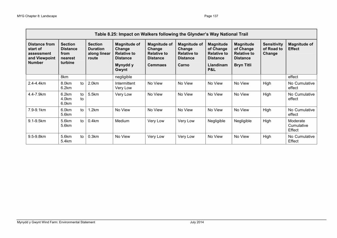
MYG Chapter 8: Landscape Page 137
Mynydd y Gwynt Wind Farm: Environmental Statement July 2014
Table 8.25: Impact on Walkers following the Glyndwr’s Way National Trail
Distance from start of assessment and Viewpoint Number
Section Distance from nearest turbine
Section Duration along linear route
Magnitude of Change Relative to Distance
Mynydd y Gwynt
Magnitude of Change Relative to Distance
Cemmaes
Magnitude of Change Relative to Distance
Carno
Magnitude of Change Relative to Distance
Llandinam P&L
Magnitude of Change Relative to Distance
Bryn Titli
Sensitivity of Road to Change
Magnitude of Effect
8km negligible effect
2.4-4.4km 8.0km to 6.2km
2.0km Intermittent Very Low
No View No View No View No View High No Cumulative effect
4.4-7.9km 6.2km to 4.0km to 6.0km
5.5km Very Low No View No View No View No View High No Cumulative effect
7.9-9.1km 6.0km to 5.6km
1.2km No View No View No View No View No View High No Cumulative effect
9.1-9.5km 5.6km to 5.6km
0.4km Medium Very Low Very Low Negligible Negligible High Moderate Cumulative Effect
9.5-9.8km 5.6km to 5.4km
0.3km No View Very Low Very Low No View No View High No Cumulative Effect

Page 138 MYG Chapter 8: Landscape
Mynydd y Gwynt Wind Farm: Environmental Statement July 2014
Table 8.26: Impact on Linear Routes - the Unclassified Road Running between
Staylittle and Llanidloes through Hafren Forest / Sustrans Route 8
Distance from start of assessment and viewpoint number
Section distance from nearest turbine
Section duration along linear route
Magnitude of change relative to distance
Mynydd y Gwynt
Magnitude of change relative to distance
Carno
Magnitude of change relative to distance
Cemmaes
Magnitude of change relative to distance
Llandinam P&L
Magnitude of change relative to distance
Llandinam P&L repowering
Magnitude of change relative to distance
Nant y Moch
Sensitivity of road to change
Magnitude of effect
Travelling South-East
0-7.2km 8km to 1.8km
7.2km No view/ Negligible
No View No View No View No View No View Medium No cumulative effect
7.2-7.7km
Viewpoint 5
1.8km to 1.8km
0.5km High No View No View No View No View No view Medium No Cumulative effect
7.7-11.3 1.8km to 3.9km
3.6km No View No View No View No View No View No view Medium No Cumulative Effect
11.3-14.5km 3.9km to 6.3km
3.2km No View No View No View negligible negligible No view Medium No Cumulative Effect
14.5-15km 6.3km to 5.8km
0.5km Low No View No View No View No View No view Medium No Cumulative Effect
15-19.6km 5.8km to 10km
4.6km No View No View No View No View No View No View Medium No Cumulative Effect
Travelling North-West
0-2.4km 10km to 8km
2.4km No view No View No View No View No View No view Medium No Cumulative Effect
2.4-2.6km 8.0km to 0.2km Very Low No View No View No View No View No view Medium No

MYG Chapter 8: Landscape Page 139
Mynydd y Gwynt Wind Farm: Environmental Statement July 2014
Table 8.26: Impact on Linear Routes - the Unclassified Road Running between
Staylittle and Llanidloes through Hafren Forest / Sustrans Route 8
Distance from start of assessment and viewpoint number
Section distance from nearest turbine
Section duration along linear route
Magnitude of change relative to distance
Mynydd y Gwynt
Magnitude of change relative to distance
Carno
Magnitude of change relative to distance
Cemmaes
Magnitude of change relative to distance
Llandinam P&L
Magnitude of change relative to distance
Llandinam P&L repowering
Magnitude of change relative to distance
Nant y Moch
Sensitivity of road to change
Magnitude of effect
7.8km Cumulative Effect
2.6-2.7km 7.8km to 7.7km
0.1km No view No View No View No View No View No view Medium No Cumulative Effect
2.7-4.6km 7.7km to 5.8km
1.9km Low No View No View No View No View No view Medium No Cumulative Effect
4.6-5.1km 5.8km to 6.3km
0.5km No View No View No View No View No View No View Medium No Cumulative Effect
5.1-5.5km 6.3km to 5.4km
0.5km Medium to Low
No View No View No View No View No View Medium No Cumulative Effect
5.5-6km 5.4km to 4.4km
0.5km Medium No View No View No View No View No View Medium No Cumulative Effect
6-7.8km 4.4km to 3.9km
1.8km Medium No View No View No View No View No View Medium No Cumulative Effect
7.8-11.4km 3.9km to 1.8km
2.6km No View No View No View No View No View No View Medium No Cumulative Effect
10.4-10.9km 1.8km to 0.5km High No View No View No View No View No View Medium No Cumulative

Page 140 MYG Chapter 8: Landscape
Mynydd y Gwynt Wind Farm: Environmental Statement July 2014
Table 8.26: Impact on Linear Routes - the Unclassified Road Running between
Staylittle and Llanidloes through Hafren Forest / Sustrans Route 8
Distance from start of assessment and viewpoint number
Section distance from nearest turbine
Section duration along linear route
Magnitude of change relative to distance
Mynydd y Gwynt
Magnitude of change relative to distance
Carno
Magnitude of change relative to distance
Cemmaes
Magnitude of change relative to distance
Llandinam P&L
Magnitude of change relative to distance
Llandinam P&L repowering
Magnitude of change relative to distance
Nant y Moch
Sensitivity of road to change
Magnitude of effect
Viewpoint 5 1.8km Effect
10.5-17.6 1.8km to 8km
7.1km No View Negligible Very Low No View No View No View Medium No Cumulative Effect
17.6-19.6km 8km to 10km
2km No View Negligible Very Low No View No View No View Medium No Cumulative Effect

MYG Chapter 8: Landscape Page 141
Mynydd y Gwynt Wind Farm: Environmental Statement July 2014
Conclusions
8.570 This LVIA has systematically analysed the effects likely to be brought about on the landscape character and visual amenity of an initial 30km study area through the development of 27, 125m to tip wind turbines on the Mynydd y Gwynt Wind Farm site. This assessment has been informed through the utilisation of a detailed landscape character assessment produced by NRW, LANDMAP, and by Powys County Council and through the generation of ZTVs, wireframes and the analysis of 26 specific viewpoints.
Significance of Effect
8.571 This section of the LVIA draws together the likely significant environmental effects identified through the assessment process. It is fully acknowledged, and anticipated that any development involving the erection of tall structures with moving parts would give rise to significant visual and landscape effects. The systematic process undertaken in the LVIA identifies the location of these effects and to whom it would matter. The magnitude of the effect determines whether an effect would be significant.
8.572 In this assessment, significance is expressed in terms of varying degree from slight to substantial (with those on the very margins of change expressed as being negligible) and occasionally in intermediate steps, such as slight to moderate / moderate. Those effects evaluated as being of ‘Moderate to Substantial’ or greater magnitude in the methodology statement matrix presented in Appendix 8.1 are regarded in this part of the assessment as likely to be equivalent to significant effects when considered in terms of the appropriate EIA Regulations.
8.573 In other words, any potential effect greater than ‘Moderate’ magnitude would be considered to give rise to a significant effect.
8.574 In addition, when considering effects on the character of the receiving landscape, the author has also adopted an approach whereby she has chosen to determine whether or not the proposed development would either give rise to a new landscape character/type in its own right, such as where the proposed development would become the defining landscape element of the type and / or give rise to a new landscape sub-type where the proposed development would be a significant contributor in defining character. In both these cases the change would be significant.
8.575 In the concluding section of this chapter, the changes identified as being likely to be significant are evaluated in terms of their impact on those elements that are valued, in terms of the landscape and visual amenity resources.
Landscape and Visual Effects: Positive or Negative
8.576 Significant effects are not necessarily adverse or unacceptable. The public perception of wind farms on the landscape and on views within the landscape ranges widely from those strongly in favour of wind turbines and those who are wholly against wind farm developments (often described as valency). Whilst many see wind farms as a very positive approach to dealing with climate change, others have equally strong views that are negative and represent their objection to wind turbines. In this particular development scenario, wind turbines would become a key characteristic of the local landscape, visible from surrounding areas, from predominantly from open access land, paths and to a much

Page 142 MYG Chapter 8: Landscape
Mynydd y Gwynt Wind Farm: Environmental Statement July 2014
lesser extent from roads, very few individual dwellings and from almost no settlements. This reflects the relatively remote location of the proposed wind farm in Mid Wales.
8.577 In the presentation of the effects in the body of this LVIA a neutral stance has deliberately been taken, with effects identified in terms of their significance, expressed in terms of the likely and predicted effects that the proposed Mynydd y Gwynt Wind Farm would bring about on the landscape and visual amenity of the site and study area. Valency has not been included in this former, quantitative part of the assessment. The subsequent conclusions that are presented in the following section consider the qualitative effects of the wind farm, and consider the perception of those experiencing the change proposed. Wind farm development gives rise to a range of response from people ranging from strongly adverse to strongly positive.
8.578 To achieve full compliance with the EIA Regulations requires that the likely significant effects should be described covering the type of effect (for example direct, indirect, secondary, cumulative), their temporal nature (short, medium and long-term, permanent, temporary), and their valency (positive and negative / beneficial or adverse).
8.579 Accordingly, judgements concerning the valency of the effect need to be given, and justified, in a transparent manner accepting that this aspect of the assessment process is particularly subjective.
Effects on Landscape Fabric and Character of the Site
8.580 The proposed development is now considered in terms of the magnitude (scale) of the potentially significant change identified through the LVIA set against the value of the landscape as perceived by both observers in the landscape and through policy or guidance, in order to establish the importance of the effect over and above its significance.
8.581 The assessment of the effects on the landscape fabric of the site, are set out in Paragraphs 8.133 to 8.146. This assessment concludes that there will be long-term, but reversible effects on the landscape fabric of the site during the operational life of the development of the 27 wind turbines and the associated infrastructure. The effects of the development on the landscape fabric of the site have been assessed as being likely to be long-term, moderate to substantial and significant.
8.582 However, on decommissioning these effects will be reversed and the landscape will be able to be restored to normal upland grazing farming practices. Thereafter there will be some slight and localised effects, but no significant permanent adverse effects on the landscape fabric of the site are anticipated.
Effects on Landscape Character
Landscape Character of the Site
8.583 The effects of the proposed Mynydd y Gwynt Wind Farm would be primarily on the less tangible aspects of the landscape character, which are now explored. The magnitude of change of the introduction of the wind turbines onto the site is judged to be high which, combined with the sensitivity of the landscape to this change being assessed as medium to high; the resulting significance of effect on the landscape character of the site is assessed as being moderate to substantial / substantial and significant. The site is

MYG Chapter 8: Landscape Page 143
Mynydd y Gwynt Wind Farm: Environmental Statement July 2014
characterised by open grass moorland that is afforded open views, some of which are panoramic, from both within the site, and from the surrounding land of the site. Much of the land is open access, but the number of viewers in the landscape is very low, with few walkers venturing beyond the defined paths, and those only attracting a relatively small number of walkers, in part due to the remoteness of the site and the use as a rally complex, and regular use of parts of the site as a rifle range and other parts for motorcycle training. When these regular activities are not being undertaken the levels of tranquility can be higher, reflecting the remote location of the site (albeit adjacent to the A44). However, this is relatively low compared to the more remote land to the south of the A44 and land within the upland National Parks in Wales. The sense of remoteness in the context of the site is heavily reduced by the on-going rally, rifle range and motorcycling activities. There are extensive track networks, large-scale buildings and a number of non-inherent features that potentially detract from the wild and remote qualities related to the Plynlimon area. The wind turbine development needs to be seen in this context.
Landscape Character of the Study Area
8.584 The introduction of 27 wind turbines with an overall height of 125m to tip will be a long-term, but not permanent change to the landscape. The character within the vicinity of the site, along the Tir Gwyn / Y Foel ridge within the Plynlimon Moorlands aspect area (MNTGMVS910), will change, including the undulating ridge / plateau land on which the site lies. The sensitivity of the landscape aspect areas in the context of the site is variable, in part reflecting the high levels of forestry present and incised nature of valleys that influence the perception of the landscape, and the number and location of highly sensitive receptors in the landscape.
8.585 Therefore, in practice, although theoretically visible from 20km or more from one upland area to another, the presence of the development in the view is only likely to be clearly discernable beyond the distance of 3.5km to 4km in the west, 9km in the east and north-east and in the forested areas to the north, east and south within areas with a very open character. The wind farm will be most visible from elevated areas within a radius of about 4.5km.
8.586 The viewpoint analysis has been used to inform the conclusion that significant effects on the perception of the landscape character are likely up to approximately 7km from the site, in the north and east, 3.5km to 4km in the west and out to about 5.5km elsewhere in the study area. Once viewed at a greater distance from a wind turbine these effects on the landscape character fall to moderate, below the threshold of significance. The threshold of significance falls at moderate to substantial.
8.587 Within 3.5km of the site the wind turbines would be highly visible in the raised open upland landscapes, and slightly to moderately visible from more enclosed areas. This change will be long-term over the 25 year operational life of the project, yet reversible on decommissioning.
8.588 Twelve landscape aspect areas were defined in the 10km context of the site, in the NRW LANDMAP landscape character assessments.
8.589 The effects of the development on the character and perception of the other four aspects of LANDMAP has also been evaluated, both individually by layer, and through landscape character areas.

Page 144 MYG Chapter 8: Landscape
Mynydd y Gwynt Wind Farm: Environmental Statement July 2014
8.590 As considered in relation to direct effects, it must be borne in mind that this site, whilst characterised by open grass moorland, and being open access land, the use as a rally complex heavily influences the perception of the landscape from the surrounding area. The context of the site is also already heavily influenced by wind turbine developments, and as such, the proposed turbines would not be seen as a completely new element in the landscape, whilst being a new element on the site itself.
8.591 The scale of the landscape is sufficient to accommodate the scale of the development proposed. There would be no impact on the perception of the scale. The site is not a massive plain or plateau or simple ridge that would be diminished in value or perceived scale by the turbines. NRW have raised some concerns about the location of the turbines nearest the south-western edge of the site. These would not look “unstable” anywhere, including from where the public would be afforded open views, some of which are panoramic, such as from Plynlimon Fawr above the site, or from the Wye Valley Walk below the turbines, from both within the site, and from the surrounding land of the site. In addition, the levels of tranquility can be very low relative to the remote location of the site and the sense of remoteness in the context of the site is heavily reduced by the on-going rally activities. These qualities are not perceived from vantage points or locations farther from the site, but the extensive track networks, large-scale buildings and a number of non-inherent features that potentially detract from the wild and remote qualities related to the Plynlimon area are readily perceived. The impact of the proposed wind turbine development needs to be seen in this context, as well as the context of the very extensive modern coniferous forestry to the north and south that has a barring effect on the appreciation of the character of the landscape. All of these factors influence the perception of the site, and how the qualities of the landscape are perceived. These are all accommodating factors to a development of this nature on this site.
Effects on Landscape Designations
8.592 There is one national landscape designation within the study area, the Snowdonia National Park (18km north-west).
8.593 There would be some views afforded from the southern edges of the Snowdonia National Park, from the ridge along the southern edge, such as from Bryn Coch (227m AOD), that would bring about a very low magnitude of change of view from the southern edge at a distance of 19.5km, that would be slight to moderate and not significant. Views in more enclosed areas and further away would be of a lower magnitude, negligible, that would also not create significant effects on the character or appreciation of the Snowdonia National Park.
Effects on Visual Amenity
8.594 The analysis of wireframes in the field, including from locations used in the viewpoint analysis presented in Paragraphs 8.219 to 8.228, has informed the conclusion on effects on visual amenity. This has shown that changes in view would fall to medium at distance of about 3.5km from the proposed wind turbines in the west (due to landform falling into Nant-y-Moch and falling outside the ZTV), 6km to the north, 6.5km to the south and east. Therefore significant effects are likely on visual amenity up to these distances for highly sensitive visual receptors.

MYG Chapter 8: Landscape Page 145
Mynydd y Gwynt Wind Farm: Environmental Statement July 2014
8.595 At greater distances the levels of effect drop away to non-significant effects and from slight to negligible.
Settlements
8.596 The assessment concludes that there would be no significant effects on towns, villages or hamlets.
Individual Dwellings
8.597 There are very few dwellings in proximity to the proposed wind farm. The assessment identified that significant effects would be experienced by the occupiers of six dwellings, all of which are either part of the landowner’s property holding or financially involved in the landowner’s farmed estate or proposed development.
8.598 With regard to the acceptability of impacts on residential dwellings, this is the test as set out in the Weston Longville Wind Farm Appeal decision by Paul Jackson (APP/K2610/A/11/2156693) referring to Enifer Downs Wind Farm, North Dover by David Lavender:
8.599 In paragraph 32 Inspector Jackson considers outlook as part of living conditions: “With regard to outlook, the advice in the PPS22 Companion Guide, for wind energy projects, affirms the basic principle that ‘The planning system exists to regulate the development and use of land in the public interest. The material question is whether the proposal would have a detrimental effect on the locality generally, and on amenities that ought, in the public interest, to be protected’. In terms of visual amenity, this translates into the long established principle that there is ‘no right to a view’, meaning that it is not possible to protect a property simply on the basis that an attractive or cherished view would be adversely affected by development. My colleague Inspector, David Lavender, in his Enifer Downs (North Dover) decision, expressed it in this way: ‘...... when turbines are present in such number, size and proximity that they represent an unpleasantly overwhelming and unavoidable presence in main views from a house or garden, there is every likelihood that the property concerned would come to be widely regarded as an unattractive and thus unsatisfactory (but not necessarily uninhabitable) place in which to live. It is not in the public interest to create such living conditions where they did not exist before.’ This test is one way of describing the situation where private and public interests could coincide in such a way that the outlook from a dwelling would be so harmed as to be generally regarded as unacceptable.”
8.600 This provides a useful set of criteria with which to judge whether the outlook from a dwelling would be unacceptably harmed or not.
8.601 In the case of Mynydd y Gwynt, the farmhouse at Pont Rhydgaled would experience views from the windows on two elevations, bringing about moderate to substantial and significant effects. The view from this property would be one of the most open and changed by the wind farm. The view would be to the north and east and there is no appreciable vegetation in the front, garden to soften the view. The nearest turbine would be 800m from the property and five turbines would be seen from this property from the garden and all of the north and west-facing windows. This is the landowner’s house. This fact does not change the view, but changes the perception of the view. The principle that those with a financial stake in a wind farm can reasonably be expected to experience higher thresholds of

Page 146 MYG Chapter 8: Landscape
Mynydd y Gwynt Wind Farm: Environmental Statement July 2014
change in outlook before the change would become unacceptable in their view is set out in two recent appeal decisions.
8.602 In an update from McGrigors LLP on Wind Turbines and Residential Amenity (http://www.mcgrigors.com/e-bulletin/energy/eb_27_Sept_2010.html) (Appendix 5) at the penultimate bullet point of the section titled “What kind and degree of harm amounts to a "material planning consideration"?” it states: “inspectors have given less (or no) weight to the impact on occupiers of dwellings who have a financial interest in the turbine development (akin to the assessment of noise impact, where a higher noise tolerance is allowed if the occupiers have a financial interest)”
8.603 In addition, at paragraph 214 of the Inspector’s report for Swinford, which was endorsed by the Secretary of State, it is written midway down the paragraph: “The nearest occupied dwellings that would not have a financial interest in the proposed wind farm would be located about 670 m from the nearest turbine.” This shows that the visual impact of dwellings occupied by those with a financial interest are not assessed on the same basis as those without a financial interest when assessing the residential amenity impact.
8.604 In the Cotton Farm Decision, at paragraph 100, it is written in the second sentence “From the evidence I am satisfied that the occupiers of Cotton Farm would have employment and financial interests in the wind farm and are therefore less sensitive receptors than other local residents who would have the development imposed upon them; accordingly I have not considered this property further.”
8.605 The author’s conclusion is that, as these authorities show, the residential amenity impact threshold is set higher for those with a financial interest in the scheme. So, whilst the author has assessed that there would be a significant change in view from within the farmhouse at Pont Rhydgaled, the closest dwelling with the greatest opportunity for visual impact, as that the turbines would be prominent in the view, it is not believed that the effect would be overbearing on living conditions regardless of the landowner’s involvement in the wind farm.
8.606 The other five properties are more distant and whilst the turbines would also be prominent in the views from either windows in the dwellings or the curtilages of the dwellings, it is not believed that the effect would be overbearing on living conditions regardless of the occupiers involvement in the landowner’s estate or the wind farm.
Tourist and Recreational Facilities
8.607 The only significant effects on tourist attractions that would be brought about would be on the users of the Hafren Forest picnic site upper level and access road, and from a short, 300m section of the path link between the Wye Valley Walk and the Severn Way, close to turbines 3, 8, 10, 11 and 12, within the forest and from walkers on higher land surrounding Llyn Clywedog. There would be no significant changes in view from any other formal out-door recreation locations.
Road Users
8.608 There would be no views afforded from the A4120. A few moderate to substantial and significant effects would be experienced by motorists using the A44 between 1.5km to 1.2km from the proposed development for a duration of 300m. A few negligible effects

MYG Chapter 8: Landscape Page 147
Mynydd y Gwynt Wind Farm: Environmental Statement July 2014
would be experienced by users of the A44 from two other sections of this route. A 1.5km section of the A470 would be afforded side views in both directions that would create negligible, not significant effects.
8.609 Some effects of a moderate magnitude are anticipated from the B4518, the only B road within 10km of the site. The greatest magnitude of effect would be moderate, for a 1.5km length of road, 6.6km to 6.9km to the north-east of the nearest wind turbine. There would be no significant effects.
8.610 From the local road network there will be a series of views with the wind turbines set against the open sky or the backdrop of forestry and mountain or hillsides, characteristic of the area. The wind turbines will, from every near and middle distance view appear to be a large single group with a uniform, strong, simple form. These views would be predominantly from the east and north-eastern quadrant of the study area; with the turbines seen towards the south-west.
8.611 From these roads (with the exception of the 500m length of road) the view will be of a medium magnitude when looking directly at the site with a clear view of the turbines. Most of the roads however would only be afforded very intermittent or side views of the proposed development, as these roads generally connect the surrounding hamlets and cross the valley streams and heads of tributaries that flow into the larger Severn and Wye Valleys and are sunken in nature and within valley heads, or on land falling towards the valleys that is also concealed from views. There are very few sections where the view will be direct. The sensitivity is medium and the impact therefore assessed as being moderate to substantial and significant in the near, under 2.0km, distance to the north-east. Views over 2.0km would be of a medium magnitude or lower, and would create moderate, not significant visual effects.
8.612 The quantitative analysis and assessment of effects, summarised above, shows that the impact on road users would be relatively modest considering the scale of the development proposed. This is in the main due to the siting of the majority of the wind farm scheme turbines back from the site-edge facing the A44, meaning that only a few of the proposed turbines would be seen from a short section of this closest, main arterial road. Wind turbines in this part of mid-Wales are not uncommon, and a feature of the landscape seen from the road network, as explored in the cumulative assessment. However, in the context of this site, the number of and magnitude of views that would be afforded from roads would be relatively minor in comparison to the overall views experience from roads in this area. The turbines would form a minor element in the view from road users on the A44 over its length between Duffryn Castell and Llangurig, the closest section.
Rail Users
8.613 No effects on rail users were identified through the assessment process.
Cyclists
8.614 There are two Sustrans routes in the study area; Routes 8 and 81. There would be significant effects over Route 8 over 2.8km for north-west bound cyclists and 500m for south-east bound cyclists following the route where it passes through Hafren Forest to the north-east of the site. Beyond 5.4km from the site no significant changes in views are anticipated from Routes 8 or 81 or any other routes used by cyclists. Parts of the Severn

Page 148 MYG Chapter 8: Landscape
Mynydd y Gwynt Wind Farm: Environmental Statement July 2014
Way are used by cyclists. Sustrans routes, by their very nature, are long-distance routes, and to only impact on the views of one route over 2.8km in this part of mid-Wales is a minor change overall. The closest views to Route 8 would be classed as being in the middle-distance, and the turbines would be seen as part of the broader landscape that has other wind turbines, power routes, forestry and many other human interventions, not in the context of virgin upland landscape.
Walkers and Horse Riders
8.615 This assessment shows that the anticipated magnitude of view likely to be brought about through the development of wind turbines on the site is generally substantial for footpaths within 3.5km in unforested areas and substantial under 1.8km for the named long-distance paths, including the Wye Valley Walk and the Severn Way. There are variations with some receptors within these distances, in well-forested and enclosed valley locations being less likely to experience a change in view. This assessment takes into account the extent of change of view, the direction of view in relation to direction of travel and the length of path from which the view will be afforded. The assessment is based on the judgement that the sensitivity of these receptors is high. Significant effects would be experienced from sections of all of the four named paths, with the greatest duration of significant change of view from the Wye Valley Walk upper reaches, and from the Cambrian Way on the ridge of Plynlimon between the sources of the Wye and Severn. User data was gathered in August 2013 (Appendix 8.3) and showed extremely low usage of the paths crossing the site, including only 55 users in all of August of the Wye Valley Walk, compared to over 400,000 who walk up Snowdon each year and 67,000 who walk up Cadair Idris in an average year. The August figure includes 3 Duke of Edinburgh groups and represented usage in one of the warmest and driest summers when more walkers would be expected than in a normal summer. Whilst highly sensitive, the number of receptors is relatively low, only an average of two per day. User data has not been recorded for the Severn Way, but is highly unlikely to be anyway near that of the peaks visited in the National Parks. There would be views of the proposed turbines from the paths, particularly from the Wye Valley Walk crossing the landholding of the wind farm site, as fully acknowledged in the assessment. They would impact on the appreciation of the landscape character, however, this needs to be seen in the context of the rally complex activities in the vicinity. The only close views from the upper sections of the Severn Way 2-3km distant and in the context of the intervening Hafren Forest that walkers would have travelled through to reach the source. The source provides panoramic views, of which the proposed turbines would form a part of the southern quadrant. They would not surround the viewer or impact on the viewer’s appreciation of the achievement of reaching the source of Britain’s longest river.
8.616 The proposed development has the potential to be seen over very long distances. The wind turbines have been designed to appear as a consistent and coherent group of simple structures. Only in very near views will the access tracks and from very few views would the substation be seen post-construction.
8.617 The initial 30km study area was chosen to effectively assess all of the potential impacts likely to be brought about through this development. Whilst it is possible to see wind turbines of this scale at distances over 20km on very clear days, and with no clutter on the horizon, only slight or negligible effects are likely over 10km. The development will be most likely to be seen from within a radius of about 8km from the site, on clear days

MYG Chapter 8: Landscape Page 149
Mynydd y Gwynt Wind Farm: Environmental Statement July 2014
subject to the degree of localised enclosure from forestry and vegetation, as described in the landscape character assessment.
8.618 The sensitivity of the receptors assessed ranged from high to low, with sensitivity increasing in areas of high numbers of receptors of a high quality and in areas of few other features or few discordant elements. The effects are assessed as ranging from slight in distant locations and moderate on middle-distance footpath locations, to some substantial effects from clearly visible locations within the site and from footpaths.
8.619 Some significant effects have been identified in the near to middle distance the site, as informed by the use of wireframes, some of which have been used in the viewpoint analysis, these effects are not necessarily assessed as being negative. This is expanded on in the assessment of significance of effects below.
Assessment of Significance of Effects
8.620 Through the assessment process recorded in this document, the potential landscape and visual impacts likely to be brought about by the development of the Mynydd y Gwynt Wind Farm have been systematically analysed and evaluated in detail. The significance of these potential effects have been recorded as being either substantial, moderate to substantial, moderate, slight to moderate, slight, slight to negligible or negligible. Effects of a moderate to substantial or greater significance have been assessed as being significant.
8.621 Wind turbines would become a defining characteristic of this part of the landscape, within the slopes and hills surrounding the source of the Afon Gwy (River Wye) and the near to middle distance parts of the Plynlimon Moorlands (MNTGMVS910). Due to the nature of wind turbines and more exposed and visually open land, and hill / moorland character of the receiving landscape, some significant effects have been recorded. These are now related back to the underlying policy context of the site. The acceptability of these substantial effects is balanced against the positive benefits to the wider environment and the policy aims of the UK government elsewhere in this assessment.
8.622 Significant effects are not necessarily adverse or unacceptable. The public perception of wind farms on the landscape and on views within the landscape ranges widely from those strongly in favour of wind turbines and those who are wholly against wind farm developments. Whilst many see wind farms as a very positive approach to dealing with climate change, others have equally strong views that are negative and represent their objection to wind turbines. In this particular development scenario, wind turbines would become a key characteristic of the local landscape, visible from upland areas, but only from few and limited roads and not from settlements.
8.623 In the quantitative part of this LVIA a neutral stance has deliberately been taken, with effects identified in terms of their significance, expressed in terms of the likely and predicted effects that the proposed Mynydd y Gwynt Wind Farm would bring about on the landscape and visual amenity of the site and study area. The subsequent conclusions over the significance of effect have not been weighted either as being positive or negative, however, taking a worst-case scenario of a person being strongly adverse to views of turbines, the effects would all be put into the adverse category and into the planning balance as such. This is not a scenario where the landscape is so degraded as to be enhanced by wind turbines. The presence of the existing rally activities and the adjacent forestry mean that the site is relatively more accommodating than virgin upland grazing or

Page 150 MYG Chapter 8: Landscape
Mynydd y Gwynt Wind Farm: Environmental Statement July 2014
more remote and wild landscapes found farther to the west and south of Cefn Croes and the Ysgair Ychion Forest associated with the Afon Ystwyth.
8.624 The siting of the development proposal has been sensitively considered in relation to the character of the receiving landscape within which the wind farm is proposed. The sense of place and local distinctiveness of the landscape strongly relates to exposure, and simple windblown characteristics are present. There would be no loss of characteristic features on the site. However, the proposed wind turbines would reinforce one of the key characteristics, the exposed and open nature, in the local landscape.
8.625 Throughout the design evolution the extent of significant effects on the landscape and visual amenity of the area have been considered and has influenced the project development. Tools such as wireframes and ZTVs have been used to inform these design decisions. The wind farm design has evolved through numerous design iterations ranging from 49 turbines to the final 27-turbine layout. The landscape assessment initially considered a proposal for 29 turbines to be installed at 133.5m to tip and through the design iteration process the number of turbines had been reduced to 23, and the tip heights were dropped to 125m to tip. Reconsideration of the scheme in light of more detailed ecological surveys, and in light of need has led to the site now being brought forward with 27 turbines. The re-running of the LVIA showed almost no increase in effects for 27 turbines over 23 turbines (of the same height).
8.626 The drop in turbine height had the effect of slightly reducing the visibility of the turbines, as illustrated in the Viewpoints from a range of locations and visual and landscape receptors in the study area, particularly those located in the eastern and southern part of the landscape.
8.627 Substantial and moderate to substantial effects have been identified from near public rights of way and from three dwellings in close proximity to the site. They have also been recorded for traffic on short sections of the near A and B and nearby unclassified local roads.
8.628 Significant effects are concentrated on the local visual receptors, and are broadly contained within 6.5km of a proposed wind turbine location in the east and south, and within 6km to the north and 4km to the west. These effects on the character and visual amenity of the receptors are not assessed as being significant. The scale of the landscape is large, particularly in the local area of the Plynlimon Moorlands aspect area (MNTGMVS910), and the simple and cohesive form of the development will not create clutter or detract from the simple upland grazing patterns. There is a single, very large simple framed building on the site next to the rally complex and an area of open flat land that has an industrial character, contrasting with the inherent patterns. The proposed construction compound, substation and infrastructure would be based near and within this part of the site to reduce effects elsewhere.
8.629 There are likely to be some significant effects on the landscape fabric of the site. Nearer to the site the effects are greater, and the assessment has concluded that there will be a localised change in character through the addition of this development within the Plynlimon Moorlands aspect area (MNTGMVS910). This assessment has taken into account the scale and form of both the landscape and the proposed wind turbines. This is an exposed and open landscape and these characteristics relate well and directly to the form and purpose of wind turbines.

MYG Chapter 8: Landscape Page 151
Mynydd y Gwynt Wind Farm: Environmental Statement July 2014
8.630 The development relates well to the receiving landscape character of the site and the perception of the landscape. A development of this nature in this location will not detract from the sub-regional landscape character or the diversity of landscape character beyond the local context. The scale, design and layout of the scheme and materials are appropriate to the landscape character and development proposed.
Cumulative Impact Assessment Conclusions
Cumulative Landscape Effects
8.631 As no other proposed or existing wind farm development lies on or adjacent to the proposed Mynydd y Gwynt Wind Farm site, or within the same part of the landscape, there is no need to assess the potential for any effects on the physical fabric of the landscape.
Cumulative Effects on the Character of the Landscape
8.632 The preliminary analysis of ZTVs, wireframes and field observations identified that only the following operational or proposed wind farms would have the potential to bring about significant combined landscape or visual impacts:
8.633 Llandinam P&L or Llandinam P&L re-powering, Cefn Croes, Carno (A + B), Carno Extension, Bryn Titli and Rheidol Wind Farm sites, and Nant y Moch; as only these sites or proposals lie within sufficient proximity and within the ZTV of the proposed Mynydd y Gwynt Wind Farm for any effects on the landscape character and visual amenity to be likely. The presence of such of these developments as have been constructed (as opposed to those several which are in planning or scoping) in the landscape is testament to the general principle of wind turbines being appropriate in this part of mid-Wales.
8.634 The linear route analysis of the A44, A470, B4518, Severn Way, Wye Valley Walk and Glyndwr’s Way routes demonstrated that there would be some sequential significant effects on the following sections of route:
• Severn Way – a 450m section at the western end of the Way;
• Wye Valley Walk – 5.8km from the source of the Wye; and
• Cambrian Way – 6.7km for north-bound walkers, north of the A44.
8.635 These are long-distance paths already impacted on by the views of turbines, hence cumulative effects being afforded. The user data shows that, whilst highly sensitive to changes in view, there are relatively small numbers of users on these long-distance paths and the changes in view brought about through the addition of the Mynydd y Gwynt turbines represent a very small proportion of the routes. Whilst theoretically there is the potential for some cumulative sequential effects to be brought about on the 450m section running east from the source of the River Severn on the Severn Way, these would be the only significant cumulative effects on this route. Due to the heavily forested character of the landscape between the trail and the proposed site there is no potential for significant consecutive and concurrent sequential cumulative effects to be brought about on the Glyndwr’s Way through the combination of views of the proposed Mynydd y Gwynt Wind Farm, and any other planned or consented wind farm. Therefore no further analysis has been undertaken. The re-analysis of the viewpoints for cumulative effects demonstrated

Page 152 MYG Chapter 8: Landscape
Mynydd y Gwynt Wind Farm: Environmental Statement July 2014
that there would be some significant combined cumulative effects from only one of the viewpoint locations, Viewpoint 1 (Figure 8.11a), Plynlimon Fawr.
8.636 The addition of the turbines would not prevent any walkers from using the paths or impact on their overall enjoyment of the achievement associated with long-distance path walking.
8.637 Detailed analysis has shown that there would be no significant concurrent or sequential effects brought about on the users of the A44 by the proposed Mynydd y Gwynt Wind Farm in combination Nant y Moch, Rheidol and Cefn Croes Wind Farms or any of the more distant existing or proposed schemes.
8.638 There would be no significant concurrent or sequential effects brought about on the users of the A470 by the proposed Mynydd y Gwynt Wind Farm in combination with any existing or proposed wind farms.
8.639 Theoretically there is the potential for some cumulative sequential and concurrent effects to be brought about on the B4518 road. However, detailed analysis has shown that there would be no significant concurrent or sequential effects.
8.640 There is the potential for some significant consecutive and concurrent sequential cumulative effects to be brought about on the Wye Valley Walk through the combination of views of the Bryn Titli Wind Farm and Cefn Croes Wind Farm with the proposed Mynydd y Gwynt Wind Farm, the greatest magnitude would be moderate to substantial, and significant. There would be some moderate and not significant cumulative effects on this route in the east through the combination of the Bryn Titli Wind Farm and the proposed Mynydd y Gwynt Wind Farm.
8.641 The LVIA has concluded that there would be no views of the proposed Mynydd y Gwynt Wind Farm from any settlements. Accordingly, no cumulative assessment has been undertaken.
Conclusions Drawn from the Analysis of Cumulative Landscape Effects
8.642 The assessment of cumulative effects on the landscape character of the receiving landscape showed that the development of the proposed Mynydd y Gwynt Wind Farm would bring about some new cumulative impacts on the landscape character of the Plimlimon aspect area (PWYSVS212), which is located between 1.5km to 8km north-west of the site. From the environs of the source of the River Severn (Viewpoints 16 and 17 (Figures 8.11p and q)) there would be views of Bryn Titli, Llandinam P&L, Carno and the Carno Extension, Cemmaes II, Nant y Moch and Cefn Croes. The addition of the Mynydd y Gwynt turbines to this view would bring about an introduction of a wind farm in the closer distance, and bring about a medium magnitude of cumulative change in view, that due to the high sensitivity would bring about some moderate to substantial and significant effects.
8.643 The assessment of cumulative effects on designated landscapes demonstrated that development of the proposed Mynydd y Gwynt Wind Farm, in combination with any of the other wind farm proposals, would not bring about any cumulative impacts on the landscape character, visual amenity or purpose of designation of the Snowdonia National Park. The Nant y Moch Wind Farm site lies under 10km to the west of the proposed Mynydd y Gwynt Wind Farm to the north of the A44 at Ponterwyd.

MYG Chapter 8: Landscape Page 153
Mynydd y Gwynt Wind Farm: Environmental Statement July 2014
Nant y Moch
8.644 As set out above the Nant y Moch Wind Farm was progressed to Section 42 Consultation stage. Since February 2013, however, its promoter, SSE Renewables, has put the proposal on ice stating that it is not likely to be progressed at least “until the ambitions for the delivery of renewable energy in Wales is clearer”. Since making that announcement SSE Renewables has also cancelled the project’s grid connection contract. Whilst the scheme has not been formally withdrawn it is understood that there are some serious issues with the current draft proposal that mean that it is likely that only a much reduced scheme will be possible on this site and that the proposals may ultimately not be progressed to an actual application. As previously set out, the foregoing assessment assumes that the Nant y Moch scheme will go ahead as previously proposed. In light of the uncertainties surrounding the Nant-y-Moch scheme, however, the CLVIA conclusions have been re-run without this formerly proposed wind farm in the assessment.
8.645 As no other proposed or existing wind farm development lies on or adjacent to the proposed Mynydd y Gwynt Wind Farm site, or within the same part of the landscape, there is no need to assess the potential for any effects on the physical fabric of the landscape.
Cumulative Effects on the Character of the Landscape in the absence of the Nant y Moch Turbines
8.646 The preliminary analysis of ZTVs, wireframes and field observations identified that in the absence of the Nant y Moch Turbines only the following operational or proposed wind farms would have the potential to bring about significant combined landscape or visual impacts:
8.647 Llandinam P&L or Llandinam P&L re-powering, Cefn Croes, Carno (A + B), Carno Extension, Bryn Titli and Rheidol Wind Farm sites; as only these sites or proposals lie within sufficient proximity and within the ZTV of the proposed Mynydd y Gwynt Wind Farm for any effects on the landscape character and visual amenity to be likely.
8.648 The linear route analysis of the A44, A470, B4518, Severn Way, Wye Valley Walk and Glyndwr’s Way routes demonstrated that there would be some sequential significant effects on the following sections of route:
• Severn Way – a 450m section at the western end of the Way;
• Wye Valley Walk – 5.8km from the source of the Wye; and
• Cambrian Way – 6.7km for north-bound walkers, north of the A44.
8.649 These are long-distance paths already impacted on by the views of turbines, hence cumulative effects being afforded. The user data shows that, whilst highly sensitive to changes in view, there are relatively small numbers of users on these long-distance paths and the changes in view brought about through the addition of the Mynydd y Gwynt turbines represent a very small proportion of the routes. Whilst theoretically there is the potential for some cumulative sequential effects to be brought about on the 450m section running east from the source of the River Severn on the Severn Way. These would be the only significant cumulative effects on this route. Due to the heavily forested character of the landscape between the trail and the proposed site there is no potential for significant

Page 154 MYG Chapter 8: Landscape
Mynydd y Gwynt Wind Farm: Environmental Statement July 2014
consecutive and concurrent sequential cumulative effects to be brought about on the Glyndwr’s Way through the combination of views of the proposed Mynydd y Gwynt Wind Farm, and any other planned or consented wind farm. Therefore no further analysis has been undertaken. The re-analysis of the Viewpoints for cumulative effects demonstrated that there would be some significant combined cumulative effects from only one of the viewpoint locations, Viewpoint 1 (Figure 8.11a), Plynlimon Fawr.
8.650 The addition of the turbines would not prevent any walkers from using the paths or impact on their overall enjoyment of the achievement associated with long-distance path walking.
8.651 Detailed analysis has shown that there would be no significant concurrent or sequential effects brought about on the users of the A44 by the proposed Mynydd y Gwynt Wind Farm in combination with the Rheidol and Cefn Croes Wind Farms or any of the more distant existing or proposed schemes.
8.652 There would be no significant concurrent or sequential effects brought about on the users of the A470 by the proposed Mynydd y Gwynt Wind Farm in combination with any existing or proposed wind farms.
8.653 Theoretically there is the potential for some cumulative sequential and concurrent effects to be brought about on the B4518 road. However, detailed analysis has shown that there would be no significant concurrent or sequential effects.
8.654 There is the potential for some significant consecutive and concurrent sequential cumulative effects to be brought about on the Wye Valley Walk through the combination of views of the Bryn Titli Wind Farm and Cefn Croes Wind Farm with the proposed Mynydd y Gwynt Wind Farm, the greatest magnitude would be moderate to substantial, and significant. There would be some moderate and not significant cumulative effects on this route in the east through the combination of the Bryn Titli Wind Farm and the proposed Mynydd y Gwynt Wind Farm.
8.655 The LVIA has concluded that there would be no views of the proposed Mynydd y Gwynt Wind Farm from any settlements. Accordingly, no cumulative assessment has been undertaken.
Conclusions Drawn from the Analysis of Cumulative Landscape Effects in the absence of the Nant y Moch Turbines
8.656 The assessment of cumulative effects on the landscape character of the receiving landscape showed that the development of the proposed Mynydd y Gwynt Wind Farm would bring about some new cumulative impacts on the landscape character of the Plimlimon aspect area (PWYSVS212), which is located between 1.5km to 8km north-west of the site. From the environs of the source of the River Severn (Viewpoints 16 and 17 (Figures 8.11p and q)) there would be views of Bryn Titli, Llandinam P&L / Llandinam P&L Repowering, Carno and the Carno Extension, Cemmaes II and Cefn Croes. The addition of the Mynydd y Gwynt turbines to this view would bring about an introduction of a wind farm in the closer distance, and bring about a medium magnitude of cumulative change in view, that due to the high sensitivity would bring about some moderate to substantial and significant effects.

MYG Chapter 8: Landscape Page 155
Mynydd y Gwynt Wind Farm: Environmental Statement July 2014
8.657 The assessment of cumulative effects on designated landscapes demonstrated that development of the proposed Mynydd y Gwynt Wind Farm, in combination with any of the other wind farm proposals, would not bring about any cumulative impacts on the landscape character, visual amenity or purpose of designation of the Snowdonia National Park.
References
Countryside Agency (1999, revised 2002) Landscape Character Assessment Guidance, England (Ref-8-001)
Countryside Agency (2004) Landscape Character Assessment: Topic Paper 6: Techniques and Criteria for Judging Capacity and Sensitivity, England (Ref-8-002)
NRW, LANDMAP. http://landmap.naturalresourceswales.gov.uk/ (Ref-8-003)
CCW (May 2013) LANDMAP Information Guidance Note 3: Using LANDMAP for landscape and visual impact assessment of onshore wind turbines (Ref-8-004)
ENTEC (September 2008) Review of Guidance on the Assessment of Cumulative Impacts of Onshore Windfarms: Phase 1 Report; (Ref-8-005)
Horner & Maclennan and Envision 3D Ltd (2006) Visual Representation of Windfarms: Good Practice Guidance commissioned by SNH; (Ref-8-006)
Landscape Institute (LI) and Institute of Environmental Management and Assessment (IEMA) (2013) Guidelines for Landscape and Visual Impact Assessment (GLVIA3); Third Edition 2013. (Ref-8-007)
Landscape Institute (2009) Advice Note 01/09: Use of Photography and Photomontage in Landscape and Visual Assessment. (Ref-8-008)
Scottish Natural Heritage (2001) Guidelines on the Environmental Impact of Windfarms and Small Scale Hydroelectric Schemes, Scotland. (Ref-8-009)
Scottish Natural Heritage, (March 2012) Assessing the Cumulative Impact of Onshore Wind Energy Developments. (Ref-8-010)
SNH (2009) Siting and design of windfarms in the landscape. (Ref-8-011)
University of Newcastle (2002) Visual Assessment of Windfarms: Best Practice. Report F01AA303A Commissioned by Scottish Natural Heritage, Scotland (Ref-8-012)
Weston Longville Wind Farm Appeal decision by Paul Jackson (Ref-8-013)
Snowdonia National Park Authority Website (Ref-8-14)
McGrigors LLP update on Wind Turbines and Residential Amenity (Ref-8-015)
Inspector’s report for Swinford Wind Farm (Ref-8-016)
Cotton Farm Wind Farm Decision (Ref-8-017)

Page 156 MYG Chapter 8: Landscape
Mynydd y Gwynt Wind Farm: Environmental Statement July 2014
1st Edition 6” OS maps (Ref-8-018)
1:25,000 Pathfinder O.S. and 1:50,000 OS maps (Ref-8-019)
Planning Act 2008 (Ref-3-007)
DECC, (2011) Overarching National Policy Statement for Energy (EN-1). (Ref-3-009)
DECC, (2011) National Policy Statement for Renewable Energy Infrastructure (EN-3). (Ref-3-010)
Welsh Assembly Government, (2005). Planning Policy Wales, Technical Advice Note 8: Planning for Renewable Energy. (Ref-3-011)
Welsh Government, (2012) Planning Policy Wales, Edition 6 – February 2014. (Ref-3-015)
Powys Unitary Development Plan (Ref-3-043)
Powys County Council, (2008). Interim Development Control Guidance: Onshore Wind Farm Developments. Second Draft Interim Development Control Guidance on Wind Farm Development in Powys. (Ref-4-002)