chapter 4 summary of the results of supplementary
TRANSCRIPT
41
Chapter 4 Summary of the Results of Supplementary Geological Survey
4.1. Overview
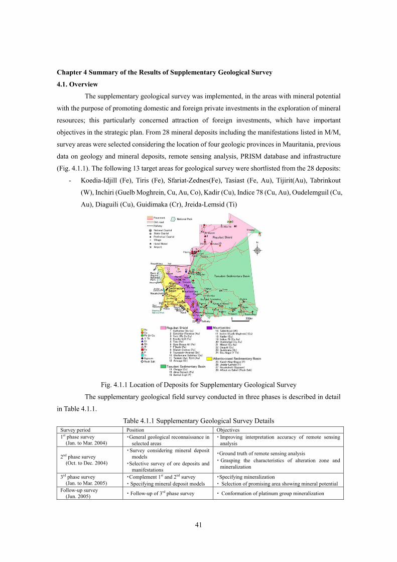
The supplementary geological survey was implemented, in the areas with mineral potential
with the purpose of promoting domestic and foreign private investments in the exploration of mineral
resources; this particularly concerned attraction of foreign investments, which have important
objectives in the strategic plan. From 28 mineral deposits including the manifestations listed in M/M,
survey areas were selected considering the location of four geologic provinces in Mauritania, previous
data on geology and mineral deposits, remote sensing analysis, PRISM database and infrastructure
(Fig. 4.1.1). The following 13 target areas for geological survey were shortlisted from the 28 deposits:
- Koedia-Idjill (Fe), Tiris (Fe), Sfariat-Zednes(Fe), Tasiast (Fe, Au), Tijirit(Au), Tabrinkout
(W), Inchiri (Guelb Moghrein, Cu, Au, Co), Kadir (Cu), Indice 78 (Cu, Au), Oudelemguil (Cu,
Au), Diaguili (Cu), Guidimaka (Cr), Jreida-Lemsid (Ti)
Fig. 4.1.1 Location of Deposits for Supplementary Geological Survey
The supplementary geological field survey conducted in three phases is described in detail
in Table 4.1.1.
Table 4.1.1 Supplementary Geological Survey Details Survey period Position Objectives 1st phase survey
(Jan. to Mar. 2004) ・General geological reconnaissance in
selected areas ・ Improving interpretation accuracy of remote sensing
analysis
2nd phase survey (Oct. to Dec. 2004)
・Survey considering mineral deposit models
・Selective survey of ore deposits and manifestations
・Ground truth of remote sensing analysis ・ Grasping the characteristics of alteration zone and
mineralization
3rd phase survey (Jan. to Mar. 2005)
・Complement 1st and 2nd survey ・ Specifying mineral deposit models
・Specifying mineralization ・ Selection of promising area showing mineral potential
Follow-up survey (Jun. 2005) ・ Follow-up of 3rd phase survey ・ Conformation of platinum group mineralization
42
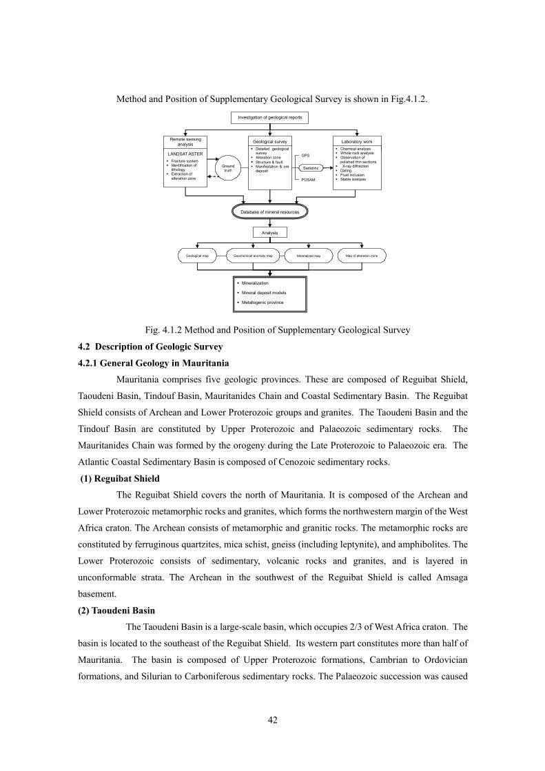
Method and Position of Supplementary Geological Survey is shown in Fig.4.1.2.
Investigation of geological reports
Laboratory work Chemical analysis Whole rock analysis Observation of
polished thin sections X-ray diffraction Dating Fluid inclusion Stable isotopes
Geological survey
Ground
truth
GPS
POSAM
Geological map Geochemical anomaly map Mineralized map Map of alteration zone
Database of mineral resources
Mineralization
Mineral deposit models
Metallogenic province
Analysis
Sampling
Remote sensing analysis
Detailed geological survey
Alteration zone Structure & fault Manifestation & ore
deposit
LANDSAT ASTER Fracture system Identification of
lithology Extraction of
alteration zone
Fig. 4.1.2 Method and Position of Supplementary Geological Survey
4.2 Description of Geologic Survey
4.2.1 General Geology in Mauritania
Mauritania comprises five geologic provinces. These are composed of Reguibat Shield,
Taoudeni Basin, Tindouf Basin, Mauritanides Chain and Coastal Sedimentary Basin. The Reguibat
Shield consists of Archean and Lower Proterozoic groups and granites. The Taoudeni Basin and the
Tindouf Basin are constituted by Upper Proterozoic and Palaeozoic sedimentary rocks. The
Mauritanides Chain was formed by the orogeny during the Late Proterozoic to Palaeozoic era. The
Atlantic Coastal Sedimentary Basin is composed of Cenozoic sedimentary rocks.
(1) Reguibat Shield
The Reguibat Shield covers the north of Mauritania. It is composed of the Archean and
Lower Proterozoic metamorphic rocks and granites, which forms the northwestern margin of the West
Africa craton. The Archean consists of metamorphic and granitic rocks. The metamorphic rocks are
constituted by ferruginous quartzites, mica schist, gneiss (including leptynite), and amphibolites. The
Lower Proterozoic consists of sedimentary, volcanic rocks and granites, and is layered in
unconformable strata. The Archean in the southwest of the Reguibat Shield is called Amsaga
basement.
(2) Taoudeni Basin
The Taoudeni Basin is a large-scale basin, which occupies 2/3 of West Africa craton. The
basin is located to the southeast of the Reguibat Shield. Its western part constitutes more than half of
Mauritania. The basin is composed of Upper Proterozoic formations, Cambrian to Ordovician
formations, and Silurian to Carboniferous sedimentary rocks. The Palaeozoic succession was caused

43
by a weak tectonic movement, and has a flat structure with a few faults, revealing a simple structure.
Fig.4.2.1 Geotectonic history in the north area of Mauritania
44
(3) Tindouf Basin
Some parts of the Tindouf Basin intercept small sectors near the northeastern borders of the
West Sahara or Algeria. The Basin covers the Reguibat Shield, and consists of dolomite of the Upper
Proterozoic and sandstone, shale and limestone of the Ordovician-Devonian (BRGM, 1975).
(4) Mauritanides Chain
The Mauritanides Chain, the so-called “Greenstone Belt”, characterized by folds and thrust
faults formed by Palaeozoic Hercynian orogeny, is located at the western margin of the West Africa
craton. It stretches for more than 2,500km, from Senegal through Mauritania to Morocco. It is
constituted by sedimentary rocks, igneous and metamorphic rocks of the Precambrian to Palaeozoic
era.
(5) Atlantic Coast Sedimentary Basin
The Atlantic Coast Sedimentary Basin is located in the west of the Mauritanides. It is
constituted by the Lower Cretaceous to Quaternary sediments and sedimentary rocks.
From viewpoints of geological structure, supplementary geological survey and literature
research, geotectonic history of the north area of Mauritania is presented in Fig.4.2.1.
4.2. 2 Overview of ore deposits
The 13 deposits where the supplementary geological survey has been implemented are as
follows.
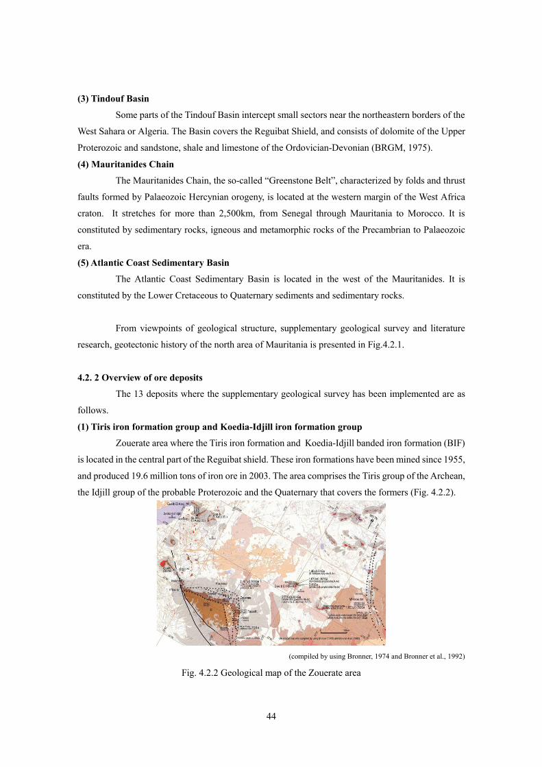
(1) Tiris iron formation group and Koedia-Idjill iron formation group
Zouerate area where the Tiris iron formation and Koedia-Idjill banded iron formation (BIF)
is located in the central part of the Reguibat shield. These iron formations have been mined since 1955,
and produced 19.6 million tons of iron ore in 2003. The area comprises the Tiris group of the Archean,
the Idjill group of the probable Proterozoic and the Quaternary that covers the formers (Fig. 4.2.2).
(compiled by using Bronner, 1974 and Bronner et al., 1992)
Fig. 4.2.2 Geological map of the Zouerate area

45
The Tiris group is composed of amphibolites and the metamorphic rocks of
meta-ferruginous quartzite and leptynite originated from the clastics of the Archean. The iron ore
deposit of the Tiris group consists of coarse-grained magnetite orebody in meta-ferruginous quartzite.
The ore is mainly composed of coarse-grained magnetite with average grade ranging from 35 to 42%
of Fe. The ore grade is low as iron ore, so it is enriched to 65-66 % of Fe by magnetic separation.
Fig. 4.2.3 Satellite images LANDSAT of the Zouerate area and ASTER of the Koedia-Idjill
The Idjill group thrusts over the Tiris group as nappe. The itabirite formation is predominant
in the Tazadit unit which is one of the nappes of the Idjill group. The formation is accompanied by
schists and nonferrous quartzite. All the iron deposits of the Koedia-Idjill BIF consist of the itabirite
formation in the Tazadit unit. The formation thickness ranges from 300 to 2,000 m, while the length
reaches 30 km. It comprises siliceous phyllite, siliceous Itabirite (35-45 % Fe) and hematite-bearing
itabirite (63-64 % Fe) from the lower layer. The ore body is about 150m thick hematite-bearing
Itabirite. It generally reveals banded structure that is several millimeters thick. The high-grade ore is
found in the concentrated layer of fine-grained scaly hematite and reveals grade of 67-68 % Fe. These
deposits are mined with the largest open pit of Tazadit T01 being 700 m in the major axis, 500 m in the
minor axis and 500 m deep.
Zouerate (LANDSAT ETM False Color RGB: 571)
Kedia Idjill (Topographic Map)
Kedia Idjill (ASTER HIS: 974) Kedia Idjill (ASTER Band RationRGB:4/8, 4/9, 1/3)

46
LANDSAT image of the Zouerate area including the Koedia-Idjill and Tiris iron formation,
and ASTER images of the Koedia-Idjill region are shown in Fig 4.2.3. The assessment for image
analysis is as follows:
• It is difficult to extract the iron deposits in the Koedia-Idjill and Tiris by using LANDSAT
images, but ASTER images are distinct and clearer than LANDSAT.
• ASTER band ration image is shown on right bottom picture in Fig. 4.2.3, where RGB is
applied in the ratio of 4/8, 4/9 and 1/3. These band ratios are selected when the 4/8 reflects
calcite and mica, the 4/9 reflects clay minerals and the 1/3 reflects iron oxides. The entire
area of mountain range of the Koedia-Idjill displays blue iron oxides, but it is difficult to
extract only itabirite layer of the Tazadit unit where the iron formation lies.
(2) Sfariat-Zednes
Sfariat-Zednes area is located in the central zone of the Reguibat Shield. It is composed of
gneiss, limestone, granitic rocks, migmatite and amphibolite of the Archean age. The area shows
tectonic zone with faults developing NW-SE and WEW-ESE, and strongly sheared rocks. Sequence of
three ranges of 10-30m thick BIFs extends 70km.There is a scarce distribution of greenstone and
alteration and mineralization are rarely found.
(3) Tasiast area
The Tasiast area is located in the southwestern end of the Reguibat shield. The area consists
of gneisses, granites and greenstone belt trending N-S at the Amsaga basement. Recently orogenic
gold deposits have been found in greenstone belt of the Archean in Canada, Australia and West Africa.
Exploration for this type of deposit has become intense globally. Because this area also overlays
greenstone belt containing BIF of the Archean, there is some possibility for an orogenic deposit to
exist. From 1993 to 1996, OMRG conducted a geochemical prospecting for gold in cooperation with
BRGM.
That was followed by additional drilling and trench surveys in the deposit area, with total
boring length reaching about 62,835m by foreign companies in cooperation with OMRG. The deposit
includes gold-bearing quartz veinlets, gold-bearing quartz networks and dissemination. In April 2004,
the confirmed values for gold ore were 12.07 million tons, grade of 3.06 g/t, with a total gold content
of 1.185 million oz (36.8t), which were similar to the estimated values of 12.4 million tons, ore grade
of 2.25 g/t and total gold content of 899,000 oz (27.9t). Presently, the Tasiast Mauritania Ltd. (Canada)
is developing the mine to prepare for commencement of production in 2006.
The Tasiast area consists of Archean group, comprising a granite-gneiss zone and a
greenstone belt. The granite-gneiss zone consists of tonalite-granodiorite series and migmatitic gneiss.
The greenstone belt is composed of greenstone of peridotite, serpentinite and amphibolite, and
quartzite and mafic schist (Fig. 4.2.4).

47
(modified Artignan et al., 2000)
Fig. 4.2.4 Regional geological map of the Tasiast area
Fig. 4.2.5 Geological map and geochemical anomalies in the Tasiast Piment area

48
Formation of the gold deposits in this area is associated to hydrothermal alteration of sericite
and kaolinite in magnetite-bearing BIF with the greenstone belt (Fig.4.2.5). The hydrothermal
alteration covers an area of 200m from east to west and about 1km from north to south. The gold
mineralization presents various types of occurrences: gold-bearing quartz vein (3.3-0.5cm in
thickness), gold-bearing quartz network and dissemination. At present, the high gold mineralization is
found in the sector called Piment.
Fig. 4.2.6 Satellite image of the Tasiast and Tijirit areas
Owing to the relation with the host rock, the structure geology and alteration, characteristics
of mineralization in the Tasiast deposit are considered as listed below:
• Sulfide mineral composed of pyrrhotite occur in disseminated and veinlet forms in magnetite
layer of BIF
• Gold mineralization exists with pyrrhotite in and around the rocks showing high
metamorphose facies formed garnet.
• Gold mineralization is confirmed along the bedding, fissures and fractures in the magnetite
layers.
49
• Gold mineralization is accompanied by silicification and argillization
• Supergene at the surface makes nontronite, hematite and goethite, and these minerals are
mainly recognized at the shallow part of the banded magnetite formation as veinlets and
dissemination.
• BIF was formed during Archean about 3.0 Ga, and mineralization took place later than
Proterozoic of 1.7 Ga.
• Homogenization temperature of the ore fluid probably related to the gold mineralization
ranges from 120 to 190 ゚ C, and salinity ranges between 28 and 30wt% NaCl eq.
The LANDSAT image including the Tasiast and Tijirit areas, and ASTER images of the
Tasiast area are shown in Fig 4.2.6. The conclusions from the image analysis are as follows:
• The greenstone belt including BIF is distinguished in dark blue, corresponding to iron oxide
in the ASTER Band Ratio image (RGB: 4/8, 4/9, 1/3). Image processing is effective for BIF
there.
• The alteration zone accompanied with gold in the Piment sector is not extracted in red (mice),
green (clay minerals) and yellow (mica and clay minerals) in ASTER Band Ratio image.
It is concluded that it is possible to distinguish BIF in desert region as the Tasiast area by
means of the band rationing process.
(4) Tijirit
The Tijirit area is situated in the southwestern part of the Reguibat shield, and in about 120
km east-northeast to the Tasiast deposit. The southwestern part of the Tijirit comprises the same
geological unit as the Tasiast area and consists of tonalite-granodiorite zone, granite-gneiss zone, and
the greenstone belt composed of quartzite, mafic schist, banded iron formation, peridotite, serpentinite
and amphibolite. The Ator sector in the Tijirit area investigated by this survey consists of basic
volcanics, amphibolite, serpentinite and schists of probably Archean, but banded iron formation is not
found. Compared to the Tasiast area, the NNE-SSW directed structure is distinct and develops dykes
and shear zone showing the same direction. The Ator vein consists of gold-bearing quartz vein
extending along a fissure belt in basalt and ophicalcite discovered in a 2001 OMRG regional survey.
Thus the Tijirit deposit is the vein-type deposit formed in the greenstone belt of the
Proterozoic. Fractures trending NNE-SSW have developed by regional metamorphism and
deformation caused by orogeny. Along these fractures, highly saline hydrothermal fluid has ascended
and formed gold-bearing quartz veins (Fig.4.2.7).

50
Fig. 4.2.7 Geological and geochemical maps of the Tijirit area
(5) Guelb Moghrein
The Akjoujt area including Guelb Moghrein deposit lies in the north of the Mauritanides.
From 1967-78, the Guelb Moghrein Cu-Au deposit mined at Akjoujt was Mauritania’s only working
copper-gold mine. While this deposit is a hydrothermal magnetite-bearing copper-gold carbonate
replacement, there may be a chance that it is an IOCG (iron-oxide copper gold)-type deposit. General
Gold International (GGI), Australia, carried out the downward drillings from the surface during
1994-1995. GGI has implemented drillings totaling 8,000m in the course of evaluating the ore
reserves. Total measured and indicated resources of 23.6 million tons with 1.88% of Cu, 1.41 g/t of Au
and 143 ppm of Co have been calculated and officially announced (Strickland and Martyn, 2001).
The northern part of the Akjoujt area consists of the Amsaga basement of the Archean, while
the eastern side contains layers of the Taoudeni Sedimentary Basin. The main geological unit in this
area is the Akjoujt metabasalt (metadolerite, metabasaltic volcanics) of the Oumachoueima group
consisting of calcareous schist, ferruginous quartzite, serpentinite, and so on (Fig. 4.2.8). Near the
Guelb Moghrein deposit there is widely distributed chlorite schist that has originated from (andesitic-)
basaltic volcanic rocks, and also includes block- or lens-shaped carbonate bodies. The strike of the
schistosity is either WNW-ESE or NW-SE, with a SW dip of 25-40°, which is in conformity with the
overall area.

51
(modified Strickland and Martyn, 2001)
Fig. 4.2.8 Regional geological map of the Akjoujt area
The Guelb Moghrein Deposit is composed of a western ore body and an eastern
ore body. Currently the excavation focuses on the western body only and has exposed its upper part.
The ore body is 60m wide, 20m thick and more than 300m long and consists of carbonate rock
replacement with lens-shaped magnetite-malachite ore bodies (Fig. 4.2.9).
Fig. 4.2.9 Geological and geochemical maps of the Guelb Moghrein deposit
52
It is suggested that the deposits were formed after the replacement of carbonate rock by ore
solution, because copper and gold mineralization occurs restrictedly in and around magnesium-rich
magnesitic and dolomitic carbonate rocks in the green schists. Thus, the ore body shows lenticular
form owing to the reflection of occurrence of original rock.
In the lower part of the carbonate ore body, magnetite is accompanied by sulfide minerals of
pyrite, chalcopyrite and covellite. On the other hand, the upper part of the ore body shows
development of an oxide zone, which comprises iron oxide, copper carbonates and copper sulfosalts
composed of goethite, malachite, azurite, chysocolla, antlerite, bonattite and chalcanthite. This
suggests that the copper found in the upper part of the ore body having been oxidized by oxygen,
afterwards dissolved in the shallow meteoric groundwater.
By the naked eye gold concentrates can be seen to be associated with copper oxides
composed of malachite, azurite and chysocolla. It is also clear that the gold geochemical anomaly
overlaps with the copper anomaly. The above facts allow assuming that gold and copper acted
similarly in the process of transformation from ore fluid to their precipitation.
Concentrations of copper and gold mineralization are disseminated and found in veins along
fractures and fissures in the Guelb Moghrein deposit. Thus, it shows that the fracture zone and fissures
formed by the results of tectonic movement in the host rock had become main pathways of the
hydrothermal solution.
In the quartz veins with malachite, polyphase inclusions containing halite crystals are
generally observed. Homogenization temperature ranges from 240 to 320ºC, and salinity reaches
33-39 wt% NaCl eq. Thus it suggests that high saline fluid is related to copper and gold mineralization.
Peculiarity of gold mineralization in the Guelb Moghrein deposit suggests the Au, Cu, Co,
Ni, Zn, Ag, As elements had precipitated with strong positive correlation mutually showing in the
loading factor of a principal component analysis. It is possible that gold, silver, copper and arsenic be
associated with acidic plutonic rocks under the intermediate or acidic near intermediate circumstance
rather than mafic rocks.
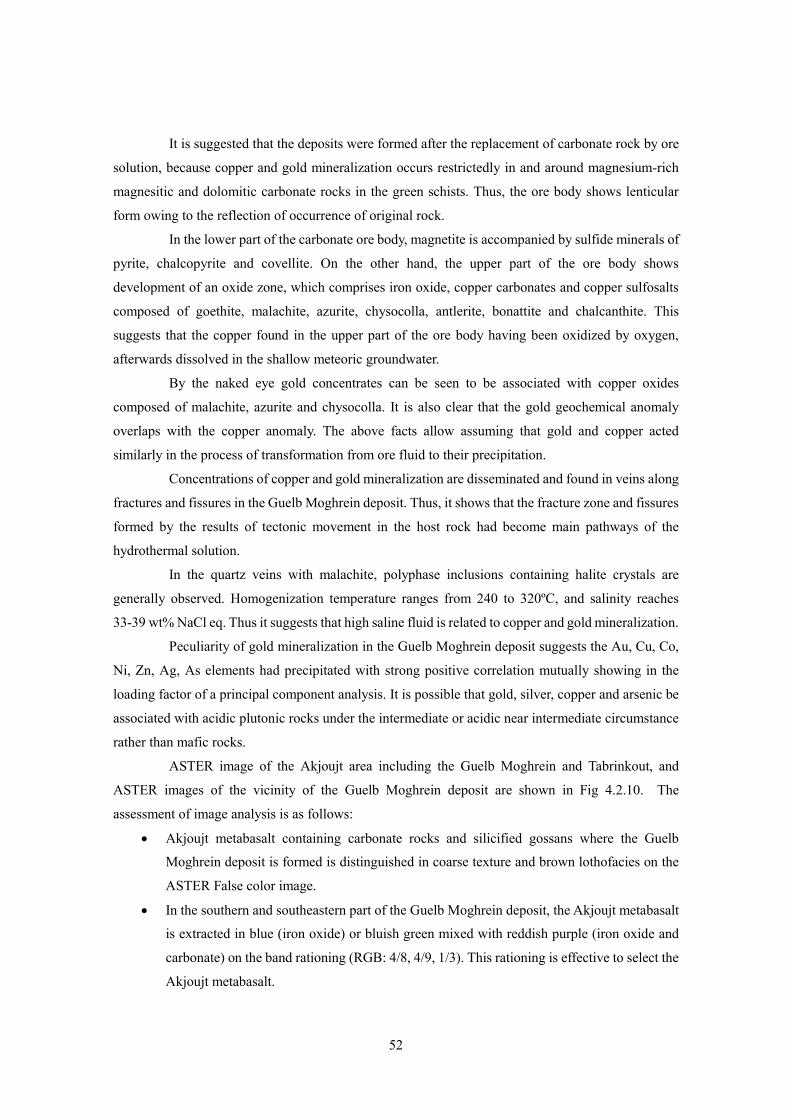
ASTER image of the Akjoujt area including the Guelb Moghrein and Tabrinkout, and
ASTER images of the vicinity of the Guelb Moghrein deposit are shown in Fig 4.2.10. The
assessment of image analysis is as follows:
• Akjoujt metabasalt containing carbonate rocks and silicified gossans where the Guelb
Moghrein deposit is formed is distinguished in coarse texture and brown lothofacies on the
ASTER False color image.
• In the southern and southeastern part of the Guelb Moghrein deposit, the Akjoujt metabasalt
is extracted in blue (iron oxide) or bluish green mixed with reddish purple (iron oxide and
carbonate) on the band rationing (RGB: 4/8, 4/9, 1/3). This rationing is effective to select the
Akjoujt metabasalt.
53
Fig. 4.2.10 Satellite images of the Akjoujt area and the Guelb Moghrein deposit
(6) Tabrinkout
The Tabrinkout prospect was selected as tungsten occurrence, but the study has resulted in
being regarded as a copper and gold prospect. Around this prospect, chlorite schist and small block of
carbonate rocks spread widely as at the Guelb Moghrein deposit. Gold-bearing malachite quartz vein
and malachite dissemination are found in chlorite schist.
In the Tabrinkout prospect, elements showing strong positive correlation with Au bear a
striking analogy to an assemblage of elements revealing a strong positive correlation with Au in the
Guelb Moghrein deposit. This indicates that the mineralization of both districts have been formed
under similar circumstances and mechanism. This is also revealed by fluid inclusion study in quartz
vein, so that fluid inclusions in quartz veins in both the Tabrinkout prospect and the Guelb Moghrein
deposit are composed of polyphase inclusions containing halite crystal and gaseous inclusions, and
that homogenization temperatures and salinities in both districts represent almost the same range. It is
suggested that mineralization of both districts have passed under the high temperature and high
salinity. Therefore, it is highly probable that mineral deposit such as the Guelb Moghrein gold-bearing
ASTER False Color Topographic Map
ASTER BandASTER False Color

54
copper deposit could lie under the carbonate rocks in the Tabrinkout prospect
(7) Kadiar
The Kadiar Cu-Au prospect contains chlorite-sericite schist, meta-basic volcanics and
serpentinite. In the lens-shaped or lumpy siliceous gossan sandwiched between these rock bodies,
disseminations of malachite have been found. Oxidation zone within 20m below the surface contains
1% Cu, and the mineralization containing 1% of Cu have been confirmed at more than 60m depth of
sulfide zone, and the drillings have caught assay of 0.5-1.3 g/t Au (OMRG, 1995). The maximum
assay of 3.6% of Cu and 4.4 g/t of Au is conformed in siliceous gossan accompanied with malachite.
(8) Indice 78
The Indice 78 prospect consists of gold-bearing quartz veins and malachite lens in chlorite
schist and chloritic andesite in the Mauritanides. Copper and gold mineralization in the region trends
NNW-SSE, this direction corresponding to the schistosity of chlorite schist.The quartz vein is
composed of secondary copper oxides of malachite, chalcopyrite, chalcocite and native gold. In
chlorite schist and chloritic andesite, copper mineralization composed of small malachite lies widely
in veinlet and dissemination. The maximum assay of 9.7% Cu and 19.3 g/t Au is confirmed in
malachite-chalcocite quartz vein in the southern part. Fluid inclusion in the quartz vein suggests that
the highly saline fluid is related to copper and gold mineralization.
(9) Oudelemguil
The Oudelemguil copper deposit consists of silver-bearing malachite veins in the picritic basalt of the
Mauritanides. Five veins are confirmed parallel to each other, which show N25-40 ゚ E strike and
30-55 ゚ dip to northwest. The veins are 0.4-0.8m thick, with the maximal extension of 300m. The
present survey conforms with the maximum assay of 34.4% for Cu, 0.59 g/t for Au and 196 g/t for Ag..
(10) Diaguili
Diaguili prospect forms a line of three about 10m high hills. The hills are directed NE-SW
with about 1km extension. The region consists of quartzite, conglomerate, muscovite schist and black
schist. Schists lie between the southern and central hills. The southern hill mainly consists of quartzite,
and the northern hill is composed of conglomerate, while the central hill comprises quartzite and
conglomerate. Quartz network and quartz veins mainly develop in quartzite, and rarely in schists and
schistose conglomerate. The quartz vein is, in average, 10 cm thick, with maximal thickness of 70cm.
The present survey has found specularite in the quartz vein, but has not confirmed copper
mineralization.
(11) Guidimaka
The Guidimaka deposits are podiform-type chromite ore bodies that are in the serpentinite in
the Mauritanides. There are five chromite deposits in the surveyed area. The present geological survey
has focused on the No.1, No.2 and No.3 deposits among them.
The No.1 deposit is located about 5 km east of the Diaguili village and is situated on the
55
northwestern part of the hill which trends N-S with about 40m asl. The north-trending hill consists of
siliceous pelitic schist, and serpentinite and chlorite schist occur in the northwestern part of the hill.
The pelitic schist includes layers of iron-oxide with siliceous part. Serpentinite exposes in an area of
about 200m width in east-west and about 500m extension in north-south (Fig. 4.3.11). Serpentinite
intercalates layers of chlorite schist with 10m to 20m thickness. Six chromite orebodies in the
serpentinite unit are exposed on the surface. They are 10m to 40m long and a few meters to 15m thick.
Chromite ores are massive, and consist of coarse-grained chromite. Blind chromite orebodies could be
buried under the surface. The orebodies are of podiform type.
Fig. 4.2.11 Geological and geochemical maps of the Guidimaka No.1 deposit
The No.2 deposit is located about 4 km north-northeast of the Diaguili village. The deposit
is 90m x 70m in scale. Since serpentinite lies about 350m southeast far from the chromite orebody, the
direct relation between chromite and serpentinite on the surface. The No.3 deposit crops out 4m x 5m
in a small scale locating 2km northeast of the No.1 deposit, and situating westward of serpentinite
body trending N-S.
Microscope observation shows massive chromite ore to be composed of chromite,
magnetite, chlorite and serpentinite. Chromite is transparent brown to yellowish brown, and 0.3mm to
5mm in size. Numerous fractures run in the chromite ore, and along the fractures it changes to opaque
and partly altered to magnetite.
The chromite grains are analyzed by X-ray Diffraction analyzer and EDX. It is confirmed
that most of grains is ferro-magnesiochromite (Fe,Mg)((Cr,Al)2O4), and little of grains is chromite.
Ferro-magnesiochromite is massive and runs numerous cracks. Based on the present survey, the grade
of the chromite ores in the Guidimaka is low, and varies from 22.6 to 33.7% Cr2O3. The low grade ores
56
in this deposit are caused by chemical composition of chromium minerals that are chiefly
magnesiochromite, and not chromite. The chromite ores in the Guidimaka deposit have revealed the
grade of 0.07 to 0.104 g/t Pt in this survey. The following five kinds of platinum group minerals
(PGM) are confirmed by semi-quantitative analysis of EDX and qualitative analysis of EPMA;
Osmium: Os, Irarsite: (Ir,Ru)AsS, Laurite: RuS2, Erlichmanite: OsS2, Cuproiridsite: CuIr2S4..
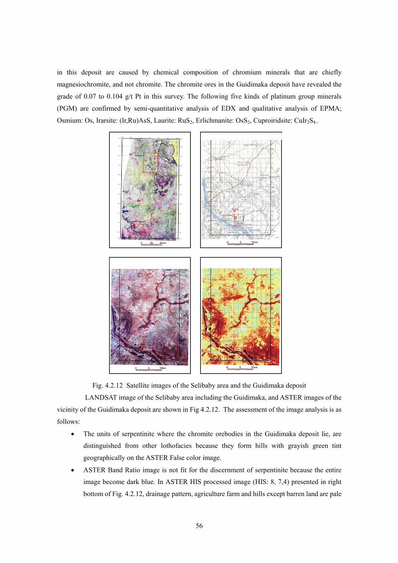
Fig. 4.2.12 Satellite images of the Selibaby area and the Guidimaka deposit
LANDSAT image of the Selibaby area including the Guidimaka, and ASTER images of the
vicinity of the Guidimaka deposit are shown in Fig 4.2.12. The assessment of the image analysis is as
follows:
• The units of serpentinite where the chromite orebodies in the Guidimaka deposit lie, are
distinguished from other lothofacies because they form hills with grayish green tint
geographically on the ASTER False color image.
• ASTER Band Ratio image is not fit for the discernment of serpentinite because the entire
image become dark blue. In ASTER HIS processed image (HIS: 8, 7,4) presented in right
bottom of Fig. 4.2.12, drainage pattern, agriculture farm and hills except barren land are pale
57
brown, and this rationing process is not suitable for the extraction of the serpentinite.
It is clarified that the ASTER False color image is better than the processing images such as
Band Ration and HIS, for the extraction of the serpentinite in the Guidimaka area.
(12) Jreida-Lemsid
Jreida-Lemsid is an area along the Atlantic Ocean from 15km north to 100km north of
Nouakchott. Coastal sand and dune sediment of Quaternary are widely spread in the area. This survey
has been conducted in the Tanit-Lemsid sector in the central part of the area.
In this survey, totally 8 pit holes, about 5m deep have been drilled in the coastal sand and
dune: 4 pits at Tanit forming a square at each apex with the interval of 500m, and 4 pit holes at Lemsid.
Based on the observation of pits, terrigenous reddish brown-colored sandy formation is dominant in
black heavy minerals compared with white oceanic sandy formation containing fragments of shells. In
the pit holes generally, concentrations of 2.8-5.1% TiO2, of ilmenite which is several cm thick exist
just beneath the surface, but there is no concentration layer as large as to measure in meters.
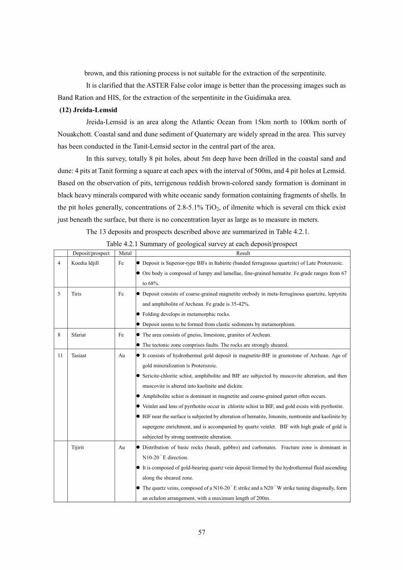
The 13 deposits and prospects described above are summarized in Table 4.2.1.
Table 4.2.1 Summary of geological survey at each deposit/prospect Deposit/prospect Metal Result
4 Koedia Idjill Fe Deposit is Superior-type BIFs in Itabirite (banded ferruginous quartzite) of Late Proterozoic.
Ore body is composed of lumpy and lamellae, fine-grained hematite. Fe grade ranges from 67
to 68%.
5 Tiris Fe Deposit consists of coarse-grained magnetite orebody in meta-ferruginous quartzite, leptynite
and amphibolite of Archean. Fe grade is 35-42%.
Folding develops in metamorphic rocks.
Deposit seems to be formed from clastic sediments by metamorphism.
8 Sfariat Fe The area consists of gneiss, limestone, granites of Archean.
The tectonic zone comprises faults. The rocks are strongly sheared.
11 Tasiast Au It consists of hydrothermal gold deposit in magnetite-BIF in greenstone of Archean. Age of
gold mineralization is Proterozoic.
Sericite-chlorite schist, amphibolite and BIF are subjected by muscovite alteration, and then
muscovite is altered into kaolinite and dickite.
Amphibolite schist is dominant in magnetite and coarse-grained garnet often occurs.
Veinlet and lens of pyrrhotite occur in chlorite schist in BIF, and gold exists with pyrrhotite.
BIF near the surface is subjected by alteration of hematite, limonite, nontronite and kaolinite by
supergene enrichment, and is accompanied by quartz veinlet. BIF with high grade of gold is
subjected by strong nontronite alteration.
Tijirit Au Distribution of basic rocks (basalt, gabbro) and carbonates. Fracture zone is dominant in
N10-20 ゚ E direction.
It is composed of gold-bearing quartz vein deposit formed by the hydrothermal fluid ascending
along the sheared zone.
The quartz veins, composed of a N10-20 ゚ E strike and a N20 ゚ W strike tuning diagonally, form
an echelon arrangement, with a maximum length of 200m.
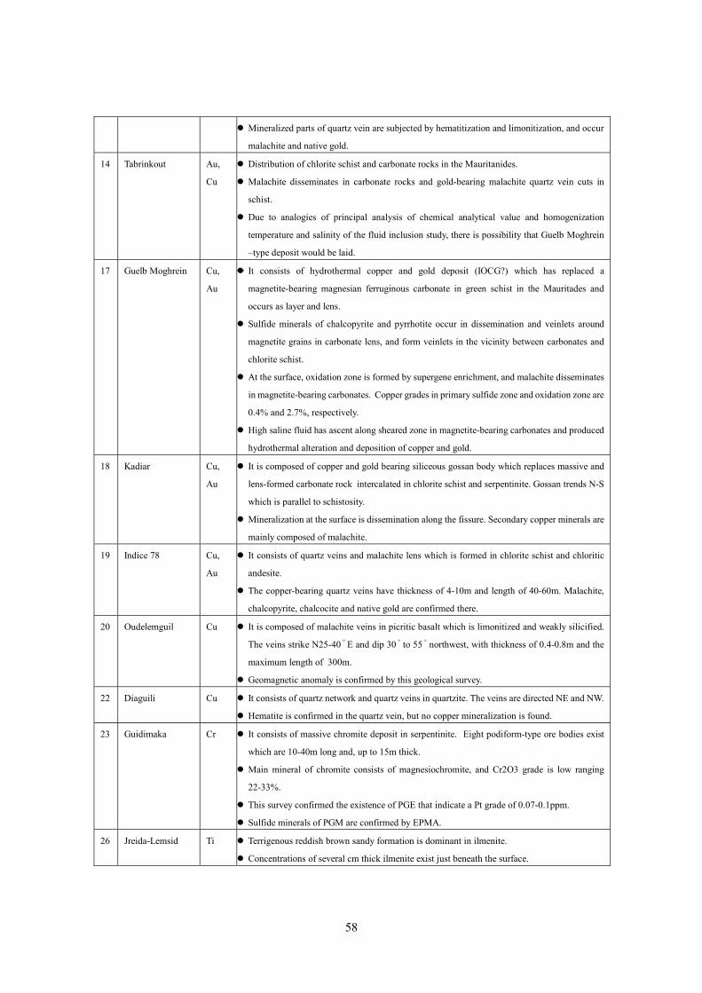
58
Mineralized parts of quartz vein are subjected by hematitization and limonitization, and occur
malachite and native gold.
14 Tabrinkout Au,
Cu
Distribution of chlorite schist and carbonate rocks in the Mauritanides.
Malachite disseminates in carbonate rocks and gold-bearing malachite quartz vein cuts in
schist.
Due to analogies of principal analysis of chemical analytical value and homogenization
temperature and salinity of the fluid inclusion study, there is possibility that Guelb Moghrein
–type deposit would be laid.
17 Guelb Moghrein Cu,
Au
It consists of hydrothermal copper and gold deposit (IOCG?) which has replaced a
magnetite-bearing magnesian ferruginous carbonate in green schist in the Mauritades and
occurs as layer and lens.
Sulfide minerals of chalcopyrite and pyrrhotite occur in dissemination and veinlets around
magnetite grains in carbonate lens, and form veinlets in the vicinity between carbonates and
chlorite schist.
At the surface, oxidation zone is formed by supergene enrichment, and malachite disseminates
in magnetite-bearing carbonates. Copper grades in primary sulfide zone and oxidation zone are
0.4% and 2.7%, respectively.
High saline fluid has ascent along sheared zone in magnetite-bearing carbonates and produced
hydrothermal alteration and deposition of copper and gold.
18 Kadiar Cu,
Au
It is composed of copper and gold bearing siliceous gossan body which replaces massive and
lens-formed carbonate rock intercalated in chlorite schist and serpentinite. Gossan trends N-S
which is parallel to schistosity.
Mineralization at the surface is dissemination along the fissure. Secondary copper minerals are
mainly composed of malachite.
19 Indice 78 Cu,
Au
It consists of quartz veins and malachite lens which is formed in chlorite schist and chloritic
andesite.
The copper-bearing quartz veins have thickness of 4-10m and length of 40-60m. Malachite,
chalcopyrite, chalcocite and native gold are confirmed there.
20 Oudelemguil Cu It is composed of malachite veins in picritic basalt which is limonitized and weakly silicified.
The veins strike N25-40 ゚ E and dip 30 ゚ to 55 ゚ northwest, with thickness of 0.4-0.8m and the
maximum length of 300m.
Geomagnetic anomaly is confirmed by this geological survey.
22 Diaguili Cu It consists of quartz network and quartz veins in quartzite. The veins are directed NE and NW.
Hematite is confirmed in the quartz vein, but no copper mineralization is found.
23 Guidimaka Cr It consists of massive chromite deposit in serpentinite. Eight podiform-type ore bodies exist
which are 10-40m long and, up to 15m thick.
Main mineral of chromite consists of magnesiochromite, and Cr2O3 grade is low ranging
22-33%.
This survey confirmed the existence of PGE that indicate a Pt grade of 0.07-0.1ppm.
Sulfide minerals of PGM are confirmed by EPMA.
26 Jreida-Lemsid Ti Terrigenous reddish brown sandy formation is dominant in ilmenite.
Concentrations of several cm thick ilmenite exist just beneath the surface.

59
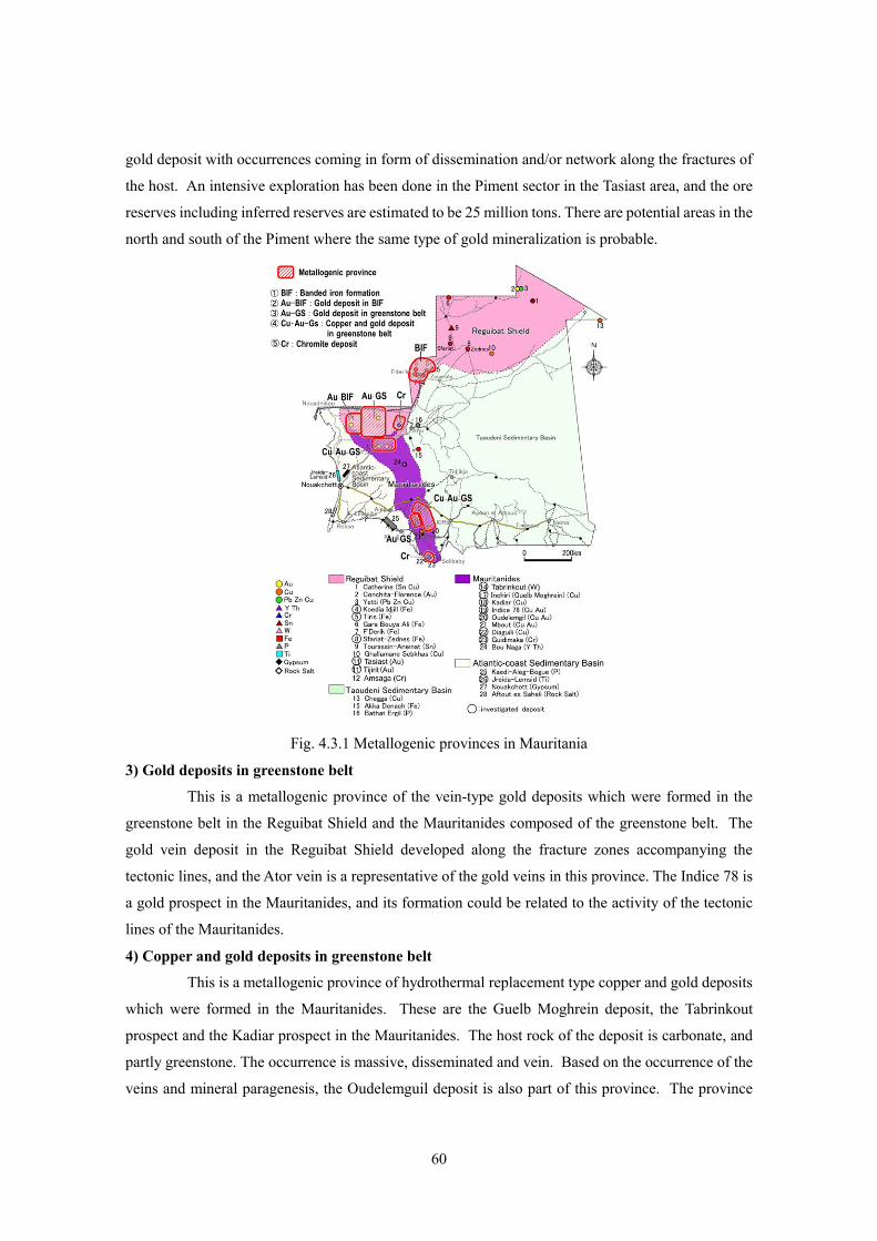
4.3. Metallogenic Provinces
Taking into consideration the results of the supplementary geological survey in 13 deposits,
metallogenic provinces are examined putting emphasis on gold and copper deposits. The following
five metallogenic provinces have been selected (Table 4.3.1 and Fig. 4.3.1) based on the survey:
1) Banded iron formation, 2) gold deposit in BIF, 3) gold deposit in greenstone belt, 4) copper and gold
deposit in greenstone belt, and 5) chromite deposit.
Table 4.3.1 Metallogenic province
Metallogenic province Geologic province Deposit type Deposit Metal Mineralization age
BIF origin clastics deposit
Tiris El Rhein, El Aouj
Fe Archean 1) Banded iron formation (BIF)
Reguibat Shield
Superior-type BIF Koedia-Idjill T014, M’Haoudat
Fe Proterozoic
2) Gold deposit in BIF (greenstone)
Reguibat Shield
Mesothermal disseminated and network deposit
Tasiast AU Proterozoic
Reguibat Shield Hypothermal vein
Tijirit Ator
Au Proterozoic 3) Gold deposit in greenstone belt
Mauritanides Mesothermal vein Indice 78 Au ? 4) Copper and gold deposit in
greenstone belt
Mauritanides
Carbonate replacement copper and gold deposit
(IOCG?)
Guelb Moghrein Tabrinkout (Kadiar, Oudelemguil)
Cu, Au
Late Proterozoic
Mauritanides Orthomagmatic chromite deposit
Guidimaka Cr, PGE
Late Paleozoic 5) Chromite deposit
Reguibat Shield Orthomagmatic chromite deposit
Amsaga Cr ?
1) Banded Iron Formation (BIF) province
This is a metallogenic province of iron formations which were formed in the Reguibat
Shield, and consists of the Tiris iron formation group and the Koedia-Idjill iron formation group. The
deposits of the Tiris iron formation are considered to probably be a metamorphic deposit of clastic
sediments originated from Algoma-type BIF of the Archean. The deposits of the Koedia-Idjill iron
formation group are Superior-type BIF which formed in the Proterozoic era after the deposition of the
Tiris iron formation in the Archean era. Geographically the former formed near the Koedia-Idjill iron
formation group. Thus, both of the iron formation groups of the Tiris and Koedia-Idjill can be included
in the same metallogenic province. Iron ore reserves are estimated to be over 1 billion tons in this
province.
2) Gold deposits in BIF
This is a metallogenic province of the gold deposits which were formed in the BIFs in the
greenstone belt of the Reguibat Shield, and the Tasiast is representative of the gold deposit. Though
the age (the Archean) of formation of magnetite layers as host is different from the age (the
Proterozoic) of gold mineralization, the deposit consists of hydrothermal (epithermal to mesothermal)
60
gold deposit with occurrences coming in form of dissemination and/or network along the fractures of
the host. An intensive exploration has been done in the Piment sector in the Tasiast area, and the ore
reserves including inferred reserves are estimated to be 25 million tons. There are potential areas in the
north and south of the Piment where the same type of gold mineralization is probable.
Fig. 4.3.1 Metallogenic provinces in Mauritania
3) Gold deposits in greenstone belt
This is a metallogenic province of the vein-type gold deposits which were formed in the
greenstone belt in the Reguibat Shield and the Mauritanides composed of the greenstone belt. The
gold vein deposit in the Reguibat Shield developed along the fracture zones accompanying the
tectonic lines, and the Ator vein is a representative of the gold veins in this province. The Indice 78 is
a gold prospect in the Mauritanides, and its formation could be related to the activity of the tectonic
lines of the Mauritanides.
4) Copper and gold deposits in greenstone belt
This is a metallogenic province of hydrothermal replacement type copper and gold deposits
which were formed in the Mauritanides. These are the Guelb Moghrein deposit, the Tabrinkout
prospect and the Kadiar prospect in the Mauritanides. The host rock of the deposit is carbonate, and
partly greenstone. The occurrence is massive, disseminated and vein. Based on the occurrence of the
veins and mineral paragenesis, the Oudelemguil deposit is also part of this province. The province

61
includes a significant copper resource in Mauritania.
Formation age of the deposits is assumed to be Late Paleozoic. Mineralization is summed to
take place at the same stage of formation of the greenstone belts. Concreteness of possibility that the
deposit is belong to IOCG, is an important subject to clarify the metallogenic province.
5) Chromite deposits
This is a metallogenic province of podiform-type chromite deposits which were formed
accompanying ultramafic rocks in the Mauritanides. This survey has clarified that the Guidimaka
chromite deposit is accompanied by platinum group minerals (PGM). There are the same
podiform-type chromite deposits in the Amsaga area in the western part of the Reguibat Shield.
Although the Amsaga chromite deposit belongs to a different geological province that is the Reguibat
Shield, it is also a part of this metallogenic province. To clarify the relationship between difference of
geological province and this metallogenic province is a subject in future.
4.4. Mineral Deposit Models
4.4.1. Tiris iron formation group
Iron ores of coarse-grained magnetite are mined at these deposits. The magnetite ores occur
as lenticular and disseminated in quartzite, leptynite and amphibolite of the Tiris group of the
Precambrian (before 1.7 Ga at least). The thickness of the ore body is about 100m with the extension
of about 1km. Each deposit includes the horizon comprising the iron ores on a large scale.
Almost all the iron deposits lying in the Precambrian group (especially, before 1.9 Ga) are
banded iron formations, but the above-mentioned deposition of Tiris iron formation is a peculiar case.
However, there could be possibility that “1) iron contents
concentrated as banded iron formation even in this type iron deposit,
and 2) after that, iron contents dispersed in other rocks through some
other process.”
As one of the considerable processes of dispersion, iron
contents of the banded iron formation diffused and injected into
other rocks due to the high temperature of metamorphism of
amphibolite facies which impacted the Tiris iron formation.
However, the boundaries among quartzite, leptynite and amphibolite
are sharply drawn as lithological boundaries. It is difficult to
suppose an intensive diffusion of chemical components caused by
high temperature, and chemical mixture and fusion between many
kinds of rocks took place in the past geological time.
Mechanical diffusion is considered to be another diffusion
process. After weathering and crushing of the banded iron formation,
the clastics originating from granitic rocks mechanically mixed with Fig. 4.4.1 Mineral deposit
model of the Tiris iron

62
clastics originating from mafic igneous rocks, and iron oxides diffused. There is a possibility that after
the regional metamorphism, the quartz-rich clastics turned into magnetite-bearing quartzite, the
quartz-feldspar dominant clastics turned into magnetite-bearing leptynite, and the mafic clastics
turned into magnetite-bearing amphibolite. There are multiple possibilities of rocks being the source
of supply for mafic clastics. For convenience, in Fig. 4.4.1, the banded iron formation is drawn as the
Algoma-type BIF with mafic igneous rocks.
4.4.2. Koedia-Idjill iron formation group
This iron formation group is the typical banded iron formation lying in the Idjill group of the
Precambrian group. The Idjill group as host rock consists of seven nappes. Among the seven nappes,
three units are small in scale and expose out in narrow section, and their geological features is
ambiguous. On the other hand, the formations composed of the remaining four units show different
lothofacies. That is, the la broche unit consists of conglomerate, the l’Achouil unit consists of pelitic
schist, the Tazadit unit consists of the banded iron formation, and the M’Haoudat unit comprises
banded iron formation, basaltic schist, partly hematite dissemination, and meta-basalt. These units
show different lothofacies. The following is a description of each unit and the geological interpretation
of each case.
(1) La broche unit
The la broche unit consists of conglomerate, and in a certain part of the unit, orthoquartzite
is recognized in the shape of pebbles and gravels cemented with iron oxides and silica materials.
Based on their lithofacies, it is understandable that the deposition of iron and silica diffused into the
sea water and deposited to the sea floor as the same phenomenon as the formation of the banded iron
formation at the shallow sea near the continent composed of orthoquartzite. Based on the theory, the
above-mentioned mechanism of conglomerate formation is considered as follows:
1) The rift valley was born, and the continent started to divide.
2) After the start of division of the continent, the rift valley was narrow, and pebbles and
gravels of orthoquartzite supplied from the divided continent deposited near the shallow
sea near the rift valley.
3) Pebbles and gravels are cemented with iron and silica materials which emitted from the
rift valley.
(2) l’Achouil unit
The l’Achouil unit consists of pelitic schist, and its sedimentation is considered to have
advanced under the oceanic circumstances; that is, the activity of the rift valley continued, the seafloor
spread wider, and the sea area holding oceanic environment took place.
(3) Tazadit unit
The Tazadit unit consists of banded iron formation and lacks clastic rocks. This means that

63
the seafloor continued to spread, and it was under more intense oceanic environment than the
l’Achouil unit, that is the sea area having the environment where clastics from the continent seldom
reached, was born. In such an environment, iron and silica materials restarted to emit, and the banded
iron formation was formed after the deposition of the emitted materials to the seafloor.
Fig. 4.4.2 Mineral deposit model of the Koedia-Idjill BIFs
(4) M’Haoudat unit
The M’Haoudat unit is dominant in basaltic schist and meta-basalt, and dissemination of
hematite is conformed in the basaltic schist. Thus, it is considered that another basaltic volcanic
activity different from the ridge took place at the time of the forming of banded iron, and basalt was
spewed out, and then basaltic pyroclastics were spouted.
(5) Thrust of the Idjill group
Concerning the above-mentioned process, after the seafloor was spread by the rift valley
and ridge, varied sedimentation advanced, and the Idjill group was formed. It is conceivable that the
Idjill group thrust over the continental crust composed of the Tiris group about 2.0Ga? At this time, the
Idjill group was divided onto seven nappes. Then, these thrust sheets were subjected to metamorphism
of the green schist facies.
4.4.3. Tasiast gold deposit
(1) Hydrothermal stage

64
This deposit consists of hydrothermal gold-bearing quartz veins cutting Algoma type BIFs,
and of gold disseminations in the BIFs. The influence of hydrothermal process in this deposit is
confirmed in gold mineralization, small amount of pyrrhotite dissemination, tungsten mineralization,
and intensive white argillized zone. Gold mineralization, tungsten mineralization, and intensive white
argillized zone are supposed to have formed under various temperatures on the basis of the
homogenization temperatures of fluid inclusions and the estimated temperatures based on
assemblages of clay minerals. It is needed that formation temperature will be calculated from the
homogenization temperature on the basis of pressure compensation. According to depositional
circumstance, the pressure is assumed to be 1.5 kb and the formation temperature is presumed the
homogenization temperature plus about 100℃.
Fig. 4.4.3 Mineral deposit model of the Tasiast gold deposit
Tungsten mineralization yielded at the highest temperature of about 380ºC. The salinity of
ore-forming fluid is assumed to have been about 37wt% NaCl eq. White clay argillization occurred at
a medium temperature of about 200ºC. Based on the kinds of clay minerals, the ore-forming fluid is
assumed to have been neutral to weakly acidic, while intensive dissolution of iron from BIFs suggests
it also acted as the reducing factor. Gold was produced at a temperature of about 250 ºC. The salinity
of the ore-forming fluid is assumed to have been about 26wt% NaCl eq.
If the above three mineralization and alteration has taken place as a chain of hydrothermal
activity, the higher temperature must have produced the first and the lower must have produced the
latter mineral, that is, it is highly probable that they occurred in the following order 1) tungsten
mineralization, 2) white argillization, and 3) gold mineralization (Fig. 4.4.3).
(2) Pathway of the ore-forming fluid
In a part of the gold mineralized area over 1 g/t for Au, the detritus from trenches were
strongly crushed. The small detritus shows crushing of the strata by the fractures, and it suggests that
the ore-forming fluid ascended through the sheared zone and loose parts in the vicinity of the sheared
zone. Dominant orientation of the sheared zone is roughly presumed to be N-S direction, taking
account of the trend of gold mineralized area showing 0.1-1 g/t for Au - the low gold mineralized area.

65
(3) Mineralization age
If the gold mineralization took place simultaneously with the white argillization (1.5Ga), the
age would be 0.2-0.3 billion ages younger than K-Ar closed ages (1.8-1.7Ga) of amphibolite from
amphibolite schist as host in the Tasiast deposit, and muscovite from of biotite-muscovite. Since it is
presumed that closed ages of minerals in crystalline schists show the terminal age of metamorphism,
the gold mineralization took place 0.2 to 0.3 billion years later than the terminal age of the
metamorphism.
Izawa (1993) estimates that one of the peak times of the gold mineralization is 1.5Ga, and
total amount of gold produced at that time reaches 600 tons. It is highly probable that certain
geological conditions to yield global gold mineralization also in the Tasiast area were in place at that
time.
4.4.4 Copper and gold deposits in the Mauritanides
The deposit is assumed to be skarn type iron-oxide copper and gold deposit (IOCG) which
replaced the carbonate rocks interacted in greenstone. Near the deposit, the greenstone chiefly consists
of (biotite-) chlorite schist of the green schist facies, and is associated with meta-gabbro which
contains amphibole and amphibolite. A small block of black politic-muscovite schist is confirmed in
the green schist. The Algoma type BIFs are confirmed to lie as thin layers in the green schist in the
vicinity of the deposit. It is suggested that the entire greenstone is of the Archean group.
Iron magnesium skarn was produced in the carbonate rocks and the greenstone before the
mineralization in this deposit. It is assumed that the magma originated in the above-mentioned
anatexis came up just under the deposit, and heating the carbonate rocks formed skarnization. After
that, iron oxide mainly composed of magnetite with a little amount of pyrite and pyrrhotite crystallized,
and copper sulfide of chalcopyrite etc., crystallized, and gold mineralization occurred at the same time,
carbonate rock and parts of skarn being replaced.
Fig. 4.4.4 Mineral deposit model in the Guelb Moghrein copper and gold deposit
66
4.5. Selection of promising areas
4.5.1. Promising area
Based on the investigation of deposits and prospects in this survey, the Tasiast area (Au),
Tijirit area (Au) and Amsaga area (Cr) were chosen as promising in the Reguibat Shield, and the
Akjoujt area (Cu, Au: the Guelb Moghrein deposit and the Tabrinkout prospect) and Guidimaka area
(Cr, Pt) in the Mauritanides.
Table 4.5.1 Promising areas Geologic province Mineralization Promising area Exploration target
Mesothermal gold disseminated and
network
・ Tasiast ・ Magnetite bearing BIF
・ Hydrothermal alteration with
nontronite
Hypothermal quartz gold vein
・ Tijirit ・ Quartz vein in basic rock
・ Tectonic
Reguibat shield
Podiform chromite ・ Amsaga ・ Serpentinite Carbonate replacement copper and
gold
・ Akjoujt ・ Carbonates in basic schist Mauritanides
Podiform chromite ・ Selibaby ・ Serpentinite in greenstone belt
4.5.2. Promising deposit and mineralization
(1) Tasiast area
The Piment deposit in the Tasiast area is a hydrothermal gold deposit in magnetite-bearing
BIF of the greenstone belt in the Reguibat Shield. The occurrence includes quartz veinlets, quartz
networks and dissemination. Chlorite schist and amphibolite schist are dominant in magnetite,
porphyroblast of garnet also occurs. Veinlets and lens layer of pyrrhotite lie in magnetite-bearing
chlorite schist. Native gold coexists with pyrrhotite. At the surface, BIF is exposed to hematitization,
limonitization, nontrinitization and kaolinitization by supergene process associated with quartz veins.
The Piment sector has been intensively explored, and it was identified that main orebody extends
about 1km along a N-S direction which is a strike of BIF with average width of 25m, and that the shoot
composed of high grade ores over Au 50g.m, plunges in a southerly direction. The reserves are
estimated at about 25 million tons, grade of 2.6 g/t, with a total gold content of 2.084 million oz (65t).
The altered BIF subjected silicification, white argillization and nontronitization are
distributed about 5km north and about 10km south-southeast of the Piment sector. Therefore, it is
probable that gold mineralization similar to the Tasiast Piment deposit exists beneath these sectors,
and it is presumably in form of two or three deposits.
(2) Tijirit area
The Ator vein at the Tijirit area consists of gold-bearing quartz veins formed in the
Proterozoic greenstone belt of the Reguibat Shield. NNE-SSW tectonic lines develop in this area, and
gold-bearing quartz veins were formed along the fractures parallel to these tectonic lines.
Characteristics of the gold vein at the Ator vein and vicinity of veins are the co-existence of copper
mineralization composed of malachite, and a local existence of the high-grade gold ores over 10 g/t
67
Au.
Exploration under the quartz veins in the Ator sector has not been conducted so far and the
downward continuance of mineralization is still unconfirmed. No sufficient survey around the area has
been conducted. Since there is a possibility that gold-bearing veins exist there, it is necessary to do the
detailed geological survey in the area
Geochemical anomalies over 100 ppb Au are spread in the large region of 6km east to west
and 8k north to south about 30km southwest of the Ator sector (OMRG, 1996a). NNE-SSW directed
dykes and faults are revealed in this sector. The lithological facies are similar to those in the Ator
sector. Based on a similar geological environment, existence of gold-bearing veins is also expected
there.
The Tijirit West sector located about 110km southwest of the Ator sector, in the southeastern
extension of the Tasiast area consists of the greenstone which spreading in NE-SW direction. Since
geochemical gold anomalies are extracted in the area of 30km x 5km in this sector (Fig. 4.3.2), it is
possible that hydrothermal quartz vein type and quartz network gold deposits similar to those of the
Tasiast deposit also exist there. One of the promising areas is located here.
(3) Akjoujt area
The Guelb Moghrein deposit and the Tabrinkout prospect are hydrothermal copper and gold
deposits formed in the Mauritanides. The deposits have replaced magnetite-bearing carbonate layer in
the green schist. Coarse grains of magnetite occur in the green schist in the intercalated carbonate layer.
Sulfide minerals of chalcopyrite and pyrrhotite occur as dissemination and veins around the grains of
magnetite. At the surface, gold-bearing malachite quartz veins cut the green schist, and malachite
disseminates in the carbonate rocks. At present, proven reserves are 23.6 million tons, and average ore
grade is 1.88% for Cu, 1.41 g/t for Au, and 143 ppm for Co
Copper and gold prospects exist in the 40km area between the Guelb Moghrein deposit and
the Tabrinkout prospect. Apart from the drill and trench works implemented at limited part of these
prospects, a sufficient exploration has not been carried out here. In the nearest future, it is probable to
discover good copper and gold mineralization replacing carbonate rocks. Therefore this area was also
selected as promising.
(4) Selibaby area
The Guidimaka deposit in the Selibaby area is a podiform type chromite deposit in the
serpentinite in the Mauritanides. The deposit is 10-40m long and several meters to 15m thick. Eight
orebodies are confirmed by this survey. Because major chromium mineral is ferro-magnesiochromite,
the grade of chromium is low and ranges between 22-33% Cr2O3. It is lower than the grade of
commodity ore which is 35-55% Cr2O3. But this survey has confirmed platinum group mineralization
showing 0.07-0.1 g/t Pt in the chromite ores. Also it has confirmed a metal grain as osmium and
sulfide minerals
68
In this area five chromite deposits were found (BRGM, 1975). No.1, No2 and No3 deposits
have been investigated in this survey. Since platinum group minerals were confirmed, there is a
possibility that PGM exist in other chromite orebodies in this area.
(5) The Amsaga area
The chromite prospect is located in the Amsaga area in the Reguibat Shield, with a
serpentinite in anorthosite complex. The mineralized zone is formed in an area of 4,00m x 300m in
chromite prospect in Guelb El Foulet, and an area of about 10km x 500m in El Heinrich. Chromium
grade ranges within 30-36 % Cr2O3 (BRGM, 1975). From the point of view of the grade it is classified
as the refractory grade.
Distribution of chromite ores in the Amsaga is wider than their distribution (4km x 3km) in
the Guidimaka deposit in the Selibaby. There is no PGE data in the Amsaga area. Since geological
background is similar to the Guidimaka deposit, this is the area where existence of PGE is expected.
4.6. Guideline of the survey and exploration methods
Based on the results of this geological survey, guidelines of the survey and exploration
methods for the promising deposit are described as follow:
(1) Tasiast area
1) Guideline
BIFs related to gold mineralization chlorite schist and amphibolite schist are dominant in
magnetite.
Observation of altered minerals is very important at the surface. Especially the existence of
nontronite due to supergene process, which is the indicator of gold mineralization.
Nontronite occurs vein-like and disseminated in the hematitized and limonitized BIFs.
Porpyroblast of garnet showing high metamorphic grade occurs near pyrrhotite coexisting
with gold in drill cores. The existence of garnet at the surface suggests gold mineralization
form around the rocks containing garnet.
2) Exploration methods
Aeromagnetic survey is an effective means of prospecting to extract magnetite-bearing BIF
which is the host rock of the deposits in the greenstone belt.
Localization of the gold orebody existence area which is, like Tasiast, a mesothermal deposit,
discrimination of hydrothermal altered minerals, and alteration zoning are important
prospecting methods.
(2) Tijirit area
1) Guidelines
The gold-bearing quartz veins formed along the NNE-SSW fractures in the greenstone belt.
Quartz veins composed of a NNE strike and a NNW strike running diagonally form an
69
echelon arrangement.
Whenever gold mineralization is found in quartz vein, it is accompanied by copper
mineralization represented by malachite.
2) Exploration method
Geological reconnaissance conducted near the junctions of lineaments of ENE-WSW
direction and NE-SE direction on the satellite images regionally.
Because the existence of secondary copper ore as malachite suggests gold mineralization,
observation at outcrops of quartz veins is important.
(3) Akjoujt area
1) Guidelines
Silicified gossan is intensive at the surface, endures weathering, and forms small hills.
Sulfide minerals of chalcopyrite occur in dissemination and vein –like form near magnetite
grains in carbonate rocks, also boundaries between chlorite schist and carbonate layer.
2) Exploration method
Aeromagnetic survey is an effective prospecting method to extract magnetite-bearing
carbonate rocks which is the host rock of the deposit in chlorite schist.
If copper and gold come up to the surface, there is a certain possibility that the mineralization
reaches the depth along the quartz veins and the fracture. It is necessary to carry out drilling
in the greenstone of the footwall.
(4) Selibaby area
1) Guideline
The deposit is podiform type chromite deposit lying in a small scale in serpentinite with a
low grade of 22-33% Cr2O3.
It is confirmed that PGM exists as fine metal grain and sulfide minerals in
ferro-magnesiochromite or chlorite. In condition of PGE existence, the market values of
chromite ores will be higher. There is a possibility that PGE is concentrated in certain parts of
chromite ores.
2) Exploration method
Aeromagnetic survey is an effective method to extract chromite orebodies from serpentinite.
Drilling survey is needed to explore the depth of chromite orebody, and to grasp existence of
PGE.
(5) Amsaga area
1) Guideline
Chromite deposit must exist in the serpentinite unit similar to the Guidimaka deposit in the
Selibaby area. It must be of a podiform type chromite deposit.
2) Exploration method
70
Aeromagnetic survey is an effective prospecting method to extract chromite orebody from
serpentinite.
Schistosity of the serpentinite is used to trace chromite orebodies.