chapter 4: stansgate to … other factors affecting access: ... clarity and cohesion margin bcm- ......
TRANSCRIPT

England Coast Path | Burnham-on-Crouch to Maldon | Natural England’s Proposals
www.gov.uk/natural-england
Chapter 4:
Stansgate to Steeple Hall FarmEngland Coast Path: Burnham-on-Crouch to Maldon - Natural England’s Proposals
Part 4.1: Introduction
Start Point: Stansgate (grid reference: TL 934 058)
End Point: Steeple Hall Farm (grid reference: TL 922 029)
Relevant Maps: 4a to 4c
Understanding the proposals and accompanying maps:
The Trail:
4.1.1 Generally follows existing walked routes, including public rights of way, along most of this length.
4.1.2 Mainly follows the coastline quite closely and maintains good views of the sea.
4.1.3 Includes 5 sections of new path, in 1 location south of Stansgate. See map 4a and associated tables below for details.
4.1.4 This part of the coast includes the following sites, designated for nature conservation or heritage preservation (See map C and C2 of the Overview):
n Essex Estuaries Special Area of Conservation (SAC) n Blackwater Estuary (Mid-Essex Coast Phase 4) Special Protection Area (SPA) n Blackwater Estuary (Mid-Essex Coast Phase 4) Ramsar site n Blackwater Estuary Site of Special Scientific Interest (SSSI) for its wildlife and habitat interests n Blackwater, Crouch, Roach and Colne Estuaries Marine Conservation Zone (MCZ).
We have assessed the potential impacts of access along the proposed route (and over the associated spreading room described below) on the features for which the affected land is designated and on any which are protected in their own right.
4.1.5 With input from specialists we have considered each of the sites involved and the relevant designations and concluded that for this section of the coast our proposals will not have a detrimental effect.
In relation to those nature conservation sites listed above, refer to our published Access and Sensitive Features Appraisal for more information.
See part 6b of the Overview - ‘Protection of sensitive features’ for a description of our overall approach and a summary of our conclusions.

England Coast Path | Burnham-on-Crouch to Maldon | Natural England’s Proposals
Accessibility:
4.1.6 Generally, there are few artificial barriers to accessibility on the proposed route, which makes use of existing surface paths wherever these meet the criteria in the Coastal Access Scheme.
However, there are places where it may not be entirely suitable for people with reduced mobility because:
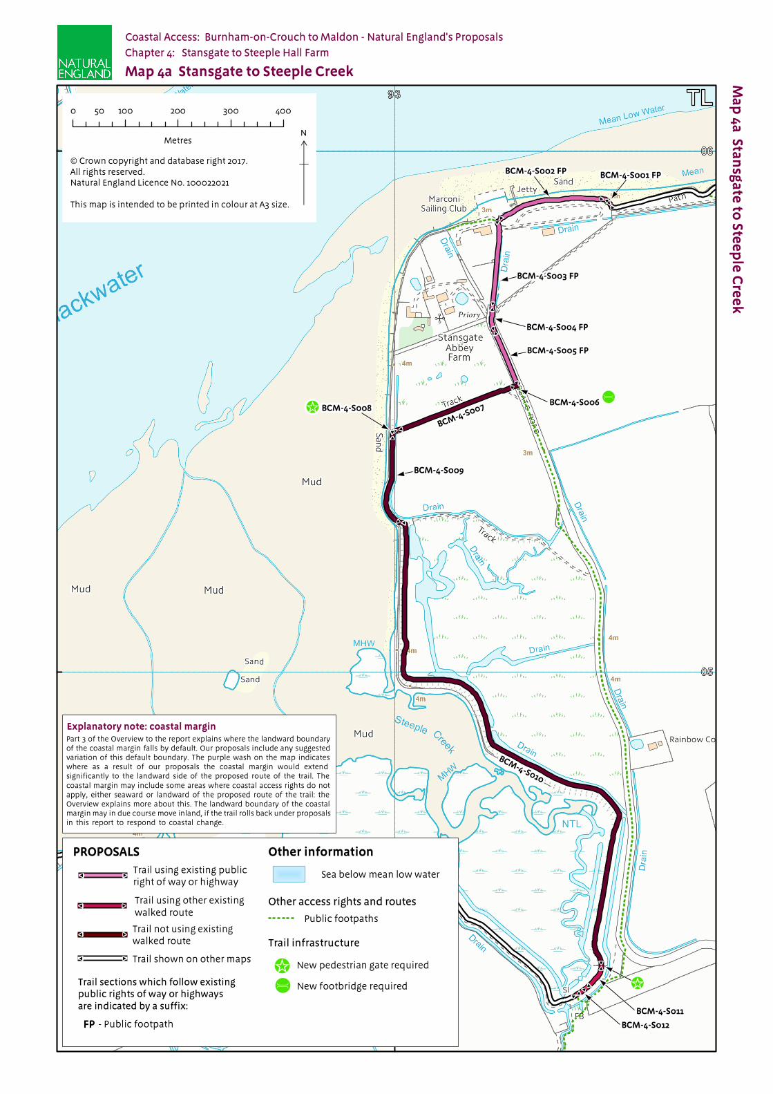
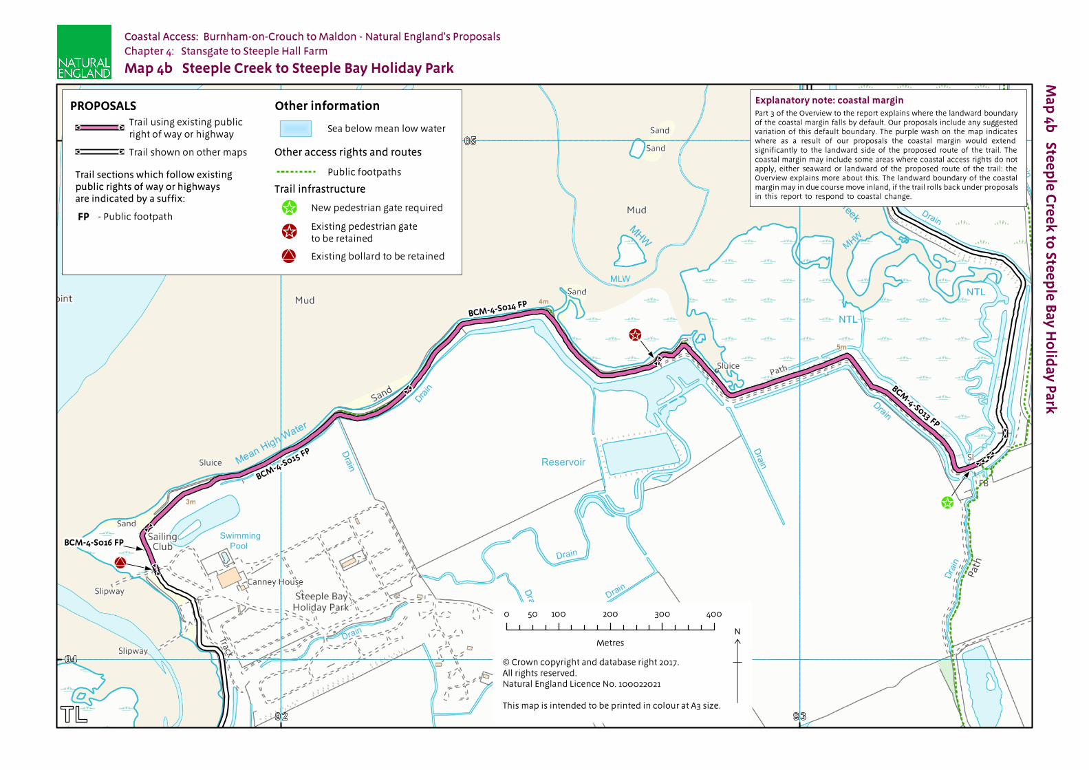
n At Marconi Sailing Club, Stansgate at the intersection of BCM-4-S002 and BCM-4-S003 it is necessary to descend/ascend the grassy flood bank; n South of Stansgate at the start of BCM-4-S010 and then further along this section it is necessary to descend/ascend more shallow sloping access ramps to descend/ascend the grassy flood bank; n There are a number of pedestrian gates necessary for livestock management (at junction of BCM-4-S008 with BCM-4-S009; junction of BCM-4-S010 with BCM-4-S011; junction of BCM- 4-S013 with BCM-4-S014 and on southern extent of BCM-4-S020).
See part 6a of the Overview - ‘Recreational issues’ - for more information.
Where we have proposed exercising our discretion:
The discretions referred to below are explained in more detail in the Overview.
4.1.7 Estuary: This report proposes that the trail should contain sections aligned on the estuary of the Rivers Crouch and Blackwater, extending upstream from the open coast. See part 5 of the Overview. The trail covered by this chapter includes part of this estuary route on the River Blackwater.
4.1.8 Landward boundary of the coastal margin: We have used our discretion on some sections of the route to map the landward extent of the coastal margin to an adjacent physical boundary such as a fence line to make the extent of the new access rights clearer. See Table 4.2.1 below.
4.1.9 At sections BCM-4-S002, BCM-4-S008, BCM-4-S009 to BCM-4-S015 and BCM-4-S018 to BCM-4-S020 we have used this discretion to limit the landward extent of the coastal margin to the landward top edge of the seawall. This has had the effect of reducing the amount of coastal margin that would have otherwise been available by default. This option provides the most clarity because:
n The break in slope provides an easily identifiable boundary for access users. n There is no clear boundary feature at the bottom of the seawall that could mark the boundary of the coastal margin.
See also part 3 of the Overview - ‘Understanding the proposals and accompanying maps’, for an explanation of the default extent of the coastal margin and how we may use our discretion to adjust the margin, either to add land or to provide clarity. See also Annex C of the Overview - ‘Excepted land categories’.
4.1.10 Restrictions and/or exclusions: We have proposed to exclude access by direction under the Countryside and Rights of Way Act (2000) in places along this section of coast. For details of these directions, see 4.3.6 in the Formal Proposals Section of this chapter and Part 10 of the Overview.
4.1.11 Access rights to the spreading room would be subject to the national restrictions on coastal access rights listed in Annex D of the Overview. These restrictions would not apply to public rights of way.
See part 10 of the Overview - ‘Restrictions and exclusions’ - for details.

England Coast Path | Burnham-on-Crouch to Maldon | Natural England’s Proposals
4.1.12 Other factors affecting access: At route sections BCM-4-S003 [Marconi Sailing Club, Stansgate] and BCM-4-S017 [Steeple Bay Holiday Park] public access may be interrupted from time to time for short periods to allow vehicles to pass and/or boats to be launched/recovered. This arrangement would continue without any local restriction on the new access rights to give effect to it formally.
Establishment and ongoing management of the trail
4.1.13 Some physical establishment of the trail would be necessary, in accordance with the general approach described in part 7 the Overview.
n A short length of scrubby woodland cleared on BCM-4-S006 n A new footbridge installed on BCM-4-S006 n New pedestrian gates installed on BCM-4-S008; at junction of BCM-4-S010 and BCM-4-S011; and on BCM-4-S013.
4.1.14 Ongoing management and maintenance would be necessary in accordance with the general approach described in part 8 of the Overview.
See parts 7 - ‘Physical establishment of the trail’ and 8 - ‘Maintenance of the trail’ of the Overview for more information.
Future Change:
4.1.15 At the time of preparing the report, we do not foresee any need for future changes to the access provisions proposed for the length of coast described in this chapter.
See parts 6f - ‘Coastal processes’ and 9 - ‘Future changes’ of the Overview for more information.

England Coast Path | Burnham-on-Crouch to Maldon | Natural England’s Proposals
Part 4.2: Commentary on Maps
See Part 3 of Overview for guidance on reading and understanding the tables below
4.2.1 Section Details – Maps 4a to 4c: Stansgate to Steeple Hall Farm
Notes on table:
Column 2 – an asterisk (*) against the route section number means see also table 4.2.2: Other options considered.
Column 7 – all sections are subject to a s25A CROW direction (year round) in the coastal margin for the purpose of excluding access
to saltmarsh and mudflat on grounds of unsuitability for public access.
1 2 3 4 5 6a 6b 7
Map(s) Route section
number(s)
Current status of this section
Current surface of
this section
Roll-back proposed?
(See Part 8 of Overview)
Landward boundary of
margin (See maps)
Reason for landward boundary discretion
Proposed exclusions or restrictions(see Part 9 of
Overview)
4a BCM-4-S001 Public footpath Concrete No Landward edge of trail
Not used Margin
BCM-4-S002 Public footpath Grass No Landward edge of top of sea wall
Clarity and cohesion
Margin
BCM-4-S003*
Public footpath Concrete No Landward edge of trail
Not used Margin
BCM-4-S004* & BCM-4-S005*
Public footpath Tarmac No Landward edge of trail
Not used Margin
BCM-4-S006*
Trail not using existing walked route
Wood No Landward edge of bridge
Clarity and cohesion
Margin
BCM-4-S007*
Trail not using existing walked route
Grass No Fence line Clarity and cohesion
Margin
BCM-4-S008* & BCM-4-S009*
Trail not using existing walked route
Grass No Landward edge of top of sea wall
Clarity and cohesion
Margin
BCM-4-S010*
Trail not using existing walked route
Grass No Various Clarity and cohesion
Margin
BCM-4-S011*
Other existing walked route
Grass No Landward edge of top of sea wall
Clarity and cohesion
Margin
BCM-4-S012*
Other existing walked route
Grass No Landward edge of top of sea wall
Clarity and cohesion
Margin

England Coast Path | Burnham-on-Crouch to Maldon | Natural England’s Proposals
1 2 3 4 5 6a 6b 7
Map(s) Route section
number(s)
Current status of this section
Current surface of
this section
Roll-back proposed?
(See Part 8 of Overview)
Landward boundary of
margin (See maps)
Reason for landward boundary discretion
Proposed exclusions or restrictions(see Part 9 of
Overview)
4b BCM-4-S013 & BCM-4-S014 & BCM-4-S015
Public footpath Grass No Landward edge of top of sea wall
Clarity and cohesion
Margin
BCM-4-S016 Public footpath Grass No Landward edge of trail
Not used Margin
4c BCM-4-S017 Public footpath Gravel No Landward edge of trail
Not used Margin
BCM-4-S018 & BCM-4-S019 & BCM-4-S020
Public footpath Grass No Landward edge of top of sea wall
Clarity and cohesion
Margin
4.2.2 Other options considered: Maps 4a to 4c: Stansgate to Steeple Hall Farm
Map(s) Section number(s)
Option(s) considered
Reasons for not proposing this option as the route
4a BCM-4-S003 to BCM-4-S008
We considered aligning the trail along the foreshore.
We opted for the proposed route because:
n it is available at all states of the tide;
n it is safer;
n the walking surface is more pleasant to walk along and accessible to a wider range of people;
n loss of sight of the sea is brief;
n it maintains a coastal feel; and
n we concluded that overall the proposed route struck the best balance in terms of the criteria described in chapter 4 of the Coastal Access Scheme.
4a BCM-4-S003 to BCM-4-S008
We considered aligning the trail along the sea wall or through the wooded area.
We opted for the proposed route because:
n It does not cross excepted land;
n loss of sight of the sea is brief;
n it maintains a coastal feel; and
n we concluded that overall the proposed route struck the best balance in terms of the criteria described in chapter 4 of the Coastal Access Scheme.
4a BCM-4-S003 to BCM-4-S008
We considered following the existing public footpath running along landward of the proposed route.
We opted for the proposed route because:
n It adheres to the periphery of the coast;
n It offers views of the sea;
n loss of sight of the sea is brief;
n it maintains a coastal feel; and
n we concluded that overall the proposed route struck the best balance in terms of the criteria described in chapter 4 of the Coastal Access Scheme.

England Coast Path | Burnham-on-Crouch to Maldon | Natural England’s Proposals
Part 4.3: Chapter 4 - Formal Proposals
n Below are our formal proposals to the Secretary of State for the length of coast shown on maps 4a to 4c.n They should be read in conjunction with the relevant maps.n The commentary above explains the practical effect of these proposals.
Formal Proposals – Stansgate to Steeple Hall Farm
Discretion to include an estuary
4.3.1 Natural England proposes to exercise its functions as if the sea included the estuarial waters of the River Blackwater as far as Promenade Park in Maldon as indicated by the extent of the trail shown on map 6e.
Proposed route of the trail
4.3.2 The route is to be at the centre of the line shown on maps 4a to 4c as the proposed route of the trail.
Landward boundary of coastal margin
4.3.3 Adjacent to route sections BCM-4-S006 and BCM-4-S007 the landward boundary of the coastal margin is to coincide with the edge of the footbridge and the existing boundary fence which are landward of the trail not using an existing walked route shown as the trail on map 4a.
4.3.4 Adjacent to route section BCM-4-S010 the landward boundary of the coastal margin varies to coincide with either the seaward edge of the borrow dyke or the landward edge of the top of the sea wall shown as the trail on map 4a.
4.3.5 Adjacent to route sections BCM-4-S002, BCM-4-S008, BCM-4-S009, BCM-4-S011 to BCM-4-S015 and BCM- 4-S018 to BCM-4-S020 the landward boundary of the coastal margin is to coincide with the landward edge of the top of the sea wall shown as the trail on maps 4a to 4c.
Local restrictions and exclusions
4.3.6 Natural England proposes to exclude access relevant to this length of coast, as follows:
n Access to the England Coast Path will be excluded all year-round along the seaward margin, adjacent to route sections BCM-4-S002 and BCM-4-S003 under s24 of the Countryside and Rights of Way Act (2000) on the grounds of land management in order to prevent disruption to commercial activities at the Marconi Sailing club and boatyard. This exclusion will not affect the route itself and does not apply to any land that could be considered to be excepted. See map G in the Overview for details.
n Access is to be excluded all year-round to all areas of intertidal mudflats and salt marsh on this length of coast, adjacent to route sections BCM-4-S001 to BCM-4-S020. This exclusion is proposed under s25A of the Countryside and Rights of Way Act (2000) as the land is unsuitable for public access. This exclusion will not affect the route itself and does not apply to any land that could be considered to be excepted. See maps Q and R in the Overview for details
Please refer to Part 10 of the Overview for further details.
Alternative routes
There are no proposals for alternative routes in relation to this length of coast.
##
#
#
#
#
#
#
#
#
#
#
#
###
#
#
#
#
#
#
#
#
#
#
#
#
#
#
#
#
#
#
#
#
#
###
#
#
#
#
#
#
#
#
#
#
Ma
p 4
a S
tan
sga
te to
Ste
ep
le C
ree
kCoastal Access: Burnham-on-Crouch to Maldon - Natural England's Proposals
Chapter 4: Stansgate to Steeple Hall Farm
© Crown copyright and database right 2017. All rights reserved.Natural England Licence No. 100022021
This map is intended to be printed in colour at A3 size.
N
×0 100 200 300 40050
Metres
Map 4a Stansgate to Steeple Creek
BCM-4-S002 FP
BCM-4-S003 FP
BCM-4-S006
BCM-4-S007
BCM-4-S001 FP
BCM-4-S004 FP
BCM-4-S005 FP
BCM-4-S008
BCM-4-S009
!_!ú
BCM-4-S011
BCM-4-S010
BCM-4-S012
!_
Part 3 of the Overview to the report explains where the landward boundary of the coastal margin falls by default. Our proposals include any suggested variation of this default boundary. The purple wash on the map indicates where as a result of our proposals the coastal margin would extend significantly to the landward side of the proposed route of the trail. The coastal margin may include some areas where coastal access rights do not apply, either seaward or landward of the proposed route of the trail: the Overview explains more about this. The landward boundary of the coastal margin may in due course move inland, if the trail rolls back under proposals in this report to respond to coastal change.
Explanatory note: coastal margin
Other informationPROPOSALS
Trail sections which follow existingpublic rights of way or highwaysare indicated by a suffix:
Trail using existing publicright of way or highway
#
#
- Public footpathFP
Sea below mean low water
Trail shown on other maps#
#
#
# Trail using other existingwalked route
Public footpaths
Other access rights and routes
#
# Trail not using existingwalked route Trail infrastructure
New pedestrian gate required!_New footbridge required!ú
#
#
#
#
#
#
#
#
#
#
#
#
#
#
#
#
#
#
#
#
#
#
#
#
#
#
Ma
p 4b
Stee
ple
Cre
ek
to Ste
ep
le B
ay
Ho
lida
y P
ark
Map 4b Steeple Creek to Steeple Bay Holiday Park
Coastal Access: Burnham-on-Crouch to Maldon - Natural England's Proposals
Chapter 4: Stansgate to Steeple Hall Farm
© Crown copyright and database right 2017. All rights reserved.Natural England Licence No. 100022021
This map is intended to be printed in colour at A3 size.
N
×0 100 200 300 40050
Metres
Other informationPROPOSALS
Sea below mean low water
Trail sections which follow existingpublic rights of way or highwaysare indicated by a suffix:
- Public footpathFP
Trail infrastructure
Other access rights and routes
Public footpaths
Trail shown on other maps#
#
Trail using existing publicright of way or highway
#
#
BCM-4-S014 FP
BCM-4-S013 FP
BCM-4-S015 FP
New pedestrian gate required!_Existing pedestrian gateto be retained!_
!_
!_
BCM-4-S016 FP
!U
!U Existing bollard to be retained
Part 3 of the Overview to the report explains where the landward boundary of the coastal margin falls by default. Our proposals include any suggested variation of this default boundary. The purple wash on the map indicates where as a result of our proposals the coastal margin would extend significantly to the landward side of the proposed route of the trail. The coastal margin may include some areas where coastal access rights do not apply, either seaward or landward of the proposed route of the trail: the Overview explains more about this. The landward boundary of the coastal margin may in due course move inland, if the trail rolls back under proposals in this report to respond to coastal change.
Explanatory note: coastal margin

#
#
#
#
#
#
#
#
#
#
#
#
#
#
#
#
#
#
Ma
p 4
c S
tee
ple
Ba
y H
olid
ay
Pa
rk to
Ste
ep
le H
all F
arm
Coastal Access: Burnham-on-Crouch to Maldon - Natural England's Proposals
Chapter 4: Stansgate to Steeple Hall Farm
© Crown copyright and database right 2017. All rights reserved.Natural England Licence No. 100022021
This map is intended to be printed in colour at A3 size.
N
×0 100 200 300 40050
Metres
Map 4c Steeple Bay Holiday Park to Steeple Hall Farm
Explanatory note: coastal margin
Part 3 of the Overview to the report explains where the landwardboundary of the coastal margin falls by default.Our proposals include any suggested variation of this defaultboundary. The purple wash on the map indicates where as aresult of our proposals the coastal margin would extendsignificantly to the landward side of the proposed route of the trail.The coastal margin may include some areas where coastalaccess rights do not apply, either seaward or landward of the proposed route of the trail: the Overview explains more about this.The landward boundary of the coastal margin may in due coursemove inland, if the trail rolls back under proposals in this report torespond to coastal change.
- Public footpathFP
Trail sections which follow existing public rightsof way or highways are indicated by a suffix:
Trail infrastructure
!_ Existing pedestrian gate to be retained
Public footpaths
Other access rights and routes
Sea below mean low water
Other information
!U Existing bollard to be retained
Existing gap in fence to be retained!(
!_
!(!U
BCM-4-S017 FP
BCM-4-S018 FP
BCM-4-S019 FP
BC
M-4
-S0
20 F
P
Trail using existing publicright of way or highway
#
#Trail shown on other maps#
#
PROPOSALS