chapter 4: europe
DESCRIPTION
Chapter 4: Europe. The European Map. Peninsula of Peninsulas. Westward projecting peninsular section of Eurasia Four larger peninsulas Scandinavian Iberian Italian Balkan Mountain ranges Southern ranges are a result of plate tectonics. Alps Pyrenees Dinaric Carpathians - PowerPoint PPT PresentationTRANSCRIPT
Chapter 4:Europe
World Regional Geography, Tenth Edition Copyright © 2010 Pearson Education, Inc. 2
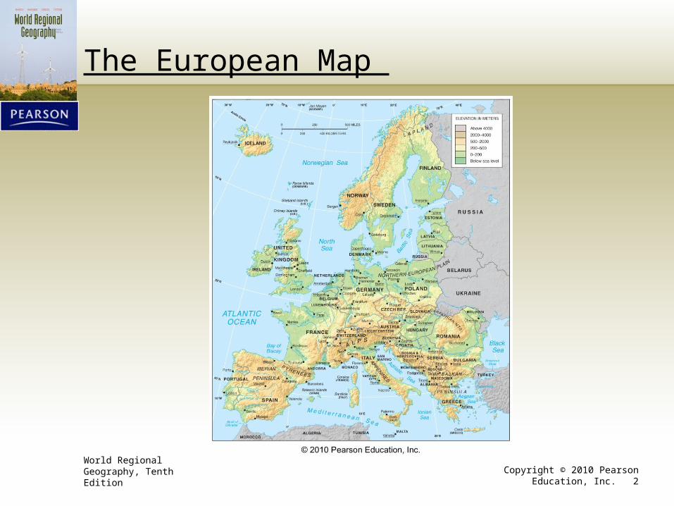
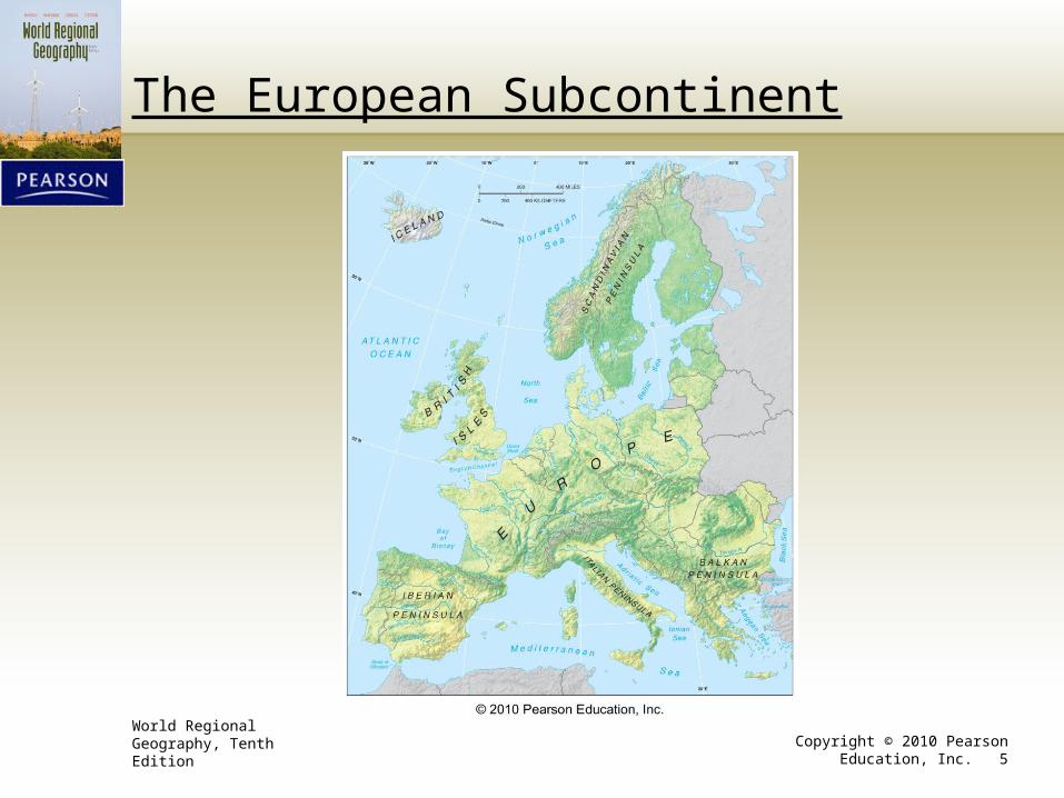
The European Map
World Regional Geography, Tenth Edition Copyright © 2010 Pearson Education, Inc. 3
Peninsula of Peninsulas
• Westward projecting peninsular section of Eurasia• Four larger peninsulas
1. Scandinavian2. Iberian3. Italian4. Balkan
• Mountain ranges• Southern ranges are a result of plate tectonics.• Alps• Pyrenees• Dinaric• Carpathians
• Fertile valleys, basins, and tablelands• Hungarian Basin• Po River valley• Meseta
World Regional Geography, Tenth Edition Copyright © 2010 Pearson Education, Inc. 4
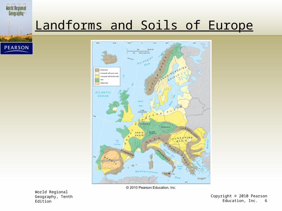
More on the European Subcontinent
• Great European Plain• Lowland that dominates northern Europe• Atlantic coast of France to the top of Russia and into Eurasia• Highly fertile soils• Sizeable agriculture
• Hill lands• Celtic refuge• Two basic locations
1. Atlantic coasts of Portugal, Spain, France, Ireland, and Britain2. Central European zone
World Regional Geography, Tenth Edition Copyright © 2010 Pearson Education, Inc. 5
The European Subcontinent
World Regional Geography, Tenth Edition Copyright © 2010 Pearson Education, Inc. 6
Landforms and Soils of Europe
World Regional Geography, Tenth Edition Copyright © 2010 Pearson Education, Inc. 7
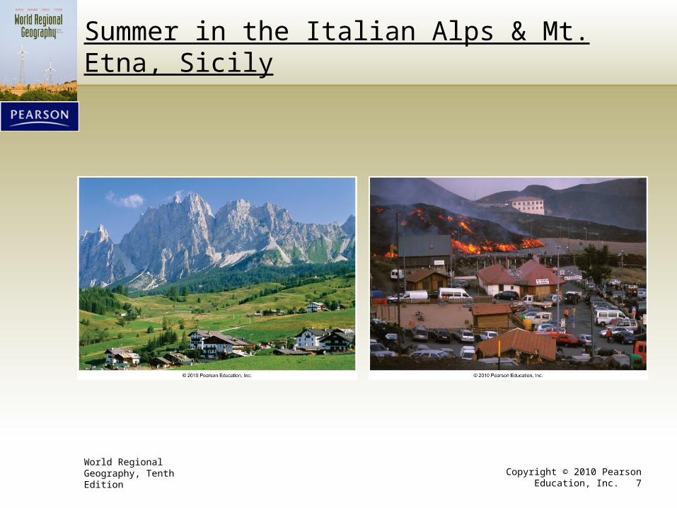
Summer in the Italian Alps & Mt. Etna, Sicily
World Regional Geography, Tenth Edition Copyright © 2010 Pearson Education, Inc. 8
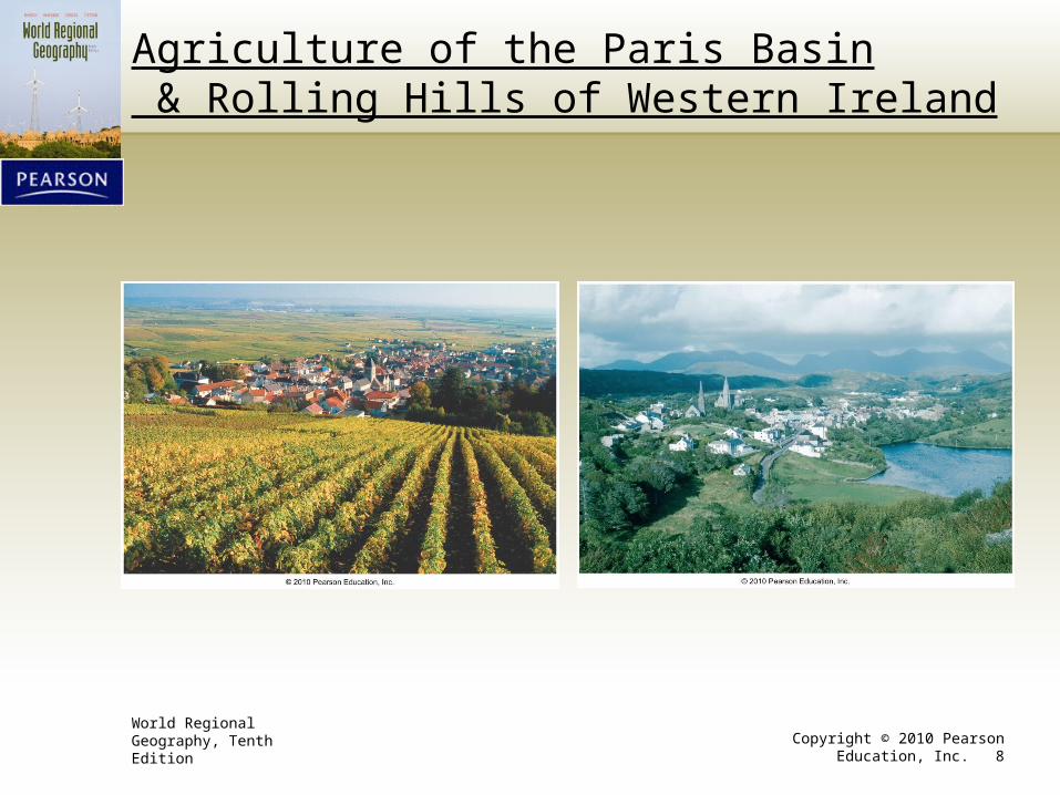
Agriculture of the Paris Basin & Rolling Hills of Western Ireland
World Regional Geography, Tenth Edition Copyright © 2010 Pearson Education, Inc. 9
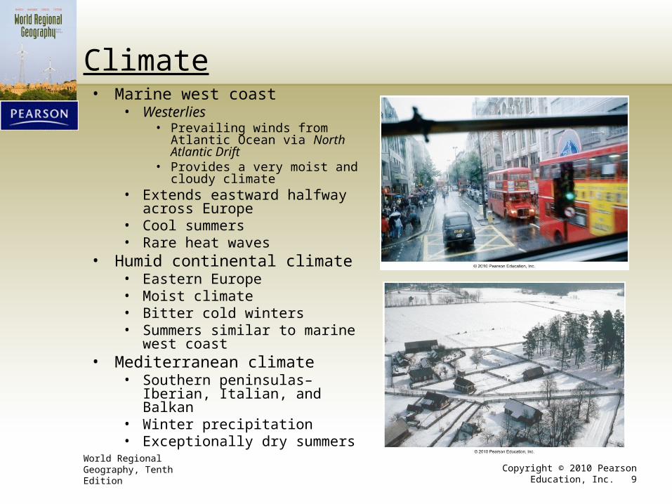
Climate• Marine west coast
• Westerlies• Prevailing winds from Atlantic
Ocean via North Atlantic Drift• Provides a very moist and cloudy
climate• Extends eastward halfway across
Europe • Cool summers• Rare heat waves
• Humid continental climate• Eastern Europe• Moist climate• Bitter cold winters• Summers similar to marine west
coast• Mediterranean climate
• Southern peninsulas–Iberian, Italian, and Balkan
• Winter precipitation• Exceptionally dry summers
World Regional Geography, Tenth Edition Copyright © 2010 Pearson Education, Inc. 10
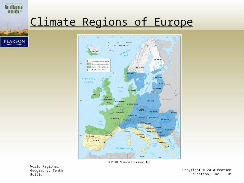
Climate Regions of Europe

World Regional Geography, Tenth Edition Copyright © 2010 Pearson Education, Inc. 11
Hydrogeography
• Water is very important.• Movement of people
• Major port cities• Rotterdam
• Amsterdam
• Hamburg
• Rivers and canals to enhance transport
World Regional Geography, Tenth Edition Copyright © 2010 Pearson Education, Inc. 12
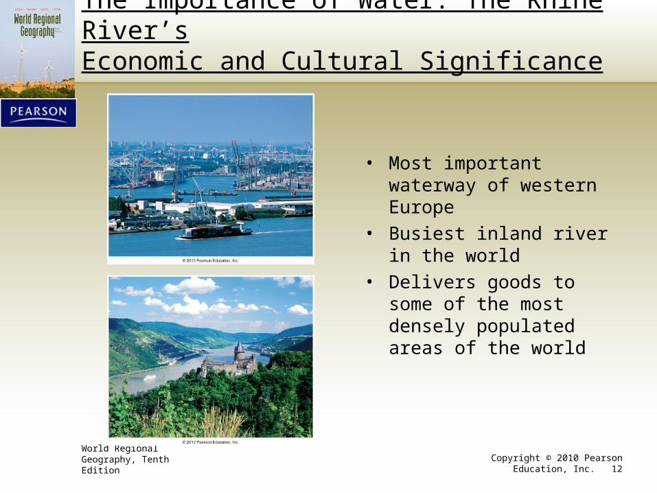
The Importance of Water: The Rhine River’sEconomic and Cultural Significance
• Most important waterway of western Europe
• Busiest inland river in the world
• Delivers goods to some of the most densely populated areas of the world
World Regional Geography, Tenth Edition Copyright © 2010 Pearson Education, Inc. 13
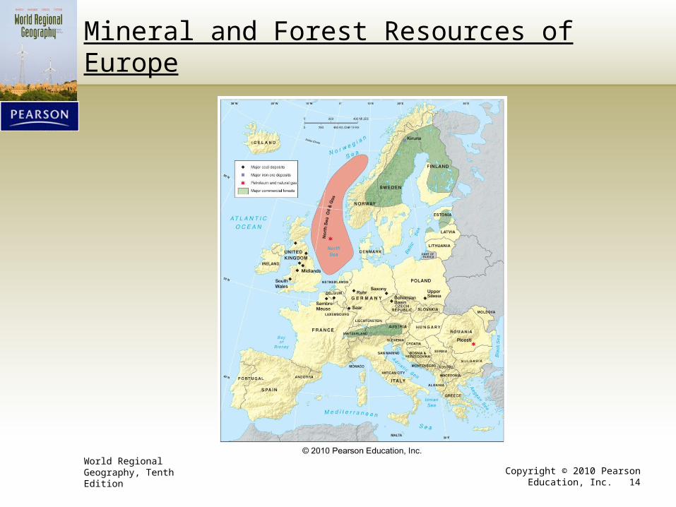
Mineral Resources
• Less abundant
• However, coal in very high quality
• North Sea• Petroleum
• Natural gas
World Regional Geography, Tenth Edition Copyright © 2010 Pearson Education, Inc. 14
Mineral and Forest Resources of Europe
World Regional Geography, Tenth Edition Copyright © 2010 Pearson Education, Inc. 15
Environmental Modifications/Problems
• Modifications• Forest clearance
• Terrain and weather modifications• Terracing–Stair-stepped hillsides
• Urban heat islands• Urban temperatures higher than in neighboring rural areas
• Air pollution is a significant problem.
• The problem of acid rain• Release of substances, such as sulfur and carbon, into the air
• Comes back with rainfall
• Creates death of forests
• Result of industrial production and heavy use of fossil fuels
• European Union has sought to coordinate standardized policies.
World Regional Geography, Tenth Edition Copyright © 2010 Pearson Education, Inc. 16
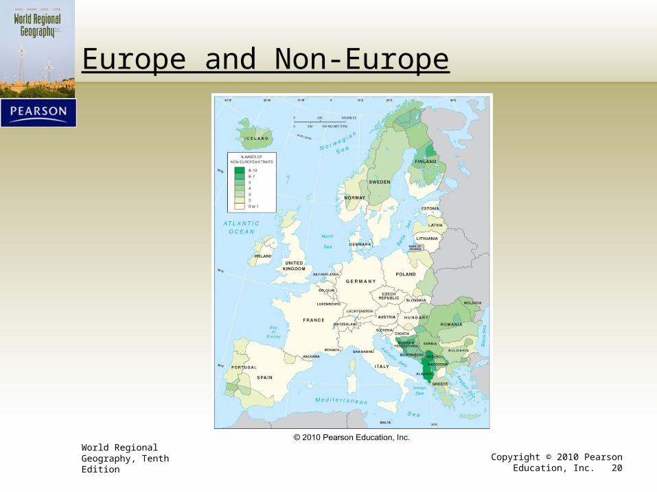
European Cultural & Economic Environment
• Human phenomenon• Twelve basic traits
1. 80% Christian2. 80%+ Indo-European speech3. 90%+ Caucasian4. Low infant mortality5. Educated population6. Highly urbanized7. Dense population8. Wealthy population9. Stabilized or declining population growth10. Densely-built public transit and road network11. Less than 10% in agriculture12. Well-established tradition of democratic governance
World Regional Geography, Tenth Edition Copyright © 2010 Pearson Education, Inc. 17
Core-Periphery Pattern
• The most purely European areas lie in the center.• Germany
• France
• Peripheral areas exhibit fewer defining traits.
• Cultural borders are rarely sharp.
World Regional Geography (Clawson et al.) - Ch. 11 Europe: Culture, Society, Economy 18
Mackinder’s Heartland Theory, 1904
• Who rules East Europe commands the HeartlandWho rules the Heartland commands the World-IslandWho rules the World-Island commands the world
World Regional Geography, Tenth Edition Copyright © 2010 Pearson Education, Inc. 19
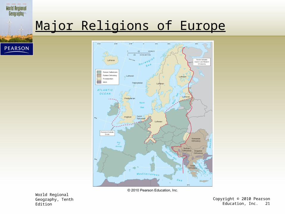
Religious Regions
• Western church split in 1504.• Roman Catholicism
• Eastern Orthodox
• Still the most fundamental religious border in Europe
• Protestant reformation (1519–1559)• Further split the western church
• Added a north–south aspect to the religious map of Europe
• North Europe predominantly Protestant (90 million)
• Southern Europe predominantly Roman Catholic (250 million)
World Regional Geography, Tenth Edition Copyright © 2010 Pearson Education, Inc. 20
Europe and Non-Europe
World Regional Geography, Tenth Edition Copyright © 2010 Pearson Education, Inc. 21
Major Religions of Europe
World Regional Geography, Tenth Edition Copyright © 2010 Pearson Education, Inc. 22
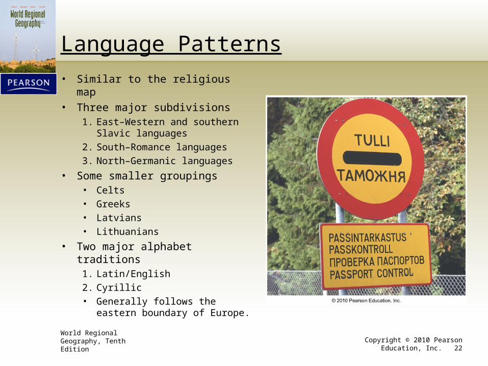
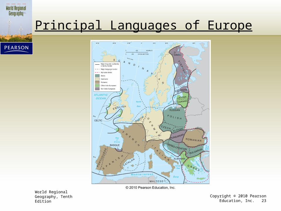
Language Patterns
• Similar to the religious map
• Three major subdivisions1. East–Western and southern Slavic
languages
2. South–Romance languages
3. North–Germanic languages
• Some smaller groupings• Celts
• Greeks
• Latvians
• Lithuanians
• Two major alphabet traditions1. Latin/English
2. Cyrillic
• Generally follows the eastern boundary of Europe.
World Regional Geography, Tenth Edition Copyright © 2010 Pearson Education, Inc. 23
Principal Languages of Europe
World Regional Geography, Tenth Edition Copyright © 2010 Pearson Education, Inc. 24
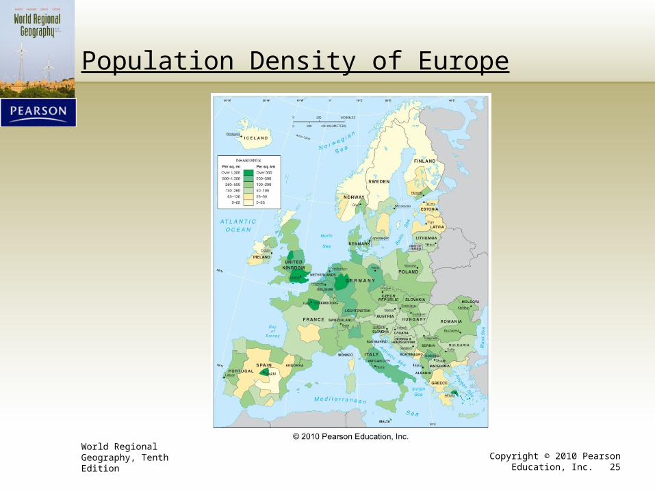
Demographics
• Population• 535 million people within the continent• Four countries with populations of over 50 million• Center of Europe is most dense.
• “European zone of continuous settlement”• Fueled by emigration from peripheries to the core
• Natural rate of increase has ceased.• Entirely due to immigration• Some predictions of demographic collapse• Older population
• Better health conditions• Zero population growth
• Other indicators• Low fertility rates• Low infant mortality–Lowest of any sizable part of the world
World Regional Geography, Tenth Edition Copyright © 2010 Pearson Education, Inc. 25
Population Density of Europe
World Regional Geography, Tenth Edition Copyright © 2010 Pearson Education, Inc. 26
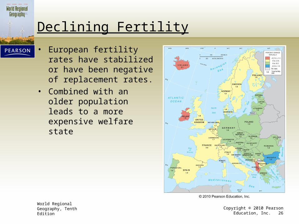
Declining Fertility
• European fertility rates have stabilized or have been negative of replacement rates.
• Combined with an older population leads to a more expensive welfare state
World Regional Geography, Tenth Edition Copyright © 2010 Pearson Education, Inc. 27
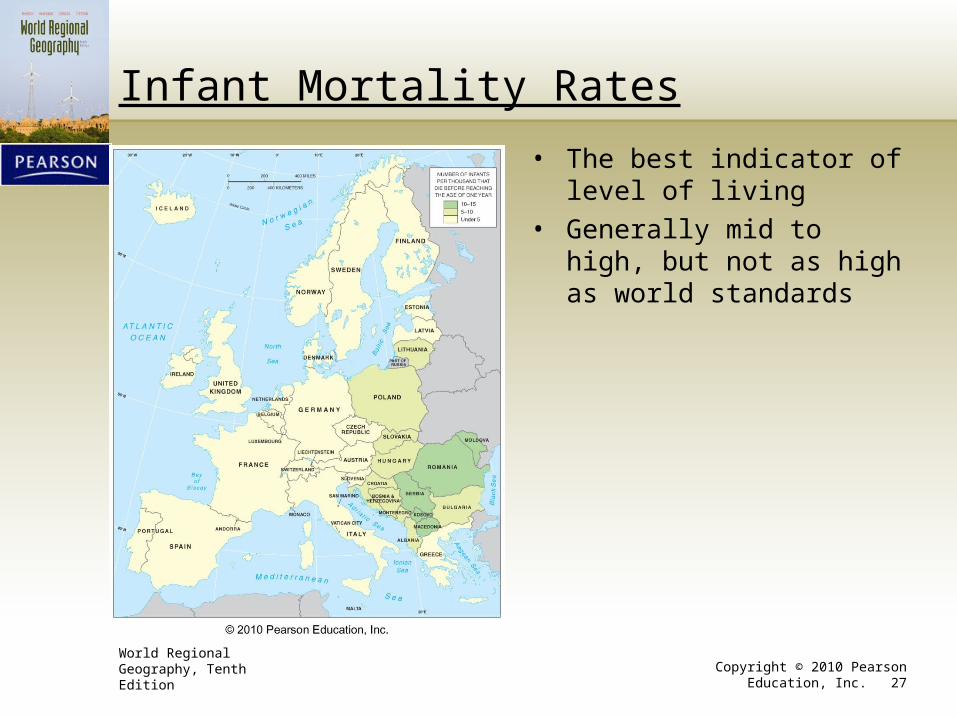
Infant Mortality Rates
• The best indicator of level of living
• Generally mid to high, but not as high as world standards
World Regional Geography, Tenth Edition Copyright © 2010 Pearson Education, Inc. 28
Immigration
• Contentious issue in some countries
• Several major migration flows• Associated with colonial legacies
• Legal and by invitation• Britain–Asian Indians, Pakistanis, and West Indians
• Germany–Turks
• France–North Africa and the Caribbean
World Regional Geography, Tenth Edition Copyright © 2010 Pearson Education, Inc. 29
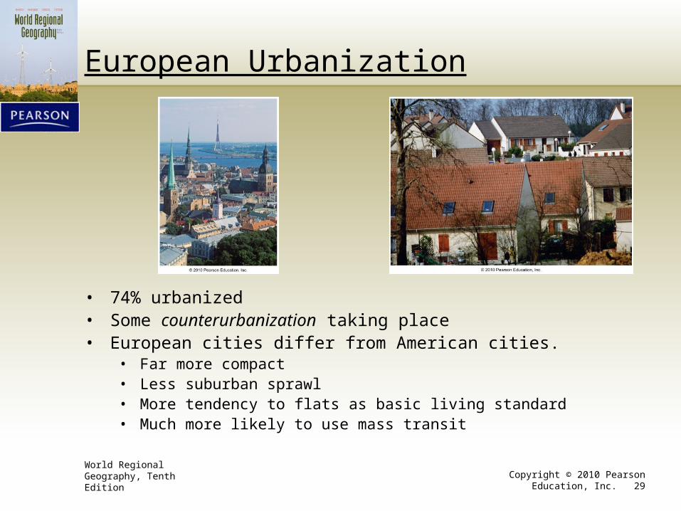
European Urbanization
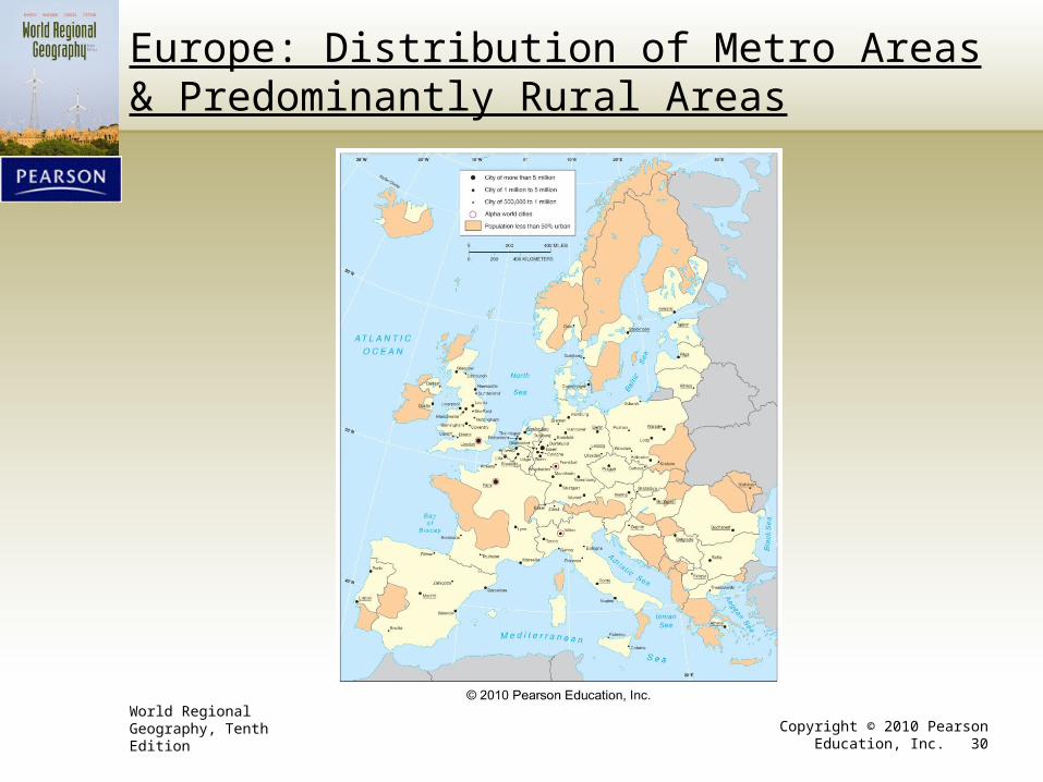
• 74% urbanized• Some counterurbanization taking place• European cities differ from American cities.
• Far more compact• Less suburban sprawl• More tendency to flats as basic living standard• Much more likely to use mass transit
World Regional Geography, Tenth Edition Copyright © 2010 Pearson Education, Inc. 30
Europe: Distribution of Metro Areas & Predominantly Rural Areas
World Regional Geography, Tenth Edition Copyright © 2010 Pearson Education, Inc. 31
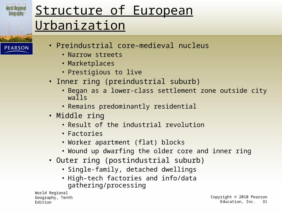
Structure of European Urbanization
• Preindustrial core–medieval nucleus• Narrow streets• Marketplaces• Prestigious to live
• Inner ring (preindustrial suburb)• Began as a lower-class settlement zone outside city walls• Remains predominantly residential
• Middle ring• Result of the industrial revolution• Factories• Worker apartment (flat) blocks• Wound up dwarfing the older core and inner ring
• Outer ring (postindustrial suburb)• Single-family, detached dwellings• High-tech factories and info/data gathering/processing
World Regional Geography, Tenth Edition Copyright © 2010 Pearson Education, Inc. 32
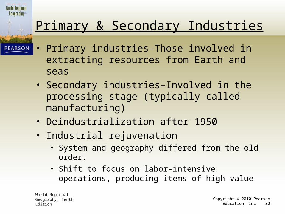
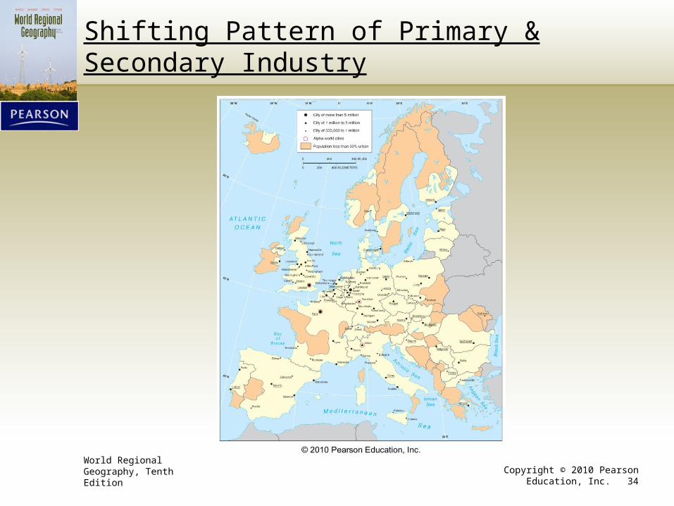
Primary & Secondary Industries
• Primary industries–Those involved in extracting resources from Earth and seas
• Secondary industries–Involved in the processing stage (typically called manufacturing)
• Deindustrialization after 1950
• Industrial rejuvenation• System and geography differed from the old order.
• Shift to focus on labor-intensive operations, producing items of high value
World Regional Geography, Tenth Edition Copyright © 2010 Pearson Education, Inc. 33
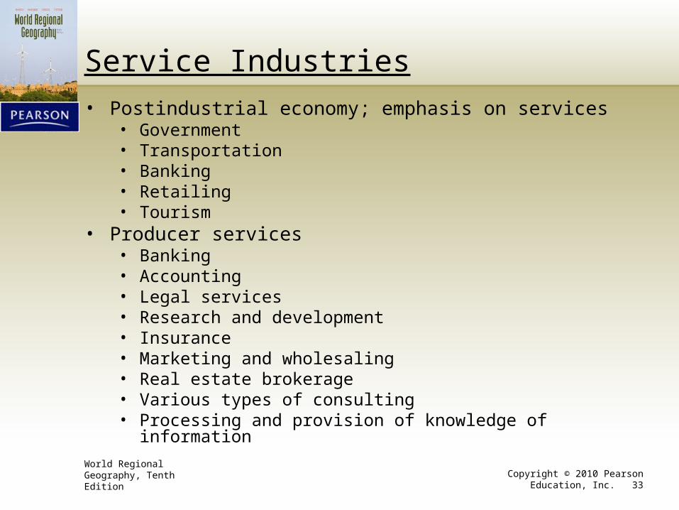
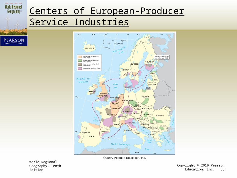
Service Industries
• Postindustrial economy; emphasis on services• Government• Transportation• Banking• Retailing• Tourism
• Producer services• Banking• Accounting• Legal services• Research and development• Insurance• Marketing and wholesaling• Real estate brokerage• Various types of consulting• Processing and provision of knowledge of information
World Regional Geography, Tenth Edition Copyright © 2010 Pearson Education, Inc. 34
Shifting Pattern of Primary & Secondary Industry
World Regional Geography, Tenth Edition Copyright © 2010 Pearson Education, Inc. 35
Centers of European-Producer Service Industries
World Regional Geography, Tenth Edition Copyright © 2010 Pearson Education, Inc. 36
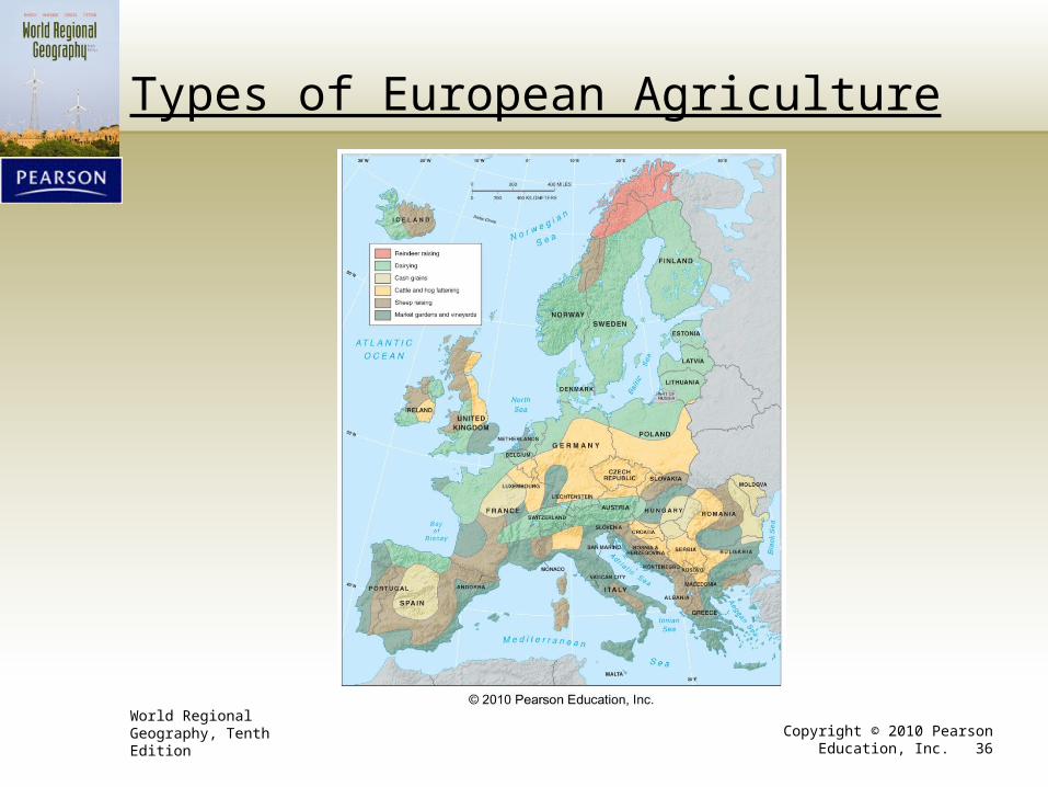
Types of European Agriculture
World Regional Geography, Tenth Edition Copyright © 2010 Pearson Education, Inc. 37
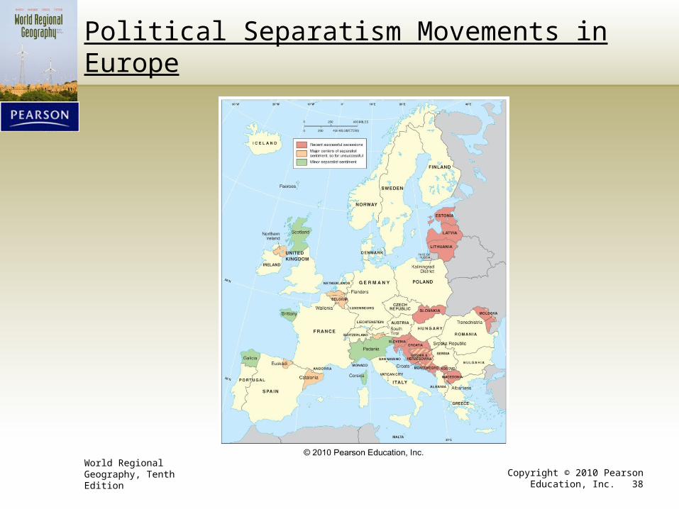
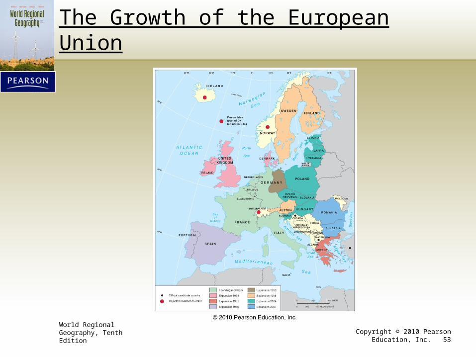
European Union (EU) Political and Geographical Context
• European map has changed in the last century.• Start of 20th century–22 independent states
• Start of 21st century–44 independent states
• Newer states are ministates–small and hard to discern on a political map.
• Separatism• Trends within existing countries
• Ethnic minorities seek to establish their own state.
• More likely to arise in heterogeneous societies
• Territorial by nature and can lead to nationalism
World Regional Geography, Tenth Edition Copyright © 2010 Pearson Education, Inc. 38
Political Separatism Movements in Europe
World Regional Geography, Tenth Edition Copyright © 2010 Pearson Education, Inc. 39
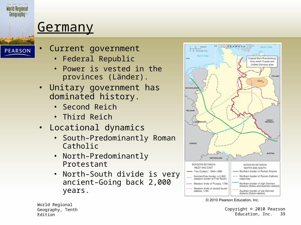
Germany
• Current government• Federal Republic• Power is vested in the provinces
(Länder).
• Unitary government has dominated history.• Second Reich• Third Reich
• Locational dynamics• South–Predominantly Roman Catholic• North–Predominantly Protestant• North–South divide is very ancient–
Going back 2,000 years.
World Regional Geography, Tenth Edition Copyright © 2010 Pearson Education, Inc. 40
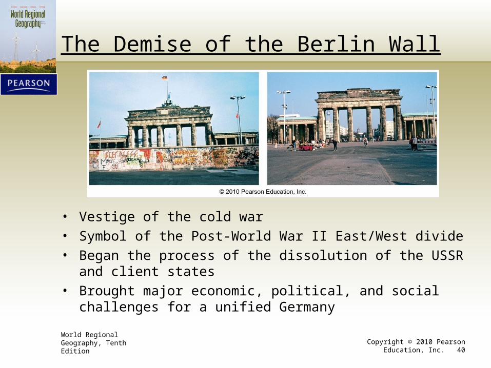
The Demise of the Berlin Wall
• Vestige of the cold war
• Symbol of the Post-World War II East/West divide
• Began the process of the dissolution of the USSR and client states
• Brought major economic, political, and social challenges for a unified Germany

World Regional Geography, Tenth Edition Copyright © 2010 Pearson Education, Inc. 41
France
• Two challenges involving cultural regionalism1. United a Germanized North
with a Mediterranean South
2. Results of annexation of peripheral lands inhabited by ethnic minorities
• Result has been an historic unitary state
World Regional Geography, Tenth Edition Copyright © 2010 Pearson Education, Inc. 42
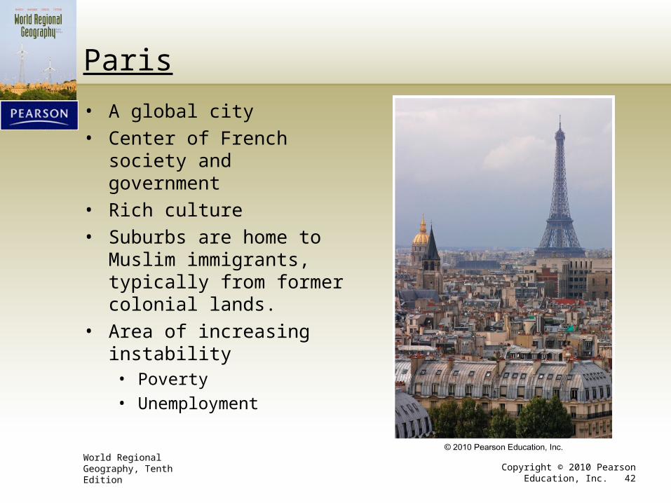
Paris
• A global city
• Center of French society and government
• Rich culture
• Suburbs are home to Muslim immigrants, typically from former colonial lands.
• Area of increasing instability• Poverty
• Unemployment
World Regional Geography, Tenth Edition Copyright © 2010 Pearson Education, Inc. 43
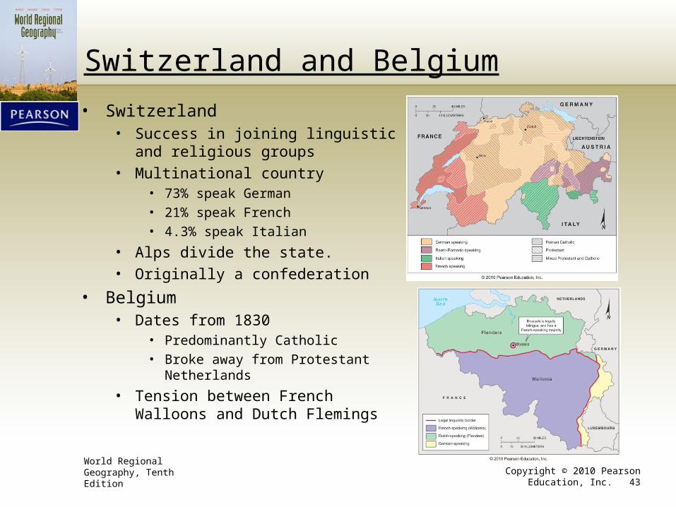
Switzerland and Belgium
• Switzerland• Success in joining linguistic and religious
groups
• Multinational country• 73% speak German
• 21% speak French
• 4.3% speak Italian
• Alps divide the state.
• Originally a confederation
• Belgium• Dates from 1830
• Predominantly Catholic
• Broke away from Protestant Netherlands
• Tension between French Walloons and Dutch Flemings
World Regional Geography, Tenth Edition Copyright © 2010 Pearson Education, Inc. 44
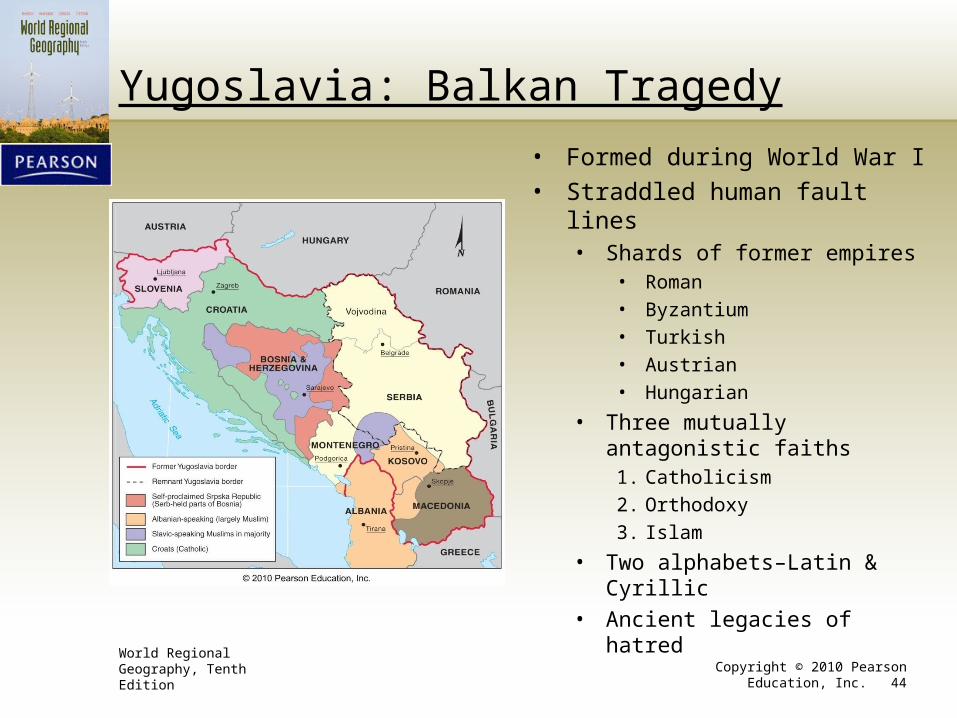
Yugoslavia: Balkan Tragedy
• Formed during World War I
• Straddled human fault lines• Shards of former empires
• Roman
• Byzantium
• Turkish
• Austrian
• Hungarian
• Three mutually antagonistic faiths
1. Catholicism
2. Orthodoxy
3. Islam
• Two alphabets–Latin & Cyrillic
• Ancient legacies of hatred
World Regional Geography, Tenth Edition Copyright © 2010 Pearson Education, Inc. 45
Yugoslavia: Balkan Tragedy (Continued)• Serb domination• Major economic disparities
• Prosperous• Slovenia• Croatia
• Not so prosperous• Macedonia• Parts of Serbia
• Memories of medieval independence harbored by Croatia and Bosnia-Herzegovina
• Break up 1991• Four provinces seceded.• 1992–Remaining parts renamed Serbia and Montenegro.• Put many people on the “wrong” side of borders• War, mass murder, and ethnic cleansing follow.• 2006–Montenegro declares independence.
World Regional Geography, Tenth Edition Copyright © 2010 Pearson Education, Inc. 46
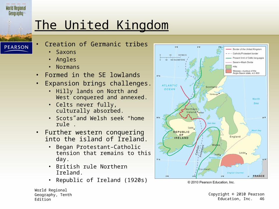
The United Kingdom
• Creation of Germanic tribes• Saxons• Angles• Normans
• Formed in the SE lowlands• Expansion brings challenges.
• Hilly lands on North and West conquered and annexed.
• Celts never fully, culturally absorbed.• Scots and Welsh seek “home rule”.
• Further western conquering into the island of Ireland.
• Began Protestant–Catholic tension that remains to this day.
• British rule Northern Ireland.• Republic of Ireland (1920s)
World Regional Geography, Tenth Edition Copyright © 2010 Pearson Education, Inc. 47
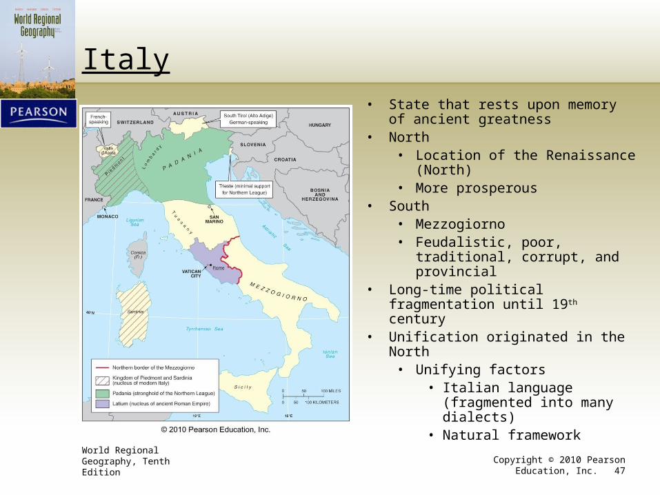
Italy• State that rests upon memory of ancient
greatness• North
• Location of the Renaissance (North)• More prosperous
• South• Mezzogiorno• Feudalistic, poor, traditional,
corrupt, and provincial• Long-time political fragmentation until
19th century• Unification originated in the North
• Unifying factors• Italian language (fragmented
into many dialects)• Natural framework
World Regional Geography, Tenth Edition Copyright © 2010 Pearson Education, Inc. 48
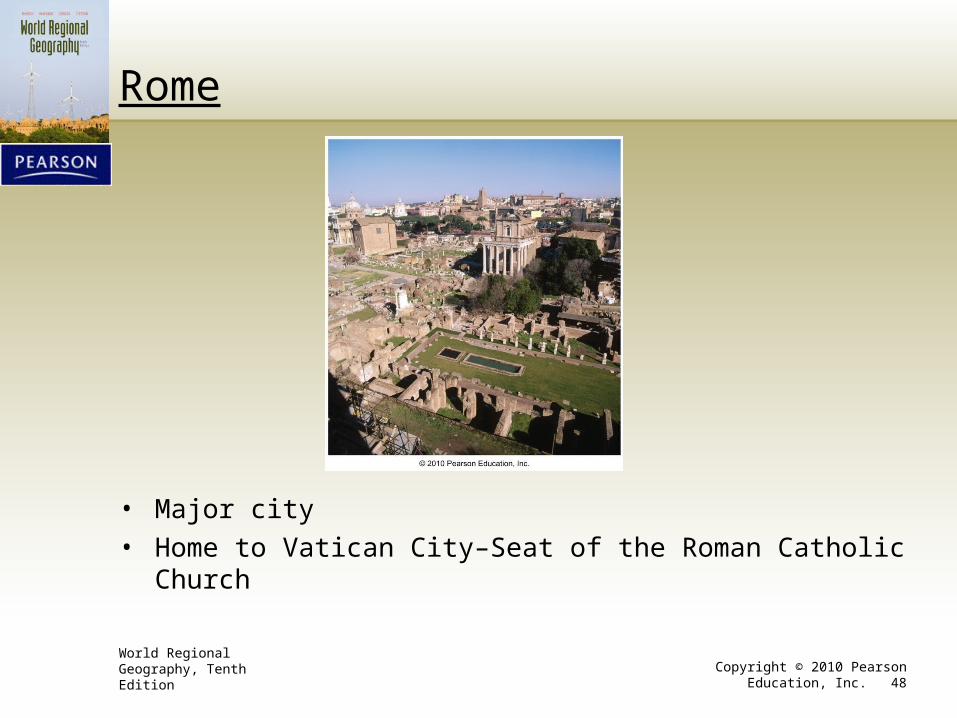
Rome
• Major city
• Home to Vatican City–Seat of the Roman Catholic Church
World Regional Geography, Tenth Edition Copyright © 2010 Pearson Education, Inc. 49
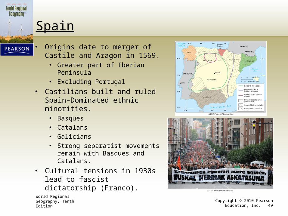
Spain
• Origins date to merger of Castile and Aragon in 1569.
• Greater part of Iberian Peninsula
• Excluding Portugal
• Castilians built and ruled Spain–Dominated ethnic minorities.
• Basques
• Catalans
• Galicians
• Strong separatist movements remain with Basques and Catalans.
• Cultural tensions in 1930s lead to fascist dictatorship (Franco).
World Regional Geography, Tenth Edition Copyright © 2010 Pearson Education, Inc. 50
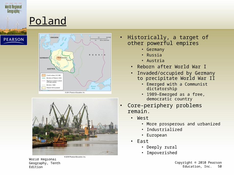
Poland
• Historically, a target of other powerful empires
• Germany• Russia• Austria
• Reborn after World War I• Invaded/occupied by Germany to
precipitate World War II• Emerged with a Communist
dictatorship• 1989–Emerged as a free, democratic
country
• Core-periphery problems remain.• West
• More prosperous and urbanized• Industrialized• European
• East• Deeply rural• Impoverished
World Regional Geography, Tenth Edition Copyright © 2010 Pearson Education, Inc. 51
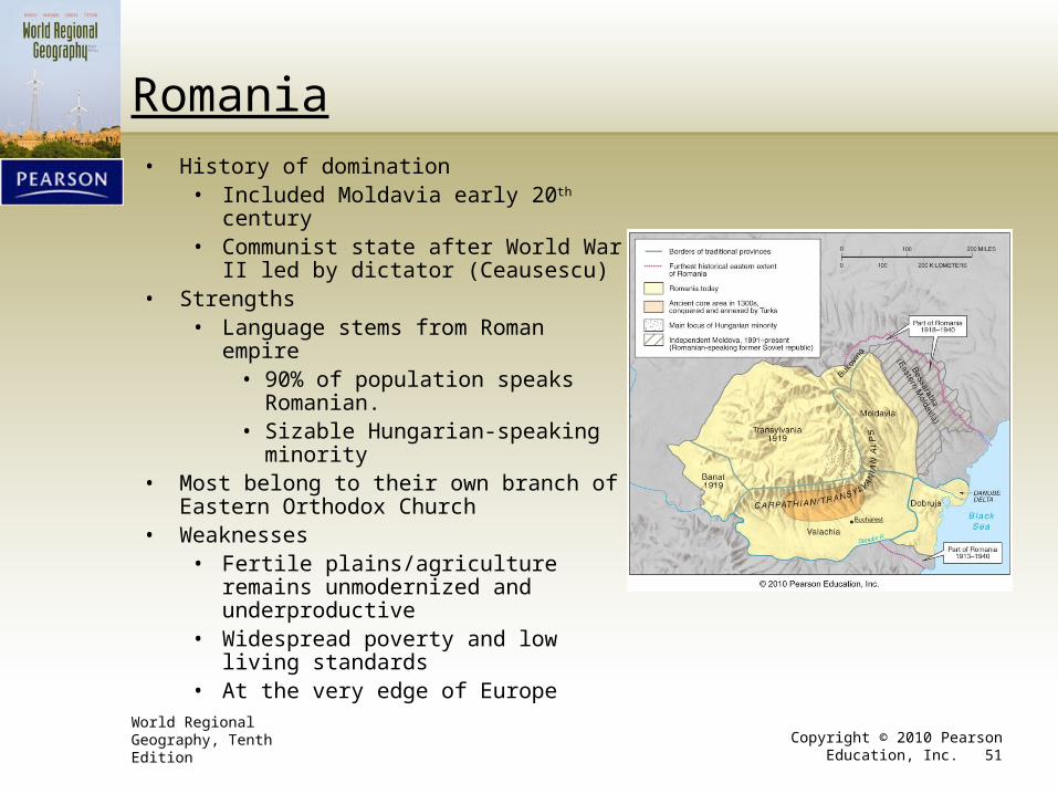
Romania• History of domination
• Included Moldavia early 20th century• Communist state after World War II led
by dictator (Ceausescu)• Strengths
• Language stems from Roman empire• 90% of population speaks
Romanian.• Sizable Hungarian-speaking
minority• Most belong to their own branch of Eastern
Orthodox Church• Weaknesses
• Fertile plains/agriculture remains unmodernized and underproductive
• Widespread poverty and low living standards
• At the very edge of Europe
World Regional Geography, Tenth Edition Copyright © 2010 Pearson Education, Inc. 52
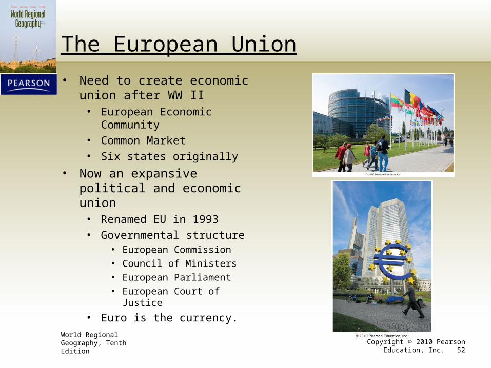
The European Union
• Need to create economic union after WW II
• European Economic Community
• Common Market
• Six states originally
• Now an expansive political and economic union
• Renamed EU in 1993
• Governmental structure• European Commission
• Council of Ministers
• European Parliament
• European Court of Justice
• Euro is the currency.
World Regional Geography, Tenth Edition Copyright © 2010 Pearson Education, Inc. 53
The Growth of the European Union
World Regional Geography, Tenth Edition Copyright © 2010 Pearson Education, Inc. 54
Challenges to European Union
• Resistance• Some countries have rejected the EU Constitution.
• Euro and EU dictates are seen by some as intrusions against local culture and identity.
• EU membership now “by invitation only” • New states have to prove their worth.
• Some criticism of cultural imperialism
• Turkey an especially controversial decision
• No EU military• NATO is de facto.
• Trends toward separatism in EU states
World Regional Geography, Tenth Edition Copyright © 2010 Pearson Education, Inc. 55
EU: Economic Powerhouse
• One of the most powerful economies in the world• 41.7% of world exports in 2006
• Leading SE Asia and US in nine of 20 different product categories
• Second in six of the remaining eleven
• Two parallel trends–Europeanization and globalization
• Free labor mobility within the EU
• Controversial issue– “Guest workers”