chapter 16 — future development areas - auckland council · manukau operative district plan 2002...
TRANSCRIPT

Chapter 16 — Future Development Areas Page 1
Chapter 16 — Future Development AreasCONTENTS AND STRUCTURE
This chapter addresses the future development areas of Manukau City and is presented as follows:
16.1 Introduction
16.2 Resource Management Issues
This outlines the significant resource management issues arising from future urban development.
16.3 Objectives
This sets out how the issues are to be managed.
16.4 Policies
This section details how the objectives are to be achieved.
16.5 Future Development Strategy
The strategy summarises the overall approach to managing natural and physical resources in the future development areas in order to promote sustainable management.
16.6 Implementation
This broadly describes the regulatory and non-regulatory methods used to implement the policies for the management of natural and physical resources in future development areas.
16.7 Anticipated Environmental Results
This outlines the environmental outcomes anticipated from the implementation of the policies and methods as set out in the future development areas chapter.
16.8 Procedures for Monitoring
This outlines how Council will monitor the effectiveness of the future development area provisions.
16.9 Description and Explanation of Zone
The future development zone is described and explained here.
Manukau Operative District Plan 2002

Chapter 16 — Future Development Areas Page 2
16.10 Rules — Activities
This sets out in an activity table the permitted, controlled, discretionary and non-complying activities for the future development zone of the City.
16.11 Rules — Development and Performance Standards
The development and performance standards that activities are to comply with in order to establish in the future development zone are outlined here.
16.12 Rules — Matters for Discretion: Restricted Discretionary Activities
This outlines the matters over which the Council has restricted the exercise of its discretion for restricted discretionary activities. It also includes assessment criteria that Council will have regard to when assessing a resource consent for a discretionary activity over which the Council has restricted the exercise of its discretion.
16.13 Assessment Criteria — Discretionary Activities
This section outlines the assessment criteria that Council will consider in addition to relevant matters set out in Section 104 of the Act when assessing resource consents for discretionary activities.
16.14 Subdivision Rules
This section sets out the rules and explanation relating to subdivision in the future development zone.
16.15 Structure Plans
These provide a description of areas currently being urbanised and outlines development patterns, development rules and assessment criteria for subdivision applications.
Manukau Operative District Plan 2002
Chapter 16 — Future Development Areas Page 3
16.1 INTRODUCTION
16.1.1 This part of the District Plan deals with the transition process of urbanisation, where rural or greenfields areas of the City are converted into developed or urban areas. The areas to which this chapter applies are those which are presently undeveloped within the metropolitan limits and the Kellys Cove locality at Beachlands. See Figures 16.1 to 16.10.
16.1.2 The strategic framework provided by the Introductory Chapters of the District Plan sets the background within which this chapter operates. In particular this involves the outcome of containing the spatial extent of urban development. This Future Development Areas chapter seeks to achieve such an outcome by defining those areas where further urban development will occur in the future.
The achievement of the final outcomes sought in this chapter will often be achieved through the methods outlined in other implementation chapters, particularly those dealing with Residential and Business activities, Public Open Space, Heritage and Transportation.
16.1.3 Several areas within the City that have been identified for future urban expansion have not as yet been developed and are subject to the objectives and policies of this chapter. These areas are:
• Westney Road
• Massey Road
• Te U Kaipo
• Flat Bush
• Hill Road
• Waiouru Peninsula
• Oruarangi South [AM 162]
• Mangere Gateway Heritage Area [AM109]
• Ihumatao Peninsula [AM147]
• East Tamaki
• Favona
• Kellys Cove
• Wiri North [AM 162]
These areas total in excess of 2000 hectares. Much of it now has an operative urban zoning such as residential, business or public open space. Parts of some of the areas have now been urbanised. [AM90]
16.1.4 As urban expansion occurs in these areas a variety of activities will establish. In Oruarangi South and Waiouru these will largely be business activities and open space. The other areas
Manukau Operative District Plan 2002

Chapter 16 — Future Development Areas Page 4
will be a mix of residential, business, public open space, community and educational activities. The detail of those activities will be described later in this chapter.
16.1.5 Within the urban area of the City, as defined by the metropolitan limits, there is approximately 1300 hectares of vacant residentially zoned land. Residential development including housing, streets, neighbourhood reserves and other associated uses, absorb approximately 100 hectares of this land each year. This uptake does not, however, occur evenly throughout the City. Approximately half of this expansion occurs within the Howick South area (Te U Kaipo and surrounding areas). The remaining uptake occurs in Manurewa and Flat Bush and on small areas of vacant land throughout the City. Most of the approximately 1200 household units built each year in Manukau are constructed on this land.
16.1.6 Smaller areas of vacant land within the City are used each year by business activities or for the provision of public open space areas and other community uses. The remaining 620 hectares of land zoned for Future Development will meet the above demands.
16.2 RESOURCE MANAGEMENT ISSUES
Issue16.2.1 Urbanisation can give rise to adverse effects on the natural resources, amenity and
heritage values of the City
The activity of urbanisation directly impacts on the resources of land, water, soil, vegetation and air, and indirectly on energy resources. It can also adversely affect amenity and heritage values. By restricting new urban development in the City to areas within the metropolitan limits many of the worst adverse effects of urban development have been avoided.
The issue for future development areas is how to manage the urbanisation process in such a way as to avoid or mitigate adverse effects such as waste generation (energy use and pollution); loss of heritage, vegetation and landscapes; detrimental effects on water quality; loss of landform by physical modification; radio and electromagnetic radiation and environmental noise. The avoidance of areas of natural hazards and areas with high coastal amenity and values also needs to be achieved.
Issue16.2.2 The development of new urban areas can give rise to the inefficient use of land, energy
and physical resources
An uncoordinated urbanisation process can result in urban development which is inefficient and unsustainable. This can involve the inefficient use of existing infrastructure, utilities and community facilities, causing demands for their uneconomic provision.
There is a limited amount of land within the metropolitan limits which can be used to accommodate urban development. The inefficient use of this land is therefore an important resource management issue for the City.
The form that urban development takes and the communities it creates can lead to high levels of energy consumption particularly through the use of transport fuels. The efficient design of neighbourhoods in energy terms and the relationship between home, work, shopping, recreation, education and leisure activities is therefore an important issue in the creation of new urban development.
Manukau Operative District Plan 2002

Chapter 16 — Future Development Areas Page 5
Issue16.2.3 New urban areas can be created with low levels of amenity
The process of developing new urban areas can lead to the creation of monotonous areas with little character or identity. Such areas may not provide a liveable environment or have development which is relieved by open spaces, views both within and outside the area or the creation and retention of amenity. The well-being of communities can be detrimentally affected by urban areas which lack diversity, provide unsafe environments, include incompatible activities, or which do not provide the range of opportunities required by residents to be conveniently located in a neighbourhood.
16.3 OBJECTIVES
Objective16.3.1 To avoid or mitigate the adverse effects of urbanisation on natural and physical
resources.
(This objective relates to Issue 16.2.1).
Objective16.3.2 To ensure the sustainable use of natural and physical resources as urbanisation
occurs.
(This objective relates to Issues 16.2.1, 16.2.2 and 16.2.3).
Objective16.3.3 To achieve a high standard of design and amenity in new urban development.
(This objective relates to Issue 16.2.3).
Objective16.3.4 To enable the provision of social and community facilities required by the population
of new urban areas.
(This objective relates to Issues 16.2.1 and 16.2.3).
Objective16.3.5 To ensure land identified for urban development is suitable for such activities.
(This objective relates to Issues 16.2.1, 16.2.2 and 16.2.3).
16.4 POLICIES
Policy16.4.1 Urban development shall be promoted in such a way as to be energy efficient. In
particular urban development shall:
• minimise motor vehicle travel;
• encourage pedestrian and cycle access;
• promote convenient access to public passenger transport; and
• maximise the use of solar energy.
(This policy seeks to achieve Objectives 16.3.1, 16.3.2 and 16.3.3).
Manukau Operative District Plan 2002

Chapter 16 — Future Development Areas Page 6
Explanation/Reasons
The use of energy within new urban development is one of the key determinants of the level of sustainability that urban areas will achieve.
Methods
- Structure plans with street layouts which achieve high levels of pedestrian and cycle permeability.
- Subdivisional controls which ensure optimum solar orientation of lots.
- Provision of public transport.
- Structure plans which provide for the range of activities which people use to be located conveniently within communities.
- The detailing of appropriate development densities in structure plans for new development areas.
- Provision of community facilities.
- Application of Business and Residential zones which support more diverse activities.
Policy16.4.2 The release of land for urban development will be staged in a manner which ensures:
• the maintenance of sufficient vacant land zoned for residential activities;
• maintenance of sufficient vacant land zoned for business activities;
• the development of new transport linkages;
• the availability of infrastructural services, utilities and facilities;
• the continued availability of rural land for farming purposes and the retention of rural character until urban development occurs; and
• vacant land availability in proximity to existing urban development.
(This policy seeks to achieve Objectives 16.3.2, 16.3.3 and 16.3.4).
Explanation/Reasons
The development of new urban areas in an unmanaged way can lead to scattered development which cannot provide the various facilities and amenities required by the new residents. Many essential utilities also need to be provided prior to urban development. Land for such development will therefore be released in a manner which enables all of the essential elements of an urban area to be available when required.
The creation of urban areas as an extension of existing urban developments allows for the utilisation of existing facilities by residents until new facilities are provided. The release of vacant land must, however, take into account the lead time required by the development sector and the availability of appropriate land in all areas and sectors of the City.
Manukau Operative District Plan 2002

Chapter 16 — Future Development Areas Page 7
Methods
- Future development zoning and staging.
- Monitoring of vacant land availability.
Policy16.4.3 New urban development shall be designed to achieve a high level of environmental
performance which:
• protects and where possible enhances water quality, particularly from the effects of sediment in the land conversion process and pollutants arising from transportation activities; and
• maintains current air quality, coastal amenities, existing landform, heritage, vegetation and character to the greatest extent possible.
(This policy seeks to achieve Objectives 16.3.1, 16.3.2 and 16.3.5).
Explanation/Reasons
The process of land conversion from rural use to urban use has by its very nature many adverse effects on the natural resources of an area. By seeking to achieve environmentally sensitive development those adverse effects will be limited in extent or avoided where possible.
Methods
- Structure plans identifying areas to be protected or avoided by urban development and rules requiring studies, surveys and consultation to be undertaken for input to structure plans in relation to areas requiring protection or avoidance.
- Provision of public open space and community facilities to mitigate the effects of development.
- Use of rules relating to appropriate zones i.e. business zones, residential zones, public open space zones.
- Subdivision and land development controls.
Policy16.4.4 New urban development should be designed in such a way that:
• is sensitive to any attractive prevailing character of the area in which it occurs;
• encourages a sense of place and identity;
• is accessible to community facilities, public open space and educational facilities; and
• incorporates identifiable edges and boundaries to developing neighbourhoods.
(This policy seeks to achieve Objectives 16.3.1 and 16.3.3).
Manukau Operative District Plan 2002

Chapter 16 — Future Development Areas Page 8
Explanation/Reasons
Urban development which occurs in an unmanaged manner has the potential to become monotonous with each area merging into the next with no real differentiation between them. The potential also exists for development to be widely dispersed, thus providing poor access to facilities for the residents of new areas. These adverse effects can be minimised by managing the urbanisation process.
Methods
- Staged release of vacant land for urbanisation in compact units.
- Provision of public facilities.
- Preparation of structure plans to guide future development. These plans will include heritage, land forms and areas of vegetation to be retained, street layouts, open space networks and the primary activity areas within the neighbourhoods (e.g. possible sites for educational facilities).
- Provision of public open space.
Policy16.4.5 Urban development will be managed so that it:
• minimises the amount of land consumed by urban development; and
• maximises the development densities while recognising the environmental, heritage and amenity constraints in each particular location.
(This policy seeks to achieve Objective 16.3.2).
Explanation/Reasons
Within Manukau City there is approximately 1800 hectares of vacant land zoned residential or future development that will be used by residential activities. Over the recent past this land has been converted to residential uses at the rate of approximately 100 hectares per year. At that rate no vacant land will be available for new residential development by the year 2015. All of this land within the metropolitan limits could be developed more quickly as the development opportunities elsewhere in the region lessen.
It is therefore important that the remaining land in the City be used efficiently. The achievement of higher residential densities, (in addition to using less land) also promotes a more energy-efficient urban area and a more efficient use of urban infrastructure. These issues are discussed more fully in the Introductory chapters of the District Plan.
Methods
- Preparation of structure plans which identify areas for higher density residential development.
- Rules in the residential areas chapter which encourage higher densities where appropriate.
- The controlled release of new areas of land for residential development.
Policy16.4.6 New urban development will occur in such a way that:
• retains natural landforms, vegetation and features where appropriate;
Manukau Operative District Plan 2002

Chapter 16 — Future Development Areas Page 9
• retains other existing heritage items;
• minimises land recontouring, bulk earthworks and modification of natural streams;
• minimises noise, particularly traffic noise;
• maximises the safety of the population;
• achieves a high degree of access, particularly pedestrian and cycle access within communities;
• ensures that the design of structures is sensitive to the character of the area;
• promotes the provision of adequate public open space opportunities; and
• avoids natural hazards.
(This policy seeks to achieve Objective 16.3.3).
Explanation/Reasons
Creating urban developments which will provide quality living environments for current and future generations is an important element of sustainable management. Such urban areas are more flexible and will better be able to adapt to future needs.
Methods
- Structure plans which direct major traffic routes around neighbourhoods, identify heritage items and other features for protection and provide for pedestrian and cycle paths and routes.
- The purchase and management of public open space areas for various purposes as detailed in the public open space chapter.
- The development conditions, particularly those in the residential, business and public open space areas chapters.
- Land Modification, Development and Subdivision Controls.
16.5 FUTURE DEVELOPMENT STRATEGY
• The future development strategy summarises the overall approach to managing natural and physical resources during the transition process of urbanisation within the City.
• The chapter deals with the spatial expansion of the urban area and interprets locally the metropolitan urban limits contained in the Auckland Regional Policy Statement.[AM89]
• In summary, the strategy is one of:
- containment
- selective intensification
- clustering and nodal development
Manukau Operative District Plan 2002

Chapter 16 — Future Development Areas Page 10
- diversity of activities
- balanced urban growth
- improved energy performance
- employment growth
- improved environmental performance
• Urbanisation as an activity will adversely affect the natural and physical resources and the amenity and heritage values in the area it occurs. These concerns need to be addressed to ensure that the environmental qualities of the City are maintained and enhanced.
• While urban developments cannot completely avoid causing adverse effects on the natural and physical resources of the City, these effects can be mitigated. The form of urban development which is pursued can also determine to what extent the use of those resources is sustainable. The requirement for and provision of mitigation measures, and the layout and design of urban areas will all impact on the level of sustainability achieved by urban development.
• While an efficient urbanisation process is important for the provision of affordable housing and achieving employment for the City’s labour force, matters such as liveability and social opportunities for residents are also important. Matters such as amenity and the creation of quality living environments involve elements which make urban areas into actual communities. Amenity, in this context, includes diversity, identity, public safety and access, self contained neighbourhoods, access to facilities and public open space, traffic calming and traffic noise control. All of these elements need to be addressed in the urbanisation process.
• Opportunities for people and communities to provide for their social and cultural well-being is an important element in the creation of sustainable urban areas. Enabling these needs to be met is therefore an important objective in the strategy.
• The avoidance of areas of natural hazard or identified heritage value by new urban development needs to be achieved to avoid adverse effects on natural and cultural resources. This will allow the provision of urban development in an efficient manner and allow the creation of high amenity communities.
16.6 IMPLEMENTATION
16.6.1 Regulatory Methods
16.6.1.1 Future Development Zone
A future development zoning has been chosen as the most efficient and effective method of implementing those policies aimed at achieving the staged release of land for new urban development, the creation of identifiable, higher amenity neighbourhoods and promoting the sustainable use of resources. The future development zone will:
• identify areas suitable for future urban development;
• provide an indication of the timing of release to aid the providers of various infrastructure elements in their planning;
Manukau Operative District Plan 2002
Chapter 16 — Future Development Areas Page 11
• provide an interim control prior to release to prevent the creation of activities or subdivision of land which may constrain or compromise future urban uses;
• encourage the continued productive use of the land and not foreclose options earlier than necessary by providing a degree of certainty about the likely time frames for urbanisation.
Before any additions are proposed to the Future Development Zone by way of Plan Change procedure, the Council will consult extensively with a range of stakeholders including the local community, tangata whenua and the Auckland Regional Council.
16.6.1.2 Structure Plans
16.6.1.2.1 For those areas of future development land being released for urban development, and those areas that will soon be released, a structure plan will be prepared. The structure plan will remain in place until the total area subject to that plan is largely developed. The detail of the structure plan will be reflected in the zoning pattern and other detail included in the zoning maps when the area is released for urban development. See Figure 16.1.
16.6.1.2.2 Several structure plans have previously been formulated and included in past district plans. Where those areas are not as yet fully developed they will be included in this District Plan, although in some cases in a modified form. These areas are:
• Westney Road
• Massey Road
• Te U Kaipo
• Flat Bush West [AM50]
• Hill Road
• [AM109 deleted Oruarangi South]
• Flat Bush [AM50]
16.6.1.2.3 Following considerable public consultation since the last review of the district plan, structure plans for the Waiouru Road and Favona areas have been prepared and are included in this District Plan. The areas subject to these structure plans will now be released for urban development with a zoning pattern to reflect this situation.
[AM90]
16.6.1.2.4 Areas that will in the future be released for urban development will have structure plans prepared for them prior to having urban zones and being released for development.
[AM50][AM90]
Manukau Operative District Plan 2002

Chapter 16 — Future Development Areas Page 12
FIGURE 16.1 STRUCTURE PLAN AREAS
[AM50][AM90][AM162]
Auckland City Tamak
i R
iver
Mangere Inlet
Howic
MANUKAU HARBOUR
Auckland InternationalAirport
Pahurehure Inlet
Papakura District
9
4
2
1
3
75
11
6
10
Key1. Waiouru Peninsula2. Flat Bush West
3. Hill Road4. Te U Kaipo
5. Westney Road6. Massey Road7. Oruarangi South
8. Kellys Cove - Beachlands (not shown)9. Flat Bush
10. Favona11, Wiri North
Reference: I:\MCC_Project\District Plan\Chapter Figures\Fig16_1
Manukau Operative District Plan 2002

Chapter 16 — Future Development Areas Page 13
16.6.1.2.5 Most of the above areas yet to be structure planned will most likely be used for residential activities. Structure plans for these areas will therefore be formulated to:
• promote a diversity and choice of opportunities within a liveable environment;
• integrate the provision of public open space;
• ensure the retention of existing amenity, landscape and heritage;
• provide for the creation of well defined, human scale neighbourhood units;
• achieve a high level of amenity particularly by the use of public open spaces;
• achieve neighbourhoods with good legibility (paths, nodes, landmarks, edges and precincts) and high permeability (convenient access);
• promote flexibility (adaptability of buildings and land use over time);
• encourage a higher degree of self sufficiency through higher density development and a wider range of activities where appropriate; and
• address the infrastructural requirements of roading and public transport, stormwater, water and sanitary sewerage.
16.6.1.2.6 The structure plans for these new areas, including those for the future development areas in Flat Bush, will likely be more detailed than previously in an attempt to meet the performance criteria detailed above. They will, however, need to retain a degree of flexibility over time so as not to lock development into a specific design for years ahead. They are also likely to have a higher urban design content, and be of finer detail involving such elements as street block and housing layout, pedestrian linkages, public views, and density, scale and form.
[AM50]
As a result they will therefore go beyond indicating the primary elements of the proposed urban framework and will include areas for business, shopping, educational and community facilities, public open space areas and major roading networks. In this way they will specify the performance elements that new urban development will need to meet. They may also enable interim subdivision where it can be demonstrated that it will not constrain or compromise future urban development.
16.6.1.2.7 The preparation of new structure plans will be achieved by a series of facilitated workshops to which the various stakeholders will be invited to attend. Stakeholders will include amongst others; tangata whenua, landowners, local interest groups, representatives of existing communities, the Auckland Regional Council, developers, housing companies, the various activities of Manukau City Council including Community Activities, Development, Environment and Works, service providers and representatives from neighbouring communities.
Following completion, the structure plans will be incorporated in this part of the District Plan. The structure plan formulation process will therefore be a non-statutory, highly public process. The statutory plan change process will then follow.
16.6.1.2.8 The timing for the formulation and adoption of these structure plans will largely be determined by market demand as measured by vacant land uptake rates. [AM50][AM90]
Manukau Operative District Plan 2002
Chapter 16 — Future Development Areas Page 14
16.6.1.2.9 The Flat Bush structure plan area consists of approximately 1,260 hectares of residentially zoned land split into four zones. The Flat Bush Residential 1, 2 and 3 zones, require higher overall residential densities than previously achieved in greenfields development. The Flat Bush Residential 4 zone is a medium to low density residential zone which responds to the steeper topography of the mid to upper catchment area.
The Flat Bush structure plan area is divided into three parts, which are identified on Figure 16.11D. The Stage 1 area was released as part of Variation 13 in 2001. Stages 2A and 2B were proposed for release as part of Plan Change 20 in 2010, with Stage 2B urban zonings not to take effect until 2013. Stage 4 covers the most southern part of the catchment and remains as a Future Development zone. The release of this remaining Future Development land will require a plan change to the District Plan to rezone the land to a suitable zone as indicated in the Flat Bush structure plan. The exact timing of this change to the District Plan will be dependent upon a number of factors including uptake of land in the Flat Bush area and addressing options in relation to the three overhead transmission lines that run across this area. It is therefore anticipated that the Stage 3 area will not be released for development until at least 2016.
[AM50][AM167]
16.6.1.3 Methods and Rules contained in other Chapters
Following the release of Future Development areas for urban development, the provisions of the relevant zones as contained in residential areas, business areas, public open space areas or special areas chapters, will be used to implement the policies in this chapter. The rules contained in the transportation, heritage, land modification, development and subdivision and network utility services chapters will also be used to implement this chapter’s policies along with the provisions of the Future Development Zone and structure plans.
[AM50]
16.6.2 Non-Regulatory Methods
16.6.2.1 Urban Design Workshops
Although these workshops are indicated as the method by which structure plans will be prepared, they largely provide a method outside the District Plan to achieve many of the policies of the Future Development Chapter. The final outcome from the workshop will, however, be reflected in a regulatory manner.
16.6.2.2 Operational Activities
The provision of bulk services such as wastewater, potable water, electricity, gas, and the construction of roading links and community facilities, will all have an impact in achieving the policies of this chapter. Stormwater quality and quantity control improvements will not only enable development to proceed but will impact on the environmental quality new development will be able to achieve. Where available detail about the plans of various service providers will be incorporated in structure plans.
16.6.2.3 Purchase and Management of Public Open Space
In addition to providing areas for active and passive recreational activities, public open space will provide an important structuring element for new urban areas. It will also provide opportunities to mitigate the
Manukau Operative District Plan 2002
Chapter 16 — Future Development Areas Page 15
adverse effects of urbanisation and provide techniques to retain important natural elements within the developed urban area. These strategies are detailed in the public open space chapter.
16.6.2.4 Other Methods
The Council also utilises other methods by which the policies of this chapter are met. Its community development activities and its provision of community, cultural and recreational facilities are all important in achieving the policies detailed above.
16.7 ANTICIPATED ENVIRONMENTAL RESULTS
The anticipated environmental results arising from the policies and methods for future development areas are as follows:
• quality built environments;
• the avoidance and mitigation of the adverse effects of urbanisation on the resources of the City;
• high levels of amenity and safety within new urban areas;
• a diversity of neighbourhood types;
• healthy environments;
• protection of environmentally sensitive areas;
• the retention of heritage features;
• lower per capita energy consumption in urban areas;
• well serviced urban areas;
• avoidance of areas of natural hazards; and
• enhanced quality of the City’s natural and physical resources, quality receiving waters, improved air quality.
16.8 PROCEDURES FOR MONITORING
In order to assess the suitability and effectiveness of the objectives, policies and methods in achieving the anticipated environmental results contained in this chapter, the Council will develop a monitoring programme (see Chapter 1, Section 1.7.3) which may include the following monitoring procedures:
• Measuring the level and uptake of vacant urban land
• Assessing changes in population and housing densities
• Surveys of land use changes occurring in areas adjoining the urban-rural boundary
• Analysing data from air and water quality monitoring programmes to determine the extent to which adverse effects of urban development are being mitigated
• Undertake assessments of the level of visual amenity being created in new urban areas
Manukau Operative District Plan 2002

Chapter 16 — Future Development Areas Page 16
• Undertake surveys of residents’ views on amenity values, accessibility to public facilities, and provision of utility services in new urban areas
• Analysing trends in motor vehicle ownership, transport mode and journey type from census data
• Undertaking safety audits and analysing crime and traffic accident statistics for new urban areas to identify areas where personal safety is not being adequately achieved
• Surveys of heritage features and ecologically significant areas considered to be most at risk from urban development.
16.9 DESCRIPTION AND EXPLANATION OF ZONE
16.9.1 Future Development Zone
The purpose of the zone is to protect the rural areas in the East Tamaki Corridor and in the Mangere and Ihumatao Peninsula areas until such time as they are required for the future expansion of existing urban areas. The areas zoned for future development are staged as either Stage 1 or Stage 2 which largely reflect current urban growth demand and the provision of services, and provides for the progressive development of the City. [AM147]
[AM90]
Although land within this zone is ultimately designed to accommodate urban development it is likely that some areas will remain in rural use for some time and planned for rezoning in later stages of development.
[AM50]
Until the land is urbanised it is intended that the Future Development Zone will retain its predominantly rural character and that farm productivity will be maintained. The activities which are allowed in the zone such as farming will enable the existing resources of the area to be used until required for urban purposes. Other permitted activities are essentially in keeping with the rural character of the zone.
To ensure that the future pattern of urban development is not prejudiced and there can be a smooth transition to urban uses, subdivision and non-rural uses are restricted. No further subdivision will generally be allowed to avoid a sporadic pattern of lots with a high level of investment which could delay or jeopardise urban development.
Following the structure planning of areas presently zoned for future development some subdivision may be able to be permitted if done in accordance with that structure plan and where it can be demonstrated that it will not constrain or compromise future urban development or create a significant demand for services. This matter will be addressed at the time the structure plan is prepared and provisions relating to subdivision will be contained in the completed structure plan.
16.9.1.1
(a) Flat Bush
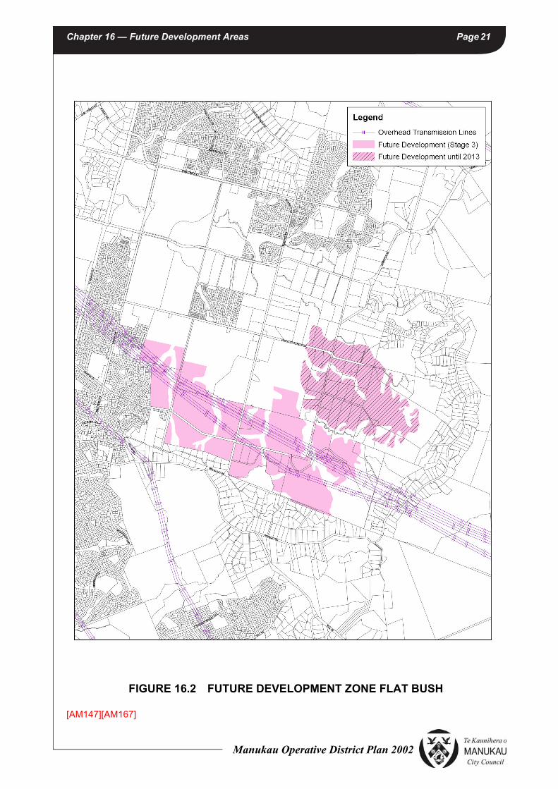
Figure 16.2 shows the land that is proposed to remain in the Future Development zone (notwithstanding that Stage 2B remains Future Development Zone until 1 January 2013). Approximately 348 hectares of land (including Stage 2B) has a Future Development Zone. A three stage approach to land release will also aim to ensure that Future Development zoning manages a controlled transition from rural to urban use. In the interim, emphasis will be given to the protection of the rural character of these
Manukau Operative District Plan 2002

Chapter 16 — Future Development Areas Page 17
areas. The staged release of land is aimed at achieving sequenced development allowing for key infrastructure to be progressively extended at the release of each stage. The current Future Development zone will continue to apply to each area until the land is progressively released and zoned by way of Plan Change.
Approximately 552 hectares of land has been earmarked for future residential purposes as contained in the Flat Bush Structure Plan in 16.15.9. Stage 2A, comprising 180 hectares, will be released for development in 2010, with Stage 2B, 134 hectares being released on 1 January 2013. Stage 3 is the final stage, encompassing approximately 215 hectares of land at the southern end of the Flat Bush Structure Plan area. It is anticipated that this final area will not be released until 2016 at the earliest. This will enable a full investigation study to be undertaken regarding the feasibility of undergrounding the three overhead transmission lines that pass through this area, or exploring other options.
Reasons for the land being released in three stages include:
• The continuing strong demand for growth at the northern end of the corridor;
• The need to co-ordinate key infrastructure relating to the stormwater management on a sub catchment basis. This will ensure that the key facilities such as the acquisition and establishment of the green finger network, including stormwater ponds can be achieved in an efficient and effective manner. This will also ensure that downstream impacts such as sedimentation are appropriately managed.
• The provision of other core infrastructure including main trunk sewer extensions and new primary roads cannot be provided efficiently to all parts of the catchment at the same time, and will be progressively be extended from the central and northern parts of the Flat Bush area.
• The need to provide for a diverse range of housing by including land in the Flat Bush Residential 1 zone (higher density area), Flat Bush Residential 2 zone (medium density area), Flat Bush Residential 3 zone (medium/high density area) and the Flat Bush Residential 4 zone (medium to low density area).
• Provides for the early establishment of elements of the Town Centre, which is crucial to creating a sense of identity and community focal point for the development of this new community.
• Minimising general disruption to the community from an uncontrolled staging programme.
• The need to resolve the best approach of dealing with the three high tension power lines that cross the southern part of the Flat Bush area.
[AM50][AM90][AM167]
(b) Ihumatao Peninsula
Figure 16.3 shows the extent of the Future Development Zoned (FDZ) land in the Ihumatao Peninsula area. The area is approximately 123.5 hectares and lies between the Manukau Harbour and the Otuataua Historic Stonefields Reserve to the northwest, west and southwest; the Makaurau Marae and Papakaianga to the northeast; and recently rezoned land and airport designations which will, in due course, be developed for business development to the east and airport expansion to the southeast.
Manukau Operative District Plan 2002

Chapter 16 — Future Development Areas Page 18
The land was zoned Future Development subsequent to a decision of the Environment Court dated 15 June 2012 (Gavin H Wallace Ltd & others v Auckland Council [2012] NZEnvC 120). In that decision, the Court held that the land should be brought within the Metropolitan Urban limits and held that "selective development will be required with some parts of the land likely to be able to be developed for urban activities and other parts managed as open space and lower intensity development" (see [153]). The Environment Court's decision should be referred to in any decision making under this part of the Plan.
The FDZ land is currently occupied by pastoral farming and associated residential activities, and quarry activities.
Significant characteristics of the area include:-
(a) Maori cultural associations with the area, including waahi tapu. Examples include, but are not limited to:
• The Oruarangi awa I river into which some of the FDZ drains, and the harvest of food from the awa;
• The cultural and use values of the harbour, including coastal access, and harvesting of kaimoana;
• The potential for koiwi and archaeological remains surviving under the pasture within the subject land; and
• The adjoining Ihumatao Papakainga and Makaurau Marae, representing almost continuous Maori occupation of the Ihumatao Peninsula over many centuries.
(b) Heritage and historic associations, including:
• Cultivation of much of the area as part of a larger food production area over approximately eight centuries by local Maori and (from the mid 19th century) Europeans;
• Examples of nineteenth century dry stone walls;
• Historic farmhouses; and
• The archaeological, architectural, cultural, historic, scientific and technological values associated with the natural and physical resources of Ihumatao that relate to both the Maori and the European occupation and use of the land.
(c) The adjoining Otuataua Historic Stonefields Reserve, which contains and protects the bulk of known remnants of past farming practices and waahi tapu. Within the Reserve, the Otuataua and Pukeiti volcanic cones immediately adjoin the FDZ land.
(d) Volcanic cone slopes and lava caves that extend onto the FDZ land.
(e) Landscape and amenity values, including:-
• The coastal environment east and north of the quarried Maungataketake cone, extending to the site of the former Ihumatao Wesleyan Mission Station and farmstead and nearby settlements, and which retains its rural context and surroundings.
Manukau Operative District Plan 2002

Chapter 16 — Future Development Areas Page 19
• The open space context within which the Ihumatao papakainga and Makaurau Marae lies.
• The open space context within which the Otuataua Historic Stonefields Reserve lies.
• Ihumatao Quarry Road and its rural context. This road passes through the FDZ, and is the main entry road to the Otuataua Historic Stonefields Reserve.
(f) Ellett's Quarry.
(g) The Manukau Harbour and coastal environment.
(h) The Auckland International Airport and business zoned lands. The area to the east and southeast is zoned for business development and/or designated for development associated with the Auckland International Airport. That area, as it develops in accordance with the district plan provisions that apply, will gradually change the character of the major part of the wider area from rural to business use, and will bring enhanced roading and servicing infrastructure to the FDZ boundary.
The Environment Court found that a degree of sensitive urban development which protects specific heritage, cultural and historic values, and which does not detract from the Otuataua Historic Stonefields Reserve, could appropriately be undertaken on this land. The Court observed that development should be such that the area remains an appropriate buffer to the Stonefields from the business development proposed to the east of Oruarangi Road. This will mean providing for areas of open space and protecting the coastal environment. The regime will also reflect the fact that this is a living landscape and enable owners of the land to provide for their social and economic wellbeing. The Court also recognised the shortage of appropriately zoned business land in Auckland.
As with all land identified as Future Development Zone, this area will be managed as a rural area until such time as a structure plan or plans are developed prior to any definitive urban rezoning being promulgated. Earthworks, land cultivation and large buildings (including greenhouses) are restricted as such activities may compromise the features and values of significance in the area.
One of the timing constraints to future rezoning is the continued operation of Ellett's Quarry, which lies in the southern part of the zone. The quarry may continue in operation up to or past 2020. Consideration in the interim may be given to dividing the zoned area outside the area adversely affected by the quarry for earlier rezoning. In any case, a structure plan that has regard to the overall context of the area will be required.
Structure Plan Content
A structure plan or plans to be developed for this area will:-
• within the relevant urban context, identify and recognise the significant characteristics of the area outlined above, and in particular:-
(a) Have regard to the heritage, cultural, archaeological and landscape information given in evidence at the hearing leading to the Environment Court's Decision ([2012] NZEnvC 120);
Manukau Operative District Plan 2002
Chapter 16 — Future Development Areas Page 20
(b) In consultation with Makaurau Marae and Te Kawerau a Maki, identify relevant and significant Maori cultural associations with the area, including waahi tapu;
(c) Require archaeological investigations prior to finalising the location and nature of development to be provided for;
(d) Heritage and historic buildings, places and associations;
(e) The Otuataua Stonefields Historic Reserve;
(f) The slopes of Pukeiti, and lava caves associated with that volcanic cone;
(g) The Manukau Harbour, Oruarangi awa and coastal environment;
(h) The wider context, including the Auckland International Airport and business zoned lands; and
(i) The rural context of Puketapapa (the Papakaianga Zone) and the requirement that this kainga provides for the future needs of manawhenua.
• determine the location and density of a range of urban development selectively; with urban activities concentrated in nodes and areas of open space and lower intensity development.
• protect Puketapapa (the Papakaianga Zone) from the adverse traffic impacts of development, particularly with respect to the amenity and safety of the kainga.
• provide for efficient and effective servicing.
• be accompanied by an Integrated Transport Assessment (ITA) to be prepared in consultation with the NZ Transport Agency (or its successor) and Auckland Transport (or its successor) which:
(a) assesses the effects of traffic generation on the safe and efficient operation of the local roading and State highway network (including but not limited to the State Highway 20A/Kirkbride Road interchange); and
(b) describes the mitigation measures to be undertaken to address the actual or potential transport and land use effects of that additional traffic generation.
Structure Plan Timing
It is anticipated that a structure plan for the Ihumatao FDZ area will be initiated and prepared for consultation within five years from 2012. [AM147]
Manukau Operative District Plan 2002
Chapter 16 — Future Development Areas Page 21
FIGURE 16.2 FUTURE DEVELOPMENT ZONE FLAT BUSH
[AM147][AM167]
Manukau Operative District Plan 2002

Chapter 16 — Future Development Areas Page 22
FIGURE 16.3 MANGERE GATEWAY - FUTURE DEVELOPMENT ZONE
[AM50] [AM109]
IHU
MA
TAO
RD
ORUARANGI RD
RENTON RDIHUMATA
O QUARRY
RD
RUAI
TI R
D
WA
IPO
UR
I RD
Figu
re 1
6.3
Man
gere
Gat
eway
- Fu
ture
Dev
elop
men
t Zon
e
Futu
re D
evel
opm
ent Z
one
Manukau Operative District Plan 2002

Chapter 16 — Future Development Areas Page 23
16.10 RULES — ACTIVITIES
Rule16.10.1 Activities in Future Development Zone
Activities in the Future Development Zone shall comply with the following:
(a) All permitted activities in Rule 16.10.2 Activity Table shall comply with Rule 16.11.1 General Development and Performance Standards and any relevant Additional Development and Performance Standards for specified activities in Rule 16.11.2.
(b) All restricted discretionary activities in Rule 16.10.2 Activity Table shall be assessed against those matters for discretion specified in Rule 16.12.
(c) All discretionary activities in 16.10.2 Activity Table will be assessed against 16.13 Assessment Criteria — Discretionary Activities, together with the relevant matters set out in S.104 of the Act.
(d) Any activity not listed in 16.10.2 Activity Table is deemed to be a non-complying activity.
(e) For notification procedures under the Resource Management Act 1991 see Rules 5.2.2, 5.2.3, 5.2.4 and 5.3.3.1 of Chapter 5 – General Procedures and Rules.
Note: Activities Sensitive to Aircraft Noise in the Future Development Zones
Any Activity Sensitive to Aircraft Noise (“ASAN”) and certain additions to an ASAN for which provision is made in this zone as a permitted, controlled, restricted discretionary or discretionary activity:
- are subject to Rule 5.21, and
- may also become a controlled, restricted discretionary, discretionary or non-complying activity by reason of Rule 5.21
if the subject site is located within the High Aircraft Noise Area or the Moderate Aircraft Noise Area. Therefore, in the case of an ASAN and certain additions to an ASAN in this zone, reference should be made to Rule 5.21.
(Refer to Chapter 18 for the definition of “Activity Sensitive to Aircraft Noise”)
Manukau Operative District Plan 2002

Chapter 16 — Future Development Areas Page 24
16.10.2 Activity Table
NOTE:
In the table below the terms used have the following meanings:
P = Permitted Activity;
(R)D= Restricted Discretionary Activity
D = Discretionary Activity;
ACTIVITY FUTURE DEVELOPMENT ZONE
Activities which may have an adverse effect on any scheduled heritage resource in Schedule 6A to 6G
Refer to Rules in Chapter 6 — Heritage
Building accessory to any permitted activity P
Farming but excluding pig keeping and pig farming and factory farming P
Single household unit, the construction, repair, alteration of, addition to and replacement of Note: within the HANA and the MANA subject to Rule 5.21
P
Single household unit, the construction, repair, alteration of, addition to and replacement of within the HANA and the MANA except as provided in Rule 5.21
C
Land Modification, Development and Subdivision Refer to Rules in Chapter 9 — Land Modification, Development and
Subdivision and 16.14
Produce stalls, not exceeding 15m2 in floor area for the direct sale of farm produce grown on the farm or holding on which the produce stall is located
P
Parking and Access Refer to Rules in Chapter 8 — Transportation
Home enterprises[AM61]
Refer Section 5.18.5, Chapter 5 — General Procedures and Rules
Land set aside for public open space purposes P
Network Utility Services Refer to Chapter 7 — Network Utility Services
Activities listed as permitted in Activity Table 16.10.2 that do not comply with the development and performance standards of 16.11.1 and 16.11.2
(R)D
Horse riding clubs and riding schools on sites greater than 2 ha in area D
Churches and church halls serving the local community D
Signs Refer to Section 5.14 Chapter 5 — General Procedures and Rules
Cleanfill activities up to 200m3 (refer also to Chapter 9, Development and Performance Standards, Rule 9.9.1 as for earthworks)
P
Cleanfill activities exceeding 200m3 complying with 16.13.3 D
The alteration or clearance of any native bush complying with 16.13.4 D
Relocated Buildings Refer to Section 5.17.2 Chapter 5 — General Procedures and Rules
Nurseries and ancillary garden centres D
Outdoor recreation including the use of land and buildings D
Cemeteries and urupa D
Manukau Operative District Plan 2002
Chapter 16 — Future Development Areas Page 25
16.11 RULES: DEVELOPMENT AND PERFORMANCE STANDARDS
16.11.1 General Development and Performance Standards
Rule16.11.1.1 Height
(a) Maximum Height
- Subject to (b) below the maximum height for household units shall be 8.0 metres.
- Subject to (b) below the maximum height for accessory buildings shall be 4.0 metres
(b) Height in Relation to Boundary
Rule 5.18.1 Chapter 5 General Procedures and Rules applies.
Explanation/Reasons
The primary purpose of these height controls is to protect adjacent activities and future activities from shading and the visual impact of buildings. This will become particularly important if adjacent land is ultimately used for residential or public open space purposes.
Rule16.11.1.2 Yards
Yard Exception
• Coastal Protection Yards
Buildings shall not be erected or any clean fill undertaken or native vegetation cleared or removed within the coastal protection yard irrespective of whether the site adjoins Mean High Water Springs. (Note: the removal of native vegetation does not include that by grazing stock).
Earthworks involving more than a cumulative total of 200m3 in a coastal protection yard shall be a restricted discretionary activity in terms of Rule 9.8.2
Temporary Activities Refer to Section 5.16 Chapter 5 — General Procedures and Rules
Accessory Buildings except for those allowed as permitted activities D
Hazardous Facilities and Substances Chapter 10.1 Hazardous Facilities and Substances
Front Yard 10 metres
Side/Rear Yard 3 metres
Coastal 30 metres
ACTIVITY FUTURE DEVELOPMENT ZONE
Manukau Operative District Plan 2002

Chapter 16 — Future Development Areas Page 26
(See also Rule 5.15 Chapter 5, General Procedures and Rules).
Explanation/Reasons
The main purpose of the above controls is to reduce the adverse impacts of development on adjacent activities and the coastal marine area.
Rule16.11.1.3 Traffic Generation, Parking, Loading and Access
Chapter 8 — Transportation applies.
Rule16.11.1.4 Heritage and Amenity
(i) Refer Chapter 6 — Heritage.
(ii) Scheduled Heritage Resources. (See Chapter 6, Heritage, Schedules 6A to 6G and Rules relating to these resources.)
(iii) No activity shall involve:
(a) The modification, damage or destruction of any recorded or unrecorded archaeological site pursuant to the Historic Places Act 1993.
(b) The removal of topsoil from any property provided that nothing herein shall prevent the removal of topsoil in the course of the extension or initiation of any existing or allowed activity
Rule16.11.1.5 Noise
(a) To ensure noise from non farming activities is maintained at a reasonable level, the following noise performance standards shall not be exceeded at, or within the notional boundary of any site zoned future development nor within the boundary of any adjacent land zoned for residential use.
ACTIVITYAVERAGE MAXIMUM LEVEL MAXIMUM
L10 dBA LMAX dBA
MONDAY TO SATURDAY
7.00AM–6.00PM(0700–1800)
MONDAY TO SATURDAY
6.00PM–10.00PM(1800–2200)
SUNDAY AND PUBLIC
HOLIDAYS 7.00AM–10.00PM
(0700–2200)
AT ALL OTHER TIMES
10.00PM–7.00AM(2200–0700)
Household units only (at, or within, the notational boundary)
45 40 35 65(or the background plus 30 whichever
is the lower)
Business and Recreational Activities (at, or within the notational boundary)
50 45 40 70(or the background plus 30, whichever
is the lower)
Manukau Operative District Plan 2002

Chapter 16 — Future Development Areas Page 27
The Notional Boundary is a line 20 metres from the facade of any rural dwelling or the legal boundary where this is closer to the dwelling.
Where mineral extraction activities are located within the Quarry Zone the following noise standards apply when measured at or within the boundary of any adjacent site except that the noise limits specified in Rule 16.11.1.5 may be exceeded by a maximum of 10dBA during the day time period only for sporting, recreational and cultural activities, provided that such activities do not occur more than 2 times in any 12 month period and for a period of not more than 3 hours on any single occasion (the day time period is defined as 7.00am to 10.00pm).
(b) See Rules relating to noise in all zones. Rule 5.18.3 Noise — Chapter 5 General Procedures and Rules
Rule16.11.1.6 Other Rules
See the following Chapters for general rules and provisions relating to:
- Artificial lighting, Rule 5.18.2 Chapter 5, General Procedures and Rules
- Vibration, Rule 5.18.4 Chapter 5, General Procedures and Rules
- Signs, Rule 5.14.9 Chapter 5, General Procedures and Rules
- Hazardous Facilities and Substances, refer to Rules in Chapter 10.1, Hazardous Facilities and Substances
- Land Modification Development and Subdivision, Chapter 9, including:
- Waste Water and Storm Water Disposal;
- Roading;
- Water Supply
- Earthworks
16.11.2 Additional Development and Performance Standards for Particular Permitted Activities
As well as the general development and performance standards in 16.11.1 the following standards shall also apply to the following permitted activities.
16.11.2.1 Buildings in the Future Development Zone - Ihumatao Peninsula
On any existing title, any buildings erected after 1 October 2012 shall be limited to a cumulative total of 300m2 per site, or otherwise be a Discretionary Activity. [AM147]
16.11.2.1 Home Enterprises [Deleted by AM61 See Plan Change No. 10]
Manukau Operative District Plan 2002
Chapter 16 — Future Development Areas Page 28
16.12 RULES — MATTERS FOR DISCRETION AND ASSESSMENT CRITERIA — RESTRICTED DISCRETIONARY ACTIVITIES
Rule16.12.1 Activities listed as Permitted in Activity Table 16.10.2 that do not comply with the
development and performance standards of 16.11.1.1 Height
Rule16.12.1.1 Council restricts the exercise of its discretion to the following matters for a restricted
discretionary activity resource consent for an activity listed as Permitted in Activity Table 16.10.2 that does not comply with the development and performance standards of 16.11.1.1 Height and may impose conditions in respect of each:
(a) Scale, siting and external appearance of development
(b) Landscaping
16.12.1.2 When assessing an application for a resource consent for the above activity 16.12.1 Council shall have regard to the following assessment criteria and any relevant matters set out in Section 104 of the Act:
(i) Whether the scale of the development is in keeping with the rural character and the future urban activities of the area.
(ii) Whether any potential adverse effects of the amenity values can be avoided, remedied or mitigated.
Rule16.12.2 Activities listed as Permitted in Activity Table 16.10.2 that do not comply with the
development and performance standards of 16.11.1.2 Yards except Coastal Protection Yard
Rule16.12.2.1 Council restricts the exercise of its discretion to the following matters for a restricted
discretionary activity resource consent for an activity listed as Permitted in Activity Table 16.10.2 that does not comply with the development and performance standards of 16.11.1.2 Yards and may impose conditions in respect of each:
(a) Site layout
(b) Design and external appearance of buildings
16.12.2.2 When assessing an application for a resource consent for the above activity 16.12.2 the Council shall have regard to the following assessment criteria and any relevant matters set out in Section 104 of the Act:
(i) Whether the site layout and design and external appearance of development avoids adverse effects on landscape and amenity values.
Manukau Operative District Plan 2002

Chapter 16 — Future Development Areas Page 29
16.13 ASSESSMENT CRITERIA: DISCRETIONARY ACTIVITIES AND ADDITIONAL DEVELOPMENT AND PERFORMANCE STANDARDS FOR PARTICULAR DISCRETIONARY ACTIVITIES
16.13.1 General Assessment Criteria
Any application for a discretionary activity shall be considered in terms of the requirements of section 104 of the Resource Management Act 1991 and how the proposed activity will affect:
(i) People in the neighbourhood and wider community and in particular whether the activity will:
- detract from the amenity values of the surrounding area including:
• detract from the visual qualities of the area;
• detract from the rural character of the surrounding area;
• visually compromise significant landscapes and natural features. including landforms, ridgelines, trees or native bush, wetlands, rivers or streams, or the items listed in Schedules 6A to 6G
• visually compromise the natural character of the coastal environment;
• create noise, dust, glare, vibration, fumes, smoke, or odour;
- improve or impede public access to the coastal marine area;
- adversely affect the health or safety of people in the neighbourhood or wider community, including traffic movement and road safety;
- create a demand for services or infrastructure at a cost to the wider community.
(ii) Ecosystems, including effects on plants and animals. In particular whether the activity will either indirectly or directly:
- result in the damage or removal of indigenous vegetation;
- result in the damage or destruction of any terrestrial or aquatic habitat of indigenous species;
- otherwise compromise the functioning of any ecological system;
(iii) Natural and Physical Resources. In particular whether the activity will:
- damage or destroy any outstanding natural feature;
- cause or contribute to land erosion or flooding;
- result in the degradation of air or water resources;
- compromise the relationship of Maori and their culture and traditions with their ancestral lands, water, sites, waahi tapu and other taonga;
- damage or destroy any recorded or unrecorded archaeological sites;
- result in the unnecessary depletion of non-renewable resources;
Manukau Operative District Plan 2002
Chapter 16 — Future Development Areas Page 30
- otherwise compromise the potential of particular resources to be used by future generations for activities that directly rely upon those resources;
(iv) The environment in terms of any discharge of contaminants and the use of hazardous substances. In particular whether the activity will:
- result in any discharges of contaminants such as dust, fumes smoke or odours, and including noise that are or are likely to be noxious, dangerous, offensive, or objectionable to such an extent that they will have or are likely to have an adverse effect on the environment;
- create risk to the community and includes any measures necessary to prevent or mitigate against any impact from hazards;
(v) Public services the Council is responsible for in the locality including:
- whether the proposed activity is likely to have any effects on the physical and natural environment or community such that some form of financial contribution for public services is necessary and should be imposed as a condition of consent.
- where a development proposal is likely to lie over a gas or fuel pipeline the likely effect of the proposed development on the safety and security of the pipelines.
(vi) The future development or subdivision of land for ultimate urban use.
16.13.2 Additional Development and Performance Standards and Assessment Criteria for Particular Discretionary Activities
In addition to the General Assessment Criteria in 16.13.1 the Council will have regard to the following performance standards and assessment criteria and relevant matters set out in Section 104 of the Act for the specified discretionary activities.
16.13.3 Clean Fill Activities
Rule16.13.3.1 Development Standards
(i) A management plan shall be prepared for discretionary clean fill activities.
(ii) The management plan shall include:
(a) A plan of the property showing the area to be filled.
(b) The approximate quantity of material to be deposited, the type of material, the timing and progress of the operation, its operating times and the clean fills completion date.
(c) An investigation into the stability of the underlying land and its ability to remain stable under increased loadings in all conditions.
(d) Proposals to ensure the prevention of mass movement of the filled material itself. This will include details on benching, method of compaction, etc.
(e) A final landscape plan showing proposals for rehabilitation of the surface of the fill to prevent surface erosion such as sheet, rill and gully erosion. This will include details on topsoiling and grassing, planting etc.
Manukau Operative District Plan 2002

Chapter 16 — Future Development Areas Page 31
(f) Details of traffic generation, size of trucks, vehicle trips per day, position of access points, likely routes to be taken to the clean fill and possible effects on public roads, location of adjacent dwellings.
(g) Proposals to deal with noise, dust, smoke and other detractions from the amenities of the area.
(h) Proposals to ensure security of the site to prevent public dumping.
(i) Drainage proposals. How gullies would be drained in order to prevent excessive saturation of the fill.
(j) Proposals for control of silt which discharge from bare earth areas during operations. Such proposals may include installation of a silt pond, in which case specification of the pond’s dimensions would need to be provided.
(k) Comment on the quality of material to be deposited. If leachate was discharged from the fill, how it would be contained.
(l) Signage
NOTE:
(1) For the formulation of a management plan the Council may request input from a Registered engineer experienced in the geotechnical field.
(2) The extension to existing clean fills shall be controlled by the provisions of this Rule.
(3) Cleanfills are excluded from coastal protection yards — refer Rule 16.11.1.2.
Explanation/Reasons
Clean fill activities have the potential to have significant adverse effects on the environment such as traffic generation, noise, dust and a visual impact. Council has reserved control over the above matters to ensure that the adverse effects are addressed and appropriate conditions placed on the resource consent to protect the amenity values and rural character of the area.
16.13.3.2 Assessment Criteria
(i) Council will have regard to the matters required to be addressed in the management plan in considering whether or not to grant consent.
(ii) Council will also consider the following assessment criteria:
(a) Operators should take account of public concerns arising from such matters as traffic generation, noise, dust and general unsightliness.
(b) Operators have a duty to avoid, remedy and mitigate adverse environmental effects of the activity so as not to detrimentally affect the amenities of the area in which it is located.
(c) Operators must also address matters relating to water courses, soil stability and water pollution and obtain the appropriate water resource consents.
Manukau Operative District Plan 2002

Chapter 16 — Future Development Areas Page 32
(d) The appropriateness of the clean fill regarding design, appearance, location and access layout.
(e) Whether the landfill in its completed state will be sensitive in terms of appearance, form and location to the existing amenities of the neighbourhood.
(f) Whether the operator has planned the rehabilitation of the landfill following its completion both from the visual and soil stability viewpoint.
(g) The degree to which traffic generated by the landfill will adversely affect any adjacent residential amenities.
(h) The objectives and policies for the future development area.
16.13.4 Alteration or Clearance of Native Bush
Rule16.13.4.1 Development Standards
(i) No native bush shall be cleared from any site on which the native bush is protected by a covenant under Section 22 of the Queen Elizabeth the Second National Trust Act 1977 or by a conservation covenant with the Manukau City Council or a conservation covenant under Section 77 of the Reserves Act 1977.
(ii) An application to clear native bush shall include a native bush management plan which shall contain the following details:
(a) The extent, nature, ecological and landscape significance of all the native bush on the site;
(b) The nature and extent of any proposed alteration to or removal of the native bush;
(c) The reasons for any native bush being sought to be altered or removed;
(d) The nature and extent of any development of the site likely to affect the area of native bush intended to remain;
(e) Details of noxious weed and animal control;
(f) A native bush management plan shall normally include details in both map and written form, and shall provide information sufficient to give a clear understanding of the plan.
16.13.4.2 Assessment Criteria
In assessing an application the Council shall take into account the following specific matters:
(a) the significance of the native bush to the landscape of the area
(b) the significance of the native bush in ecological terms
(c) the impact on wildlife habitats and on adjacent areas of native vegetation
(d) the impact on natural landforms in terms of potential for subsidence and erosion
(e) the impact on adjacent water courses, wetlands, estuaries or coastal waters
Manukau Operative District Plan 2002

Chapter 16 — Future Development Areas Page 33
(f) the extent to which other areas of native bush on the site are to be protected
16.14 SUBDIVISION RULES
16.14.1 The subdivisional activities listed below are discretionary and are subject to any relevant Rules in Chapter 9 Land Modification, Development and Subdivision. It must also be demonstrated that the proposed subdivisional activity will not prejudice the future development or subdivision of land for its ultimate urban use.
• A lot for a cemetery or urupa.
• The creation of a public open space.
• A lot to contain a network utility service.
• A lot for a church or church hall where a resource consent for the activities has been obtained.
• A lot containing a heritage item for protection.
• A boundary adjustment or alteration between two lots complying with the Rules in Chapter 9, Land Modification, Development and Subdivision.
Explanation/Reasons
Subdivisional activity is strictly limited in the Future Development Zone to prevent the ultimate urban development of the area being prejudiced. This control is considered to be interim as the majority of this area will likely have urban zoning within the next ten years. Subdivision will then be able to proceed within the rules of the applicable zoning and the provisions of the relevant structure plan.
Manukau Operative District Plan 2002

Chapter 16 — Future Development Areas Page 34
Manukau Operative District Plan 2002