chapter 1. introduction - michigan
TRANSCRIPT
MDOT State Long‐Range Transportation Plan MI Corridors of Highest Significance Profile Summary Report
_____________________________________________________________________________________ Page 1
Chapter 1. Introduction
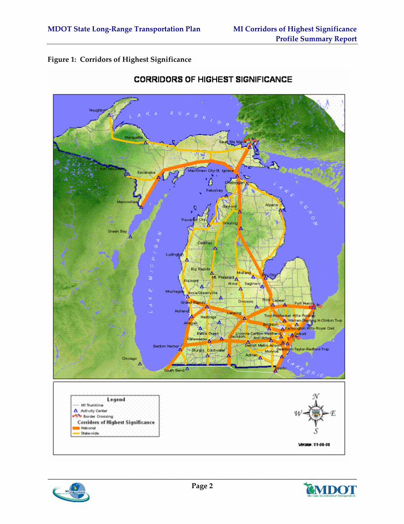
This MI Corridors of Highest Significance Profile Summary Report – Executive Summary I is one of two Executive Summaries to the Corridors and International Borders Report produced for the Michigan Department of Transportation State Long‐Range Plan 2005‐2030, the MI Transportation Plan. It describes the integrated, multi‐modal journey the people and supply chain movements of goods encounter as they move along 19 Corridors of Highest Significance. This report defines in detail each of these 19 corridors illustrated in Figure 1 and summarizes their value to Michigan. It includes an evaluation of the multi‐modal travel conditions and needs on each corridor by identifying opportunities and barriers to movement such as gaps or missing or defective links that hinder economic growth. It describes objectives for each corridor as were discussed in the many public meetings during the development of the MI Transportation Plan. It suggests broad, policy‐based strategies that may take advantage of economic opportunities or address transportation barriers and gaps on the corridors.
This report also provides Michigan Department of Transportation (MDOT) staff, MPO/RPA staff, the public and other interested stakeholders with an overview of the major multi‐modal transportation facilities, connections, opportunities, barriers or transportation gaps, and transportation strategies being implemented within their local area. It also provides agencies and organizations involved in economic development with a single source for information describing major transportation resources and connectivity available in their region.
The decision to conduct a corridor‐based analysis is grounded in the belief that specific corridors serve and support specific economic sectors. By improving specific corridors the businesses and industries dependent on these corridors will be strengthened as will be Michigan’s economic competitiveness. This report has been developed based on MDOT’s recognition that passengers and freight travel along geographic corridors on multiple modes between locations or activity centers both within and outside Michigan. While all travel routes and modes are important to MDOT, certain corridors carry the highest value and volumes of goods, services, and people, and provide a higher level of support for the economy or specific economic sectors of the economy, and Michigan’s overall transportation system. These travel routes and modes are the MI Transportation Plan’s 19 Corridors of Highest Significance described in this report.
MDOT State Long‐Range Transportation Plan MI Corridors of Highest Significance Profile Summary Report
_____________________________________________________________________________________ Page 2
Figure 1: Corridors of Highest Significance
MDOT State Long‐Range Transportation Plan MI Corridors of Highest Significance Profile Summary Report
_____________________________________________________________________________________ Page 3
1.1 Overview of this Report For each of the MI Transportation Plan 19 Corridors of Highest Significance, this report presents the following:
• Profile and map; • Discussion of corridor value; • Analysis, identifying conditions that provide: _ Opportunities; or _ Barriers to movement, including missing or deficient links and existing and future
physical transportation system gaps; • Corridor objectives; and • Broad, policy‐based corridor strategies that may help to advance the corridor‐specific
objectives.
1.2 Data Sources The numbers presented in each corridor profile are corridor‐specific. Because corridors cross each other and share activity centers, corridor values and conditions described cannot be simply added to create a statewide total. To a certain degree, many values are double counted or attributed to more than a single corridor. Because the corridors are multi‐modal, and not limited to the highways, their service areas are defined as including the population and employment within a 20‐mile geographic area around the corridor. Adding the numbers from all 19 corridors will produce a number higher than the statewide total.
The population and employment percentages reported in the corridor value sections are based on the population within the 20‐mile geographic area around the corridor as presented on, for example, Table 1 and Table 5. Activity center summary tables, such as Table 5, present population and employment within the Traffic Analysis Zones (TAZ) in the activity center area, and are not the same as a city’s population.
The conditions, objectives, and strategies presented in this chapter provide an overview of the multi‐modal character of the corridors. The profiles and strategies presented in this chapter are not intended to restate in detail all the information presented in the 17 MI Transportation Plan technical reports. Specific information, objectives and strategies on rail, air, public transit, highways, and other issues can be found in these technical reports.
A variety of data sources were used to complete this report. Population and traffic data and activity center data used in this chapter was provided by MDOT Statewide and Urban Travel Analysis Section (SUTA). Truck and rail freight information was based on the 2003 Transearch database from Global Insight, Inc. Waterborne freight is based on data supplied by the US Army Corps of Engineers, local agencies, and marine terminals. Airports statistics were compiled by MDOT from reports completed by individual airports. The source for information on modal facilities came from the various technical reports produced for MI Transportation Plan. Data presented for MI Transportation Plan activity centers and Corridors of Highest Significance
MDOT State Long‐Range Transportation Plan MI Corridors of Highest Significance Profile Summary Report
_____________________________________________________________________________________ Page 4
are based on Transportation Analysis Zones (TAZ) used by MDOT for their transportation modeling activities. Detailed maps, data, modal facilities, and other characteristics for each MI Transportation Plan activity center within each corridor are provided in Appendix C to the Corridors and International Borders Report.
To calculate statistics for each Corridor of Highest Significance, the Statewide and Urban Travel Analysis section at MDOT used the primary highway that connects all activity centers within each corridor. Using GIS tools, 10‐mile buffer zones were established around each side of these highways, creating 20‐mile wide zones running the length of each corridor. Statistics for the population and employment within each of these zones could then be calculated. Also, using the main highway for each corridor, daily traffic and amount of truck freight were calculated using travel demand modeling and the 2005 MDOT sufficiency database. The rail freight data were compiled using a rail network that does not mirror the highway network. Because the rail lines between activity centers quite often lie outside the buffered corridor zones of the highways, they were selected for each corridor based on their proximity and activity centers used.
Truck and rail freight tonnage and value movements came from the 2003 Transearch database from Global Insight, Inc for years 2003 and 2013 forecast. The database contained movements of freight for Michigan counties to and from other states and Canada, Michigan counties to and from other Michigan counties, and through movements between other states and between Canada and other states. For truck movements, Transearch included entry and exit points for out‐of‐state and through movements. The movements were then assigned to the statewide truck network in eight steps (all were “All or Nothing” assignments):
1. Michigan county origin to Michigan county destination and any outstate trips with no route indicated;
2. Outstate to Michigan ‐ outstate origin to Michigan entry point;
3. Outstate to Michigan ‐ Michigan entry point to Michigan destination;
4. Michigan to outstate ‐ Michigan origin to Michigan exit point;
5. Michigan to outstate ‐ Michigan exit point to outstate destination;
6. Through trip ‐ outstate origin to Michigan entry point;
7. Through trip ‐ Michigan entry point to Michigan exit point;
8. Through trip ‐ Michigan exit point to outstate destination.
These eight assignments on network links were summed to obtain the total tonnage assignment for each link.
For rail movements, the Transearch database included a route number for the Michigan portion of nearly all trips. A route table included the ID numbers of all links on each route. Therefore, for the Michigan portion of rail movements, all tonnages could be assigned to the proper rail network link. A few of the movements included routes that were not in the route table, and the
MDOT State Long‐Range Transportation Plan MI Corridors of Highest Significance Profile Summary Report
_____________________________________________________________________________________ Page 5
outstate portion of any outstate or through trips were assigned separately using the same method described above for the truck assignments.
Value per ton numbers were also supplied by Global Insight at a 4‐digit STCC level. These values per ton were multiplied to the tonnage movements by the 4‐digit commodity. The total values for each movement were then assigned for truck and rail using the same processes as the tonnages.
For rail tonnage and value, some corridors had multiple rail lines so their track miles may be much greater than the highway miles for trucks. A few corridors do not have specific rail line corridors within them. For each corridor, totals were derived for miles (highway or track), total ton miles, low tonnage or value on the corridor, high tonnage or value on the corridor, and the average tons and value per mile on the corridor.
For highways, in addition to the total daily vehicle‐miles of travel (VMT), the high, low, and average values of average daily traffic (ADT) were determined for each corridor, for both passenger and commercial traffic. Estimates for 2030 were calculated using growth rates from the MDOT Statewide travel demand model, applied to the 2005 base year sufficiency file data.
Chapter 2. Basis for Broad-based Policy Strategies Contained within the Corridor Profiles
The recommendations contained within this transportation plan will be achieved by developing and advancing a set of strategies, policies, programs, activities, and projects that achieve the preferred vision of MI Transportation Plan. The corridor element of this plan and the associated strategies support the overall planning goals and vision established for the statewide transportation system while addressing and being sensitive to the unique and specific needs and objectives, opportunities, barriers or limitations of the corridor, region, or sub‐area.
Specific corridor policy‐based recommendations have been developed for each National/International and Statewide Corridor of Significance. These recommended strategies reflect each corridor’s unique character, performance‐based needs, and objectives (as articulated during the public participation processes and “Attitudes and Perceptions of Transportation in Michigan: A Survey of Michigan Adults,” March 2006 conducted for MI Transportation Plan). The recommended corridor strategies also take into consideration the unique character, opportunities, barriers or limitation of each corridor.
Each of these corridor‐specific strategies was developed from the following alphabetical listing of strategy groups. The strategy groups selected and presented are consistent with the goals, vision, objectives, and other input from Michigan stakeholders, and are applicable to Michigan’s Corridors of Highest Significance. Appendix D to the Corridors and International Borders Report presents and describes the strategy groups and their respective policies, activities, projects, and programs.
MDOT State Long‐Range Transportation Plan MI Corridors of Highest Significance Profile Summary Report
_____________________________________________________________________________________ Page 6
A. Access Management Strategy Group
Capital projects and policies that reduce or eliminate roadway access points, driveways or at‐grade intersections; intended to improve safety, reduce congestion, and improve traffic mobility by removing conflict points.
B. Asset Management Strategy Group
Policies, programs, and activities that address a strategic approach to managing and preserving assets including transportation infrastructure and resources (such as staff and equipment) through fact‐based investment decisions and focused management programs. Policy driven approach focused on getting the best results or performance for the preservation, improvement, and operation of infrastructure assets given the resources available.
C. Congestion Pricing Strategy Group
Programs, policies, legislation, and administrative or management changes that reduce demand during times of day with the highest congestion by charging fees to use designated transportation facilities during the hours of heaviest congestion (see also TDM Strategies).
D. Enhancement Programs Strategy Group
Policies, programs, and activities that add unique, desired features or designs to new or existing facilities and can be advanced through a Context Sensitive Solutions approach.
E. Highway and Bridge Strategy Group
Highway and bridge strategies are broken out and described in eight sub‐categories:
1. Pavement Surface – Service life
Policies, programs and project that measure and maintain an agreed upon, standardized pavement riding surface through resurfacing or rehabilitating roadways and bridge surfaces.
2. Rehabilitation and Reconstruction
Policies, programs and projects to rehabilitate or reconstruct a capital facility with a similar facility.
3. Safety Strategy Group
This strategy includes policies, programs and projects that will reduce the number and rate of crashes and fatalities. As part of an overall focus on safety, Michigan has developed, The Strategic Highway Safety Plan, which identifies the key safety needs in the state and guide investment decisions to achieve significant reductions in highway fatalities and serious injuries on all public roads. The Strategic Highway Safety Plan is implemented through MDOTʹs Safety Improvement Program Section 6.7.5 as Safety: Integrating safety into Michigan’s long‐range planning entails
MDOT State Long‐Range Transportation Plan MI Corridors of Highest Significance Profile Summary Report
_____________________________________________________________________________________ Page 7
identifying in greater detail those situations where improvements to highway, bicycle/pedestrian, freight and transit oriented projects may provide the opportunity to offer safer access to key activities.
4. Capacity Additions and New Facilities Strategy Group
Policies, programs, and capital improvement projects to add capacity, improve roadway design or geometrics, or in other ways make improvements to a roadways or bridges to handle more traffic.
5. Maintenance – Capital Preventive
Policies, programs and capital improvement projects to repair roadway and bridge infrastructure, repair and replacement of signs, markings and signals with similar or in‐kind facilities prior to their deterioration to extend their useful life and to avoid the need replace or rebuild.
6. Maintenance – Scheduled
Policies, programs and capital improvement projects to repair, resurface, or replace roadway and bridge infrastructure with similar or in‐kind facilities at regularly scheduled intervals; also includes programs and activities to remove snow, ice, and other debris from the infrastructure and adjoining rights‐of‐way; and, repair and replacement of signs, markings and signals.
7. Modernization and Rebuild Strategy Group
Programs and projects to improve roadway design or geometrics or in other ways modernize a roadway or bridge.
8. Operational Improvements
(See M for multi‐modal based operational strategies)
F. Intelligent Transportation Systems (ITS) and Incident Management Strategy Group
Facilities, services, and technological enhancements to existing roadways to improve mobility and safety (Note: ITS addresses both re‐occurring congestion such as that caused by daily rush‐hour traffic and incident‐induced congestion such as that caused by crashes).
G. Land Use Planning Strategy Group
Land use or zoning ordinance that allow development patterns conducive to walking, bicycling, and using public transportation, or in some way reducing the need to use an automobile (may also be called sustainable development).
H. Pedestrian and Bicycle Facilities Strategy Group
Development of facilities and support for programs to promote activities such as, but not limited to, walking, bicycling, small‐wheeled transport (skates, skateboards, push

MDOT State Long‐Range Transportation Plan MI Corridors of Highest Significance Profile Summary Report
_____________________________________________________________________________________ Page 8
scooters and handcarts) and wheelchair travel. The facilities in this strategy group would be designed and intended as facilities that link, for example, homes to schools, shopping, work, and other destinations, as an alternative or replacement for travel by vehicle. (This does not refer to recreational facilities).
I. Ports ‐‐ Water and Airports Strategy Group
Capital projects, operational and management improvements and expansion of water port and airport facilities and services.
J. Public Transit Strategy Group – Bus and Rail
Capital projects, operational and management improvements and expansion of public transit facilities and services.
K. Railroad Strategy Group
Capital projects, operational and management improvements and expansion of railroad facilities and services.
L. Transportation Demand Management (TDM) Strategy Group
Programs, policies and administrative or management changes that reducing demand on roadways by promoting or encouraging activities such as ridesharing, and employer incentives to discourage driving single occupancy vehicles during peak periods and result in more efficient use of existing resources.
M. Traffic Operational Improvements/Transportation Systems Management (TSM)/Transportation System Management and Operations (TSMO) Strategy Group
Capital projects, policies and system operational changes that result in more efficient use of existing transportation resources by making improvements or changes to signs, signals, markings, incident management, speed, access, etc. This strategy incorporates other groups listed, including Access Management, Congestion Pricing, ITS, and Modernization.
Chapter 3. Corridor Profiles, Analyses, and Strategies
This chapter provides a detailed profile, estimation of a corridor’s economic value, objectives and broad‐based strategies that may help to advance these corridor‐specific objectives. The corridor profiles are listed in the following order:
MI Transportation Plan Corridors of National/International Significance These 11 multi‐modal corridors and the 20‐mile geographic area around these corridors serve and provide access to 72 percent of Michigan’s population and 83 percent of the Michigan’s employment. The corridors include:
MDOT State Long‐Range Transportation Plan MI Corridors of Highest Significance Profile Summary Report
_____________________________________________________________________________________ Page 9
A Mackinaw City–St. Ignace/Wisconsin
B Sault Ste. Marie / Bay City
C Bay City–Midland–Saginaw/Flint/Detroit
D Muskegon/Grand Rapids/Lansing/Detroit
E Detroit/Chicago
F Grand Rapids/Chicago
G Port Huron/Detroit/Toledo
H Port Huron/Lansing/Indianapolis
J Port Huron/Chicago
K I‐696
L I‐275
MI Transportation Plan Corridors of Statewide Significance
When combined with the Corridors of National/International Significance, these eight multi‐modal Corridors of Statewide Significance and the 20‐mile geographic area around them serve 92.8 percent of Michigan’s population and 95.1 percent of Michigan’s employment base.
M Houghton/Marquette/Sault Ste. Marie
N Petoskey/Grand Rapids/Indiana
P Mackinaw City–St. Ignace/Holland
Q Benton Harbor/Indiana
R Flint/Toledo
S Mackinaw City–St. Ignace /Alpena/Standish
T Grayling/Jackson
U Jackson/Toledo
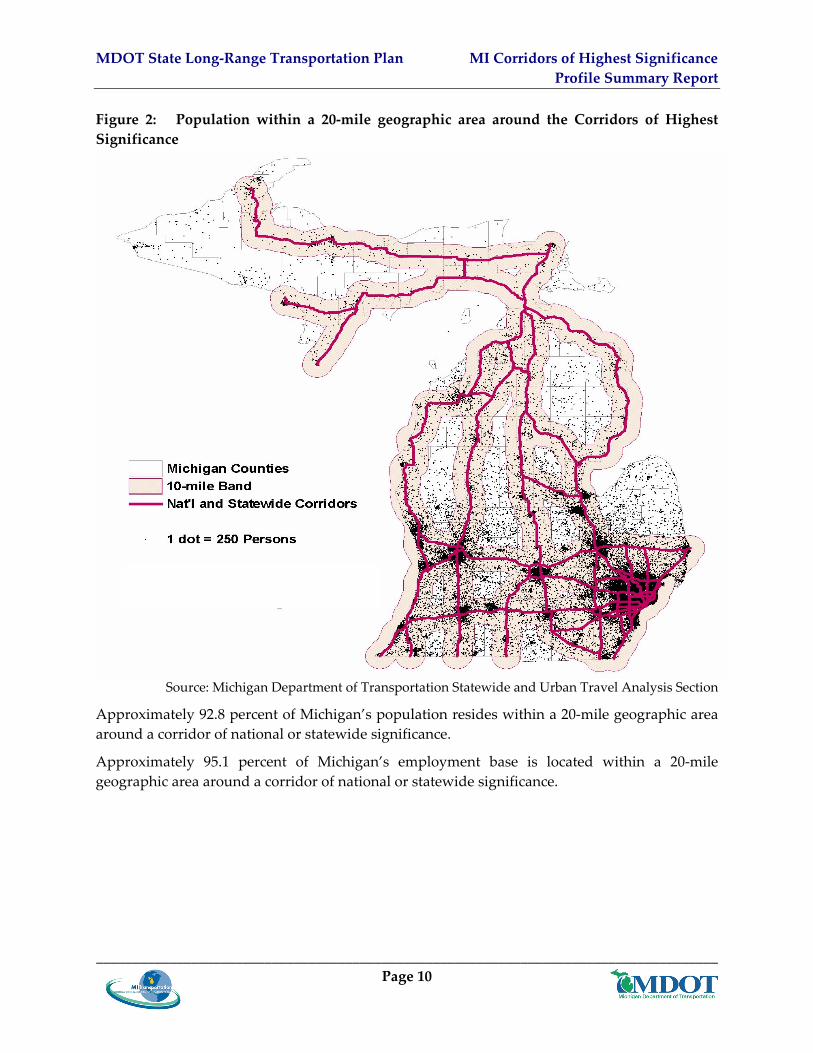
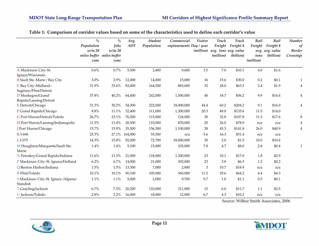
Figure 2 presents a map showing the population within the 20‐mile wide geographic areas associated with the Corridors of Highest Significance. Table 1 presents a comparison of corridor values based on some of the characteristics used to define each corridor’s value.
MDOT State Long‐Range Transportation Plan MI Corridors of Highest Significance Profile Summary Report
_____________________________________________________________________________________ Page 10
Figure 2: Population within a 20‐mile geographic area around the Corridors of Highest Significance
Source: Michigan Department of Transportation Statewide and Urban Travel Analysis Section
Approximately 92.8 percent of Michigan’s population resides within a 20‐mile geographic area around a corridor of national or statewide significance.
Approximately 95.1 percent of Michigan’s employment base is located within a 20‐mile geographic area around a corridor of national or statewide significance.
MDOT State Long‐Range Transportation Plan MI Corridors of Highest Significance Profile Summary Report
_____________________________________________________________________________________________________________________ Page 11
Table 1: Comparison of corridor values based on some of the characteristics used to define each corridor’s value
Source: Wilbur Smith Associates, 2006
% Population
w/in 20 miles buffer
zone
% Jobs
w/in 20 miles buffer
zone
Avg. ADT
Student Population
Commercial enplanements
Visitor Day / year (million)
Truck Freight
avg. tons (million)
Truck Freight $ avg. value (billion)
Rail Freightavg. tons
(million)
Rail Freight $ avg. value (billion)
Number of
Border Crossings
A Mackinaw City–St. Ignace/Wisconsin
0.6% 0.7% 5,500 2,400 9,600 3.5 7.0 $10.1 4.0 $1.6
B Sault Ste. Marie / Bay City 3.0% 2.9% 12,000 14,000 15,000 16 15.6 $30.0 0.2 $0.1 1 C Bay City–Midland–Saginaw/Flint/Detroit
31.9% 33.6% 83,000 164,500 883,000 32 28.0 $63.5 2.4 $1.9 4
D Muskegon/Grand Rapids/Lansing/Detroit
37.8% 40.2% 64,400 242,000 1,500,000 40 18.7 $56.2 9.9 $14.4 4
E Detroit/Chicago 31.3% 30.2% 54,300 222,000 18,000,000 44.4 60.2 $204.2 9.1 $16.0 4 F Grand Rapids/Chicago 8.8% 11.1% 32,400 111,000 1,300,000 20.3 49.0 $135.6 11.5 $14.0 G Port Huron/Detroit/Toledo 26.7% 23.1% 76,200 115,000 124,000 30 32.8 $107.8 11.3 $17.6 8 H Port Huron/Lansing/Indianapolis 11.5% 11.4% 28,500 110,000 870,000 20 26.0 $78.9 n/a n/a 4 J Port Huron/Chicago 15.7% 15.9% 35,500 156,500 1,100,000 28 45.3 $141.8 26.0 $40.9 4 K I‐696 25.3% 27.1% 164,000 55,500 n/a 5.6 16.3 $51.4 n/a n/a L I‐275 14.3% 15.8% 92,000 72,700 18,000,000 29 2.0 $1.5 10.0 $10.4 M Houghton/Marquette/Sault Ste. Marie
1.4% 1.4% 5,100 15,000 103,000 7.8 4.7 $8.0 2.8 $0.4 1
N Petoskey/Grand Rapids/Indiana 11.6% 13.3% 21,000 118,000 1,300,000 23 10.1 $17.0 1.8 $2.9 P Mackinaw City–St. Ignace/Holland 6.2% 6.7% 14,000 21,000 303,000 23 3.8 $6.5 1.2 $0.2 Q Benton Harbor/Indiana 1.5% 1.5% 13,300 7,000 2,800 3 10.7 $18.9 n/a n/a R Flint/Toledo 10.1% 10.1% 50,100 105,000 560,000 11.2 29.6 $64.2 4.4 $4.3 S Mackinaw City–St. Ignace /Alpena/ Standish
1.1% 1.1% 5,000 2,000 9,700 9.7 1.0 $1.1 0.5 $0.1
T Grayling/Jackson 6.7% 7.5% 20,200 110,000 311,000 15 6.0 $11.7 1.1 $2.5 U Jackson/Toledo 2.8% 2.2% 16,000 18,000 12,000 6.7 4.3 $10.2 n/a n/a