challenges of fire and floods in human settlements conference 19 – 20 april 2005 gerhard schulze...
TRANSCRIPT
CHALLENGES OF FIRE AND FLOODS IN HUMAN SETTLEMENTS CONFERENCE
19 – 20 APRIL 2005
Gerhard Schulze
Cause, effect and prevention of fire and
flood disasters in human settlement.
Photo’s News24
[PMG note: email [email protected] for picture]
Kofi Annan, SG of the UN8 October 2003
“Natural hazards are a part of life. But hazards only become disaster when people’s lives and livelihood are swept away . . . Let us remind ourselves that we can and must reduce the impact of disasters by building sustainable communities that have long-term capacity to live with the risk”

Secretary-General of WMO22 March 2004
►Nearly 90% of the economic impact of disaster in last ten years was weather and climate related.
►Progress in meteorological and hydrological sciences shows that the impacts of natural hazards can be reduced trough preparedness and mitigation.
► It is imperative to be informed of the risks and options to mitigate the risk.
►3rd Assessment report of the IPCC concluded that it is likely that the duration, location, frequency and intensity of extreme events will change.

Economic impacts of natural disasters
Impact on economies (Munich Re)
0
100
200
300
400
500
600
700
Richest mations Poorest nations
Bil
lio
n U
S $
0
2
4
6
8
10
12
14
Pre
sen
t G
DP
Economic losses Losses as % of GDP

Increases in natural disasters
0
500
1000
1500
2000
2500
3000
1970's 1980's 1990's
No. reported disasters
No. reported killed(thousands)
Damage (US$ billion)

CONCEPTUAL DEFINITION OF RISK:
Vulnerabilities
Hazard Risk
Def
icie
nci
es
in p
rep
ared
nes
s
Disaster

Risk as a process
Time
RIS
K
► Settlement in hazardous area
► Lack of zoning ordinance
► Lack of building codes
► Poverty and increases in poverty
► Occurrence of disasters
► Migration & population increase
Hazard
Disaster
Rel
ief
fun
din
g
Investment

Risk reduction
►Preparedness►Reduce deficiencies
►Mitigation►Reduce vulnerabilities
►Prevention►Hazard reduction
(Early warning systems)
Risk Management

Risk Identification: Hazard analysis
►Improved hazard analysis and hazard mapping are needed as a tool for risk communication among policy makers and communities.
►Hazard maps are essential to prepare evacuation efficiently and to allow authorities to adjust land use and city planning.
What the SA Weather Service can offer
►Hazard monitoring in real time
►Early warnings
►Risk-identification (assessments)
►Climate records
►Expert advice

South Africa - Country ProfileMunich Re


[PMG note: email [email protected] for picture]
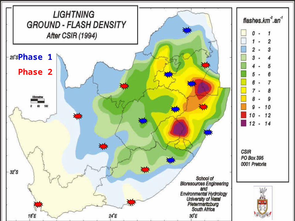
Phase 1
Phase 2


Preparedness and emergency management
►Timely and accurate forecasts and warnings of natural hazards coupled with adequate local preparedness planning are fundamental requirements for disaster reduction
►Optimal response to natural disasters requires effective coordination and cooperation between responsible agencies, institutions, officials, the media, political leaders and other players at local, national and international levels

Monitor precursors
Issue warning
or alert
Will hazard
occur?
Yes
No
Initiate actions according
to emergency plans

Knowledge Management
► Many hazards associated with high-impact weather involve smaller-scale atmospheric phenomena, which exhibit still low predictive skills (e.g., localized heavy precipitation)
► Further improvements in the prediction of high-impact weather and in the full utilization of forecast information
► User education and awareness are essential:► to increase weather literacy and interest in meteorological topics ► to ensure that warnings and forecasts provided by the NMHSs are understood by
the intended users► to build up a high level of awareness of hazards and preparedness► to enable emergency management authorities to make well-informed decisions

ECMWF model scores 1981-2003

Conclusions
►SA Weather Service can provide a more effective service to reduce the consequences of extreme weather events by quantifying the risks and disseminating this information directly to the general public.
► Its profile and the support that it gains from the community can only be strengthened by this sort of process.►But naturally even greater benefits will be gained if we improve
the reliability of our forecasts, particularly for events which still remain difficult to forecast using numerical forecasting models.


Weather Warnings issued► 08/04/2005 08:14 Advisory: Widespread showers expected Sunday
along south coast and adjacent interior with possible heavy falls in places East of Still Bay
► 09/04/2005 07:48 Heavy falls of rain likely in places between Stilbaai and Plettenbergbaai tomorrow (Sunday)
► 10/04/2005 10:59 Heavy falls likely today (Sunday), Overberg, Breede River valley, Ruens, Little Karoo, South Coast persisting in east tomorrow morning Monday.
► 10/04/2005 13:13 Warnings as issued earlier, heavy falls will last longer and improve during tomorrow (Mon) from the west. Please keep communication channels constantly open as in past. Thank you Johan Stander
► 10/04/2005 13:15 Gale force south easterly winds (35knots/65km/h) expected in places Between Table Bay and Cape Agulhas today and Mon Morning

Weather Warnings (cont)
► 10/04/2005 14:09: There seems to be a well developed weather systems to North West of Cape Town. If this moves across we might have substantial falls in Cape Town. Regard this information as an Advisory for Cape Town. Will keep a close eye on this and inform well in advance if significant for CT. JS
► 10/04/2005 15:01 Severe thunderstorms might move across the Peninsula till tonight. Thunderstorms already over areas defined earlier, will keep you informed.
► 11/04/2005 14:23 Heavy falls and gale force winds warnings for the CAPE PENINSULA hereby cancelled.
► 11/04/2005 17:26 While further rain is still expected overnight, warning heavy falls of rain is hereby cancelled, Keith Moir

Storms of 10 & 11 April 2005 News24
► Torrential rain lashed the region on Sunday night, causing millions of Rands damage.
► In Bredasdorp between 600 to 800 houses were damaged, and 3 000 people affected.
► In Mitchells Plain, Bellville, Durbanville and Khayelitsha heavy rains, a strong wind and hailstorms created havoc
► Sixty-one families from the temporary tented accommodation at Joe Slovo informal settlement were "re-housed" at the Langa civic centre
► In the Joe Slovo tented emergency shelter, hundreds of people, already displaced after a fire swept through the informal settlement, were also affected by the downpour.


Climate change

►[PMG note: email [email protected] for picture]