central bedfordshire landscape character …...central bedfordshire landscape character assessment...
TRANSCRIPT

Central Bedfordshire
Landscape Character Assessment
Prepa red b yLUCJ a n u a ry20 1 5

Pl a n n in g & EIADe s ignL a n ds ca pe Pl a n n in gL a n ds ca pe M a n a gem en tEcol ogyM a ppin g & Vis u a l is a tion
LUC LON DON43 Ch a l ton S treetLon don N W 1 1 J DT 0 20 7383 5784F 0 20 7383 4798l on don @ l a n du s e . co. u k
Offices a l s oin :Bris tolG l a s gowEdin b urgh
FS 5660 56
EM S 5660 57
L a n d Us e Con s u l ta n ts LtdRegis tered in En gl a n dRegis tered n um b er:2549296Regis tered Office:43 Ch a l ton S treetLon don N W 1 1 J D
LUC u s e s 1 0 0 % recycl ed pa per
Fron t cov er:Dun s ta b l e Down s
22

Central Bedfordshire Landscape Character
Assessment
Final Report
Prepared by LUC
Ammended following Public Consultation
Central Bedfordshire Council
February 2016
33

44
Contents
Executive Summary 11
1 Introduction 13
Landscape context of Central Bedfordshire 13 Background and drivers for the LCA 13 This Landscape Character Assessment (LCA) 14
2 Physical and human influences on the landscape character of Central Bedfordshire 18 Physical influences 18 Human and cultural influences 23
3 The Landscape Classification of Central Bedfordshire 36
TYPE 1: CLAY FARMLAND 40
1A Character area 1A: Cranfield to Stagsden Clay Farmland 41 Landscape Character Description 43 Evaluation 44 Landscape Strategy 45
1C Cockayne Hatley Clay Farmland 47 Landscape Character Description 48 Evaluation 50 Landscape Strategy 51
TYPE 4: CLAY VALLEYS 52 Key Characteristics 52
4A Great Ouse Clay Valley 53 Landscape Character Description 55 Evaluation 57 Landscape Strategy 58
4B Lower Ivel Clay Valley 60 Landscape Character Description 62 Evaluation 65 Landscape Strategy 66
4C Upper Ivel Clay Valley 68 Landscape Character Description 69 Evaluation 72 Landscape Strategy 72
TYPE 5: CLAY VALES 74
5A Eaton Bray Clay Vale 75 Landscape Character Description 77 Evaluation 80 Landscape Strategy 82
5

5B Barton-Le-Clay Vale 84 Landscape Character Description 86 Evaluation 88 Landscape Strategy 89
5C Salford – Aspley Clay Vale 91 Landscape Character Description 93 Evaluation 95 Landscape Strategy 96
5D North Marston Clay Vale 98 Landscape Character Description 100 Evaluation 102 Landscape Strategy 103
5E East Marston Clay Vale 105 Landscape Character Description 107 Evaluation 108 Landscape Strategy 109
5F Biggin Wood Clay Vale 111 Landscape Character Description 113 Evaluation 115
Landscape Strategy 116
5G Dunton Clay Vale 118 Landscape Character Description 120 Evaluation 122 Landscape Strategy 123
TYPE 6: WOODED GREENSAND RIDGE 124 Key Characteristics 124
6A Woburn Greensand Ridge 125 Landscape Character Description 127 Evaluation 129 Landscape Strategy 130
6B Mid Greensand Ridge 133 Landscape Character Description 135 Evaluation 138 Landscape Strategy 139
6C Everton Heath Greensand Ridge 141 Landscape Character Description 143 Evaluation 145 Landscape Strategy 146
TYPE 7: GREENSAND VALLEY 148 Key Characteristics 148
7A Flit Greensand Valley 149 Landscape Character Description 151 Evaluation 153 Landscape Strategy 154
7B Ouzel Greensand Valley 156 Landscape Character Description 158 Evaluation 160
6
TYPE 8: CLAY HILLS 162 Key Characteristics 162
8A Toddington – Hockcliffe Clay Hills 163 Landscape Character Description 165 Evaluation 167 Landscape Strategy 168
8B Billington Clay Hills 170 Landscape Character 171 Evaluation 173 Landscape Strategy 174
8C Harlington – Pulloxhill Clay Hills 176 Landscape Character Description 178 Evaluation 180 Landscape Strategy 181
8D Upper Gravenhurst – Meppershall Clay Hills 183 Landscape Character Description 185 Evaluation 187 Landscape Strategy 188
TYPE 9: CHALK ESCARPMENTS 189 Key Characteristics 189
9A Dunstable Downs Chalk Escarpment 190 Landscape Character Description 192 Evaluation 194 Landscape Strategy 195
9B Totternhoe Chalk Escarpment 196 Landscape Character Description 198 Evaluation 200 Landscape Strategy 201
9C The Clappers Chalk Escarpment 203 Landscape Character Description 205 Evaluation 207 Landscape Strategy 207
9D Warden Hill – Stopsley Common Chalk Escarpment 209 Landscape Character Description 211 Evaluation 212 Landscape Strategy 213
9E South Dunstable Chalk Escarpment 216 Landscape Character Description 218 Evaluation 220 Landscape Strategy 221
TYPE 10: ROLLING CHALK FARMLAND 223 Key Characteristics 223
10A Totternhoe – Dunstable Downs Rolling Chalk Farmland 224 Landscape Character Description 226 Evaluation 229 Landscape Strategy 230
7

10B Houghton Regis – North Luton Rolling Chalk Farmland 232 Landscape Character Description 234 Evaluation 235 Landscape Strategy 236
10C Barton Hill Rolling Chalk Farmland 239 Landscape Character Description 241 Evaluation 243 Landscape Strategy 244
10D Fairfield Chalk Farmland 245 Landscape Character Description 246 Evaluation 248 Landscape Strategy 249
TYPE 11: CHALK DIPSLOPE 250 Key Characteristics 250
11A Whipsnade Chalk Dipslope 251 Landscape Character Description 253 Evaluation 255 Landscape Strategy 256
11B Caddington – Slip End Chalk Dipslope 259 Landscape Character Description 261 Evaluation 262 Landscape Strategy 263
11C Luton Hoo Chalk Dipslope 265 Landscape Character Description 267 Evaluation 268 Landscape Strategy 269
11D Luton Airport – Chiltern Green Chalk Dipslope 271 Landscape Character Description 273 Evaluation 275 Landscape Strategy 276
TYPE 12: CHALK VALLEYS 278 Key Characteristics 278
12A Gade Chalk Valley 279 Landscape Character Description 281 Evaluation 282 Landscape Strategy 283
12B Ver Chalk Valley 285 Landscape Character Description 287 Evaluation 288 Landscape Strategy 289
12C Slip End Chalk Valley 291 Landscape Character Description 293 Evaluation 295 Landscape Strategy 296
12D Lea Chalk Valley 297 Landscape Character Description 299 Evaluation 301 Landscape Strategy 302
8

Appendix 1: Study Methodology 304 Introduction 304 Stage 1 - Characterisation 304
Stage 2 –Evaluation 307
Figures
Figure 1: Landscape Classification
Figure 2: Landscape Designations
Figure 3: National Character Areas
Figure 4: Topography
Figure 5: Solid Geology
Figure 6: Drift Geology
Figure 7: Hydrology
Figure 8: Nature Conservation Designations
Figure 9: Historic Landscape Characterisation
9

!
!
!
!
!
!
!
!
!
!
!
!
!
!
!
!
!
!
!
11D
12D
10C9C
9E
9C9C
12A
9A
10A
8A
8B
6C
10D
5C
9D
1C
7A
12B
11A
11B
2B
11C12C
5F
5G
8D
10B10C
9B
5B
7B5A
6A6A
7B8A
1A
6A
5D
6B
6B8D
8C
5E
2A
2A
3B
3A3A
4A
4B
4C
1D
1E
CentralBedfordshire
© Crown Copyright and database right 2014. Ordnance Survey 100049029. Central Bedfordshire Council LUC LDN 5877-01_020_CentralBeds_Landscape_Classification_Rev1 10/09/2014
Map Scale @ A4: 1:230,000
Landscape Classification
Source:
Bedford Borough & Central Bedfordshire Landscape Character Areas
Figure 1
0 42 km²
5A: Eaton Bray Clay Vale5B: Barton-le-Clay Clay Vale5C: Salford - Aspley Clay Vale5D: North Marston Clay Vale5E: East Marston Clay Vale5F: Biggin Wood Clay Vale5G: Dunton Clay Vale
6A: Woburn Greensand Ridge6B: Mid Greensand Ridge6C: Everton Heath Greensand Ridge
7A: Flit Greensand Valley7B: Ouzel Greensand Valley
8A: Toddington - Hockliffe Clay Hills8B: Billington Clay Hills8C: Harlington - Pulloxhill Clay Hills8D: Upper Gravenhurst - Meppershall Clay Hills
Central Bedfordshire LCA
1A: Cranfield to Stagsden 1C: Cockayne Hatley Clay Farmland
4A: Great Ouse Clay Valley4B: Lower Ivel Clay Valley4C: Upper Ivel Clay Valley
Central Bedfordshire Unitary Authority
1. Clay Farmland
4. Clay Valleys
5. Clay Vales
6. Wooded Greensand Ridge
7. Greensand Valley
8. Clay Hills
9A: Dunstable Downs Chalk Escarpment9B: Totternhoe Chalk Escarpment9C: The Clappers Chalk Escarpment9D: Warden Hill - Stopsley Common Chalk Escarpment9E: South Dunstable Chalk Escarpment
9. Chalk Escarpments
10A: Totternhoe-Dunstable Downs Rolling Chalk Frmld10B: Houghton Regis-North Luton Rolling Chalk Frmld10C: Barton Hill Rolling Chalk Farmland10D: Fairfield Rolling Chalk Farmland
10. Rolling Chalk Farmland
11A: Whipsnade Chalk Dipslope11B: Caddington - Slip End Chalk Dipslope11C: Luton Hoo Chalk Dipslope11D: Luton Airport - Chiltern Green Chalk Dipslope
11. Chalk Dipslope
12A: Gade Chalk Valley12B: Ver Chalk Valley12C: Slip End Chalk Valley12D: Lea Chalk Valley
12. Chalk Valleys
Bedfordshire County boundary
1010

Central Bedfordshire Landscape Character Assessment January 2015
Executive Summary
1.1 This report contains the Landscape Character Assessment (LCA) of Central Bedfordshire. It is a
revision to the previous LCA for the county of Bedfordshire (2007) after the administrative
boundaries of the county were split into the unitary authority of Central Bedfordshire and the
Bedford Borough. It is accompanied by a separate LCA for Bedford Borough. The LCA covers the
rural landscapes within the unitary authority. The document is supported by a GIS data set.
What is Landscape Character Assessment?
1.2 Landscape Character Assessment (LCA) is an accepted and recognised method for understanding
the landscape. It describes and classifies the recognisable and consistent pattern of elements
that makes one landscape different from another rather than better or worse. Character is what
makes each part of the landscape distinct and gives each area its particular sense of place.
1.3 The landscape character approach considers that all landscapes are valued; the values people
place on their landscape will vary and will reflect the benefits they receive from the landscape or
features within it.
1.4 The LCA of Central Bedfordshire provides a comprehensive landscape evidence base to help
underpin planning and management decisions in the Unitary Authority.
What does this Landscape Character Assessment contain?
1.5 This document provides a seamless assessment with Bedford Borough to the north. It fits within
an overarching assessment of the whole of the County undertaken at a scale of 1:50,000 (2007)
and aims to provide a consistent landscape framework with neighbouring Counties and Districts.
1.6 The assessment has been undertaken in accordance with best practice guidance1. The findings
have been subject to consultation with a wide stakeholder audience, including communities of
interest and communities of place.
1.7 The assessment presents a characterisation of the whole Unitary Authority (see Figure 1:
Landscape Classification). This describes 10 landscape types – each with a relatively
homogeneous character with similar physical and cultural attributes. The landscape types are
subdivided into component landscape character areas. These are discrete geographic areas that
possess the common characteristics described in the landscape type. There are 38 character
areas in Central Bedfordshire, each with a distinct and recognisable local identity. The character
areas form the fundamental unit for this assessment and the basis for a detailed description and
evaluation.
1.8 Each character area sets out the following information:
Description – outlines key characteristics and describes character under the headings of
landscape character, historic landscape, biodiversity and settlement and form.
Evaluation – summarises past and present change and assesses landscape and visual
sensitivities. The evaluation concludes with an overall landscape strategy followed by detailed
guidelines for landscape management and in relation to new development.
Who is this document aimed at?
1.9 The document is aimed at a wide audience. It provides a technical document and evidence base
that can be used to underpin landscape policies in the preparation of the Development Strategy.
This information can be used by both developers and development control officers in helping to
make decisions on the appropriate location, scale and design of new development. It is also
1 Scottish Natural Heritage/Former Countryside Agency, 2002, Landscape Character Assessment Guidance for England and Scotland.
CAX 84/F and subsequent Topic Papers. Guidance amended and updated (consultation draft) by Natural England 2011
1111

Central Bedfordshire Landscape Character Assessment January 2015
available to the public with a general interest in their local landscape and provides a framework
for more detailed studies of landscape character for example through parish plans,
neighbourhood plans or village design statements. The assessment also has wider applications
for example in influencing land management decisions.
How should the Central Bedfordshire Landscape Character Assessment be used?
1.10 The Central Bedfordshire LCA has been undertaken at 1:25,000 scale and therefore provides
character-based information for use at this scale. It aims to provide a strong and robust
evidence base to help ensure future change and development conserve and enhance rather than
erode landscape character. There are a number of considerations governing its use:
It is a strategic study rather than a detailed field by field survey and any detailed decisions
will therefore also need to consider specific local circumstances;
The assessment concentrates on the rural landscapes of Central Bedfordshire and excludes
detailed townscape considerations within the main developed areas;
Character area boundaries usually represent a ‘zone of transition’ and in considering any
change within any one character area it is often useful to consider effects on adjacent areas;
The landscape character assessment takes an integrated approach, however landscape is only
one resource to be considered alongside other cultural and environmental factors.
1212

Central Bedfordshire Landscape Character Assessment January 2015
1 Introduction
Landscape context of Central Bedfordshire
1.1 Central Bedfordshire stretches across the centre and south of the ceremonial county of
Bedfordshire, with Bedford Borough to the north. Central Bedfordshire has an area of 716 km2
and a population of 260,0002. It is bordered to the west by Milton Keynes and Aylesbury Vale, to
the south by Dacorum and to the east by Luton, North Hertfordshire and South Cambridgeshire.
The location and context of the study area are illustrated on Figure 2. Central Bedfordshire is
classified as predominantly rural, containing countryside, villages and small to medium sized
towns including Leighton Buzzard and Dunstable.
1.2 Central Bedfordshire has a varied and distinct landscape, informed by the underlying geology of
clay, chalk and greensand. The distinctive chalk escarpment of the Chilterns Area of Outstanding
Natural Beauty covers an area to the south east of Dunstable and north of Luton in the south of
the area, and the southern half of the Marston Vale Community Forest lies to the north of Central
Bedfordshire (see Figure 2: Landscape Designations.)
1.3 Natural England3 identifies four National Character Areas (NCAs) within Central Bedfordshire.
These are illustrated in Figure 3. A sector to the south and east is covered by NCA 110:
Chilterns, with NCA 90: Bedfordshire Greensand Ridge extending diagonally/ centrally from the
south west to the north east. The extensive band of clayland - NCA 88: The Bedfordshire and
Cambridgeshire Claylands extends to the north and south of the greensand and a pocket of NCA
87: East Anglian Chalk occurs in the east. The variety in character is reflected by landscapes that
range from intimate wooded hills, to open arable vales to chalk scarps.
Background and drivers for the LCA
National Planning Policy Framework
1.4 The National Planning Policy Framework (NPPF) sets out the following in relation to landscape
character. At paragraph 109, it notes that
The planning system should contribute to and enhance the natural and local environment by:
protecting and enhancing valued landscapes, geological conservation interests and soils;
1.5 Furthermore at paragraph 113, it states that:
Local planning authorities should set criteria based policies against which proposals for any
development on or affecting protected wildlife or geodiversity sites or landscape areas will be
judged.
1.6 And at para 170:
Where appropriate, landscape character assessments should also be prepared, integrated with
assessment of historic landscape character, and for areas where there are major expansion
options assessments of landscape sensitivity.
2 Central Bedfordshire Key Facts and Figures, October 2013
3 http://www.naturalengland.org.uk/publications/nca/eastofengland.aspx
1313

Central Bedfordshire Landscape Character Assessment January 2015
Central Bedfordshire’s Local Plan
1.7 Central Bedfordshire Council is a unitary authority that is comprised of two legacy district councils
(Mid Bedfordshire and South Bedfordshire) and the functions of the former County Council. Two
adopted development plans for the north and south of the authority area remain in place until a
plan for the whole of Central Bedfordshire can be sufficiently progressed.
1.8 Central Bedfordshire is subject to pressure for growth particularly the areas close to urban
conurbations outside of the Unitary Authority such as Luton and Milton Keynes. Strategic sites
either committed or allocated for new development include: north of Houghton Regis, north of
Luton, east of Leighton Linslade, Sundon Rail Freight Interchange, land northeast of Flitwick, land
south east of Wixams and land at Stratton Farm Biggleswade. There is also planned growth for
major service centres including Biggleswade, Sandy, Ampthill, Flitwick and the Wixams.
1.9 When resources allow, these planned areas of growth will be illustrated on the Landscape
Character Area Maps, together with other areas of growth, in order to update the base maps.
Whilst the principles of the guidance given can be used to help inform sympathetic design,
including a response to the sense of place, it is accepted that the planned extensions will
introduce urban character to areas currently described with rural characteristics.
Green Infrastructure Initiatives in Central Bedfordshire
1.10 Initiatives influencing positive change within the landscape include the Forest of Marston Vale,
and management undertaken by organisations such as the Greensand Trust and The Wildlife
Trust .The Local Nature Partnership, of which Central Bedfordshire Council is a member, has
produced strategic and more detailed Green Infrastructure (GI) plans, identifying existing green
infrastructure assets whilst locating opportunities to create a wider network4. The network
identifies the best areas for biodiversity and landscape and opportunity areas for enhancement of
the resource, enabling priorities to be set regarding future expansion and connectivity. Good
landscape planning and management is a key way to deliver green infrastructure.
1.11 The Forest of Marston Vale is one of only 12 Community Forests in England, each designated by
Government as national priority areas for the environmentally-led regeneration of degraded and
industrially scarred landscapes. The core objective for all Community Forests is to radically
transform these degraded landscapes using trees and woodlands to create a new landscape with
30% tree cover by 2030. This being the catalyst for wider social and economic regeneration of
these areas. These new woodlands , hedgerows and other habitats have strengthened the
landscape pattern within the Vale ; the Bedford River Valley Park lies just to the north of the
Unitary Area.
This Landscape Character Assessment (LCA)
1.12 This study provides an opportunity to explore the landscape issues faced by Central Bedfordshire
through a process of identifying, describing and evaluating the character and condition of the
landscape, and providing management guidance.
1.13 The results from the study will present the opportunity to direct spatial planning policy and assist
in the development management decision making process; helping Central Bedfordshire to
determine the future of its landscape allowing its prosperity to continue, whilst ensuring the
conservation of key elements of local character.
1.14 The following points should also be noted:
The study is a strategic study rather than a detailed field by field survey and any detailed
decisions will therefore also need to consider specific local circumstances;
4 http://www.bedsandlutongreeninfrastructure.org/plans/index.html - Bedfordshire and Luton Green Infrastructure Consortium, Bedfordshire Strategic GI Plan, Mid Bedfordshire GI Plan, Luton & Southern Bedfordshire GI Plan
1414

Central Bedfordshire Landscape Character Assessment January 2015
The assessment concentrates on the rural landscapes of Central Bedfordshire and excludes
detailed townscape considerations within the main developed areas;
Character area boundaries usually represent a ‘zone of transition’ and in considering any
change within any one character area it is often useful to consider effects on adjacent areas;
The landscape character assessment takes an integrated approach, however landscape is only
one resource to be considered alongside other cultural and environmental factors.
This revision no longer includes an overall sensitivity judgement for landscape character or
visual sensitivity but identifies the key features and attributes which contribute to character
and sense of place and which could be vulnerable to change.
1.15 This document incorporates comments made by the community during three consulation
events held to inform the former District studies. These findings are contained in Appendix 2.
1515

CentralBedfordshire
© Crown Copyright and database right 2014. Ordnance Survey 100049029. Central Bedfordshire Council LUC LDN 5877-01_004_CentralBeds_Landscape_designations_Rev2 10/09/2014
Map Scale @ A4: 1:250,000
Landscape Designations
Source: Forestry Comission, Natural England
Bedford Borough & Central Bedfordshire Landscape Character AreasBedfordshire County boundary
Figure 2
0 42 km²
© Crown copyright and database right 2013 Ordnance Survey 100021242
Forest of Marston ValeChilterns Area of Outstanding Natural Beauty
Central Bedfordshire Unitary Authority
Service Layer Credits: Sources: Esri, DeLorme, NAVTEQ, TomTom, Intermap, iPC, USGS, FAO, NPS, NRCAN, GeoBase, IGN,Kadaster NL, Ordnance Survey, Esri Japan, METI, Esri China (Hong Kong), and the GIS User Community
Location
1616

CentralBedfordshire
1 1 0:
CH
IL
TE
RN
S
1 1 1:
NO
RT
HE
RN
T HA
ME
SB
AS
IN
87
:E
AS
TA
NG
LI
AN
CH
AL
K
88
:B
ED
FO
RD
S HI R E
A N D
CA
MB
RI
DG
ES
HI R
EC L A Y L A N D S
9 0 :B
ED
FO
RD
S
HI
RE
G R E EN
SA
ND
RI
DG
E
Reproduced from Ordnance Survey digital m ap data © Crow n copyright 2014. All rights reserved. Licence num bers 100047514, 0100031673.LU C LDN 5877-01_006_CentralBeds_NatCharacterAreas_Rev2 10/09/2014
Map Scale @ A4: 1:230,000
National Character Areasand Landscape Typology
Source: Natural England, Landscape East.
Bedford Borough & Central Bedfordshire Landscape Character Areas
Figure 3
0 42 km²Wooded Sandstone HillsWooded Plateau Farm landsWooded Village Farm landsPlateau Estate Farm lands
● ● ● ●
● ● ● ●
● ● ● ●
Low land Village Farm lands● ● ● ● ●● ● ● ● ●● ● ● ● ●
● ● ● ● ●● ● ● ● ●● ● ● ● ●
Low land Settled Farm landsWooded Hills and RidgesValley Meadow lands
● ● ● ●
● ● ● ●
● ● ● ●
Planned Peat FenU rban
Regional Landscape Typology for the East of England (Source: Landscape East, 2010)
Bedfordshire County boundary
National Character Areas
Chalk Hills and ScarpsWooded Chalk Valleys
● ● ● ● ●● ● ● ● ●● ● ● ● ●
● ● ● ● ●● ● ● ● ●● ● ● ● ●
Settled Chalk Valleys
● ● ● ●
● ● ● ● Low land Village Chalk lands
● ● ● ●
● ● ● ●
● ● ● ● Lim estone Village Farm lands
Central Bedfordshire U nitary Authority
1717

Central Bedfordshire Landscape Character Assessment January 2015
2 Physical and human influences on the
landscape character of Central Bedfordshire
Physical influences
2.1 The physical components of the landscape have a tangible and fundamental influence upon its
character, being the most permanent and least changeable aspect of its appearance. The
underlying geology creates the ‘backbone’ of the landscape. The actions of weathering, erosion
and deposition alter the landform, consequently influencing hydrological patterns and affecting
the nature of soil conditions. This affects how humans have used and continue to exploit the
landscape for agriculture, settlement and industry and, consequently, influences the nature of the
vegetation and fauna that the landscape can support.
Solid geology and landform
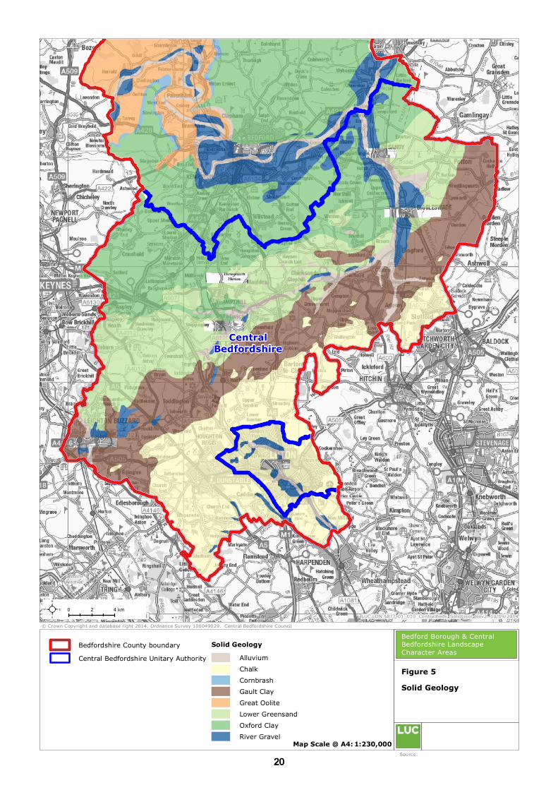
2.2 The geology of Central Bedfordshire follows a simple pattern with the geological strata generally
running diagonally from south-west to north-east, dipping in a south-easterly direction. The
variety of geological formations in the area creates a varied landscape character ranging from the
chalk of the Chiltern Hills which forms a distinct landform of scarp, plateau and dip slope in the
south, contrasting with the low lying clay vales and hills and the distinctive Greensand ridge
which runs across the northern part of Central Bedfordshire. The main types of rocks found
within the area are chalk, gault clay, greensand and Oxford clay. Figure 4 illustrates the varied topography of Central Bedfordshire.
2.3 The underlying rock strata, as illustrated in Figure 5, were laid down under maritime conditions
between 160 million and 70 million years ago. At this time the area was completely covered by
the sea resulting in a range of geological deposits. Geological events that followed these
maritime conditions resulted in drift geological deposits and these define the upper strata in
many places.
Drift geology
2.4 The consistent nature of the clay plateau landscape found to the north (within Bedford Borough)
and south of the River Great Ouse valley, and east and west of the Ivel valley in the east, is
varied by the overlying boulder clay drift (Figure 6). Boulder clay is not generally found on the
valley sides, having been eroded and transported away by the rivers. The former extent and
influence of the Great Ouse and Ivel can be seen in the resultant valley landform, and also in the
alluvial drift deposits. The alluvium deposits have a significant impact upon the landscape,
creating some of the most agriculturally-rich land within the county. The soil is a Brown Earth
which supports a wide range of cereal crops and grasses. Pebbles eroded from the Jurassic Oolite
limestone strata dominate the River Great Ouse gravels.
Hydrology
2.5 There are four main rivers within Central Bedfordshire, illustrated in Figure 7 – these are the
River Great Ouse (which follows the northernmost boundary of Central Bedfordshire with Bedford
Borough) and its tributaries of the River Ivel and the River Flit, and the River Ouzel which flows
through Leighton Buzzard and cuts the Greensand Ridge. The rivers are joined by numerous
small watercourses which thread across the vales and through the greensand and clay hills and a
number of seasonally wet valleys, including the headwaters of the Gade and the Ver. The Lea
Valley breaches the chalk escarpment and contains a permanent watercourse. The chalk is an
important aquifer and gives rise to a number of springs where the permeable chalk meets the
impermeable clay, which forms minor watercourses crossing the vale. The rivers have a varied
form ranging from the relatively narrow incised valley of the Flit to the wider flat floodplain of the
Ivel and Great Ouse, which has been subject to gravel extraction.
1818

CentralBedfordshire
© Crown Copyright and database right 2014. Ordnance Survey 100049029. Central Bedfordshire Council LUC LDN 5877-01_008_CentralBeds_Topography_Rev2 10/09/2014
Map Scale @ A4: 1:230,000
Topography
Source: Natural England
Bedford Borough & Central Bedfordshire Landscape Character Areas
Figure 4
0 42 km²Elevation (m)
234 - 263205 - 234176 - 205147 - 176118 - 14789 - 11860 - 8931 - 602 - 31
Central Bedfordshire Unitary AuthorityBedfordshire County boundary
1919
CentralBedfordshire
© Crown Copyright and database right 2014. Ordnance Survey 100049029. Central Bedfordshire Council LUC LDN 5877-01_010_CentralBeds_SolidGeol_Rev2 10/09/2014
Map Scale @ A4: 1:230,000
Solid Geology
Source:
Bedford Borough & Central Bedfordshire Landscape Character Areas
Bedfordshire County boundary
Figure 5
0 42 km²Solid Geology
AlluviumChalkCornbrashGault ClayGreat OoliteLower GreensandOxford ClayRiver Gravel
Central Bedfordshire Unitary Authority
2020

CentralBedfordshire
© Crown Copyright and database right 2014. Ordnance Survey 100049029. Central Bedfordshire Council LUC LDN 5877-01_012_CentralBeds_DriftGeol_Rev2 11/09/2014
Map Scale @ A4: 1:230,000
Drift Geology
Source:
Bedford Borough & Central Bedfordshire Landscape Character Areas
Bedfordshire County boundary
Figure 6
0 42 km²
River Great OuseDrift Geology
AlluviumBoulder ClayGlacial GravelRiver Gravel
Central Bedfordshire Unitary Authority
2121

Rive r
Beane
Grand UnionCanal
Riv
erHiz
RiverGreat Ouse
RiverOuzel o r Lovat
RiverIvel
River IvelRiverOuzelor Lovat
R iver Flit
River Lea or Lee
River
Rhee
RiverIvel
Grand Union Canal
RiverVer
RiverOuzel
RiverThame
River Leaor Lee
CentralBedfordshire
© Crown Copyright and database right 2014. Ordnance Survey 100049029. Central Bedfordshire Council LUC LDN 5877-01_014_CentralBeds_Hydrology_Rev2 11/09/2014
Map Scale @ A4: 1:230,000
Hydrology
Source:
Bedford Borough & Central Bedfordshire Landscape Character Areas
Bedfordshire County boundary
Figure 7
0 42 km²
RiversLakeFlood risk
Central Bedfordshire Unitary Authority
2222

Central Bedfordshire Landscape Character Assessment January 2015
2.6 The River Ivel rises near Hitchin in the neighbouring county of Hertfordshire following north
across greensand, chalk and Gault Clays to meet the Great Ouse east of Bedford. Before meeting
the River Great Ouse, it is met at Langford by the River Flit which is the smallest of the rivers in
Bedfordshire, arises from chalk springs near Chalton. The River Flit has been extensively
canalised between Shefford and Langford.
Human and cultural influences
2.7 The following section presents an outline of the historic environment of Bedfordshire County,
covering both Central Bedfordshire and Bedford Borough. It provides a chronological sequence
and indicates how historic processes have informed the present day landscape. It contains
relevant information for each of the two planning authority areas in the ceremonial county.
2.8 Figure 9 shows the Historic Landscape Characterisation of Bedfordshire which has provided a
vital layer of information for the landscape characterisation.
2.9 The most dominant aspects of Bedfordshire’s modern landscape – the transport corridors, the
Marston Vale brickfields, and areas of large arable fields – owe their character to processes
operating over the last century and a half. However, the underlying framework of the landscape
has been shaped by millennia of human activity. This section summarises the history of
Bedfordshire’s landscape and the main factors which have influenced its development.
The early pre historic landscape
2.10 At the end of the last Ice Age (from about 8000 BC), the improving climate allowed recolonisation
by woodland species – initially juniper, birch, pine and hazel, followed by oak, elm, lime and
alder. The extensive woodland cover supported a small mobile human population, preferring
mostly riverside areas where a variety of resources from the watercourse and adjacent woodland
could be exploited. Settlement evidence is elusive, but concentrations of Mesolithic finds in such
areas as the Biddenham Loop suggest that the hunter-gatherers regularly returned to favoured
locations on a seasonal basis.
2.11 This level of human activity may have had a localised and temporary effect on the landscape, but
it was with the arrival of agriculture at the beginning of the Neolithic period (c.4000 BC) that
significant inroads began to be made on the county’s woodland cover. The earliest areas to be
farmed were the lighter soils on the chalk hills and river valley gravels, probably at first involving
short-term clearances which were cultivated until the soil became impoverished. Woodland
resources were still exploited (such as deer and wild pig) alongside domesticated sheep and
cattle. In time, the loss of woodland on the Chiltern Hills and in the river valleys became
permanent, as cultivation and grazing prevented regeneration and resulted in a significantly more
open landscape.
2.12 Interaction with the landscape, even in early Neolithic times, involved more than the practicalities
of subsistence farming. Some of the open areas, notably at the confluence of watercourses,
developed a religious significance which was expressed by the construction of ritual enclosures
and the avoidance of the area by settlements. The Ouse valley, east of present day Bedford, is
one such area, with a large interrupted-ditch enclosure nearby at Cardington which probably
served as a central meeting-place.
2.13 In the later Neolithic, the practice of communal burial in long barrows gave way to the use of
individual monuments in the form of round barrows. Some of these (such as the Five Knolls at
Dunstable, or Galley Hill near Luton) survive as earthworks. Situated on the brow of the chalk
escarpments, they were intended to be highly visible features in an open landscape. Many more
have been recorded as ring ditch crop marks on the valley gravels; these are particularly
common in the vicinity of earlier ritual sites, showing the persistence of traditions of sanctity.
2323

Central Bedfordshire Landscape Character Assessment January 2015
Above: Neolithic burial mounds at Five Knolls,
Dunstable Dows (Image copyright: Guy Woodward)
2.14 Excavations and field-walking (notably at Roxton and Biddenham) have provided evidence that
the late Neolithic/early Bronze Age landscape was systematically structured, with clearly defined
zones of activity. The burial monuments (ring ditches) were located on seasonally flooded land
near the river, while settlement areas lay on the higher terrace. The intervening land was
farmed; physical evidence for this is relatively rare, though a middle Bronze Age field system has
been recorded at Broom quarry near Southill.
2.15 Away from the river valleys and chalk hills, the heavier claylands of Bedfordshire probably
retained their woodland cover. This is not to say that this part of the Bronze Age landscape was
not exploited: systematic survey (e.g. on the Chilterns Clay-with-Flints deposits and in the M1
corridor) has produced flint scatters on clay soils; and a ring ditch has been recorded on the clay
of the greensand ridge near Millbrook. Coppicing is known to have been practised as far back as
Neolithic times, and managed woodland would have formed at least a part of the early prehistoric
landscape.
The later pre-historic and Roman landscape
2.16 During the later Bronze Age, there is evidence of increased population, further woodland
clearance and more intensive use of the land. For example, pollen analysis from Flitwick Moor
has shown a decrease in lime pollen, and an increase of grasses, weeds and cereals from the
second half of the second millennium BC. Population pressures appear to have resulted in the
need to identify territorial boundaries, and to construct defensive earthworks. Dray’s Ditches,
north of Luton, was first built in the late Bronze Age as a palisade barrier to control movement
along the prehistoric Icknield Way. The earliest phase of Maiden Bower hillfort, Houghton Regis,
may also date from this period. Hillforts are also known at Sharpenhoe Clappers, Mowsbury Park
(Bedford) and Sandy.
2.17 Throughout the Iron Age, settlement density increased and there was a marked expansion of
settlement on to the higher claylands away from the river valleys, which must have involved
considerable woodland clearance. Aerial photographic evidence for the north Bedfordshire
Boulder Clay plateau indicates that small enclosures were located at regular intervals along the
ridge-tops and spur ends, many of which may have originated in the later prehistoric period. In
other places (e.g. Salford), existing farmsteads grew in size. By the time of the Roman invasion
of AD 43, the area of Bedfordshire was a landscape of farmsteads and small hamlets, enclosed
fields, open grazing and woodland, connected by a network of local tracks and long-distance
routeways.
2.18 The most immediate impact of the Roman conquest came in the construction of two major roads,
carved across the landscape in the manner of modern motorways – Watling Street and the
Baldock-Sandy-Godmanchester road. These served as military supply routes to the first Roman
frontier but also were important in local terms for their role in securing Roman authority. Posting
stations were established in two key locations: on the site of modern Dunstable, where Watling
Street intersects with the Icknield Way; and at Sandy, where the River Ivel cuts through the
greensand ridge, and Iron Age coin finds suggest there was a pre-Roman settlement of some
importance. On both sites, small towns developed, serving as centralised markets for the
surrounding rural hinterland.
2424

Central Bedfordshire Landscape Character Assessment January 2015
2.19 The wider effect of the Roman occupation on the landscape was most obviously seen in the
development of villas. These were Romanised farmsteads, usually stone-built with tiled roofs and
often incorporating features such as hypocausts, bath houses and mosaic pavements. In
Bedfordshire the known villa sites are concentrated in two areas, the Ouse valley, and the base of
the Chilterns escarpment. Their distribution suggests that they were at the centre of
considerable estates: in the upper Ouse valley they occur with about the same spacing as later
medieval parishes. Smaller farmsteads continued to exist (though possibly in smaller numbers
than in the Iron Age), probably in a dependent relationship with the villas. There were also linear
settlements, and at Kempston a regular planned village was laid out soon after the conquest.
2.20 Woodland clearance appears to have continued, leading to increased run-off of rainfall into the
watercourses. This in turn led to a rise in the water table, and the formation of wetland areas
and peat deposits near to watercourses. Pollen and other evidence demonstrates that the
wetland areas of the county (such as Flitwick Moor) owe their origin to this later Roman change in
the landscape and environment.
Above: Wetland landscape of Flitwick Moor (Image: Bedfordshire,
Cambridgeshire and Northamptonshire Wildlife Trust)
2.21 While Bedfordshire’s main economic base in this period was agricultural, some industrial activity
made use of surviving areas of woodland as a fuel resource. In the north-west of the county,
iron ores brought in from south Northamptonshire were smelted in small bloomeries, using locally
produced charcoal; and pottery production (for example, at Harrold) took place in rural
communities.
The early medieval landscape
2.22 The period immediately following the end of the Roman administration in Britain in the early 5th
century was a time of considerable change. Without a supply of coinage, the monetary economy
collapsed and the complex market networks could no longer function. Germanic invasions
exacerbated the instability, and there seems to have been a substantial drop in population. The
rich evidence of the Roman period is replaced in the archaeological record by the much sparser
pottery and other artefacts of Anglo-Saxon type. What is not clear is whether this represents a
change of ethnicity or whether a surviving native population adopted the material culture of a
small number of immigrants.
2.23 What is certain, though, is that the landscape was no longer fully exploited. Evidence of early
Anglo-Saxon occupation is largely confined to the Chilterns and the river valleys, echoing the
preference for better soils seen in the early prehistoric period and no doubt taking advantage of
the good farmland already under cultivation on the villa estates. While this distribution may be
partly due to the accidents of discovery, it does seem that agricultural activity was severely
curtailed on the claylands, and there was considerable woodland regeneration.
2.24 Until about the 9th century, Anglo-Saxon settlement was characterised by farms or small hamlets
scattered throughout the landscape, each with its own agricultural land. These existed within a
framework of territories or estates, such as that of the ‘Gifle’ people of the Ivel valley. This name
is perpetuated in the parishes of Northill and Southill and the former hamlet of Hill in Old Warden,
the three parishes forming subdivisions of the original estate.
2.25 The smaller unit of the parish provided the framework for a new phase of major landscape
change, in about the 9th century. This involved the wholesale reorganisation of settlements and
agricultural land, into what has become known as the typical ‘Midland’ system of nucleated village
2525

Central Bedfordshire Landscape Character Assessment January 2015
surrounded by common arable fields divided into strips. The mechanisms behind these
remarkable changes are still under debate, but are possibly partly connected with the adoption of
the heavy mould-board plough, and the need for individual farmers to work co-operatively in
order to get together the ox-teams needed to pull it.
2.26 In contrast to counties to its north-west, this reorganisation was not adopted evenly throughout
Bedfordshire. It was widespread in the major river valleys, as can be seen for example in the
nucleated villages typical of the upper Ouse valley, but parishes on the claylands show a much
more variable character. In the north, Thurleigh and Bolnhurst have a dispersed settlement
pattern, while Eversholt, on the clay hills near Woburn, is extremely fragmented and may have
had a large number of small common fields attached to individual hamlets or ‘ends’. The
differences between parishes follows no clear pattern dictated by topography, soils or other
geographical determinants; adjacent parishes with similar physical characteristics may have
developed very different settlement and field patterns.
The medieval landscape
2.27 By the end of the Anglo-Saxon period, the framework which underlies the modern landscape of
Bedfordshire was largely in place. From this point on, documentary sources and the evidence
preserved in later maps enable a much more detailed understanding of how that landscape
functioned, and how changes over time have influenced the nature of the landscape today.
These issues are discussed below under a series of headings, describing the main components of
the medieval landscape.
Settlement pattern
2.28 As mentioned above, the pattern of settlement in Bedfordshire is a mixture of nucleation and
dispersal. The dates of origin of most of the villages, hamlets and ends is unknown, mainly
because their earliest remains are buried beneath modern buildings. Some of the scattered
settlements may be the remnants of the early Saxon landscape, others owe their existence to
later medieval reorganisation and expansion.
2.29 Settlement location has been strongly influenced by geographical factors. In the river valleys,
nucleated settlements tend to lie along the valley side. On the northern clay uplands, there is a
preference for the small valleys, particularly where the north-flowing tributaries of the Kym are
associated with limestone exposures or gravel; this is in marked contrast to the later
prehistoric/Roman situation, where ridge-tops and spur ends were favoured. In the heaviest clay
areas (the Marston Vale and Gault Clay vale), the slightest changes in soils and topography were
exploited to best advantage: the Marston Vale villages form a loop on the slightly sloping land
round the edge of the vale, running from Kempston south-west to Lidlington, then east-north-
east through Houghton Conquest to Wilstead; most of the villages in the Gault Clay vale take
advantage of the Boulder Clay hills – Stanbridge, Eggington, Harlington and Pulloxhill for
example.
2.30 Population growth in the 12th and 13th centuries resulted in the creation of new settlements
towards the margins of parishes, either as rows or blocks of dwellings laid out over former open
fields (Scald End in Thurleigh, Hobbs Green in Odell), or as farmsteads set up in land newly
cleared (assarted) from woodland (as in Cranfield). Existing villages and towns could also be re-
planned: Potton and Biggleswade both appear to have shifted their location to a new market
place; Girtford near Sandy was reorganised into a compact block over open fields.
2.31 Population decline in the mid-14th century, primarily due to the Black Death but also associated
with climatic deterioration and poor harvests, led to the shrinkage and abandonment of some
settlements, though Bedfordshire has few examples of complete deserted villages of the classic
‘Midland’ pattern. Often it was the latest foundations which disappeared: Hobbs Green is now a
single farm, and Scald End a dispersed scatter of farms and dwellings.
Fields and closes
2.32 The distribution of nucleated and dispersed settlement was closely connected with the pattern of
landscape organisation, with nucleated villages usually being associated with extensive open
fields, and scattered ends being surrounded by areas of small closes in individual ownership.
Some parishes show a mixture of both patterns: in Cranfield, the central village lay next to the
2626
Central Bedfordshire Landscape Character Assessment January 2015
open fields (later to become the site of Cranfield Airfield); around the parish perimeter, several
farms and small ends were set in groups of closes carved out of woodland.
2.33 At the height of the medieval population growth, the pressure to produce more food led to
expansion of arable land as far as local circumstances would permit. This could be by expansion
of the open fields, as for example in the strip parishes south-east of Bedford, where arable land
was pushed up the greensand scarp slope; or it might involve the creation of discrete assart
farms. Many of the ancient woodlands in the county bear traces of this period of clearance, in the
presence of ridge and furrow earthworks from medieval ploughing.
2.34 After the mid-14th century population decline, there was no longer need for such intensive arable
exploitation, nor indeed the labour force to maintain it. A long process of piecemeal enclosure
began, involving the consolidation of groups of strips into separate closes. This conflicted with
the exercise of common grazing rights, and so was more easily accomplished where land-owners
were fewer. In some cases (e.g. Hockliffe and Clapham in the 17th century), agreement between
a few powerful land-owners eventually resulted in the enclosure of whole parishes. By the time
of the enclosure movement of the 18th and 19th century, only about 50% of the Bedfordshire
landscape lay in open fields or other common land.
Meadow and pasture
2.35 Livestock was an important part of the medieval agricultural economy, not only providing meat,
leather, horn and wool, but also draft for ploughs and wagons, and manure to fertilise the arable
land. Maintenance of livestock required both access to grazing and the means to produce fodder
for winter.
2.36 Meadows were areas of land set aside for hay production, and only grazed after the hay crop had
been brought in. They were associated with watercourses (taking advantage of the
replenishment offered by regular flooding) and were usually administered as part of the open
field system. Meadow recorded in the Domesday Survey in 1086 lies mostly in the Ouse, Ivel and
Flit valleys. Pasture land could be grazed throughout the year, and might be found in open
commons, greens and roadside verges, or be managed as pasture closes within enclosed land.
Grazing was also available within the open field system, in fallow years or after cropping.
2.37 Where meadow land was unavailable or in short supply – away from the large watercourses, or
on the chalk hills – the need for fodder was met through the maintenance of commons and
greens. This had a distinctive effect on the landscape, particularly on the Chiltern Hills, where
settlements ringed the edges of extensive commons (such as Kensworth Common). Further
north, most settlements on the clay hills were arranged round a green of greater or lesser extent
(e.g. Stanbridge and Eggington, and the ends of Cranfield, Kempston and Thurleigh).
2.38 There are a few examples of large greens in river valley settlements, most notably in Goldington
and Beeston. The reason for this is unclear, as there was meadow land nearby. It may have
been a matter of ownership and access, the meadows within Goldington parish presumably being
endowed on the riverside priory at Newnham.
Heaths and warrens
2.39 Where the local geology of the greensand ridge gave rise to extensive areas of heathland, this
usually formed part of the parish common land or ‘waste’, with grazing and other rights such as
the gathering of fuel. Many though became particularly associated with manorial rights of
warren, which dominated their character.
2.40 The rabbit was introduced at the Norman Conquest, and keeping of rabbits was a manorial
preserve, licensed by the king (‘the right of free warren’). They might be managed in small
enclosures with artificial mounds as at Sharpenhoe, or associated with a fishpond complex in
Home Wood, Northill, but the heath areas offered a very suitable environment and ground
conditions for more extensive exploitation. This aspect of past land-use is preserved in the
names of Sandy Warren and Rowney Warren (Southill parish); large areas of warren existed on
the heath west of Ampthill, and at Priestley in Flitwick.
2727
Central Bedfordshire Landscape Character Assessment January 2015
Woods and trees
2.41 At Domesday (1086), woodland in Bedfordshire was concentrated in three areas, the mid-
Bedfordshire greensand ridge (and the adjacent Cranfield plateau), the northern claylands, and in
the royal manor of Luton. Only very small quantities were listed for east Bedfordshire and the
river valleys. No distinction is made between coppiced woodland, and wood pasture (which was
more open), but figures for other areas (e.g. Lincolnshire) suggest that there were equal
quantities of each.
2.42 Later maps demonstrate that woodland tended to be preserved at the margins of parishes, often
where two parishes met on a clay ridge. With the exception of the Luton area, the Domesday
distribution is much the same as that of woodlands identified today as ‘ancient’ (that is,
presumed to have been wooded since c.1600), suggesting that these woods have originated as
far back as the post-Roman period of regeneration. Tree cover may not have been continuous
throughout however, as the evidence for medieval ploughing within many ancient woods
demonstrates.
2.43 Some woods appear to have originated as medieval parks – that is, areas enclosed under licence
for the management of deer, which incorporated both trees and open areas for the deer to graze.
Deer parks at Kempston and Potton gave rise to woods of typical oval deer park outline.
2.44 Apart from the wooded areas, trees were a common feature of hedgerows and settlements. In
parishes without a sizeable woodland area, many of the needs for firewood, poles and other
‘underwood’ would be met by the pollarding of hedgerow trees.
Ponds
2.45 Ponds were constructed where livestock did not have access to natural watercourses. They were
a common feature of greens, and of enclosed pasture. Within woodland, ponds were maintained
for the use both of draught and grazing animals.
Roads
2.46 The two main routes of Roman origin – Watling Street and the Great North Road – continued as
major arteries in the medieval period, though the Roman line of the Great North Road was
abandoned between Sandy and Biggleswade because of waterlogging brought on by rising water
levels. Other through routes were strongly influenced by the location of fords and bridging-
points. There was no crossing-point on the Great Ouse between Bedford and St Neots until Great
Barford Bridge was built in the 15th century, maintaining the importance of Bedford as a node in
the road network.
Great Barford Bridge (Image copyright Mary T Moore)
2.47 Major roads could have a significant effect on the settlement pattern of adjacent parishes.
Hockliffe, whose early centre lay to one side of Watling Street, shifted to become a linear
roadside village. On the upper Great Ouse, the construction of Harrold Bridge by the 12th
century (on what was then route between Bedford and Northampton) drew settlement to its
southern approach from Carlton and Chellington on either side; the deserted village of
2828

Central Bedfordshire Landscape Character Assessment January 2015
Chellington is now represented by a single farm and the isolated parish church, set within a
complex of earthworks.
2.48 Local communications were served by a network of narrow irregular lanes. In areas of enclosed
land, these were narrow and often became sunken through use. Where there were open fields,
the tracks followed baulks between the blocks of strips, with no fencing or hedging.
Monasteries and Estates
2.49 An important influence on the medieval landscape (and one which was to have significant impact
subsequently) was the presence of large monastic or secular estates. Lands in the wooded areas
of the greensand ridge (probably considered marginal by their original owners) were granted to a
series of monastic houses – Warden Abbey, Beadlow Priory (Clophill), Chicksands Priory.
Ampthill was for a time the centre of a royal estate, comprising Ampthill Castle and Park,
Houghton Park, and a number of dependent manors. There were also sizeable deer parks at
Steppingley, Brogborough and Beckeringspark.
Remains of Gostwick Mansion, on the site of Warden Abbey
THE POST-MEDIEVAL LANDSCAPE
2.50 The post-medieval development of Bedfordshire’s landscape can be summarised under four inter-
connecting themes:
Land ownership
2.51 The end of the medieval period, conventionally placed in the early 16th century, was not marked
by any immediate or substantial change in the Bedfordshire landscape. The Dissolution of the
Monasteries did however influence the landownership structure of the county in a way which was
to bear fruit in the following centuries. The redistribution of the monastic land-holding (and of
the royal interest in Ampthill and its dependent parishes) played a part the development of
several large estates, particularly of the Russell family of Woburn (the Dukes of Bedford).
2.52 Lands held within the open field system, even by the major landowners, were subject to common
rights, which imposed some limitations on the changes which could be made by individual
proprietors. On the other hand, sufficient land was held ‘in hand’ to allow the development of
sizeable landscaped parks in the 17th and 18th centuries, among which those at Woburn, Wrest
and Luton Hoo stand out.
2929

Central Bedfordshire Landscape Character Assessment January 2015
Woburn Abbey, seat of the Dukes of Bedford
(Image copyright Philip Halling)
2.53 The big estates also influenced the character of rural housing, with the growing trend in the 18th
century towards the construction of estate cottages, sometimes (as at Old Warden) as an integral
part of the overall picturesque ideal. Wider changes in the agricultural landscape came as a
consequence of the Enclosure movement of the late 18th and early 19th centuries.
Enclosure and the agricultural landscape
2.54 With the onset of Parliamentary Enclosure, the areas of land which were subject to common
rights (including open fields, commons and greens) were surveyed and redistributed in compact,
individually-owned blocks. For major owners such as the Duke of Bedford, this enabled them to
consolidate substantial tracts of countryside. The open fields were divided by new hedges, and
the former trackways fixed as new straight roads. Even where the hedgerows have subsequently
disappeared, the difference between anciently enclosed land and areas of modern enclosure can
usually be read in the way the character of roads changes between the two. And while pre-
enclosure scattered holdings had previously been managed from a farmhouse in the associated
village or hamlet, Enclosure led to the construction of many new farmsteads on the consolidated
land.
2.55 This new agricultural structure gave great scope for the introduction of innovative ideas, one of
the most influential in terms of its effect on the landscape being the steam plough. A product of
Bedford’s growing engineering industry, this development required large rectangular fields for its
efficient use. The Howard family, who founded the Britannia Ironworks in 1859, purchased land
in Clapham and swept away the existing small enclosures to create a practical demonstration
area for their products.
2.56 Meanwhile, the Duke of Bedford was also introducing innovative methods across an estate which
at its height amounted to 10% of the county’s area. In the mid-19th century, he introduced the
concept of the model farm, with purpose-built farmsteads laid out to facilitate efficient
management of all farming processes, as well as to incorporate new technology. With the advent
of the steam plough, many of the Bedford estate farms were re-organised into a regular layout of
larger rectangular fields, not only affecting recently enclosed land but also obliterating areas of
more ancient landscape.
2.57 Enclosure also involved the removal of common rights in woods, allowing the introduction of
management regimes which were particularly geared towards realising woodland’s economic
potential. The beginning of the railway era in the mid-19th century introduced a large market for
timber for railway sleepers; it also provided a ready means of distribution of coal as the fuel of
choice, contributing to the decline in demand for firewood and thus to the demise of traditional
coppice management.
2.58 Woodland areas were not necessarily only regarded as an economic asset. They had already
played a role in the creation of designed landscapes in the 18th century. As a significant feature
in the visual landscape, woods were altered in shape and size to fit within an idealised design.
The present layout of King’s Wood, Houghton Conquest, is the result of an extension of planting
along the skyline when viewed from Houghton House. Old woodland access routes, originally
serving a functional purpose for the extraction of wood and timber, were replaced by regular
rides which could provide scenic routes for carriage drives and dramatic vistas – for example, the
central ride through Chicksand Wood is over 2km long.
3030

Central Bedfordshire Landscape Character Assessment January 2015
2.59 The existing woodland holdings were supplemented, notably again by the Duke of Bedford, by
new plantations, particularly on newly enclosed heath (such as Maulden and Rowney Warren).
These involved the novel introduction of large-scale coniferous planting, and also brought about
the reduction of the increasingly rare heathland habitat.
Transport
2.60 The first phase of improvement to the transport system in the post-medieval period was the
development of waterborne traffic. The Great Ouse, which had been throttled in the Middle Ages
by the presence of numerous watermills, was opened between Bedford and the sea in 1689,
which brought in new products and offered new markets. Similarly, the Ivel Navigation was
established as far as Biggleswade in 1758, and re-ordered and extended to Shefford in 1822.
These improvements stimulated the growth of these towns, but the impact of the Grand Junction
Canal, laid out through Leighton Buzzard in 1805, was considerably greater. This waterway
connected the industrial Midlands with London, and Leighton Buzzard (along with the
neighbouring village of Linslade in Buckinghamshire) was well-placed to profit from the passing
trade.
2.61 Meanwhile, road improvements were also being carried by various Turnpike Trusts in the 18th
and early 19th centuries. The turnpiking of the Great North Road in 1725 gave a significant
boost to the market gardens of east Bedfordshire. Specialisation in vegetable crops, particularly
for the London market, was recorded in Sandy as far back as the early 17th century. The easier
road transport, combined with the benefits of Enclosure, provided a solid foundation to the
industry which has been built on to the present day.
2.62 Alongside improvements to the road network, access to the villages of the upper Ouse valley was
enhanced by the construction of a series of bridges at Oakley, Radwell and Felmersham between
1760 and 1820. Their traditional limestone design is a distinctive feature of this area of the
county.
2.63 Further transport advances were achieved by the creation of the railway network in the mid-19th
century. The mainline between Birmingham and Euston was the first to be constructed and
provided a stimulus for growth at Leighton Buzzard . The current Marston Vale line between
Bedford and Bletchley provided a link to the western mainline. The London-York line through
Sandy was opened in 1850, giving further stimulus to the market gardeners. Produce could be
rapidly moved to London, and London’s ‘products’ in turn used to manure the rich alluvial soils of
the Ivel valley.
2.64 Other ‘inter-city’ routes were constructed through Bedford, via Hitchin in 1857 and via Luton in
1868. These lines contributed to the urban expansion of these two centres, with industrial
enterprises (such as the Britannia Ironworks in Bedford), directly connected to the railway by
private sidings. The branch line from Leighton Buzzard to Dunstable was important for the sand
extraction industry and also transported lime from Totternhoe and flowers and other produce
from Eaton Bray.
Industry
2.65 Bedfordshire’s rural industry, outside the growing centres of Bedford and Luton, was mainly
small-scale until the later 19th century, and cottage- or farm-based. The traditional female
occupations of lace-making and straw-plaiting had no influence on the rural landscape (though
the hat-making industry which straw-plait supplied played an important role in the development
of Luton). However, the brick industry was to develop into one of the most significant, and
visible, aspects of Bedfordshire’s more recent past.
2.66 Brick was first used as a high-status building material in the later Middle Ages (as at Someries
Castle near Luton). Its production gradually grew in volume until, by the 18th century, most
parishes with suitable clay deposits could support a brickyard. At first brick-making was a
seasonal, farm-based activity; high transport costs limited the range of supply, resulting in the
distinctive pattern of older brick buildings in the county – red-bricks in the north, yellow in the
Gault Clay vale and greys around Luton. Estate brickyards were also an important component of
the industry, meeting the high demand for bricks for estate cottages, and field drains for
agricultural improvements.
3131

Central Bedfordshire Landscape Character Assessment January 2015
Early use of red brick at Someries Castle
2.67 The demands of urban expansion, and the opportunities offered by railway transport, placed
Bedfordshire in an ideal position to exploit its clay resources. The development of the Fletton
process in the 1880s (using the organic content of Oxford Clay to achieve the cost-effective
production of bricks for the mass market) paved the way for the massive growth that was to
follow in the 20th century.
2.68 As well as clay for brick-making, other mineral resources have been exploited in the county.
Most parishes had a ‘gravel pit’ for road maintenance, which would use any local form of small
stones (including flint in chalk areas). Limestone and sandstone has long been extracted for the
construction of major buildings such as parish churches, and increasingly for domestic dwellings
as the supply of suitable timber declined. Chalk and limestone provided the raw material for the
manufacture of lime, and fuller’s earth (a clay deposit within the Greensand) had been used in
the processing of cloth since Roman times. Before mechanised extraction techniques, these
quarrying activities were localised and comparatively small-scale, even when meeting the high
demands of urban expansion. It was not until the 20th century that they became a major factor
in shaping the landscape.
The 20th century
2.69 Many of the most visible aspects of Bedfordshire’s landscape, while rooted in a longer process of
historic development, are a product of the 20th century. Agricultural changes were slight in the
decades before the Second World War as the industry suffered from recession, and in some areas
land even went out of use and began to revert to scrub. Innovations were not entirely lacking,
however. The Land Settlement Association was responsible in the 1930s for the allocation of co-
operative smallholdings, each with its own house, to unemployed workers, resulting in a
distinctive pattern of fields and buildings in Potton, and around the A1 at Chawston and
Wyboston. These units became another component of the east Bedfordshire market garden
industry, which has become increasingly visible in the landscape through the construction of vast
areas of glasshouses along the A1 corridor.
2.70 Mechanisation of clay extraction and brick production, along with the amalgamation of many of
the local brickyards, paved the way for the Marston Vale to become a world leader in the
industry. An estate village for the workforce of the London Brick Company was built at Stewartby
from the 1920s, and by the 1930s the Stewartby brickworks was the largest in the world. Large-
scale production continued for several decades at Stewartby, Kempston Hardwick and Ridgmont,
leaving in its wake large areas of deep worked-out pits.
2.71 Other mineral extraction operations expanded throughout the 20th century, supplying the
increasing demands of the construction industry. Worked-out gravel pits are widespread
throughout the Ouse and Ivel valleys, as are sand quarries surround Leighton Buzzard and Heath
and Reach, and chalk quarries have re-shaped the landscape around Dunstable and Houghton
Regis.
2.72 Since the Second World War, the agricultural landscape has undergone structural changes to a
degree not seen since the re-organisation in the middle Saxon period, or the Enclosure
movement of the 18th /19th century. The increase in field sizes in the most intensively farmed
3232

Central Bedfordshire Landscape Character Assessment January 2015
areas, particularly on the clay plateaux, has resulted in the removal of much of the historic
dimension of the landscape. While some have argued that this simply marks a return to the open
field landscape of medieval times, it has also involved in places the loss of an intricate network of
ancient enclosures.
2.73 Natural processes have also played a part in recent landscape changes. The consequence of
Dutch elm disease in the 1970s has been the loss of many hedgerow trees and the distinctive
clumps around ancient farmstead sites and village ends.
3333
CentralBedfordshire
© Crown Copyright and database right 2014. Ordnance Survey 100049029. Central Bedfordshire Council LUC LDN 5877-01_016_CentralBeds_Nature_Conservation_designations_Rev2 11/09/2014
Map Scale @ A4: 1:230,000
Nature Conservation Designations
Source:
Bedford Borough & Central Bedfordshire Landscape Character Areas
Bedfordshire County boundary
Figure 8
0 42 km²
Inset Map
Key - Inset MapNatural Areas
Bedfordshire Greensand RidgeChilternsEast Anglian ChalkWest Anglian PlainYardley-Whittlewood Ridge
Sites of Special Scientific Interest (SSSI)Local Nature Reserve (LNR)National Nature Reserve (NNR)Ancient woodland
Central Bedfordshire Unitary Authority
3434

CentralBedfordshire
© Crown Copyright and database right 2014. Ordnance Survey 100049029. Central Bedfordshire Council LUC LDN 5877-01_018_CentralBeds_HLC_Rev2 11/09/2014
Map Scale @ A4: 1:230,000
Historic Landscape Characterisation
Source:
Bedford Borough & Central Bedfordshire Landscape Character Areas
Bedfordshire County boundary
Figure 9
0 42 km²
Service Layer Credits: Sources: Esri, DeLorme, NAVTEQ, TomTom, Intermap, iPC, USGS,FAO, NPS, NRCAN, GeoBase, IGN, Kadaster NL, Ordnance Survey, Esri Japan, METI, Esri
Inset MapSites and Monuments Record (SMR)Registered Parks and Gardens
Inset Map
Central Bedfordshire Unitary Authority
3535
Central Bedfordshire Landscape Character Assessment LUC 2015
3 The Landscape Classification of Central
Bedfordshire
3.1 The physical and cultural influences described in the previous chapters have combined to create
the unique and distinctive character of Central Bedfordshire. The area is characterised by a
variety of landscapes represented by 10 landscape types.
3.2 There are 12 landscape types for the whole of the ceremonial county of Bedfordshire (Central
Bedfordshire and Bedford Borough) on which the Landscape Character Assessment was based.
Two landscape types (Type 2 and Type 3) occur only within Bedford Borough.
Landscape Types within Central Bedfordshire
Type 1: Clay Farmland
Type 4: Clay Valleys
Type 5: Clay Vales
Type 6: Wooded Greensand Ridge
Type 7: Greensand Valley
Type 8: Clay Hills
Type 9: Chalk Escarpments
Type 10: Rolling Chalk Farmland
Type 11: Chalk Dipslope
Type 12: Chalk Valleys
3.3 Each of the generic landscape types has a distinct and relatively homogenous character with
similar physical and cultural attributes, including geology, landform, land cover, and historical
evolution. For this strategic scale study the landscape types are further sub-divided into
component local landscape character areas. These are discrete geographic areas that possess
the common characteristics described for the landscape type. Each character area has a distinct
and recognisable local identity.
3.4 The landscape classification is set out in Table 0.1 and illustrated on Figure 1.
3.5 Figure 1 has been prepared on a Geographic Information System (GIS), with mapping
undertaken at a scale of 1:50,000. It should however be noted that there are subtle differences
between and within the individual landscape types and character areas. The boundaries
illustrated therefore usually indicate transitions rather than marked changes on the ground.
3.6 Table 0.1 shows the classification for the whole of Bedfordshire, with the landscape character
areas within or partly within Central Bedfordshire identified.
3636
!
!
!
!
!
!
!
!
!
!
!
!
!
!
!
!
!
!
!
11D
12D
10C9C
9E
9C9C
12A
9A
10A
8A
8B
6C
10D
5C
9D
1C
7A
12B
11A
11B
2B
11C12C
5F
5G
8D
10B10C
9B
5B
7B5A
6A6A
7B8A
1A
6A
5D
6B
6B8D
8C
5E
2A
2A
3B
3A3A
4A
4B
4C
1D
1E
CentralBedfordshire
© Crown Copyright and database right 2014. Ordnance Survey 100049029. Central Bedfordshire Council LUC LDN 5877-01_020_CentralBeds_Landscape_Classification_Rev1 10/09/2014
Map Scale @ A4: 1:230,000
Landscape Classification
Source:
Bedford Borough & Central Bedfordshire Landscape Character Areas
Figure 1
0 42 km²
5A: Eaton Bray Clay Vale5B: Barton-le-Clay Clay Vale5C: Salford - Aspley Clay Vale5D: North Marston Clay Vale5E: East Marston Clay Vale5F: Biggin Wood Clay Vale5G: Dunton Clay Vale
6A: Woburn Greensand Ridge6B: Mid Greensand Ridge6C: Everton Heath Greensand Ridge
7A: Flit Greensand Valley7B: Ouzel Greensand Valley
8A: Toddington - Hockliffe Clay Hills8B: Billington Clay Hills8C: Harlington - Pulloxhill Clay Hills8D: Upper Gravenhurst - Meppershall Clay Hills
Central Bedfordshire LCA
1A: Cranfield to Stagsden 1C: Cockayne Hatley Clay Farmland
4A: Great Ouse Clay Valley4B: Lower Ivel Clay Valley4C: Upper Ivel Clay Valley
Central Bedfordshire Unitary Authority
1. Clay Farmland
4. Clay Valleys
5. Clay Vales
6. Wooded Greensand Ridge
7. Greensand Valley
8. Clay Hills
9A: Dunstable Downs Chalk Escarpment9B: Totternhoe Chalk Escarpment9C: The Clappers Chalk Escarpment9D: Warden Hill - Stopsley Common Chalk Escarpment9E: South Dunstable Chalk Escarpment
9. Chalk Escarpments
10A: Totternhoe-Dunstable Downs Rolling Chalk Frmld10B: Houghton Regis-North Luton Rolling Chalk Frmld10C: Barton Hill Rolling Chalk Farmland10D: Fairfield Rolling Chalk Farmland
10. Rolling Chalk Farmland
11A: Whipsnade Chalk Dipslope11B: Caddington - Slip End Chalk Dipslope11C: Luton Hoo Chalk Dipslope11D: Luton Airport - Chiltern Green Chalk Dipslope
11. Chalk Dipslope
12A: Gade Chalk Valley12B: Ver Chalk Valley12C: Slip End Chalk Valley12D: Lea Chalk Valley
12. Chalk Valleys
Bedfordshire County boundary
3737

Central Bedfordshire Landscape Character Assessment LUC 2015
Table 0.1: Landscape Classification for Bedfordshire showing Landscape Types/ Character
Areas within Central Bedfordshire
Landscape Type Landscape Character Area Within
Central
Beds
Within
Bedford
Borough
1 CLAY
FARMLAND
1A Cranfield to Stagsden Clay Farmland
1B Riseley Clay Farmland
1C Cockayne Hatley Clay Farmland
1D Thurleigh Clay Farmland
1E Renhold Clay Farmland
2 WOODED
WOLDS
2A Hinwick Wooded Wolds
2B Pavenham Wooded Wolds
3 LIMESTONE
VALLEYS
3A Harrold - Great Ouse Limestone Valley
3B Oakley - Great Ouse Limestone Valley
4 CLAY VALLEYS 4A Great Ouse Clay Valley
4B Lower Ivel Clay Valley
4C Upper Ivel Clay Valley
5 CLAY VALES 5A Eaton Bray Clay Vale
5B Barton-Le-Clay Clay Vale
5C Salford – Aspley Clay Vale
5D North Marston Clay Vale
5E East Marston Clay Vale
5F Biggin Wood Clay Vale
5G Dunton Clay Vale
6 WOODED
GREENSAND
RIDGE
6A Woburn Greensand Ridge
6B Mid Greensand Ridge
6C Everton Heath Greensand Ridge
7 GREEN-SAND 7A Flit Greensand Valley
3838

Central Bedfordshire Landscape Character Assessment LUC 2015
Landscape Type Landscape Character Area Within
Central
Beds
Within
Bedford
Borough
VALLEY 7B Ouzel Greensand Valley
8 CLAY HILLS 8A Toddington – Hockliffe Clay Hills
8B Billington Clay Hills
8C Harlington – Pulloxhill Clay Hills
8D Upper Gravenhurst – Meppershall Clay
Hills
9 CHALK
ESCARPMENTS
9A Dunstable Downs Chalk Escarpment
9B Totternhoe Chalk Escarpment
9C The Clappers Chalk Escarpment
9D Warden Hill – Stopsley Common Chalk
Escarpment
9E South Dunstable Chalk Escarpment
10 ROLLING
CHALK
FARMLAND
10A Totternhoe – Dunstable Downs Rolling
Chalk Farmland
10B Houghton Regis – North Luton Rolling
Chalk Farmland
10C Barton Hill Rolling Chalk Farmland
10D Fairfield Rolling Chalk Farmland
11 CHALK
DIPSLOPE
11A Whipsnade Chalk Dipslope
11B Caddington – Slip End Chalk Dipslope
11C Luton Hoo Chalk Dipslope
11D Luton Airport – Chiltern Green Chalk
Dipslope
12 CHALK
VALLEYS
12A Gade Chalk Valley
12B Ver Chalk Valley
12C Slip End Chalk Valley
12D Lea Chalk Valley
3939