caulerpa taxifolia - national oceanic and atmospheric ... taxifolia survey and identification...
TRANSCRIPT

Caulerpa taxifoliaSurvey and Identification
Information Packagein support of the
CAULERPA CONTROL PROTOCOL
NOAA FisheriesSouthwest Regional Office501 West Ocean Blvd.Suite 4200Long Beach, CA 90802
California Departmentof Fish & GameSouth Coast Region4949 Viewridge DriveSan Diego, CA 92124
SCCATSouthern California Caulerpa Action Team
Sponsored by:
A joint program of:
Photo: R. Woodfield

Caulerpa taxifolia Survey and Identification
Introduction
The highly invasive Mediterranean strain of the tropical marine alga, Caulerpa taxifolia,was discovered in Agua Hedionda Lagoon, Carlsbad, California in June 2000. Itsdiscovery represented the first known occurrence of this strain within the WesternHemisphere and is believed to pose a major threat to coastal ecosystems and recreationaland commercial uses dependent upon coastal resources. This species has also beenidentified at a second site in California (Huntington Harbour, Orange County). It is notknown whether other infestations also exist elsewhere in the United States. Thecontinued wide availability and use of this species by saltwater aquarists is cause forconcern.
In the Mediterranean, this species has been reported to grow to depths in excess of 150feet, and given its ability to survive in high energy areas, consideration should be given toits potential to expand from coastal lagoons onto nearshore reefs and into kelp forests ofCalifornia. The dense carpet that this species can form can smother natural communitieson both soft and hard bottoms. Caulerpa contains toxins that make it unpalatable tograzing species that typically keep seaweeds under control. Its establishment offshorecould seriously impact recreational and commercial fisheries, as well as marine tradewith non-infested nations. Due to its cold tolerance this clone could likely survive northof Southern California. The concern at Agua Hedionda Lagoon was Caulerpa’s apparentdisplacement of native eelgrass beds, Zostera marina, which are well documented to bean important habitat for many species of fish and invertebrates that are recreationally andcommercially important.
In the United States, the Mediterranean strain of Caulerpa taxifolia has been banned fromimportation and interstate commerce since 1999 through the Federal Noxious Weed Act.Legislation banning the transport, sale, and possession of nine potentially invasivespecies of Caulerpa, including Caulerpa taxifolia, was enacted in the State of Californiain September 2001. Earlier in 2001, the City of San Diego adopted an ordinance withsimilar restrictions applicable to the entire genus of Caulerpa.
The distribution of C. taxifolia in California is restricted enough that successfuleradication at the two known infestations sites is achievable with diligence. Experts in thestudy of Caulerpa, as well as federal and state agencies responsible for dealing withexotic invasions, have formulated a response plan for locating, removing and preventingthe spread of this alga, and have implemented an aggressive eradication effort at bothknown California sites.
Since the discovery of C. taxifolia in Agua Hedionda Lagoon in June 2000, eradication,surveillance, public outreach efforts, eradication research, and legislative efforts havebeen initiated and are on-going under the direction of the Southern California CaulerpaAction Team (SCCAT). The SCCAT is chaired by the San Diego Regional WaterQuality Control Board, with other members including NOAA Fisheries, CaliforniaDepartment of Fish and Game, Santa Ana Regional Water Quality Control Board, USDepartment of Agriculture, the City of Carlsbad, Agua Hedionda Lagoon Foundation,

Caulerpa taxifolia Survey and Identification
Cabrillo Power, and others. Intensive treatment and surveillance efforts at the twoinfested sites have had promising results, with no Caulerpa found at either site since2002.
An important goal of SCCAT is the detection of other infestations of C. taxifolia or otherinvasive species of Caulerpa, and the prevention of their spread. This is best achievedthrough the requirement placed by CDFG and NOAA Fisheries on any work that couldpotentially fragment or spread Caulerpa to survey for Caulerpa species prior to initiationof the work. It critical that personnel conducting these surveys be qualified in theidentification of Caulerpa species and in the design of systematic underwater surveys.This guide in intended to provide background, survey design suggestions, reportingguidance, and identification materials to assist in preparation for conducting surveys forCaulerpa under the Caulerpa Control Protocol and for the certification exam to beadministered by NOAA Fisheries or CDFG.
Also in this section is included a fact sheet about C. taxifolia and an informationalbrochure about C. taxifolia, which includes an update on the status of the two eradicationefforts in Carlsbad and Huntington Beach.

Facts about Caulerpa taxifoliaFebruary 2003
The problem: The aquarium strain of Caulerpataxifolia is an extremely invasive seaweed that iscurrently infesting tens of thousands of acres in theMediterranean Sea and has now been found in twocoastal water bodies in southern California.
Aquarium use: Due to its fast-growing, hardy natureand attractive appearance, C. taxifolia is used as adecorative saltwater aquarium plant. The variety ofthis species cultured for use in aquaria, known as the“aquarium strain,” tolerates colder water and growsmore rapidly than the native strain. The native strain is not known to be invasive, and is geneticallydistinct from the aquarium strain. It is now illegal to possess, sell, or transport C. taxifolia in California.
Description: C. taxifolia is bright green, with feathery, fern-like fronds that extend upward from a mainstem.
Distribution: C. taxifolia is native to tropical waters, including the Caribbean, Indo-Pacific, and Red Sea.Infestations of the aquarium strain have been found in the Mediterranean Sea, Australia, and California.
Growth: The aquarium strain of C. taxifolia has the ability to form a dense carpet on any surfaceincluding rock, sand, and mud. It is capable of extremely rapid growth; up to one half inch per day (1cm/day).
Depth: C. taxifolia can grow in shallow coastal lagoons as well as in deeper ocean waters, possibly todepths of greater than 150 feet (nearly 50 meters).
Ecological risks: Plant and animal diversity and abundance are reduced where C. taxifolia has invaded.The aquarium strain of C. taxifolia has been documented to displace native vegetation, particularlyseagrass beds, and become the dominant plant life.
Human health threat: There are no human health risks associated with Caulerpa taxifolia.
Natural control: Outside of the tropics where Caulerpa occurs naturally, there is no known marine lifethat eats C. taxifolia in any significant quantities. C. taxifolia contains toxins that are distasteful tospecies that might feed on it.
Source and spread: Genetic evidence indicates that the most likely source of infestations in areas whereC. taxifolia is not native is through release from aquaria. Once introduced, C. taxifolia spreads byfragmentation, and even a small, broken-off fragment can form a new plant. Distances between coloniescan be great due to transport on boat anchors and fishing gear. C. taxifolia does not float, has never beenobserved to grow on boat hulls, and is unlikely to be transported in ballast water. Sexual reproduction hasnot been observed in the aquarium strain of C. taxifolia .
Mediterranean infestation: The aquarium strain of C. taxifolia was first found in the Mediterranean Seaoff Monaco, adjacent to the Oceanographic Museum of Monaco, around 1984. Since then, C. taxifoliahas spread along the Mediterranean coast and dramatically altered and displaced native plant and animalcommunities. Early eradication was not attempted in the Mediterranean, and the infestation is now

considered beyond control. As of 2001, it was estimated that C. taxifolia had infested over 30,000 acresof seafloor in Spain, France, Italy, Croatia and Tunisia. C. taxifolia infestations have negatively impactedtourism, commercial and recreational fishing, and recreational activities such as SCUBA diving.
Australian infestation: The invasive aquarium strain of C. taxifolia has been reported in South Australiaand New South Wales and is invading in a pattern similar to the Mediterranean infestation. Efforts arebeing made to control its spread.
Southern California infestations: C. taxifolia was first identified in June 2000 in Agua HediondaLagoon, a coastal marine lagoon located in Carlsbad in San Diego County. Its growth pattern was similarto that observed in the Mediterranean Sea, having spread to many areas and displaced the native seagrass.In July 2000, another infestation of C. taxifolia was reported in a portion of Huntington Harbour inOrange County. Test results indicate that the C. taxifolia in both Huntington Harbour and AguaHedionda is genetically identical to the aquarium strain. Releases from aquaria, either directly into thewater body, or indirectly through a storm drain, are the most likely sources of both southern Californiainfestations of C. taxifolia .
Legislation and regulations: Assembly Bill 1334 (Harman), signed into law by the Governor inSeptember 2001, prohibits the possession, sale, and transport of C. taxifolia throughout California. Thisbill also establishes the same restrictions on several other species of the genus Caulerpa that are similar inappearance to C. taxifolia and that are believed to have the ability to become invasive. Earlier in 2001,the City of San Diego adopted an ordinance banning the possession, sale, and transport of the entire genusof Caulerpa within city limits. Furthermore, the importation, interstate sale (including Internet sale), andtransport of the Mediterranean strain (i.e., aquarium strain) of C. taxifolia is prohibited under the federalNoxious Weed Act (1999) and the federal Plant Protection Act (2000).
Eradication effort: The Southern California Caulerpa Action Team, SCCAT, is a committee establishedto respond quickly and effectively to the discovery of C. taxifolia in southern California. The groupconsists of representatives from local, state, and federal governmental entities, as well as privateorganizations. The goal of SCCAT is to completely eradicate all C. taxifolia infestations and to preventnew infestations. As part of the eradication effort, divers periodically conduct surveys in Agua Hediondaand Huntington Harbour. Wherever C. taxifolia is found, it is contained and treated with chlorine. Long-term monitoring will be necessary to assure complete eradication.
Prevention of new infestations: Aquarium water and other contents should never be emptied into or nearany gutter, storm drain, creek, lagoon, bay, harbor, or the ocean. Aquarium water should be disposed ofonly in a sink or toilet. Rock and other solid material from an aquarium should be disposed of in a trashcan. C. taxifolia from an aquarium (and anything it is attached to), should be placed in a plastic bag, putin a freezer for at least 24 hours, and then disposed of in a trash can. If any seaweed suspected to be C.taxifolia is found on fishing gear, anchoring gear, or vessels, it should be removed, carefully bagged(since even a small fragment has the potential to regenerate into a new plant), and reported. In order toprevent new infestations and comply with the law, Caulerpa taxifolia should not be purchased, sold, ordistributed.
Contact information: Any sightings of Caulerpa taxifolia should be immediately reported to theCalifornia Department of Fish and Game at (858) 467-4218 ([email protected]) or National MarineFisheries Service at (562) 980-4043 ([email protected]). For further information, please visitwww.caulerpa.cjb.net and www.sccat.net.

Caulerpa taxifolia Survey and Identification
Protocol – Caulerpa Surveys
A copy of the most recent Caulerpa Control Protocol is included in this section. It isimportant to check the NOAA Fisheries web-site frequently in order to obtain the mostcurrent version of the protocol.
http://swr.nmfs.noaa.gov/hcd/caulerad.htm
When reviewing the protocol, be careful to note the intensity levels and required timingof the surveys based on the status of the water body. References to an infected systemindicate an bay, harbor, estuary, or lagoon in which Caulerpa has been previouslyidentified. Currently Agua Hedionda Lagoon in San Diego County and HuntingtonHarbour in Orange County are designated as infected. Surveys in ANY portion of thesewater bodies must be conducted following the guidelines for Infected Systems. Checkthe above web-site to obtain information about the addition or removal of systems fromthis designation.

CAULERPA CONTROL PROTOCOL(Version 1.2b, adopted January 31, 2003)
A. Background Information:
Caulerpa taxifolia (“Caulerpa”) is a green alga native to tropical waters that typicallygrows in limited patches. A particularly cold tolerant clone (tolerant of temperatures atleast as low as 10 ?C for a period of three months) of this species has already proven tobe highly invasive in the Mediterranean Sea and efforts to control its spread have beenunsuccessful. In areas where the species has become well established, it has causedecological and economic devastation by overgrowing and eliminating native seaweeds,seagrasses, reefs, and other communities. In the Mediterranean, it is reported to haveharmed tourism and pleasure boating, devastated recreational diving, and had asignificant impact on commercial fishing both by altering the distribution of fish as wellas creating a considerable impediment to net fisheries.
This alga and potentially other Caulerpa species pose a substantial threat to marineecosystems in California, particularly to the extensive eelgrass meadows and otherbenthic environments that make coastal waters such a rich and productive environment.The eelgrass beds and other coastal resources that could be directly impacted by aninvasion of Caulerpa are part of a food web that is critical to the survival of numerousnative marine species including those of commercial and recreational importance..
Currently, Caulerpa has been detected in two locations in southern California and otherinfestations may also exist but remain undetected. In order to minimize the spread andintroduction of this species and other potentially invasive species of this genus to othersystems, the following provisions have been established for California nearshore coastaland enclosed bays, estuaries, and harbors from Morro Bay to the U.S./Mexican border.
B. Definitions:
Disturbing Activity – a work activity initiated by a permit holder which could fragmentor disseminate Caulerpa.
Area of Potential Effect (APE) – the area surrounding an authorized project site thatcould be affected by a Disturbing Activity related to the implementation of theproject work. This includes the project footprint, areas where equipment isstored, areas where vessel prop-wash could occur in association with work, or in-water disposal areas used by the project. It does not include EPA designateddeep-ocean disposal sites.
High Growth Period – May 1 to September 30.

2
Infected System – any bay, harbor, estuary, or lagoon in which Caulerpa has beenidentified , regardless of where the infestation occurs geographically within thesystem. Following eradication and subsequent verification surveillance for atleast two High Growth Periods, an Infected System may be re-designated as a“Caulerpa-Free System” by the National Marine Fisheries Service (NOAAFisheries) and California Department of Fish and Game (CDFG). Currentlyidentified infected systems are:
Agua Hedionda LagoonHuntington Harbour
NOAA Fisheries/CDFG Contacts – the designated federal and state agency contacts forsubmittal of survey reports and reports of Caulerpa findings. All submittedmaterial must be provided to these agencies at the following addresses:
National Marine Fisheries ServiceSouthwest Regional Office501 West Ocean Boulevard, Suite 4200Long Beach, CA 90802Attn: Robert Hoffmanph.: (562) 980-4043fx.: (562) 980-4092e-mail: [email protected]
Calif. Dept. of Fish & GameSouth Coast Region4949 Viewridge DriveSan Diego, CA 92124Attn: William Paznokasph.: (858) 467-4218fx.: (858) 467-4299e-mail: [email protected]
Survey Area – the area over which surveys are conducted, typically synonymous with theArea of Potential Effect.
Survey Level – the level of intensity of the survey within the survey area. Survey levelsare defined as either:
1) Surveillance Level – General survey coverage providing a systematic sub-sampling of the entire APE during which at least 20% of the bottom isinspected and widespread occurrences of Caulerpa would be expected to beidentified if present. Surveys may be accomplished using diver transects,remote cameras, and acoustic surveys with visual ground truthing. Otherproposed methodologies may be approved on a case-by-case basis by NOAAFisheries and CDFG.
2) High Intensity Level– More intensive survey using a systematic sub-samplingof the entire APE during which at least 50% of the bottom is inspected.Surveys may be accomplished using diver or remote camera transects. Otherproposed methodologies may be approved on a case-by-case basis by NOAAFisheries and CDFG.
3) Eradication Level – This is the most intensive survey using a systematic andcomprehensive survey of the entire APE during which 100% of the bottom isinspected. Surveys must be accomplished using divers moving at a rate

3
appropriate to the site conditions to ensure that all areas are comprehensivelysearched irrespective of site conditions which may complicate surveys. Otherproposed methodologies may be approved on a case-by-case basis by NOAAFisheries and CDFG.
C. Reporting Requirements:
1. Surveys conducted in accordance with requirements outlined in this documentshall be submitted to the NOAA Fisheries/CDFG Contacts within 15 days ofcompletion of each survey. Surveys shall be submitted on the attached surveyform or in a suitable reproduction of the form fields.
2. If Caulerpa is identified at a permitted project site during a survey or at any othertime prior, during, or within 120 days after completion of authorized activities,the NOAA Fisheries/CDFG Contacts shall be contacted within 24 hours of firstnoting the occurrence.
3. For survey actions requiring input or coordination with NOAA Fisheries/CDFGContacts, please provide information in a timely fashion and allow at least 5working days for agency coordination and feedback.
D. Surveys within Caulerpa-Free System:
The following survey conditions shall apply to permitted Disturbing Activity withinCaulerpa-Free Systems.
1. Prior to initiation of any permitted Disturbing Activity , a pre-construction surveyof the project APE shall be conducted to determine the presence or absence ofCaulerpa. This survey shall be conducted at a Surveillance Level. Survey workshall be completed not earlier than 90 days prior to the Disturbing Activity andnot later than 30 days prior to the Disturbing Activity.
2. In the event that Caulerpa is detected, the Disturbing Activity shall not beconducted until such time as the infestation has been isolated, treated and the riskof spread from the proposed Disturbing Activity is eliminated in accordance withsection F.
3. Exemptions – Individual, privately owned boat docks and related structures areexempt from provisions 1and 2 of this section when such facilities are found inCaulerpa-Free Systems and permitted activities are limited to structural repairs,replacement, modification, and pile driving and do not include dredging or othersignificant bottom disturbing activities.
4
E. Surveys within Infected Systems:
The following survey conditions shall apply to permitted Disturbing Activity withinInfected Systems.1. Prior to initiation of any permitted Disturbing Activity within an Infected System,
two surveys, initiated not less than 60 days apart, shall be conducted within theproject APE during the High Growth Period. The first survey shall be conductedusing High Intensity Level techniques and the second survey shall be conductedusing Eradication Area Level techniques.
2. At least one survey shall be conducted within 45 days of initiation of permittedDisturbing Activity dredging (a “Pre-Act Survey”). This survey could be thesecond (Eradication Area Level) survey conducted during the High GrowthPeriod. However, project timing may require that a third survey be conductedprior to initiation of Disturbing Activity in order to meet this 45 day requirement.If a third survey is required, this survey shall be conducted at a either a HighIntensity Level or Eradication Area Level as determined by the NOAAFisheries/CDFG Contacts based upon site circumstances and proximity toinfestations. To determine appropriate survey level, please contact the NOAAFisheries/CDFG Contacts with project specific information.
3. If the Disturbing Activity extends for over 90 calendar days, the portions of theAPE that would be expected to be impacted by a Disturbing Activity within thesubsequent 90 days must be surveyed at a High Intensity Level. This subsequentsurvey must be conducted within 15 days following the first 90 days. Prolongedactivities would require a repetition of this phased survey requirement.
4. If dredged material is removed from the APE and placed elsewhere in the marineenvironment, then no sooner than 60 days after placement of the dredgedmaterials and during the next High Growth Period, the applicant shall conduct aSurveillance Level survey at all disposal areas except where material is disposedof within an existing EPA designated deep ocean disposal site. The specificsurvey requirements shall be determined by NOAA Fisheries and CDFG on acase-by-case basis.
F. If Caulerpa is Found:
1. If Caulerpa is found, then the NOAA Fisheries/CDFG Contacts shall be notifiedwithin 24 hours of the discovery.
2. All Caulerpa assessment and treatment shall be conducted under the auspices ofthe CDFG and NOAA Fisheries as the state and federal lead agencies forimplementation of Caulerpa eradication in California.
3. Within 96 hours of notification, the extent of the Caulerpa infestation within theproject APE shall be fully documented. Caulerpa eradication activities shall be

5
undertaken using the best available technologies at the time and will depend uponthe specific circumstances of the infestation. This activity may include in situtreatment using contained chlorine applications, and may also incorporatemechanical removal methods. The eradication technique is subject to change atthe discretion of NOAA Fisheries and CDFG and as technologies are refined.
4. The efficacy of treatment shall be determined prior to proceeding with permittedactivities. To determine effectiveness of the treatment efforts, a written Samplingand Analysis Plan (SAP) shall be prepared. The plan shall be developed inconjunction with the CDFG and NOAA Fisheries and shall be approved by theseagencies prior to implementation.
5. This policy does not vacate any additional restrictions on the handling, transport,or disposal of Caulerpa that may apply at the time of permit issuance or in thefuture. It is incumbent upon the permittee to comply with any other applicableState or Federal regulations, restrictions, or changes to the Protocol that may be ineffect at the time of initiation of permitted activities.

Caulerpa taxifolia Survey and Identification
Reporting - Caulerpa taxifolia Surveys
Reports of conducted surveys should be submitted on the Protocol survey form or asuitable reproduction. A copy of the reporting form is included in this section. The mostcurrent version of this form is also available electronically at:
http://swr.nmfs.noaa.gov/hcd/caulerad.htm
Reports should be sent to NOAA Fisheries and CDFG at the addresses listed on page 2 ofthe Protocol. The reports may be sent on paper or electronically. Electronic formats arestrongly encouraged. The submitted reports will be entered into a coast-wide databasethat will be made available to the public.
Also included in this section are demonstration reports that can be reviewed as anexample. The reporting form is self-explanatory, however there are a few guidelines andtips discussed below to complete the form thoroughly so the collected data are mostuseful to NOAA Fisheries and CDFG.
Site Name - this is specific to survey area: e.g. Santa Clara Boat Ramp, ShelterIsland Yacht Club, Berth 200- Port of Los Angeles.
Hydrographic System - name of water body e.g. Mission Bay, San Diego Bay,Los Angeles Harbor.
Specific Location – this should be very specific, with highly detailedgeographical coordinates, especially for small sites. This allows for pinpointingsmall surveys in the larger database.
Survey type and methods - include the survey level used and details of theselected methodology (number of transects, compass or GPS, etc.).
Survey density - report the percent cover achieved by the employed method.

6
Caulerpa Survey Reporting Form
This form is required to be submitted for any surveys conducted for the invasive exotic alga Caulerpataxifolia that are required to be conducted under federal or state permits and authorizations issued by theU.S. Army Corps of Engineers or Regional Water Quality Control Boards (Regions 8 & 9). The form hasbeen designed to assist in controlling the costs of reporting while ensuring that the required informationnecessary to identify and control any potential impacts of the authorized actions on the spread ofCaulerpa. Surveys required to be conducted for this species are subject to modification throughpublication of revisions to the Caulerpa survey policy. It is incumbent upon the authorized permittee toensure that survey work is following the latest protocols. For further information on these protocols,please contact: Robert Hoffman, National Marine Fisheries Service (NOAA Fisheries), (562) 980-4043,or William Paznokas, California Department of Fish & Game, (858) 467-4218).
Site Name:(common reference)Survey Contact:(name, phone, e-mail)Permit Reference:(ACOE Permit No.,RWQCB Order or Cert. No.)Hydrographic System:(name of bay, estuary,lagoon, or harbor)Specific Location:(UTM, Lat./Long., datum,accuracy level, and anelectronic survey area mapor hard copy of the mapmust be included)
Was Caulerpa Detected:(if Caulerpa is found, pleaseimmediately contact thepermitting agency projectstaff and NOAA Fisheries orCDFG personnel identifiedabove)
__________________Yes, Caulerpa was found at this site and
___________________has been contacted on __________ date.
__________________No, Caulerpa was not found at this site.
Description of PermittedWork:(describe briefly the work tobe conducted at the siteunder the permits identifiedabove)

7
Depth range:Substrate type:Temperature:Salinity:Dominant flora:
Dominant fauna:
Exotic speciesencountered(including anyother Caulerpaspecies):
Description of Site:(describe the physical andbiological conditions within thesurvey area at the time of thesurvey and provide insight intovariability, if known. Pleaseprovide units for all numericalinformation).
Other sitedescription notes:
Survey date andtime period:Horizontalvisibility in water:Survey type andmethods:
Survey personnel:
Survey density:
Description of SurveyEffort:(please describe the surveysconducted including type ofsurvey (SCUBA, remotevideo, etc.) and surveymethods employed, date ofwork, and survey density(estimated percentage of thebottom actually viewed).Describe any limitationsencountered during thesurvey efforts.
Survey limitations:
Other Information:(use this space to provideany additional information orreferences to attachedmaterials such as maps,reports, etc.)Caulerpa Survey Reporting Form (version 1.1, 8/22/02)

Galley Restaurant – Caulerpa Results
Page 1 of 3 9/17/03
Caulerpa Survey Reporting Form(Version 1.0, September 18, 2001)
Site Name:(common reference)
Galley Restaurant. 899 Embarcadero, Morro Bay, California (see map
Survey Contact:(name, phone, e-mail)
Scott Kimura (Tenera Environmental): (805) 541-0310,[email protected]
Permit Reference:(ACOE Permit No., RWQCB Orderor Cert. No.)
Not Applicable
Hydrographic System: (bay,estuary, lagoon, or harbor)
bay/harbor
Specific Location:(UTM, Lat./Long., datum, accuracylevel, attach electronic survey areamap if possible)
Galley Restaurant. 899 Embarcadero, Morro Bay, California (see map)
Was Caulerpa Detected:(if Caulerpa is found, pleaseimmediately contact the permittingagency project staff and NMFS orCDFG personnel identified above)
No Caulerpa was found at this site.
Description of Permitted Work:(describe briefly the work to beconducted at the site under thepermits identified above)
See Map: The 75 ft (23 m) wide restaurant presently extends approximately50 ft (15 m) over water to the outer boundary of the rock revetment thatarmors the shoreline. The owner of the restaurant has submitted plans to theCity of Morro Bay to completely remove and construct a new building and toadd a bayside boardwalk. The new building and boardwalk are to extend 16ft farther over the water than the existing building, but the width will notchange. The work is to include the removal of 20 piles, most of which arepresently embedded in the revetment. They would be replaced by 8 newpiles. The outer row of 4 piles will be embedded in the sand-mudflat. Theinner row will also be placed in the sand-mudflat, but some piles may occurimmediately next to the revetment, depending on the configuration of therevetment at the piling locations. The work may also necessitate the removalof several individual 2 ft x 5 ft segments of steel pipe debris that arescattered about on the sand-mudflat in the area of the proposed new piles.
Description of Site:(describe the physical and biologicalconditions within the survey area atthe time of the survey and provideinsight into variability, if known.Please provide units for all numericalinformation).
Depth range: Substrate: Rock revetment that terminates at a depthof approx. -9 ft (-3 m) MLLW. Sand-mudflat offshore.
The survey area included revetment and sand-mudflathabitats, and was based on a 50 ft (15 m) perimetersurrounding all areas of finished building dimensions.
The depth of the offshore survey boundary on thesand-mudflat was -12 ft (-4 m) MLLW.
Nothing is known on biological variation at this site ordescriptions of this particular area from previousstudies.
Substrate type: Rock revetment in the area of the existing piles. Sand-mud in the area of the proposed piles.
Temperature: N/A
SampleReport

Galley Restaurant – Caulerpa Results
Page 2 of 3 9/17/03
Salinity: N/A
Dominant flora: Eelgrass (Zostera marina) and sea lettuce(Ulva/Enteromorpha) on the revetment in openunshaded areas between decks, buildings, and floatingdocks. One patch of eelgrass (0.75 m2, 8.1 ft2) in thearea underneath the proposed building extension.
Dominant fauna: Barnacles, limpets, and hermit crabs in all areas of therevetment. Clams, burrows, and Diopatra on the sandmudflat offshore of the revetment.
Exotic speciesencountered:
Watersipora (bryozoan) and few Sargassum (bladderkelp) on the revetment and pilings.
Other sitedescription notes:
Appropriate visibility during the survey.
Description of Survey Effort:(please describe the surveysconducted including type of survey(SCUBA, remote video, etc.) andsurvey methods employed, date ofwork, and survey density (estimatedpercentage of the bottom actuallyviewed). Describe any limitationsencountered during the surveyefforts.
Survey date and timeperiod:
A SCUBA survey was completed on September 9,2003 during the late morning hours. The survey area(174 ft x 100 ft, 53 m x 30 m) was based on a 50 ft (15m) perimeter encompassing all construction andfinished dimensions of the new building and deck.
The purpose of the survey was to map the occurrenceof Zostera marina (eelgrass) and to search for thepresence of Caulerpa taxifolia. The occurrences ofother species were also noted.
Horizontal visibilityin water:
8 ft (2.4 m) horizontal visibility
Survey type andmethods:
Meter tapes were used to partition the study area intomanageable search areas. The area was thoroughlysearched using SCUBA by swimming transect swathsin the study area. Visibility and transect spacing wassufficient to provide a 100 % area search.
Survey personnel: Scott Kimura, Andrew Harmer (TeneraEnvironmental)
Survey density: Meter tapes were used to delineate the survey area intomanageable sampling blocks.
Survey limitations: There were no limitations of the survey.
Other Information:(use this space to provide anyadditional information or referencesto attached materials such as maps,reports, etc.)
Attached map
A separate report on eelgrass will be submitted to the National MarineFisheries Service.
Caulerpa Survey Reporting Form (version 1.0, 9/18/01)

Galley Restaurant – Caulerpa Results
Page 3 of 3 9/17/03
10 ft (3 m)
12 ft 9 ft
Proposed Deck Extension (16 ft, 5 m)
Sandy-mudflat offshore of revetment
Study Area Boundary Area = 174 ft x 100 ft (53 m x 30 m)
Proposed Piles (8)
75 ft (23 m)
Existing Piles to Be Removed (20)
Lower Boundary of Revetment
Upper Boundary of Revetment
~ Mean High Tide Level
11 ft
Otter Rock Cafe
Galley Restaurant
Hofbrau Restaurant
Floating dock
Floating dock
Viewing Deck
Floating Dock
Caulerpa Survey Map
Project Location Oblique Aerial View of Project Location
Meter tapes were used to delineate and subdivide the survey area.
Morro Rock
Estero Bay
Morro Bay
0 0.5 1.0 mi
0 0.5 1.0 km
Survey Area
City of Morro Bay
PURPOSE OF STUDY: Survey for
Caulerpa taxifolia
LOCATION: Galley Restaurant 899 Embarcadero, Morro Bay, CA.
SURVEY DATE AND CONDITIONS: September 9, 2003 Tide level ~ +3.4 ft MLLW Horizontal visiblity = 8 ft
METHODS: Study area = 50 ft (15 m) perimeter around all proposed construction/finished work (high water mark on revetment to -12 ft MLLW).
Two divers using SCUBA visually searched 100 % of the survey area.
CAULERPA FINDING: No was observed at this site. Caulerpa
MARINE CONSTRUCTION : 16 ft deck extension over the water Removal of 20 piles Installation of 8 new piles Removal of several discarded pipe segments in the area of the proposed piles
Galley Restaurant Survey Area
Morro Rock

Caulerpa Survey Reporting Form(Version 1.0, September 18, 2001)
This form is required to be submitted for any surveys conducted for the invasive exotic alga Caulerpataxifolia that are required to be conducted under federal or state permits and authorizations issued by theU.S. Army Corps of Engineers or Regional Water Quality Control Boards (Regions 8 & 9). The form hasbeen designed to assist in controlling the costs of reporting while ensuring that the required informationnecessary to identify and control any potential impacts of the authorized actions on the spread ofCaulerpa. Surveys required to be conducted for this species are subject to modification throughpublication of revisions to the Caulerpa survey policy. It is incumbent upon the authorized permittee toensure that survey work is following the latest protocols. For further information on these protocols,please contact: Robert Hoffman, National Marine Fisheries Service, (562) 980-4043, or WilliamPaznokas, California Department of Fish & Game, (858) 467-4218).
Site Name:(common reference)
East Basin of Agua Hedionda Lagoon
Survey Contact:(name, phone, e-mail)
John Doe, Project [email protected]: 760/XXX-XXXX; ph. 760/XXX-XXXX; main 760/XXX-XXXX
Permit Reference:(ACOE Permit No.,RWQCB Order or Cert. No.)
ACOE (# XXXXXX)RWQCB-SDR (# XXXXXX)Coastal Comm. (#XXXXXXX)
Hydrographic System:(bay, estuary, lagoon, orharbor)
Agua Hedionda Lagoon
Specific Location:(UTM, Lat./Long., datum,accuracy level, attachelectronic survey area map ifpossible)
Lat. 33.1428; Long. -117.3390North shore of east basin at foot of Hoover St.
Was Caulerpa Detected:(if Caulerpa is found, pleaseimmediately contact thepermitting agency projectstaff and NMFS or CDFGpersonnel identified above)
__________________Yes, Caulerpa was found at this site and
___________________has been contacted on __________ date.
________X_________No, Caulerpa was not found at this site.
Description of PermittedWork:(describe briefly the work tobe conducted at the siteunder the permits identifiedabove)
Installation of a temporary dock that is 400 m long and extendssubtidally to a depth of –4 m MLLW. The APE includes the dockfootprint plus a 50 meter buffer on all sides. Construction is anticipatedto begin July 1, 2002 and last for two months.
SAMPLE REPORTNOT A REAL PROJECT

2
Depth range: +0 m MLLW to –6 m MLLWSubstrate type: mud bottomTemperature: 20-21 degrees CSalinity: 34-36 pptDominant flora: EelgrassDominant fauna: Round stingray, bat ray, sandbasses, and topsmeltExotic speciesencountered:
Musculista senhouseii, Bunodeopsis
Description of Site:(describe the physical andbiological conditions within thesurvey area at the time of thesurvey and provide insight intovariability, if known. Pleaseprovide units for all numericalinformation).
Other sitedescription notes:
This site supports eelgrass in a narrow bandfringing the shoreline. Caulerpa has beenpreviously identified in this system.
Survey date andtime period:
15June20020800 to 1600
Horizontalvisibility in water:
1-2 m depending upon location and tidalconditions
Survey type andmethods:
Eradication level survey.Diver transect along anchored baselines.Navigation was dGPS controlled at sub-meteraccuracy. Divers were spaced 1m apart to provide100% coverage.
Survey personnel: Jim Doe ([email protected])(ph. xxx/xxx-xxxx);Jane DoeDavid DoeTom DoeJennifer Doe
Survey density: 100% survey density
Description of SurveyEffort:(please describe the surveysconducted including type ofsurvey (SCUBA, remotevideo, etc.) and surveymethods employed, date ofwork, and survey density(estimated percentage of thebottom actually viewed).Describe any limitationsencountered during thesurvey efforts.
Survey limitations: Heavy recreational boat use caused the surveyto halt survey work from 1200-1245 untilconditions allowed the dive team to worksafely.
Other Information:(use this space to provideany additional information orreferences to attachedmaterials such as maps,reports, etc.)
A map of the proposed project, survey site and transects surveyed isattached.
Caulerpa Survey Reporting Form (version 1.0, 9/18/01)
3
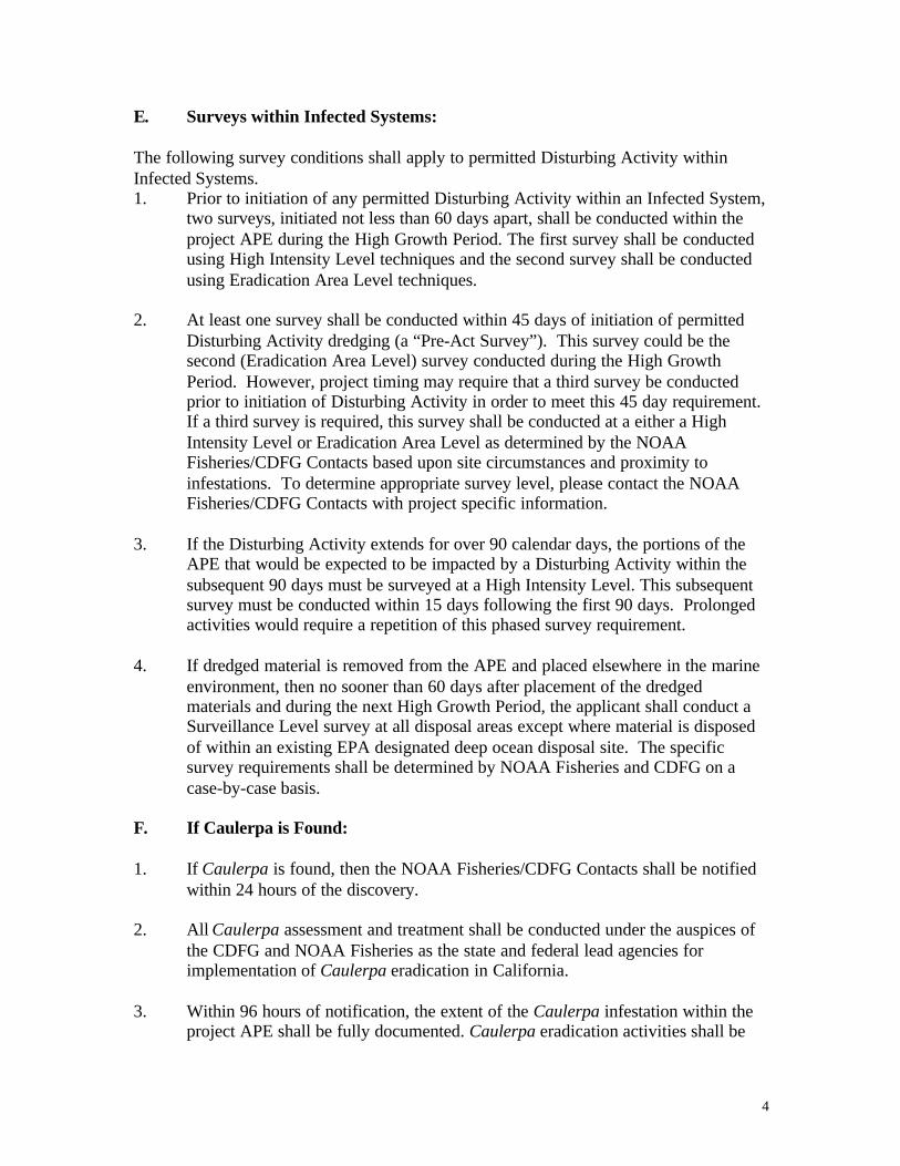
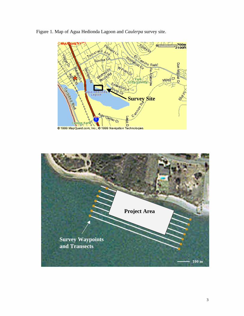
Figure 1. Map of Agua Hedionda Lagoon and Caulerpa survey site.
Survey Site
Project Area
Survey Waypointsand Transects
100 m

Caulerpa taxifolia Survey and Identification
Caulerpa taxifolia Survey Methodology
The Caulerpa Control Protocol calls for three levels of survey intensity, based on thecurrent status of the marine system (infected or Caulerpa free). Approved methodologiesfor conducting Caulerpa surveys at each level are discussed below. Other methodologiesmay be approved on a case-by-case basis by NOAA Fisheries and CDFG.
SURVEILLANCE LEVELThis survey intensity level is to be used at sites not previously known to be infested withCaulerpa and at dredged material placement sites. Surveys are intended to detect largeoccurrences of Caulerpa that may be present at the site. A minimum of 20% of thebottom must be inspected. It is expected that the survey coverage will be uniformlydistributed throughout the Area of Potential Effect (APE), rather than being confined to a20% portion of the APE. This inspection may be completed by using SCUBA divers,remote cameras, or acoustic equipment paired with visual ground truthing. Visualsurveys of subtidal APEs from the surface are not acceptable.
SCUBAA surveillance level survey can be conducted through systematic inspection by SCUBAdivers. Divers should evenly cover a minimum of 20% of the APE, using a compass toswim transects. Visibility conditions should be used to determine the width of the visualcoverage achieved. A record should be made of the portion of the site surveyed,preferably on a site map.
Remote CameraA surveillance level survey can be conducted using a remote camera. The camera shouldbe towed from above at an appropriately slow speed to allow thorough examination of thebottom, using a compass or GPS to view transects that evenly cover a minimum of 20%of the APE. Visibility and the view width of the camera should be used to determine thewidth of the visual coverage achieved on each transect. A record should be made of boatspeed and the portion of the site surveyed, preferably showing transects on a site map.
Acoustic EquipmentWhere appropriate, sidescan sonar equipment may be used to survey the APE. Thecollected images should be examined for suspect returns, typically expected to appear asmonotypic, low-growing vegetative patches, likely exhibiting circular colonial growthpatterns. All suspect patches should be ground-truthed by a SCUBA diver or remotecamera.
HIGH INTENSITY LEVELThis survey intensity level is to be used when conducting the first of the two requiredsurveys at sites previously identified as infected. At this level a minimum of 50% of thebottom must be sub-sampled. It is expected that the survey coverage will be uniformlydistributed throughout the APE. This inspection may be completed by using SCUBA

Caulerpa taxifolia Survey and Identification
divers or remote cameras, using the methods discussed above. Visual surveys of subtidalAPEs from the surface are not acceptable.
ERADICATION LEVELThis survey intensity level is to be used when conducting the second of the two requiredsurveys at sites previously identified as infected. This is the most intensive survey leveland requires that 100% of the bottom must be systematically inspected. This inspectionmust be completed by SCUBA divers. Unless the APE is very small or visibility isexcellent, it is recommended that diver transects be surveyed using transect linesdeployed using a GPS, in order ensure comprehensive coverage. This is most efficientlyachieved using a team of divers. A map of the APE should be prepared showing thetransects surveyed by the survey team.

Caulerpa taxifolia Survey and Identification
Identification
Caulerpa taxifolia is a very distinctive green alga. It can be identified by the followingfeatures:
? bright green? feathered fronds? rubbery texture? long stolon or stem
Patches typically grow low to the bottom, typically 6-12 inches high, with individualfronds up to 24 inches in length. It can grow in calm or rough waters, on rock, mud, orsand. Fragments do not float and it has not been observed on floating docks or boat hulls.It typically displays colonial growth patterns, with stolons extending out from the patch,secured to the substrate by rhizoids.
The following pages will present C. taxifolia as it looks out of the water, as small plantsin the water, and as large, dense patches. Also will be included pictures of other speciesof Caulerpa that are also banned in California due to their potential to be invasive. Inaddition pictures of other benthic plants and animals that have been mis- identified asCaulerpa is the past will be presented.
FrondsStolon
Rhizoids

Caulerpa taxifolia Survey and Identification
a) Close-up of C. taxifolia fronds (photo: Greig Peters)
b) Close-up of C. taxifolia fronds (photo: A. Meinesz)
c) C. taxifolia laid out (photo: R. Woodfield)

Caulerpa taxifolia Survey and Identification
d) C. taxifolia becoming established in an eelgrass bed (photo: R. Woodfield)
e) C. taxifolia growing among rocks f)C. taxifolia growing in sand (photo: A. Meinesz) (photo: J. Huisman)
g) a small colony of C. taxifolia expanding by stolon elongation(photo: R. Woodfield)

Caulerpa taxifolia Survey and Identification
h) C. taxifolia overtaking a sponge (photo: R. Woodfield) i) C. taxifolia (photo: R. Woodfield)
j) C. taxifolia overtaking seagrass bed k) monotypic bed of C. taxifolia(photo: A. Meinesz) (photo: A. Zuljevik)
l) dense C. taxifolia (photo: R. Woodfield) m) dense C. taxifolia in eelgrass bed (photo: R. Woodfield)
n) dense C. taxifolia displacing eelgrass bed (photo: R. Woodfield)

Caulerpa taxifolia Survey and Identification
THE FOLLOWING SECTIONS ARE NOT AVAILABLE ON-LINE
Other genera potentially mis-identified as Caulerpa:
Other species of Caulerpa to be familiar with:
Surveyors should be able to identify all species of Caulerpa banned inCalifornia:
Caulerpa taxifoliaCaulerpa racemosaCaulerpa sertulariodesCaulerpa scalpelliformisCaulerpa verticillataCaulerpa ashmeadiiCaulerpa cupressoidesCaulerpa floridanaCaulerpa mexicana

Caulerpa taxifolia Survey and Identification
Certification - Caulerpa taxifolia Survey Staff
All personnel conducting surveys under the Caulerpa Control Protocol must be certifiedby either NOAA Fisheries or California Department of Fish and Game. Survey reportswith non-certified survey personnel will not be accepted. The certification process willinclude passing an exam on identification of Caulerpa taxifolia. This exam will be givenby NOAA Fisheries and CDFG. Certification will be valid for two years, at which timethe exam must be retaken and surveyors will be provided with updated information onprotocols, reporting requirements, target species, and known infestation locations.
Contact the agencies at the addresses listed in the Resources section of this binder toschedule an exam. The exams will be given at the discretion of NOAA Fisheries andCDFG.

Caulerpa taxifolia Survey and Identification
Caulerpa taxifolia Identification CertificationCaulerpa Control Protocol
______________________ has successfully passed the Caulerpa taxifoliaIdentification exam and is a Certified Caulerpa taxifolia Surveyor under theCaulerpa Control Protocol.
Certified by:
_______________________ _________________________(print name) (agency)
_______________________ _________________________(date) (signature)
This certification is valid for two years from the above date. Thiscertification will be kept on file by NOAA Fisheries and CDFG.
Signed by applicant:
_______________________ _________________________(signature) (date)

Caulerpa taxifolia Survey and Identification
Additional information on Caulerpa taxifolia is availableon-line at:
? http://sccat.net? http://www.caulerpa.cjb.net? http://swr.ucsd.edu/hcd/Caulerpa.htm? http://swr.nmfs.noaa.gov/hcd/caulerad.htm? http://www.caulerpa.org? http://www.isima.fr/ecosim/ct.html? http://www.divebums.com/General/Caulerpa/index.html
The book Killer Algae, by Alexandre Meinesz, University of Chicago Press, 1999, relatesthe Mediterranean experience with Caulerpa taxifolia.
Any questions regarding site status, survey requirements, or reporting can be directed to:
NOAA FisheriesSouthwest Regional Office
501 West Ocean Boulevard, Suite 4200Long Beach, CA 90802Attn: Robert Hoffmanph.: (562) 980-4043fx.: (562) 980-4092
e-mail: [email protected]
Calif. Dept. of Fish & GameSouth Coast Region4949 Viewridge DriveSan Diego, CA 92124
Attn: William Paznokasph.: (858) 467-4218fx.: (858) 467-4299
e-mail: [email protected]